Totale Sonnenfinsternis vom 01.10.-0023
| Wochentag: | Freitag |
| Maximale Dauer der Verfinsterung: | 02m09s |
| Maximale Breite des Finsternispfades: | 124 km |
| Saroszyklus: | 82 |
| Bedeckungsgrad: | 100% |
| Magnitude: | 1.0281 |
| Gamma: | -0.6597 |
Wo kann man die Sonnenfinsternis vom 01.10.-0023 sehen?

Die Sonnenfinsternis am 01.10.-0023 kann man in 41 Ländern als partielle Sonnenfinsternis beobachten.
Der Finsternispfad verläuft durch 5 Länder. Nur in diesen Ländern ist sie als totale Sonnenfinsternis zu sehen.
In den folgenden Ländern ist die Sonnenfinsternis total zu sehen
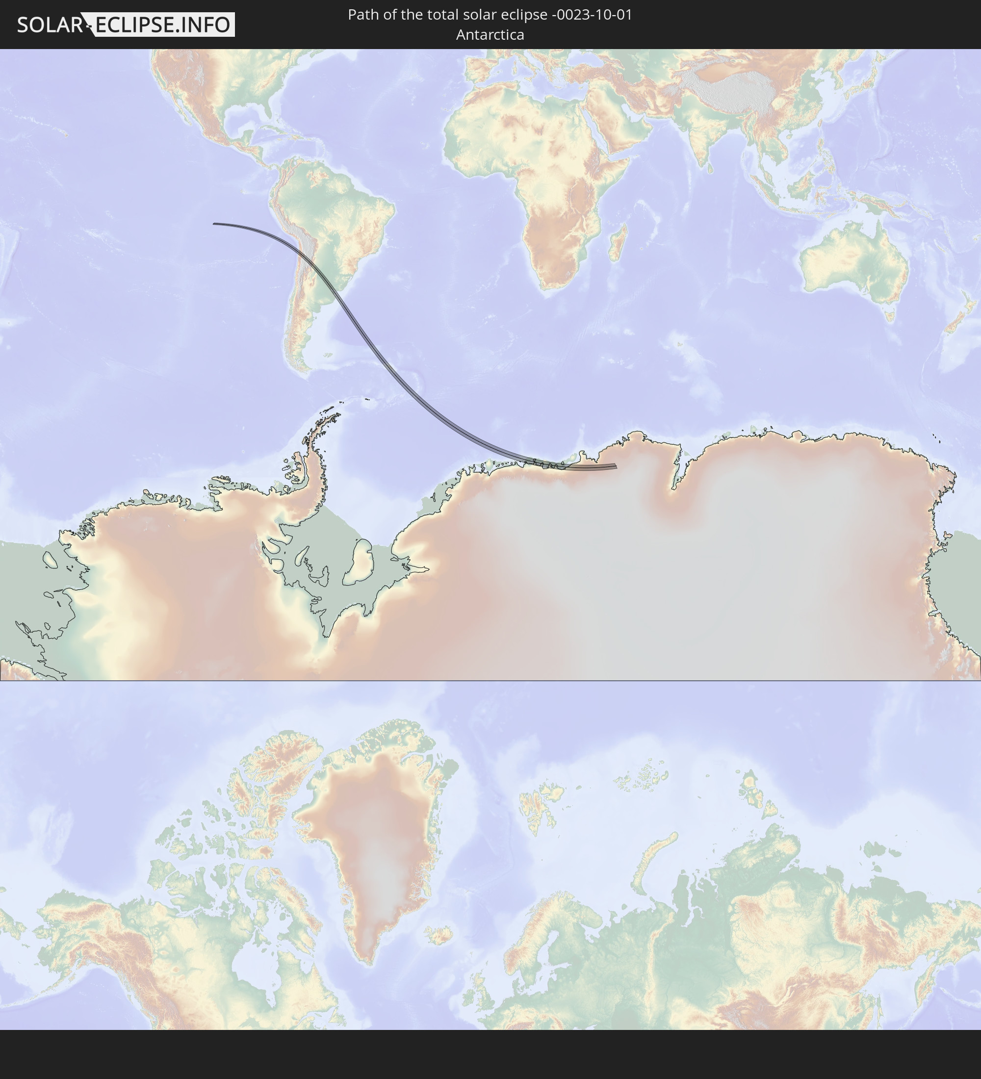 Antarktika
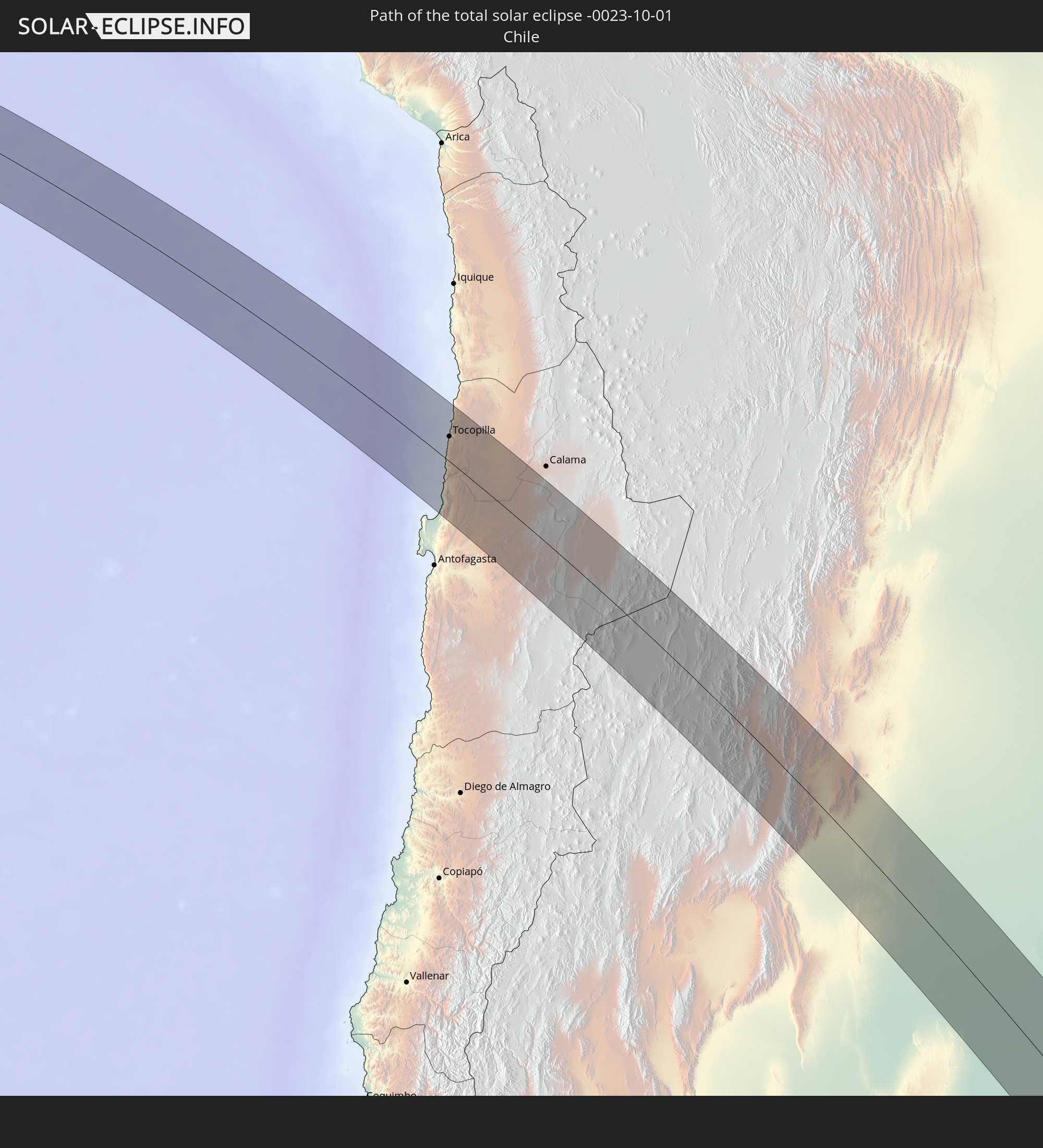 Chile
Chile
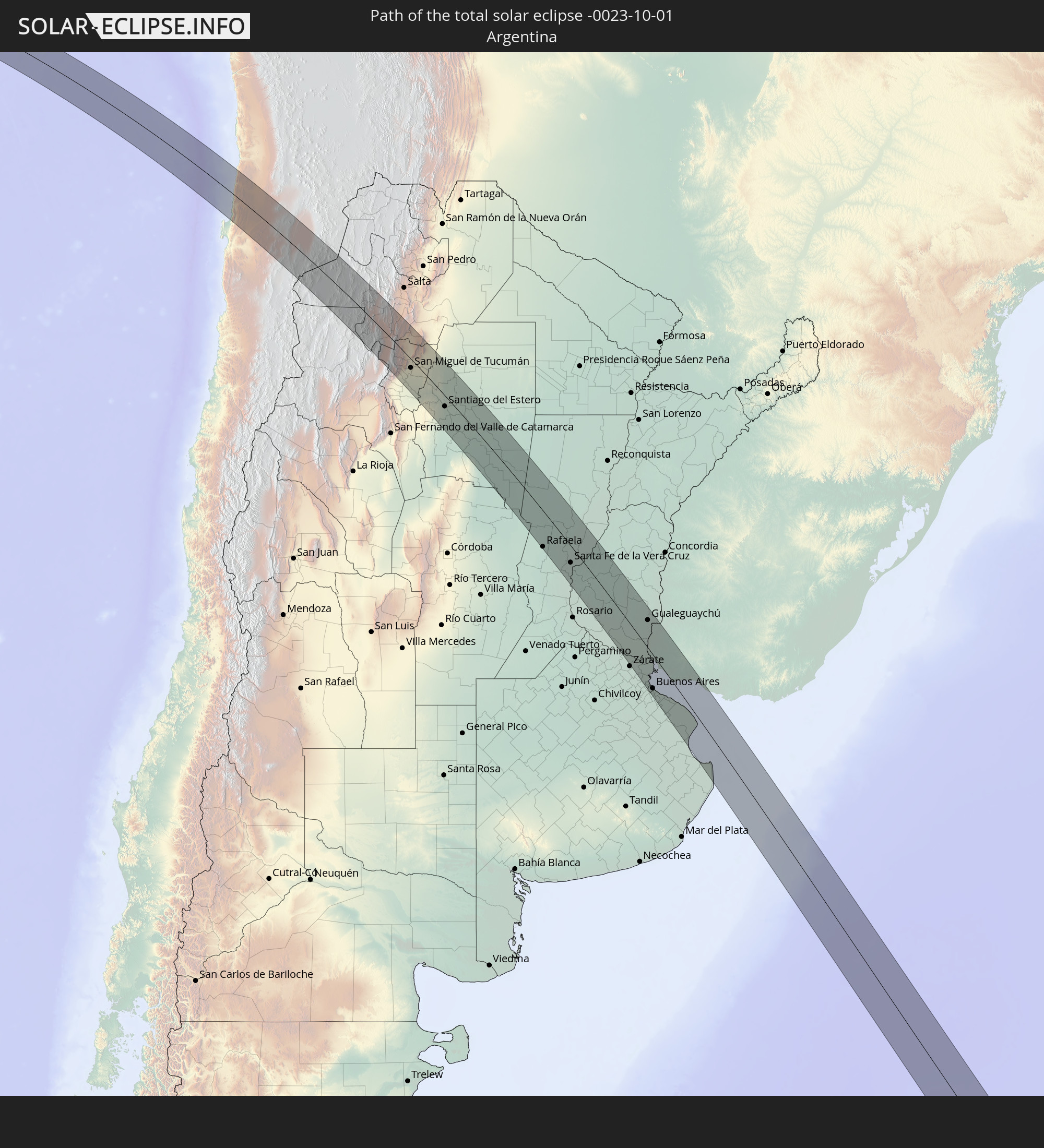 Argentinien
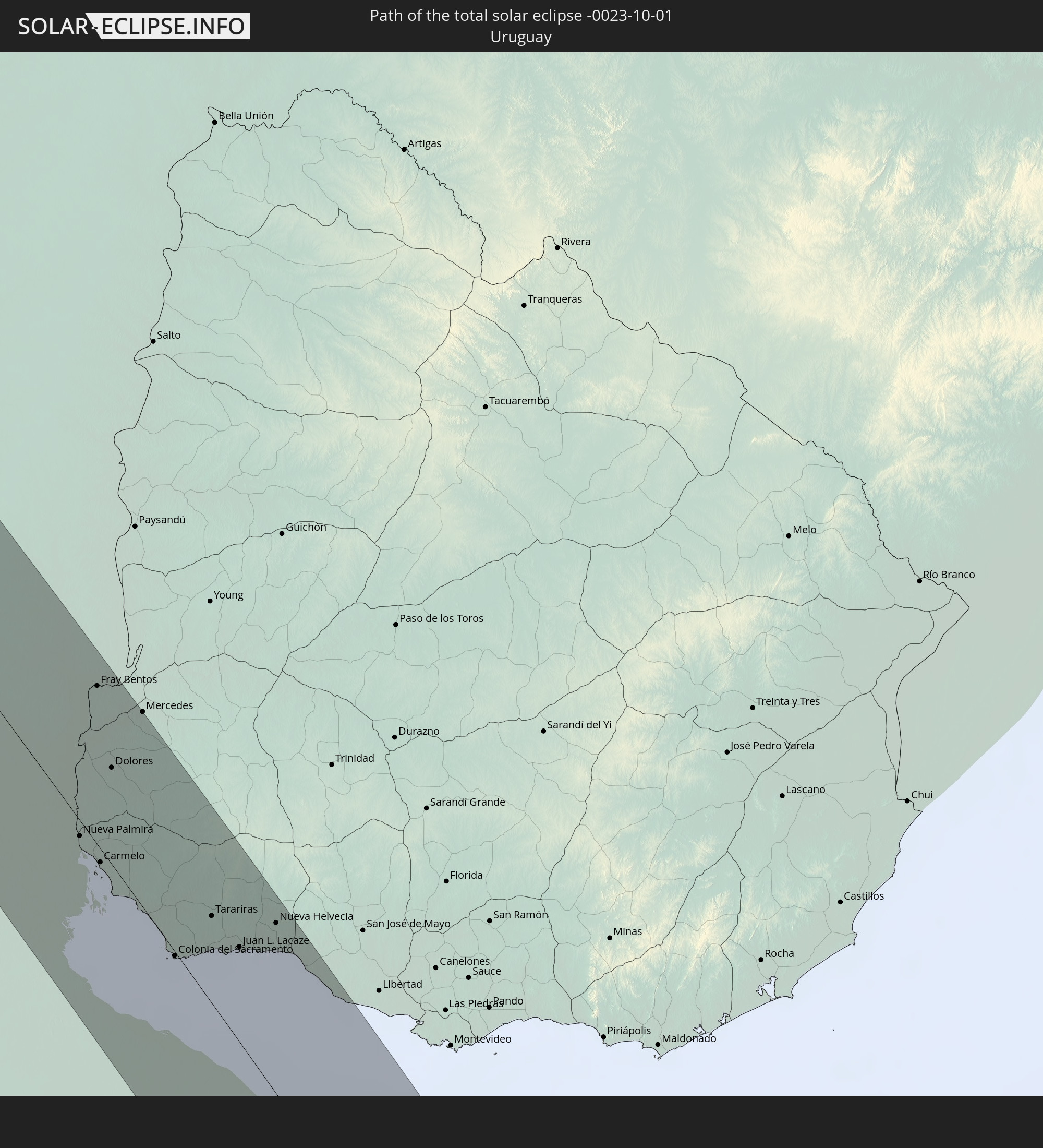 Uruguay
 Südgeorgien und die Südlichen Sandwichinseln
In den folgenden Ländern ist die Sonnenfinsternis partiell zu sehen
 Antarktika
 United States Minor Outlying Islands
 Mexiko
 Chile
Chile
 Guatemala
 Ecuador
 El Salvador
 Honduras
 Belize
 Nicaragua
 Costa Rica
 Kuba
Kuba
 Panama
 Kolumbien
 Kaimaninseln
 Peru
Peru
 Jamaika
 Haiti
Haiti
 Brasilien
 Argentinien
 Venezuela
 Dominikanische Republik
 Aruba
Aruba
 Bolivien
 Puerto Rico
 Paraguay
 Trinidad und Tobago
 Grenada
 Dominica
 St. Vincent und die Grenadinen
 Falklandinseln
 Guyana
 Martinique
 St. Lucia
 Barbados
 Uruguay
 Suriname
 Französisch-Guayana
 Südgeorgien und die Südlichen Sandwichinseln
 St. Helena
 Bouvetinsel
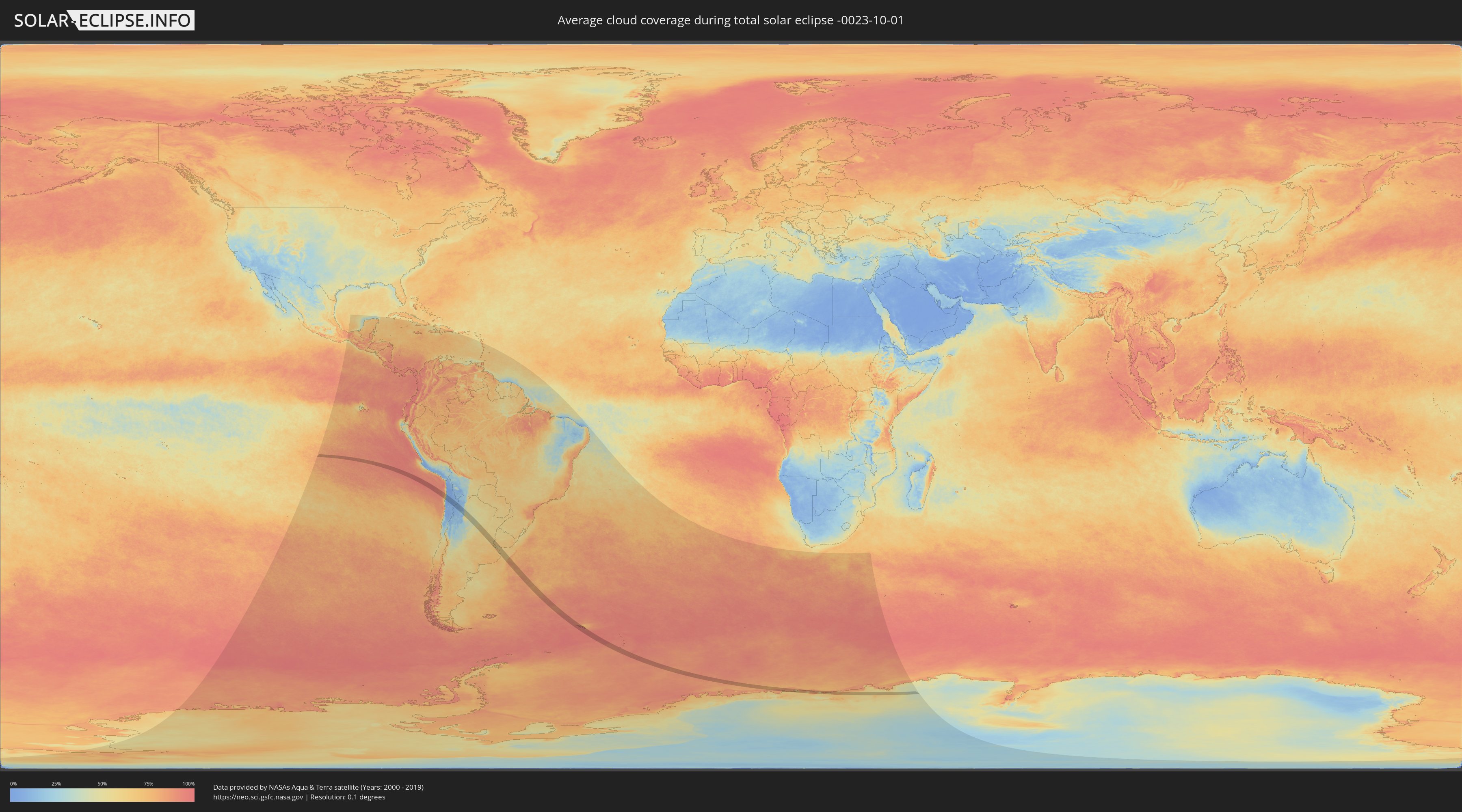
Wie wird das Wetter während der totalen Sonnenfinsternis am 01.10.-0023?
Wo ist der beste Ort, um die totale Sonnenfinsternis vom 01.10.-0023 zu beobachten?
Die folgenden Karten zeigen die durchschnittliche Bewölkung für den Tag, an dem die totale Sonnenfinsternis
stattfindet. Mit Hilfe der Karten lässt sich der Ort entlang des Finsternispfades eingrenzen,
der die besten Aussichen auf einen klaren wolkenfreien Himmel bietet.
Trotzdem muss man immer lokale Gegenenheiten beachten und sollte sich genau über das Wetter an seinem
gewählten Beobachtungsort informieren.
Die Daten stammen von den beiden NASA-Satelliten
AQUA und TERRA
und wurden über einen Zeitraum von 19 Jahren (2000 - 2019) gemittelt.

Detaillierte Länderkarten
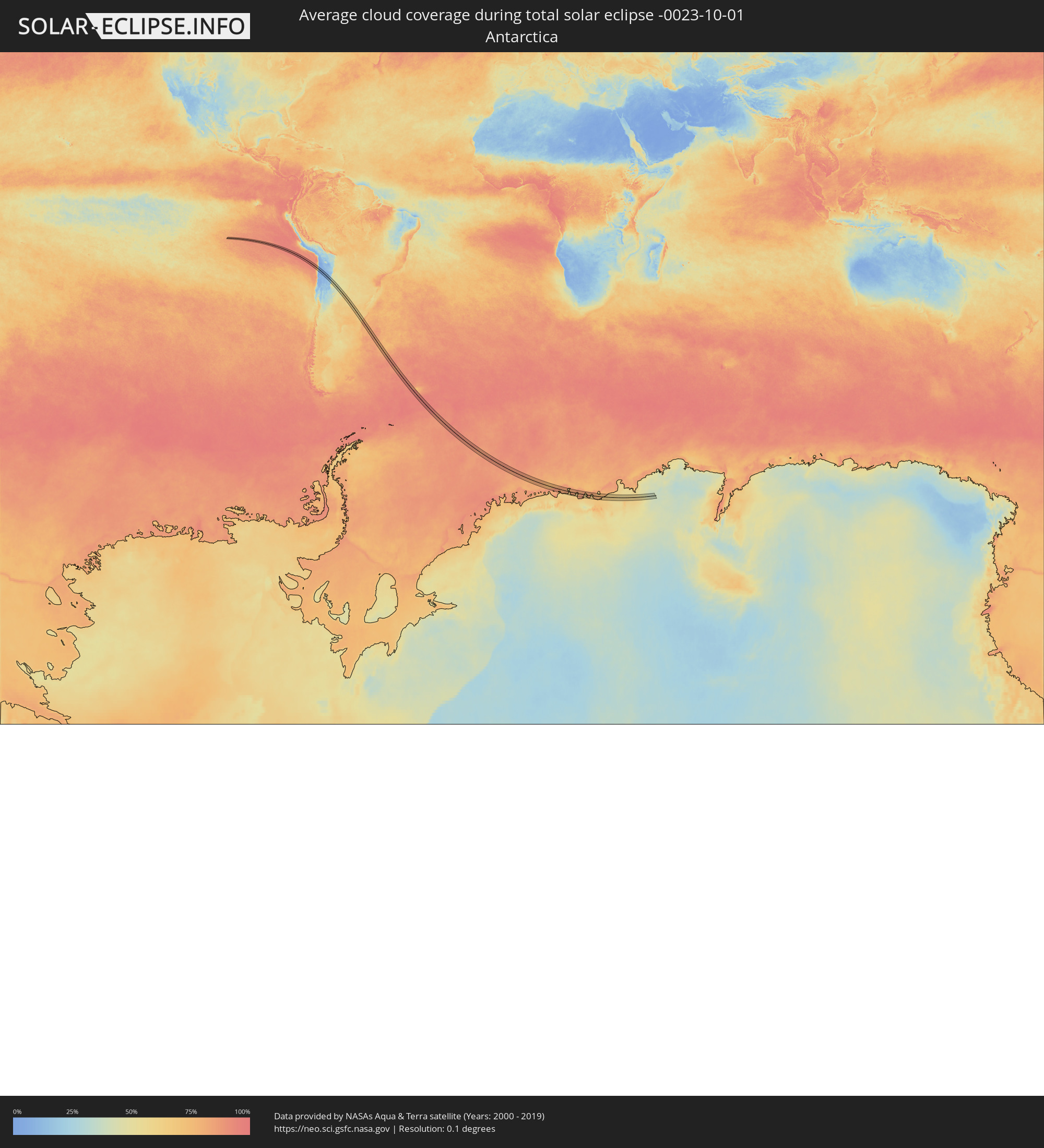 Antarktika
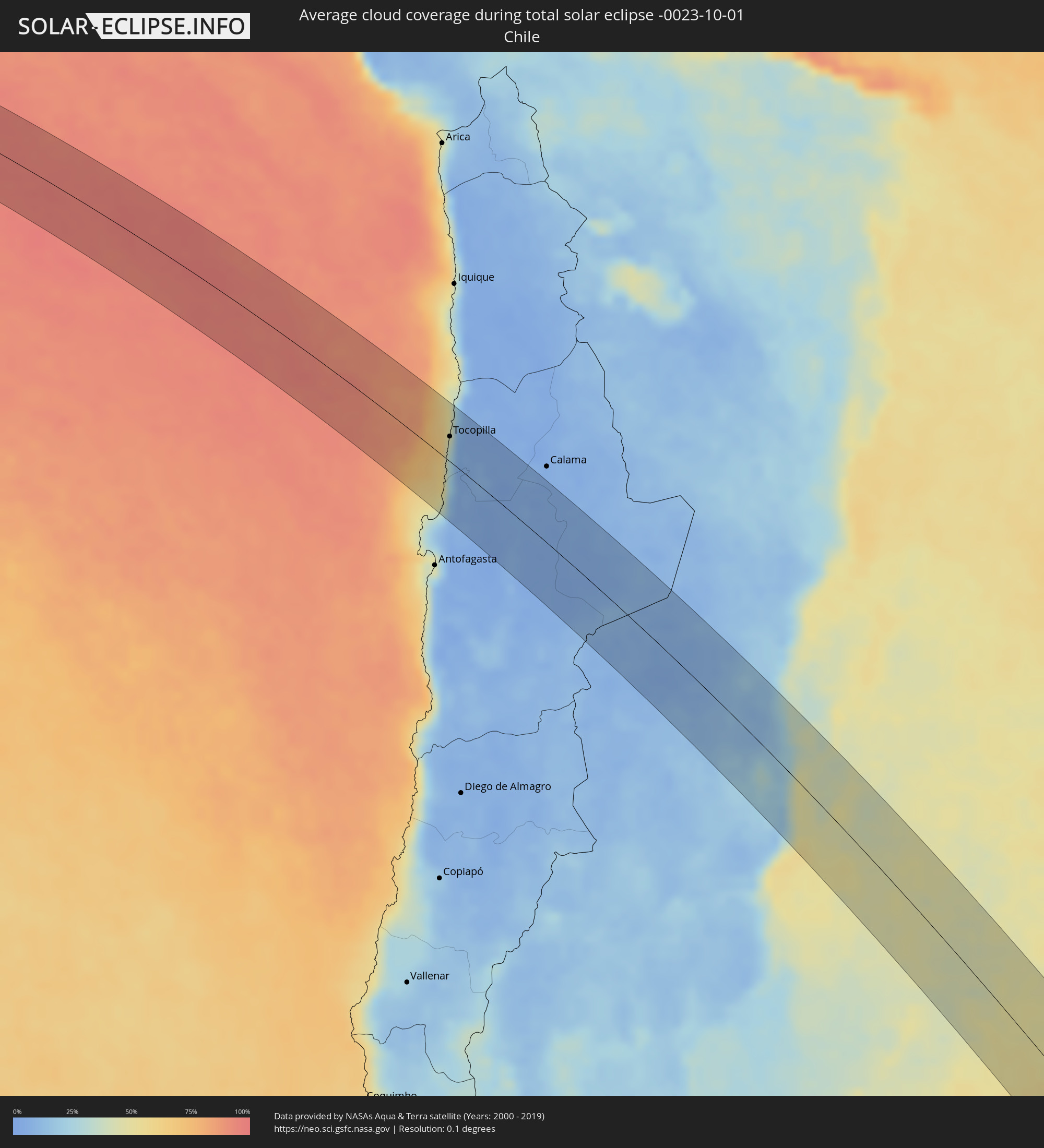 Chile
Chile
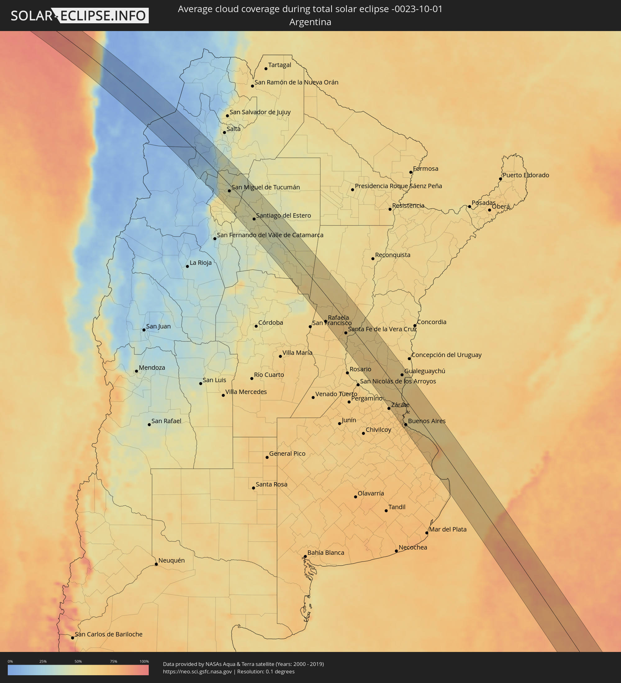 Argentinien
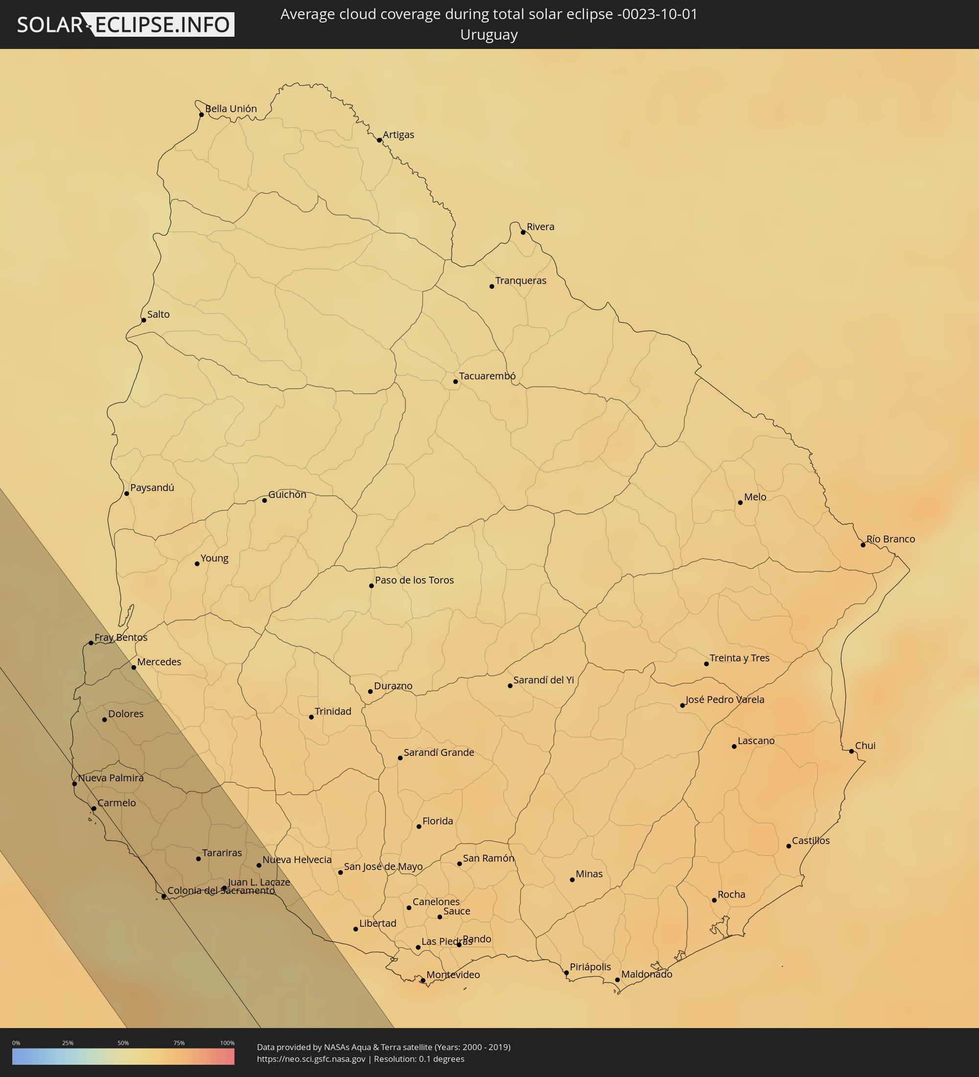 Uruguay
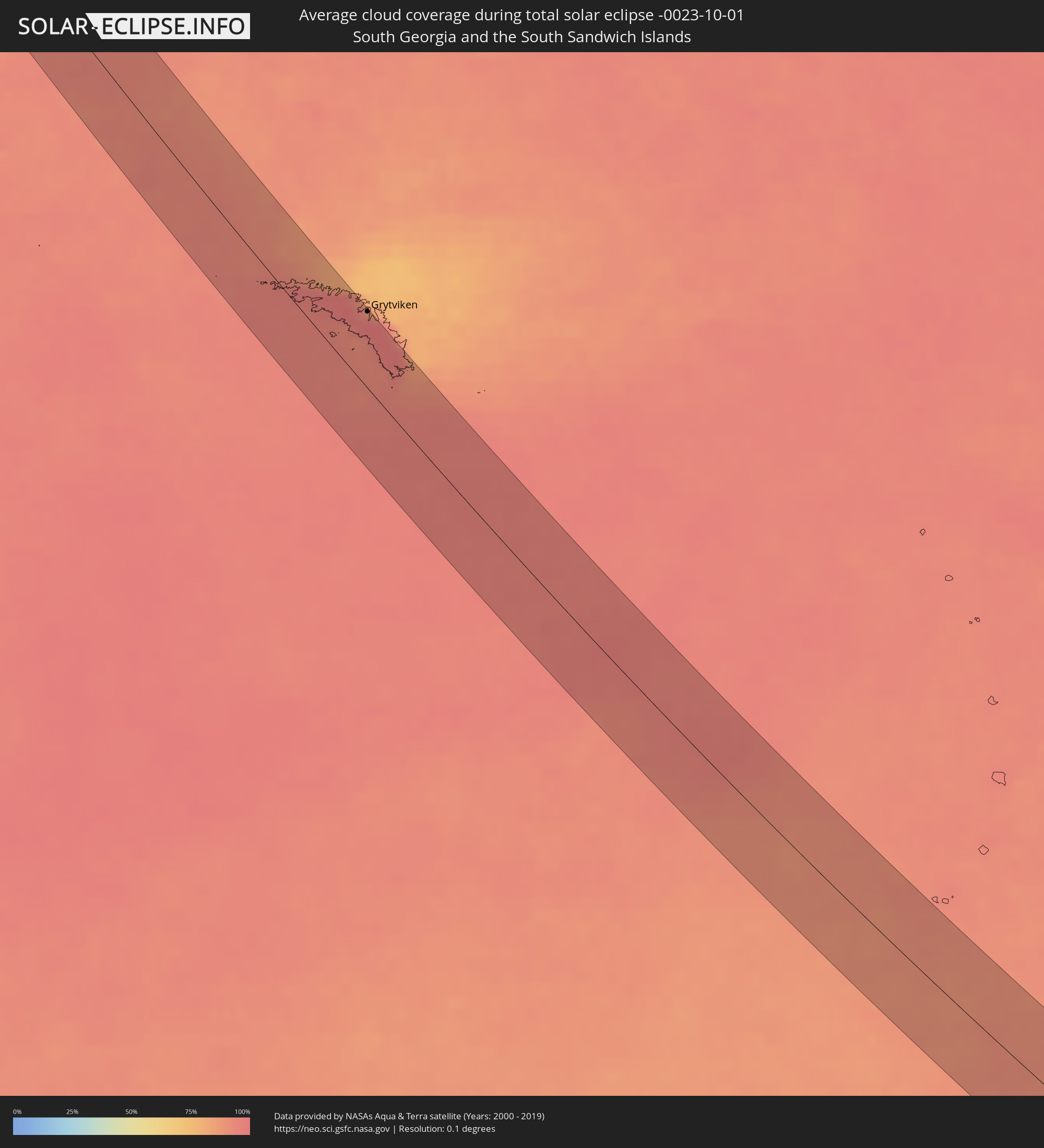 Südgeorgien und die Südlichen Sandwichinseln
Orte im Finsternispfad
Die nachfolgene Tabelle zeigt Städte und Orte mit mehr als 5.000 Einwohnern, die sich im Finsternispfad befinden. Städte mit mehr als 100.000 Einwohnern sind dick gekennzeichnet. Mit einem Klick auf den Ort öffnet sich eine Detailkarte die die Lage des jeweiligen Ortes zusammen mit dem Verlauf der zentralen Finsternis präsentiert.
| Ort | Typ | Dauer der Verfinsterung | Ortszeit bei maximaler Verfinsterung | Entfernung zur Zentrallinie | Ø Bewölkung |
|
Tocopilla, Antofagasta
|
total | - | 08:24:28 UTC-04:42 | 26 km | 38% |
|
Cafayate, Salta Province
|
total | - | 09:02:44 UTC-04:16 | 13 km | 28% |
|
Monteros, Tucumán Province
|
total | - | 09:05:28 UTC-04:16 | 63 km | 51% |
|
Famaillá, Tucumán Province
|
total | - | 09:05:21 UTC-04:16 | 48 km | 51% |
|
Simoca, Tucumán Province
|
total | - | 09:05:49 UTC-04:16 | 60 km | 51% |
|
Yerba Buena, Tucumán Province
|
total | - | 09:04:58 UTC-04:16 | 23 km | 47% |
|
Bella Vista, Tucumán Province
|
total | - | 09:05:25 UTC-04:16 | 39 km | 48% |
|
Trancas, Tucumán Province
|
total | - | 09:03:49 UTC-04:16 | 25 km | 41% |
|
Tafí Viejo, Tucumán Province
|
total | - | 09:04:52 UTC-04:16 | 13 km | 46% |
|
San Miguel de Tucumán, Tucumán Province
|
total | - | 09:05:06 UTC-04:16 | 17 km | 45% |
|
Alderetes, Tucumán Province
|
total | - | 09:05:11 UTC-04:16 | 10 km | 45% |
|
Termas de Río Hondo, Santiago del Estero Province
|
total | - | 09:06:51 UTC-04:16 | 41 km | 45% |
|
Santiago del Estero, Santiago del Estero Province
|
total | - | 09:08:10 UTC-04:16 | 20 km | 45% |
|
Clodomira, Santiago del Estero Province
|
total | - | 09:07:52 UTC-04:16 | 6 km | 46% |
|
Añatuya, Santiago del Estero Province
|
total | - | 09:11:12 UTC-04:16 | 36 km | 47% |
|
Morteros, Cordoba Province
|
total | - | 09:16:44 UTC-04:16 | 62 km | 61% |
|
Ceres, Santa Fe Province
|
total | - | 09:15:09 UTC-04:16 | 1 km | 56% |
|
Tostado, Santa Fe Province
|
total | - | 09:14:04 UTC-04:16 | 60 km | 56% |
|
Sunchales, Santa Fe Province
|
total | - | 09:17:44 UTC-04:16 | 45 km | 59% |
|
Rafaela, Santa Fe Province
|
total | - | 09:18:26 UTC-04:16 | 61 km | 61% |
|
San Cristóbal, Santa Fe Province
|
total | - | 09:16:53 UTC-04:16 | 23 km | 58% |
|
San Carlos Centro, Santa Fe Province
|
total | - | 09:19:53 UTC-04:16 | 64 km | 63% |
|
Esperanza, Santa Fe Province
|
total | - | 09:19:32 UTC-04:16 | 32 km | 64% |
|
Santo Tomé, Santa Fe Province
|
total | - | 09:20:10 UTC-04:16 | 35 km | 60% |
|
Recreo, Santa Fe Province
|
total | - | 09:19:52 UTC-04:16 | 20 km | 64% |
|
Santa Fe de la Vera Cruz, Santa Fe Province
|
total | - | 09:20:11 UTC-04:16 | 28 km | 62% |
|
Laguna Paiva, Santa Fe Province
|
total | - | 09:19:35 UTC-04:16 | 2 km | 63% |
|
Diamante, Entre Ríos Province
|
total | - | 09:21:07 UTC-04:16 | 52 km | 58% |
|
San Justo, Santa Fe Province
|
total | - | 09:18:39 UTC-04:16 | 38 km | 61% |
|
Paraná, Entre Ríos Province
|
total | - | 09:20:36 UTC-04:16 | 21 km | 59% |
|
San Benito, Entre Ríos Province
|
total | - | 09:20:49 UTC-04:16 | 19 km | 60% |
|
Crespo, Entre Ríos Province
|
total | - | 09:21:28 UTC-04:16 | 25 km | 61% |
|
General Ramírez, Entre Ríos Province
|
total | - | 09:21:54 UTC-04:16 | 27 km | 63% |
|
Victoria, Entre Ríos Province
|
total | - | 09:22:50 UTC-04:16 | 53 km | 59% |
|
Viale, Entre Ríos Province
|
total | - | 09:21:32 UTC-04:16 | 8 km | 58% |
|
Villa María Grande, Entre Ríos Province
|
total | - | 09:21:16 UTC-04:16 | 30 km | 60% |
|
Gualeguay, Entre Ríos Province
|
total | - | 09:24:56 UTC-04:16 | 25 km | 62% |
|
Rosario del Tala, Entre Ríos Province
|
total | - | 09:23:30 UTC-04:16 | 44 km | 60% |
|
Larroque, Entre Ríos Province
|
total | - | 09:25:07 UTC-04:16 | 5 km | 62% |
|
Urdinarrain, Entre Ríos Province
|
total | - | 09:24:35 UTC-04:16 | 37 km | 62% |
|
Tigre, Buenos Aires
|
total | - | 09:28:22 UTC-04:16 | 54 km | 69% |
|
San Isidro, Buenos Aires
|
total | - | 09:28:32 UTC-04:16 | 53 km | 66% |
|
Gualeguaychú, Entre Ríos Province
|
total | - | 09:25:42 UTC-04:16 | 44 km | 58% |
|
Villa Santa Rita, Buenos Aires F.D.
|
total | - | 09:28:52 UTC-04:16 | 59 km | 70% |
|
Villa Lugano, Buenos Aires F.D.
|
total | - | 09:29:00 UTC-04:16 | 63 km | 69% |
|
Colegiales, Buenos Aires F.D.
|
total | - | 09:28:50 UTC-04:16 | 54 km | 68% |
|
Nueva Palmira, Colonia
|
total | - | 09:59:28 UTC-03:44 | 5 km | 61% |
|
Retiro, Buenos Aires F.D.
|
total | - | 09:28:56 UTC-04:16 | 50 km | 68% |
|
Buenos Aires, Buenos Aires F.D.
|
total | - | 09:29:00 UTC-04:16 | 51 km | 68% |
|
Fray Bentos, Río Negro
|
total | - | 09:58:09 UTC-03:44 | 52 km | 56% |
|
Carmelo, Colonia
|
total | - | 09:59:53 UTC-03:44 | 4 km | 63% |
|
Quilmes, Buenos Aires
|
total | - | 09:29:22 UTC-04:16 | 50 km | 68% |
|
Dolores, Soriano
|
total | - | 09:59:03 UTC-03:44 | 31 km | 62% |
|
La Plata, Buenos Aires
|
total | - | 09:30:08 UTC-04:16 | 40 km | 70% |
|
Colonia del Sacramento, Colonia
|
total | - | 10:01:21 UTC-03:44 | 1 km | 58% |
|
Tarariras, Colonia
|
total | - | 10:01:16 UTC-03:44 | 28 km | 64% |
|
Juan L. Lacaze, Colonia
|
total | - | 10:01:47 UTC-03:44 | 30 km | 60% |
|
Rosario, Colonia
|
total | - | 10:01:43 UTC-03:44 | 45 km | 65% |
|
Nueva Helvecia, Colonia
|
total | - | 10:01:50 UTC-03:44 | 54 km | 66% |
|
San Clemente del Tuyú, Buenos Aires
|
total | - | 09:34:29 UTC-04:16 | 40 km | 64% |
|
Grytviken
|
total | - | 12:41:36 UTC-02:00 | 52 km | 96% |