Totale Sonnenfinsternis vom 20.09.-0060
| Wochentag: | Donnerstag |
| Maximale Dauer der Verfinsterung: | 04m48s |
| Maximale Breite des Finsternispfades: | 192 km |
| Saroszyklus: | 72 |
| Bedeckungsgrad: | 100% |
| Magnitude: | 1.0584 |
| Gamma: | -0.0062 |
Wo kann man die Sonnenfinsternis vom 20.09.-0060 sehen?
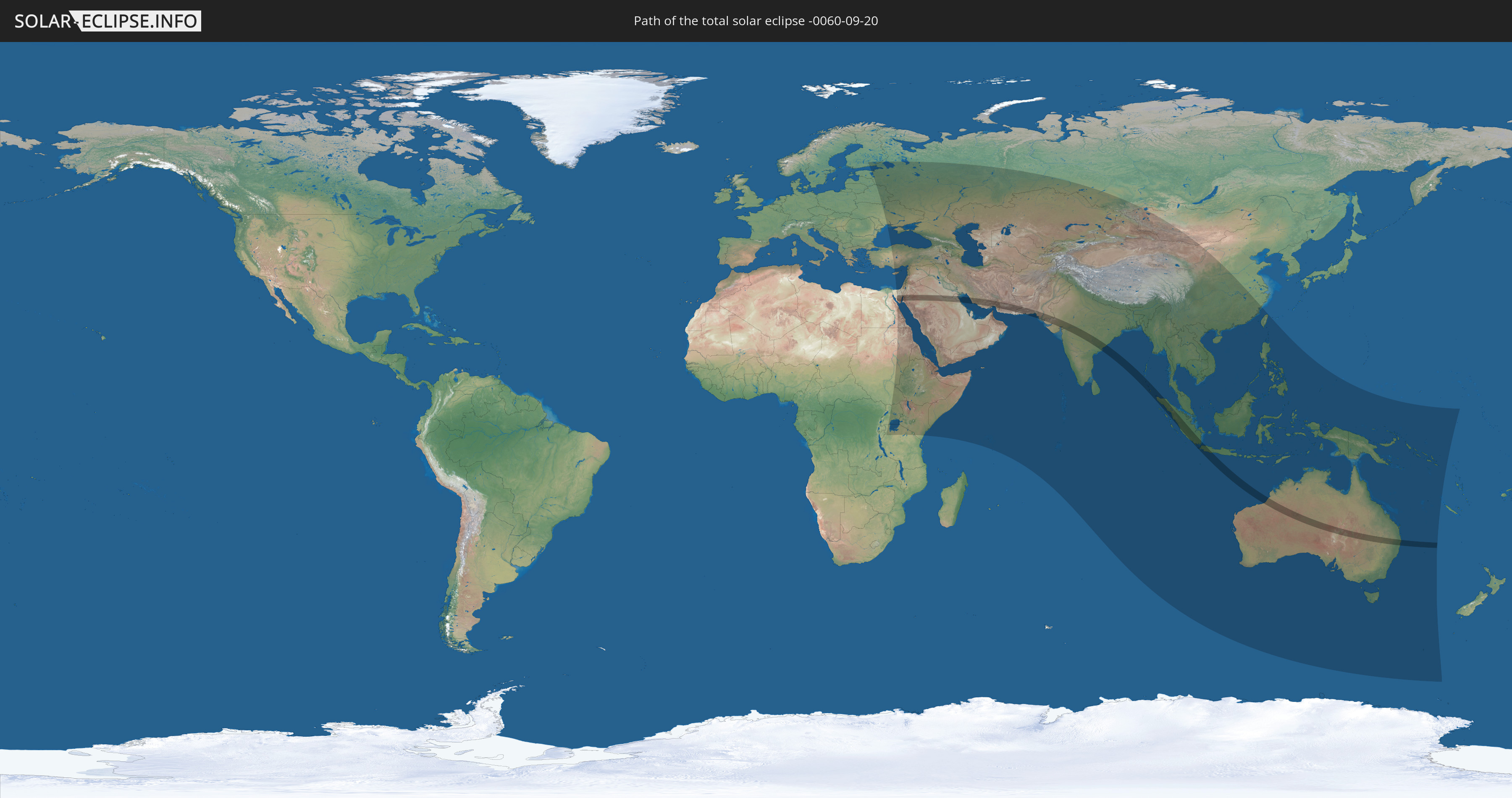
Die Sonnenfinsternis am 20.09.-0060 kann man in 72 Ländern als partielle Sonnenfinsternis beobachten.
Der Finsternispfad verläuft durch 11 Länder. Nur in diesen Ländern ist sie als totale Sonnenfinsternis zu sehen.
In den folgenden Ländern ist die Sonnenfinsternis total zu sehen
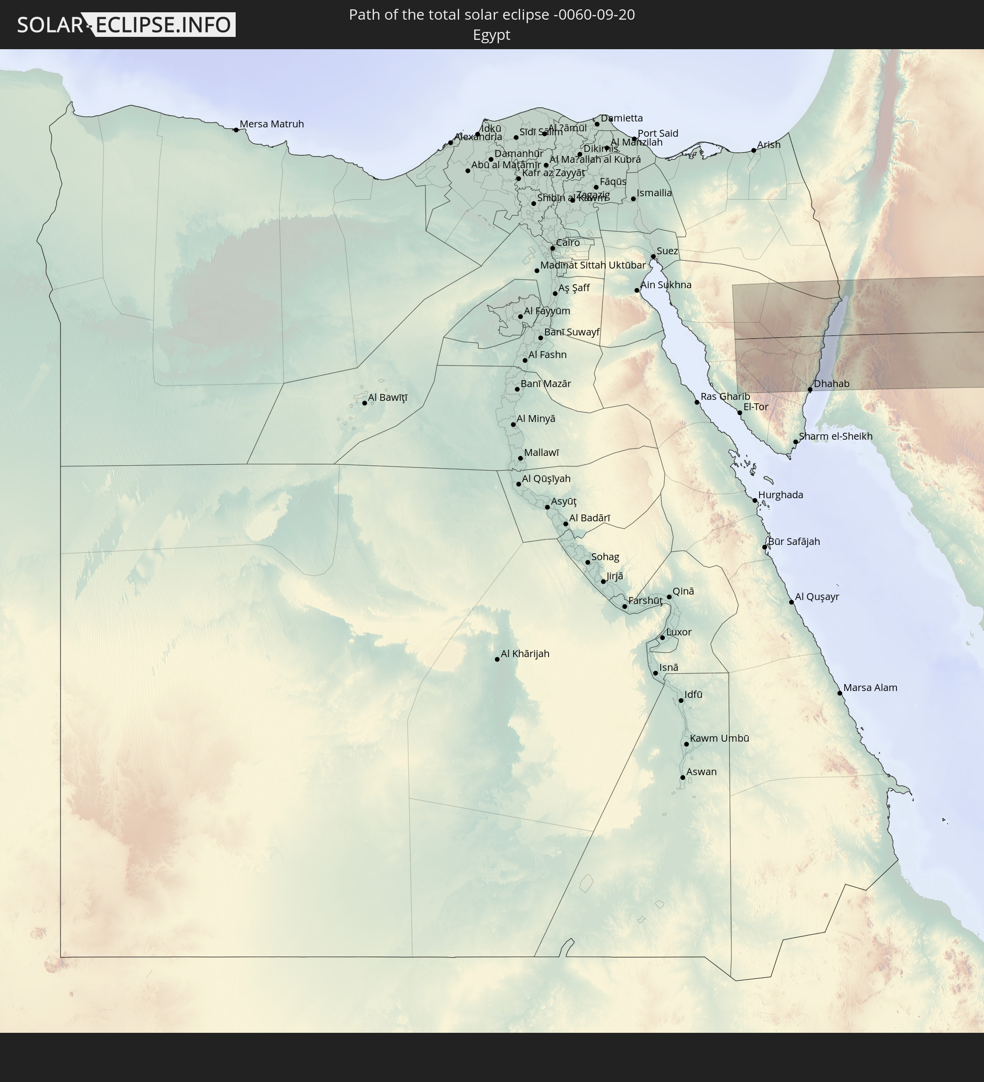 Ägypten
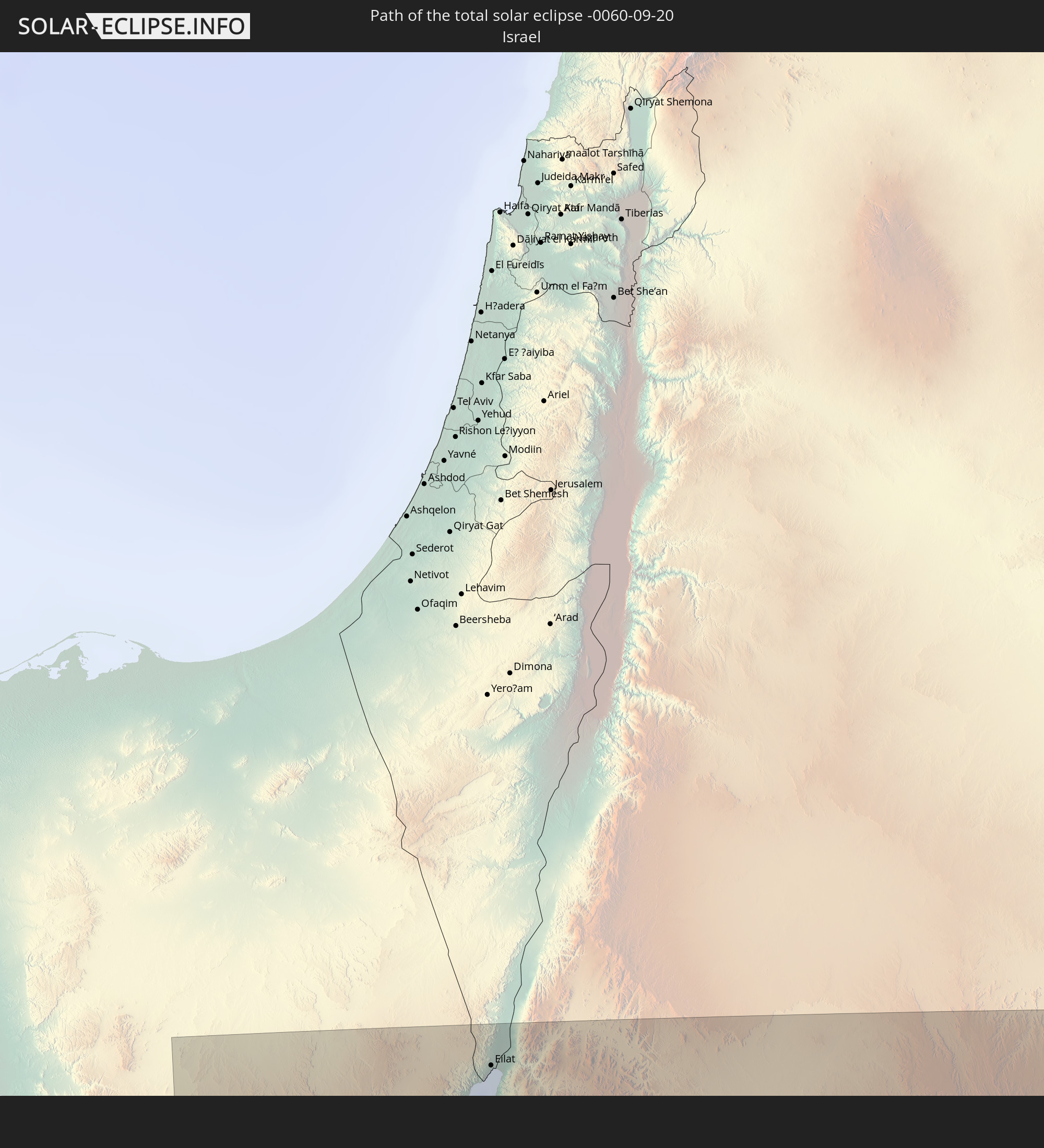 Israel
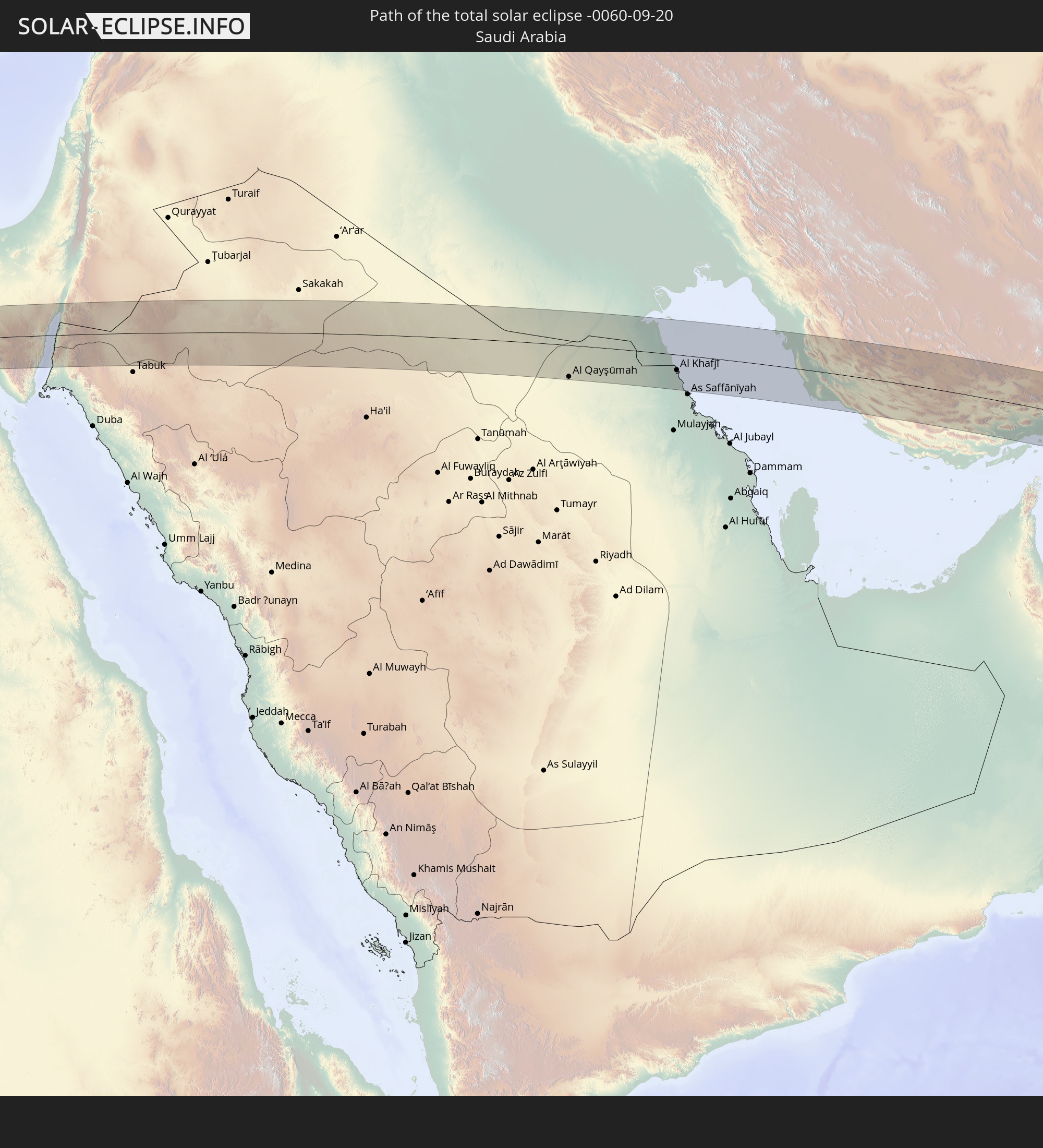 Saudi-Arabien
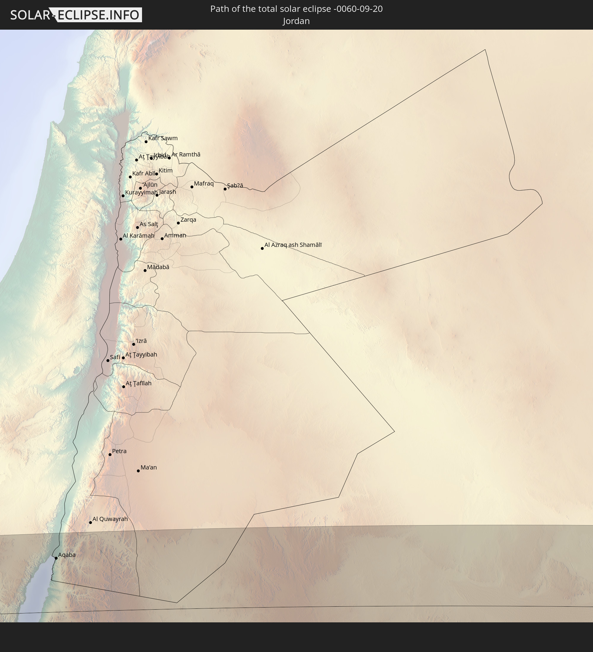 Jordanien
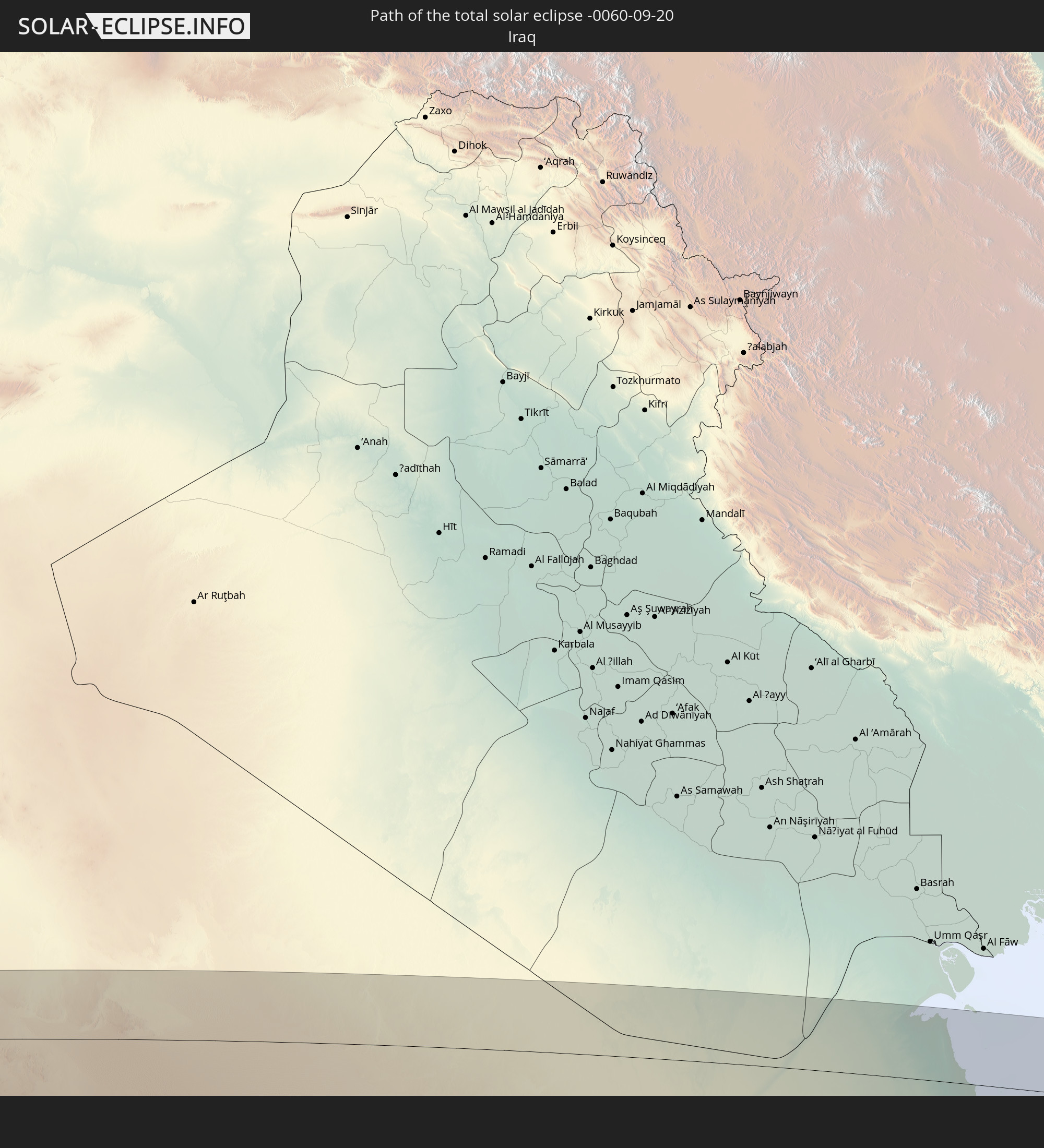 Irak
Irak
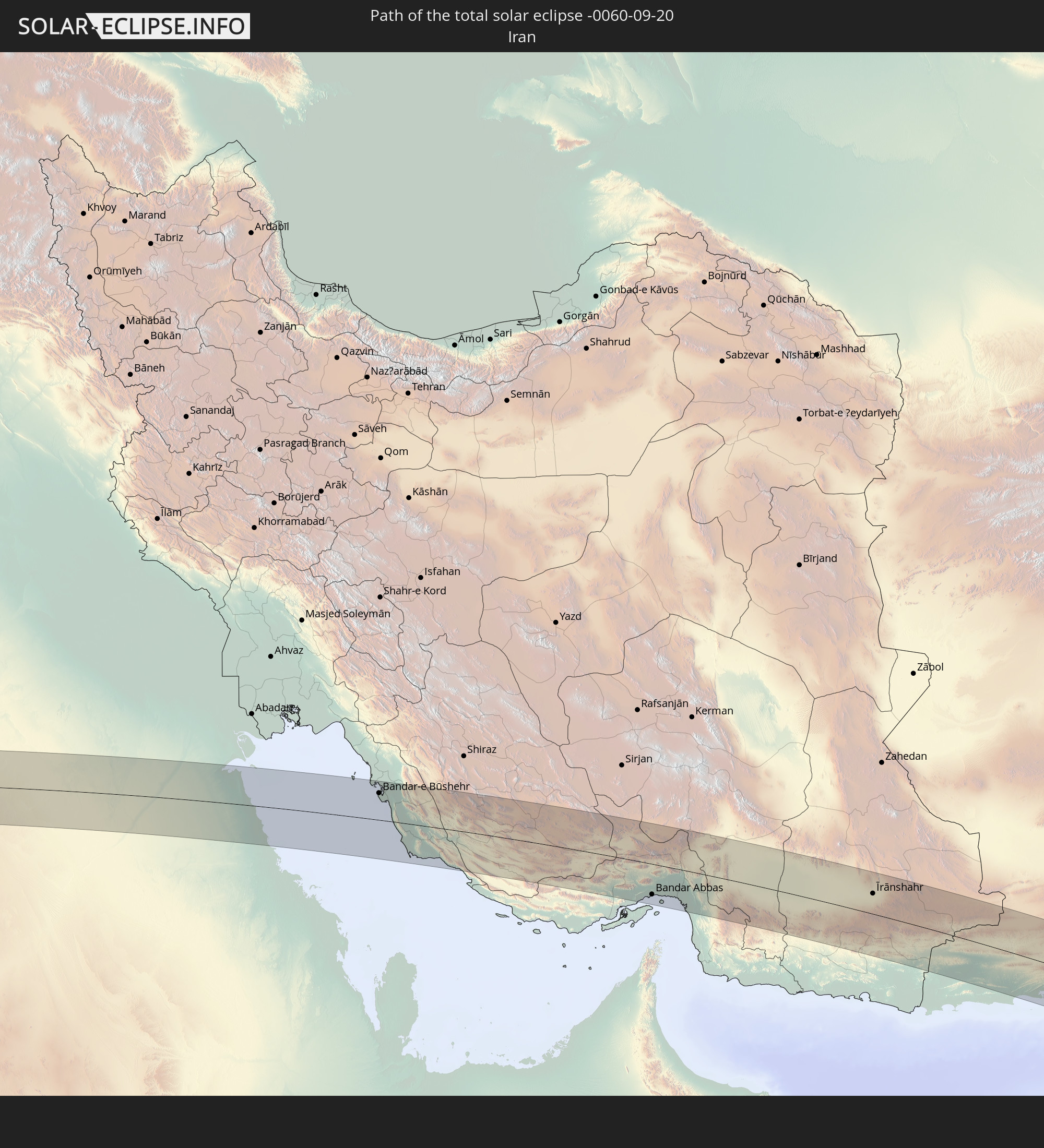 Iran
Iran
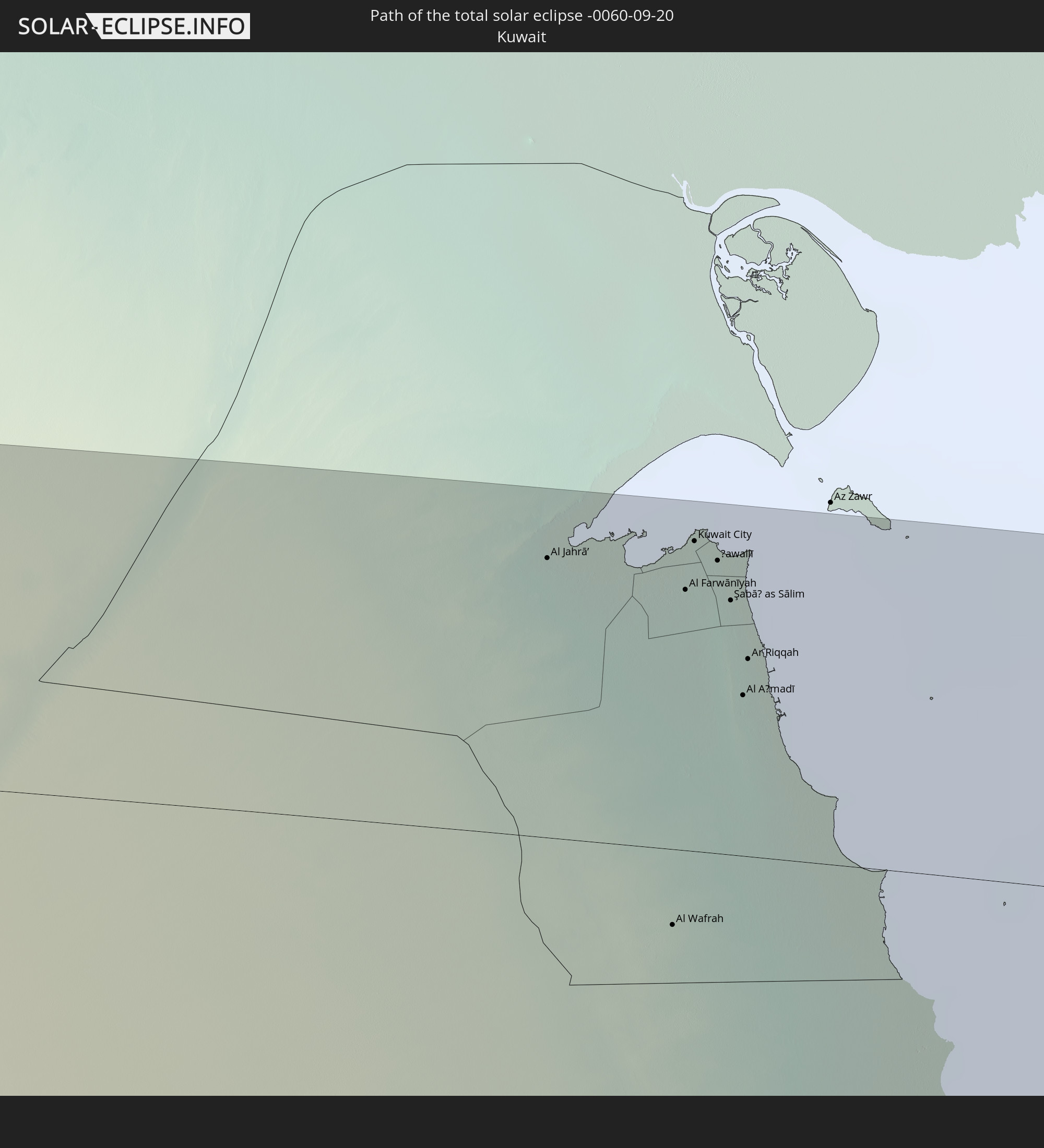 Kuwait
 Pakistan
 Indien
 Indonesien
 Australien
In den folgenden Ländern ist die Sonnenfinsternis partiell zu sehen
 Russland
 Finnland
 Estland
 Sudan
Sudan
 Ukraine
 Weißrussland
 Ägypten
 Türkei
 Tansania
 Uganda
 Republik Zypern
 Äthiopien
 Kenia
Kenia
 Staat Palästina
 Israel
 Saudi-Arabien
 Jordanien
 Libanon
 Syrien
 Eritrea
 Irak
Irak
 Georgien
 Somalia
 Dschibuti
 Jemen
Jemen
 Armenien
 Iran
Iran
 Aserbaidschan
 Seychellen
 Kasachstan
 Kuwait
 Bahrain
 Katar
Katar
 Vereinigte Arabische Emirate
 Oman
Oman
 Turkmenistan
 Usbekistan
 Afghanistan
 Pakistan
 Tadschikistan
 Indien
 Kirgisistan
 Britisches Territorium im Indischen Ozean
 Malediven
 Volksrepublik China
 Sri Lanka
 Nepal
Nepal
 Mongolei
 Bangladesch
 Bhutan
 Myanmar
 Indonesien
 Kokosinseln
 Thailand
 Malaysia
 Laos
Laos
 Vietnam
 Kambodscha
 Singapur
 Weihnachtsinsel
 Australien
 Macau
Macau
 Hongkong
 Brunei
 Taiwan
 Philippinen
 Osttimor
 Palau
Palau
 Föderierte Staaten von Mikronesien
 Papua-Neuguinea
 Salomonen
 Neukaledonien
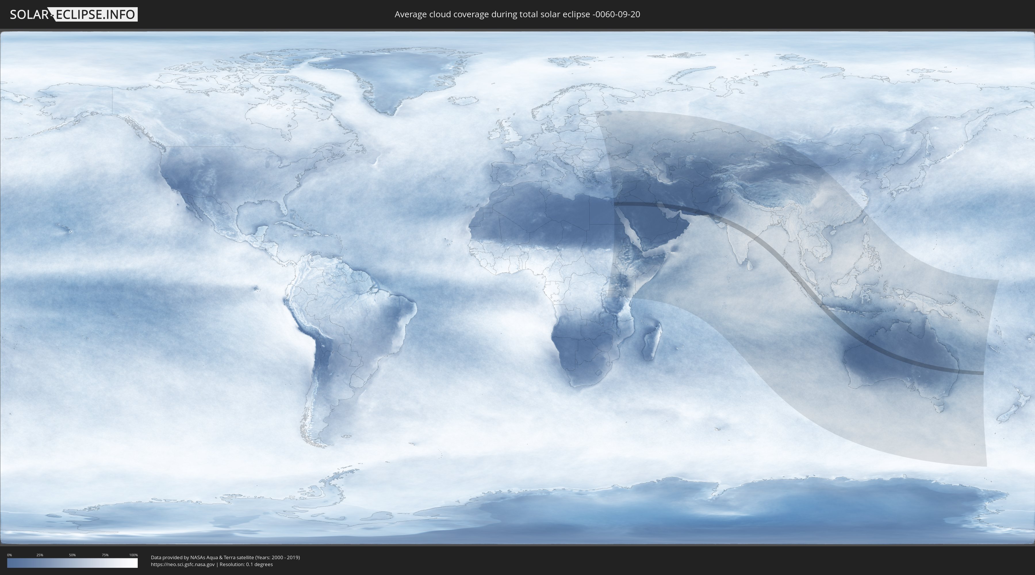
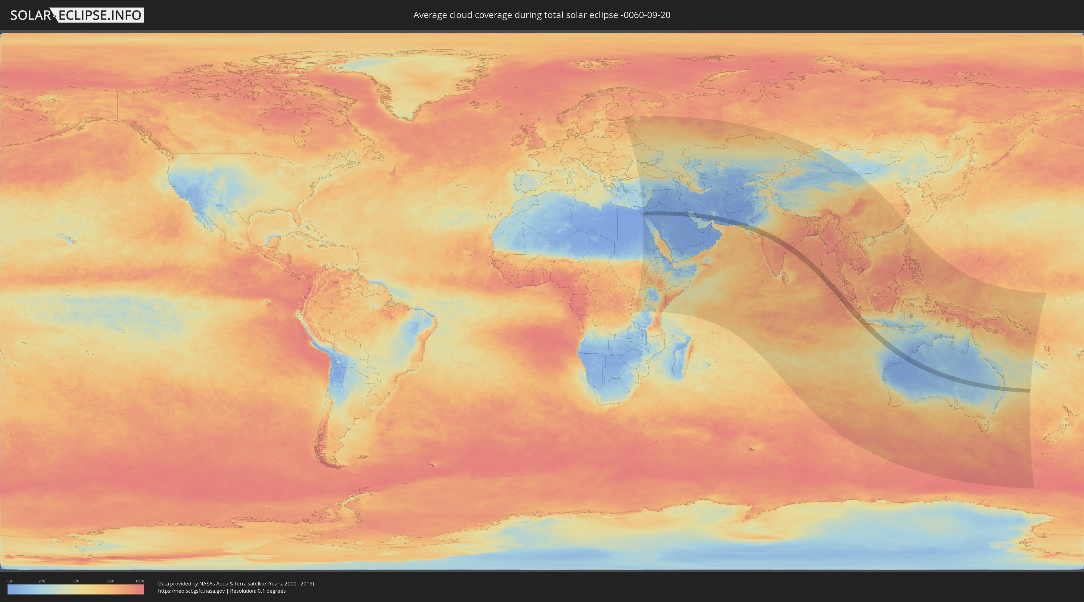
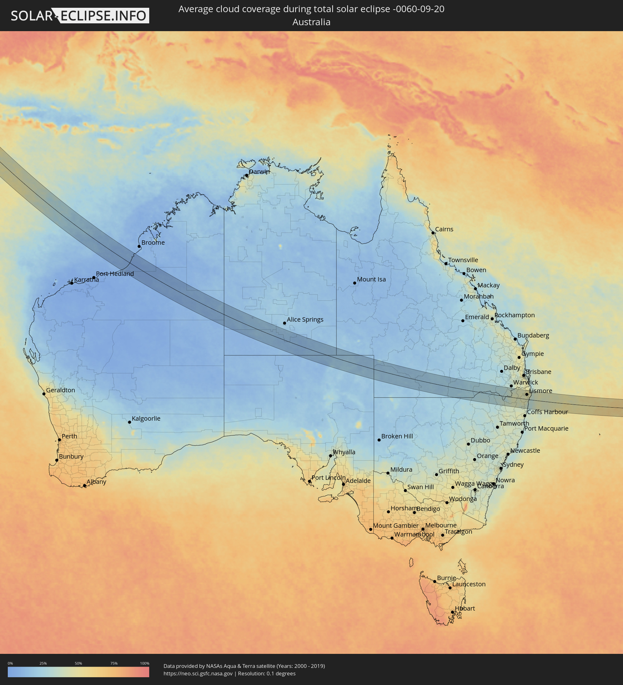
Wie wird das Wetter während der totalen Sonnenfinsternis am 20.09.-0060?
Wo ist der beste Ort, um die totale Sonnenfinsternis vom 20.09.-0060 zu beobachten?
Die folgenden Karten zeigen die durchschnittliche Bewölkung für den Tag, an dem die totale Sonnenfinsternis
stattfindet. Mit Hilfe der Karten lässt sich der Ort entlang des Finsternispfades eingrenzen,
der die besten Aussichen auf einen klaren wolkenfreien Himmel bietet.
Trotzdem muss man immer lokale Gegenenheiten beachten und sollte sich genau über das Wetter an seinem
gewählten Beobachtungsort informieren.
Die Daten stammen von den beiden NASA-Satelliten
AQUA und TERRA
und wurden über einen Zeitraum von 19 Jahren (2000 - 2019) gemittelt.
Detaillierte Länderkarten
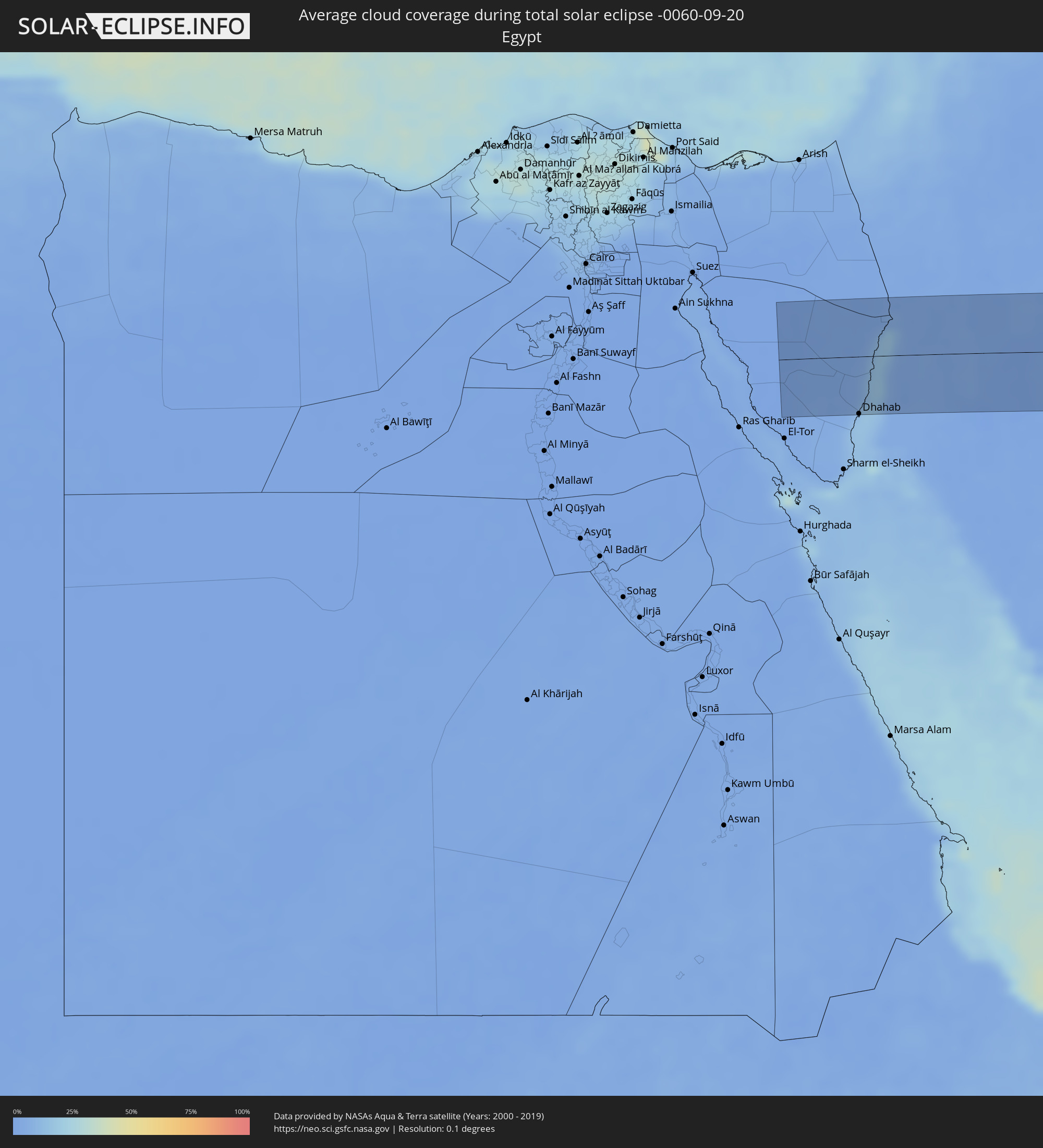 Ägypten
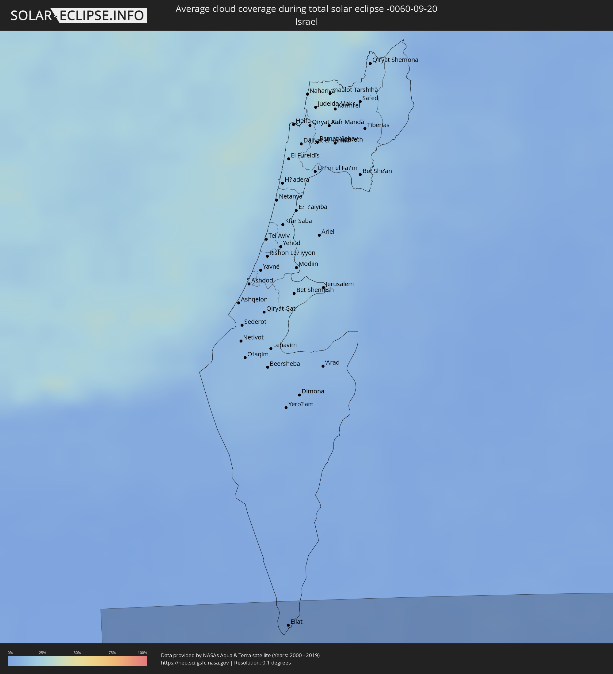 Israel
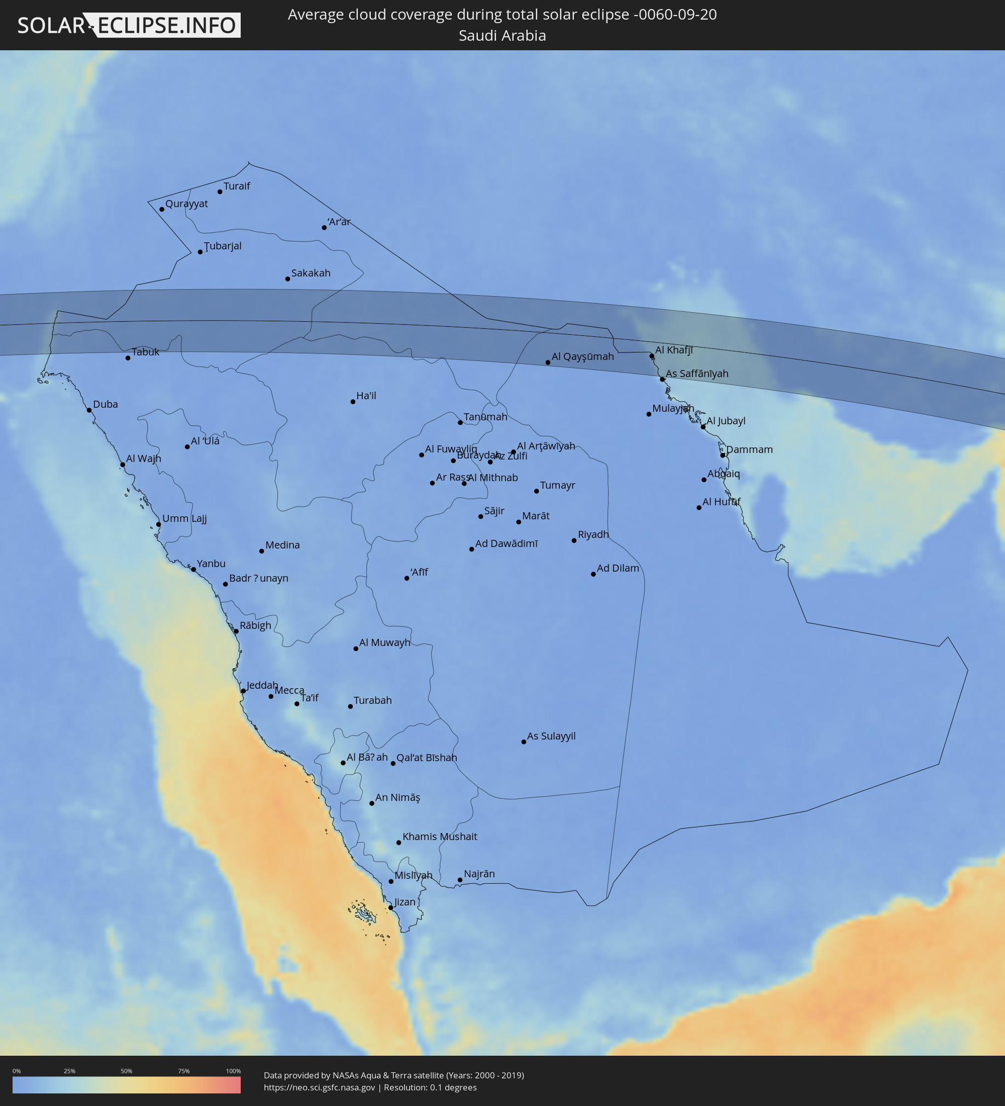 Saudi-Arabien
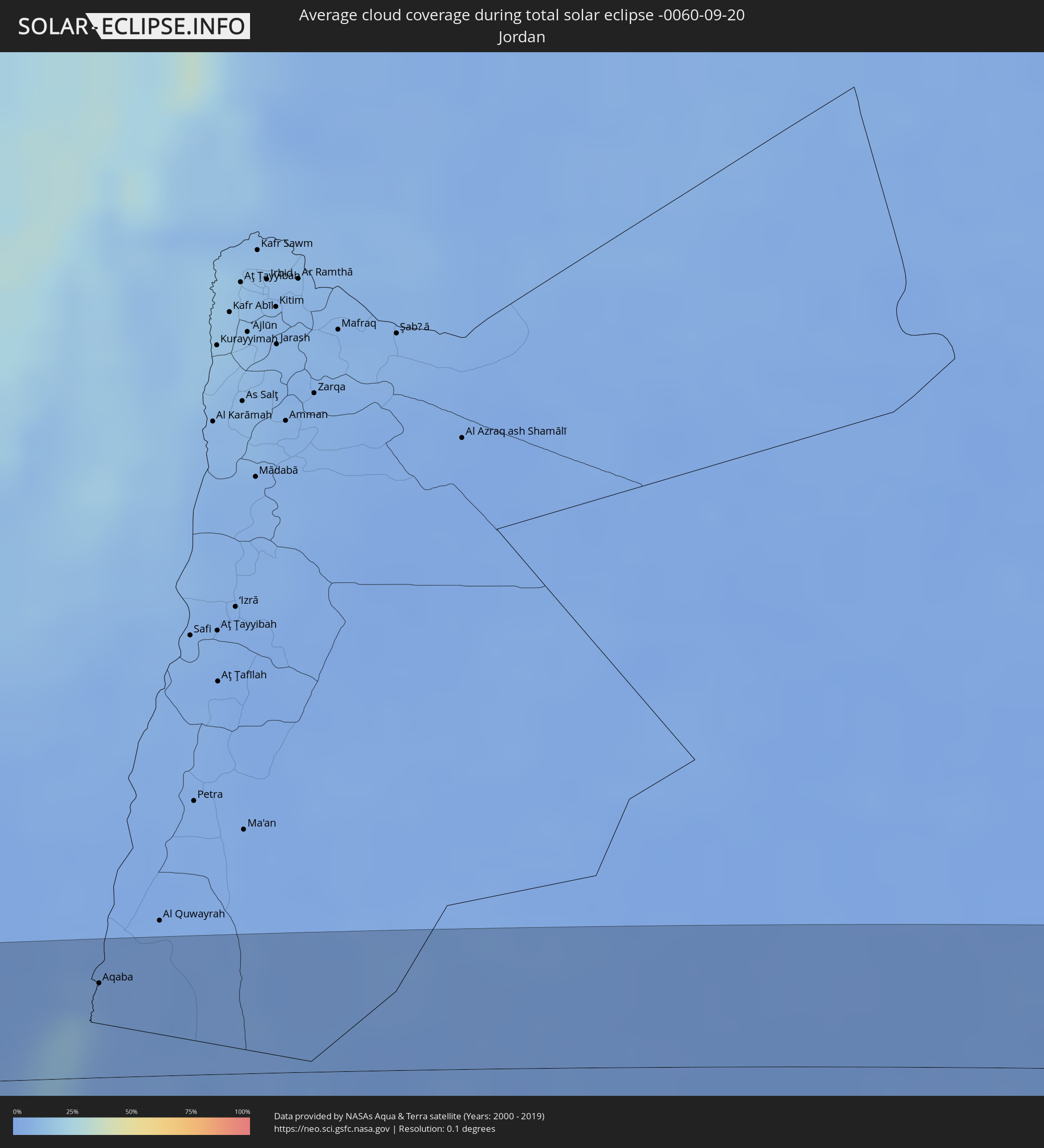 Jordanien
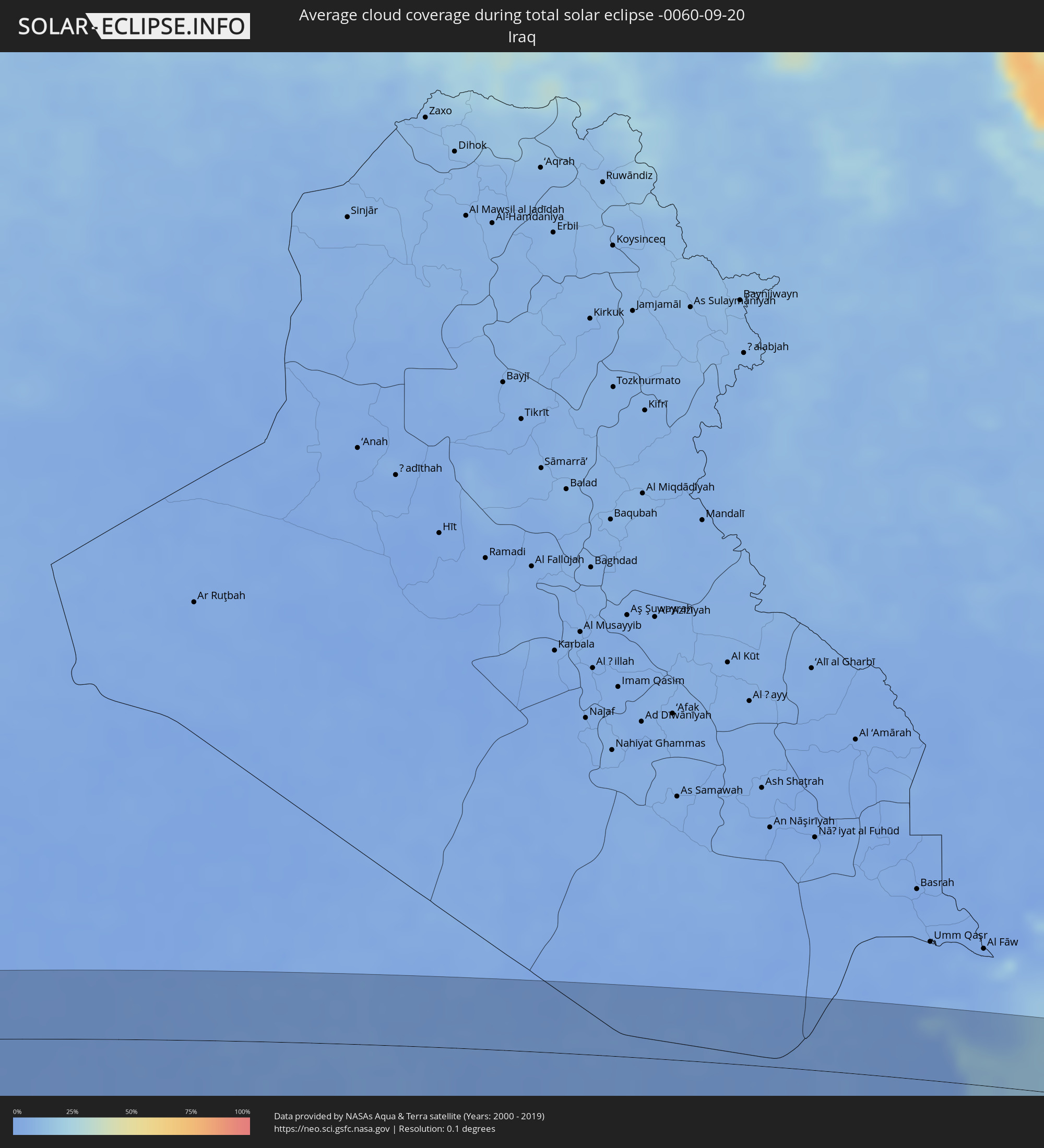 Irak
Irak
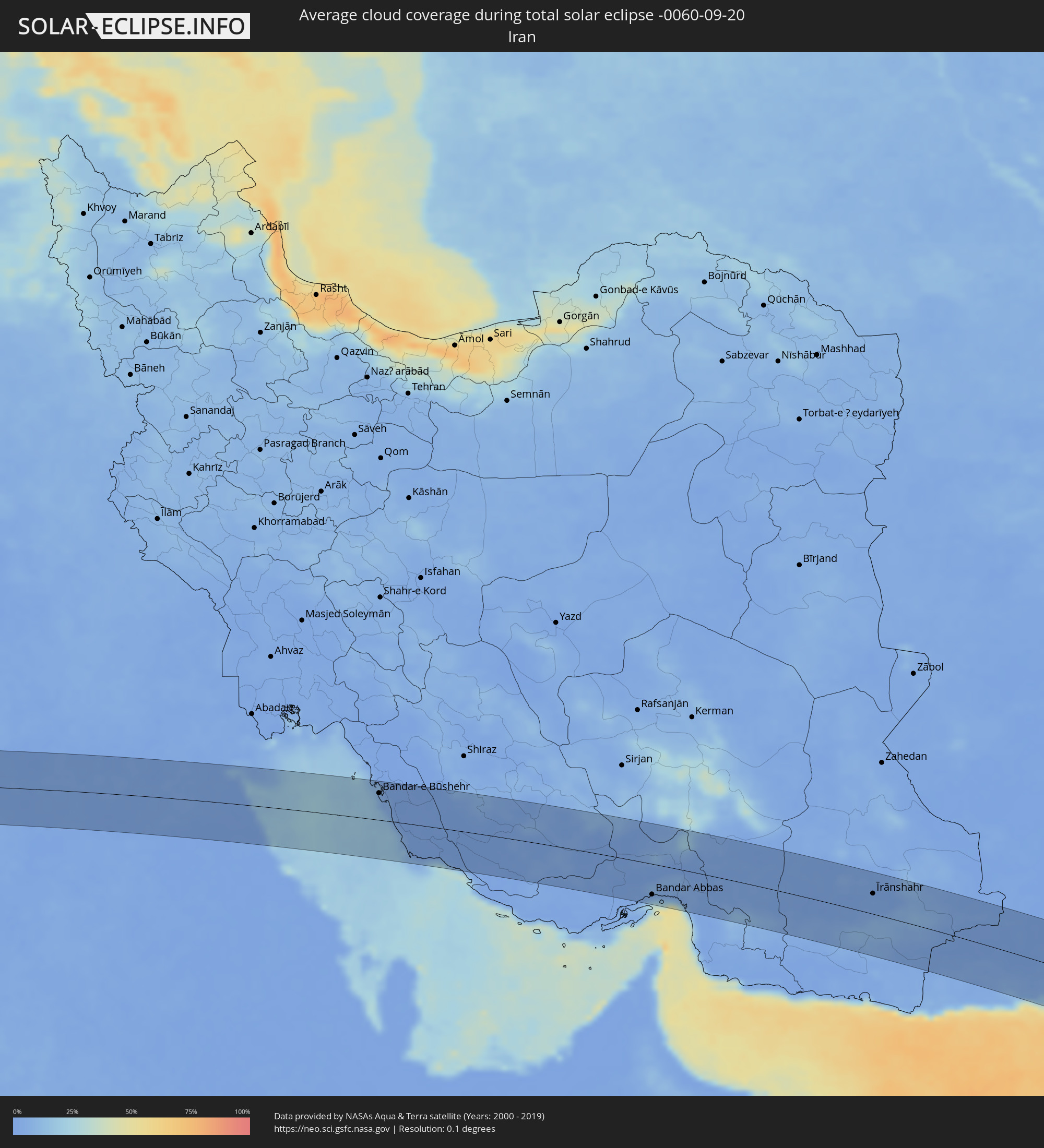 Iran
Iran
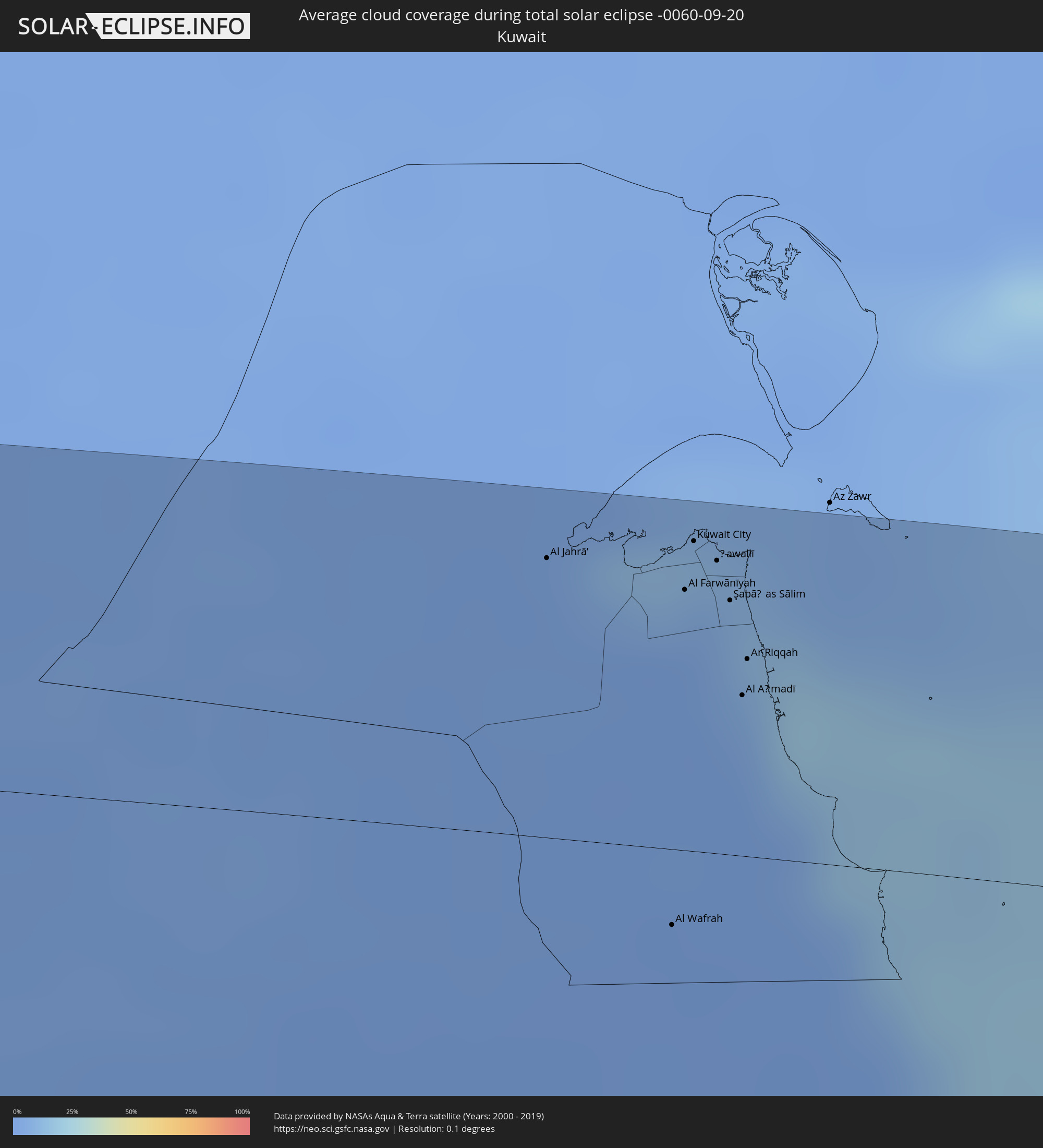 Kuwait
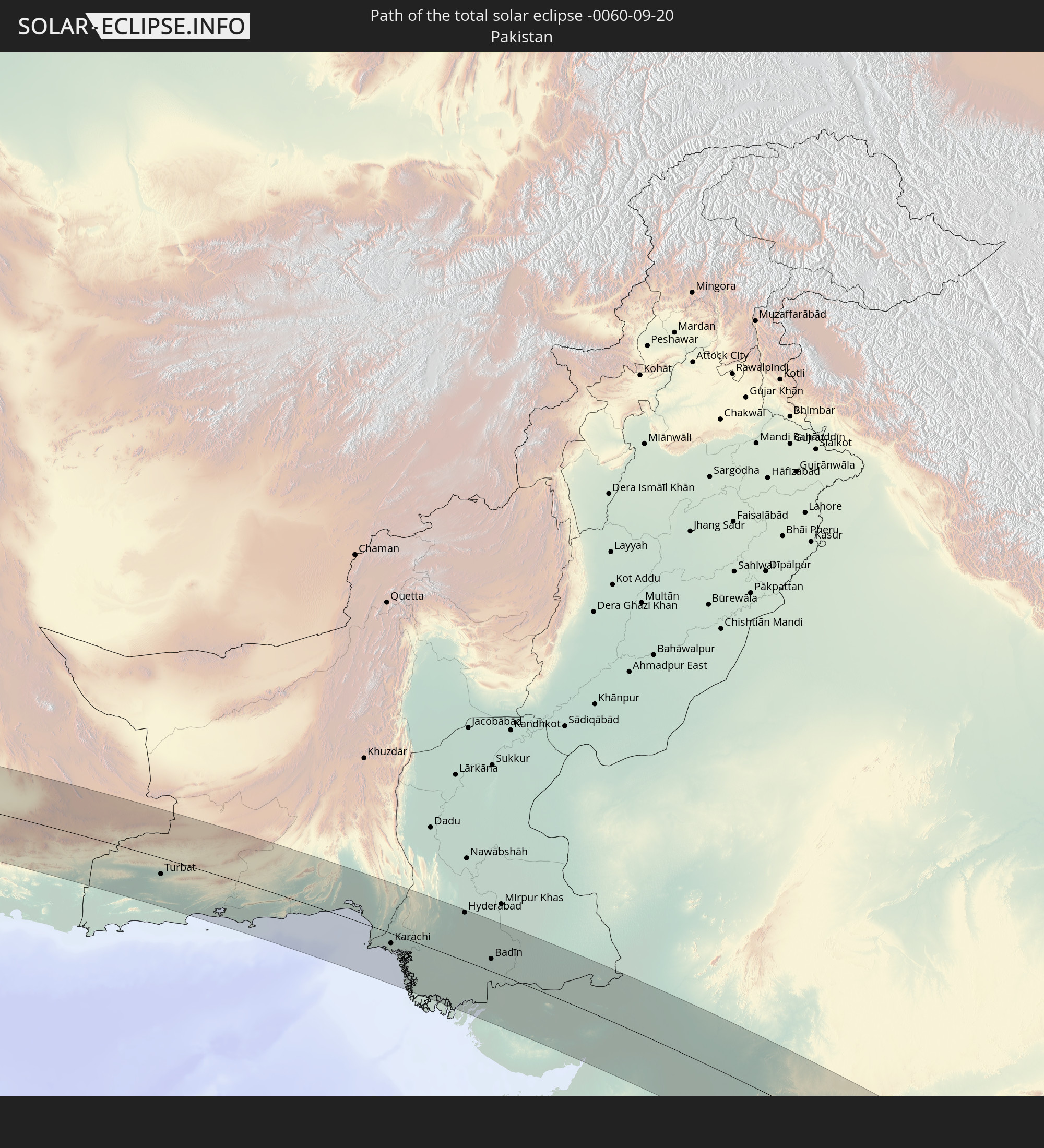
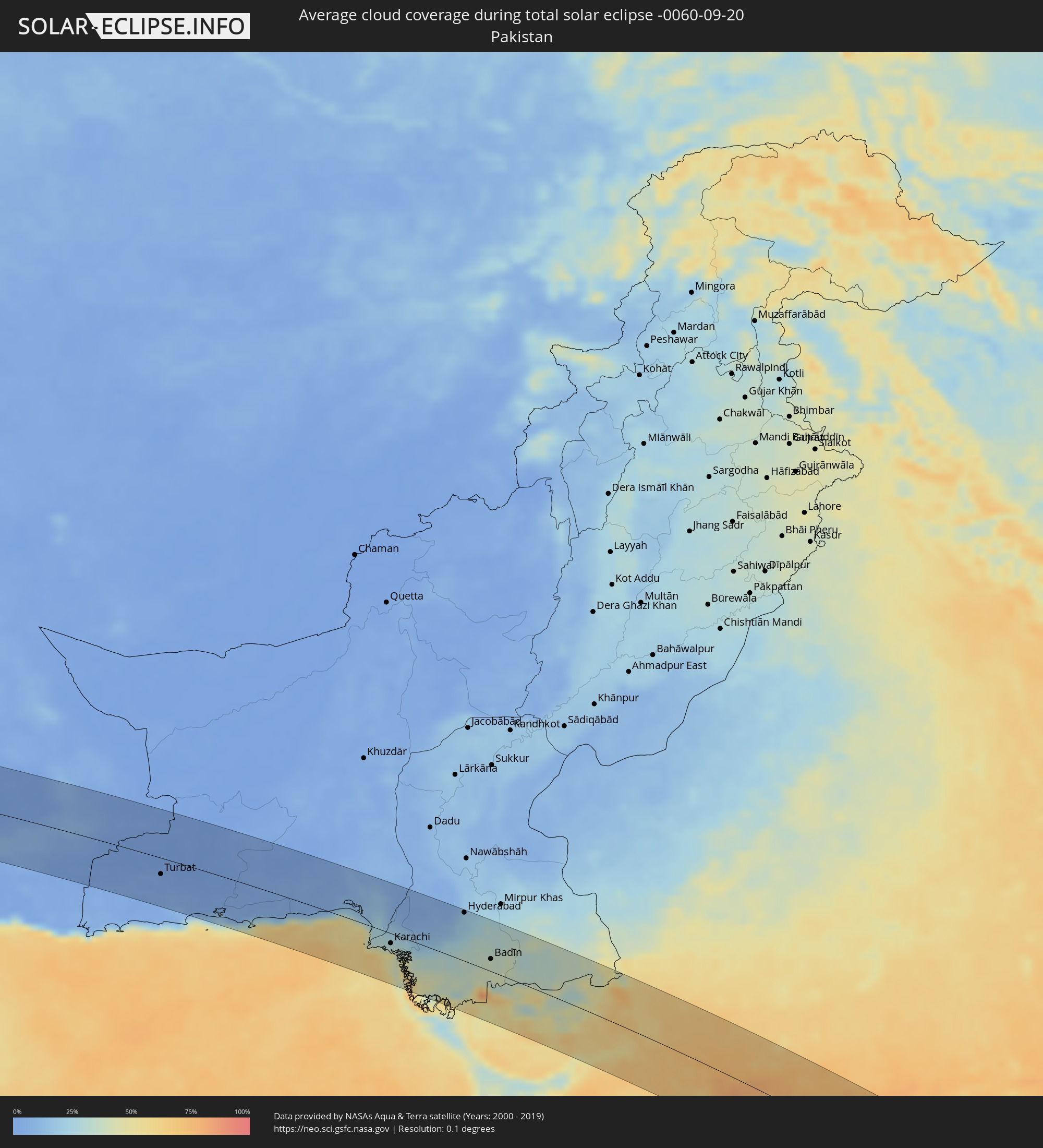 Pakistan
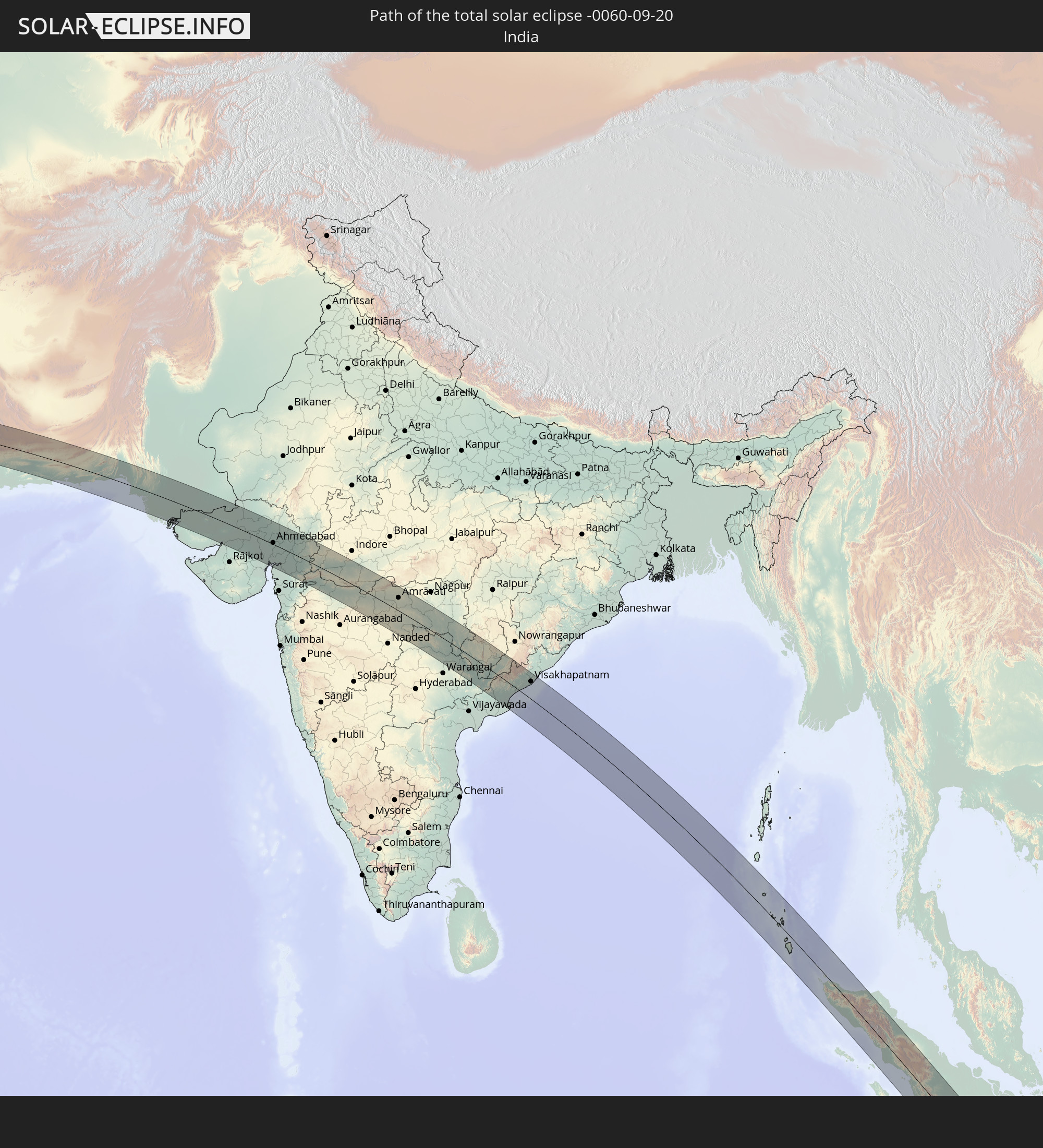
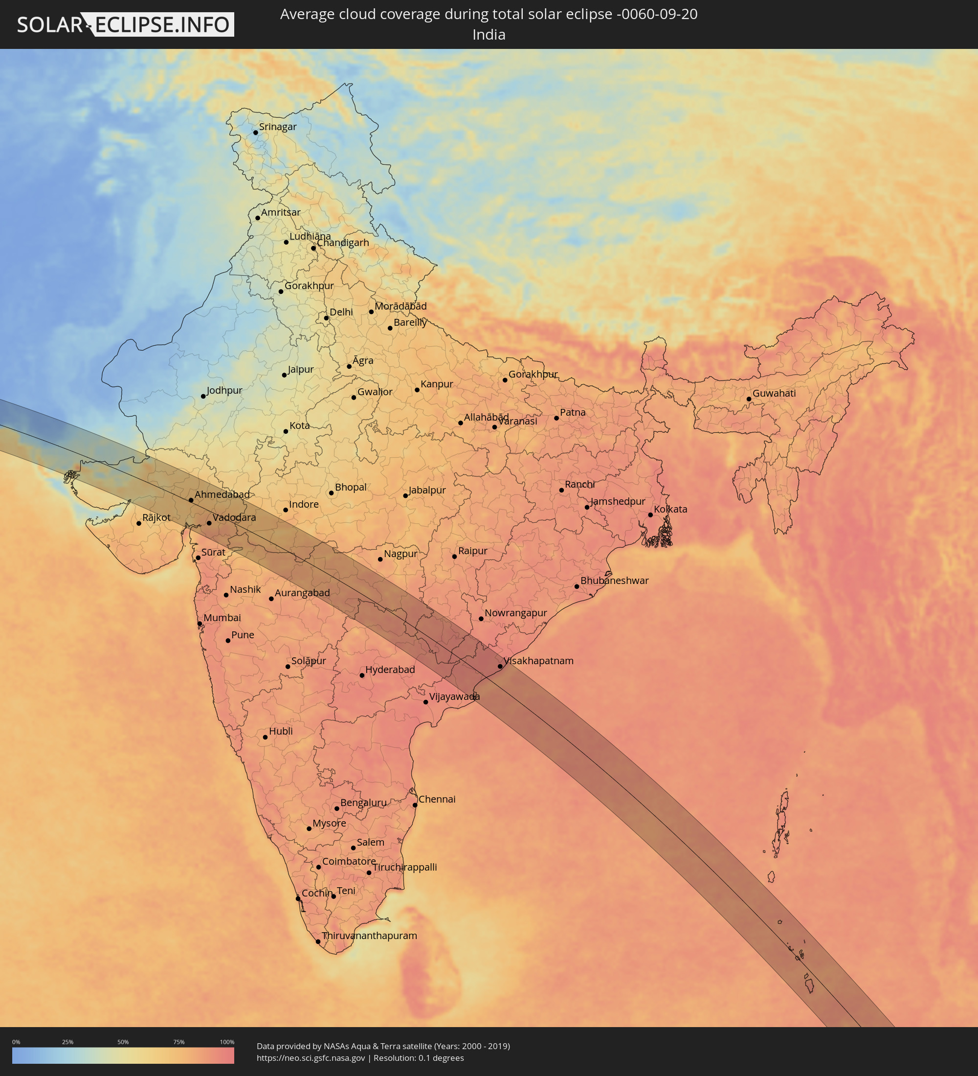 Indien
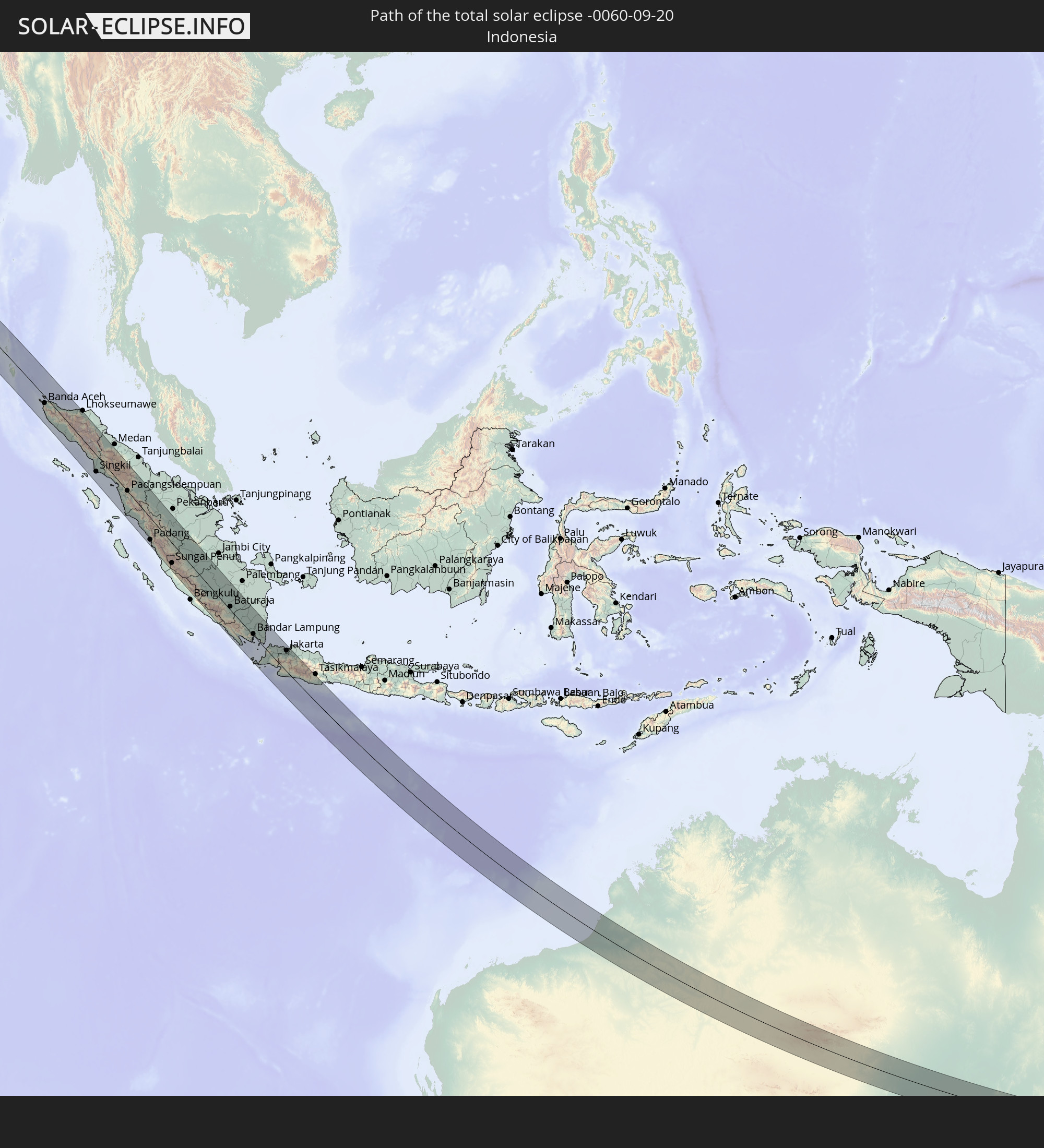
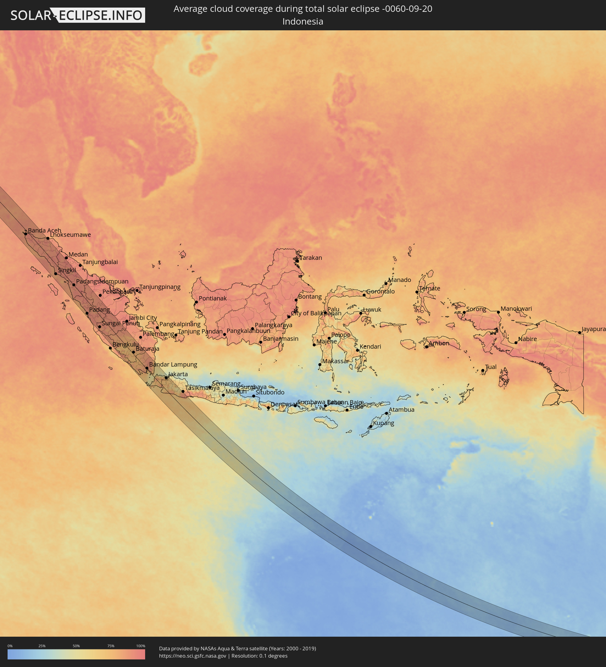 Indonesien
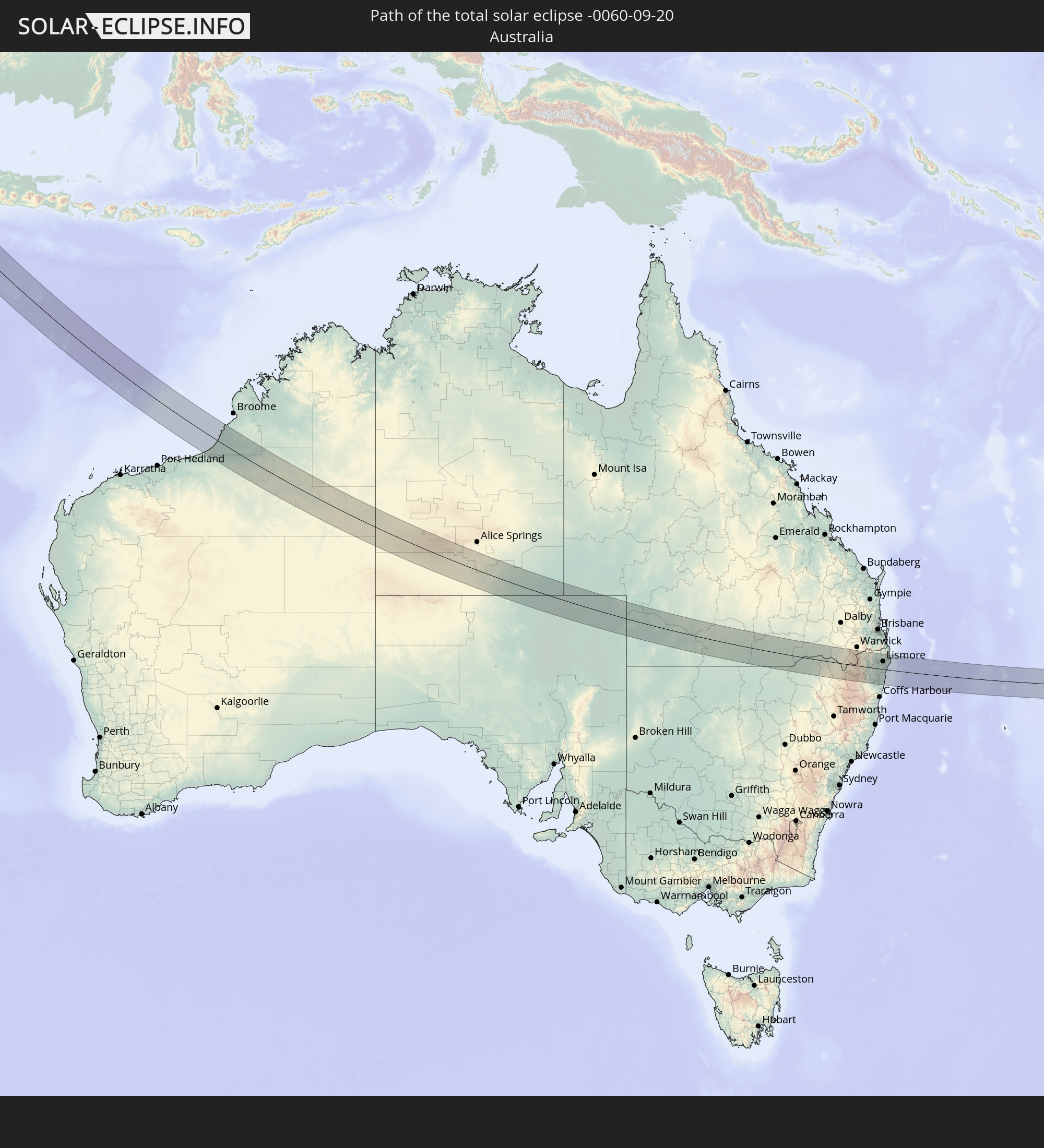
 Australien
Orte im Finsternispfad
Die nachfolgene Tabelle zeigt Städte und Orte mit mehr als 5.000 Einwohnern, die sich im Finsternispfad befinden. Städte mit mehr als 100.000 Einwohnern sind dick gekennzeichnet. Mit einem Klick auf den Ort öffnet sich eine Detailkarte die die Lage des jeweiligen Ortes zusammen mit dem Verlauf der zentralen Finsternis präsentiert.
| Ort | Typ | Dauer der Verfinsterung | Ortszeit bei maximaler Verfinsterung | Entfernung zur Zentrallinie | Ø Bewölkung |
|
Dhahab, South Sinai
|
total | - | 05:35:32 UTC+02:00 | 67 km | 14% |
|
Eilat, Southern District
|
total | - | 05:56:14 UTC+02:20 | 50 km | 5% |
|
Aqaba, Aqaba
|
total | - | 05:59:18 UTC+02:23 | 46 km | 9% |
|
Al Qayşūmah, Eastern Province
|
total | - | 06:44:31 UTC+03:06 | 67 km | 1% |
|
Al Jahrā’, Al Jahrāʼ
|
total | - | 06:44:57 UTC+03:06 | 59 km | 1% |
|
Al Wafrah, Al Aḩmadī
|
total | - | 06:45:08 UTC+03:06 | 16 km | 1% |
|
Ar Rābiyah, Al Asimah
|
total | - | 06:45:04 UTC+03:06 | 57 km | 1% |
|
Al Farwānīyah, Al Farwaniyah
|
total | - | 06:45:04 UTC+03:06 | 55 km | 3% |
|
Ash Shāmīyah, Al Asimah
|
total | - | 06:45:04 UTC+03:06 | 63 km | 3% |
|
Janūb as Surrah, Al Farwaniyah
|
total | - | 06:45:05 UTC+03:06 | 54 km | 3% |
|
Kuwait City, Al Asimah
|
total | - | 06:45:04 UTC+03:06 | 65 km | 6% |
|
Ad Dasmah, Al Asimah
|
total | - | 06:45:05 UTC+03:06 | 65 km | 6% |
|
Ḩawallī, Hawalli
|
total | - | 06:45:05 UTC+03:06 | 62 km | 3% |
|
Bayān, Hawalli
|
total | - | 06:45:06 UTC+03:06 | 59 km | 3% |
|
Şabāḩ as Sālim, Mubārak al Kabīr
|
total | - | 06:45:07 UTC+03:06 | 54 km | 11% |
|
Ar Rumaythīyah, Hawalli
|
total | - | 06:45:07 UTC+03:06 | 60 km | 11% |
|
As Sālimīyah, Hawalli
|
total | - | 06:45:07 UTC+03:06 | 62 km | 11% |
|
Salwá, Hawalli
|
total | - | 06:45:07 UTC+03:06 | 58 km | 11% |
|
Al Aḩmadī, Al Aḩmadī
|
total | - | 06:45:08 UTC+03:06 | 34 km | 4% |
|
Ar Riqqah, Al Aḩmadī
|
total | - | 06:45:08 UTC+03:06 | 42 km | 4% |
|
Al Finţās, Al Aḩmadī
|
total | - | 06:45:09 UTC+03:06 | 45 km | 7% |
|
Al Faḩāḩīl, Al Aḩmadī
|
total | - | 06:45:09 UTC+03:06 | 35 km | 4% |
|
Al Mahbūlah, Al Aḩmadī
|
total | - | 06:45:09 UTC+03:06 | 42 km | 4% |
|
Al Manqaf, Al Aḩmadī
|
total | - | 06:45:09 UTC+03:06 | 37 km | 4% |
|
Al Khafjī, Eastern Province
|
total | - | 06:45:23 UTC+03:06 | 33 km | 7% |
|
Bandar-e Būshehr, Bushehr
|
total | - | 07:05:12 UTC+03:25 | 52 km | 6% |
|
Fīrūzābād, Fars
|
total | - | 07:06:04 UTC+03:25 | 61 km | 3% |
|
Gerāsh, Fars
|
total | - | 07:07:11 UTC+03:25 | 45 km | 3% |
|
Bandar Abbas, Hormozgan
|
total | - | 07:08:39 UTC+03:25 | 59 km | 19% |
|
Mīnāb, Hormozgan
|
total | - | 07:09:13 UTC+03:25 | 49 km | 2% |
|
Īrānshahr, Sistan and Baluchestan
|
total | - | 07:11:50 UTC+03:25 | 39 km | 2% |
|
Qaşr-e Qand, Sistan and Baluchestan
|
total | - | 07:12:17 UTC+03:25 | 62 km | 5% |
|
Turbat, Balochistān
|
total | - | 08:16:48 UTC+04:28 | 27 km | 3% |
|
Ormāra, Balochistān
|
total | - | 08:18:41 UTC+04:28 | 65 km | 47% |
|
Uthal, Balochistān
|
total | - | 08:20:15 UTC+04:28 | 62 km | 11% |
|
Gadāni, Balochistān
|
total | - | 08:20:47 UTC+04:28 | 6 km | 43% |
|
Karachi, Sindh
|
total | - | 08:21:16 UTC+04:28 | 16 km | 34% |
|
Ghāro, Sindh
|
total | - | 08:21:54 UTC+04:28 | 16 km | 33% |
|
Thatta, Sindh
|
total | - | 08:22:15 UTC+04:28 | 3 km | 32% |
|
Chuhar Jamāli, Sindh
|
total | - | 08:22:34 UTC+04:28 | 38 km | 38% |
|
Hyderabad, Sindh
|
total | - | 08:22:17 UTC+04:28 | 80 km | 19% |
|
Tando Muhammad Khān, Sindh
|
total | - | 08:22:38 UTC+04:28 | 58 km | 26% |
|
Mātli, Sindh
|
total | - | 08:22:49 UTC+04:28 | 54 km | 33% |
|
Talhār, Sindh
|
total | - | 08:23:06 UTC+04:28 | 43 km | 34% |
|
Badīn, Sindh
|
total | - | 08:23:17 UTC+04:28 | 20 km | 37% |
|
Tando Ghulām Ali, Sindh
|
total | - | 08:22:59 UTC+04:28 | 71 km | 31% |
|
Tando Bāgo, Sindh
|
total | - | 08:23:20 UTC+04:28 | 39 km | 33% |
|
Digri, Sindh
|
total | - | 08:23:14 UTC+04:28 | 82 km | 30% |
|
Naukot, Sindh
|
total | - | 08:23:45 UTC+04:28 | 63 km | 35% |
|
Diplo, Sindh
|
total | - | 08:24:14 UTC+04:28 | 29 km | 33% |
|
Mithi, Sindh
|
total | - | 08:24:16 UTC+04:28 | 65 km | 32% |
|
Islāmkot, Sindh
|
total | - | 08:24:43 UTC+04:28 | 76 km | 38% |
|
Surendranagar, Gujarat
|
total | - | 09:20:58 UTC+05:21 | 65 km | 67% |
|
Ahmedabad, Gujarat
|
total | - | 09:21:50 UTC+05:21 | 5 km | 71% |
|
Ghandinagar, Gujarat
|
total | - | 09:21:47 UTC+05:21 | 29 km | 71% |
|
Nadiād, Gujarat
|
total | - | 09:22:28 UTC+05:21 | 16 km | 77% |
|
Ānand, Gujarat
|
total | - | 09:22:43 UTC+05:21 | 26 km | 79% |
|
Vadodara, Gujarat
|
total | - | 09:23:16 UTC+05:21 | 40 km | 81% |
|
Godhra, Gujarat
|
total | - | 09:23:20 UTC+05:21 | 26 km | 78% |
|
Māndu, Madhya Pradesh
|
total | - | 09:25:58 UTC+05:21 | 68 km | 75% |
|
Jalgaon, Maharashtra
|
total | - | 09:27:37 UTC+05:21 | 57 km | 80% |
|
Bhusāval, Maharashtra
|
total | - | 09:27:52 UTC+05:21 | 42 km | 81% |
|
Burhānpur, Madhya Pradesh
|
total | - | 09:28:11 UTC+05:21 | 6 km | 84% |
|
Khandwa, Madhya Pradesh
|
total | - | 09:27:48 UTC+05:21 | 62 km | 78% |
|
Akola, Maharashtra
|
total | - | 09:29:53 UTC+05:21 | 13 km | 82% |
|
Amrāvati, Maharashtra
|
total | - | 09:30:40 UTC+05:21 | 48 km | 80% |
|
Yavatmāl, Maharashtra
|
total | - | 09:31:49 UTC+05:21 | 17 km | 83% |
|
Chānda, Maharashtra
|
total | - | 09:34:00 UTC+05:21 | 38 km | 85% |
|
Rāmgundam, Telangana
|
total | - | 09:35:40 UTC+05:21 | 61 km | 87% |
|
Rājahmundry, Andhra Pradesh
|
total | - | 09:41:37 UTC+05:21 | 88 km | 92% |
|
Kākināda, Andhra Pradesh
|
total | - | 09:42:24 UTC+05:21 | 63 km | 91% |
|
Visakhapatnam, Andhra Pradesh
|
total | - | 09:42:53 UTC+05:21 | 62 km | 92% |
|
Banda Aceh, Aceh
|
total | - | 12:11:27 UTC+07:07 | 24 km | 90% |
|
Padang, West Sumatra
|
total | - | 12:34:02 UTC+07:07 | 76 km | 90% |
|
Lubuklinggau, South Sumatra
|
total | - | 12:43:20 UTC+07:07 | 35 km | 79% |
|
Baturaja, South Sumatra
|
total | - | 12:47:20 UTC+07:07 | 12 km | 77% |
|
Bandar Lampung, Lampung
|
total | - | 12:51:50 UTC+07:07 | 6 km | 77% |
|
Metro, Lampung
|
total | - | 12:51:18 UTC+07:07 | 33 km | 86% |
|
Serang, Banten
|
total | - | 12:54:44 UTC+07:07 | 27 km | 76% |
|
Rangkasbitung, Banten
|
total | - | 12:55:22 UTC+07:07 | 16 km | 71% |
|
Tangerang, Banten
|
total | - | 12:55:40 UTC+07:07 | 61 km | 77% |
|
South Tangerang, Banten
|
total | - | 12:56:02 UTC+07:07 | 60 km | 75% |
|
Bogor, West Java
|
total | - | 12:56:45 UTC+07:07 | 42 km | 69% |
|
Depok, West Java
|
total | - | 12:56:26 UTC+07:07 | 59 km | 71% |
|
Jakarta, Jakarta
|
total | - | 12:56:07 UTC+07:07 | 75 km | 71% |
|
Sukabumi, West Java
|
total | - | 12:57:37 UTC+07:07 | 28 km | 68% |
|
Cileungsir, West Java
|
total | - | 12:56:39 UTC+07:07 | 71 km | 67% |
|
Bekasi, West Java
|
total | - | 12:56:24 UTC+07:07 | 86 km | 67% |
|
Padalarang, West Java
|
total | - | 12:58:23 UTC+07:07 | 79 km | 65% |
|
Soreang, West Java
|
total | - | 12:58:50 UTC+07:07 | 67 km | 58% |
|
Bandung, West Java
|
total | - | 12:58:47 UTC+07:07 | 83 km | 54% |
|
Paseh, West Java
|
total | - | 12:59:23 UTC+07:07 | 82 km | 61% |
|
Goondiwindi, Queensland
|
total | - | 16:59:19 UTC+10:00 | 24 km | 25% |
|
Gordon, New South Wales
|
total | - | 17:00:04 UTC+10:00 | 25 km | 38% |
|
South Grafton, New South Wales
|
total | - | 17:00:09 UTC+10:00 | 67 km | 40% |
|
Grafton, New South Wales
|
total | - | 17:00:09 UTC+10:00 | 64 km | 40% |
|
Casino, New South Wales
|
total | - | 17:00:05 UTC+10:00 | 28 km | 42% |
|
Lismore, New South Wales
|
total | - | 17:00:08 UTC+10:00 | 36 km | 45% |
|
East Lismore, New South Wales
|
total | - | 17:00:08 UTC+10:00 | 34 km | 45% |
|
Goonellabah, New South Wales
|
total | - | 17:00:08 UTC+10:00 | 36 km | 45% |
|
Ballina, New South Wales
|
total | - | 17:00:12 UTC+10:00 | 34 km | 34% |
|
East Ballina, New South Wales
|
total | - | 17:00:12 UTC+10:00 | 33 km | 34% |
|
Byron Bay, New South Wales
|
total | - | 17:00:11 UTC+10:00 | 59 km | 39% |