Totale Sonnenfinsternis vom 29.08.-0115
| Wochentag: | Donnerstag |
| Maximale Dauer der Verfinsterung: | 01m36s |
| Maximale Breite des Finsternispfades: | 90 km |
| Saroszyklus: | 62 |
| Bedeckungsgrad: | 100% |
| Magnitude: | 1.021 |
| Gamma: | 0.6167 |
Wo kann man die Sonnenfinsternis vom 29.08.-0115 sehen?
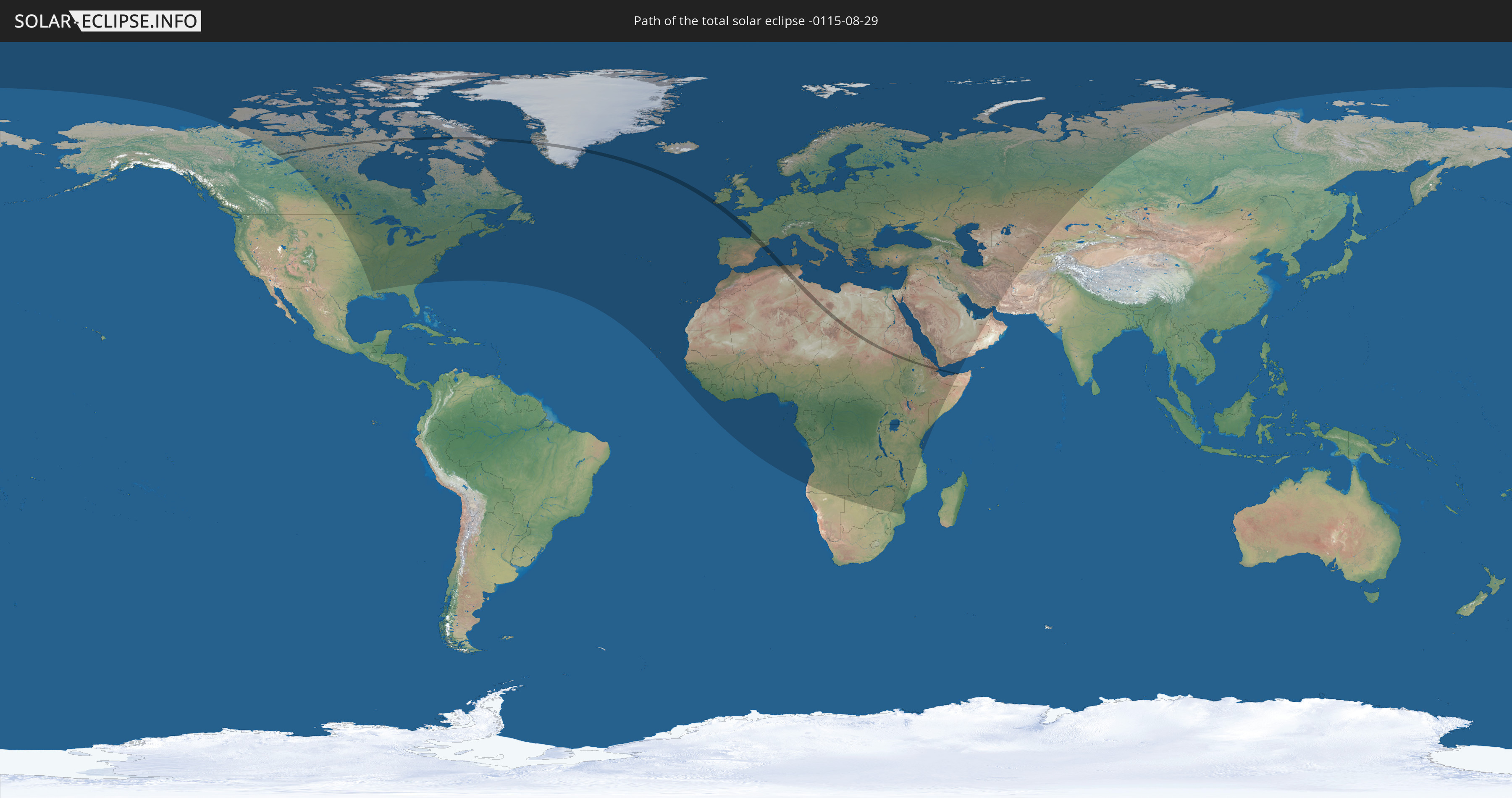
Die Sonnenfinsternis am 29.08.-0115 kann man in 124 Ländern als partielle Sonnenfinsternis beobachten.
Der Finsternispfad verläuft durch 14 Länder. Nur in diesen Ländern ist sie als totale Sonnenfinsternis zu sehen.
In den folgenden Ländern ist die Sonnenfinsternis total zu sehen
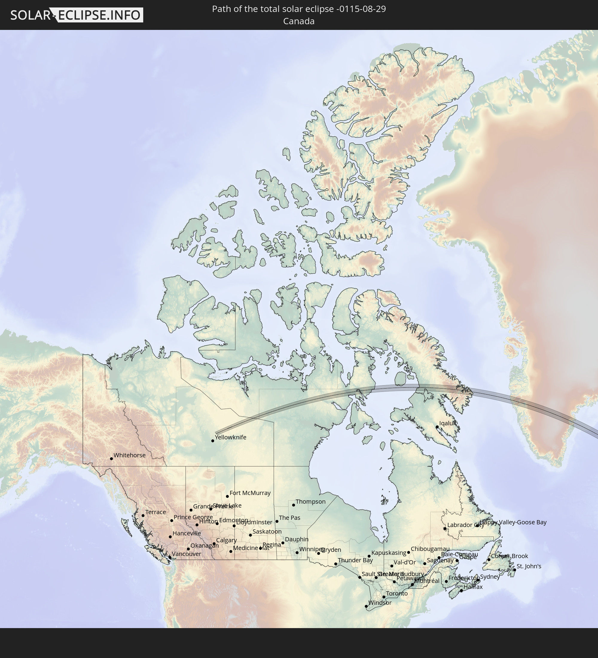 Kanada
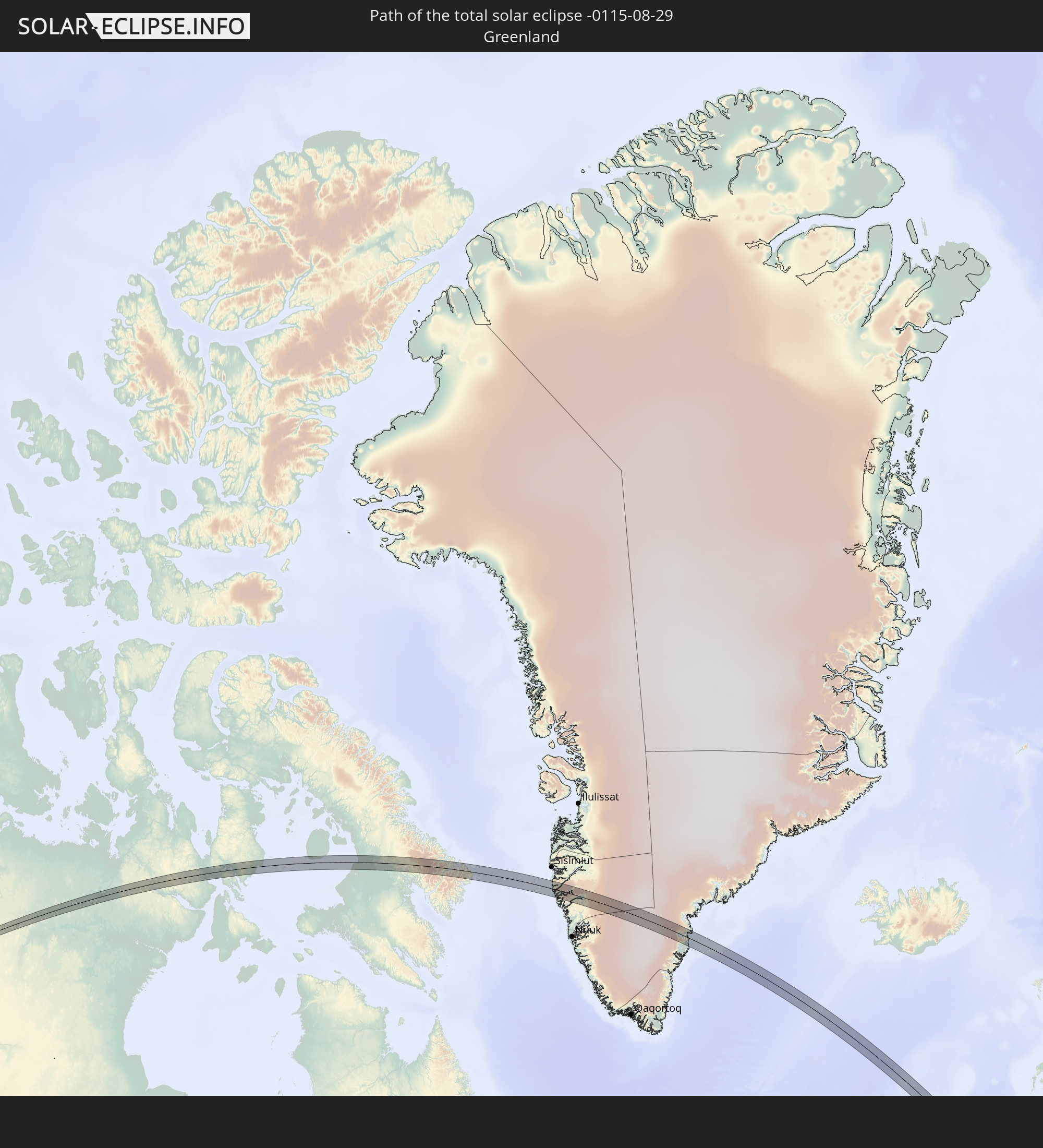 Grönland
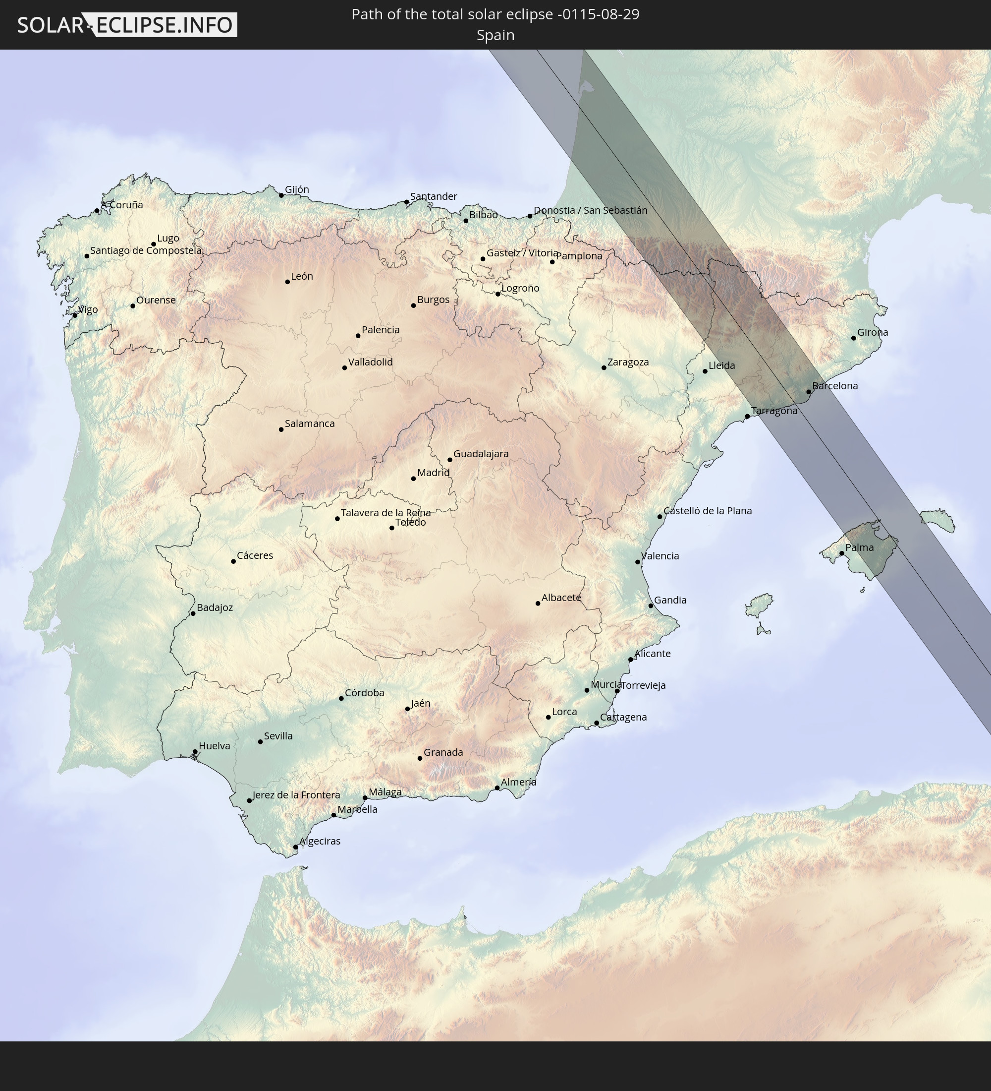 Spanien
 Irland
 Algerien
 Frankreich
 Andorra
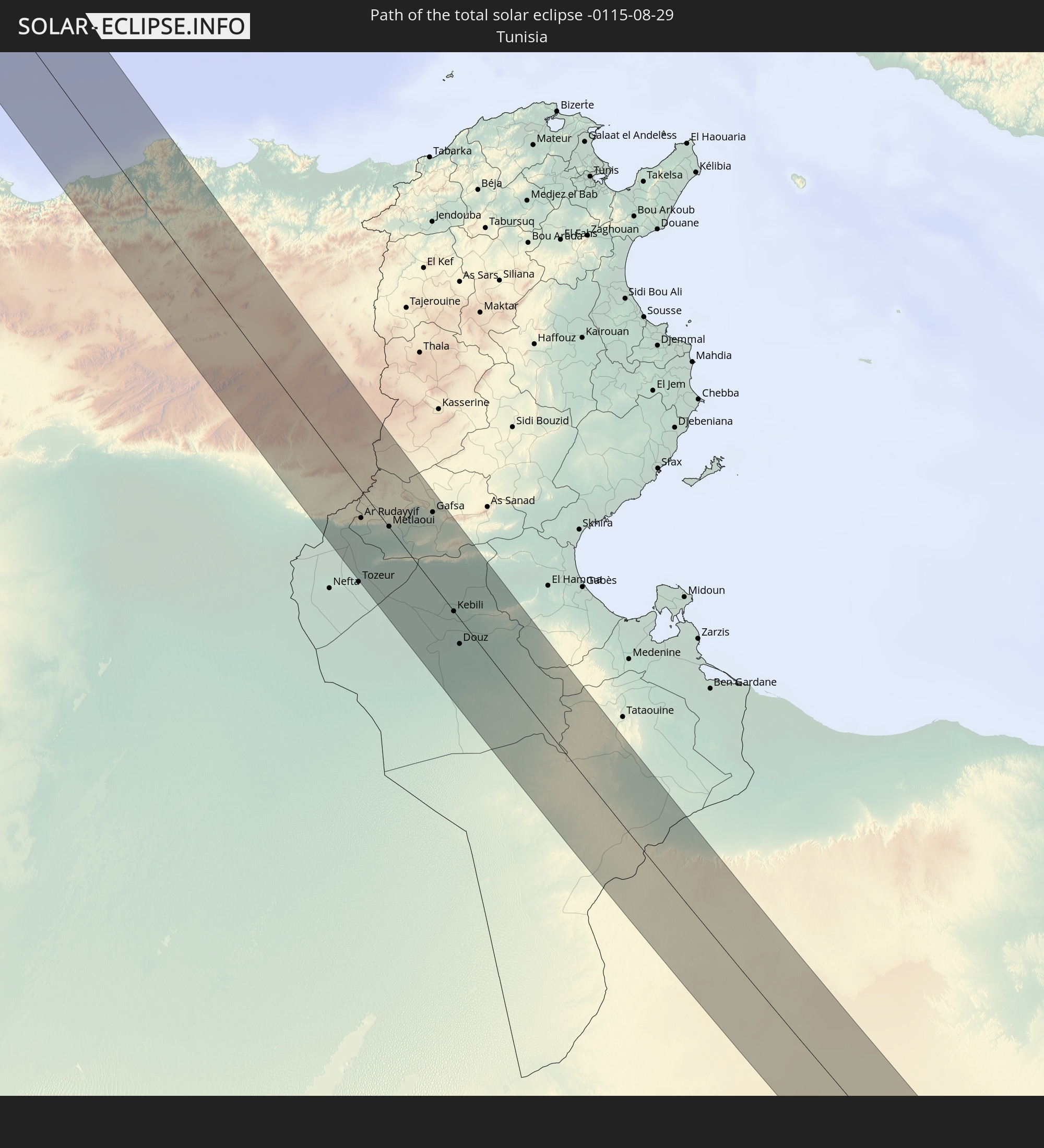 Tunesien
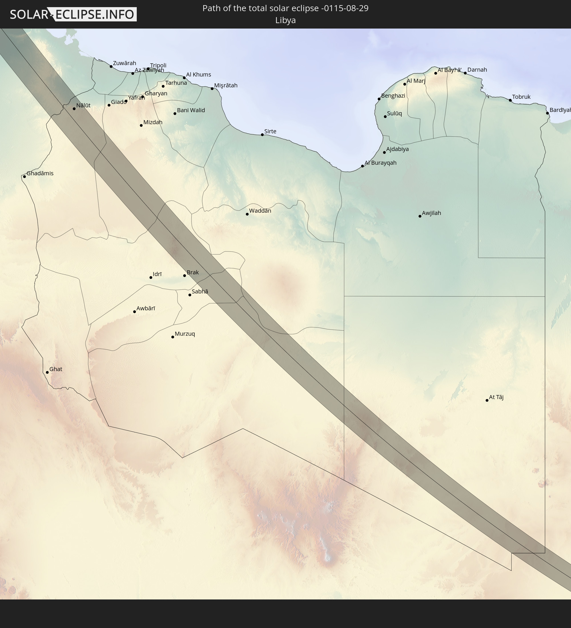 Libyen
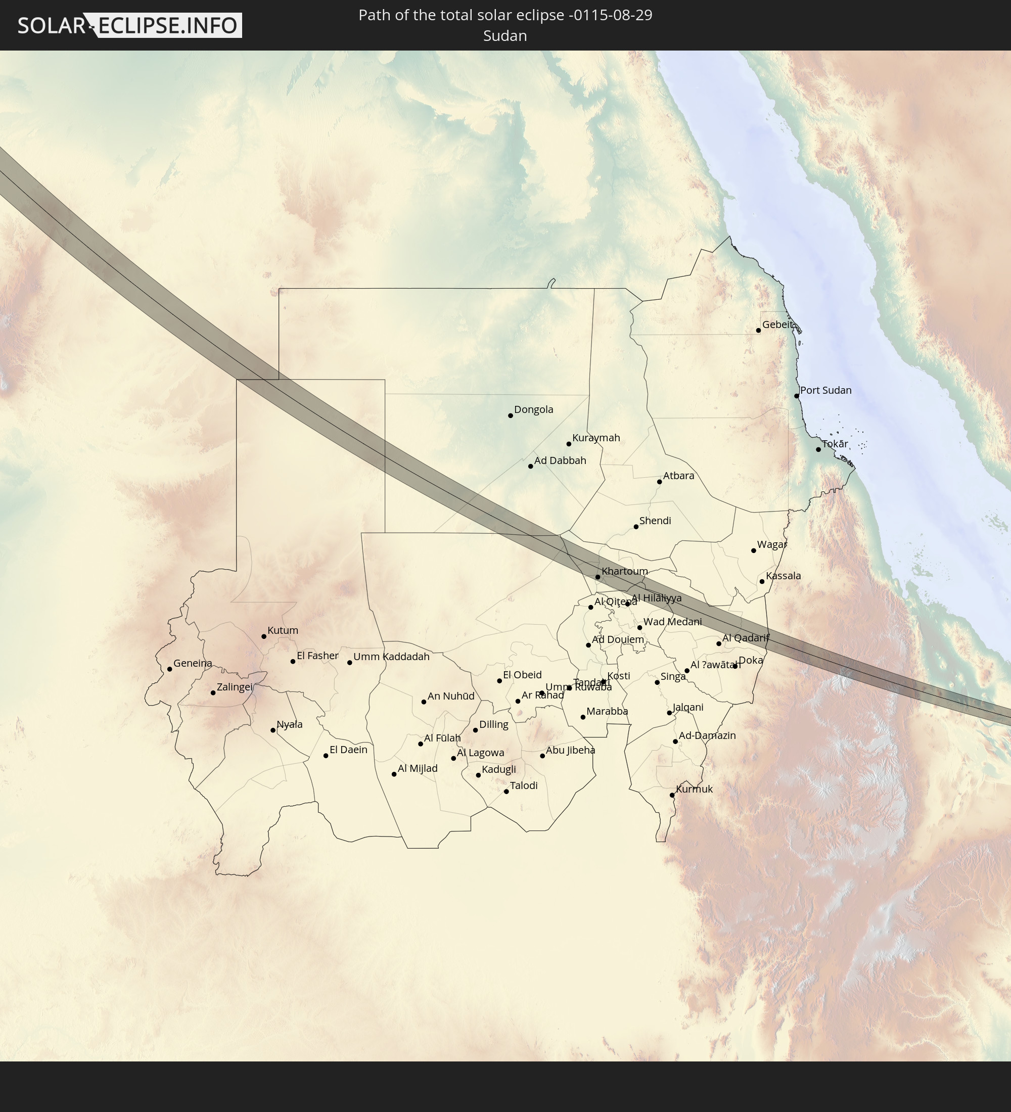 Sudan
Sudan
 Äthiopien
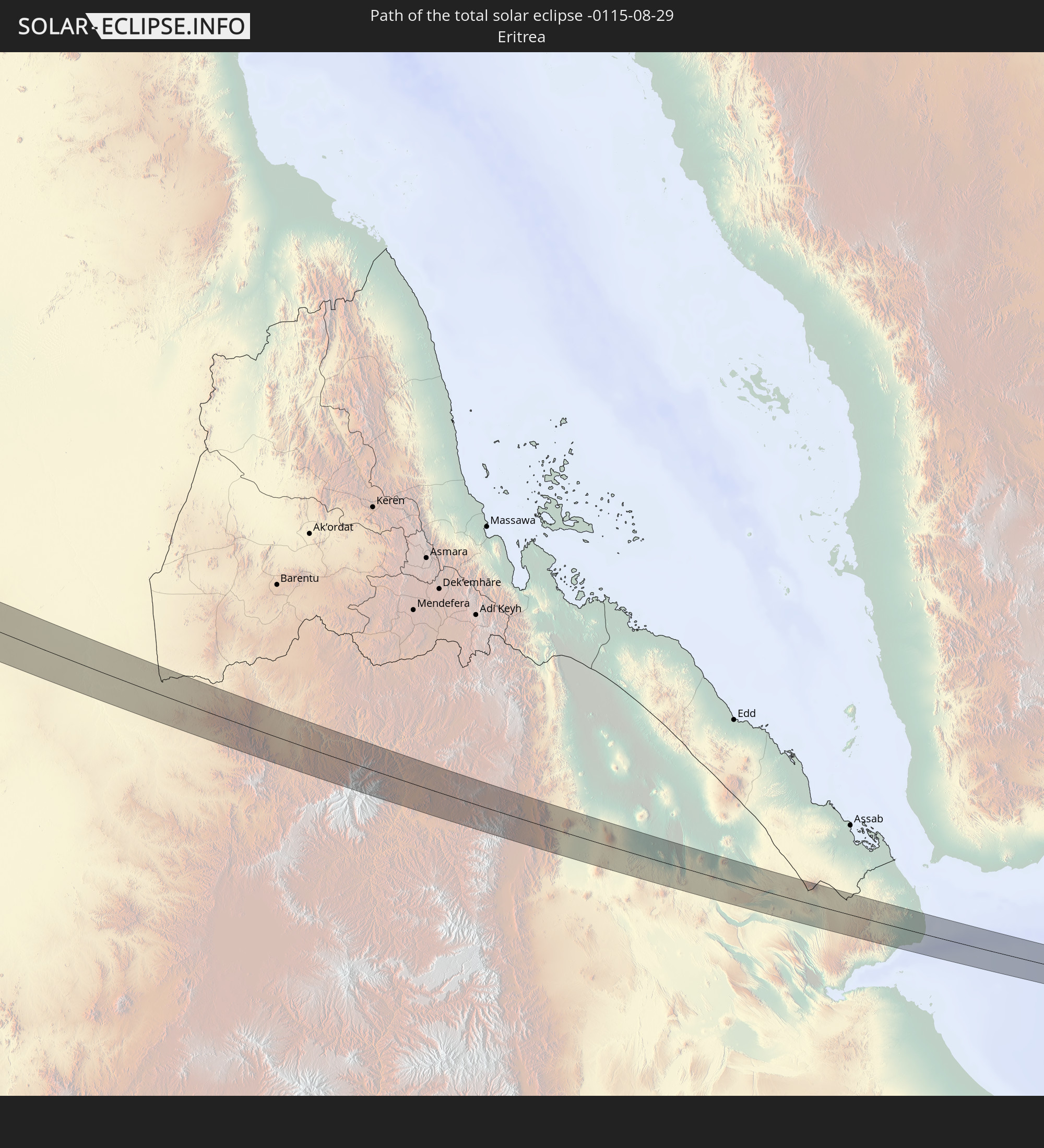 Eritrea
 Somalia
 Dschibuti
In den folgenden Ländern ist die Sonnenfinsternis partiell zu sehen
 Russland
 Vereinigte Staaten
 Kanada
 Grönland
 Saint-Pierre und Miquelon
 Portugal
 Kap Verde
 Island
 Spanien
 Senegal
 Mauretanien
 Gambia
 Guinea-Bissau
 Guinea
 Sierra Leone
 Marokko
 Mali
Mali
 Liberia
 Irland
 Spitzbergen
 Algerien
 Vereinigtes Königreich
 Elfenbeinküste
 Färöer
 Burkina Faso
 Gibraltar
 Frankreich
 Isle of Man
 Ghana
Ghana
 Guernsey
 Jersey
 Togo
Togo
 Niger
Niger
 Benin
Benin
 Andorra
 Belgien
 Nigeria
 Niederlande
 Norwegen
 Äquatorialguinea
 Luxemburg
 Deutschland
 Schweiz
 São Tomé und Príncipe
 Italien
 Monaco
 Tunesien
 Dänemark
 Kamerun
 Gabun
Gabun
 Libyen
 Liechtenstein
 Österreich
 Schweden
 Republik Kongo
 Angola
 Namibia
 Tschechien
 Demokratische Republik Kongo
 San Marino
 Vatikanstadt
 Slowenien
 Tschad
 Kroatien
 Polen
Polen
 Malta
Malta
 Zentralafrikanische Republik
 Bosnien und Herzegowina
 Ungarn
 Slowakei
 Montenegro
 Serbien
 Albanien
 Åland Islands
 Griechenland
 Botswana
 Rumänien
 Mazedonien
 Finnland
 Litauen
 Lettland
 Estland
 Sudan
Sudan
 Sambia
 Ukraine
 Bulgarien
 Weißrussland
 Ägypten
 Simbabwe
 Türkei
 Moldawien
 Ruanda
 Burundi
 Tansania
 Uganda
 Mosambik
 Republik Zypern
 Malawi
 Äthiopien
 Kenia
Kenia
 Staat Palästina
 Israel
 Saudi-Arabien
 Jordanien
 Libanon
 Syrien
 Eritrea
 Irak
Irak
 Georgien
 Somalia
 Dschibuti
 Jemen
Jemen
 Armenien
 Iran
Iran
 Aserbaidschan
 Kasachstan
 Kuwait
 Bahrain
 Katar
Katar
 Vereinigte Arabische Emirate
 Oman
Oman
 Turkmenistan
 Usbekistan
 Afghanistan
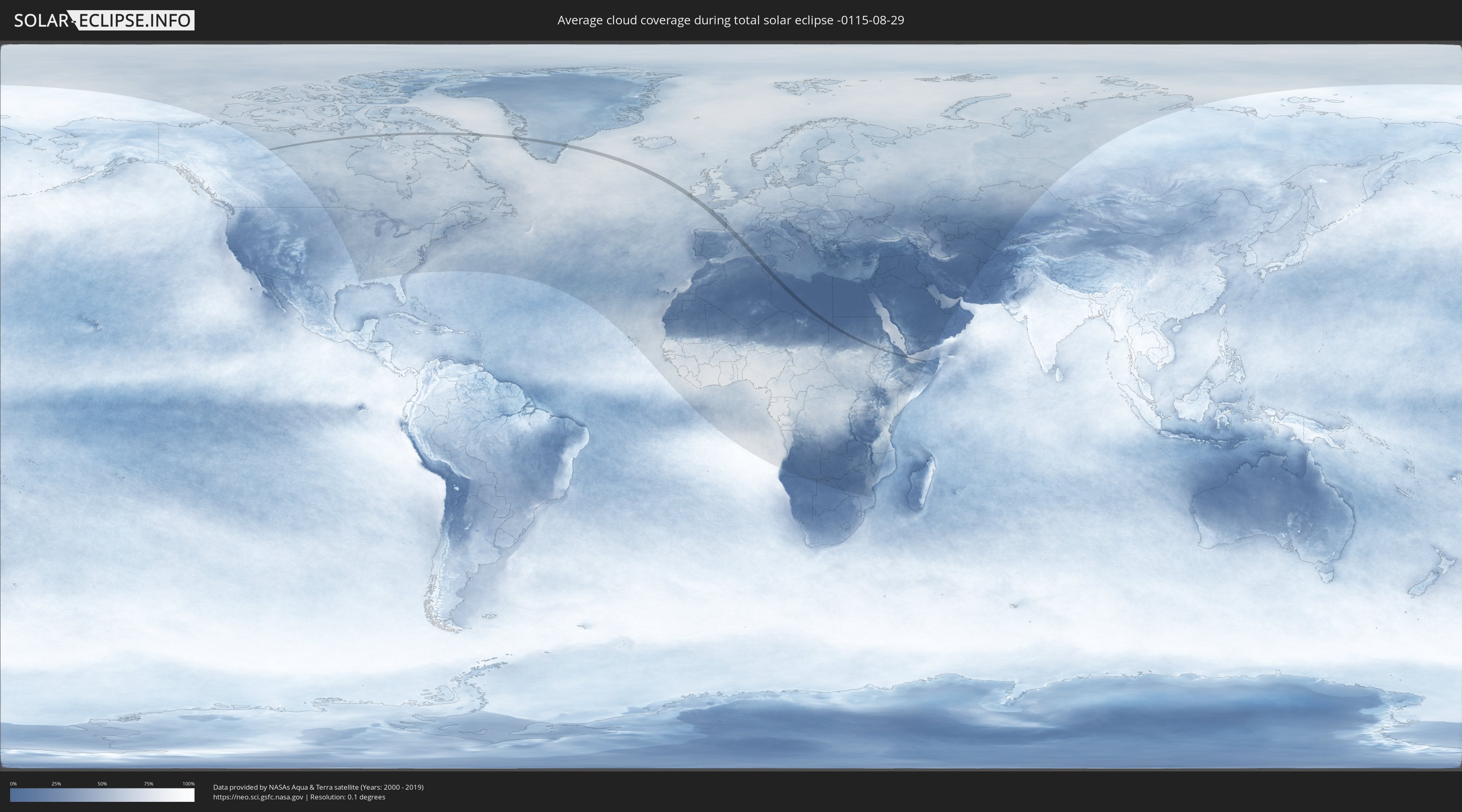
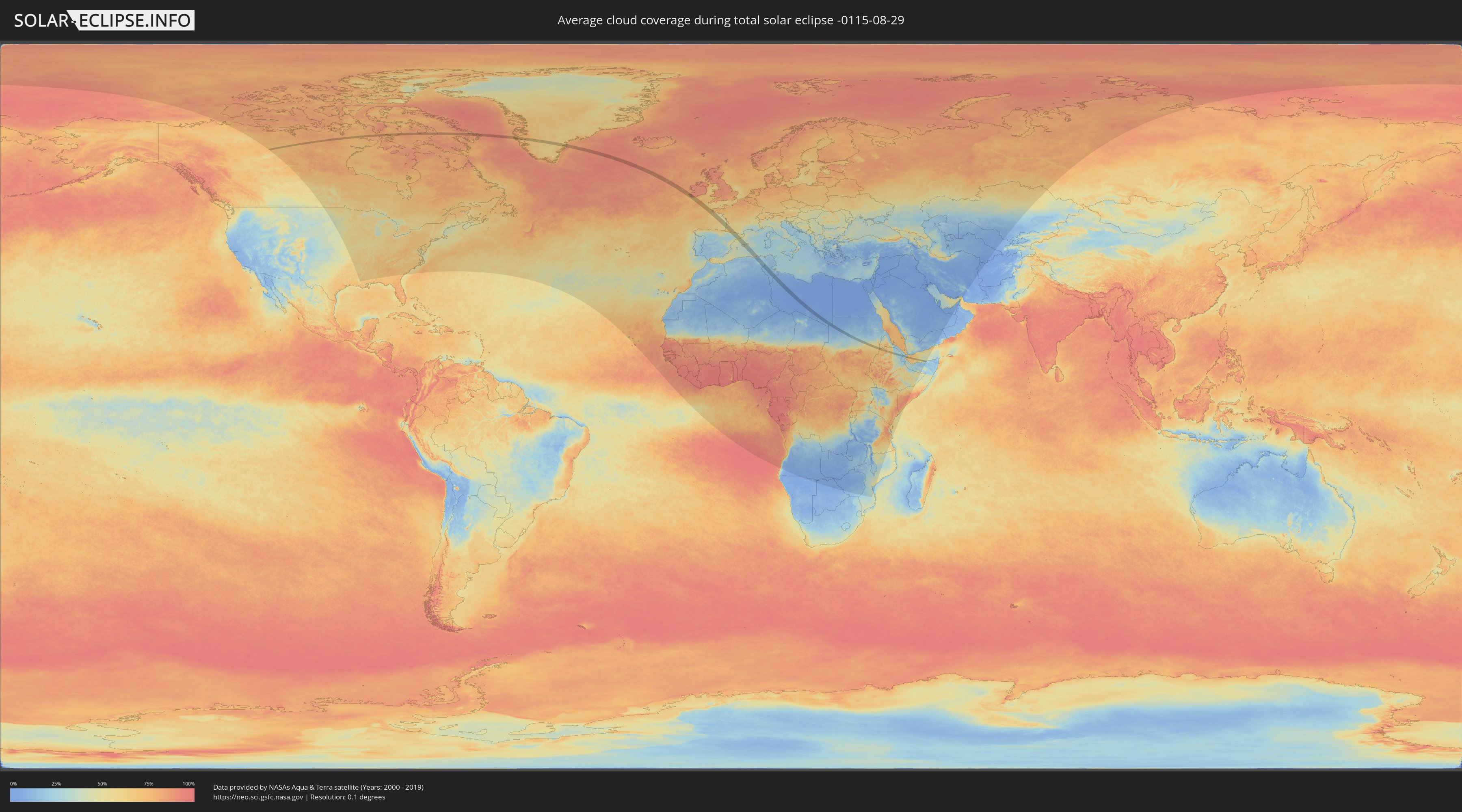
Wie wird das Wetter während der totalen Sonnenfinsternis am 29.08.-0115?
Wo ist der beste Ort, um die totale Sonnenfinsternis vom 29.08.-0115 zu beobachten?
Die folgenden Karten zeigen die durchschnittliche Bewölkung für den Tag, an dem die totale Sonnenfinsternis
stattfindet. Mit Hilfe der Karten lässt sich der Ort entlang des Finsternispfades eingrenzen,
der die besten Aussichen auf einen klaren wolkenfreien Himmel bietet.
Trotzdem muss man immer lokale Gegenenheiten beachten und sollte sich genau über das Wetter an seinem
gewählten Beobachtungsort informieren.
Die Daten stammen von den beiden NASA-Satelliten
AQUA und TERRA
und wurden über einen Zeitraum von 19 Jahren (2000 - 2019) gemittelt.
Detaillierte Länderkarten
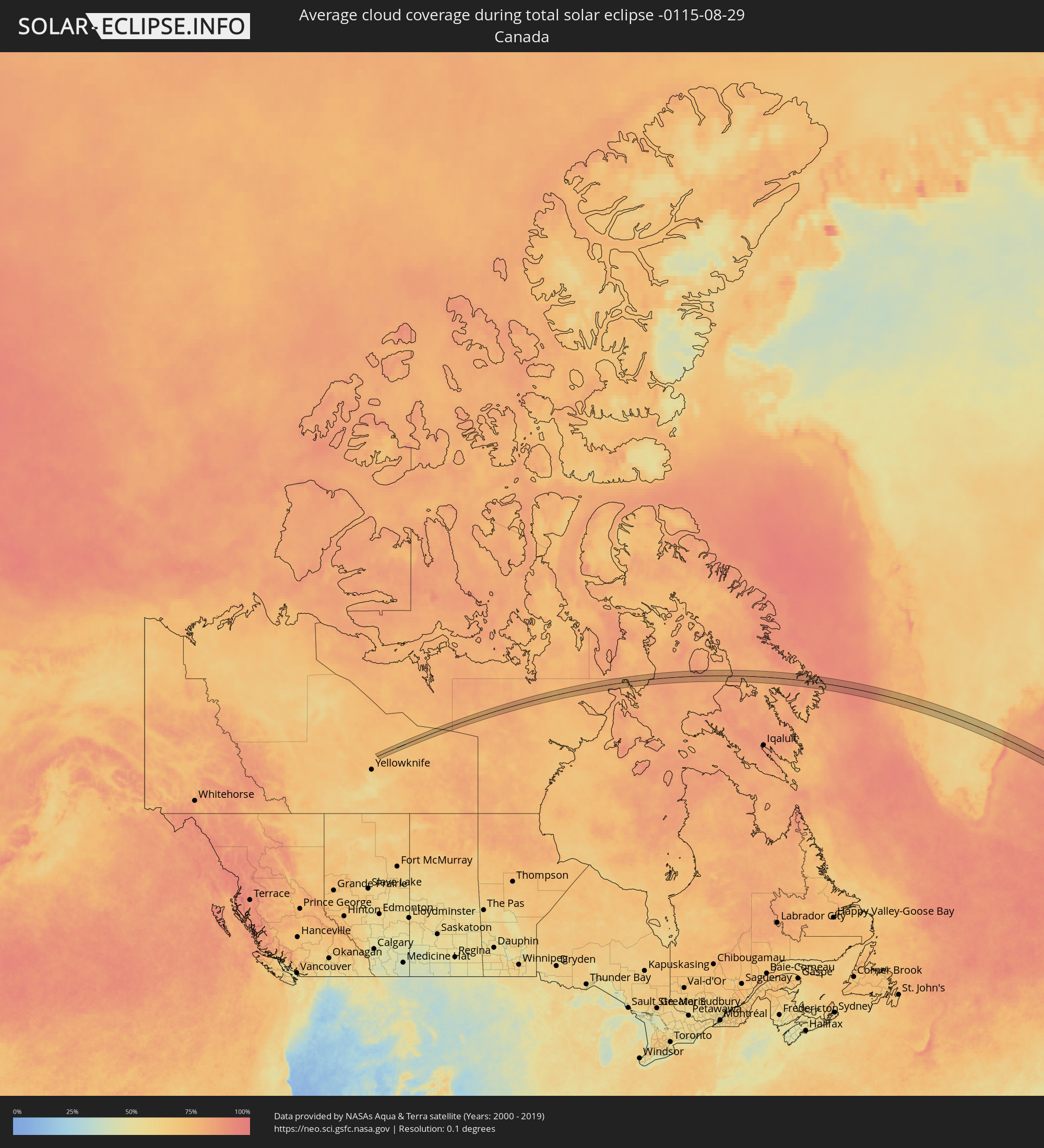 Kanada
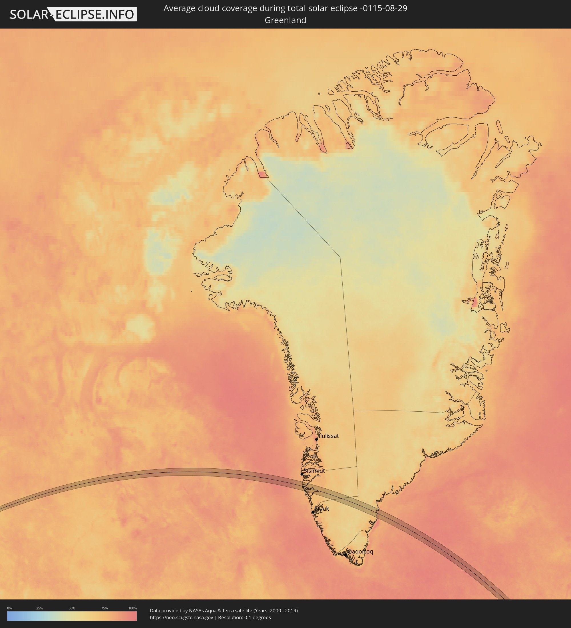 Grönland
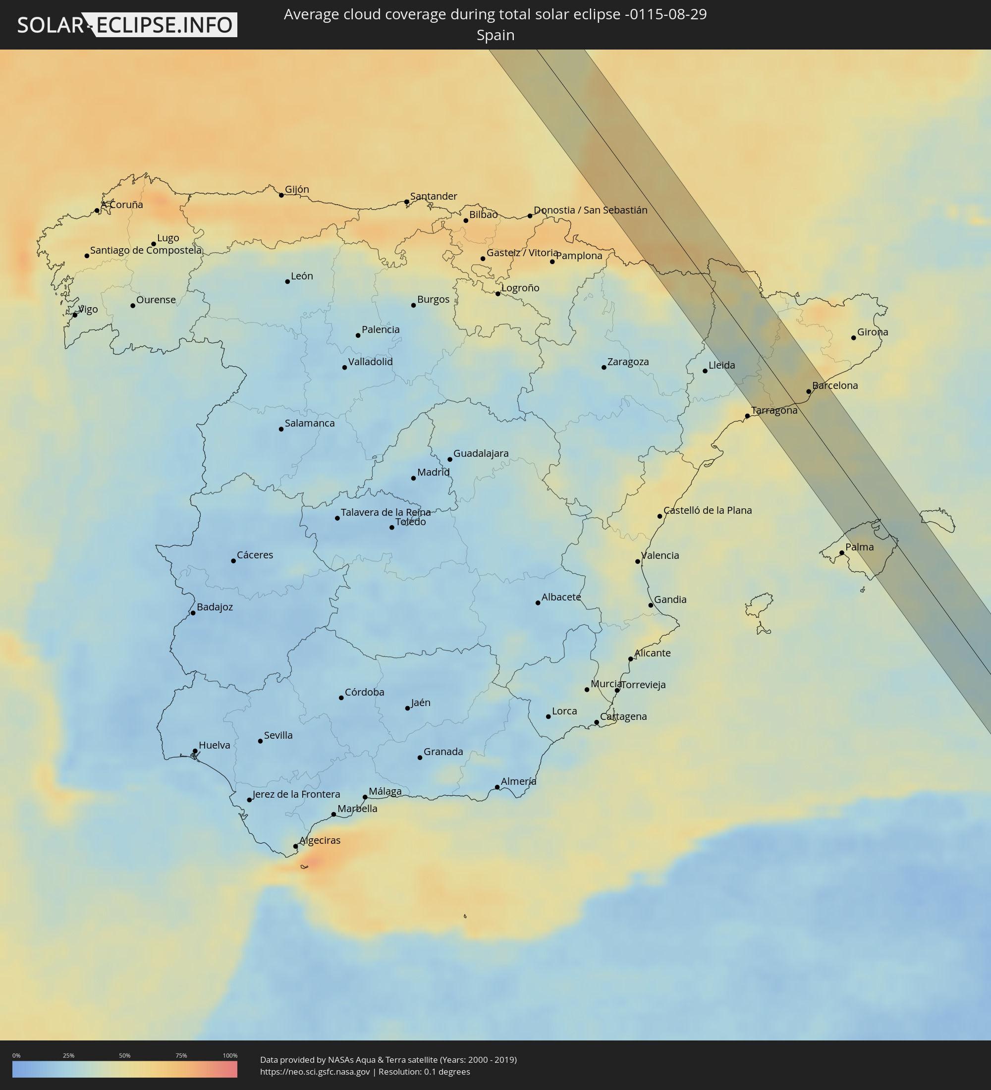 Spanien
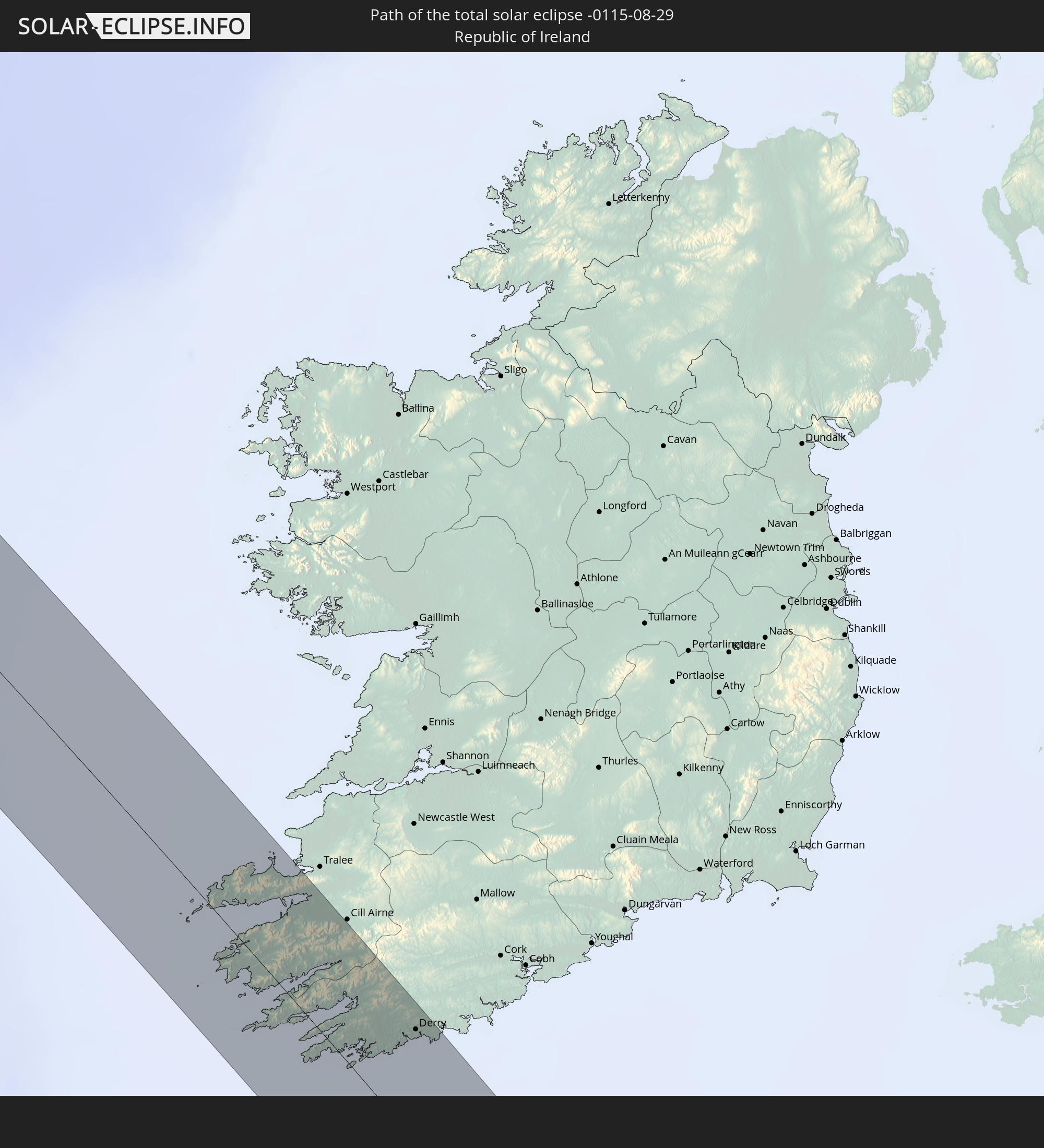
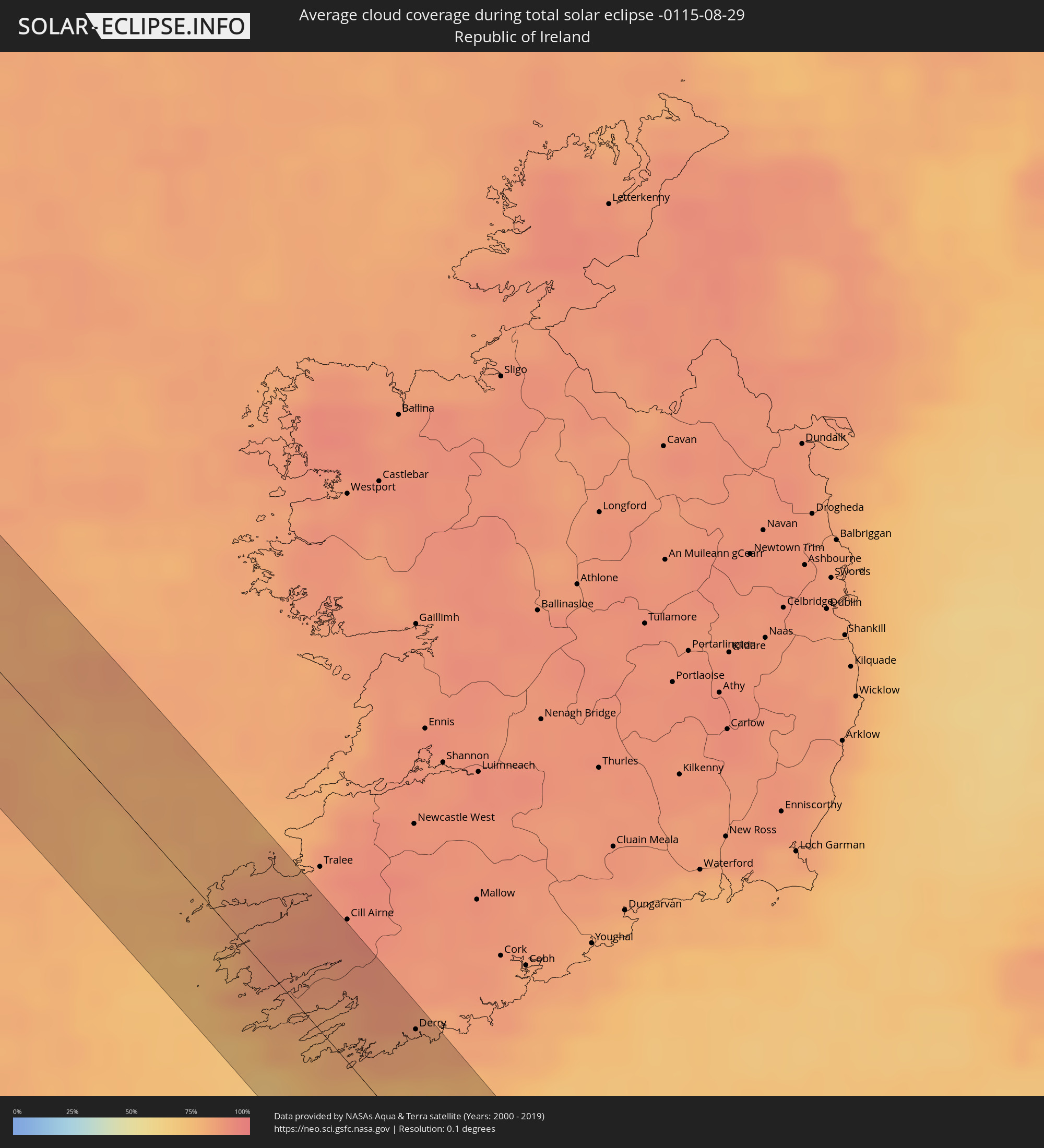 Irland
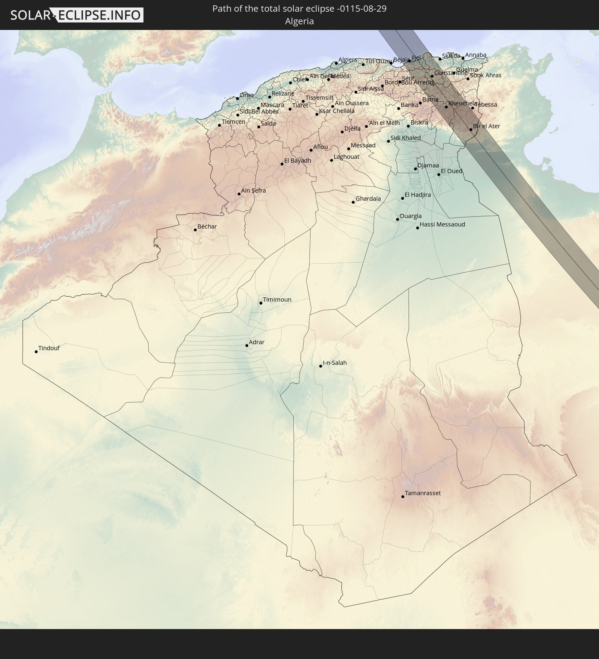
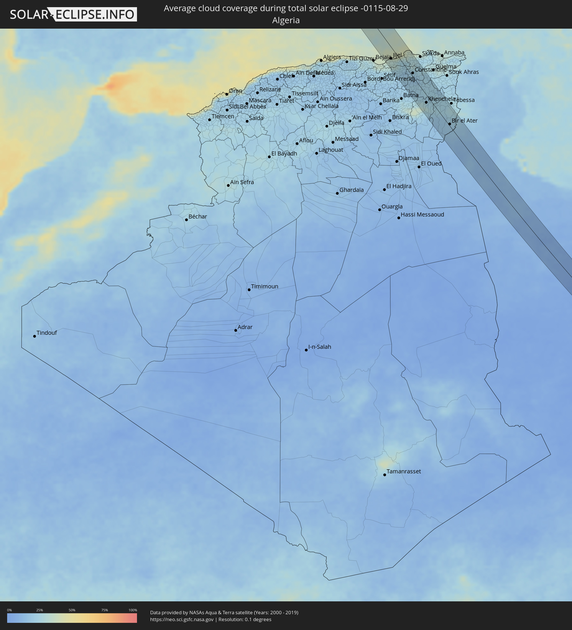 Algerien
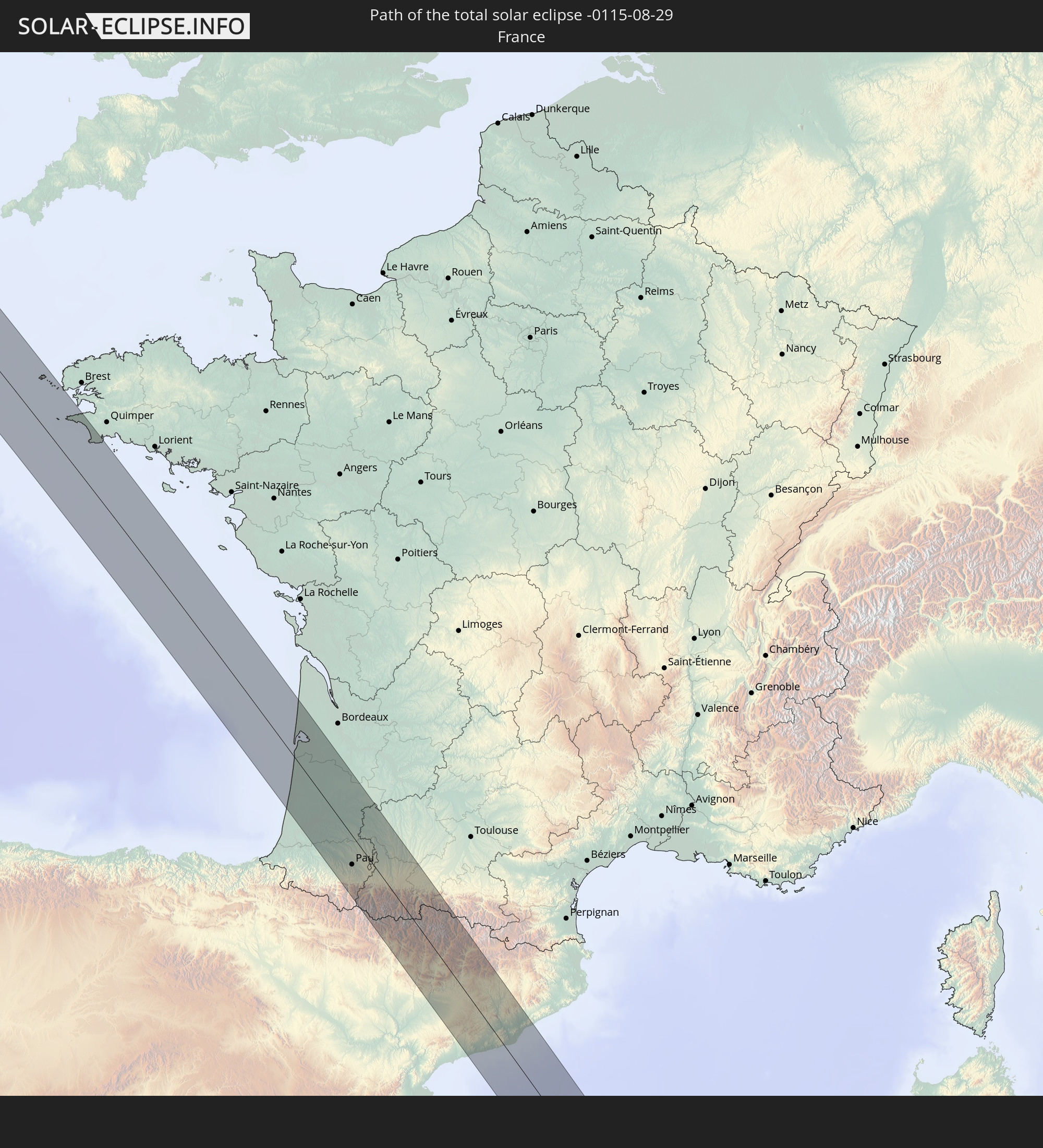
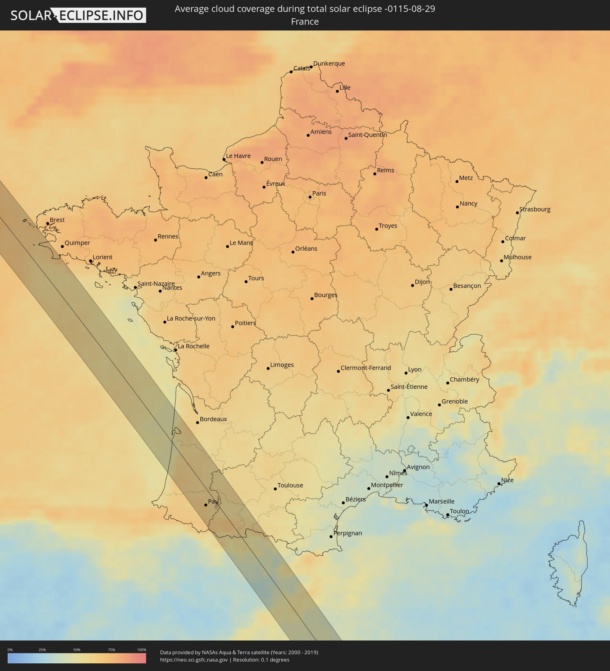 Frankreich
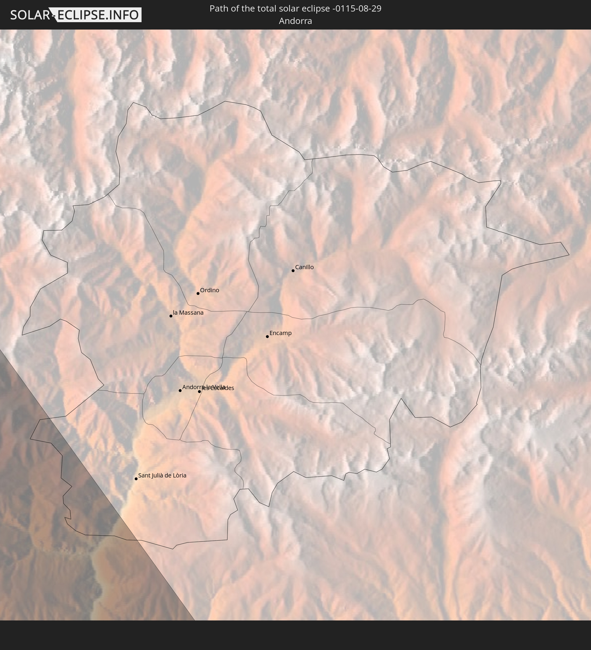
 Andorra
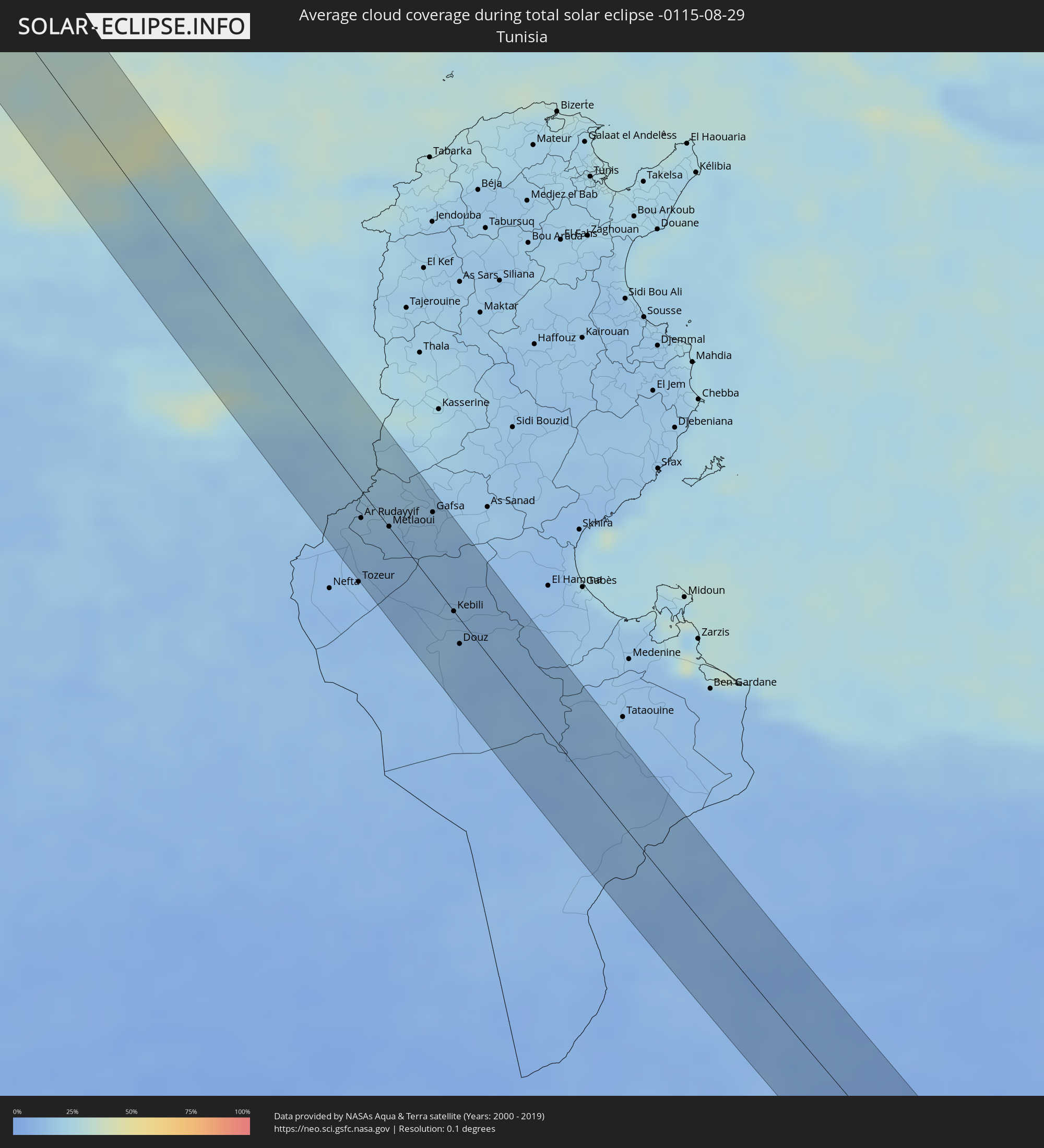 Tunesien
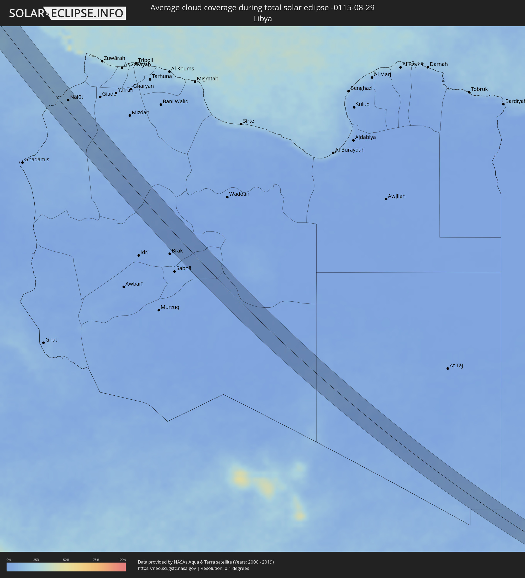 Libyen
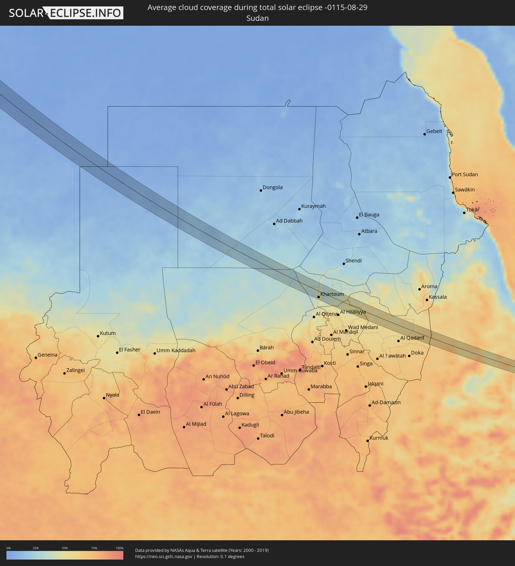 Sudan
Sudan
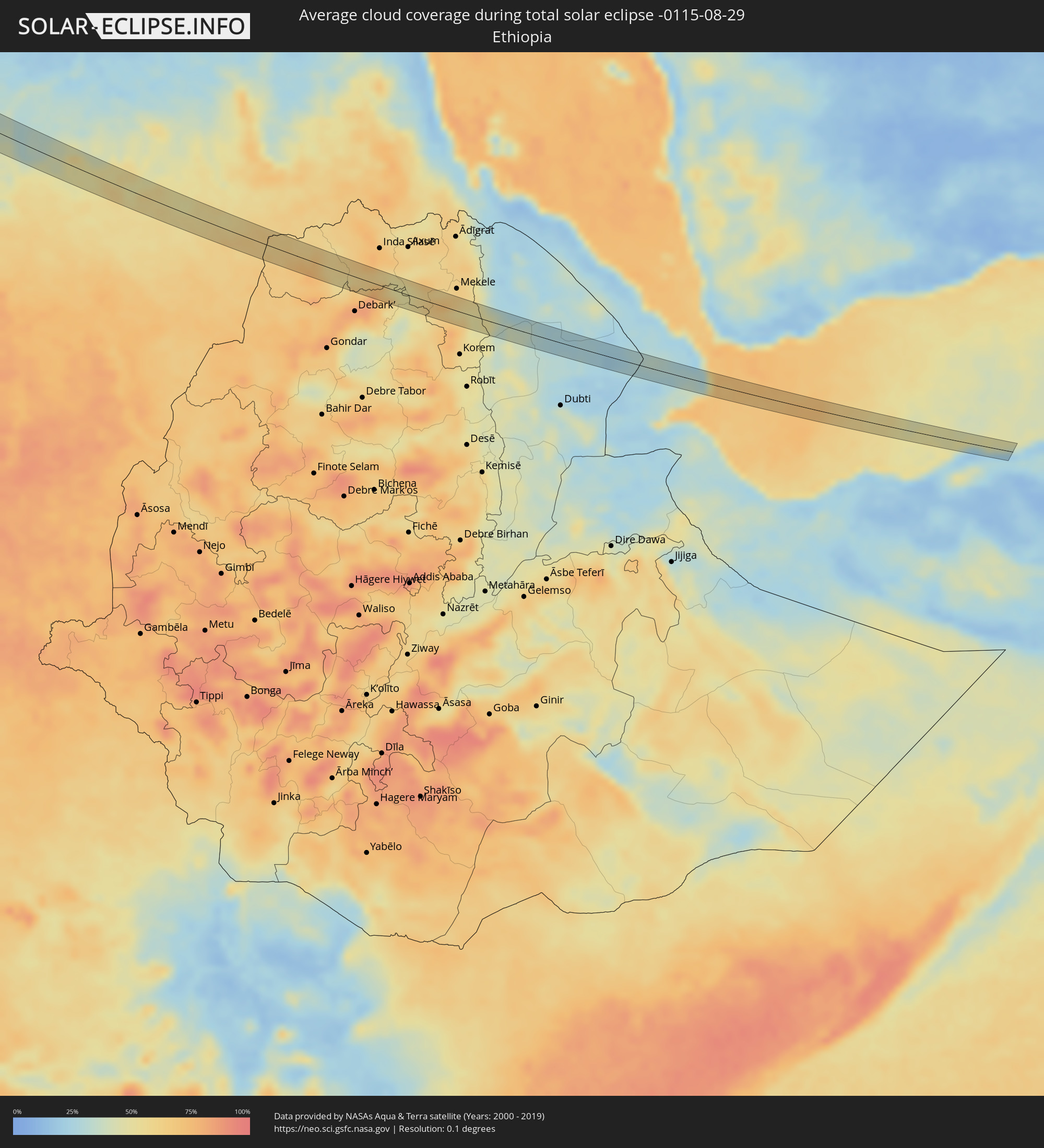 Äthiopien
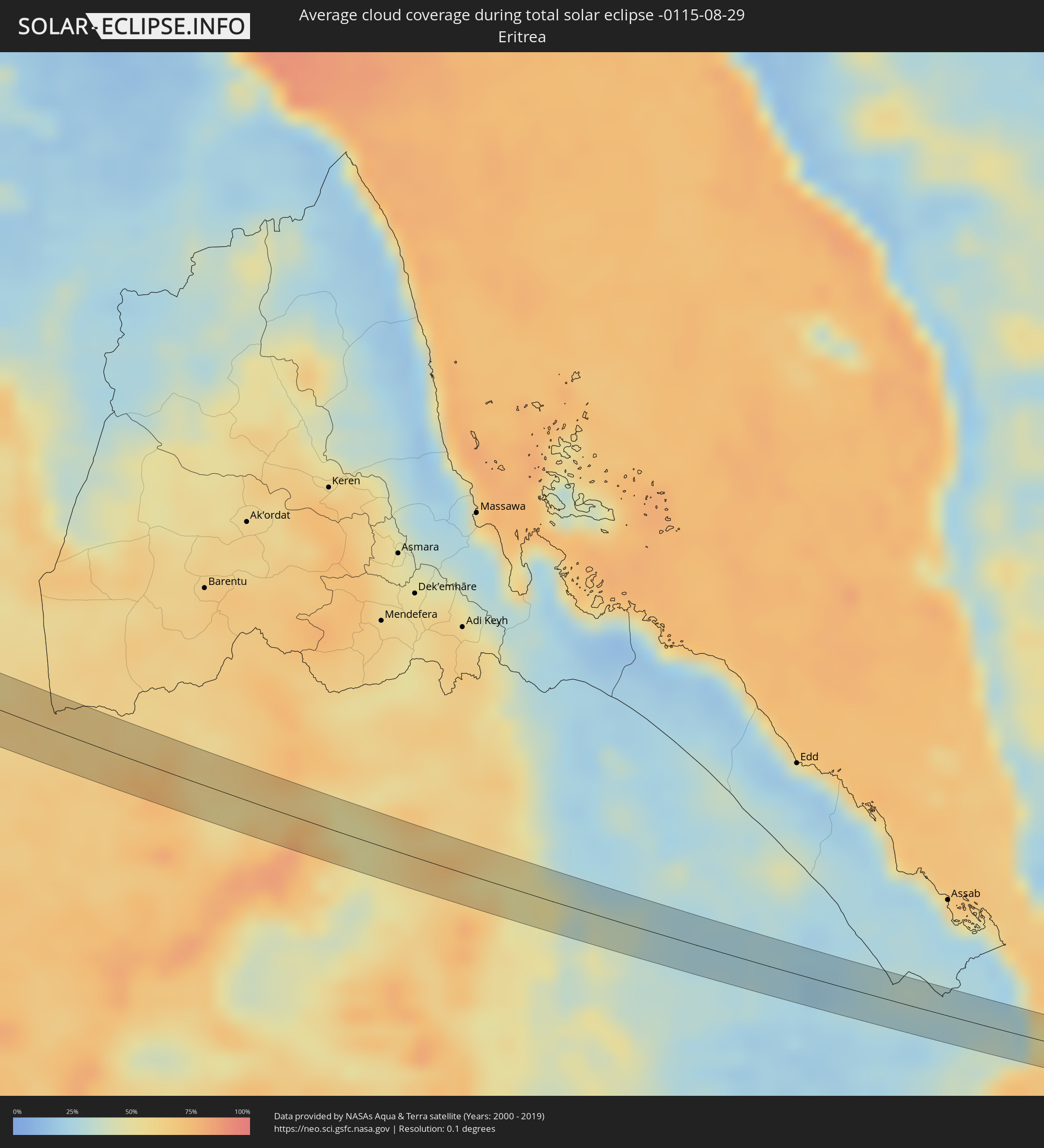 Eritrea
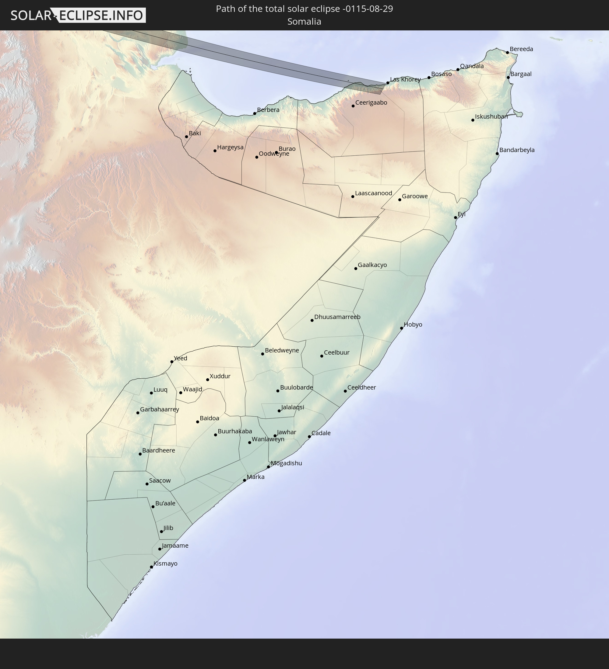
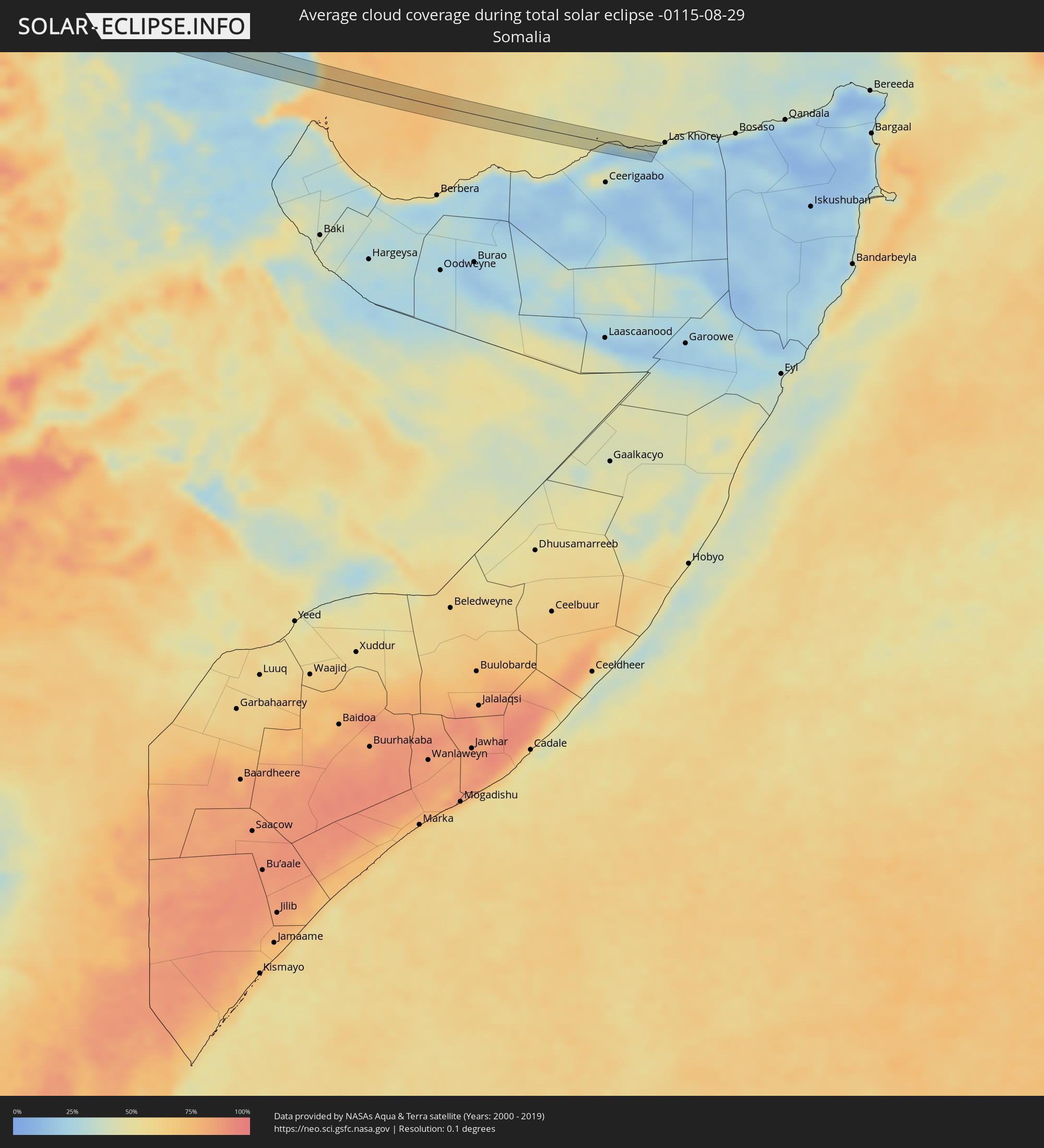 Somalia
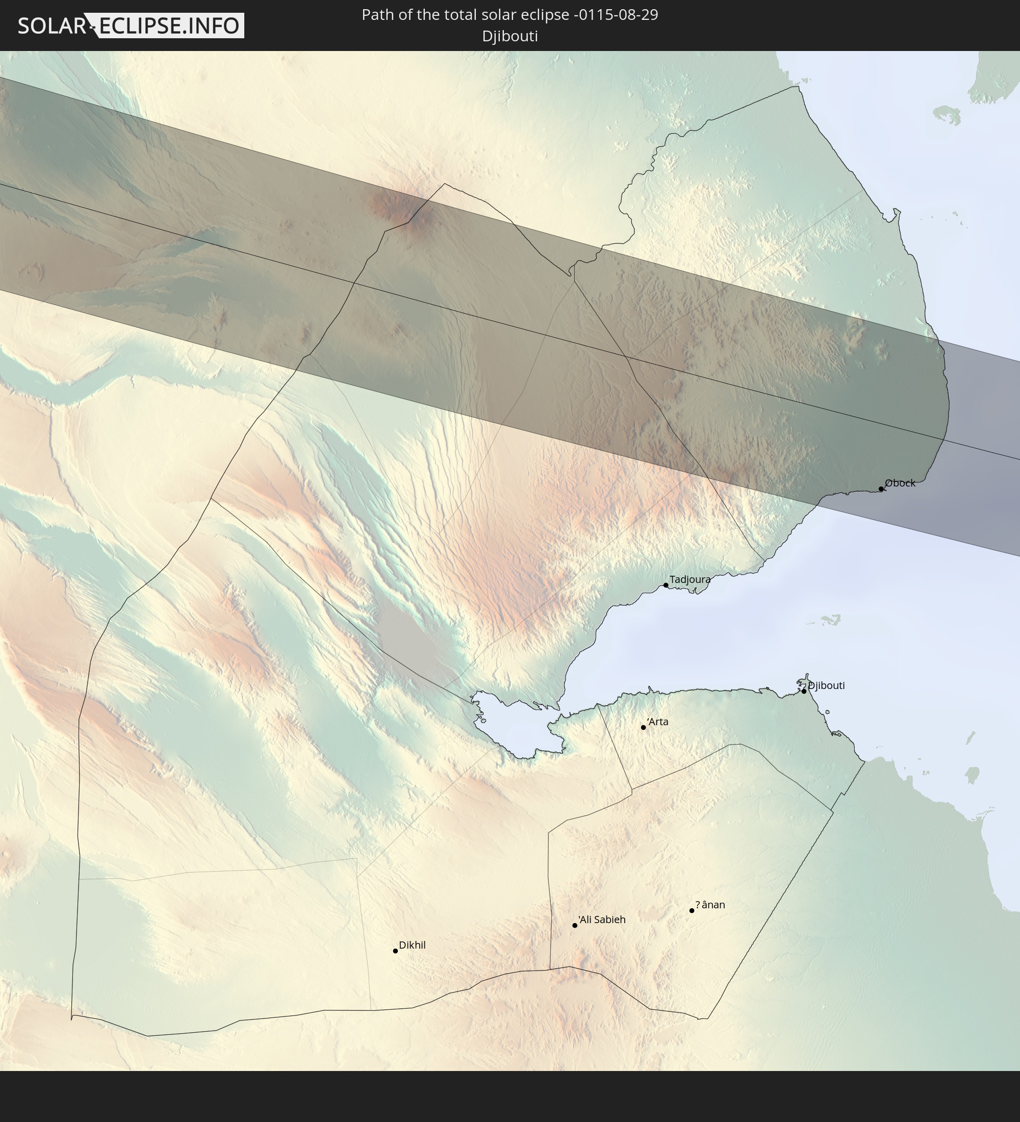
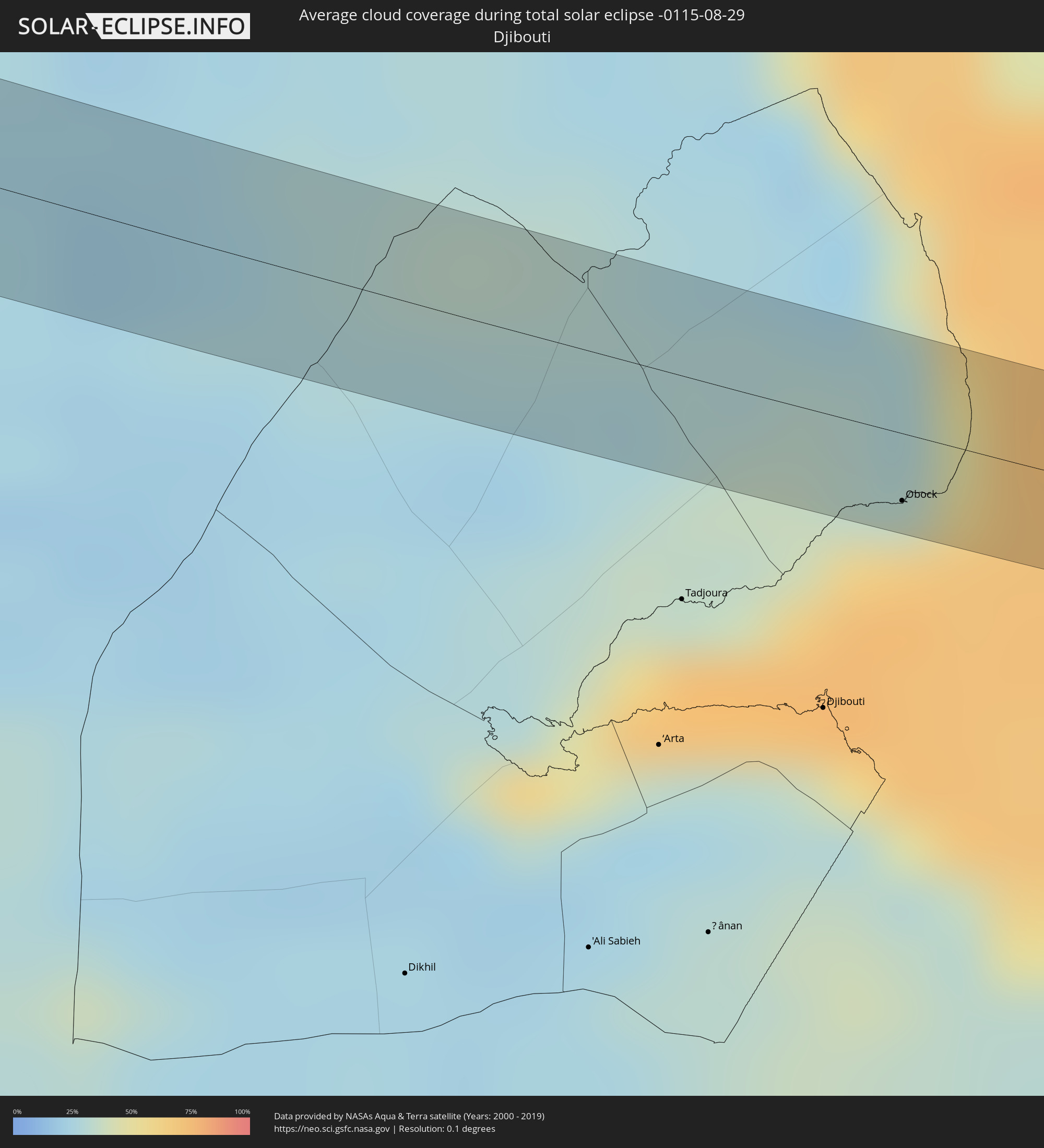 Dschibuti
Orte im Finsternispfad
Die nachfolgene Tabelle zeigt Städte und Orte mit mehr als 5.000 Einwohnern, die sich im Finsternispfad befinden. Städte mit mehr als 100.000 Einwohnern sind dick gekennzeichnet. Mit einem Klick auf den Ort öffnet sich eine Detailkarte die die Lage des jeweiligen Ortes zusammen mit dem Verlauf der zentralen Finsternis präsentiert.
| Ort | Typ | Dauer der Verfinsterung | Ortszeit bei maximaler Verfinsterung | Entfernung zur Zentrallinie | Ø Bewölkung |
|
Derry, Munster
|
total | - | 12:43:21 UTC-00:25 | 35 km | 82% |
|
Mimizan, Nouvelle-Aquitaine
|
total | - | 13:39:12 UTC+00:09 | 17 km | 55% |
|
Biscarrosse, Nouvelle-Aquitaine
|
total | - | 13:38:56 UTC+00:09 | 1 km | 47% |
|
Arcachon, Nouvelle-Aquitaine
|
total | - | 13:38:29 UTC+00:09 | 17 km | 53% |
|
La Teste-de-Buch, Nouvelle-Aquitaine
|
total | - | 13:38:33 UTC+00:09 | 17 km | 53% |
|
Andernos-les-Bains, Nouvelle-Aquitaine
|
total | - | 13:38:23 UTC+00:09 | 27 km | 55% |
|
Dax, Nouvelle-Aquitaine
|
total | - | 13:40:18 UTC+00:09 | 38 km | 62% |
|
Saint-Paul-lès-Dax, Nouvelle-Aquitaine
|
total | - | 13:40:16 UTC+00:09 | 37 km | 62% |
|
Lanton, Nouvelle-Aquitaine
|
total | - | 13:38:32 UTC+00:09 | 28 km | 55% |
|
Audenge, Nouvelle-Aquitaine
|
total | - | 13:38:36 UTC+00:09 | 29 km | 55% |
|
Biganos, Nouvelle-Aquitaine
|
total | - | 13:38:43 UTC+00:09 | 29 km | 56% |
|
Orthez, Nouvelle-Aquitaine
|
total | - | 13:41:03 UTC+00:09 | 35 km | 62% |
|
Oloron-Sainte-Marie, Nouvelle-Aquitaine
|
total | - | 13:41:47 UTC+00:09 | 44 km | 64% |
|
Mourenx, Nouvelle-Aquitaine
|
total | - | 13:41:27 UTC+00:09 | 31 km | 62% |
|
Saint-Pierre-du-Mont, Nouvelle-Aquitaine
|
total | - | 13:40:38 UTC+00:09 | 7 km | 58% |
|
Mont-de-Marsan, Nouvelle-Aquitaine
|
total | - | 13:40:39 UTC+00:09 | 9 km | 58% |
|
Lescar, Nouvelle-Aquitaine
|
total | - | 13:41:46 UTC+00:09 | 22 km | 62% |
|
Jurançon, Nouvelle-Aquitaine
|
total | - | 13:41:53 UTC+00:09 | 23 km | 62% |
|
Pau, Nouvelle-Aquitaine
|
total | - | 13:41:53 UTC+00:09 | 21 km | 62% |
|
Lourdes, Occitania
|
total | - | 13:42:38 UTC+00:09 | 13 km | 64% |
|
Vic-en-Bigorre, Occitania
|
total | - | 13:42:14 UTC+00:09 | 12 km | 55% |
|
Tarbes, Occitania
|
total | - | 13:42:33 UTC+00:09 | 4 km | 61% |
|
Aureilhan, Occitania
|
total | - | 13:42:33 UTC+00:09 | 6 km | 61% |
|
Bagnères-de-Bigorre, Occitania
|
total | - | 13:42:56 UTC+00:09 | 2 km | 67% |
|
Lannemezan, Occitania
|
total | - | 13:43:07 UTC+00:09 | 17 km | 64% |
|
Saint-Gaudens, Occitania
|
total | - | 13:43:33 UTC+00:09 | 39 km | 57% |
|
Balaguer, Catalonia
|
total | - | 13:36:46 UTC+00:00 | 42 km | 30% |
|
Tàrrega, Catalonia
|
total | - | 13:37:26 UTC+00:00 | 30 km | 35% |
|
la Seu d'Urgell, Catalonia
|
total | - | 13:36:28 UTC+00:00 | 38 km | 38% |
|
Solsona, Catalonia
|
total | - | 13:37:13 UTC+00:00 | 18 km | 40% |
|
El Vendrell, Catalonia
|
total | - | 13:38:43 UTC+00:00 | 31 km | 47% |
|
Igualada, Catalonia
|
total | - | 13:38:07 UTC+00:00 | 2 km | 47% |
|
Vilanova i la Geltrú, Catalonia
|
total | - | 13:38:56 UTC+00:00 | 18 km | 45% |
|
Masquefa, Catalonia
|
total | - | 13:38:30 UTC+00:00 | 6 km | 51% |
|
Manresa, Catalonia
|
total | - | 13:38:05 UTC+00:00 | 22 km | 47% |
|
Sallent, Catalonia
|
total | - | 13:37:59 UTC+00:00 | 33 km | 41% |
|
Corbera de Llobregat, Catalonia
|
total | - | 13:38:48 UTC+00:00 | 8 km | 54% |
|
Cervelló, Catalonia
|
total | - | 13:38:53 UTC+00:00 | 9 km | 55% |
|
Castelldefels, Catalonia
|
total | - | 13:39:07 UTC+00:00 | 2 km | 49% |
|
Santa Coloma de Cervelló, Catalonia
|
total | - | 13:39:00 UTC+00:00 | 11 km | 55% |
|
Terrassa, Catalonia
|
total | - | 13:38:38 UTC+00:00 | 24 km | 52% |
|
Barcelona, Catalonia
|
total | - | 13:39:08 UTC+00:00 | 22 km | 47% |
|
Mollet del Vallès, Catalonia
|
total | - | 13:38:54 UTC+00:00 | 36 km | 49% |
|
Sóller, Balearic Islands
|
total | - | 13:42:55 UTC+00:00 | 45 km | 44% |
|
Inca, Balearic Islands
|
total | - | 13:43:14 UTC+00:00 | 35 km | 45% |
|
Santa Margalida, Balearic Islands
|
total | - | 13:43:30 UTC+00:00 | 23 km | 47% |
|
Alcúdia, Balearic Islands
|
total | - | 13:43:14 UTC+00:00 | 11 km | 40% |
|
Santanyí, Balearic Islands
|
total | - | 13:44:13 UTC+00:00 | 43 km | 36% |
|
Can Picafort, Balearic Islands
|
total | - | 13:43:26 UTC+00:00 | 15 km | 40% |
|
Manacor, Balearic Islands
|
total | - | 13:43:53 UTC+00:00 | 24 km | 44% |
|
Capdepera, Balearic Islands
|
total | - | 13:43:53 UTC+00:00 | 1 km | 40% |
|
Jijel, Jijel
|
total | - | 14:01:38 UTC+00:09 | 24 km | 31% |
|
Rouached, Mila
|
total | - | 14:02:41 UTC+00:09 | 28 km | 23% |
|
Chelghoum el Aïd, Mila
|
total | - | 14:03:25 UTC+00:09 | 38 km | 20% |
|
Sidi Mérouane, Mila
|
total | - | 14:02:48 UTC+00:09 | 8 km | 18% |
|
Mila, Mila
|
total | - | 14:02:56 UTC+00:09 | 12 km | 18% |
|
Telerghma, Mila
|
total | - | 14:03:43 UTC+00:09 | 28 km | 20% |
|
Aïn Smara, Constantine
|
total | - | 14:03:34 UTC+00:09 | 7 km | 21% |
|
Kerkera, Skikda
|
total | - | 14:02:20 UTC+00:09 | 42 km | 27% |
|
Hamma Bouziane, Constantine
|
total | - | 14:03:23 UTC+00:09 | 9 km | 21% |
|
Constantine, Constantine
|
total | - | 14:03:30 UTC+00:09 | 7 km | 21% |
|
Didouche Mourad, Constantine
|
total | - | 14:03:21 UTC+00:09 | 15 km | 21% |
|
Tamalous, Skikda
|
total | - | 14:02:34 UTC+00:09 | 40 km | 28% |
|
El Khroub, Constantine
|
total | - | 14:03:48 UTC+00:09 | 6 km | 18% |
|
Aïn Kercha, Oum el Bouaghi
|
total | - | 14:04:29 UTC+00:09 | 16 km | 21% |
|
Aïn Fakroun, Oum el Bouaghi
|
total | - | 14:04:35 UTC+00:09 | 1 km | 23% |
|
’Aïn Abid, Constantine
|
total | - | 14:04:08 UTC+00:09 | 22 km | 20% |
|
Oum el Bouaghi, Oum el Bouaghi
|
total | - | 14:05:02 UTC+00:09 | 11 km | 25% |
|
Khenchela, Khenchela
|
total | - | 14:05:58 UTC+00:09 | 16 km | 31% |
|
Aïn Beïda, Oum el Bouaghi
|
total | - | 14:05:30 UTC+00:09 | 26 km | 23% |
|
Meskiana, Oum el Bouaghi
|
total | - | 14:06:08 UTC+00:09 | 35 km | 23% |
|
Cheria, Tébessa
|
total | - | 14:06:57 UTC+00:09 | 17 km | 24% |
|
Hammamet, Tébessa
|
total | - | 14:06:48 UTC+00:09 | 43 km | 26% |
|
Bir el Ater, Tébessa
|
total | - | 14:08:21 UTC+00:09 | 4 km | 19% |
|
Ar Rudayyif, Gafsa
|
total | - | 14:09:12 UTC+00:09 | 13 km | 15% |
|
Degache, Tawzar
|
total | - | 14:10:05 UTC+00:09 | 37 km | 12% |
|
Metlaoui, Gafsa
|
total | - | 14:09:35 UTC+00:09 | 1 km | 12% |
|
Gafsa, Gafsa
|
total | - | 14:09:46 UTC+00:09 | 35 km | 14% |
|
Kebili, Qibilī
|
total | - | 14:11:26 UTC+00:09 | 0 km | 12% |
|
El Golaa, Qibilī
|
total | - | 14:11:55 UTC+00:09 | 12 km | 13% |
|
Jemna, Qibilī
|
total | - | 14:11:44 UTC+00:09 | 5 km | 13% |
|
Douz, Qibilī
|
total | - | 14:11:58 UTC+00:09 | 12 km | 13% |
|
Nālūt, Sha‘bīyat Nālūt
|
total | - | 15:00:36 UTC+00:52 | 21 km | 10% |
|
Omdurman, Khartoum
|
total | - | 17:00:38 UTC+02:10 | 15 km | 44% |
|
Khartoum, Khartoum
|
total | - | 17:00:47 UTC+02:10 | 22 km | 44% |
|
Obock, Obock
|
total | - | 17:23:23 UTC+02:27 | 13 km | 63% |