Totale Sonnenfinsternis vom 10.10.-0173
| Wochentag: | Montag |
| Maximale Dauer der Verfinsterung: | 01m35s |
| Maximale Breite des Finsternispfades: | 73 km |
| Saroszyklus: | 60 |
| Bedeckungsgrad: | 100% |
| Magnitude: | 1.0183 |
| Gamma: | 0.5303 |
Wo kann man die Sonnenfinsternis vom 10.10.-0173 sehen?
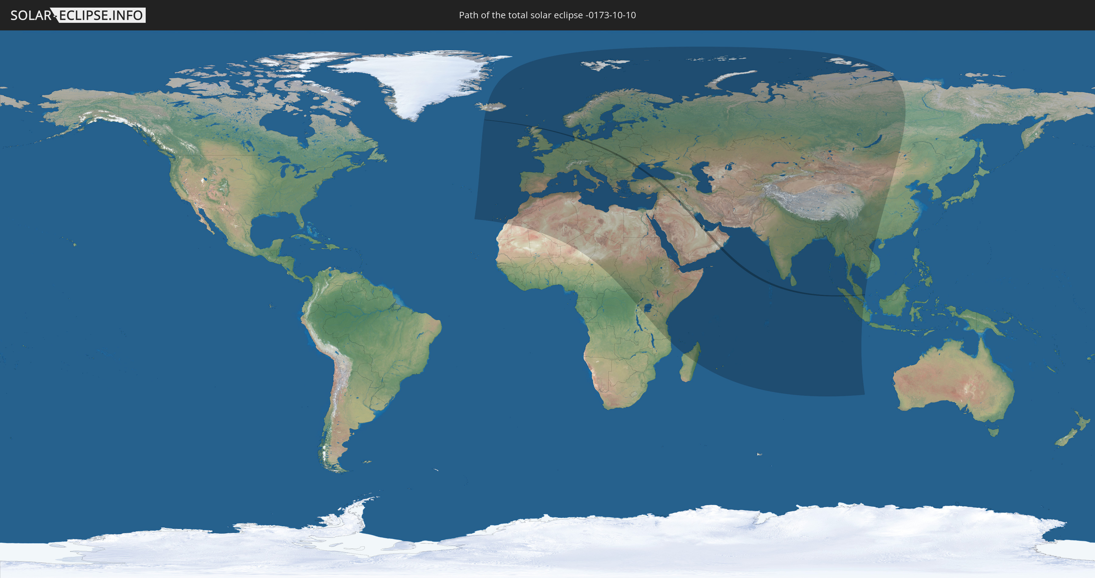
Die Sonnenfinsternis am 10.10.-0173 kann man in 123 Ländern als partielle Sonnenfinsternis beobachten.
Der Finsternispfad verläuft durch 20 Länder. Nur in diesen Ländern ist sie als totale Sonnenfinsternis zu sehen.
In den folgenden Ländern ist die Sonnenfinsternis total zu sehen
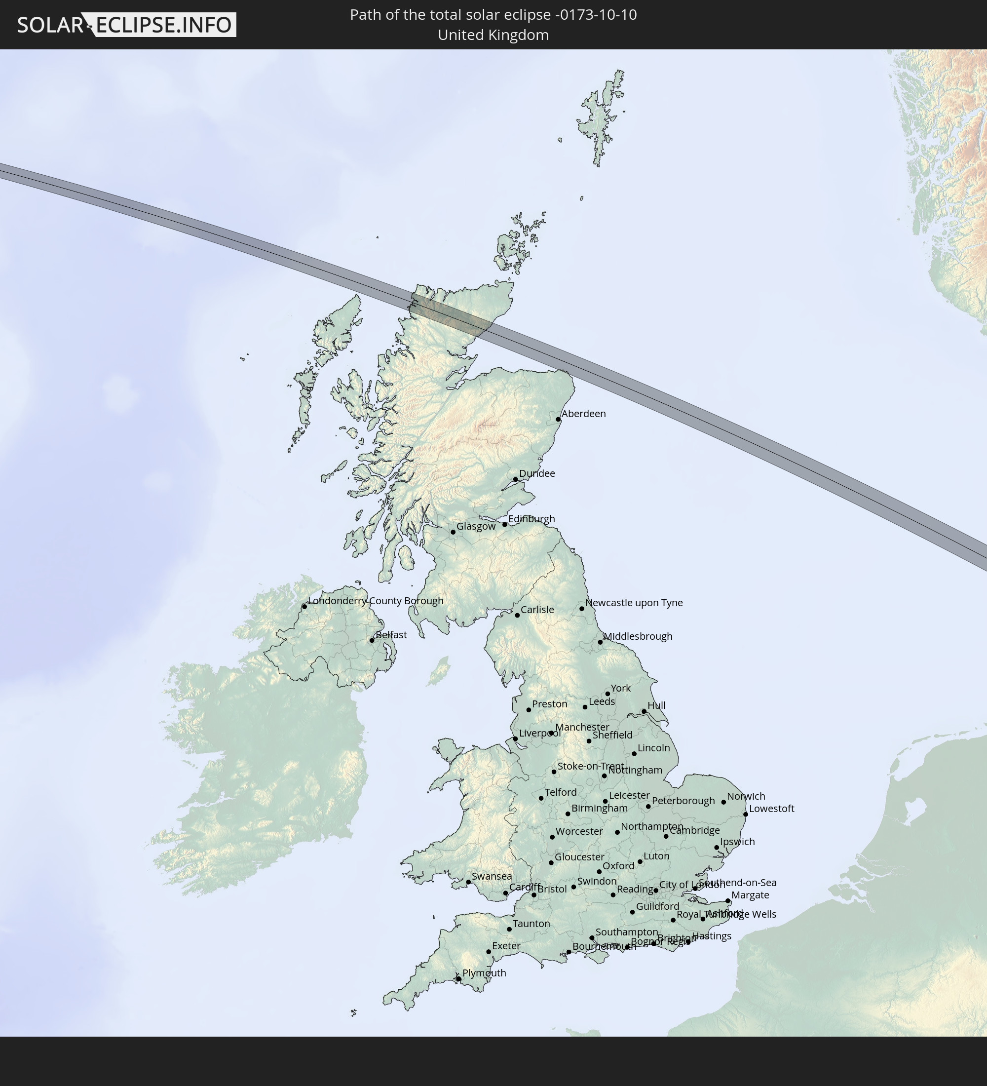 Vereinigtes Königreich
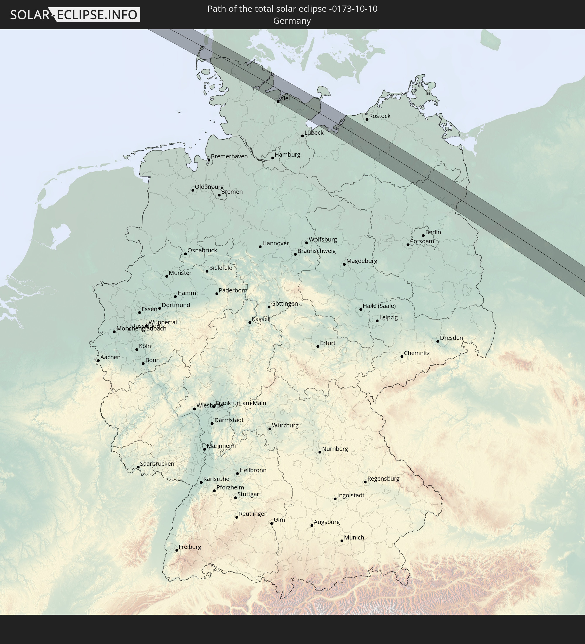 Deutschland
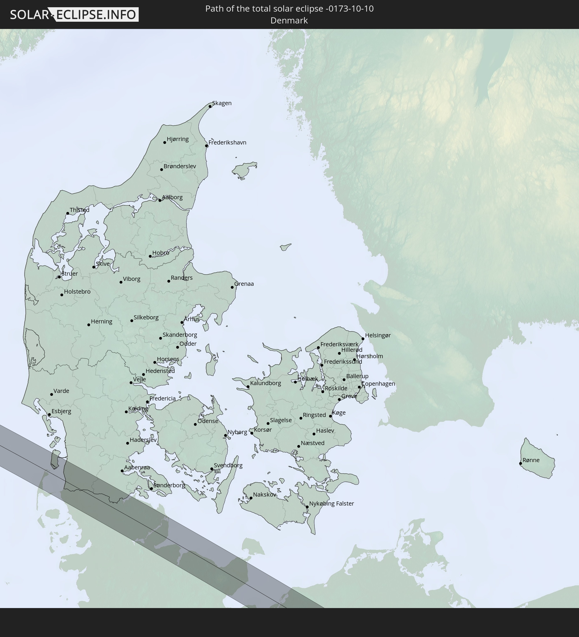 Dänemark
 Polen
Polen
 Slowakei
 Rumänien
 Ukraine
 Türkei
 Moldawien
 Saudi-Arabien
 Syrien
 Irak
Irak
 Kuwait
 Bahrain
 Katar
Katar
 Vereinigte Arabische Emirate
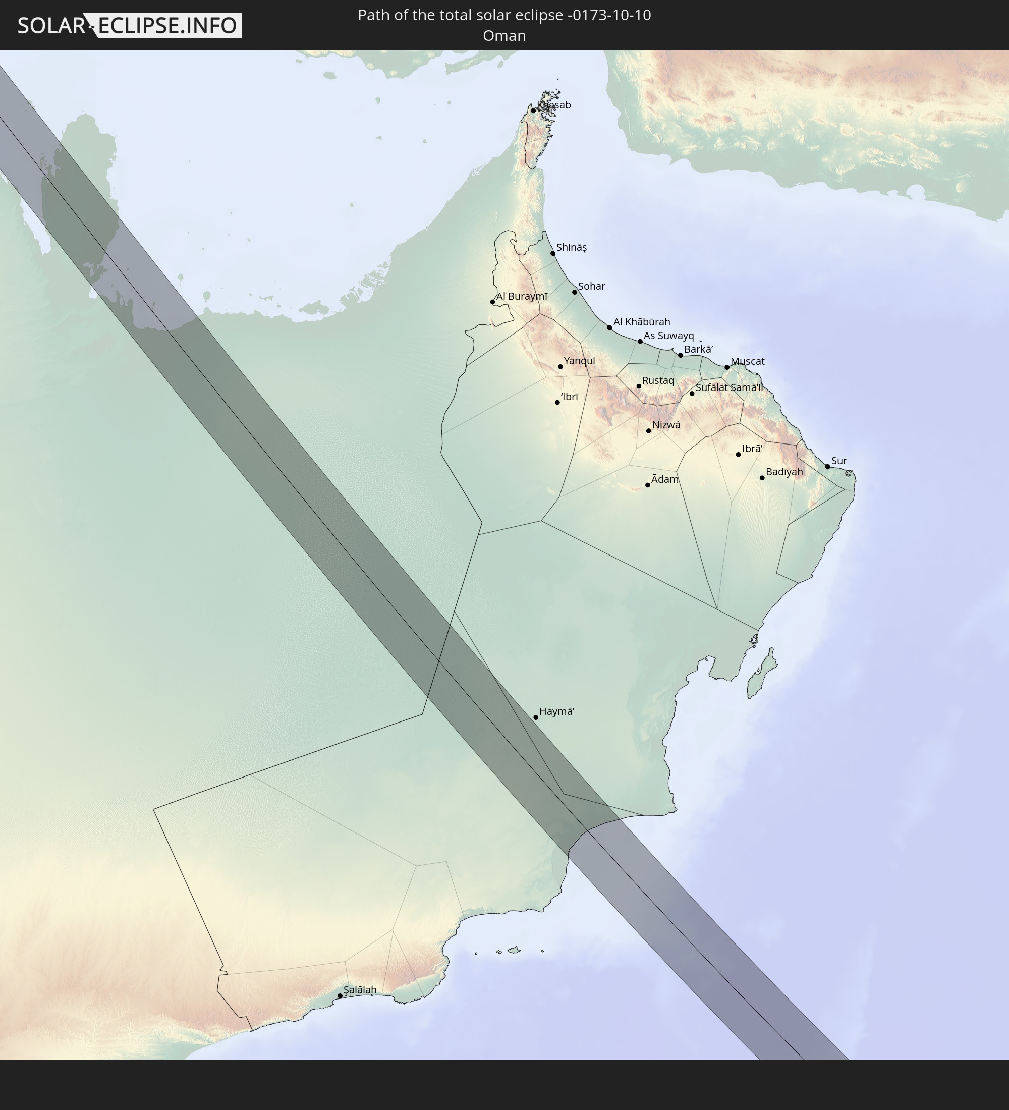 Oman
Oman
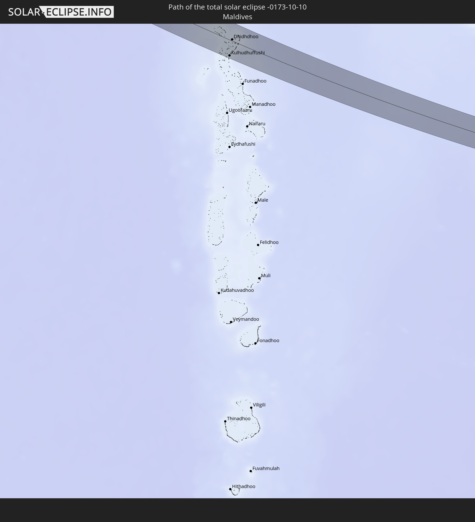 Malediven
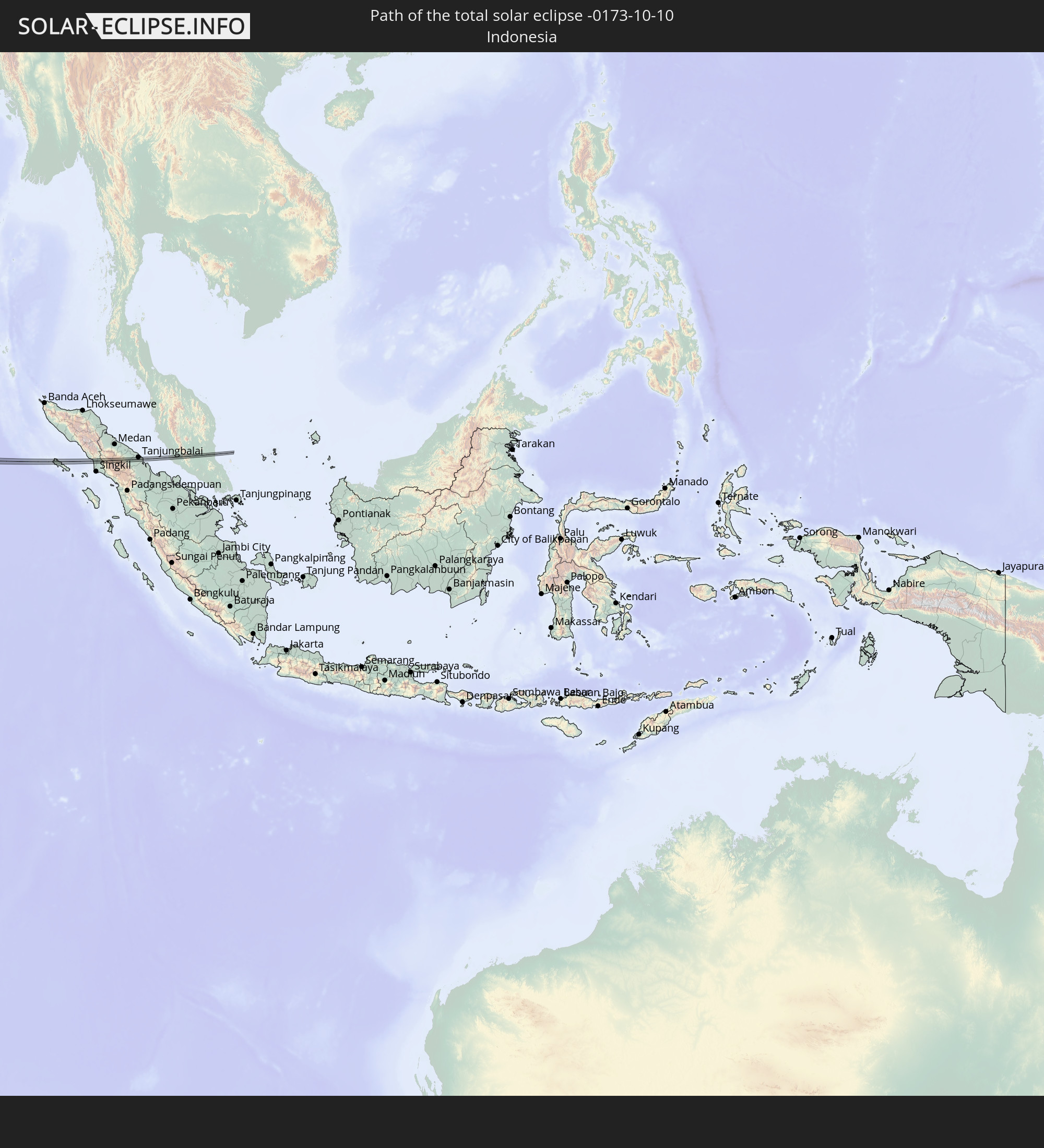 Indonesien
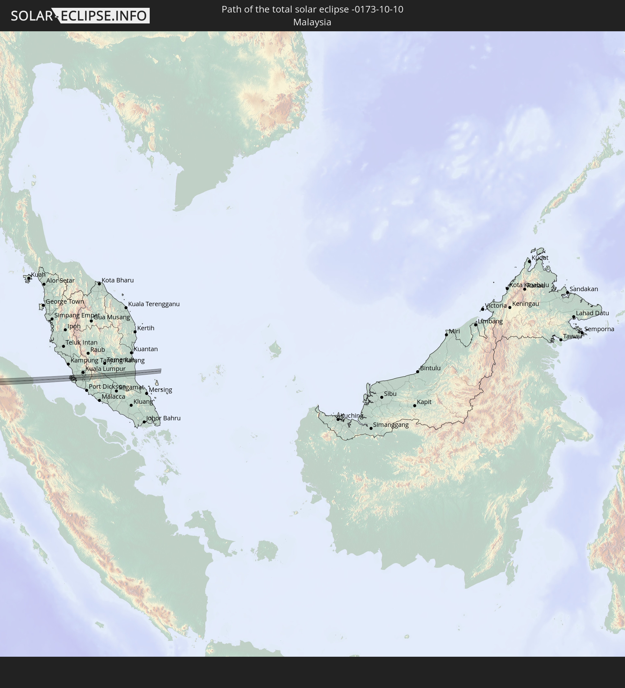 Malaysia
In den folgenden Ländern ist die Sonnenfinsternis partiell zu sehen
 Russland
 Portugal
 Island
 Spanien
 Mauretanien
 Marokko
 Mali
Mali
 Irland
 Spitzbergen
 Algerien
 Vereinigtes Königreich
 Färöer
 Gibraltar
 Frankreich
 Isle of Man
 Guernsey
 Jersey
 Niger
Niger
 Andorra
 Belgien
 Niederlande
 Norwegen
 Luxemburg
 Deutschland
 Schweiz
 Italien
 Monaco
 Tunesien
 Dänemark
 Libyen
 Liechtenstein
 Österreich
 Schweden
 Tschechien
 Demokratische Republik Kongo
 San Marino
 Vatikanstadt
 Slowenien
 Tschad
 Kroatien
 Polen
Polen
 Malta
Malta
 Zentralafrikanische Republik
 Bosnien und Herzegowina
 Ungarn
 Slowakei
 Montenegro
 Serbien
 Albanien
 Åland Islands
 Griechenland
 Rumänien
 Mazedonien
 Finnland
 Litauen
 Lettland
 Estland
 Sudan
Sudan
 Ukraine
 Bulgarien
 Weißrussland
 Ägypten
 Türkei
 Moldawien
 Ruanda
 Tansania
 Uganda
 Mosambik
 Republik Zypern
 Äthiopien
 Kenia
Kenia
 Staat Palästina
 Israel
 Saudi-Arabien
 Jordanien
 Libanon
 Syrien
 Eritrea
 Irak
Irak
 Georgien
 Französische Süd- und Antarktisgebiete
 Somalia
 Dschibuti
 Jemen
Jemen
 Madagaskar
 Komoren
 Armenien
 Iran
Iran
 Aserbaidschan
 Mayotte
 Seychellen
 Kasachstan
 Kuwait
 Bahrain
 Katar
Katar
 Vereinigte Arabische Emirate
 Oman
Oman
 Turkmenistan
 Réunion
 Usbekistan
 Mauritius
 Afghanistan
 Pakistan
 Tadschikistan
 Indien
 Kirgisistan
 Britisches Territorium im Indischen Ozean
 Malediven
 Volksrepublik China
 Sri Lanka
 Nepal
Nepal
 Mongolei
 Bangladesch
 Bhutan
 Myanmar
 Indonesien
 Kokosinseln
 Thailand
 Malaysia
 Laos
Laos
 Vietnam
 Kambodscha
 Singapur
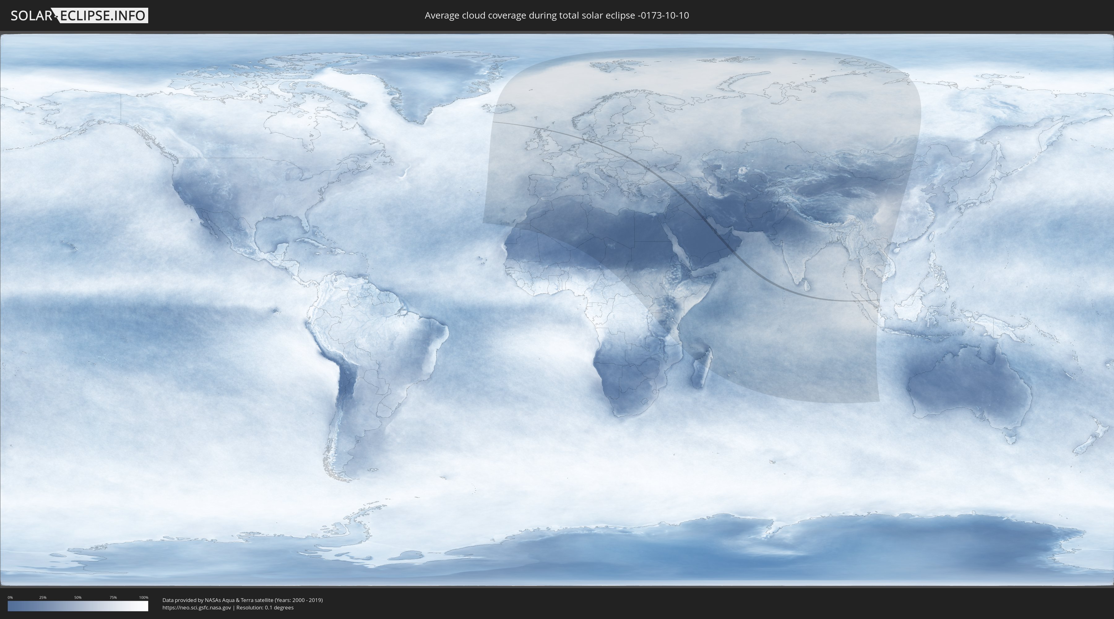
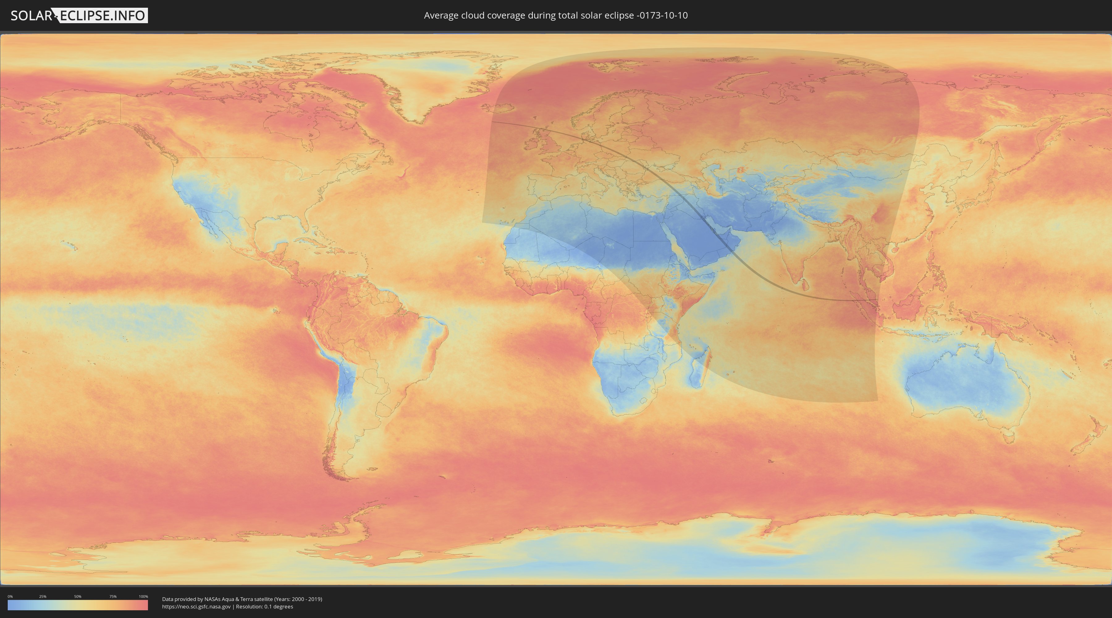
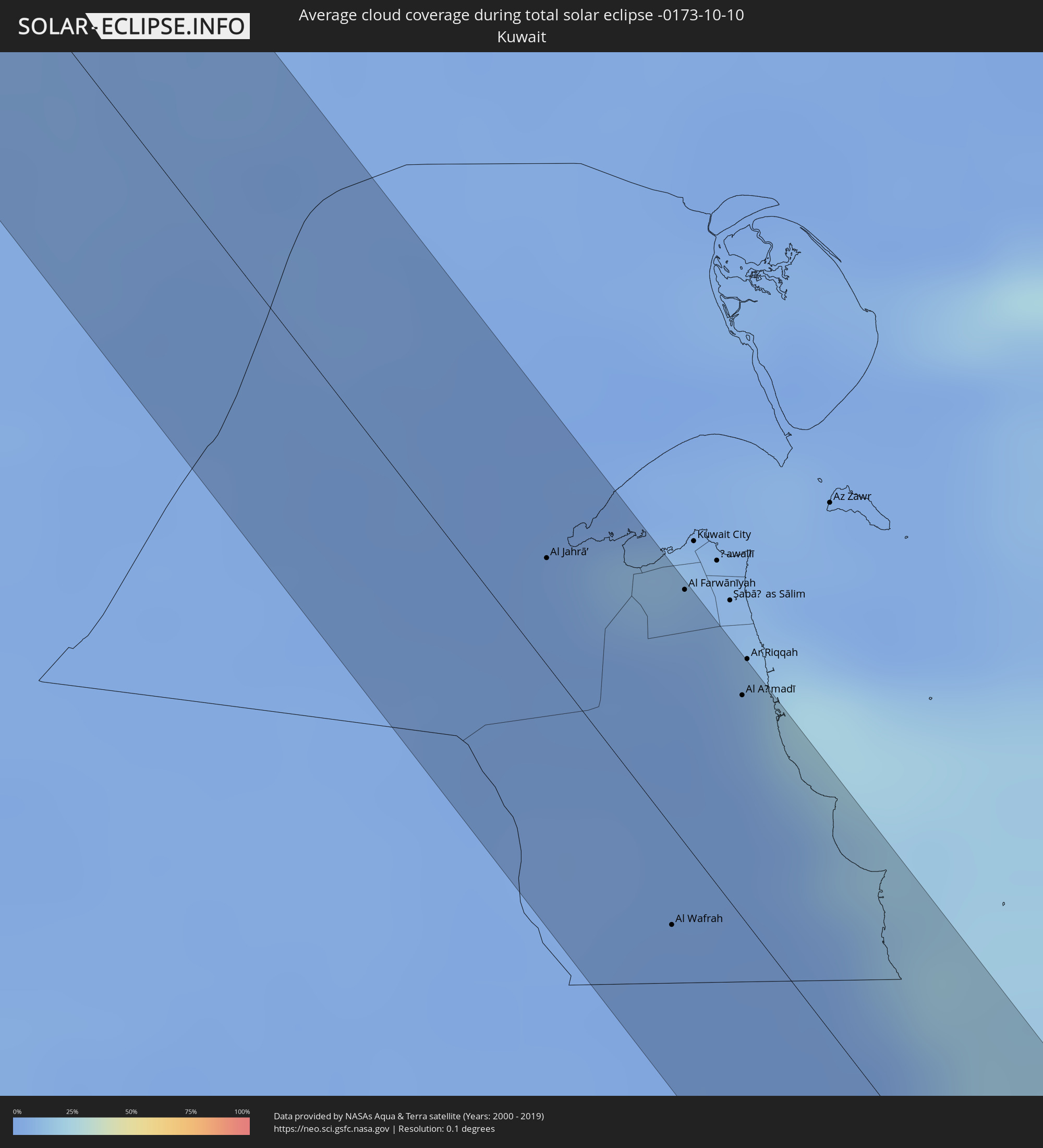
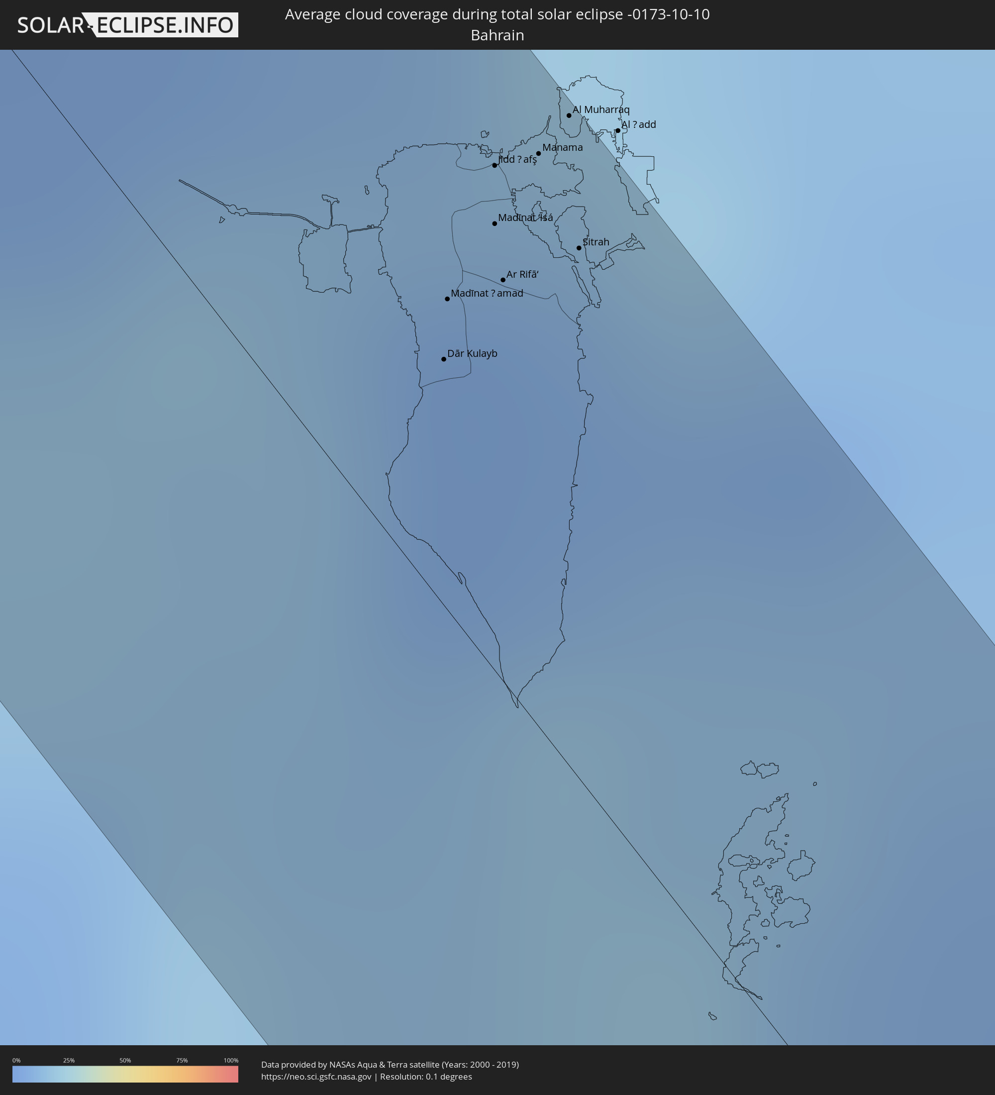
Wie wird das Wetter während der totalen Sonnenfinsternis am 10.10.-0173?
Wo ist der beste Ort, um die totale Sonnenfinsternis vom 10.10.-0173 zu beobachten?
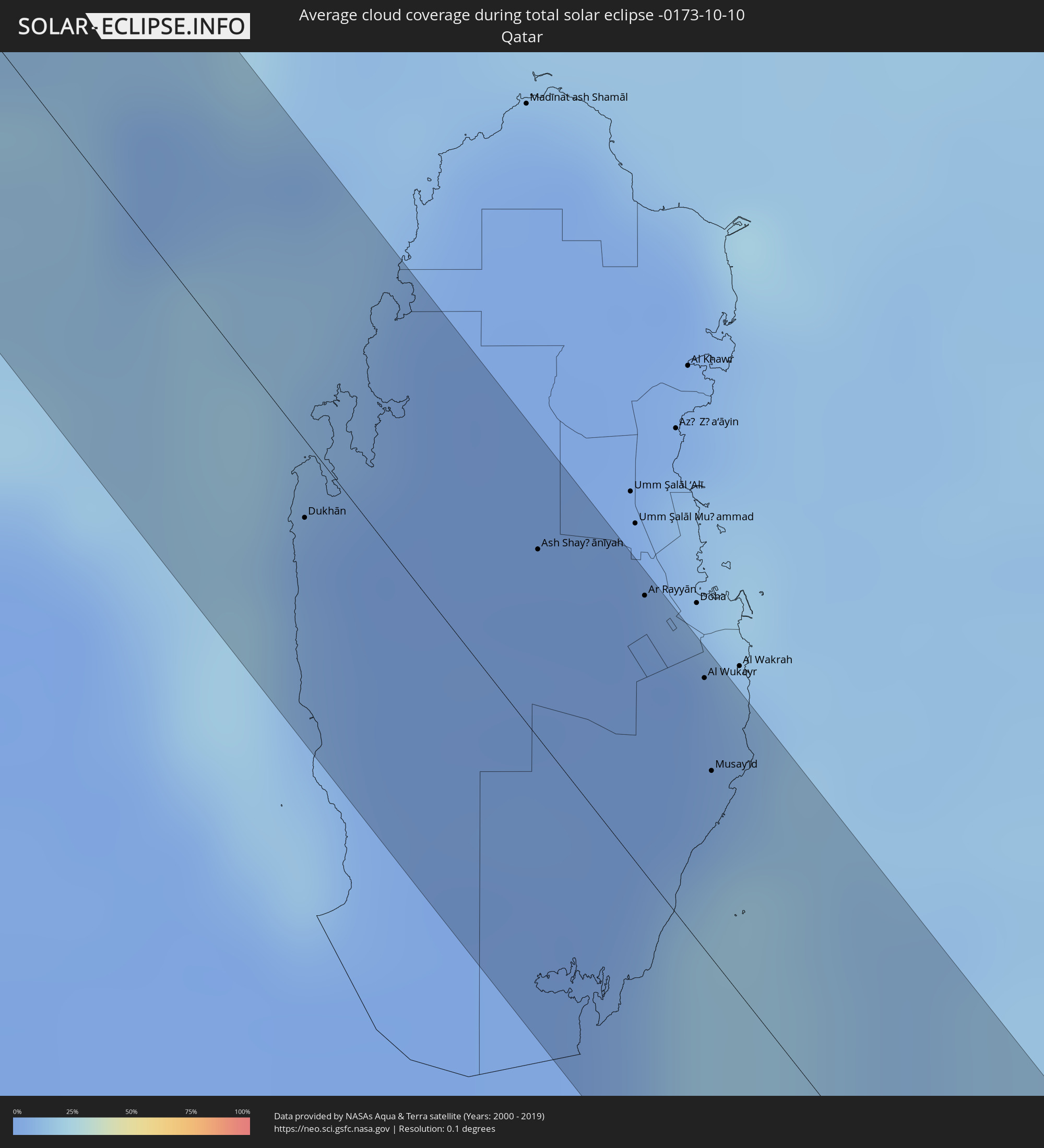
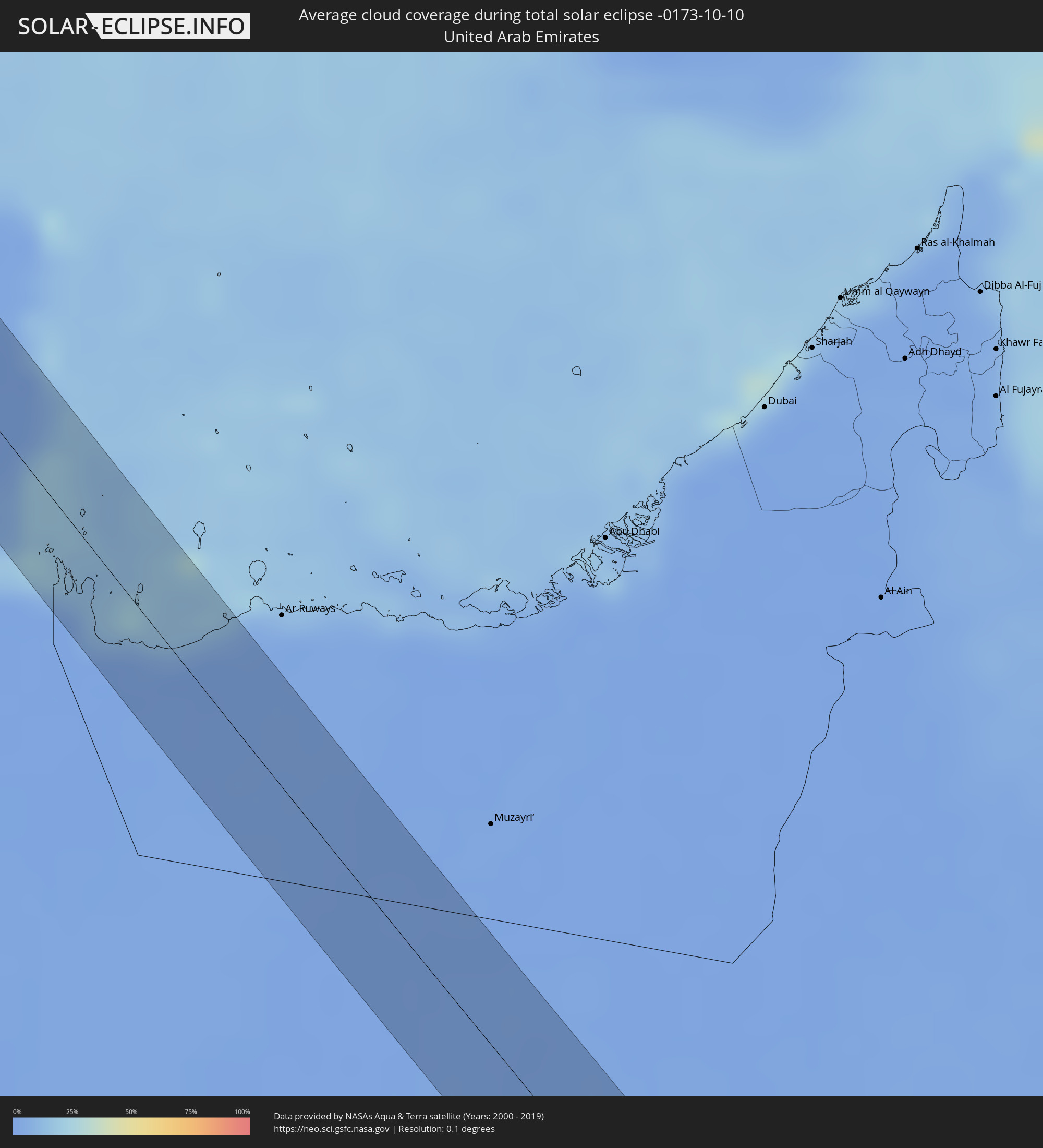
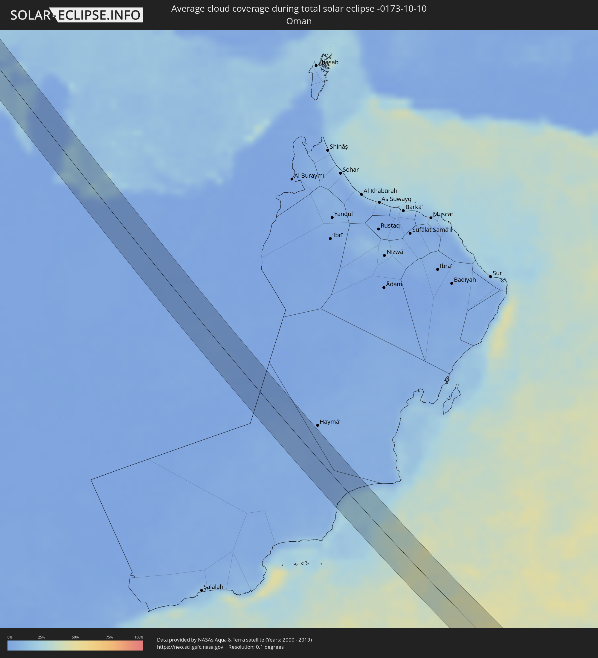
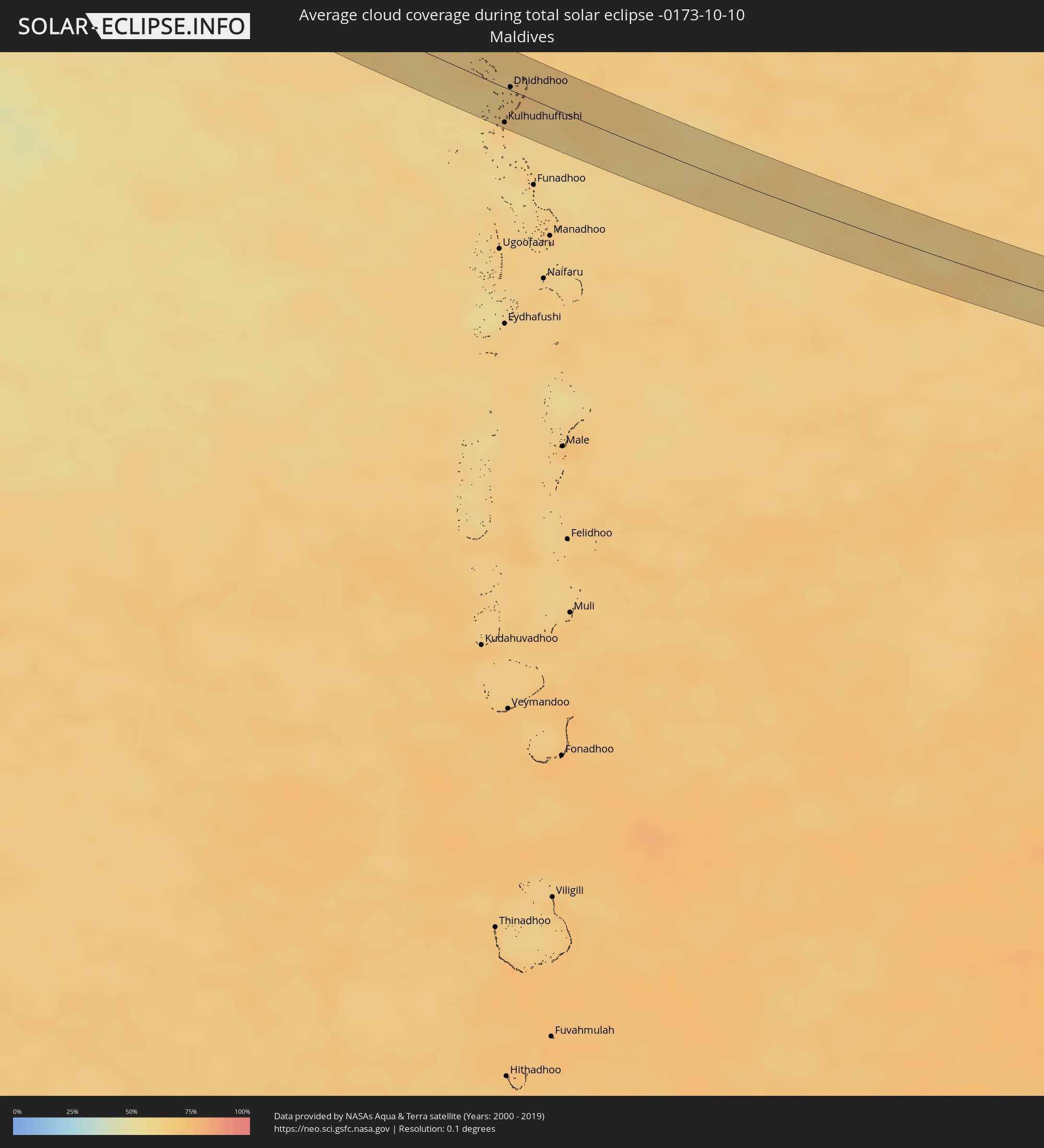
Die folgenden Karten zeigen die durchschnittliche Bewölkung für den Tag, an dem die totale Sonnenfinsternis
stattfindet. Mit Hilfe der Karten lässt sich der Ort entlang des Finsternispfades eingrenzen,
der die besten Aussichen auf einen klaren wolkenfreien Himmel bietet.
Trotzdem muss man immer lokale Gegenenheiten beachten und sollte sich genau über das Wetter an seinem
gewählten Beobachtungsort informieren.
Die Daten stammen von den beiden NASA-Satelliten
AQUA und TERRA
und wurden über einen Zeitraum von 19 Jahren (2000 - 2019) gemittelt.
Detaillierte Länderkarten
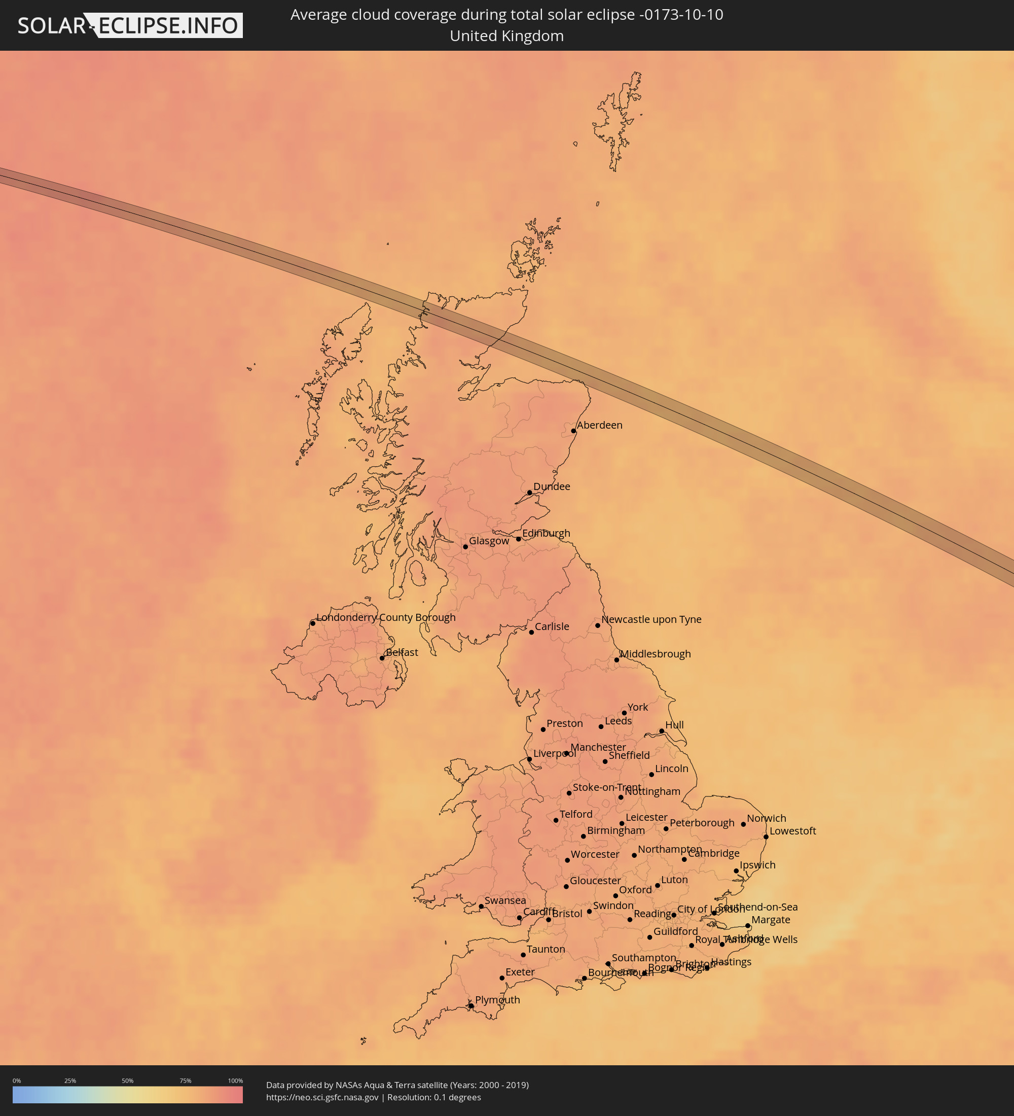 Vereinigtes Königreich
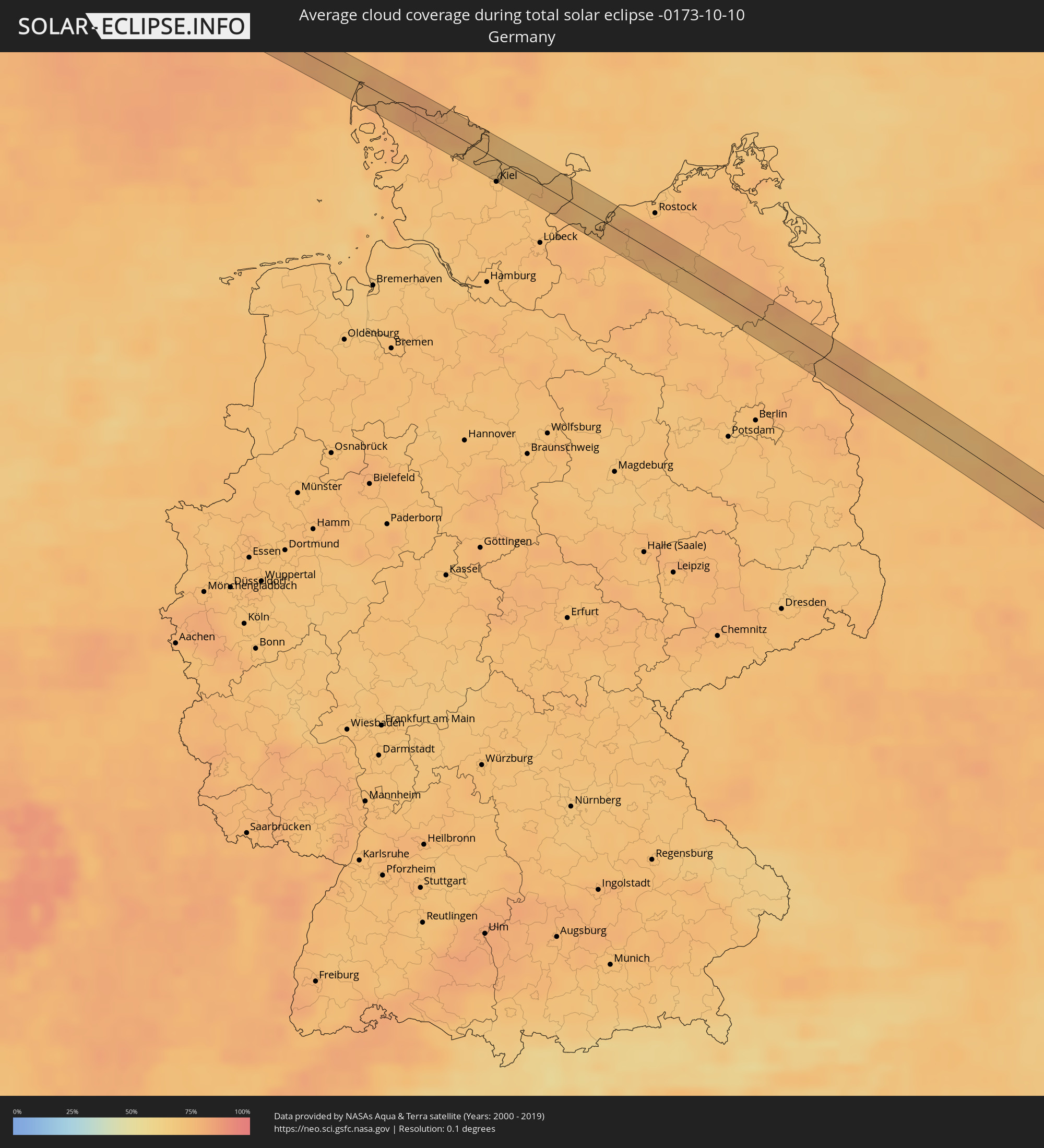 Deutschland
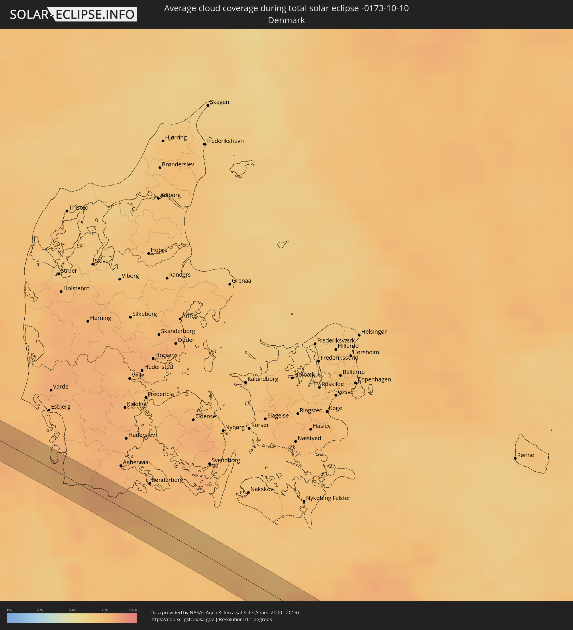 Dänemark
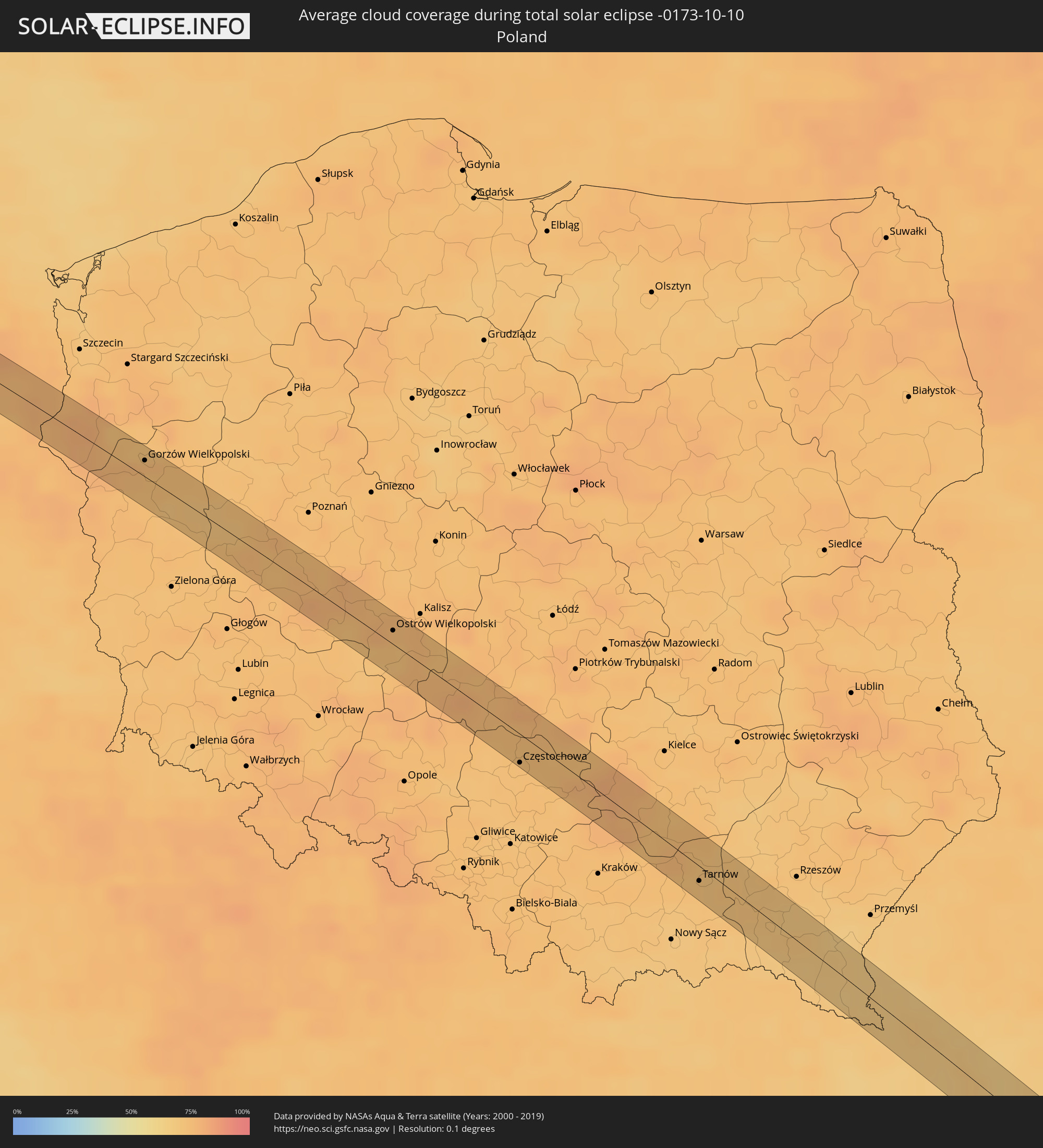 Polen
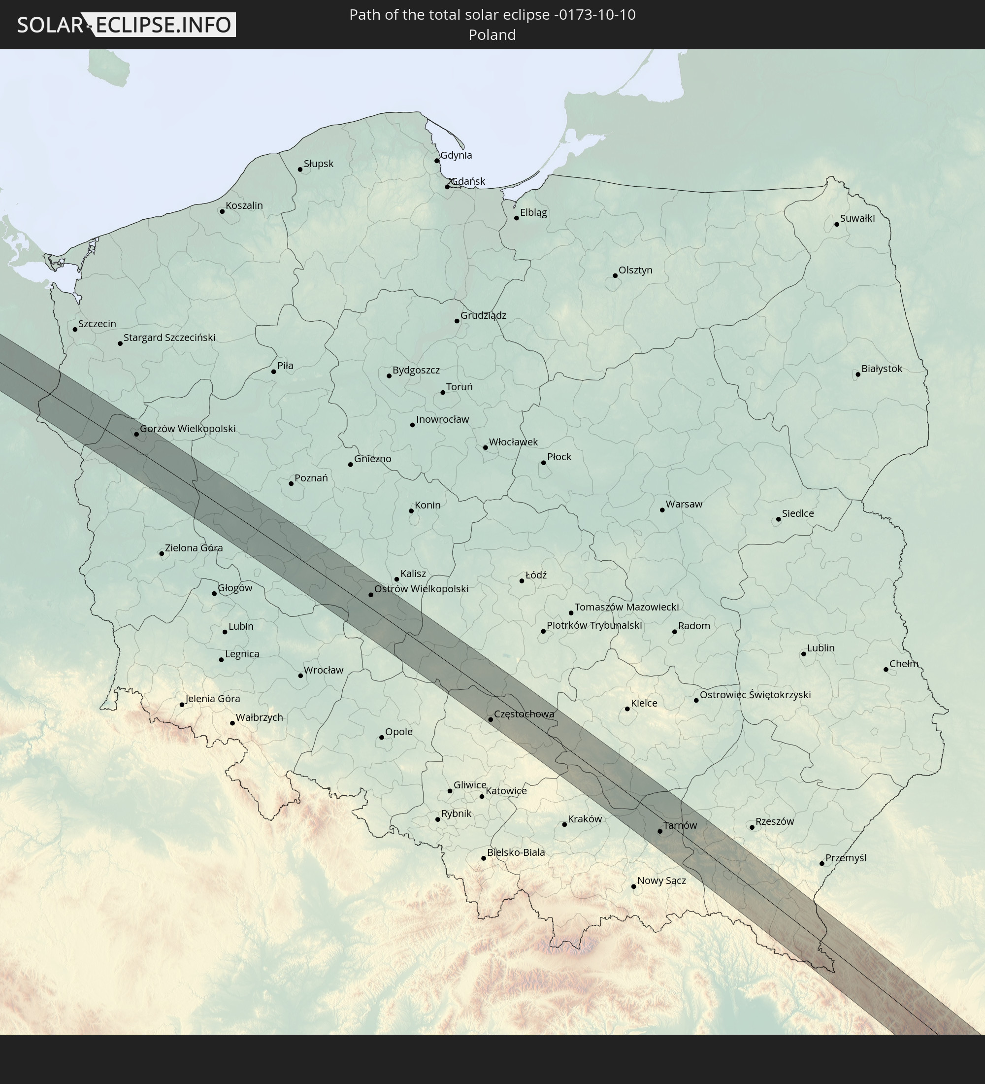
Polen
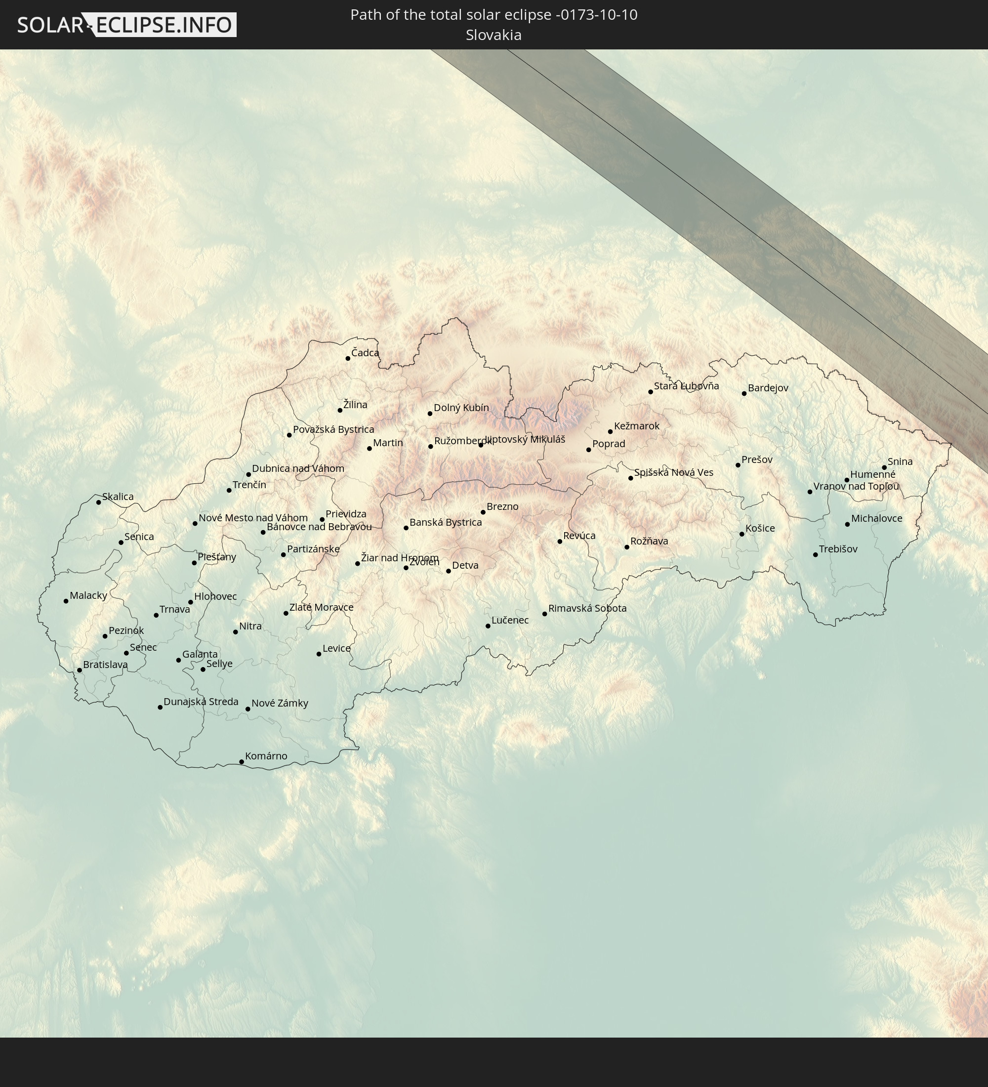
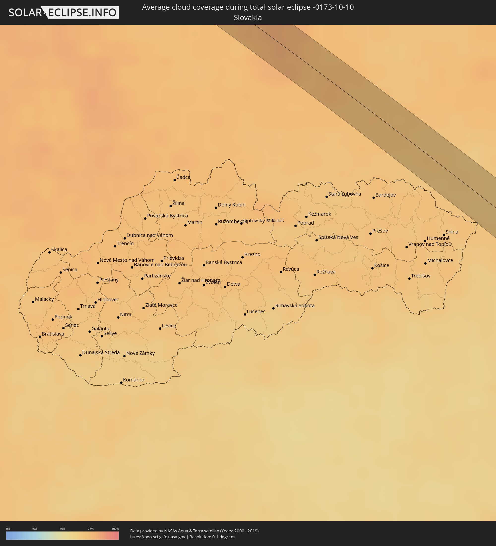 Slowakei
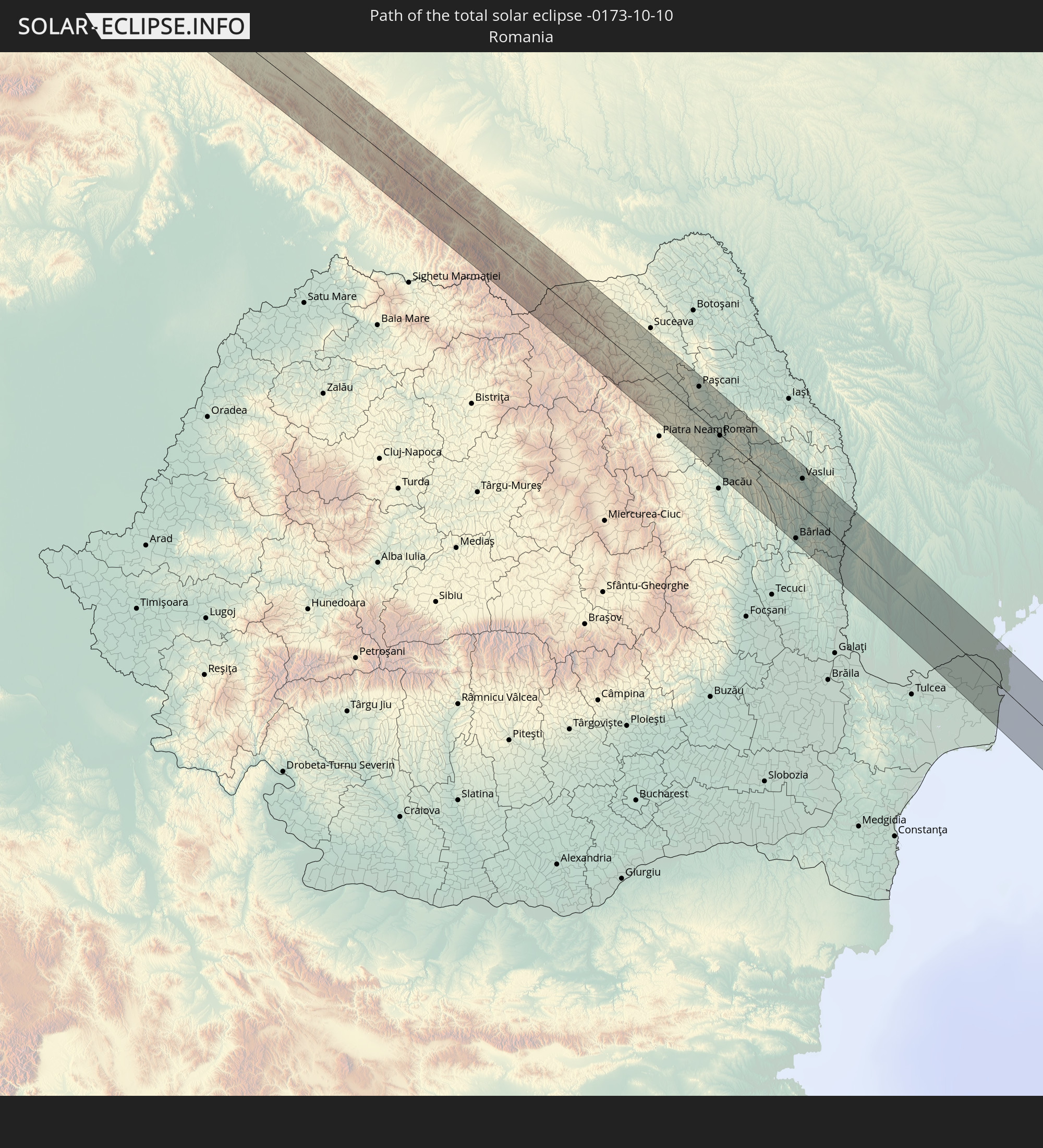
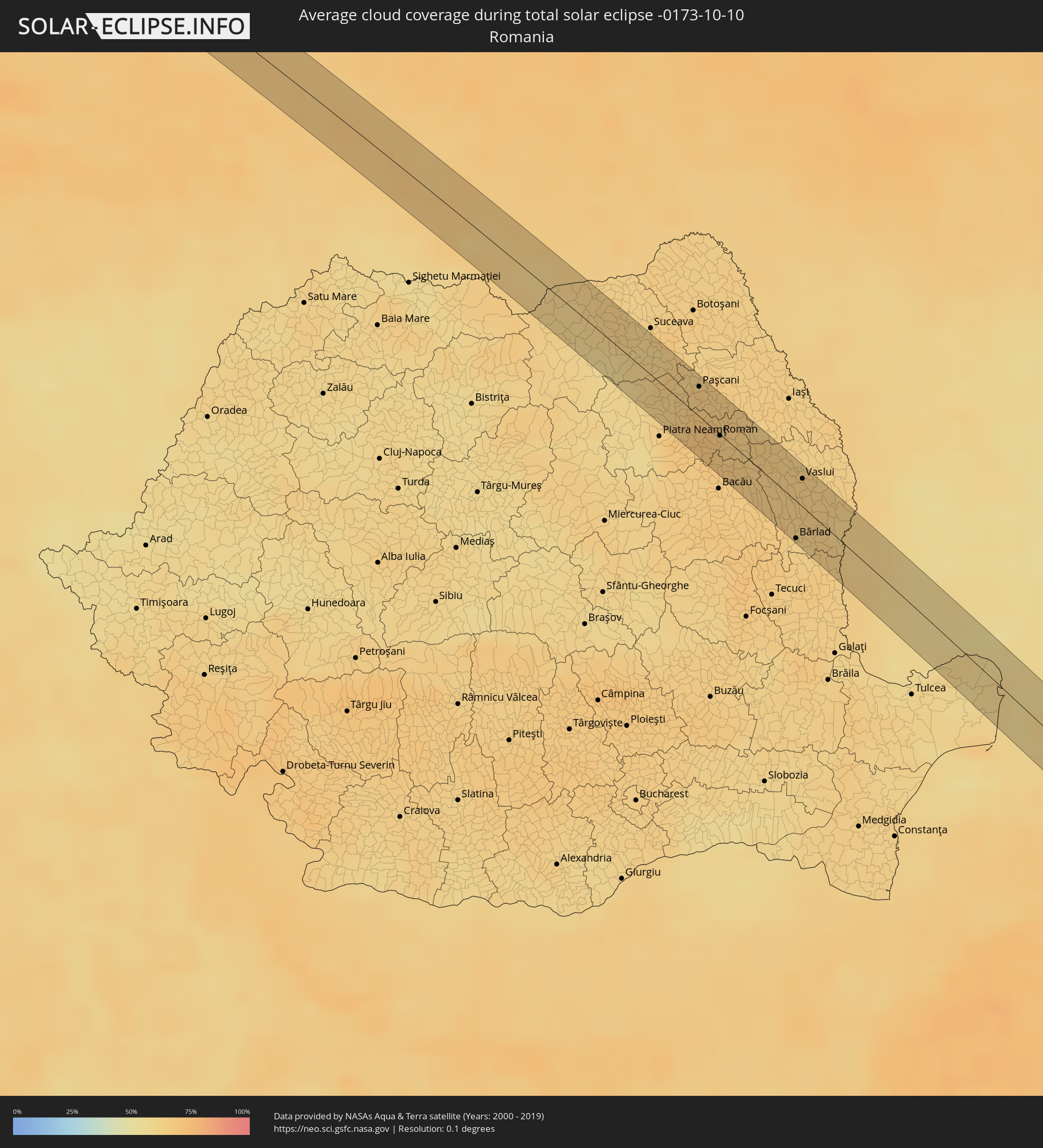 Rumänien
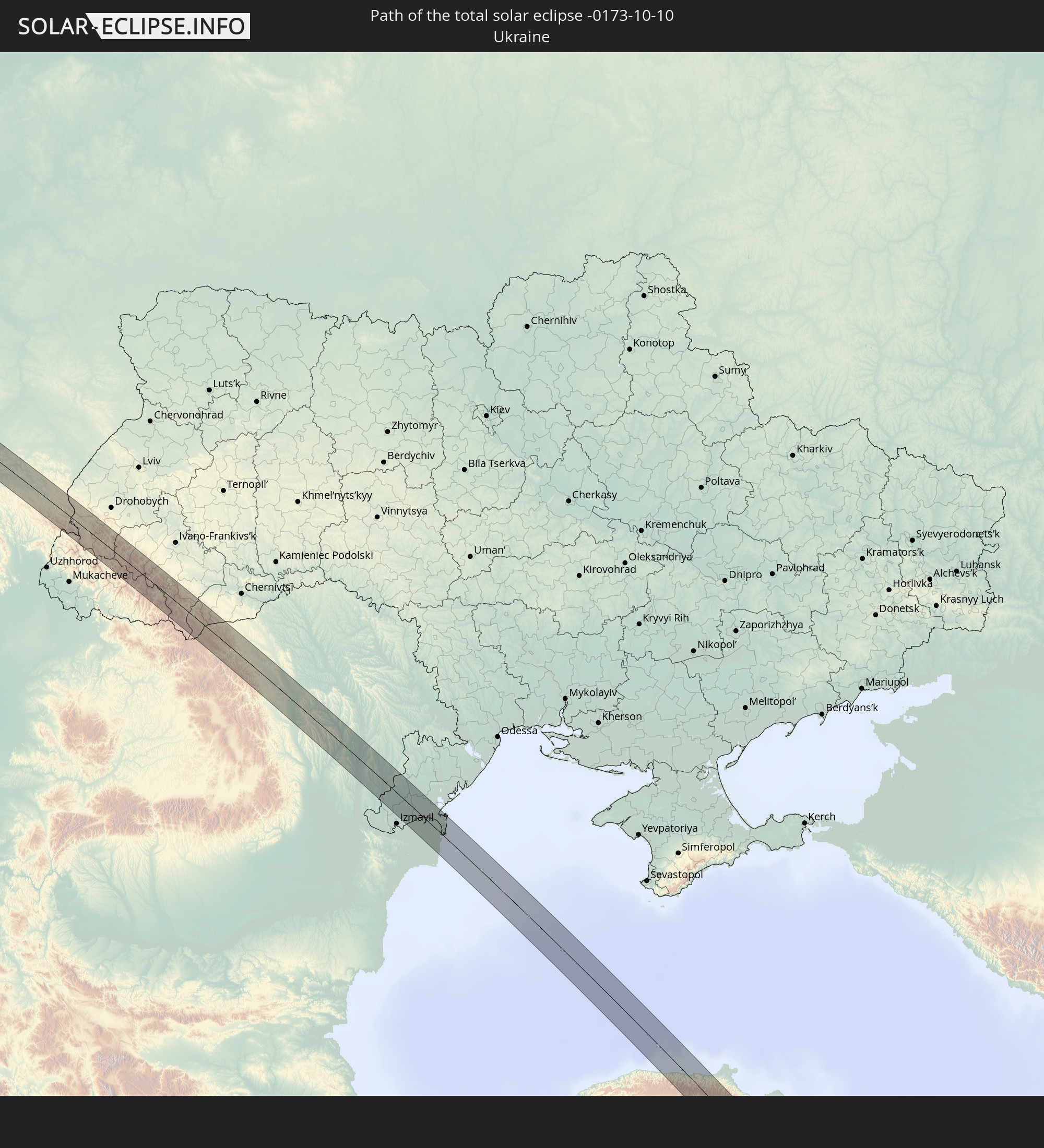
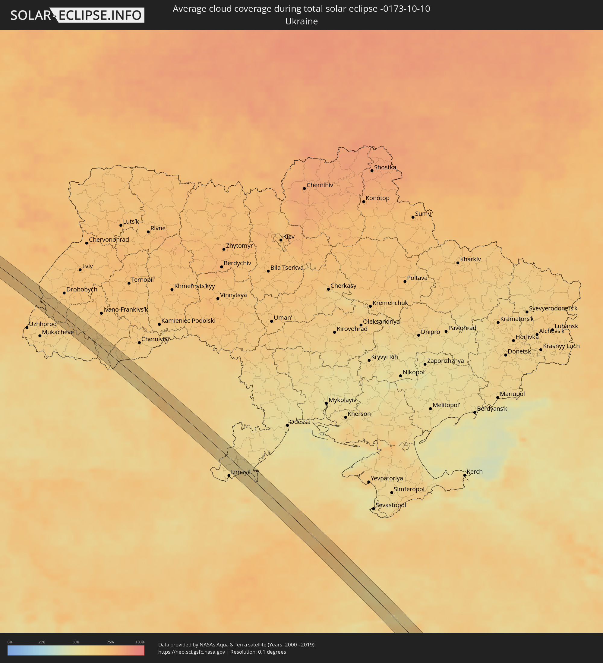 Ukraine
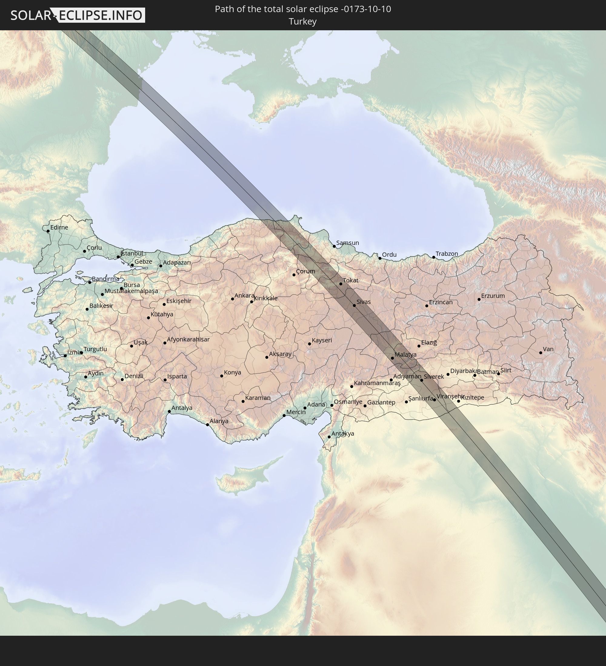
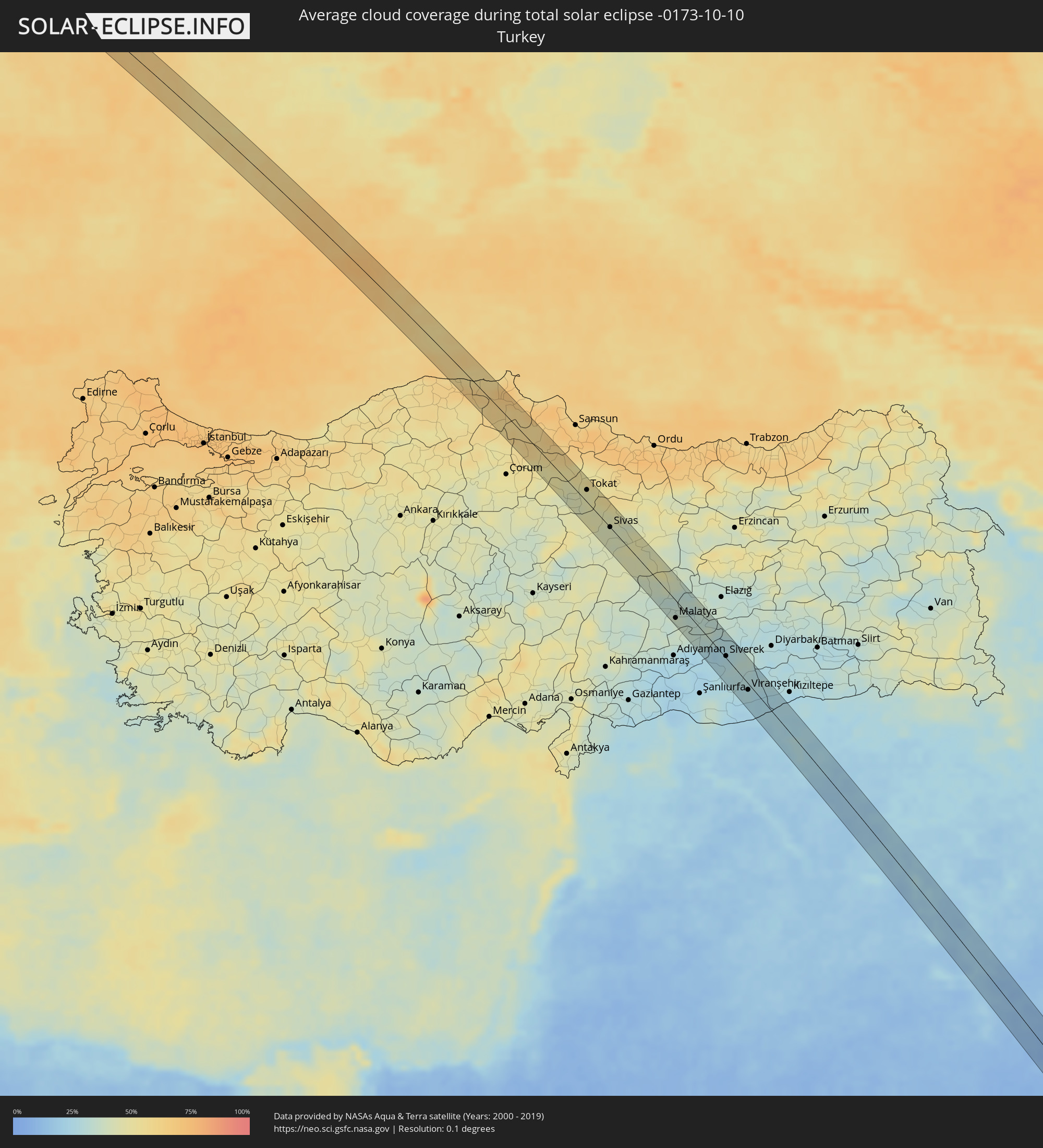 Türkei
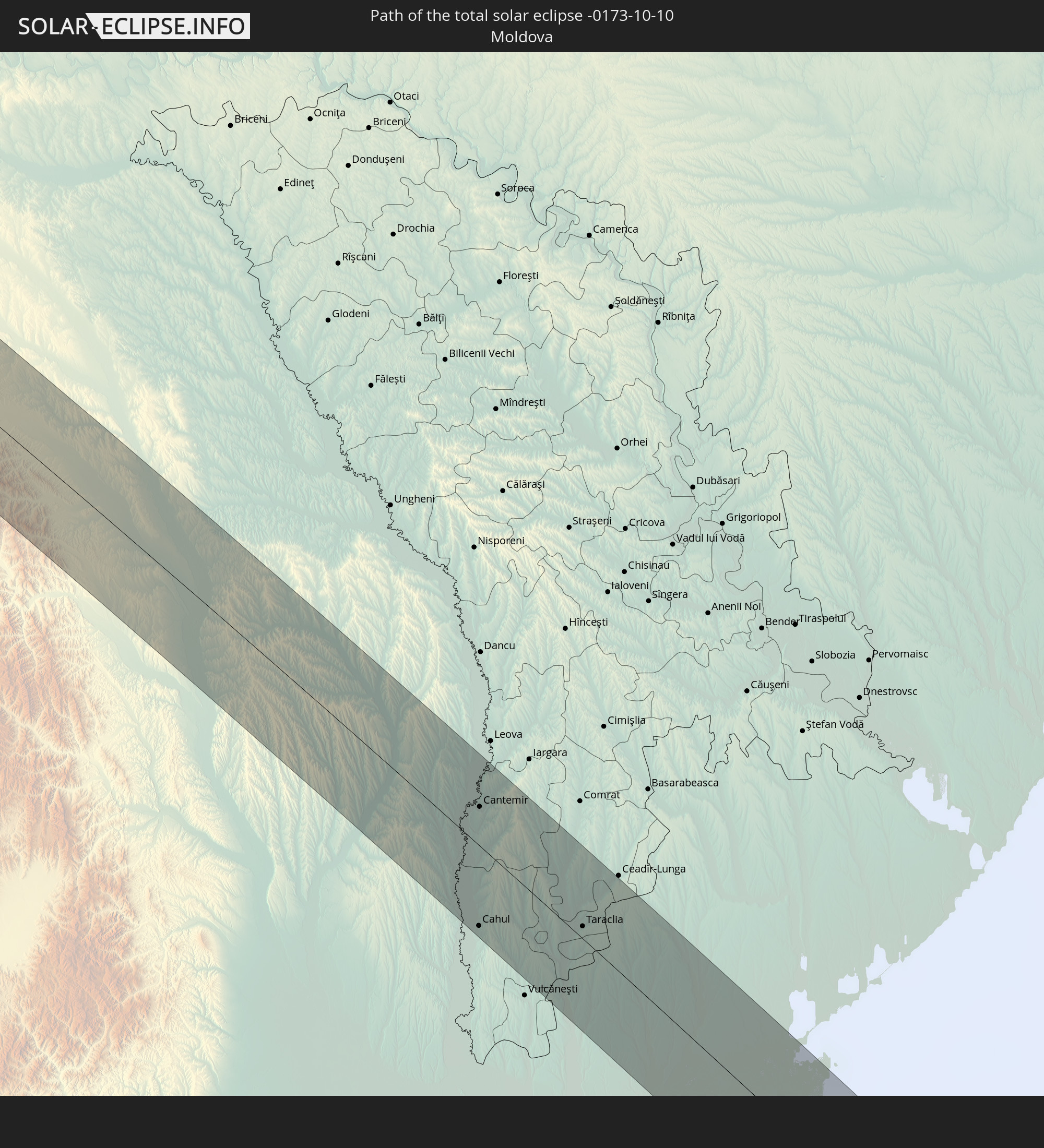
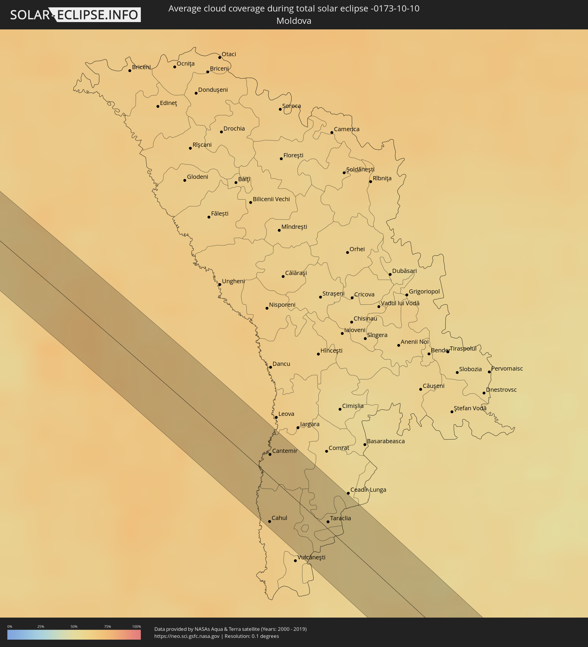 Moldawien
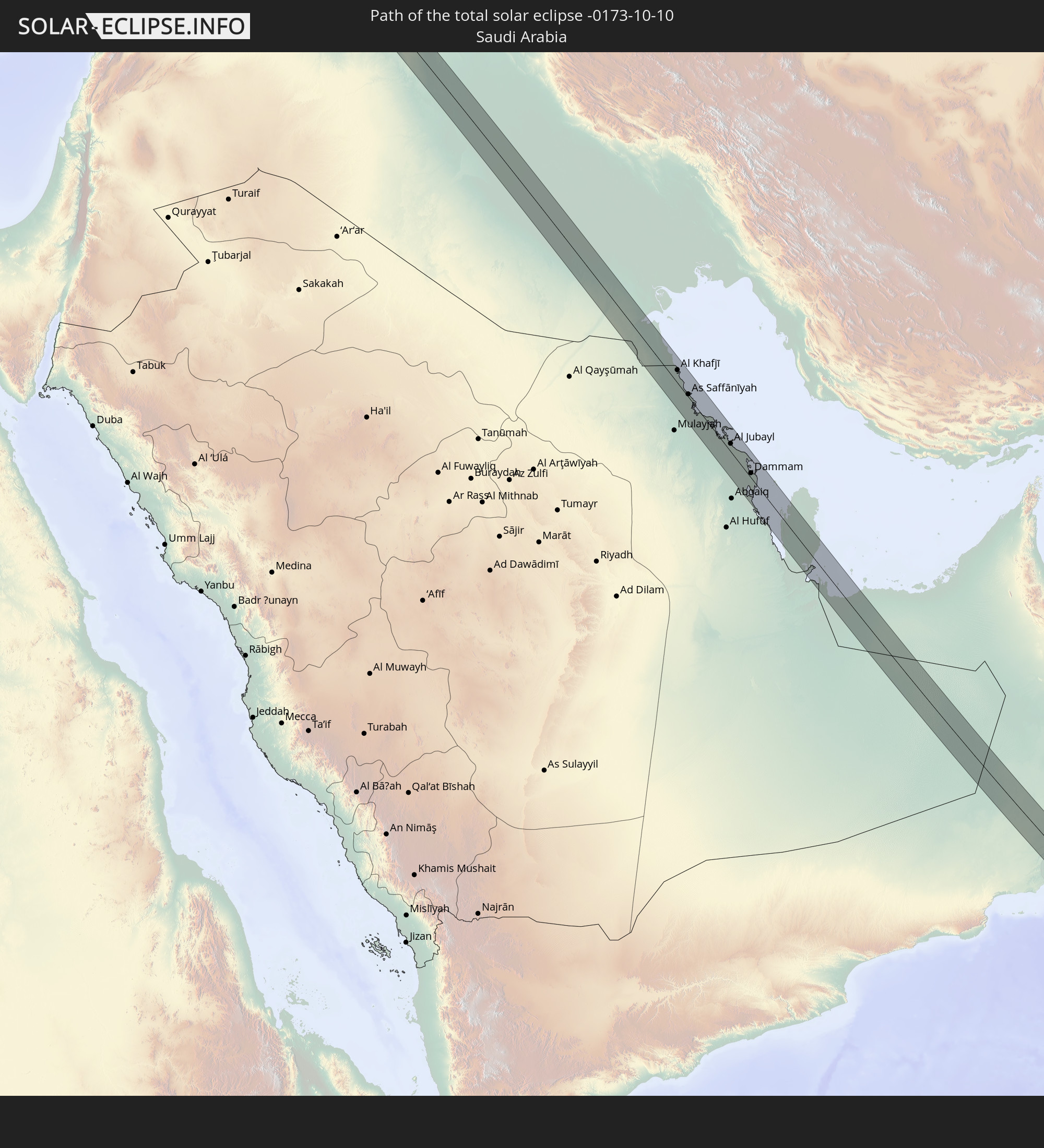
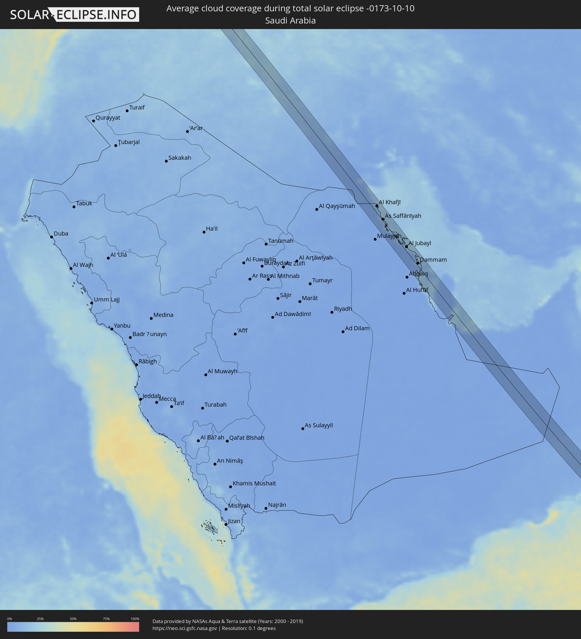 Saudi-Arabien
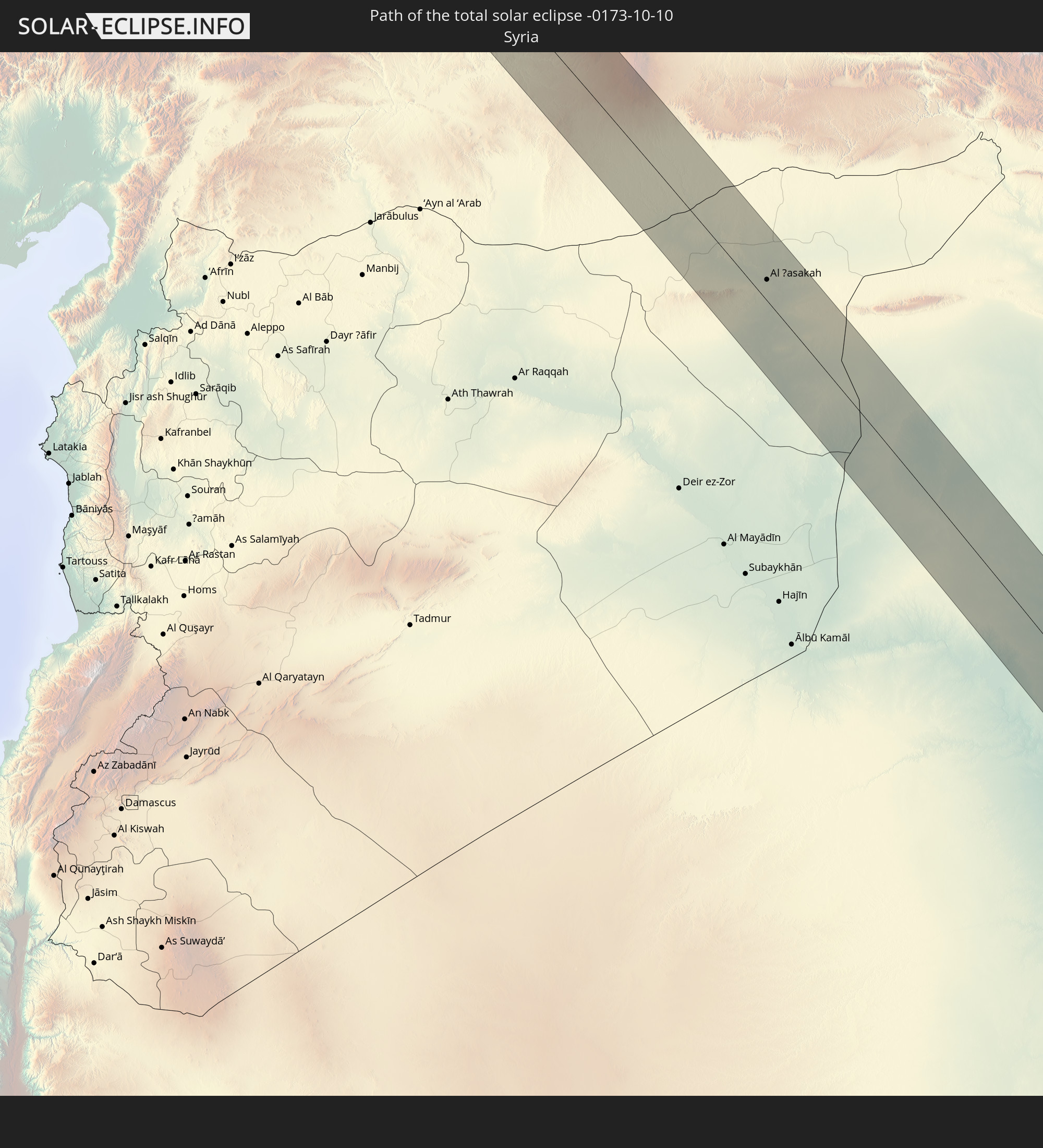
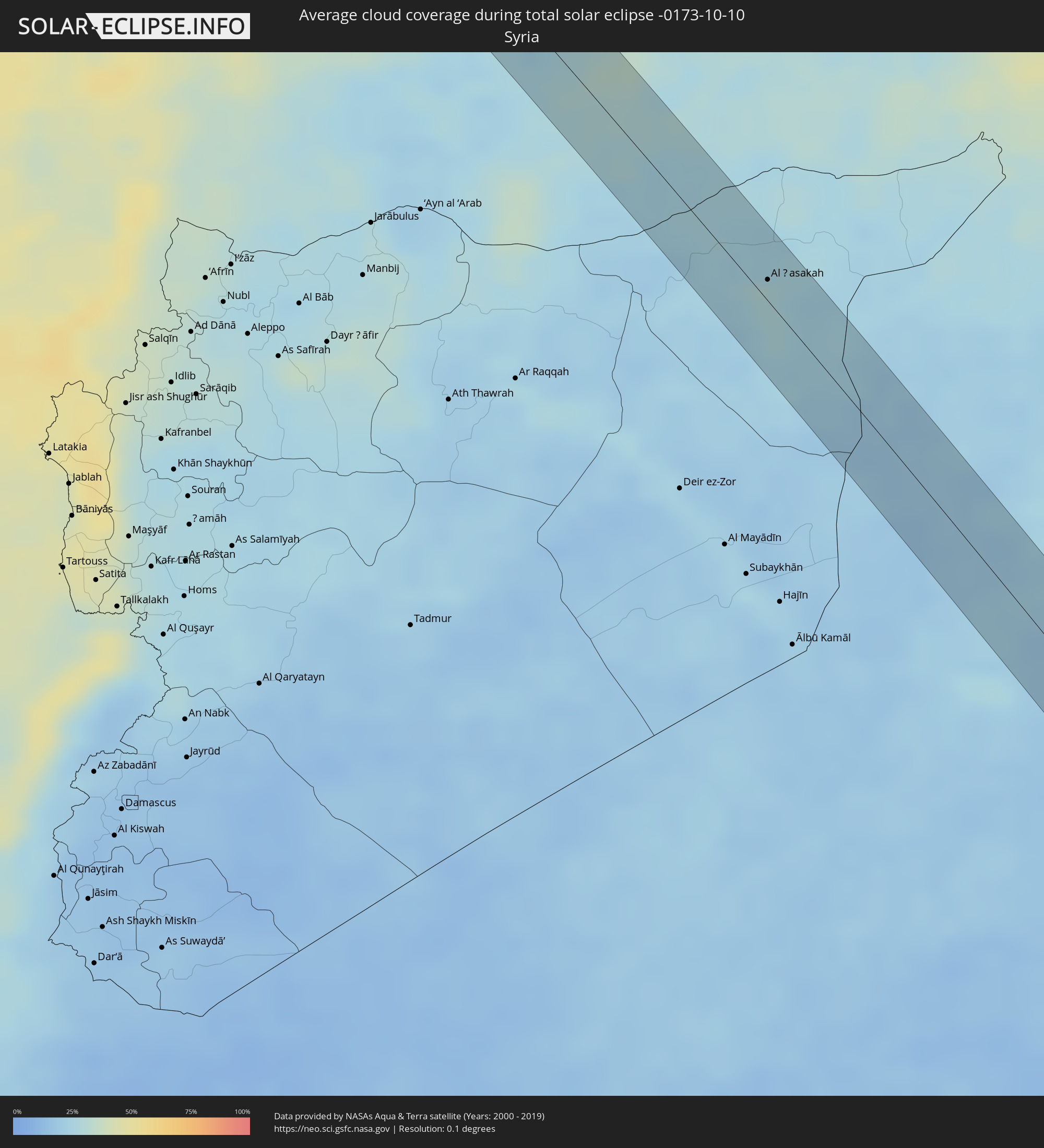 Syrien
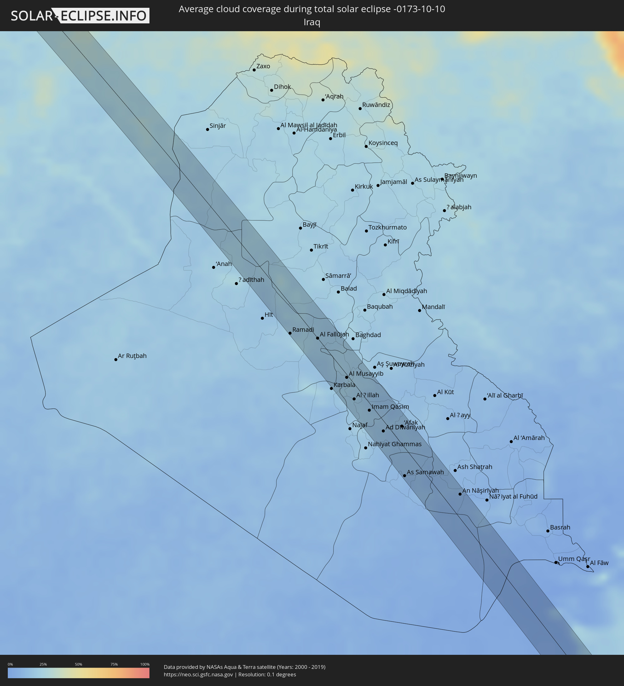 Irak
Irak
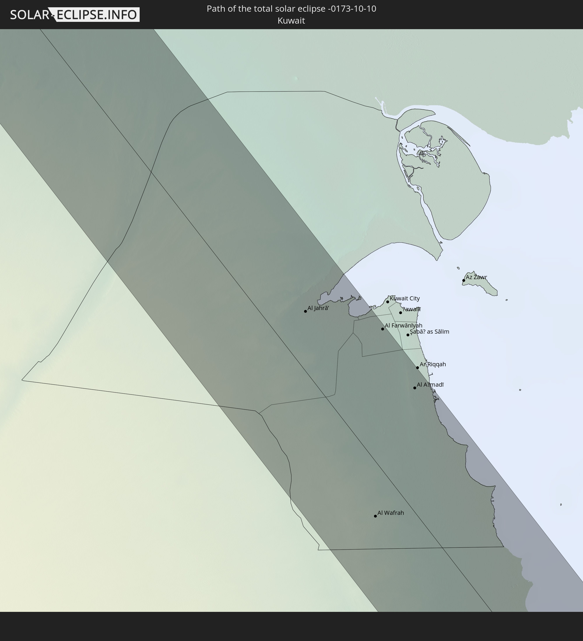
 Kuwait
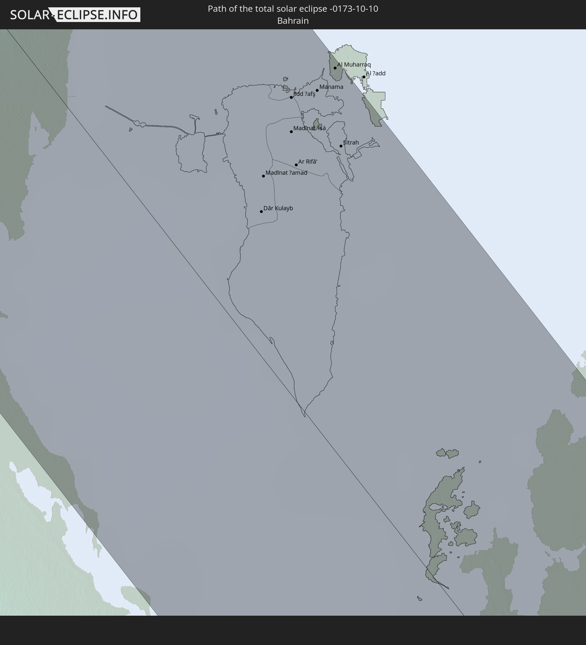
 Bahrain
 Katar
Katar
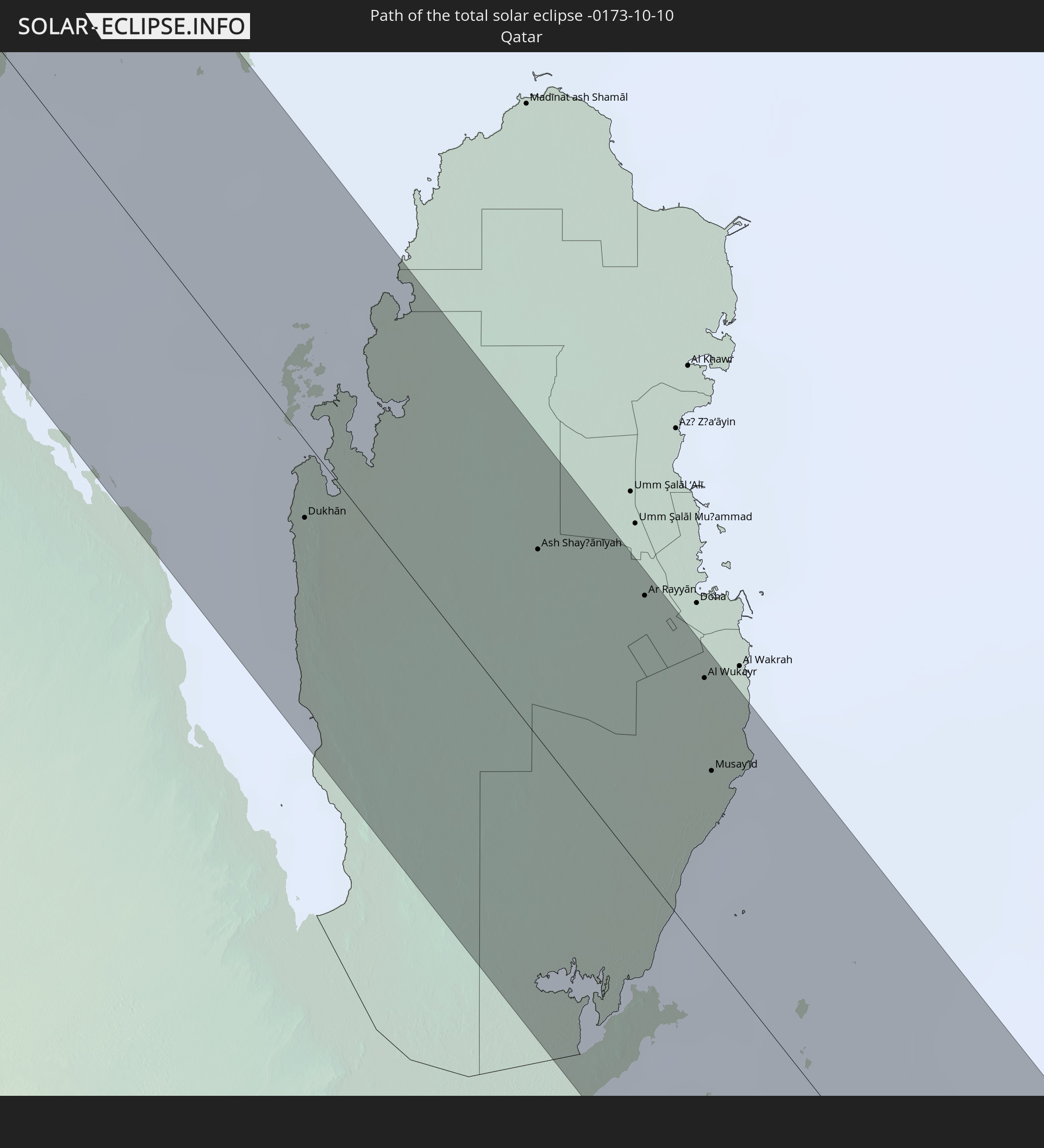
 Vereinigte Arabische Emirate
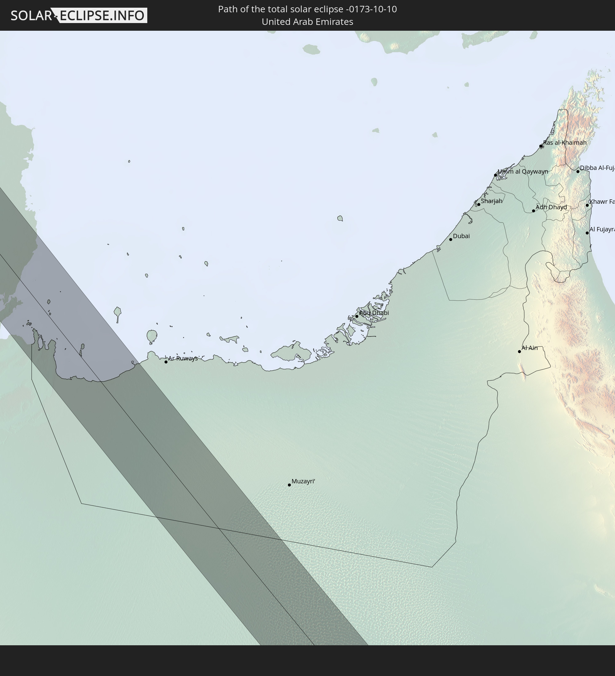
 Oman
Oman
 Malediven
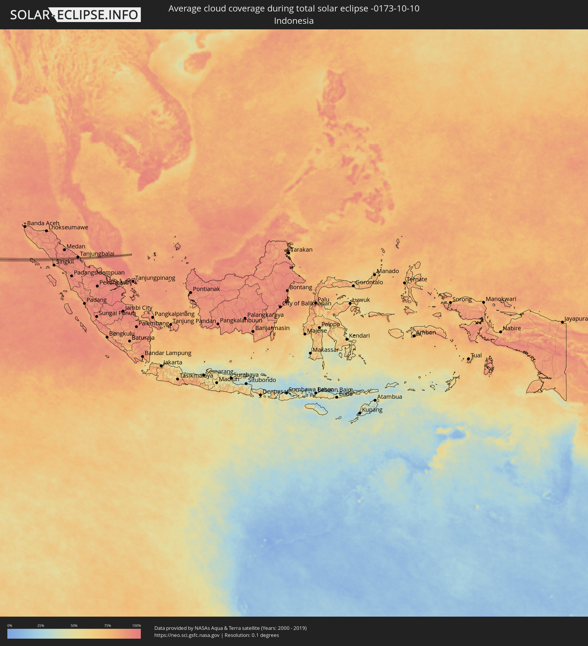 Indonesien
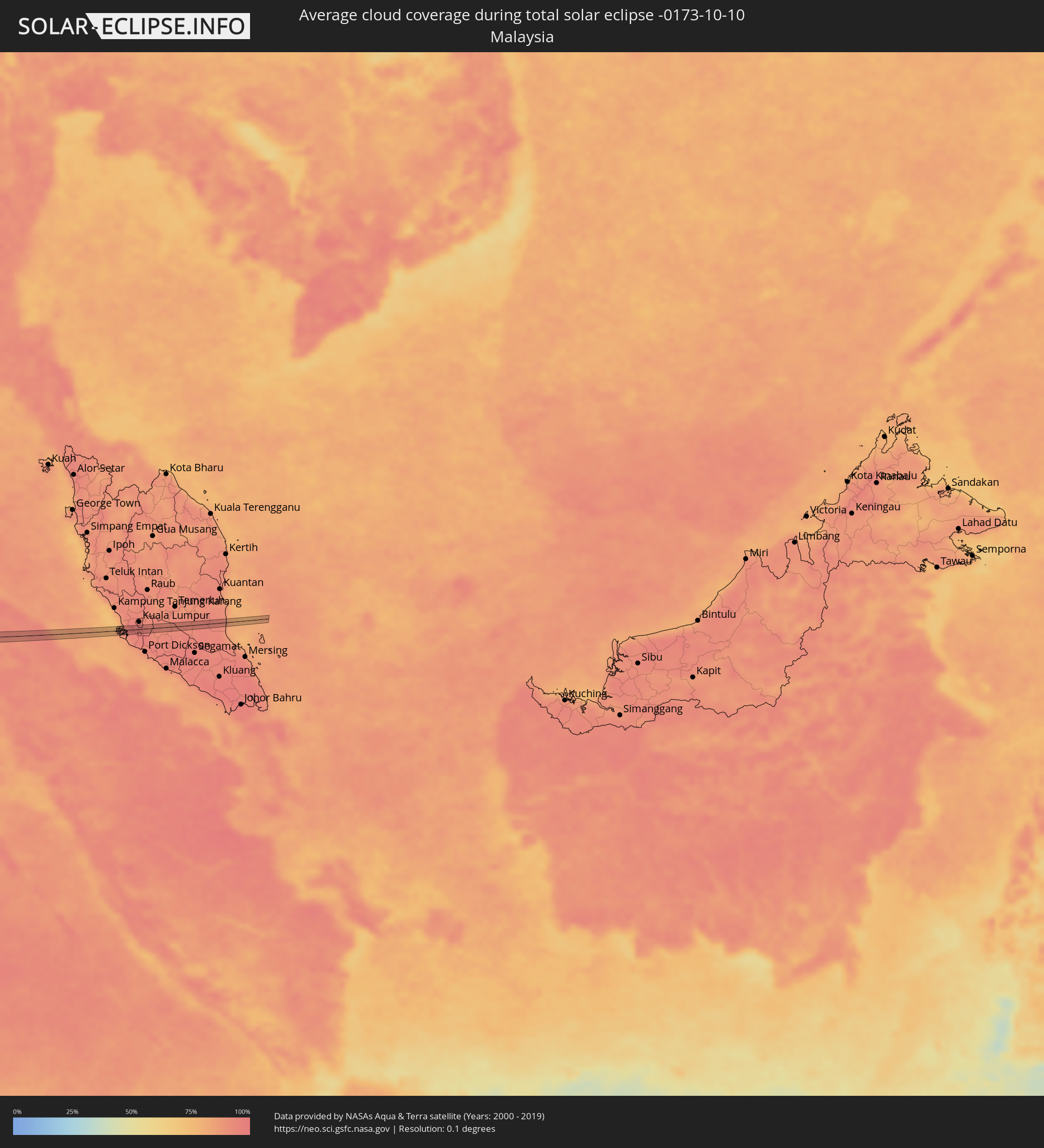 Malaysia
Orte im Finsternispfad
Die nachfolgene Tabelle zeigt Städte und Orte mit mehr als 5.000 Einwohnern, die sich im Finsternispfad befinden. Städte mit mehr als 100.000 Einwohnern sind dick gekennzeichnet. Mit einem Klick auf den Ort öffnet sich eine Detailkarte die die Lage des jeweiligen Ortes zusammen mit dem Verlauf der zentralen Finsternis präsentiert.
| Ort | Typ | Dauer der Verfinsterung | Ortszeit bei maximaler Verfinsterung | Entfernung zur Zentrallinie | Ø Bewölkung |
|
Fraserburgh, Scotland
|
total | - | 07:53:06 UTC+00:00 | 11 km | 79% |
|
Tønder, South Denmark
|
total | - | 08:56:57 UTC+01:00 | 3 km | 80% |
|
Flensburg, Schleswig-Holstein
|
total | - | 08:57:14 UTC+01:00 | 6 km | 78% |
|
Schleswig, Schleswig-Holstein
|
total | - | 08:57:12 UTC+01:00 | 15 km | 75% |
|
Eckernförde, Schleswig-Holstein
|
total | - | 08:57:21 UTC+01:00 | 12 km | 72% |
|
Neustadt in Holstein, Schleswig-Holstein
|
total | - | 08:57:50 UTC+01:00 | 15 km | 74% |
|
Wismar, Mecklenburg-Vorpommern
|
total | - | 08:58:11 UTC+01:00 | 14 km | 76% |
|
Güstrow, Mecklenburg-Vorpommern
|
total | - | 08:58:38 UTC+01:00 | 1 km | 75% |
|
Waren, Mecklenburg-Vorpommern
|
total | - | 08:58:54 UTC+01:00 | 8 km | 71% |
|
Neustrelitz, Mecklenburg-Vorpommern
|
total | - | 08:59:08 UTC+01:00 | 9 km | 74% |
|
Neubrandenburg, Mecklenburg-Vorpommern
|
total | - | 08:59:20 UTC+01:00 | 17 km | 75% |
|
Templin, Brandenburg
|
total | - | 08:59:22 UTC+01:00 | 17 km | 74% |
|
Prenzlau, Brandenburg
|
total | - | 08:59:41 UTC+01:00 | 14 km | 75% |
|
Schwedt (Oder), Brandenburg
|
total | - | 08:59:55 UTC+01:00 | 5 km | 77% |
|
Gorzów Wielkopolski, Lubusz
|
total | - | 09:24:33 UTC+01:24 | 9 km | 75% |
|
Kościan, Greater Poland Voivodeship
|
total | - | 09:25:31 UTC+01:24 | 3 km | 73% |
|
Śrem, Greater Poland Voivodeship
|
total | - | 09:25:48 UTC+01:24 | 17 km | 75% |
|
Krotoszyn, Greater Poland Voivodeship
|
total | - | 09:26:05 UTC+01:24 | 2 km | 73% |
|
Ostrów Wielkopolski, Greater Poland Voivodeship
|
total | - | 09:26:23 UTC+01:24 | 8 km | 75% |
|
Wieluń, Łódź Voivodeship
|
total | - | 09:26:58 UTC+01:24 | 1 km | 77% |
|
Częstochowa, Silesian Voivodeship
|
total | - | 09:27:25 UTC+01:24 | 17 km | 73% |
|
Tarnów, Lesser Poland Voivodeship
|
total | - | 09:29:03 UTC+01:24 | 9 km | 71% |
|
Dębica, Subcarpathian Voivodeship
|
total | - | 09:29:26 UTC+01:24 | 13 km | 71% |
|
Jasło, Subcarpathian Voivodeship
|
total | - | 09:29:31 UTC+01:24 | 12 km | 69% |
|
Krosno, Subcarpathian Voivodeship
|
total | - | 09:29:47 UTC+01:24 | 4 km | 69% |
|
Sanok, Subcarpathian Voivodeship
|
total | - | 09:30:12 UTC+01:24 | 4 km | 68% |
|
Turka, Lviv
|
total | - | 10:09:05 UTC+02:02 | 6 km | 66% |
|
Slavs’ke, Lviv
|
total | - | 10:09:32 UTC+02:02 | 2 km | 67% |
|
Skole, Lviv
|
total | - | 10:09:34 UTC+02:02 | 17 km | 68% |
|
Yasinya, Zakarpattia
|
total | - | 10:10:32 UTC+02:02 | 9 km | 62% |
|
Yaremche, Ivano-Frankivsk
|
total | - | 10:10:41 UTC+02:02 | 15 km | 65% |
|
Verkhovyna, Ivano-Frankivsk
|
total | - | 10:10:59 UTC+02:02 | 1 km | 63% |
|
Kosmach, Ivano-Frankivsk
|
total | - | 10:10:59 UTC+02:02 | 17 km | 63% |
|
Câmpulung Moldovenesc, Suceava
|
total | - | 09:54:16 UTC+01:44 | 16 km | 59% |
|
Marginea, Suceava
|
total | - | 09:54:27 UTC+01:44 | 21 km | 64% |
|
Gura Humorului, Suceava
|
total | - | 09:54:36 UTC+01:44 | 2 km | 62% |
|
Pipirig, Neamţ
|
total | - | 09:54:52 UTC+01:44 | 15 km | 60% |
|
Liteni, Suceava
|
total | - | 09:54:55 UTC+01:44 | 18 km | 61% |
|
Fălticeni, Suceava
|
total | - | 09:55:03 UTC+01:44 | 13 km | 63% |
|
Târgu Neamţ, Neamţ
|
total | - | 09:55:12 UTC+01:44 | 5 km | 62% |
|
Paşcani, Iaşi
|
total | - | 09:55:33 UTC+01:44 | 17 km | 69% |
|
Roman, Neamţ
|
total | - | 09:55:53 UTC+01:44 | 1 km | 66% |
|
Negreşti, Vaslui
|
total | - | 09:56:27 UTC+01:44 | 17 km | 65% |
|
Bârlad, Vaslui
|
total | - | 09:56:56 UTC+01:44 | 21 km | 63% |
|
Vaslui, Vaslui
|
total | - | 09:56:51 UTC+01:44 | 16 km | 66% |
|
Cahul, Cahul
|
total | - | 10:08:15 UTC+01:55 | 21 km | 63% |
|
Cantemir, Cantemir
|
total | - | 10:08:06 UTC+01:55 | 10 km | 61% |
|
Bolhrad, Odessa
|
total | - | 10:15:52 UTC+02:02 | 18 km | 58% |
|
Taraclia, Taraclia
|
total | - | 10:08:46 UTC+01:55 | 3 km | 59% |
|
Kiliya, Odessa
|
total | - | 10:16:43 UTC+02:02 | 2 km | 61% |
|
Shevchenkove, Odessa
|
total | - | 10:16:45 UTC+02:02 | 10 km | 57% |
|
Vylkove, Odessa
|
total | - | 10:17:06 UTC+02:02 | 10 km | 61% |
|
Boyabat, Sinop
|
total | - | 10:20:53 UTC+01:56 | 8 km | 58% |
|
Vezirköprü, Samsun
|
total | - | 10:22:04 UTC+01:56 | 9 km | 60% |
|
Merzifon, Amasya
|
total | - | 10:22:19 UTC+01:56 | 11 km | 52% |
|
Suluova, Amasya
|
total | - | 10:22:36 UTC+01:56 | 3 km | 49% |
|
Amasya, Amasya
|
total | - | 10:23:00 UTC+01:56 | 5 km | 49% |
|
Turhal, Tokat
|
total | - | 10:23:35 UTC+01:56 | 10 km | 46% |
|
Tokat, Tokat
|
total | - | 10:24:17 UTC+01:56 | 14 km | 46% |
|
Sivas, Sivas
|
total | - | 10:25:27 UTC+01:56 | 1 km | 42% |
|
Malatya, Malatya
|
total | - | 10:28:43 UTC+01:56 | 20 km | 35% |
|
Siverek, Şanlıurfa
|
total | - | 10:30:49 UTC+01:56 | 3 km | 27% |
|
Viranşehir, Şanlıurfa
|
total | - | 10:32:04 UTC+01:56 | 7 km | 27% |
|
Ceylanpınar, Şanlıurfa
|
total | - | 10:32:56 UTC+01:56 | 14 km | 24% |
|
Al Ḩasakah, Al-Hasakah
|
total | - | 11:02:40 UTC+02:25 | 8 km | 28% |
|
Ramadi, Anbar
|
total | - | 11:43:07 UTC+02:57 | 30 km | 22% |
|
Al Fallūjah, Anbar
|
total | - | 11:43:59 UTC+02:57 | 1 km | 19% |
|
Abū Ghurayb, Mayorality of Baghdad
|
total | - | 11:44:41 UTC+02:57 | 26 km | 20% |
|
Al Hindīyah, Karbalāʼ
|
total | - | 11:45:52 UTC+02:57 | 24 km | 15% |
|
Nāḩīyat Saddat al Hindīyah, Bābil
|
total | - | 11:45:42 UTC+02:57 | 8 km | 20% |
|
Al Musayyib, Bābil
|
total | - | 11:45:38 UTC+02:57 | 3 km | 21% |
|
Al Ḩillah, Bābil
|
total | - | 11:46:18 UTC+02:57 | 15 km | 18% |
|
Imam Qasim, Bābil
|
total | - | 11:46:59 UTC+02:57 | 7 km | 17% |
|
Ad Dīwānīyah, Al Qādisīyah
|
total | - | 11:47:50 UTC+02:57 | 11 km | 13% |
|
Ar Rumaythah, Al Muthanná
|
total | - | 11:49:01 UTC+02:57 | 22 km | 11% |
|
As Samawah, Al Muthanná
|
total | - | 11:49:28 UTC+02:57 | 29 km | 9% |
|
An Nāşirīyah, Dhi Qar
|
total | - | 11:51:30 UTC+02:57 | 25 km | 7% |
|
Al Jahrā’, Al Jahrāʼ
|
total | - | 12:05:56 UTC+03:06 | 14 km | 1% |
|
Al Wafrah, Al Aḩmadī
|
total | - | 12:07:36 UTC+03:06 | 13 km | 1% |
|
Ar Rābiyah, Al Asimah
|
total | - | 12:06:29 UTC+03:06 | 32 km | 3% |
|
Al Farwānīyah, Al Farwaniyah
|
total | - | 12:06:33 UTC+03:06 | 33 km | 5% |
|
Janūb as Surrah, Al Farwaniyah
|
total | - | 12:06:36 UTC+03:06 | 34 km | 5% |
|
Al Aḩmadī, Al Aḩmadī
|
total | - | 12:07:06 UTC+03:06 | 29 km | 7% |
|
Al Faḩāḩīl, Al Aḩmadī
|
total | - | 12:07:11 UTC+03:06 | 33 km | 7% |
|
Al Manqaf, Al Aḩmadī
|
total | - | 12:07:09 UTC+03:06 | 34 km | 7% |
|
Al Khafjī, Eastern Province
|
total | - | 12:08:54 UTC+03:06 | 17 km | 8% |
|
Al Jubayl, Eastern Province
|
total | - | 12:13:27 UTC+03:06 | 11 km | 7% |
|
Umm as Sāhik, Eastern Province
|
total | - | 12:14:33 UTC+03:06 | 7 km | 2% |
|
Al Awjām, Eastern Province
|
total | - | 12:14:46 UTC+03:06 | 3 km | 1% |
|
Şafwá, Eastern Province
|
total | - | 12:14:37 UTC+03:06 | 9 km | 6% |
|
Al Qaţīf, Eastern Province
|
total | - | 12:14:59 UTC+03:06 | 6 km | 2% |
|
Tārūt, Eastern Province
|
total | - | 12:14:55 UTC+03:06 | 11 km | 6% |
|
Sayhāt, Eastern Province
|
total | - | 12:15:05 UTC+03:06 | 5 km | 2% |
|
Raḩīmah, Eastern Province
|
total | - | 12:14:43 UTC+03:06 | 22 km | 18% |
|
Dammam, Eastern Province
|
total | - | 12:15:17 UTC+03:06 | 6 km | 2% |
|
Dhahran, Eastern Province
|
total | - | 12:15:34 UTC+03:06 | 3 km | 3% |
|
Khobar, Eastern Province
|
total | - | 12:15:45 UTC+03:06 | 4 km | 7% |
|
Dār Kulayb, Southern Governorate
|
total | - | 12:35:55 UTC+03:26 | 13 km | 6% |
|
Madīnat Ḩamad, Central Governorate
|
total | - | 12:35:51 UTC+03:26 | 16 km | 6% |
|
Madīnat ‘Īsá, Southern Governorate
|
total | - | 12:35:48 UTC+03:26 | 24 km | 6% |
|
Jidd Ḩafş, Manama
|
total | - | 12:35:43 UTC+03:26 | 27 km | 6% |
|
Ar Rifā‘, Southern Governorate
|
total | - | 12:35:54 UTC+03:26 | 21 km | 6% |
|
Manama, Manama
|
total | - | 12:35:46 UTC+03:26 | 30 km | 8% |
|
Al Muharraq, Muharraq
|
total | - | 12:35:46 UTC+03:26 | 34 km | 14% |
|
Sitrah, Manama
|
total | - | 12:35:58 UTC+03:26 | 28 km | 8% |
|
Dukhān, Baladīyat ar Rayyān
|
total | - | 12:37:37 UTC+03:26 | 9 km | 7% |
|
Ash Shayḩānīyah, Baladīyat ar Rayyān
|
total | - | 12:38:29 UTC+03:26 | 22 km | 0% |
|
Ar Rayyān, Baladīyat ar Rayyān
|
total | - | 12:39:00 UTC+03:26 | 33 km | 1% |
|
Al Wukayr, Al Wakrah
|
total | - | 12:39:28 UTC+03:26 | 32 km | 2% |
|
Musay‘īd, Al Wakrah
|
total | - | 12:39:47 UTC+03:26 | 22 km | 12% |
|
Kulhudhuffushi, Haa Dhaalu Atholhu
|
total | - | 15:19:15 UTC+04:54 | 27 km | 66% |
|
Dhidhdhoo, Haa Alifu Atholhu
|
total | - | 15:18:52 UTC+04:54 | 2 km | 66% |
|
Tongging, North Sumatra
|
total | - | 17:57:42 UTC+07:07 | 8 km | 92% |
|
Tanjungbalai, North Sumatra
|
total | - | 17:57:58 UTC+07:07 | 9 km | 93% |
|
Klang, Selangor
|
total | - | 17:46:27 UTC+06:55 | 6 km | 94% |
|
Putra Heights, Selangor
|
total | - | 17:46:31 UTC+06:55 | 1 km | 95% |
|
Subang Jaya, Selangor
|
total | - | 17:46:28 UTC+06:55 | 6 km | 95% |
|
Putrajaya, Putrajaya
|
total | - | 17:46:35 UTC+06:55 | 7 km | 95% |
|
Kampong Baharu Balakong, Selangor
|
total | - | 17:46:30 UTC+06:55 | 4 km | 97% |
|
Semenyih, Selangor
|
total | - | 17:46:36 UTC+06:55 | 6 km | 97% |