Totale Sonnenfinsternis vom 04.03.-0180
| Wochentag: | Donnerstag |
| Maximale Dauer der Verfinsterung: | 04m27s |
| Maximale Breite des Finsternispfades: | 182 km |
| Saroszyklus: | 56 |
| Bedeckungsgrad: | 100% |
| Magnitude: | 1.0492 |
| Gamma: | 0.4546 |
Wo kann man die Sonnenfinsternis vom 04.03.-0180 sehen?
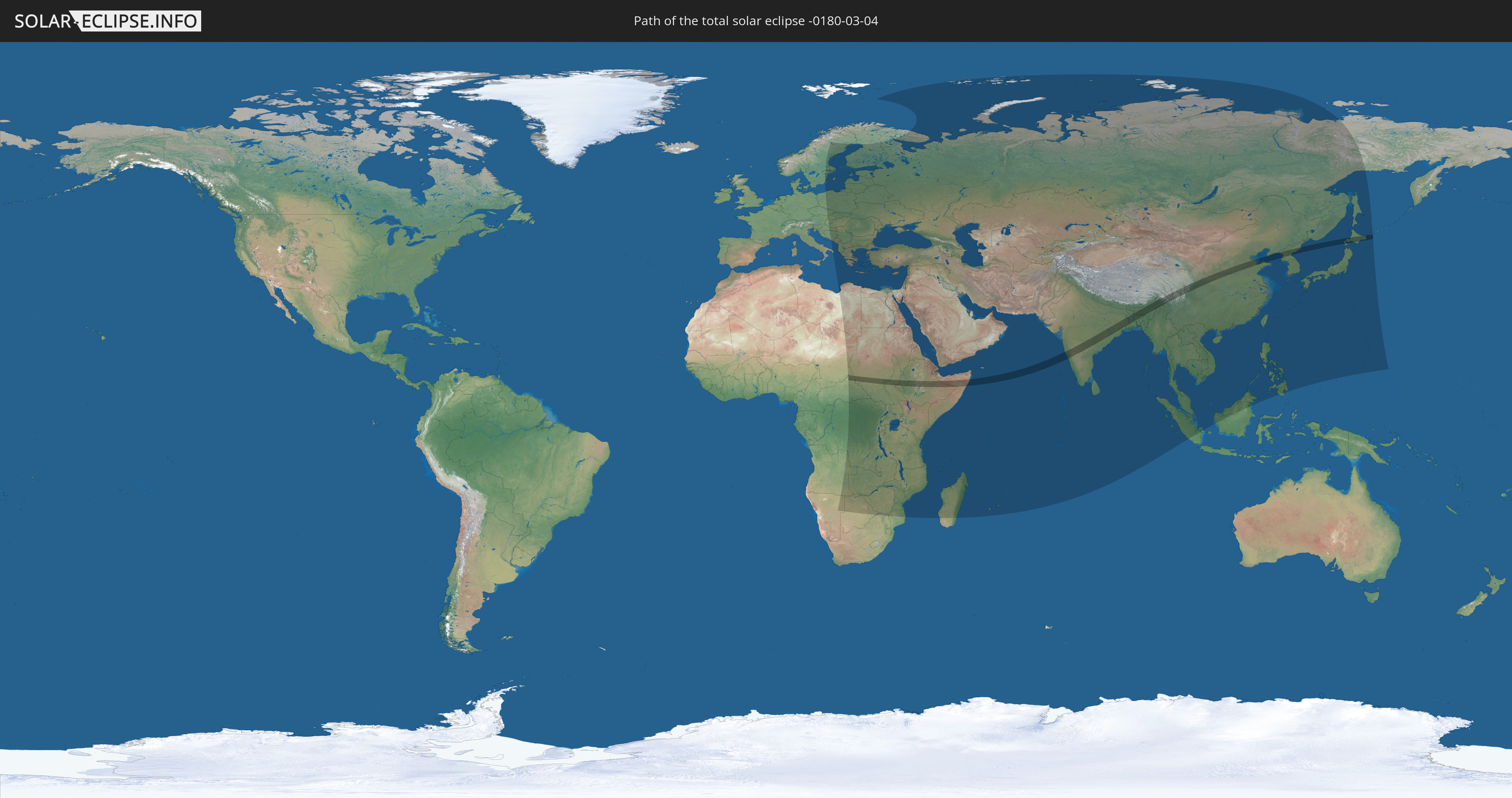
Die Sonnenfinsternis am 04.03.-0180 kann man in 108 Ländern als partielle Sonnenfinsternis beobachten.
Der Finsternispfad verläuft durch 12 Länder. Nur in diesen Ländern ist sie als totale Sonnenfinsternis zu sehen.
In den folgenden Ländern ist die Sonnenfinsternis total zu sehen
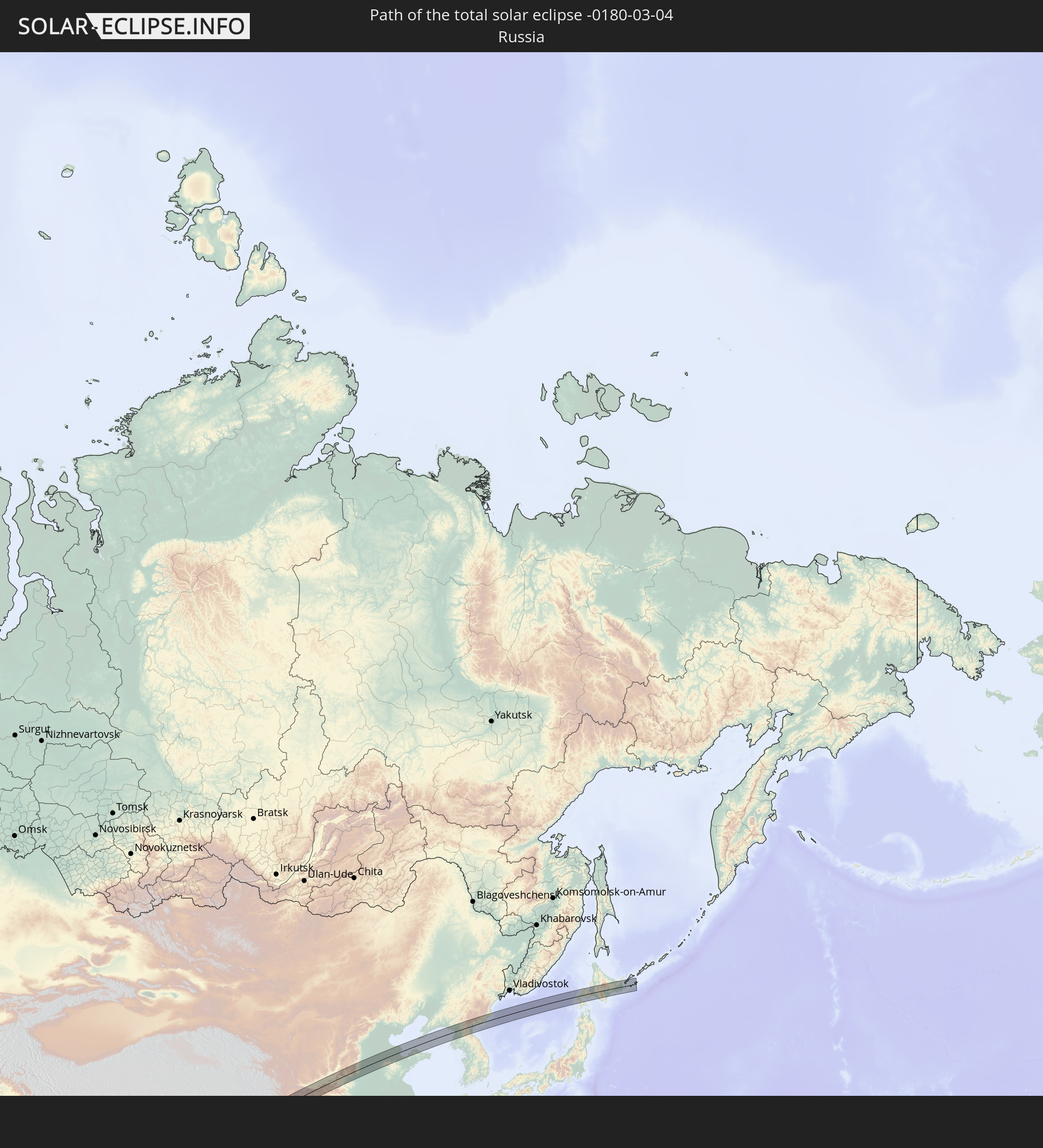 Russland
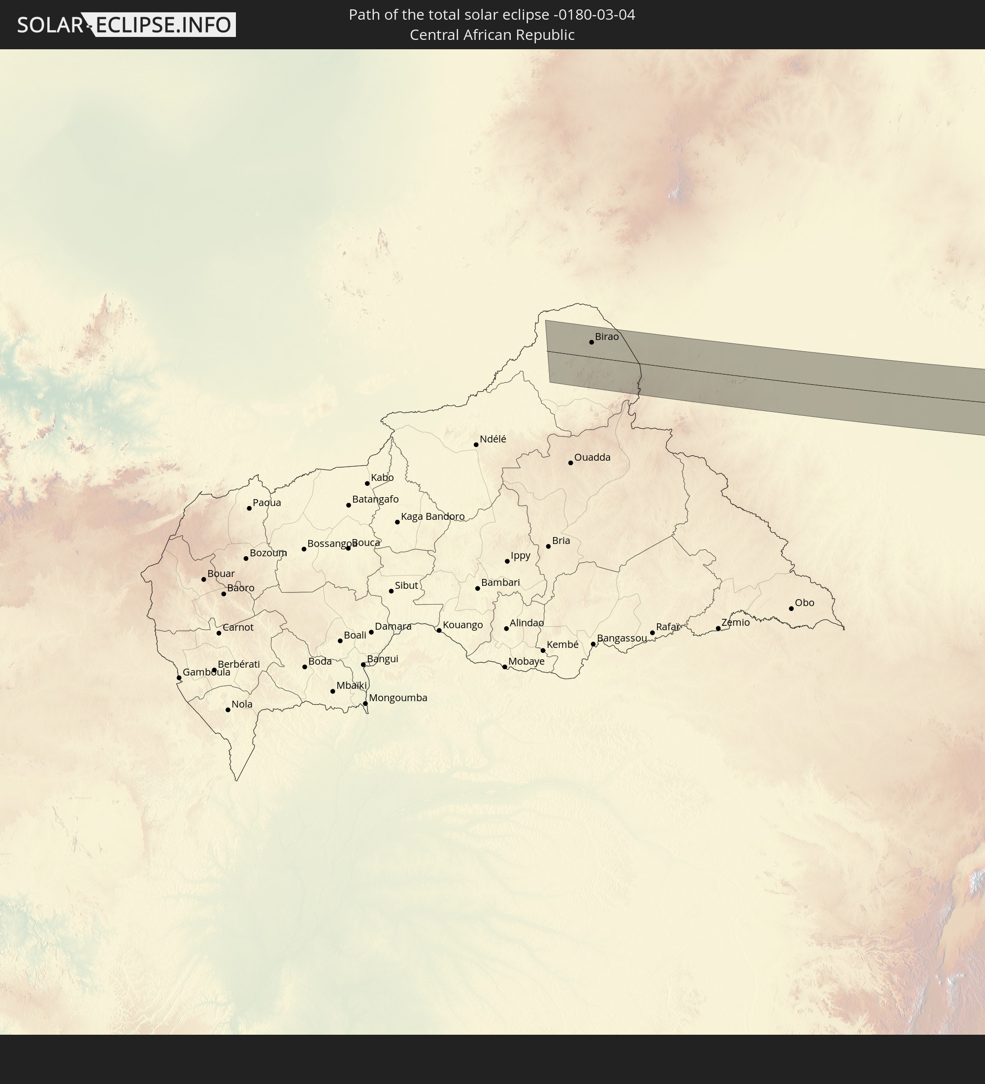 Zentralafrikanische Republik
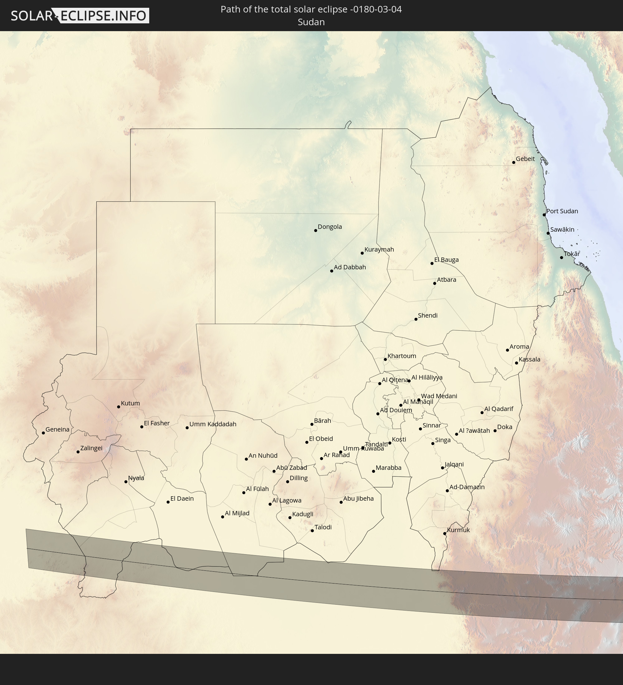 Sudan
Sudan
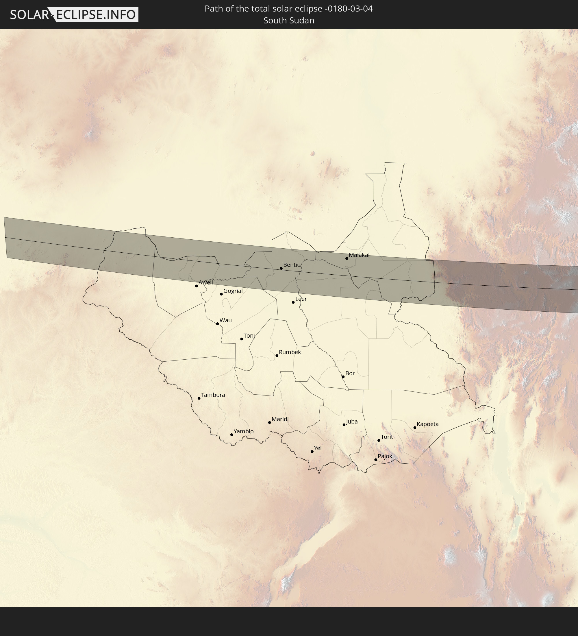 Südsudan
 Äthiopien
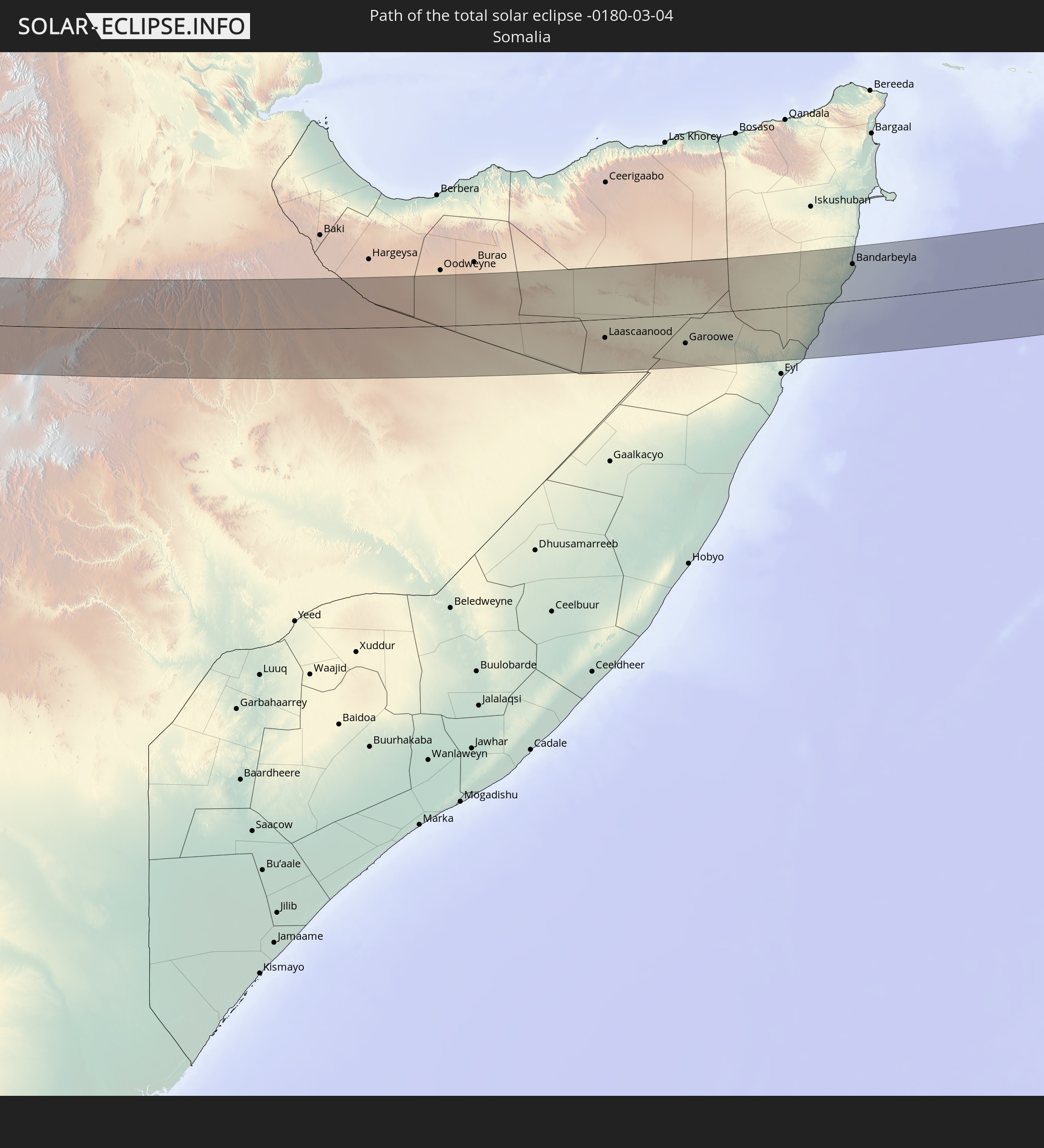 Somalia
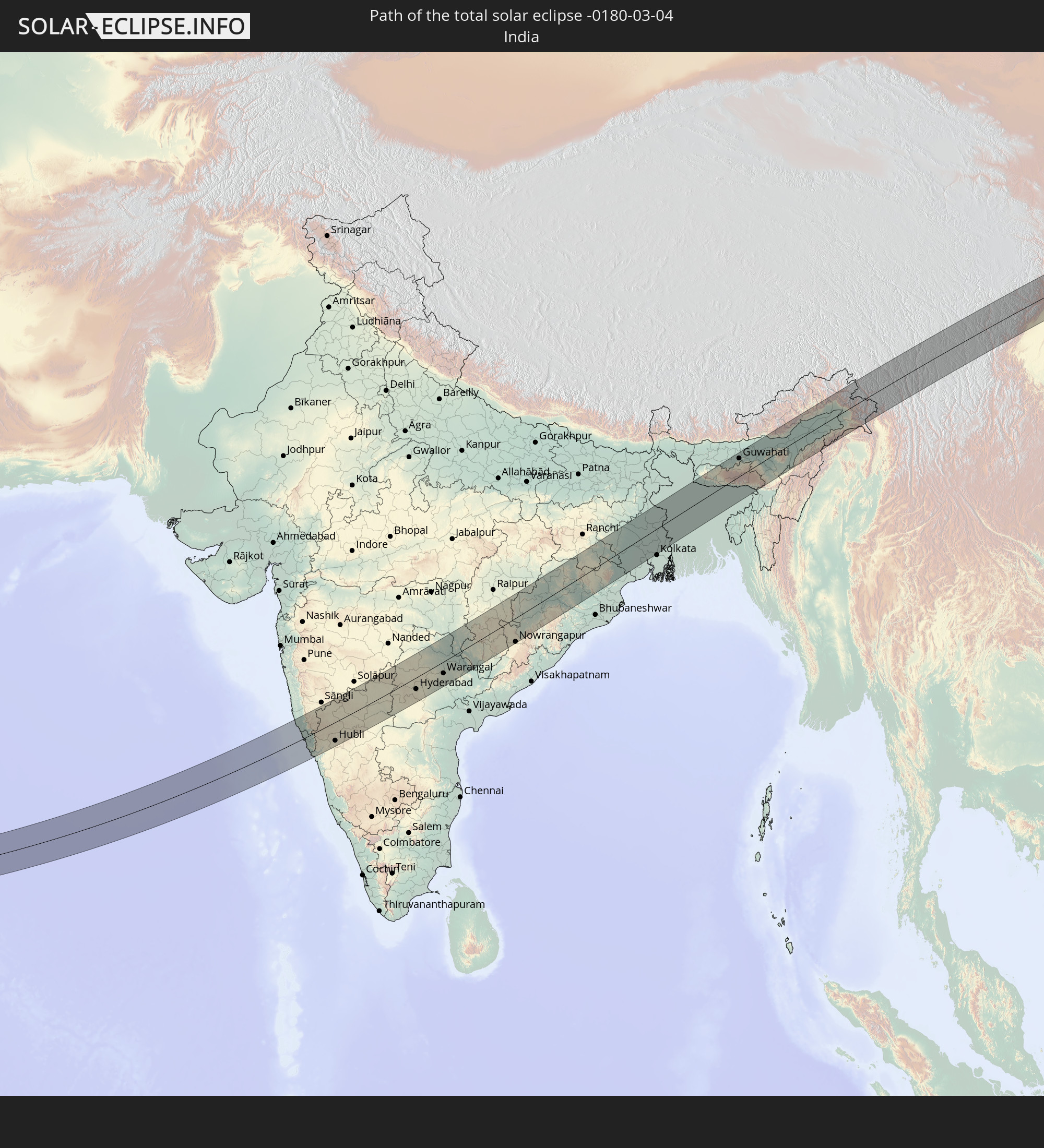 Indien
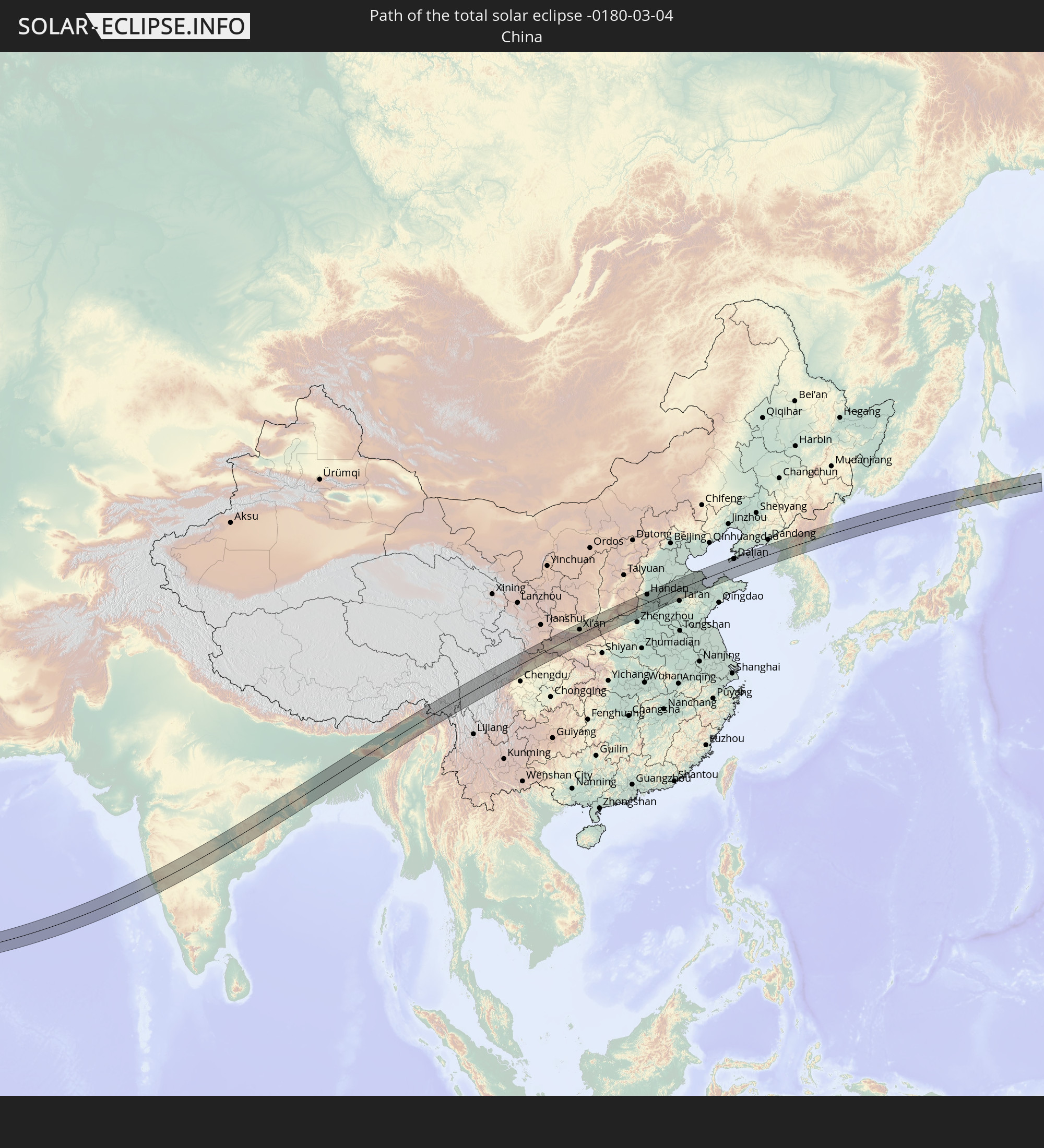 Volksrepublik China
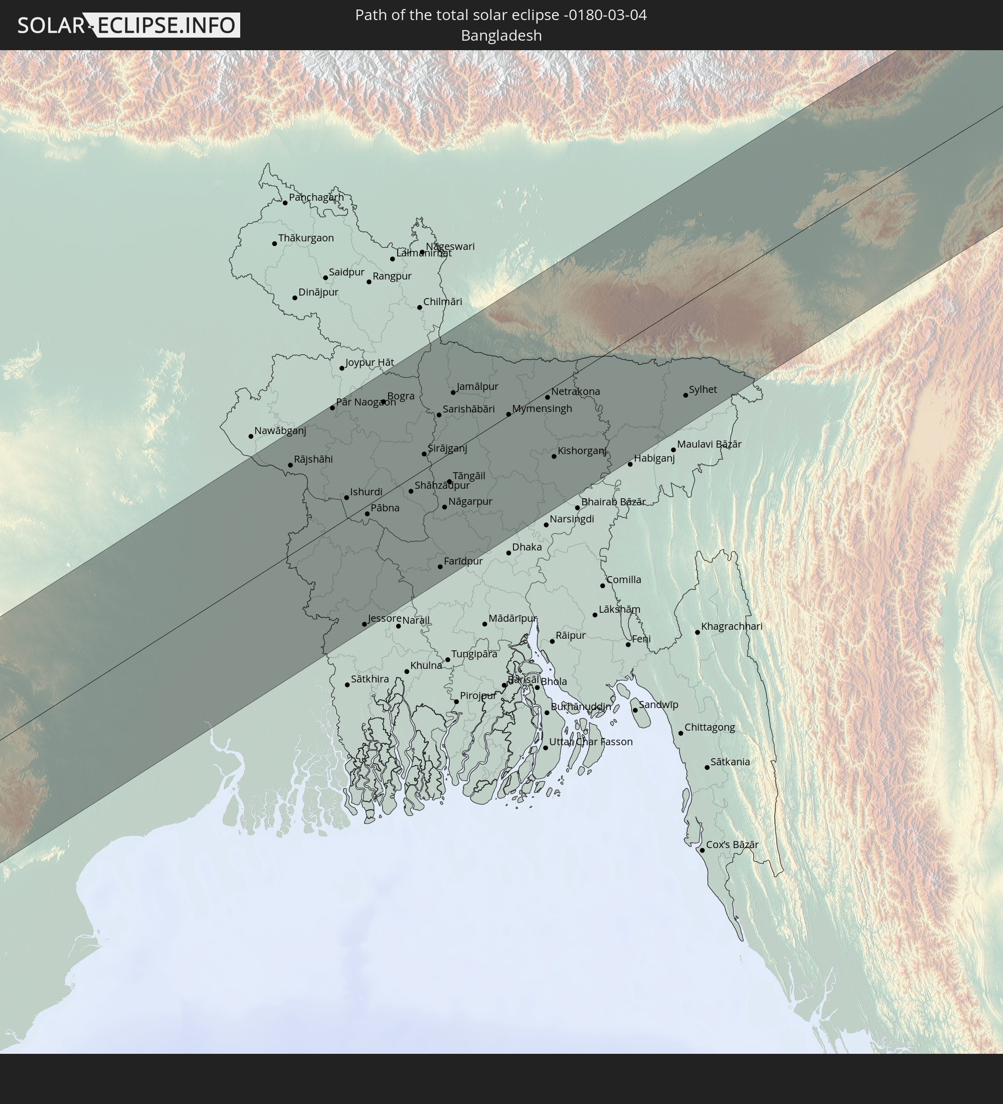 Bangladesch
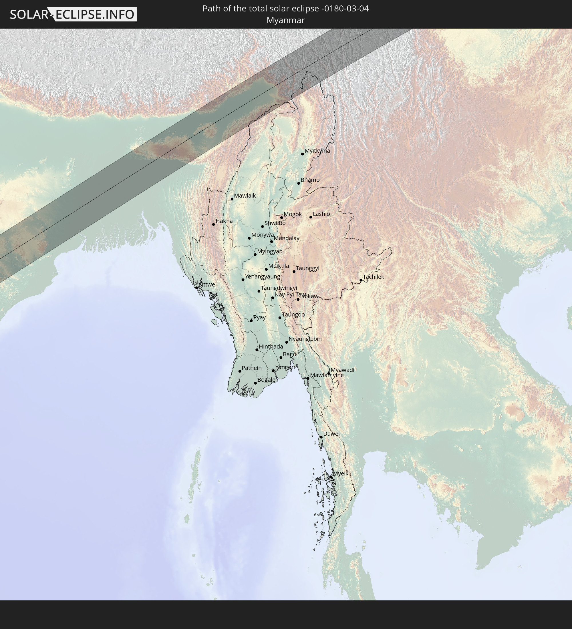 Myanmar
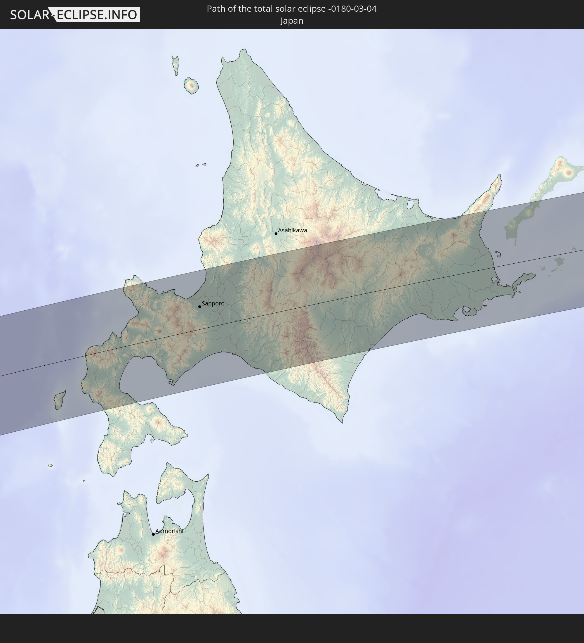 Japan
Japan
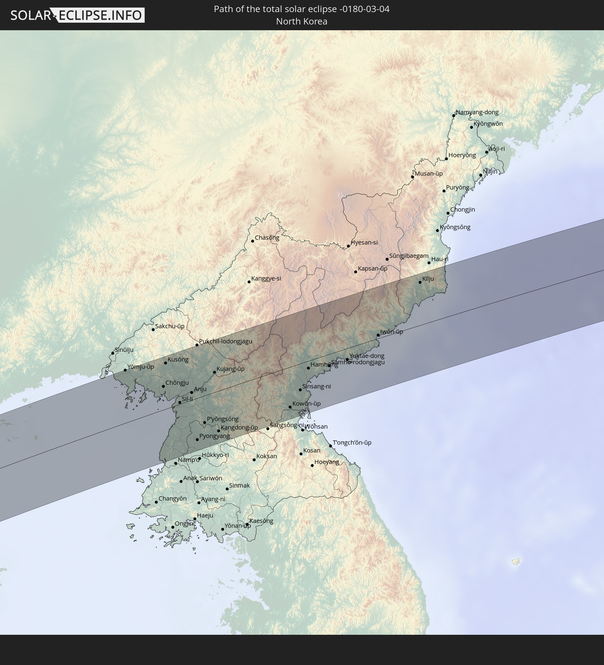 Nordkorea
In den folgenden Ländern ist die Sonnenfinsternis partiell zu sehen
 Russland
 Italien
 Libyen
 Österreich
 Schweden
 Angola
 Namibia
 Tschechien
 Demokratische Republik Kongo
 Tschad
 Kroatien
 Polen
Polen
 Zentralafrikanische Republik
 Bosnien und Herzegowina
 Ungarn
 Südafrika
 Slowakei
 Montenegro
 Serbien
 Albanien
 Åland Islands
 Griechenland
 Botswana
 Rumänien
 Mazedonien
 Finnland
 Litauen
 Lettland
 Estland
 Sudan
Sudan
 Sambia
 Ukraine
 Bulgarien
 Weißrussland
 Ägypten
 Simbabwe
 Türkei
 Moldawien
 Ruanda
 Burundi
 Tansania
 Uganda
 Mosambik
 Republik Zypern
 Malawi
 Äthiopien
 Kenia
Kenia
 Staat Palästina
 Israel
 Saudi-Arabien
 Jordanien
 Libanon
 Syrien
 Eritrea
 Irak
Irak
 Georgien
 Französische Süd- und Antarktisgebiete
 Somalia
 Dschibuti
 Jemen
Jemen
 Madagaskar
 Komoren
 Armenien
 Iran
Iran
 Aserbaidschan
 Mayotte
 Seychellen
 Kasachstan
 Kuwait
 Bahrain
 Katar
Katar
 Vereinigte Arabische Emirate
 Oman
Oman
 Turkmenistan
 Réunion
 Usbekistan
 Mauritius
 Afghanistan
 Pakistan
 Tadschikistan
 Indien
 Kirgisistan
 Britisches Territorium im Indischen Ozean
 Malediven
 Volksrepublik China
 Sri Lanka
 Nepal
Nepal
 Mongolei
 Bangladesch
 Bhutan
 Myanmar
 Indonesien
 Thailand
 Malaysia
 Laos
Laos
 Vietnam
 Kambodscha
 Singapur
 Macau
Macau
 Hongkong
 Brunei
 Taiwan
 Philippinen
 Japan
Japan
 Nordkorea
 Südkorea
 Guam
Guam
 Nördliche Marianen
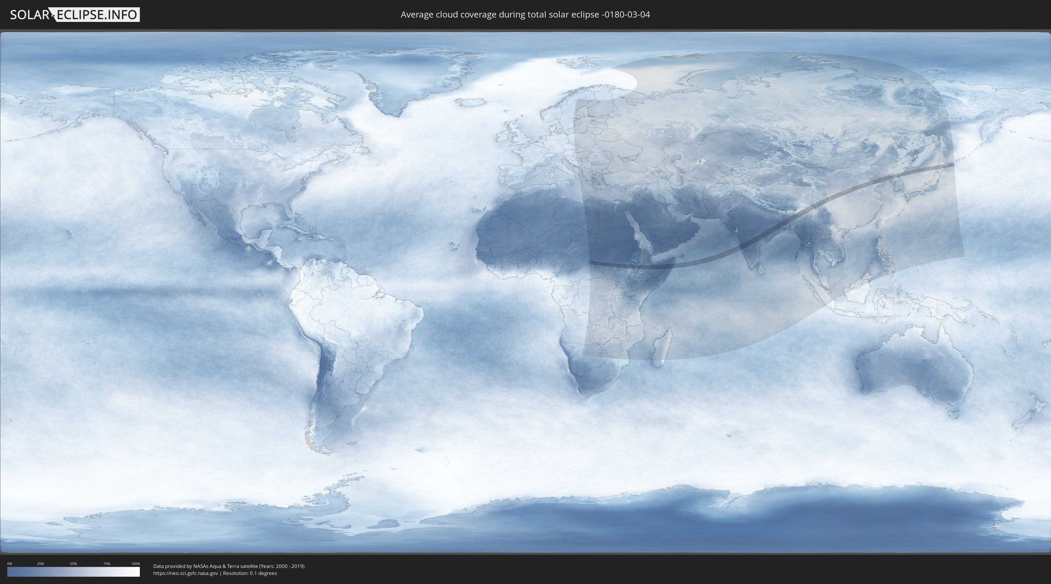
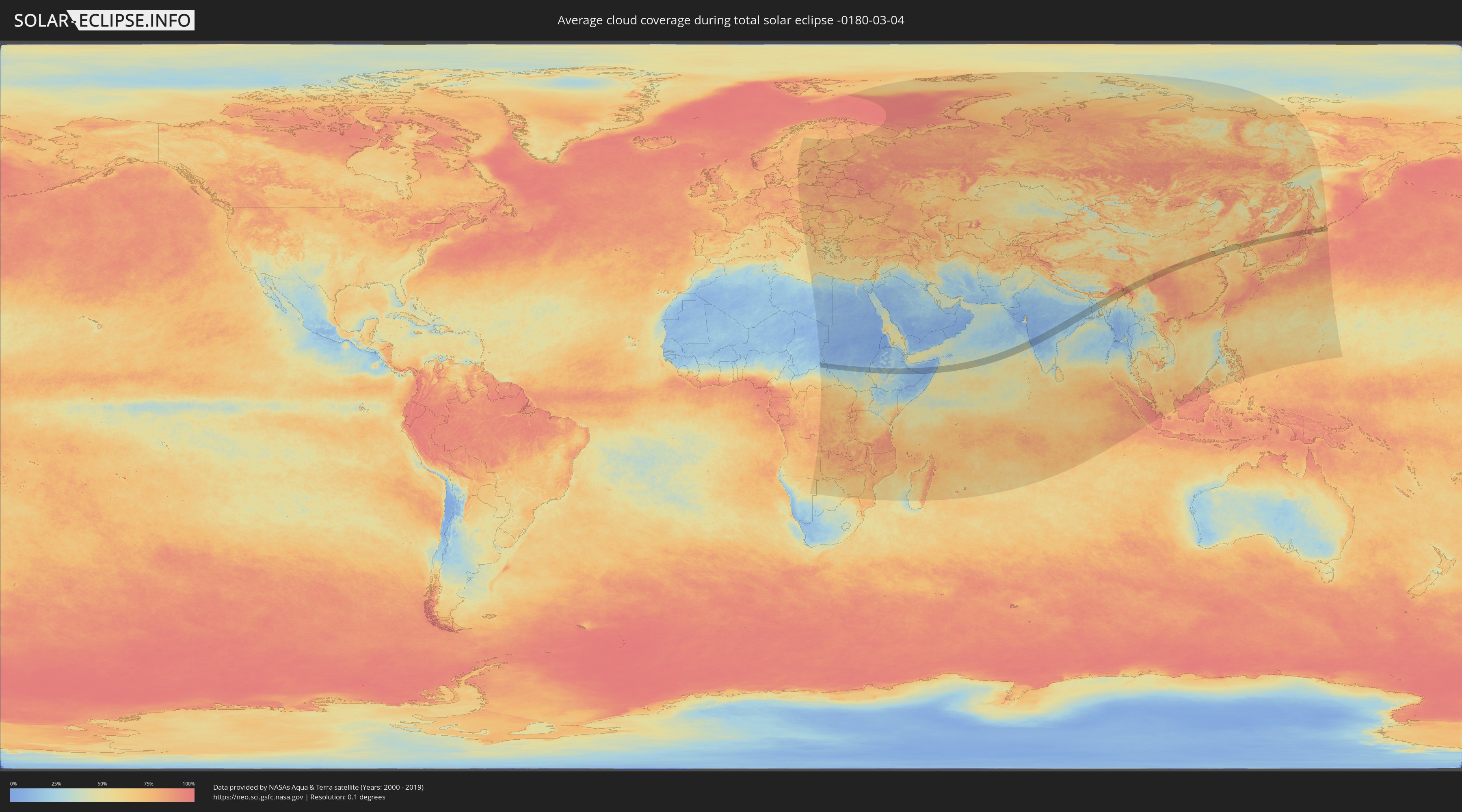
Wie wird das Wetter während der totalen Sonnenfinsternis am 04.03.-0180?
Wo ist der beste Ort, um die totale Sonnenfinsternis vom 04.03.-0180 zu beobachten?
Die folgenden Karten zeigen die durchschnittliche Bewölkung für den Tag, an dem die totale Sonnenfinsternis
stattfindet. Mit Hilfe der Karten lässt sich der Ort entlang des Finsternispfades eingrenzen,
der die besten Aussichen auf einen klaren wolkenfreien Himmel bietet.
Trotzdem muss man immer lokale Gegenenheiten beachten und sollte sich genau über das Wetter an seinem
gewählten Beobachtungsort informieren.
Die Daten stammen von den beiden NASA-Satelliten
AQUA und TERRA
und wurden über einen Zeitraum von 19 Jahren (2000 - 2019) gemittelt.
Detaillierte Länderkarten
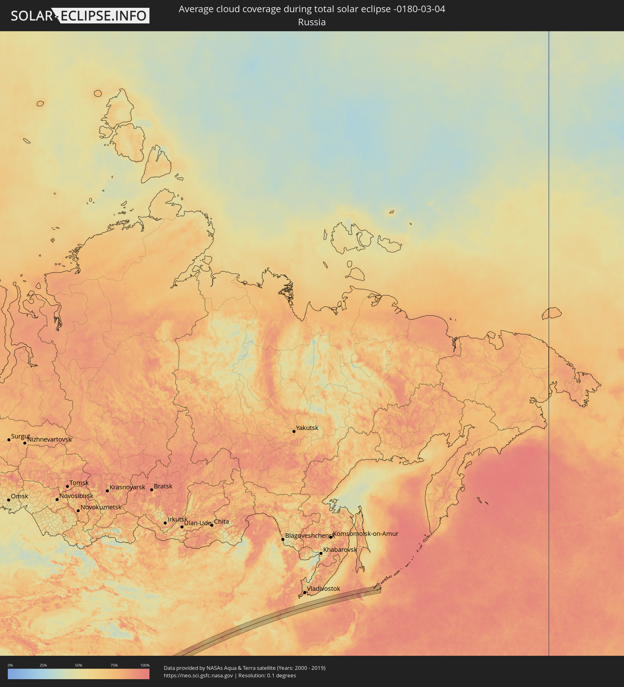 Russland
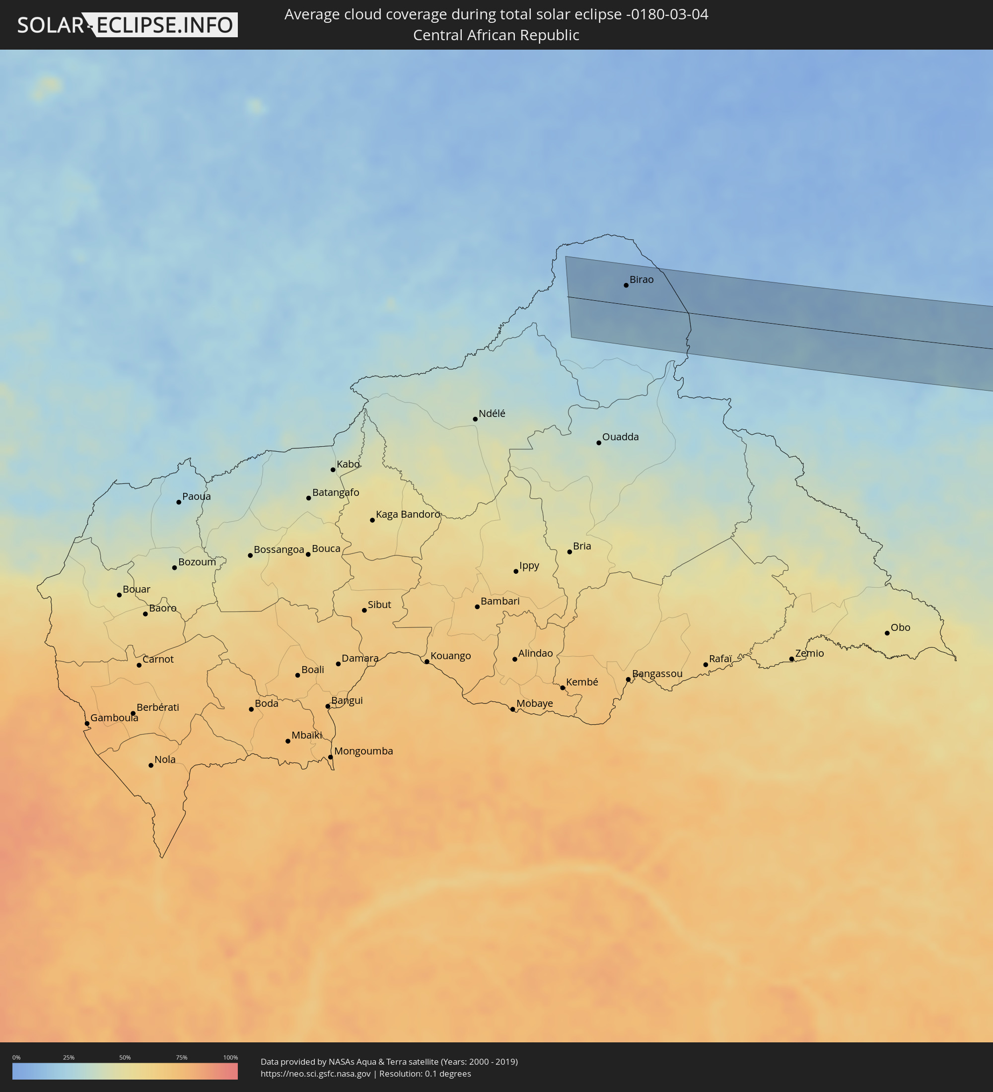 Zentralafrikanische Republik
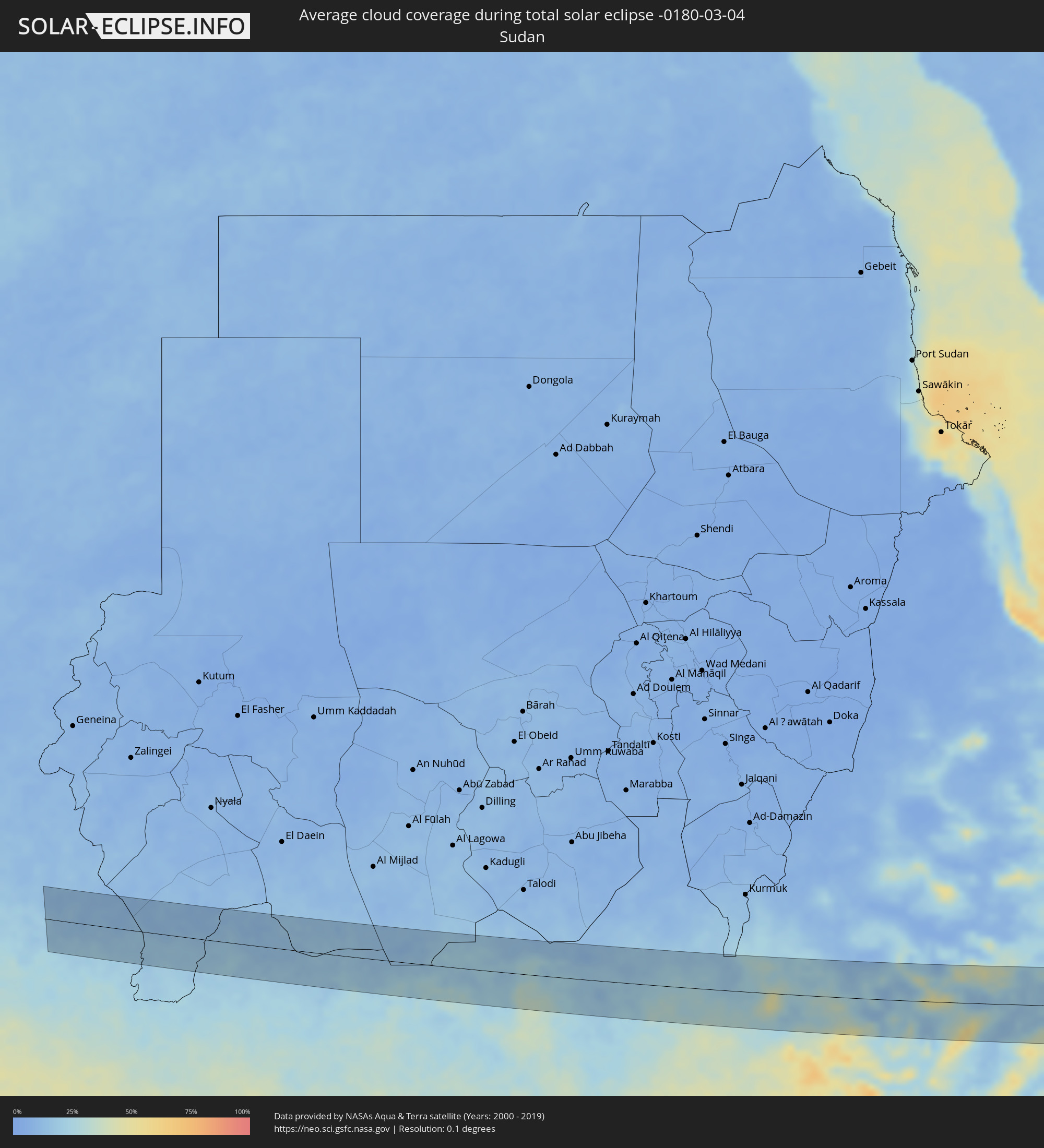 Sudan
Sudan
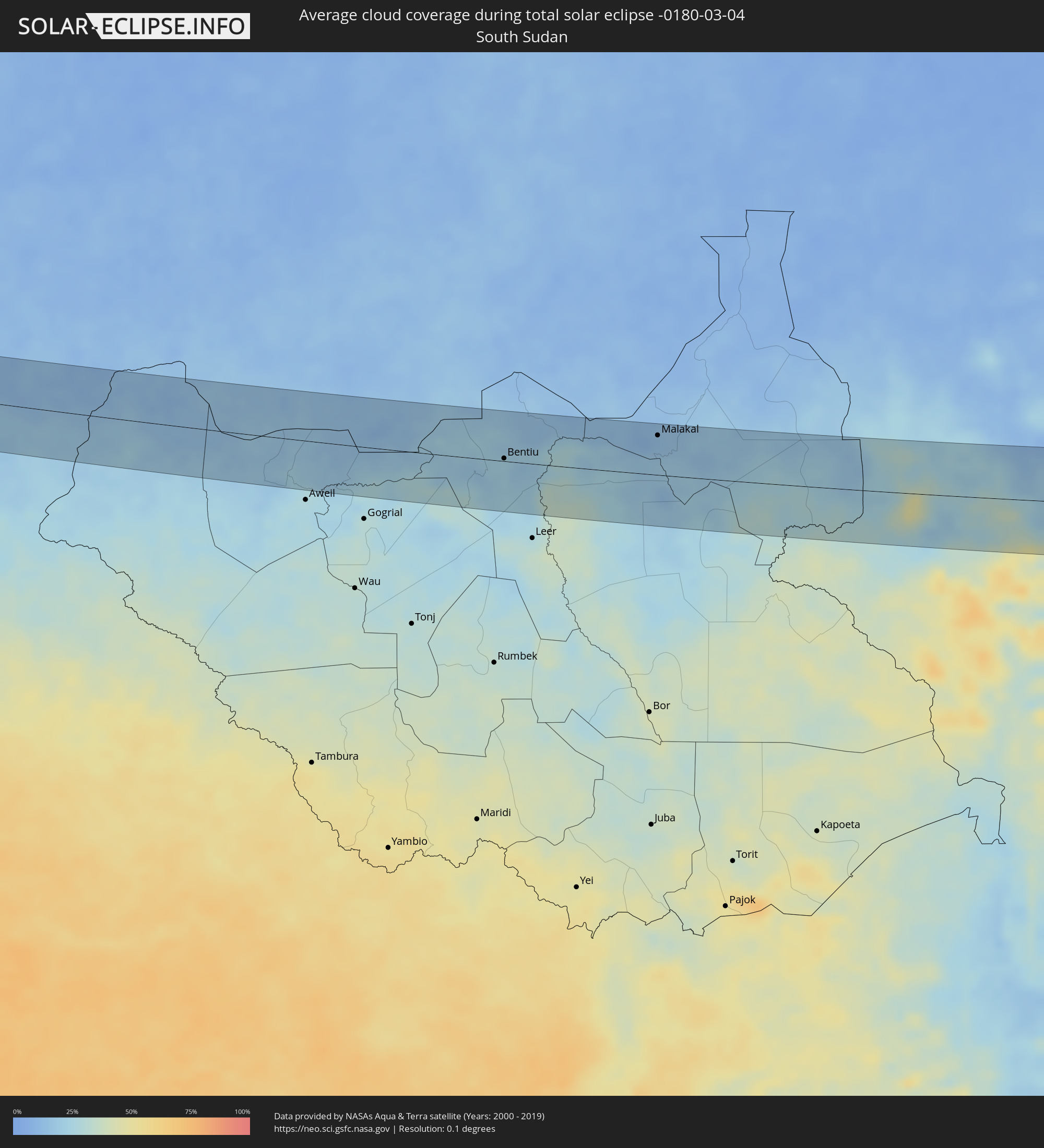 Südsudan
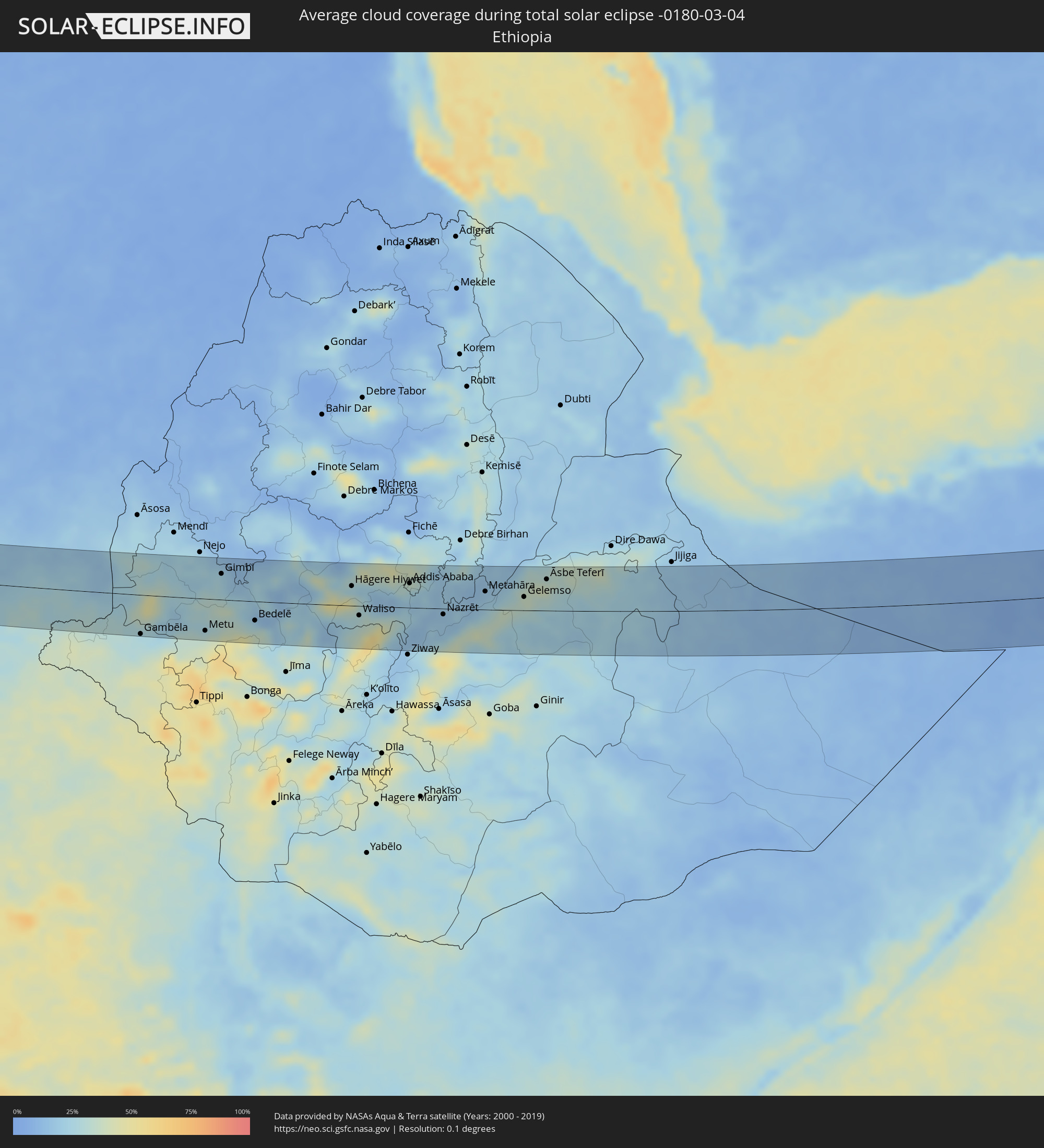 Äthiopien
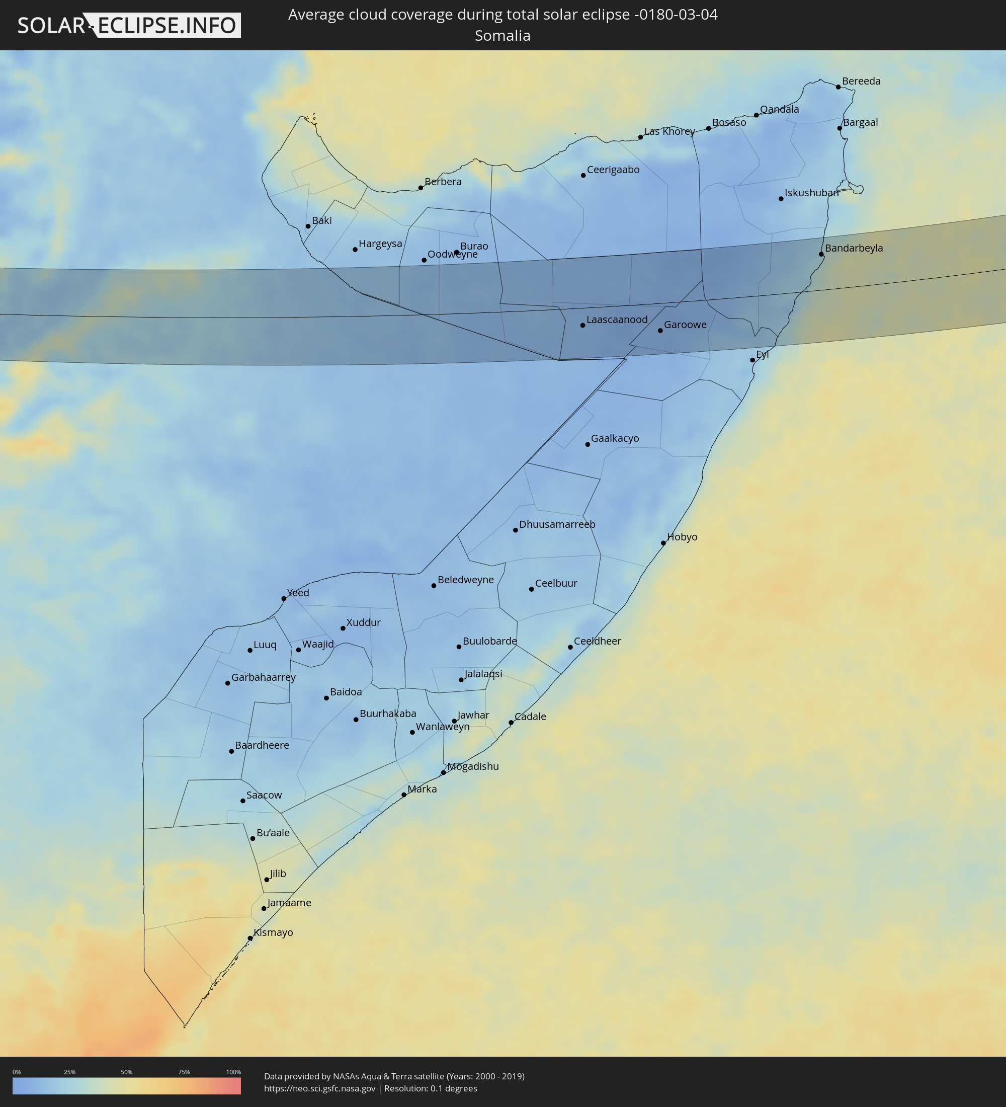 Somalia
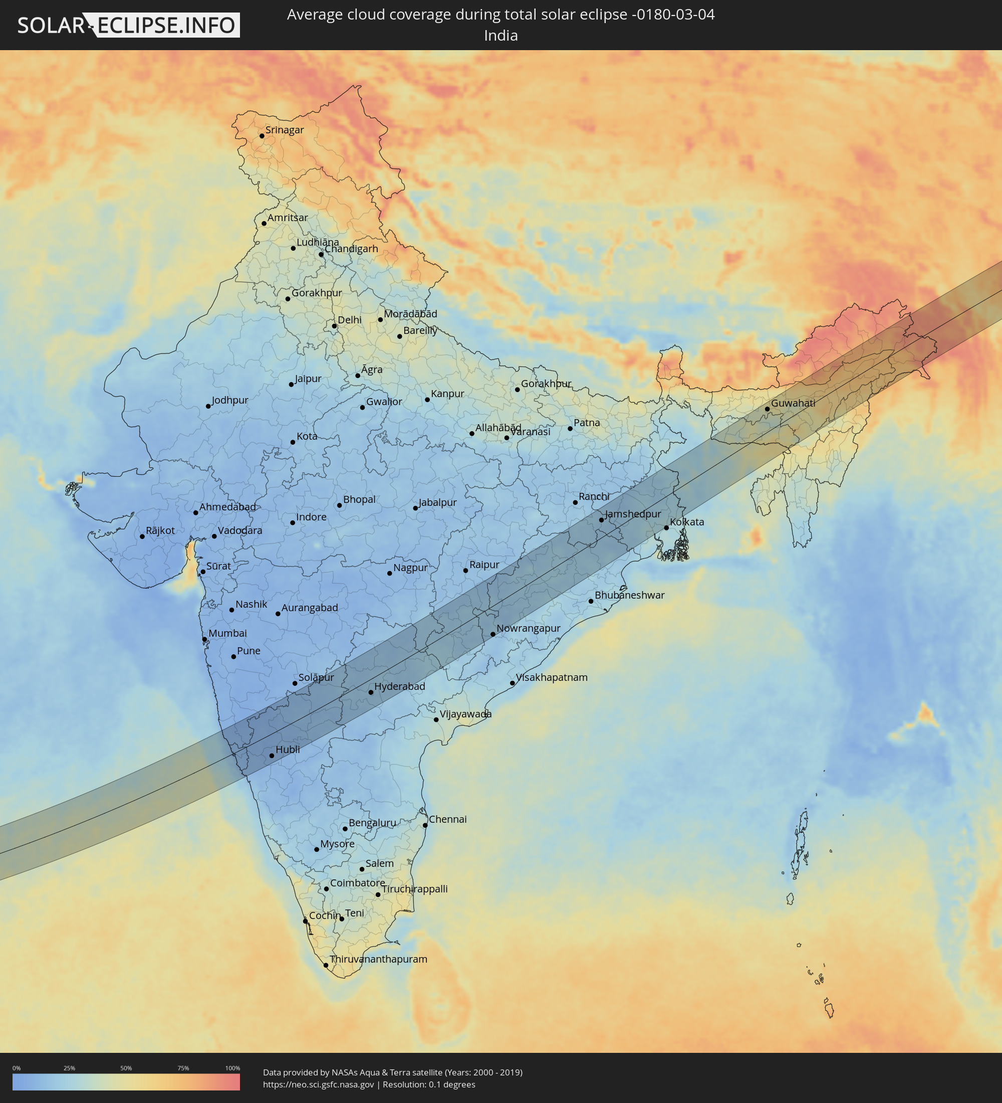 Indien
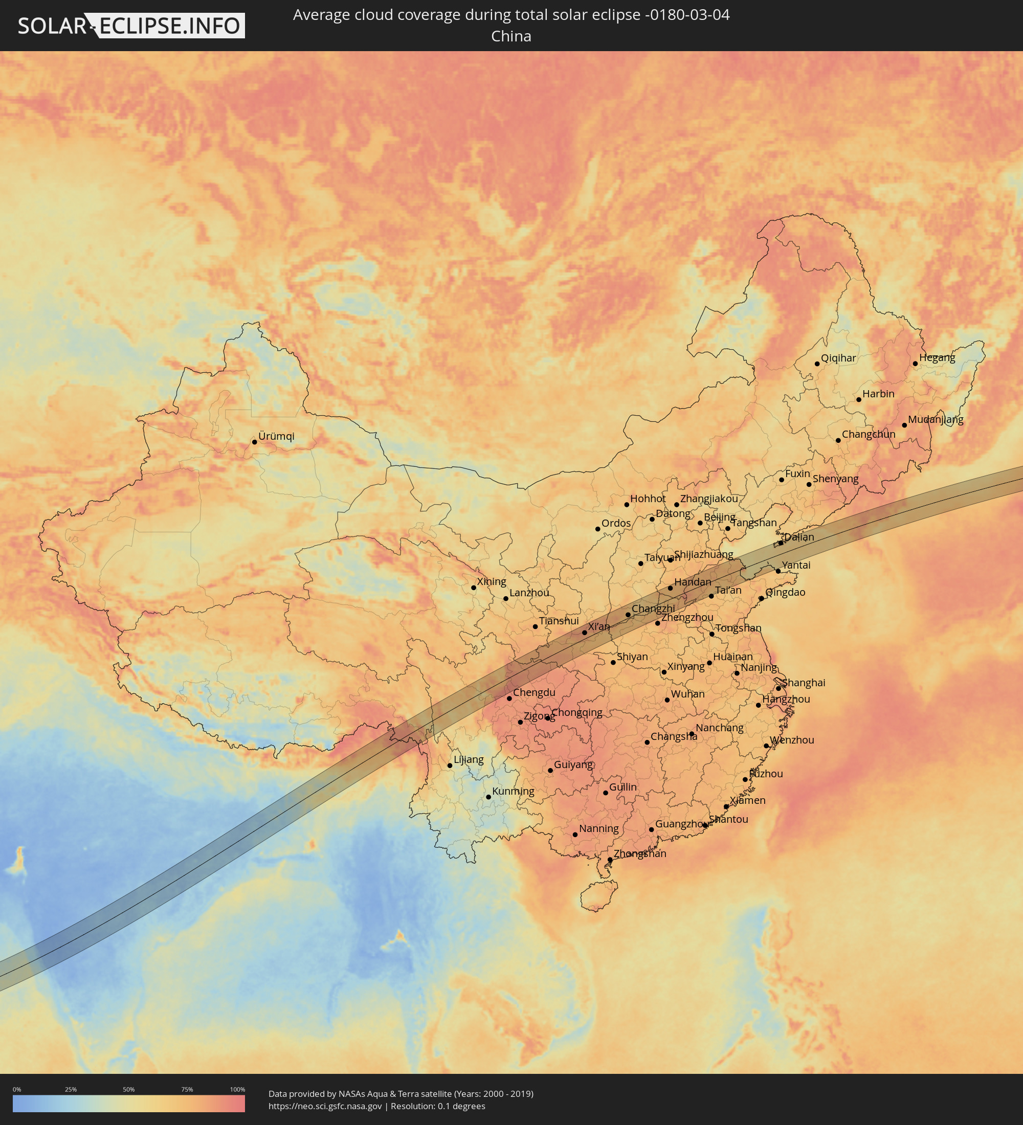 Volksrepublik China
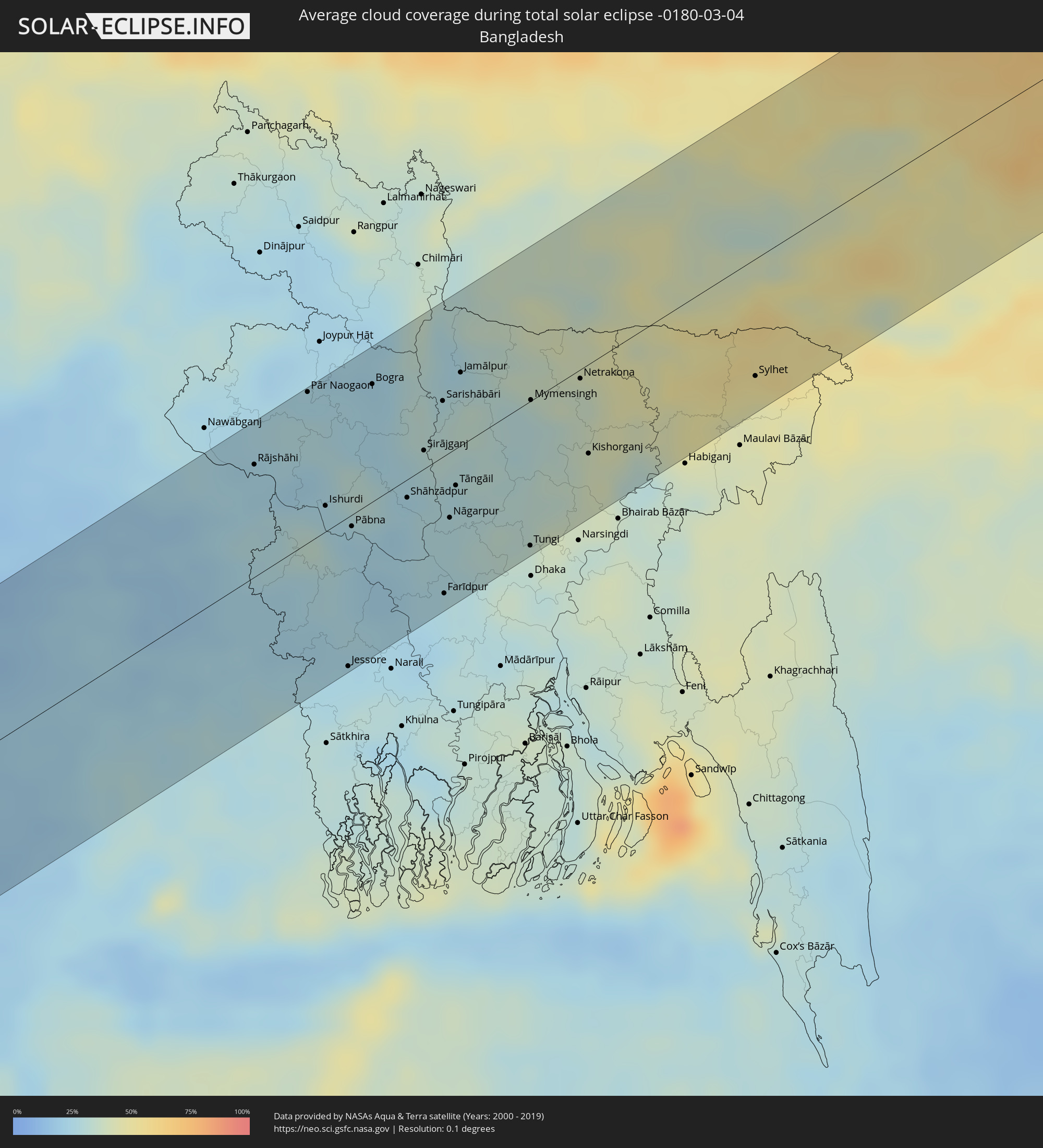 Bangladesch
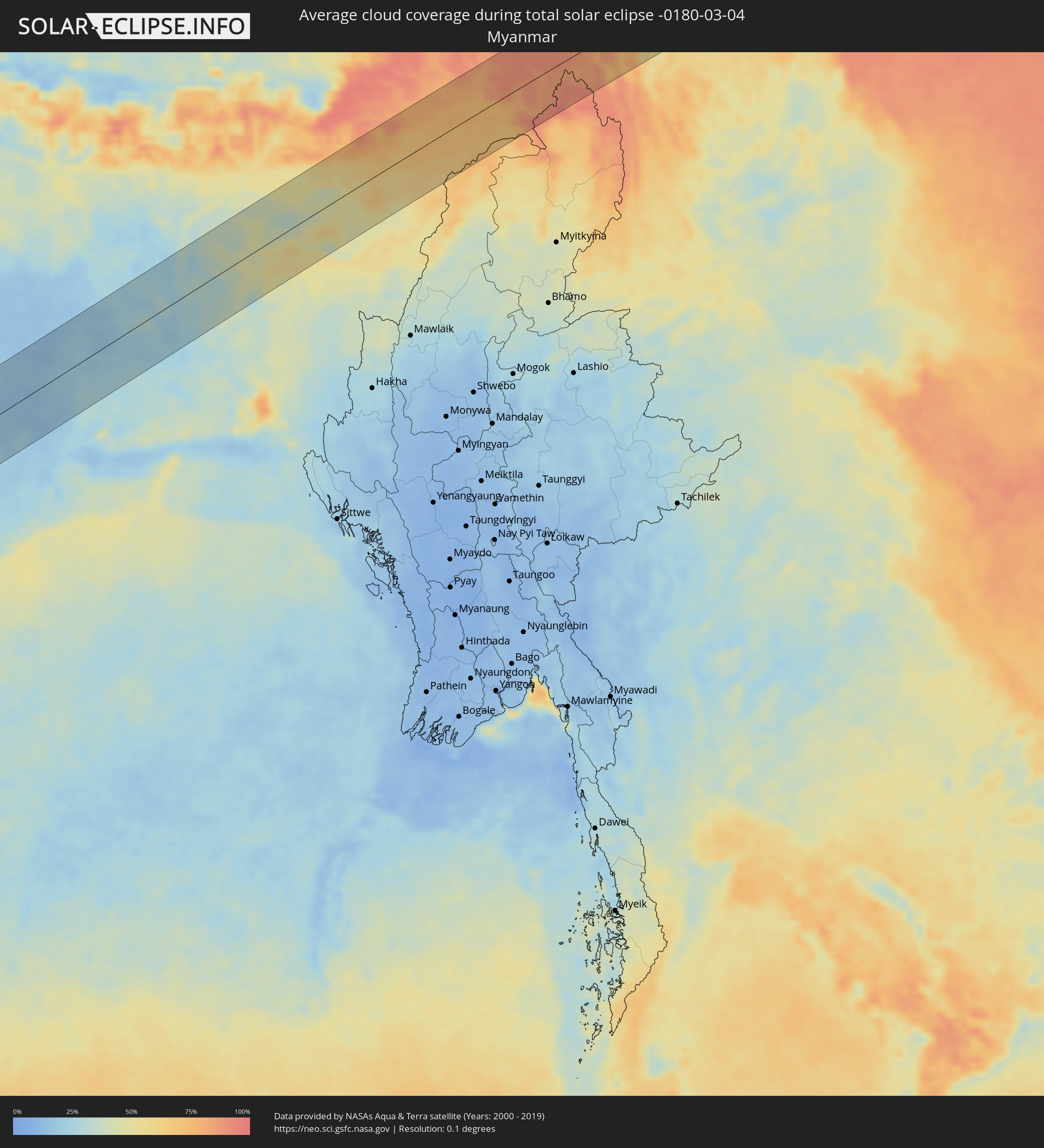 Myanmar
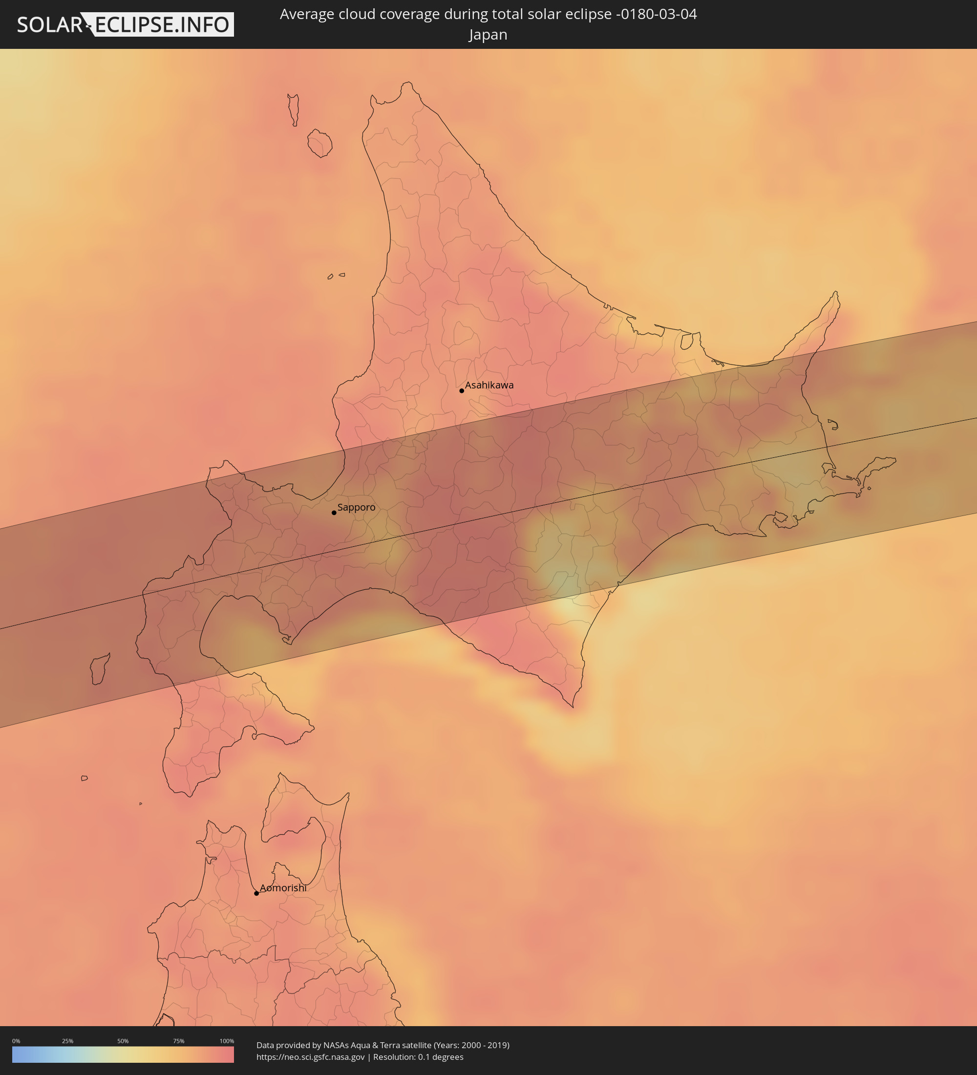 Japan
Japan
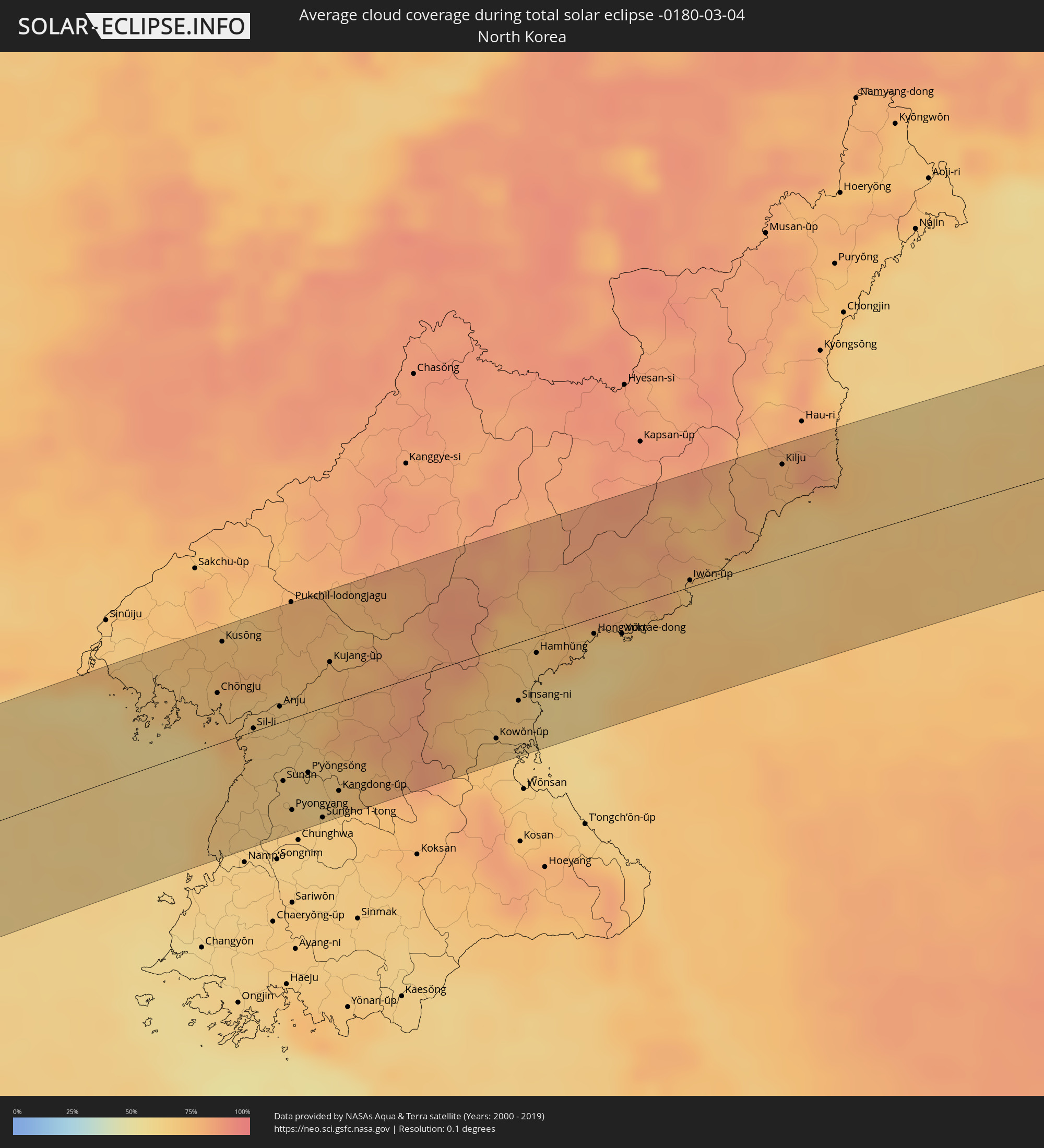 Nordkorea
Orte im Finsternispfad
Die nachfolgene Tabelle zeigt Städte und Orte mit mehr als 5.000 Einwohnern, die sich im Finsternispfad befinden. Städte mit mehr als 100.000 Einwohnern sind dick gekennzeichnet. Mit einem Klick auf den Ort öffnet sich eine Detailkarte die die Lage des jeweiligen Ortes zusammen mit dem Verlauf der zentralen Finsternis präsentiert.
| Ort | Typ | Dauer der Verfinsterung | Ortszeit bei maximaler Verfinsterung | Entfernung zur Zentrallinie | Ø Bewölkung |
|
Birao, Vakaga
|
total | - | 05:06:07 UTC+00:13 | 29 km | 13% |
 Bentiu, Unity
|
total | - | 06:59:59 UTC+02:06 | 4 km | 23% |
|
Malakal, Upper Nile
|
total | - | 07:00:59 UTC+02:06 | 52 km | 15% |
|
Gambēla, Gambela
|
total | - | 07:22:14 UTC+02:27 | 66 km | 26% |
|
Dembī Dolo, Oromiya
|
total | - | 07:22:36 UTC+02:27 | 33 km | 29% |
|
Metu, Oromiya
|
total | - | 07:22:53 UTC+02:27 | 54 km | 32% |
|
Gimbi, Oromiya
|
total | - | 07:23:46 UTC+02:27 | 44 km | 25% |
|
Bedelē, Oromiya
|
total | - | 07:23:30 UTC+02:27 | 33 km | 21% |
|
Guder, Oromiya
|
total | - | 07:24:54 UTC+02:27 | 31 km | 27% |
|
Hāgere Hiywet, Oromiya
|
total | - | 07:24:59 UTC+02:27 | 33 km | 26% |
|
Waliso, Oromiya
|
total | - | 07:24:40 UTC+02:27 | 16 km | 30% |
|
Butajīra, Southern Nations, Nationalities, and People's Region
|
total | - | 07:24:37 UTC+02:27 | 61 km | 25% |
|
Genet, Oromiya
|
total | - | 07:25:32 UTC+02:27 | 45 km | 33% |
|
Sebeta, Oromiya
|
total | - | 07:25:30 UTC+02:27 | 29 km | 20% |
|
Addis Ababa, Addis Ababa
|
total | - | 07:25:41 UTC+02:27 | 41 km | 29% |
|
Bishoftu, Oromiya
|
total | - | 07:25:38 UTC+02:27 | 12 km | 21% |
|
Mojo, Oromiya
|
total | - | 07:25:36 UTC+02:27 | 6 km | 16% |
|
Nazrēt, Oromiya
|
total | - | 07:25:41 UTC+02:27 | 10 km | 17% |
|
Wenjī, Oromiya
|
total | - | 07:25:36 UTC+02:27 | 21 km | 19% |
|
Metahāra, Oromiya
|
total | - | 07:26:31 UTC+02:27 | 31 km | 17% |
|
Gelemso, Oromiya
|
total | - | 07:26:57 UTC+02:27 | 23 km | 34% |
|
Bedēsa, Oromiya
|
total | - | 07:27:15 UTC+02:27 | 32 km | 33% |
|
Āsbe Teferī, Oromiya
|
total | - | 07:27:30 UTC+02:27 | 53 km | 35% |
|
Laascaanood, Sool
|
total | - | 07:33:40 UTC+02:27 | 29 km | 10% |
|
Garoowe, Nugaal
|
total | - | 07:34:58 UTC+02:27 | 44 km | 7% |
|
Bandarbeyla, Bari
|
total | - | 07:39:14 UTC+02:27 | 56 km | 29% |
|
Belgaum, Karnataka
|
total | - | 11:30:30 UTC+05:21 | 8 km | 8% |
|
Hubli, Karnataka
|
total | - | 11:31:22 UTC+05:21 | 73 km | 9% |
|
Bijapur, Karnataka
|
total | - | 11:34:59 UTC+05:21 | 44 km | 11% |
|
Gulbarga, Karnataka
|
total | - | 11:38:35 UTC+05:21 | 36 km | 13% |
|
Bīdar, Karnataka
|
total | - | 11:41:10 UTC+05:21 | 56 km | 18% |
|
Hyderabad, Telangana
|
total | - | 11:42:47 UTC+05:21 | 44 km | 16% |
|
Secunderabad, Telangana
|
total | - | 11:43:10 UTC+05:21 | 37 km | 17% |
|
Karīmnagar, Telangana
|
total | - | 11:45:59 UTC+05:21 | 22 km | 17% |
|
Rāmgundam, Telangana
|
total | - | 11:47:18 UTC+05:21 | 40 km | 16% |
|
Warangal, Telangana
|
total | - | 11:46:31 UTC+05:21 | 44 km | 17% |
|
Nowrangapur, Odisha
|
total | - | 11:55:42 UTC+05:21 | 87 km | 17% |
|
Jamshedpur, Jharkhand
|
total | - | 12:09:03 UTC+05:21 | 48 km | 18% |
|
Āsansol, West Bengal
|
total | - | 12:11:54 UTC+05:21 | 87 km | 16% |
|
Durgapur, West Bengal
|
total | - | 12:12:29 UTC+05:21 | 53 km | 21% |
|
Kharagpur, West Bengal
|
total | - | 12:11:13 UTC+05:21 | 58 km | 20% |
|
Barddhamān, West Bengal
|
total | - | 12:13:29 UTC+05:21 | 1 km | 20% |
|
Baharampur, West Bengal
|
total | - | 12:15:18 UTC+05:21 | 57 km | 23% |
|
Pānihāti, West Bengal
|
total | - | 12:14:04 UTC+05:21 | 83 km | 26% |
|
Bhātpāra, West Bengal
|
total | - | 12:14:20 UTC+05:21 | 68 km | 27% |
|
Rājshāhi, Rājshāhi
|
total | - | 12:48:32 UTC+05:53 | 63 km | 24% |
|
Pār Naogaon, Rājshāhi
|
total | - | 12:49:46 UTC+05:53 | 84 km | 25% |
|
Ishurdi, Rājshāhi
|
total | - | 12:49:21 UTC+05:53 | 14 km | 26% |
|
Kushtia, Khulna
|
total | - | 12:49:14 UTC+05:53 | 10 km | 29% |
|
Jessore, Khulna
|
total | - | 12:48:42 UTC+05:53 | 84 km | 25% |
|
Pābna, Rājshāhi
|
total | - | 12:49:37 UTC+05:53 | 6 km | 24% |
|
Bogra, Rājshāhi
|
total | - | 12:50:46 UTC+05:53 | 66 km | 23% |
|
Shāhzādpur, Rājshāhi
|
total | - | 12:50:36 UTC+05:53 | 10 km | 25% |
|
Sirājganj, Rājshāhi
|
total | - | 12:51:08 UTC+05:53 | 10 km | 29% |
|
Sarishābāri, Dhaka
|
total | - | 12:51:42 UTC+05:53 | 31 km | 28% |
|
Farīdpur, Dhaka
|
total | - | 12:50:35 UTC+05:53 | 77 km | 25% |
|
Nāgarpur, Dhaka
|
total | - | 12:51:07 UTC+05:53 | 37 km | 28% |
|
Tāngāil, Dhaka
|
total | - | 12:51:24 UTC+05:53 | 21 km | 28% |
|
Jamālpur, Dhaka
|
total | - | 12:52:07 UTC+05:53 | 41 km | 28% |
|
Sherpur, Dhaka
|
total | - | 12:52:22 UTC+05:53 | 46 km | 27% |
|
Tungi, Dhaka
|
total | - | 12:52:08 UTC+05:53 | 81 km | 33% |
|
Mymensingh, Dhaka
|
total | - | 12:52:59 UTC+05:53 | 0 km | 32% |
|
Netrakona, Dhaka
|
total | - | 12:53:49 UTC+05:53 | 5 km | 37% |
|
Kishorganj, Dhaka
|
total | - | 12:53:31 UTC+05:53 | 50 km | 40% |
|
Guwahati, Assam
|
total | - | 12:25:02 UTC+05:21 | 63 km | 42% |
|
Sylhet, Sylhet
|
total | - | 12:56:21 UTC+05:53 | 65 km | 50% |
|
Mianyang, Sichuan
|
total | - | 15:30:48 UTC+08:00 | 67 km | 88% |
|
Guangyuan, Sichuan
|
total | - | 15:32:45 UTC+08:00 | 22 km | 83% |
|
Xianyang, Shaanxi
|
total | - | 15:37:00 UTC+08:00 | 46 km | 84% |
|
Xi’an, Shaanxi
|
total | - | 15:37:18 UTC+08:00 | 29 km | 83% |
|
Huayin, Shaanxi
|
total | - | 15:38:47 UTC+08:00 | 14 km | 81% |
|
Changzhi, Shanxi
|
total | - | 15:40:51 UTC+08:00 | 13 km | 73% |
|
Luoyang, Henan
|
total | - | 15:41:45 UTC+08:00 | 67 km | 76% |
|
Jincheng, Shanxi
|
total | - | 15:42:07 UTC+08:00 | 1 km | 67% |
|
Jiaozuo, Henan
|
total | - | 15:42:37 UTC+08:00 | 40 km | 74% |
|
Nangandao, Henan
|
total | - | 15:43:17 UTC+08:00 | 66 km | 77% |
|
Hebi, Henan
|
total | - | 15:43:37 UTC+08:00 | 9 km | 71% |
|
Anyang, Henan
|
total | - | 15:43:48 UTC+08:00 | 5 km | 73% |
|
Handan, Hebei
|
total | - | 15:43:47 UTC+08:00 | 53 km | 75% |
|
Puyang Chengguanzhen, Henan
|
total | - | 15:44:33 UTC+08:00 | 58 km | 76% |
|
Liaocheng, Shandong
|
total | - | 15:45:26 UTC+08:00 | 16 km | 78% |
|
Jinan, Shandong
|
total | - | 15:46:25 UTC+08:00 | 29 km | 73% |
|
Zibo, Shandong
|
total | - | 15:47:27 UTC+08:00 | 53 km | 72% |
|
Shengli, Shandong
|
total | - | 15:47:39 UTC+08:00 | 2 km | 75% |
|
Dalian, Liaoning
|
total | - | 15:49:52 UTC+08:00 | 54 km | 62% |
|
Jinzhou, Liaoning
|
total | - | 15:49:53 UTC+08:00 | 70 km | 67% |
|
Chŏngju, P'yŏngan-bukto
|
total | - | 16:15:15 UTC+08:23 | 30 km | 71% |
|
Kusŏng, P'yŏngan-bukto
|
total | - | 16:15:08 UTC+08:23 | 59 km | 73% |
|
Sil-li, P'yŏngan-namdo
|
total | - | 16:15:31 UTC+08:23 | 2 km | 70% |
|
Sinanju, P'yŏngan-namdo
|
total | - | 16:15:34 UTC+08:23 | 9 km | 67% |
|
Anju, P'yŏngan-namdo
|
total | - | 16:15:36 UTC+08:23 | 9 km | 66% |
|
Sunan, Pyongyang
|
total | - | 16:15:49 UTC+08:23 | 36 km | 68% |
|
Pyongyang, Pyongyang
|
total | - | 16:15:56 UTC+08:23 | 55 km | 67% |
|
P’yŏngsŏng, P'yŏngan-namdo
|
total | - | 16:15:55 UTC+08:23 | 36 km | 63% |
|
Sŭngho 1-tong, Pyongyang
|
total | - | 16:16:06 UTC+08:23 | 65 km | 66% |
|
Kujang-ŭp, P'yŏngan-bukto
|
total | - | 16:15:43 UTC+08:23 | 26 km | 74% |
|
Kangdong-ŭp, Pyongyang
|
total | - | 16:16:07 UTC+08:23 | 53 km | 68% |
|
Kowŏn-ŭp, Hamgyŏng-namdo
|
total | - | 16:16:43 UTC+08:23 | 53 km | 71% |
|
Sinsang-ni, Hamgyŏng-namdo
|
total | - | 16:16:43 UTC+08:23 | 35 km | 69% |
|
Yŏnggwang-ŭp, Hamgyŏng-namdo
|
total | - | 16:16:34 UTC+08:23 | 3 km | 70% |
|
Hamhŭng, Hamgyŏng-namdo
|
total | - | 16:16:40 UTC+08:23 | 10 km | 67% |
|
Samho-rodongjagu, Hamgyŏng-namdo
|
total | - | 16:16:51 UTC+08:23 | 15 km | 63% |
|
Hongwŏn, Hamgyŏng-namdo
|
total | - | 16:16:52 UTC+08:23 | 9 km | 63% |
|
Yuktae-dong, Hamgyŏng-namdo
|
total | - | 16:16:59 UTC+08:23 | 15 km | 63% |
|
Iwŏn-ŭp, Hamgyŏng-namdo
|
total | - | 16:17:07 UTC+08:23 | 4 km | 66% |
|
Kilju, Hamgyŏng-bukto
|
total | - | 16:17:09 UTC+08:23 | 55 km | 78% |
|
Yoichi, Hokkaido
|
total | - | 16:57:13 UTC+09:00 | 49 km | 89% |
|
Date, Hokkaido
|
total | - | 16:57:46 UTC+09:00 | 33 km | 86% |
|
Muroran, Hokkaido
|
total | - | 16:57:54 UTC+09:00 | 51 km | 74% |
|
Otaru, Hokkaido
|
total | - | 16:57:17 UTC+09:00 | 43 km | 90% |
|
Sapporo, Hokkaido
|
total | - | 16:57:27 UTC+09:00 | 23 km | 87% |
|
Ishikari, Hokkaido
|
total | - | 16:57:20 UTC+09:00 | 42 km | 81% |
|
Tōbetsu, Hokkaido
|
total | - | 16:57:23 UTC+09:00 | 37 km | 79% |
|
Ebetsu, Hokkaido
|
total | - | 16:57:28 UTC+09:00 | 24 km | 75% |
|
Kitahiroshima, Hokkaido
|
total | - | 16:57:34 UTC+09:00 | 10 km | 79% |
|
Tomakomai, Hokkaido
|
total | - | 16:57:49 UTC+09:00 | 28 km | 75% |
|
Chitose, Hokkaido
|
total | - | 16:57:42 UTC+09:00 | 9 km | 87% |
|
Iwamizawa, Hokkaido
|
total | - | 16:57:27 UTC+09:00 | 31 km | 80% |
|
Bibai, Hokkaido
|
total | - | 16:57:23 UTC+09:00 | 43 km | 87% |
|
Shimo-furano, Hokkaido
|
total | - | 16:57:28 UTC+09:00 | 36 km | 89% |
|
Otofuke, Hokkaido
|
total | - | 16:57:54 UTC+09:00 | 17 km | 64% |
|
Obihiro, Hokkaido
|
total | - | 16:57:57 UTC+09:00 | 25 km | 56% |
|
Kitami, Hokkaido
|
total | - | 16:57:25 UTC+09:00 | 60 km | 84% |
|
Bihoro, Hokkaido
|
total | - | 16:57:26 UTC+09:00 | 59 km | 79% |
|
Kushiro, Hokkaido
|
total | - | 16:58:06 UTC+09:00 | 38 km | 73% |
|
Nemuro, Hokkaido
|
total | - | 16:58:02 UTC+09:00 | 19 km | 78% |
|
Yuzhno-Kurilsk, Sakhalin
|
total | - | 18:12:24 UTC+10:14 | 54 km | 75% |