Totale Sonnenfinsternis vom 19.10.-0201
| Wochentag: | Donnerstag |
| Maximale Dauer der Verfinsterung: | 04m37s |
| Maximale Breite des Finsternispfades: | 169 km |
| Saroszyklus: | 69 |
| Bedeckungsgrad: | 100% |
| Magnitude: | 1.0501 |
| Gamma: | 0.1652 |
Wo kann man die Sonnenfinsternis vom 19.10.-0201 sehen?
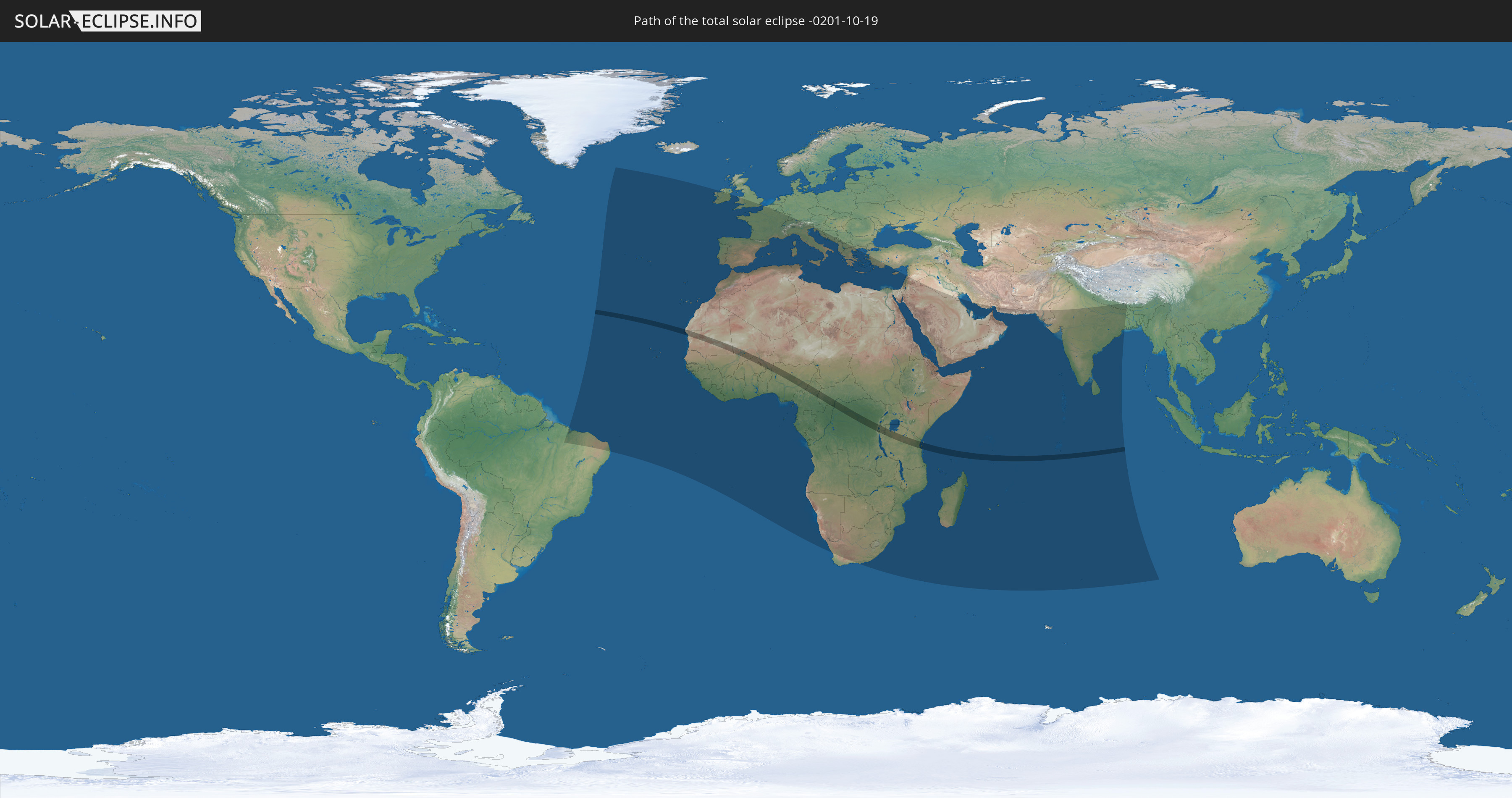
Die Sonnenfinsternis am 19.10.-0201 kann man in 107 Ländern als partielle Sonnenfinsternis beobachten.
Der Finsternispfad verläuft durch 14 Länder. Nur in diesen Ländern ist sie als totale Sonnenfinsternis zu sehen.
In den folgenden Ländern ist die Sonnenfinsternis total zu sehen
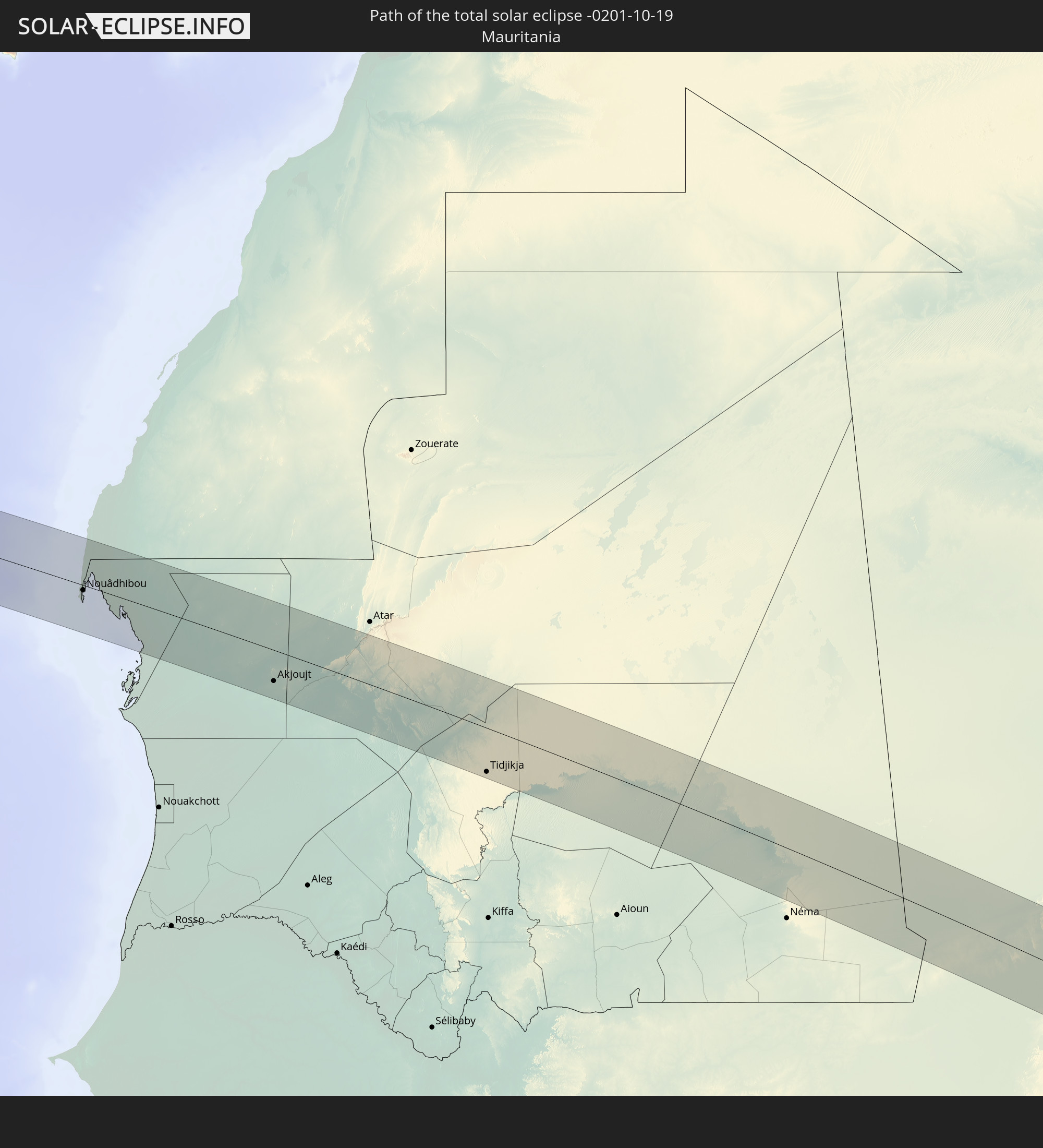 Mauretanien
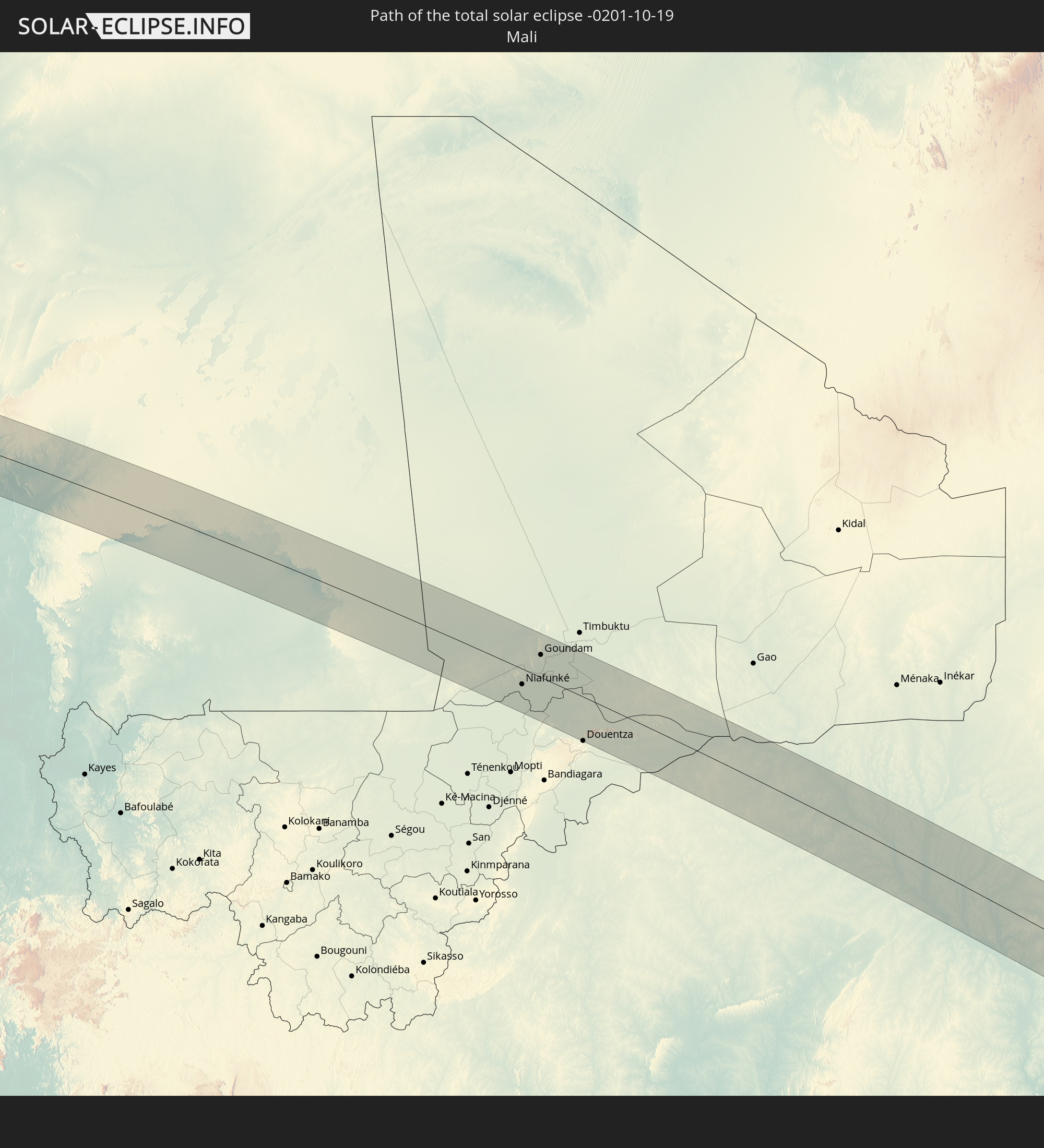 Mali
Mali
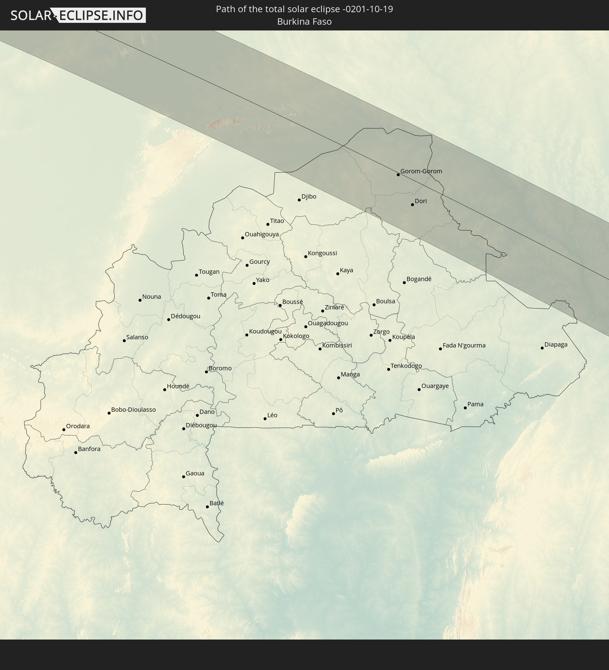 Burkina Faso
 Niger
Niger
 Benin
Benin
 Nigeria
 Kamerun
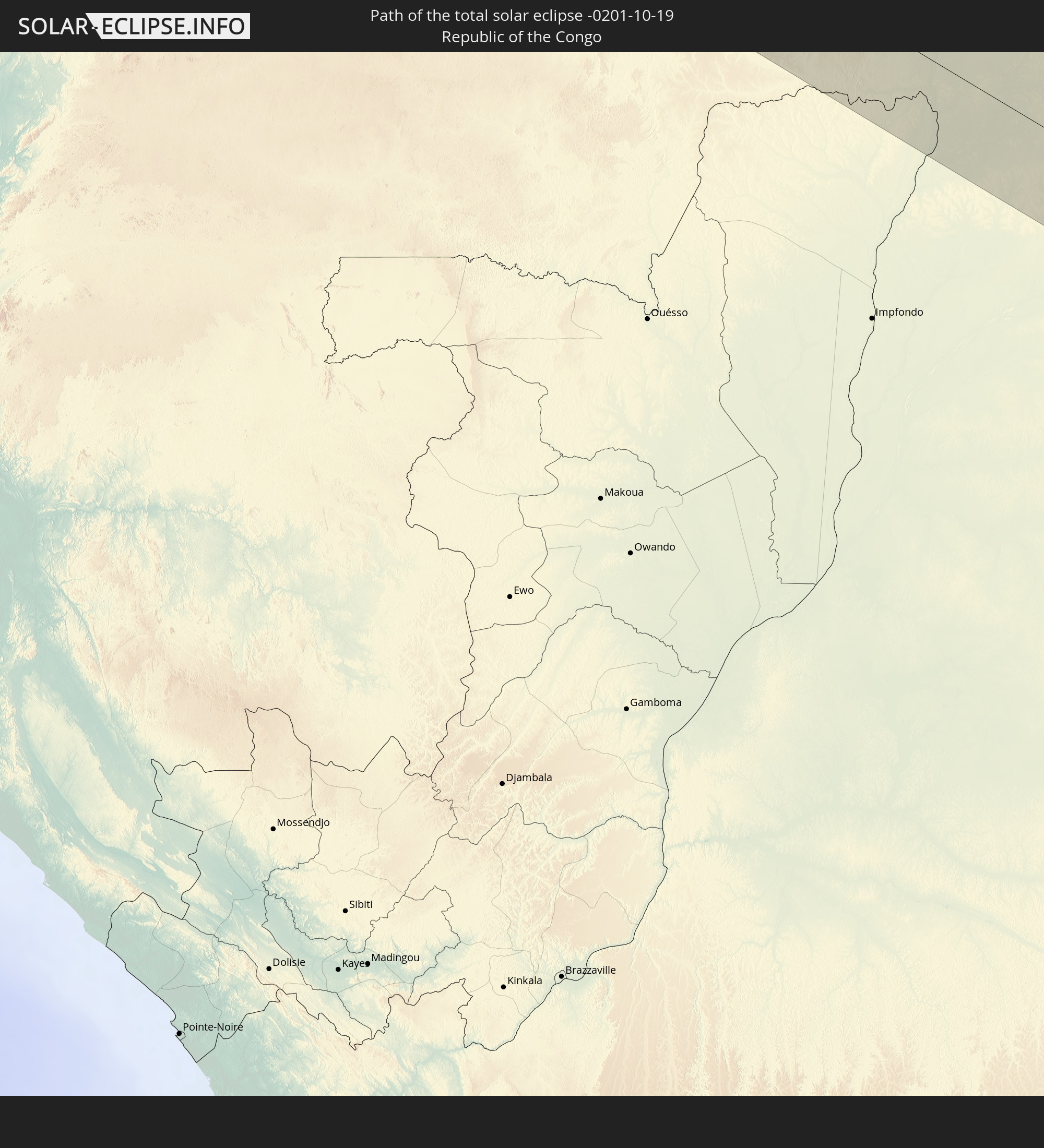 Republik Kongo
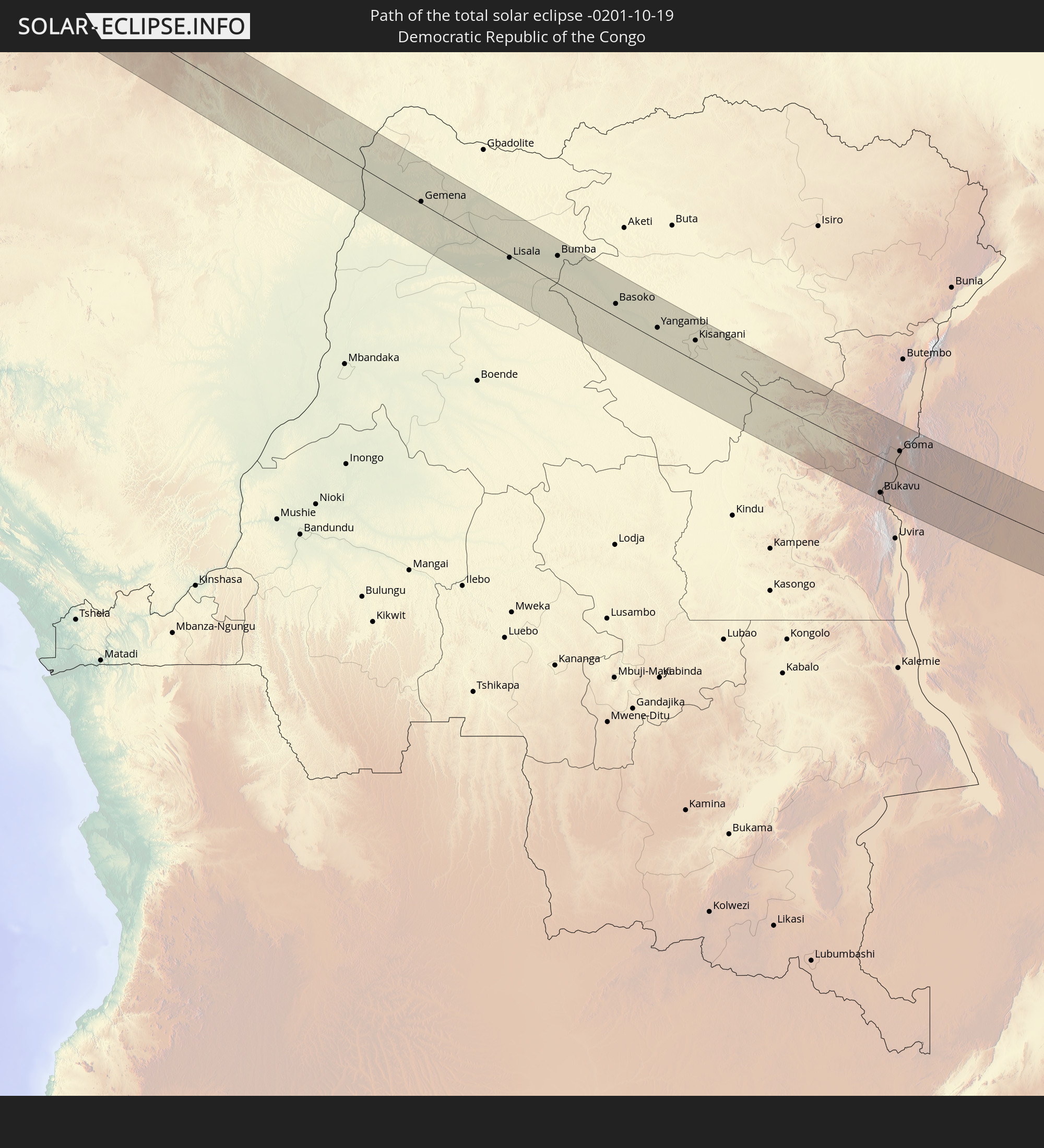 Demokratische Republik Kongo
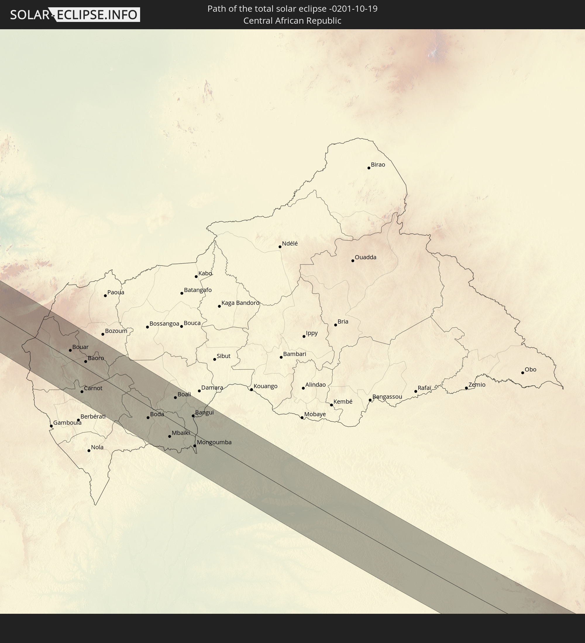 Zentralafrikanische Republik
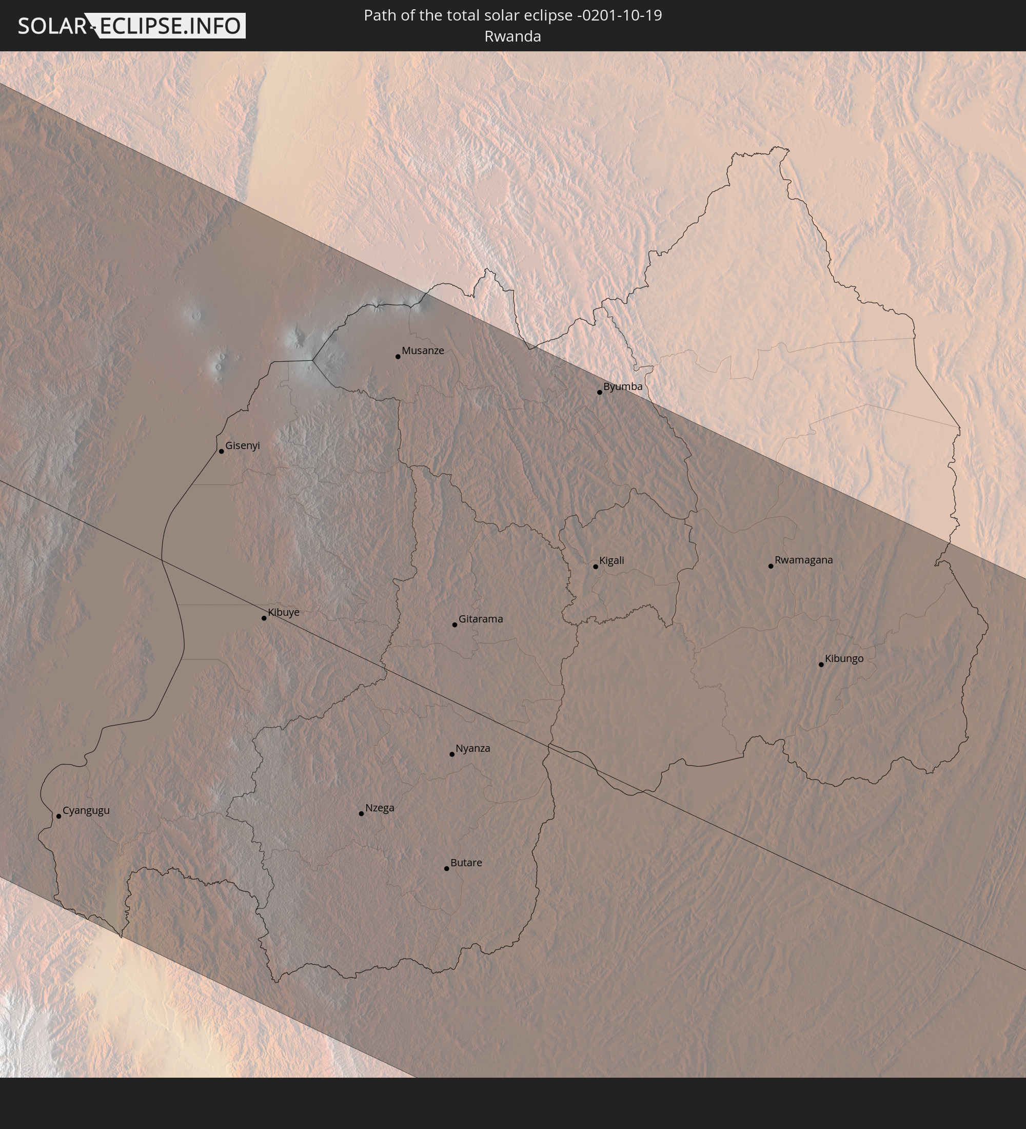 Ruanda
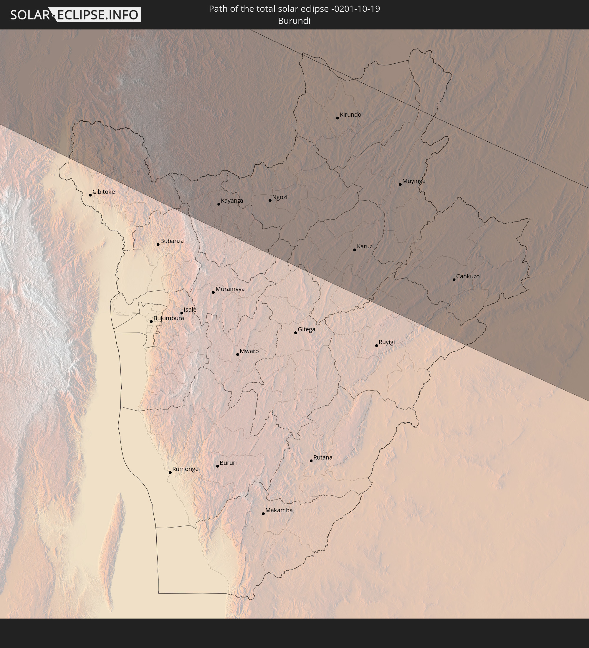 Burundi
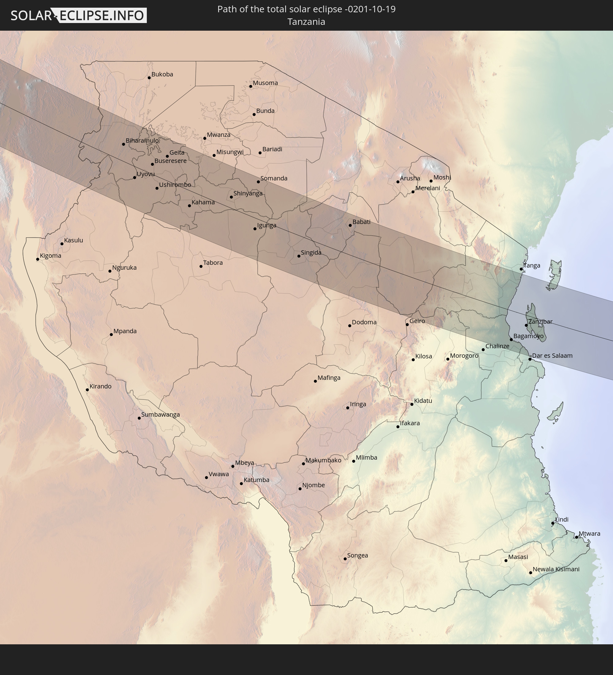 Tansania
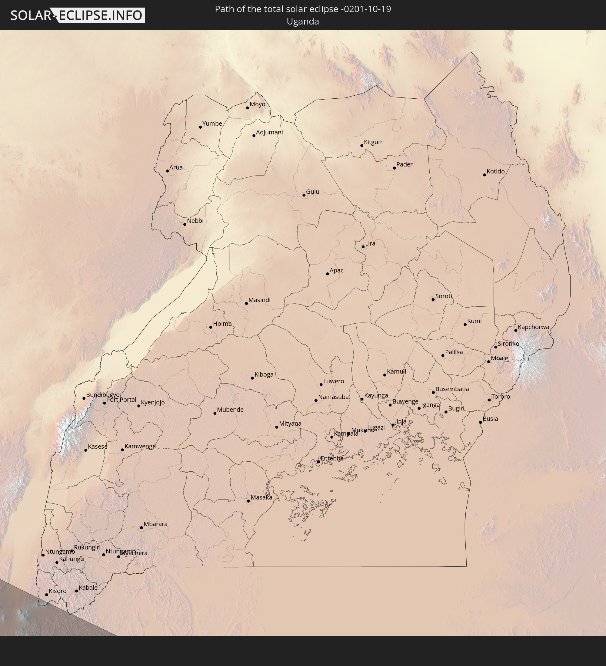 Uganda
In den folgenden Ländern ist die Sonnenfinsternis partiell zu sehen
 Brasilien
 Portugal
 Kap Verde
 Spanien
 Senegal
 Mauretanien
 Gambia
 Guinea-Bissau
 Guinea
 St. Helena
 Sierra Leone
 Marokko
 Mali
Mali
 Liberia
 Irland
 Algerien
 Vereinigtes Königreich
 Elfenbeinküste
 Burkina Faso
 Gibraltar
 Frankreich
 Ghana
Ghana
 Guernsey
 Jersey
 Togo
Togo
 Niger
Niger
 Benin
Benin
 Andorra
 Belgien
 Nigeria
 Äquatorialguinea
 Deutschland
 Schweiz
 São Tomé und Príncipe
 Italien
 Monaco
 Tunesien
 Kamerun
 Gabun
Gabun
 Libyen
 Liechtenstein
 Österreich
 Republik Kongo
 Angola
 Namibia
 Demokratische Republik Kongo
 San Marino
 Vatikanstadt
 Slowenien
 Tschad
 Kroatien
 Malta
Malta
 Zentralafrikanische Republik
 Bosnien und Herzegowina
 Südafrika
 Montenegro
 Albanien
 Griechenland
 Botswana
 Mazedonien
 Sudan
Sudan
 Sambia
 Ägypten
 Simbabwe
 Türkei
 Lesotho
 Ruanda
 Burundi
 Tansania
 Uganda
 Mosambik
 Swasiland
 Republik Zypern
 Malawi
 Äthiopien
 Kenia
Kenia
 Staat Palästina
 Israel
 Saudi-Arabien
 Jordanien
 Libanon
 Syrien
 Eritrea
 Irak
Irak
 Französische Süd- und Antarktisgebiete
 Somalia
 Dschibuti
 Jemen
Jemen
 Madagaskar
 Komoren
 Iran
Iran
 Mayotte
 Seychellen
 Kuwait
 Bahrain
 Katar
Katar
 Vereinigte Arabische Emirate
 Oman
Oman
 Réunion
 Mauritius
 Pakistan
 Indien
 Britisches Territorium im Indischen Ozean
 Malediven
 Volksrepublik China
 Sri Lanka
 Nepal
Nepal
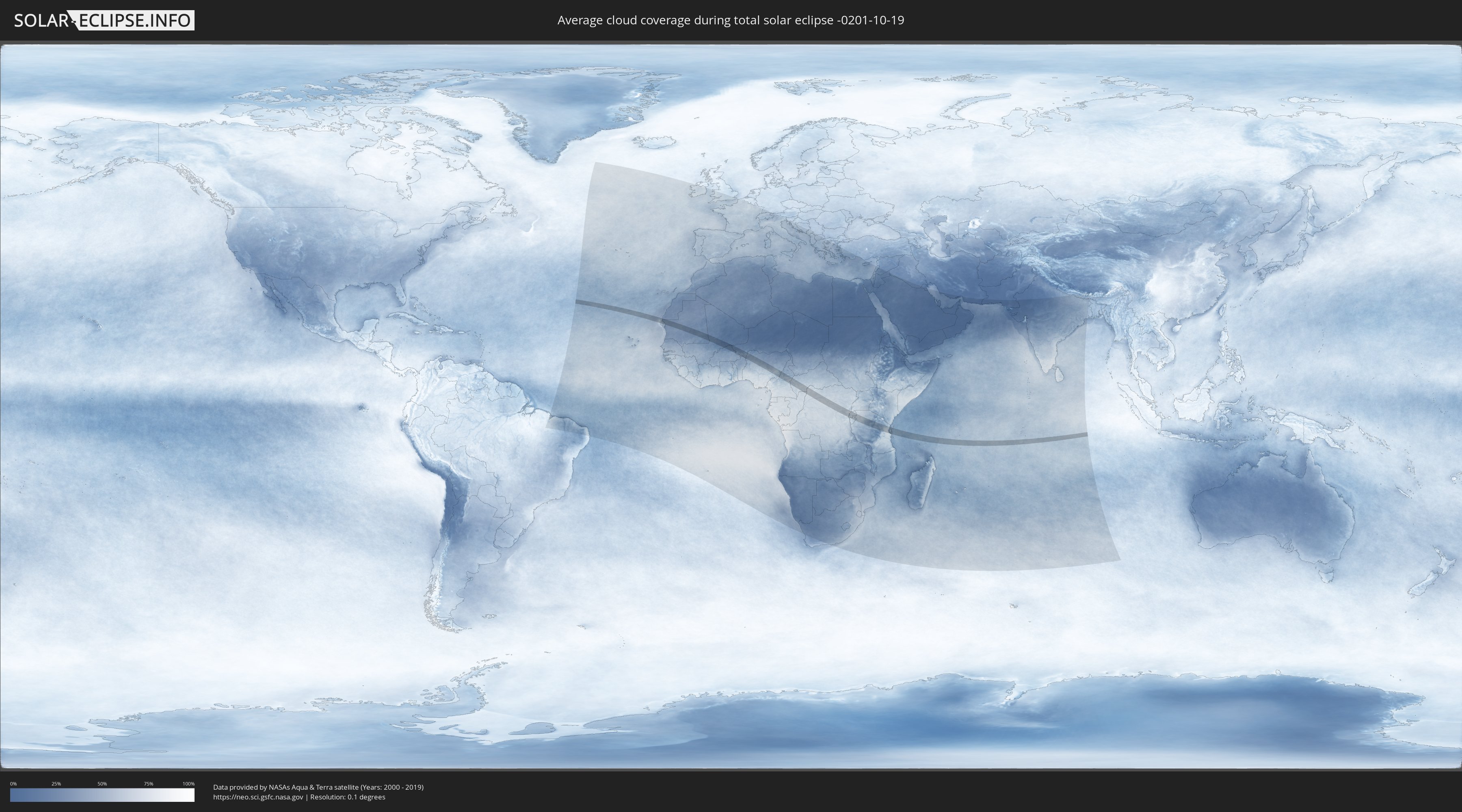
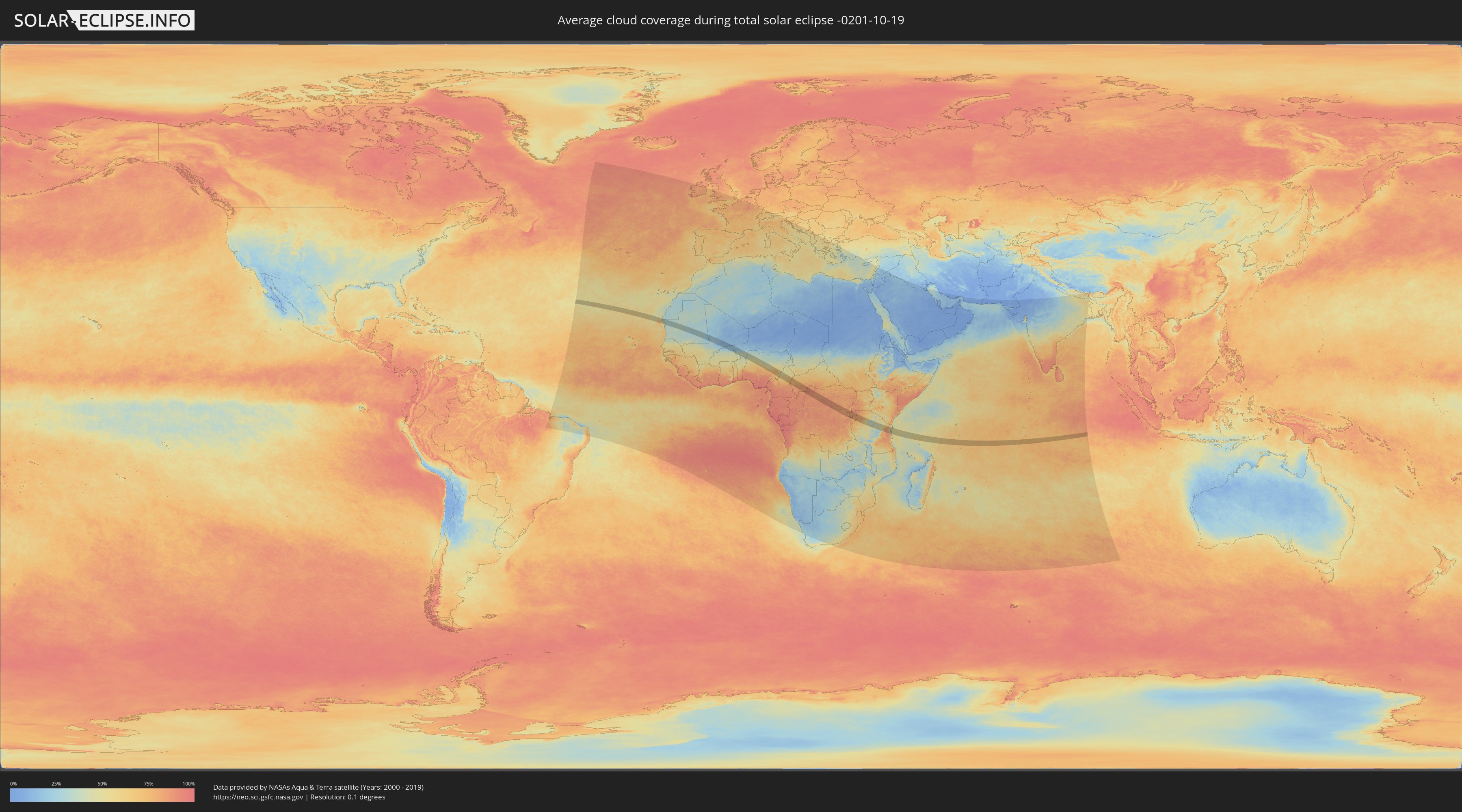
Wie wird das Wetter während der totalen Sonnenfinsternis am 19.10.-0201?
Wo ist der beste Ort, um die totale Sonnenfinsternis vom 19.10.-0201 zu beobachten?
Die folgenden Karten zeigen die durchschnittliche Bewölkung für den Tag, an dem die totale Sonnenfinsternis
stattfindet. Mit Hilfe der Karten lässt sich der Ort entlang des Finsternispfades eingrenzen,
der die besten Aussichen auf einen klaren wolkenfreien Himmel bietet.
Trotzdem muss man immer lokale Gegenenheiten beachten und sollte sich genau über das Wetter an seinem
gewählten Beobachtungsort informieren.
Die Daten stammen von den beiden NASA-Satelliten
AQUA und TERRA
und wurden über einen Zeitraum von 19 Jahren (2000 - 2019) gemittelt.
Detaillierte Länderkarten
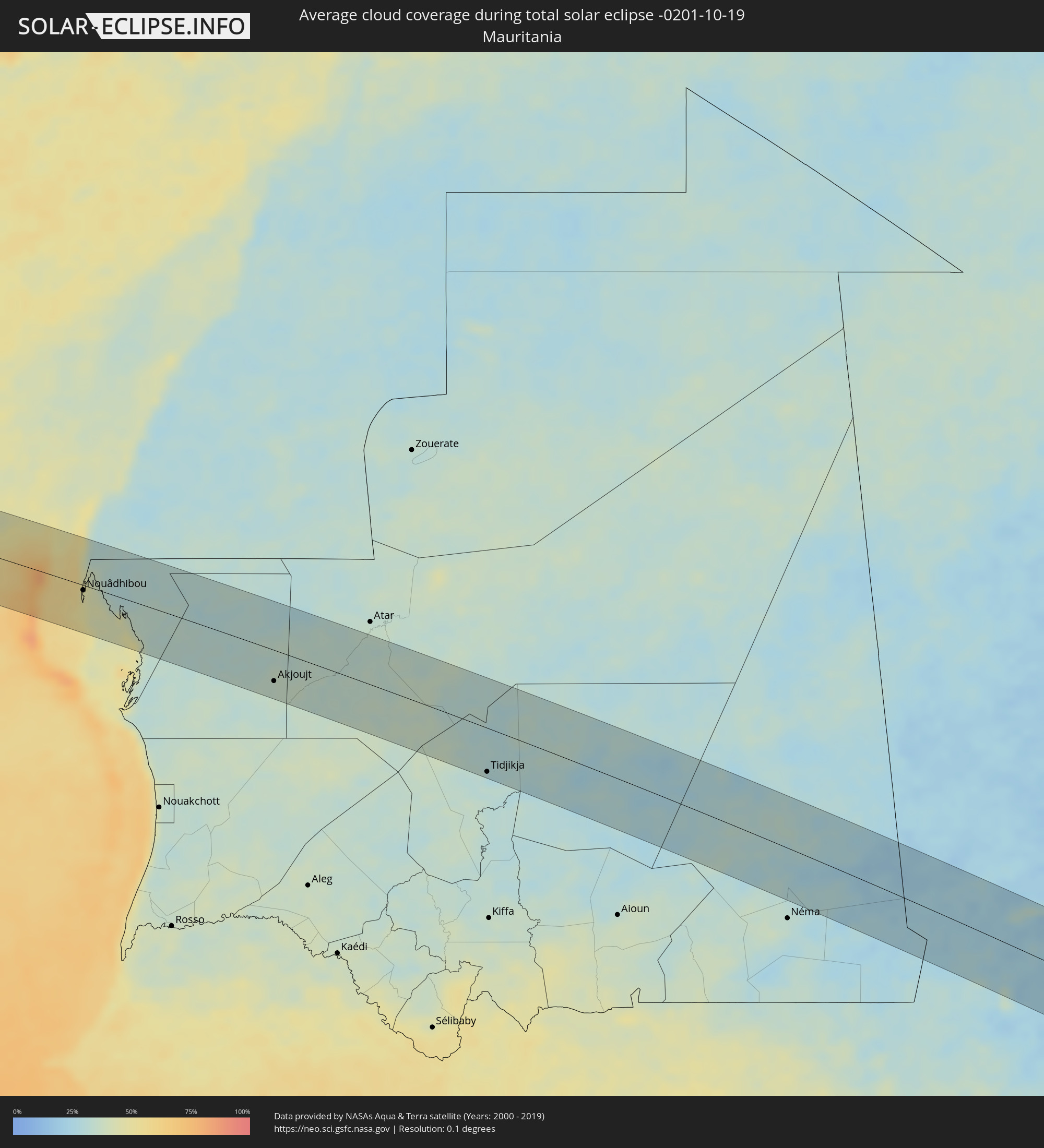 Mauretanien
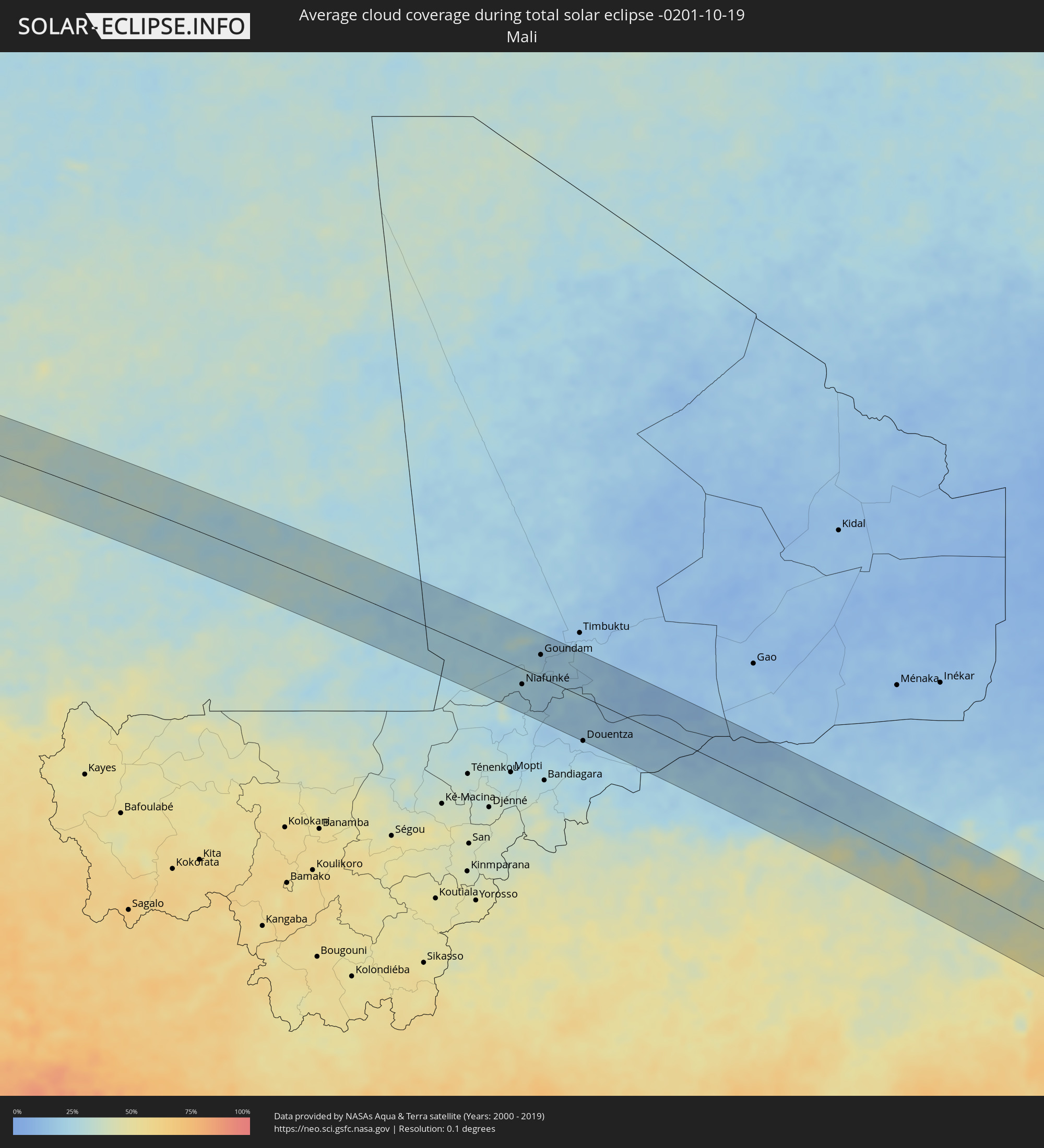 Mali
Mali
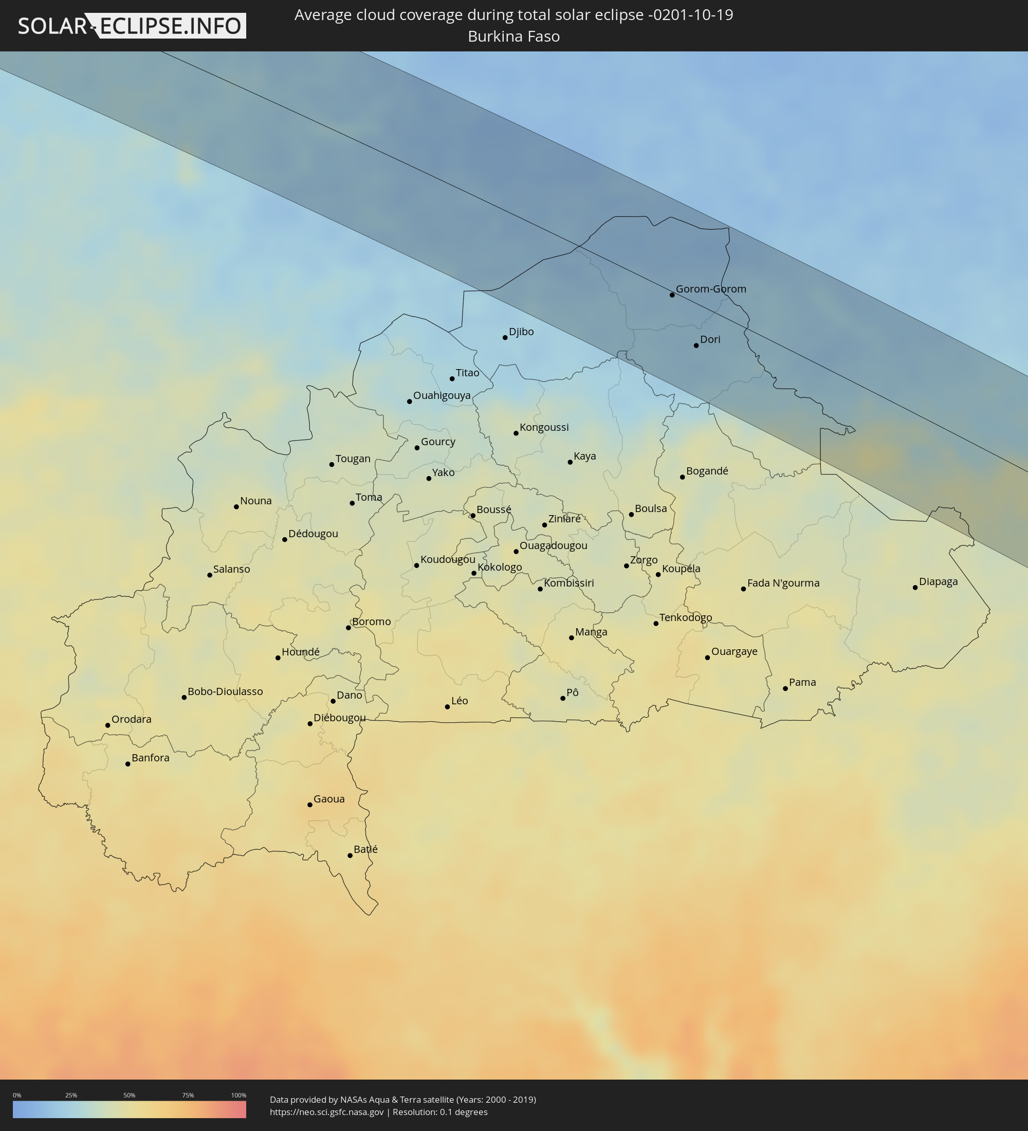 Burkina Faso
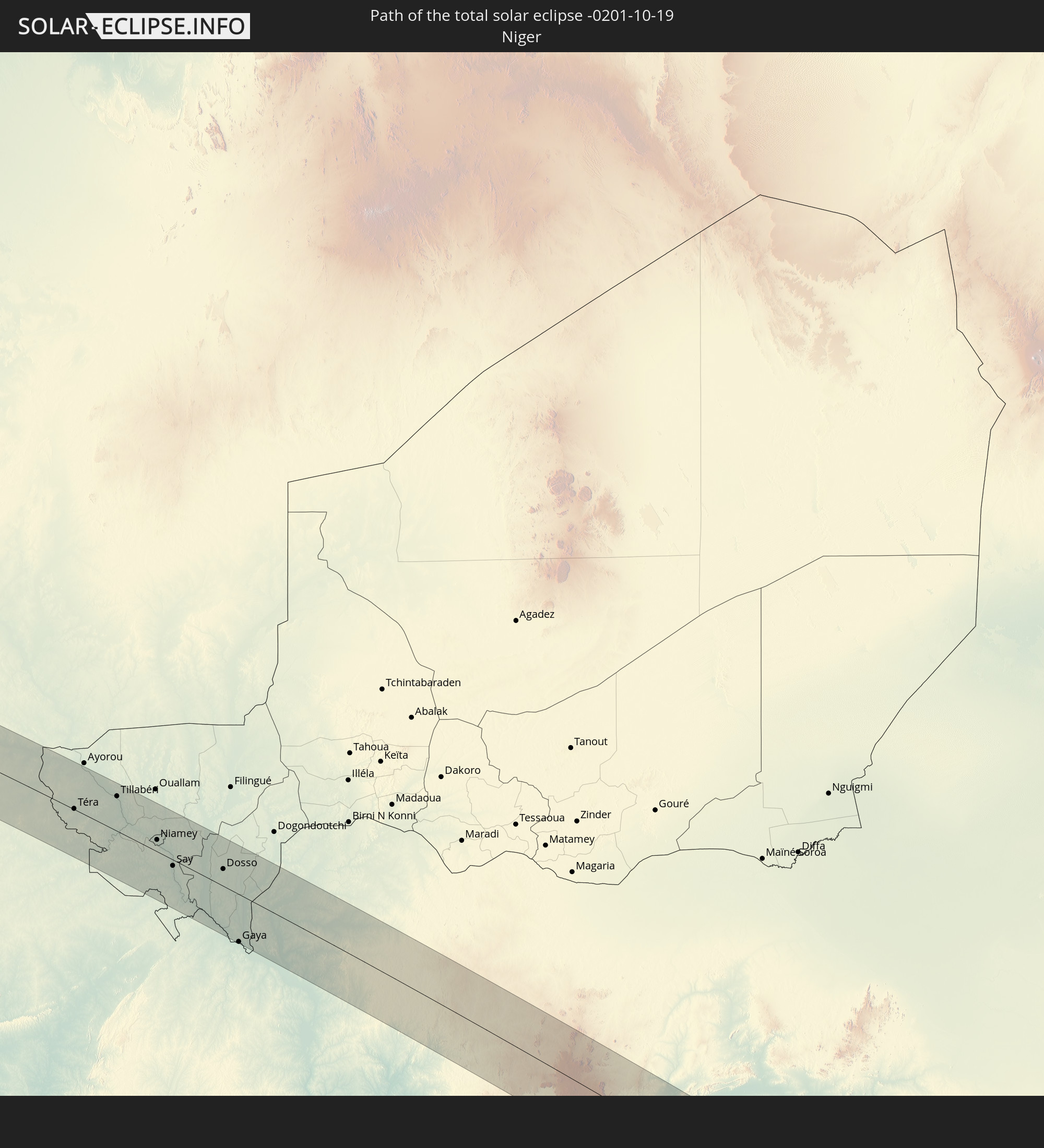
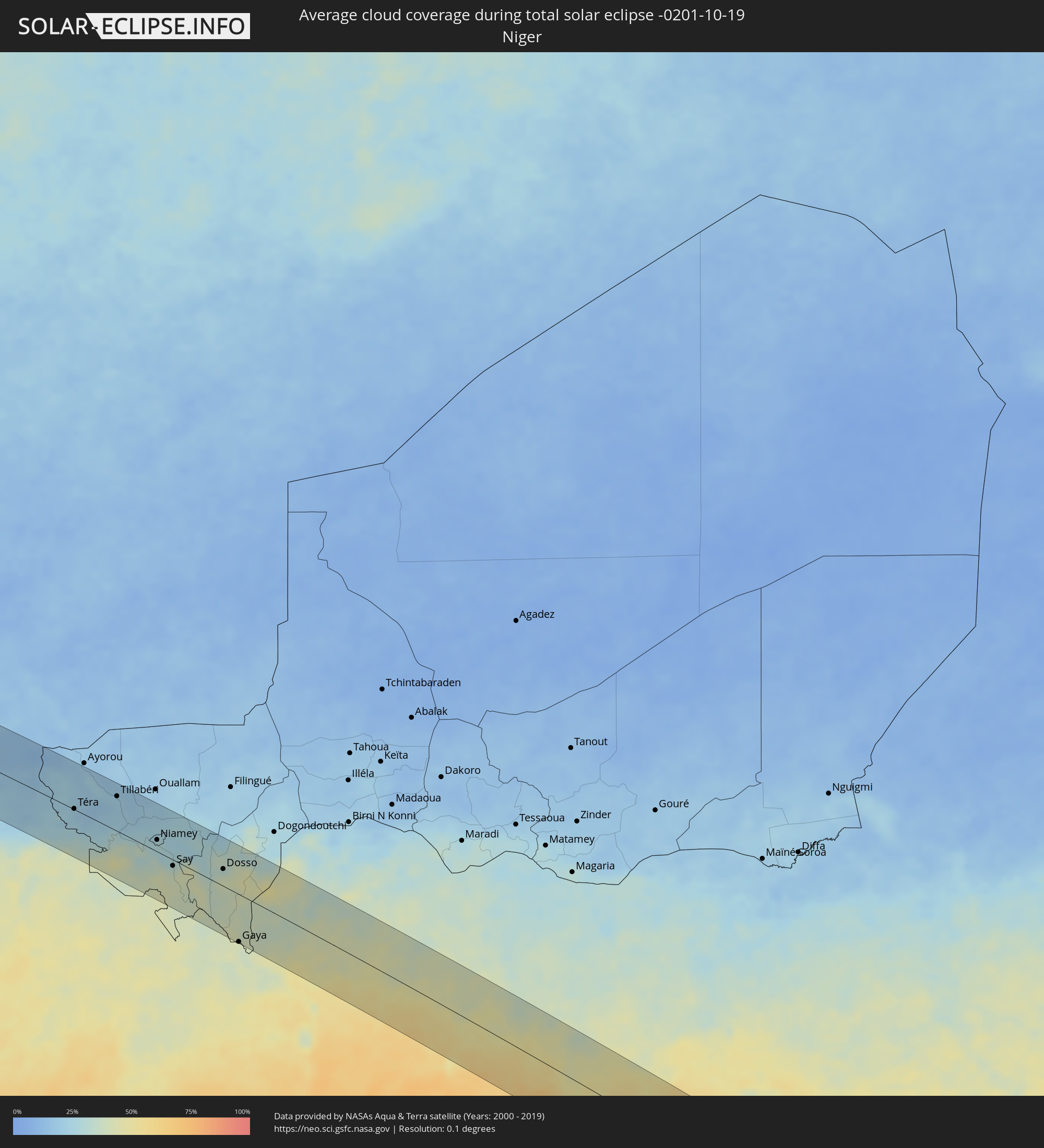 Niger
Niger
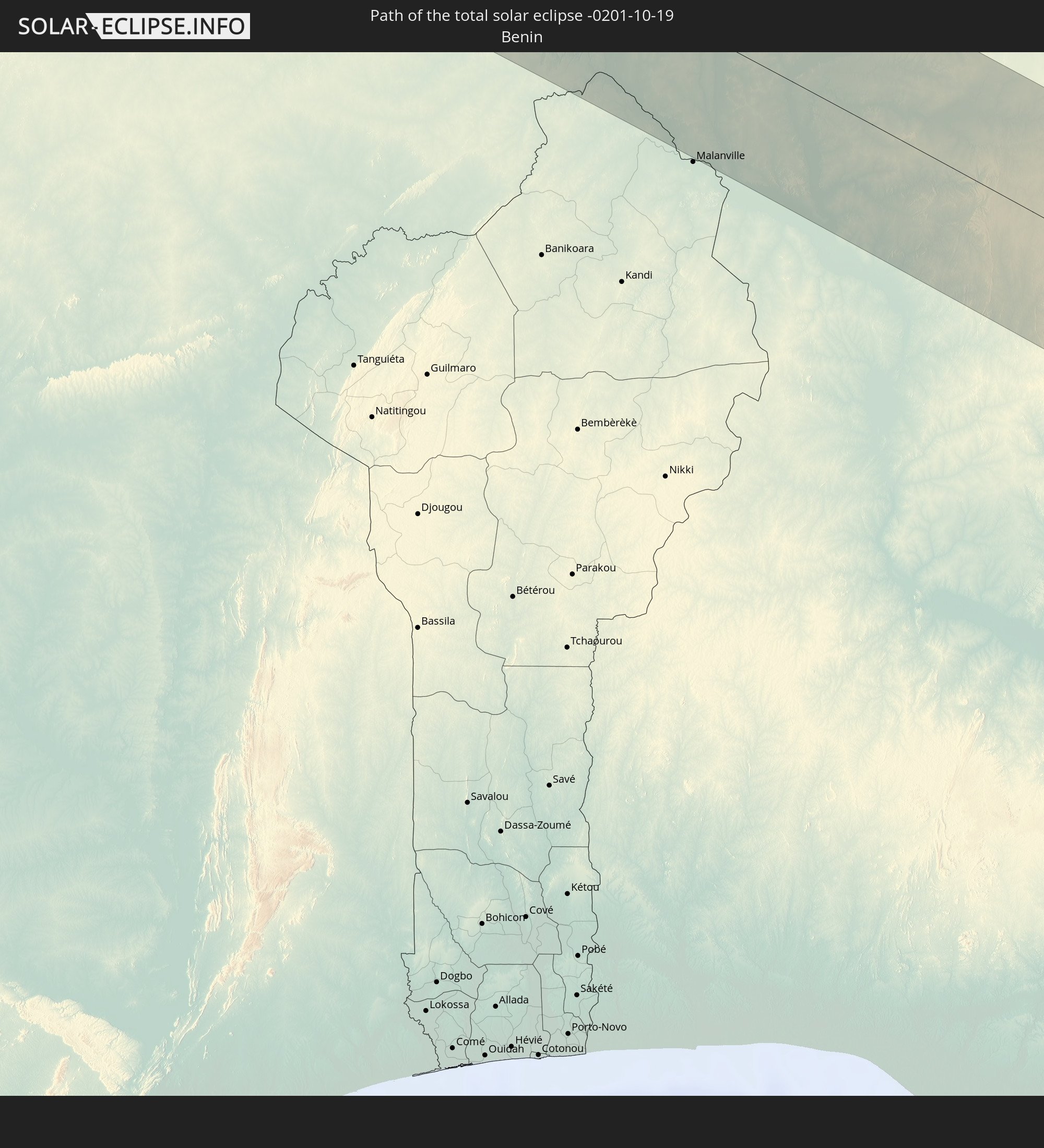
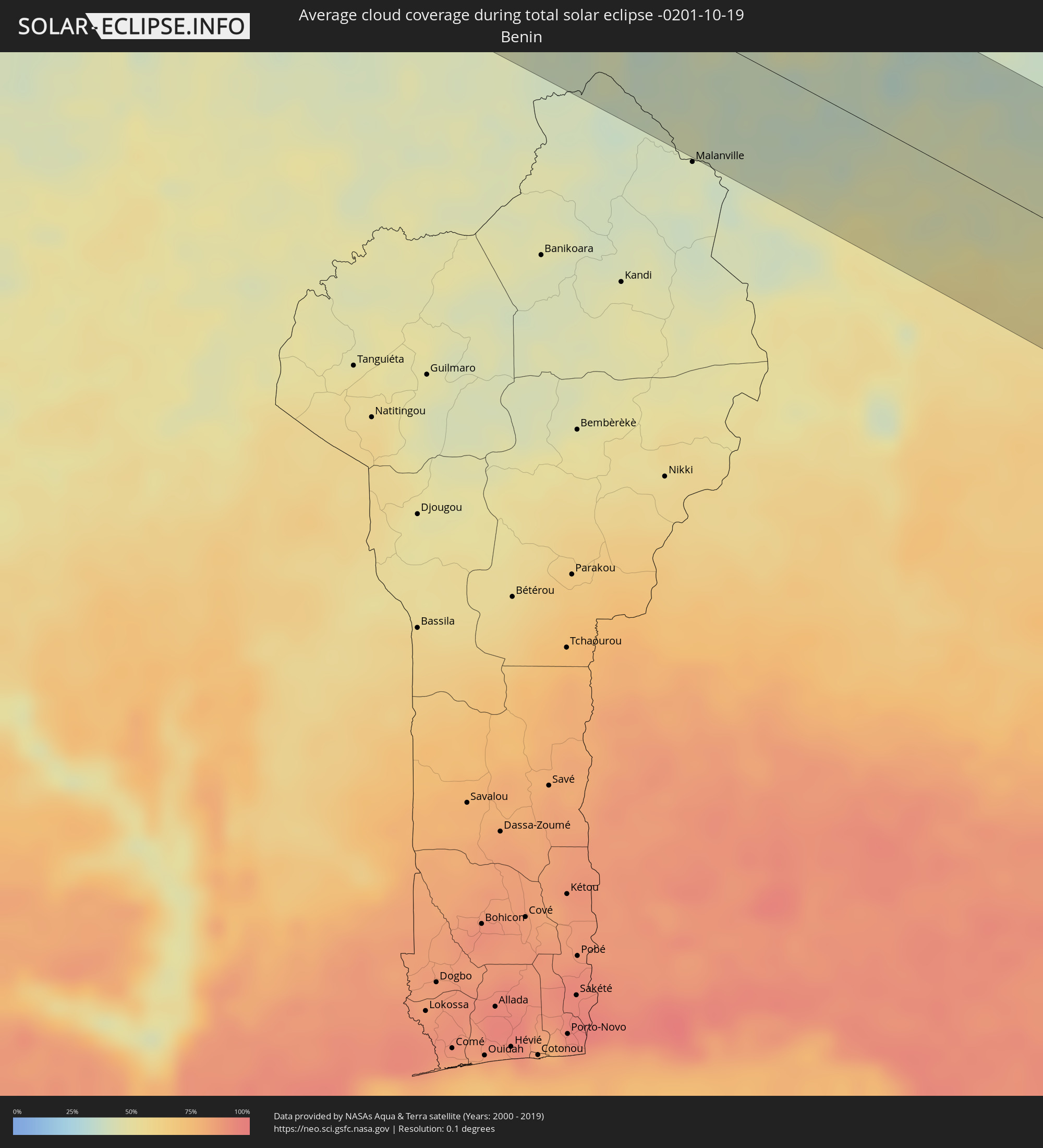 Benin
Benin
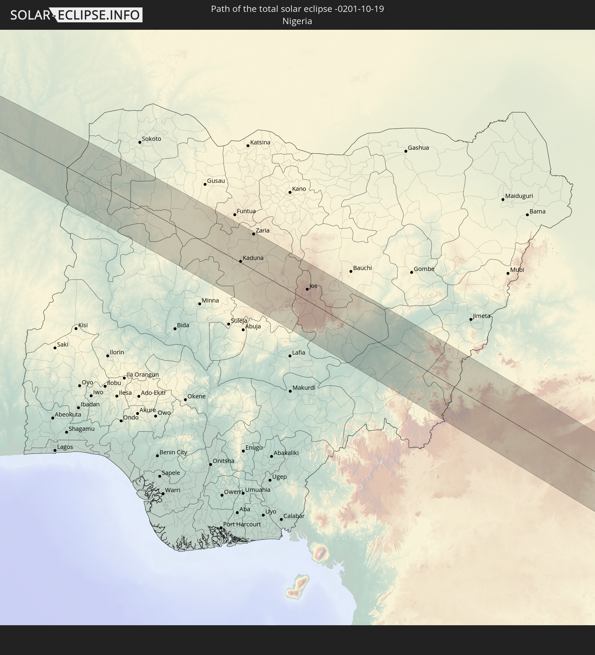
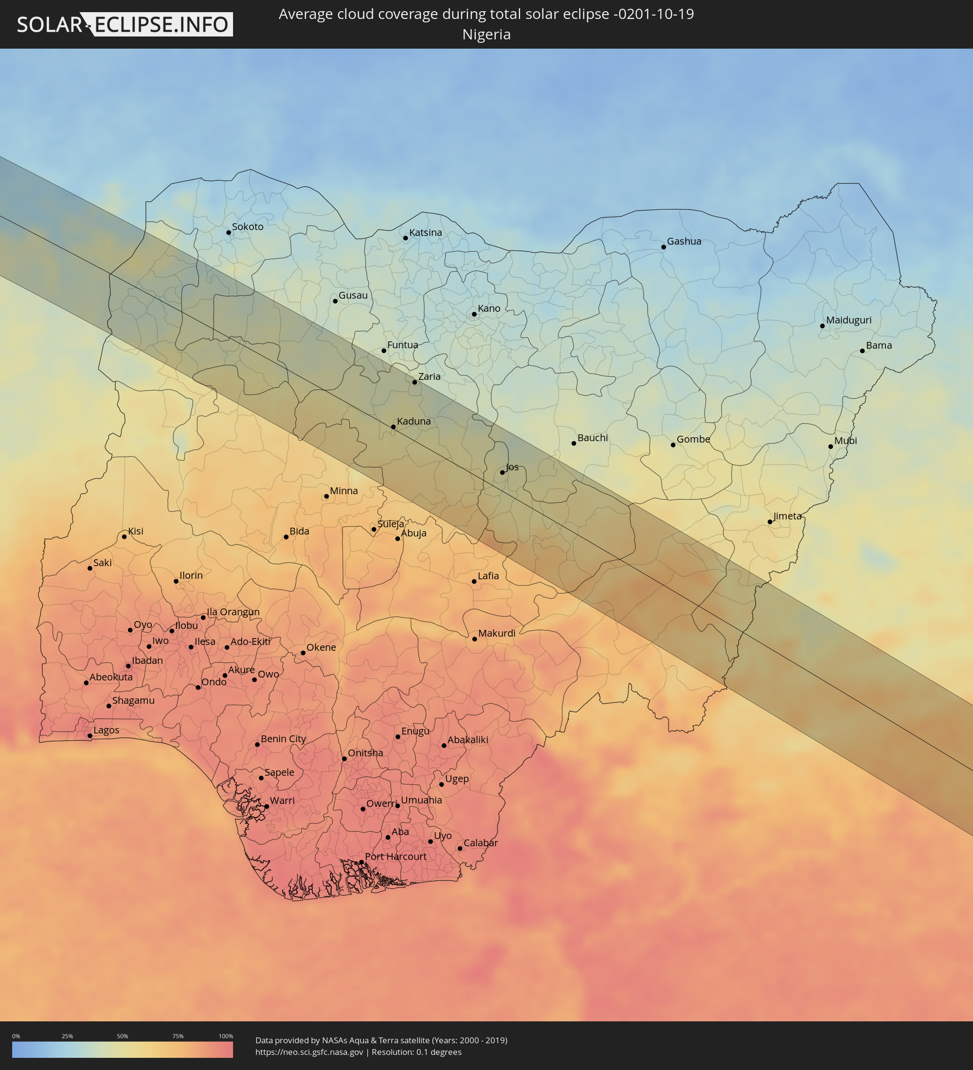 Nigeria
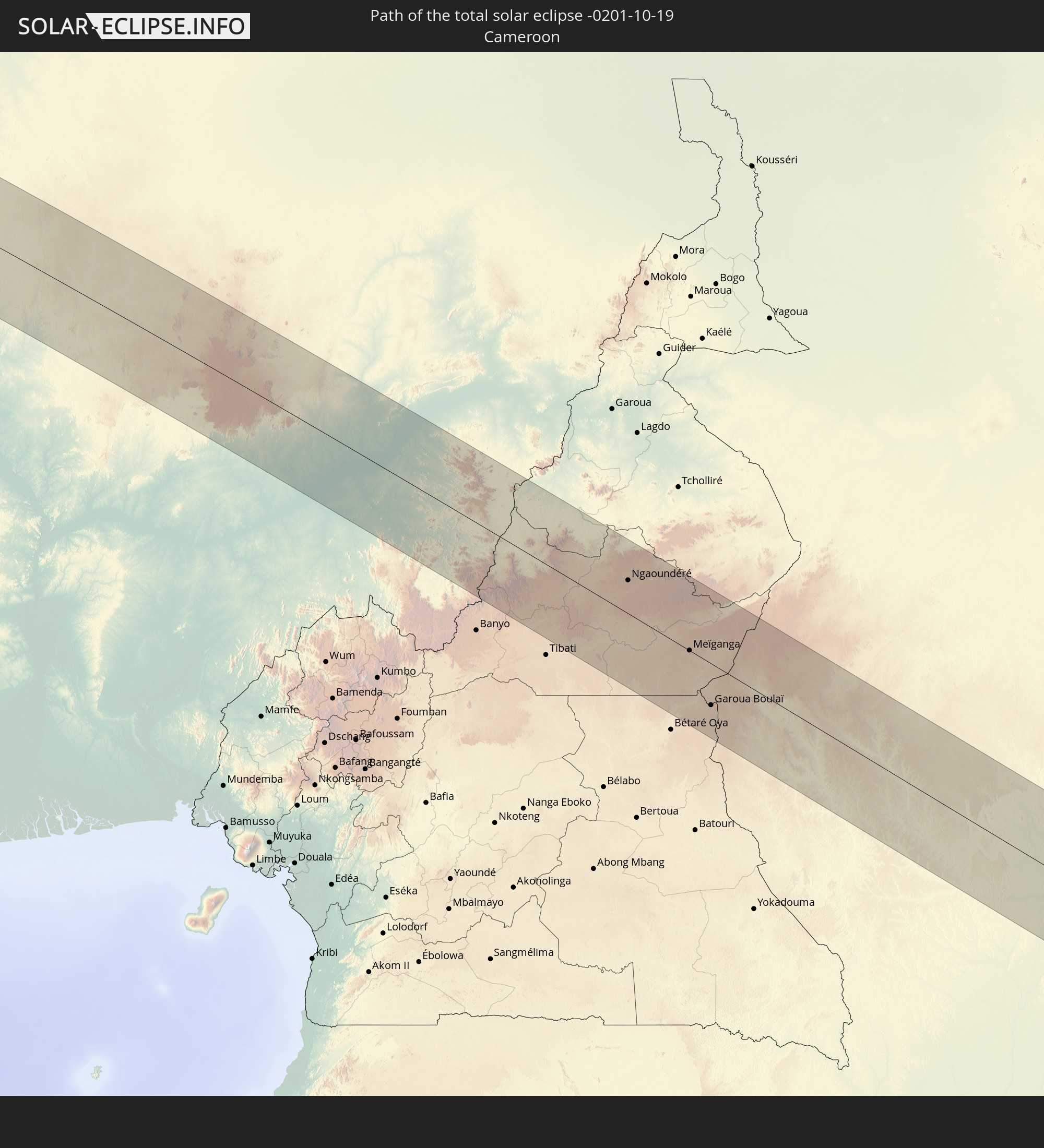
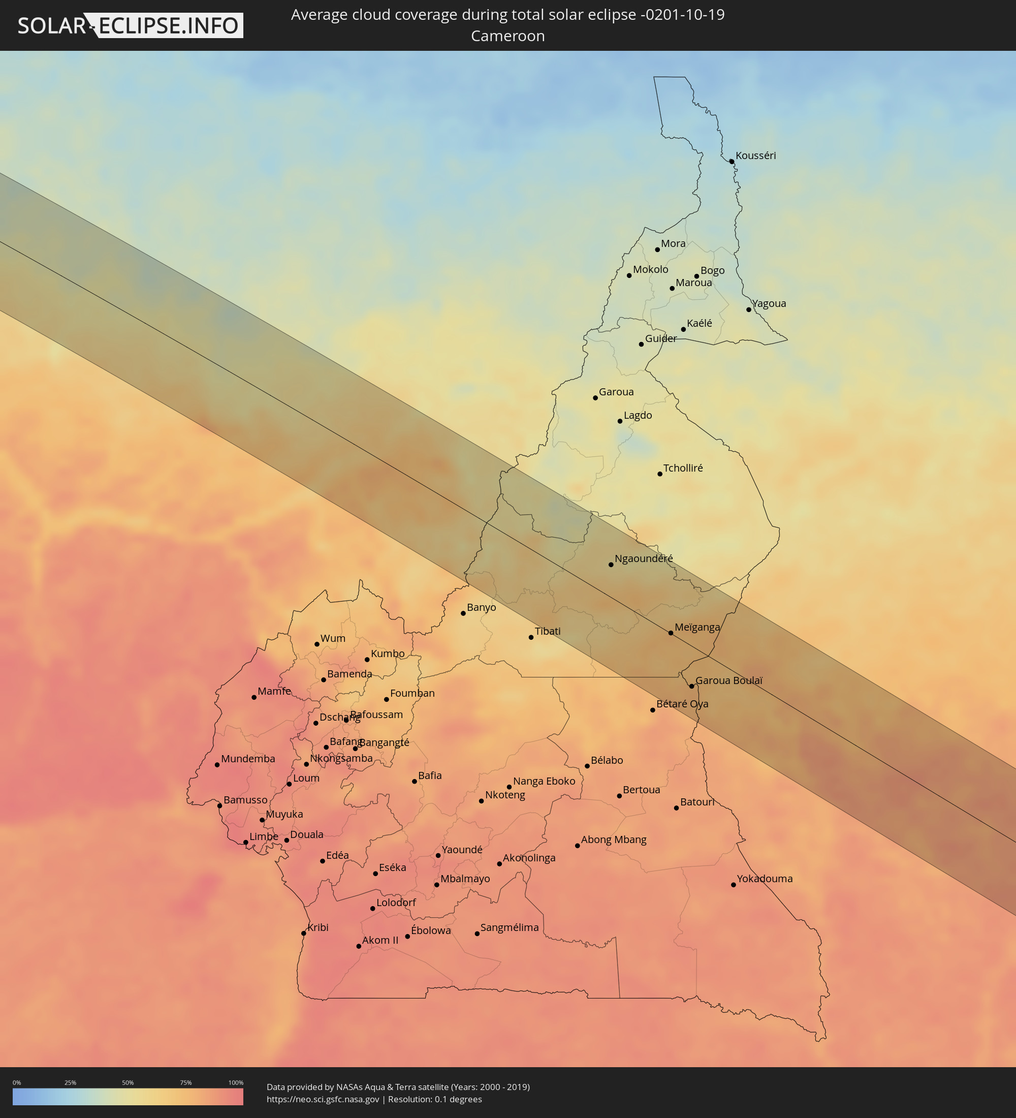 Kamerun
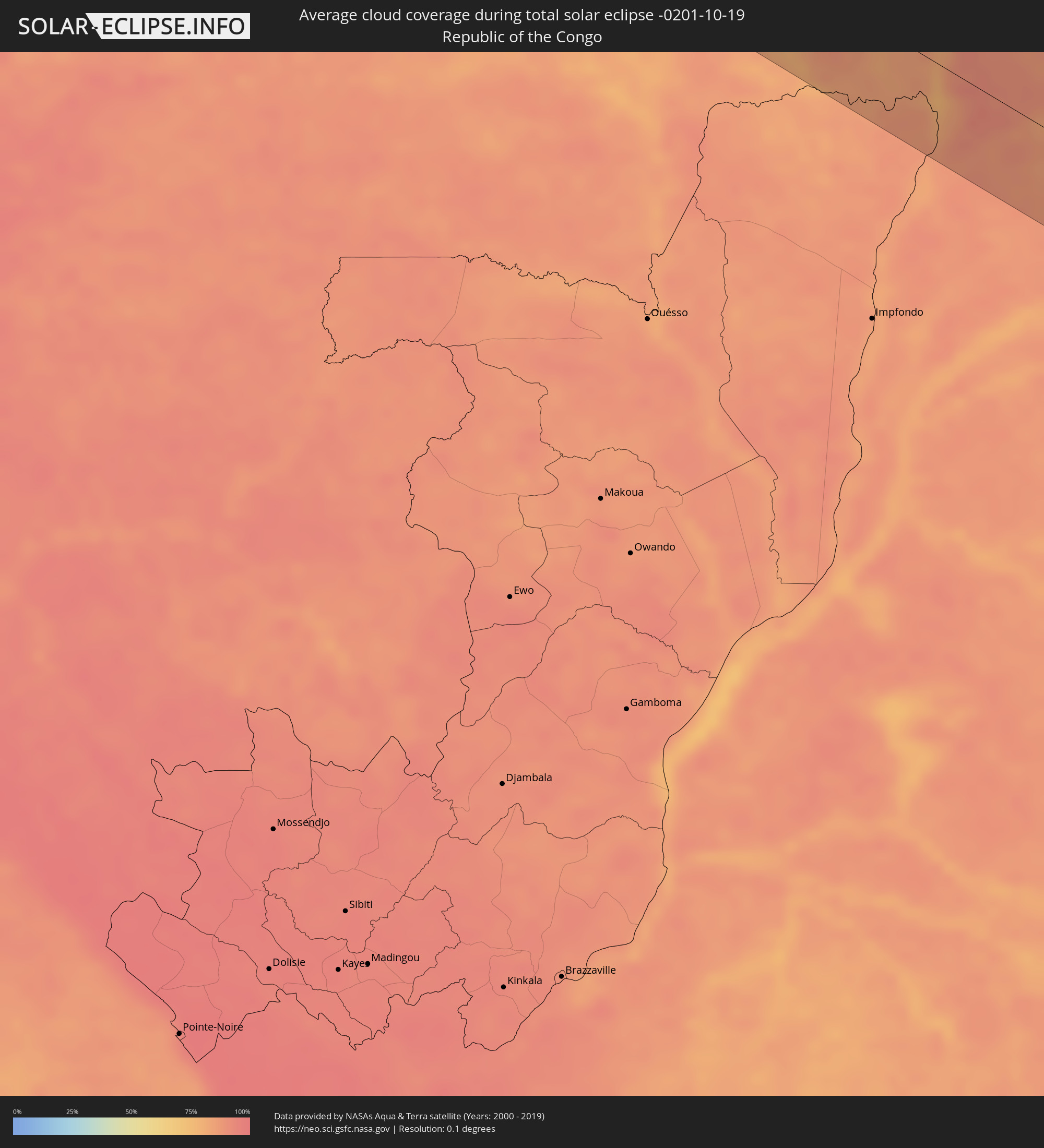 Republik Kongo
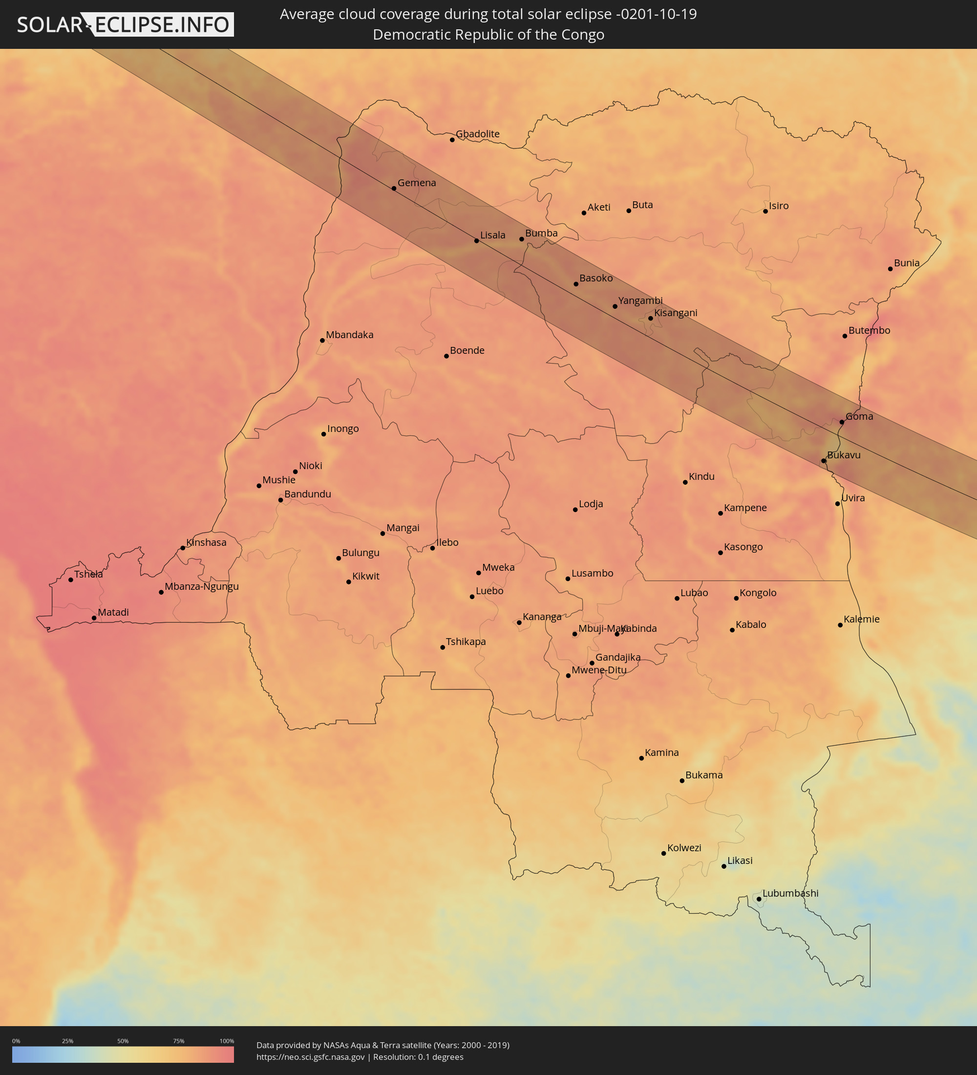 Demokratische Republik Kongo
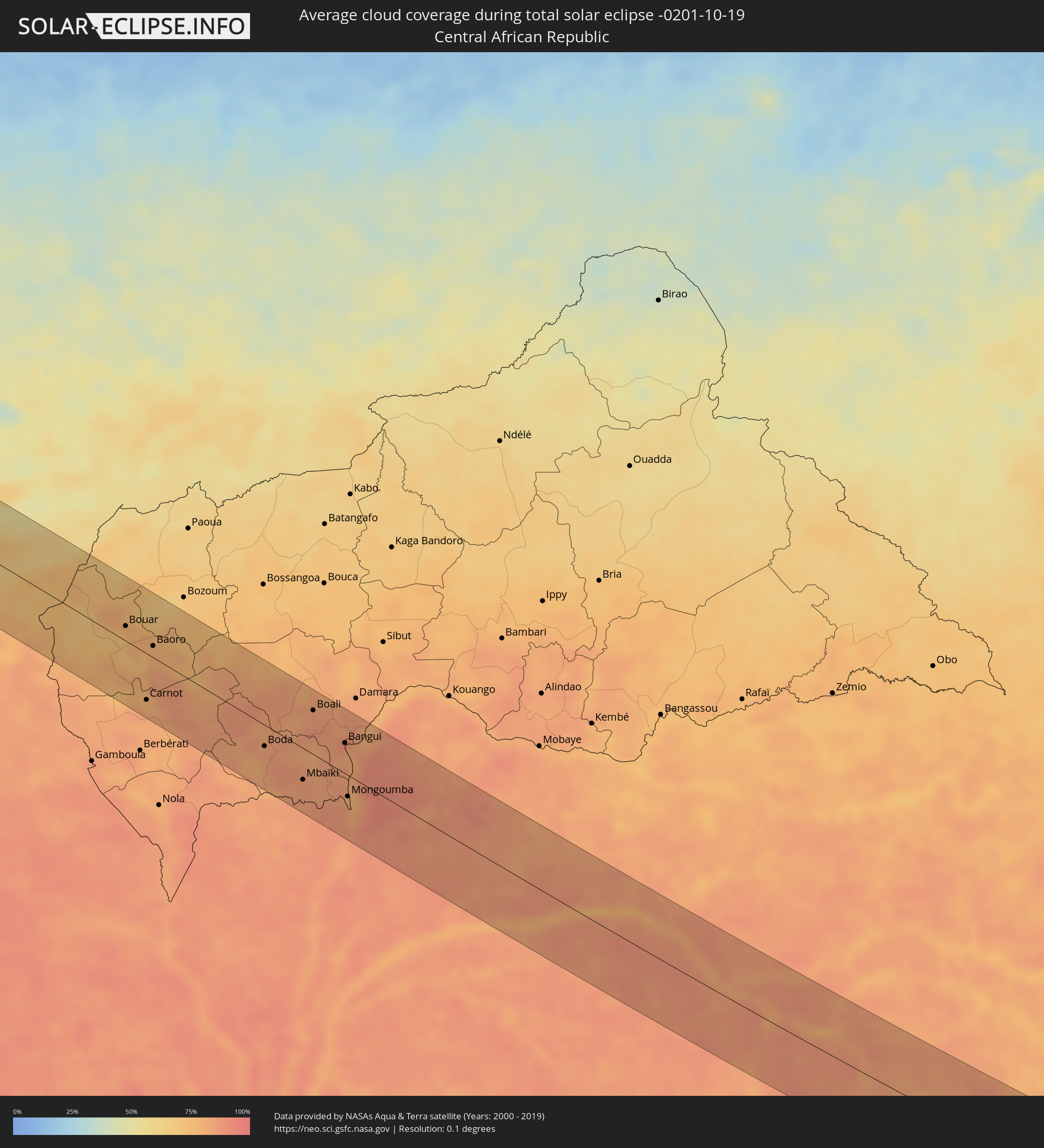 Zentralafrikanische Republik
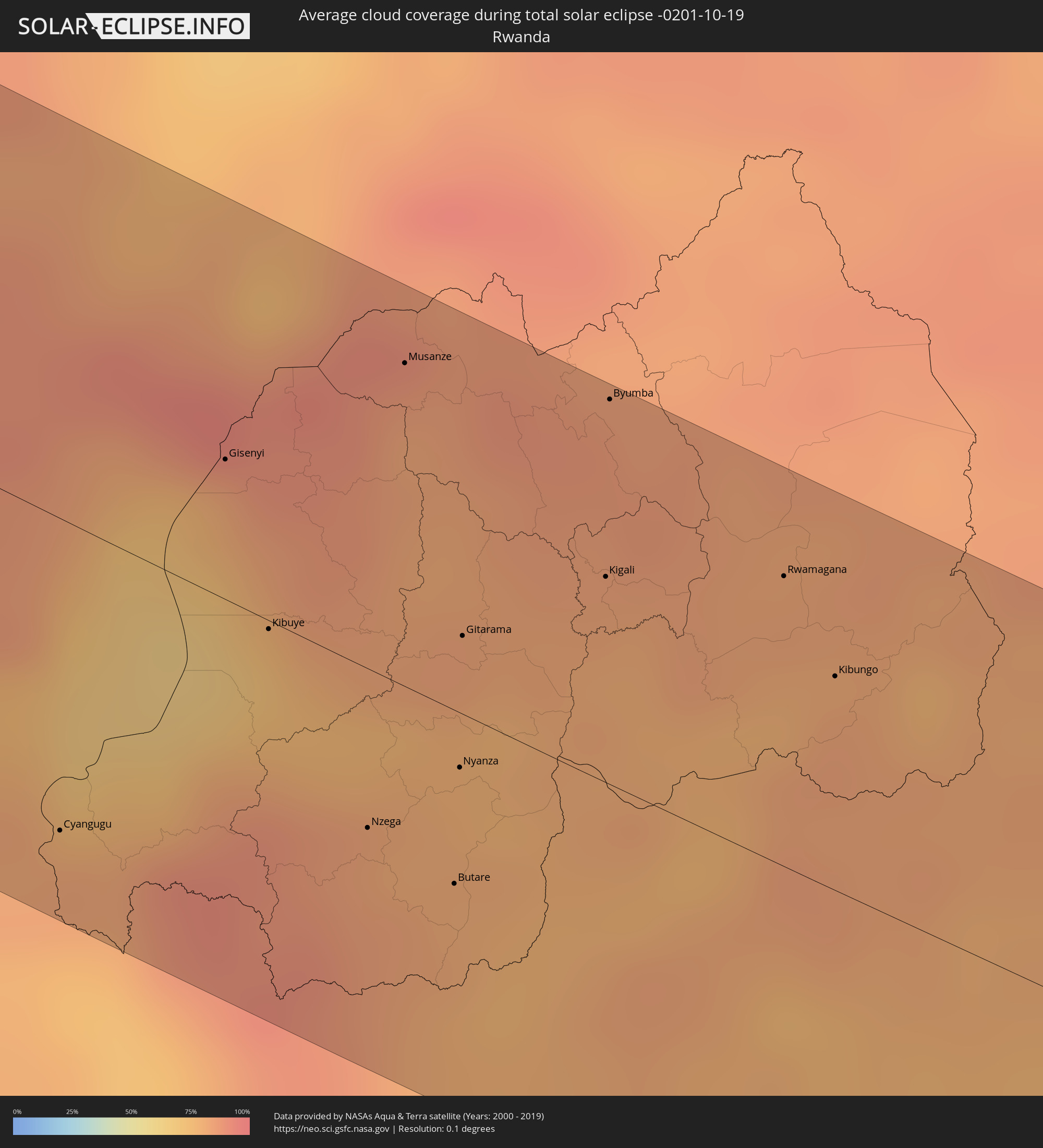 Ruanda
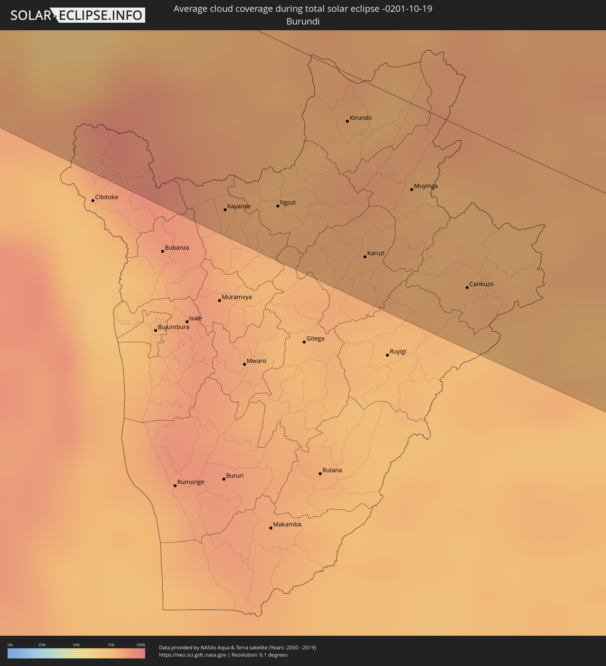 Burundi
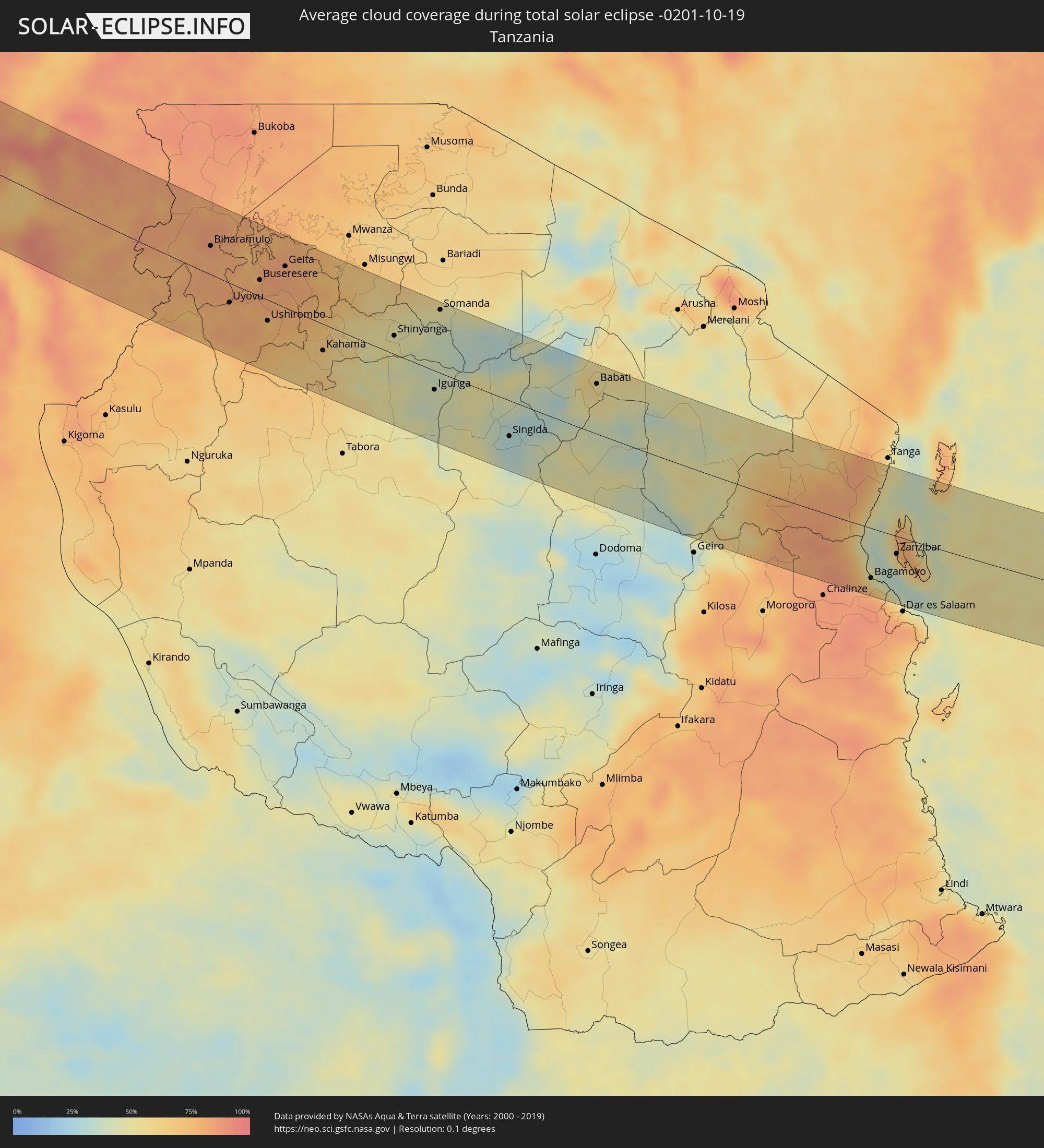 Tansania
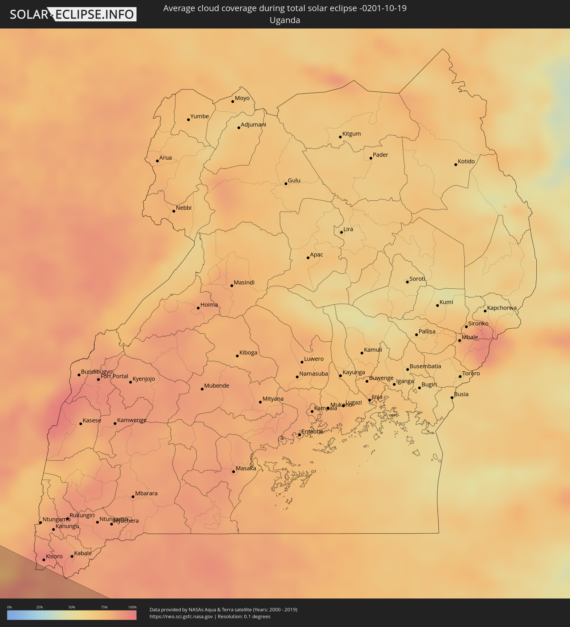 Uganda
Orte im Finsternispfad
Die nachfolgene Tabelle zeigt Städte und Orte mit mehr als 5.000 Einwohnern, die sich im Finsternispfad befinden. Städte mit mehr als 100.000 Einwohnern sind dick gekennzeichnet. Mit einem Klick auf den Ort öffnet sich eine Detailkarte die die Lage des jeweiligen Ortes zusammen mit dem Verlauf der zentralen Finsternis präsentiert.
| Ort | Typ | Dauer der Verfinsterung | Ortszeit bei maximaler Verfinsterung | Entfernung zur Zentrallinie | Ø Bewölkung |
|
Nouâdhibou, Dakhlet Nouadhibou
|
total | - | 08:29:42 UTC-00:16 | 7 km | 47% |
|
Akjoujt, Inchiri
|
total | - | 08:32:02 UTC-00:16 | 42 km | 34% |
|
Tidjikja, Tagant
|
total | - | 08:35:05 UTC-00:16 | 60 km | 29% |
|
Niafunké, Tombouctou
|
total | - | 08:44:57 UTC-00:16 | 26 km | 23% |
|
Goundam, Tombouctou
|
total | - | 08:45:07 UTC-00:16 | 37 km | 24% |
|
Douentza, Mopti
|
total | - | 08:46:58 UTC-00:16 | 73 km | 18% |
|
Gorom-Gorom, Sahel
|
total | - | 08:51:22 UTC-00:16 | 3 km | 21% |
|
Dori, Sahel
|
total | - | 08:51:59 UTC-00:16 | 34 km | 19% |
|
Téra, Tillabéri
|
total | - | 09:22:58 UTC+00:13 | 1 km | 20% |
|
Tillabéri, Tillabéri
|
total | - | 09:23:57 UTC+00:13 | 55 km | 22% |
|
Niamey, Niamey
|
total | - | 09:25:35 UTC+00:13 | 18 km | 28% |
|
Kollo, Tillabéri
|
total | - | 09:26:09 UTC+00:13 | 9 km | 28% |
|
Say, Tillabéri
|
total | - | 09:26:22 UTC+00:13 | 9 km | 35% |
|
Dosso, Dosso
|
total | - | 09:27:49 UTC+00:13 | 27 km | 40% |
|
Gaya, Dosso
|
total | - | 09:29:18 UTC+00:13 | 75 km | 42% |
|
Kamba, Kebbi
|
total | - | 09:29:42 UTC+00:13 | 68 km | 40% |
|
Birnin Kebbi, Kebbi
|
total | - | 09:30:07 UTC+00:13 | 19 km | 39% |
|
Jega, Kebbi
|
total | - | 09:30:40 UTC+00:13 | 6 km | 38% |
|
Argungu, Kebbi
|
total | - | 09:30:27 UTC+00:13 | 65 km | 39% |
|
Tambuwal, Sokoto
|
total | - | 09:30:59 UTC+00:13 | 38 km | 38% |
|
Gummi, Zamfara
|
total | - | 09:32:05 UTC+00:13 | 37 km | 43% |
|
Zuru, Kebbi
|
total | - | 09:32:58 UTC+00:13 | 27 km | 53% |
|
Rijau, Niger
|
total | - | 09:33:20 UTC+00:13 | 58 km | 53% |
|
Sofo-Birnin-Gwari, Kaduna
|
total | - | 09:36:20 UTC+00:13 | 14 km | 47% |
|
Kaduna, Kaduna
|
total | - | 09:38:08 UTC+00:13 | 2 km | 51% |
|
Zaria, Kaduna
|
total | - | 09:38:06 UTC+00:13 | 74 km | 42% |
|
Kachia, Kaduna
|
total | - | 09:39:52 UTC+00:13 | 33 km | 59% |
|
Dutsen Wai, Kaduna
|
total | - | 09:39:19 UTC+00:13 | 75 km | 40% |
|
Kafanchan, Kaduna
|
total | - | 09:40:53 UTC+00:13 | 43 km | 65% |
|
Lere, Kaduna
|
total | - | 09:40:35 UTC+00:13 | 50 km | 47% |
|
Jos, Plateau
|
total | - | 09:41:44 UTC+00:13 | 23 km | 45% |
|
Pankshin, Plateau
|
total | - | 09:43:32 UTC+00:13 | 5 km | 62% |
|
Beli, Taraba
|
total | - | 09:48:35 UTC+00:13 | 60 km | 67% |
|
Jalingo, Taraba
|
total | - | 09:48:11 UTC+00:13 | 61 km | 67% |
|
Kontcha, Adamaoua
|
total | - | 09:51:15 UTC+00:13 | 21 km | 52% |
|
Ngaoundéré, Adamaoua
|
total | - | 09:55:09 UTC+00:13 | 37 km | 60% |
|
Meïganga, Adamaoua
|
total | - | 09:57:53 UTC+00:13 | 0 km | 72% |
|
Bélel, Adamaoua
|
total | - | 09:57:30 UTC+00:13 | 59 km | 62% |
|
Garoua Boulaï, East
|
total | - | 09:59:19 UTC+00:13 | 46 km | 77% |
|
Bouar, Nana-Mambéré
|
total | - | 10:01:46 UTC+00:13 | 19 km | 77% |
|
Carnot, Mambéré-Kadéï
|
total | - | 10:03:48 UTC+00:13 | 59 km | 78% |
|
Baoro, Nana-Mambéré
|
total | - | 10:03:02 UTC+00:13 | 15 km | 77% |
|
Boda, Lobaye
|
total | - | 10:08:38 UTC+00:13 | 27 km | 84% |
|
Mbaïki, Lobaye
|
total | - | 10:10:35 UTC+00:13 | 40 km | 85% |
|
Boali, Ombella-M'Poko
|
total | - | 10:09:37 UTC+00:13 | 56 km | 84% |
|
Bimbo, Ombella-M'Poko
|
total | - | 10:11:07 UTC+00:13 | 21 km | 84% |
|
Bangui, Bangui
|
total | - | 10:11:19 UTC+00:13 | 39 km | 84% |
|
Mongoumba, Lobaye
|
total | - | 10:12:26 UTC+00:13 | 27 km | 78% |
|
Libenge, Équateur
|
total | - | 10:12:32 UTC+00:13 | 24 km | 76% |
|
Gemena, Équateur
|
total | - | 10:16:02 UTC+00:13 | 3 km | 88% |
|
Businga, Équateur
|
total | - | 10:18:50 UTC+00:13 | 74 km | 83% |
|
Lisala, Équateur
|
total | - | 10:22:13 UTC+00:13 | 4 km | 81% |
|
Bumba, Équateur
|
total | - | 10:24:42 UTC+00:13 | 53 km | 78% |
|
Basoko, Orientale
|
total | - | 12:25:56 UTC+02:10 | 25 km | 80% |
|
Yangambi, Orientale
|
total | - | 12:28:51 UTC+02:10 | 24 km | 83% |
|
Kisangani, Orientale
|
total | - | 12:31:15 UTC+02:10 | 40 km | 82% |
|
Kabare, South Kivu
|
total | - | 12:45:21 UTC+02:10 | 73 km | 82% |
|
Bukavu, South Kivu
|
total | - | 12:45:29 UTC+02:10 | 70 km | 82% |
|
Cyangugu, Western Province
|
total | - | 12:45:39 UTC+02:10 | 66 km | 82% |
|
Sake, Nord Kivu
|
total | - | 12:44:45 UTC+02:10 | 32 km | 78% |
|
Goma, Nord Kivu
|
total | - | 12:45:24 UTC+02:10 | 31 km | 77% |
|
Gisenyi, Western Province
|
total | - | 12:45:31 UTC+02:10 | 29 km | 83% |
|
Kibuye, Western Province
|
total | - | 12:46:16 UTC+02:10 | 2 km | 75% |
|
Nzega, Southern Province
|
total | - | 12:47:24 UTC+02:10 | 34 km | 83% |
|
Kayanza, Kayanza
|
total | - | 12:48:12 UTC+02:10 | 75 km | 82% |
|
Musanze, Northern Province
|
total | - | 12:46:16 UTC+02:10 | 68 km | 82% |
|
Butare, Southern Province
|
total | - | 12:48:03 UTC+02:10 | 37 km | 81% |
|
Nyanza, Southern Province
|
total | - | 12:47:45 UTC+02:10 | 12 km | 80% |
|
Gitarama, Southern Province
|
total | - | 12:47:23 UTC+02:10 | 17 km | 77% |
|
Ngozi, Ngozi
|
total | - | 12:48:44 UTC+02:10 | 64 km | 80% |
|
Kigali, Kigali
|
total | - | 12:48:02 UTC+02:10 | 44 km | 81% |
|
Byumba, Northern Province
|
total | - | 12:47:33 UTC+02:10 | 81 km | 86% |
|
Kirundo, Kirundo
|
total | - | 12:49:00 UTC+02:10 | 19 km | 82% |
|
Karuzi, Karuzi
|
total | - | 12:49:53 UTC+02:10 | 67 km | 80% |
|
Muyinga, Muyinga
|
total | - | 12:50:01 UTC+02:10 | 33 km | 78% |
|
Rwamagana, Eastern Province
|
total | - | 12:49:03 UTC+02:10 | 62 km | 83% |
|
Bugarama, Kagera
|
total | - | 13:07:29 UTC+02:27 | 27 km | 78% |
|
Kibungo, Eastern Province
|
total | - | 12:49:38 UTC+02:10 | 45 km | 84% |
|
Cankuzo, Cankuzo
|
total | - | 12:51:05 UTC+02:10 | 61 km | 78% |
|
Biharamulo, Kagera
|
total | - | 13:09:16 UTC+02:27 | 33 km | 82% |
|
Uyovu, Geita
|
total | - | 13:10:43 UTC+02:27 | 23 km | 79% |
|
Chato, Geita
|
total | - | 13:10:31 UTC+02:27 | 54 km | 76% |
|
Buseresere, Geita
|
total | - | 13:11:18 UTC+02:27 | 19 km | 81% |
|
Ushirombo, Geita
|
total | - | 13:12:09 UTC+02:27 | 24 km | 77% |
|
Geita, Geita
|
total | - | 13:11:53 UTC+02:27 | 49 km | 81% |
|
Masumbwe, Geita
|
total | - | 13:12:55 UTC+02:27 | 29 km | 71% |
|
Kasamwa, Geita
|
total | - | 13:12:34 UTC+02:27 | 62 km | 78% |
|
Kahama, Shinyanga
|
total | - | 13:14:17 UTC+02:27 | 31 km | 62% |
|
Shinyanga, Shinyanga
|
total | - | 13:16:14 UTC+02:27 | 22 km | 49% |
|
Igunga, Tabora
|
total | - | 13:18:13 UTC+02:27 | 22 km | 42% |
|
Somanda, Simiyu
|
total | - | 13:17:15 UTC+02:27 | 75 km | 41% |
|
Singida, Singida
|
total | - | 13:21:06 UTC+02:27 | 42 km | 29% |
|
Babati, Manyara
|
total | - | 13:22:58 UTC+02:27 | 60 km | 54% |
|
Chanika, Tanga
|
total | - | 13:30:02 UTC+02:27 | 18 km | 77% |
|
Mvomero, Pwani
|
total | - | 13:32:30 UTC+02:27 | 48 km | 76% |
|
Bagamoyo, Pwani
|
total | - | 13:33:16 UTC+02:27 | 61 km | 55% |
|
Zanzibar, Zanzibar Urban/West
|
total | - | 13:33:41 UTC+02:27 | 21 km | 56% |