Totale Sonnenfinsternis vom 04.05.-0248
| Wochentag: | Dienstag |
| Maximale Dauer der Verfinsterung: | 06m07s |
| Maximale Breite des Finsternispfades: | 243 km |
| Saroszyklus: | 63 |
| Bedeckungsgrad: | 100% |
| Magnitude: | 1.0746 |
| Gamma: | 0.0902 |
Wo kann man die Sonnenfinsternis vom 04.05.-0248 sehen?
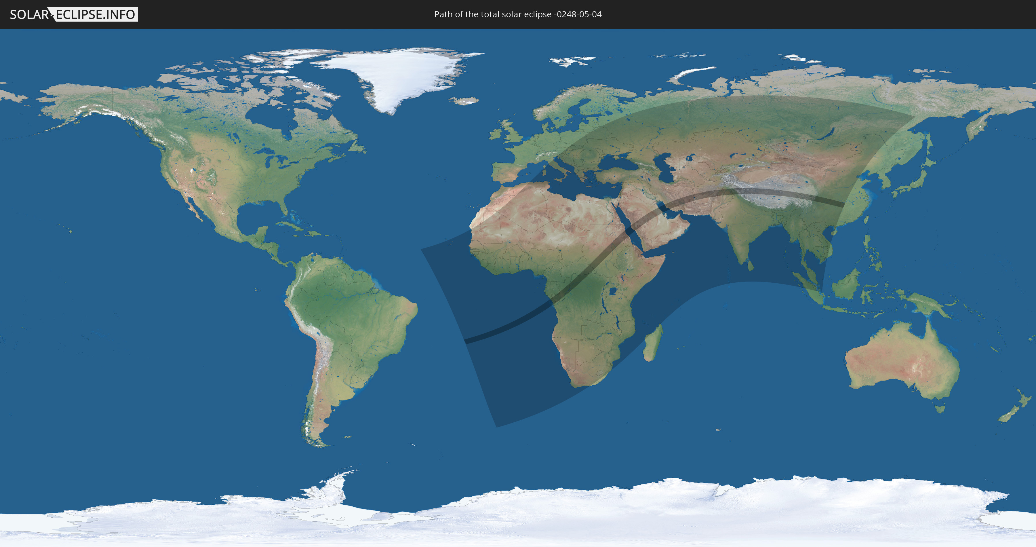
Die Sonnenfinsternis am 04.05.-0248 kann man in 121 Ländern als partielle Sonnenfinsternis beobachten.
Der Finsternispfad verläuft durch 14 Länder. Nur in diesen Ländern ist sie als totale Sonnenfinsternis zu sehen.
In den folgenden Ländern ist die Sonnenfinsternis total zu sehen
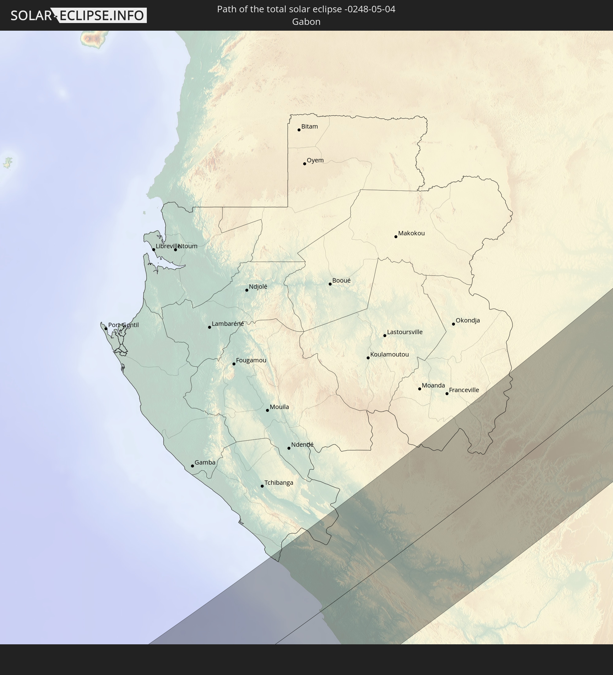 Gabun
Gabun
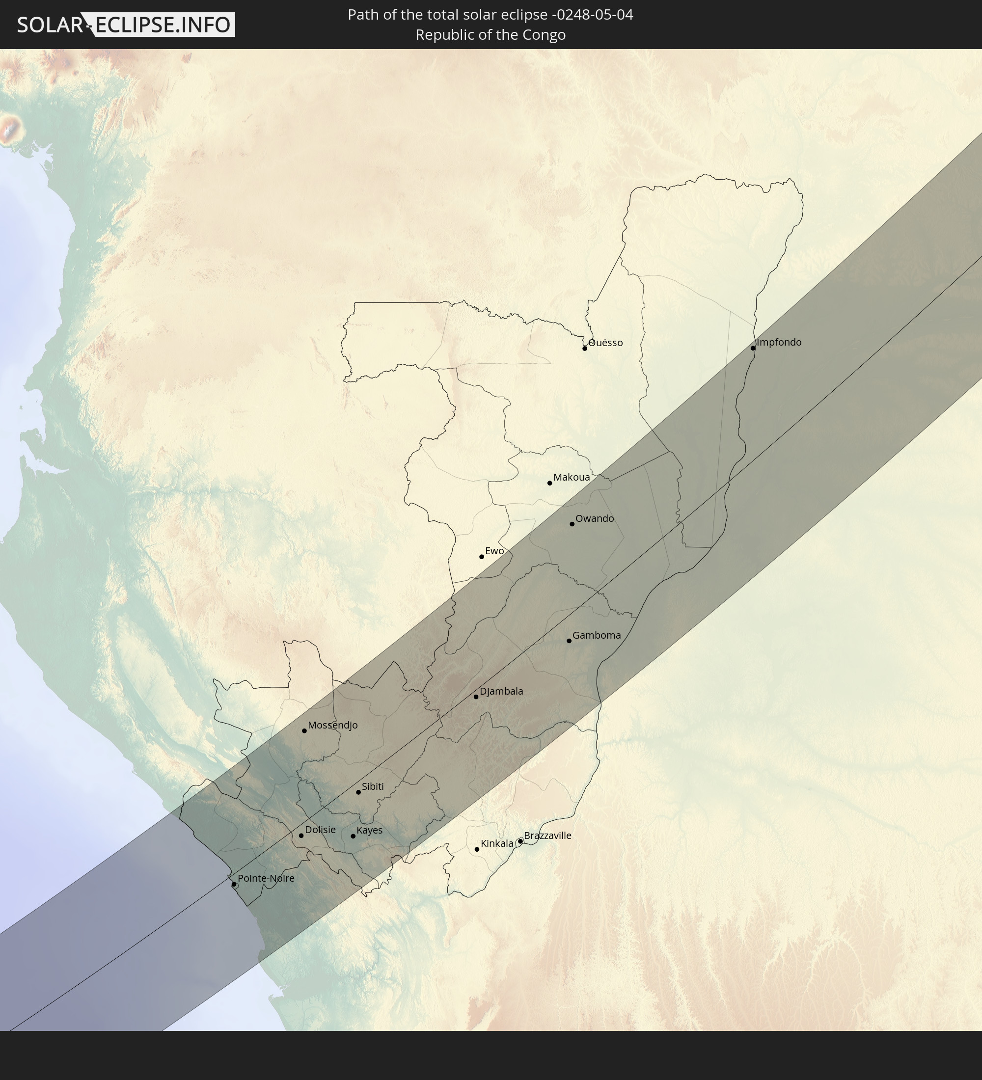 Republik Kongo
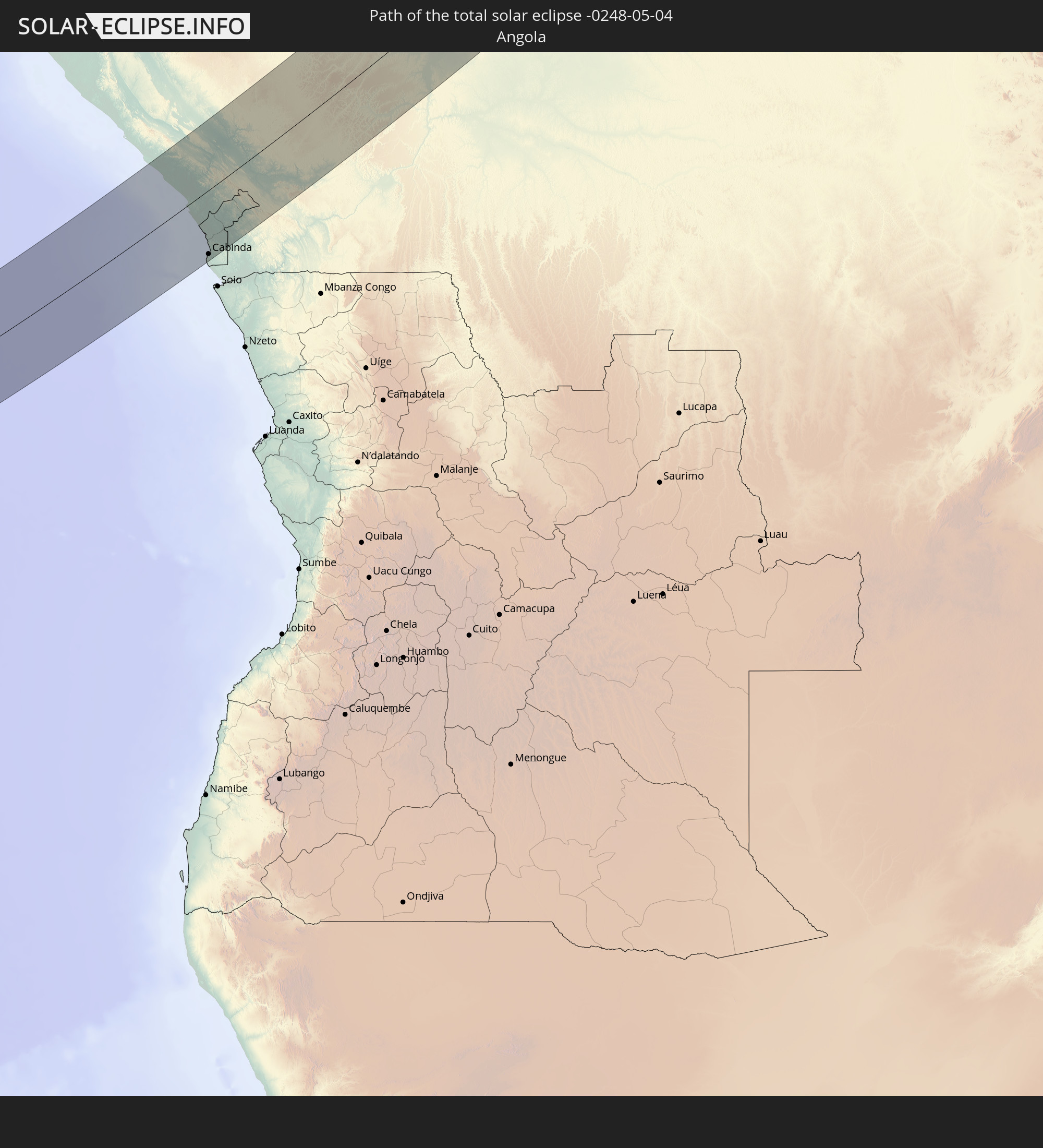 Angola
 Demokratische Republik Kongo
 Zentralafrikanische Republik
 Sudan
Sudan
 Südsudan
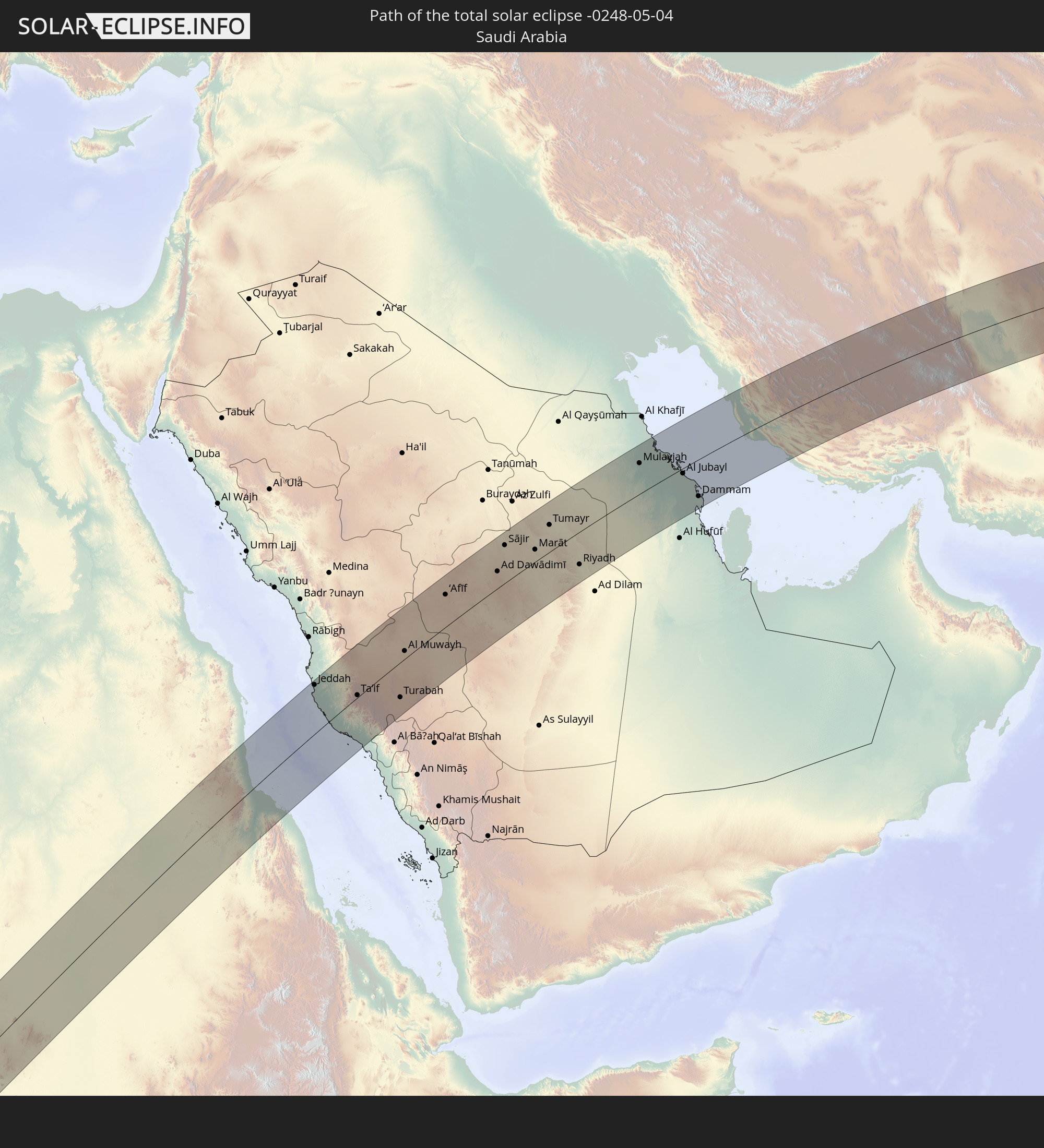 Saudi-Arabien
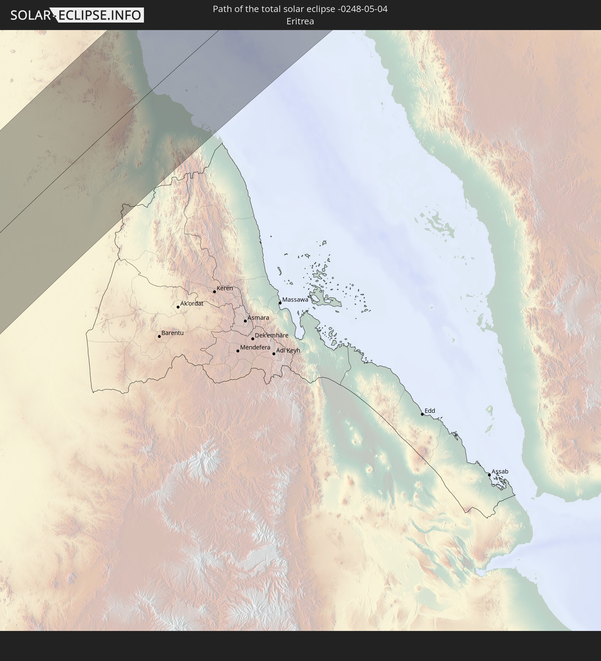 Eritrea
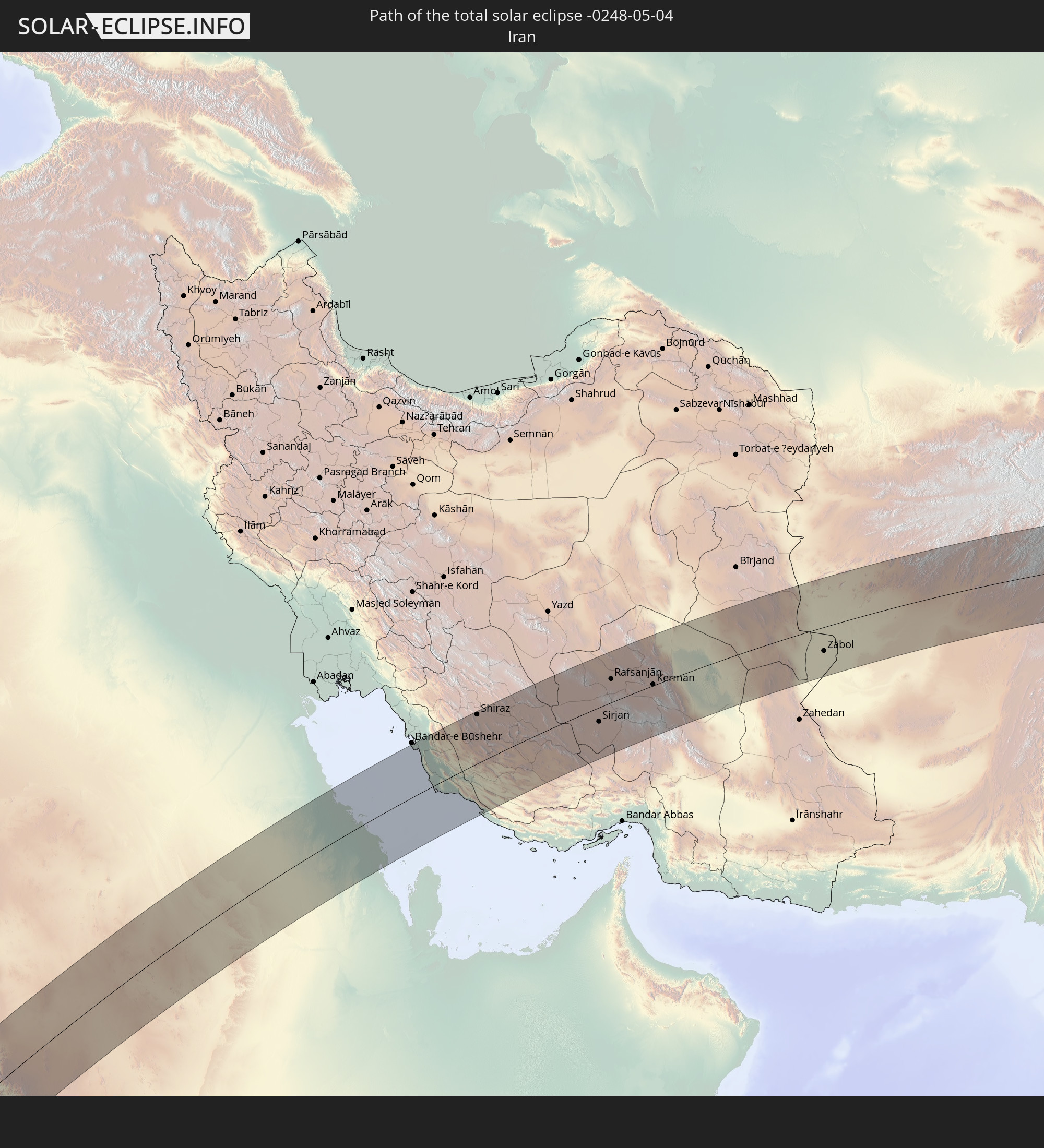 Iran
Iran
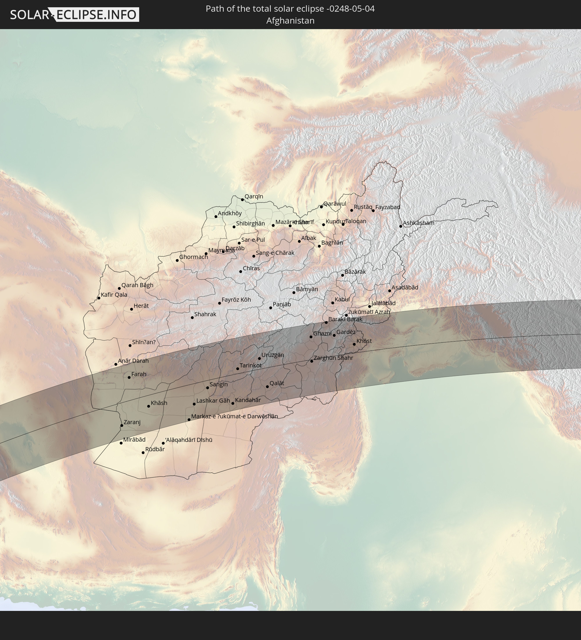 Afghanistan
 Pakistan
 Indien
 Volksrepublik China
In den folgenden Ländern ist die Sonnenfinsternis partiell zu sehen
 Russland
 Kap Verde
 Senegal
 Mauretanien
 Gambia
 Guinea-Bissau
 Guinea
 St. Helena
 Sierra Leone
 Mali
Mali
 Liberia
 Algerien
 Elfenbeinküste
 Burkina Faso
 Frankreich
 Ghana
Ghana
 Togo
Togo
 Niger
Niger
 Benin
Benin
 Nigeria
 Äquatorialguinea
 São Tomé und Príncipe
 Italien
 Tunesien
 Kamerun
 Gabun
Gabun
 Libyen
 Österreich
 Republik Kongo
 Angola
 Namibia
 Tschechien
 Demokratische Republik Kongo
 San Marino
 Vatikanstadt
 Slowenien
 Tschad
 Kroatien
 Polen
Polen
 Malta
Malta
 Zentralafrikanische Republik
 Bosnien und Herzegowina
 Ungarn
 Südafrika
 Slowakei
 Montenegro
 Serbien
 Albanien
 Griechenland
 Botswana
 Rumänien
 Mazedonien
 Litauen
 Sudan
Sudan
 Sambia
 Ukraine
 Bulgarien
 Weißrussland
 Ägypten
 Simbabwe
 Türkei
 Moldawien
 Lesotho
 Ruanda
 Burundi
 Tansania
 Uganda
 Mosambik
 Swasiland
 Republik Zypern
 Malawi
 Äthiopien
 Kenia
Kenia
 Staat Palästina
 Israel
 Saudi-Arabien
 Jordanien
 Libanon
 Syrien
 Eritrea
 Irak
Irak
 Georgien
 Französische Süd- und Antarktisgebiete
 Somalia
 Dschibuti
 Jemen
Jemen
 Madagaskar
 Komoren
 Armenien
 Iran
Iran
 Aserbaidschan
 Mayotte
 Seychellen
 Kasachstan
 Kuwait
 Bahrain
 Katar
Katar
 Vereinigte Arabische Emirate
 Oman
Oman
 Turkmenistan
 Usbekistan
 Afghanistan
 Pakistan
 Tadschikistan
 Indien
 Kirgisistan
 Malediven
 Volksrepublik China
 Sri Lanka
 Nepal
Nepal
 Mongolei
 Bangladesch
 Bhutan
 Myanmar
 Indonesien
 Thailand
 Malaysia
 Laos
Laos
 Vietnam
 Kambodscha
 Singapur
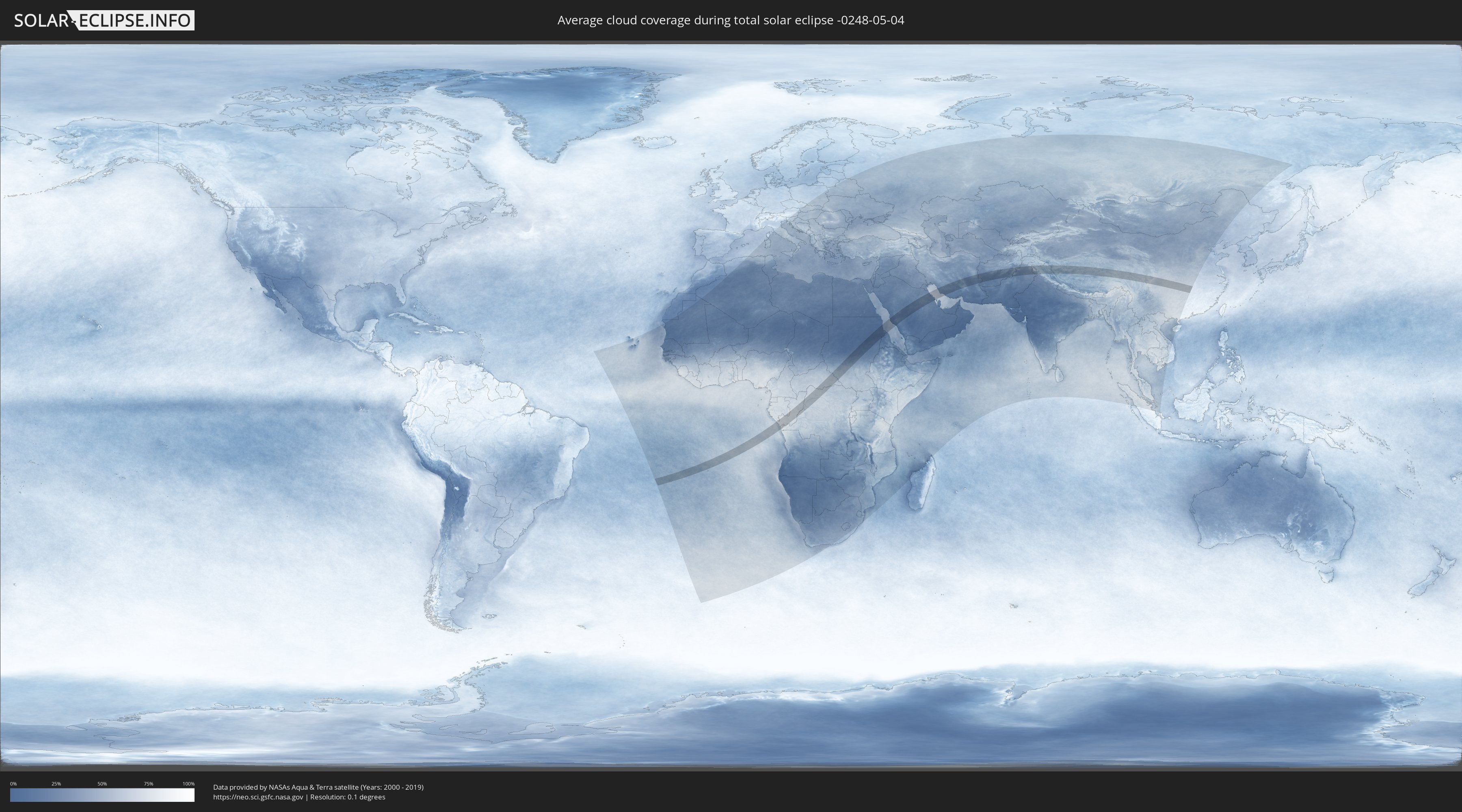
Wie wird das Wetter während der totalen Sonnenfinsternis am 04.05.-0248?
Wo ist der beste Ort, um die totale Sonnenfinsternis vom 04.05.-0248 zu beobachten?
Die folgenden Karten zeigen die durchschnittliche Bewölkung für den Tag, an dem die totale Sonnenfinsternis
stattfindet. Mit Hilfe der Karten lässt sich der Ort entlang des Finsternispfades eingrenzen,
der die besten Aussichen auf einen klaren wolkenfreien Himmel bietet.
Trotzdem muss man immer lokale Gegenenheiten beachten und sollte sich genau über das Wetter an seinem
gewählten Beobachtungsort informieren.
Die Daten stammen von den beiden NASA-Satelliten
AQUA und TERRA
und wurden über einen Zeitraum von 19 Jahren (2000 - 2019) gemittelt.
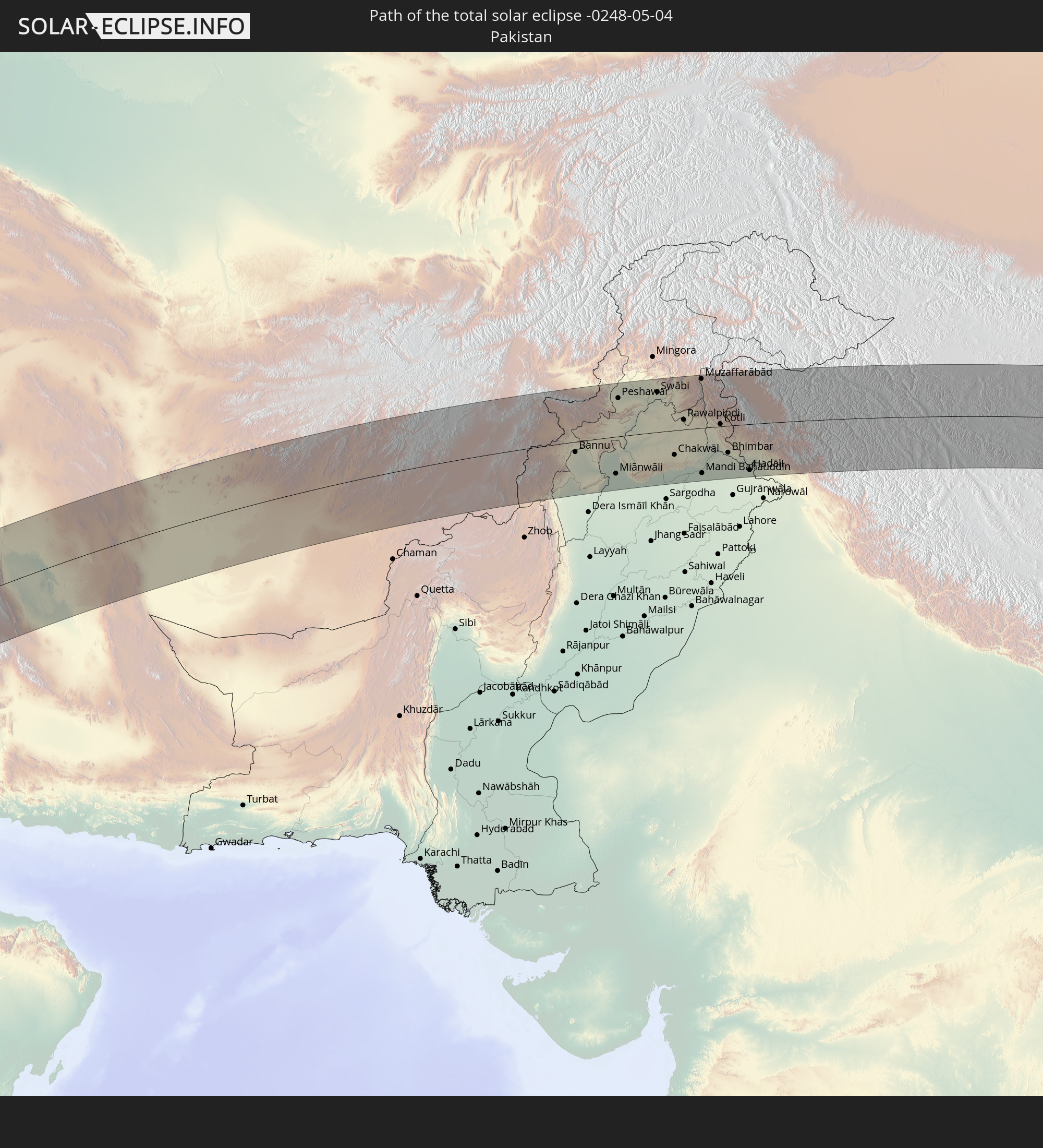
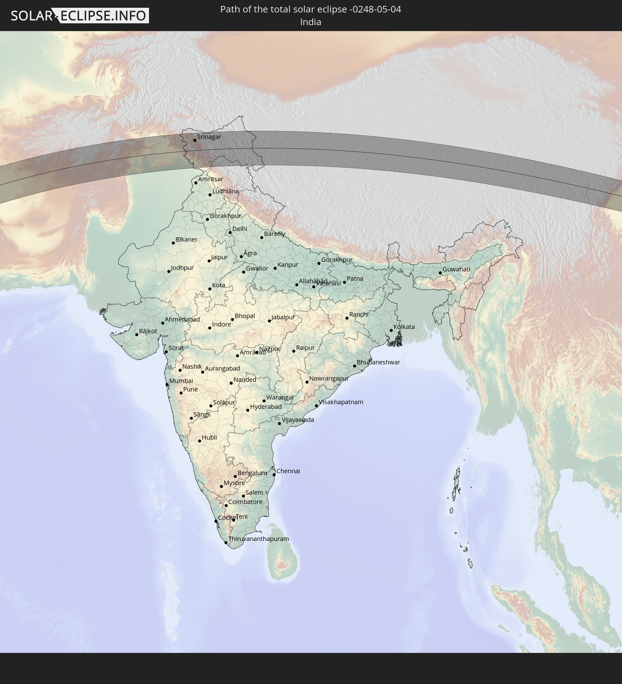
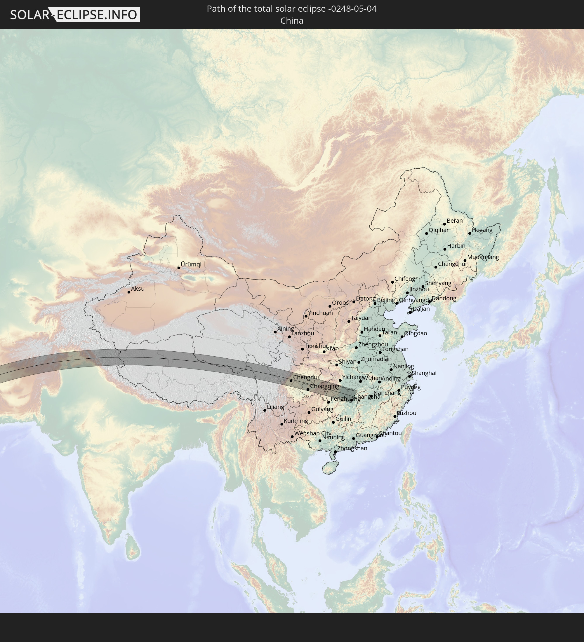
Detaillierte Länderkarten
 Gabun
Gabun
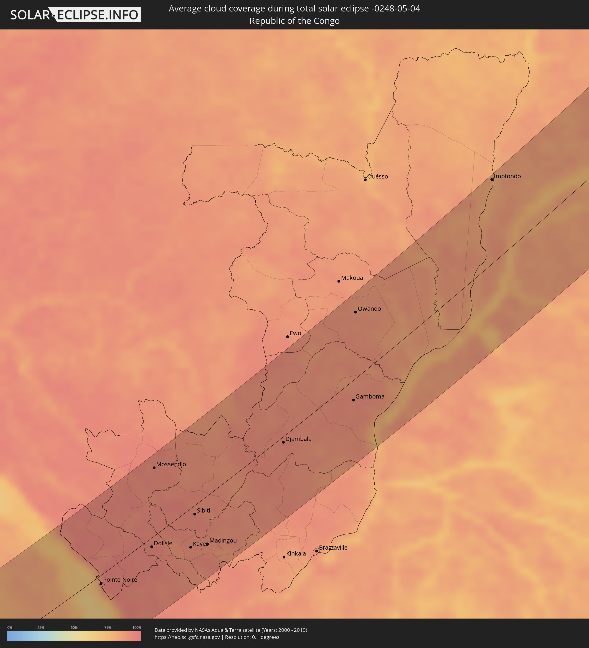 Republik Kongo
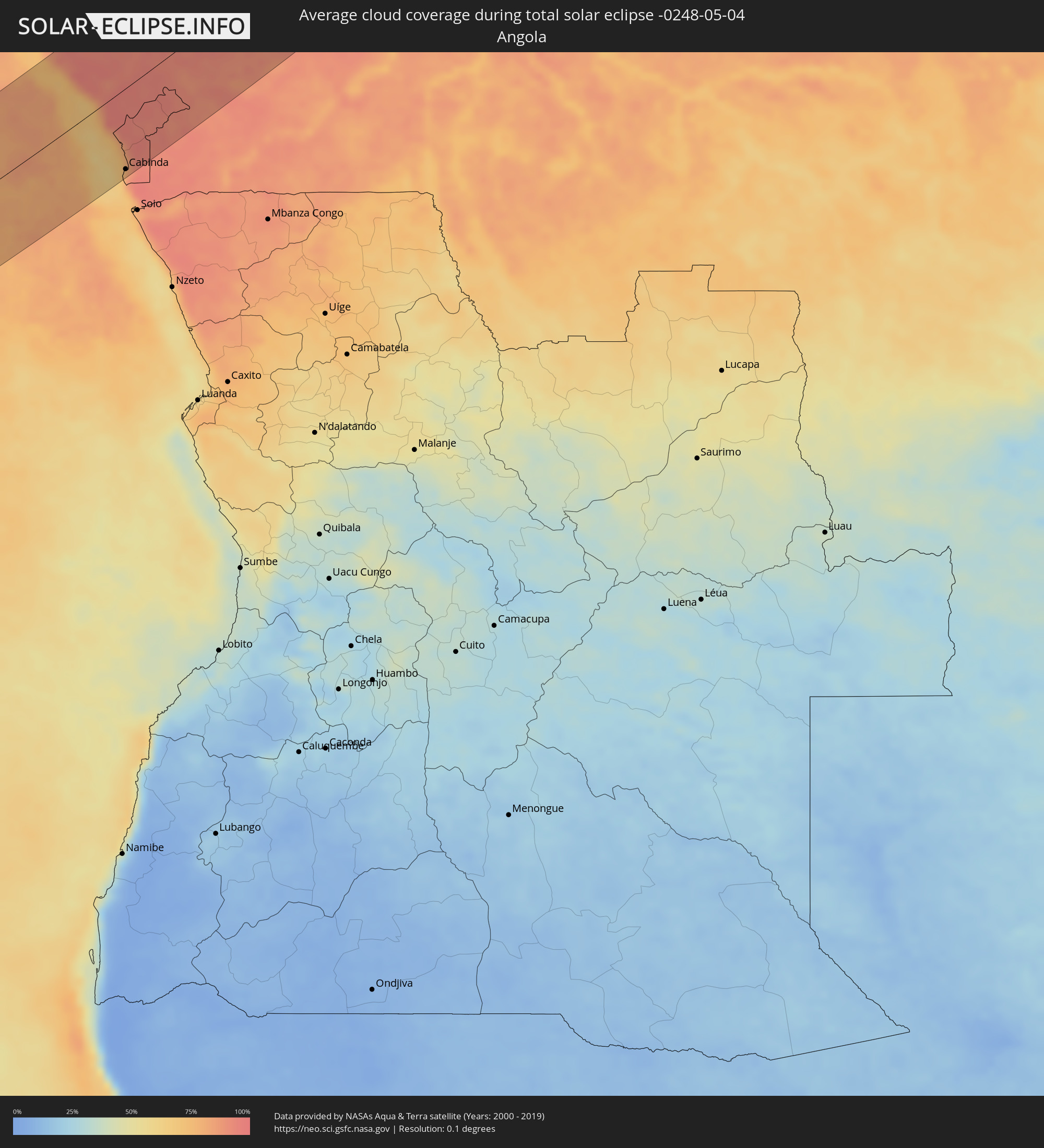 Angola
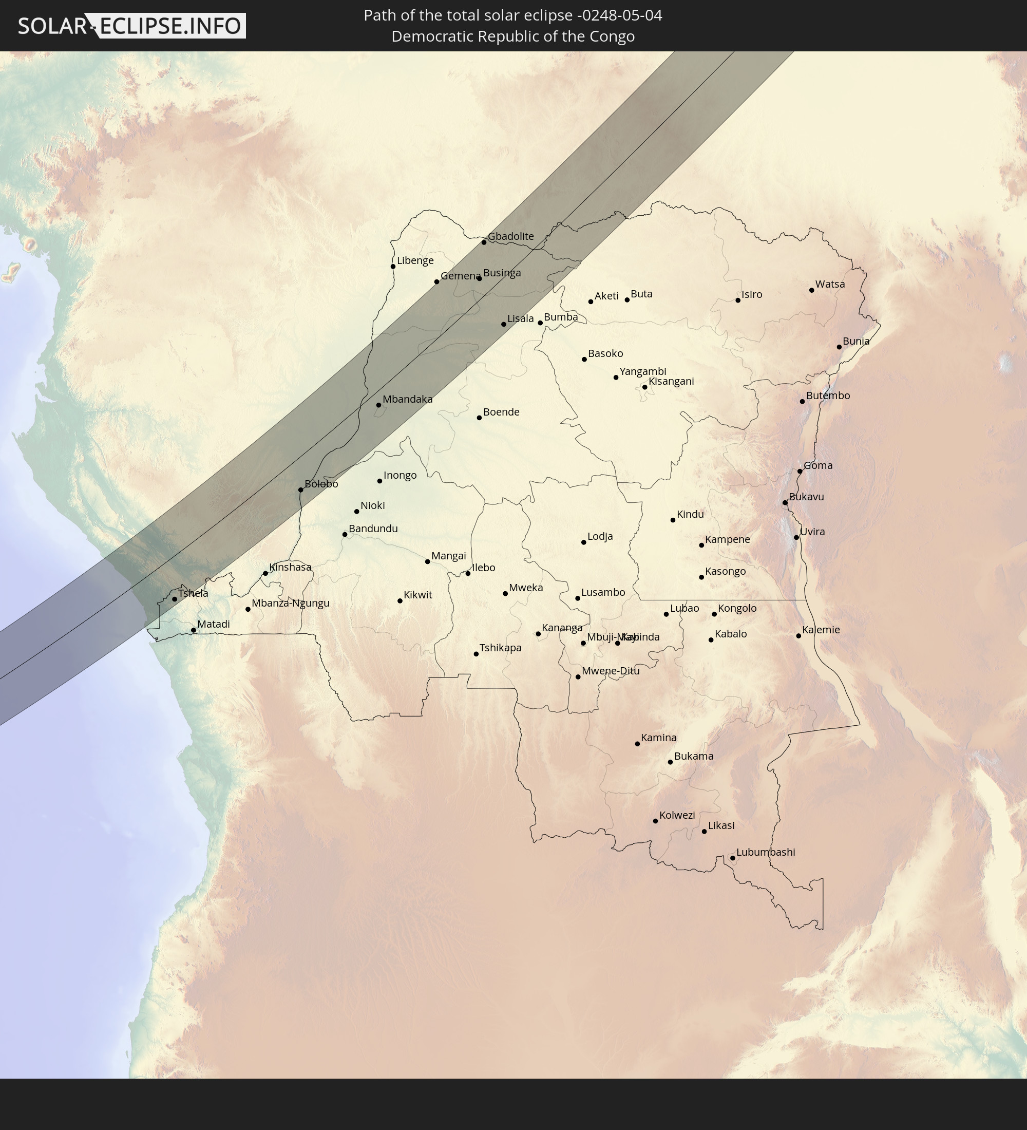
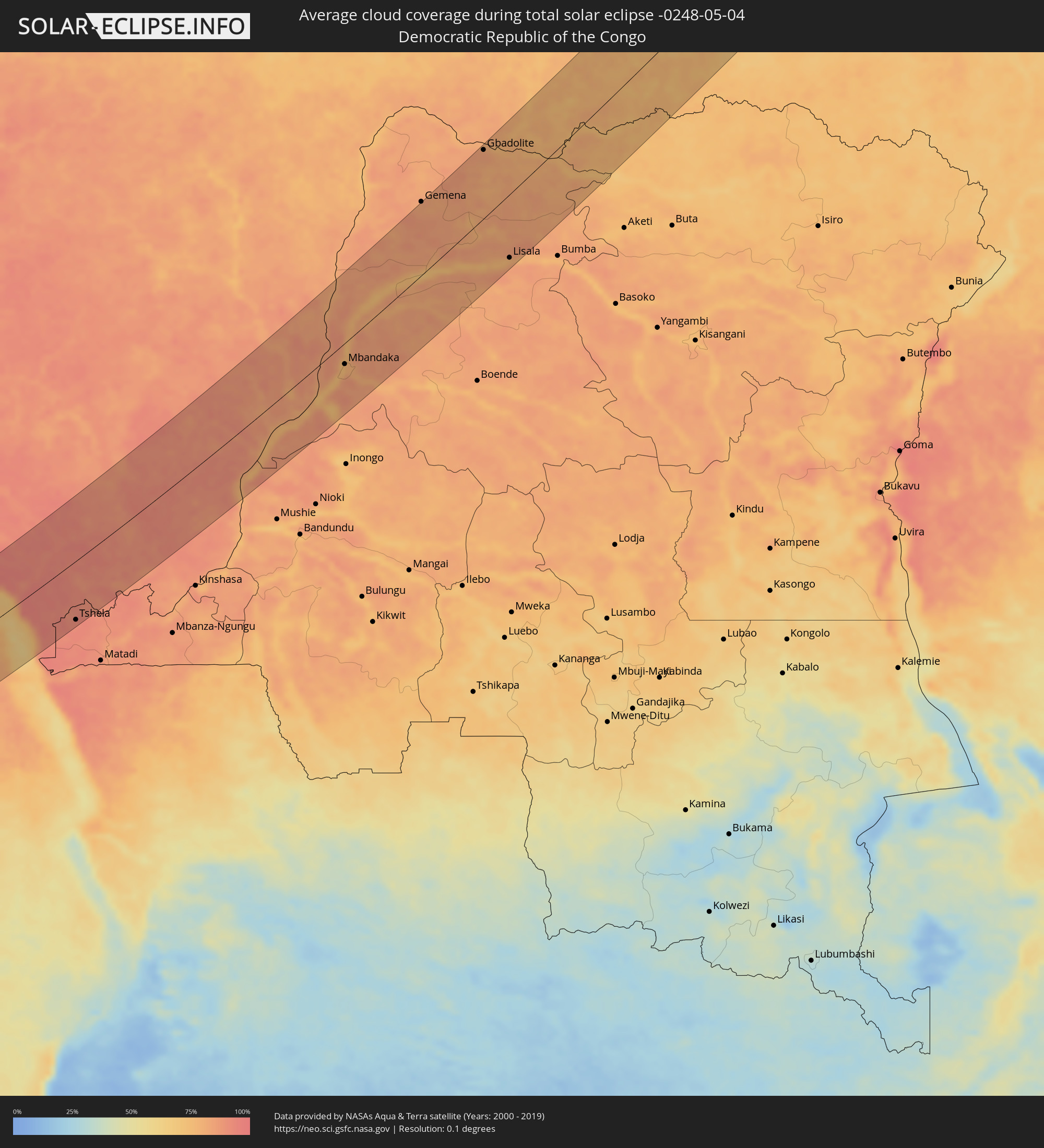 Demokratische Republik Kongo
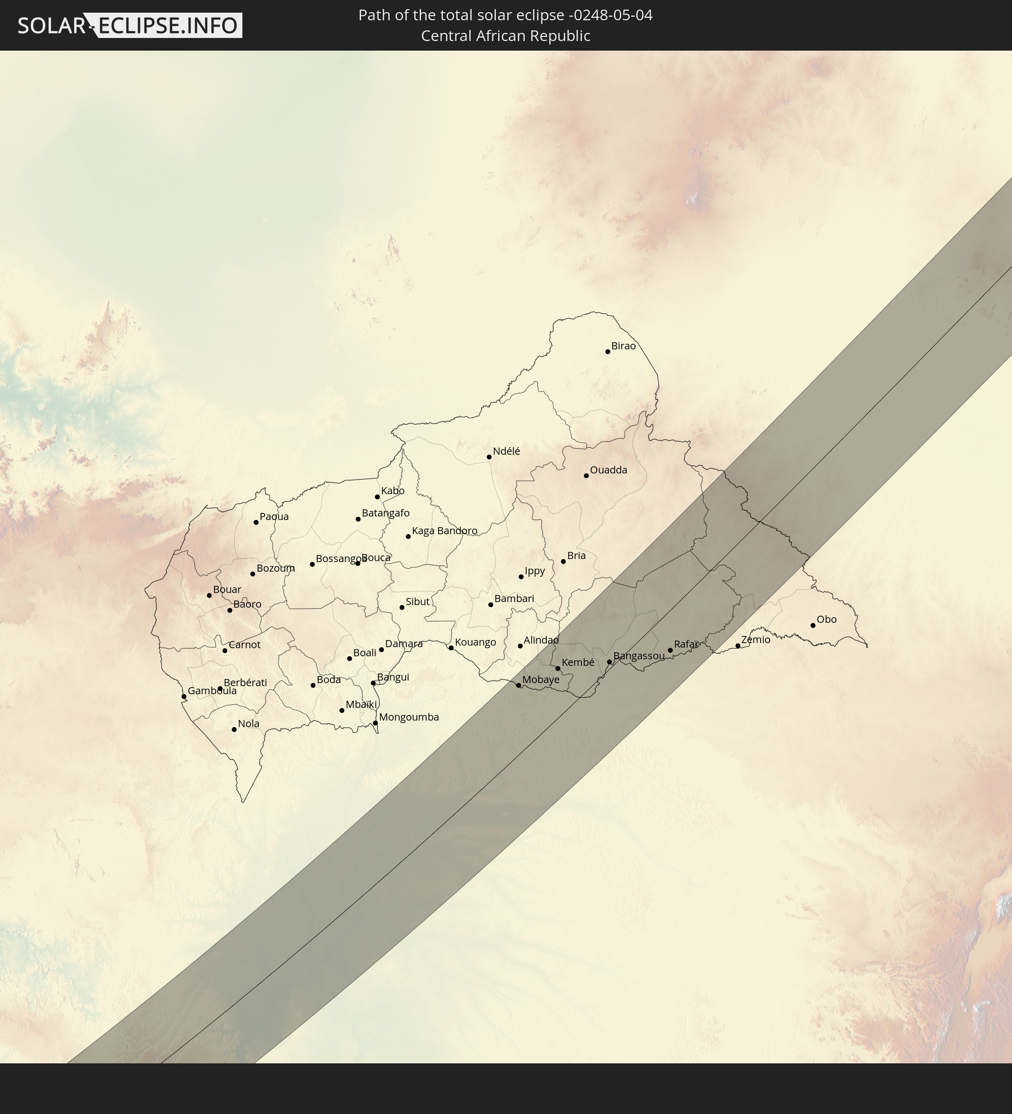
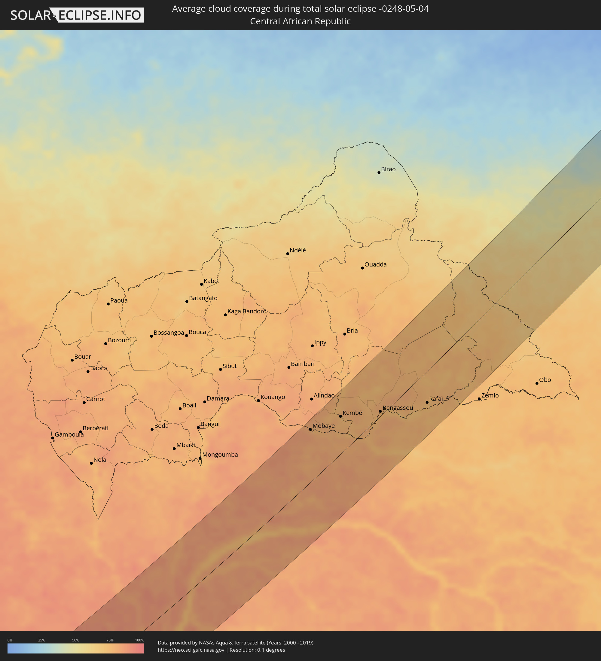 Zentralafrikanische Republik
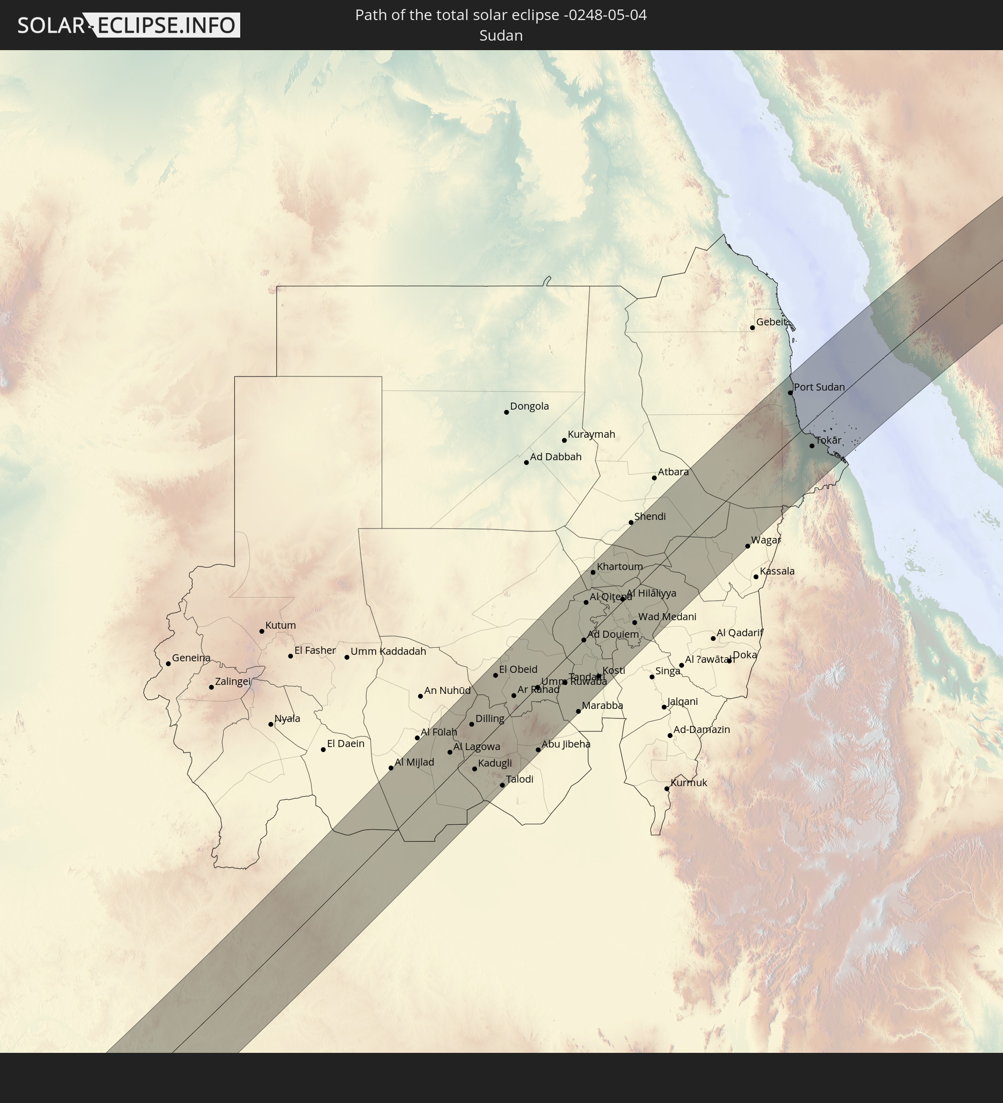
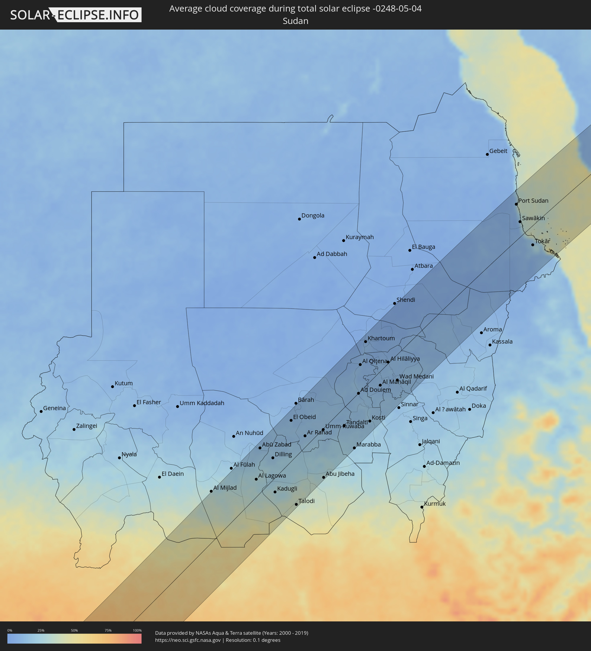 Sudan
Sudan
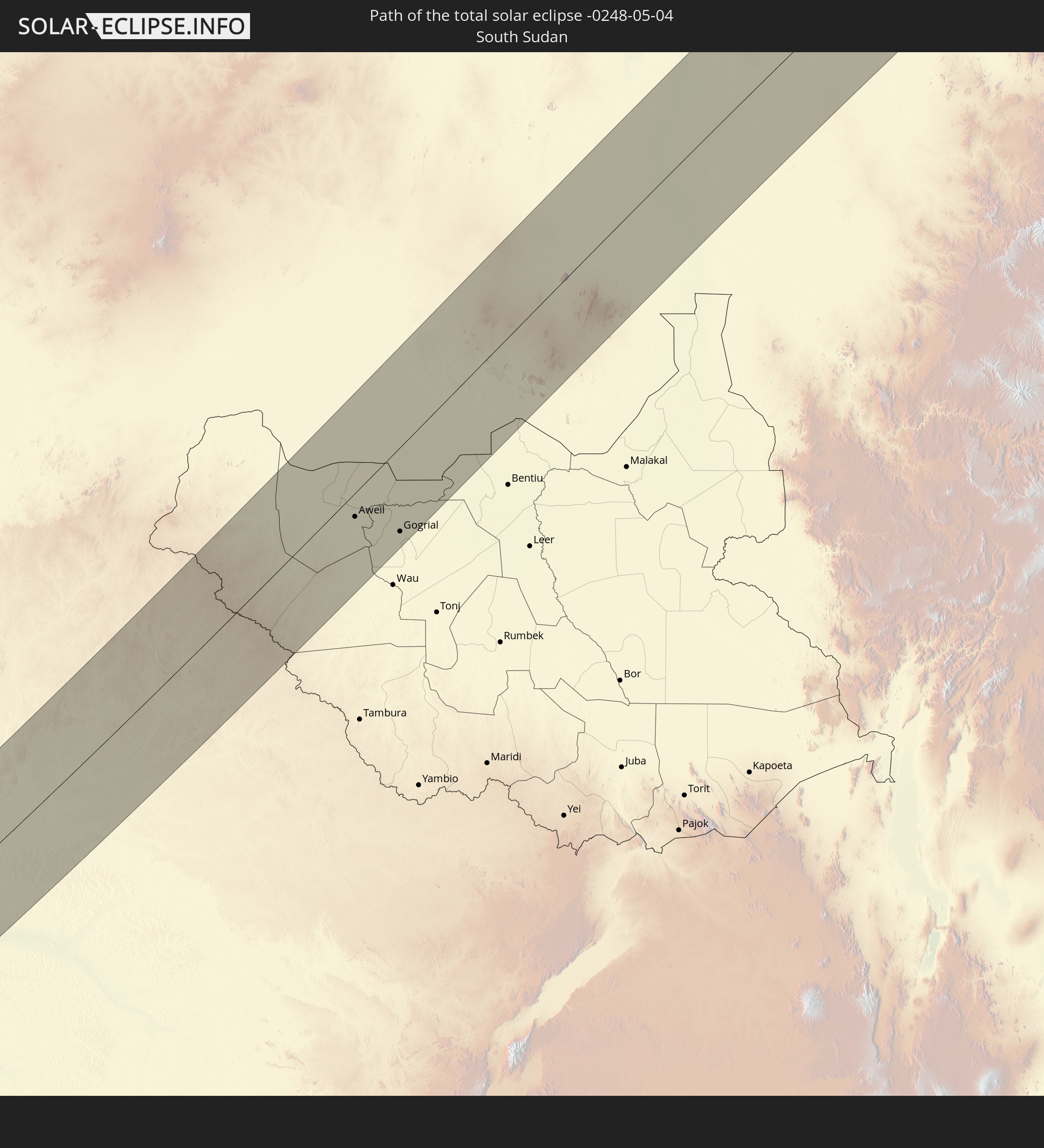
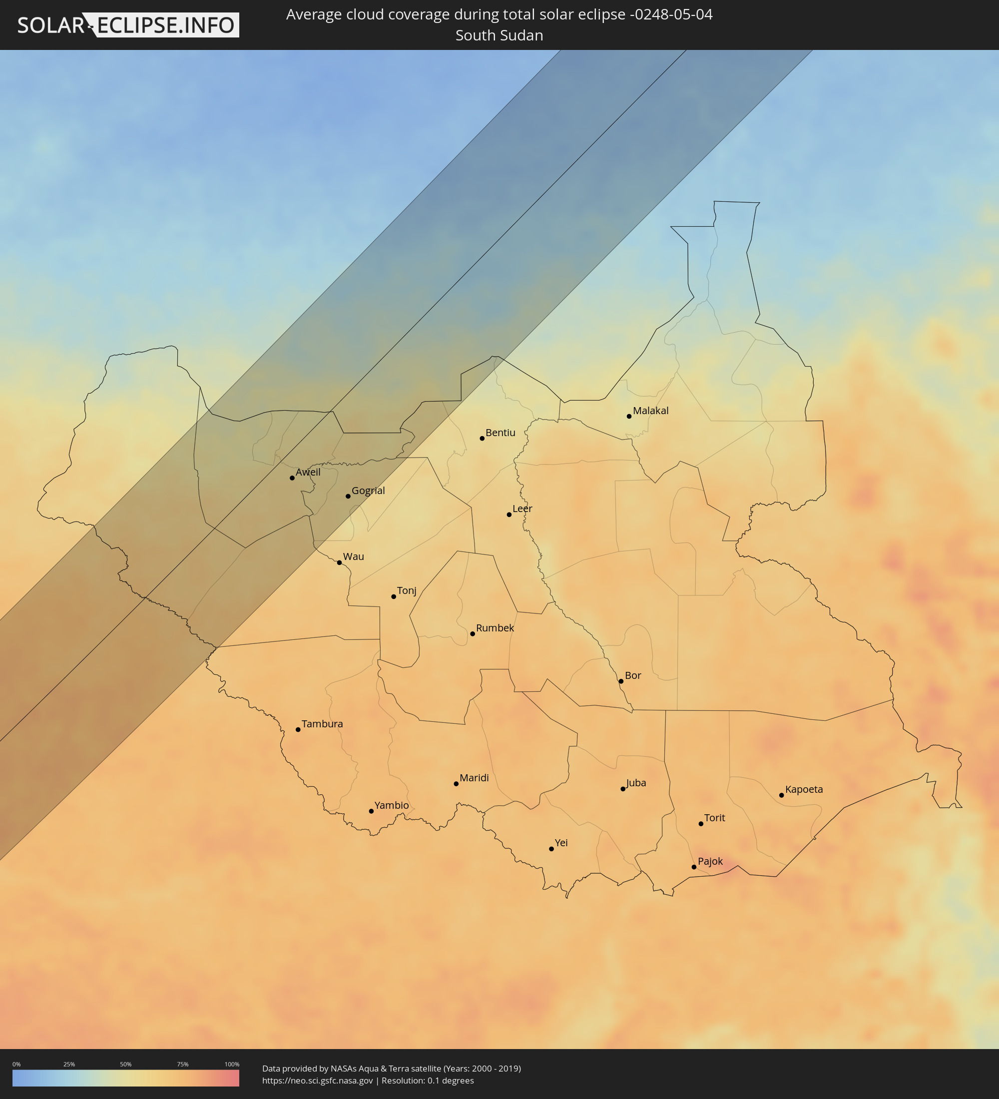 Südsudan
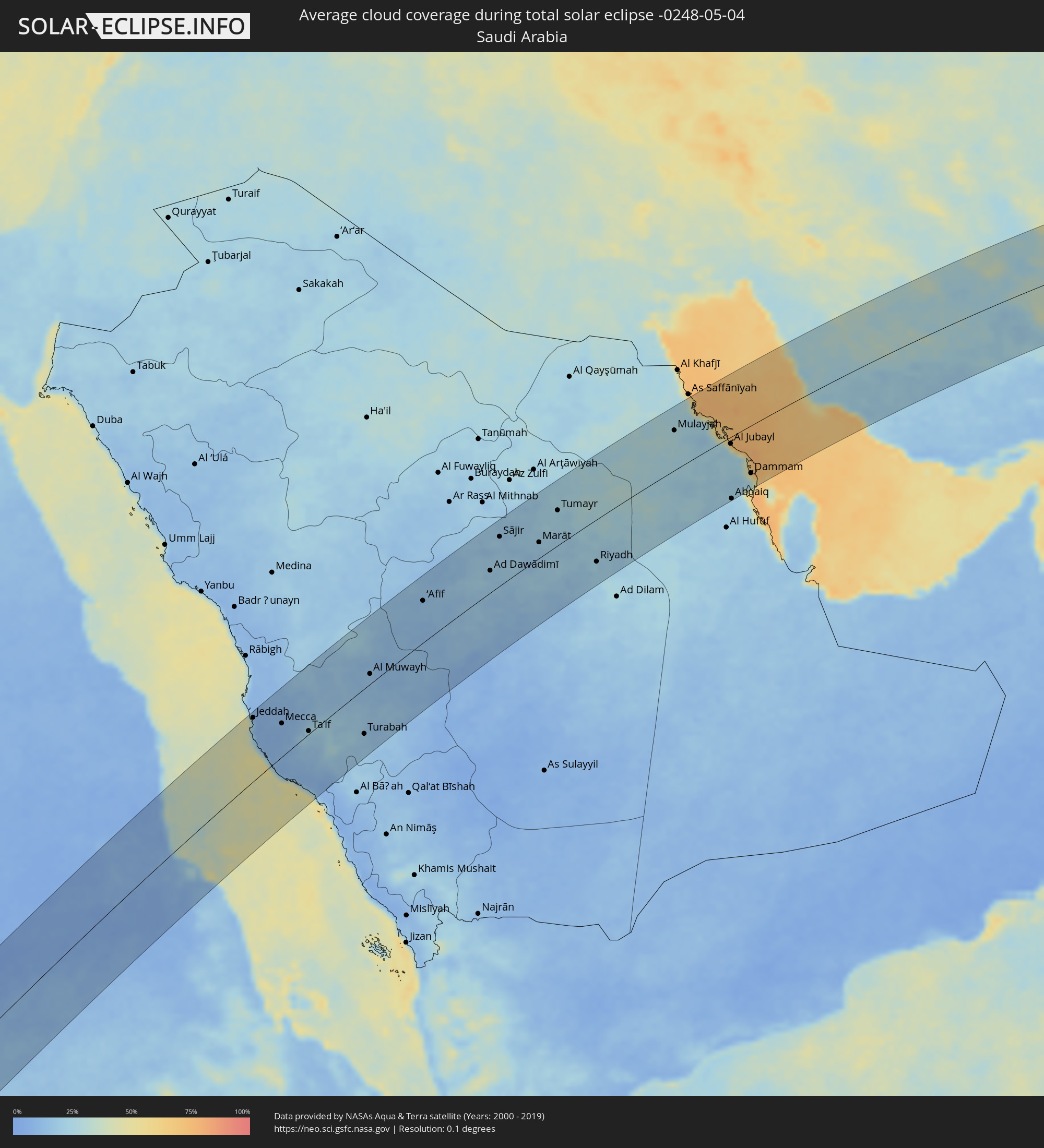 Saudi-Arabien
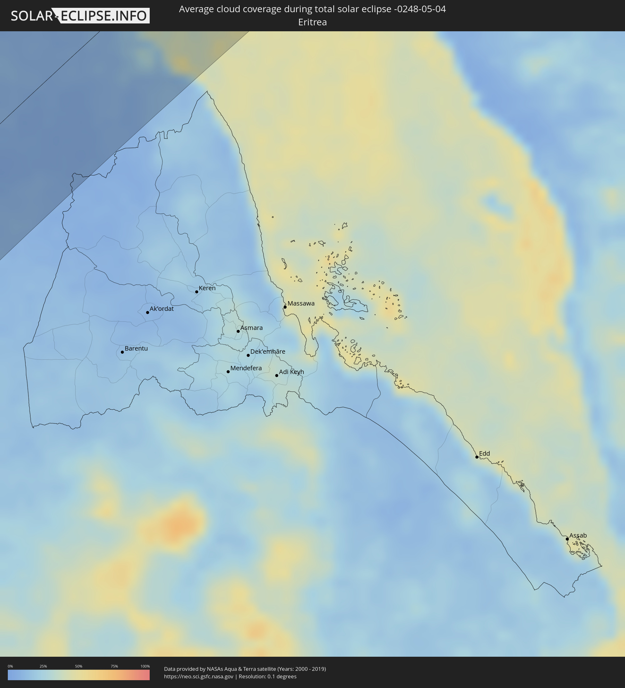 Eritrea
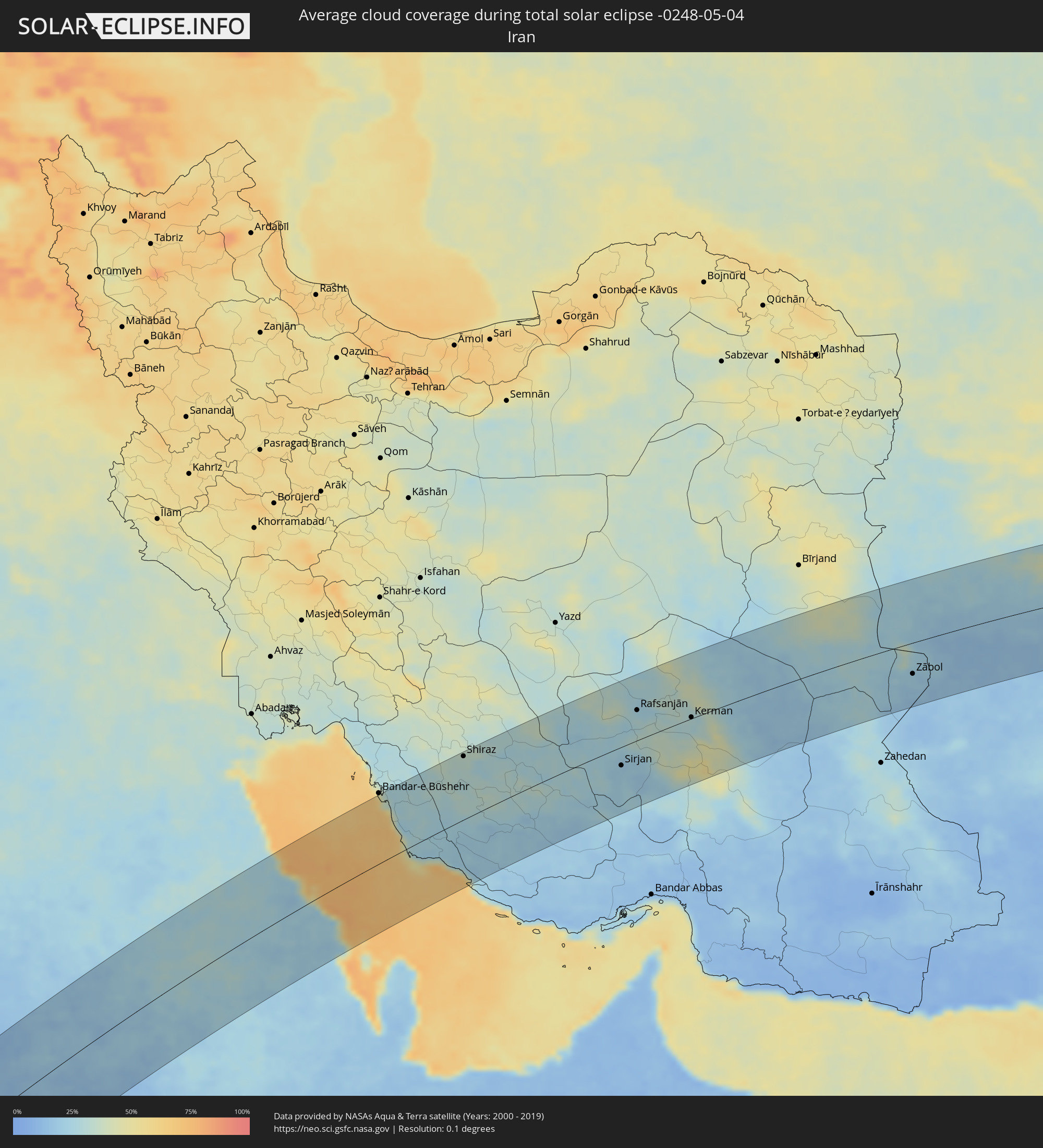 Iran
Iran
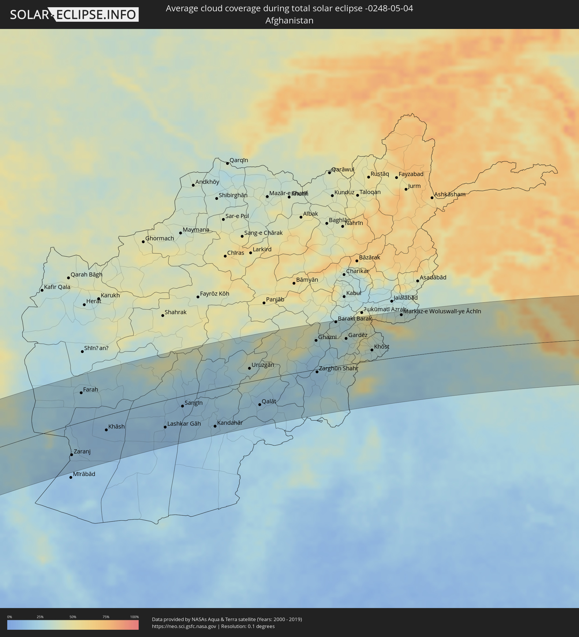 Afghanistan
 Pakistan
 Indien
 Volksrepublik China
Orte im Finsternispfad
Die nachfolgene Tabelle zeigt Städte und Orte mit mehr als 5.000 Einwohnern, die sich im Finsternispfad befinden. Städte mit mehr als 100.000 Einwohnern sind dick gekennzeichnet. Mit einem Klick auf den Ort öffnet sich eine Detailkarte die die Lage des jeweiligen Ortes zusammen mit dem Verlauf der zentralen Finsternis präsentiert.
| Ort | Typ | Dauer der Verfinsterung | Ortszeit bei maximaler Verfinsterung | Entfernung zur Zentrallinie | Ø Bewölkung |
|
Loango, Kouilou
|
total | - | 08:03:46 UTC+00:13 | 2 km | 77% |
|
Loandjili, Pointe-Noire
|
total | - | 08:03:41 UTC+00:13 | 10 km | 82% |
|
Pointe-Noire, Pointe-Noire
|
total | - | 08:03:40 UTC+00:13 | 12 km | 82% |
|
Cabinda, Cabinda
|
total | - | 08:03:00 UTC+00:13 | 104 km | 87% |
|
Dolisie, Niari
|
total | - | 08:05:06 UTC+00:13 | 13 km | 93% |
|
Mossendjo, Niari
|
total | - | 08:06:45 UTC+00:13 | 95 km | 93% |
|
Tshela, Bas-Congo
|
total | - | 08:04:21 UTC+00:13 | 103 km | 91% |
|
Kayes, Bouenza
|
total | - | 08:05:40 UTC+00:13 | 55 km | 91% |
|
Sibiti, Lékoumou
|
total | - | 08:06:24 UTC+00:13 | 13 km | 93% |
|
Madingou, Bouenza
|
total | - | 08:05:58 UTC+00:13 | 68 km | 91% |
|
Djambala, Plateaux
|
total | - | 08:09:17 UTC+00:13 | 9 km | 92% |
|
Gamboma, Plateaux
|
total | - | 08:11:21 UTC+00:13 | 28 km | 91% |
|
Owando, Cuvette
|
total | - | 08:13:24 UTC+00:13 | 90 km | 88% |
|
Bolobo, Bandundu
|
total | - | 08:11:20 UTC+00:13 | 78 km | 78% |
|
Lukolela, Équateur
|
total | - | 08:13:56 UTC+00:13 | 51 km | 86% |
|
Impfondo, Likouala
|
total | - | 08:19:00 UTC+00:13 | 111 km | 81% |
|
Mbandaka, Équateur
|
total | - | 08:16:49 UTC+00:13 | 35 km | 83% |
|
Businga, Équateur
|
total | - | 08:25:17 UTC+00:13 | 43 km | 85% |
|
Gbadolite, Équateur
|
total | - | 08:27:01 UTC+00:13 | 110 km | 84% |
|
Mobaye, Basse-Kotto
|
total | - | 08:27:19 UTC+00:13 | 100 km | 81% |
|
Lisala, Équateur
|
total | - | 08:24:08 UTC+00:13 | 102 km | 77% |
|
Kembé, Basse-Kotto
|
total | - | 08:28:47 UTC+00:13 | 71 km | 75% |
|
Bangassou, Mbomou
|
total | - | 08:30:16 UTC+00:13 | 9 km | 76% |
|
Rafaï, Mbomou
|
total | - | 08:32:10 UTC+00:13 | 59 km | 72% |
 Aweil, Northern Bahr al Ghazal
|
total | - | 10:37:14 UTC+02:06 | 29 km | 58% |
|
Kuacjok, Warrap
|
total | - | 10:37:19 UTC+02:06 | 111 km | 54% |
|
Gogrial, Warrap
|
total | - | 10:37:56 UTC+02:06 | 102 km | 55% |
|
Dilling, Southern Kordofan
|
total | - | 10:50:54 UTC+02:10 | 51 km | 18% |
|
Kadugli, Southern Kordofan
|
total | - | 10:49:01 UTC+02:10 | 35 km | 30% |
|
El Obeid, North Kordofan
|
total | - | 10:54:05 UTC+02:10 | 96 km | 14% |
|
Ar Rahad, North Kordofan
|
total | - | 10:53:55 UTC+02:10 | 26 km | 15% |
|
Umm Ruwaba, North Kordofan
|
total | - | 10:55:17 UTC+02:10 | 3 km | 16% |
|
Abu Jibeha, Southern Kordofan
|
total | - | 10:52:29 UTC+02:10 | 118 km | 29% |
|
Tandaltī, White Nile
|
total | - | 10:56:39 UTC+02:10 | 45 km | 16% |
|
Ad Douiem, White Nile
|
total | - | 10:59:22 UTC+02:10 | 2 km | 13% |
|
Khartoum, Khartoum
|
total | - | 11:02:47 UTC+02:10 | 103 km | 10% |
|
Kosti, White Nile
|
total | - | 10:58:22 UTC+02:10 | 95 km | 17% |
|
Al Manāqil, Al Jazīrah
|
total | - | 11:01:05 UTC+02:10 | 34 km | 11% |
|
Kināna, Sinnār
|
total | - | 11:01:00 UTC+02:10 | 65 km | 14% |
|
Al Hasaheisa, Al Jazīrah
|
total | - | 11:02:38 UTC+02:10 | 18 km | 14% |
|
Wad Medani, Al Jazīrah
|
total | - | 11:02:21 UTC+02:10 | 62 km | 12% |
|
Port Sudan, Red Sea
|
total | - | 11:19:24 UTC+02:10 | 86 km | 13% |
|
Sawākin, Red Sea
|
total | - | 11:18:40 UTC+02:10 | 36 km | 9% |
|
Tokār, Red Sea
|
total | - | 11:18:11 UTC+02:10 | 48 km | 16% |
|
Jeddah, Makkah
|
total | - | 12:23:32 UTC+03:06 | 110 km | 20% |
|
Al Jumūm, Makkah
|
total | - | 12:24:40 UTC+03:06 | 83 km | 10% |
|
Mecca, Makkah
|
total | - | 12:24:35 UTC+03:06 | 58 km | 9% |
|
Ash Shafā, Makkah
|
total | - | 12:24:56 UTC+03:06 | 5 km | 18% |
|
Ta’if, Makkah
|
total | - | 12:25:30 UTC+03:06 | 5 km | 24% |
|
Turabah, Makkah
|
total | - | 12:27:53 UTC+03:06 | 80 km | 18% |
|
‘Afīf, Ar Riyāḑ
|
total | - | 12:35:02 UTC+03:06 | 75 km | 14% |
|
Ad Dawādimī, Ar Riyāḑ
|
total | - | 12:38:59 UTC+03:06 | 40 km | 18% |
|
Riyadh, Ar Riyāḑ
|
total | - | 12:44:02 UTC+03:06 | 78 km | 24% |
|
Al Jubayl, Eastern Province
|
total | - | 12:53:14 UTC+03:06 | 13 km | 47% |
|
Abqaiq, Eastern Province
|
total | - | 12:51:53 UTC+03:06 | 117 km | 19% |
|
Umm as Sāhik, Eastern Province
|
total | - | 12:53:18 UTC+03:06 | 60 km | 26% |
|
Şafwá, Eastern Province
|
total | - | 12:53:22 UTC+03:06 | 62 km | 39% |
|
Tārūt, Eastern Province
|
total | - | 12:53:27 UTC+03:06 | 74 km | 39% |
|
Raḩīmah, Eastern Province
|
total | - | 12:53:40 UTC+03:06 | 62 km | 66% |
|
Dammam, Eastern Province
|
total | - | 12:53:24 UTC+03:06 | 90 km | 27% |
|
Khobar, Eastern Province
|
total | - | 12:53:25 UTC+03:06 | 110 km | 44% |
|
Shiraz, Fars
|
total | - | 13:20:43 UTC+03:25 | 110 km | 33% |
|
Fīrūzābād, Fars
|
total | - | 13:20:00 UTC+03:25 | 32 km | 31% |
|
Akbarābād, Fars
|
total | - | 13:20:49 UTC+03:25 | 63 km | 33% |
|
Fasā, Fars
|
total | - | 13:22:11 UTC+03:25 | 4 km | 30% |
|
Neyrīz, Fars
|
total | - | 13:23:45 UTC+03:25 | 6 km | 30% |
|
Dārāb, Fars
|
total | - | 13:23:44 UTC+03:25 | 60 km | 25% |
|
Shahr-e Bābak, Kerman
|
total | - | 13:26:05 UTC+03:25 | 57 km | 28% |
|
Sirjan, Kerman
|
total | - | 13:26:33 UTC+03:25 | 33 km | 21% |
|
Rafsanjān, Kerman
|
total | - | 13:27:58 UTC+03:25 | 54 km | 25% |
|
Shahrak-e Pābedānā, Kerman
|
total | - | 13:29:18 UTC+03:25 | 114 km | 31% |
|
Zarand, Kerman
|
total | - | 13:29:21 UTC+03:25 | 75 km | 33% |
|
Bardsīr, Kerman
|
total | - | 13:28:38 UTC+03:25 | 17 km | 35% |
|
Rāvar, Kerman
|
total | - | 13:30:08 UTC+03:25 | 114 km | 38% |
|
Kerman, Kerman
|
total | - | 13:29:52 UTC+03:25 | 2 km | 29% |
|
Zābol, Sistan and Baluchestan
|
total | - | 13:38:15 UTC+03:25 | 56 km | 21% |
|
Zaranj, Nimroz
|
total | - | 14:13:06 UTC+04:00 | 74 km | 19% |
|
Farah, Farah
|
total | - | 14:14:16 UTC+04:00 | 71 km | 22% |
|
Khāsh, Nimroz
|
total | - | 14:14:58 UTC+04:00 | 37 km | 14% |
|
Lashkar Gāh, Helmand
|
total | - | 14:17:36 UTC+04:00 | 67 km | 14% |
|
Gereshk, Helmand
|
total | - | 14:18:01 UTC+04:00 | 47 km | 16% |
|
Sangīn, Helmand
|
total | - | 14:18:32 UTC+04:00 | 25 km | 16% |
|
Kandahār, Kandahar
|
total | - | 14:19:45 UTC+04:00 | 93 km | 19% |
|
Tarinkot, Oruzgan
|
total | - | 14:20:21 UTC+04:00 | 14 km | 22% |
|
Uruzgān, Oruzgan
|
total | - | 14:21:35 UTC+04:00 | 32 km | 31% |
|
Qalāt, Zabul
|
total | - | 14:21:47 UTC+04:00 | 62 km | 20% |
|
Ghazni, Ghazni
|
total | - | 14:24:20 UTC+04:00 | 71 km | 29% |
|
Zarghūn Shahr, Paktika
|
total | - | 14:24:15 UTC+04:00 | 7 km | 18% |
|
Barakī Barak, Logar
|
total | - | 14:25:09 UTC+04:00 | 109 km | 31% |
|
Pul-e ‘Alam, Logar
|
total | - | 14:25:15 UTC+04:00 | 111 km | 29% |
|
Gardēz, Paktia
|
total | - | 14:25:29 UTC+04:00 | 64 km | 28% |
|
Khōst, Khowst
|
total | - | 14:26:25 UTC+04:00 | 26 km | 30% |
|
Markaz-e Woluswalī-ye Āchīn, Nangarhar
|
total | - | 14:27:33 UTC+04:00 | 103 km | 37% |
|
Kohāt, Khyber Pakhtunkhwa
|
total | - | 14:56:42 UTC+04:28 | 34 km | 29% |
|
Miānwāli, Punjab
|
total | - | 14:56:43 UTC+04:28 | 78 km | 24% |
|
Peshawar, Khyber Pakhtunkhwa
|
total | - | 14:56:53 UTC+04:28 | 80 km | 33% |
|
Chārsadda, Khyber Pakhtunkhwa
|
total | - | 14:57:06 UTC+04:28 | 94 km | 33% |
|
Nowshera Cantonment, Khyber Pakhtunkhwa
|
total | - | 14:57:26 UTC+04:28 | 75 km | 30% |
|
Mardan, Khyber Pakhtunkhwa
|
total | - | 14:57:30 UTC+04:28 | 97 km | 32% |
|
Attock City, Punjab
|
total | - | 14:57:54 UTC+04:28 | 46 km | 30% |
|
Swābi, Khyber Pakhtunkhwa
|
total | - | 14:58:02 UTC+04:28 | 84 km | 31% |
|
Chakwāl, Punjab
|
total | - | 14:58:30 UTC+04:28 | 51 km | 29% |
|
Rawalpindi, Punjab
|
total | - | 14:58:47 UTC+04:28 | 21 km | 31% |
|
Abbottābād, Khyber Pakhtunkhwa
|
total | - | 14:58:58 UTC+04:28 | 80 km | 40% |
|
Muzaffarābād, Azad Kashmir
|
total | - | 14:59:17 UTC+04:28 | 103 km | 43% |
|
Mandi Bahāuddīn, Punjab
|
total | - | 14:59:17 UTC+04:28 | 96 km | 28% |
|
Jhelum, Punjab
|
total | - | 14:59:36 UTC+04:28 | 59 km | 28% |
|
Kotli, Azad Kashmir
|
total | - | 14:59:50 UTC+04:28 | 5 km | 34% |
|
Bhimbar, Azad Kashmir
|
total | - | 15:00:03 UTC+04:28 | 57 km | 30% |
|
Gujrāt, Punjab
|
total | - | 15:00:03 UTC+04:28 | 101 km | 28% |
|
Pūnch, Kashmir
|
total | - | 15:53:01 UTC+05:21 | 31 km | 40% |
|
Rajaori, Kashmir
|
total | - | 15:53:18 UTC+05:21 | 14 km | 39% |
|
Bāramūla, Kashmir
|
total | - | 15:53:18 UTC+05:21 | 78 km | 59% |
|
Pattan, Kashmir
|
total | - | 15:53:34 UTC+05:21 | 72 km | 47% |
|
Bandipura, Kashmir
|
total | - | 15:53:39 UTC+05:21 | 100 km | 47% |
|
Gāndarbal, Kashmir
|
total | - | 15:53:49 UTC+05:21 | 77 km | 49% |
|
Srinagar, Kashmir
|
total | - | 15:53:52 UTC+05:21 | 62 km | 49% |
|
Jammu, Kashmir
|
total | - | 15:53:59 UTC+05:21 | 89 km | 33% |
|
Pulwama, Kashmir
|
total | - | 15:53:59 UTC+05:21 | 38 km | 51% |
|
Kulgam, Kashmir
|
total | - | 15:54:08 UTC+05:21 | 11 km | 62% |
|
Sāmba, Kashmir
|
total | - | 15:54:18 UTC+05:21 | 109 km | 32% |
|
Udhampur, Kashmir
|
total | - | 15:54:19 UTC+05:21 | 69 km | 32% |
|
Anantnag, Kashmir
|
total | - | 15:54:18 UTC+05:21 | 20 km | 50% |
|
Doda, Kashmir
|
total | - | 15:54:47 UTC+05:21 | 47 km | 51% |
|
Kishtwār, Kashmir
|
total | - | 15:55:02 UTC+05:21 | 30 km | 53% |
|
Padam, Kashmir
|
total | - | 15:56:19 UTC+05:21 | 17 km | 46% |
|
Leh, Kashmir
|
total | - | 15:57:00 UTC+05:21 | 58 km | 47% |
|
Chengdu, Sichuan
|
total | - | 18:53:11 UTC+08:00 | 24 km | 78% |
|
Deyang, Sichuan
|
total | - | 18:53:03 UTC+08:00 | 33 km | 74% |
|
Yanjiang, Sichuan
|
total | - | 18:53:30 UTC+08:00 | 70 km | 74% |
|
Mianyang, Sichuan
|
total | - | 18:52:58 UTC+08:00 | 76 km | 77% |
|
Suining, Sichuan
|
total | - | 18:53:28 UTC+08:00 | 6 km | 72% |
|
Nanchong, Sichuan
|
total | - | 18:53:25 UTC+08:00 | 37 km | 75% |
|
Hechuan, Chongqing
|
total | - | 18:53:45 UTC+08:00 | 45 km | 77% |
|
Beibei, Chongqing
|
total | - | 18:53:50 UTC+08:00 | 59 km | 79% |
|
Chongqing, Chongqing
|
total | - | 18:53:56 UTC+08:00 | 84 km | 79% |
|
Fuling, Chongqing
|
total | - | 18:53:57 UTC+08:00 | 48 km | 77% |
|
Wanxian, Chongqing
|
total | - | 18:53:35 UTC+08:00 | 96 km | 76% |
|
Enshi, Hubei
|
total | - | 18:53:48 UTC+08:00 | 69 km | 74% |
|
Changde, Hunan
|
total | - | 18:54:14 UTC+08:00 | 6 km | 80% |
|
Yiyang, Hunan
|
total | - | 18:54:21 UTC+08:00 | 36 km | 85% |
|
Xiulin, Hubei
|
total | - | 18:53:57 UTC+08:00 | 86 km | 82% |
|
Changsha, Hunan
|
total | - | 18:54:26 UTC+08:00 | 60 km | 85% |
|
Yueyang, Hunan
|
total | - | 18:54:01 UTC+08:00 | 70 km | 81% |