Totale Sonnenfinsternis vom 18.01.-0401
| Wochentag: | Sonntag |
| Maximale Dauer der Verfinsterung: | 03m49s |
| Maximale Breite des Finsternispfades: | 253 km |
| Saroszyklus: | 44 |
| Bedeckungsgrad: | 100% |
| Magnitude: | 1.0442 |
| Gamma: | 0.8128 |
Wo kann man die Sonnenfinsternis vom 18.01.-0401 sehen?
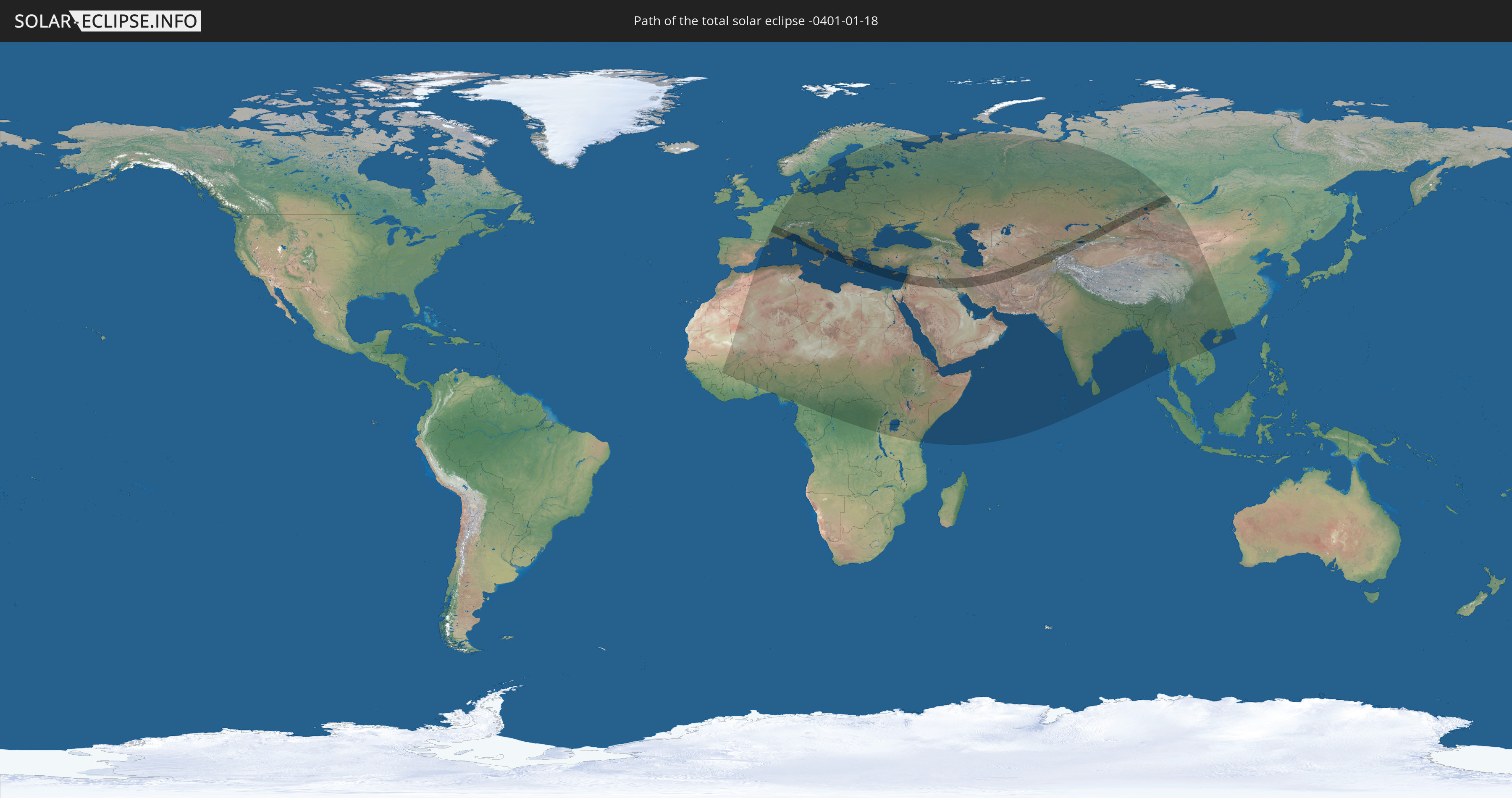
Die Sonnenfinsternis am 18.01.-0401 kann man in 105 Ländern als partielle Sonnenfinsternis beobachten.
Der Finsternispfad verläuft durch 24 Länder. Nur in diesen Ländern ist sie als totale Sonnenfinsternis zu sehen.
In den folgenden Ländern ist die Sonnenfinsternis total zu sehen
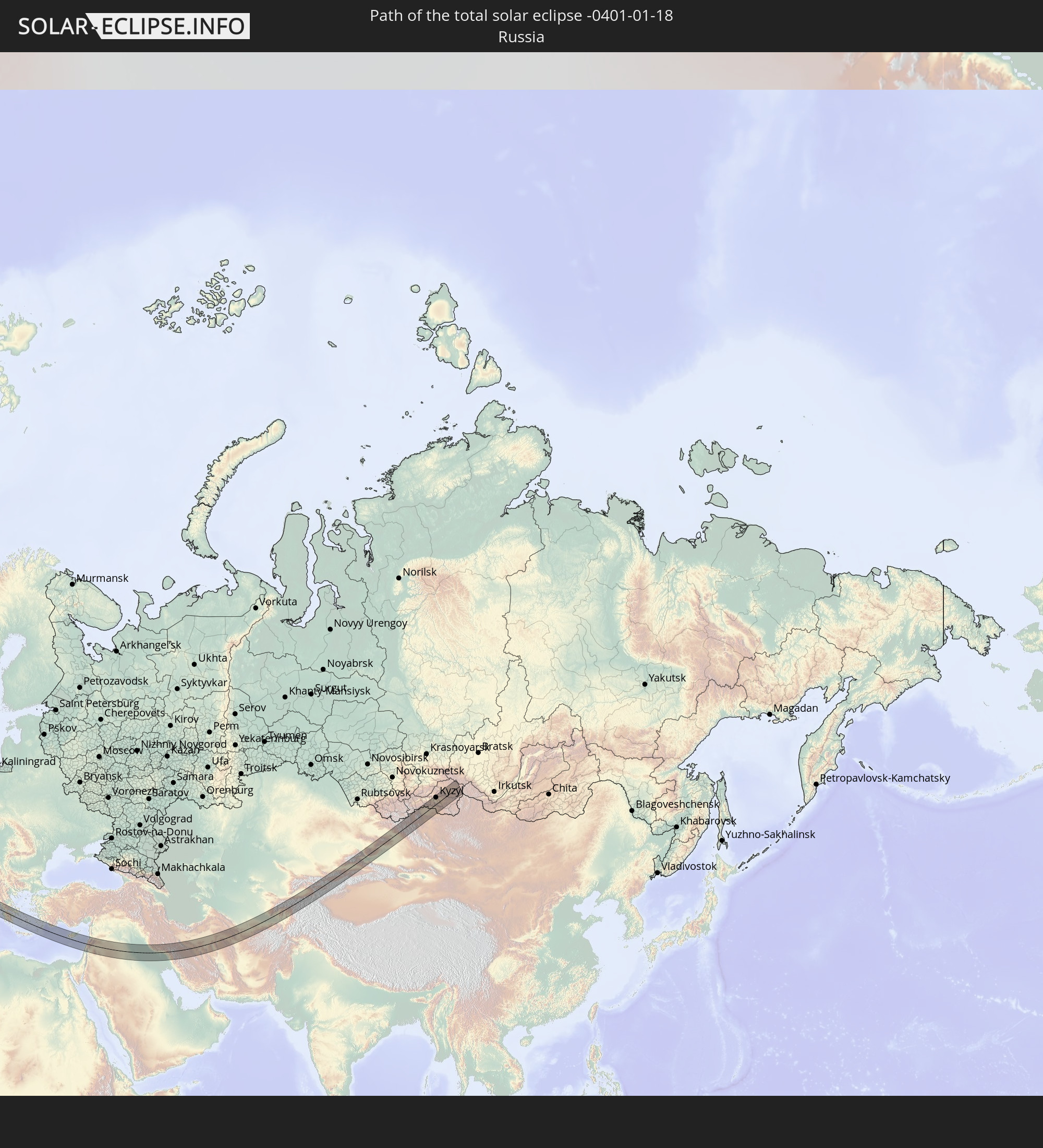 Russland
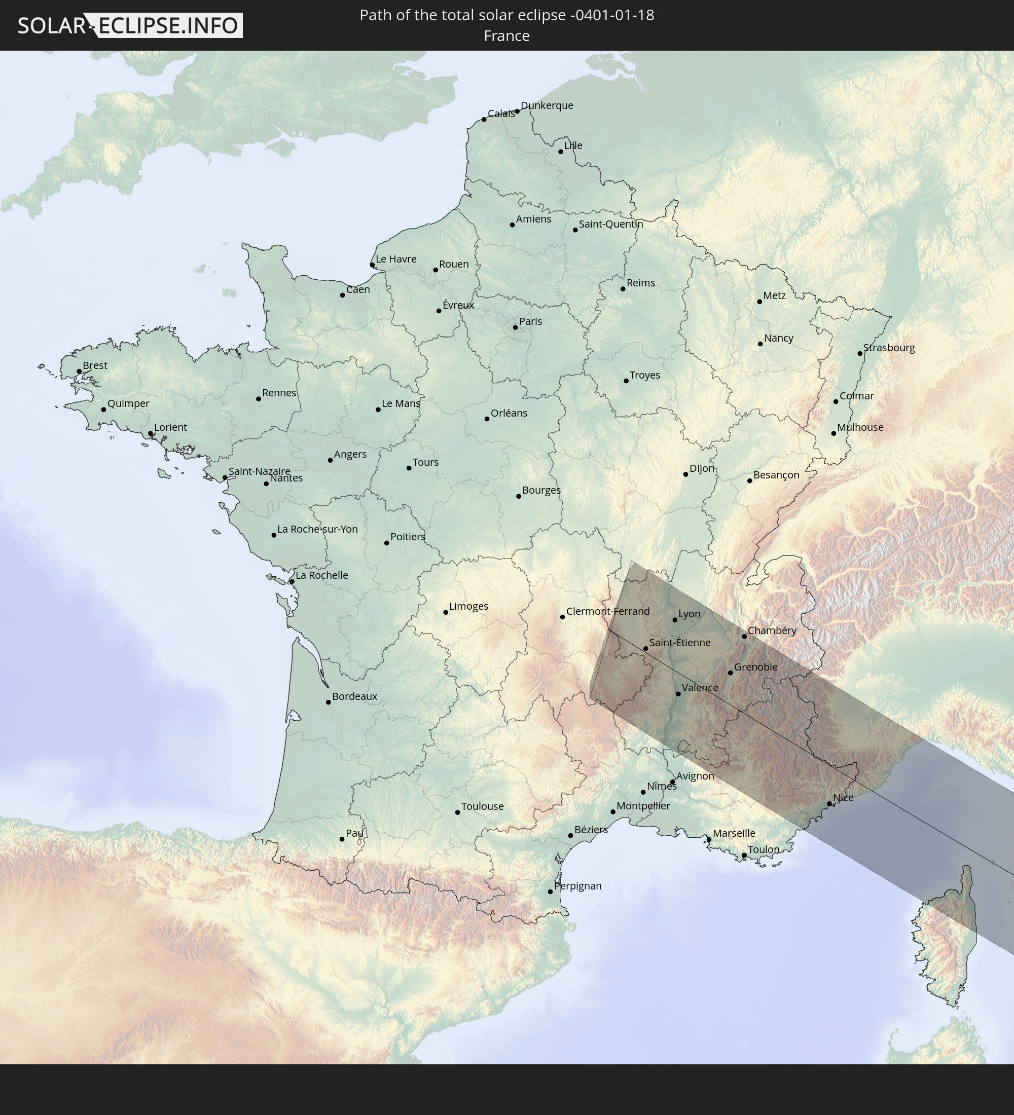 Frankreich
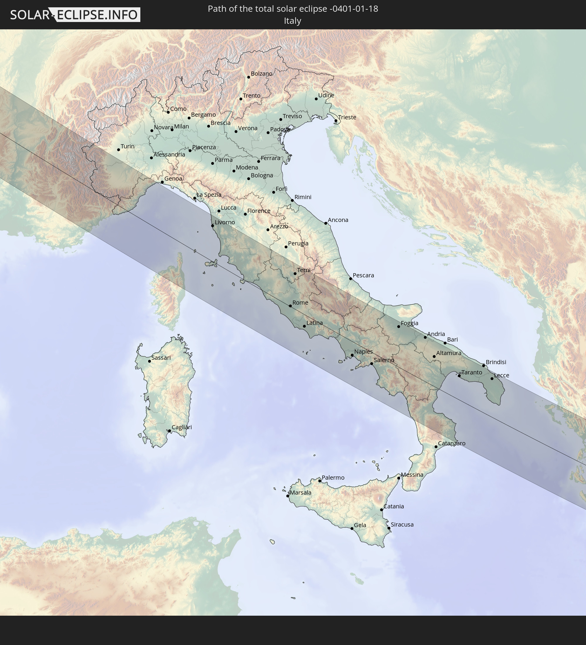 Italien
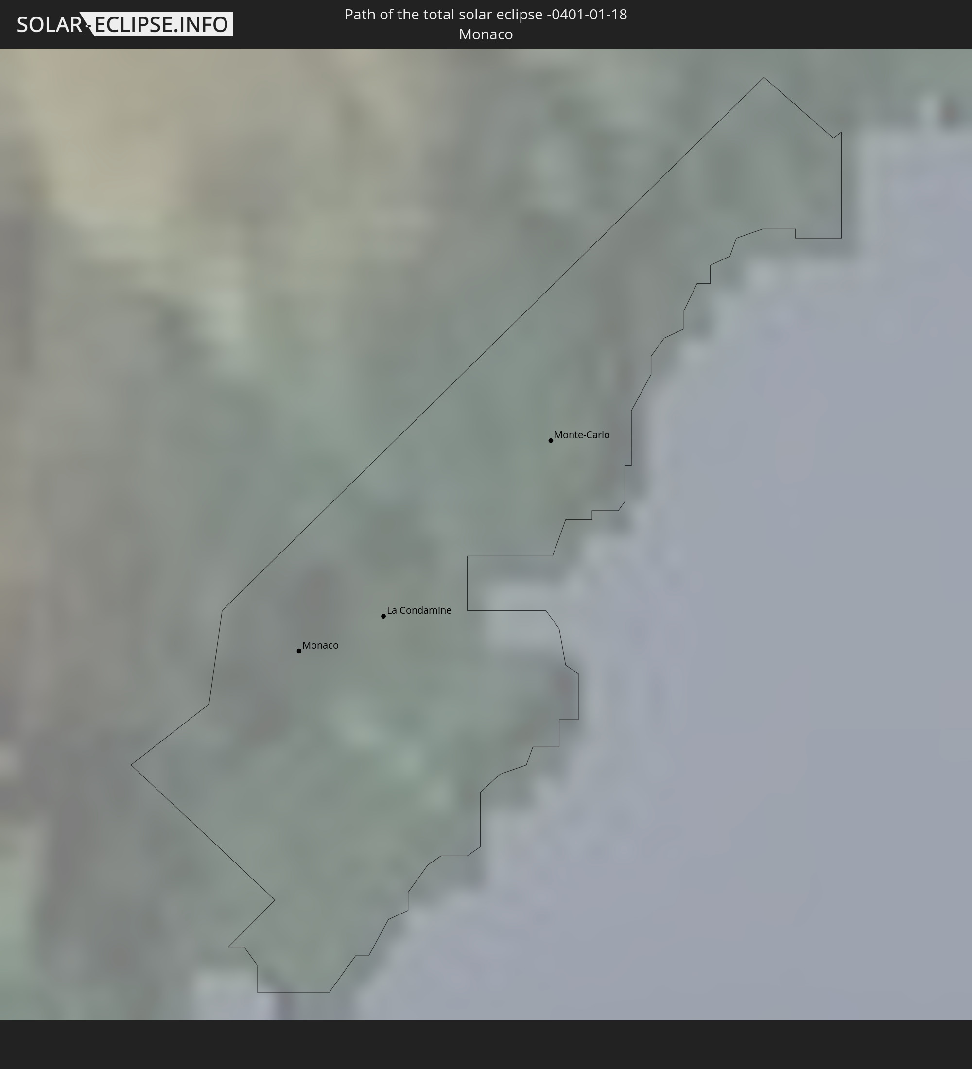 Monaco
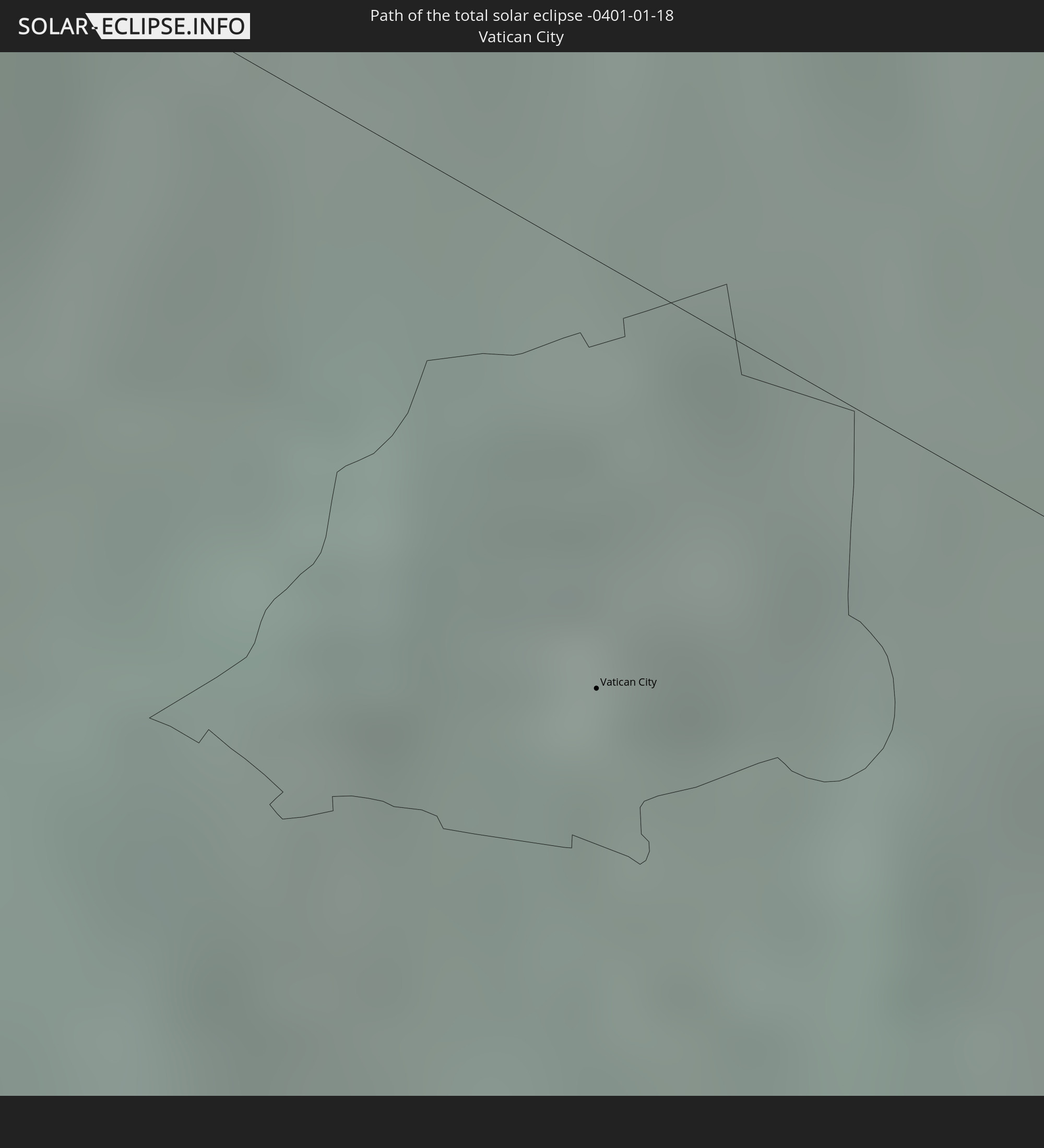 Vatikanstadt
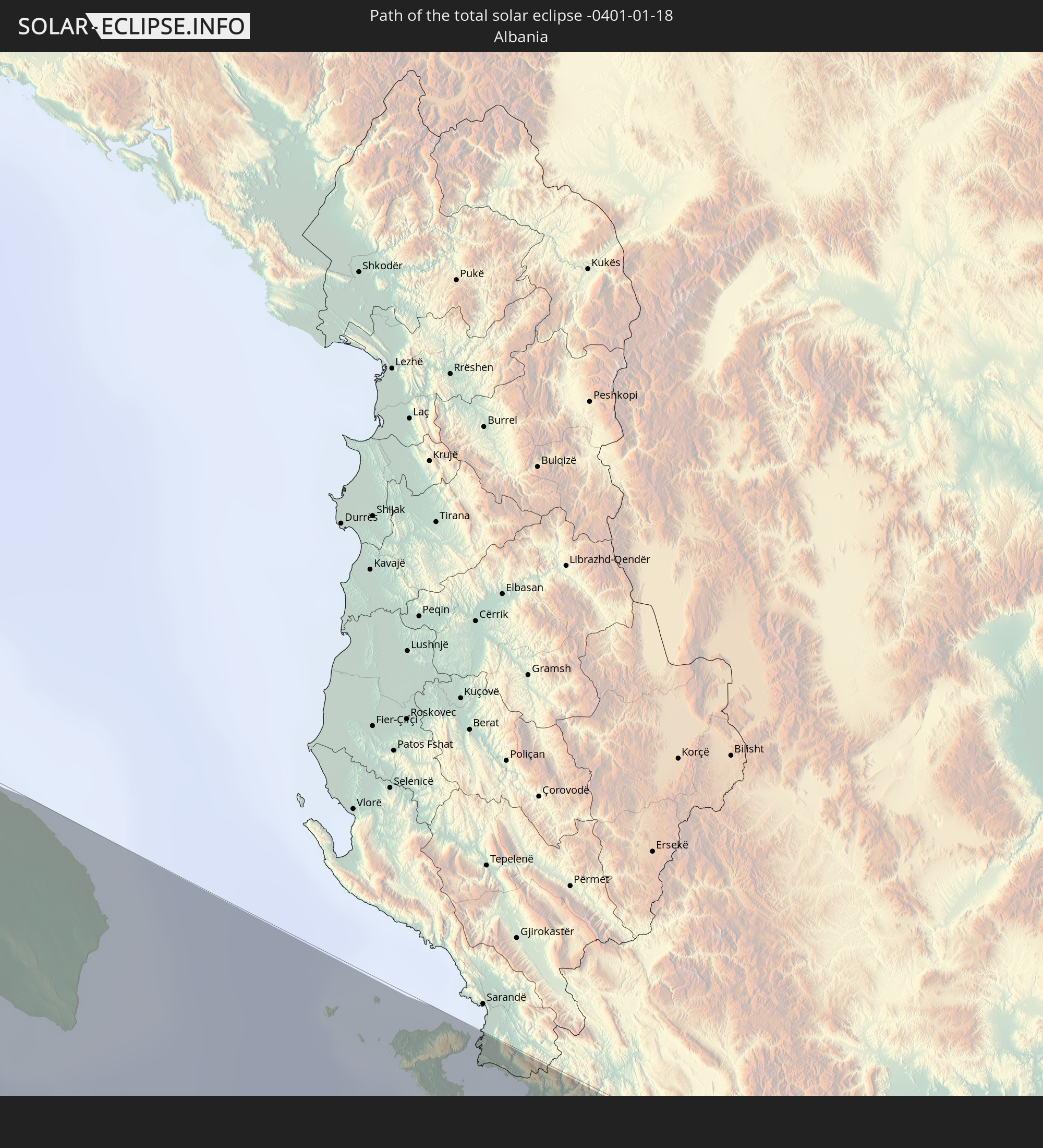 Albanien
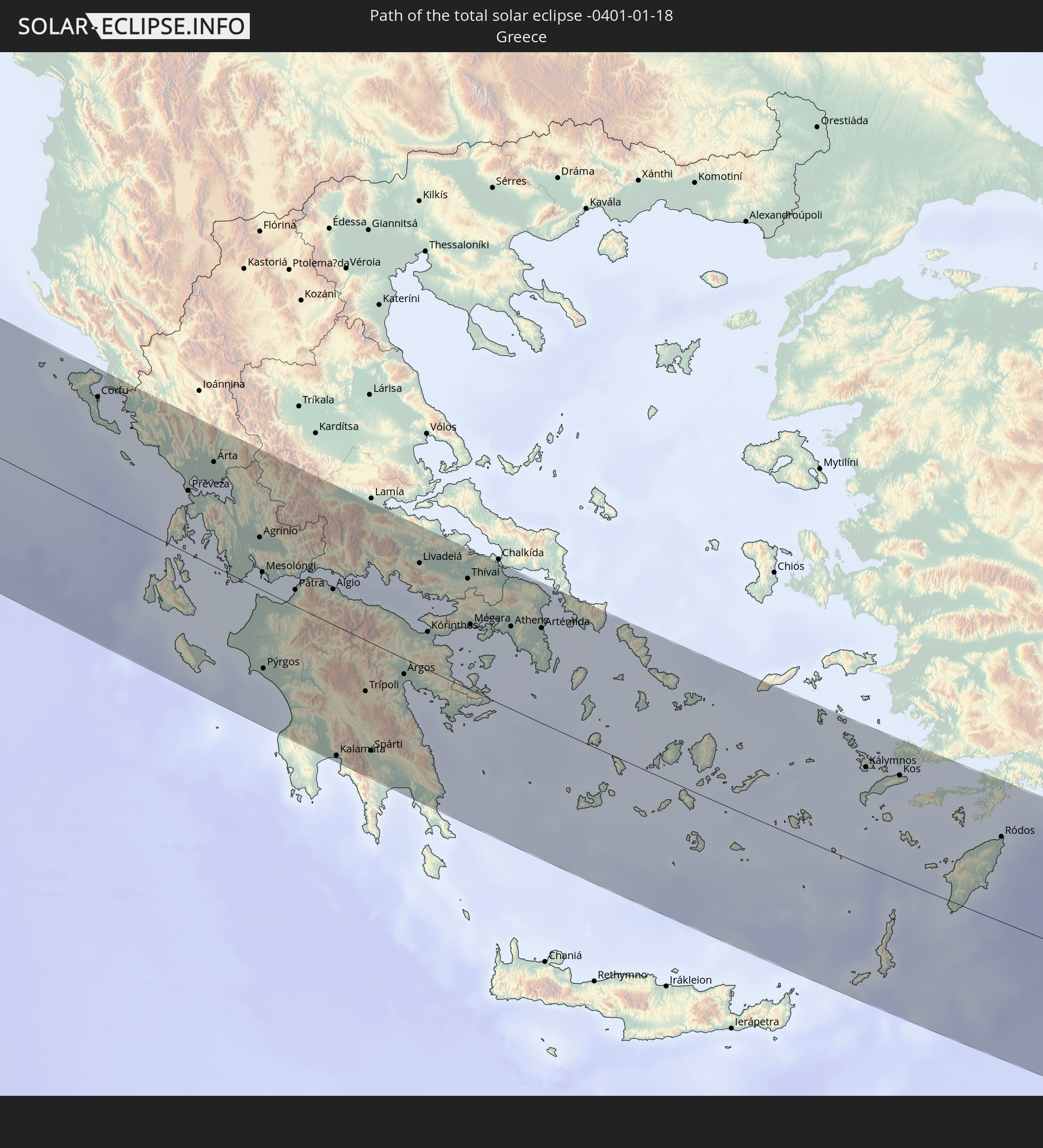 Griechenland
 Türkei
 Republik Zypern
 Israel
 Saudi-Arabien
 Jordanien
 Libanon
 Syrien
 Irak
Irak
 Iran
Iran
 Kasachstan
 Turkmenistan
 Usbekistan
 Afghanistan
 Tadschikistan
 Kirgisistan
 Volksrepublik China
 Mongolei
In den folgenden Ländern ist die Sonnenfinsternis partiell zu sehen
 Russland
 Spanien
 Mauretanien
 Marokko
 Mali
Mali
 Algerien
 Elfenbeinküste
 Burkina Faso
 Frankreich
 Ghana
Ghana
 Togo
Togo
 Niger
Niger
 Benin
Benin
 Nigeria
 Luxemburg
 Deutschland
 Schweiz
 Italien
 Monaco
 Tunesien
 Dänemark
 Kamerun
 Libyen
 Liechtenstein
 Österreich
 Schweden
 Republik Kongo
 Tschechien
 Demokratische Republik Kongo
 San Marino
 Vatikanstadt
 Slowenien
 Tschad
 Kroatien
 Polen
Polen
 Malta
Malta
 Zentralafrikanische Republik
 Bosnien und Herzegowina
 Ungarn
 Slowakei
 Montenegro
 Serbien
 Albanien
 Åland Islands
 Griechenland
 Rumänien
 Mazedonien
 Finnland
 Litauen
 Lettland
 Estland
 Sudan
Sudan
 Ukraine
 Bulgarien
 Weißrussland
 Ägypten
 Türkei
 Moldawien
 Ruanda
 Burundi
 Tansania
 Uganda
 Republik Zypern
 Äthiopien
 Kenia
Kenia
 Staat Palästina
 Israel
 Saudi-Arabien
 Jordanien
 Libanon
 Syrien
 Eritrea
 Irak
Irak
 Georgien
 Somalia
 Dschibuti
 Jemen
Jemen
 Armenien
 Iran
Iran
 Aserbaidschan
 Seychellen
 Kasachstan
 Kuwait
 Bahrain
 Katar
Katar
 Vereinigte Arabische Emirate
 Oman
Oman
 Turkmenistan
 Usbekistan
 Afghanistan
 Pakistan
 Tadschikistan
 Indien
 Kirgisistan
 Malediven
 Volksrepublik China
 Sri Lanka
 Nepal
Nepal
 Mongolei
 Bangladesch
 Bhutan
 Myanmar
 Thailand
 Laos
Laos
 Vietnam
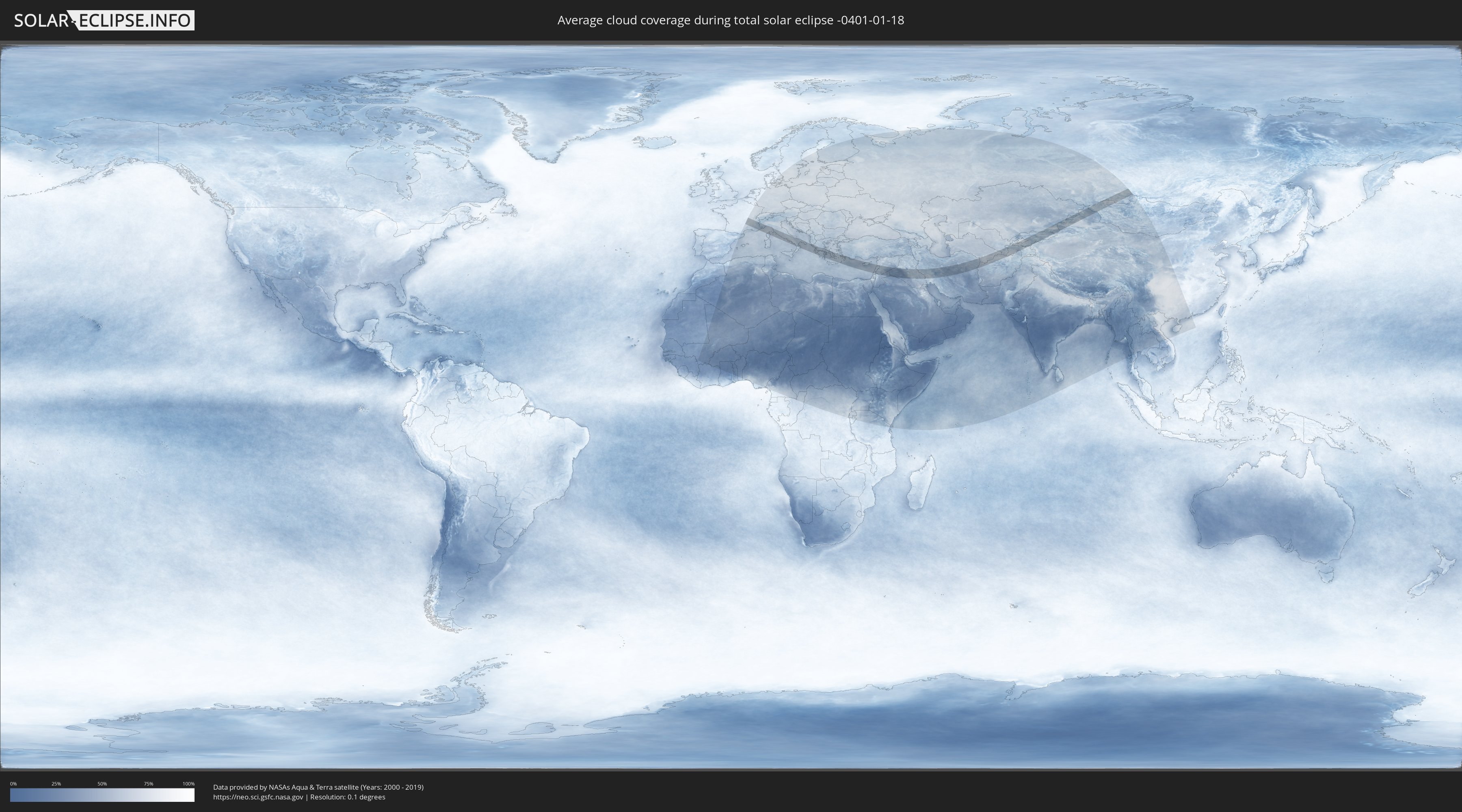
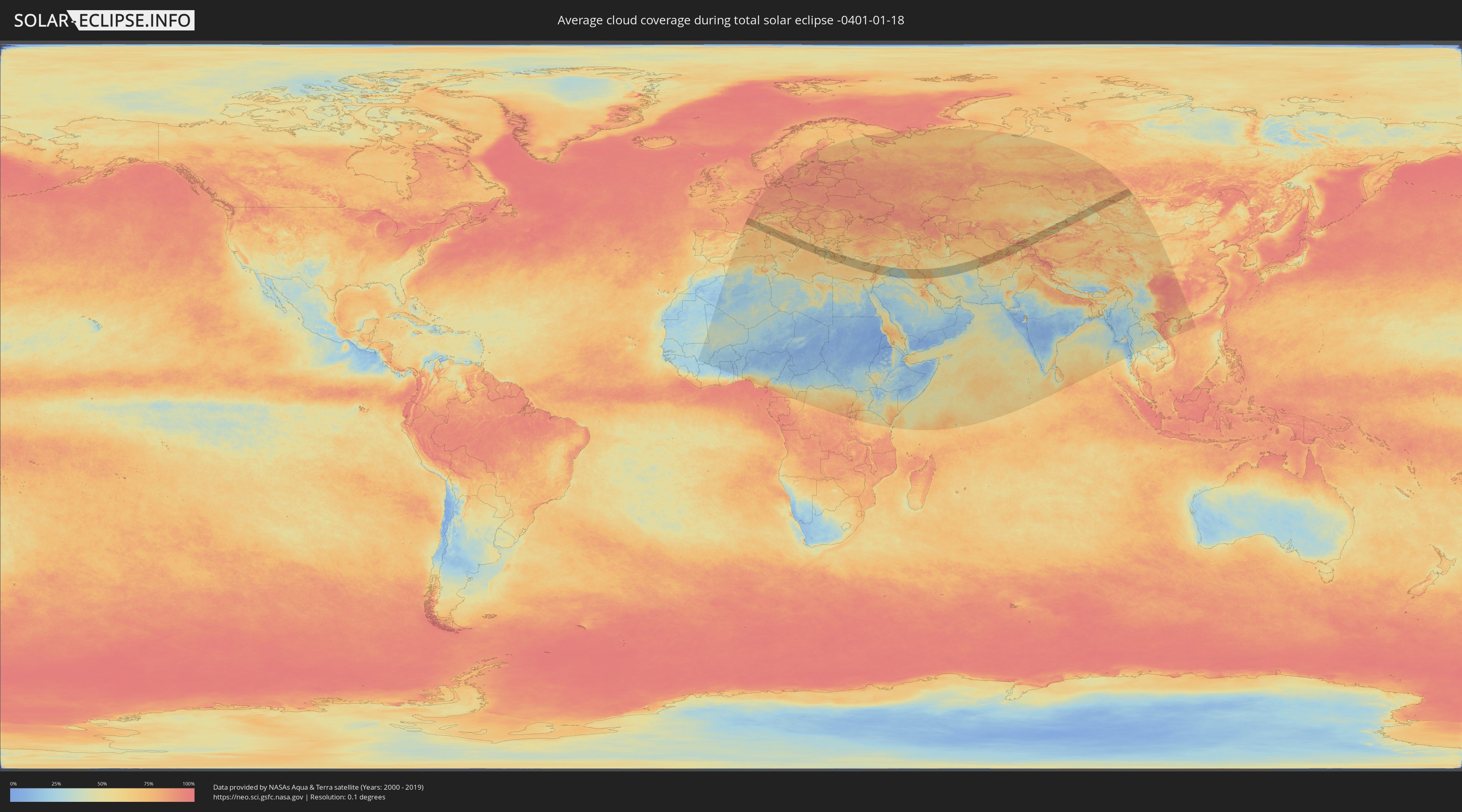
Wie wird das Wetter während der totalen Sonnenfinsternis am 18.01.-0401?
Wo ist der beste Ort, um die totale Sonnenfinsternis vom 18.01.-0401 zu beobachten?
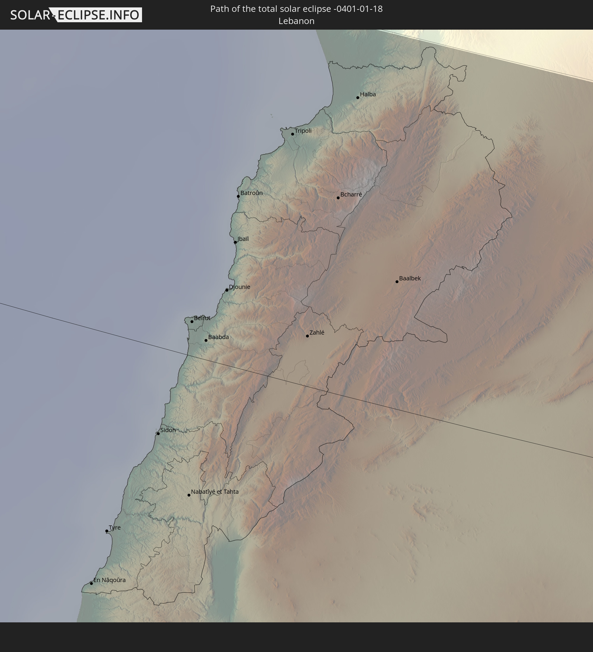
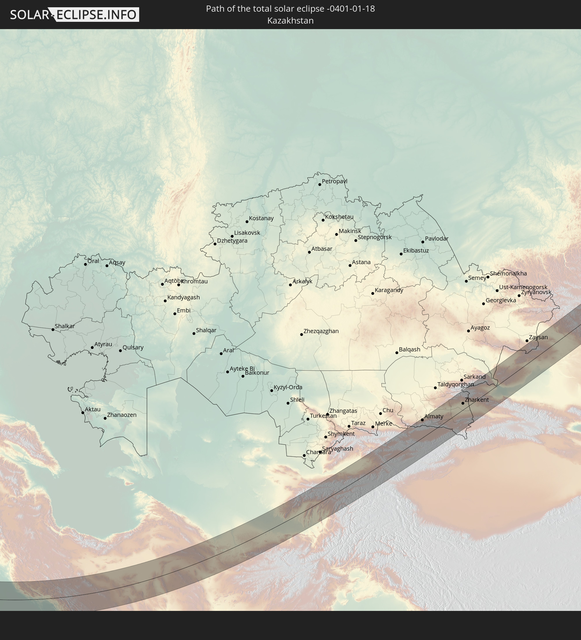
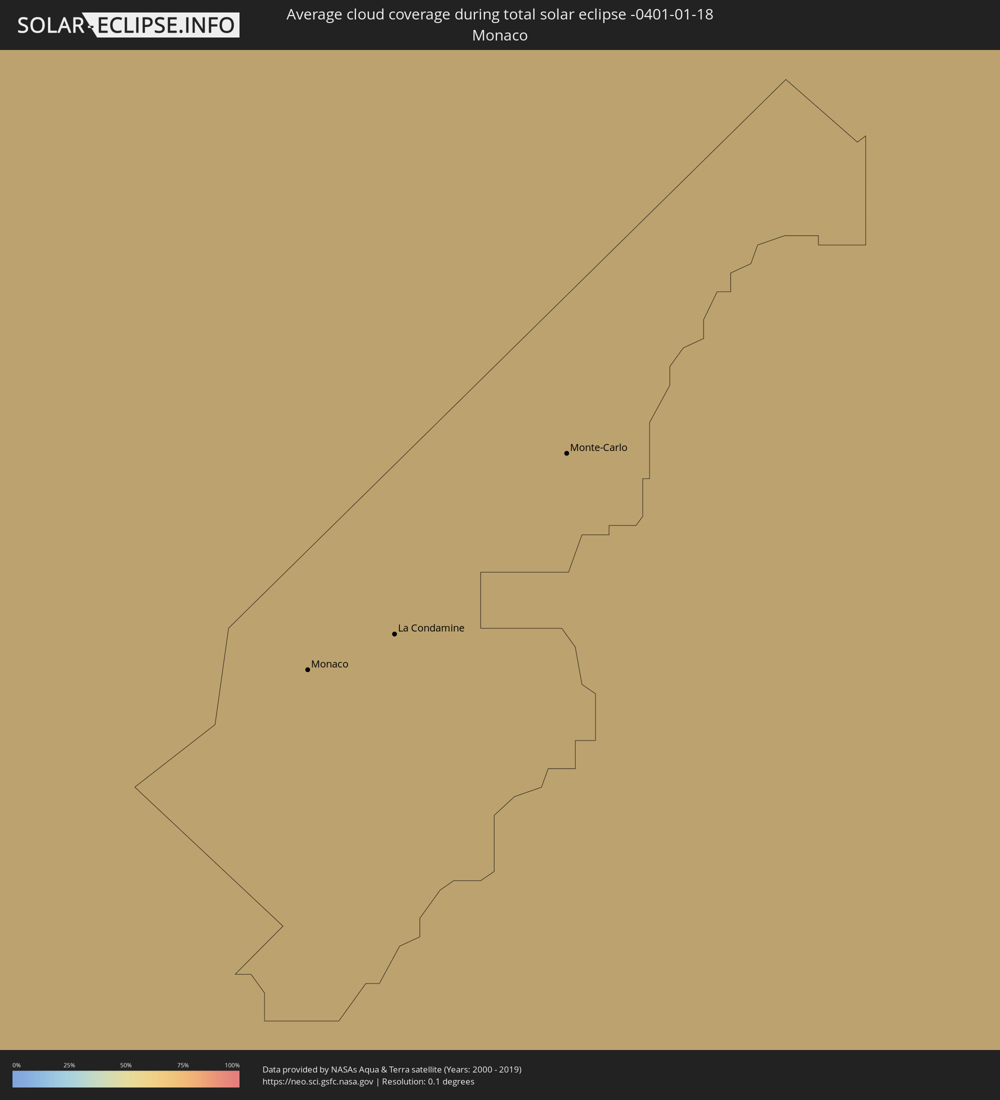
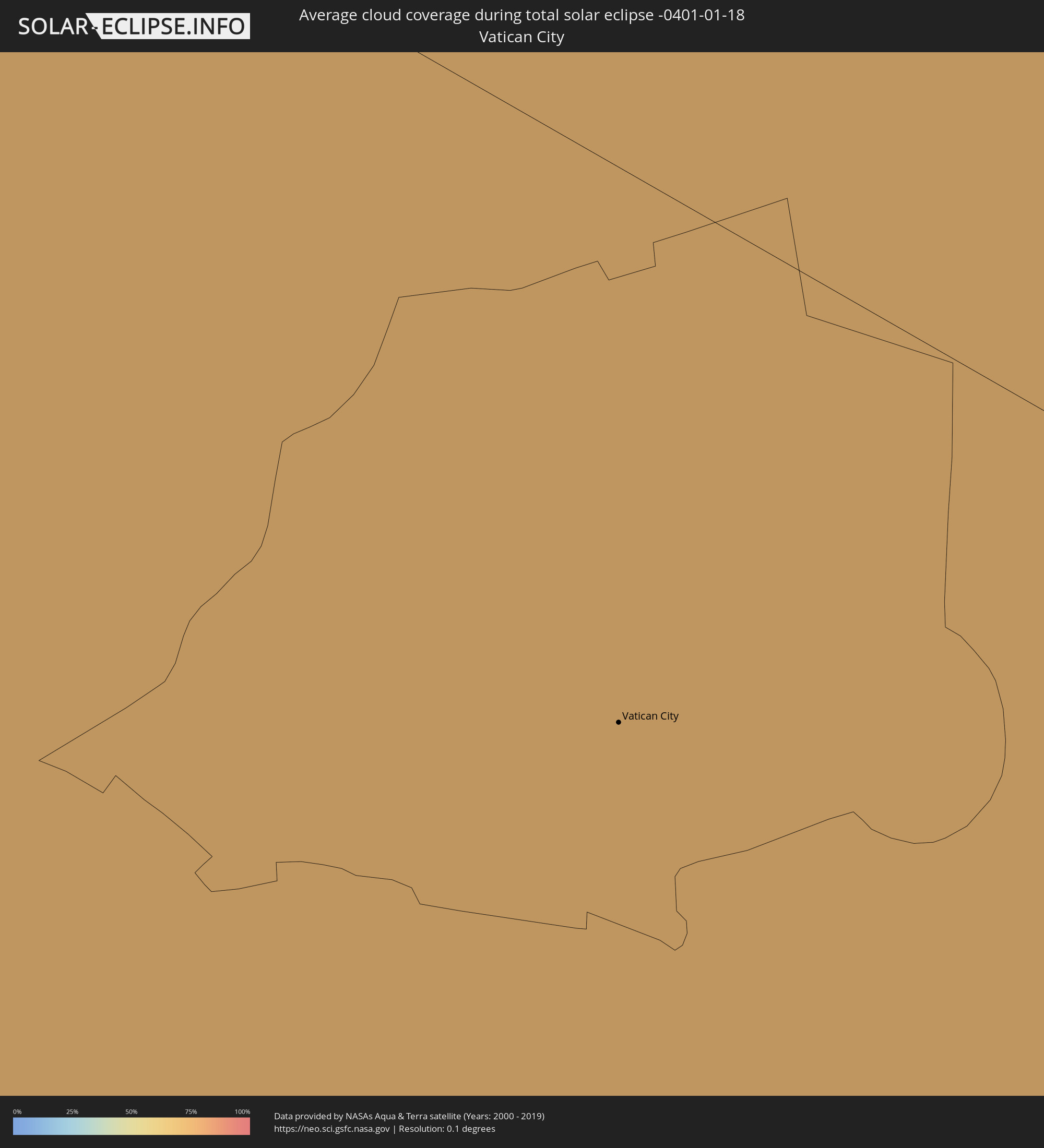
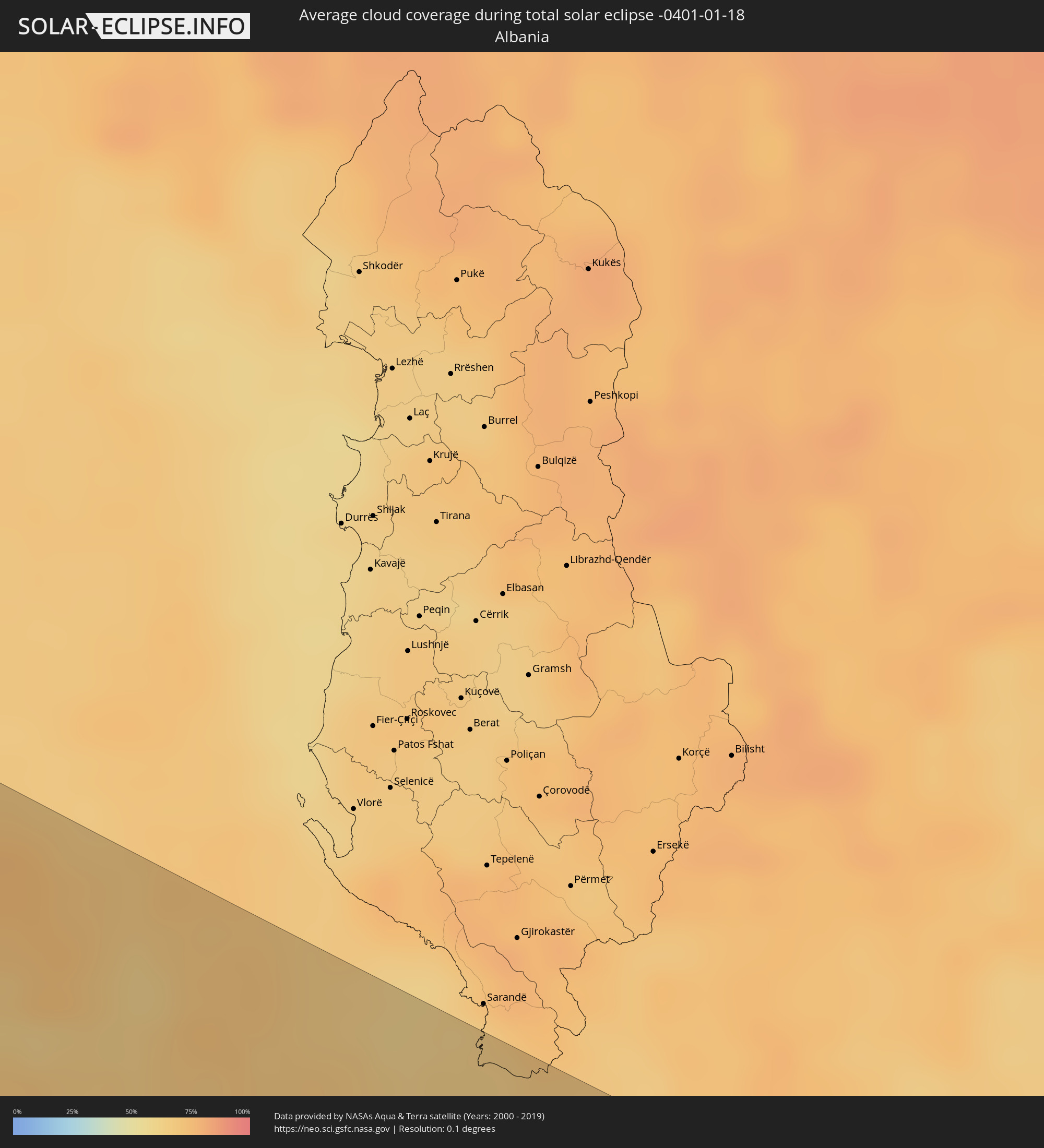
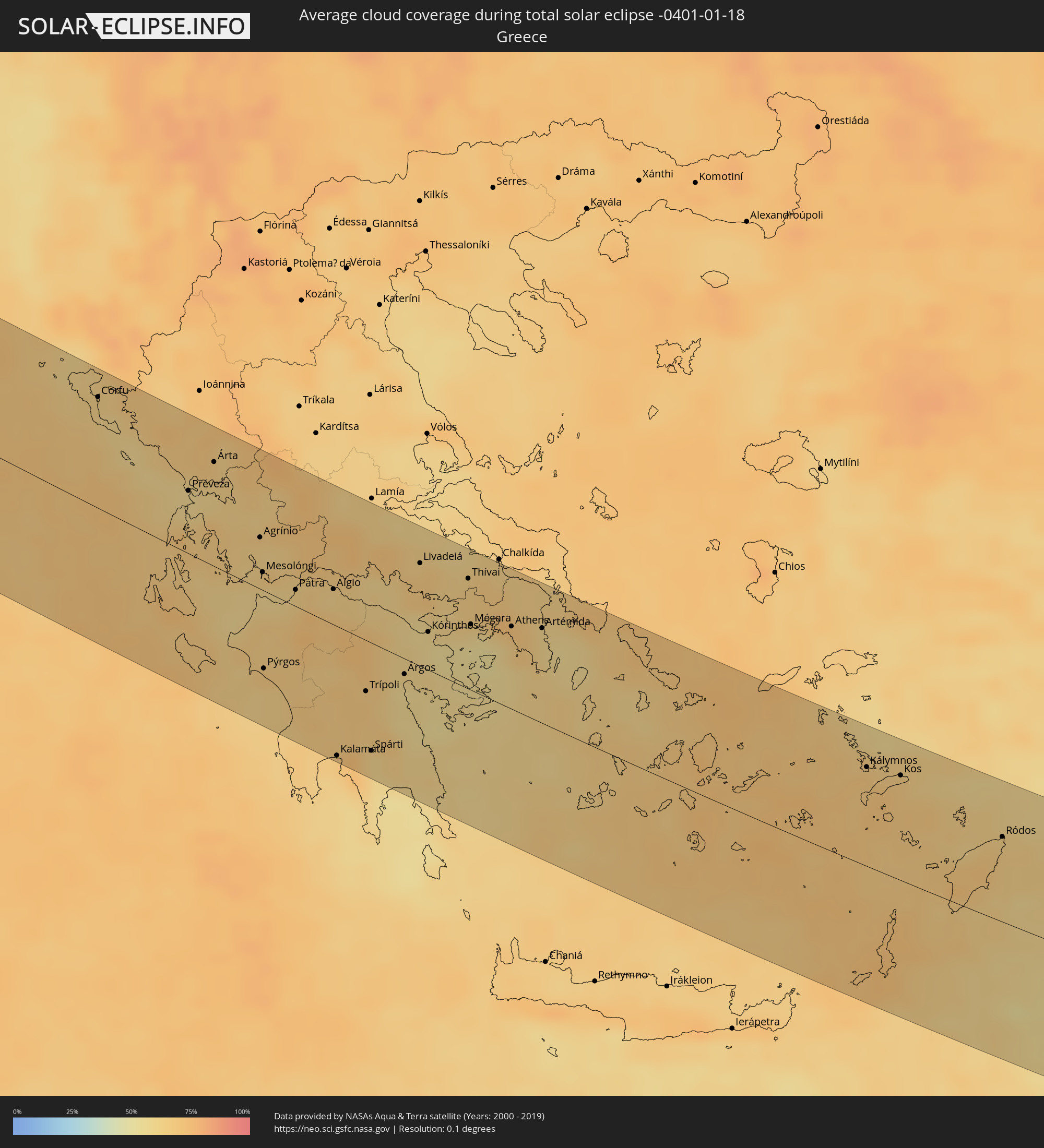
Die folgenden Karten zeigen die durchschnittliche Bewölkung für den Tag, an dem die totale Sonnenfinsternis
stattfindet. Mit Hilfe der Karten lässt sich der Ort entlang des Finsternispfades eingrenzen,
der die besten Aussichen auf einen klaren wolkenfreien Himmel bietet.
Trotzdem muss man immer lokale Gegenenheiten beachten und sollte sich genau über das Wetter an seinem
gewählten Beobachtungsort informieren.
Die Daten stammen von den beiden NASA-Satelliten
AQUA und TERRA
und wurden über einen Zeitraum von 19 Jahren (2000 - 2019) gemittelt.
Detaillierte Länderkarten
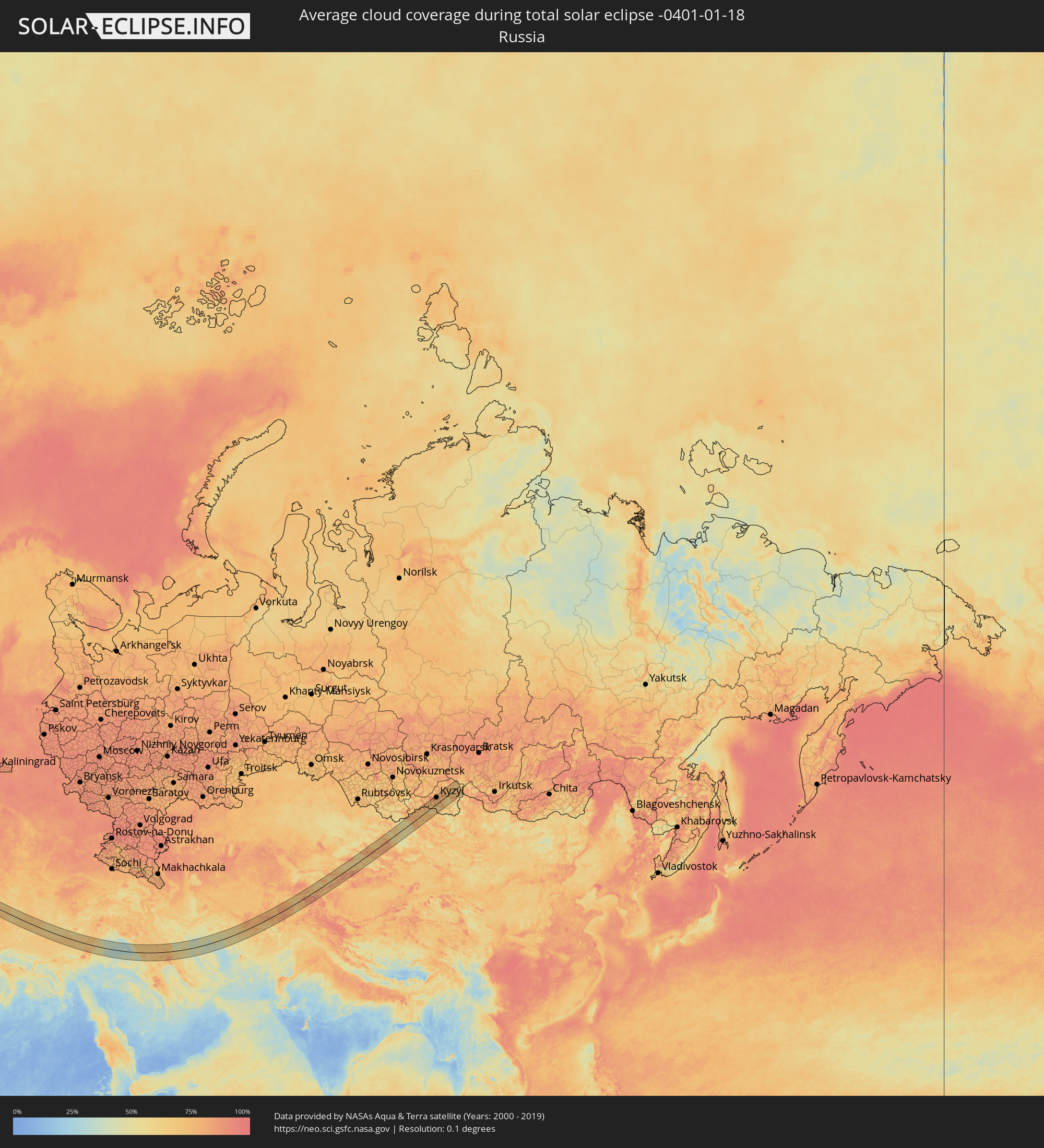 Russland
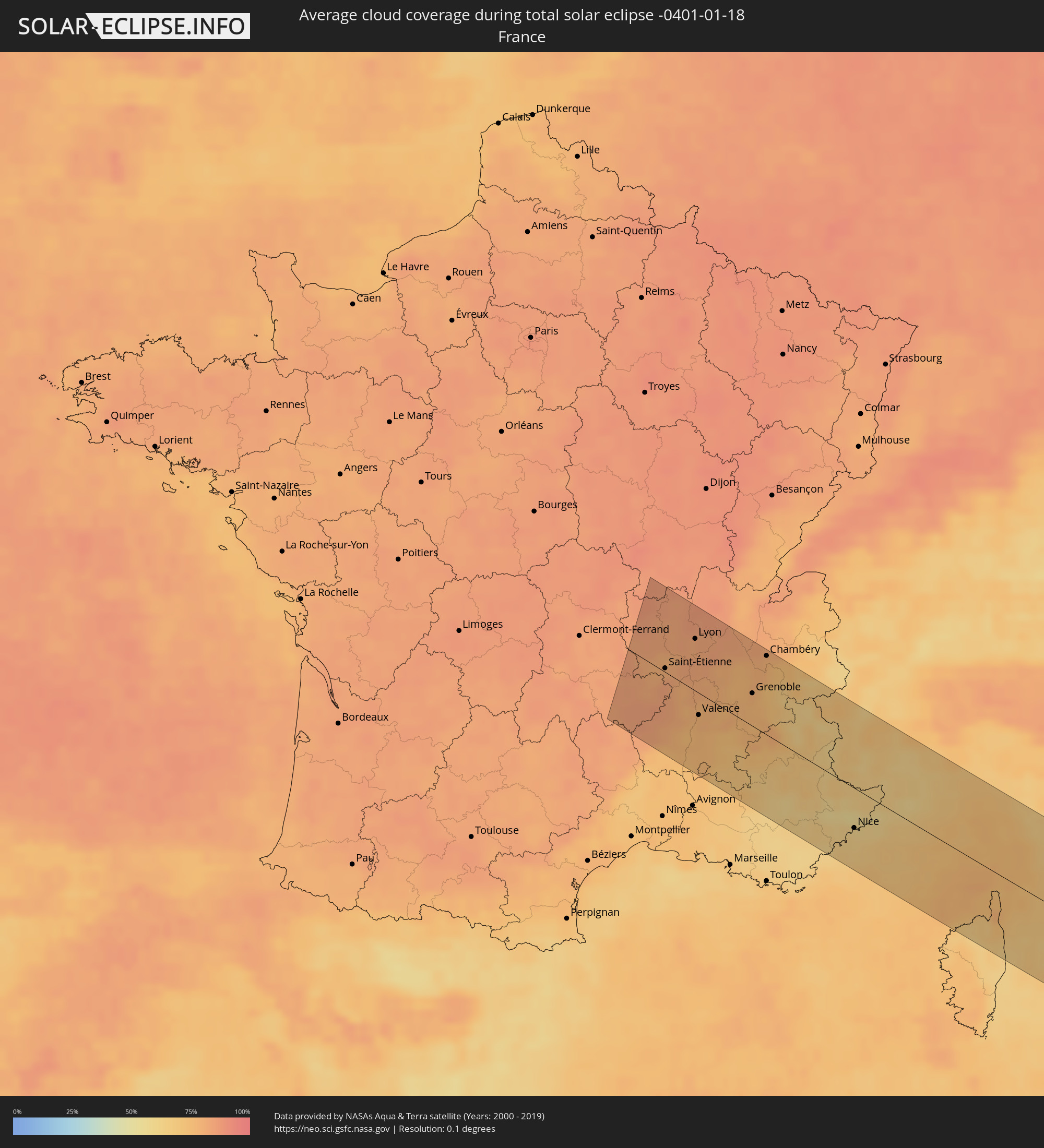 Frankreich
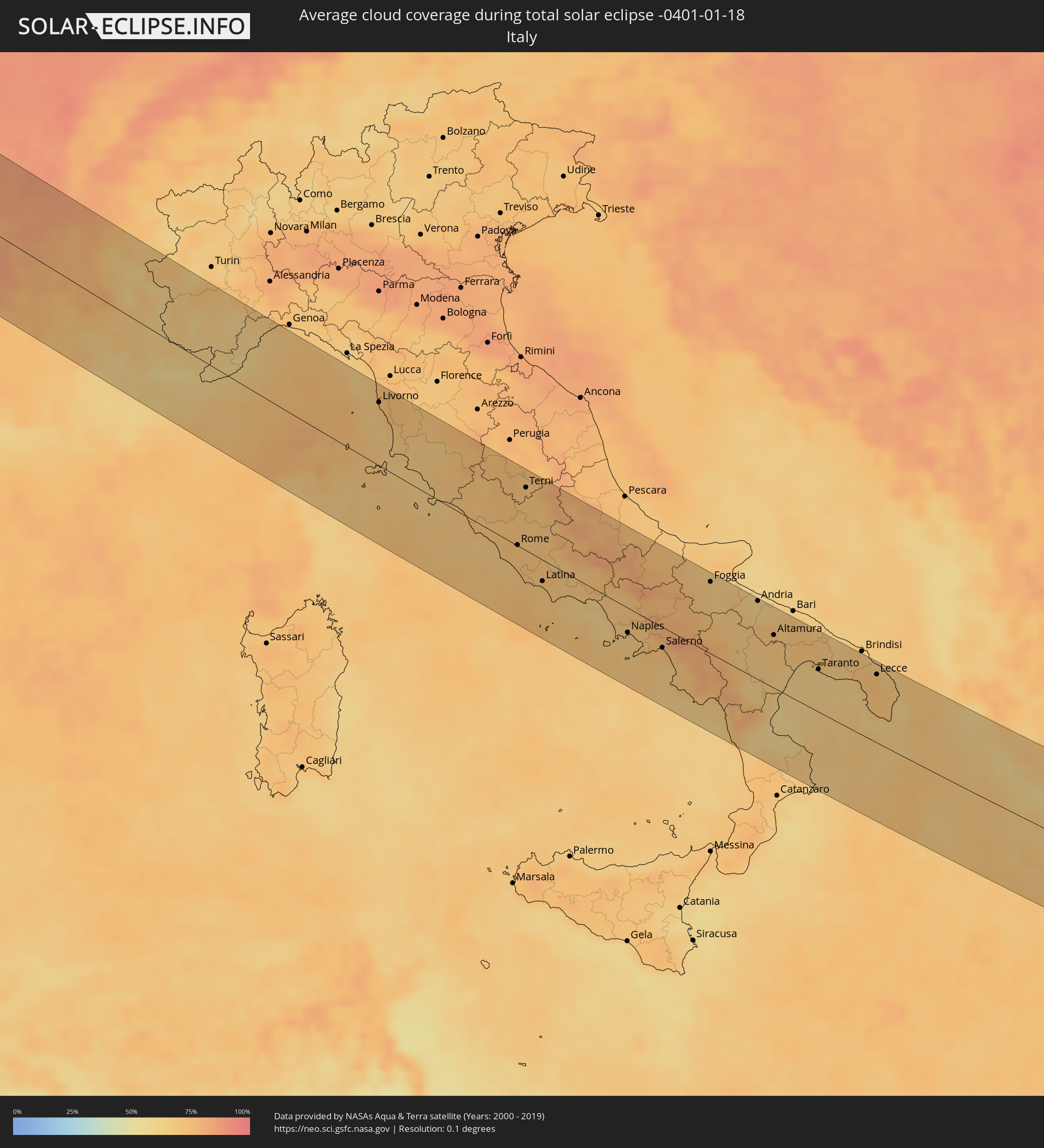 Italien
 Monaco
 Vatikanstadt
 Albanien
 Griechenland
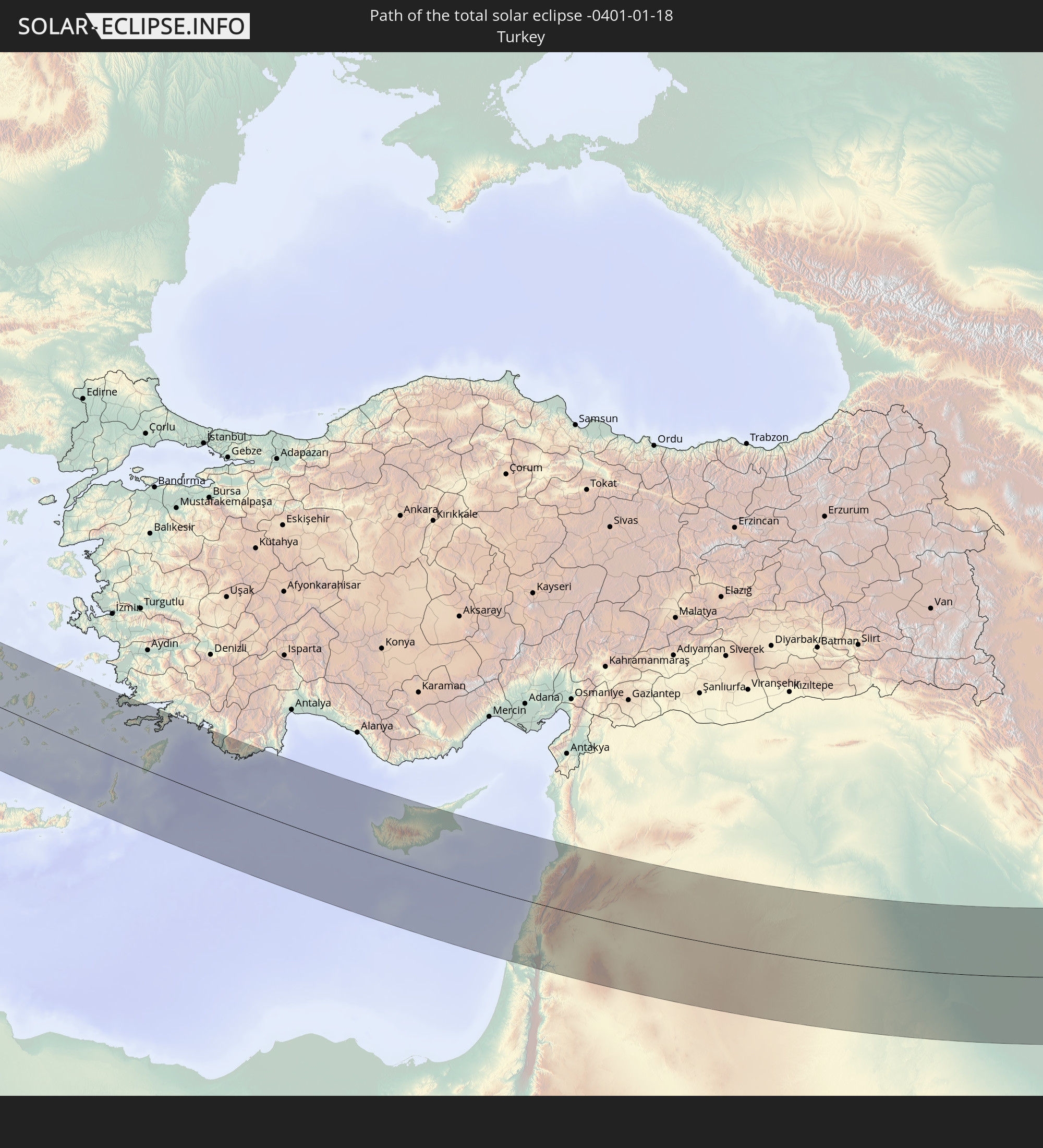
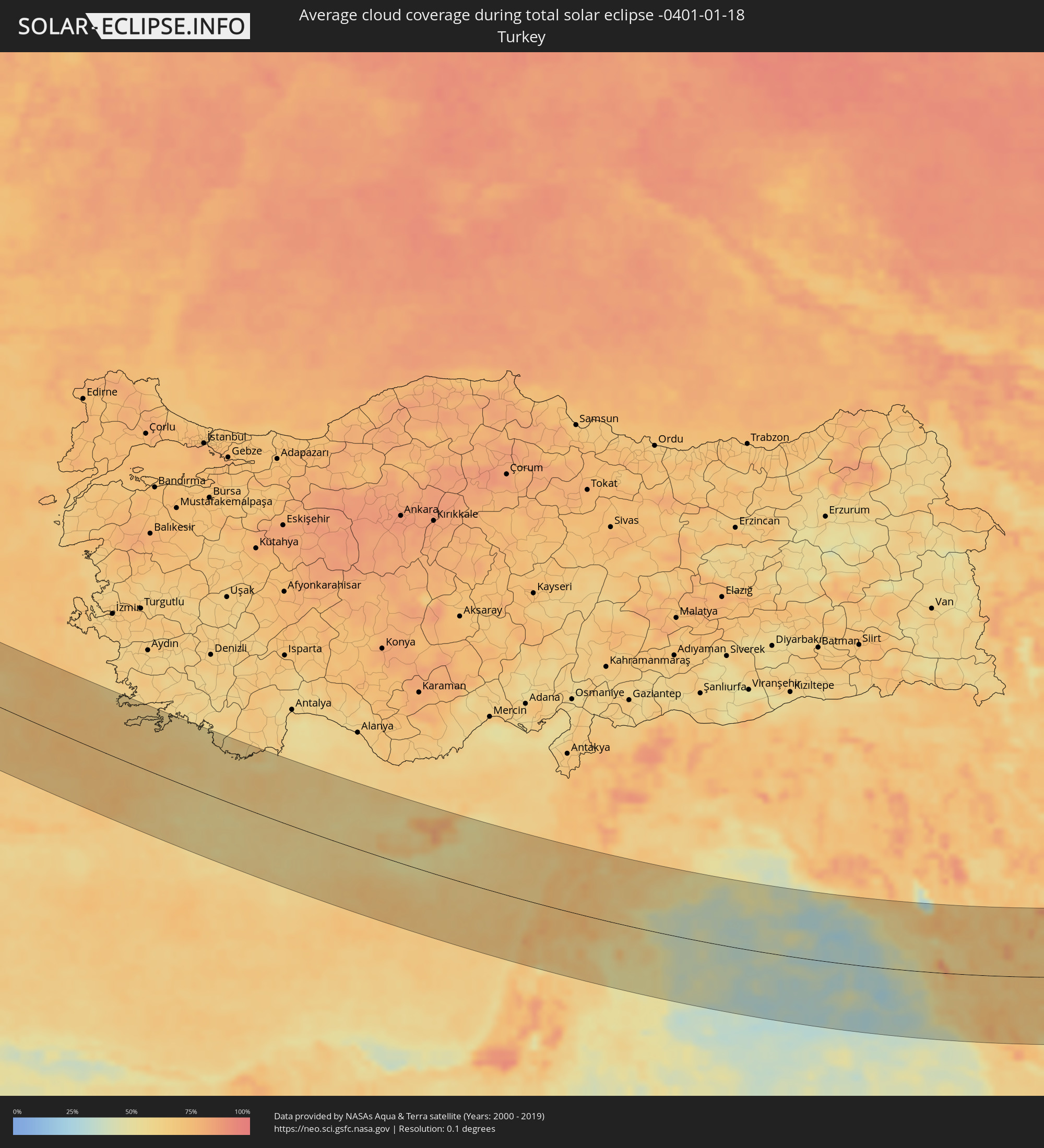 Türkei
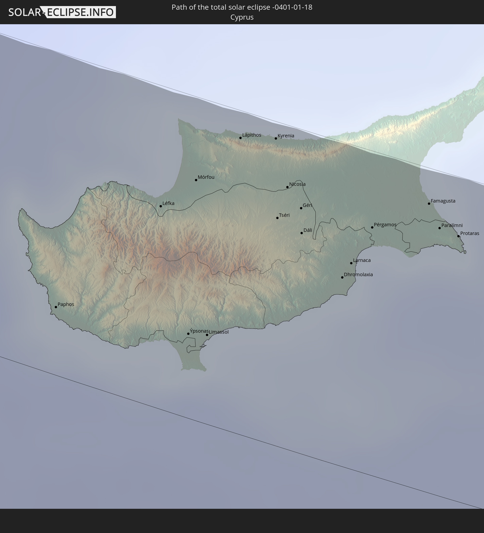
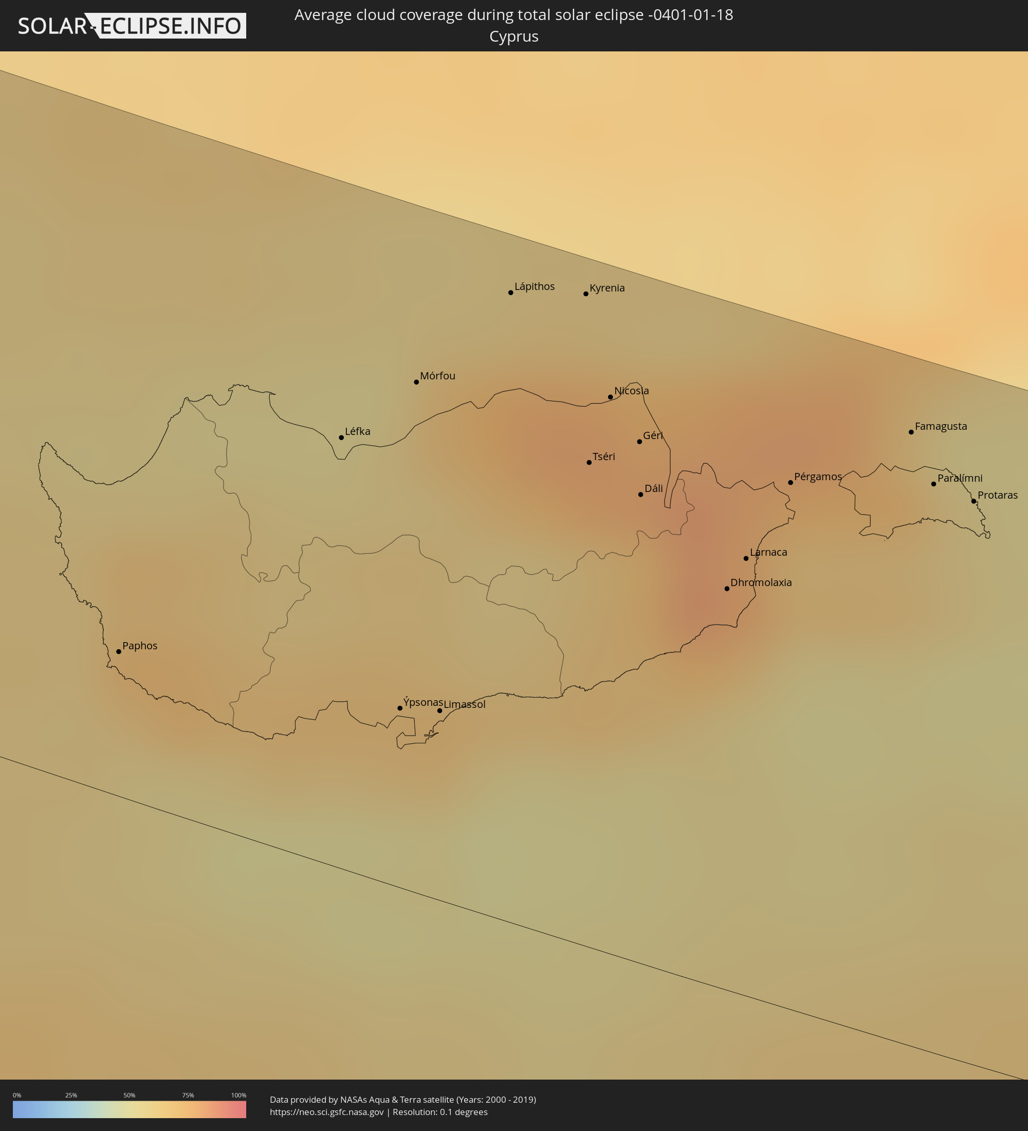 Republik Zypern
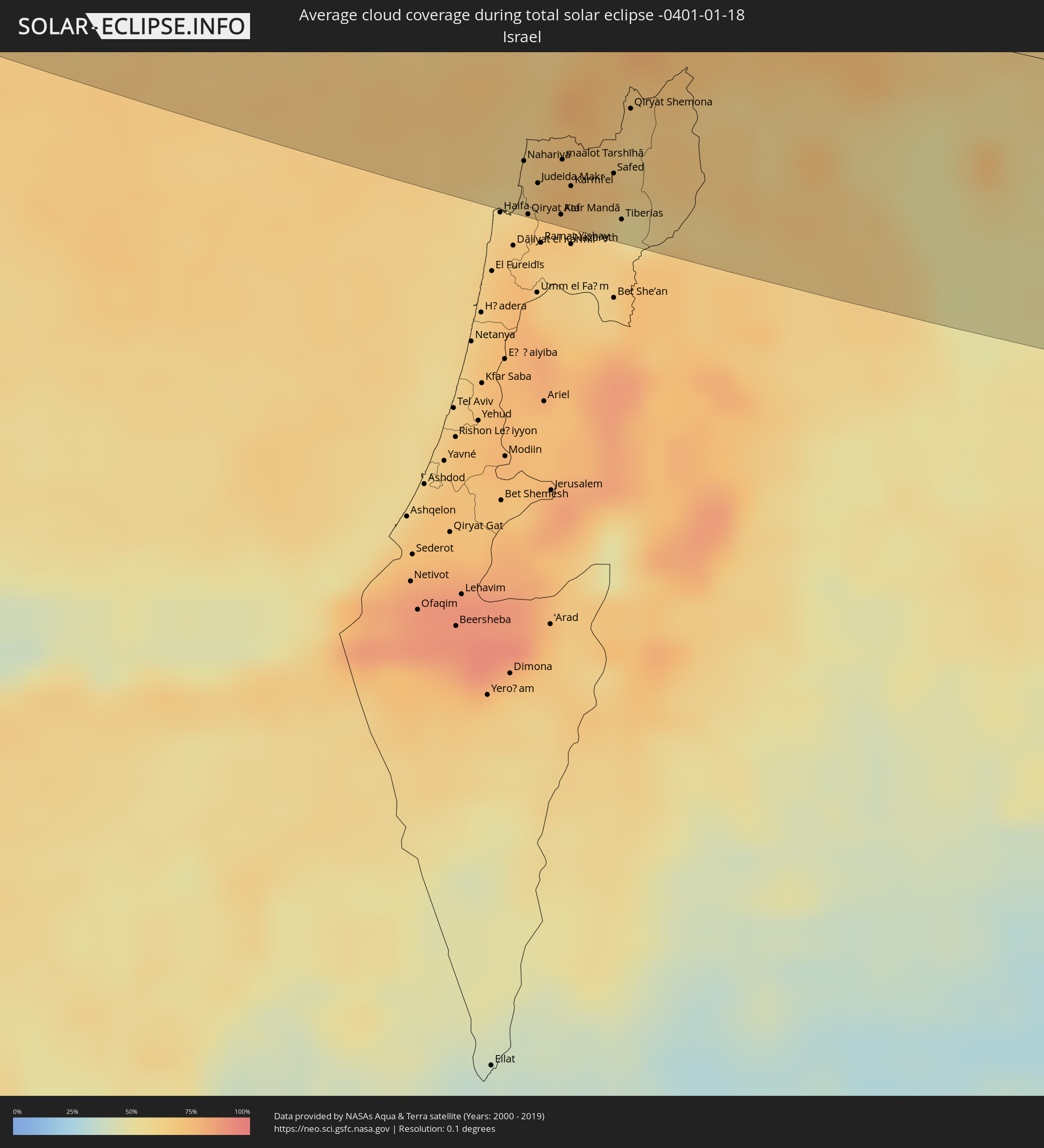 Israel
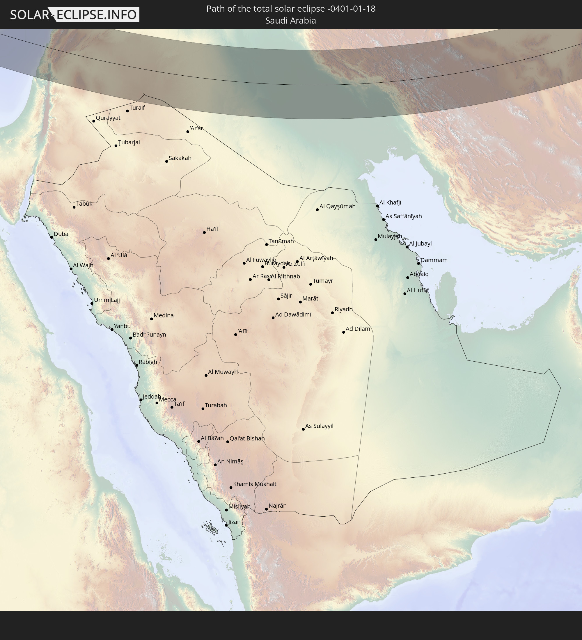
 Saudi-Arabien
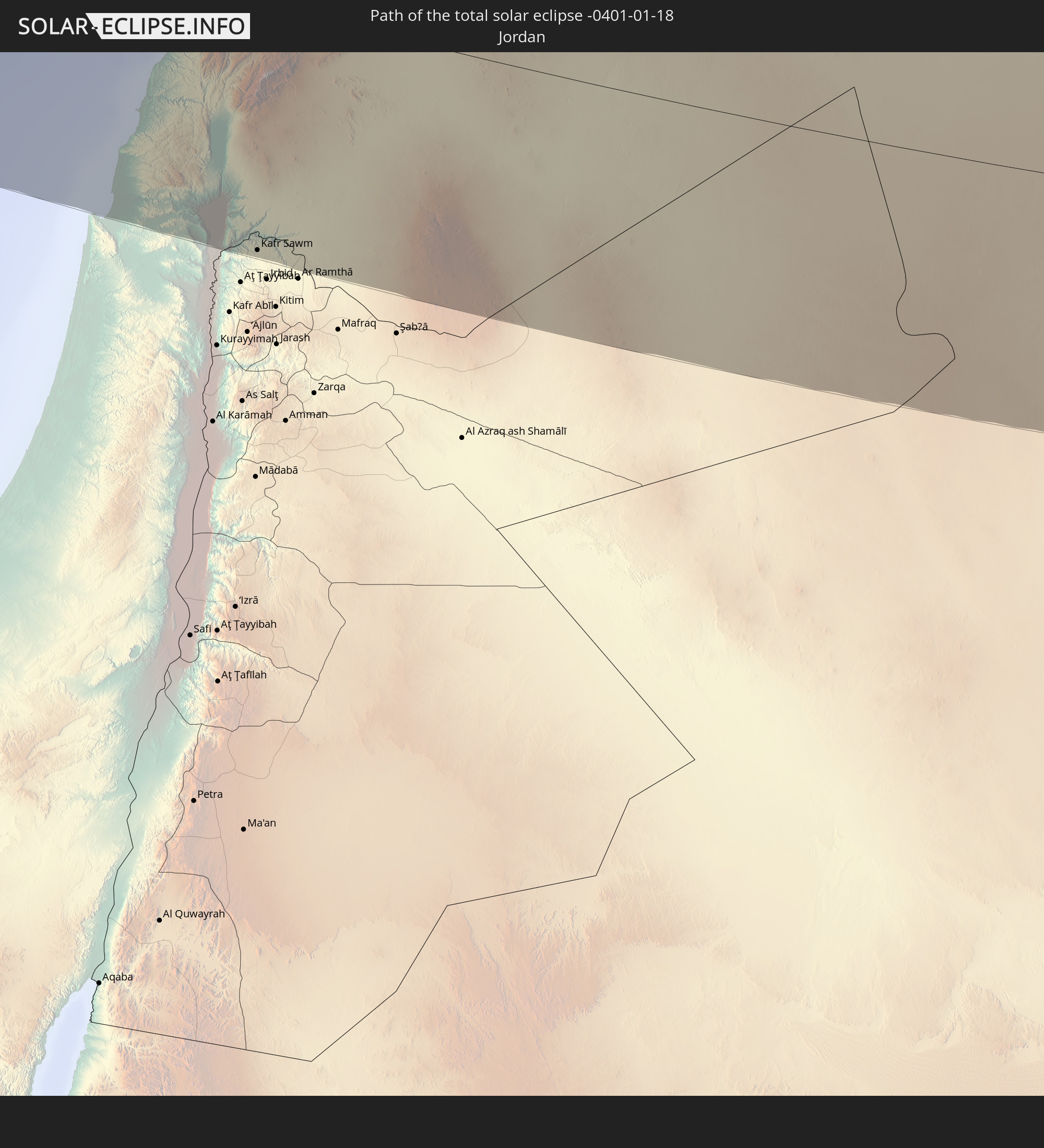
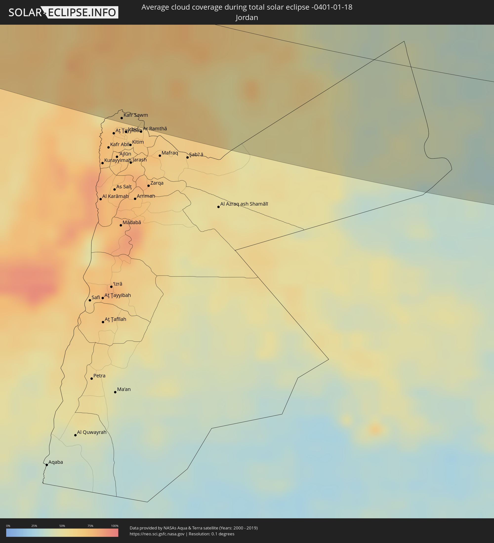 Jordanien
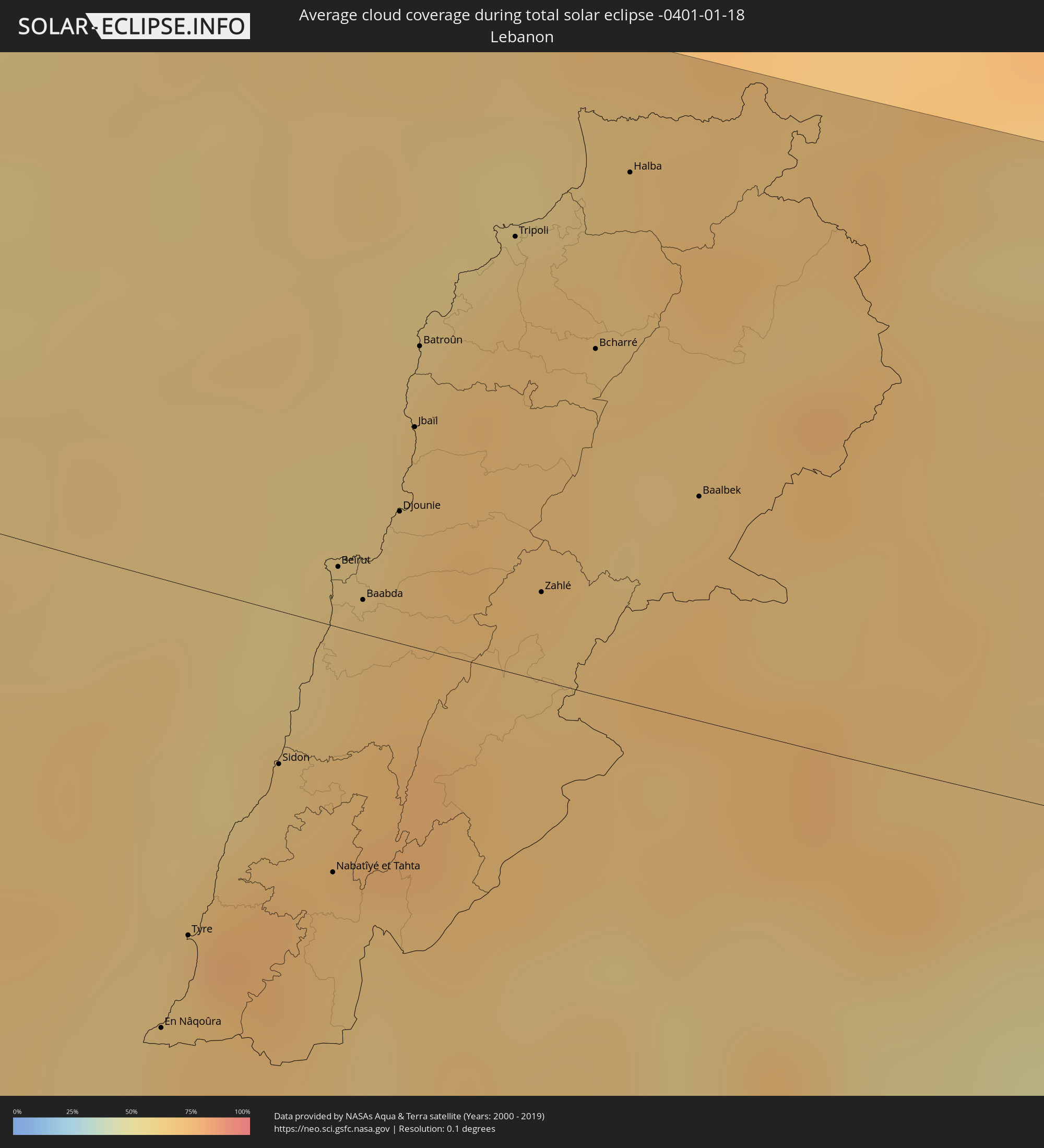 Libanon
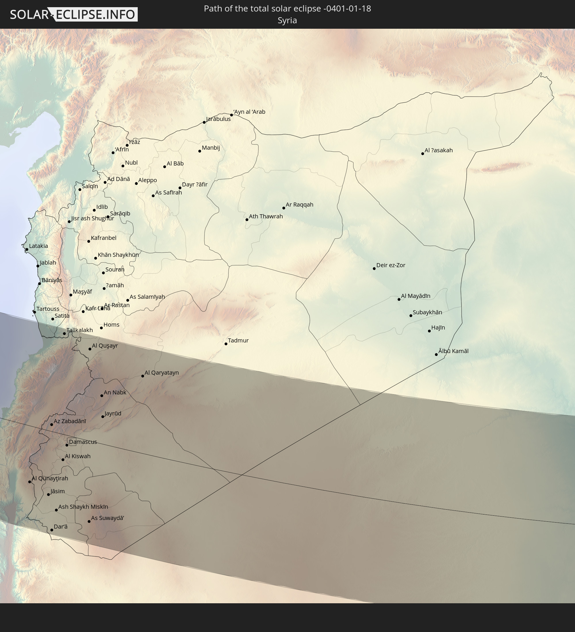
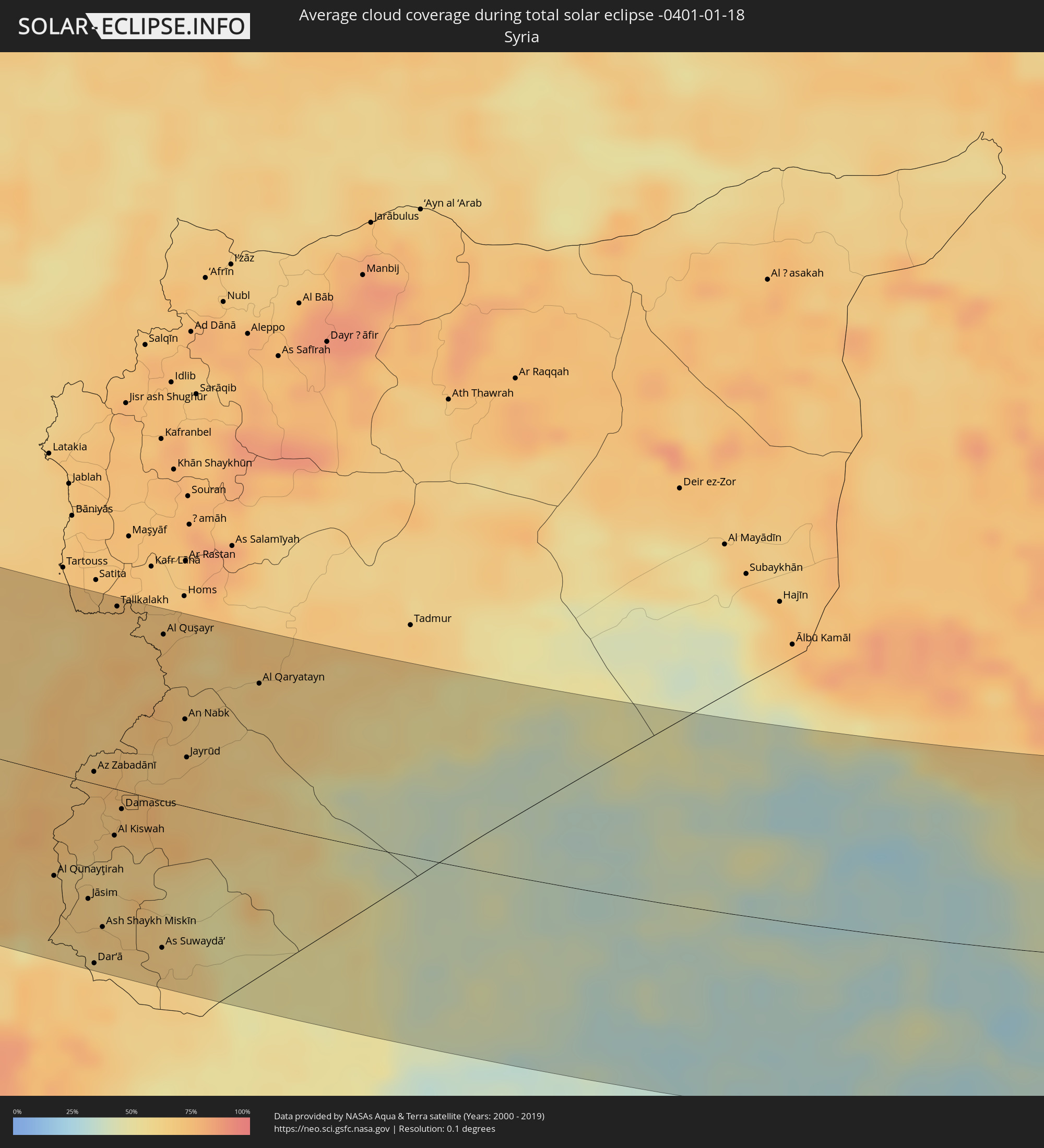 Syrien
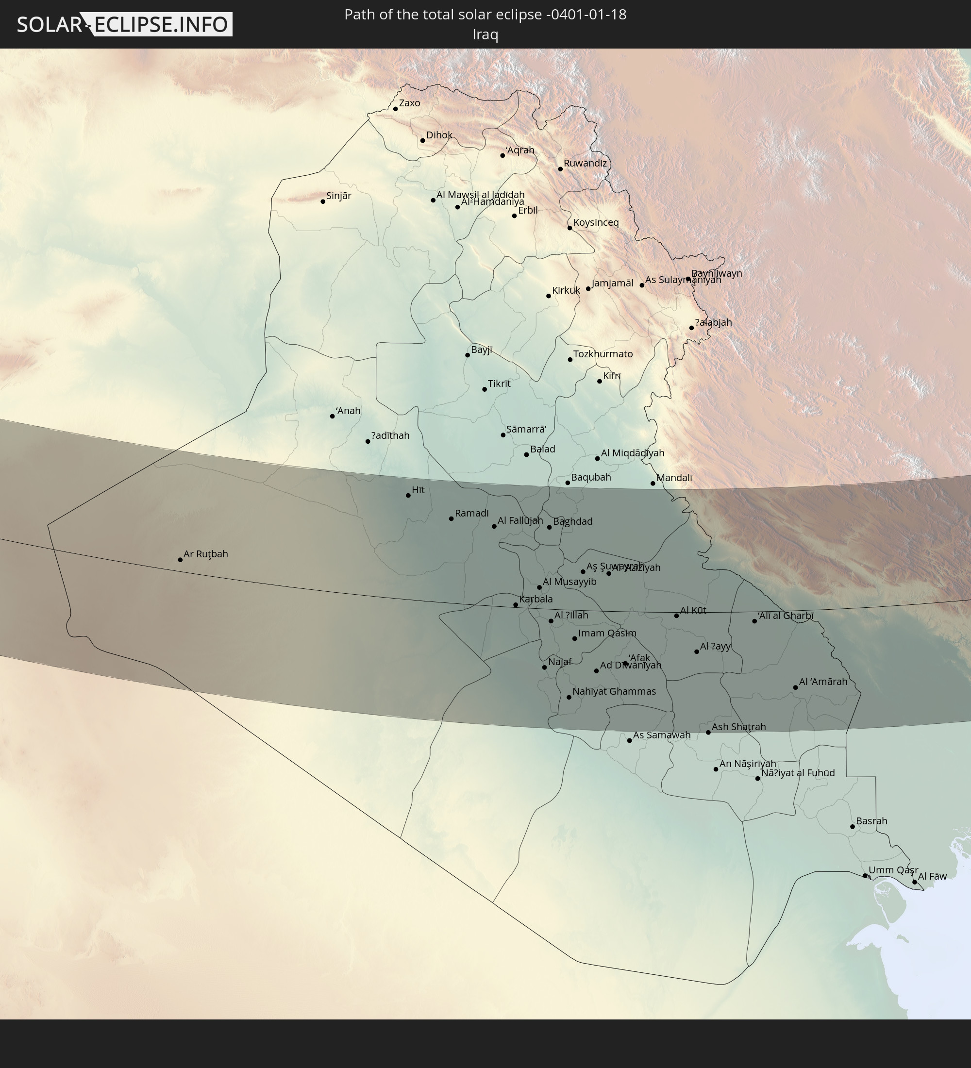
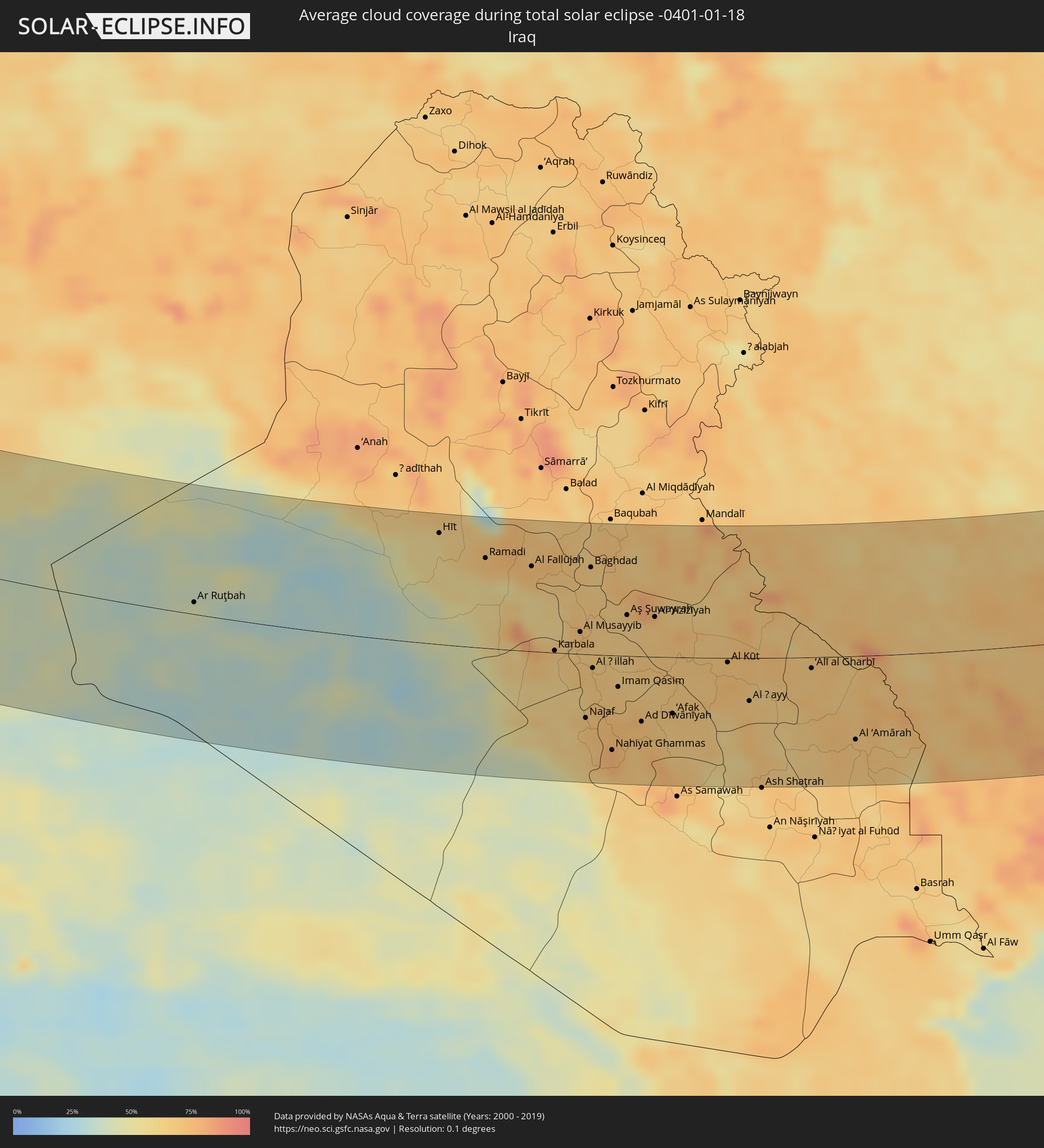 Irak
Irak
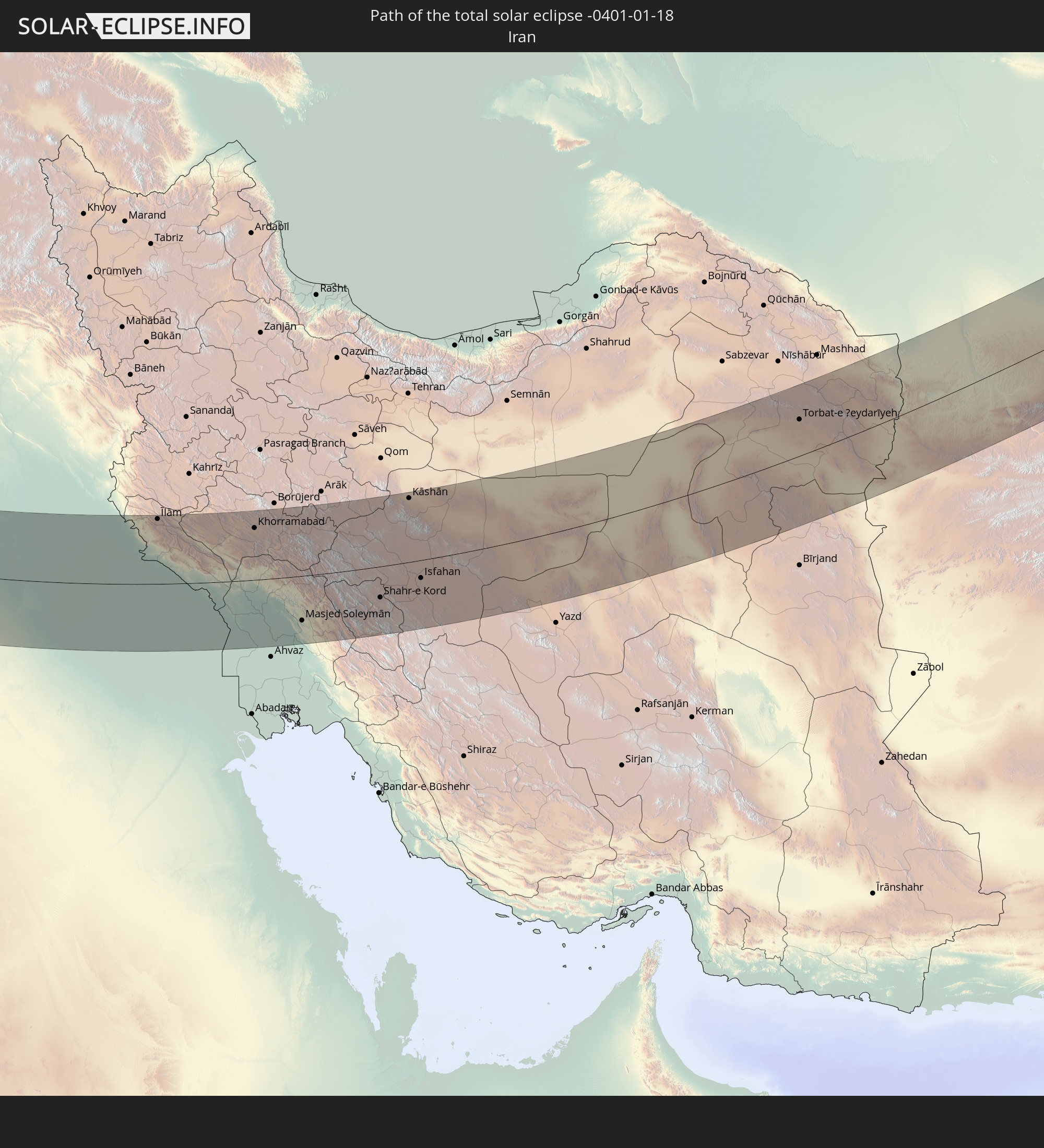
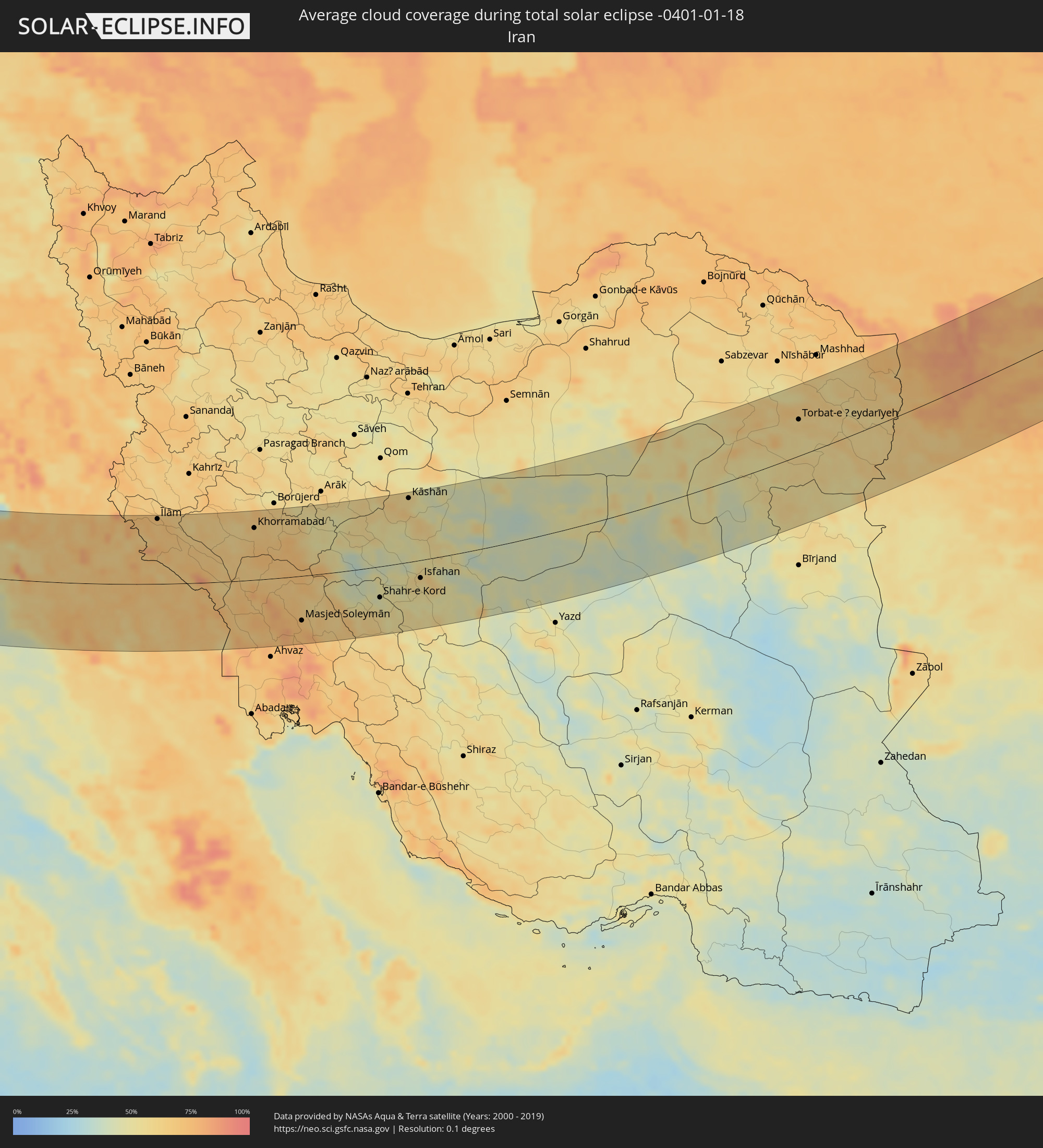 Iran
Iran
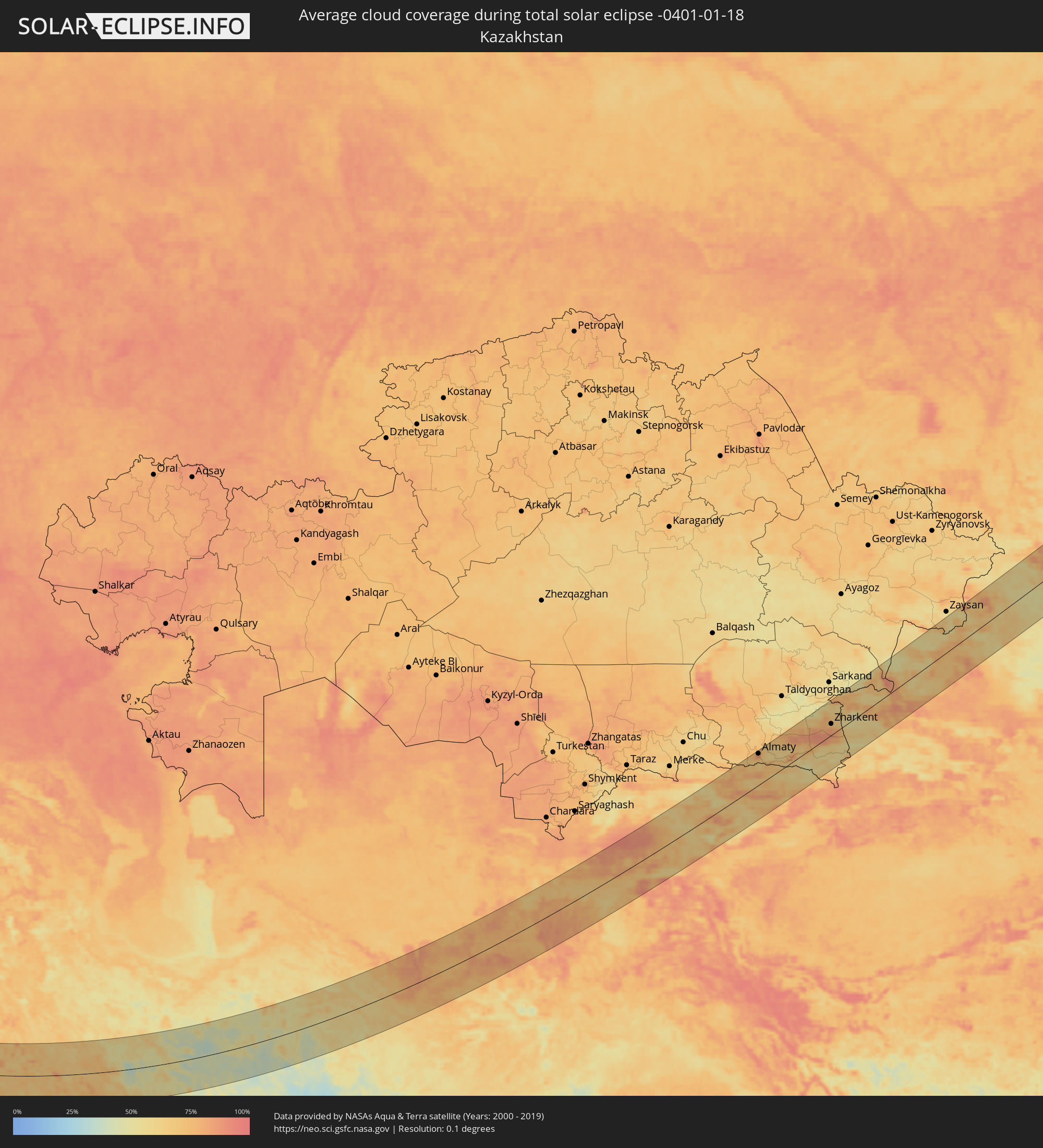 Kasachstan
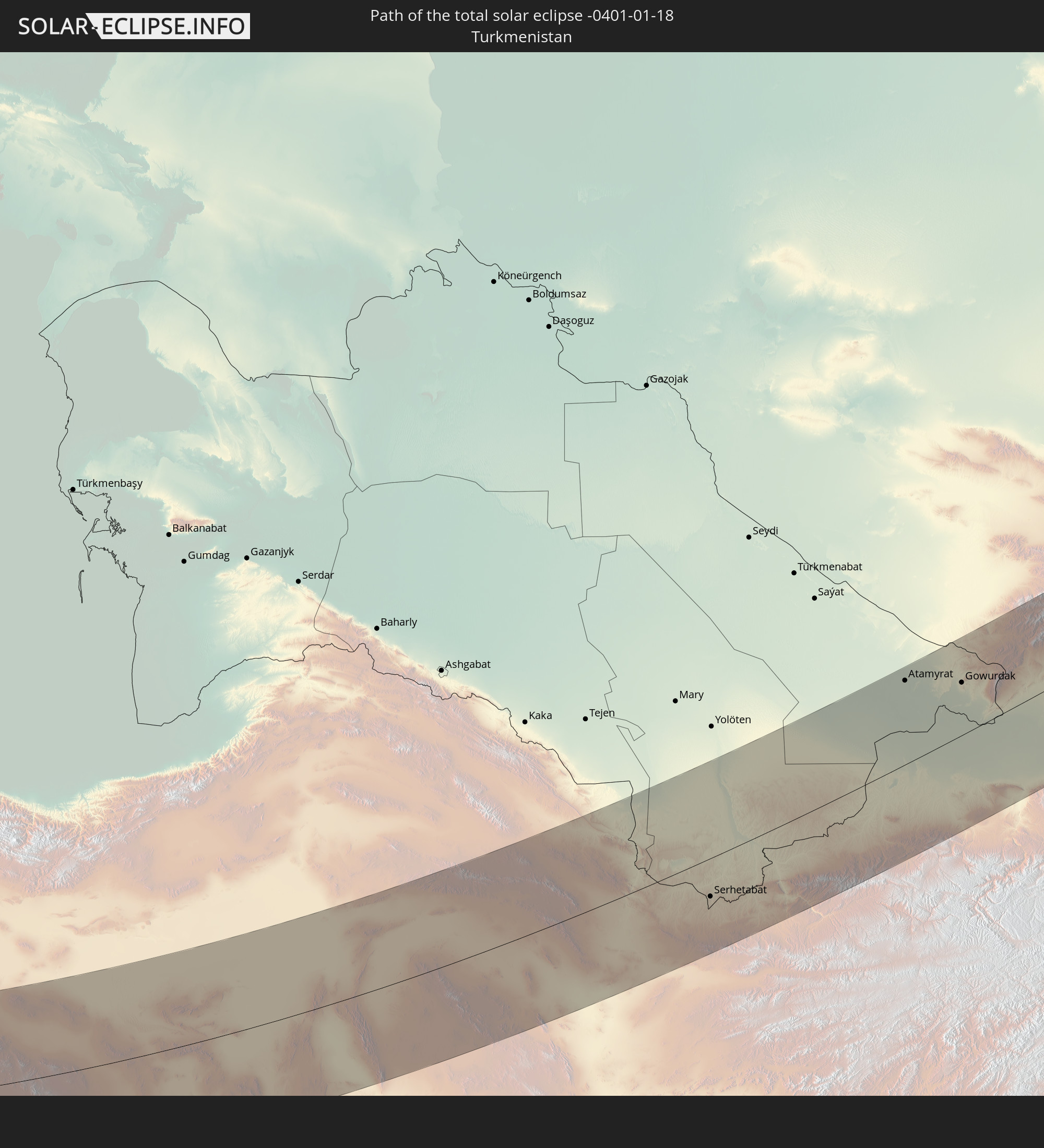
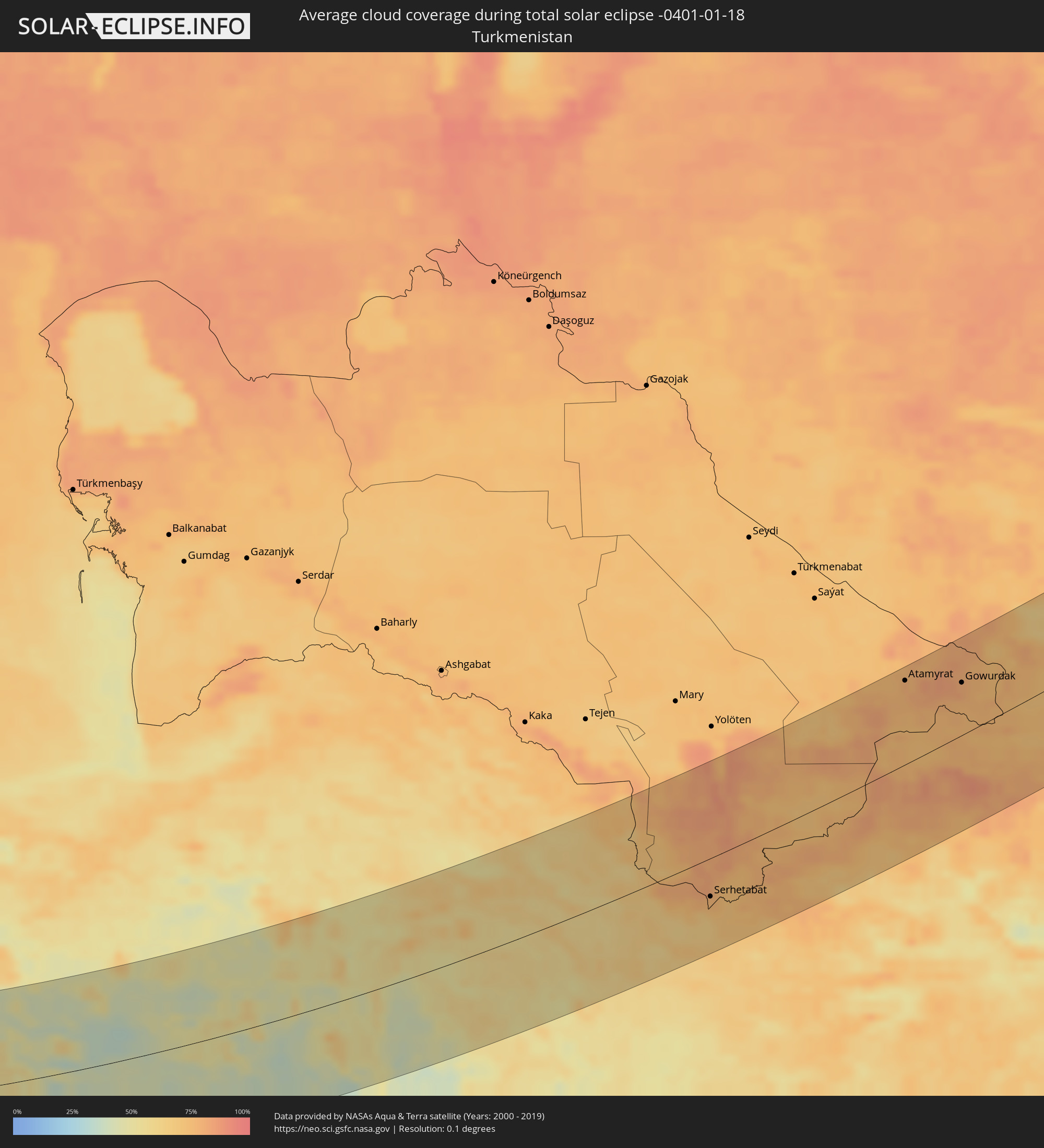 Turkmenistan
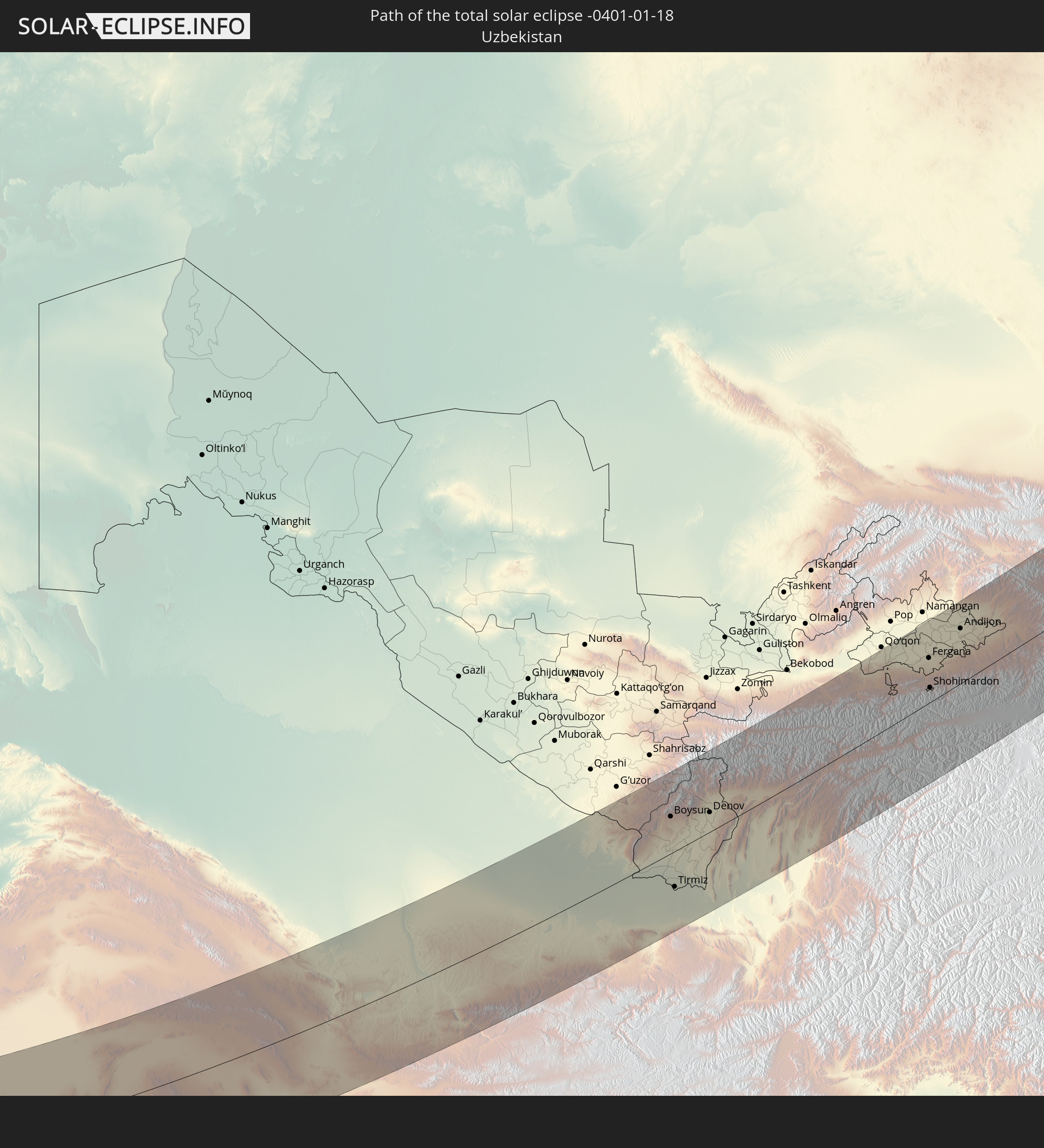
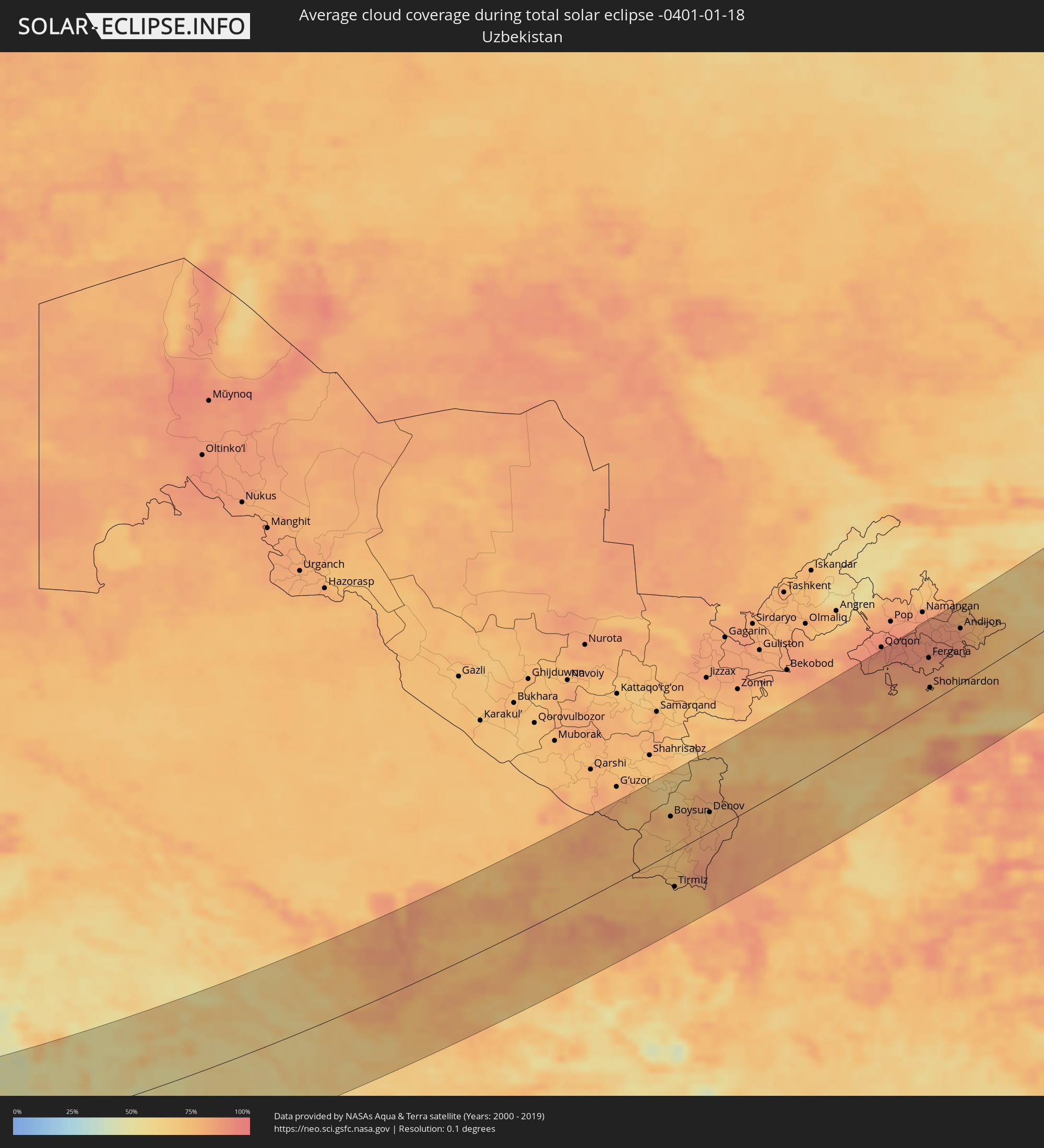 Usbekistan
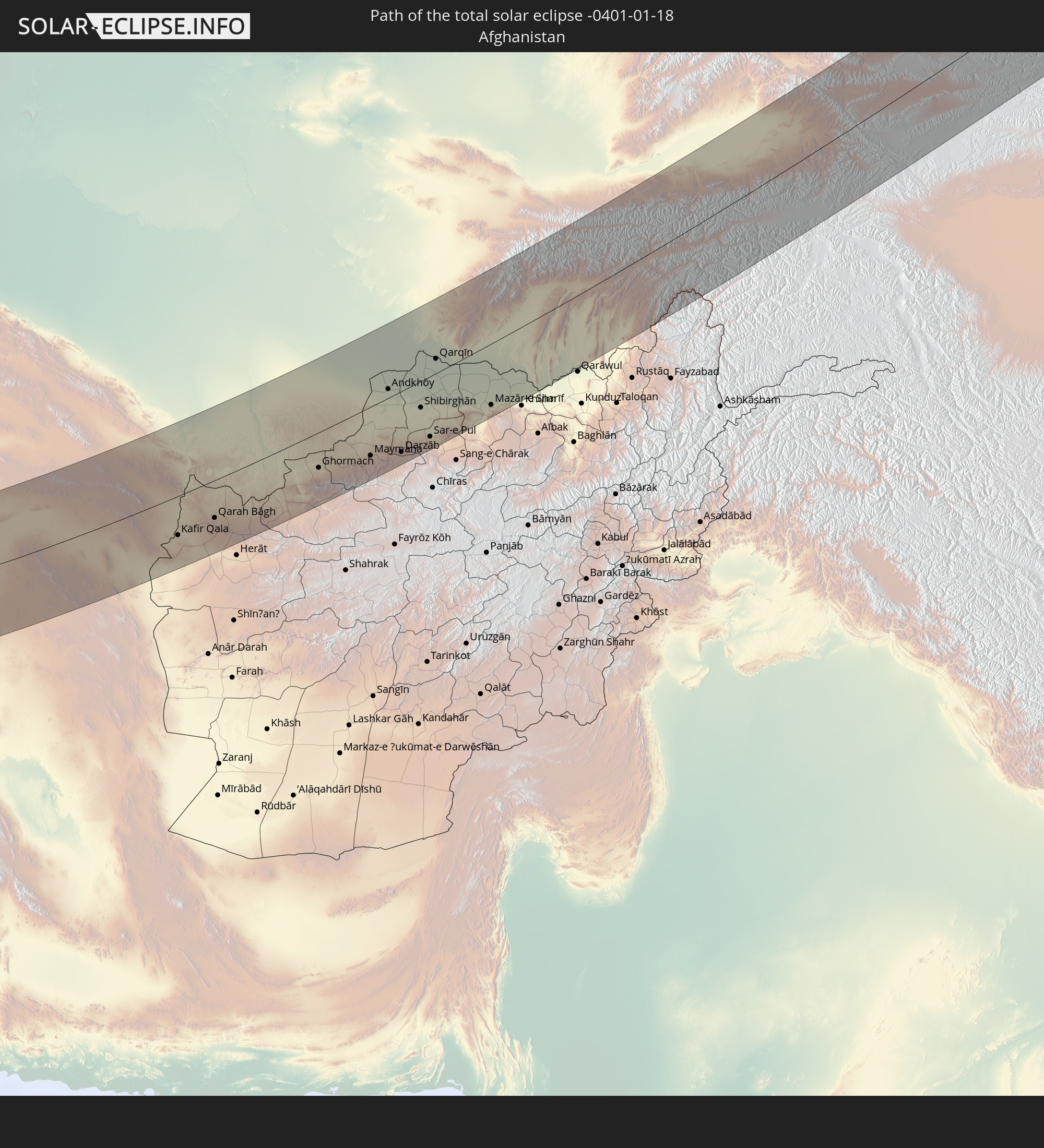
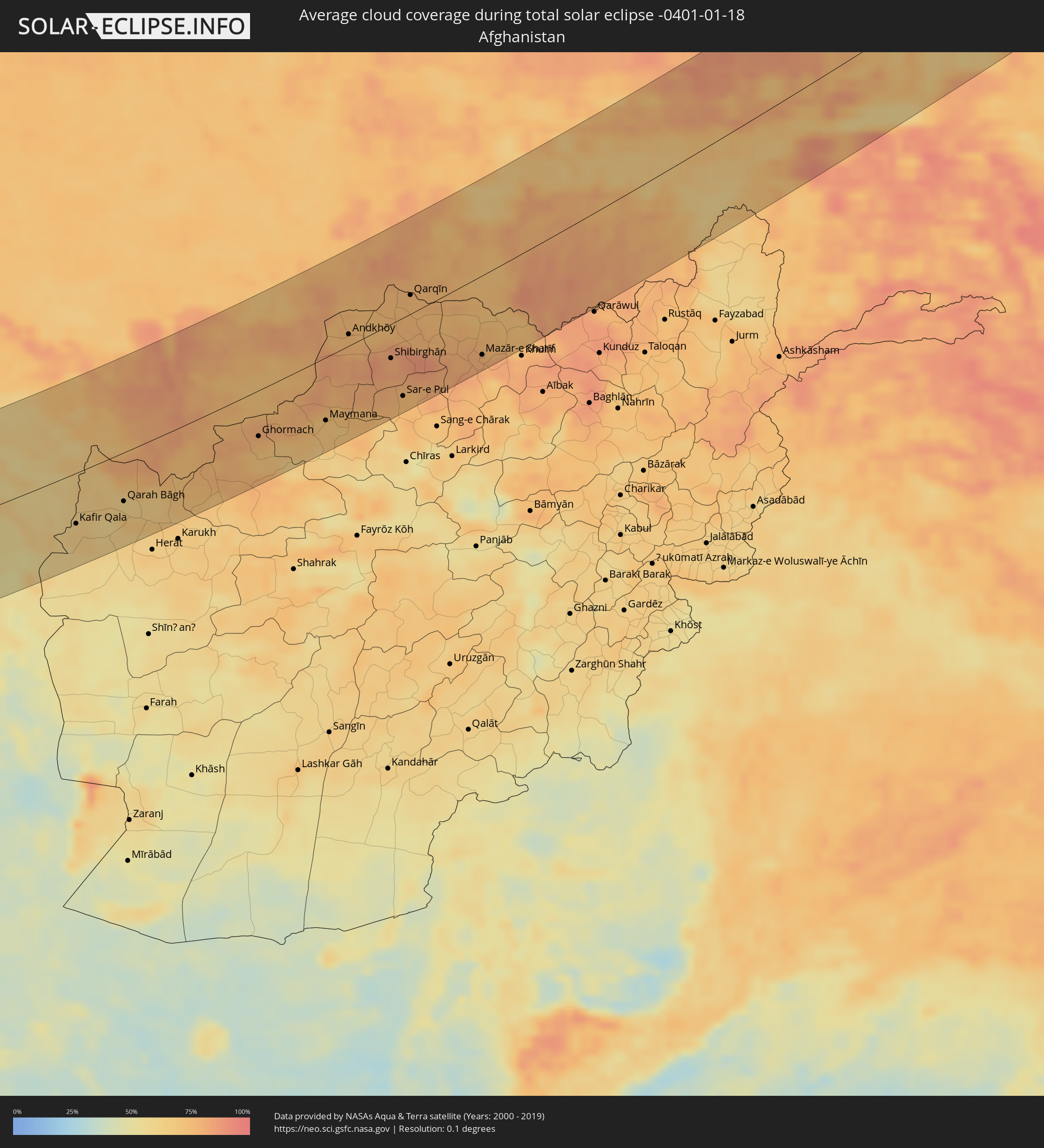 Afghanistan
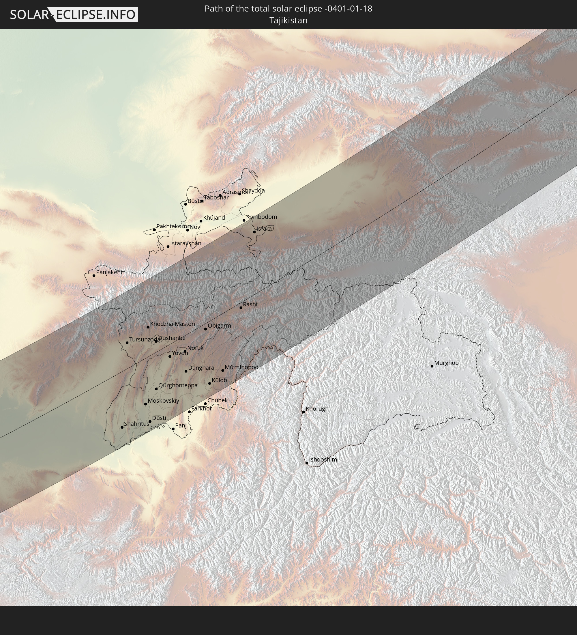
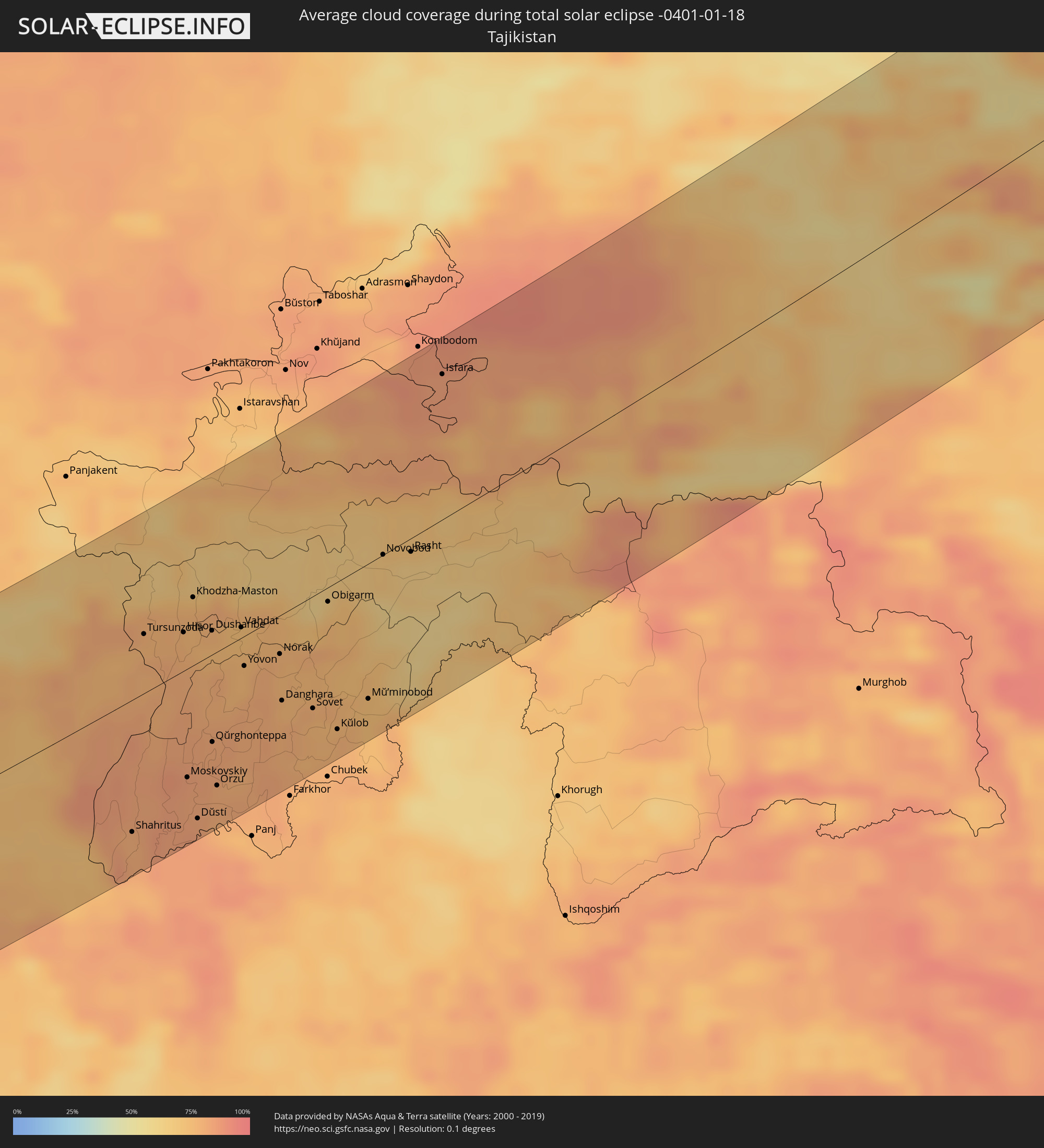 Tadschikistan
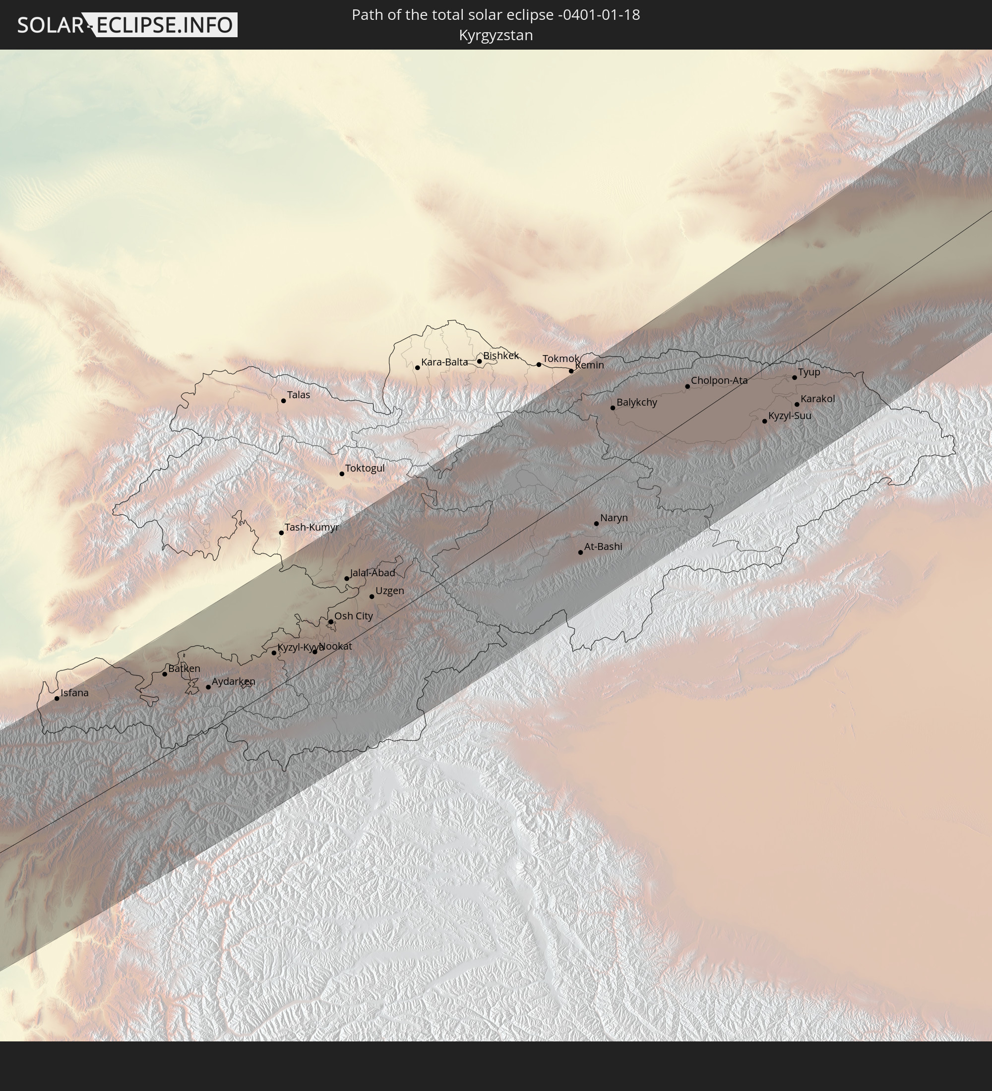
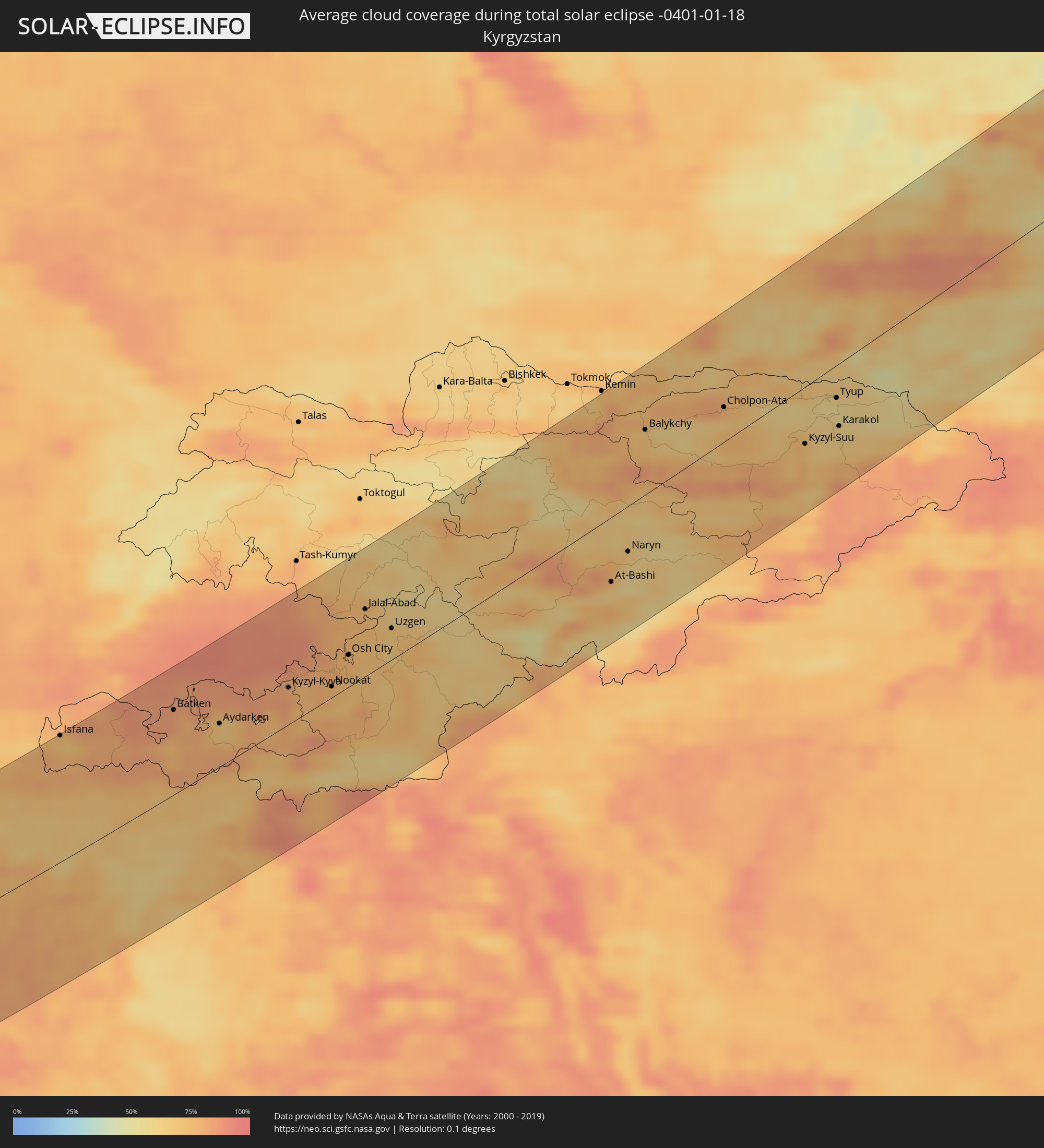 Kirgisistan
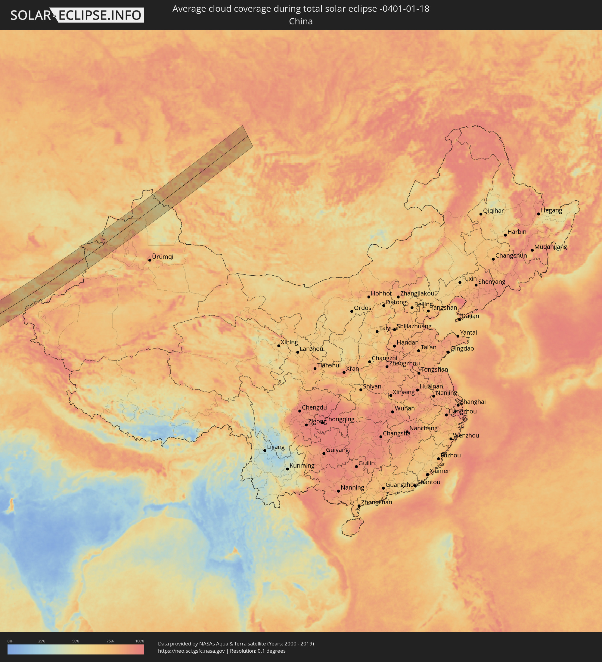 Volksrepublik China
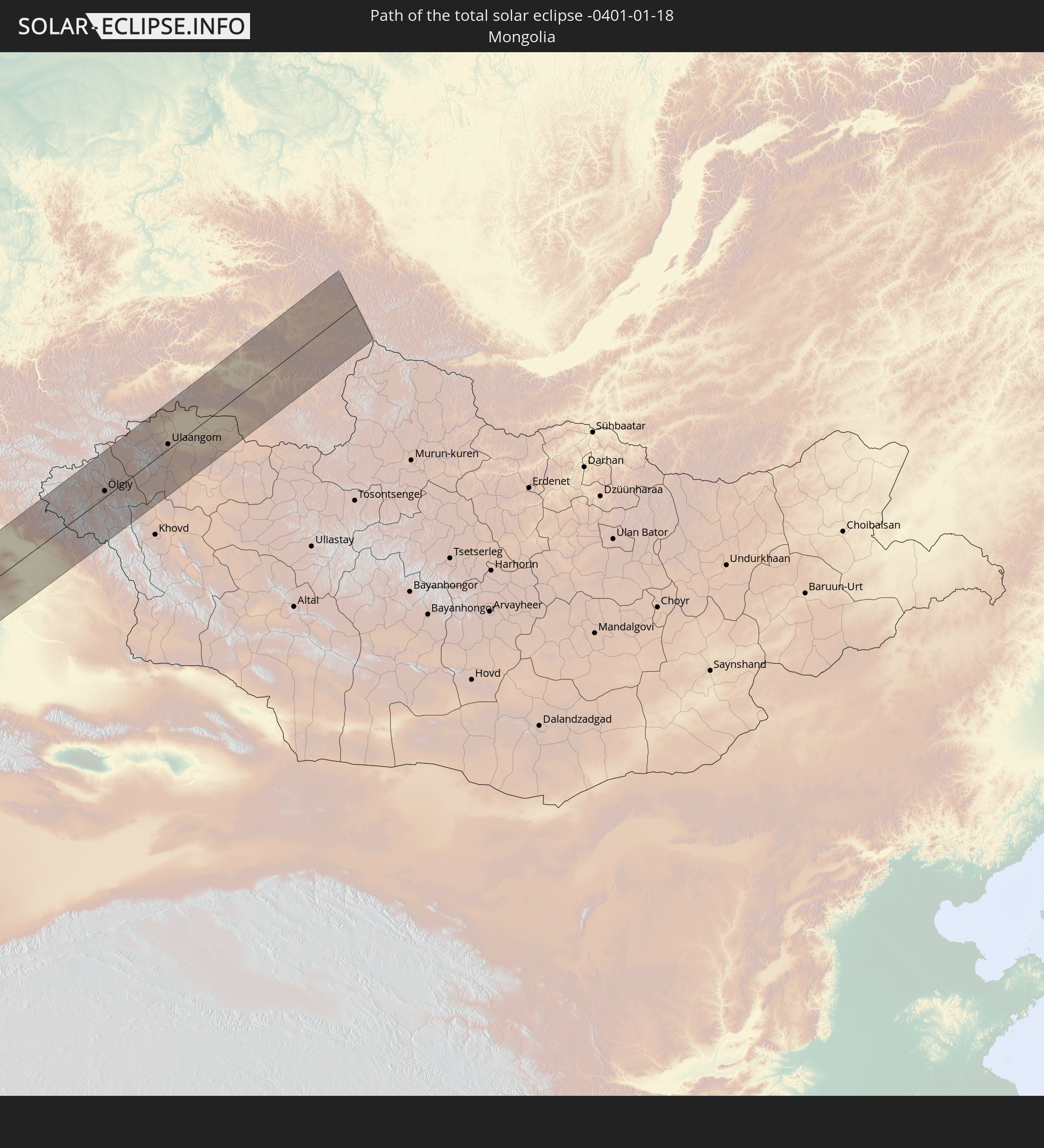
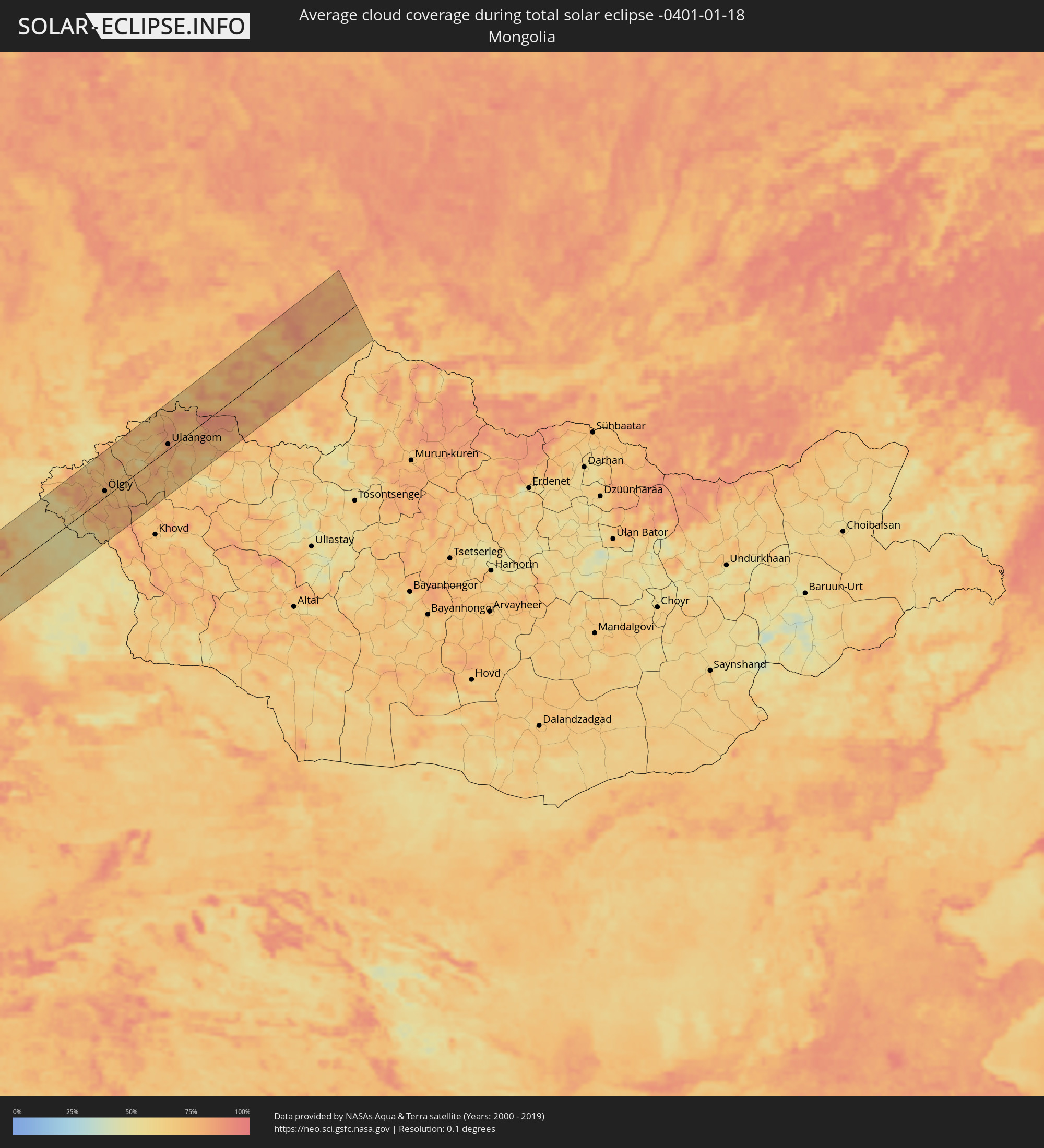 Mongolei
Orte im Finsternispfad
Die nachfolgene Tabelle zeigt Städte und Orte mit mehr als 5.000 Einwohnern, die sich im Finsternispfad befinden. Städte mit mehr als 100.000 Einwohnern sind dick gekennzeichnet. Mit einem Klick auf den Ort öffnet sich eine Detailkarte die die Lage des jeweiligen Ortes zusammen mit dem Verlauf der zentralen Finsternis präsentiert.
| Ort | Typ | Dauer der Verfinsterung | Ortszeit bei maximaler Verfinsterung | Entfernung zur Zentrallinie | Ø Bewölkung |
|
Saint-Étienne, Auvergne-Rhône-Alpes
|
total | - | 07:44:41 UTC+00:09 | 4 km | 83% |
|
Lyon, Auvergne-Rhône-Alpes
|
total | - | 07:45:22 UTC+00:09 | 52 km | 81% |
|
Valence, Auvergne-Rhône-Alpes
|
total | - | 07:44:20 UTC+00:09 | 22 km | 78% |
|
Grenoble, Auvergne-Rhône-Alpes
|
total | - | 07:45:09 UTC+00:09 | 33 km | 78% |
|
Chambéry, Auvergne-Rhône-Alpes
|
total | - | 07:45:48 UTC+00:09 | 80 km | 78% |
|
Gap, Provence-Alpes-Côte d'Azur
|
total | - | 07:44:37 UTC+00:09 | 8 km | 70% |
|
Grasse, Provence-Alpes-Côte d'Azur
|
total | - | 07:44:01 UTC+00:09 | 60 km | 65% |
|
Antibes, Provence-Alpes-Côte d'Azur
|
total | - | 07:44:02 UTC+00:09 | 61 km | 64% |
|
Nice, Provence-Alpes-Côte d'Azur
|
total | - | 07:44:18 UTC+00:09 | 42 km | 62% |
|
Monaco
|
total | - | 07:44:27 UTC+00:09 | 33 km | 63% |
|
La Condamine
|
total | - | 07:44:27 UTC+00:09 | 32 km | 63% |
|
Monte-Carlo
|
total | - | 07:44:28 UTC+00:09 | 32 km | 63% |
|
Bastia, Corsica
|
total | - | 07:44:39 UTC+00:09 | 47 km | 72% |
|
Livorno, Tuscany
|
total | - | 08:37:01 UTC+01:00 | 70 km | 68% |
|
Acilia-Castel Fusano-Ostia Antica, Latium
|
total | - | 08:36:32 UTC+01:00 | 19 km | 68% |
|
Vatican City
|
total | - | 08:36:48 UTC+01:00 | 1 km | 73% |
|
Rome, Latium
|
total | - | 08:36:51 UTC+01:00 | 1 km | 73% |
|
Terni, Umbria
|
total | - | 08:37:46 UTC+01:00 | 71 km | 72% |
|
Naples, Campania
|
total | - | 08:37:13 UTC+01:00 | 29 km | 68% |
|
Salerno, Campania
|
total | - | 08:37:32 UTC+01:00 | 24 km | 71% |
|
Foggia, Apulia
|
total | - | 08:39:12 UTC+01:00 | 83 km | 67% |
|
Andria, Apulia
|
total | - | 08:39:41 UTC+01:00 | 91 km | 63% |
|
Taranto, Apulia
|
total | - | 08:39:46 UTC+01:00 | 50 km | 63% |
|
Lecce, Apulia
|
total | - | 08:40:43 UTC+01:00 | 81 km | 72% |
|
Corfu, Ionian Islands
|
total | - | 09:16:47 UTC+01:34 | 78 km | 63% |
|
Agrínio, West Greece
|
total | - | 09:17:34 UTC+01:34 | 37 km | 63% |
|
Pátra, West Greece
|
total | - | 09:17:35 UTC+01:34 | 12 km | 64% |
|
Kalamáta, Peloponnese
|
total | - | 09:16:51 UTC+01:34 | 95 km | 62% |
|
Trípoli, Peloponnese
|
total | - | 09:17:41 UTC+01:34 | 37 km | 68% |
|
Kórinthos, Peloponnese
|
total | - | 09:18:53 UTC+01:34 | 28 km | 56% |
|
Salamína, Attica
|
total | - | 09:19:39 UTC+01:34 | 51 km | 57% |
|
Athens, Attica
|
total | - | 09:19:58 UTC+01:34 | 60 km | 66% |
|
Voúla, Attica
|
total | - | 09:19:54 UTC+01:34 | 49 km | 60% |
|
Turgutreis, Muğla
|
total | - | 09:46:18 UTC+01:56 | 91 km | 66% |
|
Bodrum, Muğla
|
total | - | 09:46:35 UTC+01:56 | 99 km | 65% |
|
Datça, Muğla
|
total | - | 09:46:42 UTC+01:56 | 77 km | 65% |
|
Ródos, South Aegean
|
total | - | 09:25:13 UTC+01:34 | 65 km | 66% |
|
Kaş, Antalya
|
total | - | 09:49:24 UTC+01:56 | 87 km | 60% |
|
Demre, Antalya
|
total | - | 09:50:01 UTC+01:56 | 104 km | 66% |
|
Demre, Antalya
|
total | - | 09:50:01 UTC+01:56 | 103 km | 55% |
|
Paphos, Pafos
|
total | - | 10:09:38 UTC+02:13 | 24 km | 63% |
|
Léfka, Nicosia
|
total | - | 10:10:41 UTC+02:13 | 72 km | 55% |
|
Mórfou, Nicosia
|
total | - | 10:11:01 UTC+02:13 | 85 km | 66% |
|
Limassol, Limassol
|
total | - | 10:10:41 UTC+02:13 | 32 km | 64% |
|
Kyrenia, Keryneia
|
total | - | 10:11:43 UTC+02:13 | 108 km | 75% |
|
Nicosia, Nicosia
|
total | - | 10:11:41 UTC+02:13 | 93 km | 76% |
|
Larnaca, Larnaka
|
total | - | 10:11:58 UTC+02:13 | 73 km | 66% |
|
Pérgamos, Larnaka
|
total | - | 10:12:13 UTC+02:13 | 88 km | 66% |
|
Famagusta, Ammochostos
|
total | - | 10:12:43 UTC+02:13 | 103 km | 71% |
|
Protaras, Ammochostos
|
total | - | 10:12:52 UTC+02:13 | 94 km | 53% |
|
Nahariya, Northern District
|
total | - | 10:20:35 UTC+02:20 | 93 km | 61% |
|
Qiryat Ata, Haifa
|
total | - | 10:20:29 UTC+02:20 | 114 km | 69% |
|
En Nâqoûra, South Governorate
|
total | - | 10:00:05 UTC+02:00 | 81 km | 63% |
|
Kafir Yasif, Northern District
|
total | - | 10:20:41 UTC+02:20 | 98 km | 71% |
|
Tyre, South Governorate
|
total | - | 10:00:18 UTC+02:00 | 63 km | 65% |
|
Kābūl, Northern District
|
total | - | 10:20:43 UTC+02:20 | 106 km | 69% |
|
Karmi’el, Northern District
|
total | - | 10:20:56 UTC+02:20 | 98 km | 70% |
|
Deir Ḥannā, Northern District
|
total | - | 10:21:01 UTC+02:20 | 103 km | 67% |
|
Bu‘eina, Northern District
|
total | - | 10:20:59 UTC+02:20 | 109 km | 65% |
|
Sidon, South Governorate
|
total | - | 10:00:53 UTC+02:00 | 27 km | 66% |
|
Nabatîyé et Tahta, Nabatîyé
|
total | - | 10:00:58 UTC+02:00 | 44 km | 72% |
|
Beirut, Beyrouth
|
total | - | 10:01:21 UTC+02:00 | 11 km | 64% |
|
Safed, Northern District
|
total | - | 10:21:21 UTC+02:20 | 89 km | 70% |
|
Tiberias, Northern District
|
total | - | 10:21:18 UTC+02:20 | 106 km | 61% |
|
Qiryat Shemona, Northern District
|
total | - | 10:21:41 UTC+02:20 | 61 km | 64% |
|
Djounie, Mont-Liban
|
total | - | 10:01:40 UTC+02:00 | 24 km | 63% |
|
Jbaïl, Mont-Liban
|
total | - | 10:01:50 UTC+02:00 | 39 km | 61% |
|
Malkā, Irbid
|
total | - | 10:24:44 UTC+02:23 | 114 km | 70% |
|
Saḩam al Kaffārāt, Irbid
|
total | - | 10:24:48 UTC+02:23 | 111 km | 69% |
|
Kafr Sawm, Irbid
|
total | - | 10:24:50 UTC+02:23 | 112 km | 69% |
|
Al Qunayţirah, Quneitra
|
total | - | 10:26:40 UTC+02:25 | 64 km | 69% |
|
Tripoli, Liban-Nord
|
total | - | 10:02:27 UTC+02:00 | 78 km | 65% |
|
Kharjā, Irbid
|
total | - | 10:25:00 UTC+02:23 | 113 km | 66% |
|
Zahlé, Béqaa
|
total | - | 10:02:08 UTC+02:00 | 16 km | 68% |
|
Ash Shajarah, Irbid
|
total | - | 10:25:06 UTC+02:23 | 113 km | 65% |
|
Aţ Ţurrah, Irbid
|
total | - | 10:25:11 UTC+02:23 | 113 km | 69% |
|
Jāsim, Daraa
|
total | - | 10:27:03 UTC+02:25 | 73 km | 68% |
|
Dar‘ā, Daraa
|
total | - | 10:26:52 UTC+02:25 | 112 km | 69% |
|
Baalbek, Baalbek-Hermel
|
total | - | 10:02:53 UTC+02:00 | 40 km | 68% |
|
Tallkalakh, Homs
|
total | - | 10:28:39 UTC+02:25 | 113 km | 69% |
|
Damascus, Dimashq
|
total | - | 10:27:53 UTC+02:25 | 12 km | 70% |
|
As Suwaydā’, As-Suwayda
|
total | - | 10:27:54 UTC+02:25 | 92 km | 66% |
|
Al Quşayr, Homs
|
total | - | 10:29:10 UTC+02:25 | 103 km | 73% |
|
An Nabk, Rif-dimashq
|
total | - | 10:29:08 UTC+02:25 | 54 km | 70% |
|
Jayrūd, Rif-dimashq
|
total | - | 10:29:00 UTC+02:25 | 31 km | 69% |
|
Al Qaryatayn, Homs
|
total | - | 10:30:20 UTC+02:25 | 87 km | 64% |
|
Ramadi, Anbar
|
total | - | 11:15:27 UTC+02:57 | 87 km | 64% |
|
Al Fallūjah, Anbar
|
total | - | 11:16:31 UTC+02:57 | 82 km | 70% |
|
Karbala, Karbalāʼ
|
total | - | 11:16:42 UTC+02:57 | 2 km | 64% |
|
Abū Ghurayb, Mayorality of Baghdad
|
total | - | 11:17:25 UTC+02:57 | 80 km | 67% |
|
Najaf, An Najaf
|
total | - | 11:17:10 UTC+02:57 | 62 km | 70% |
|
Baghdad, Mayorality of Baghdad
|
total | - | 11:17:56 UTC+02:57 | 84 km | 63% |
|
Al Ḩillah, Bābil
|
total | - | 11:17:33 UTC+02:57 | 13 km | 69% |
|
Ad Dīwānīyah, Al Qādisīyah
|
total | - | 11:18:31 UTC+02:57 | 64 km | 71% |
|
Al Kūt, Wāsiţ
|
total | - | 11:20:52 UTC+02:57 | 4 km | 74% |
|
Īlām, Īlām
|
total | - | 11:50:55 UTC+03:25 | 121 km | 67% |
|
Al ‘Amārah, Maysan
|
total | - | 11:23:45 UTC+02:57 | 81 km | 68% |
|
Kūhdasht, Lorestān
|
total | - | 11:53:41 UTC+03:25 | 106 km | 63% |
|
Khorramabad, Lorestān
|
total | - | 11:55:26 UTC+03:25 | 96 km | 65% |
|
Masjed Soleymān, Khuzestan
|
total | - | 11:57:10 UTC+03:25 | 83 km | 74% |
|
Shahr-e Kord, Chahār Maḩāll va Bakhtīārī
|
total | - | 12:01:05 UTC+03:25 | 57 km | 47% |
|
Najafābād, Isfahan
|
total | - | 12:02:24 UTC+03:25 | 30 km | 55% |
|
Kāshān, Isfahan
|
total | - | 12:02:55 UTC+03:25 | 117 km | 58% |
|
Isfahan, Isfahan
|
total | - | 12:03:08 UTC+03:25 | 33 km | 59% |
|
Shāhreẕā, Isfahan
|
total | - | 12:03:29 UTC+03:25 | 104 km | 57% |
|
Torbat-e Ḩeydarīyeh, Razavi Khorasan
|
total | - | 12:21:03 UTC+03:25 | 62 km | 61% |
|
Kafir Qala, Herat
|
total | - | 12:59:24 UTC+04:00 | 63 km | 62% |
|
Qarah Bāgh, Herat
|
total | - | 13:00:55 UTC+04:00 | 61 km | 64% |
|
Serhetabat, Mary
|
total | - | 12:55:37 UTC+03:53 | 47 km | 76% |
|
Ghormach, Badghis
|
total | - | 13:05:02 UTC+04:00 | 55 km | 74% |
|
Maymana, Faryab
|
total | - | 13:07:02 UTC+04:00 | 75 km | 70% |
|
Andkhōy, Faryab
|
total | - | 13:07:28 UTC+04:00 | 14 km | 76% |
|
Atamyrat, Lebap
|
total | - | 13:00:56 UTC+03:53 | 97 km | 77% |
|
Shibirghān, Jowzjan
|
total | - | 13:08:47 UTC+04:00 | 40 km | 79% |
|
Sar-e Pul, Sar-e Pol
|
total | - | 13:09:15 UTC+04:00 | 92 km | 74% |
|
Qarqīn, Jowzjan
|
total | - | 13:09:08 UTC+04:00 | 22 km | 75% |
|
Gowurdak, Lebap
|
total | - | 13:02:34 UTC+03:53 | 60 km | 81% |
|
Balkh, Balkh
|
total | - | 13:10:58 UTC+04:00 | 79 km | 79% |
|
Mazār-e Sharīf, Balkh
|
total | - | 13:11:23 UTC+04:00 | 92 km | 80% |
|
Tirmiz, Surxondaryo
|
total | - | 13:39:26 UTC+04:27 | 49 km | 72% |
|
Denov, Surxondaryo
|
total | - | 13:40:14 UTC+04:27 | 27 km | 76% |
|
Tursunzoda, Republican Subordination
|
total | - | 13:48:04 UTC+04:35 | 36 km | 77% |
|
Hisor, Republican Subordination
|
total | - | 13:48:38 UTC+04:35 | 23 km | 77% |
|
Moskovskiy, Khatlon
|
total | - | 13:49:02 UTC+04:35 | 67 km | 83% |
|
Dushanbe, Dushanbe
|
total | - | 13:49:03 UTC+04:35 | 15 km | 75% |
|
Qŭrghonteppa, Khatlon
|
total | - | 13:49:19 UTC+04:35 | 53 km | 82% |
|
Vahdat, Republican Subordination
|
total | - | 13:49:27 UTC+04:35 | 6 km | 74% |
|
Danghara, Khatlon
|
total | - | 13:50:13 UTC+04:35 | 52 km | 77% |
|
Vose’, Khatlon
|
total | - | 13:50:52 UTC+04:35 | 94 km | 77% |
|
Kŭlob, Khatlon
|
total | - | 13:51:05 UTC+04:35 | 89 km | 78% |
|
Isfara, Viloyati Sughd
|
total | - | 13:51:33 UTC+04:35 | 85 km | 85% |
|
Oltiariq, Fergana
|
total | - | 13:45:31 UTC+04:27 | 72 km | 90% |
|
Fergana, Fergana
|
total | - | 13:46:02 UTC+04:27 | 58 km | 86% |
|
Quvasoy, Fergana
|
total | - | 13:46:23 UTC+04:27 | 41 km | 83% |
|
Quva, Fergana
|
total | - | 13:46:25 UTC+04:27 | 58 km | 88% |
|
Haqqulobod, Namangan
|
total | - | 13:46:17 UTC+04:27 | 93 km | 87% |
|
Kyzyl-Kyya, Batken
|
total | - | 14:17:10 UTC+04:58 | 30 km | 82% |
|
Asaka, Andijon
|
total | - | 13:46:37 UTC+04:27 | 62 km | 88% |
|
Andijon, Andijon
|
total | - | 13:46:43 UTC+04:27 | 70 km | 88% |
|
Bazar-Korgon, Jalal-Abad
|
total | - | 14:17:44 UTC+04:58 | 76 km | 77% |
|
Qo‘rg‘ontepa, Andijon
|
total | - | 13:47:25 UTC+04:27 | 46 km | 76% |
|
Osh City, Osh City
|
total | - | 14:18:06 UTC+04:58 | 26 km | 76% |
|
Kara Suu, Osh
|
total | - | 14:18:06 UTC+04:58 | 39 km | 73% |
|
Jalal-Abad, Jalal-Abad
|
total | - | 14:18:11 UTC+04:58 | 54 km | 76% |
|
Uzgen, Osh
|
total | - | 14:18:45 UTC+04:58 | 25 km | 70% |
|
Naryn, Naryn
|
total | - | 14:22:23 UTC+04:58 | 36 km | 66% |
|
Balykchy, Issyk-Kul Region
|
total | - | 14:22:00 UTC+04:58 | 51 km | 69% |
|
Almaty, Almaty Qalasy
|
total | - | 13:45:57 UTC+04:21 | 90 km | 83% |
|
Pervomayskiy, Almaty Oblysy
|
total | - | 13:45:53 UTC+04:21 | 100 km | 81% |
|
Cholpon-Ata, Issyk-Kul Region
|
total | - | 14:23:07 UTC+04:58 | 27 km | 66% |
|
Talghar, Almaty Oblysy
|
total | - | 13:46:20 UTC+04:21 | 80 km | 64% |
|
Esik, Almaty Oblysy
|
total | - | 13:46:35 UTC+04:21 | 75 km | 62% |
|
Turgen, Almaty Oblysy
|
total | - | 13:46:45 UTC+04:21 | 72 km | 62% |
|
Karakol, Issyk-Kul Region
|
total | - | 14:25:00 UTC+04:58 | 48 km | 61% |
|
Kegen, Almaty Oblysy
|
total | - | 13:49:09 UTC+04:21 | 38 km | 56% |
|
Zharkent, Almaty Oblysy
|
total | - | 13:49:16 UTC+04:21 | 31 km | 77% |
|
Baijiantan, Xinjiang Uyghur Autonomous Region
|
total | - | 17:31:55 UTC+08:00 | 65 km | 76% |
|
Hoxtolgay, Xinjiang Uyghur Autonomous Region
|
total | - | 17:32:02 UTC+08:00 | 30 km | 63% |
|
Altay, Xinjiang Uyghur Autonomous Region
|
total | - | 17:32:46 UTC+08:00 | 7 km | 54% |
|
Ölgiy, Bayan-Ölgiy
|
total | - | 15:39:48 UTC+06:06 | 12 km | 74% |
|
Ulaangom, Uvs
|
total | - | 15:40:24 UTC+06:06 | 10 km | 85% |
|
Kyzyl, Tyva
|
total | - | 15:45:00 UTC+06:11 | 60 km | 82% |
|
Kaa-Khem, Tyva
|
total | - | 15:45:13 UTC+06:11 | 46 km | 78% |