Totale Sonnenfinsternis vom 30.04.-0462
| Wochentag: | Freitag |
| Maximale Dauer der Verfinsterung: | 05m13s |
| Maximale Breite des Finsternispfades: | 218 km |
| Saroszyklus: | 50 |
| Bedeckungsgrad: | 100% |
| Magnitude: | 1.0624 |
| Gamma: | 0.3529 |
Wo kann man die Sonnenfinsternis vom 30.04.-0462 sehen?
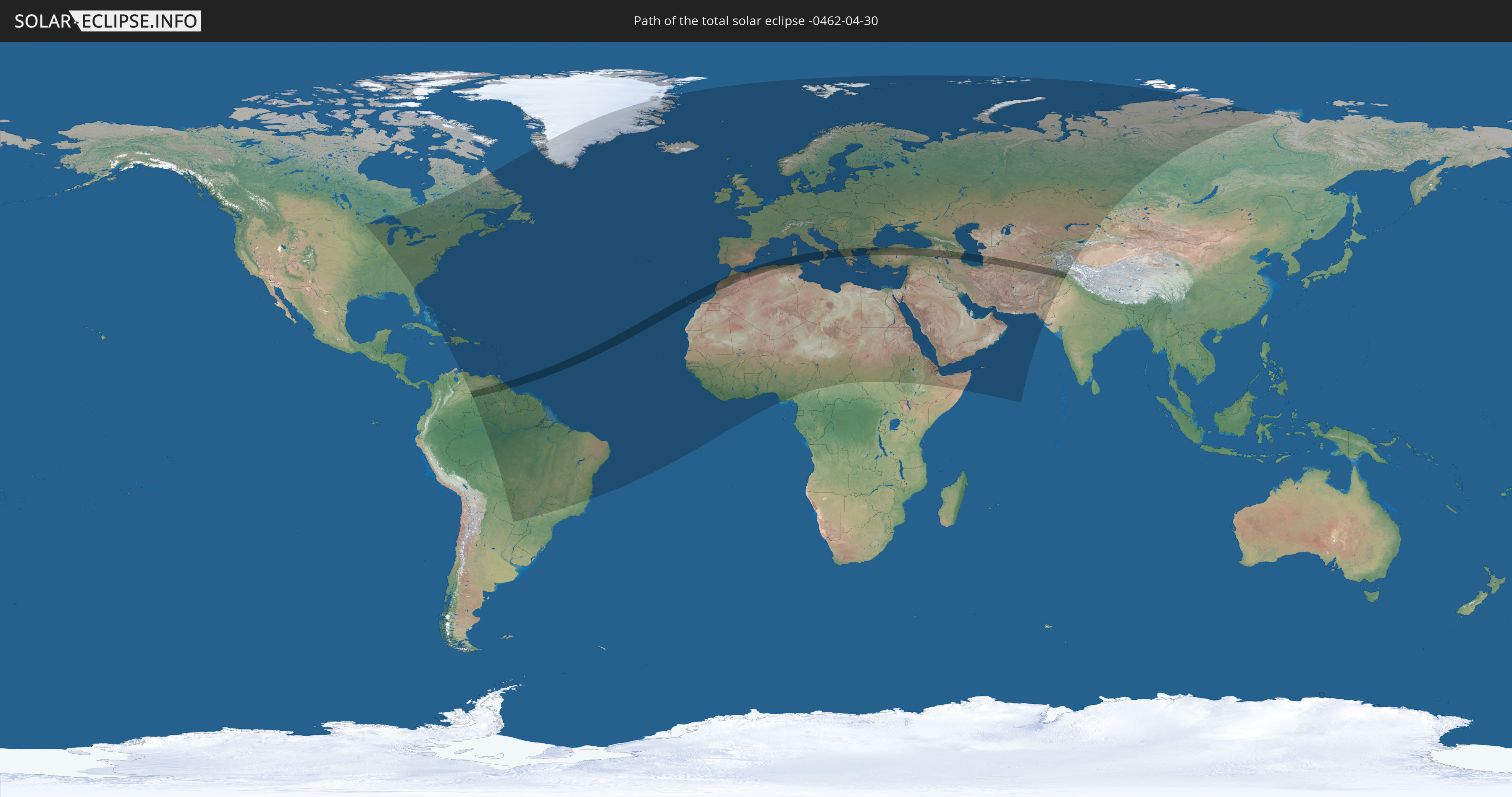
Die Sonnenfinsternis am 30.04.-0462 kann man in 144 Ländern als partielle Sonnenfinsternis beobachten.
Der Finsternispfad verläuft durch 18 Länder. Nur in diesen Ländern ist sie als totale Sonnenfinsternis zu sehen.
In den folgenden Ländern ist die Sonnenfinsternis total zu sehen
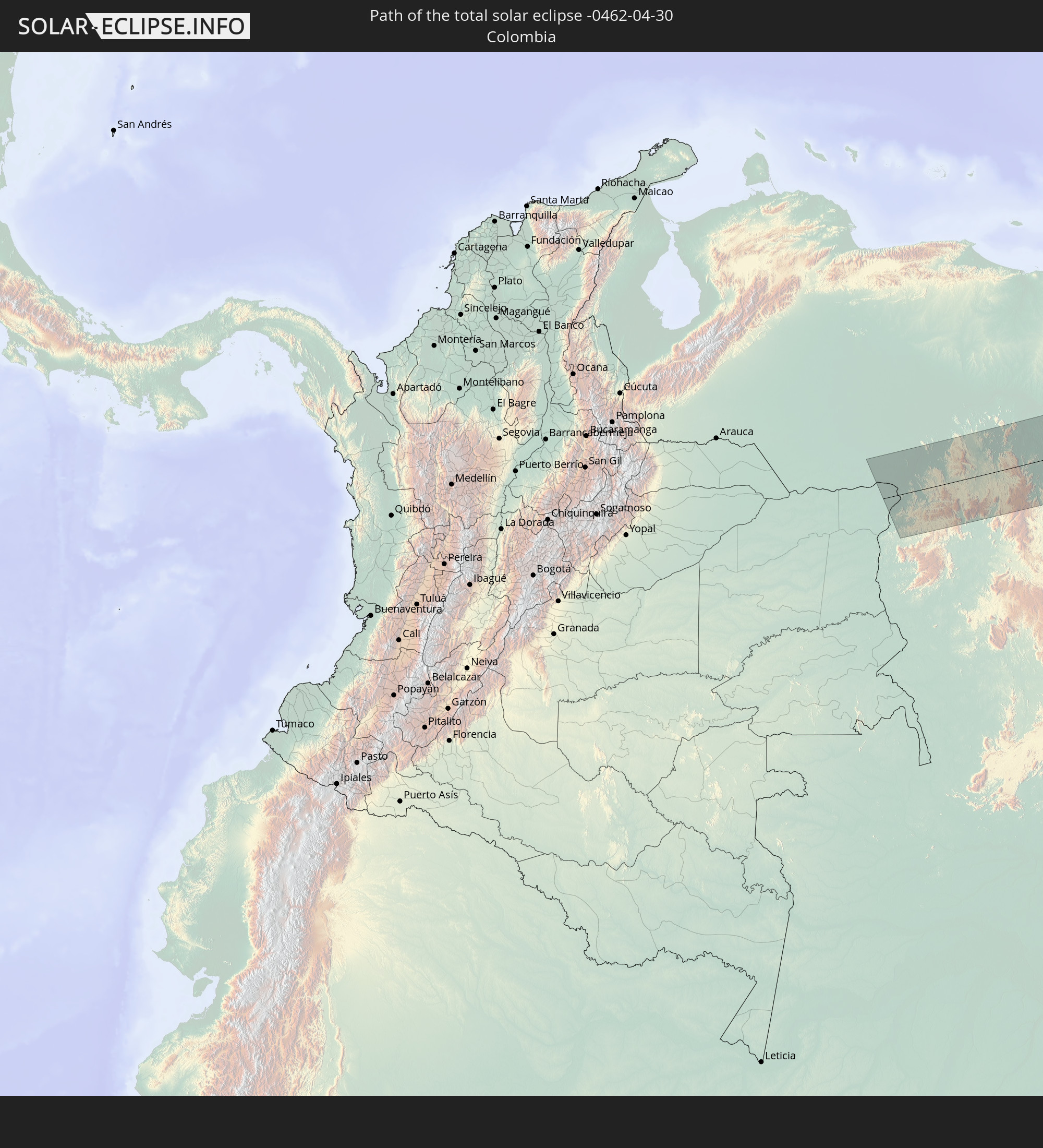 Kolumbien
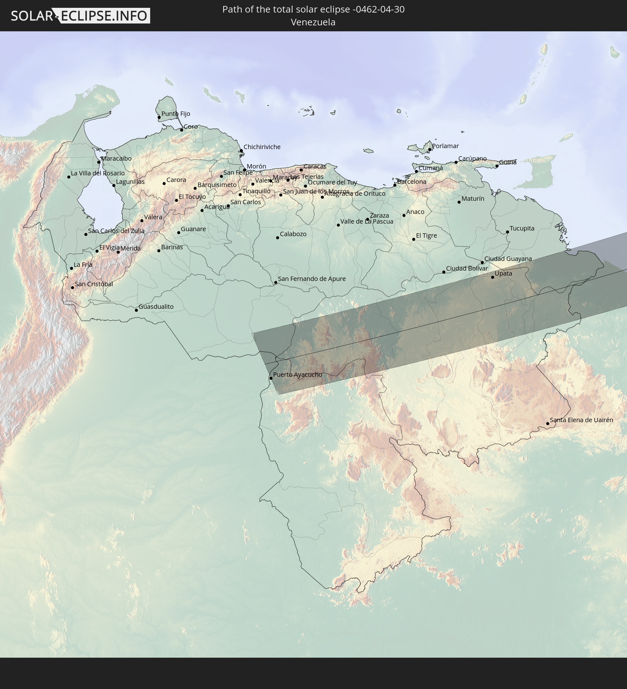 Venezuela
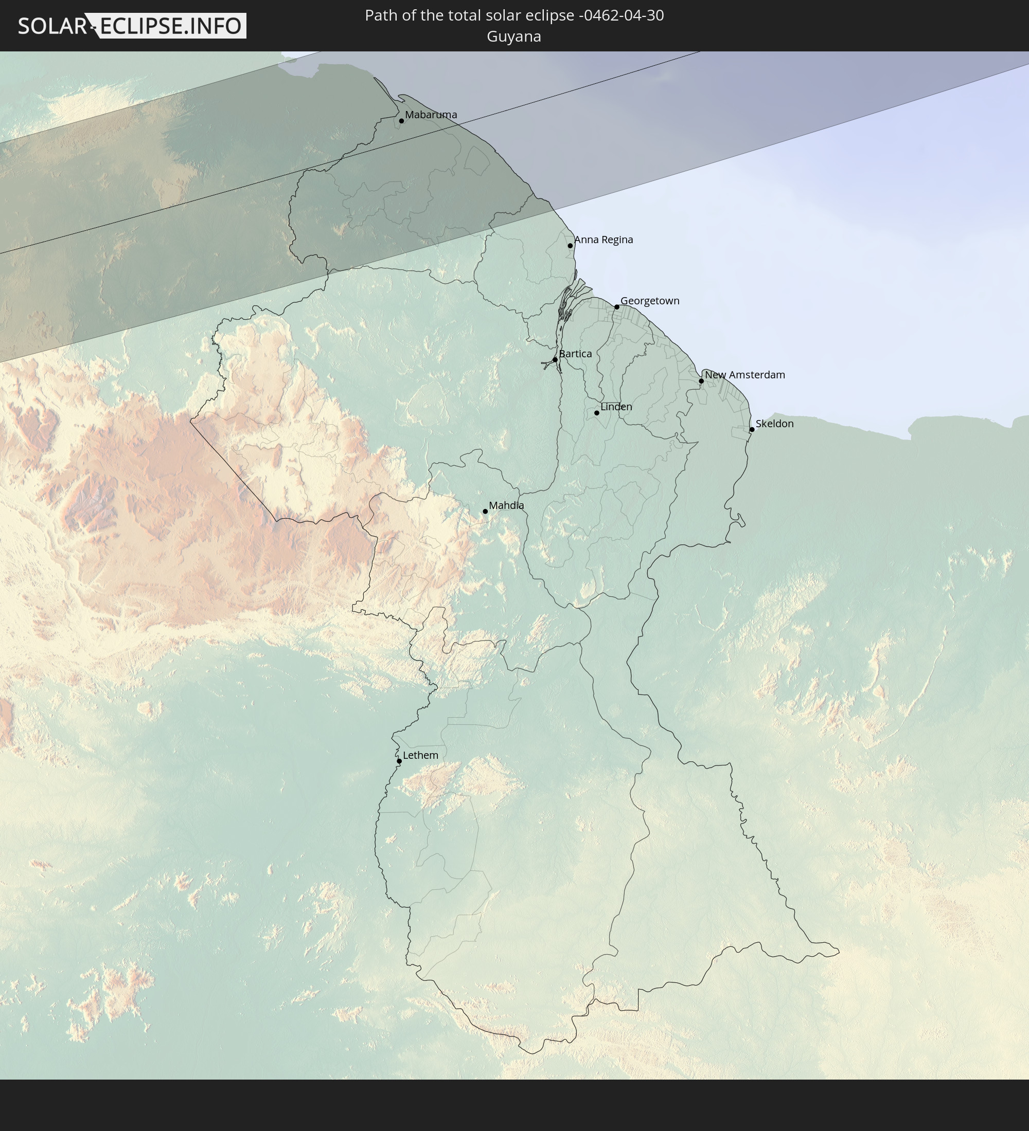 Guyana
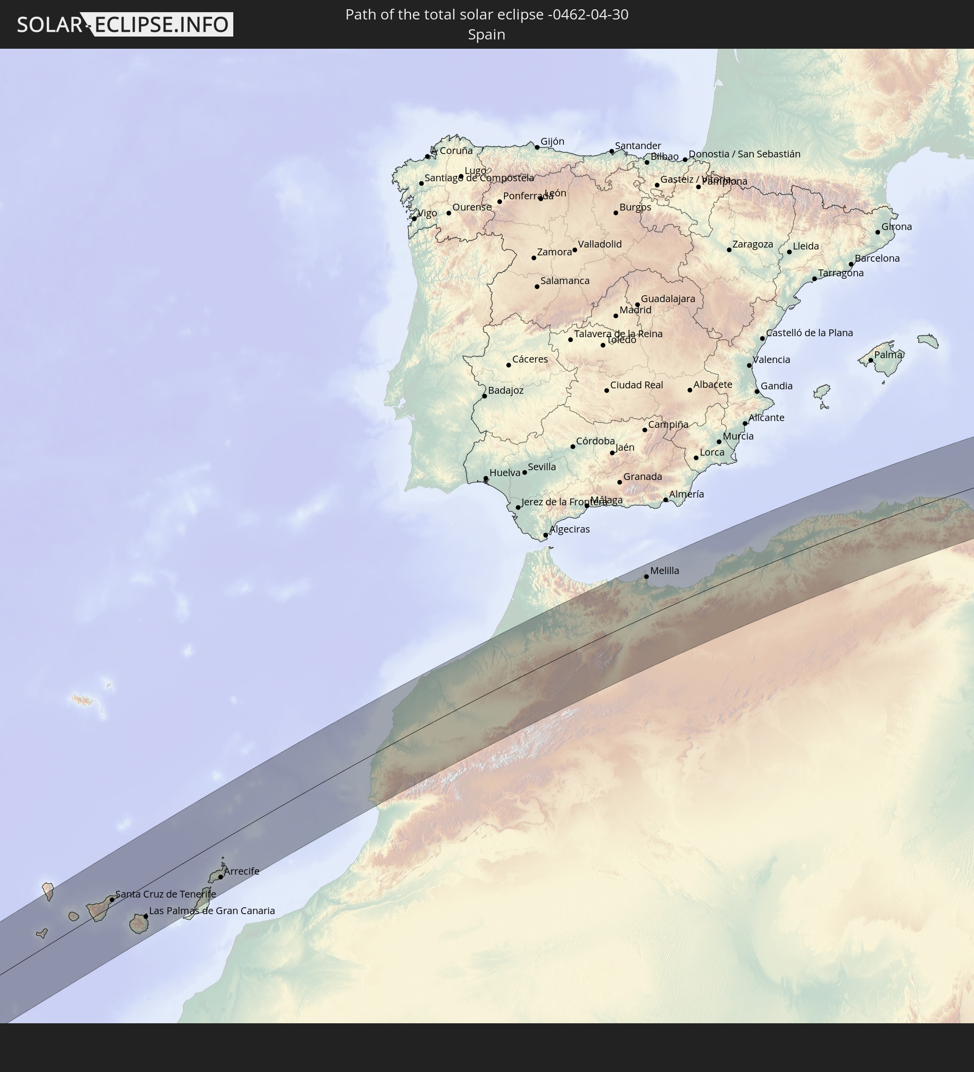 Spanien
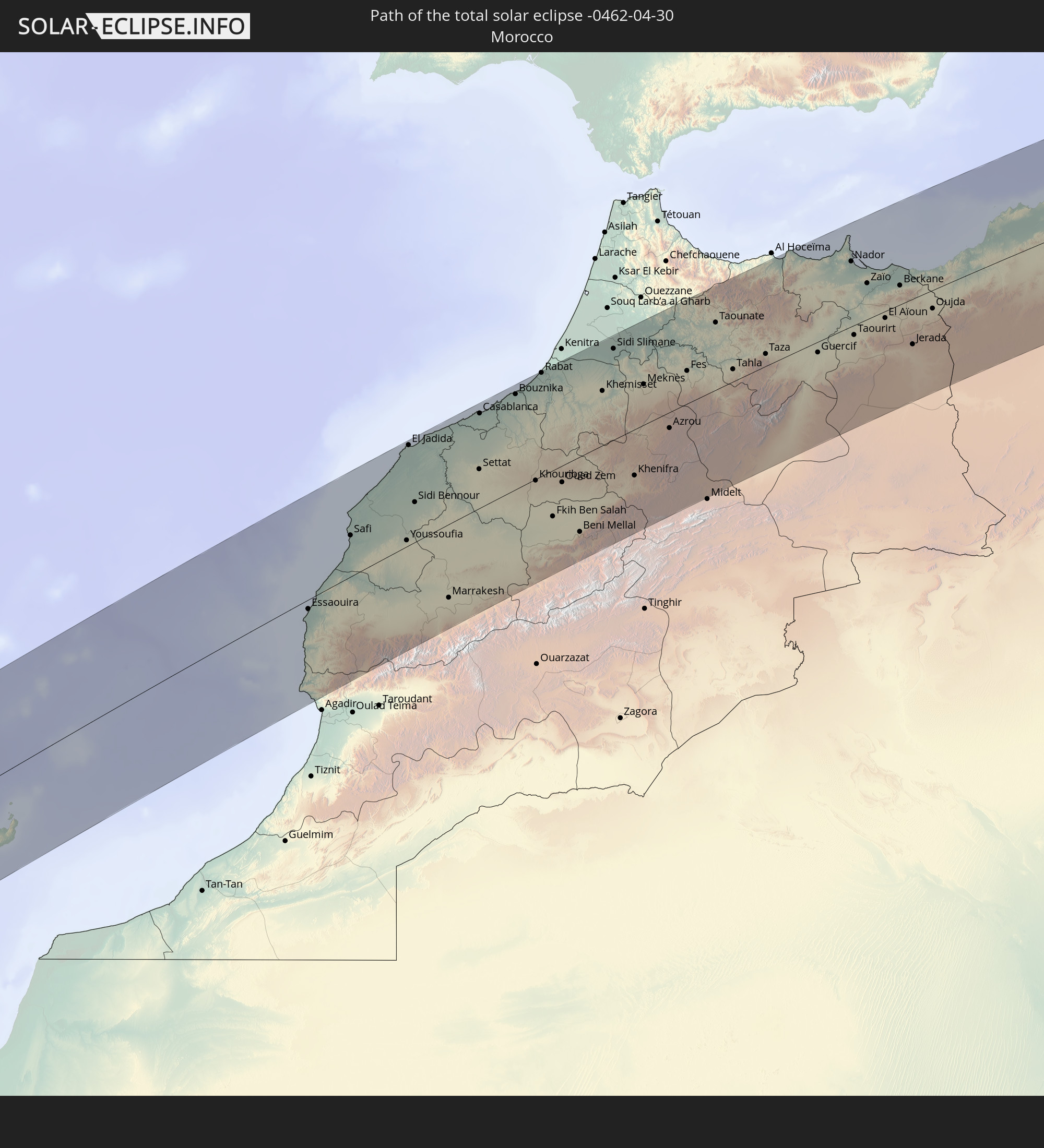 Marokko
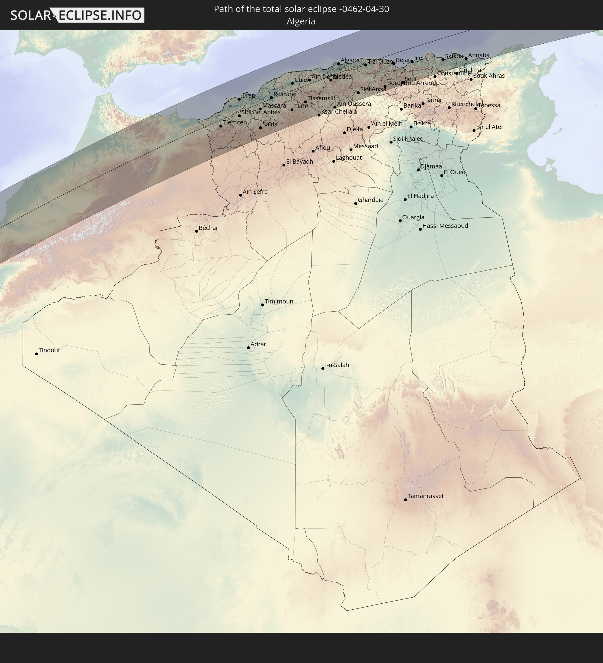 Algerien
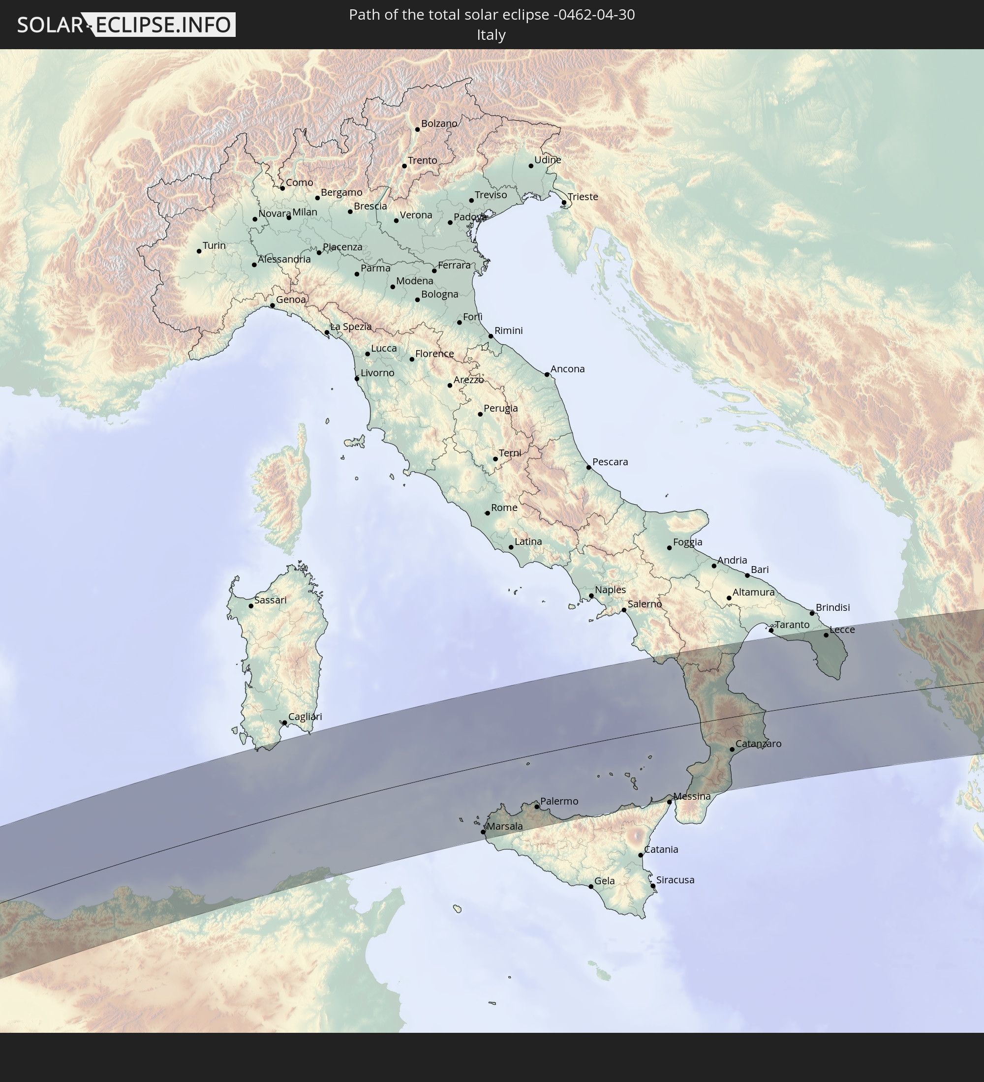 Italien
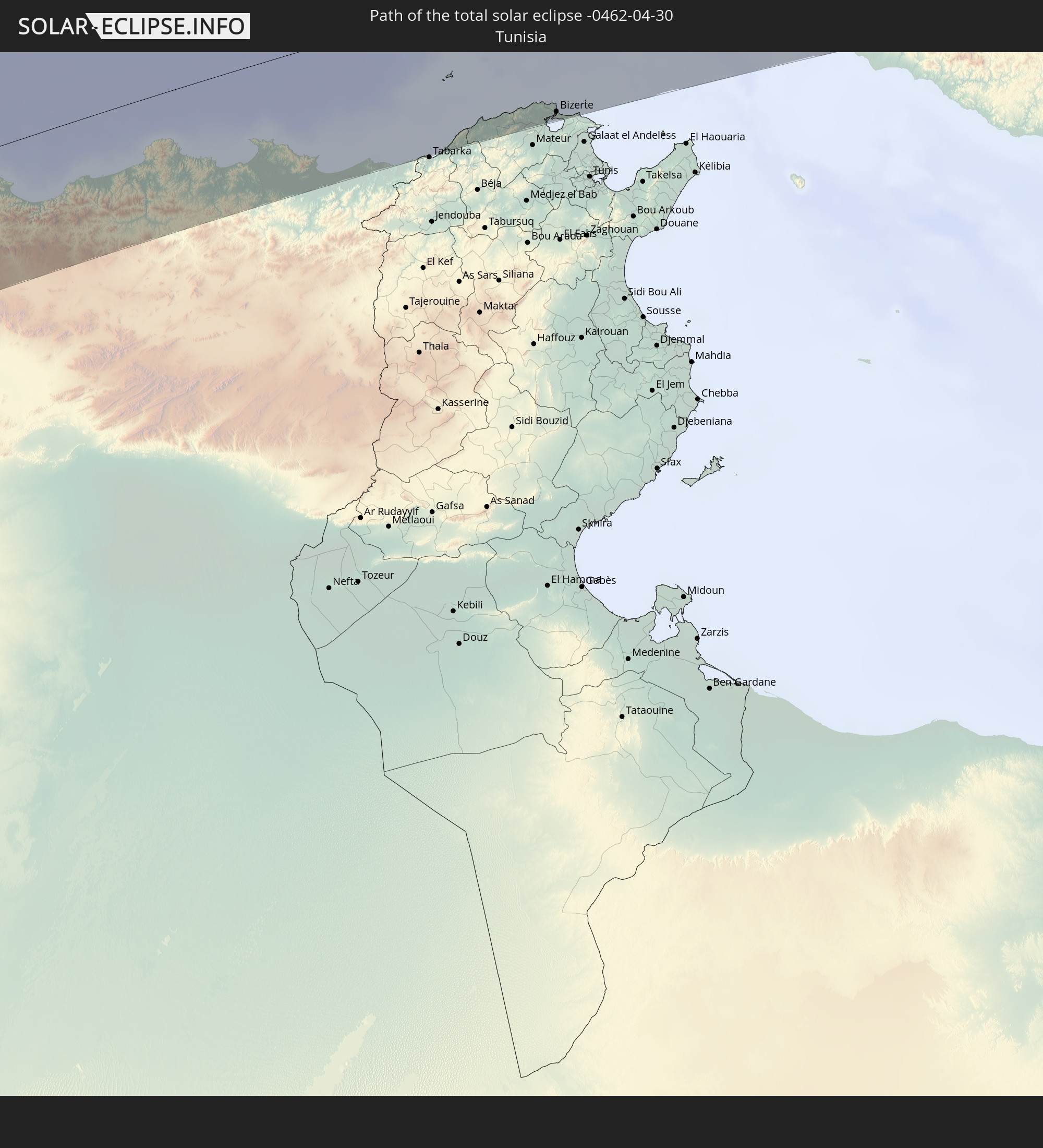 Tunesien
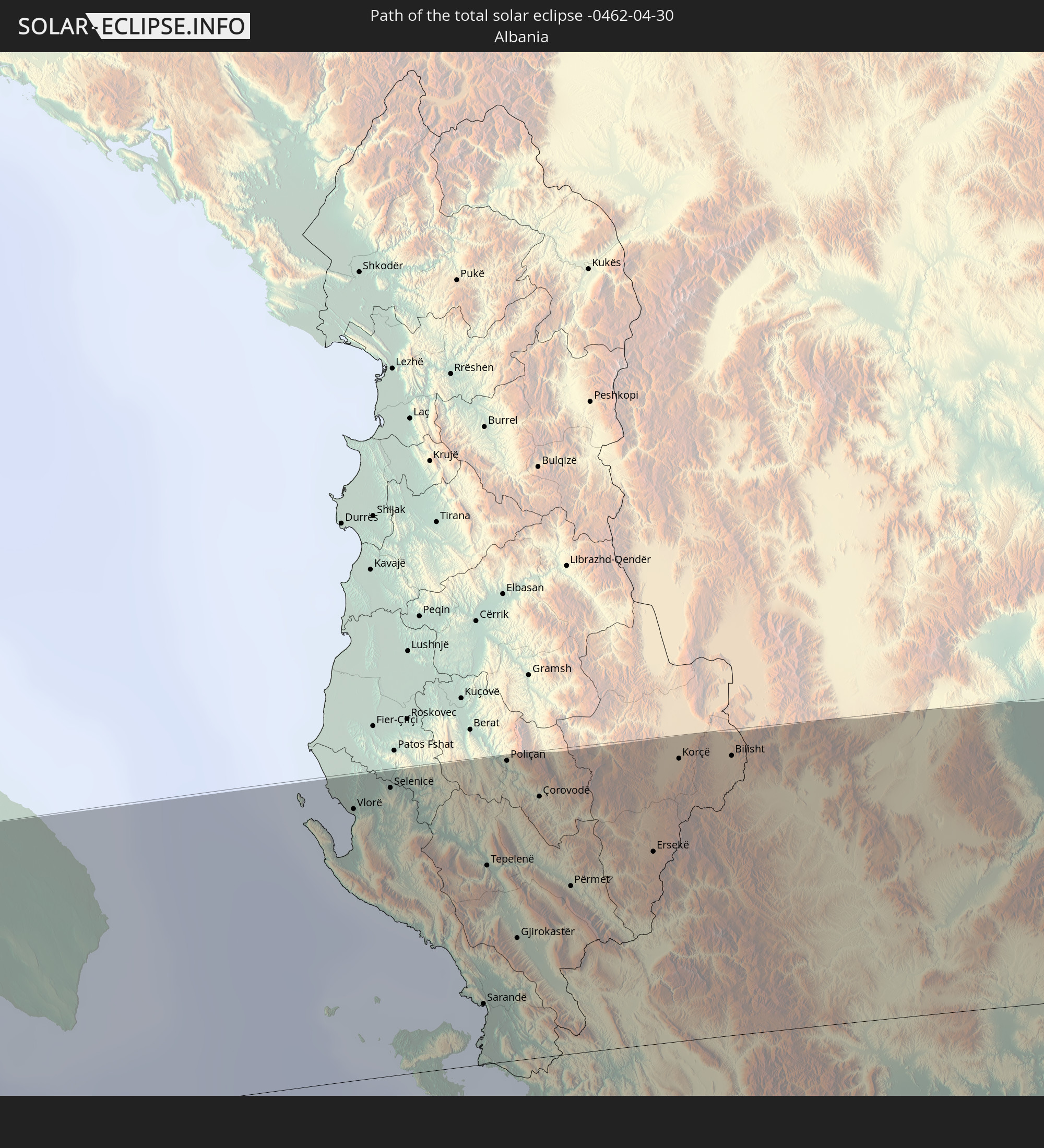 Albanien
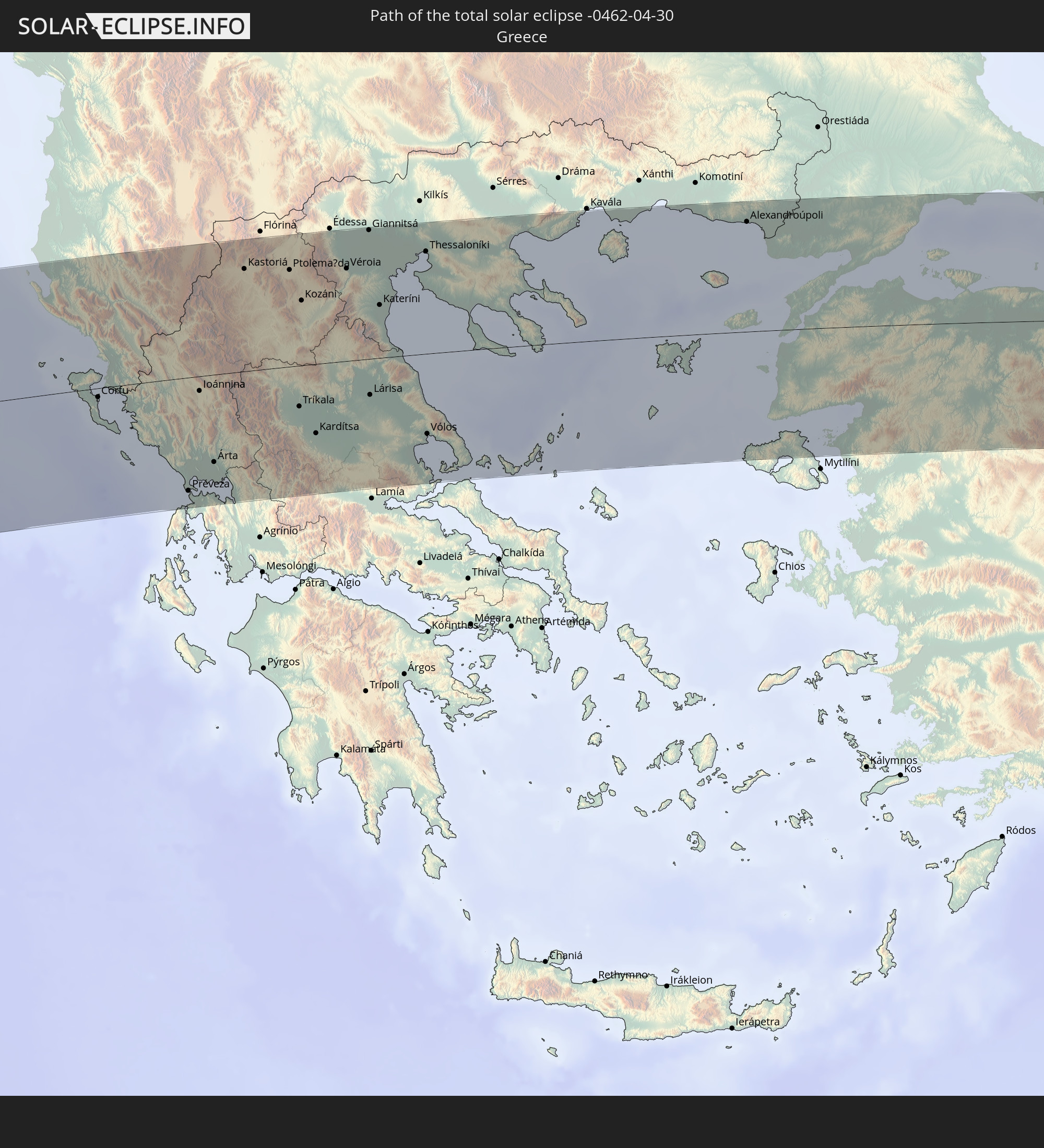 Griechenland
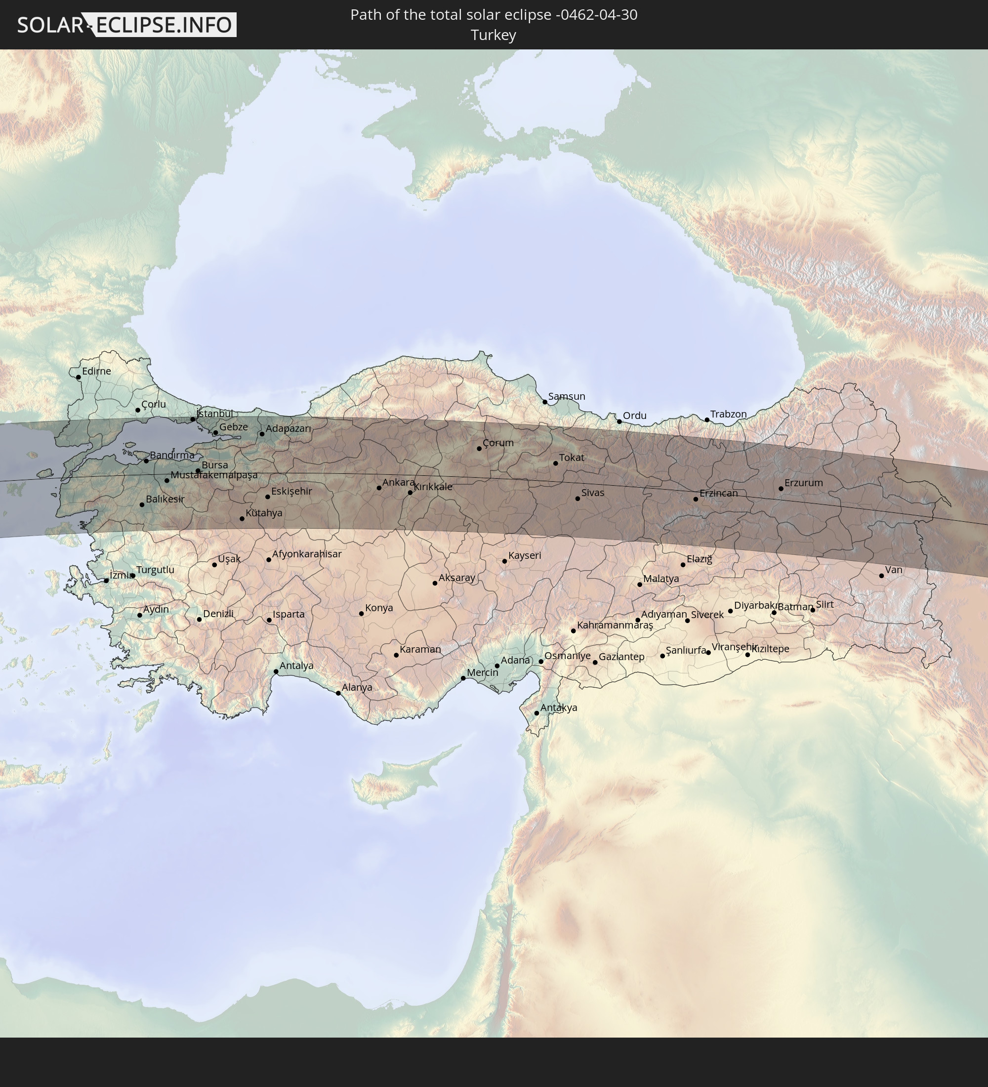 Türkei
 Armenien
 Iran
Iran
 Aserbaidschan
 Turkmenistan
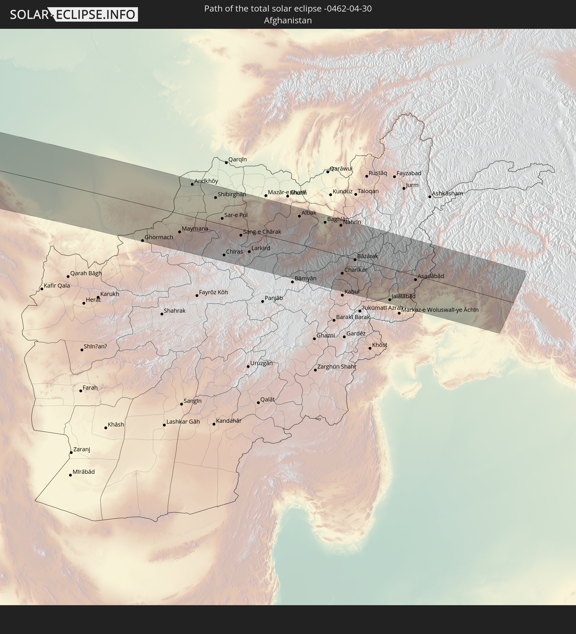 Afghanistan
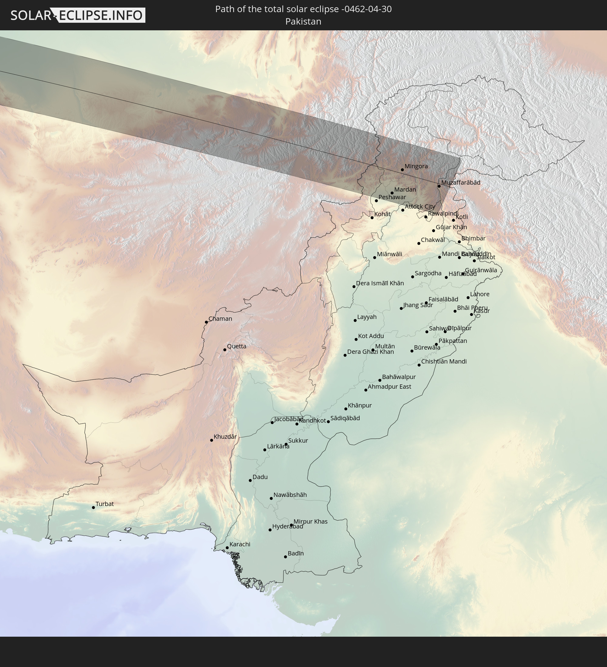 Pakistan
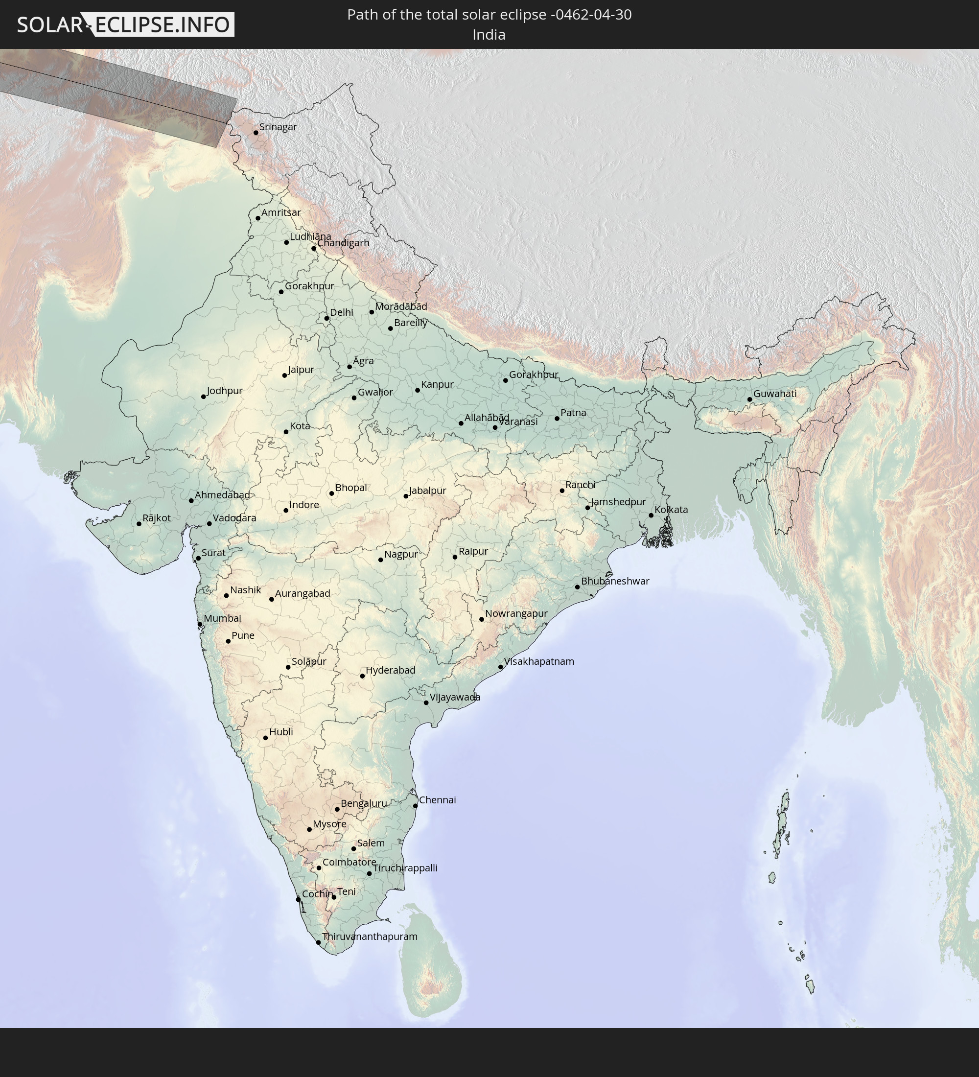 Indien
In den folgenden Ländern ist die Sonnenfinsternis partiell zu sehen
 Russland
 Vereinigte Staaten
 Kanada
 Grönland
 Kuba
Kuba
 Kolumbien
 Bahamas
 Haiti
Haiti
 Brasilien
 Venezuela
 Turks- und Caicosinseln
 Dominikanische Republik
 Aruba
Aruba
 Bolivien
 Puerto Rico
 Amerikanische Jungferninseln
 Bermuda
 Britische Jungferninseln
 Anguilla
 Saint-Martin
 Saint-Barthélemy
 St. Kitts und Nevis
 Paraguay
 Antigua und Barbuda
 Montserrat
 Trinidad und Tobago
 Guadeloupe
 Grenada
 Dominica
 St. Vincent und die Grenadinen
 Guyana
 Martinique
 St. Lucia
 Barbados
 Suriname
 Saint-Pierre und Miquelon
 Französisch-Guayana
 Portugal
 Kap Verde
 Island
 Spanien
 Senegal
 Mauretanien
 Gambia
 Guinea-Bissau
 Guinea
 Sierra Leone
 Marokko
 Mali
Mali
 Liberia
 Irland
 Spitzbergen
 Algerien
 Vereinigtes Königreich
 Elfenbeinküste
 Färöer
 Burkina Faso
 Gibraltar
 Frankreich
 Isle of Man
 Ghana
Ghana
 Guernsey
 Jersey
 Togo
Togo
 Niger
Niger
 Benin
Benin
 Andorra
 Belgien
 Nigeria
 Niederlande
 Norwegen
 Luxemburg
 Deutschland
 Schweiz
 Italien
 Monaco
 Tunesien
 Dänemark
 Kamerun
 Libyen
 Liechtenstein
 Österreich
 Schweden
 Tschechien
 San Marino
 Vatikanstadt
 Slowenien
 Tschad
 Kroatien
 Polen
Polen
 Malta
Malta
 Zentralafrikanische Republik
 Bosnien und Herzegowina
 Ungarn
 Slowakei
 Montenegro
 Serbien
 Albanien
 Åland Islands
 Griechenland
 Rumänien
 Mazedonien
 Finnland
 Litauen
 Lettland
 Estland
 Sudan
Sudan
 Ukraine
 Bulgarien
 Weißrussland
 Ägypten
 Türkei
 Moldawien
 Republik Zypern
 Äthiopien
 Staat Palästina
 Israel
 Saudi-Arabien
 Jordanien
 Libanon
 Syrien
 Eritrea
 Irak
Irak
 Georgien
 Somalia
 Dschibuti
 Jemen
Jemen
 Armenien
 Iran
Iran
 Aserbaidschan
 Kasachstan
 Kuwait
 Bahrain
 Katar
Katar
 Vereinigte Arabische Emirate
 Oman
Oman
 Turkmenistan
 Usbekistan
 Afghanistan
 Pakistan
 Tadschikistan
 Indien
 Kirgisistan
 Volksrepublik China
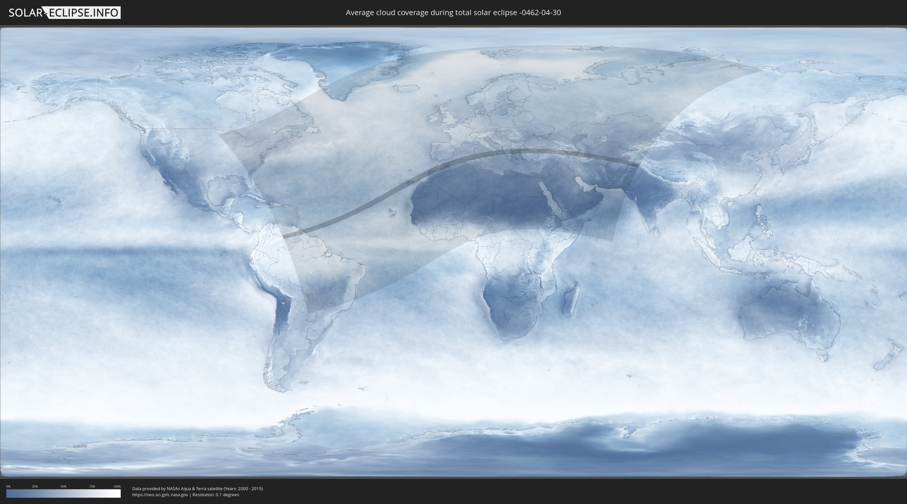
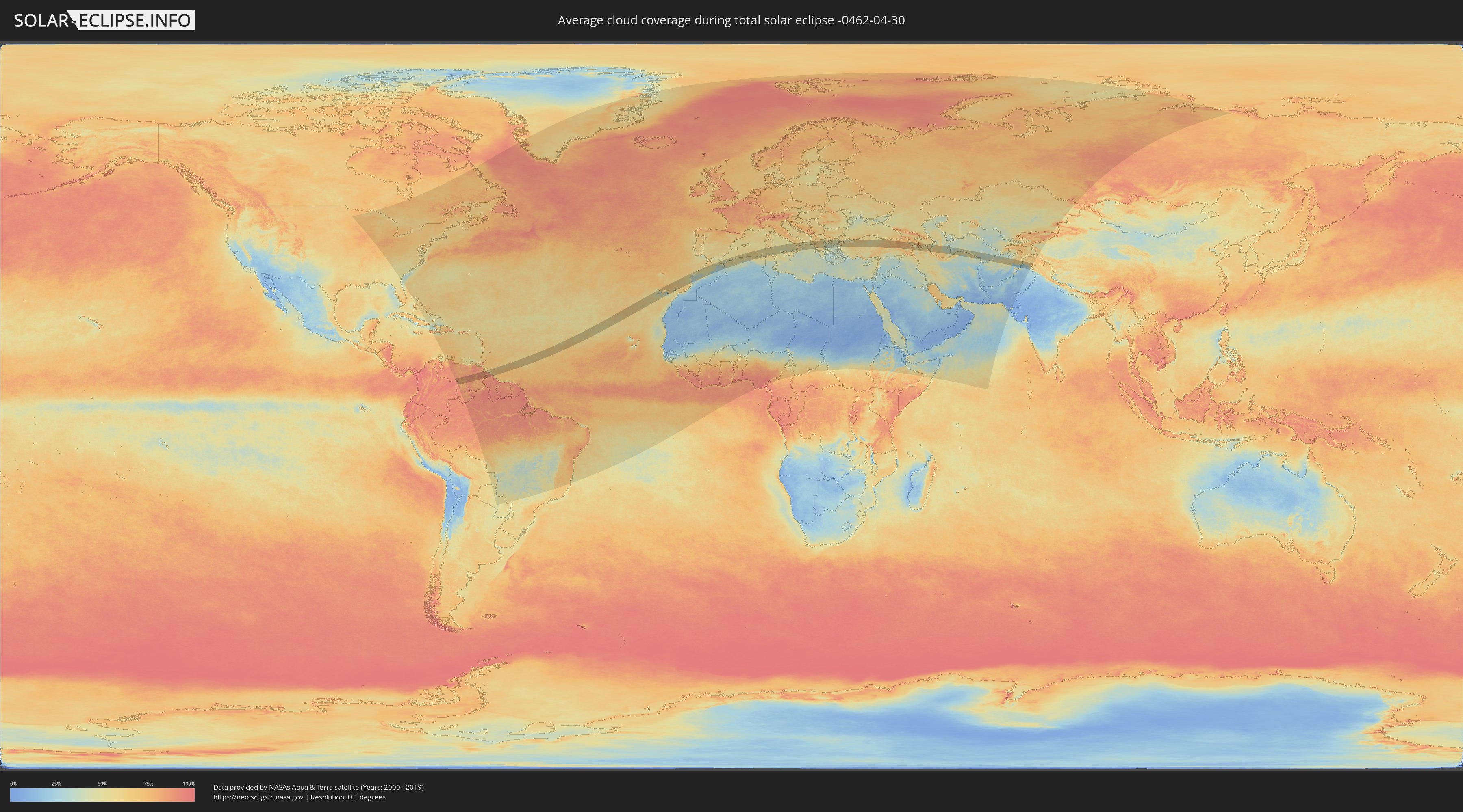
Wie wird das Wetter während der totalen Sonnenfinsternis am 30.04.-0462?
Wo ist der beste Ort, um die totale Sonnenfinsternis vom 30.04.-0462 zu beobachten?
Die folgenden Karten zeigen die durchschnittliche Bewölkung für den Tag, an dem die totale Sonnenfinsternis
stattfindet. Mit Hilfe der Karten lässt sich der Ort entlang des Finsternispfades eingrenzen,
der die besten Aussichen auf einen klaren wolkenfreien Himmel bietet.
Trotzdem muss man immer lokale Gegenenheiten beachten und sollte sich genau über das Wetter an seinem
gewählten Beobachtungsort informieren.
Die Daten stammen von den beiden NASA-Satelliten
AQUA und TERRA
und wurden über einen Zeitraum von 19 Jahren (2000 - 2019) gemittelt.
Detaillierte Länderkarten
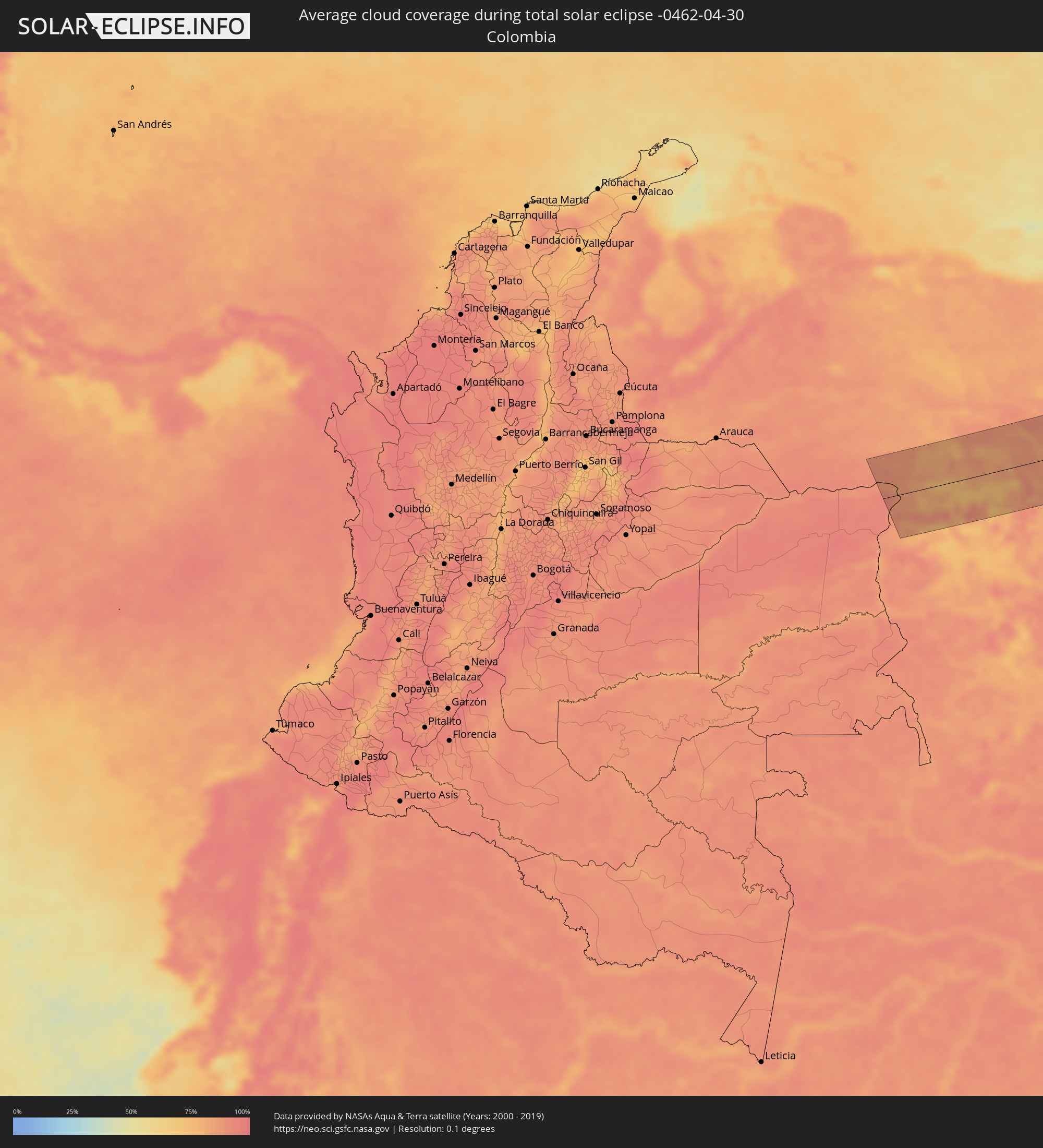 Kolumbien
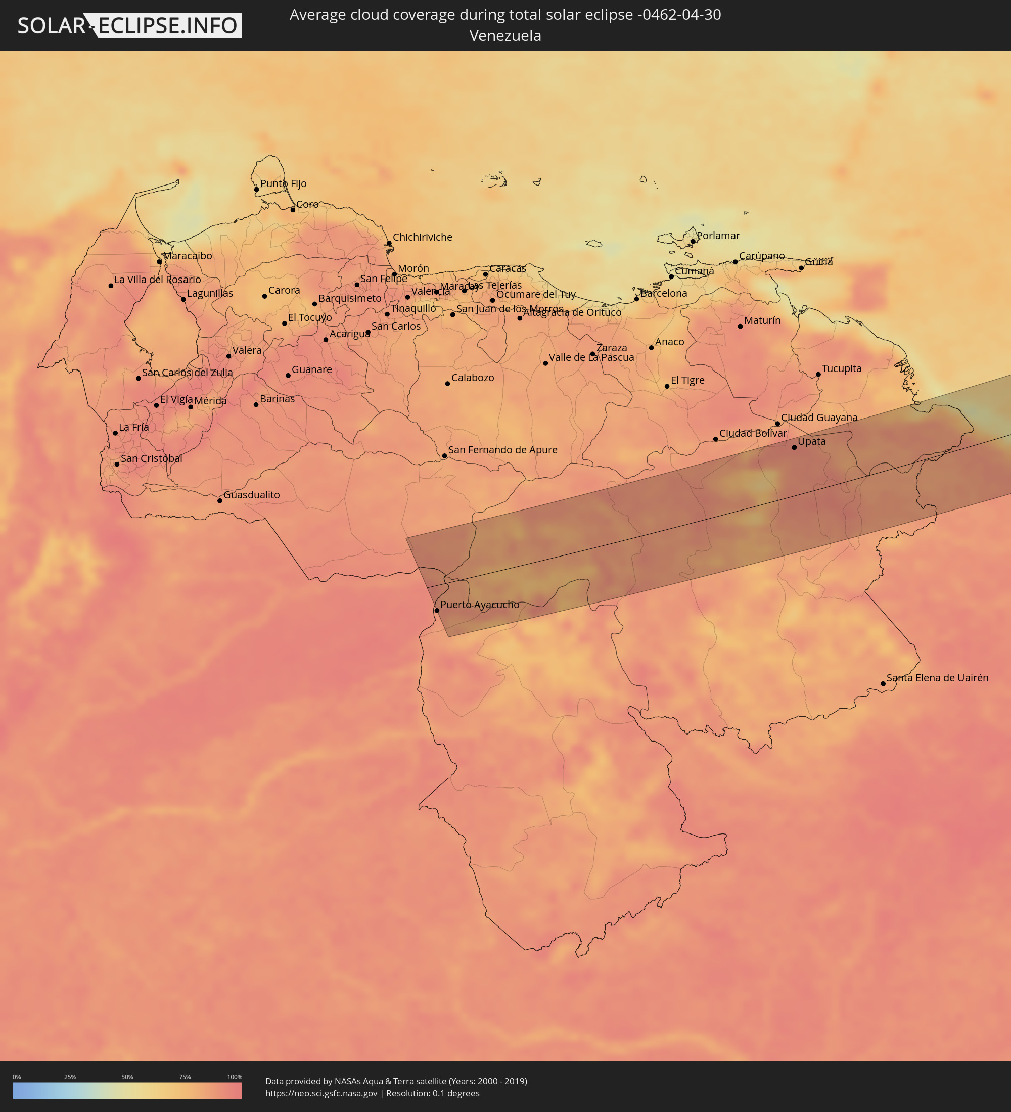 Venezuela
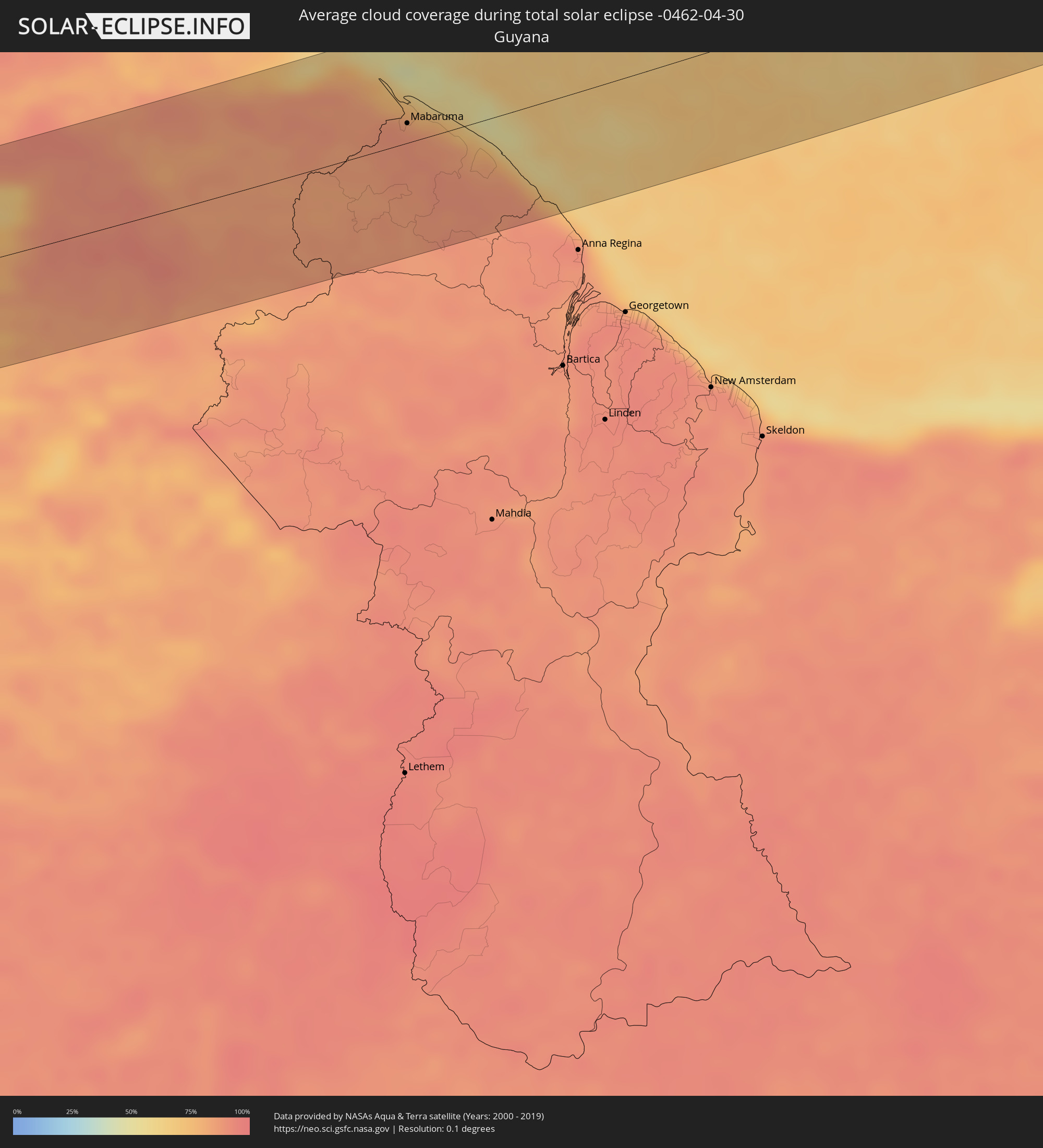 Guyana
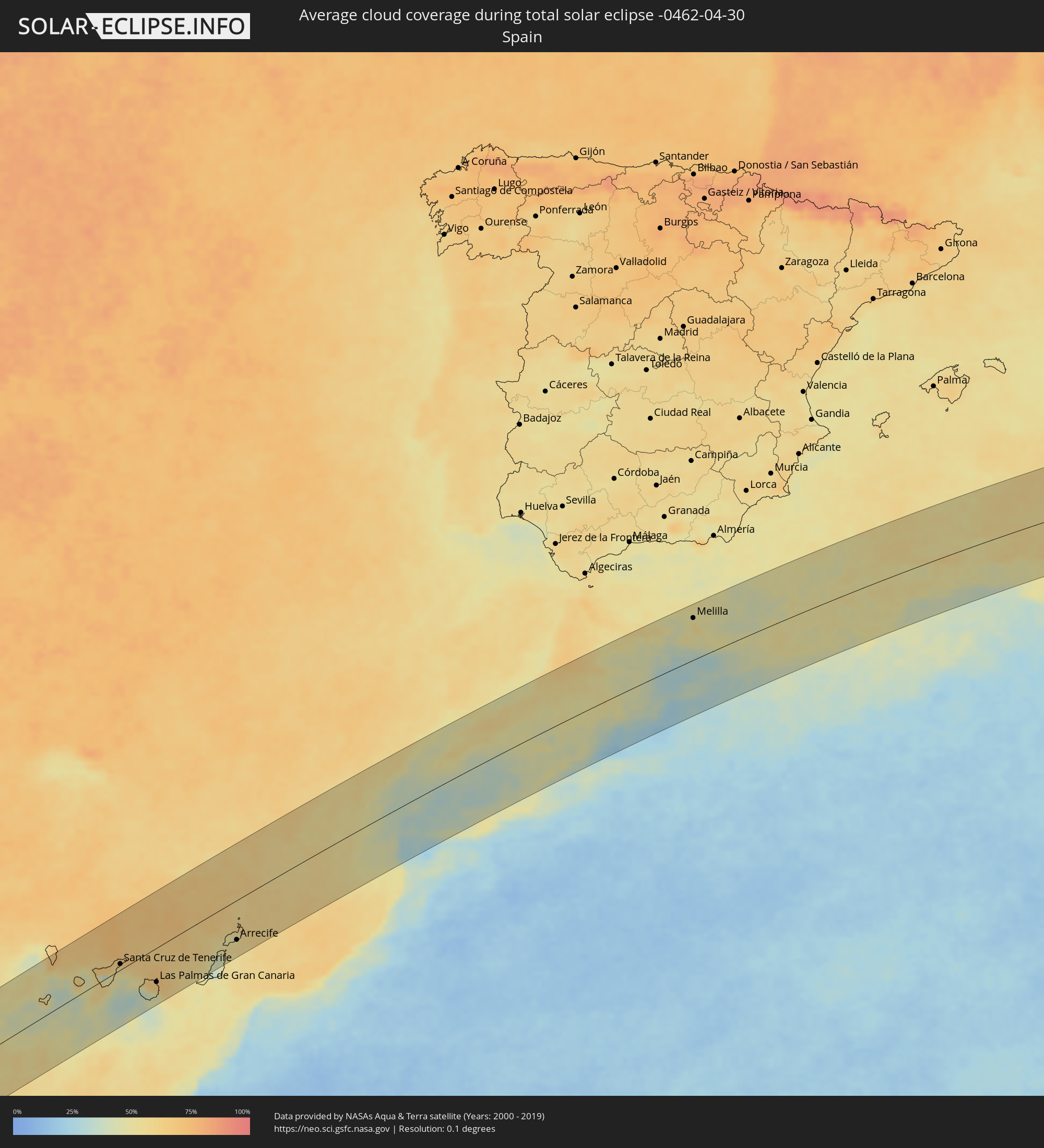 Spanien
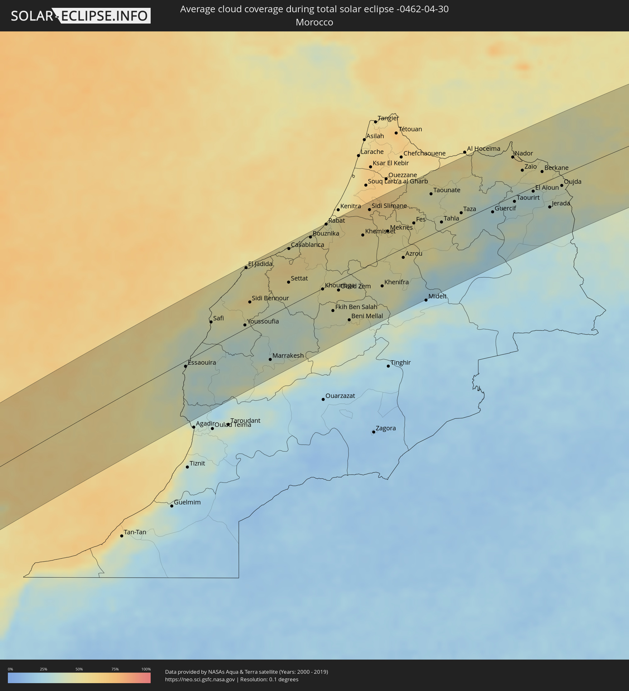 Marokko
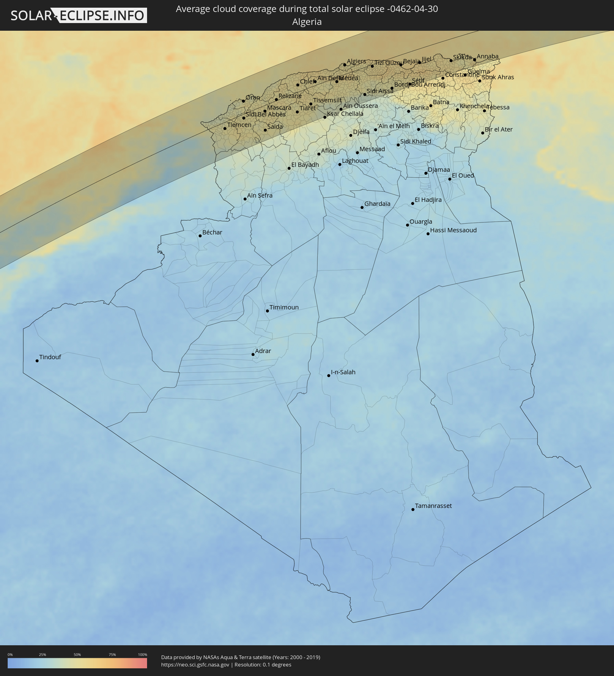 Algerien
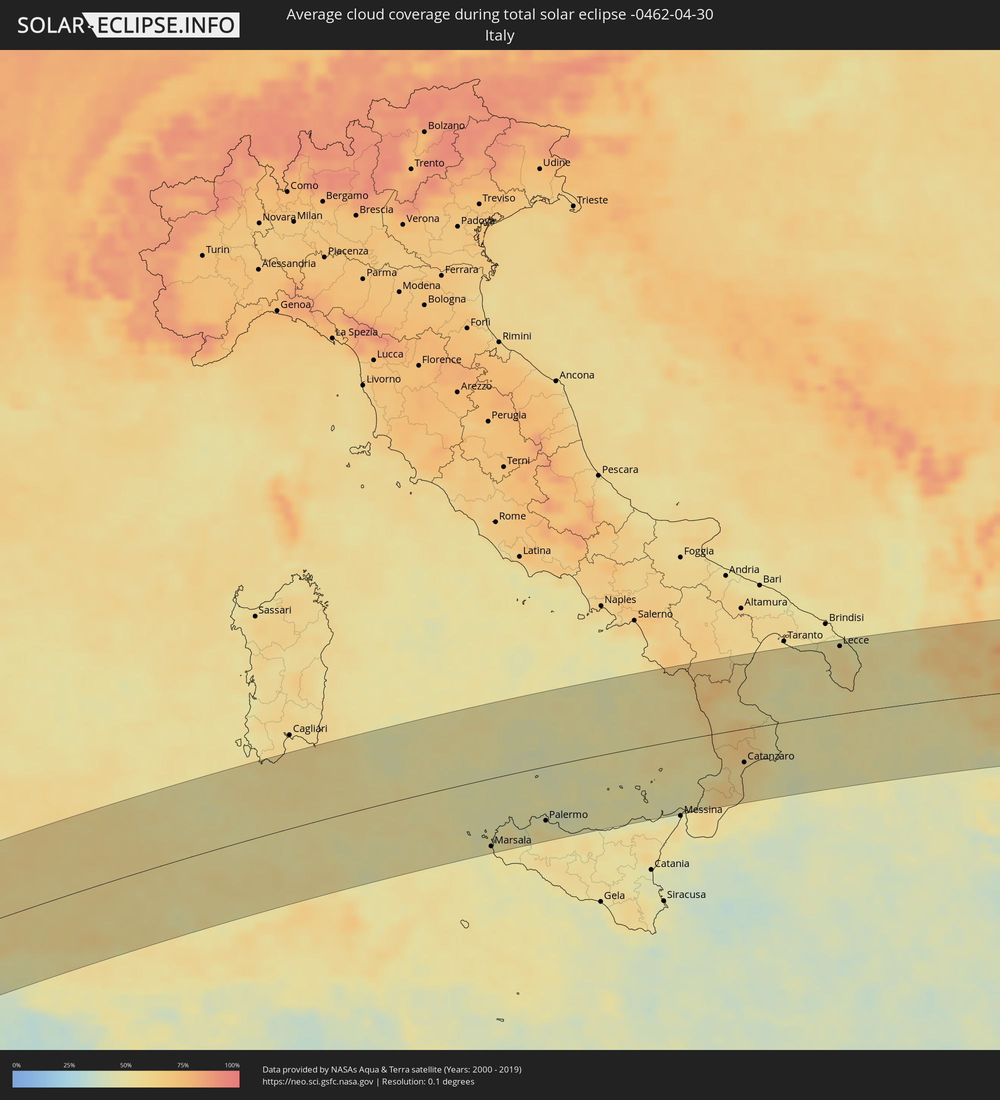 Italien
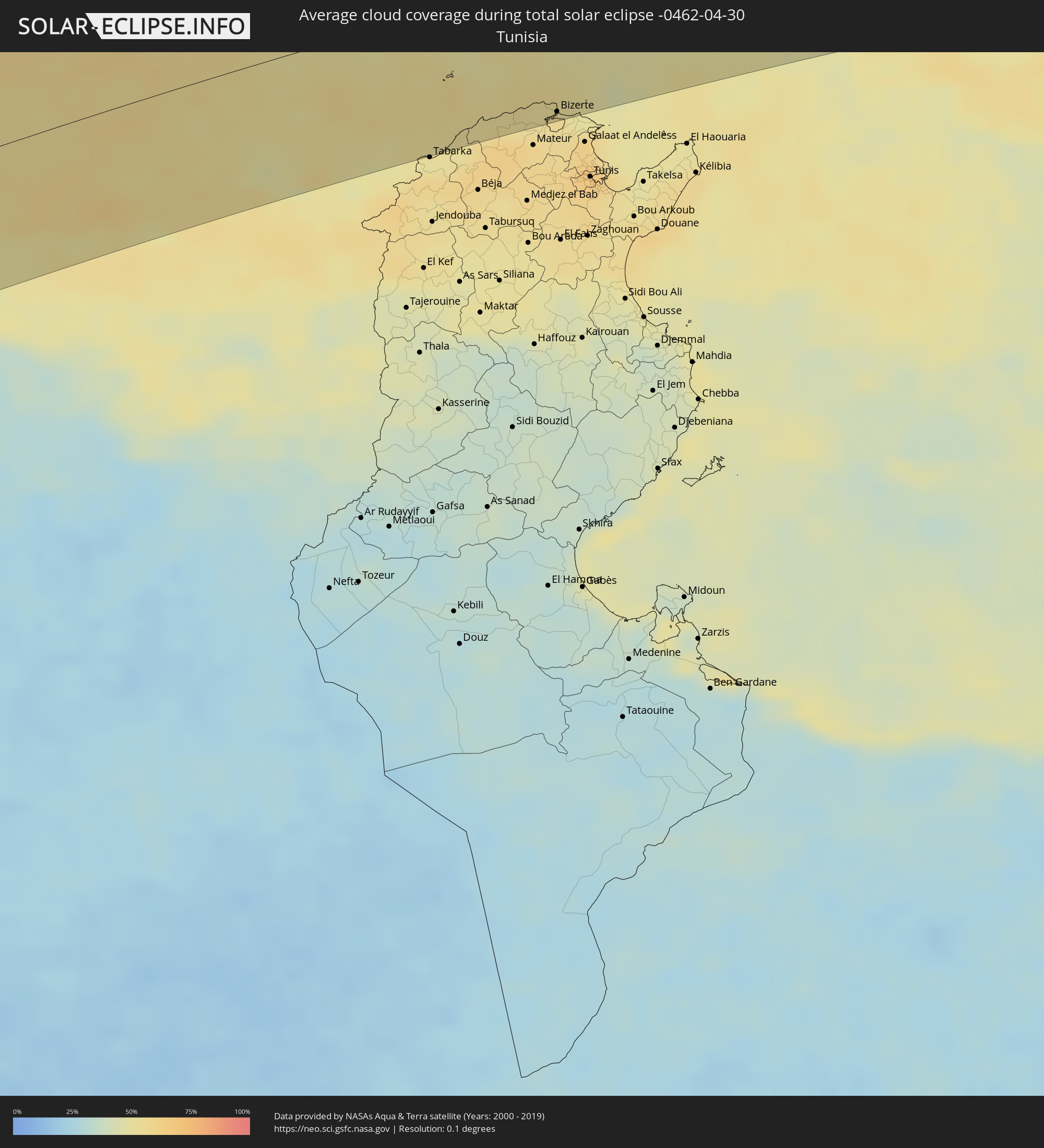 Tunesien
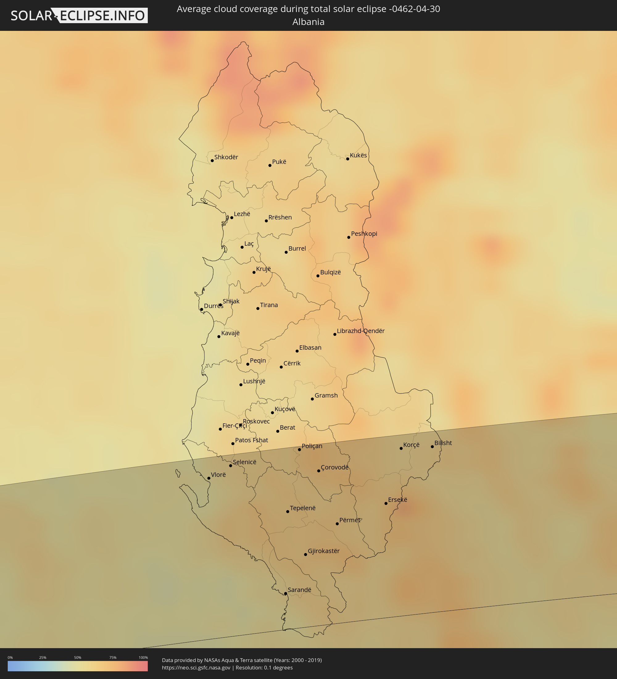 Albanien
 Griechenland
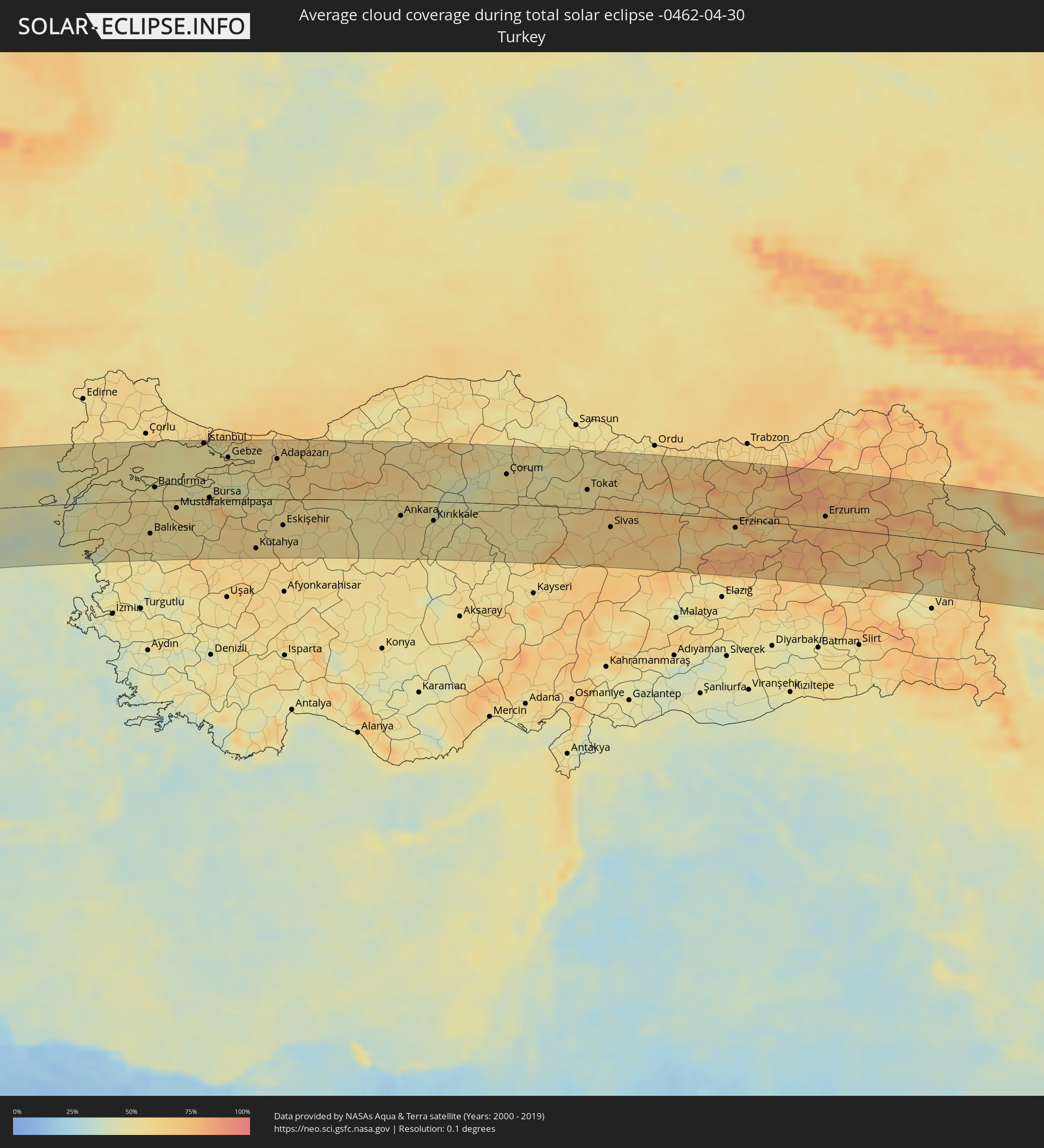 Türkei
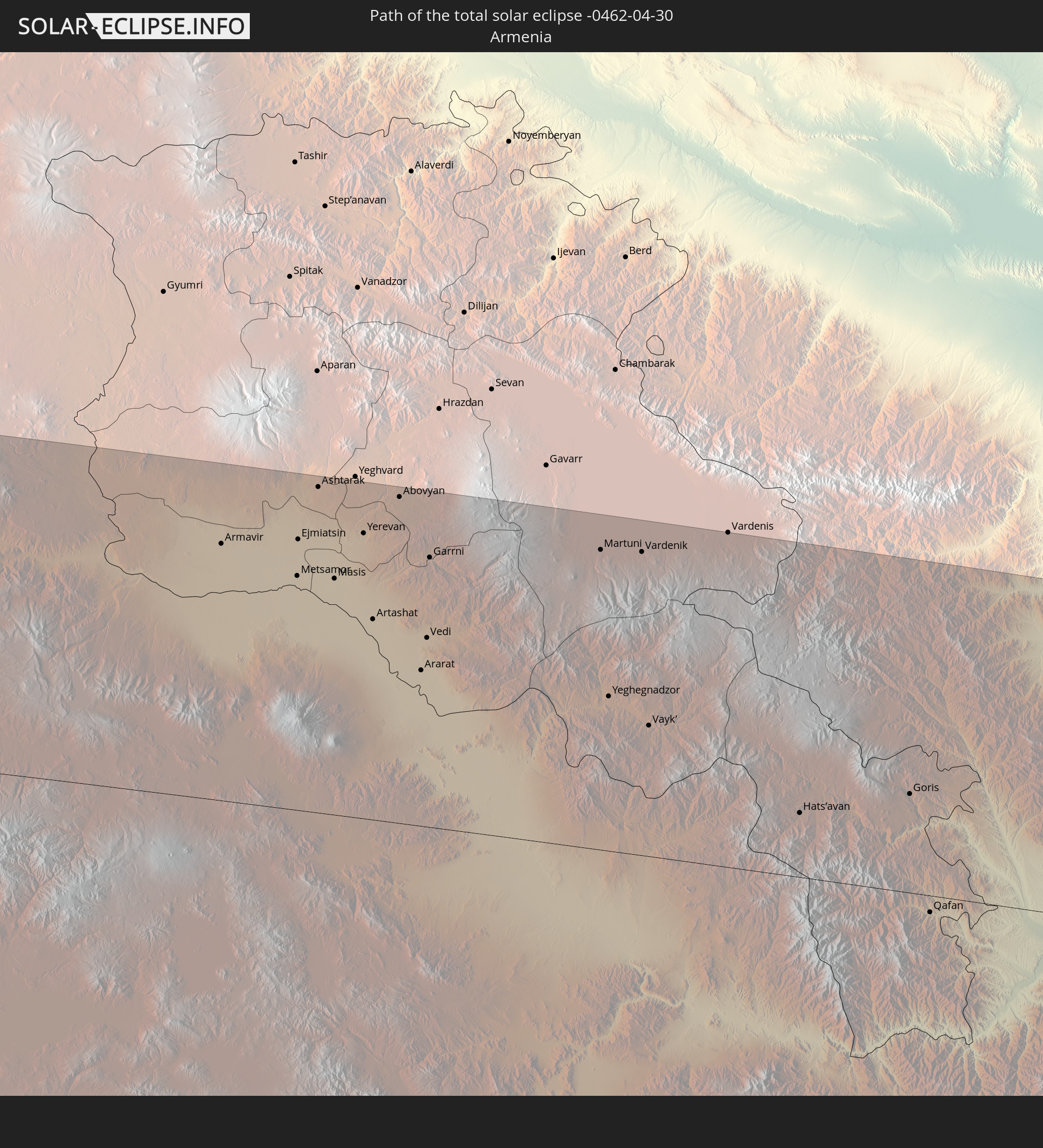
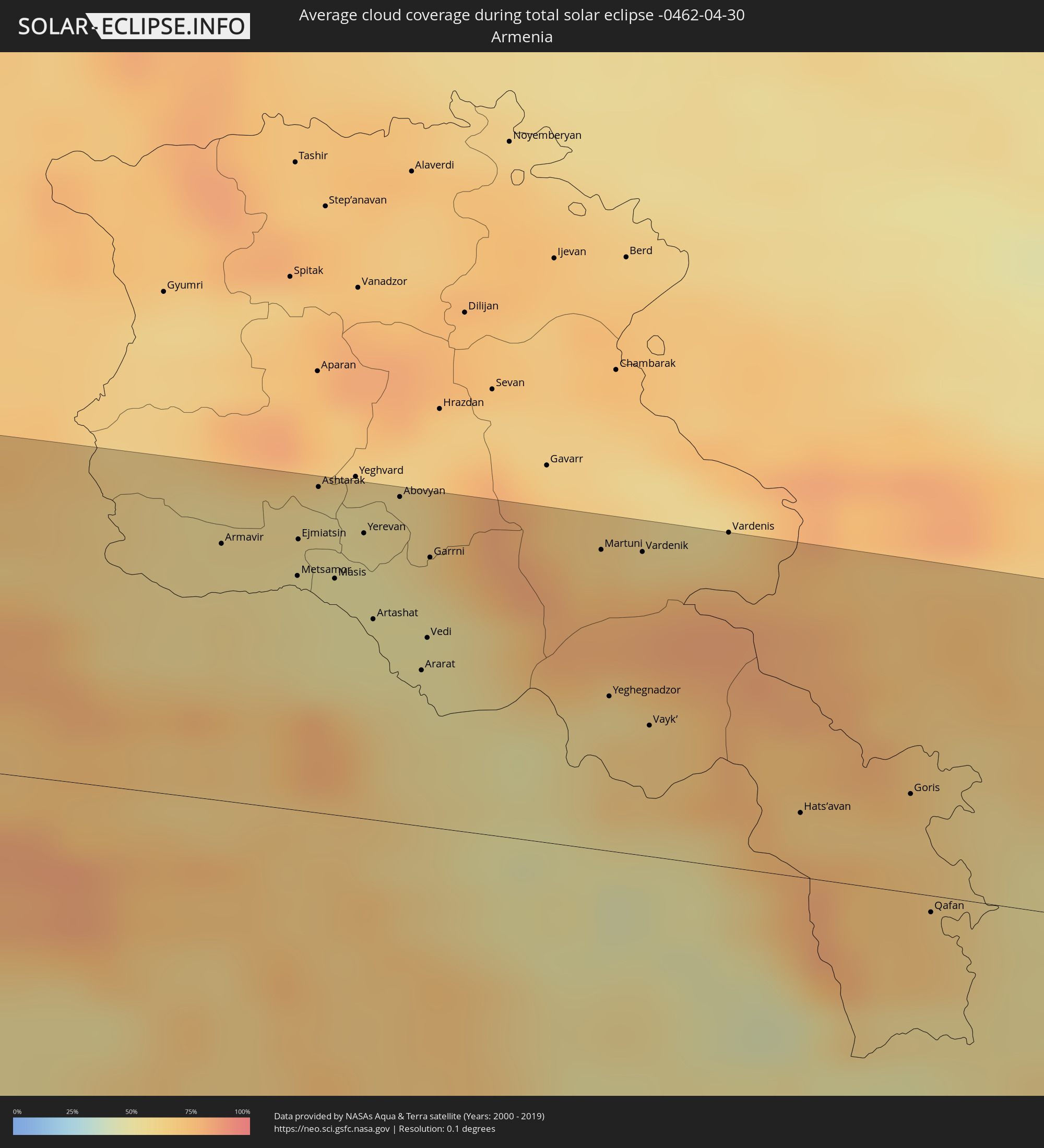 Armenien
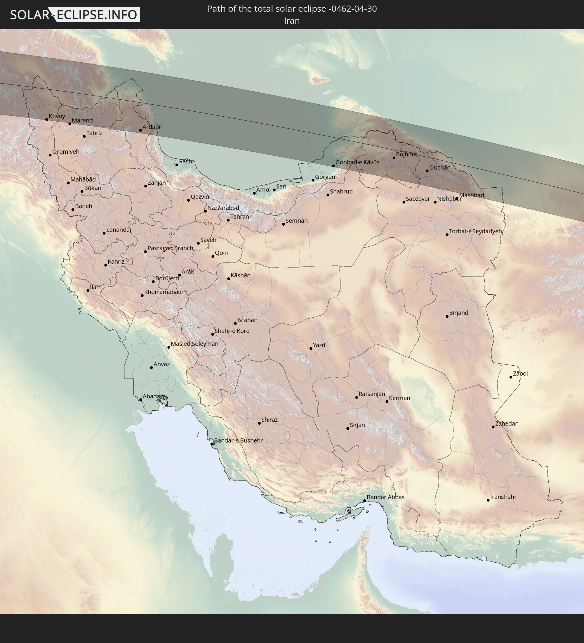
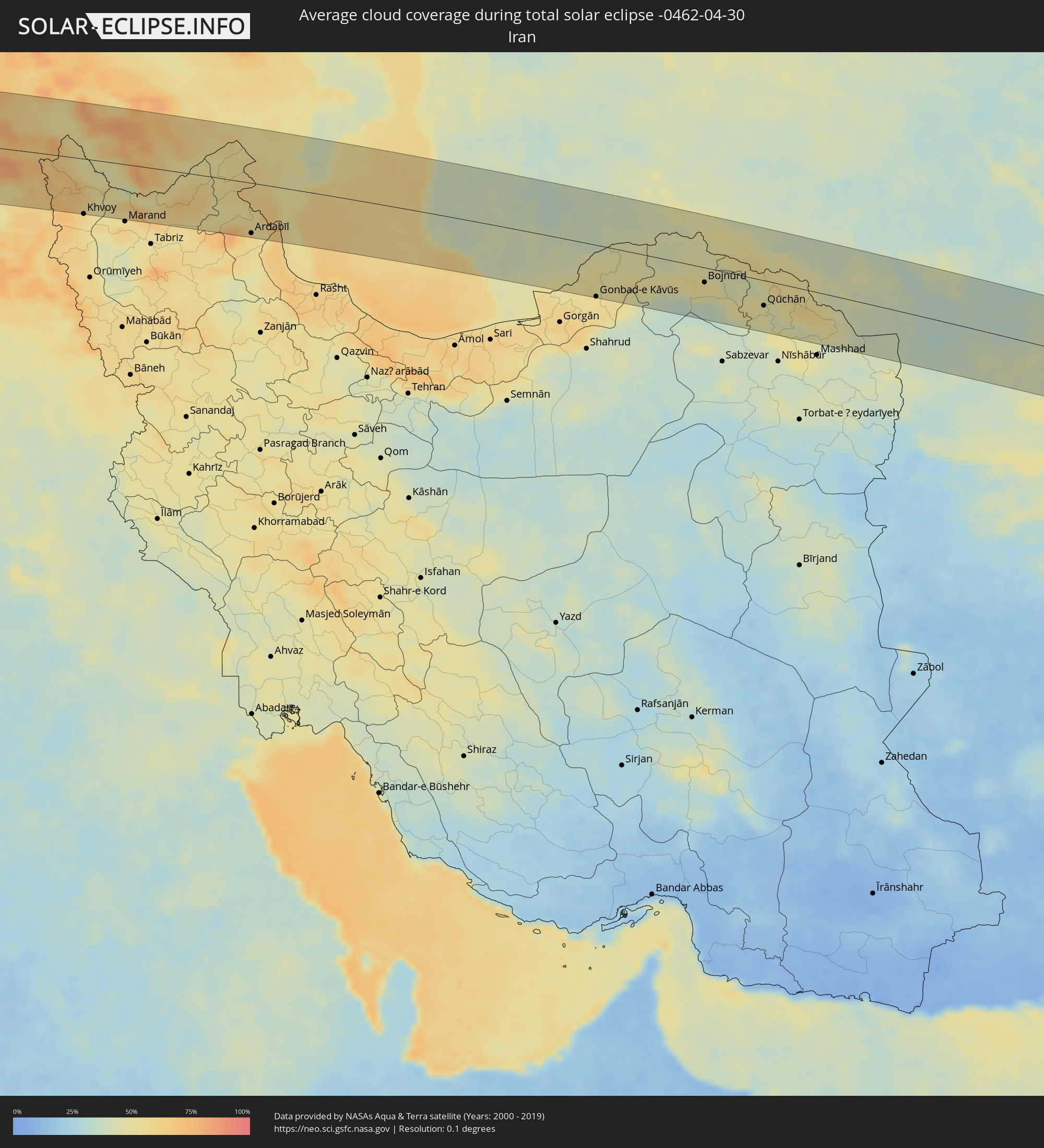 Iran
Iran
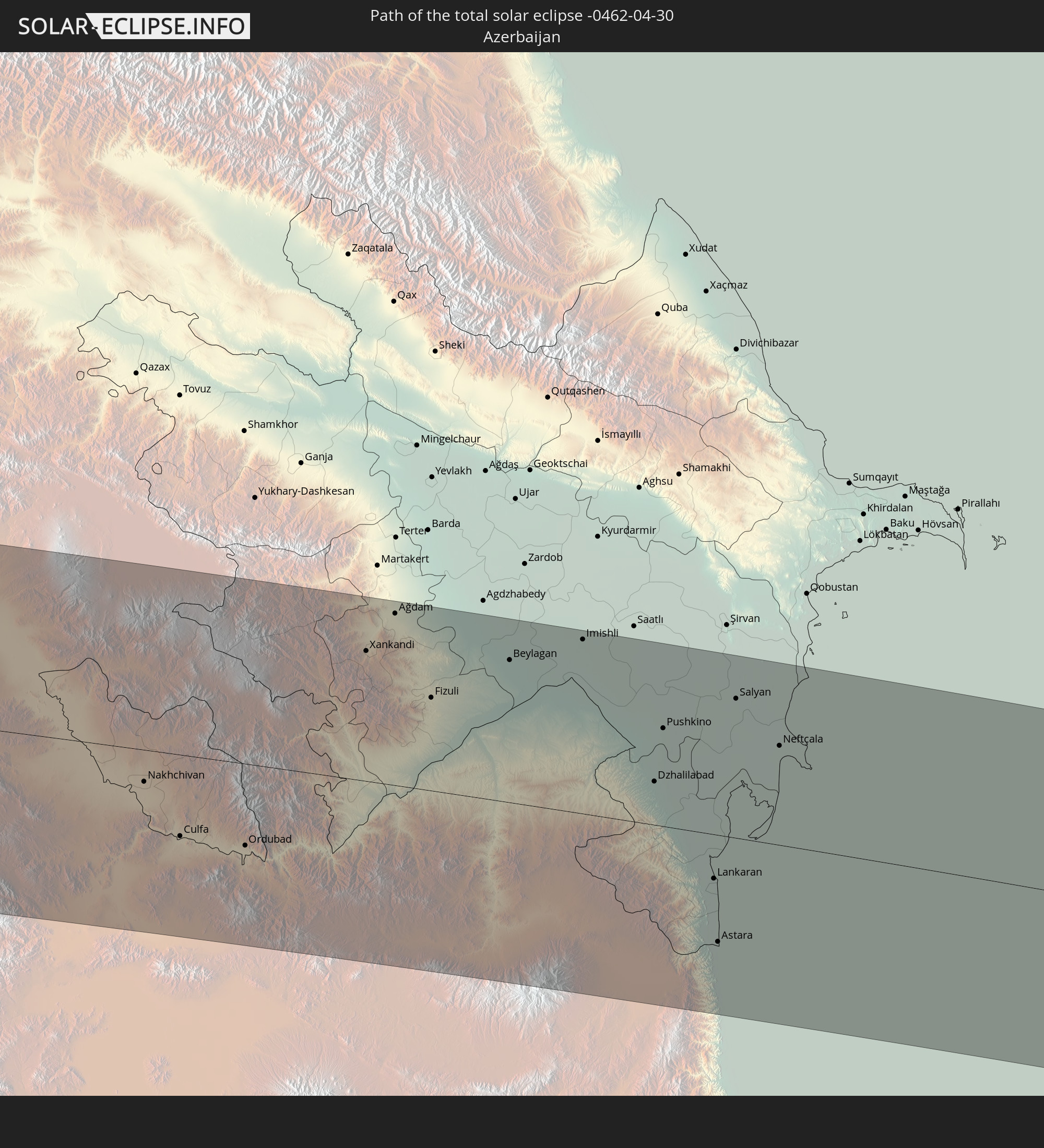
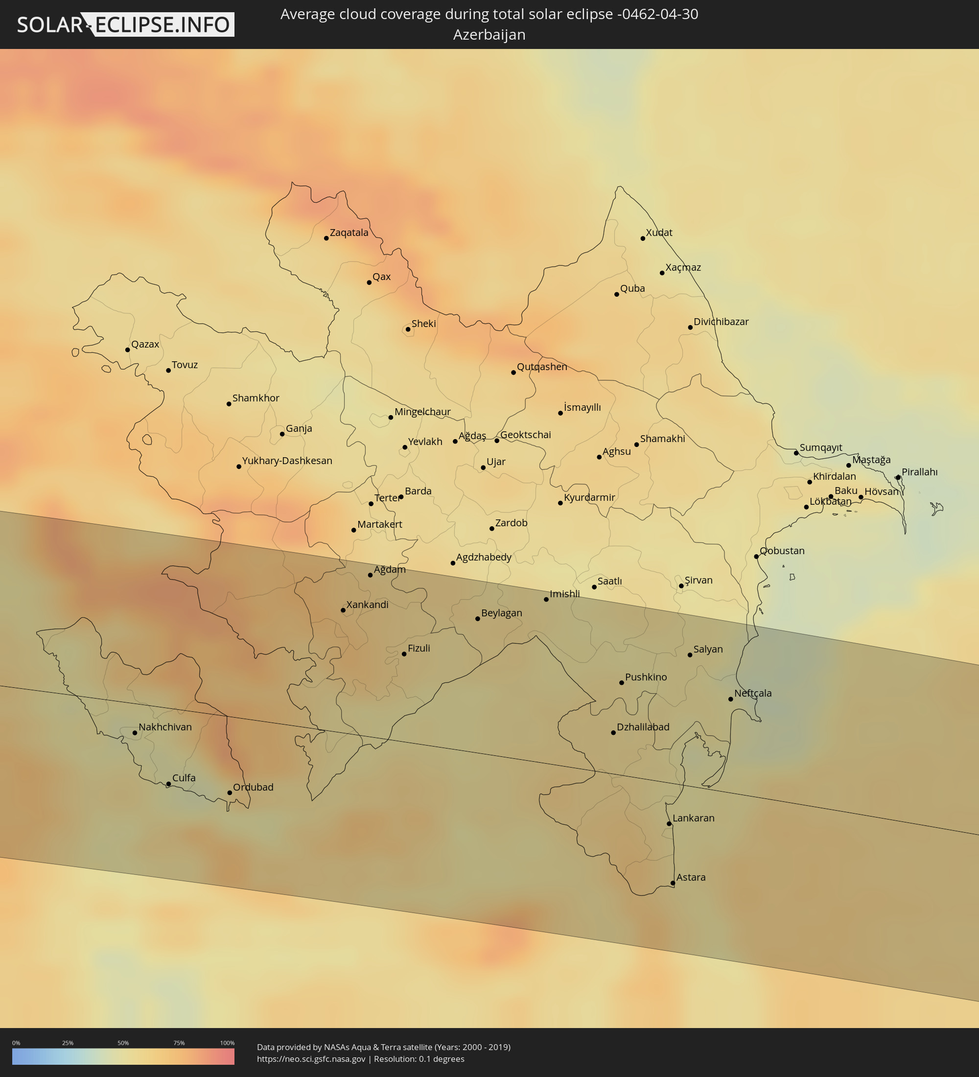 Aserbaidschan
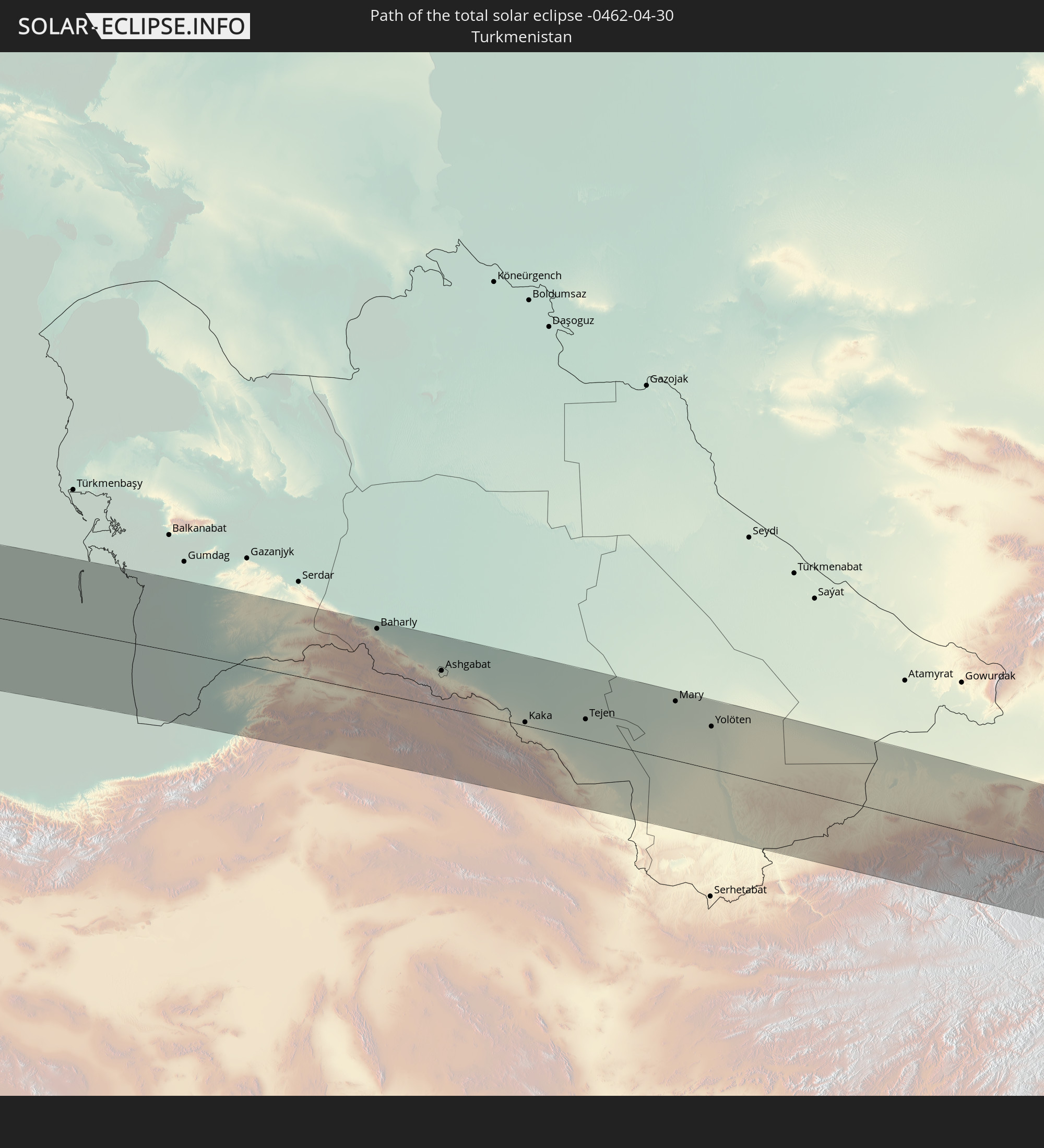
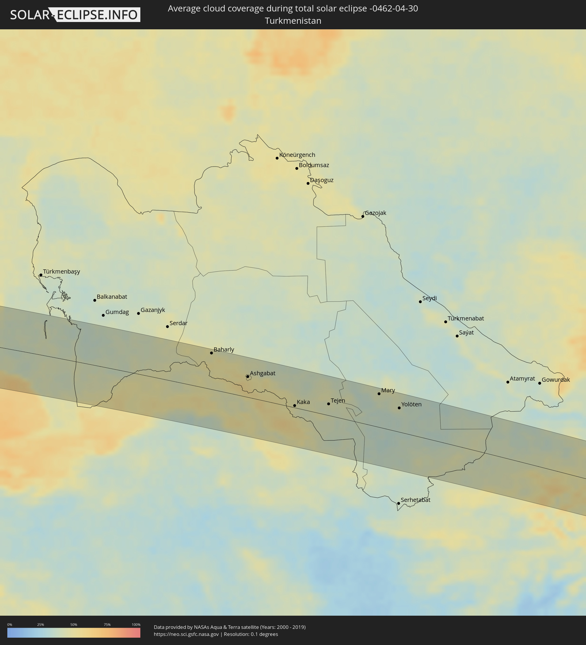 Turkmenistan
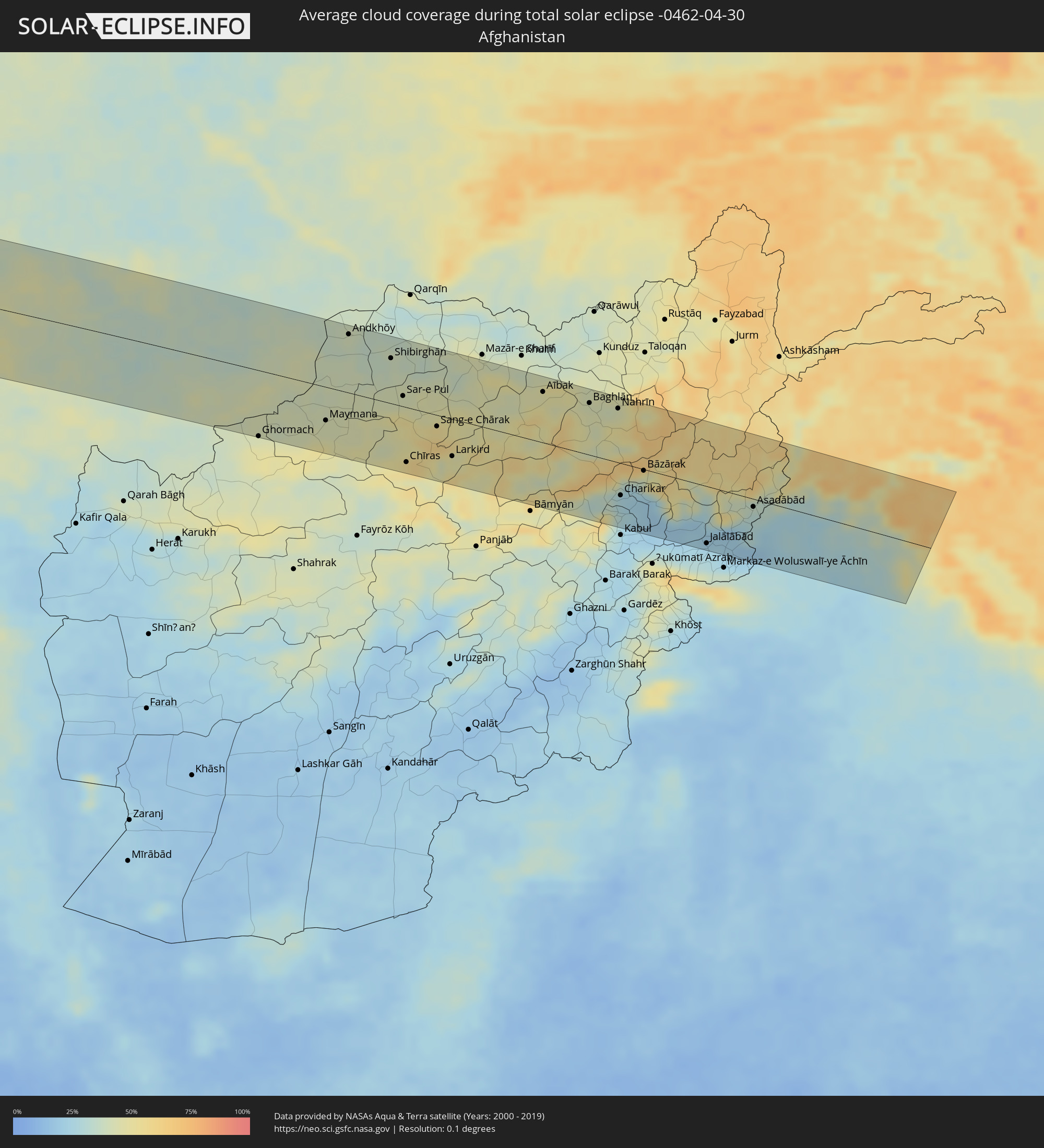 Afghanistan
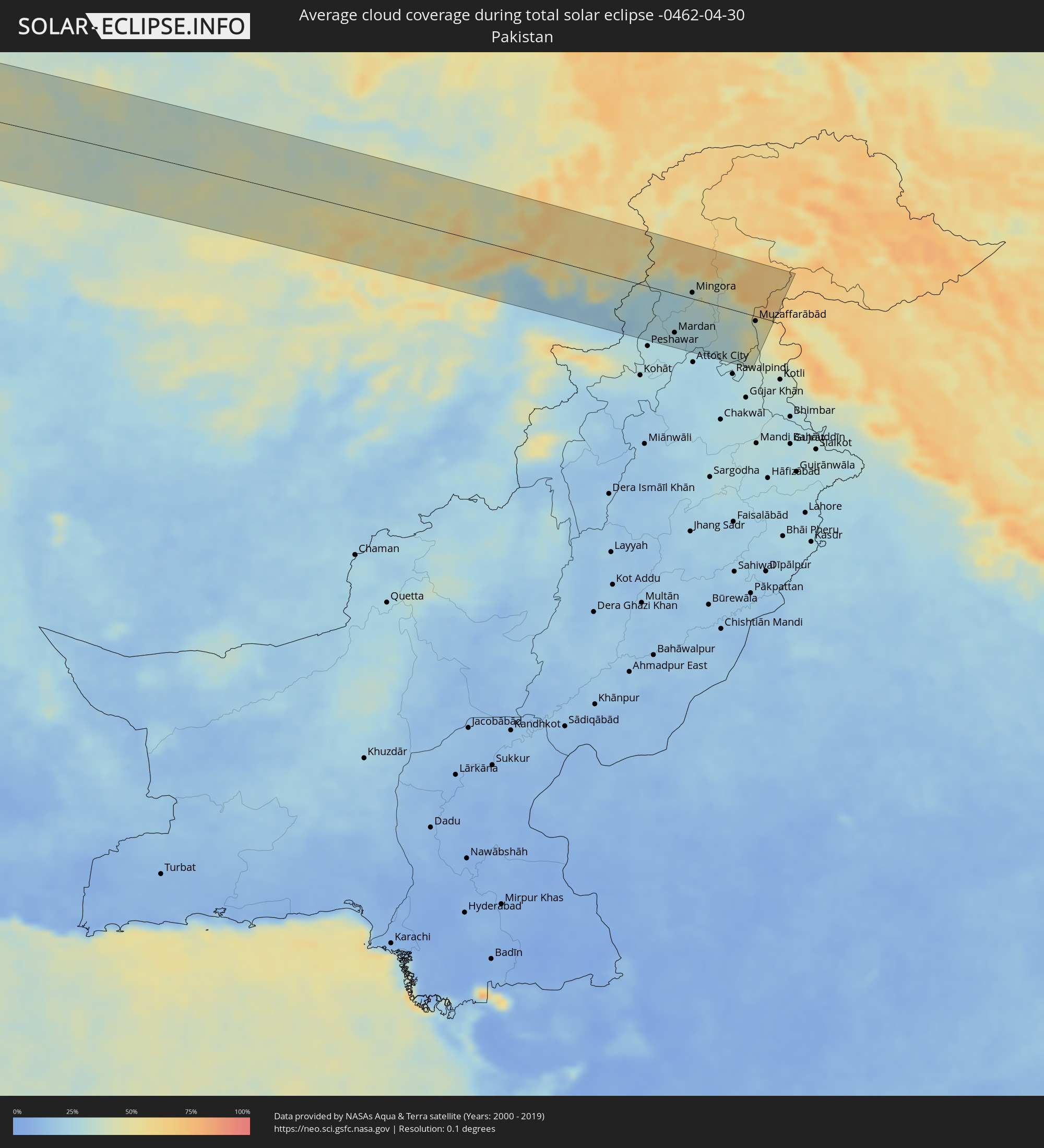 Pakistan
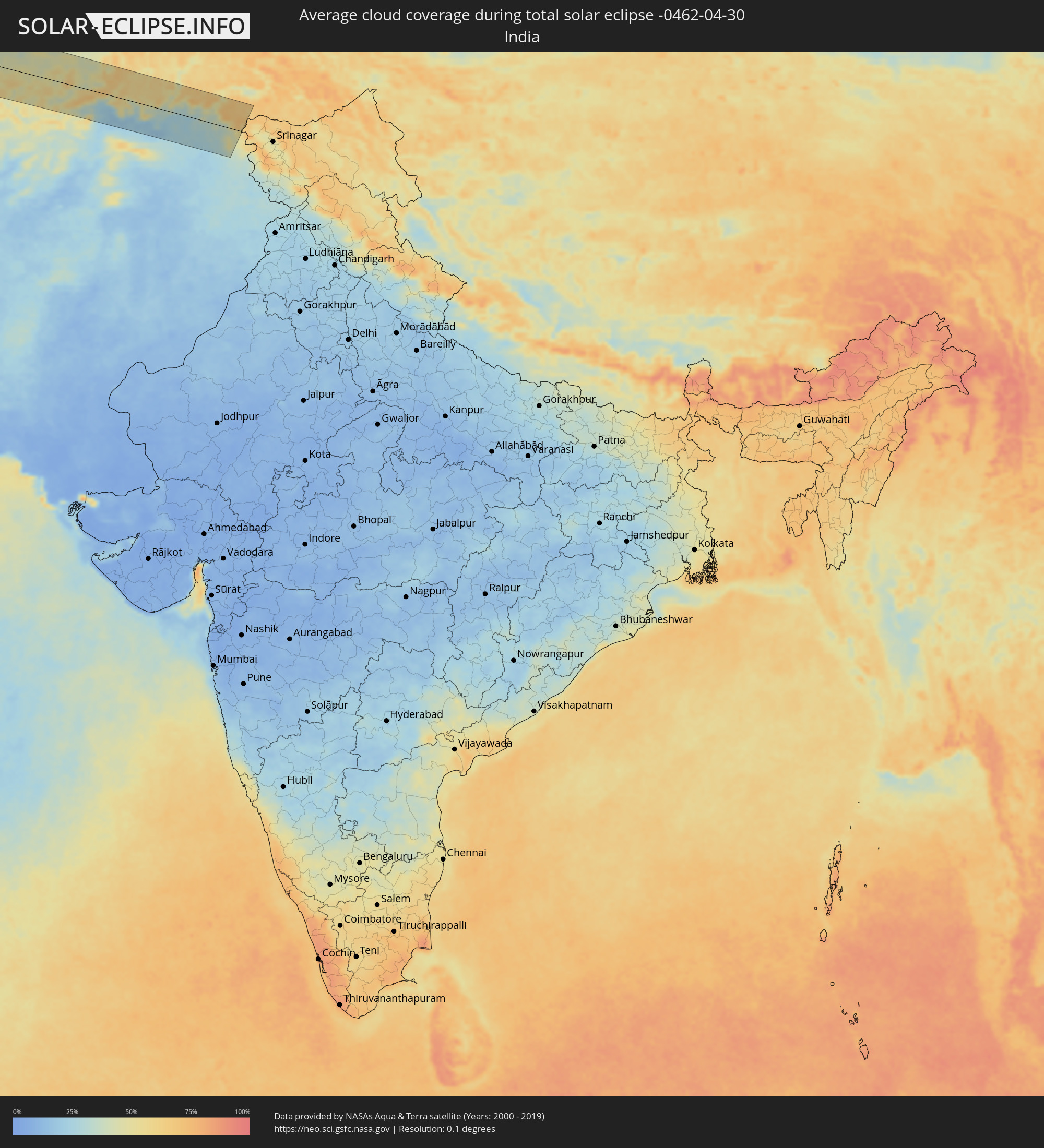 Indien
Orte im Finsternispfad
Die nachfolgene Tabelle zeigt Städte und Orte mit mehr als 5.000 Einwohnern, die sich im Finsternispfad befinden. Städte mit mehr als 100.000 Einwohnern sind dick gekennzeichnet. Mit einem Klick auf den Ort öffnet sich eine Detailkarte die die Lage des jeweiligen Ortes zusammen mit dem Verlauf der zentralen Finsternis präsentiert.
| Ort | Typ | Dauer der Verfinsterung | Ortszeit bei maximaler Verfinsterung | Entfernung zur Zentrallinie | Ø Bewölkung |
|
Puerto Ayacucho, Amazonas
|
total | - | 05:52:44 UTC-04:27 | 41 km | 89% |
|
Puerto Carreño, Vichada
|
total | - | 05:24:31 UTC-04:56 | 15 km | 85% |
|
Upata, Bolívar
|
total | - | 05:54:07 UTC-04:27 | 73 km | 89% |
|
Mabaruma, Barima-Waini
|
total | - | 06:29:21 UTC-03:52 | 16 km | 88% |
|
Icod de los Vinos, Canary Islands
|
total | - | 10:29:56 UTC-01:01 | 25 km | 65% |
|
Arona, Canary Islands
|
total | - | 10:29:34 UTC-01:01 | 2 km | 59% |
|
La Orotava, Canary Islands
|
total | - | 10:30:20 UTC-01:01 | 17 km | 62% |
|
Candelaria, Canary Islands
|
total | - | 10:30:34 UTC-01:01 | 6 km | 56% |
|
Santa Cruz de Tenerife, Canary Islands
|
total | - | 10:30:59 UTC-01:01 | 11 km | 56% |
|
Gáldar, Canary Islands
|
total | - | 10:31:39 UTC-01:01 | 50 km | 47% |
|
Maspalomas, Canary Islands
|
total | - | 10:31:11 UTC-01:01 | 90 km | 45% |
|
Santa Lucía, Canary Islands
|
total | - | 10:31:30 UTC-01:01 | 78 km | 41% |
|
Las Palmas de Gran Canaria, Canary Islands
|
total | - | 10:32:03 UTC-01:01 | 67 km | 63% |
|
Puerto del Rosario, Canary Islands
|
total | - | 10:35:48 UTC-01:01 | 106 km | 45% |
|
Arrecife, Canary Islands
|
total | - | 10:37:08 UTC-01:01 | 77 km | 56% |
|
Safi, Doukkala-Abda
|
total | - | 11:22:08 UTC-00:30 | 43 km | 40% |
|
El Jadida, Doukkala-Abda
|
total | - | 11:24:54 UTC-00:30 | 104 km | 46% |
|
Marrakesh, Marrakech-Tensift-Al Haouz
|
total | - | 11:23:54 UTC-00:30 | 77 km | 40% |
|
Casablanca, Grand Casablanca
|
total | - | 11:27:12 UTC-00:30 | 99 km | 51% |
|
Mohammedia, Grand Casablanca
|
total | - | 11:27:48 UTC-00:30 | 98 km | 50% |
|
Khouribga, Chaouia-Ouardigha
|
total | - | 11:27:49 UTC-00:30 | 2 km | 47% |
|
Rabat, Rabat-Salé-Zemmour-Zaër
|
total | - | 11:29:21 UTC-00:30 | 108 km | 50% |
|
Beni Mellal, Tadla-Azilal
|
total | - | 11:28:21 UTC-00:30 | 79 km | 46% |
|
Meknès, Meknès-Tafilalet
|
total | - | 11:31:56 UTC-00:30 | 43 km | 50% |
|
Fes, Fès-Boulemane
|
total | - | 11:33:15 UTC-00:30 | 34 km | 51% |
|
Taza, Taza-Al Hoceima-Taounate
|
total | - | 11:35:34 UTC-00:30 | 13 km | 44% |
|
Melilla, Melilla
|
total | - | 12:09:18 UTC+00:00 | 81 km | 53% |
|
Oujda, Oriental
|
total | - | 11:40:35 UTC-00:30 | 20 km | 40% |
|
Oran, Oran
|
total | - | 12:23:54 UTC+00:09 | 38 km | 54% |
|
Sidi Bel Abbès, Sidi Bel Abbès
|
total | - | 12:23:29 UTC+00:09 | 14 km | 51% |
|
Tiaret, Tiaret
|
total | - | 12:27:49 UTC+00:09 | 62 km | 51% |
|
Chlef, Chlef
|
total | - | 12:28:28 UTC+00:09 | 20 km | 51% |
|
Blida, Blida
|
total | - | 12:31:50 UTC+00:09 | 5 km | 57% |
|
Algiers, Algiers
|
total | - | 12:32:28 UTC+00:09 | 27 km | 52% |
|
Boumerdas, Boumerdes
|
total | - | 12:33:23 UTC+00:09 | 16 km | 51% |
|
Bordj Bou Arreridj, Bordj Bou Arréridj
|
total | - | 12:35:39 UTC+00:09 | 95 km | 46% |
|
Bejaïa, Béjaïa
|
total | - | 12:36:43 UTC+00:09 | 32 km | 55% |
|
Sétif, Sétif
|
total | - | 12:37:05 UTC+00:09 | 101 km | 51% |
|
Skikda, Skikda
|
total | - | 12:40:32 UTC+00:09 | 69 km | 54% |
|
Annaba, Annaba
|
total | - | 12:42:18 UTC+00:09 | 88 km | 55% |
|
Menzel Abderhaman, Banzart
|
total | - | 12:46:39 UTC+00:09 | 102 km | 53% |
|
Bizerte, Banzart
|
total | - | 12:46:41 UTC+00:09 | 98 km | 55% |
|
Menzel Jemil, Banzart
|
total | - | 12:46:45 UTC+00:09 | 103 km | 53% |
|
Marsala, Sicily
|
total | - | 13:42:27 UTC+01:00 | 95 km | 47% |
|
Trapani, Sicily
|
total | - | 13:42:40 UTC+01:00 | 74 km | 46% |
|
Alcamo, Sicily
|
total | - | 13:43:28 UTC+01:00 | 86 km | 46% |
|
Palermo, Sicily
|
total | - | 13:44:11 UTC+01:00 | 76 km | 54% |
|
Bagheria, Sicily
|
total | - | 13:44:31 UTC+01:00 | 85 km | 47% |
|
Milazzo, Sicily
|
total | - | 13:47:43 UTC+01:00 | 99 km | 47% |
|
Cosenza, Calabria
|
total | - | 13:49:28 UTC+01:00 | 4 km | 61% |
|
Lamezia Terme, Calabria
|
total | - | 13:49:36 UTC+01:00 | 34 km | 58% |
|
Catanzaro, Calabria
|
total | - | 13:50:07 UTC+01:00 | 47 km | 56% |
|
Crotone, Calabria
|
total | - | 13:51:01 UTC+01:00 | 33 km | 49% |
|
Nardò, Apulia
|
total | - | 13:52:23 UTC+01:00 | 76 km | 51% |
|
Lecce, Apulia
|
total | - | 13:52:35 UTC+01:00 | 94 km | 55% |
|
Vlorë, Vlorë
|
total | - | 14:14:01 UTC+01:19 | 91 km | 50% |
|
Selenicë, Vlorë
|
total | - | 14:14:14 UTC+01:19 | 97 km | 54% |
|
Sarandë, Vlorë
|
total | - | 14:15:00 UTC+01:19 | 20 km | 52% |
|
Tepelenë, Gjirokastër
|
total | - | 14:14:55 UTC+01:19 | 67 km | 64% |
|
Poliçan, Berat
|
total | - | 14:14:57 UTC+01:19 | 101 km | 62% |
|
Gjirokastër, Gjirokastër
|
total | - | 14:15:10 UTC+01:19 | 41 km | 66% |
|
Çorovodë, Berat
|
total | - | 14:15:11 UTC+01:19 | 88 km | 62% |
|
Përmet, Gjirokastër
|
total | - | 14:15:28 UTC+01:19 | 56 km | 71% |
|
Ersekë, Korçë
|
total | - | 14:15:57 UTC+01:19 | 65 km | 69% |
|
Korçë, Korçë
|
total | - | 14:16:01 UTC+01:19 | 95 km | 62% |
|
Ioánnina, Epirus
|
total | - | 14:31:57 UTC+01:34 | 11 km | 58% |
|
Bilisht, Korçë
|
total | - | 14:16:20 UTC+01:19 | 94 km | 57% |
|
Ptolemaḯda, West Macedonia
|
total | - | 14:32:58 UTC+01:34 | 75 km | 56% |
|
Tríkala, Thessaly
|
total | - | 14:33:26 UTC+01:34 | 32 km | 50% |
|
Kozáni, West Macedonia
|
total | - | 14:33:13 UTC+01:34 | 51 km | 54% |
|
Kardítsa, Thessaly
|
total | - | 14:33:44 UTC+01:34 | 54 km | 50% |
|
Véroia, Central Macedonia
|
total | - | 14:33:46 UTC+01:34 | 72 km | 59% |
|
Giannitsá, Central Macedonia
|
total | - | 14:33:58 UTC+01:34 | 100 km | 48% |
|
Lárisa, Thessaly
|
total | - | 14:34:25 UTC+01:34 | 28 km | 46% |
|
Kateríni, Central Macedonia
|
total | - | 14:34:19 UTC+01:34 | 41 km | 52% |
|
Thessaloníki, Central Macedonia
|
total | - | 14:34:49 UTC+01:34 | 80 km | 46% |
|
Vólos, Thessaly
|
total | - | 14:35:19 UTC+01:34 | 63 km | 47% |
|
Alexandroúpoli, East Macedonia and Thrace
|
total | - | 14:38:56 UTC+01:34 | 85 km | 48% |
|
Balıkesir, Balıkesir
|
total | - | 15:04:21 UTC+01:56 | 55 km | 56% |
|
Esenyurt, Istanbul
|
total | - | 15:04:36 UTC+01:56 | 97 km | 53% |
|
İstanbul, Istanbul
|
total | - | 15:04:58 UTC+01:56 | 95 km | 51% |
|
Bursa, Bursa
|
total | - | 15:05:35 UTC+01:56 | 4 km | 63% |
|
Maltepe, Istanbul
|
total | - | 15:05:16 UTC+01:56 | 86 km | 51% |
|
Gebze, Kocaeli
|
total | - | 15:05:41 UTC+01:56 | 71 km | 54% |
|
Adapazarı, Sakarya
|
total | - | 15:06:54 UTC+01:56 | 68 km | 62% |
|
Eskişehir, Eskişehir
|
total | - | 15:07:40 UTC+01:56 | 44 km | 57% |
|
Ankara, Ankara
|
total | - | 15:10:21 UTC+01:56 | 26 km | 58% |
|
Kırıkkale, Kırıkkale
|
total | - | 15:11:09 UTC+01:56 | 33 km | 52% |
|
Sivas, Sivas
|
total | - | 15:14:54 UTC+01:56 | 29 km | 64% |
|
Erzurum, Erzurum
|
total | - | 15:18:38 UTC+01:56 | 19 km | 78% |
|
Armavir, Armavir Province
|
total | - | 16:21:37 UTC+02:58 | 73 km | 56% |
|
Ejmiatsin, Armavir Province
|
total | - | 16:21:47 UTC+02:58 | 77 km | 52% |
|
Ashtarak, Aragatsotn Province
|
total | - | 16:21:43 UTC+02:58 | 92 km | 53% |
|
Masis, Ararat Province
|
total | - | 16:21:58 UTC+02:58 | 67 km | 50% |
|
Yerevan, Yerevan
|
total | - | 16:21:56 UTC+02:58 | 81 km | 51% |
|
Artashat, Ararat Province
|
total | - | 16:22:09 UTC+02:58 | 57 km | 51% |
|
Ararat, Ararat Province
|
total | - | 16:22:22 UTC+02:58 | 44 km | 52% |
|
Vedi, Ararat Province
|
total | - | 16:22:19 UTC+02:58 | 54 km | 51% |
|
Khvoy, Āz̄ārbāyjān-e Gharbī
|
total | - | 16:51:22 UTC+03:25 | 94 km | 55% |
|
Nakhchivan, Nakhichevan
|
total | - | 16:44:48 UTC+03:19 | 16 km | 48% |
|
Vardenis, Gegharkunik Province
|
total | - | 16:22:45 UTC+02:58 | 95 km | 66% |
|
Hats’avan, Syunik Province
|
total | - | 16:23:33 UTC+02:58 | 18 km | 66% |
|
Goris, Syunik Province
|
total | - | 16:23:44 UTC+02:58 | 28 km | 65% |
|
Qafan, Syunik Province
|
total | - | 16:24:03 UTC+02:58 | 5 km | 67% |
|
Xankandi, Xankǝndi
|
total | - | 16:45:08 UTC+03:19 | 67 km | 68% |
|
Ağdam, Ağdam
|
total | - | 16:45:05 UTC+03:19 | 88 km | 63% |
|
Ahar, East Azerbaijan
|
total | - | 16:52:50 UTC+03:25 | 77 km | 53% |
|
Fizuli, Füzuli
|
total | - | 16:45:34 UTC+03:19 | 48 km | 61% |
|
Beylagan, Beyləqan
|
total | - | 16:45:42 UTC+03:19 | 73 km | 57% |
|
Pārsābād, Ardabīl
|
total | - | 16:52:20 UTC+03:25 | 63 km | 54% |
|
Imishli, İmişli
|
total | - | 16:45:53 UTC+03:19 | 89 km | 54% |
|
Ardabīl, Ardabīl
|
total | - | 16:53:46 UTC+03:25 | 86 km | 54% |
|
Dzhalilabad, Jalilabad
|
total | - | 16:46:43 UTC+03:19 | 22 km | 55% |
|
Pushkino, Bilǝsuvar
|
total | - | 16:46:31 UTC+03:19 | 50 km | 55% |
|
Lankaran, Lənkəran
|
total | - | 16:47:19 UTC+03:19 | 23 km | 50% |
|
Āstārā, Gīlān
|
total | - | 16:53:57 UTC+03:25 | 58 km | 57% |
|
Astara, Astara
|
total | - | 16:47:36 UTC+03:19 | 55 km | 54% |
|
Salyan, Salyan
|
total | - | 16:46:39 UTC+03:19 | 72 km | 51% |
|
Neftçala, Neftçala
|
total | - | 16:46:59 UTC+03:19 | 51 km | 50% |
|
Gonbad-e Kāvūs, Golestān
|
total | - | 16:57:51 UTC+03:25 | 89 km | 53% |
|
Bojnūrd, Khorāsān-e Shomālī
|
total | - | 16:58:20 UTC+03:25 | 25 km | 51% |
|
Baharly, Ahal
|
total | - | 17:25:19 UTC+03:53 | 81 km | 46% |
|
Esfarāyen, Khorāsān-e Shomālī
|
total | - | 16:58:44 UTC+03:25 | 65 km | 38% |
|
Shīrvān, Khorāsān-e Shomālī
|
total | - | 16:58:34 UTC+03:25 | 23 km | 44% |
|
Abadan, Ahal
|
total | - | 17:25:52 UTC+03:53 | 54 km | 52% |
|
Ashgabat, Ahal
|
total | - | 17:26:00 UTC+03:53 | 46 km | 50% |
|
Qūchān, Razavi Khorasan
|
total | - | 16:58:58 UTC+03:25 | 43 km | 49% |
|
Annau, Ahal
|
total | - | 17:26:05 UTC+03:53 | 42 km | 51% |
|
Chenārān, Razavi Khorasan
|
total | - | 16:59:31 UTC+03:25 | 82 km | 46% |
|
Kaka, Ahal
|
total | - | 17:26:49 UTC+03:53 | 4 km | 44% |
|
Tejen, Ahal
|
total | - | 17:26:58 UTC+03:53 | 26 km | 41% |
|
Sarakhs, Razavi Khorasan
|
total | - | 17:00:00 UTC+03:25 | 52 km | 39% |
|
Mary, Mary
|
total | - | 17:27:00 UTC+03:53 | 75 km | 41% |
|
Murgab
|
total | - | 17:27:07 UTC+03:53 | 67 km | 38% |
|
Bayramaly, Mary
|
total | - | 17:27:02 UTC+03:53 | 85 km | 42% |
|
Yolöten, Mary
|
total | - | 17:27:20 UTC+03:53 | 54 km | 38% |
|
Ghormach, Badghis
|
total | - | 17:35:17 UTC+04:00 | 86 km | 46% |
|
Maymana, Faryab
|
total | - | 17:35:12 UTC+04:00 | 43 km | 43% |
|
Andkhōy, Faryab
|
total | - | 17:34:22 UTC+04:00 | 75 km | 40% |
|
Shibirghān, Jowzjan
|
total | - | 17:34:38 UTC+04:00 | 58 km | 39% |
|
Sar-e Pul, Sar-e Pol
|
total | - | 17:35:01 UTC+04:00 | 14 km | 44% |
|
Aībak, Samangan
|
total | - | 17:34:59 UTC+04:00 | 66 km | 46% |
|
Baghlān, Baghlan
|
total | - | 17:35:04 UTC+04:00 | 67 km | 44% |
|
Pul-e Khumrī, Baghlan
|
total | - | 17:35:13 UTC+04:00 | 47 km | 44% |
|
Charikar, Parwan
|
total | - | 17:35:56 UTC+04:00 | 42 km | 26% |
|
Bāzārak, Panjshir
|
total | - | 17:35:41 UTC+04:00 | 2 km | 38% |
|
Jalālābād, Nangarhar
|
total | - | 17:36:18 UTC+04:00 | 75 km | 25% |
|
Asadābād, Kunar
|
total | - | 17:35:53 UTC+04:00 | 10 km | 31% |
|
Shabqadar, Khyber Pakhtunkhwa
|
total | - | 18:04:32 UTC+04:28 | 71 km | 25% |
|
Chārsadda, Khyber Pakhtunkhwa
|
total | - | 18:04:34 UTC+04:28 | 74 km | 26% |
|
Bat Khela, Khyber Pakhtunkhwa
|
total | - | 18:04:11 UTC+04:28 | 18 km | 25% |
|
Risalpur Cantonment, Khyber Pakhtunkhwa
|
total | - | 18:04:36 UTC+04:28 | 77 km | 26% |
|
Mardan, Khyber Pakhtunkhwa
|
total | - | 18:04:29 UTC+04:28 | 60 km | 27% |
|
Mingora, Khyber Pakhtunkhwa
|
total | - | 18:04:01 UTC+04:28 | 9 km | 32% |
|
Swābi, Khyber Pakhtunkhwa
|
total | - | 18:04:30 UTC+04:28 | 59 km | 26% |
|
Topi, Khyber Pakhtunkhwa
|
total | - | 18:04:30 UTC+04:28 | 61 km | 26% |
|
Harīpur, Khyber Pakhtunkhwa
|
total | - | 18:04:31 UTC+04:28 | 60 km | 28% |
|
Mānsehra, Khyber Pakhtunkhwa
|
total | - | 18:04:13 UTC+04:28 | 18 km | 37% |
|
Abbottābād, Khyber Pakhtunkhwa
|
total | - | 18:04:22 UTC+04:28 | 38 km | 35% |
|
Muzaffarābād, Azad Kashmir
|
total | - | 18:04:09 UTC+04:28 | 8 km | 42% |