Totale Sonnenfinsternis vom 19.04.-0480
| Wochentag: | Sonntag |
| Maximale Dauer der Verfinsterung: | 05m07s |
| Maximale Breite des Finsternispfades: | 201 km |
| Saroszyklus: | 50 |
| Bedeckungsgrad: | 100% |
| Magnitude: | 1.0585 |
| Gamma: | 0.2839 |
Wo kann man die Sonnenfinsternis vom 19.04.-0480 sehen?
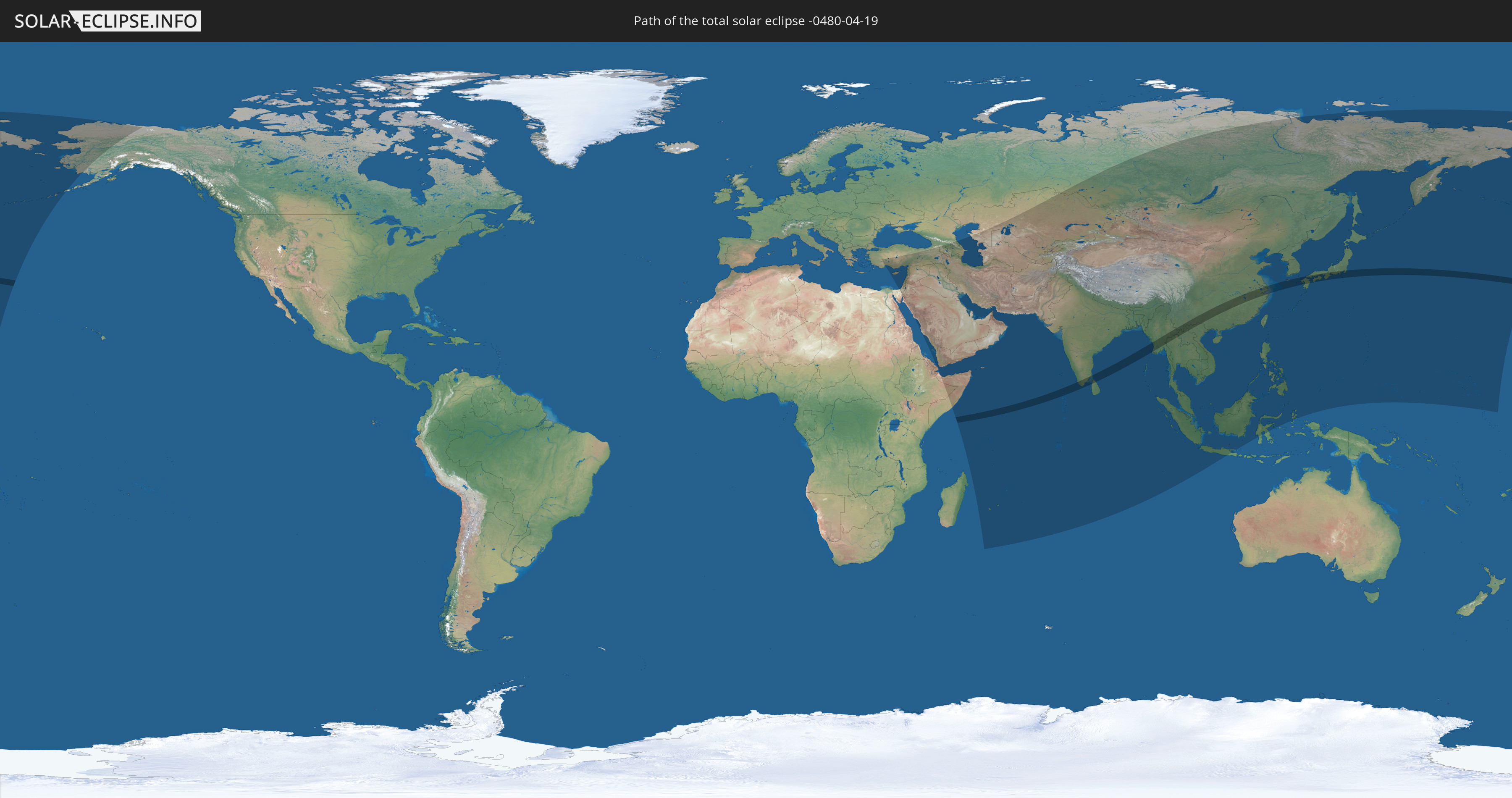
Die Sonnenfinsternis am 19.04.-0480 kann man in 71 Ländern als partielle Sonnenfinsternis beobachten.
Der Finsternispfad verläuft durch 10 Länder. Nur in diesen Ländern ist sie als totale Sonnenfinsternis zu sehen.
In den folgenden Ländern ist die Sonnenfinsternis total zu sehen
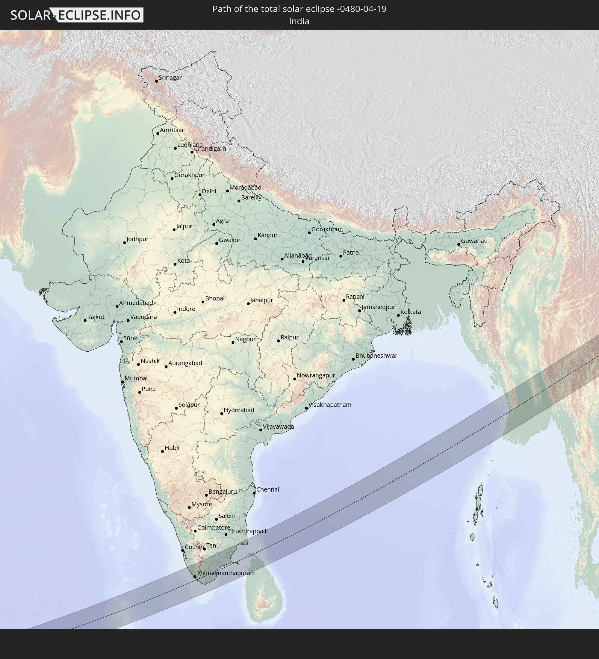 Indien
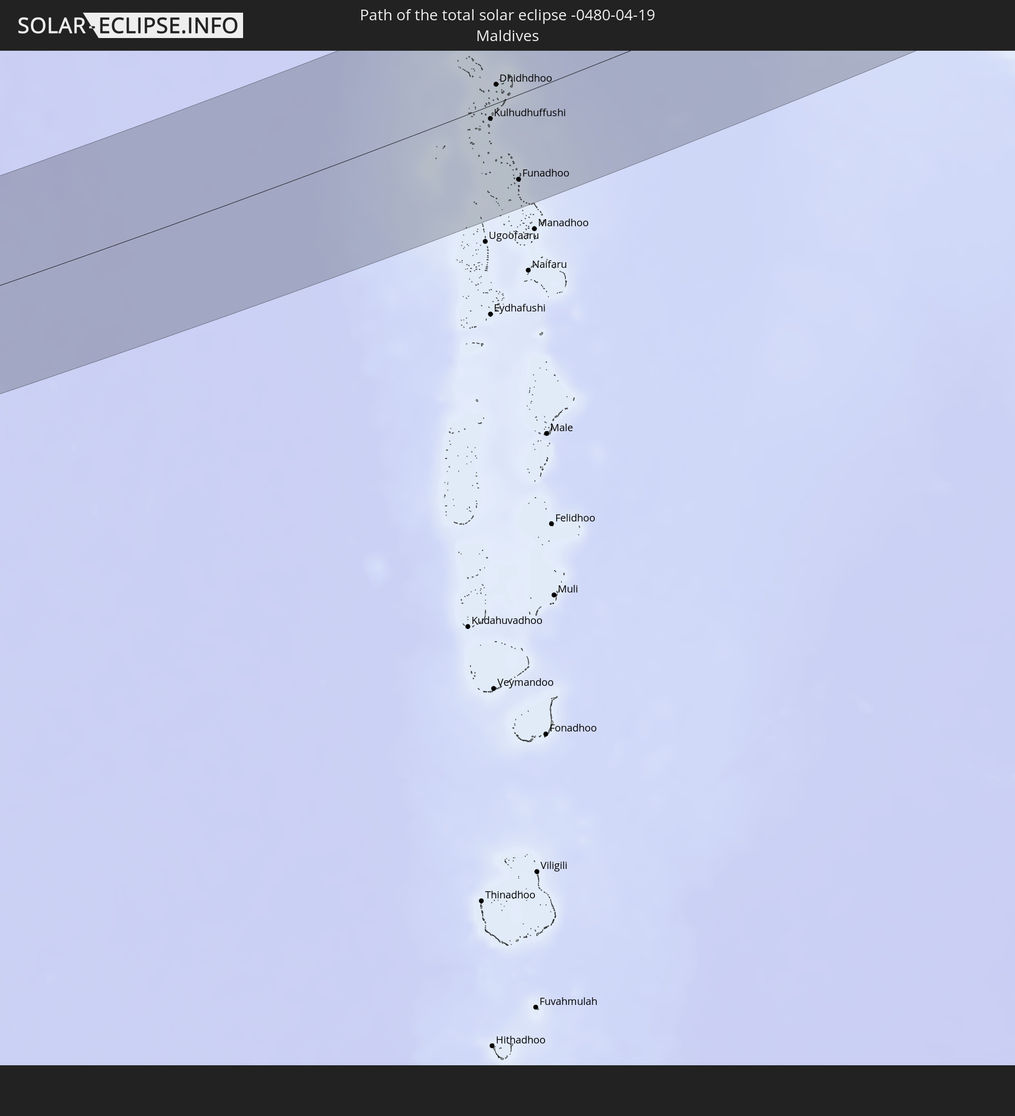 Malediven
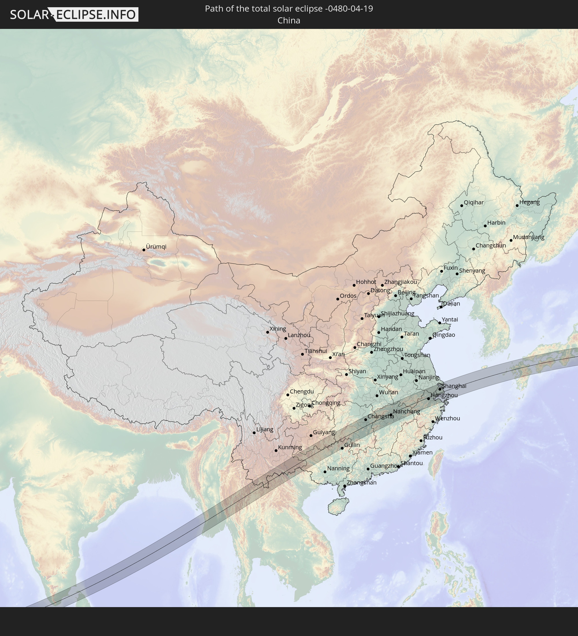 Volksrepublik China
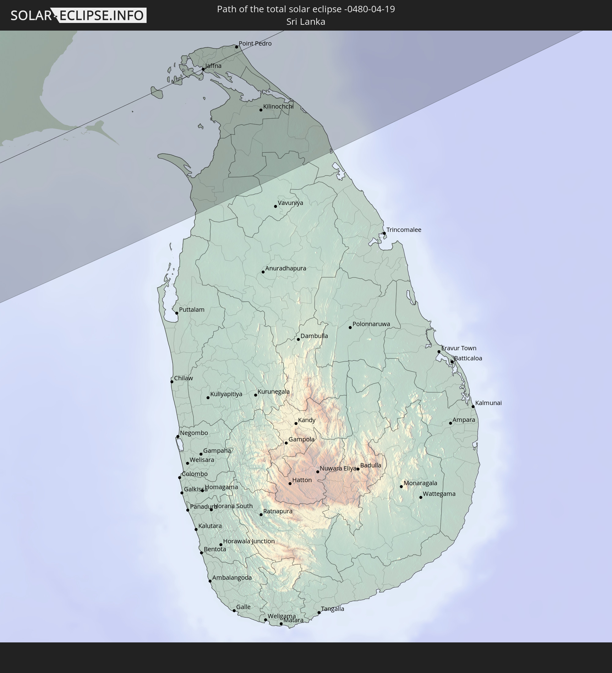 Sri Lanka
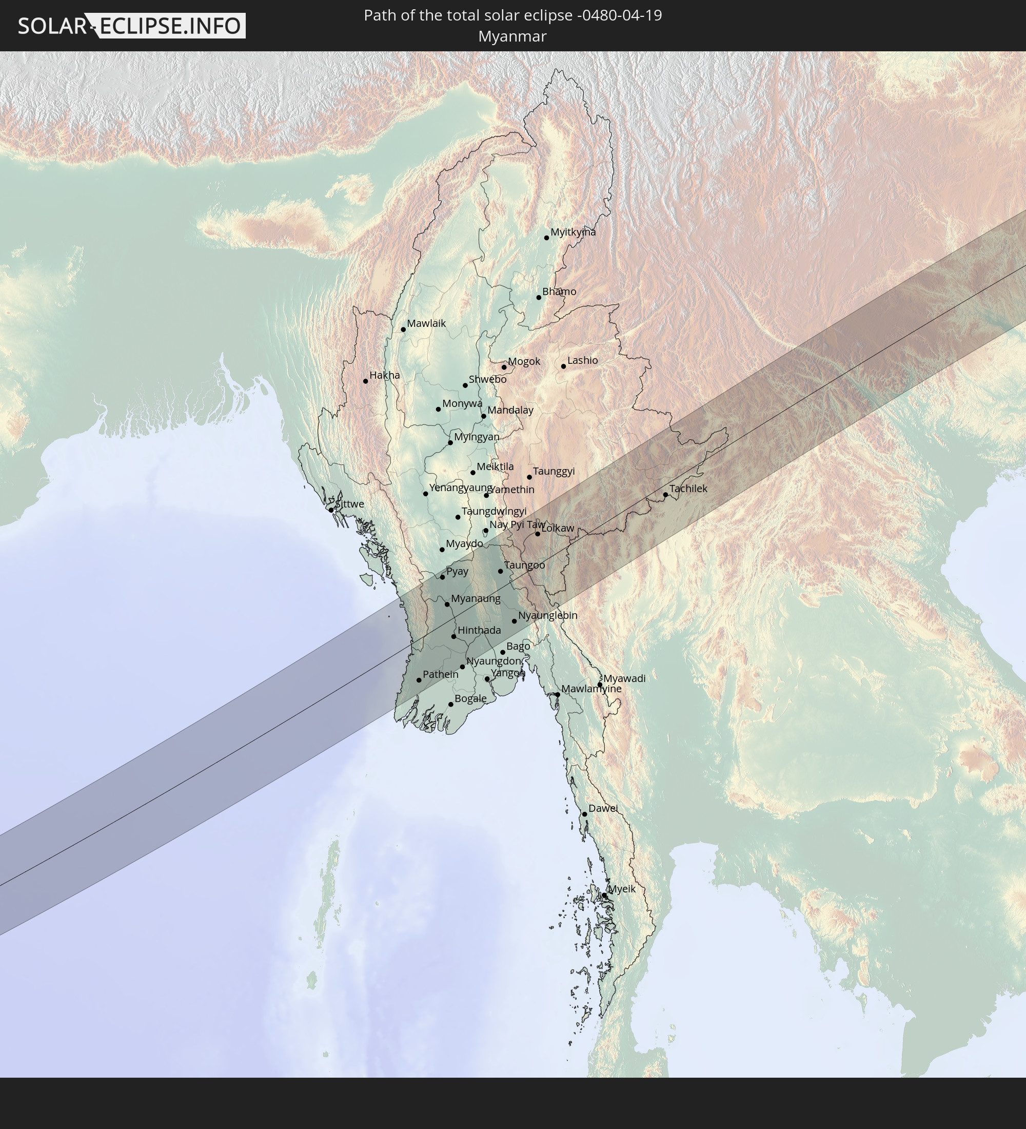 Myanmar
 Thailand
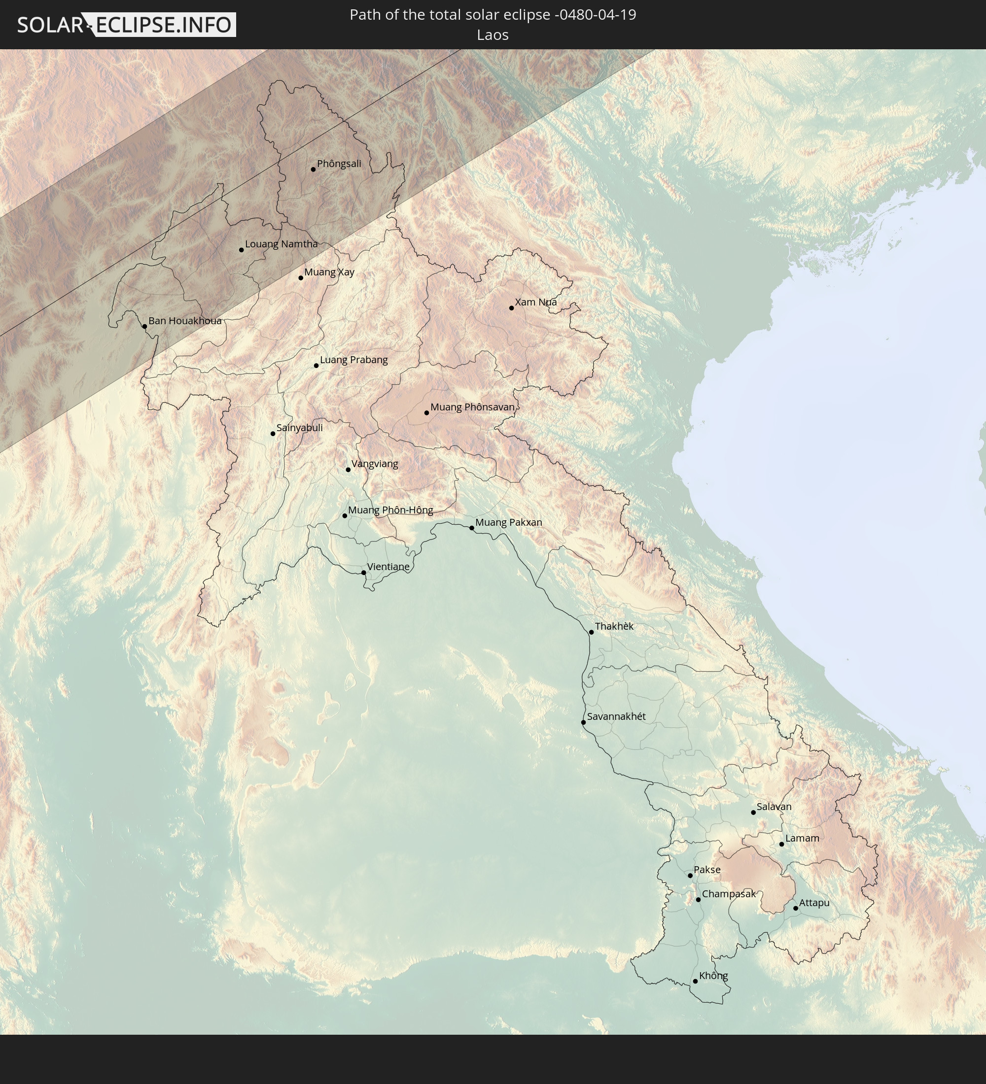 Laos
Laos
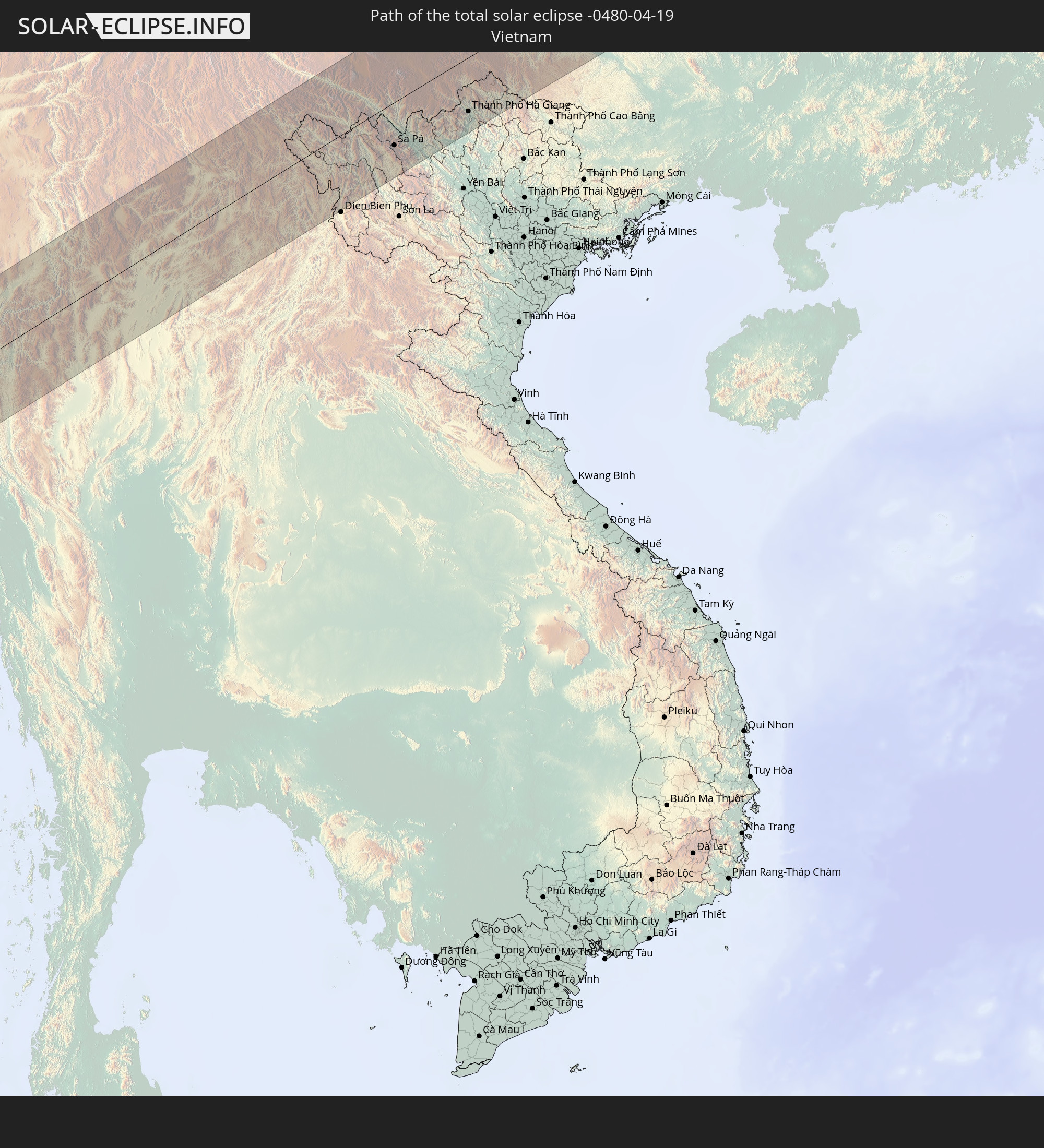 Vietnam
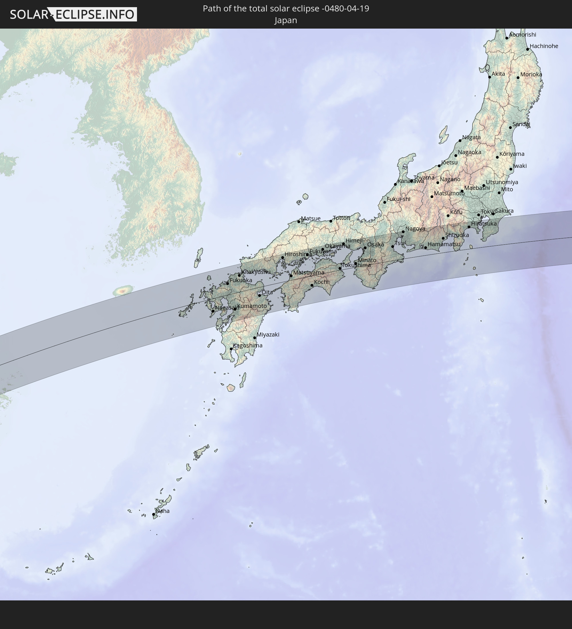 Japan
Japan
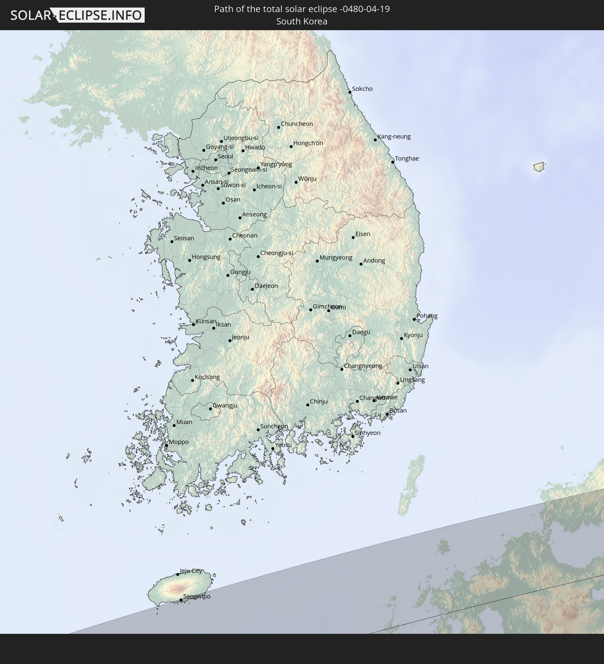 Südkorea
In den folgenden Ländern ist die Sonnenfinsternis partiell zu sehen
 Russland
 Vereinigte Staaten
 United States Minor Outlying Islands
 Kiribati
 Ägypten
 Türkei
 Republik Zypern
 Äthiopien
 Staat Palästina
 Israel
 Saudi-Arabien
 Jordanien
 Libanon
 Syrien
 Eritrea
 Irak
Irak
 Georgien
 Französische Süd- und Antarktisgebiete
 Somalia
 Dschibuti
 Jemen
Jemen
 Armenien
 Iran
Iran
 Aserbaidschan
 Seychellen
 Kasachstan
 Kuwait
 Bahrain
 Katar
Katar
 Vereinigte Arabische Emirate
 Oman
Oman
 Turkmenistan
 Réunion
 Usbekistan
 Mauritius
 Afghanistan
 Pakistan
 Tadschikistan
 Indien
 Kirgisistan
 Britisches Territorium im Indischen Ozean
 Malediven
 Volksrepublik China
 Sri Lanka
 Nepal
Nepal
 Mongolei
 Bangladesch
 Bhutan
 Myanmar
 Indonesien
 Kokosinseln
 Thailand
 Malaysia
 Laos
Laos
 Vietnam
 Kambodscha
 Singapur
 Weihnachtsinsel
 Macau
Macau
 Hongkong
 Brunei
 Taiwan
 Philippinen
 Japan
Japan
 Nordkorea
 Südkorea
 Palau
Palau
 Föderierte Staaten von Mikronesien
 Guam
Guam
 Nördliche Marianen
 Marshallinseln
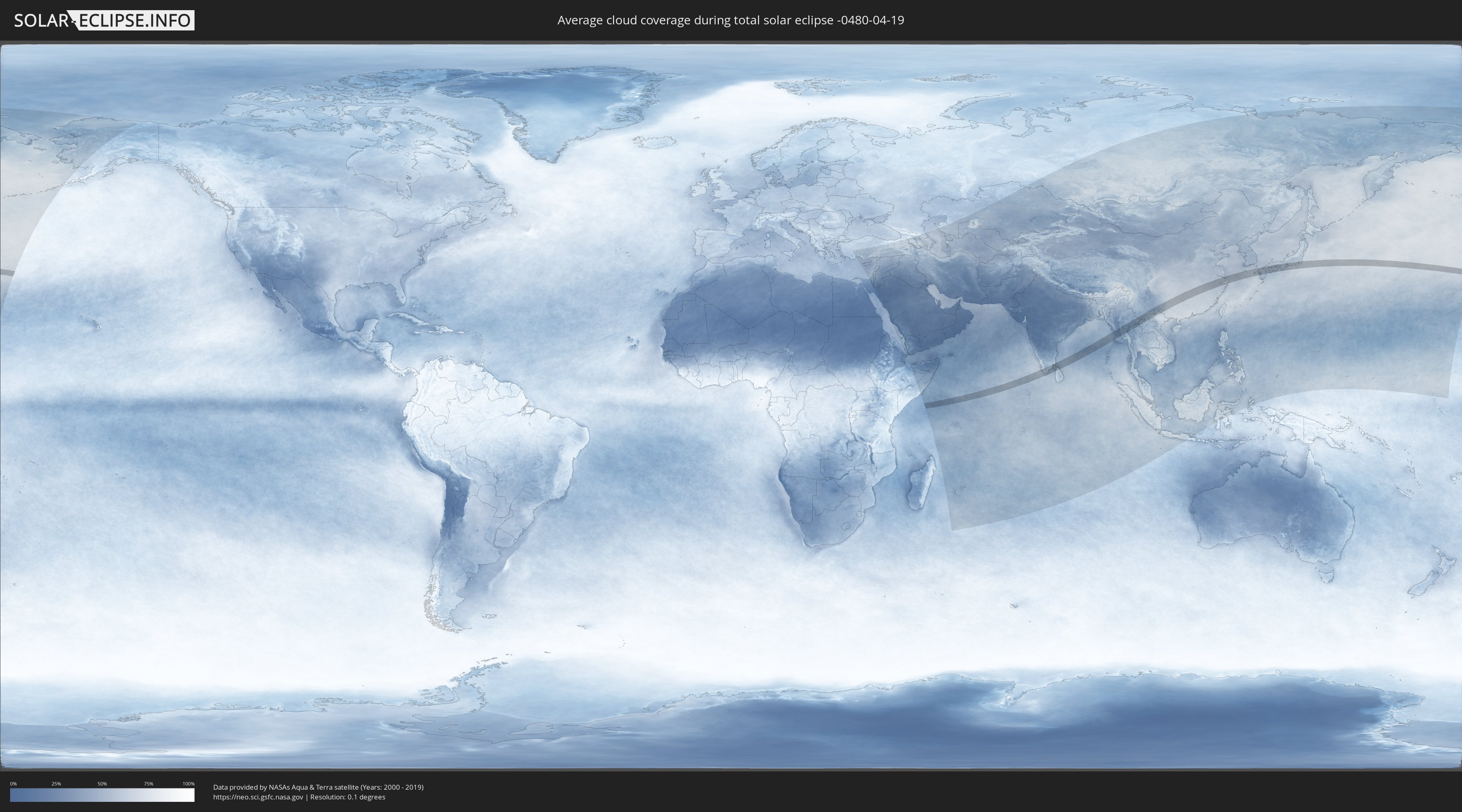
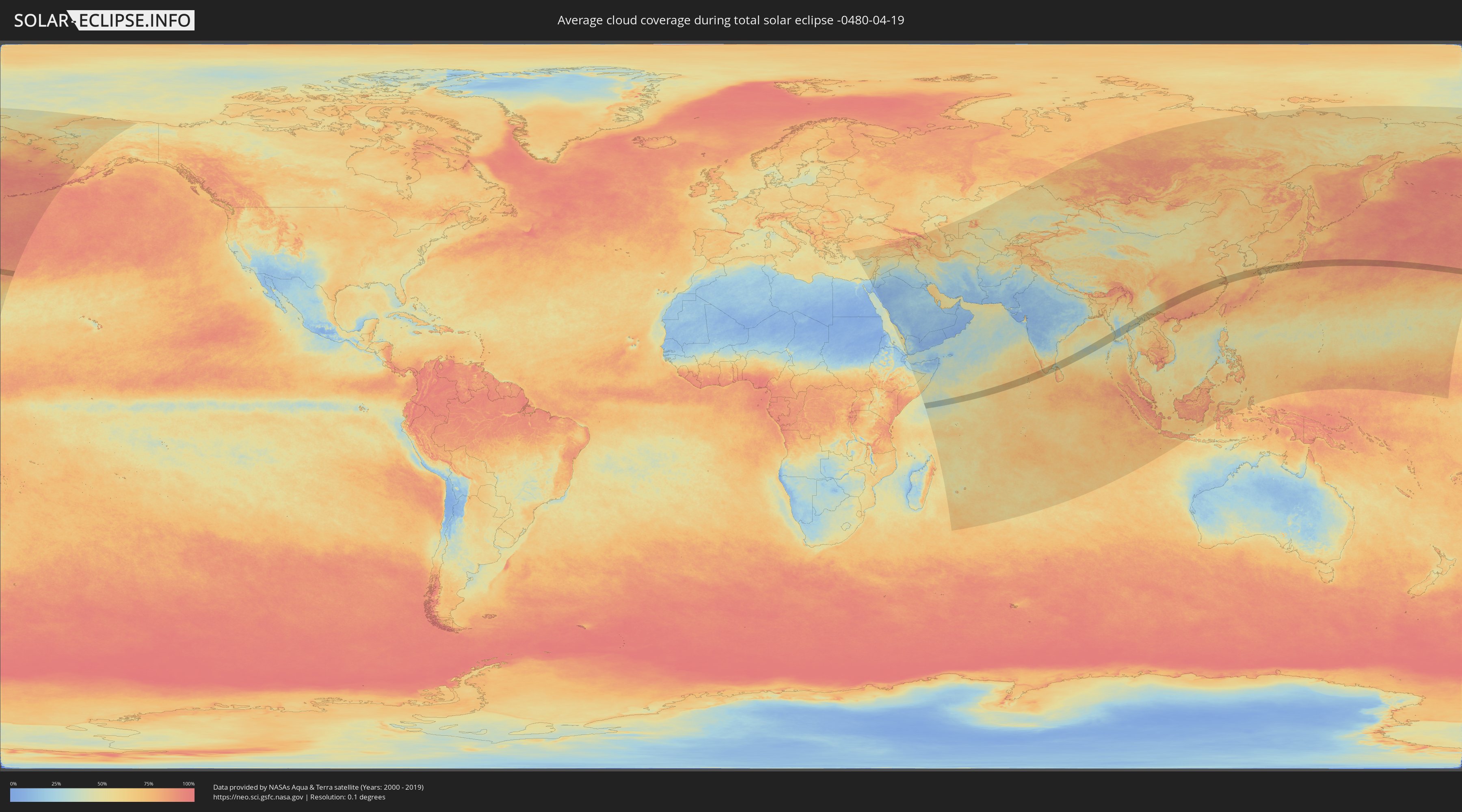
Wie wird das Wetter während der totalen Sonnenfinsternis am 19.04.-0480?
Wo ist der beste Ort, um die totale Sonnenfinsternis vom 19.04.-0480 zu beobachten?
Die folgenden Karten zeigen die durchschnittliche Bewölkung für den Tag, an dem die totale Sonnenfinsternis
stattfindet. Mit Hilfe der Karten lässt sich der Ort entlang des Finsternispfades eingrenzen,
der die besten Aussichen auf einen klaren wolkenfreien Himmel bietet.
Trotzdem muss man immer lokale Gegenenheiten beachten und sollte sich genau über das Wetter an seinem
gewählten Beobachtungsort informieren.
Die Daten stammen von den beiden NASA-Satelliten
AQUA und TERRA
und wurden über einen Zeitraum von 19 Jahren (2000 - 2019) gemittelt.
Detaillierte Länderkarten
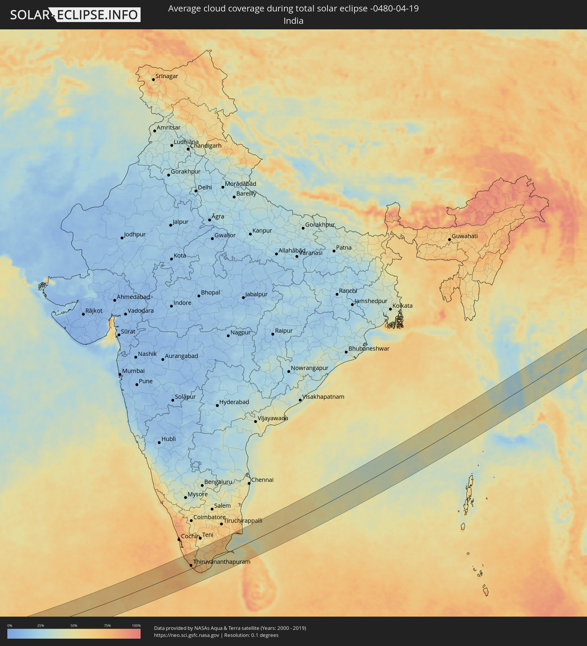 Indien
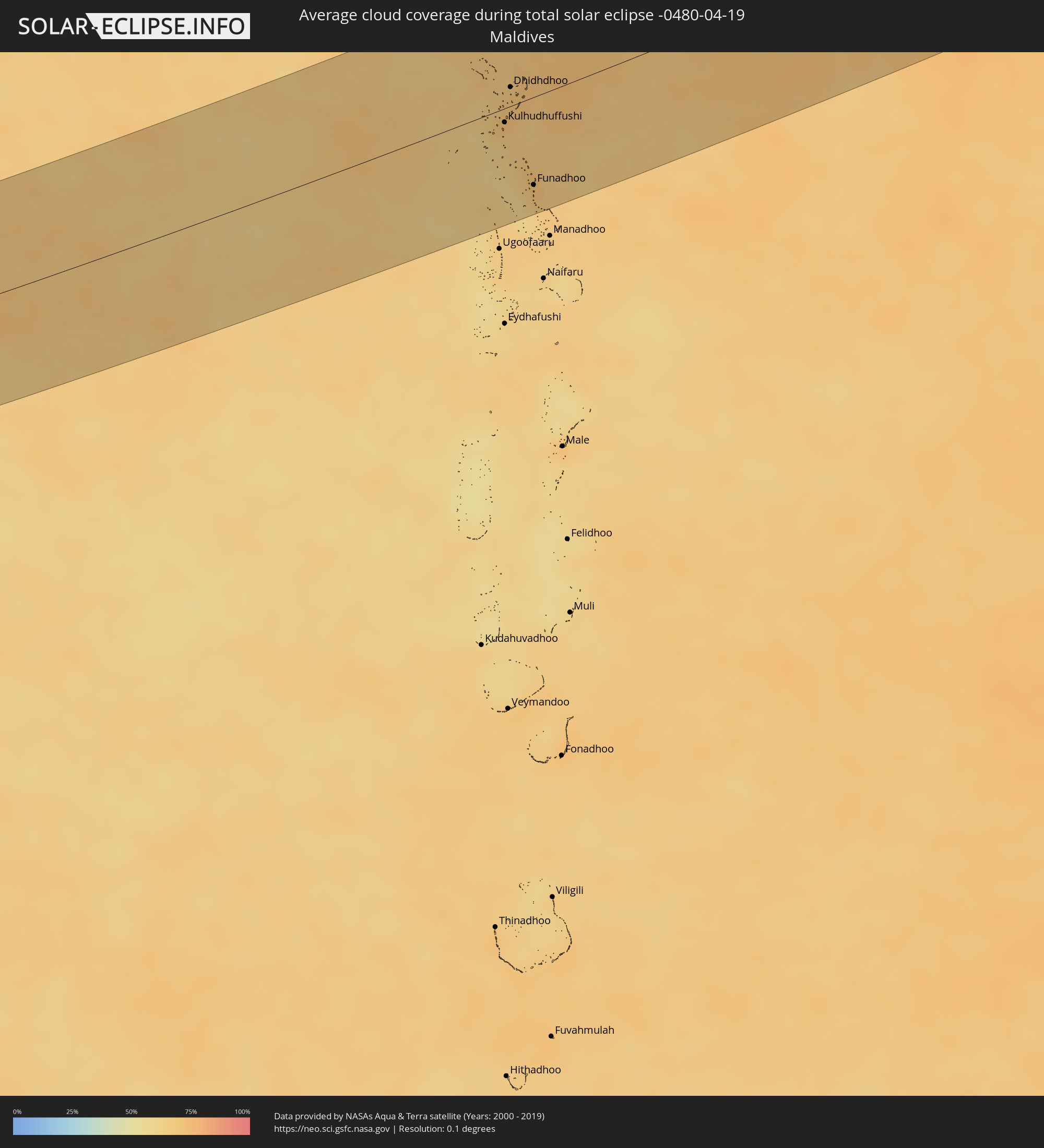 Malediven
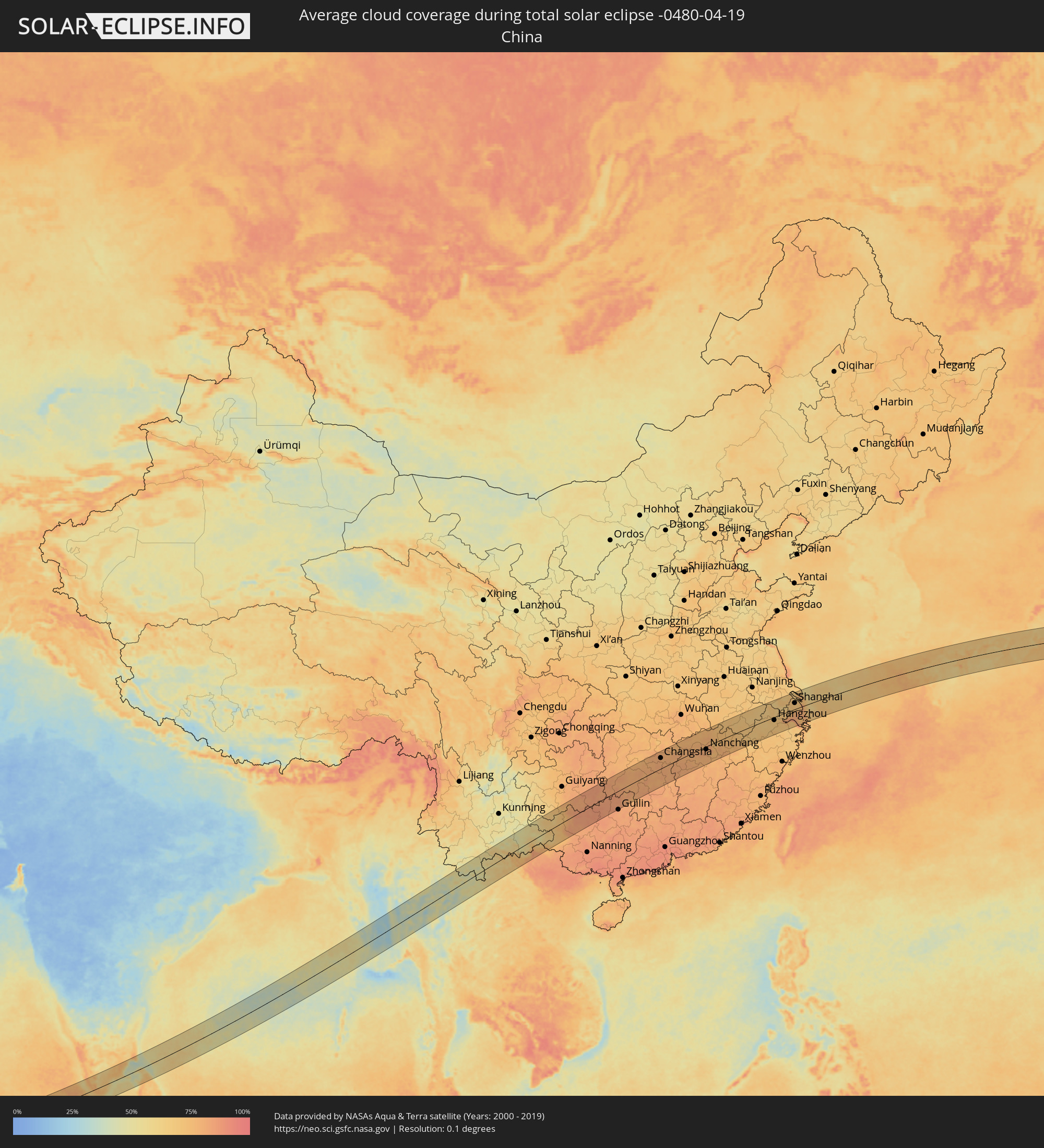 Volksrepublik China
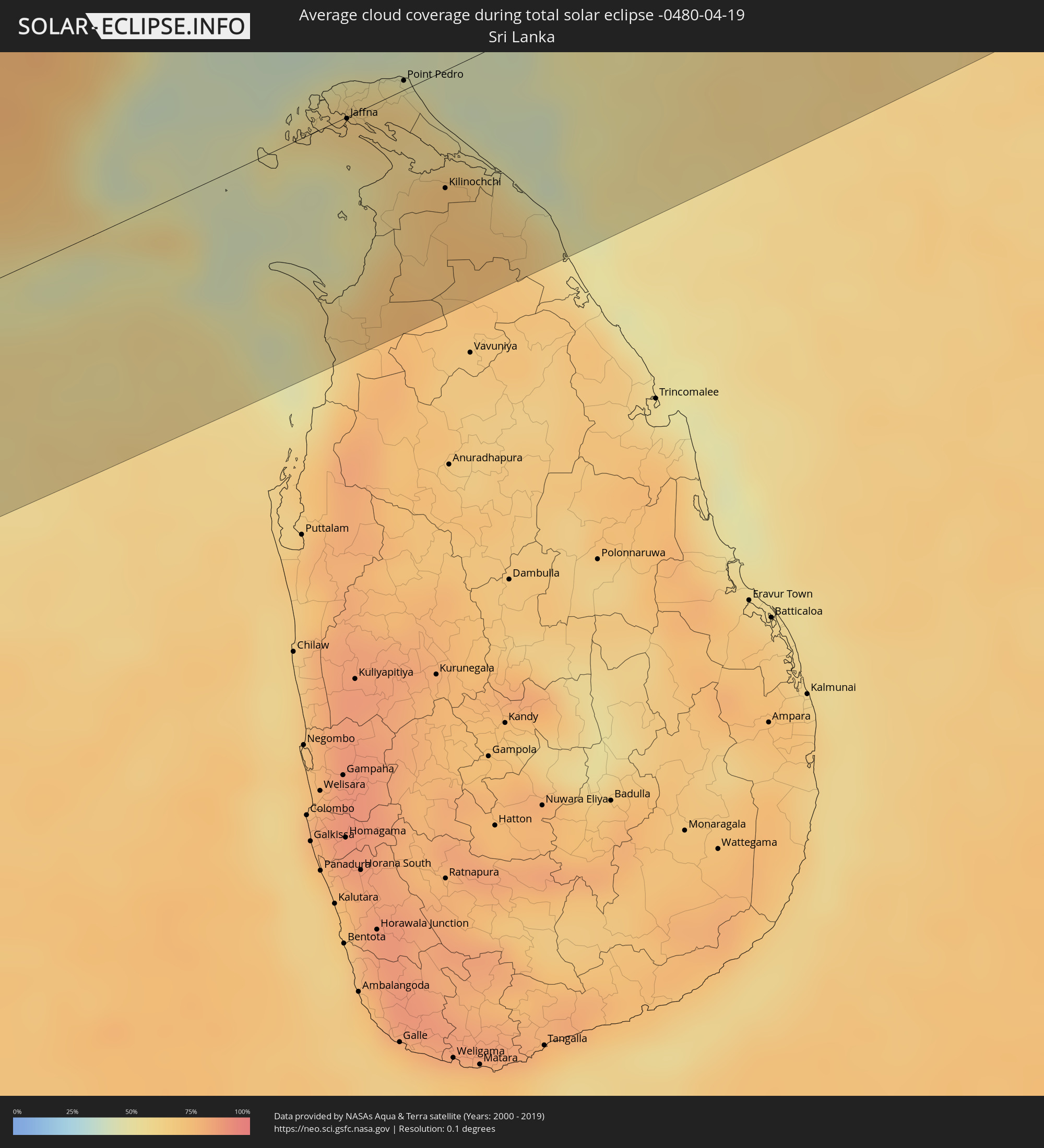 Sri Lanka
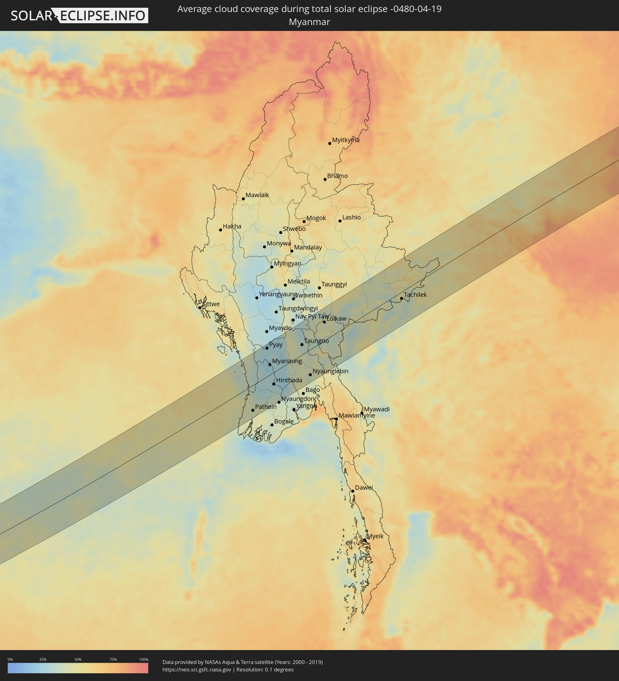 Myanmar
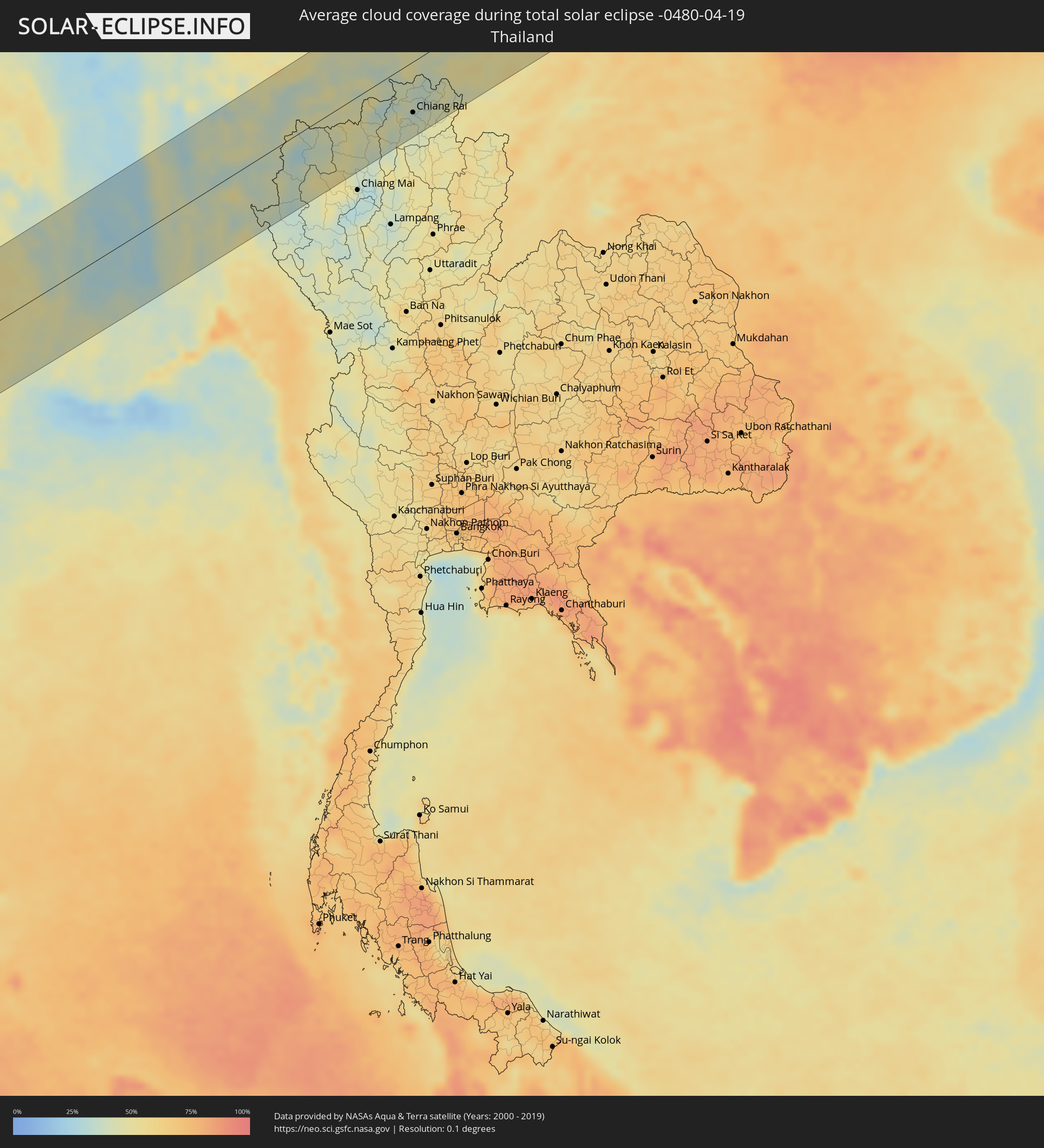 Thailand
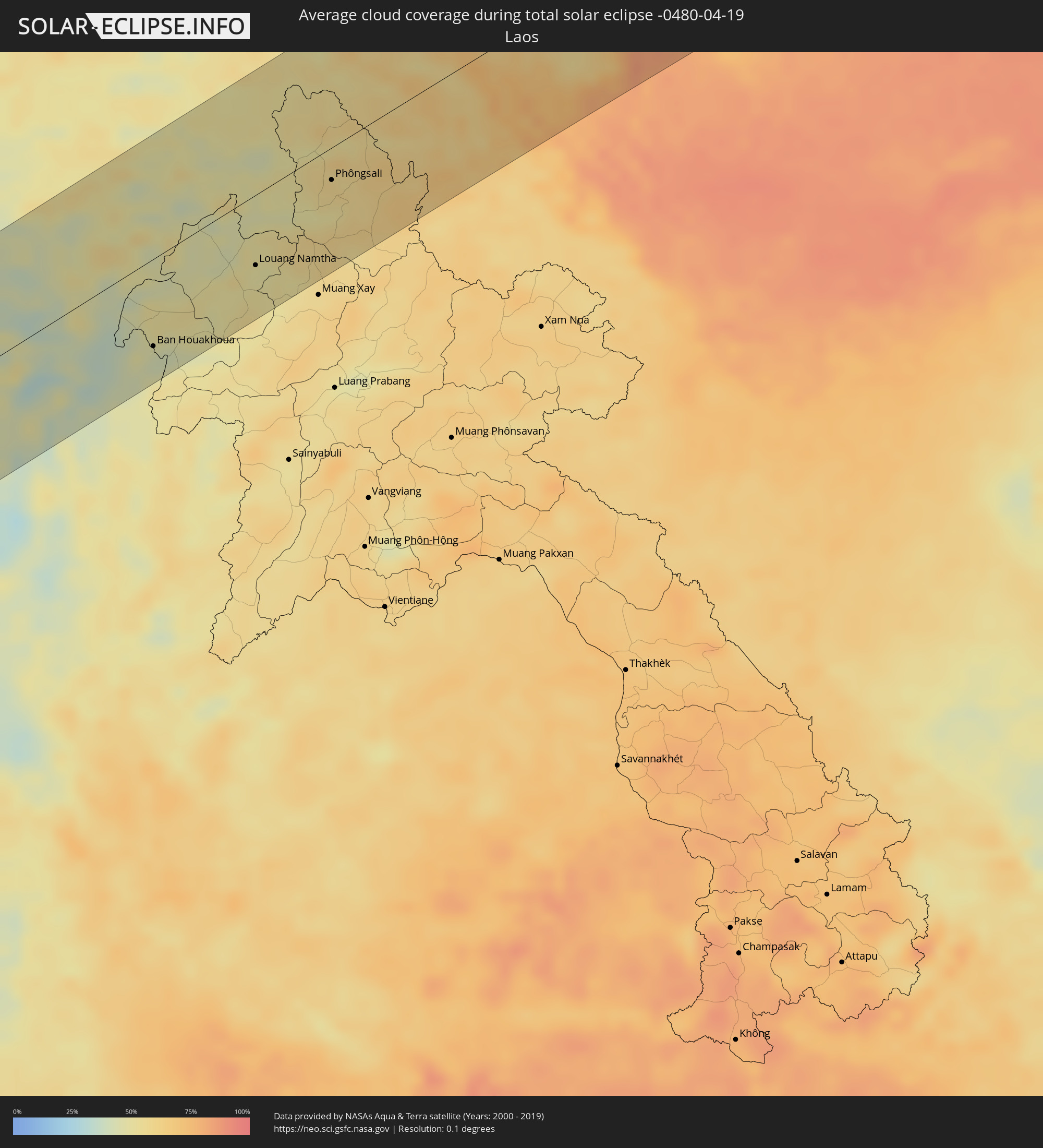 Laos
Laos
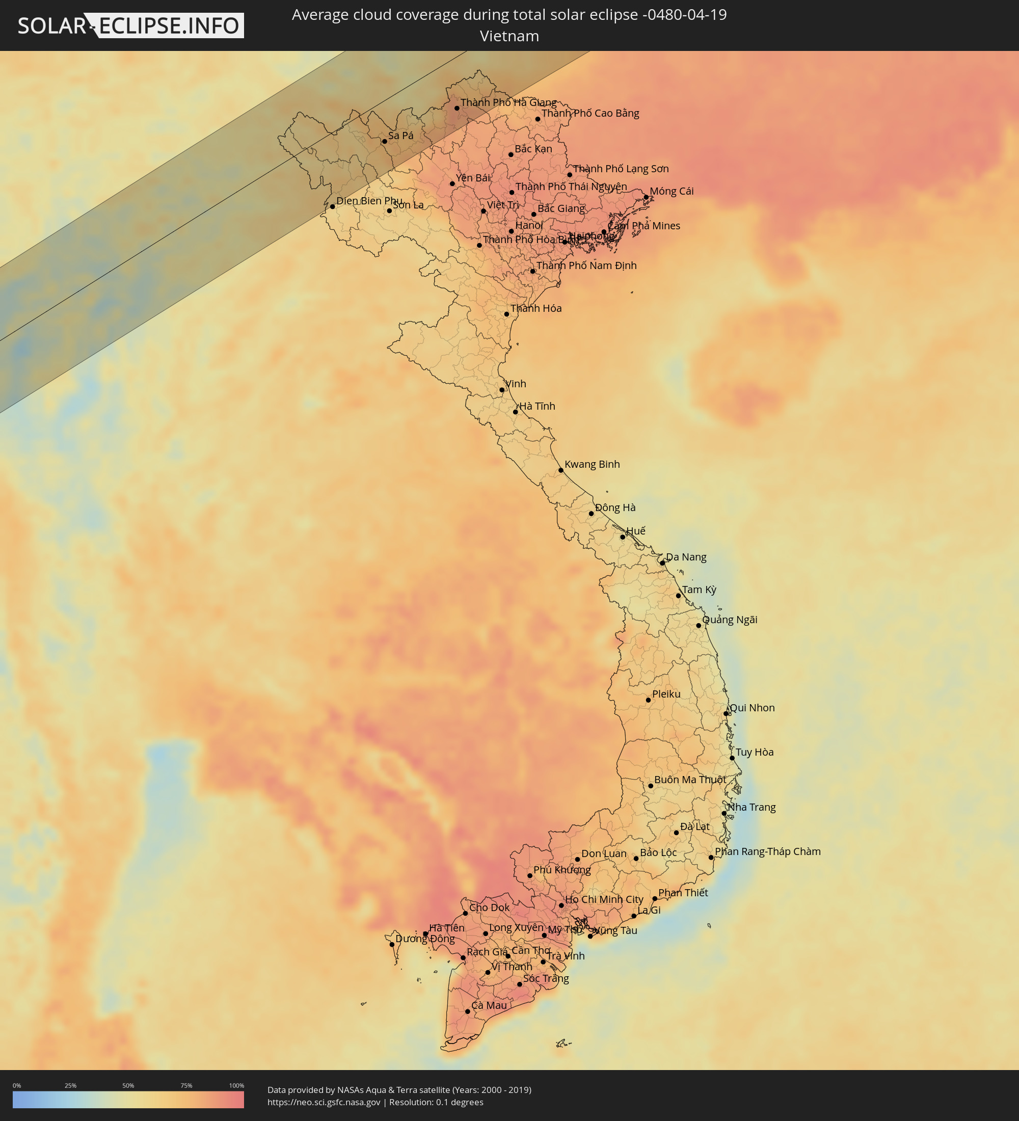 Vietnam
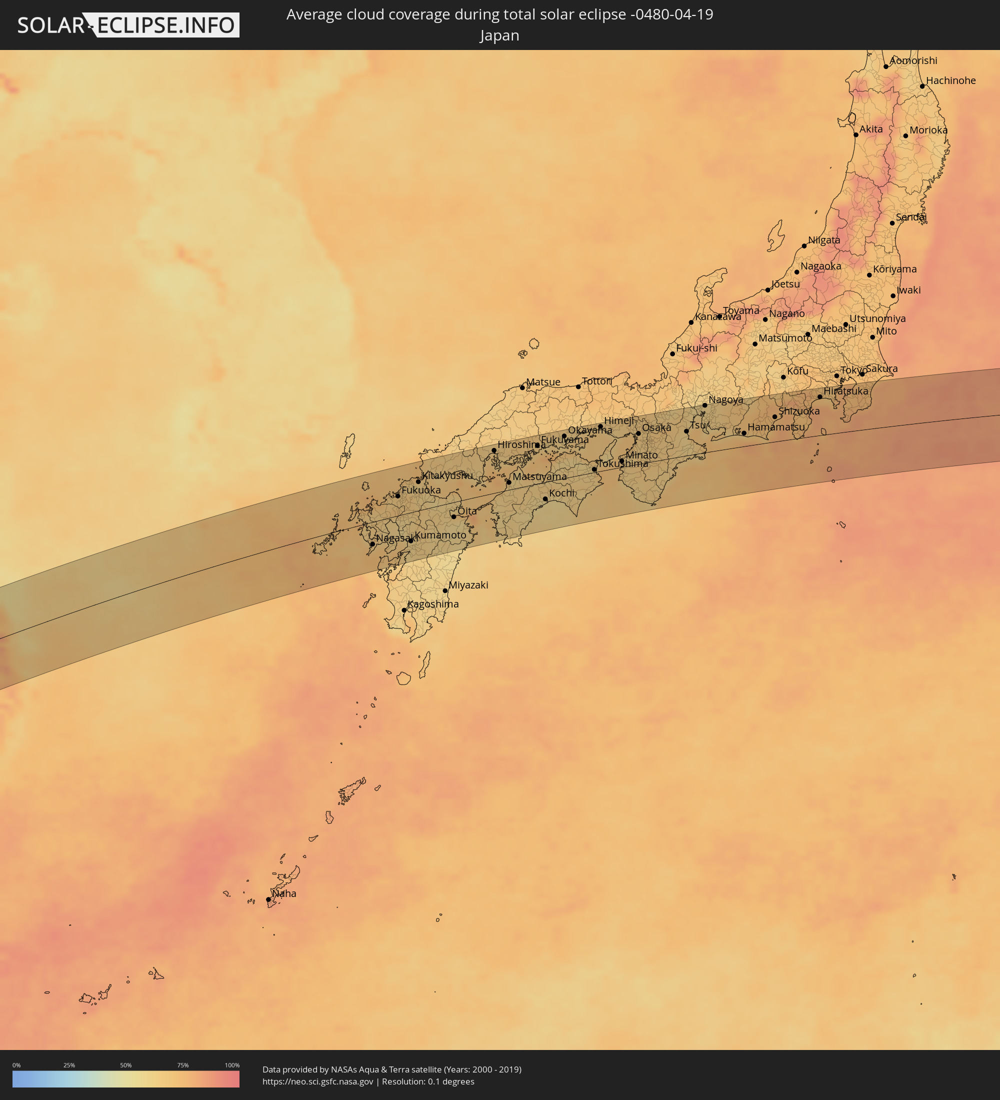 Japan
Japan
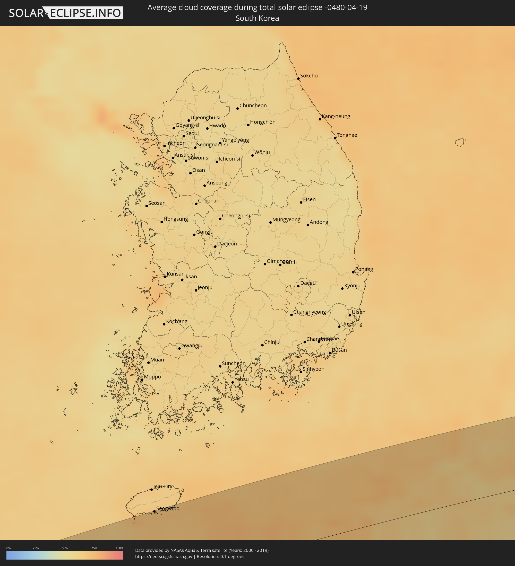 Südkorea
Orte im Finsternispfad
Die nachfolgene Tabelle zeigt Städte und Orte mit mehr als 5.000 Einwohnern, die sich im Finsternispfad befinden. Städte mit mehr als 100.000 Einwohnern sind dick gekennzeichnet. Mit einem Klick auf den Ort öffnet sich eine Detailkarte die die Lage des jeweiligen Ortes zusammen mit dem Verlauf der zentralen Finsternis präsentiert.
| Ort | Typ | Dauer der Verfinsterung | Ortszeit bei maximaler Verfinsterung | Entfernung zur Zentrallinie | Ø Bewölkung |
|
Kulhudhuffushi, Haa Dhaalu Atholhu
|
total | - | 07:55:52 UTC+04:54 | 11 km | 69% |
|
Dhidhdhoo, Haa Alifu Atholhu
|
total | - | 07:56:12 UTC+04:54 | 15 km | 70% |
|
Funadhoo, Shaviyani Atholhu
|
total | - | 07:55:31 UTC+04:54 | 69 km | 72% |
|
Kollam, Kerala
|
total | - | 08:29:02 UTC+05:21 | 75 km | 66% |
|
Varkala, Kerala
|
total | - | 08:28:59 UTC+05:21 | 54 km | 65% |
|
Punalūr, Kerala
|
total | - | 08:29:34 UTC+05:21 | 74 km | 71% |
|
Thiruvananthapuram, Kerala
|
total | - | 08:28:55 UTC+05:21 | 18 km | 69% |
|
Neyyāttinkara, Kerala
|
total | - | 08:28:57 UTC+05:21 | 3 km | 71% |
|
Kadayanallur, Tamil Nadu
|
total | - | 08:30:04 UTC+05:21 | 61 km | 56% |
|
Nāgercoil, Tamil Nadu
|
total | - | 08:29:02 UTC+05:21 | 35 km | 71% |
|
Rajapalaiyam, Tamil Nadu
|
total | - | 08:30:47 UTC+05:21 | 90 km | 61% |
|
Tirunelveli, Tamil Nadu
|
total | - | 08:29:59 UTC+05:21 | 10 km | 66% |
|
Sivakasi, Tamil Nadu
|
total | - | 08:31:03 UTC+05:21 | 79 km | 64% |
|
Kovilpatti, Tamil Nadu
|
total | - | 08:30:46 UTC+05:21 | 47 km | 67% |
|
Virudunagar, Tamil Nadu
|
total | - | 08:31:24 UTC+05:21 | 85 km | 64% |
|
Aruppukkottai, Tamil Nadu
|
total | - | 08:31:27 UTC+05:21 | 71 km | 71% |
|
Kayalpattinam, Tamil Nadu
|
total | - | 08:30:16 UTC+05:21 | 25 km | 56% |
|
Sivaganga, Tamil Nadu
|
total | - | 08:32:20 UTC+05:21 | 88 km | 70% |
|
Paramagudi, Tamil Nadu
|
total | - | 08:32:03 UTC+05:21 | 52 km | 73% |
|
Devakottai, Tamil Nadu
|
total | - | 08:32:51 UTC+05:21 | 82 km | 74% |
|
Ramanathapuram, Tamil Nadu
|
total | - | 08:32:06 UTC+05:21 | 24 km | 65% |
|
Rameswaram, Tamil Nadu
|
total | - | 08:32:32 UTC+05:21 | 7 km | 60% |
|
Vedaraniyam, Tamil Nadu
|
total | - | 08:34:37 UTC+05:21 | 77 km | 46% |
|
Jaffna, Northern Province
|
total | - | 08:32:14 UTC+05:19 | 1 km | 62% |
|
Valvedditturai, Northern Province
|
total | - | 08:32:37 UTC+05:19 | 7 km | 63% |
|
Point Pedro, Northern Province
|
total | - | 08:32:42 UTC+05:19 | 4 km | 63% |
|
Kilinochchi, Northern Province
|
total | - | 08:32:20 UTC+05:19 | 46 km | 71% |
|
Pathein, Ayeyarwady
|
total | - | 10:11:40 UTC+06:24 | 79 km | 44% |
|
Pyay, Bago
|
total | - | 10:16:01 UTC+06:24 | 87 km | 29% |
|
Myanaung, Ayeyarwady
|
total | - | 10:15:19 UTC+06:24 | 31 km | 26% |
|
Hinthada, Ayeyarwady
|
total | - | 10:14:32 UTC+06:24 | 37 km | 31% |
|
Paungde, Bago
|
total | - | 10:16:02 UTC+06:24 | 39 km | 29% |
|
Letpandan, Bago
|
total | - | 10:15:21 UTC+06:24 | 41 km | 25% |
|
Tharyarwady, Bago
|
total | - | 10:15:13 UTC+06:24 | 55 km | 26% |
|
Taungoo, Bago
|
total | - | 10:18:40 UTC+06:24 | 30 km | 34% |
|
Pyu, Bago
|
total | - | 10:17:54 UTC+06:24 | 14 km | 42% |
|
Nyaunglebin, Bago
|
total | - | 10:17:37 UTC+06:24 | 80 km | 40% |
|
Loikaw, Kayah
|
total | - | 10:21:29 UTC+06:24 | 56 km | 40% |
|
Mae Hong Son, Mae Hong Son
|
total | - | 10:39:43 UTC+06:42 | 22 km | 33% |
|
Fang, Chiang Mai
|
total | - | 10:43:24 UTC+06:42 | 34 km | 38% |
|
Chiang Rai, Chiang Rai
|
total | - | 10:44:43 UTC+06:42 | 69 km | 37% |
|
Mae Chan, Chiang Rai
|
total | - | 10:45:10 UTC+06:42 | 47 km | 37% |
|
Mae Sai, Chiang Rai
|
total | - | 10:45:41 UTC+06:42 | 22 km | 37% |
|
Tachilek, Shan
|
total | - | 10:45:43 UTC+06:42 | 21 km | 37% |
|
Chiang Saen, Chiang Rai
|
total | - | 10:45:53 UTC+06:42 | 48 km | 38% |
|
Chiang Khong, Chiang Rai
|
total | - | 10:46:33 UTC+06:42 | 67 km | 45% |
|
Ban Houayxay, Bokeo Province
|
total | - | 10:46:36 UTC+06:42 | 66 km | 45% |
|
Ban Houakhoua, Bokeo Province
|
total | - | 10:46:38 UTC+06:42 | 71 km | 41% |
|
Louang Namtha, Loungnamtha
|
total | - | 10:49:53 UTC+06:42 | 57 km | 52% |
|
Phôngsali, Phôngsali
|
total | - | 10:52:39 UTC+06:42 | 26 km | 57% |
|
Kaiyuan, Yunnan
|
total | - | 12:16:27 UTC+08:00 | 100 km | 53% |
|
Lai Châu, Lai Châu
|
total | - | 11:21:27 UTC+07:06 | 32 km | 64% |
|
Sa Pá, Lào Cai
|
total | - | 11:22:14 UTC+07:06 | 58 km | 74% |
|
Lào Cai, Lào Cai
|
total | - | 11:22:46 UTC+07:06 | 51 km | 73% |
|
Wenshan City, Yunnan
|
total | - | 12:18:06 UTC+08:00 | 17 km | 48% |
|
Thành Phố Hà Giang, Hà Giang
|
total | - | 11:25:37 UTC+07:06 | 73 km | 83% |
|
Hengyang, Hunan
|
total | - | 12:42:36 UTC+08:00 | 55 km | 79% |
|
Xiangtan, Hunan
|
total | - | 12:44:23 UTC+08:00 | 27 km | 81% |
|
Changsha, Hunan
|
total | - | 12:44:57 UTC+08:00 | 59 km | 79% |
|
Zhuzhou, Hunan
|
total | - | 12:44:57 UTC+08:00 | 14 km | 81% |
|
Guankou, Hunan
|
total | - | 12:46:25 UTC+08:00 | 26 km | 79% |
|
Pingxiang, Jiangxi
|
total | - | 12:46:21 UTC+08:00 | 38 km | 81% |
|
Yichun, Jiangxi
|
total | - | 12:47:52 UTC+08:00 | 40 km | 81% |
|
Nanchang, Jiangxi
|
total | - | 12:52:08 UTC+08:00 | 16 km | 79% |
|
Jiujiang, Jiangxi
|
total | - | 12:53:27 UTC+08:00 | 81 km | 76% |
|
Jingdezhen, Jiangxi
|
total | - | 12:55:49 UTC+08:00 | 9 km | 74% |
|
Puyang, Zhejiang
|
total | - | 13:02:01 UTC+08:00 | 94 km | 70% |
|
Huzhou, Zhejiang
|
total | - | 13:03:31 UTC+08:00 | 45 km | 69% |
|
Hangzhou, Zhejiang
|
total | - | 13:03:15 UTC+08:00 | 17 km | 67% |
|
Shaoxing, Zhejiang
|
total | - | 13:03:58 UTC+08:00 | 62 km | 70% |
|
Suzhou, Jiangsu
|
total | - | 13:04:55 UTC+08:00 | 72 km | 70% |
|
Jiaxing, Zhejiang
|
total | - | 13:04:52 UTC+08:00 | 10 km | 69% |
|
Shangyu, Zhejiang
|
total | - | 13:04:37 UTC+08:00 | 71 km | 68% |
|
Shanghai, Shanghai
|
total | - | 13:06:43 UTC+08:00 | 34 km | 70% |
|
Seogwipo, Jeju-do
|
total | - | 13:46:00 UTC+08:27 | 94 km | 71% |
|
Nagasaki, Nagasaki
|
total | - | 14:24:21 UTC+09:00 | 43 km | 67% |
|
Fukuoka, Fukuoka
|
total | - | 14:25:29 UTC+09:00 | 36 km | 66% |
|
Kumamoto, Kumamoto
|
total | - | 14:25:52 UTC+09:00 | 56 km | 62% |
|
Kitakyushu, Fukuoka
|
total | - | 14:26:18 UTC+09:00 | 54 km | 62% |
|
Ōita, Oita
|
total | - | 14:27:34 UTC+09:00 | 29 km | 59% |
|
Hiroshima, Hiroshima
|
total | - | 14:29:08 UTC+09:00 | 80 km | 65% |
|
Matsuyama, Ehime
|
total | - | 14:29:40 UTC+09:00 | 13 km | 62% |
|
Kurashiki, Okayama
|
total | - | 14:31:22 UTC+09:00 | 75 km | 62% |
|
Okayama, Okayama
|
total | - | 14:31:39 UTC+09:00 | 79 km | 62% |
|
Himeji, Hyōgo
|
total | - | 14:32:54 UTC+09:00 | 84 km | 68% |
|
Kobe, Hyōgo
|
total | - | 14:33:41 UTC+09:00 | 62 km | 70% |
|
Osaka, Ōsaka
|
total | - | 14:34:12 UTC+09:00 | 57 km | 68% |
|
Hirakata, Ōsaka
|
total | - | 14:34:25 UTC+09:00 | 68 km | 66% |
|
Kyoto, Kyoto
|
total | - | 14:34:34 UTC+09:00 | 89 km | 64% |
|
Nagoya, Aichi
|
total | - | 14:36:20 UTC+09:00 | 89 km | 62% |
|
Hamamatsu, Shizuoka
|
total | - | 14:37:40 UTC+09:00 | 24 km | 72% |
|
Shizuoka, Shizuoka
|
total | - | 14:38:35 UTC+09:00 | 47 km | 72% |
|
Fujisawa, Kanagawa
|
total | - | 14:40:05 UTC+09:00 | 73 km | 79% |
|
Yokohama, Kanagawa
|
total | - | 14:40:19 UTC+09:00 | 80 km | 78% |
|
Yokosuka, Kanagawa
|
total | - | 14:40:23 UTC+09:00 | 64 km | 76% |