Totale Sonnenfinsternis vom 10.08.-0504
| Wochentag: | Samstag |
| Maximale Dauer der Verfinsterung: | 04m43s |
| Maximale Breite des Finsternispfades: | 210 km |
| Saroszyklus: | 66 |
| Bedeckungsgrad: | 100% |
| Magnitude: | 1.0528 |
| Gamma: | -0.5679 |
Wo kann man die Sonnenfinsternis vom 10.08.-0504 sehen?
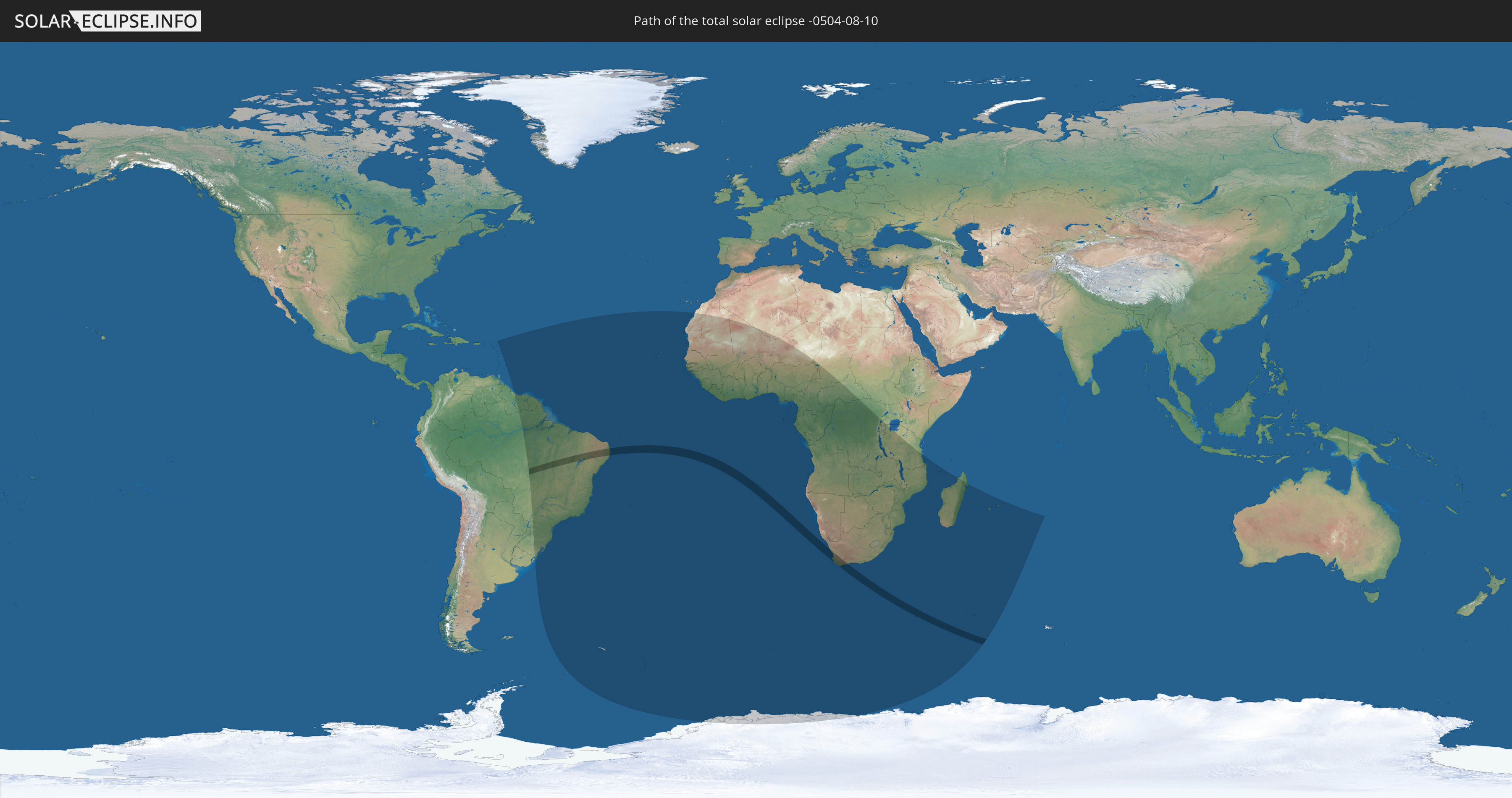
Die Sonnenfinsternis am 10.08.-0504 kann man in 54 Ländern als partielle Sonnenfinsternis beobachten.
Der Finsternispfad verläuft durch 3 Länder. Nur in diesen Ländern ist sie als totale Sonnenfinsternis zu sehen.
In den folgenden Ländern ist die Sonnenfinsternis total zu sehen
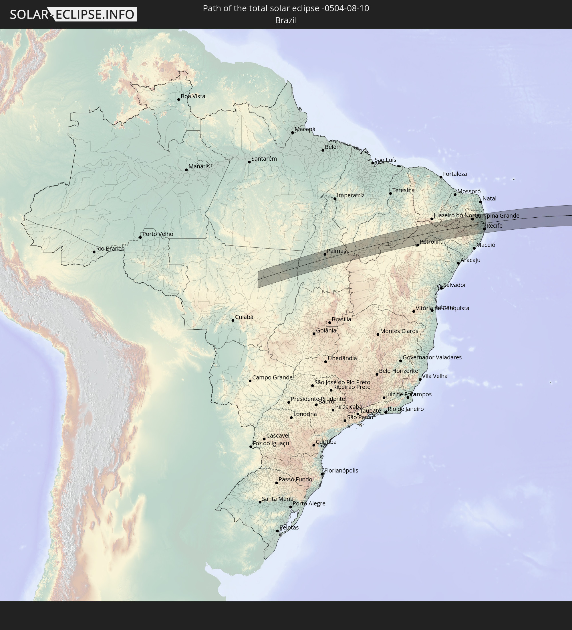 Brasilien
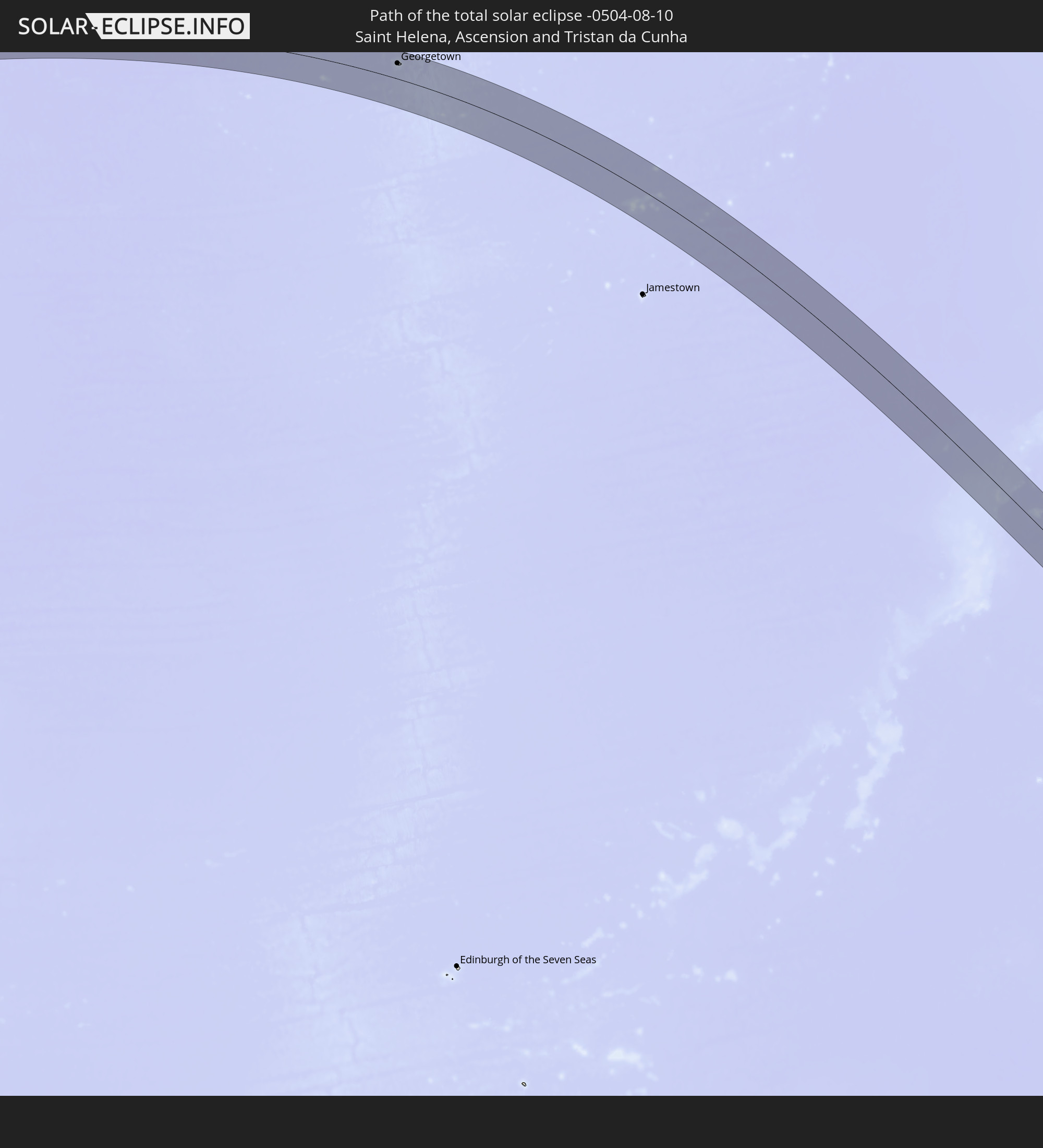 St. Helena
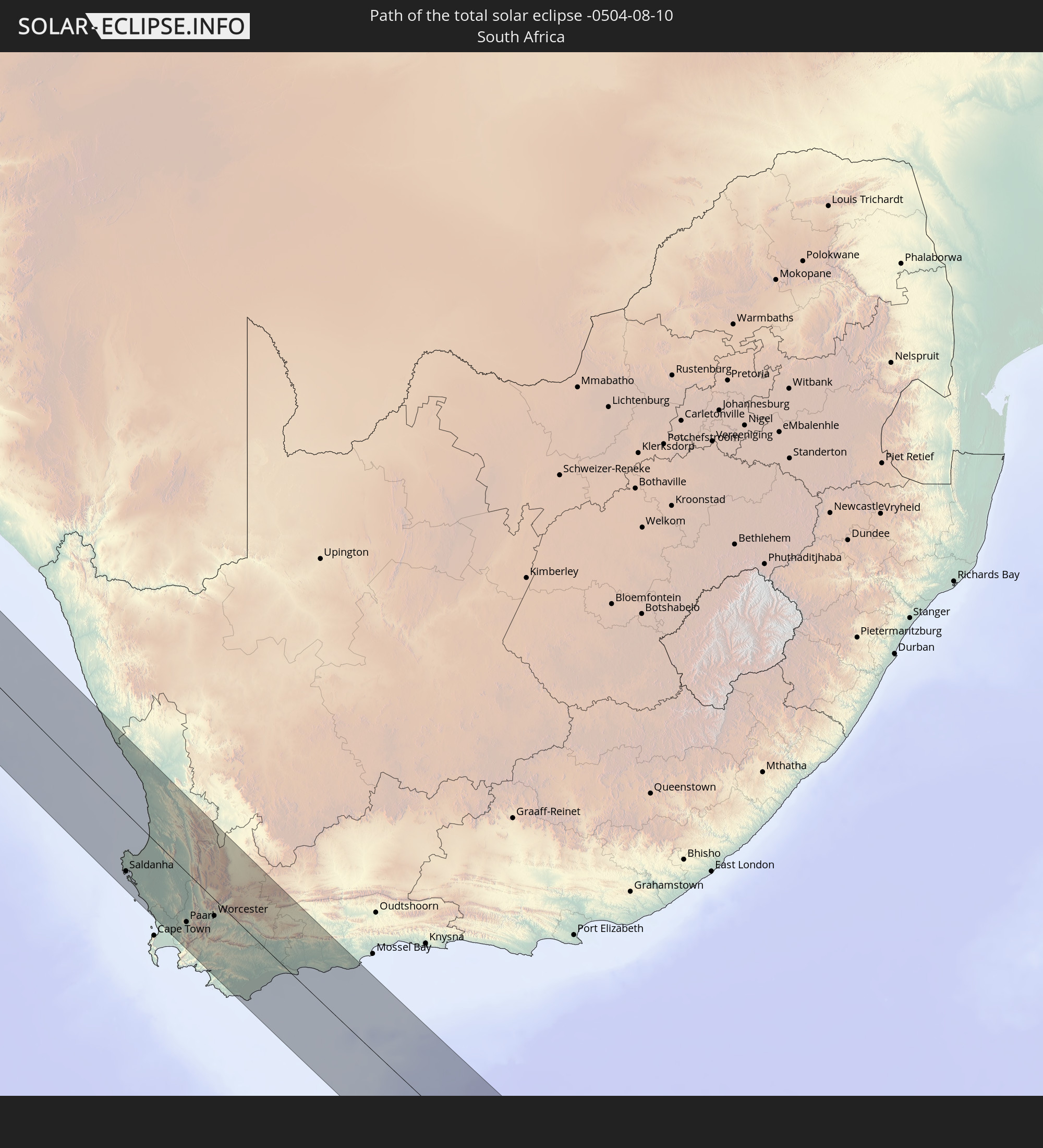 Südafrika
In den folgenden Ländern ist die Sonnenfinsternis partiell zu sehen
 Antarktika
 Brasilien
 Guyana
 Barbados
 Suriname
 Französisch-Guayana
 Südgeorgien und die Südlichen Sandwichinseln
 Kap Verde
 Senegal
 Mauretanien
 Gambia
 Guinea-Bissau
 Guinea
 St. Helena
 Sierra Leone
 Mali
Mali
 Liberia
 Algerien
 Elfenbeinküste
 Burkina Faso
 Ghana
Ghana
 Togo
Togo
 Niger
Niger
 Benin
Benin
 Nigeria
 Bouvetinsel
 Äquatorialguinea
 São Tomé und Príncipe
 Kamerun
 Gabun
Gabun
 Republik Kongo
 Angola
 Namibia
 Demokratische Republik Kongo
 Tschad
 Zentralafrikanische Republik
 Südafrika
 Botswana
 Sambia
 Simbabwe
 Lesotho
 Ruanda
 Burundi
 Tansania
 Uganda
 Mosambik
 Swasiland
 Malawi
 Französische Süd- und Antarktisgebiete
 Madagaskar
 Komoren
 Mayotte
 Réunion
 Mauritius
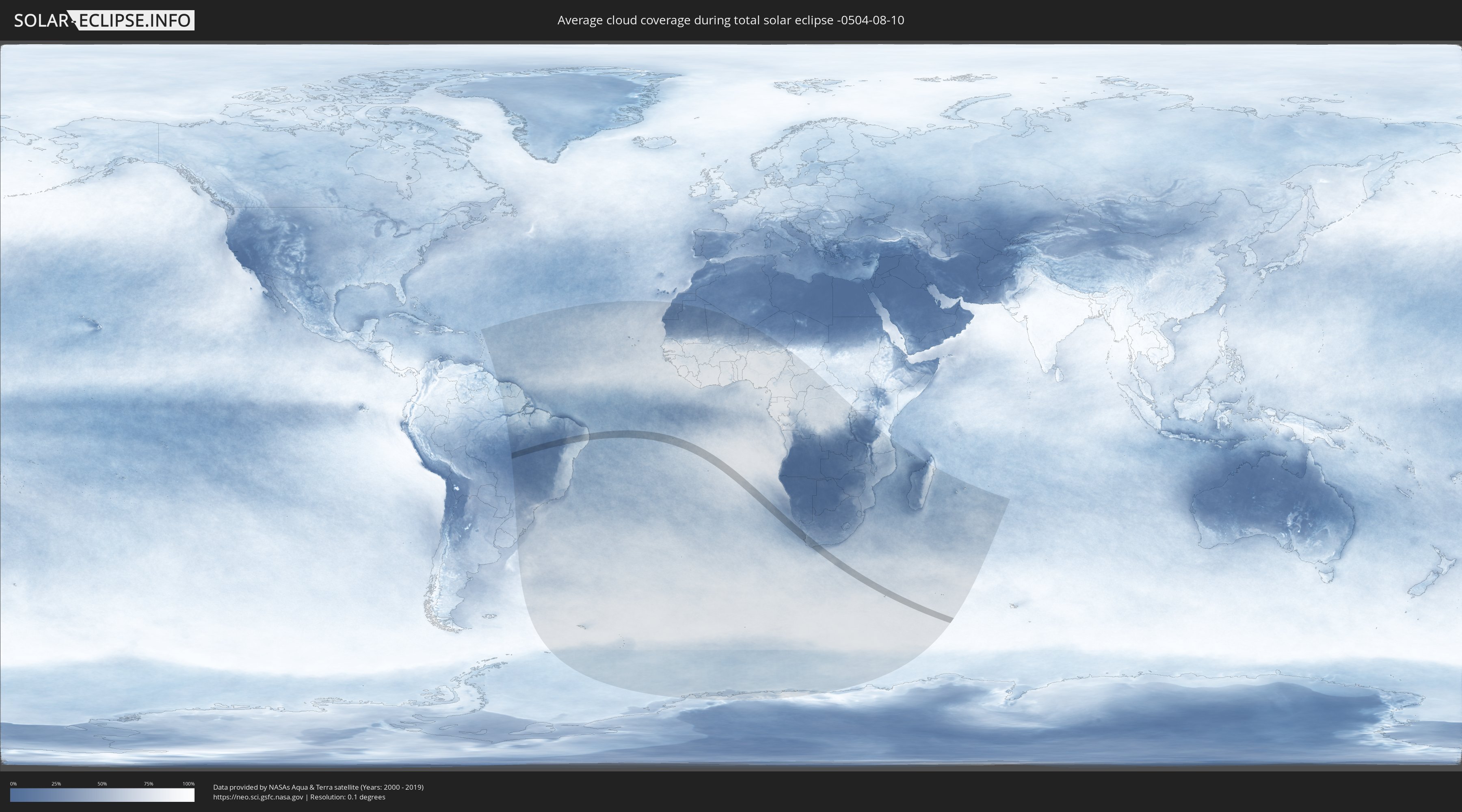
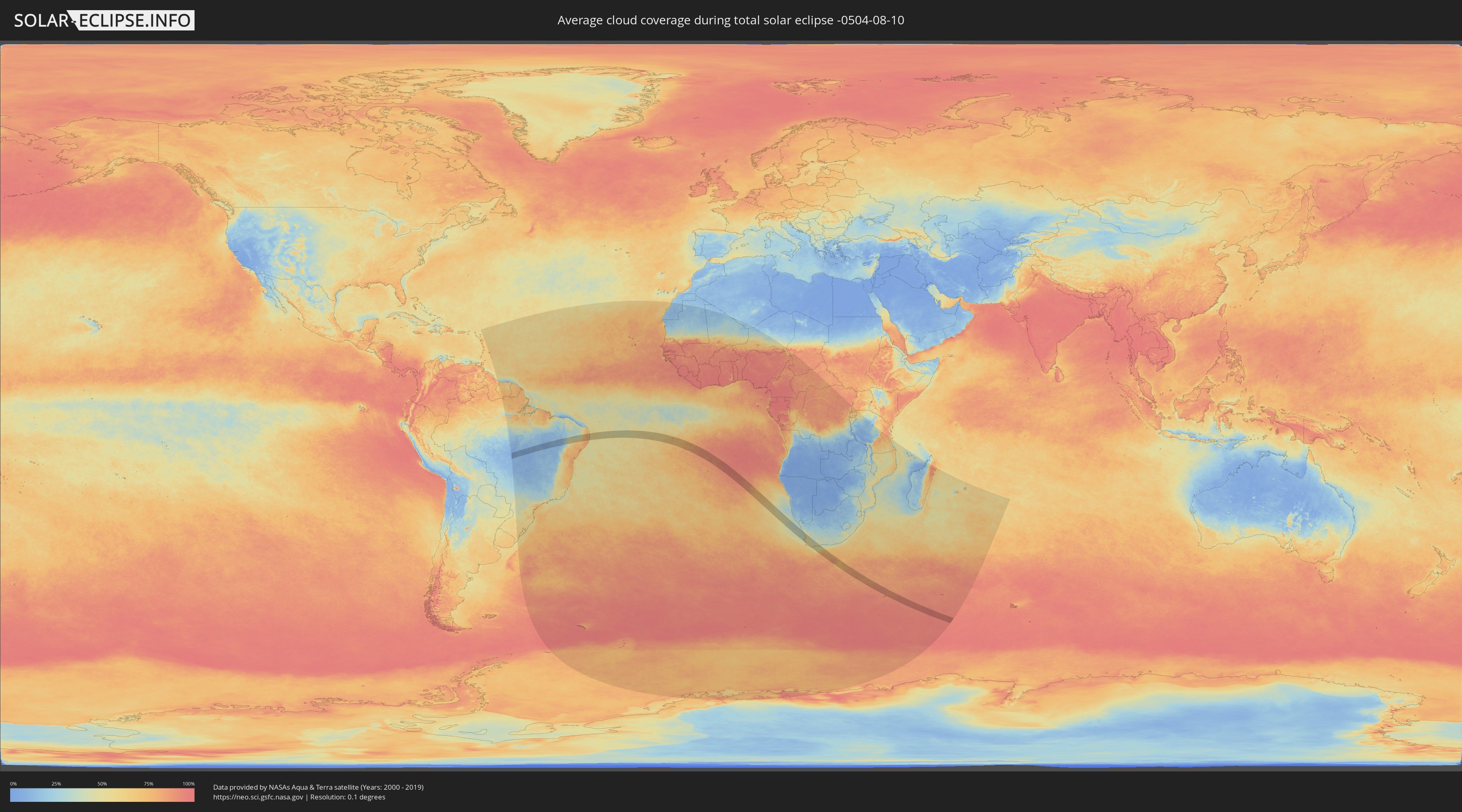
Wie wird das Wetter während der totalen Sonnenfinsternis am 10.08.-0504?
Wo ist der beste Ort, um die totale Sonnenfinsternis vom 10.08.-0504 zu beobachten?
Die folgenden Karten zeigen die durchschnittliche Bewölkung für den Tag, an dem die totale Sonnenfinsternis
stattfindet. Mit Hilfe der Karten lässt sich der Ort entlang des Finsternispfades eingrenzen,
der die besten Aussichen auf einen klaren wolkenfreien Himmel bietet.
Trotzdem muss man immer lokale Gegenenheiten beachten und sollte sich genau über das Wetter an seinem
gewählten Beobachtungsort informieren.
Die Daten stammen von den beiden NASA-Satelliten
AQUA und TERRA
und wurden über einen Zeitraum von 19 Jahren (2000 - 2019) gemittelt.
Detaillierte Länderkarten
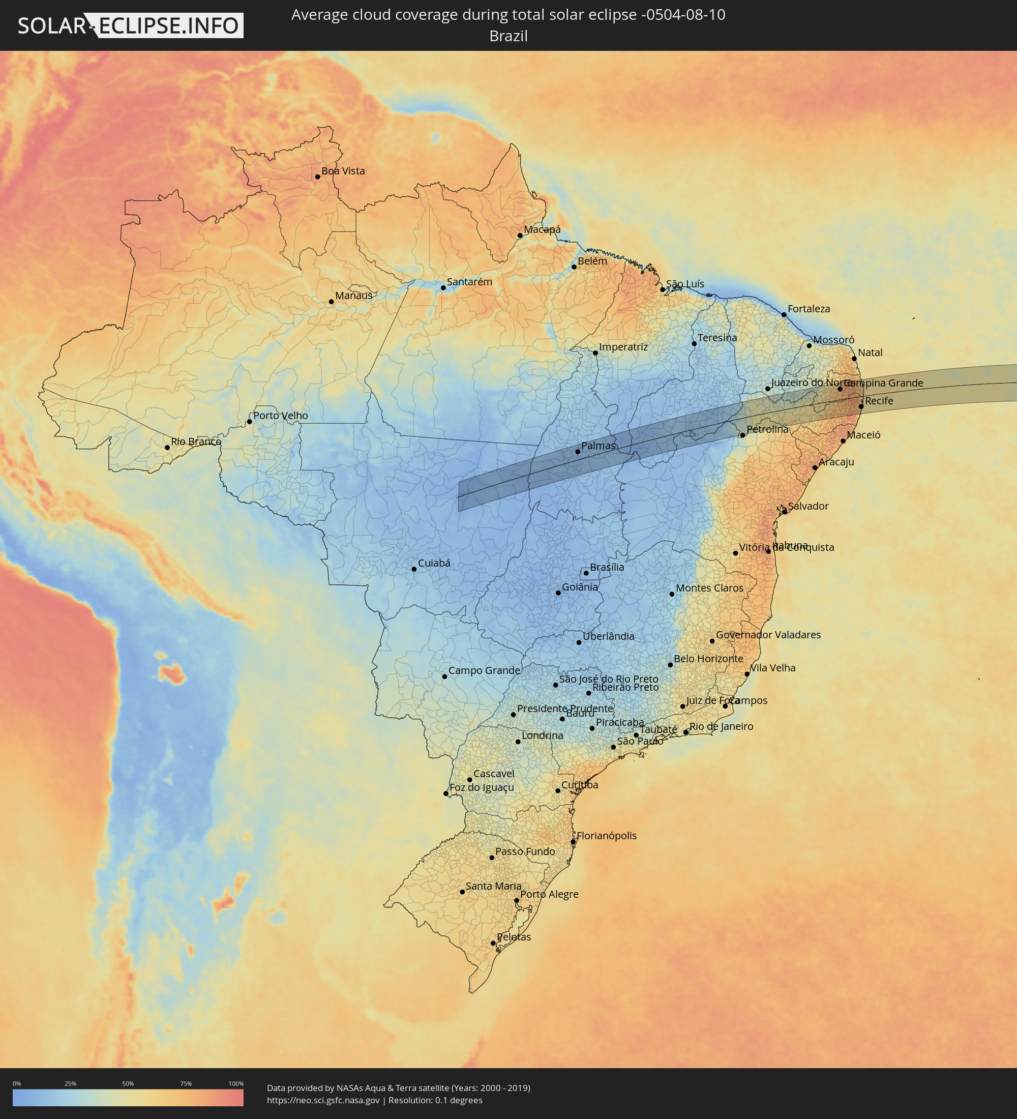 Brasilien
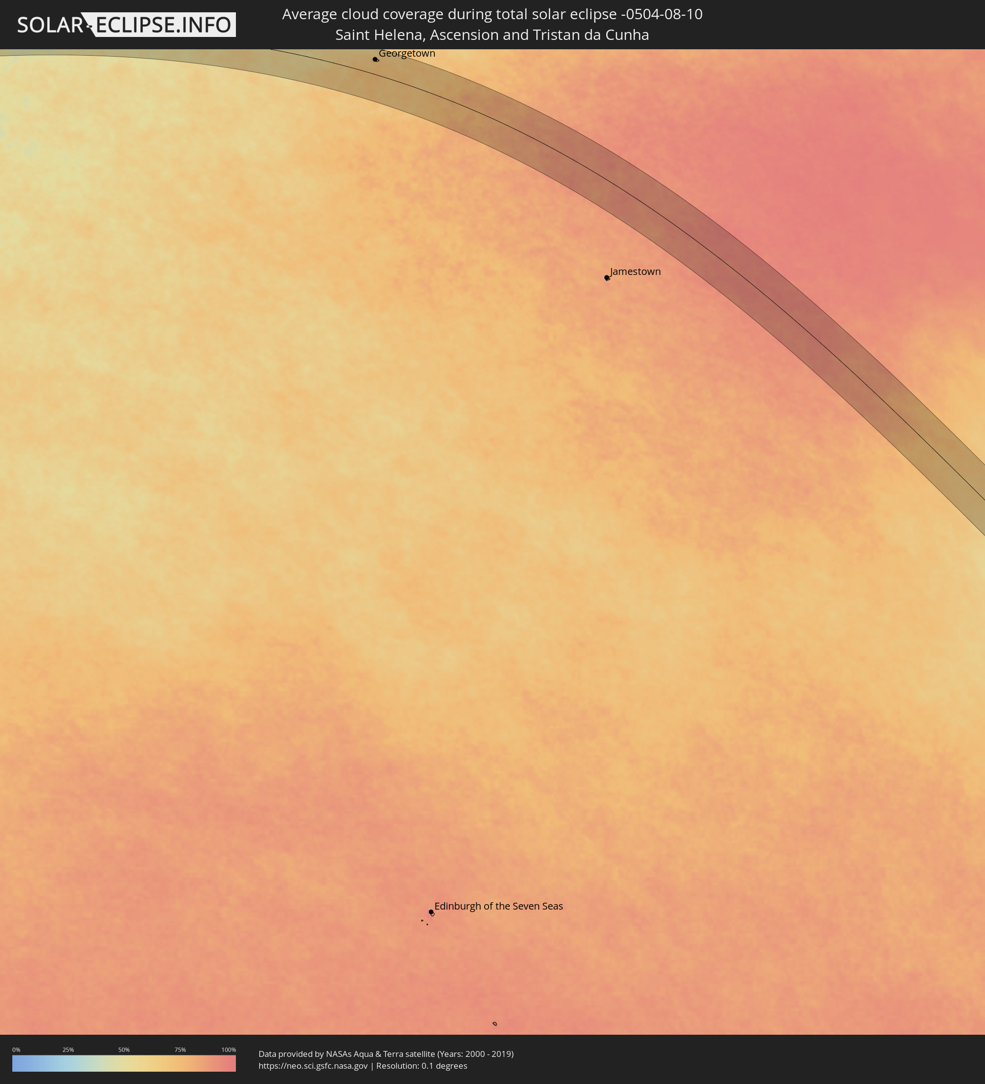 St. Helena
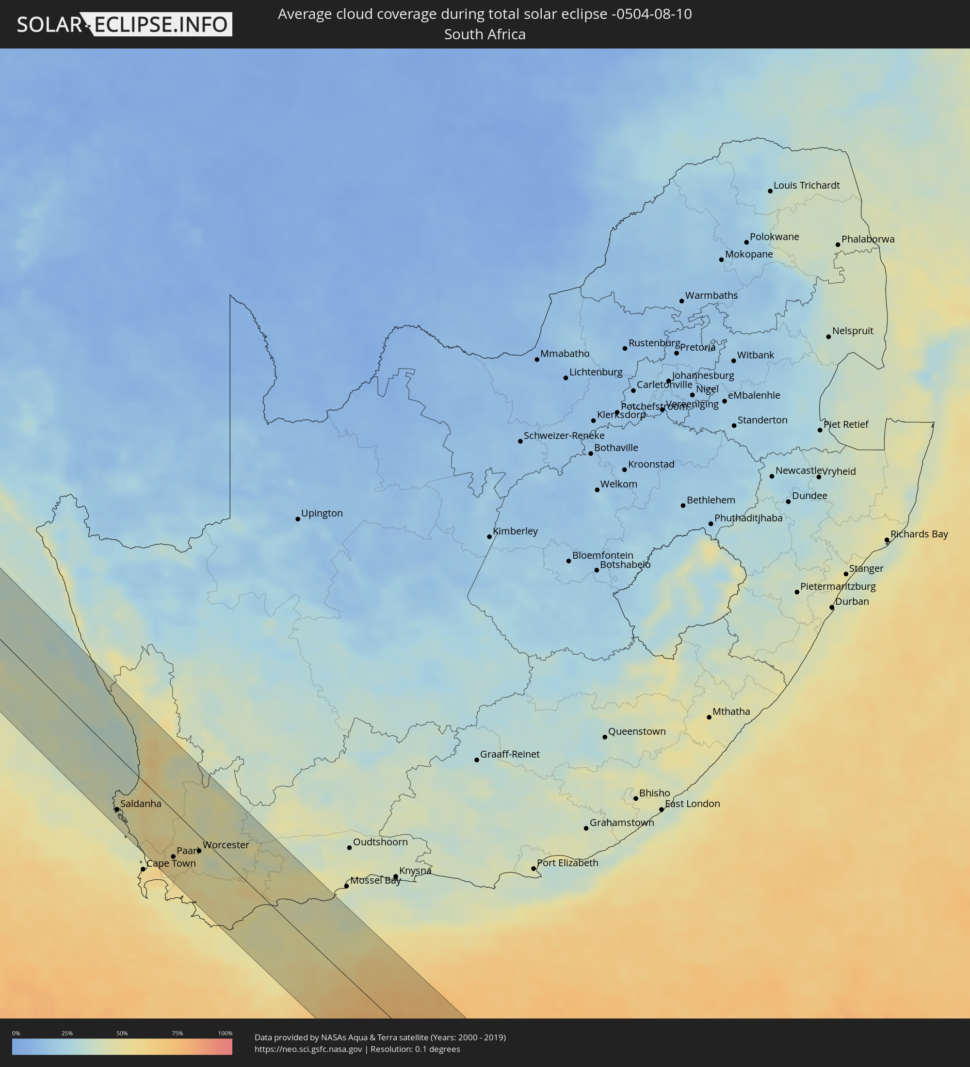 Südafrika
Orte im Finsternispfad
Die nachfolgene Tabelle zeigt Städte und Orte mit mehr als 5.000 Einwohnern, die sich im Finsternispfad befinden. Städte mit mehr als 100.000 Einwohnern sind dick gekennzeichnet. Mit einem Klick auf den Ort öffnet sich eine Detailkarte die die Lage des jeweiligen Ortes zusammen mit dem Verlauf der zentralen Finsternis präsentiert.
| Ort | Typ | Dauer der Verfinsterung | Ortszeit bei maximaler Verfinsterung | Entfernung zur Zentrallinie | Ø Bewölkung |
|
Palmas, Tocantins
|
total | - | 07:21:46 UTC-02:34 | 36 km | 10% |
|
São Raimundo Nonato, Piauí
|
total | - | 07:24:15 UTC-02:34 | 3 km | 16% |
|
São João do Piauí, Piauí
|
total | - | 07:24:01 UTC-02:34 | 63 km | 13% |
|
Trindade, Pernambuco
|
total | - | 07:39:30 UTC-02:19 | 81 km | 40% |
|
Ouricuri, Pernambuco
|
total | - | 07:39:46 UTC-02:19 | 64 km | 45% |
|
Santa Maria da Boa Vista, Pernambuco
|
total | - | 07:40:49 UTC-02:19 | 43 km | 48% |
|
Cabrobó, Pernambuco
|
total | - | 07:41:01 UTC-02:19 | 22 km | 49% |
|
Salgueiro, Pernambuco
|
total | - | 07:40:48 UTC-02:19 | 22 km | 45% |
|
Brejo Santo, Ceará
|
total | - | 07:26:00 UTC-02:34 | 82 km | 38% |
|
São José do Belmonte, Pernambuco
|
total | - | 07:40:56 UTC-02:19 | 37 km | 41% |
|
Floresta, Pernambuco
|
total | - | 07:41:48 UTC-02:19 | 48 km | 52% |
|
Serra Talhada, Pernambuco
|
total | - | 07:41:30 UTC-02:19 | 13 km | 45% |
|
Custódia, Pernambuco
|
total | - | 07:42:14 UTC-02:19 | 10 km | 53% |
|
Afogados da Ingazeira, Pernambuco
|
total | - | 07:41:55 UTC-02:19 | 27 km | 47% |
|
Tabira, Pernambuco
|
total | - | 07:41:53 UTC-02:19 | 42 km | 46% |
|
São José do Egito, Pernambuco
|
total | - | 07:42:02 UTC-02:19 | 49 km | 45% |
|
Sertânia, Pernambuco
|
total | - | 07:42:36 UTC-02:19 | 16 km | 54% |
|
Buíque, Pernambuco
|
total | - | 07:43:14 UTC-02:19 | 78 km | 60% |
|
Monteiro, Paraíba
|
total | - | 07:28:10 UTC-02:34 | 1 km | 55% |
|
Arcoverde, Pernambuco
|
total | - | 07:43:08 UTC-02:19 | 58 km | 54% |
|
Pesqueira, Pernambuco
|
total | - | 07:43:27 UTC-02:19 | 58 km | 69% |
|
Belo Jardim, Pernambuco
|
total | - | 07:43:44 UTC-02:19 | 61 km | 77% |
|
Brejo da Madre de Deus, Pernambuco
|
total | - | 07:43:36 UTC-02:19 | 41 km | 68% |
|
Cachoeirinha, Pernambuco
|
total | - | 07:44:05 UTC-02:19 | 81 km | 79% |
|
Santa Cruz do Capibaribe, Pernambuco
|
total | - | 07:43:36 UTC-02:19 | 23 km | 74% |
|
Toritama, Pernambuco
|
total | - | 07:43:49 UTC-02:19 | 31 km | 74% |
|
Taquaritinga do Norte, Pernambuco
|
total | - | 07:43:44 UTC-02:19 | 20 km | 74% |
|
Caruaru, Pernambuco
|
total | - | 07:44:10 UTC-02:19 | 63 km | 77% |
|
Agrestina, Pernambuco
|
total | - | 07:44:22 UTC-02:19 | 83 km | 75% |
|
Campina Grande, Paraíba
|
total | - | 07:28:52 UTC-02:34 | 51 km | 76% |
|
Esperança, Paraíba
|
total | - | 07:28:43 UTC-02:34 | 72 km | 74% |
|
São Joaquim do Monte, Pernambuco
|
total | - | 07:44:30 UTC-02:19 | 82 km | 79% |
|
Bezerros, Pernambuco
|
total | - | 07:44:19 UTC-02:19 | 61 km | 72% |
|
Surubim, Pernambuco
|
total | - | 07:43:59 UTC-02:19 | 17 km | 74% |
|
Areia, Paraíba
|
total | - | 07:28:50 UTC-02:34 | 77 km | 79% |
|
Alagoa Grande, Paraíba
|
total | - | 07:29:05 UTC-02:34 | 55 km | 78% |
|
Bom Jardim, Pernambuco
|
total | - | 07:44:08 UTC-02:19 | 16 km | 77% |
|
Gravatá, Pernambuco
|
total | - | 07:44:32 UTC-02:19 | 61 km | 77% |
|
Guarabira, Paraíba
|
total | - | 07:28:57 UTC-02:34 | 86 km | 79% |
|
Chã Grande, Pernambuco
|
total | - | 07:44:42 UTC-02:19 | 67 km | 80% |
|
Macaparana, Pernambuco
|
total | - | 07:44:03 UTC-02:19 | 8 km | 82% |
|
Amaraji, Pernambuco
|
total | - | 07:44:51 UTC-02:19 | 83 km | 84% |
|
Limoeiro, Pernambuco
|
total | - | 07:44:21 UTC-02:19 | 27 km | 78% |
|
Pombos, Pernambuco
|
total | - | 07:44:40 UTC-02:19 | 57 km | 78% |
|
Feira Nova, Pernambuco
|
total | - | 07:44:30 UTC-02:19 | 36 km | 78% |
|
Itabaiana, Paraíba
|
total | - | 07:29:34 UTC-02:34 | 31 km | 75% |
|
Mari, Paraíba
|
total | - | 07:29:20 UTC-02:34 | 60 km | 81% |
|
Timbaúba, Pernambuco
|
total | - | 07:44:09 UTC-02:19 | 11 km | 82% |
|
Glória do Goitá, Pernambuco
|
total | - | 07:44:39 UTC-02:19 | 44 km | 80% |
|
Vitória de Santo Antão, Pernambuco
|
total | - | 07:44:46 UTC-02:19 | 56 km | 81% |
|
Lagoa do Itaenga, Pernambuco
|
total | - | 07:44:36 UTC-02:19 | 36 km | 76% |
|
Carpina, Pernambuco
|
total | - | 07:44:33 UTC-02:19 | 28 km | 76% |
|
Escada, Pernambuco
|
total | - | 07:45:05 UTC-02:19 | 84 km | 81% |
|
Mamanguape, Paraíba
|
total | - | 07:29:21 UTC-02:34 | 82 km | 77% |
|
Pedras de Fogo, Paraíba
|
total | - | 07:29:53 UTC-02:34 | 19 km | 81% |
|
Araçoiaba, Pernambuco
|
total | - | 07:44:41 UTC-02:19 | 24 km | 78% |
|
São Lourenço da Mata, Pernambuco
|
total | - | 07:44:58 UTC-02:19 | 48 km | 75% |
|
Goiana, Pernambuco
|
total | - | 07:44:34 UTC-02:19 | 0 km | 75% |
|
Jaboatão, Pernambuco
|
total | - | 07:45:10 UTC-02:19 | 68 km | 67% |
|
Caaporã, Paraíba
|
total | - | 07:30:14 UTC-02:34 | 4 km | 64% |
|
Conde, Paraíba
|
total | - | 07:29:59 UTC-02:34 | 32 km | 69% |
|
Igarassu, Pernambuco
|
total | - | 07:44:56 UTC-02:19 | 32 km | 68% |
|
Itapissuma, Pernambuco
|
total | - | 07:44:54 UTC-02:19 | 25 km | 68% |
|
Recife, Pernambuco
|
total | - | 07:45:11 UTC-02:19 | 56 km | 54% |
|
João Pessoa, Paraíba
|
total | - | 07:29:54 UTC-02:34 | 47 km | 69% |
|
Cabedelo, Paraíba
|
total | - | 07:29:49 UTC-02:34 | 61 km | 52% |
|
Itamaracá, Pernambuco
|
total | - | 07:44:57 UTC-02:19 | 23 km | 50% |
|
Georgetown, Ascension
|
total | - | 10:24:28 UTC-00:16 | 58 km | 72% |
|
Saldanha, Western Cape
|
total | - | 13:51:37 UTC+01:30 | 66 km | 43% |
|
Atlantis, Western Cape
|
total | - | 13:52:41 UTC+01:30 | 75 km | 51% |
|
Vredendal, Western Cape
|
total | - | 13:51:41 UTC+01:30 | 77 km | 53% |
|
Kraaifontein, Western Cape
|
total | - | 13:53:09 UTC+01:30 | 82 km | 62% |
|
Malmesbury, Western Cape
|
total | - | 13:52:59 UTC+01:30 | 51 km | 58% |
|
Stellenbosch, Western Cape
|
total | - | 13:53:24 UTC+01:30 | 79 km | 56% |
|
Paarl, Western Cape
|
total | - | 13:53:28 UTC+01:30 | 56 km | 53% |
|
Ceres, Western Cape
|
total | - | 13:53:46 UTC+01:30 | 5 km | 53% |
|
Worcester, Western Cape
|
total | - | 13:54:05 UTC+01:30 | 19 km | 47% |
|
Bredasdorp, Western Cape
|
total | - | 13:55:17 UTC+01:30 | 51 km | 54% |
|
Swellendam, Western Cape
|
total | - | 13:55:37 UTC+01:30 | 15 km | 50% |
|
Hardys Memories of Africa, Western Cape
|
total | - | 13:55:57 UTC+01:30 | 42 km | 46% |
|
Riversdale, Western Cape
|
total | - | 13:56:45 UTC+01:30 | 61 km | 50% |
|
Albertina, Western Cape
|
total | - | 13:57:13 UTC+01:30 | 73 km | 47% |