Totale Sonnenfinsternis vom 23.10.-0546
| Wochentag: | Samstag |
| Maximale Dauer der Verfinsterung: | 03m11s |
| Maximale Breite des Finsternispfades: | 216 km |
| Saroszyklus: | 44 |
| Bedeckungsgrad: | 100% |
| Magnitude: | 1.0418 |
| Gamma: | 0.7755 |
Wo kann man die Sonnenfinsternis vom 23.10.-0546 sehen?
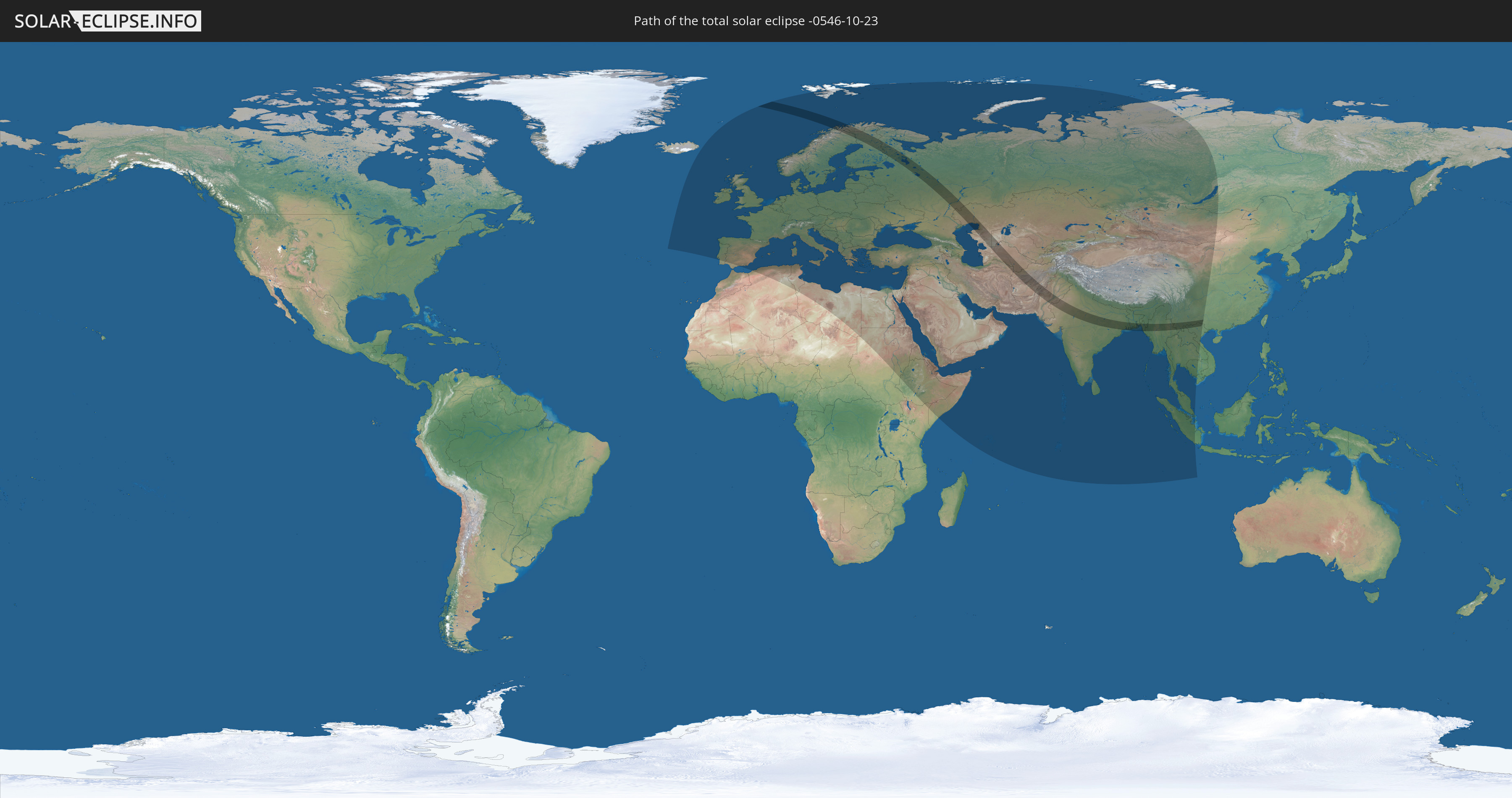
Die Sonnenfinsternis am 23.10.-0546 kann man in 104 Ländern als partielle Sonnenfinsternis beobachten.
Der Finsternispfad verläuft durch 16 Länder. Nur in diesen Ländern ist sie als totale Sonnenfinsternis zu sehen.
In den folgenden Ländern ist die Sonnenfinsternis total zu sehen
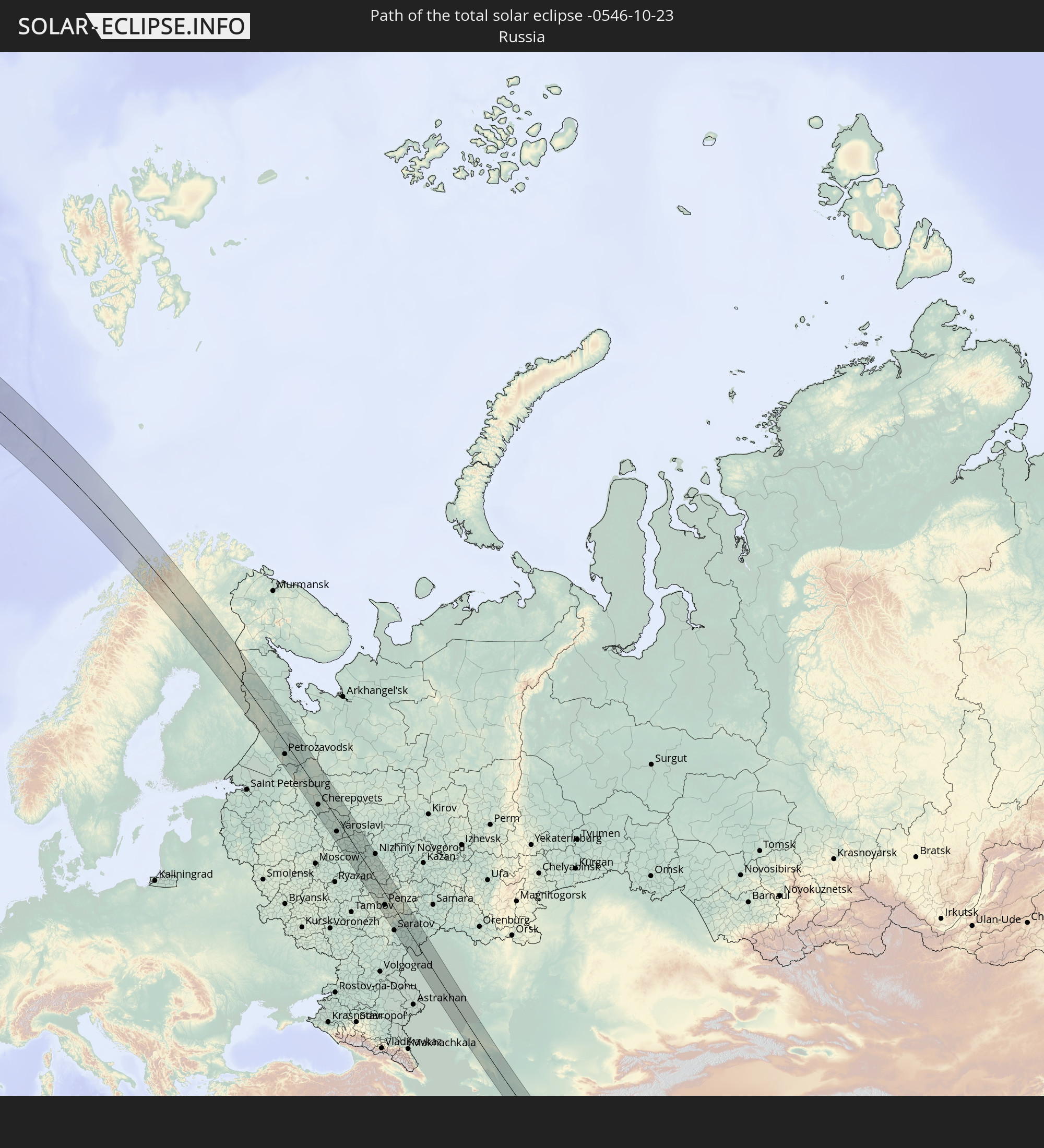 Russland
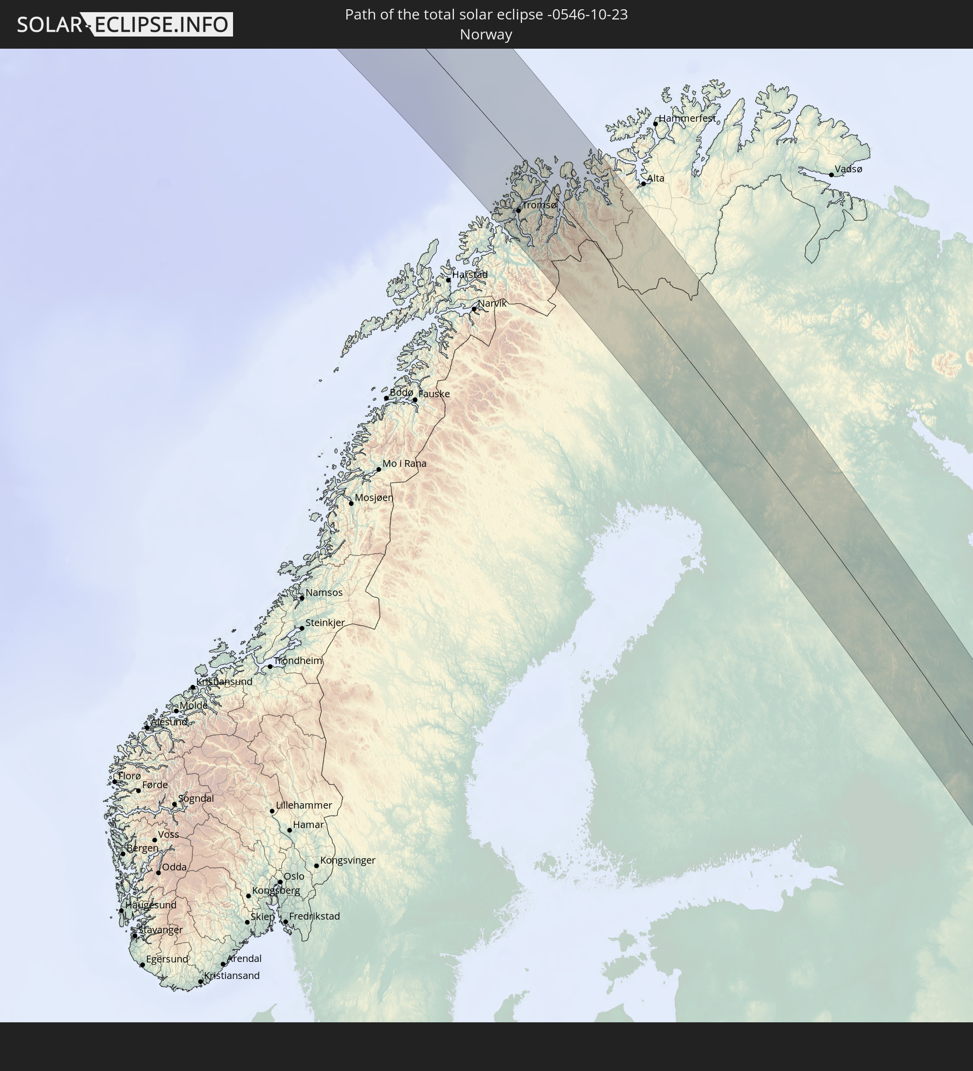 Norwegen
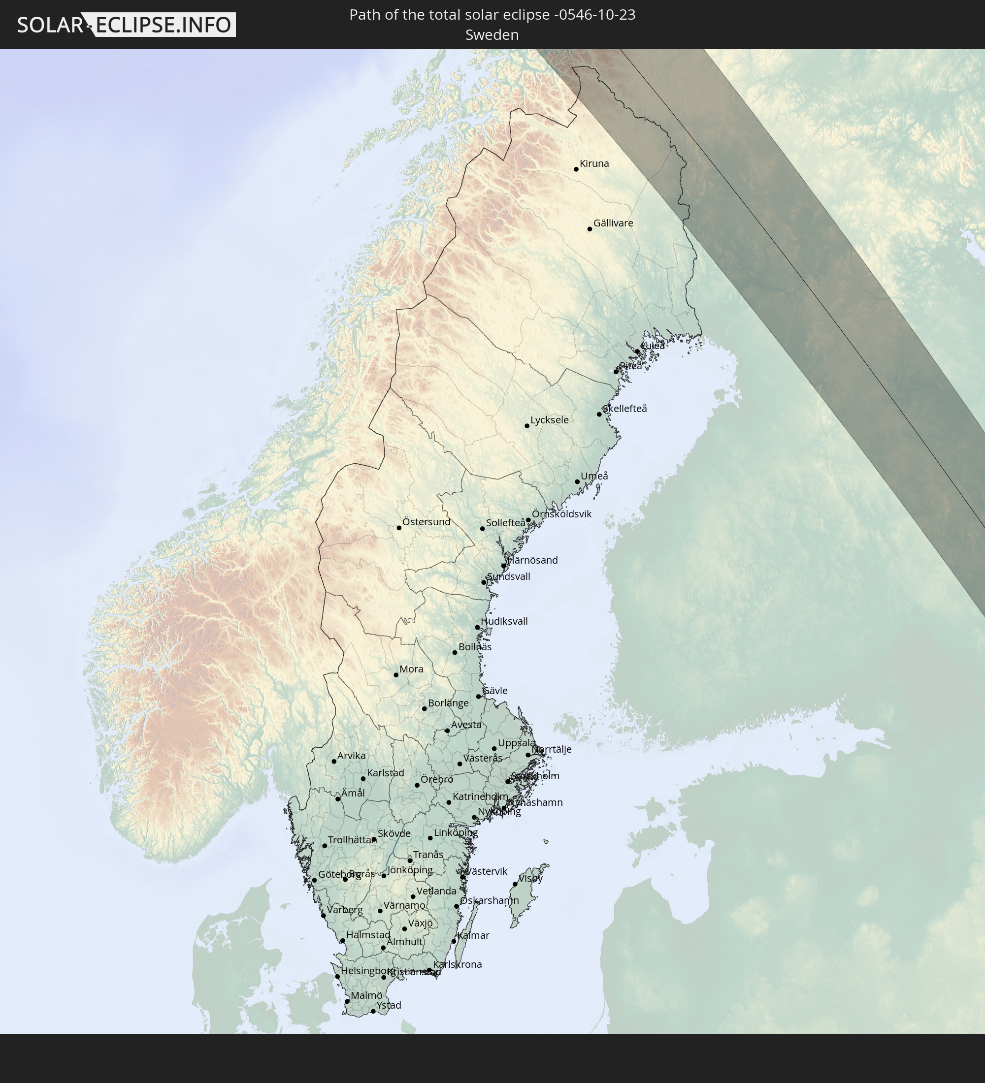 Schweden
 Finnland
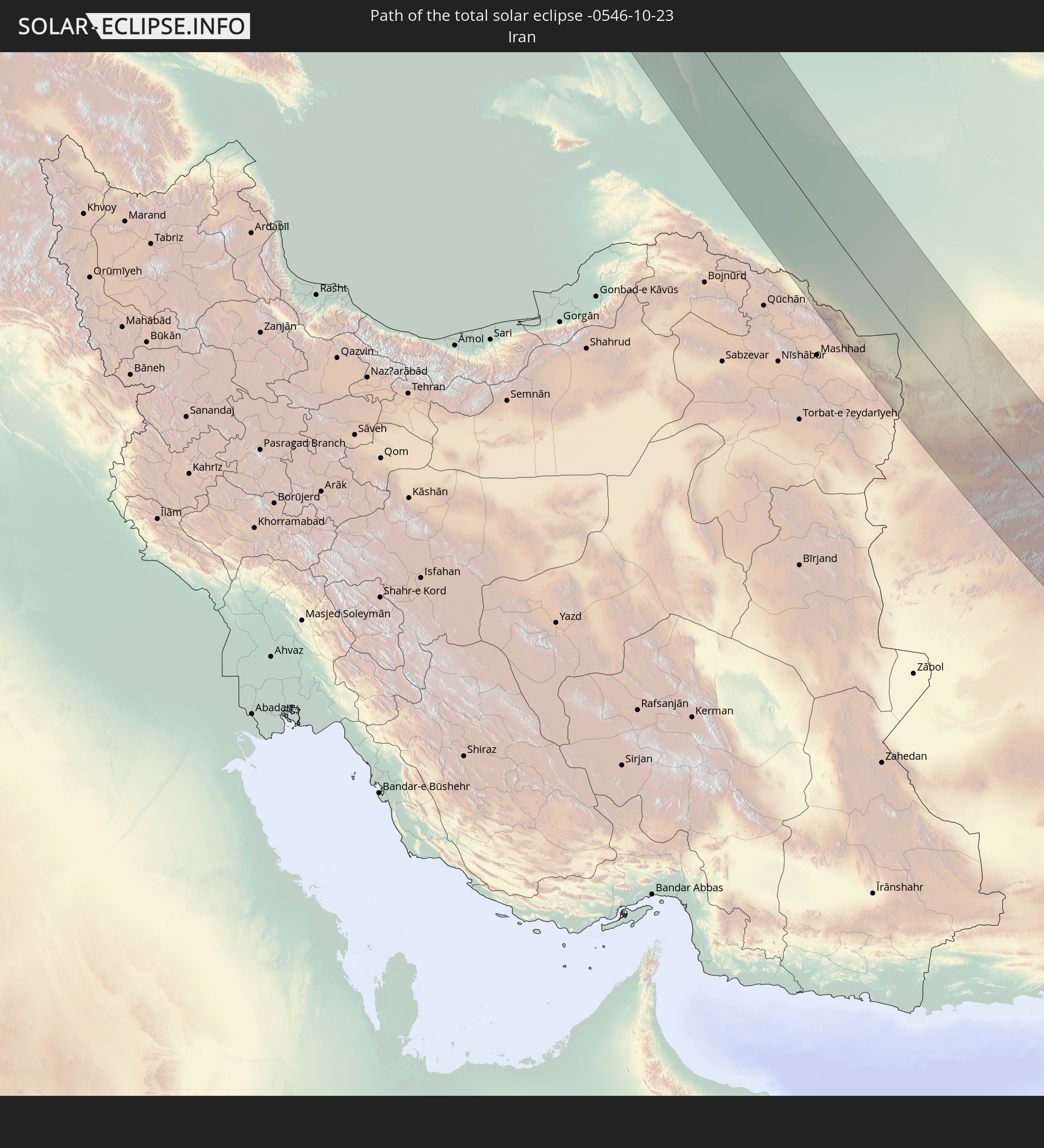 Iran
Iran
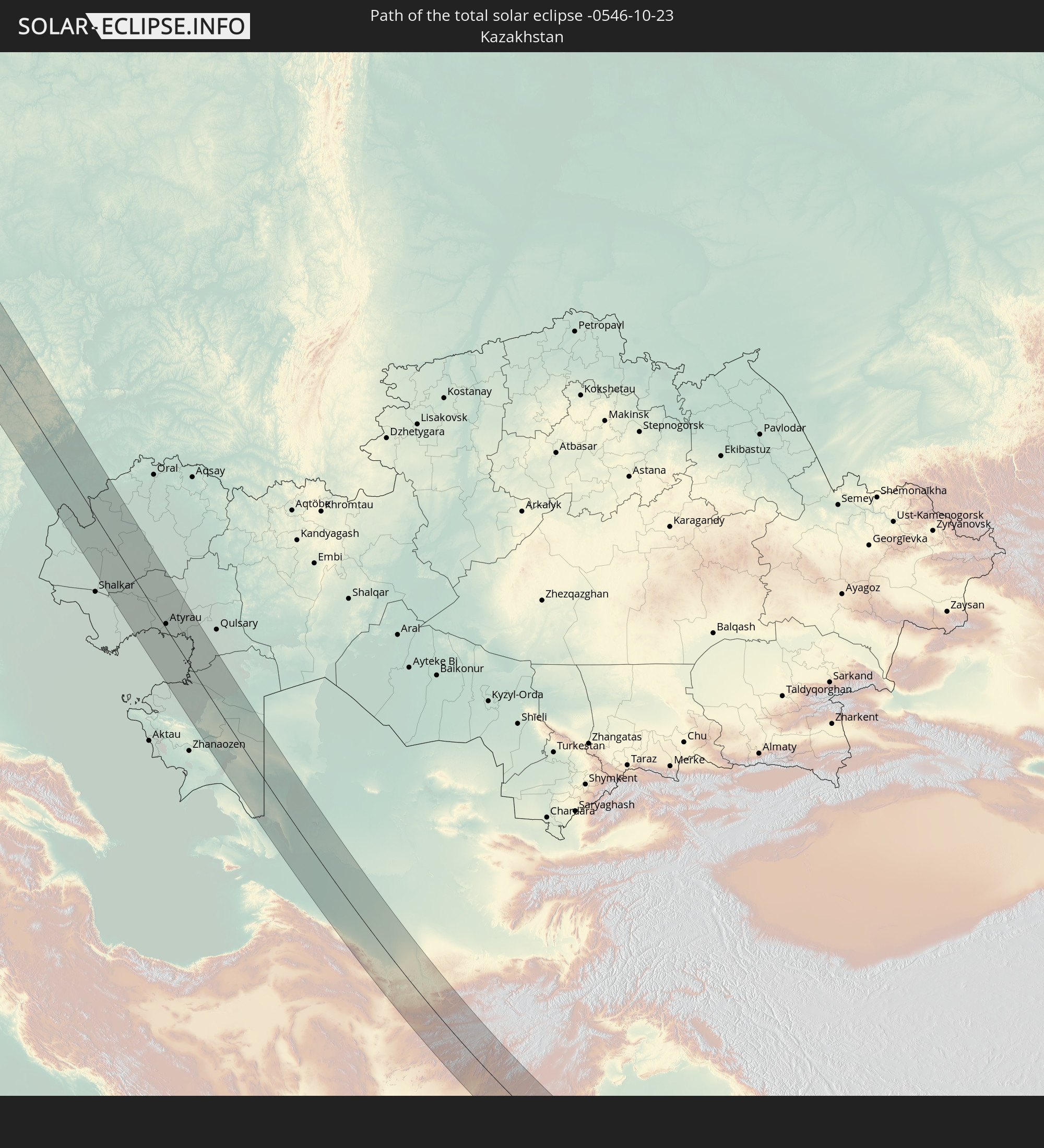 Kasachstan
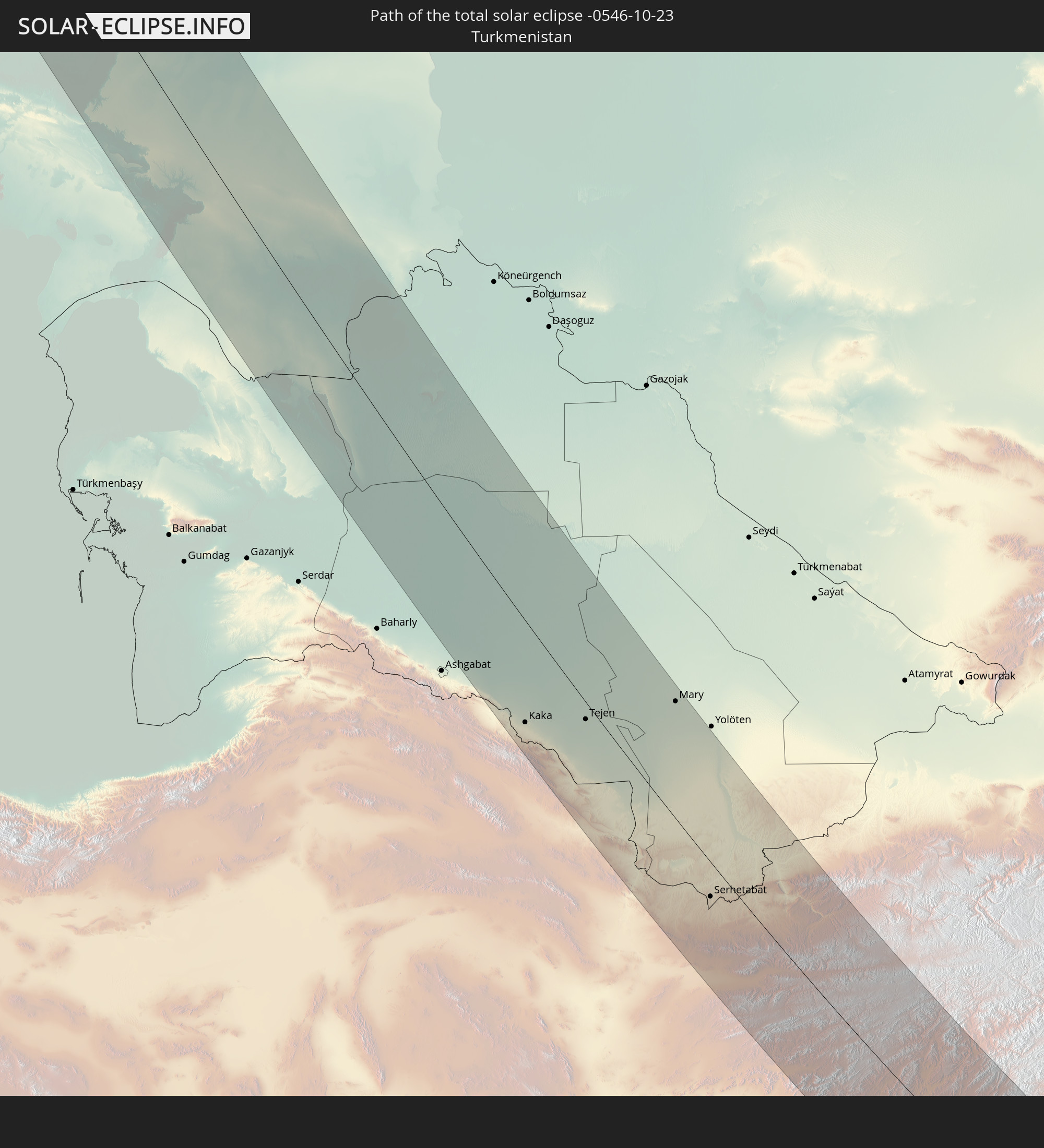 Turkmenistan
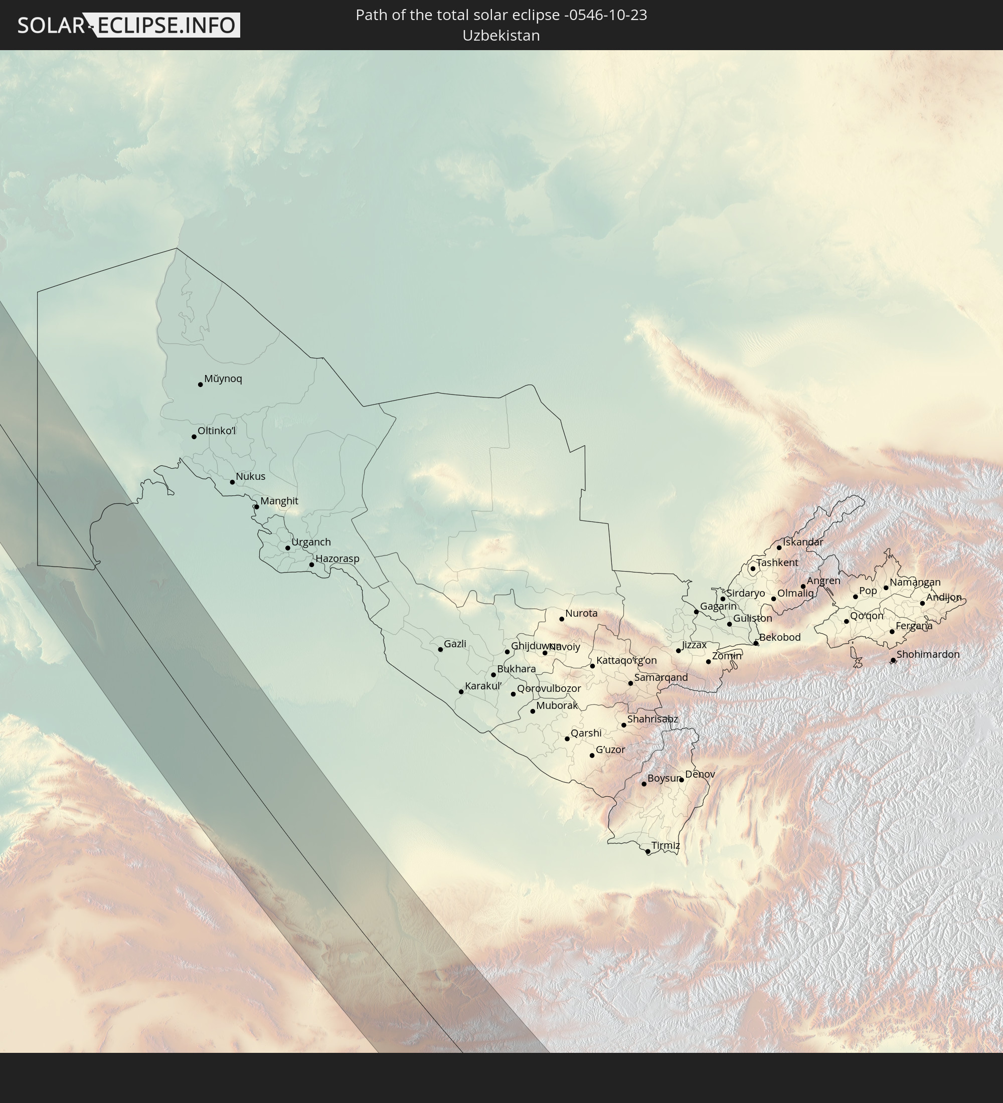 Usbekistan
 Afghanistan
 Pakistan
 Indien
 Volksrepublik China
 Bangladesch
 Myanmar
 Laos
Laos
 Vietnam
In den folgenden Ländern ist die Sonnenfinsternis partiell zu sehen
 Russland
 Portugal
 Spanien
 Irland
 Spitzbergen
 Algerien
 Vereinigtes Königreich
 Färöer
 Frankreich
 Isle of Man
 Guernsey
 Jersey
 Andorra
 Belgien
 Niederlande
 Norwegen
 Luxemburg
 Deutschland
 Schweiz
 Italien
 Monaco
 Tunesien
 Dänemark
 Libyen
 Liechtenstein
 Österreich
 Schweden
 Tschechien
 San Marino
 Vatikanstadt
 Slowenien
 Kroatien
 Polen
Polen
 Malta
Malta
 Bosnien und Herzegowina
 Ungarn
 Slowakei
 Montenegro
 Serbien
 Albanien
 Åland Islands
 Griechenland
 Rumänien
 Mazedonien
 Finnland
 Litauen
 Lettland
 Estland
 Sudan
Sudan
 Ukraine
 Bulgarien
 Weißrussland
 Ägypten
 Türkei
 Moldawien
 Republik Zypern
 Äthiopien
 Kenia
Kenia
 Staat Palästina
 Israel
 Saudi-Arabien
 Jordanien
 Libanon
 Syrien
 Eritrea
 Irak
Irak
 Georgien
 Somalia
 Dschibuti
 Jemen
Jemen
 Armenien
 Iran
Iran
 Aserbaidschan
 Seychellen
 Kasachstan
 Kuwait
 Bahrain
 Katar
Katar
 Vereinigte Arabische Emirate
 Oman
Oman
 Turkmenistan
 Usbekistan
 Afghanistan
 Pakistan
 Tadschikistan
 Indien
 Kirgisistan
 Britisches Territorium im Indischen Ozean
 Malediven
 Volksrepublik China
 Sri Lanka
 Nepal
Nepal
 Mongolei
 Bangladesch
 Bhutan
 Myanmar
 Indonesien
 Kokosinseln
 Thailand
 Malaysia
 Laos
Laos
 Vietnam
 Kambodscha
 Singapur
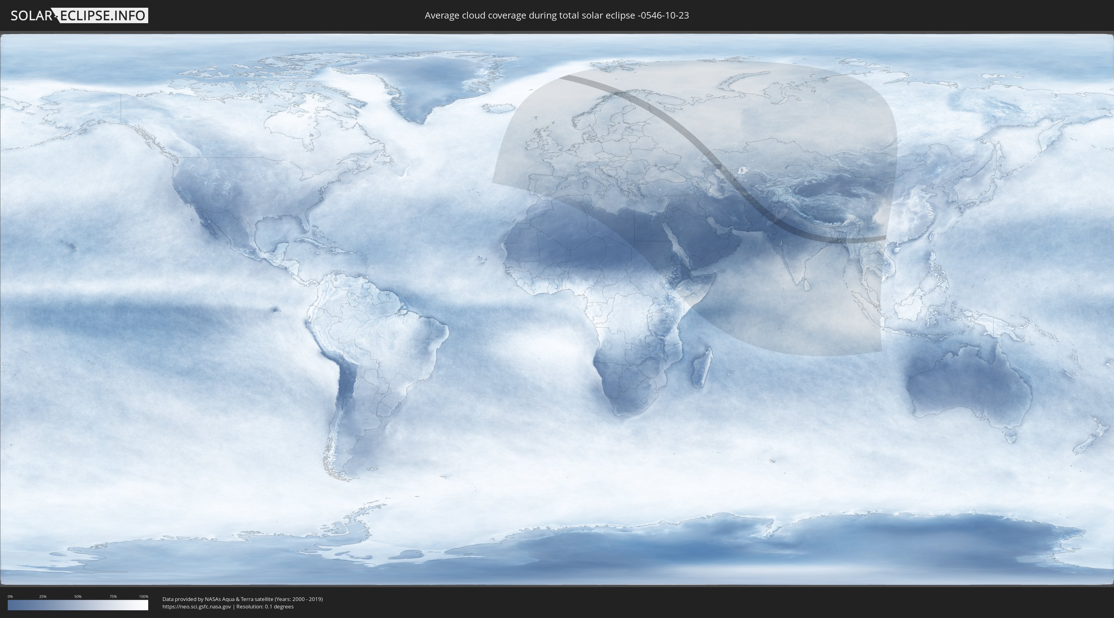
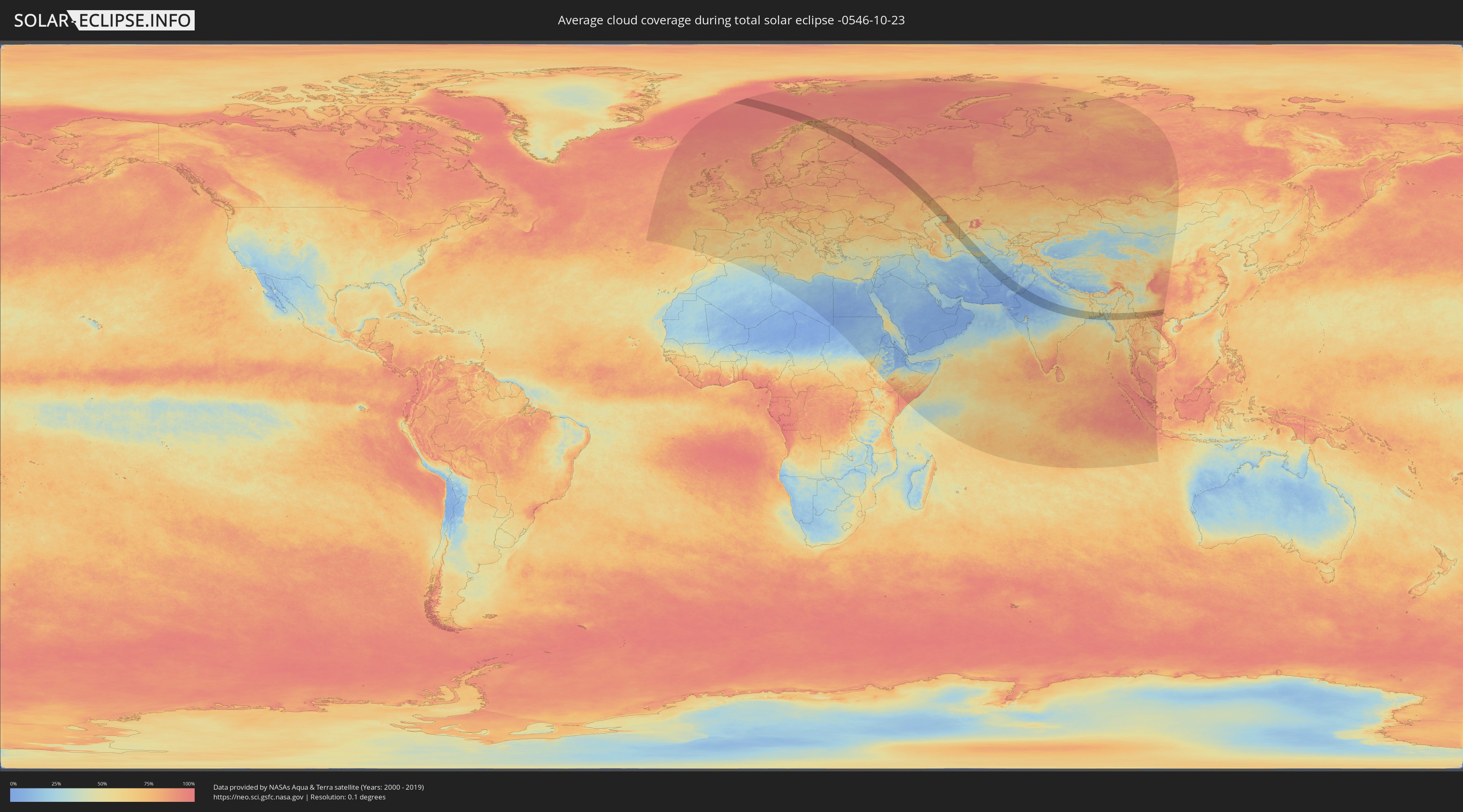
Wie wird das Wetter während der totalen Sonnenfinsternis am 23.10.-0546?
Wo ist der beste Ort, um die totale Sonnenfinsternis vom 23.10.-0546 zu beobachten?
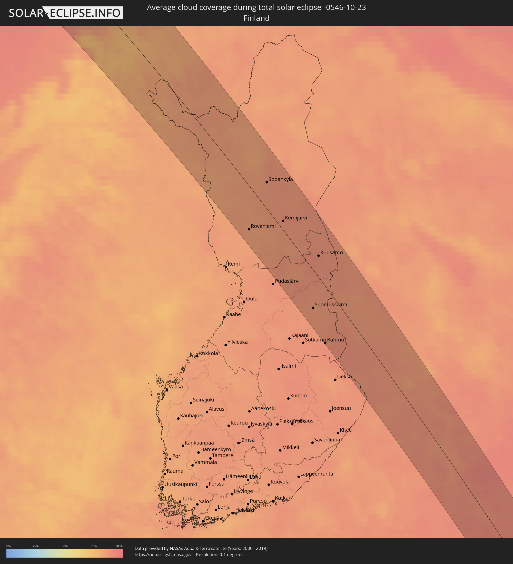
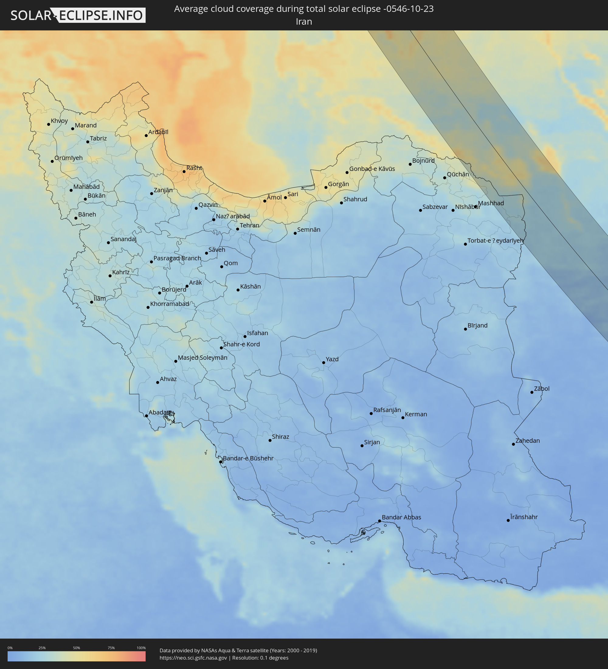
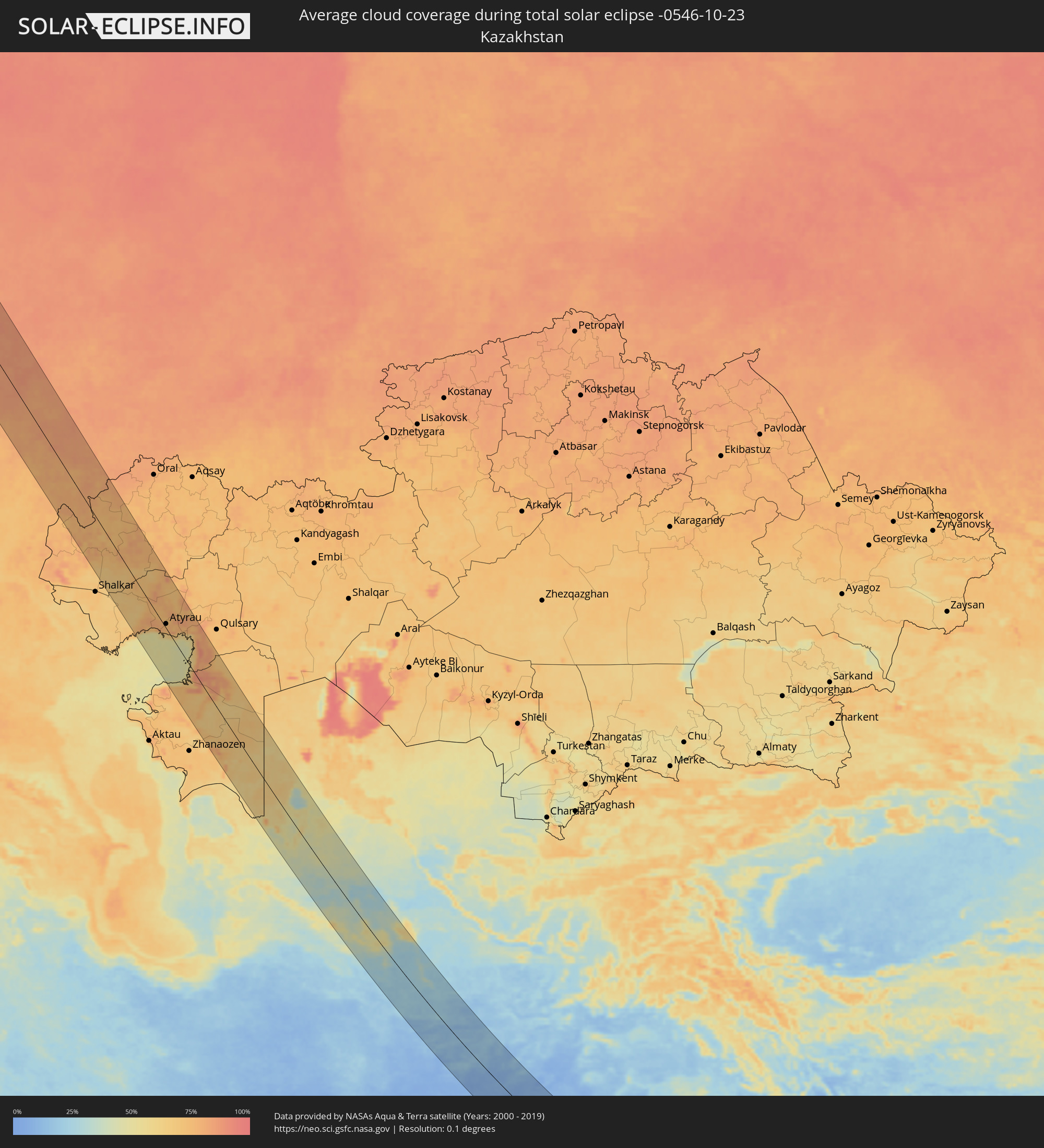
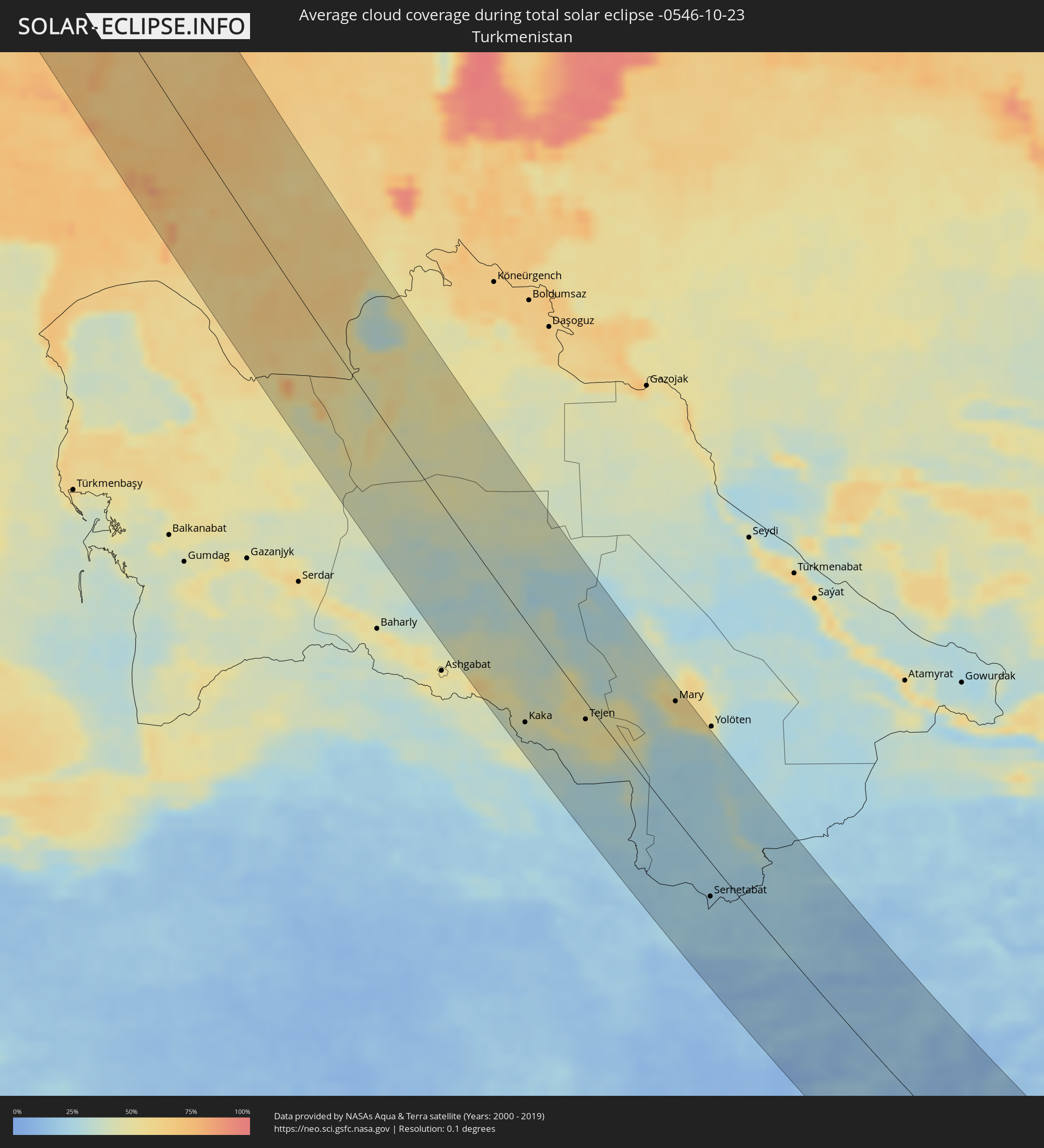
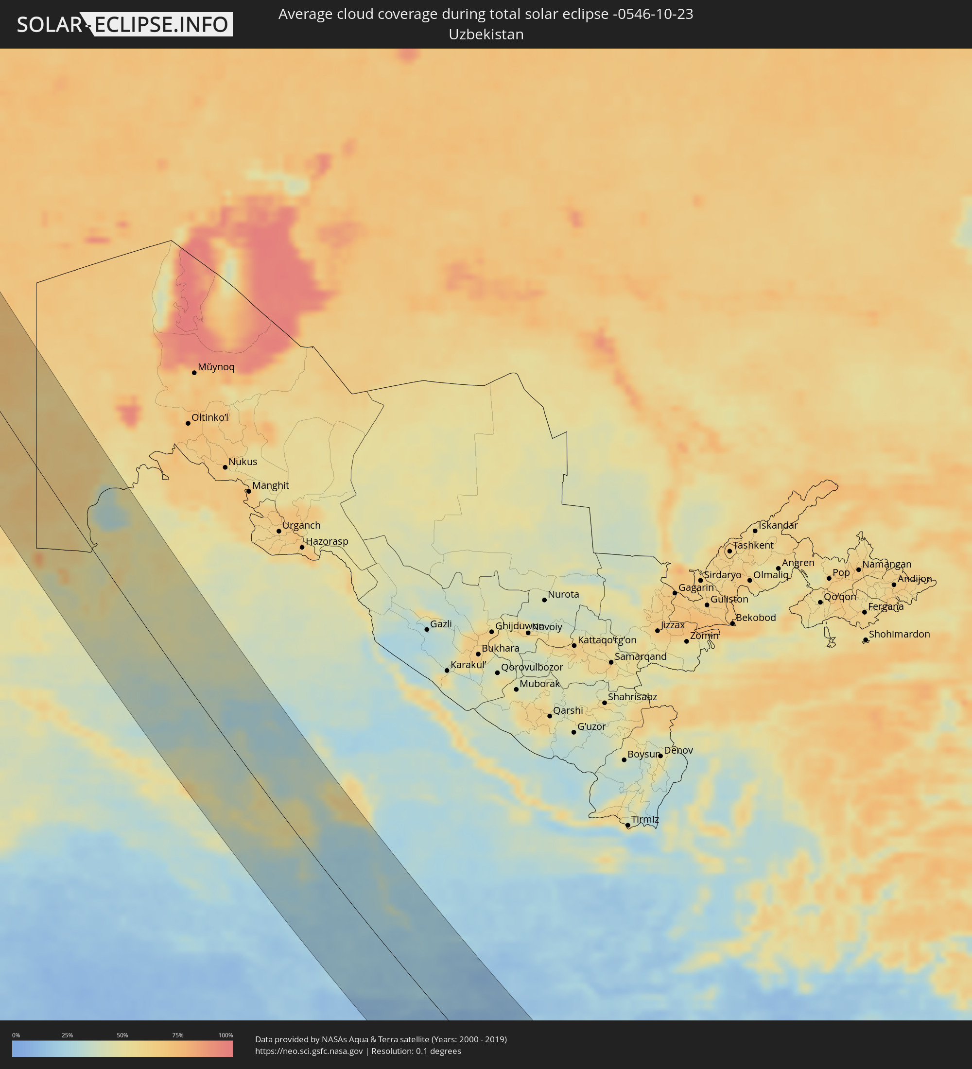
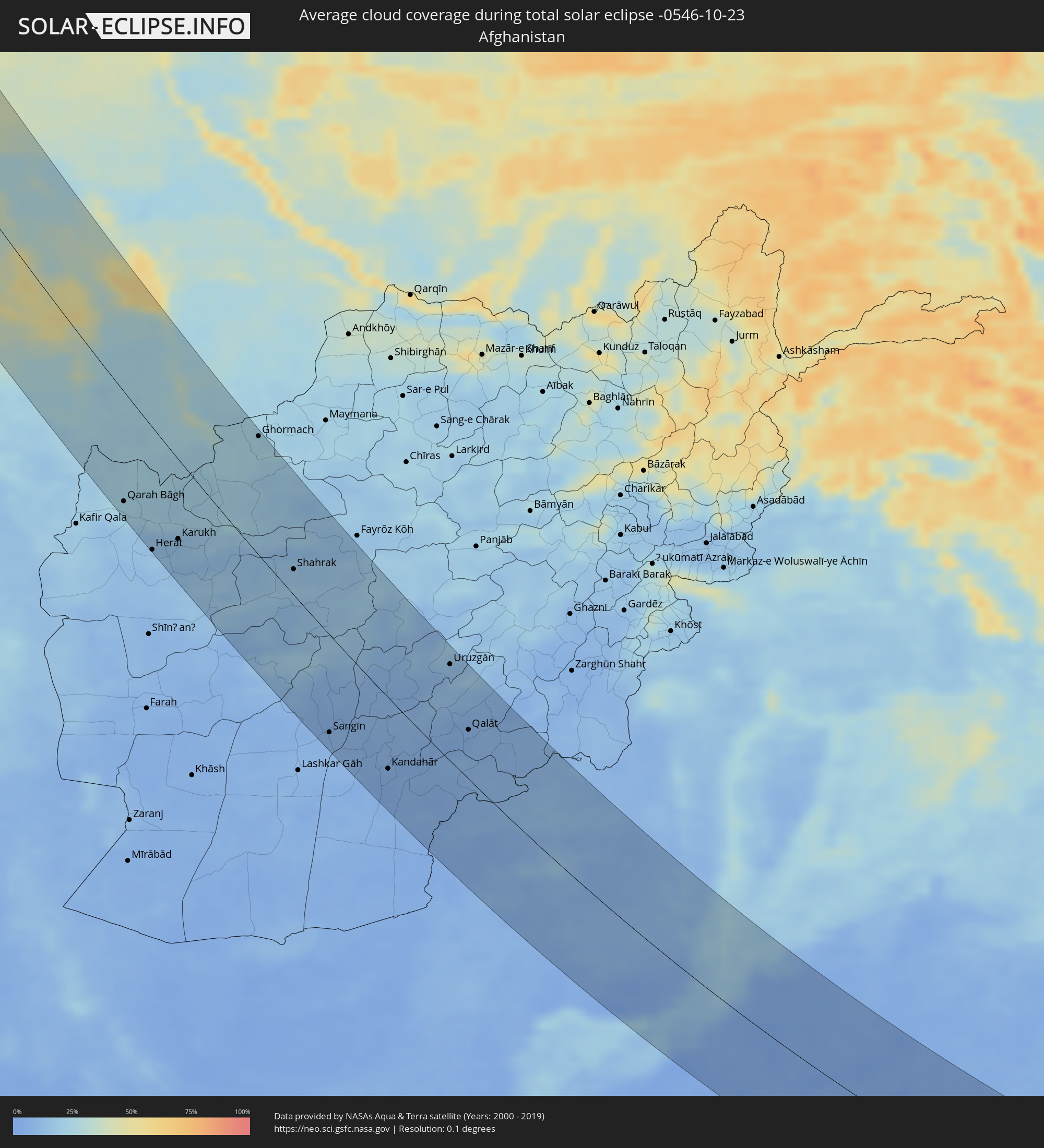
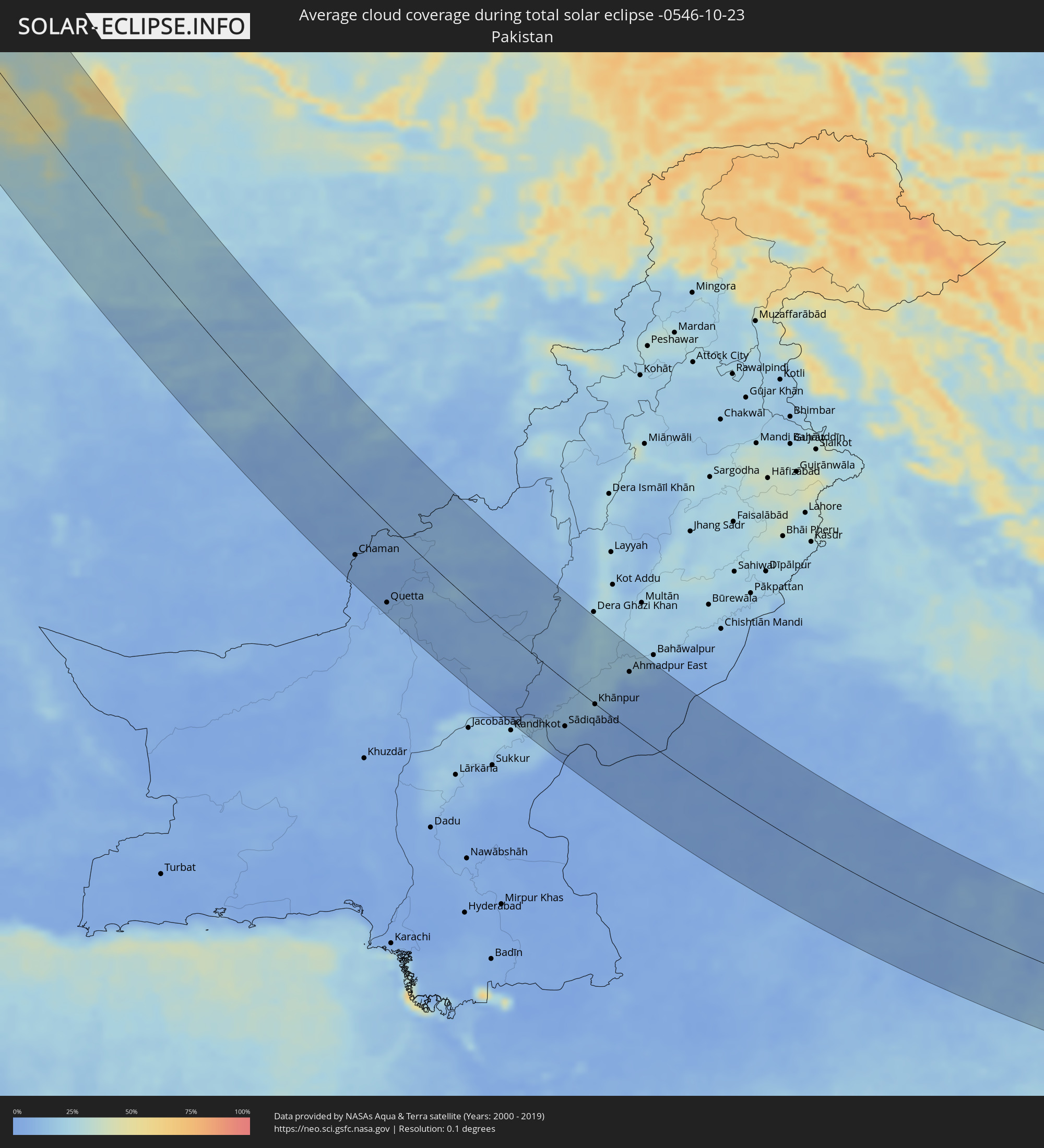
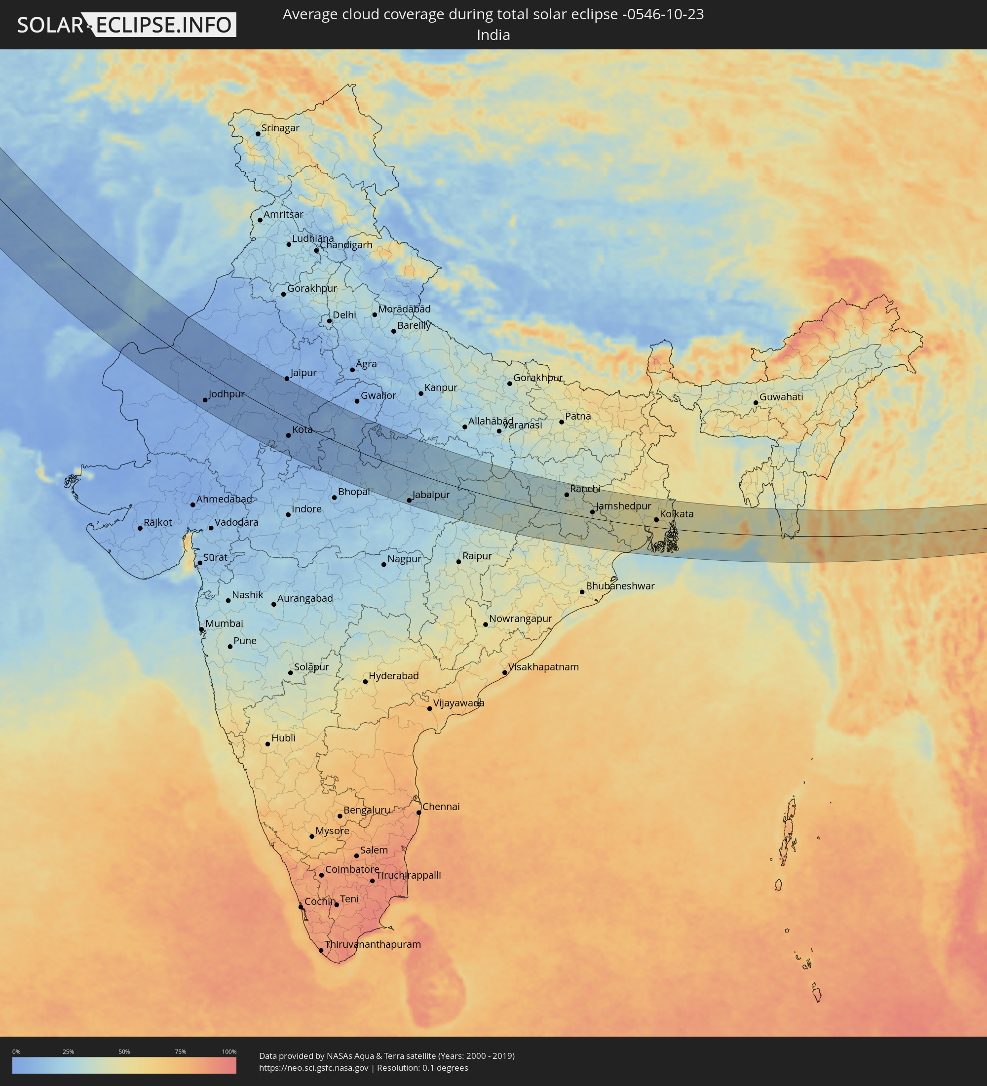
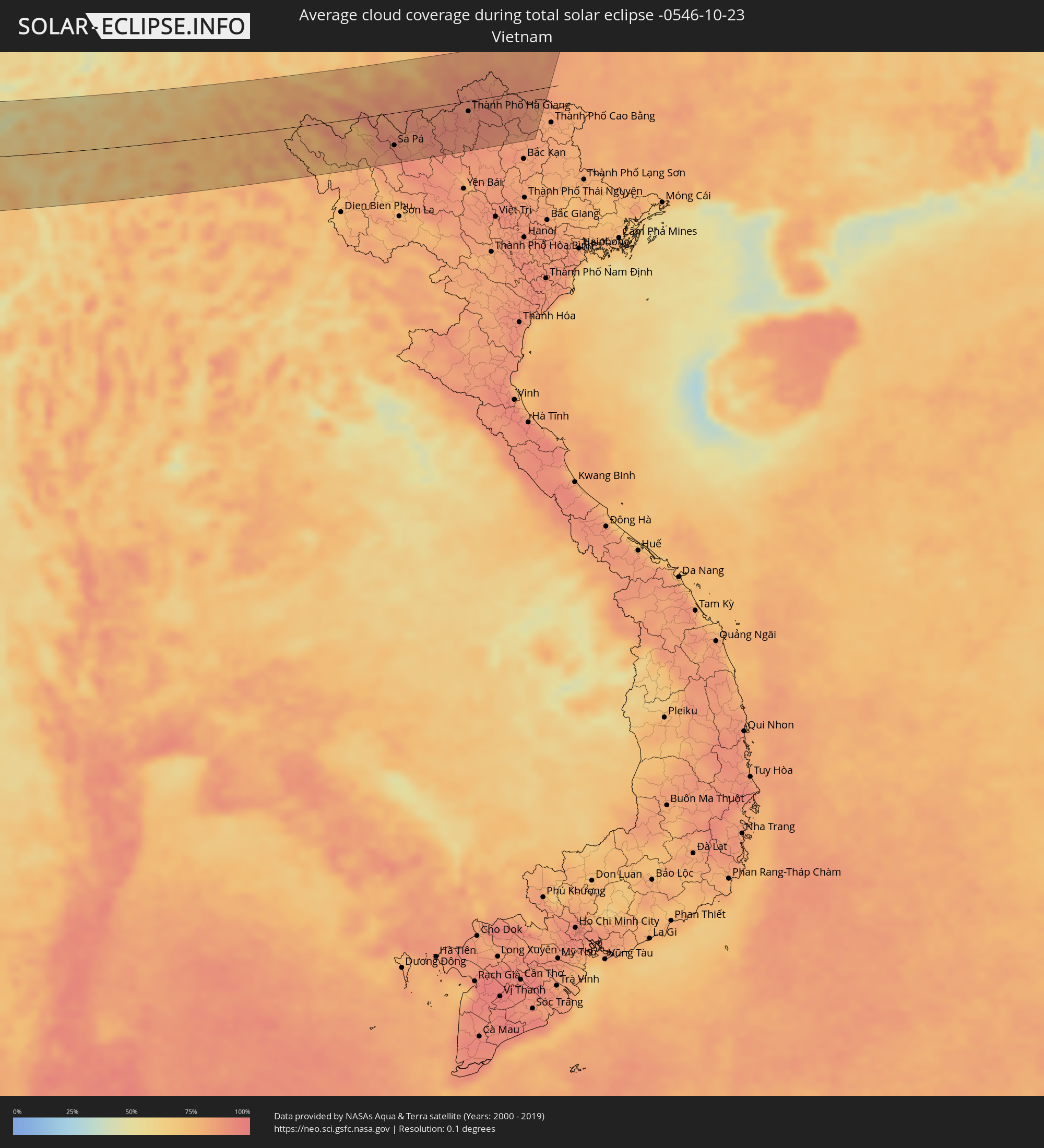
Die folgenden Karten zeigen die durchschnittliche Bewölkung für den Tag, an dem die totale Sonnenfinsternis
stattfindet. Mit Hilfe der Karten lässt sich der Ort entlang des Finsternispfades eingrenzen,
der die besten Aussichen auf einen klaren wolkenfreien Himmel bietet.
Trotzdem muss man immer lokale Gegenenheiten beachten und sollte sich genau über das Wetter an seinem
gewählten Beobachtungsort informieren.
Die Daten stammen von den beiden NASA-Satelliten
AQUA und TERRA
und wurden über einen Zeitraum von 19 Jahren (2000 - 2019) gemittelt.
Detaillierte Länderkarten
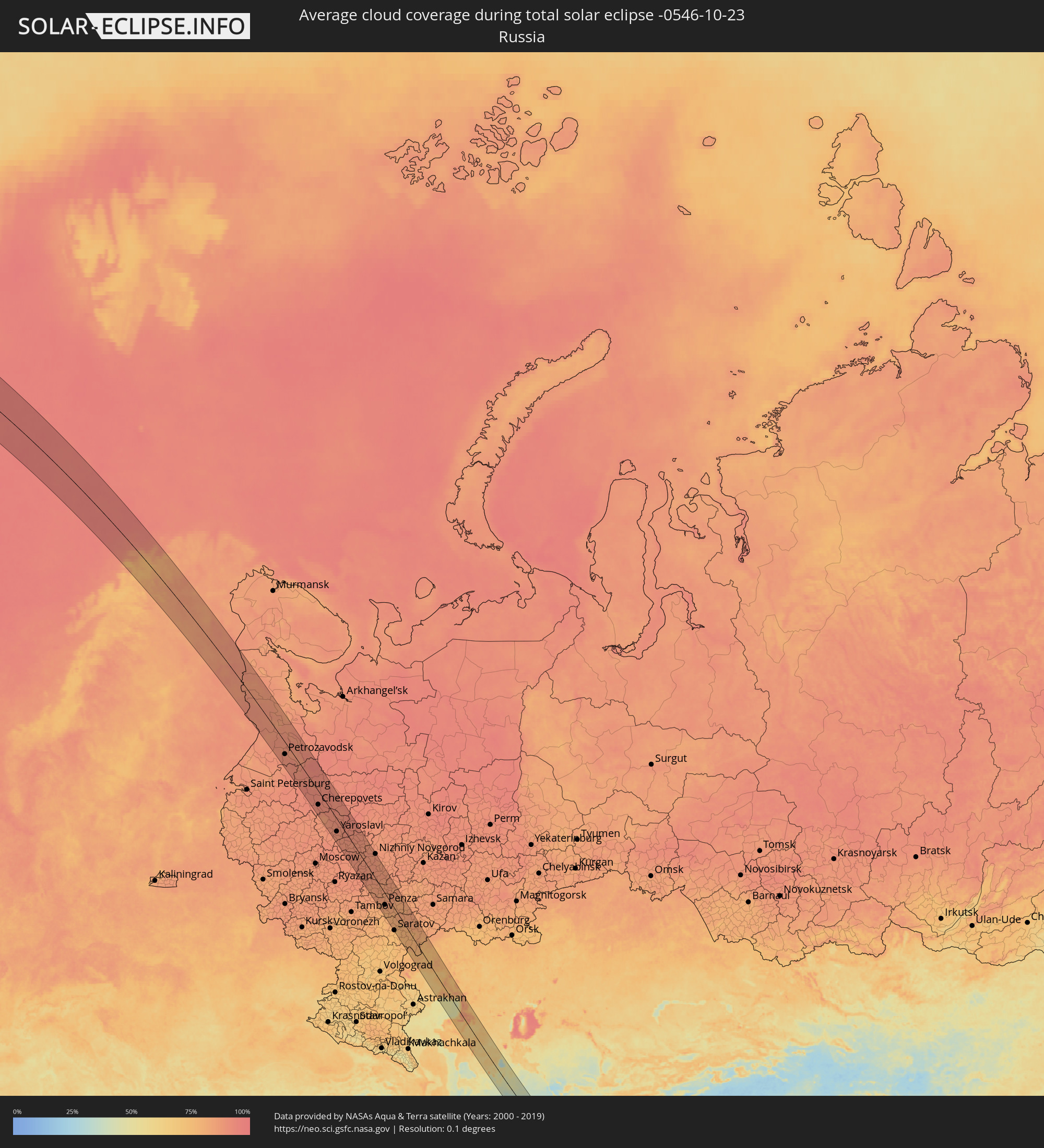 Russland
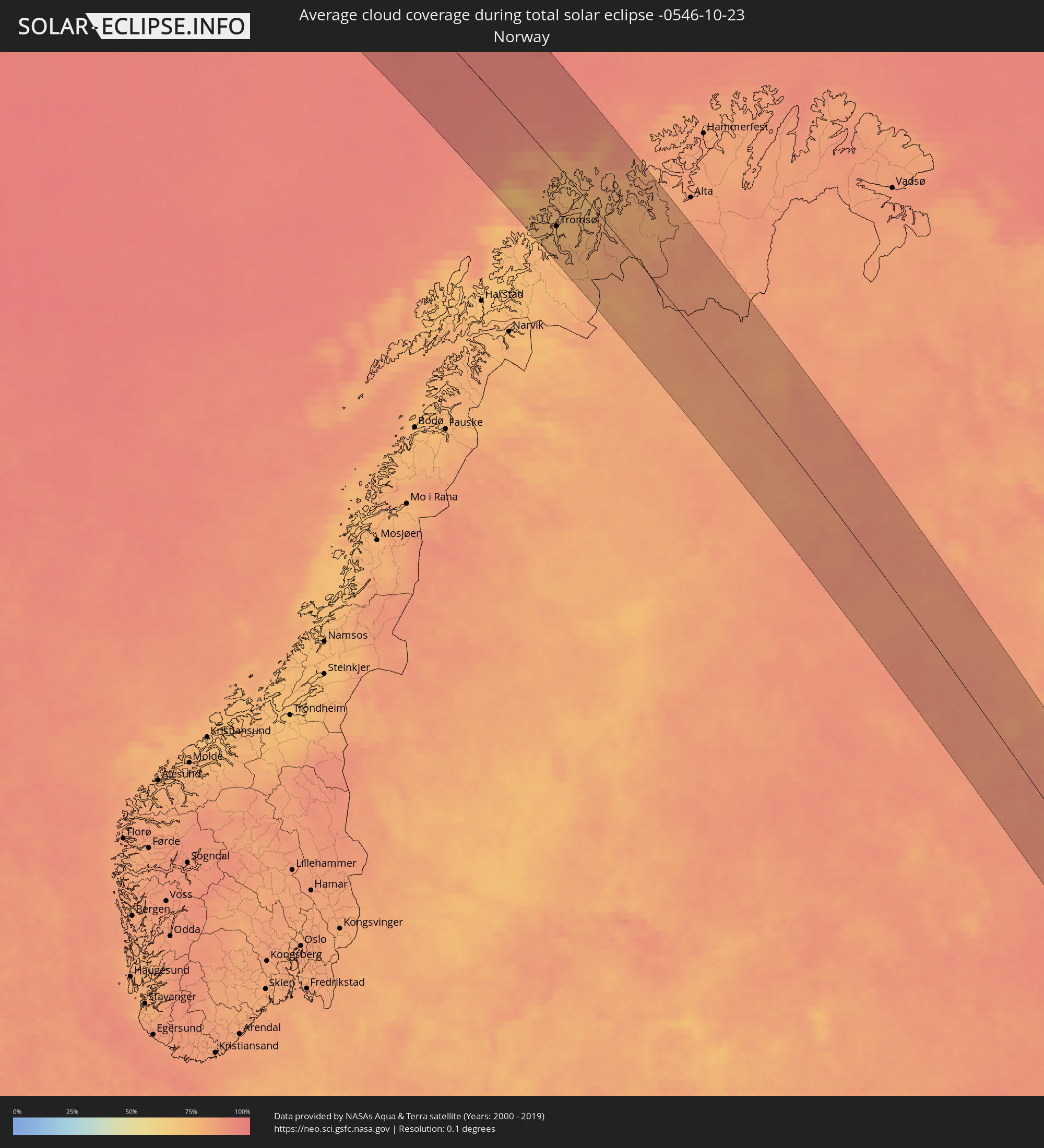 Norwegen
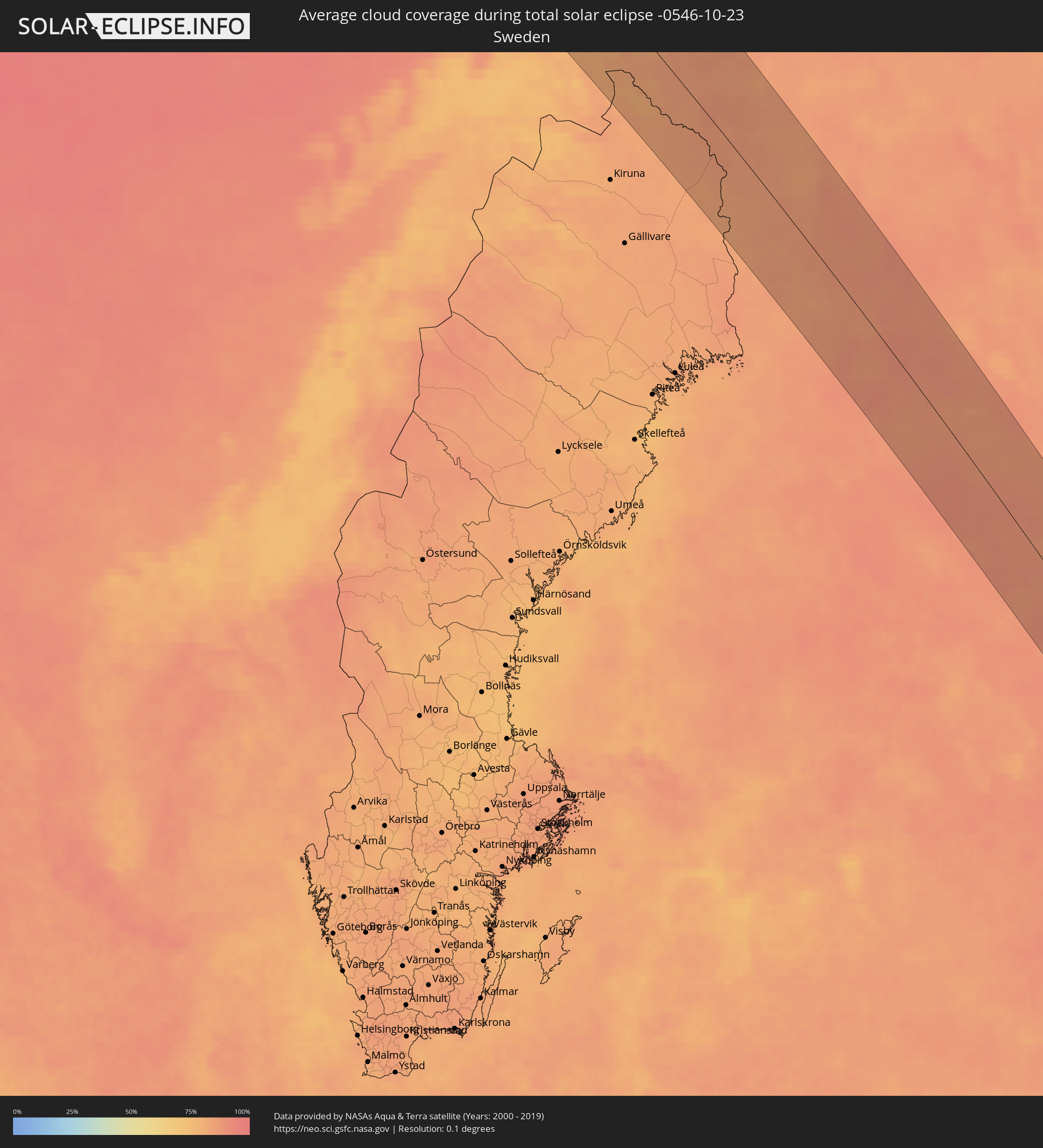 Schweden
 Finnland
 Iran
Iran
 Kasachstan
 Turkmenistan
 Usbekistan
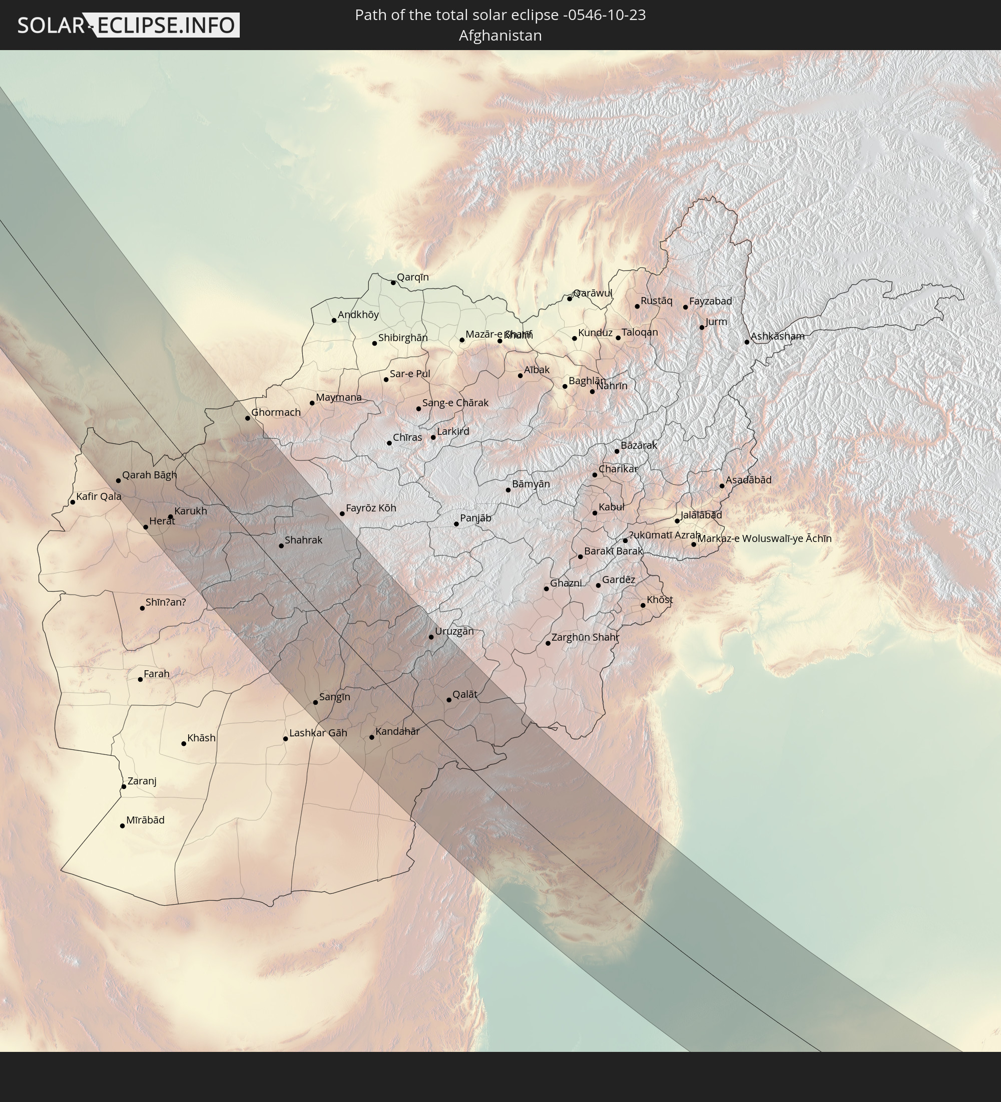
 Afghanistan
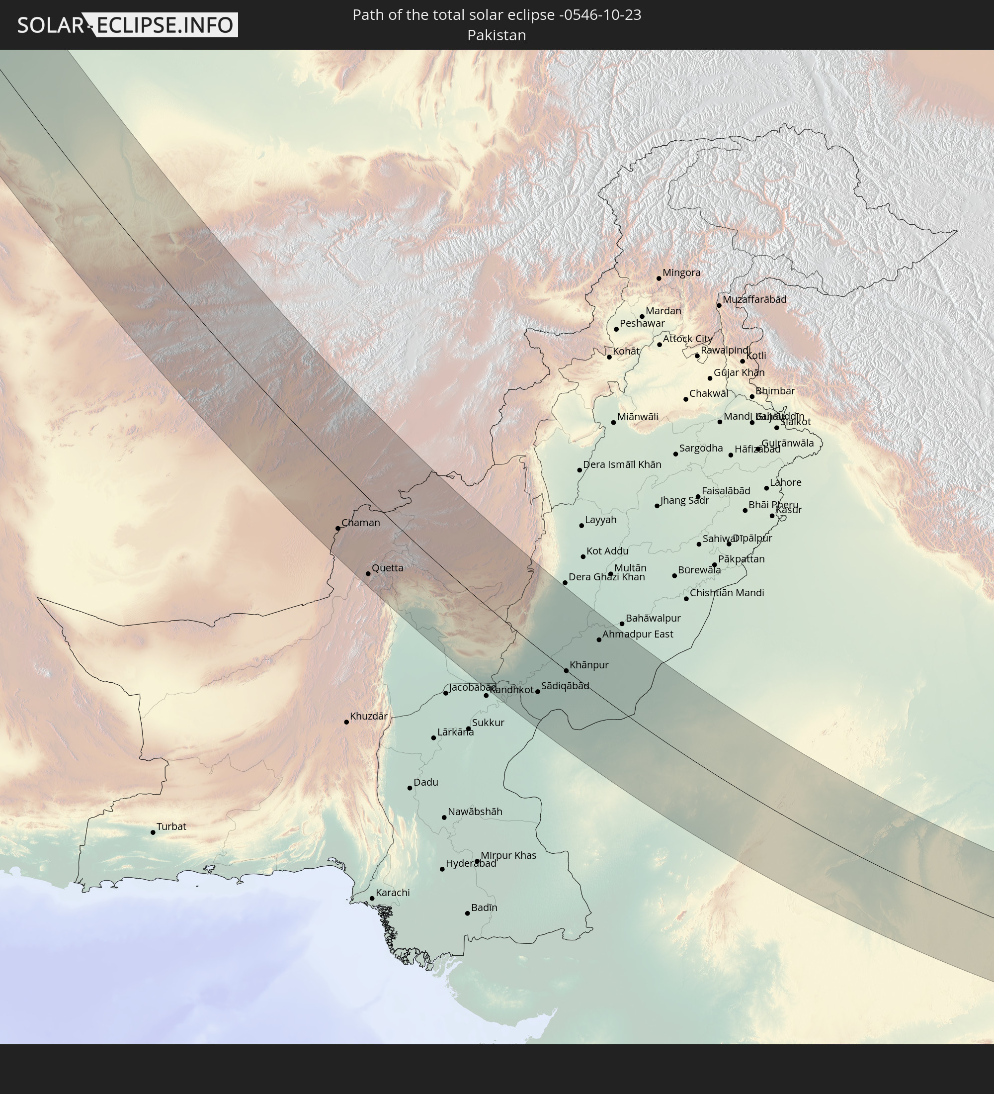
 Pakistan
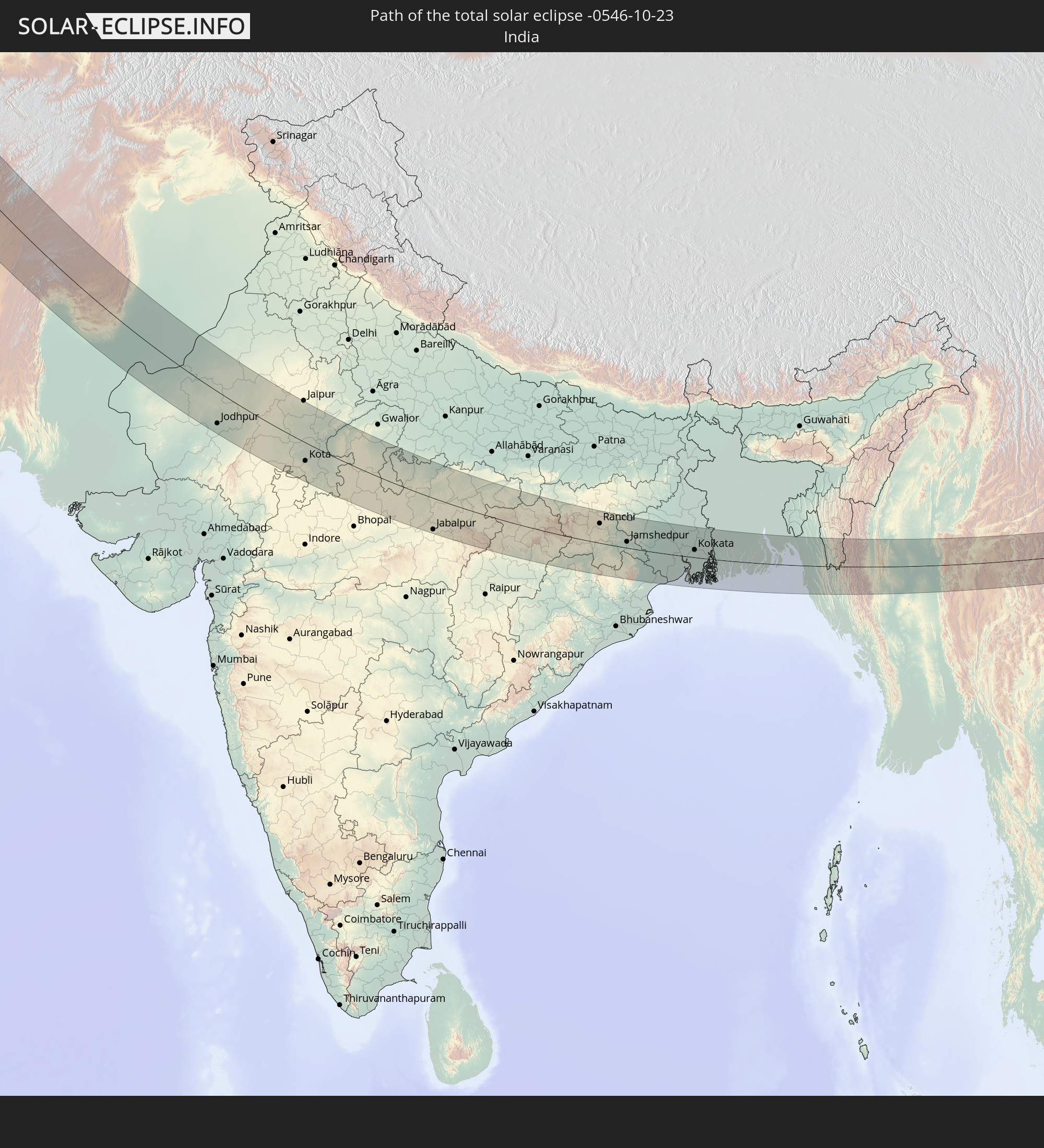
 Indien
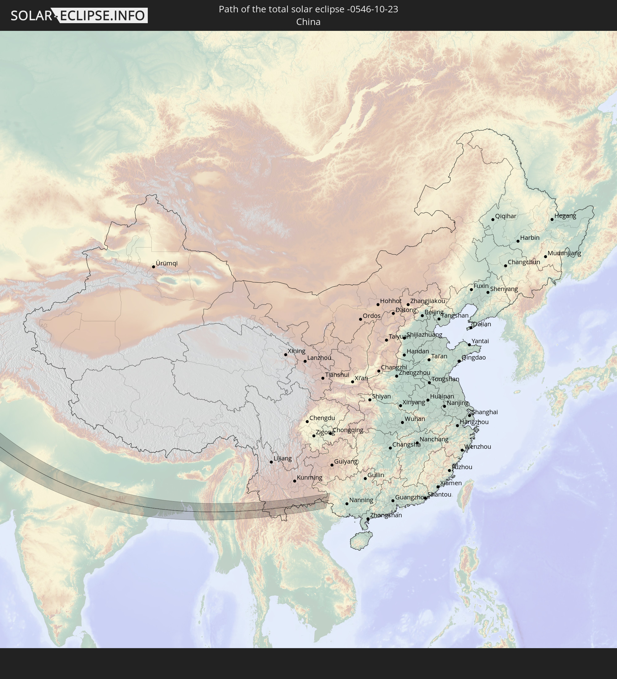
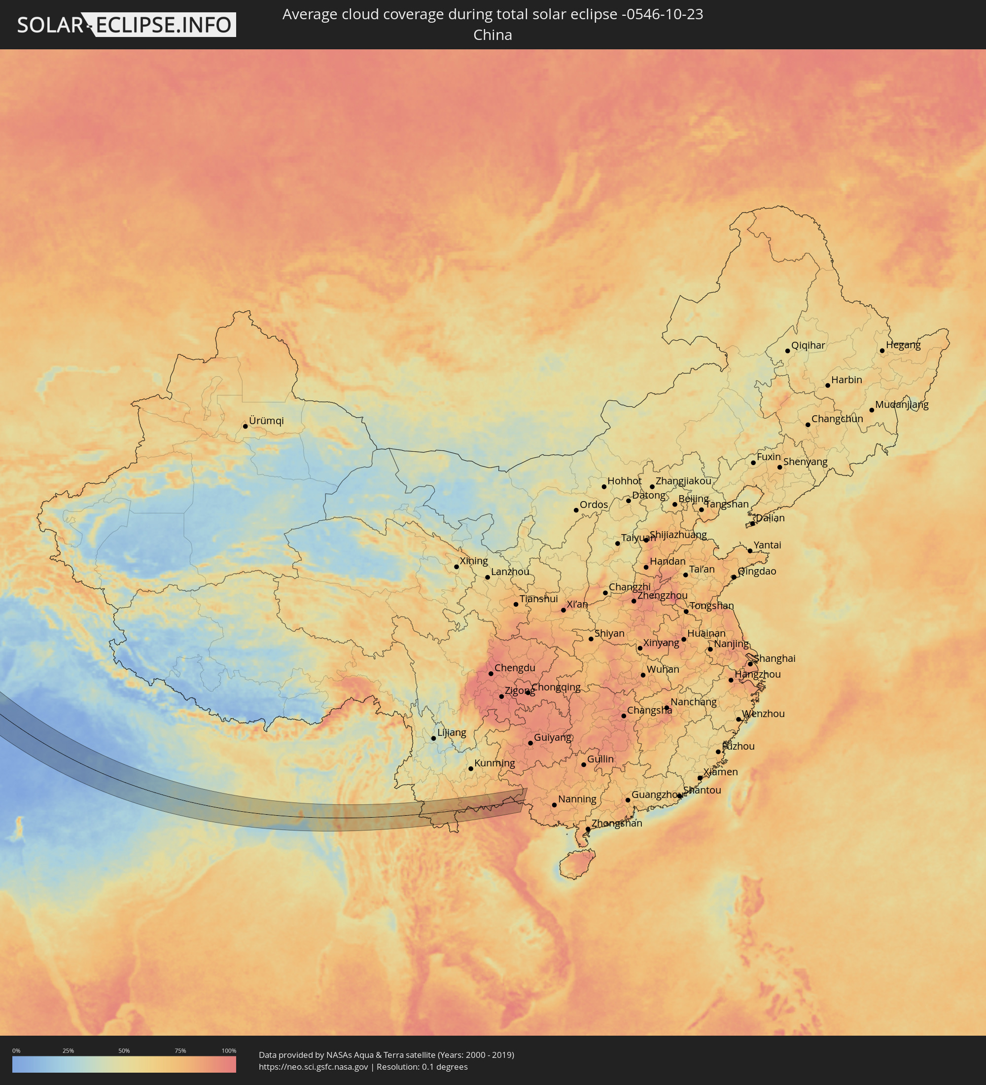 Volksrepublik China
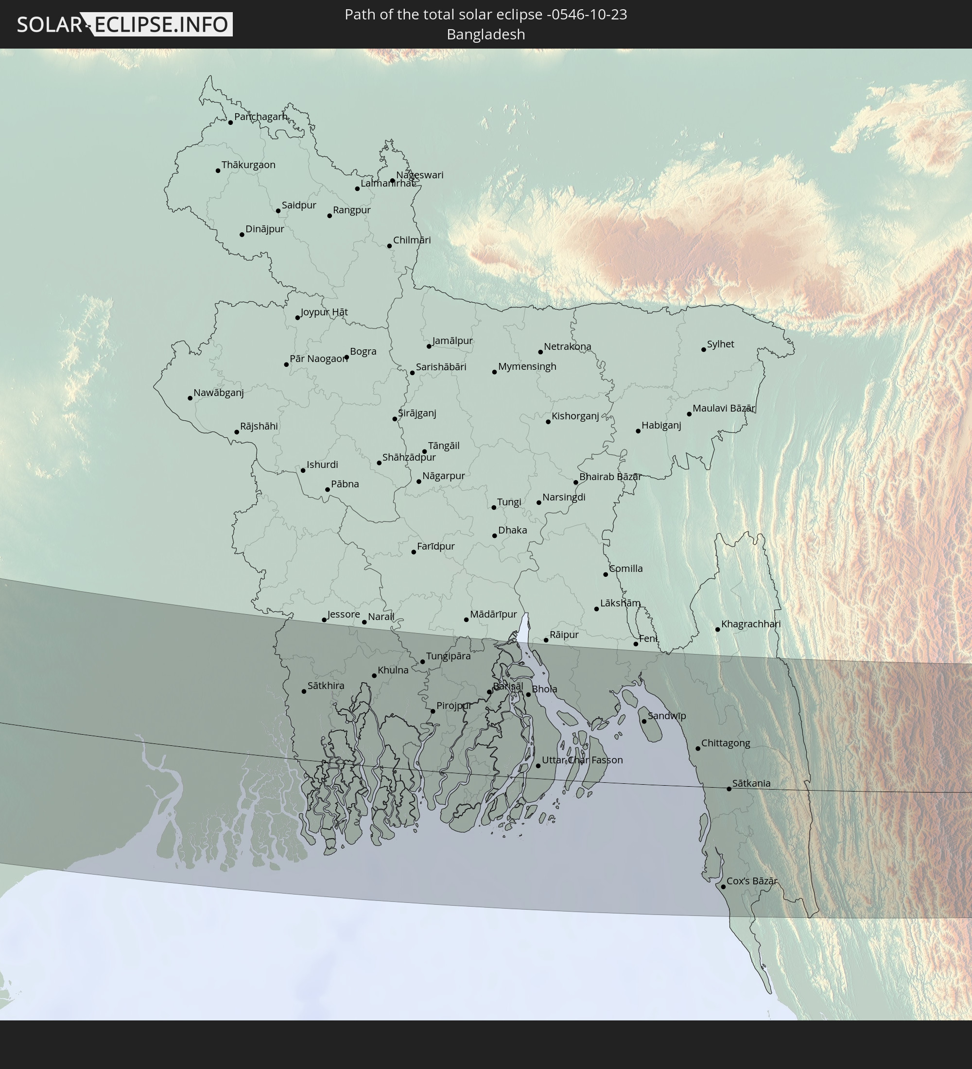
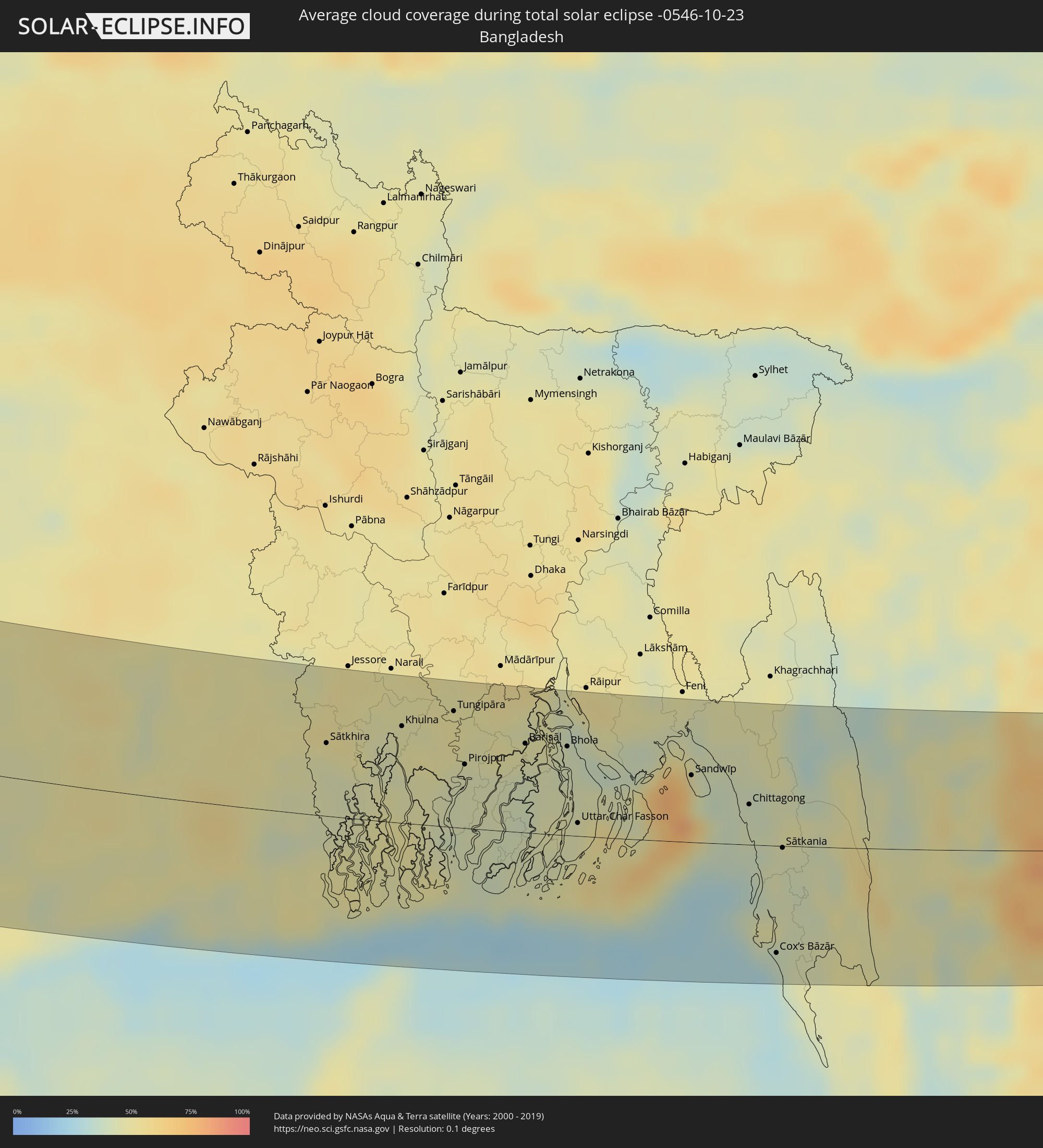 Bangladesch
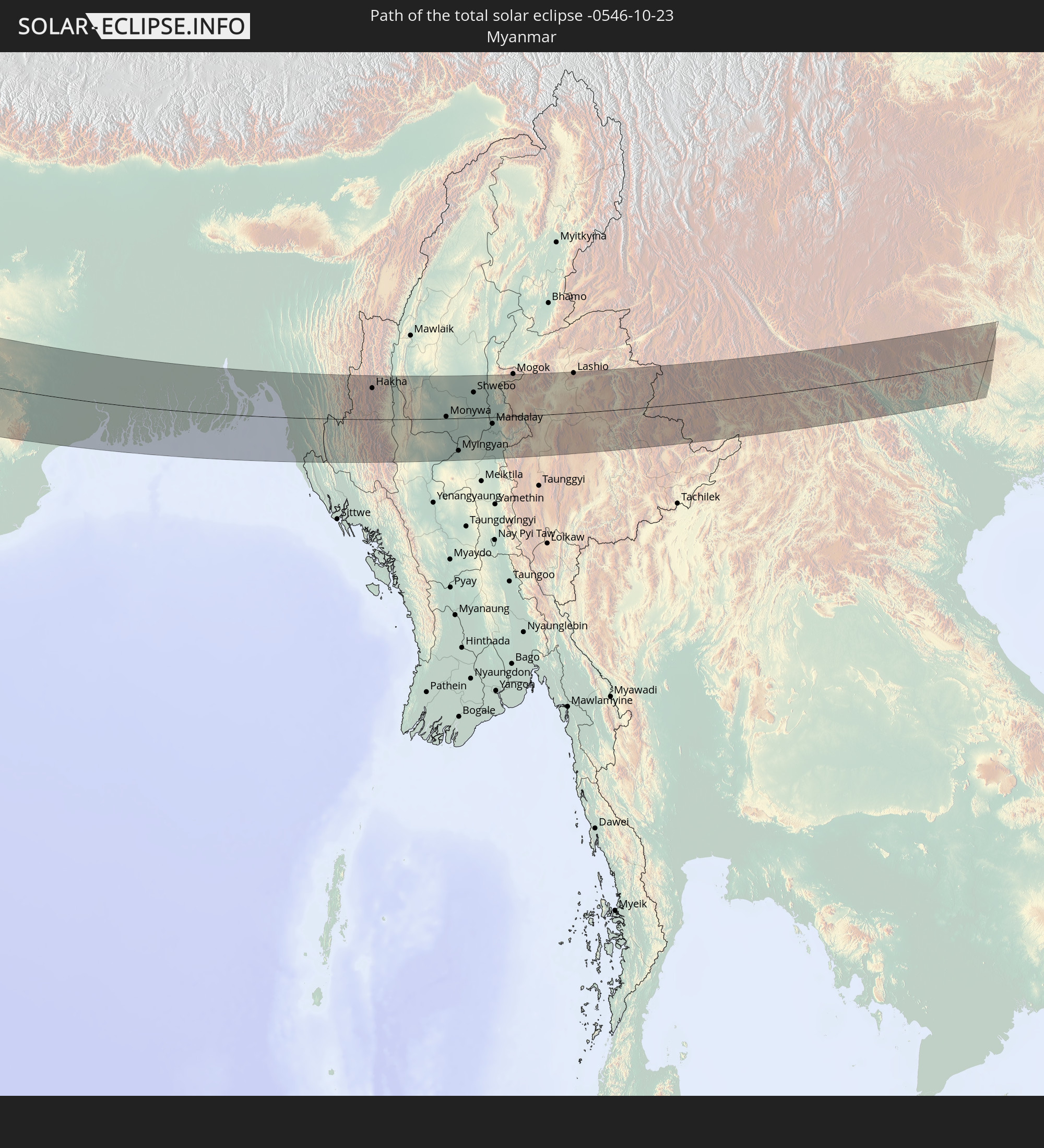
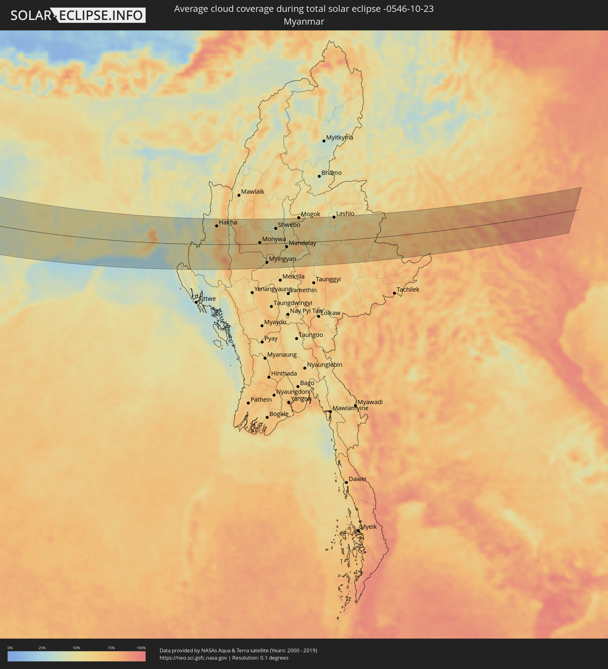 Myanmar
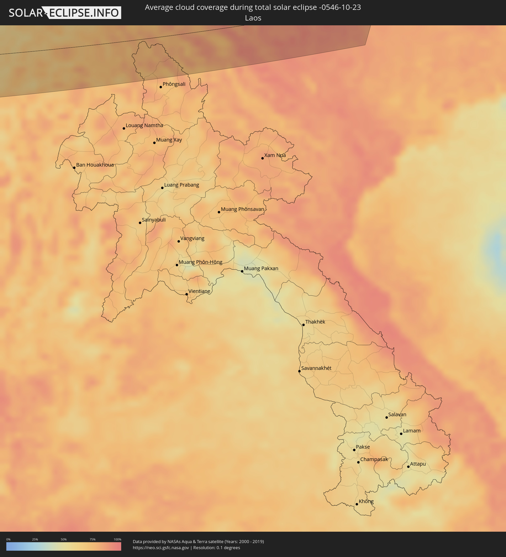 Laos
Laos
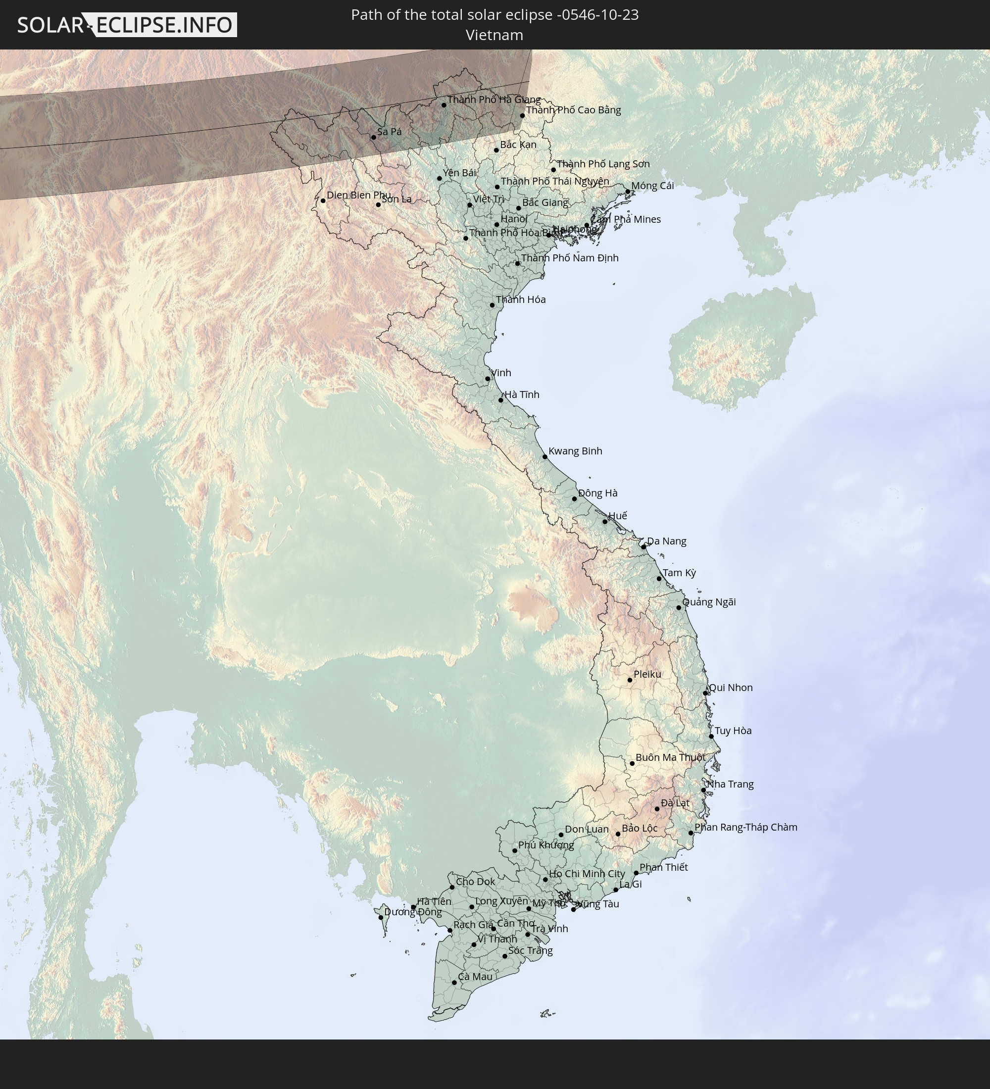
 Vietnam
Orte im Finsternispfad
Die nachfolgene Tabelle zeigt Städte und Orte mit mehr als 5.000 Einwohnern, die sich im Finsternispfad befinden. Städte mit mehr als 100.000 Einwohnern sind dick gekennzeichnet. Mit einem Klick auf den Ort öffnet sich eine Detailkarte die die Lage des jeweiligen Ortes zusammen mit dem Verlauf der zentralen Finsternis präsentiert.
| Ort | Typ | Dauer der Verfinsterung | Ortszeit bei maximaler Verfinsterung | Entfernung zur Zentrallinie | Ø Bewölkung |
|
Tromsø, Troms
|
total | - | 09:18:07 UTC+01:00 | 49 km | 76% |
|
Kittilä, Lapland
|
total | - | 09:59:50 UTC+01:39 | 6 km | 84% |
|
Rovaniemi, Lapland
|
total | - | 09:59:47 UTC+01:39 | 58 km | 84% |
|
Sodankylä, Lapland
|
total | - | 10:00:41 UTC+01:39 | 35 km | 87% |
|
Pyhäjärvi, Lapland
|
total | - | 10:00:54 UTC+01:39 | 33 km | 88% |
|
Kemijärvi, Lapland
|
total | - | 10:00:51 UTC+01:39 | 12 km | 88% |
|
Suomussalmi, Kainuu
|
total | - | 10:01:12 UTC+01:39 | 53 km | 87% |
|
Kuusamo, Northern Ostrobothnia
|
total | - | 10:01:42 UTC+01:39 | 29 km | 90% |
|
Kuhmo, Kainuu
|
total | - | 10:01:25 UTC+01:39 | 81 km | 90% |
|
Petrozavodsk, Republic of Karelia
|
total | - | 10:55:04 UTC+02:30 | 38 km | 90% |
|
Cherepovets, Vologda
|
total | - | 10:58:10 UTC+02:30 | 46 km | 92% |
|
Rybinsk, Jaroslavl
|
total | - | 10:59:13 UTC+02:30 | 69 km | 89% |
|
Yaroslavl, Jaroslavl
|
total | - | 11:00:16 UTC+02:30 | 44 km | 89% |
|
Vologda, Vologda
|
total | - | 10:59:55 UTC+02:30 | 54 km | 90% |
|
Kostroma, Kostroma
|
total | - | 11:01:14 UTC+02:30 | 17 km | 91% |
|
Ivanovo, Ivanovo
|
total | - | 11:01:30 UTC+02:30 | 28 km | 89% |
|
Kovrov, Vladimir
|
total | - | 11:02:03 UTC+02:30 | 49 km | 90% |
|
Murom, Vladimir
|
total | - | 11:03:04 UTC+02:30 | 59 km | 89% |
|
Dzerzhinsk, Nizjnij Novgorod
|
total | - | 11:04:14 UTC+02:30 | 55 km | 87% |
|
Arzamas, Nizjnij Novgorod
|
total | - | 11:04:59 UTC+02:30 | 25 km | 88% |
|
Nizhniy Novgorod, Nizjnij Novgorod
|
total | - | 11:04:45 UTC+02:30 | 89 km | 88% |
|
Penza, Penza
|
total | - | 11:07:22 UTC+02:30 | 43 km | 84% |
|
Saransk, Mordoviya
|
total | - | 11:07:00 UTC+02:30 | 25 km | 86% |
|
Saratov, Saratov
|
total | - | 11:59:35 UTC+03:20 | 86 km | 75% |
|
Balakovo, Saratov
|
total | - | 12:01:20 UTC+03:20 | 47 km | 82% |
|
Zhumysker
|
total | - | 12:10:24 UTC+03:25 | 16 km | 76% |
|
Dzhangala
|
total | - | 12:11:40 UTC+03:25 | 34 km | 78% |
|
Makhambet, Atyraū
|
total | - | 12:14:41 UTC+03:25 | 21 km | 75% |
|
Īnderbor, Atyraū
|
total | - | 12:14:06 UTC+03:25 | 86 km | 78% |
|
Balyqshy, Atyraū
|
total | - | 12:15:39 UTC+03:25 | 4 km | 76% |
|
Atyrau, Atyraū
|
total | - | 12:15:38 UTC+03:25 | 8 km | 76% |
|
Qaraton, Atyraū
|
total | - | 12:18:28 UTC+03:25 | 71 km | 81% |
|
Kaka, Ahal
|
total | - | 13:07:24 UTC+03:53 | 79 km | 39% |
|
Tejen, Ahal
|
total | - | 13:08:43 UTC+03:53 | 13 km | 47% |
|
Sarakhs, Razavi Khorasan
|
total | - | 12:43:14 UTC+03:25 | 24 km | 31% |
|
Qarah Bāgh, Herat
|
total | - | 13:21:02 UTC+04:00 | 93 km | 24% |
|
Mary, Mary
|
total | - | 13:10:26 UTC+03:53 | 94 km | 56% |
|
Murgab
|
total | - | 13:10:48 UTC+03:53 | 97 km | 56% |
|
Herāt, Herat
|
total | - | 13:22:40 UTC+04:00 | 106 km | 16% |
|
Serhetabat, Mary
|
total | - | 13:14:54 UTC+03:53 | 29 km | 24% |
|
Karukh, Herat
|
total | - | 13:23:04 UTC+04:00 | 69 km | 13% |
|
Qala i Naw, Badghis
|
total | - | 13:23:05 UTC+04:00 | 5 km | 21% |
|
Ghormach, Badghis
|
total | - | 13:22:53 UTC+04:00 | 104 km | 23% |
|
Shahrak, Ghowr
|
total | - | 13:26:23 UTC+04:00 | 24 km | 16% |
|
Sangīn, Helmand
|
total | - | 13:30:41 UTC+04:00 | 93 km | 7% |
|
Kandahār, Kandahar
|
total | - | 13:32:51 UTC+04:00 | 70 km | 6% |
|
Tarinkot, Oruzgan
|
total | - | 13:31:21 UTC+04:00 | 21 km | 7% |
|
Chaman, Balochistān
|
total | - | 14:03:26 UTC+04:28 | 75 km | 7% |
|
Uruzgān, Oruzgan
|
total | - | 13:32:01 UTC+04:00 | 95 km | 12% |
|
Qalāt, Zabul
|
total | - | 13:33:52 UTC+04:00 | 49 km | 7% |
|
Quetta, Balochistān
|
total | - | 14:05:34 UTC+04:28 | 97 km | 7% |
|
Sibi, Balochistān
|
total | - | 14:08:05 UTC+04:28 | 95 km | 6% |
|
Loralai, Balochistān
|
total | - | 14:07:44 UTC+04:28 | 20 km | 8% |
|
Kashmor, Sindh
|
total | - | 14:12:42 UTC+04:28 | 84 km | 16% |
|
Khairpur, Sindh
|
total | - | 14:13:32 UTC+04:28 | 109 km | 16% |
|
Sādiqābād, Punjab
|
total | - | 14:13:45 UTC+04:28 | 62 km | 10% |
|
Rājanpur, Punjab
|
total | - | 14:12:37 UTC+04:28 | 20 km | 12% |
|
Zāhir Pīr, Punjab
|
total | - | 14:13:27 UTC+04:28 | 6 km | 16% |
|
Jāmpur, Punjab
|
total | - | 14:12:04 UTC+04:28 | 83 km | 19% |
|
Khānpur, Punjab
|
total | - | 14:13:56 UTC+04:28 | 1 km | 13% |
|
Jatoi Shimāli, Punjab
|
total | - | 14:12:40 UTC+04:28 | 87 km | 19% |
|
Alīpur, Punjab
|
total | - | 14:13:00 UTC+04:28 | 80 km | 20% |
|
Jalālpur Pīrwāla, Punjab
|
total | - | 14:13:14 UTC+04:28 | 109 km | 18% |
|
Ahmadpur East, Punjab
|
total | - | 14:13:57 UTC+04:28 | 79 km | 11% |
|
Yazman, Punjab
|
total | - | 14:14:42 UTC+04:28 | 106 km | 9% |
|
Jodhpur, Rajasthan
|
total | - | 15:14:38 UTC+05:21 | 86 km | 4% |
|
Bīkaner, Rajasthan
|
total | - | 15:11:56 UTC+05:21 | 94 km | 3% |
|
Ajmer, Rajasthan
|
total | - | 15:16:37 UTC+05:21 | 15 km | 7% |
|
Bhīlwāra, Rajasthan
|
total | - | 15:18:35 UTC+05:21 | 92 km | 4% |
|
Kota, Rajasthan
|
total | - | 15:20:32 UTC+05:21 | 52 km | 7% |
|
Jhānsi, Uttar Pradesh
|
total | - | 15:23:38 UTC+05:21 | 92 km | 9% |
|
Jabalpur, Madhya Pradesh
|
total | - | 15:29:19 UTC+05:21 | 97 km | 17% |
|
Satna, Madhya Pradesh
|
total | - | 15:27:56 UTC+05:21 | 80 km | 19% |
|
Korba, Chhattisgarh
|
total | - | 15:33:51 UTC+05:21 | 104 km | 37% |
|
Ranchi, Jharkhand
|
total | - | 15:34:56 UTC+05:21 | 63 km | 37% |
|
Jamshedpur, Jharkhand
|
total | - | 15:36:41 UTC+05:21 | 20 km | 43% |
|
Barddhamān, West Bengal
|
total | - | 15:37:31 UTC+05:21 | 95 km | 46% |
|
Nangi, West Bengal
|
total | - | 15:39:02 UTC+05:21 | 17 km | 53% |
|
Kolkata, West Bengal
|
total | - | 15:39:05 UTC+05:21 | 25 km | 50% |
|
Bhātpāra, West Bengal
|
total | - | 15:38:38 UTC+05:21 | 59 km | 50% |
|
Bārāsat, West Bengal
|
total | - | 15:38:56 UTC+05:21 | 44 km | 51% |
|
Sātkhira, Khulna
|
total | - | 16:11:38 UTC+05:53 | 49 km | 46% |
|
Jhingergācha, Khulna
|
total | - | 16:11:00 UTC+05:53 | 94 km | 51% |
|
Bhātpāra Abhaynagar, Khulna
|
total | - | 16:11:27 UTC+05:53 | 86 km | 46% |
|
Khulna, Khulna
|
total | - | 16:11:53 UTC+05:53 | 65 km | 48% |
|
Tungipāra, Dhaka
|
total | - | 16:12:01 UTC+05:53 | 78 km | 51% |
|
Pirojpur, Barisāl
|
total | - | 16:12:35 UTC+05:53 | 43 km | 43% |
|
Barisāl, Barisāl
|
total | - | 16:12:42 UTC+05:53 | 60 km | 44% |
|
Bhola, Barisāl
|
total | - | 16:12:57 UTC+05:53 | 60 km | 42% |
|
Uttar Char Fasson, Khulna
|
total | - | 16:13:44 UTC+05:53 | 9 km | 45% |
|
Burhānuddin, Barisāl
|
total | - | 16:13:19 UTC+05:53 | 39 km | 44% |
|
Lakshmīpur, Chittagong
|
total | - | 16:12:42 UTC+05:53 | 89 km | 44% |
|
Sandwīp, Chittagong
|
total | - | 16:13:51 UTC+05:53 | 45 km | 45% |
|
Chittagong, Chittagong
|
total | - | 16:14:25 UTC+05:53 | 27 km | 42% |
|
Patiya, Chittagong
|
total | - | 16:14:35 UTC+05:53 | 23 km | 44% |
|
Cox’s Bāzār, Chittagong
|
total | - | 16:15:56 UTC+05:53 | 72 km | 33% |
|
Sātkania, Chittagong
|
total | - | 16:14:59 UTC+05:53 | 1 km | 44% |
|
Hakha, Chin
|
total | - | 16:46:39 UTC+06:24 | 66 km | 67% |
|
Pakokku, Magway
|
total | - | 16:49:35 UTC+06:24 | 82 km | 63% |
|
Monywa, Sagain
|
total | - | 16:48:27 UTC+06:24 | 4 km | 61% |
|
Myingyan, Mandalay
|
total | - | 16:49:35 UTC+06:24 | 69 km | 59% |
|
Shwebo, Sagain
|
total | - | 16:48:06 UTC+06:24 | 54 km | 47% |
|
Sagaing, Sagain
|
total | - | 16:49:18 UTC+06:24 | 24 km | 51% |
|
Mandalay, Mandalay
|
total | - | 16:49:13 UTC+06:24 | 14 km | 56% |
|
Kyaukse, Mandalay
|
total | - | 16:49:48 UTC+06:24 | 55 km | 52% |
|
Pyin Oo Lwin, Mandalay
|
total | - | 16:49:20 UTC+06:24 | 9 km | 68% |
|
Lashio, Shan
|
total | - | 16:48:42 UTC+06:24 | 84 km | 59% |
|
Jinghong, Yunnan
|
total | - | 18:26:42 UTC+08:00 | 48 km | 73% |
|
Gejiu, Yunnan
|
total | - | 18:25:38 UTC+08:00 | 72 km | 77% |
|
Lai Châu, Lai Châu
|
total | - | 17:33:47 UTC+07:06 | 39 km | 83% |
|
Sa Pá, Lào Cai
|
total | - | 17:33:59 UTC+07:06 | 51 km | 90% |
|
Lào Cai, Lào Cai
|
total | - | 17:33:49 UTC+07:06 | 37 km | 85% |
|
Wenshan City, Yunnan
|
total | - | 18:25:59 UTC+08:00 | 55 km | 76% |
|
Kaihua, Yunnan
|
total | - | 18:25:59 UTC+08:00 | 55 km | 76% |
|
Mabai, Yunnan
|
total | - | 18:26:33 UTC+08:00 | 14 km | 88% |
|
Thành Phố Hà Giang, Hà Giang
|
total | - | 17:33:38 UTC+07:06 | 16 km | 90% |