Totale Sonnenfinsternis vom 25.01.-0578
| Wochentag: | Mittwoch |
| Maximale Dauer der Verfinsterung: | 03m28s |
| Maximale Breite des Finsternispfades: | 214 km |
| Saroszyklus: | 41 |
| Bedeckungsgrad: | 100% |
| Magnitude: | 1.0512 |
| Gamma: | -0.6123 |
Wo kann man die Sonnenfinsternis vom 25.01.-0578 sehen?
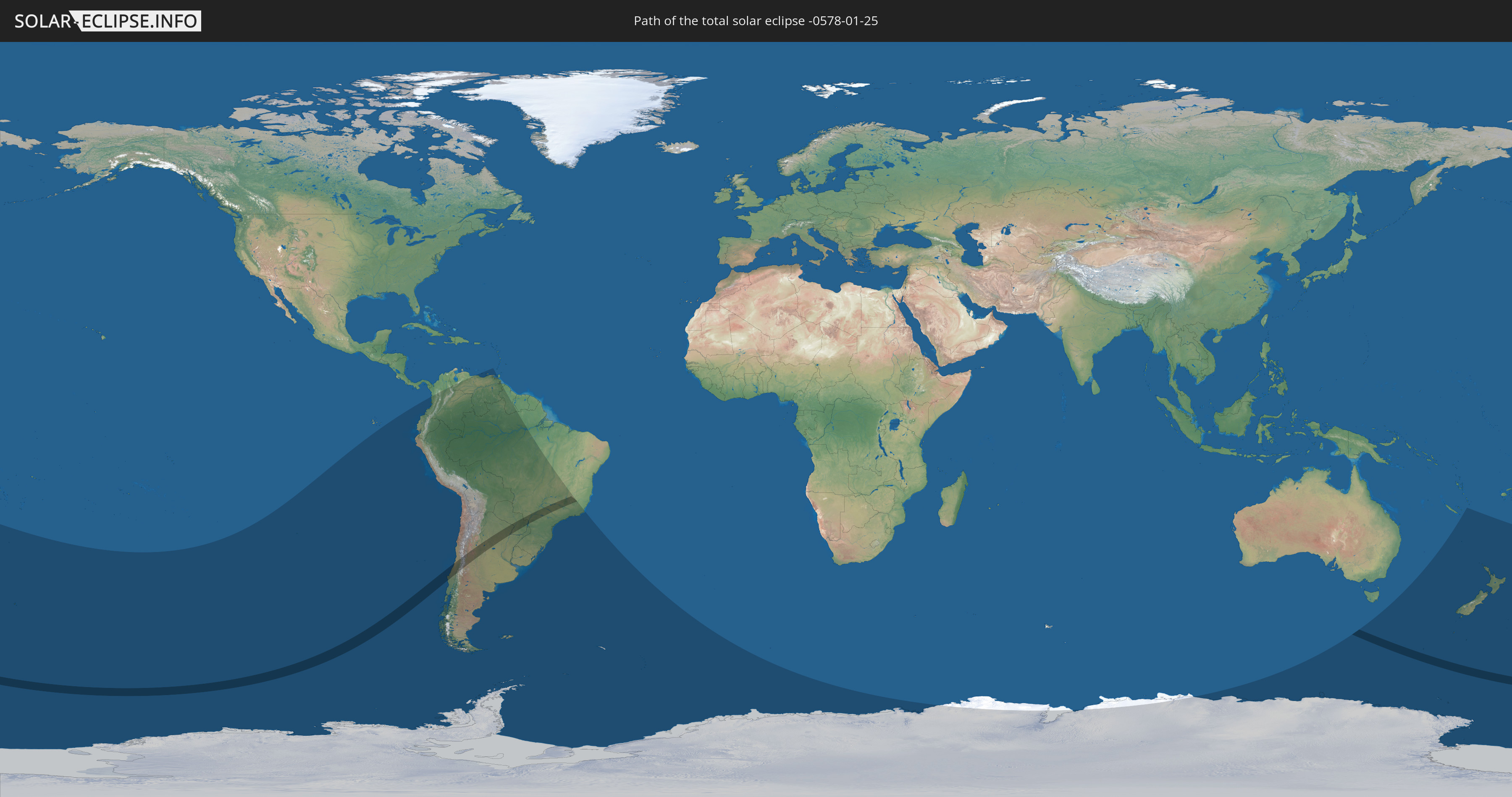
Die Sonnenfinsternis am 25.01.-0578 kann man in 19 Ländern als partielle Sonnenfinsternis beobachten.
Der Finsternispfad verläuft durch 4 Länder. Nur in diesen Ländern ist sie als totale Sonnenfinsternis zu sehen.
In den folgenden Ländern ist die Sonnenfinsternis total zu sehen
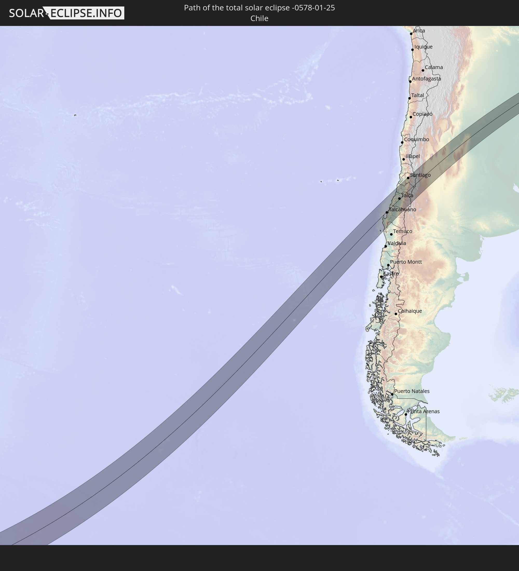 Chile
Chile
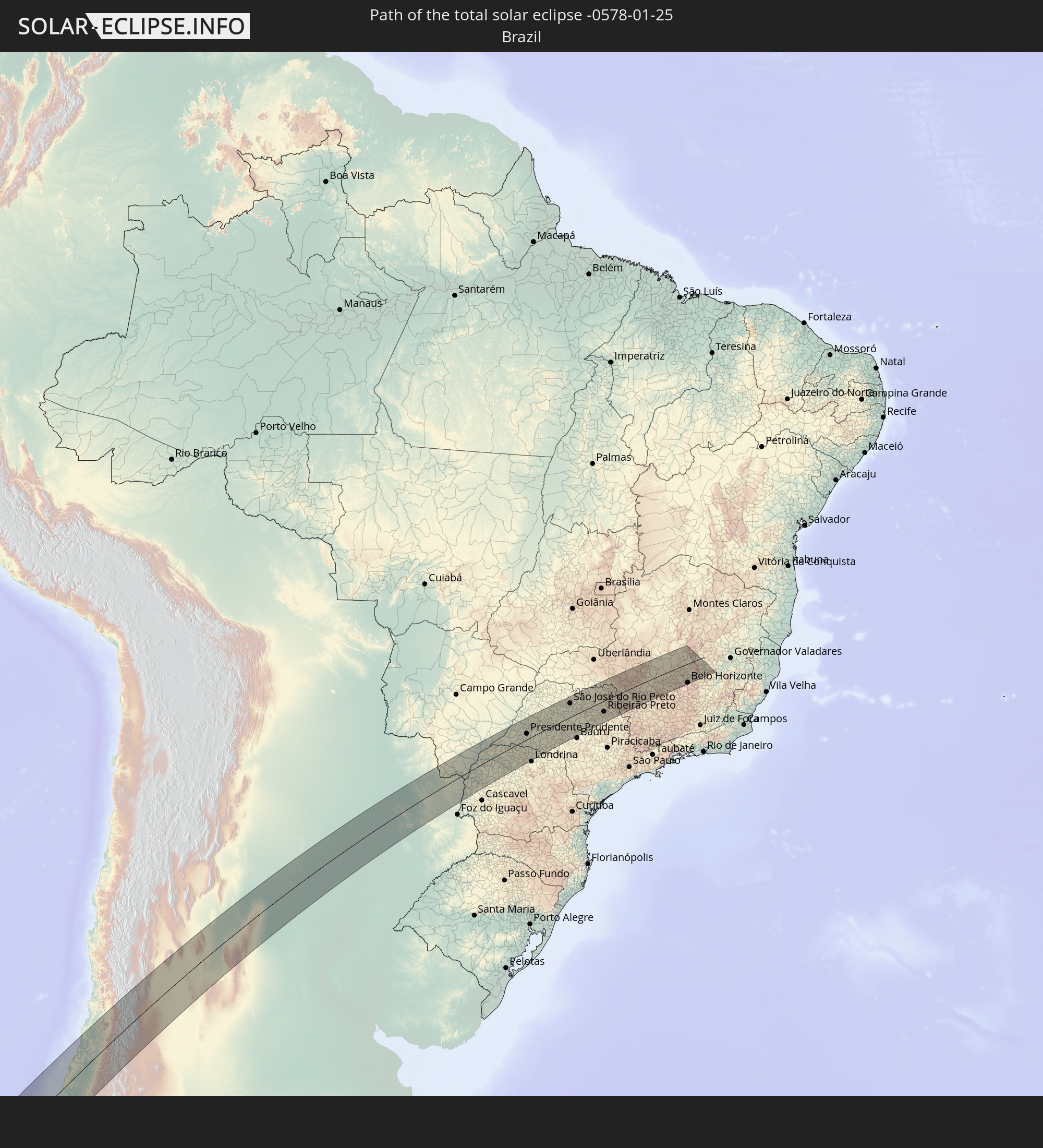 Brasilien
 Argentinien
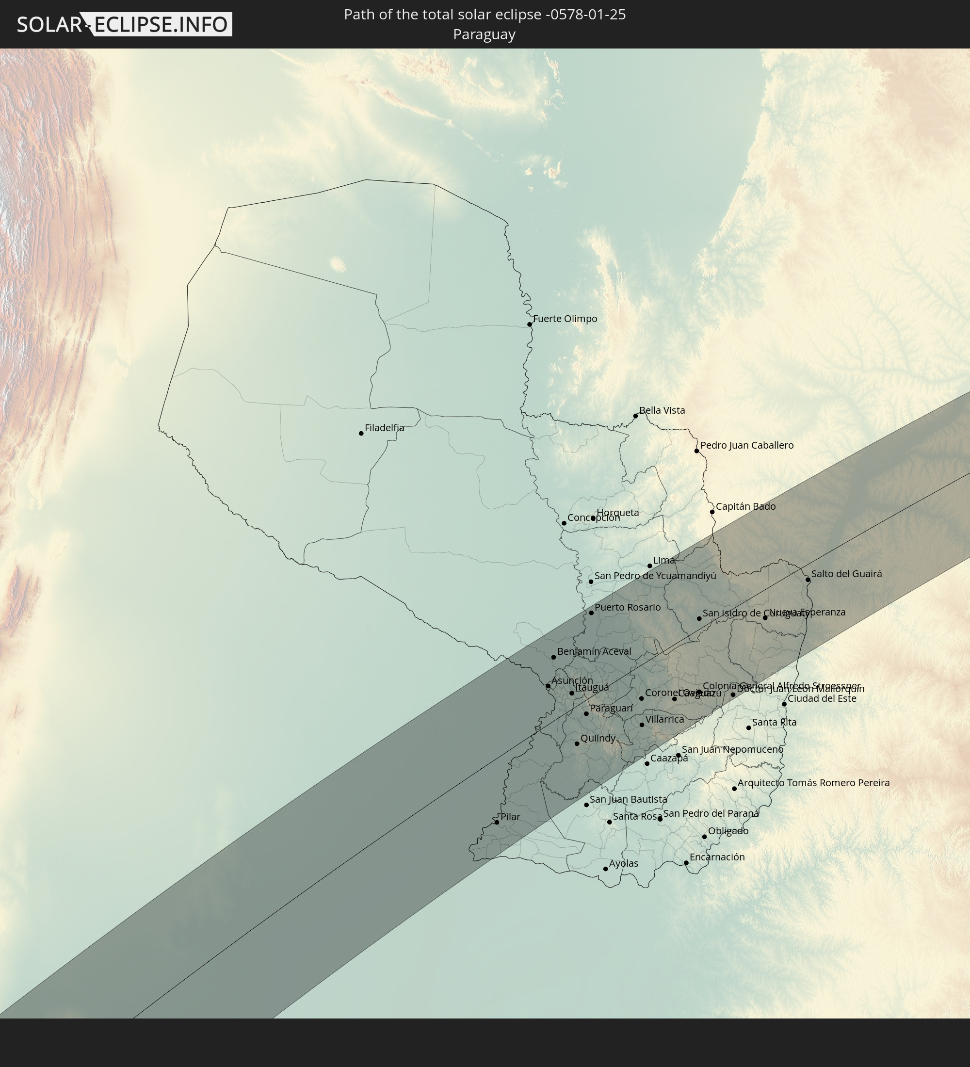 Paraguay
In den folgenden Ländern ist die Sonnenfinsternis partiell zu sehen


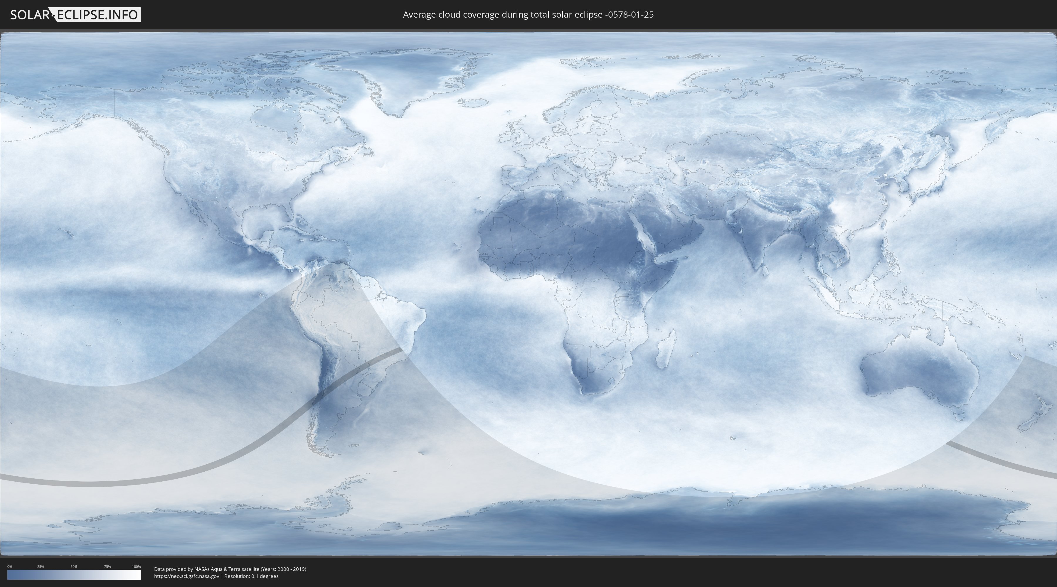
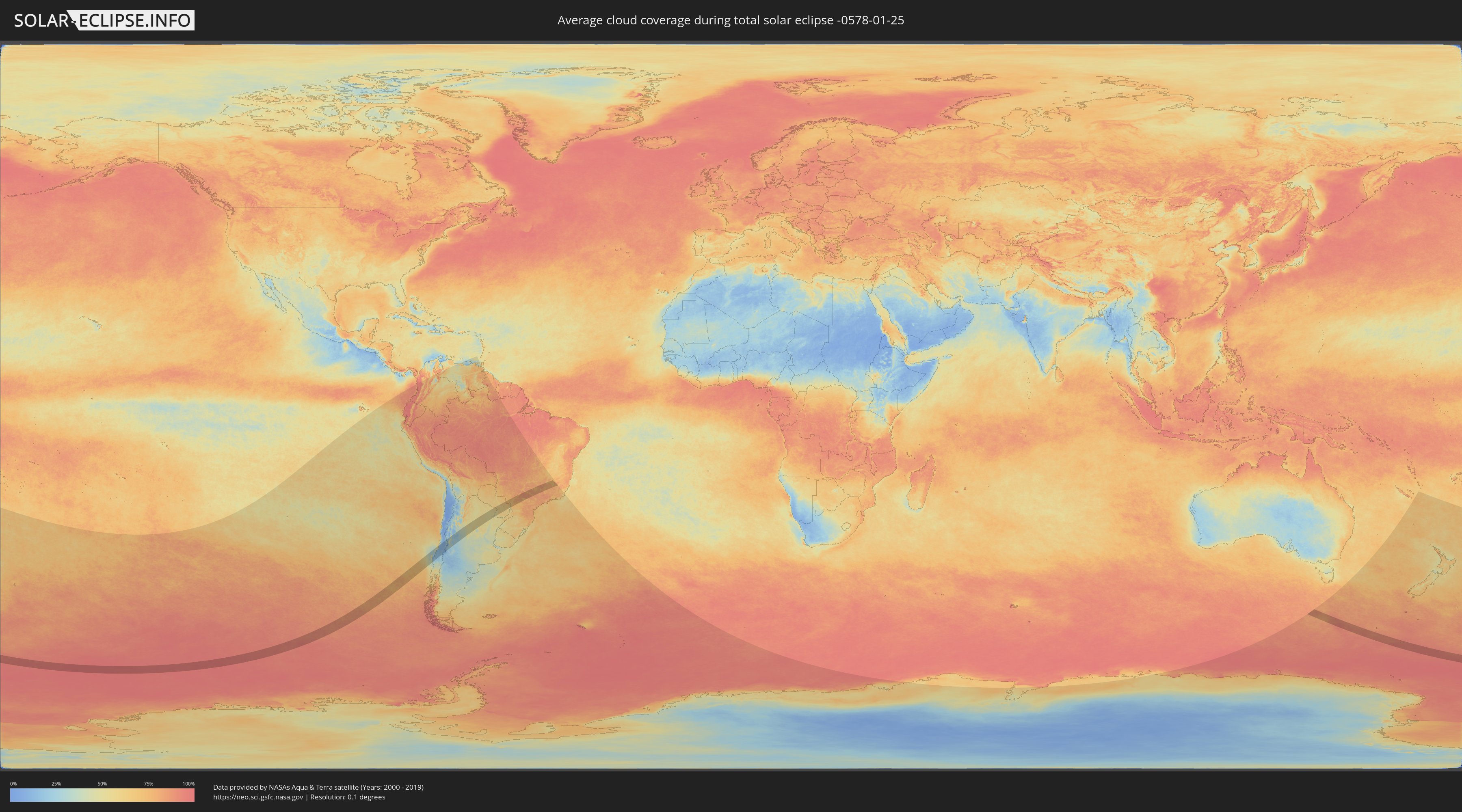
Wie wird das Wetter während der totalen Sonnenfinsternis am 25.01.-0578?
Wo ist der beste Ort, um die totale Sonnenfinsternis vom 25.01.-0578 zu beobachten?
Die folgenden Karten zeigen die durchschnittliche Bewölkung für den Tag, an dem die totale Sonnenfinsternis
stattfindet. Mit Hilfe der Karten lässt sich der Ort entlang des Finsternispfades eingrenzen,
der die besten Aussichen auf einen klaren wolkenfreien Himmel bietet.
Trotzdem muss man immer lokale Gegenenheiten beachten und sollte sich genau über das Wetter an seinem
gewählten Beobachtungsort informieren.
Die Daten stammen von den beiden NASA-Satelliten
AQUA und TERRA
und wurden über einen Zeitraum von 19 Jahren (2000 - 2019) gemittelt.
Detaillierte Länderkarten
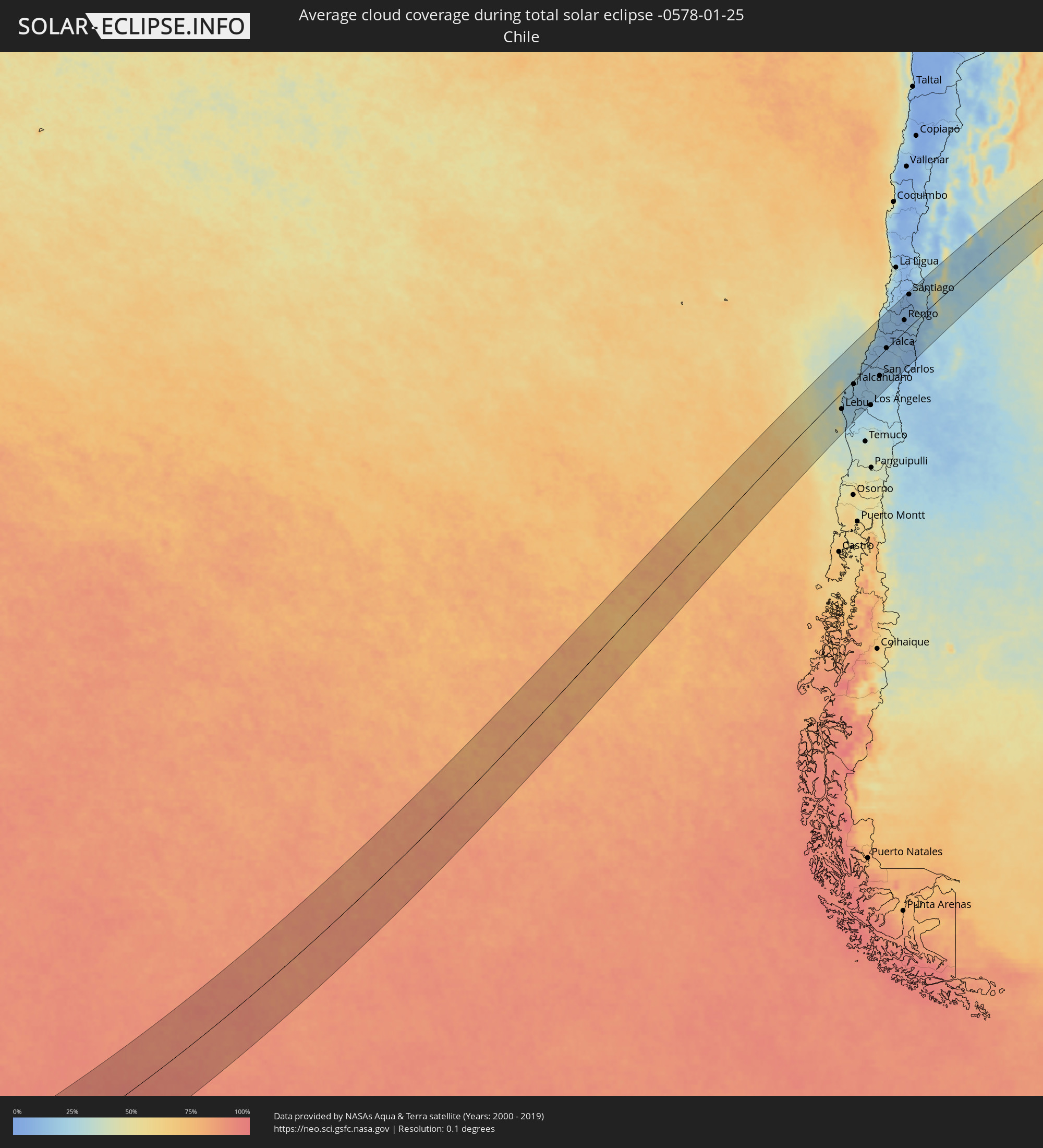 Chile
Chile
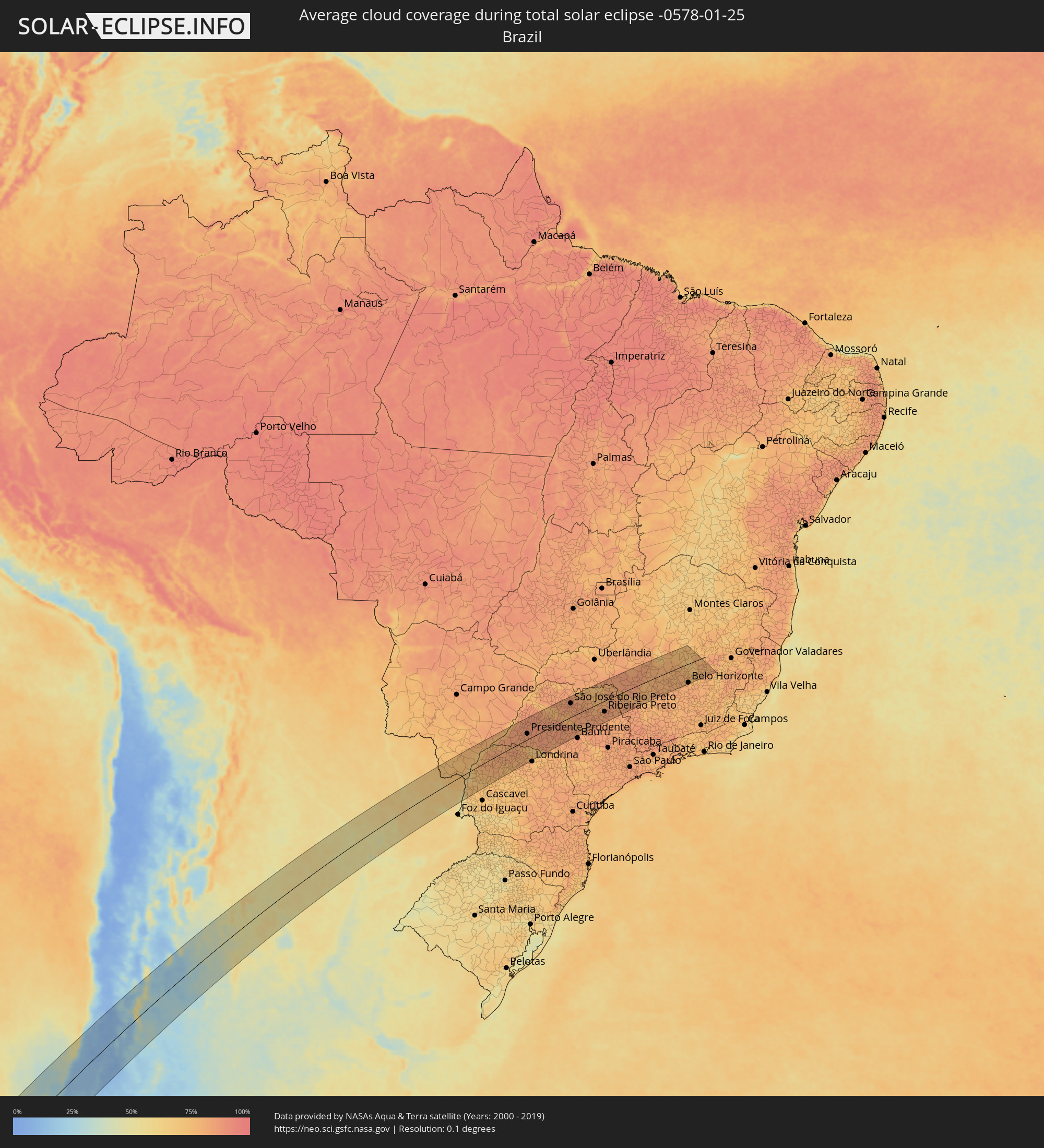 Brasilien
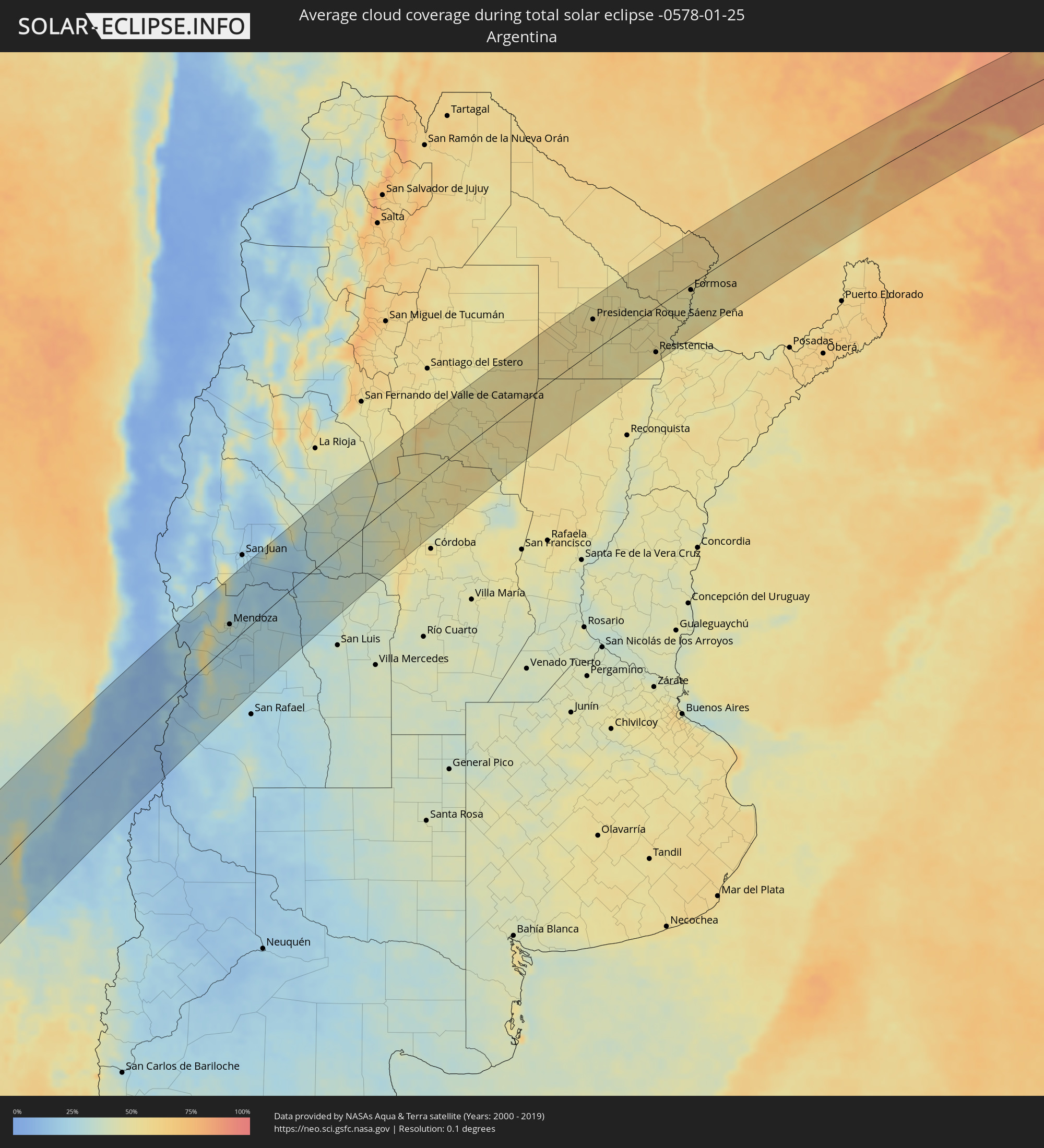 Argentinien
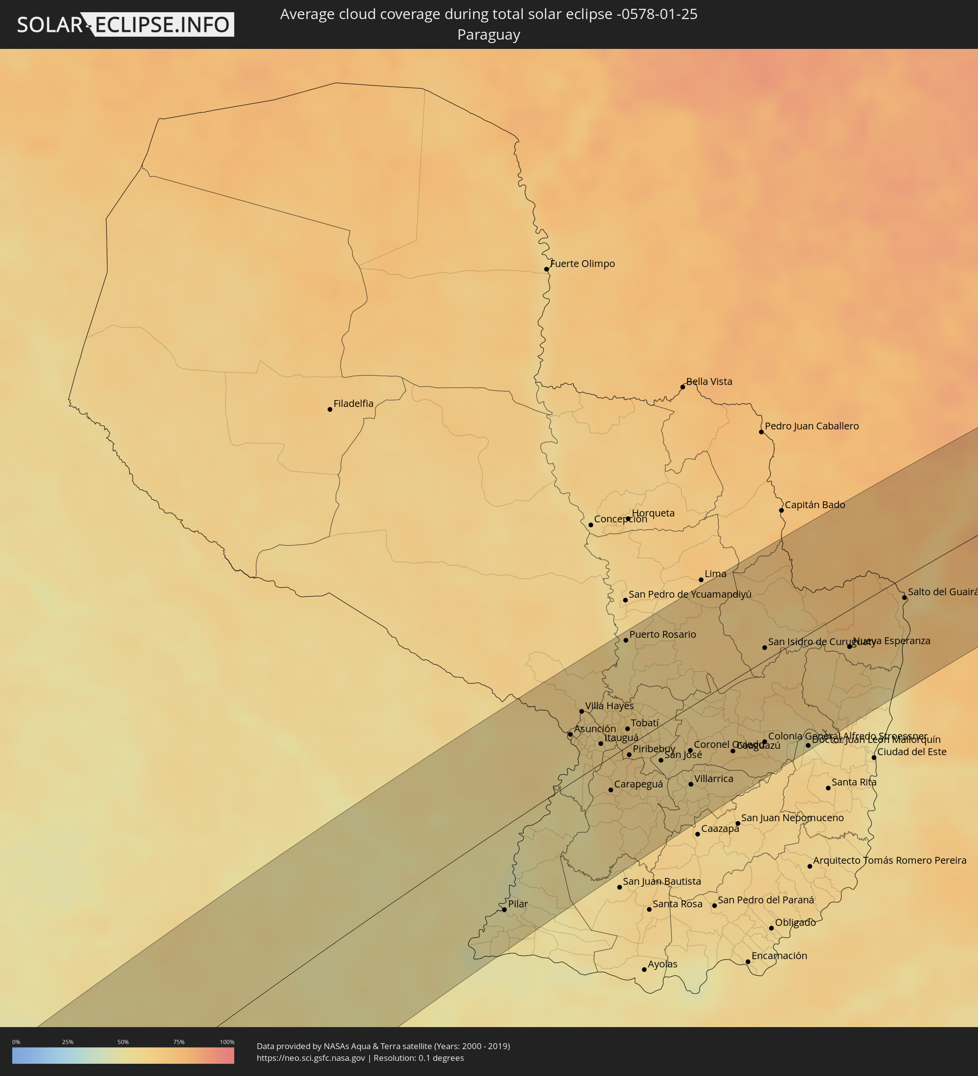 Paraguay
Orte im Finsternispfad
Die nachfolgene Tabelle zeigt Städte und Orte mit mehr als 5.000 Einwohnern, die sich im Finsternispfad befinden. Städte mit mehr als 100.000 Einwohnern sind dick gekennzeichnet. Mit einem Klick auf den Ort öffnet sich eine Detailkarte die die Lage des jeweiligen Ortes zusammen mit dem Verlauf der zentralen Finsternis präsentiert.
| Ort | Typ | Dauer der Verfinsterung | Ortszeit bei maximaler Verfinsterung | Entfernung zur Zentrallinie | Ø Bewölkung |
 Lebu, Biobío
|
total | - | 16:28:15 UTC-04:42 | 45 km | 38% |
|
Cañete, Biobío
|
total | - | 16:28:02 UTC-04:42 | 77 km | 25% |
|
Curanilahue, Biobío
|
total | - | 16:28:38 UTC-04:42 | 61 km | 18% |
|
Arauco, Biobío
|
total | - | 16:29:03 UTC-04:42 | 41 km | 20% |
|
Lota, Biobío
|
total | - | 16:29:24 UTC-04:42 | 37 km | 18% |
|
Coronel, Biobío
|
total | - | 16:29:30 UTC-04:42 | 35 km | 19% |
|
Talcahuano, Biobío
|
total | - | 16:30:03 UTC-04:42 | 10 km | 22% |
|
Concepción, Biobío
|
total | - | 16:29:54 UTC-04:42 | 22 km | 21% |
|
Chiguayante, Biobío
|
total | - | 16:29:45 UTC-04:42 | 42 km | 19% |
|
Penco, Biobío
|
total | - | 16:30:05 UTC-04:42 | 19 km | 22% |
|
Tomé, Biobío
|
total | - | 16:30:19 UTC-04:42 | 12 km | 26% |
|
La Laja, Biobío
|
total | - | 16:29:16 UTC-04:42 | 82 km | 16% |
|
Nacimiento, Biobío
|
total | - | 16:28:54 UTC-04:42 | 99 km | 19% |
|
Yumbel, Biobío
|
total | - | 16:29:39 UTC-04:42 | 74 km | 17% |
|
Constitución, Maule
|
total | - | 16:32:47 UTC-04:42 | 57 km | 27% |
|
Cabrero, Biobío
|
total | - | 16:29:50 UTC-04:42 | 79 km | 18% |
|
Cauquenes, Maule
|
total | - | 16:31:44 UTC-04:42 | 0 km | 16% |
|
Bulnes, Biobío
|
total | - | 16:30:24 UTC-04:42 | 63 km | 19% |
|
Chillán, Biobío
|
total | - | 16:30:43 UTC-04:42 | 64 km | 20% |
|
San Carlos, Biobío
|
total | - | 16:31:06 UTC-04:42 | 59 km | 18% |
|
Coihueco, Biobío
|
total | - | 16:30:48 UTC-04:42 | 83 km | 17% |
|
Parral, Maule
|
total | - | 16:31:38 UTC-04:42 | 50 km | 15% |
|
San Javier, Maule
|
total | - | 16:32:38 UTC-04:42 | 28 km | 15% |
|
Longaví, Maule
|
total | - | 16:32:00 UTC-04:42 | 40 km | 16% |
|
Talca, Maule
|
total | - | 16:32:57 UTC-04:42 | 18 km | 14% |
|
Linares, Maule
|
total | - | 16:32:15 UTC-04:42 | 40 km | 15% |
|
San Clemente, Maule
|
total | - | 16:32:49 UTC-04:42 | 24 km | 15% |
|
Santa Cruz, O'Higgins
|
total | - | 16:34:25 UTC-04:42 | 47 km | 14% |
|
Rauco, Maule
|
total | - | 16:33:57 UTC-04:42 | 29 km | 11% |
|
Molina, Maule
|
total | - | 16:33:38 UTC-04:42 | 30 km | 12% |
|
Curicó, Maule
|
total | - | 16:33:53 UTC-04:42 | 23 km | 11% |
|
Teno, Maule
|
total | - | 16:34:06 UTC-04:42 | 16 km | 12% |
|
San Vicente, O'Higgins
|
total | - | 16:34:53 UTC-04:42 | 55 km | 10% |
|
San Vicente de Tagua Tagua, O'Higgins
|
total | - | 16:34:52 UTC-04:42 | 54 km | 10% |
|
Chimbarongo, O'Higgins
|
total | - | 16:34:25 UTC-04:42 | 25 km | 13% |
|
El Monte, Santiago Metropolitan
|
total | - | 16:36:12 UTC-04:42 | 105 km | 12% |
|
Talagante, Santiago Metropolitan
|
total | - | 16:36:14 UTC-04:42 | 102 km | 11% |
|
Peñaflor, Santiago Metropolitan
|
total | - | 16:36:21 UTC-04:42 | 102 km | 11% |
|
Rengo, O'Higgins
|
total | - | 16:35:00 UTC-04:42 | 36 km | 10% |
|
Rancagua, O'Higgins
|
total | - | 16:35:27 UTC-04:42 | 47 km | 10% |
|
Buin, Santiago Metropolitan
|
total | - | 16:36:12 UTC-04:42 | 83 km | 10% |
|
Paine, Santiago Metropolitan
|
total | - | 16:36:04 UTC-04:42 | 79 km | 10% |
|
Graneros, O'Higgins
|
total | - | 16:35:38 UTC-04:42 | 57 km | 10% |
|
Lo Prado, Santiago Metropolitan
|
total | - | 16:36:41 UTC-04:42 | 104 km | 8% |
|
San Bernardo, Santiago Metropolitan
|
total | - | 16:36:27 UTC-04:42 | 90 km | 10% |
|
Machalí, O'Higgins
|
total | - | 16:35:28 UTC-04:42 | 43 km | 9% |
|
Santiago, Santiago Metropolitan
|
total | - | 16:36:42 UTC-04:42 | 98 km | 9% |
|
La Pintana, Santiago Metropolitan
|
total | - | 16:36:29 UTC-04:42 | 87 km | 9% |
|
Villa Presidente Frei, Ñuñoa, Santiago, Chile, Santiago Metropolitan
|
total | - | 16:36:43 UTC-04:42 | 94 km | 9% |
|
Puente Alto, Santiago Metropolitan
|
total | - | 16:36:28 UTC-04:42 | 81 km | 9% |
 Mendoza, Mendoza Province
|
total | - | 17:04:13 UTC-04:16 | 34 km | 36% |
|
San Martín, Mendoza Province
|
total | - | 17:04:01 UTC-04:16 | 7 km | 26% |
|
Nueve de Julio, San Juan Province
|
total | - | 17:06:21 UTC-04:16 | 108 km | 20% |
|
Caucete, San Juan Province
|
total | - | 17:06:25 UTC-04:16 | 101 km | 23% |
|
Chamical, La Rioja Province
|
total | - | 17:08:59 UTC-04:16 | 90 km | 44% |
|
Mina Clavero, Cordoba Province
|
total | - | 17:07:06 UTC-04:16 | 106 km | 49% |
|
Villa de Soto, Cordoba Province
|
total | - | 17:08:28 UTC-04:16 | 42 km | 45% |
|
Cruz del Eje, Cordoba Province
|
total | - | 17:08:43 UTC-04:16 | 34 km | 45% |
|
Capilla del Monte, Cordoba Province
|
total | - | 17:08:33 UTC-04:16 | 62 km | 51% |
|
La Cumbre, Cordoba Province
|
total | - | 17:08:22 UTC-04:16 | 74 km | 49% |
|
La Falda, Cordoba Province
|
total | - | 17:08:12 UTC-04:16 | 84 km | 47% |
|
Cosquín, Cordoba Province
|
total | - | 17:07:57 UTC-04:16 | 100 km | 49% |
|
Deán Funes, Cordoba Province
|
total | - | 17:09:16 UTC-04:16 | 36 km | 47% |
|
Río Ceballos, Cordoba Province
|
total | - | 17:08:07 UTC-04:16 | 100 km | 51% |
|
Unquillo, Cordoba Province
|
total | - | 17:08:00 UTC-04:16 | 106 km | 51% |
|
Salsipuedes, Cordoba Province
|
total | - | 17:08:09 UTC-04:16 | 100 km | 46% |
|
Jesús María, Cordoba Province
|
total | - | 17:08:26 UTC-04:16 | 103 km | 45% |
|
Villa del Totoral, Cordoba Province
|
partiell | - | 17:08:45 UTC-04:16 | 107 km | 51% |
|
Villa Ojo de Agua, Santiago del Estero Province
|
total | - | 17:10:48 UTC-04:16 | 6 km | 51% |
|
Añatuya, Santiago del Estero Province
|
total | - | 17:12:29 UTC-04:16 | 48 km | 50% |
|
Quimilí, Santiago del Estero Province
|
total | - | 17:13:46 UTC-04:16 | 99 km | 52% |
|
Tostado, Santa Fe Province
|
total | - | 17:11:26 UTC-04:16 | 88 km | 52% |
|
Hermoso Campo, Chaco Province
|
total | - | 17:13:53 UTC-04:16 | 40 km | 55% |
|
General Pinedo, Chaco Province
|
total | - | 17:14:19 UTC-04:16 | 60 km | 55% |
|
Charata, Chaco Province
|
total | - | 17:14:28 UTC-04:16 | 67 km | 54% |
|
Santa Sylvina, Chaco Province
|
total | - | 17:13:34 UTC-04:16 | 14 km | 56% |
|
Las Breñas, Chaco Province
|
total | - | 17:14:39 UTC-04:16 | 68 km | 54% |
|
Corzuela, Chaco Province
|
total | - | 17:14:52 UTC-04:16 | 74 km | 53% |
|
Coronel Du Graty, Chaco Province
|
total | - | 17:13:48 UTC-04:16 | 15 km | 53% |
|
Campo Largo, Chaco Province
|
total | - | 17:15:05 UTC-04:16 | 81 km | 54% |
|
Aviá Terai, Chaco Province
|
total | - | 17:15:15 UTC-04:16 | 90 km | 54% |
|
Villa Ángela, Chaco Province
|
total | - | 17:13:58 UTC-04:16 | 4 km | 54% |
|
San Bernardo, Chaco Province
|
total | - | 17:14:23 UTC-04:16 | 29 km | 54% |
|
Presidencia Roque Sáenz Peña, Chaco Province
|
total | - | 17:15:07 UTC-04:16 | 60 km | 55% |
|
Tres Isletas, Chaco Province
|
total | - | 17:15:46 UTC-04:16 | 101 km | 51% |
|
Villa Berthet, Chaco Province
|
total | - | 17:14:24 UTC-04:16 | 12 km | 51% |
|
Quitilipi, Chaco Province
|
total | - | 17:15:01 UTC-04:16 | 39 km | 53% |
|
Machagai, Chaco Province
|
total | - | 17:14:56 UTC-04:16 | 27 km | 51% |
|
Pampa del Indio, Chaco Province
|
total | - | 17:16:10 UTC-04:16 | 97 km | 53% |
|
Presidencia de la Plaza, Chaco Province
|
total | - | 17:14:50 UTC-04:16 | 24 km | 50% |
|
El Colorado, Formosa Province
|
total | - | 17:15:50 UTC-04:16 | 46 km | 48% |
|
General José de San Martín, Chaco Province
|
total | - | 17:15:30 UTC-04:16 | 34 km | 54% |
|
Pirané, Formosa Province
|
total | - | 17:16:38 UTC-04:16 | 83 km | 57% |
|
Puerto Tirol, Chaco Province
|
total | - | 17:14:19 UTC-04:16 | 71 km | 51% |
|
Fontana, Chaco Province
|
total | - | 17:14:15 UTC-04:16 | 79 km | 55% |
|
Resistencia, Chaco Province
|
total | - | 17:14:11 UTC-04:16 | 85 km | 51% |
|
Puerto Vilelas, Chaco Province
|
total | - | 17:14:07 UTC-04:16 | 92 km | 49% |
|
La Leonesa, Chaco Province
|
total | - | 17:14:48 UTC-04:16 | 62 km | 51% |
 Pilar, Ñeembucú
|
total | - | 17:41:10 UTC-03:50 | 72 km | 53% |
|
Formosa, Formosa Province
|
total | - | 17:16:00 UTC-04:16 | 12 km | 49% |
|
Clorinda, Formosa Province
|
total | - | 17:17:13 UTC-04:16 | 47 km | 57% |
|
Nanawa, Presidente Hayes
|
total | - | 17:43:22 UTC-03:50 | 46 km | 57% |
|
Asunción, Asunción
|
total | - | 17:43:20 UTC-03:50 | 42 km | 57% |
|
Lambaré, Central
|
total | - | 17:43:16 UTC-03:50 | 36 km | 57% |
|
Villa Elisa, Central
|
total | - | 17:43:14 UTC-03:50 | 33 km | 54% |
|
Benjamín Aceval, Presidente Hayes
|
total | - | 17:43:47 UTC-03:50 | 72 km | 63% |
|
Colonia Mariano Roque Alonso, Central
|
total | - | 17:43:30 UTC-03:50 | 54 km | 59% |
|
San Antonio, Central
|
total | - | 17:43:09 UTC-03:50 | 26 km | 58% |
|
Nemby, Central
|
total | - | 17:43:11 UTC-03:50 | 29 km | 58% |
|
Villa Hayes, Presidente Hayes
|
total | - | 17:43:36 UTC-03:50 | 61 km | 59% |
|
Fernando de la Mora, Central
|
total | - | 17:43:16 UTC-03:50 | 35 km | 60% |
|
San Lorenzo, Central
|
total | - | 17:43:16 UTC-03:50 | 35 km | 60% |
|
Limpio, Central
|
total | - | 17:43:30 UTC-03:50 | 54 km | 60% |
|
Guarambaré, Central
|
total | - | 17:43:04 UTC-03:50 | 19 km | 56% |
|
Capiatá, Central
|
total | - | 17:43:14 UTC-03:50 | 34 km | 60% |
|
Areguá, Central
|
total | - | 17:43:18 UTC-03:50 | 39 km | 59% |
|
Itá, Central
|
total | - | 17:43:02 UTC-03:50 | 22 km | 60% |
|
Emboscada, Cordillera
|
total | - | 17:43:31 UTC-03:50 | 43 km | 58% |
|
Itauguá, Central
|
total | - | 17:43:12 UTC-03:50 | 34 km | 61% |
|
Yaguarón, Paraguarí
|
total | - | 17:42:54 UTC-03:50 | 21 km | 60% |
|
Ypacarai, Central
|
total | - | 17:43:10 UTC-03:50 | 29 km | 61% |
|
Quiindy, Paraguarí
|
total | - | 17:42:24 UTC-03:50 | 42 km | 57% |
|
Carapeguá, Paraguarí
|
total | - | 17:42:37 UTC-03:50 | 31 km | 60% |
|
Paraguarí, Paraguarí
|
total | - | 17:42:52 UTC-03:50 | 32 km | 61% |
|
Caacupé, Cordillera
|
total | - | 17:43:11 UTC-03:50 | 15 km | 65% |
|
Puerto Rosario, San Pedro
|
total | - | 17:44:27 UTC-03:50 | 91 km | 56% |
|
Tobatí, Cordillera
|
total | - | 17:43:22 UTC-03:50 | 14 km | 64% |
|
Piribebuy, Cordillera
|
total | - | 17:43:03 UTC-03:50 | 14 km | 62% |
|
Eusebio Ayala, Cordillera
|
total | - | 17:43:09 UTC-03:50 | 5 km | 63% |
|
San José, Caaguazú
|
total | - | 17:42:58 UTC-03:50 | 33 km | 57% |
|
Coronel Oviedo, Caaguazú
|
total | - | 17:43:04 UTC-03:50 | 41 km | 59% |
|
Villarrica, Guairá
|
total | - | 17:42:39 UTC-03:50 | 71 km | 57% |
|
Caaguazú, Caaguazú
|
total | - | 17:43:01 UTC-03:50 | 64 km | 61% |
|
Repatriación, Caaguazú
|
total | - | 17:42:54 UTC-03:50 | 75 km | 61% |
|
Colonia General Alfredo Stroessner, Caaguazú
|
total | - | 17:43:06 UTC-03:50 | 70 km | 64% |
|
San Isidro de Curuguaty, Canindeyú
|
total | - | 17:44:15 UTC-03:50 | 11 km | 63% |
|
Doctor Juan León Mallorquín, Alto Paraná
|
total | - | 17:43:01 UTC-03:50 | 100 km | 60% |
|
Nueva Esperanza, Canindeyú
|
total | - | 17:44:10 UTC-03:50 | 33 km | 65% |
|
Salto del Guairá, Canindeyú
|
total | - | 17:44:41 UTC-03:50 | 19 km | 64% |
 Marechal Cândido Rondon, Paraná
|
total | - | 18:28:12 UTC-03:06 | 79 km | 70% |
|
Umuarama, Paraná
|
total | - | 18:29:08 UTC-03:06 | 40 km | 77% |
|
Cianorte, Paraná
|
total | - | 18:29:08 UTC-03:06 | 67 km | 76% |
|
Paranavaí, Paraná
|
total | - | 18:29:52 UTC-03:06 | 17 km | 81% |
|
Maringá, Paraná
|
total | - | 18:29:19 UTC-03:06 | 80 km | 77% |
|
Presidente Prudente, São Paulo
|
total | - | 18:30:49 UTC-03:06 | 24 km | 86% |
|
Cambé, Paraná
|
total | - | 18:29:23 UTC-03:06 | 94 km | 79% |
|
Paraguaçu Paulista, São Paulo
|
total | - | 18:30:18 UTC-03:06 | 51 km | 85% |
|
Tupã, São Paulo
|
total | - | 18:30:52 UTC-03:06 | 2 km | 84% |
|
Araçatuba, São Paulo
|
total | - | 18:31:43 UTC-03:06 | 71 km | 81% |
|
Assis, São Paulo
|
total | - | 18:29:57 UTC-03:06 | 81 km | 83% |
|
Penápolis, São Paulo
|
total | - | 18:31:22 UTC-03:06 | 33 km | 83% |
|
Marília, São Paulo
|
total | - | 18:30:23 UTC-03:06 | 57 km | 86% |
|
Lins, São Paulo
|
total | - | 18:30:59 UTC-03:06 | 27 km | 86% |
|
Garça, São Paulo
|
total | - | 18:30:19 UTC-03:06 | 66 km | 85% |
|
São José do Rio Preto, São Paulo
|
total | - | 18:31:54 UTC-03:06 | 61 km | 87% |
|
Catanduva, São Paulo
|
total | - | 18:31:25 UTC-03:06 | 12 km | 84% |
|
Olímpia, São Paulo
|
total | - | 18:31:52 UTC-03:06 | 53 km | 81% |
|
Ibitinga, São Paulo
|
total | - | 18:30:39 UTC-03:06 | 60 km | 78% |
|
Barretos, São Paulo
|
total | - | 18:31:59 UTC-03:06 | 51 km | 81% |
|
Taquaritinga, São Paulo
|
total | - | 18:30:59 UTC-03:06 | 44 km | 83% |
|
Monte Alto, São Paulo
|
total | - | 18:31:09 UTC-03:06 | 27 km | 84% |
|
Bebedouro, São Paulo
|
total | - | 18:31:30 UTC-03:06 | 8 km | 82% |
|
Matão, São Paulo
|
total | - | 18:30:42 UTC-03:06 | 67 km | 84% |
|
Jaboticabal, São Paulo
|
total | - | 18:31:06 UTC-03:06 | 32 km | 83% |
|
Sertãozinho, São Paulo
|
total | - | 18:31:09 UTC-03:06 | 39 km | 82% |
|
Orlândia, São Paulo
|
total | - | 18:31:36 UTC-03:06 | 14 km | 79% |
|
São Joaquim da Barra, São Paulo
|
total | - | 18:31:45 UTC-03:06 | 28 km | 79% |
|
Ribeirão Preto, São Paulo
|
total | - | 18:31:03 UTC-03:06 | 47 km | 85% |
|
Serrana, São Paulo
|
total | - | 18:30:57 UTC-03:06 | 63 km | 83% |
|
Batatais, São Paulo
|
total | - | 18:31:19 UTC-03:06 | 37 km | 81% |
|
Franca, São Paulo
|
total | - | 18:31:39 UTC-03:06 | 11 km | 82% |
|
São Sebastião do Paraíso, Minas Gerais
|
total | - | 18:31:06 UTC-03:06 | 63 km | 81% |
|
Araxá, Minas Gerais
|
total | - | 18:32:34 UTC-03:06 | 75 km | 86% |
|
Passos, Minas Gerais
|
total | - | 18:31:12 UTC-03:06 | 57 km | 81% |
|
Lagoa da Prata, Minas Gerais
|
total | - | 18:31:38 UTC-03:06 | 29 km | 80% |
|
Formiga, Minas Gerais
|
total | - | 18:31:06 UTC-03:06 | 79 km | 81% |
|
Bom Despacho, Minas Gerais
|
total | - | 18:31:50 UTC-03:06 | 12 km | 79% |
|
Divinópolis, Minas Gerais
|
total | - | 18:31:16 UTC-03:06 | 68 km | 80% |
|
Pará de Minas, Minas Gerais
|
total | - | 18:31:28 UTC-03:06 | 51 km | 80% |
|
Itaúna, Minas Gerais
|
total | - | 18:31:14 UTC-03:06 | 74 km | 80% |
|
Curvelo, Minas Gerais
|
total | - | 18:32:36 UTC-03:06 | 55 km | 74% |
|
Esmeraldas, Minas Gerais
|
total | - | 18:31:28 UTC-03:06 | 53 km | 81% |
|
Sete Lagoas, Minas Gerais
|
total | - | 18:31:46 UTC-03:06 | 25 km | 78% |
|
Betim, Minas Gerais
|
total | - | 18:31:12 UTC-03:06 | 79 km | 80% |
|
Ribeirão das Neves, Minas Gerais
|
total | - | 18:31:23 UTC-03:06 | 63 km | 78% |
|
Pedro Leopoldo, Minas Gerais
|
total | - | 18:31:32 UTC-03:06 | 49 km | 79% |
|
Belo Horizonte, Minas Gerais
|
total | - | 18:31:10 UTC-03:06 | 85 km | 78% |
|
Santa Luzia, Minas Gerais
|
total | - | 18:31:17 UTC-03:06 | 73 km | 79% |
|
Itabira, Minas Gerais
|
total | - | 18:31:13 UTC-03:06 | 82 km | 80% |