Totale Sonnenfinsternis vom 28.05.-0584
| Wochentag: | Sonntag |
| Maximale Dauer der Verfinsterung: | 06m04s |
| Maximale Breite des Finsternispfades: | 271 km |
| Saroszyklus: | 57 |
| Bedeckungsgrad: | 100% |
| Magnitude: | 1.0798 |
| Gamma: | 0.3201 |
Wo kann man die Sonnenfinsternis vom 28.05.-0584 sehen?
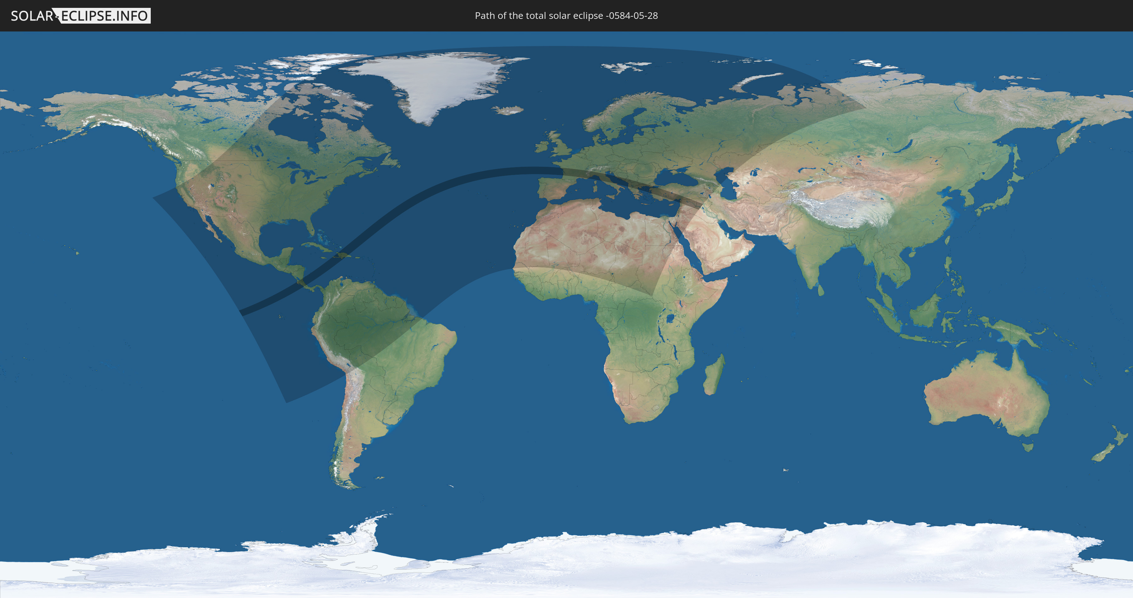
Die Sonnenfinsternis am 28.05.-0584 kann man in 130 Ländern als partielle Sonnenfinsternis beobachten.
Der Finsternispfad verläuft durch 21 Länder. Nur in diesen Ländern ist sie als totale Sonnenfinsternis zu sehen.
In den folgenden Ländern ist die Sonnenfinsternis total zu sehen
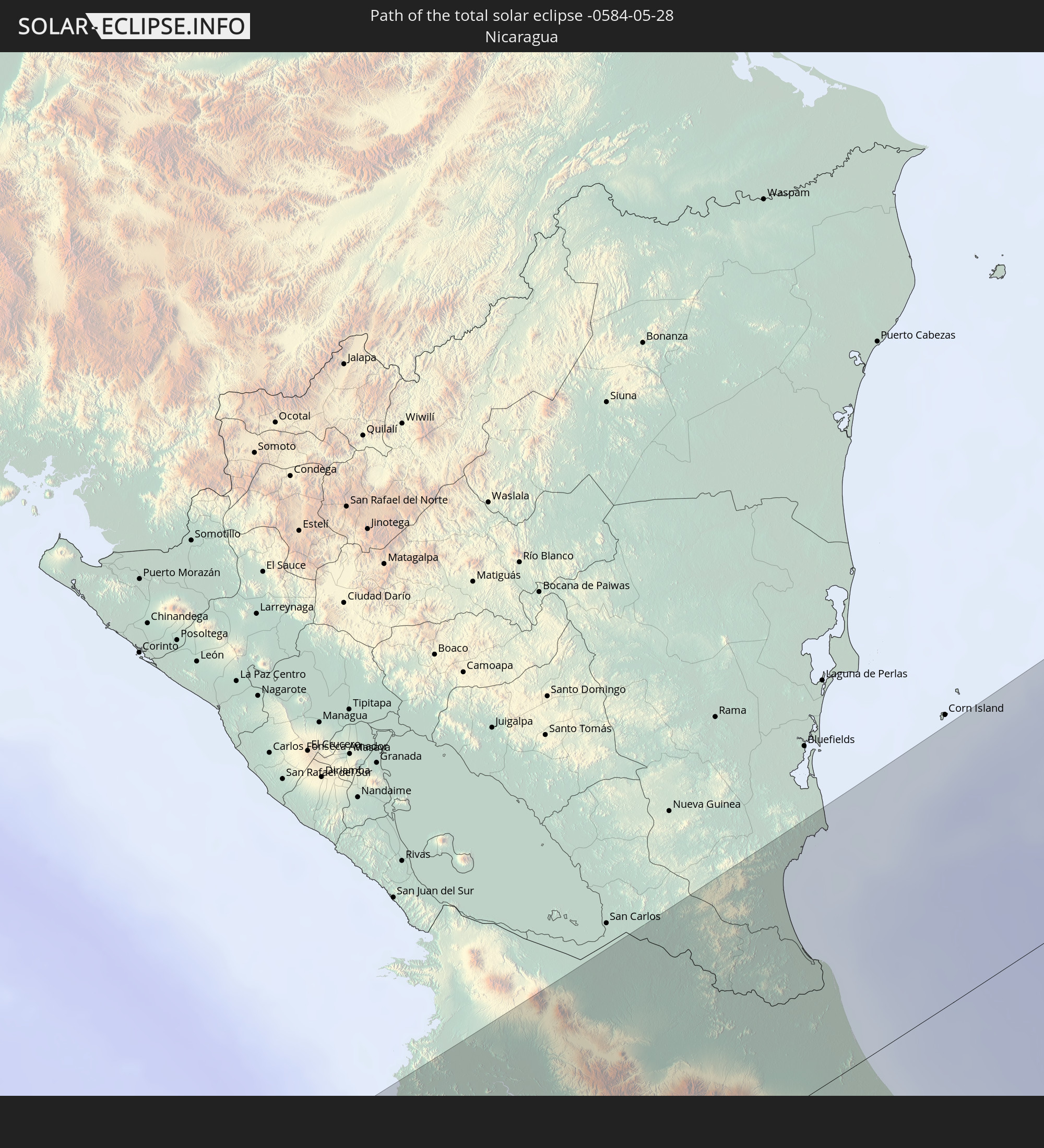 Nicaragua
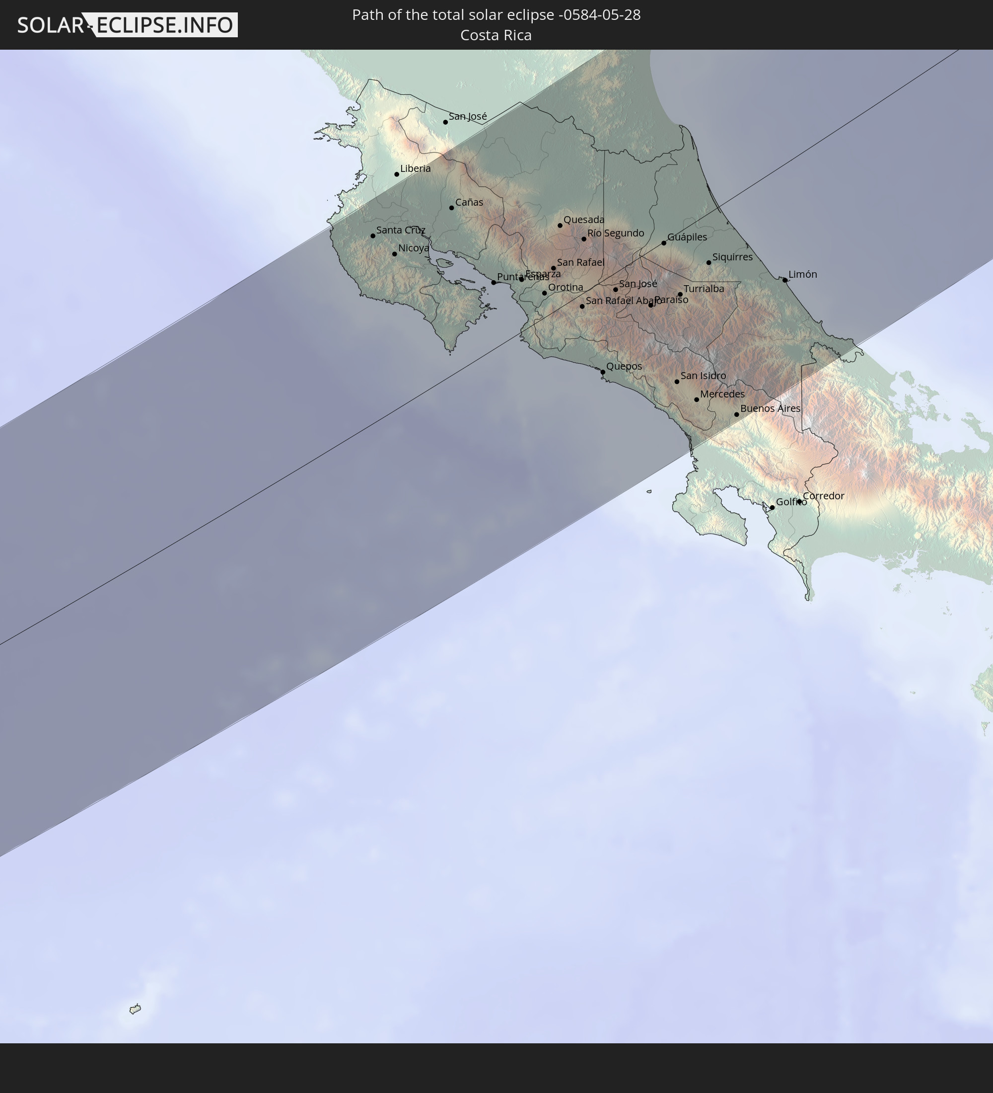 Costa Rica
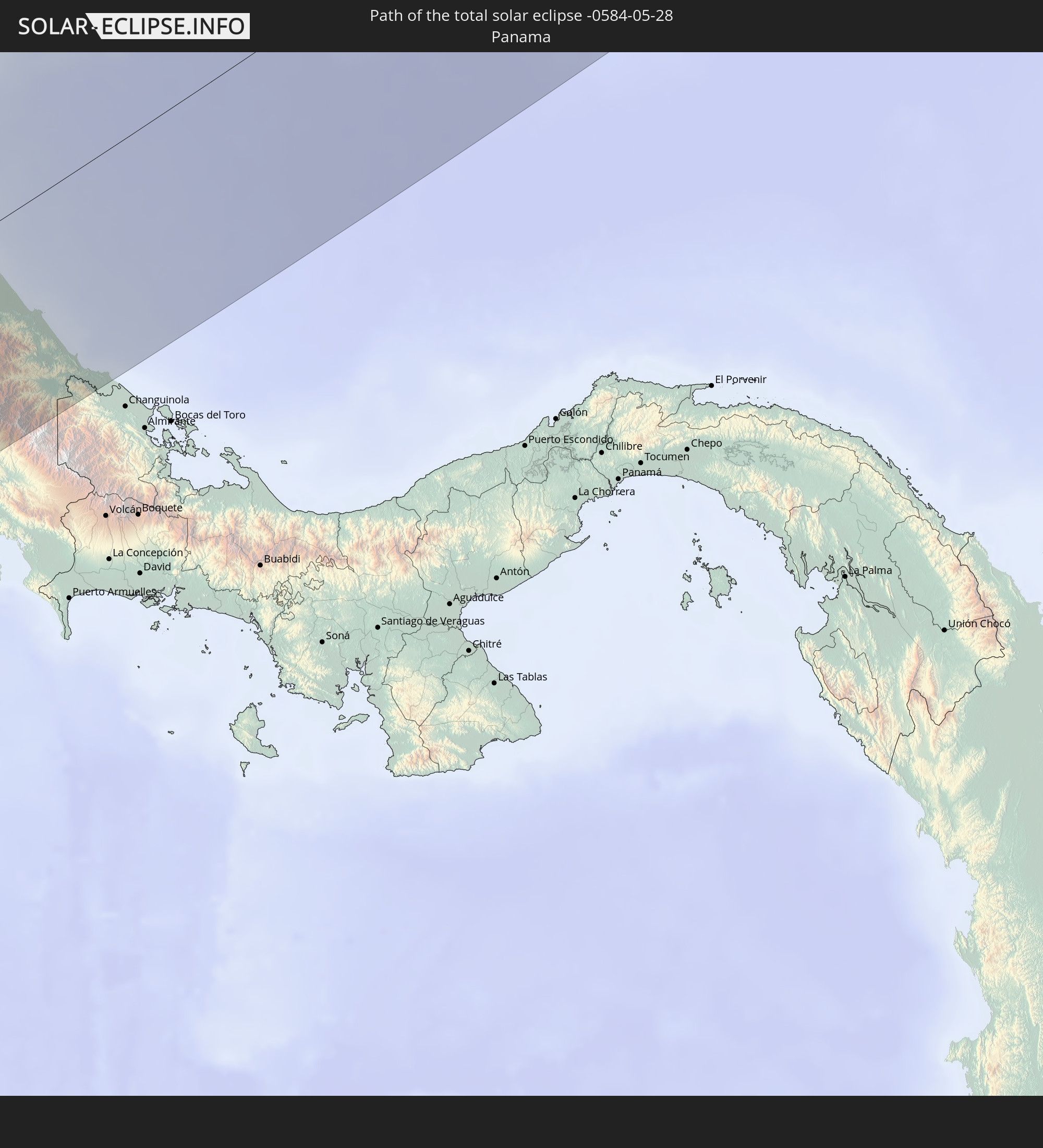 Panama
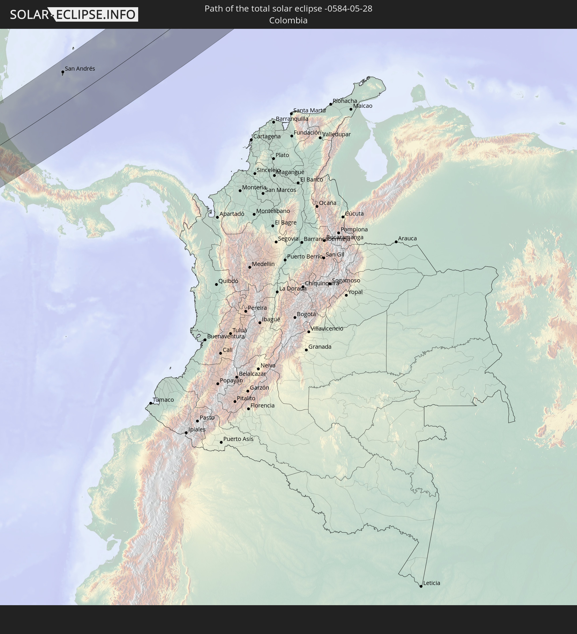 Kolumbien
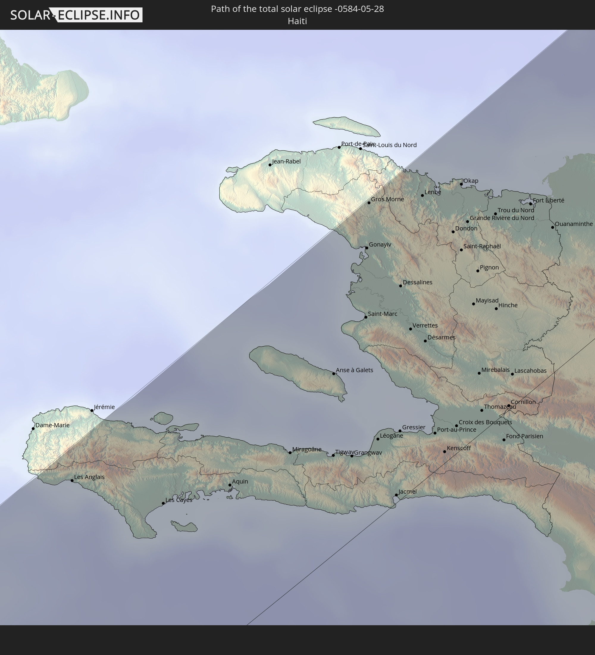 Haiti
Haiti
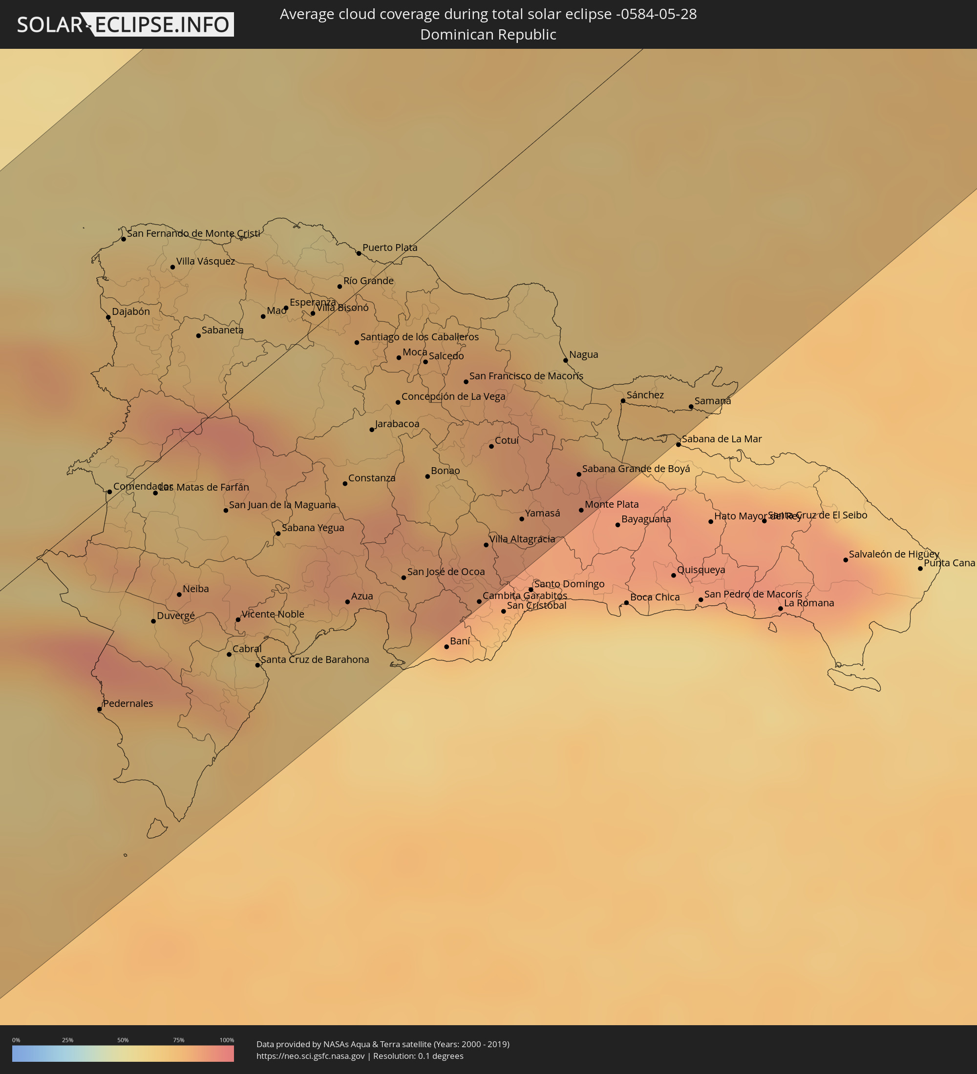
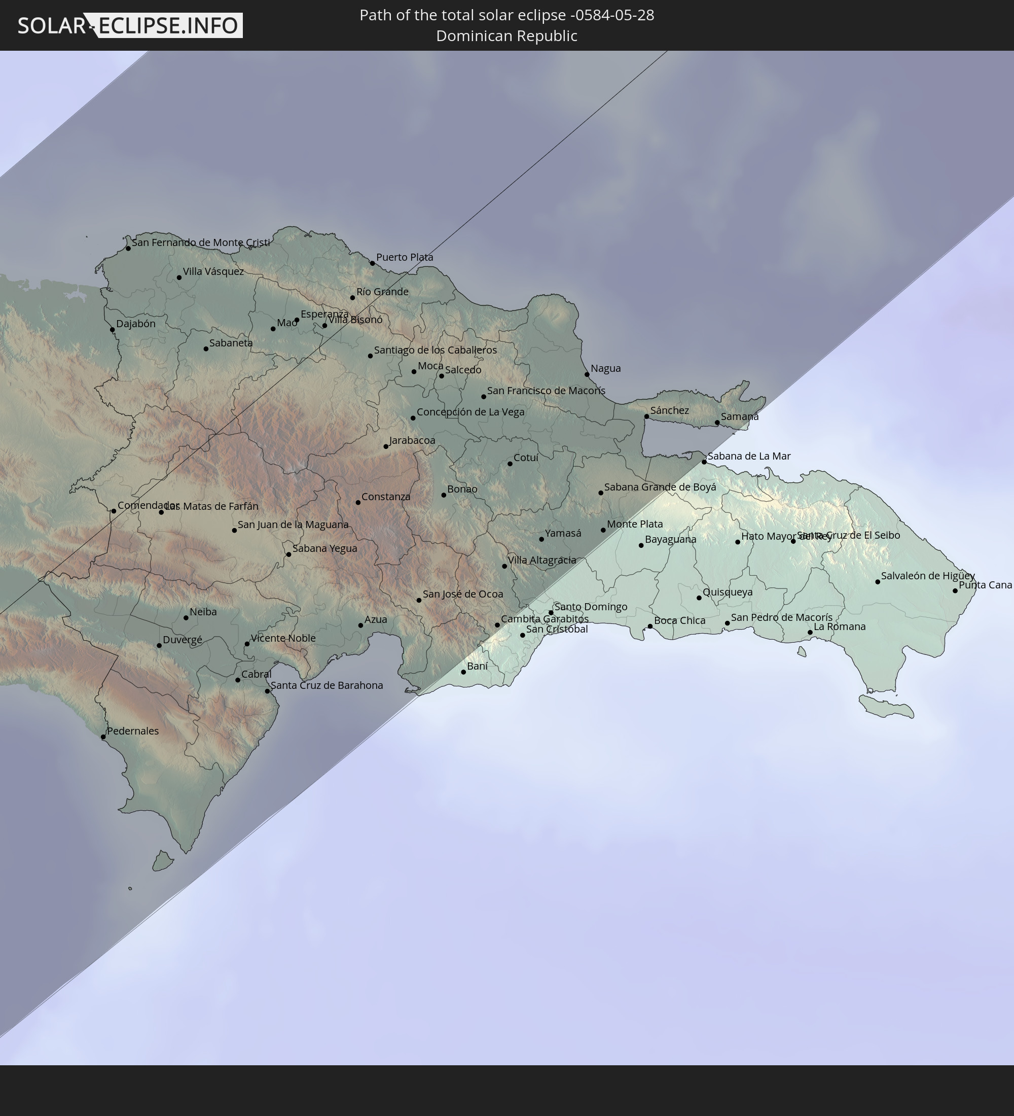 Dominikanische Republik
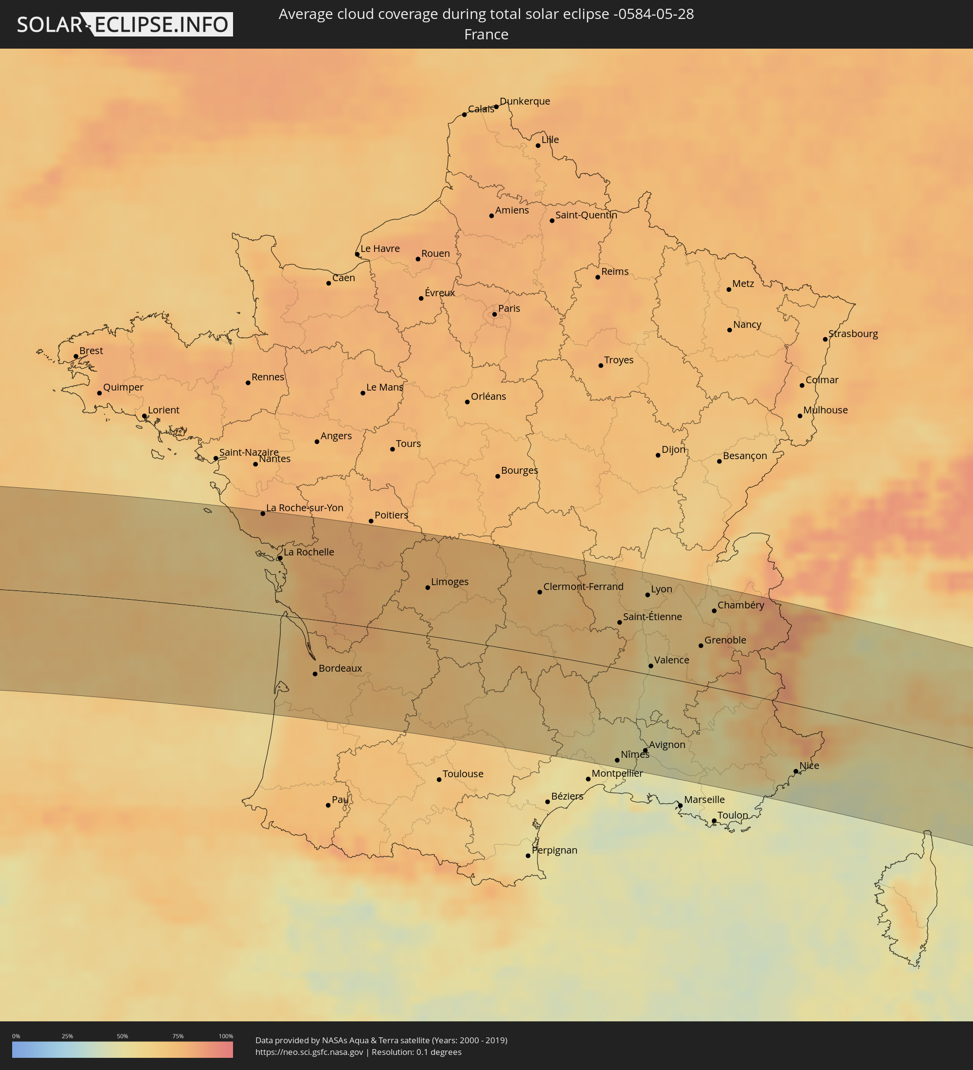
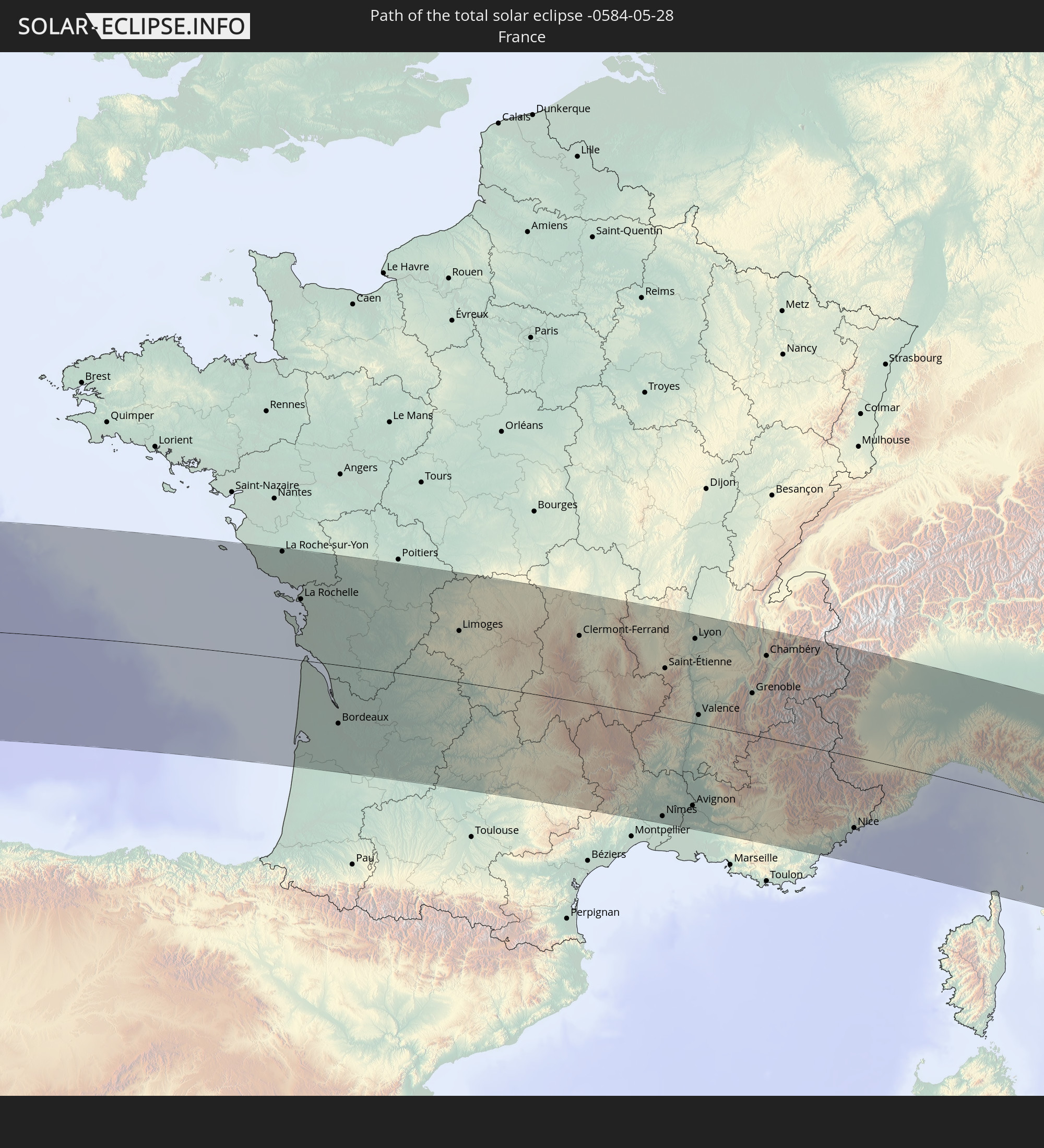 Frankreich
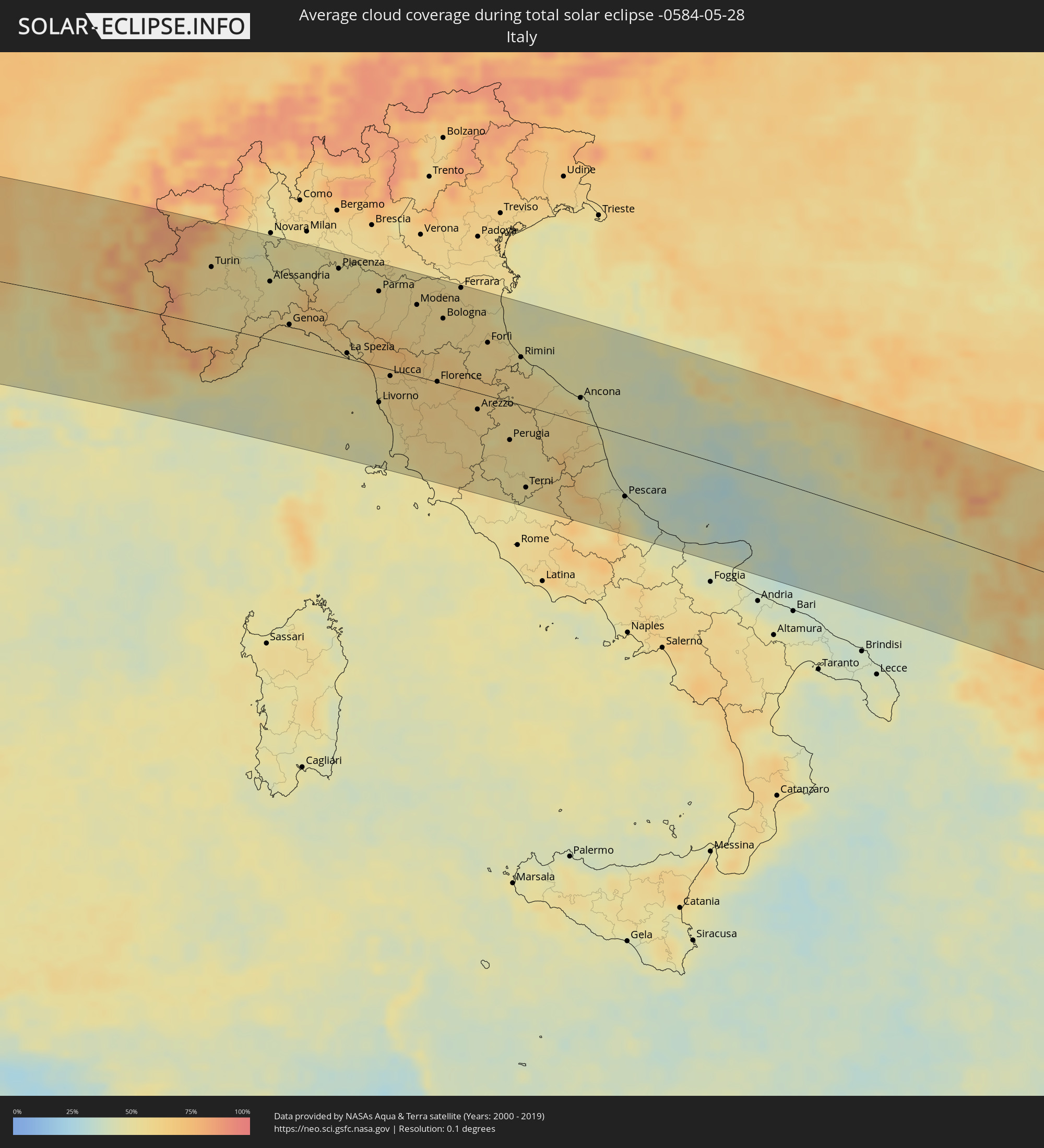
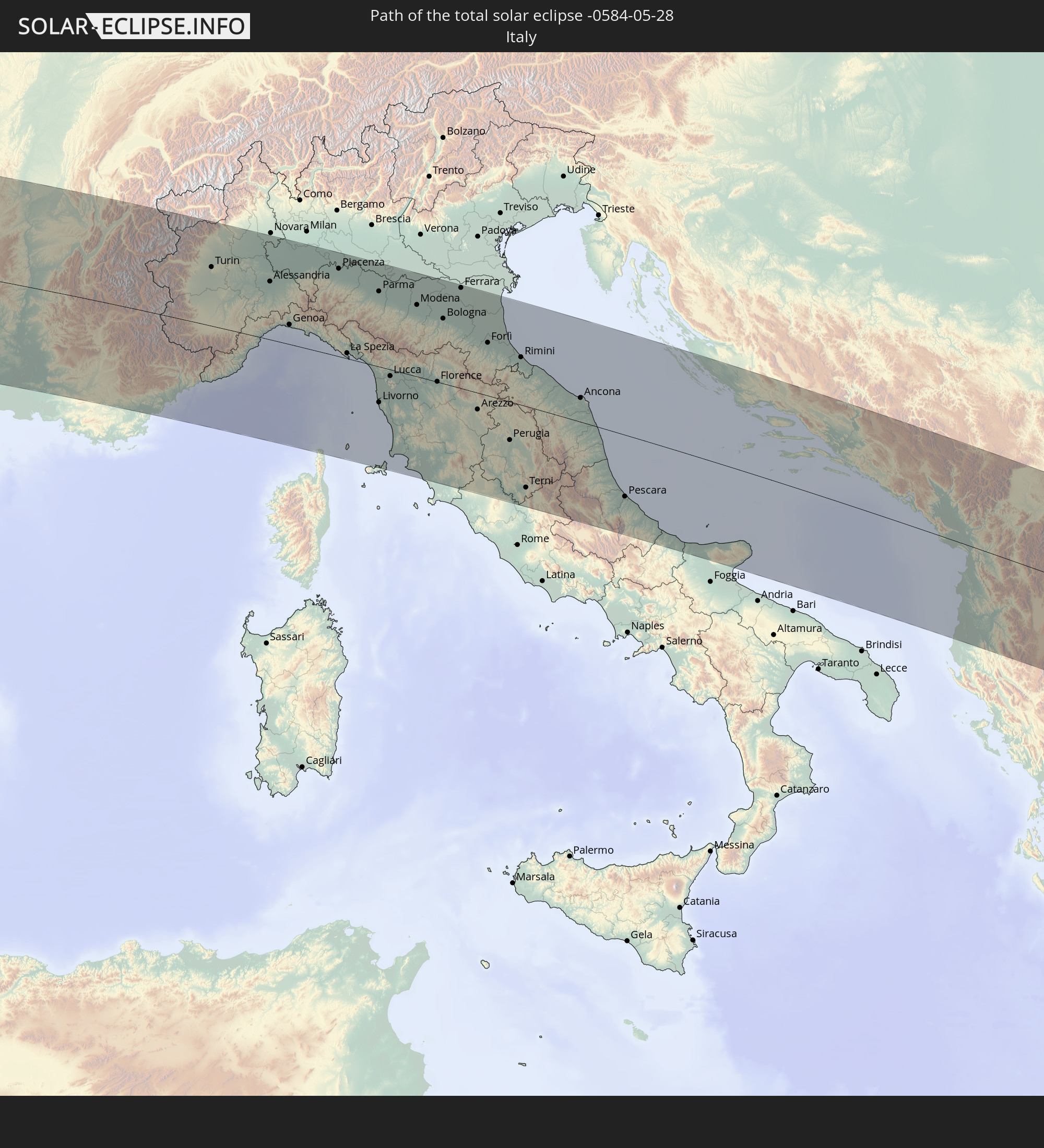 Italien
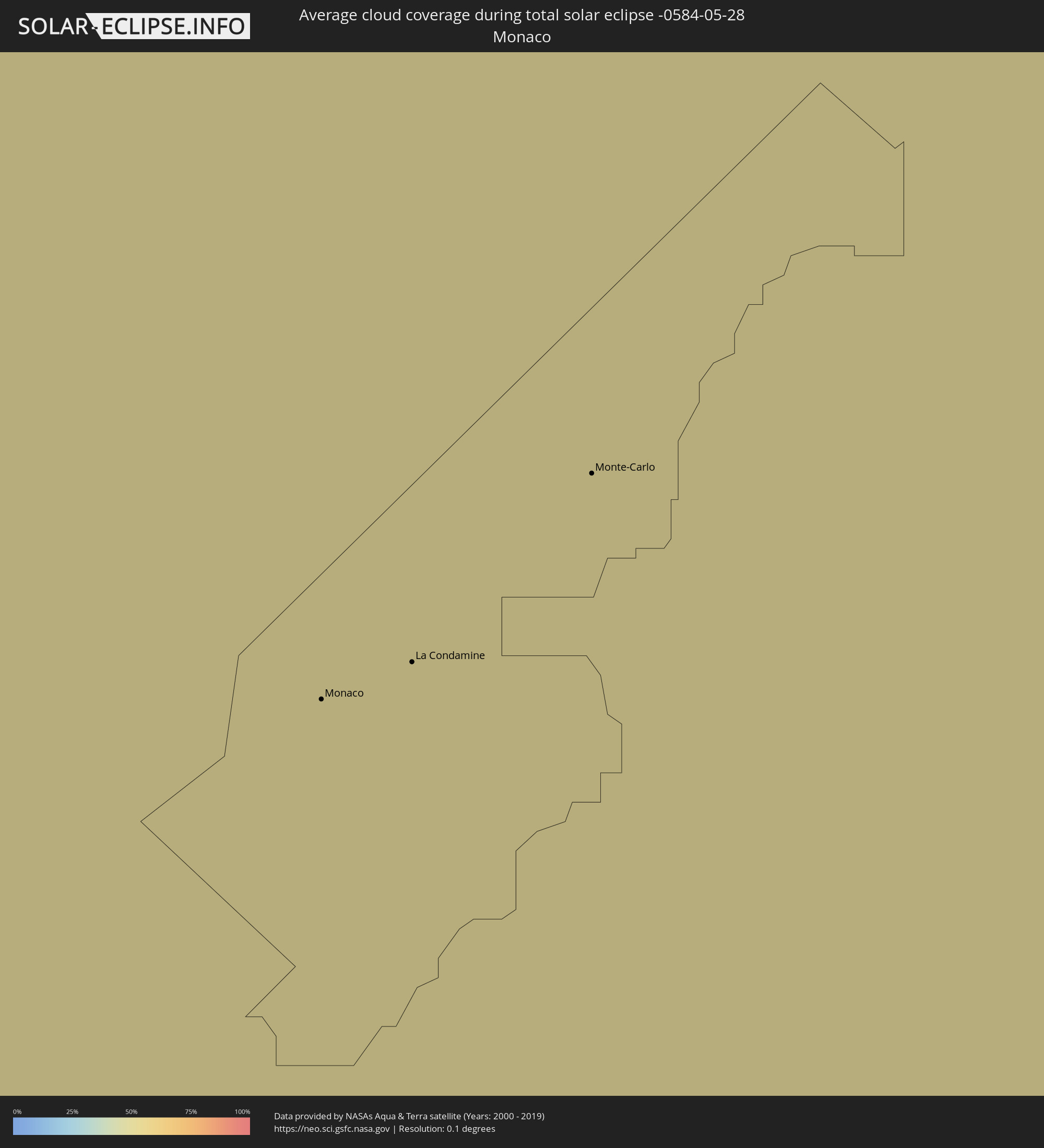
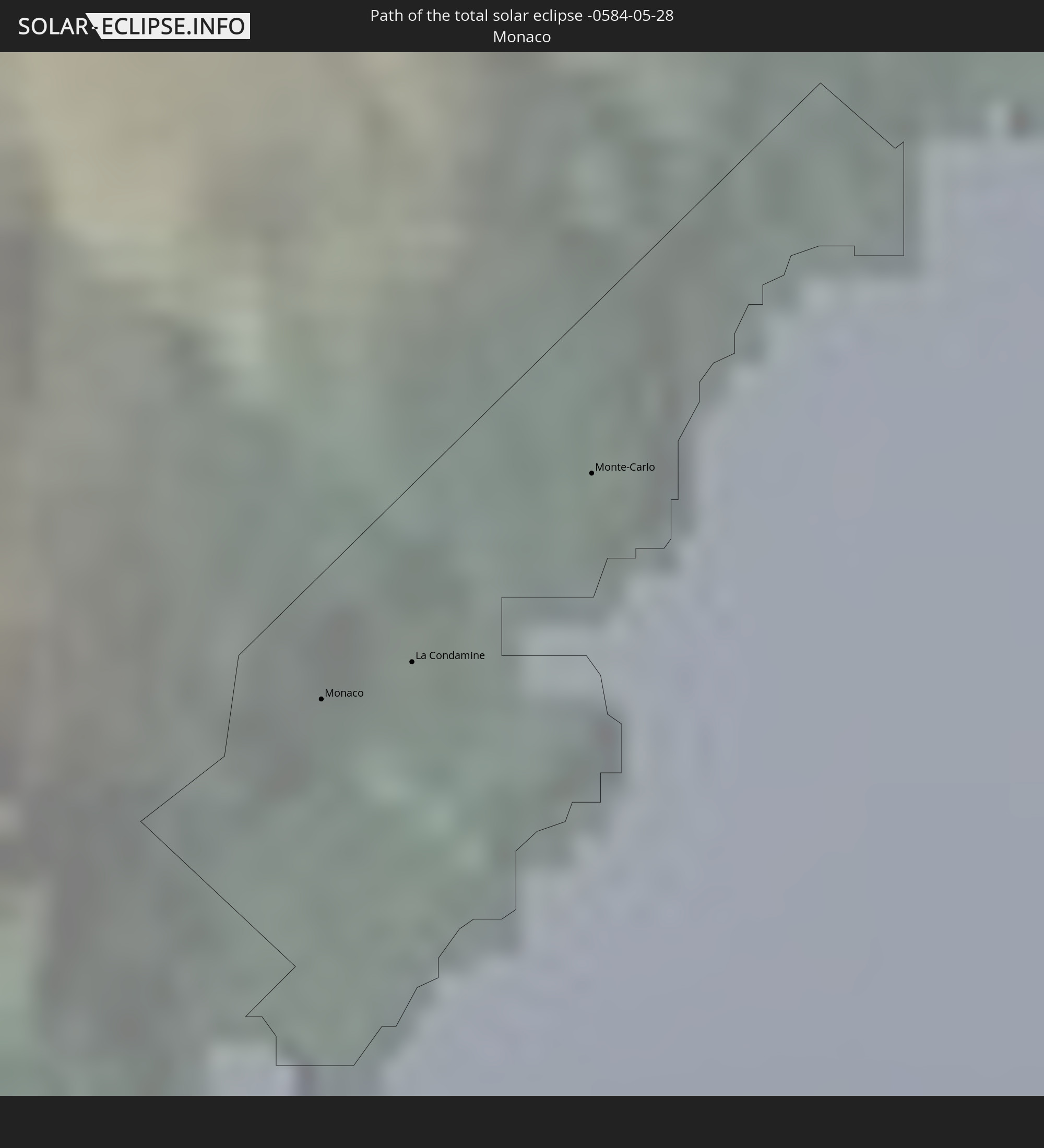 Monaco
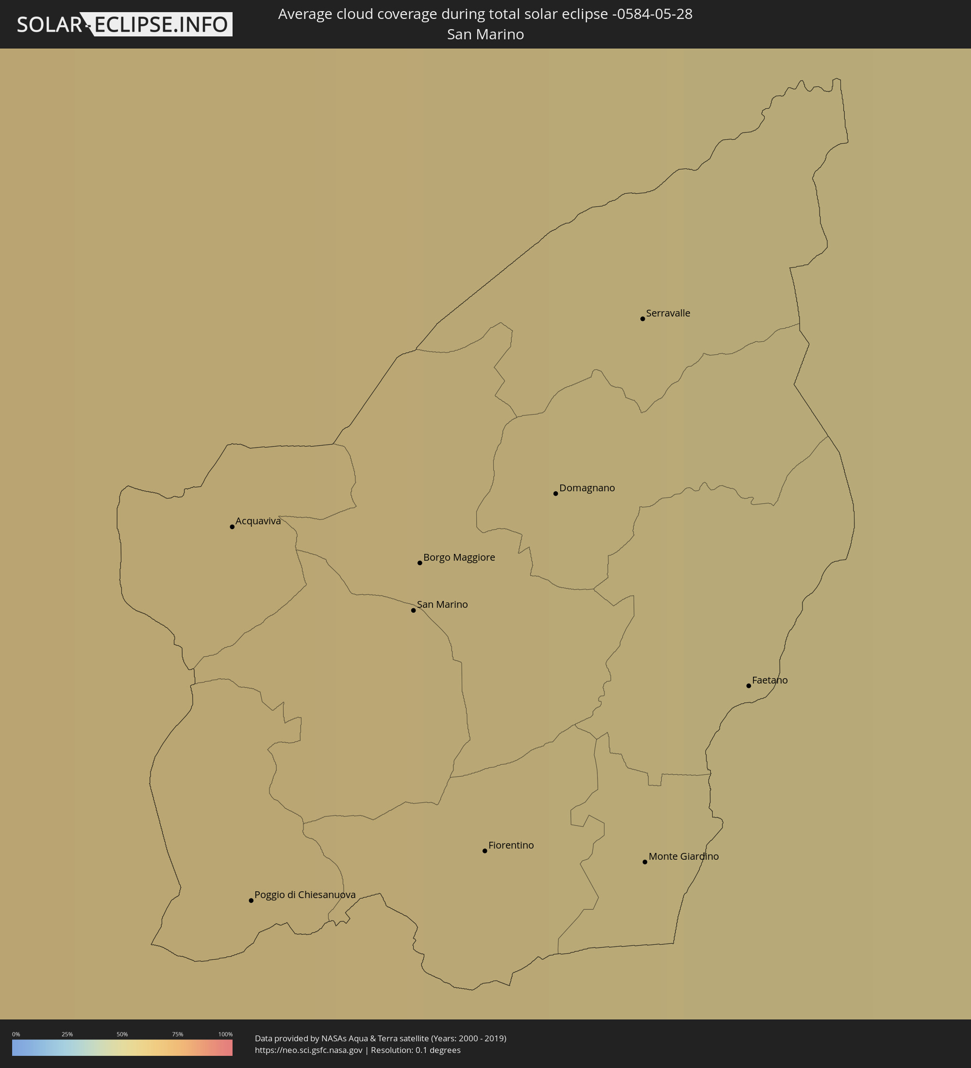
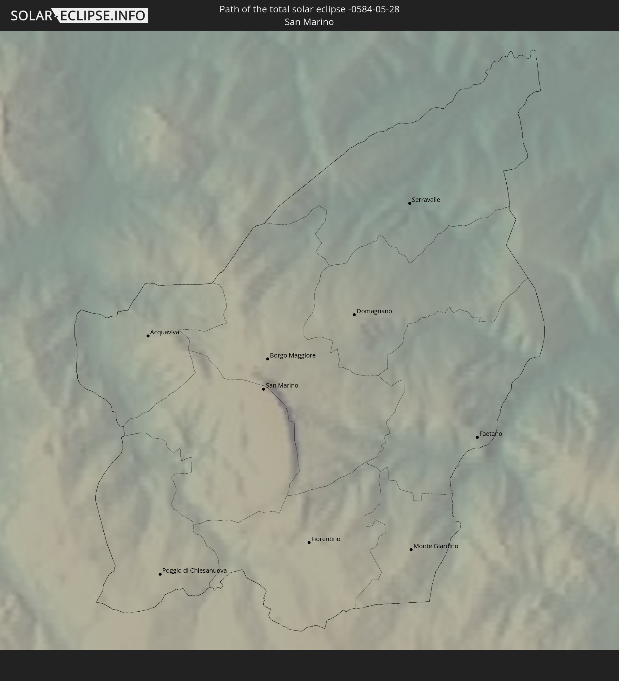 San Marino
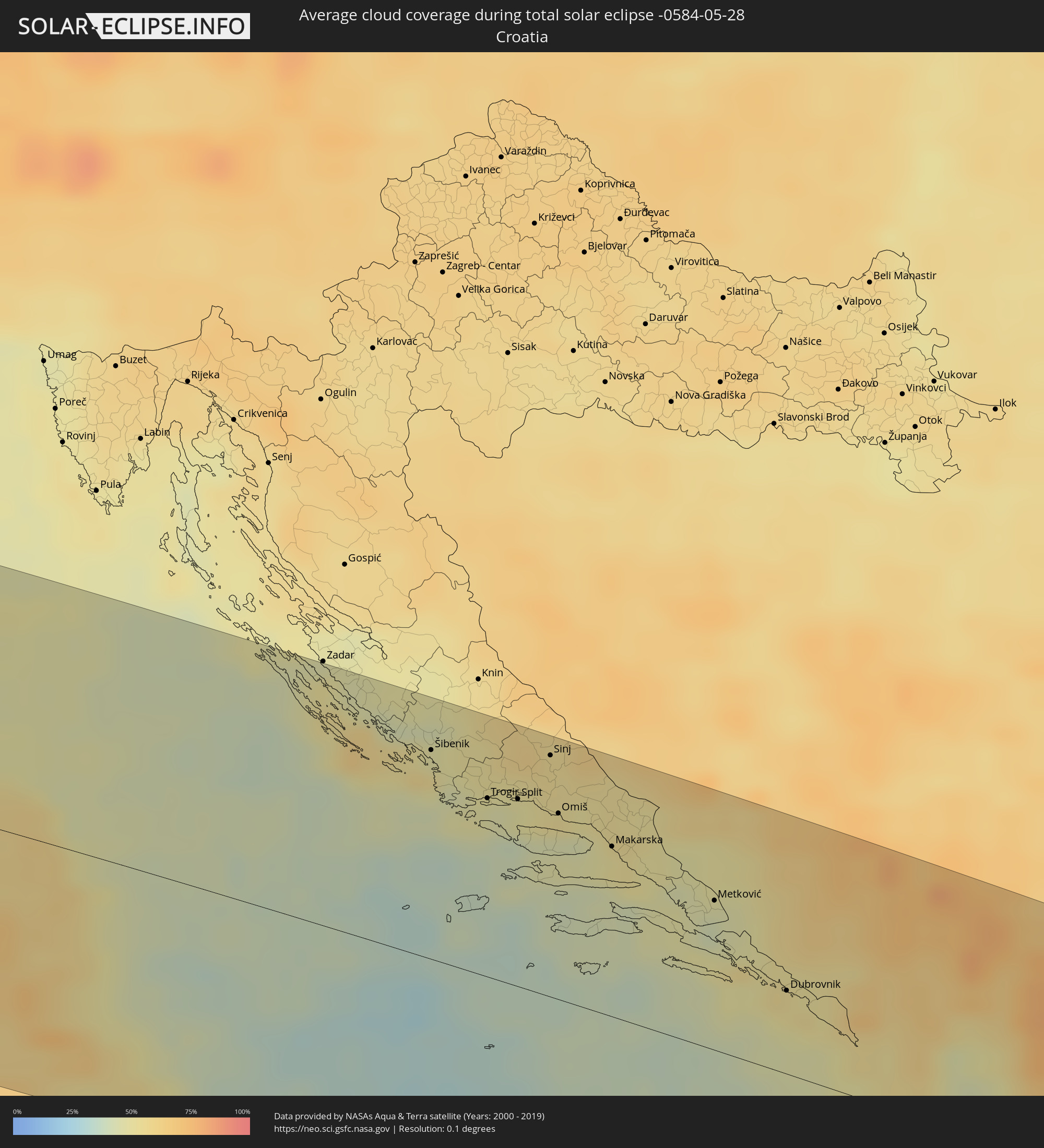
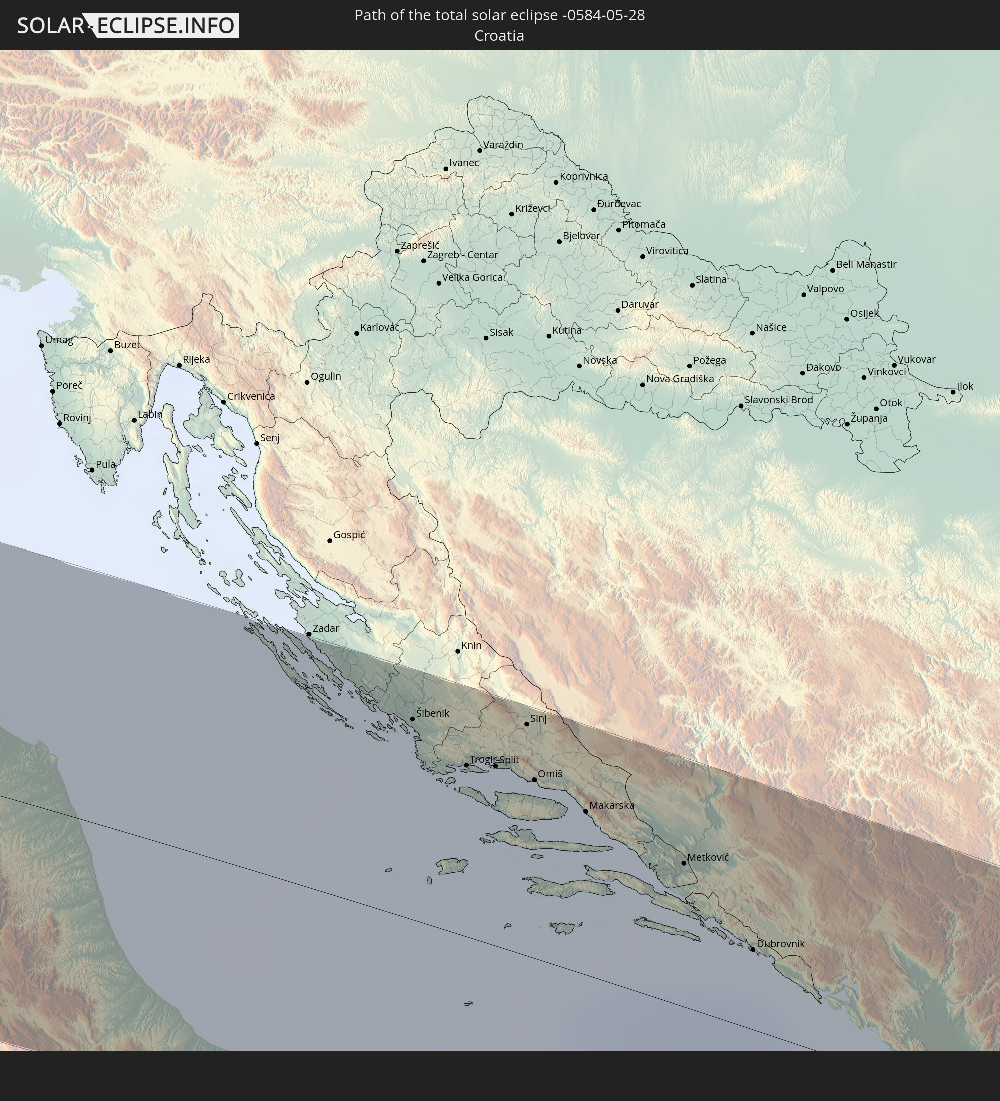 Kroatien
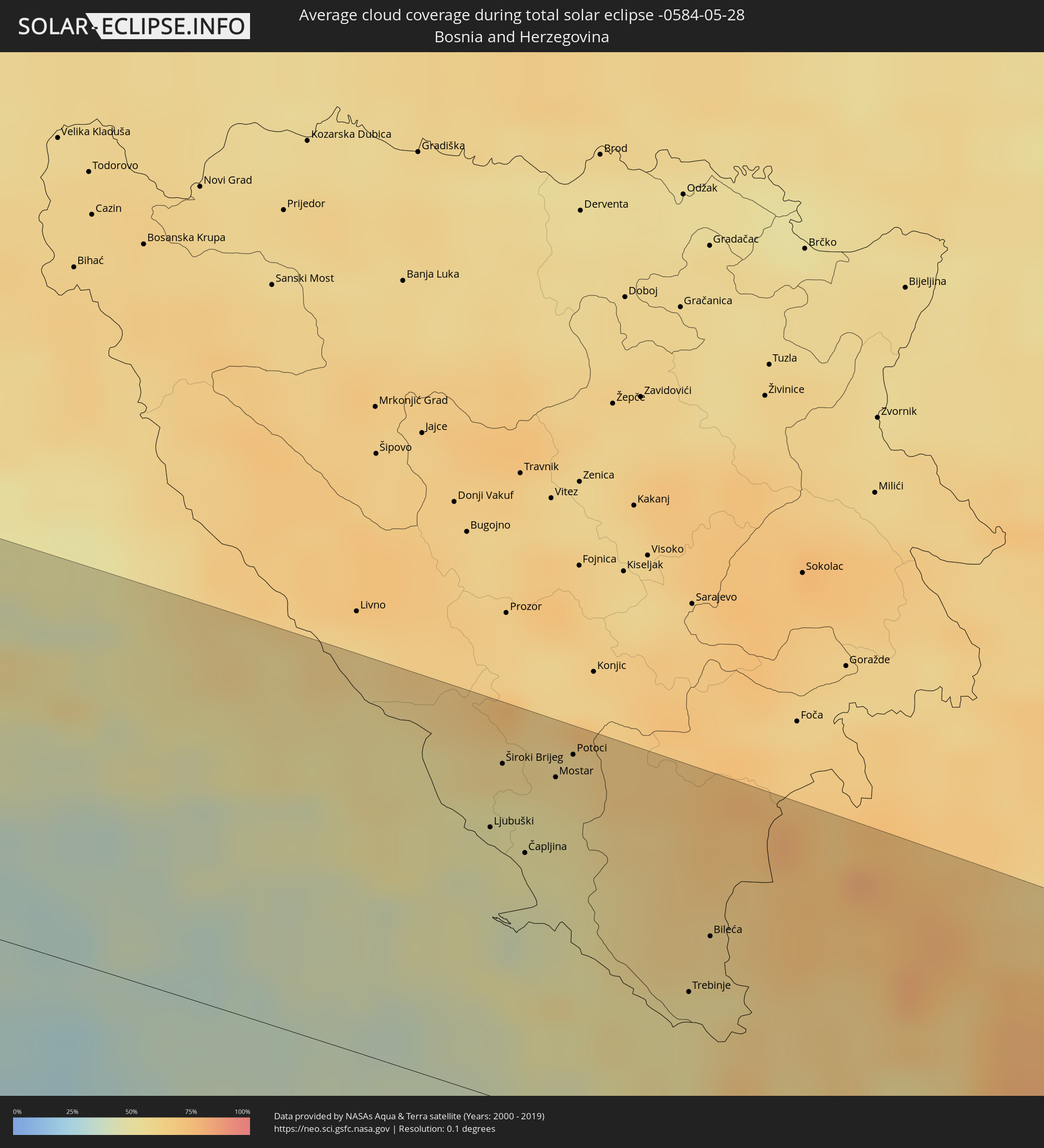
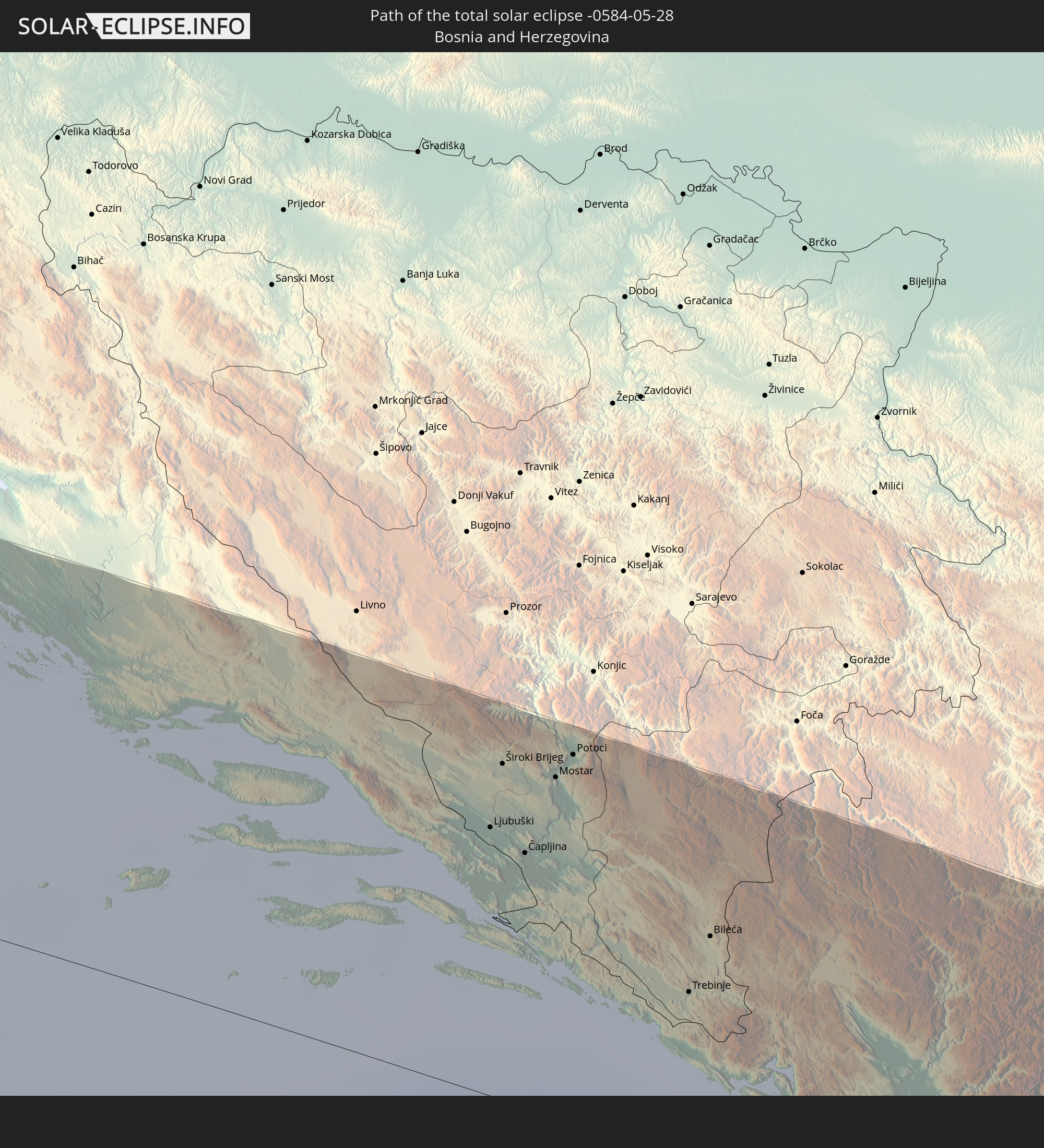 Bosnien und Herzegowina
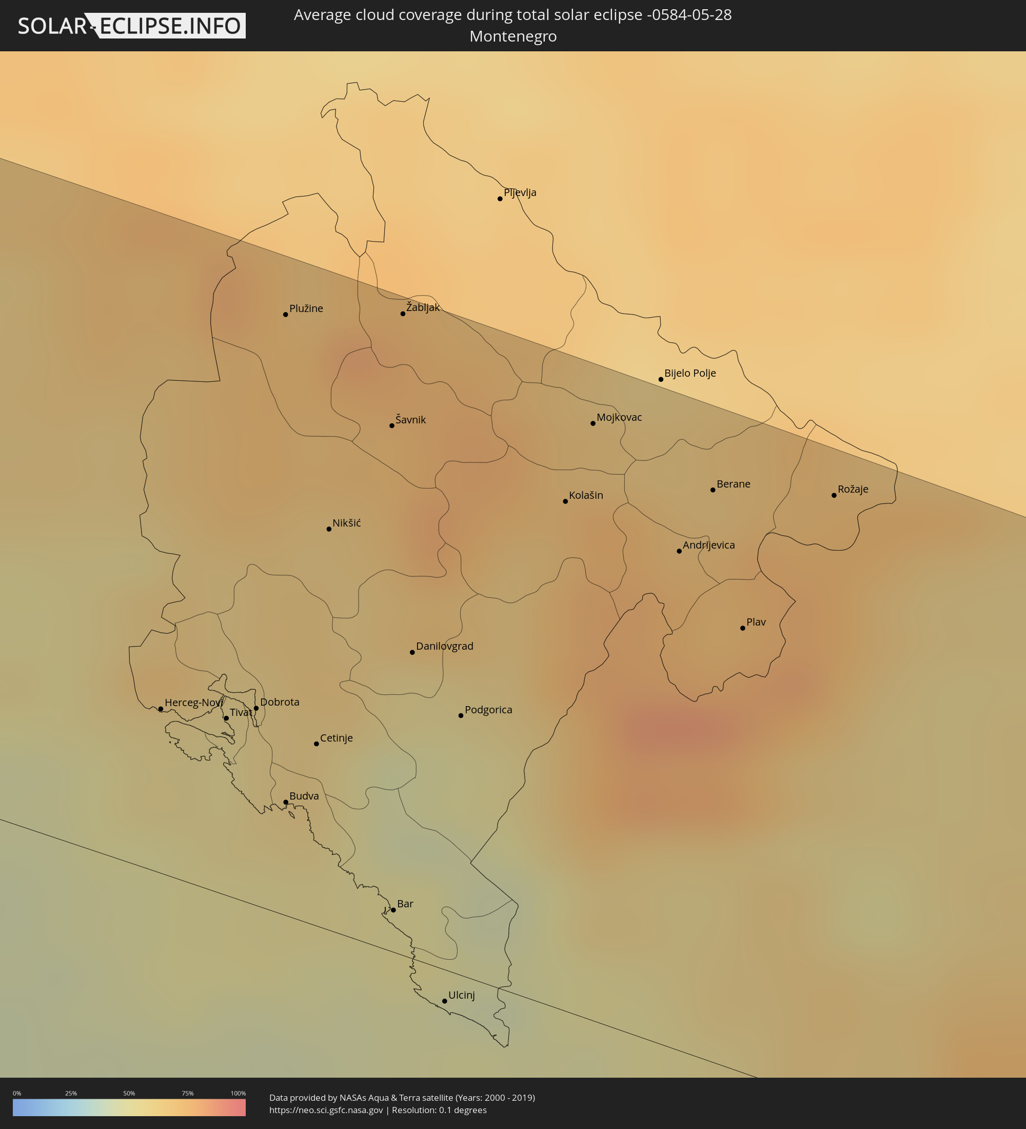
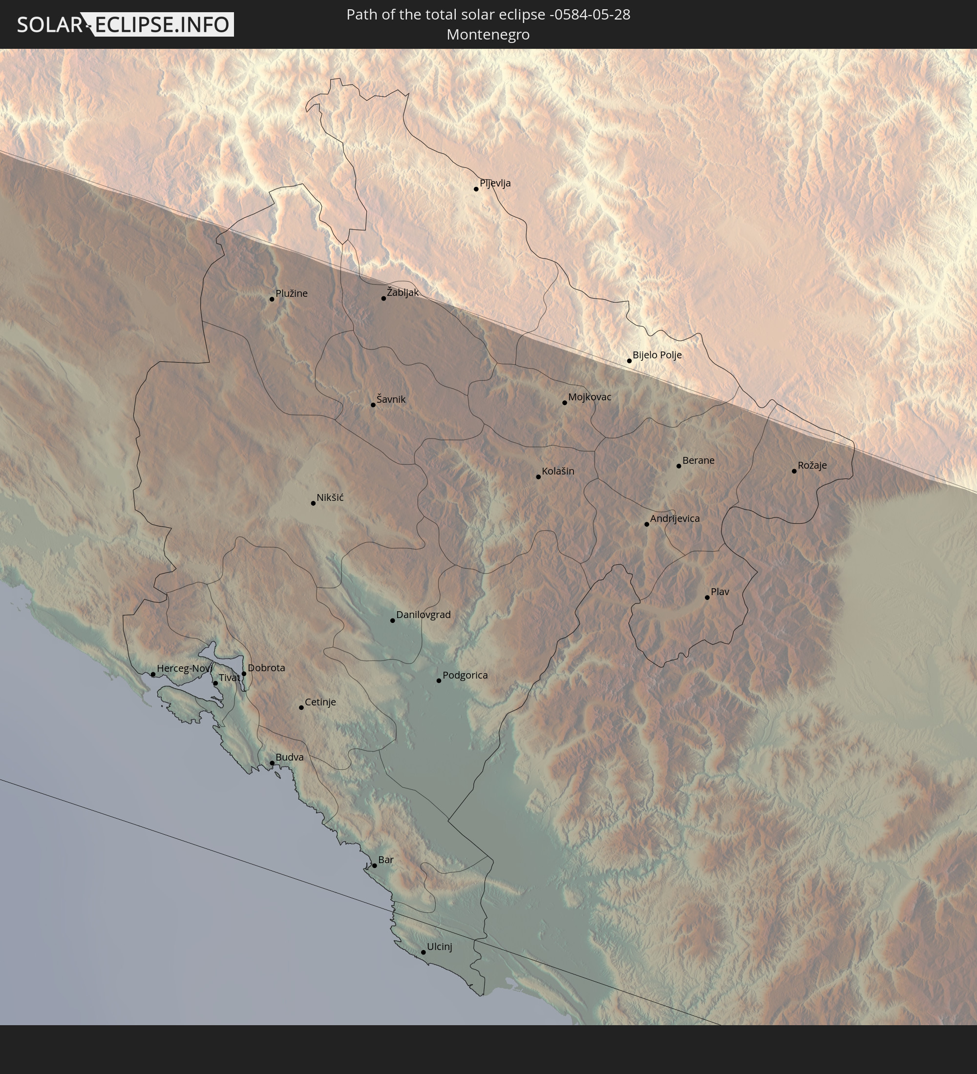 Montenegro
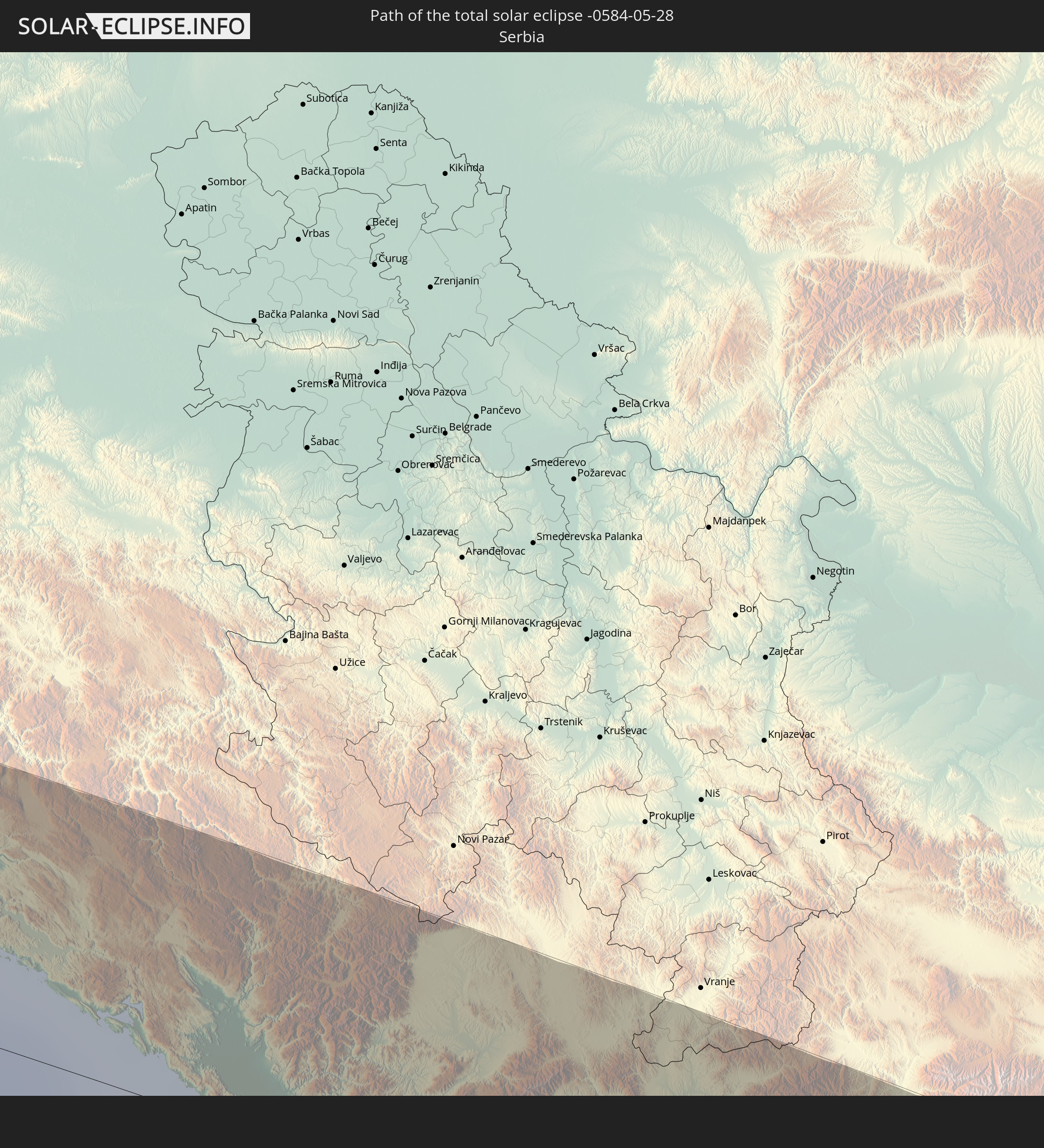 Serbien
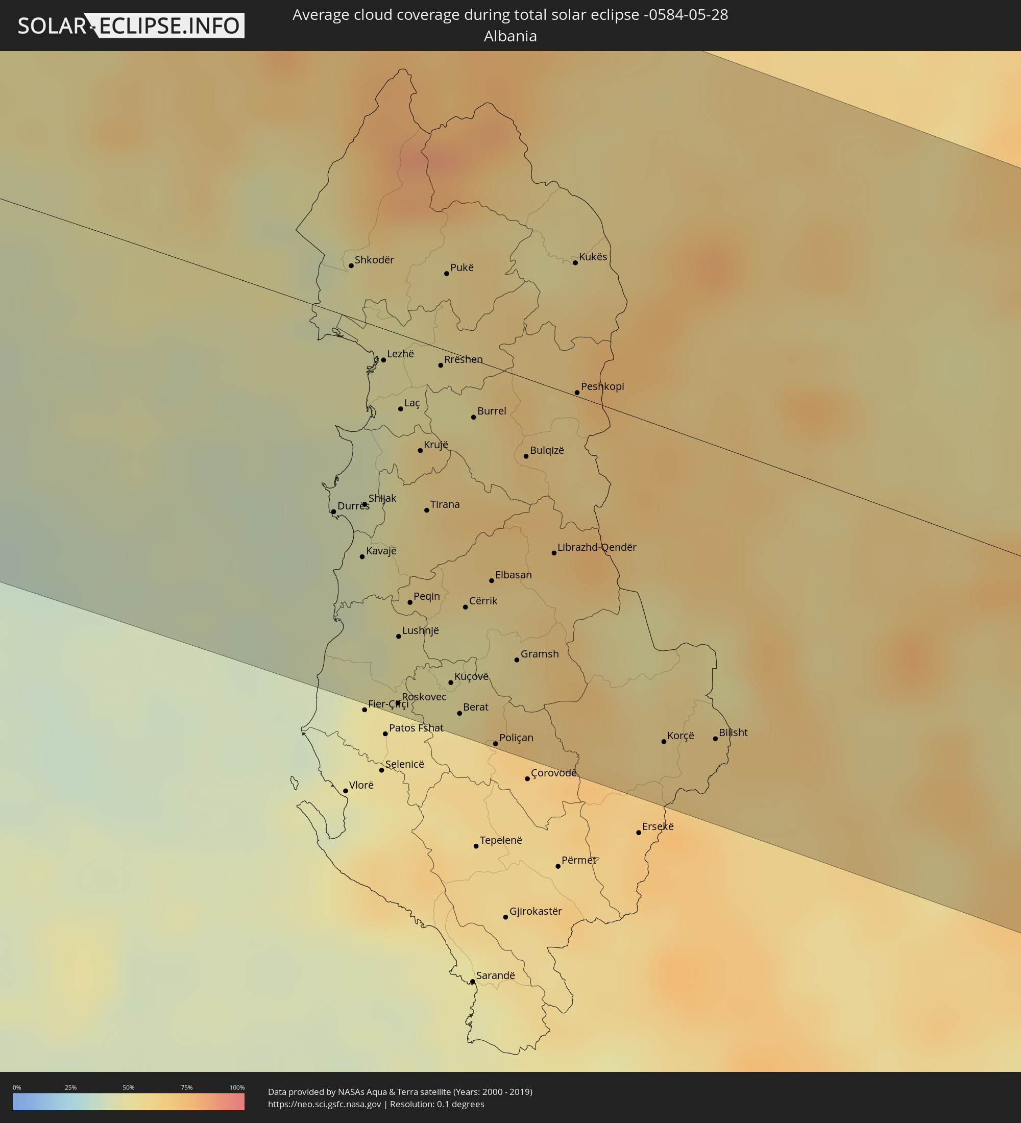
 Albanien
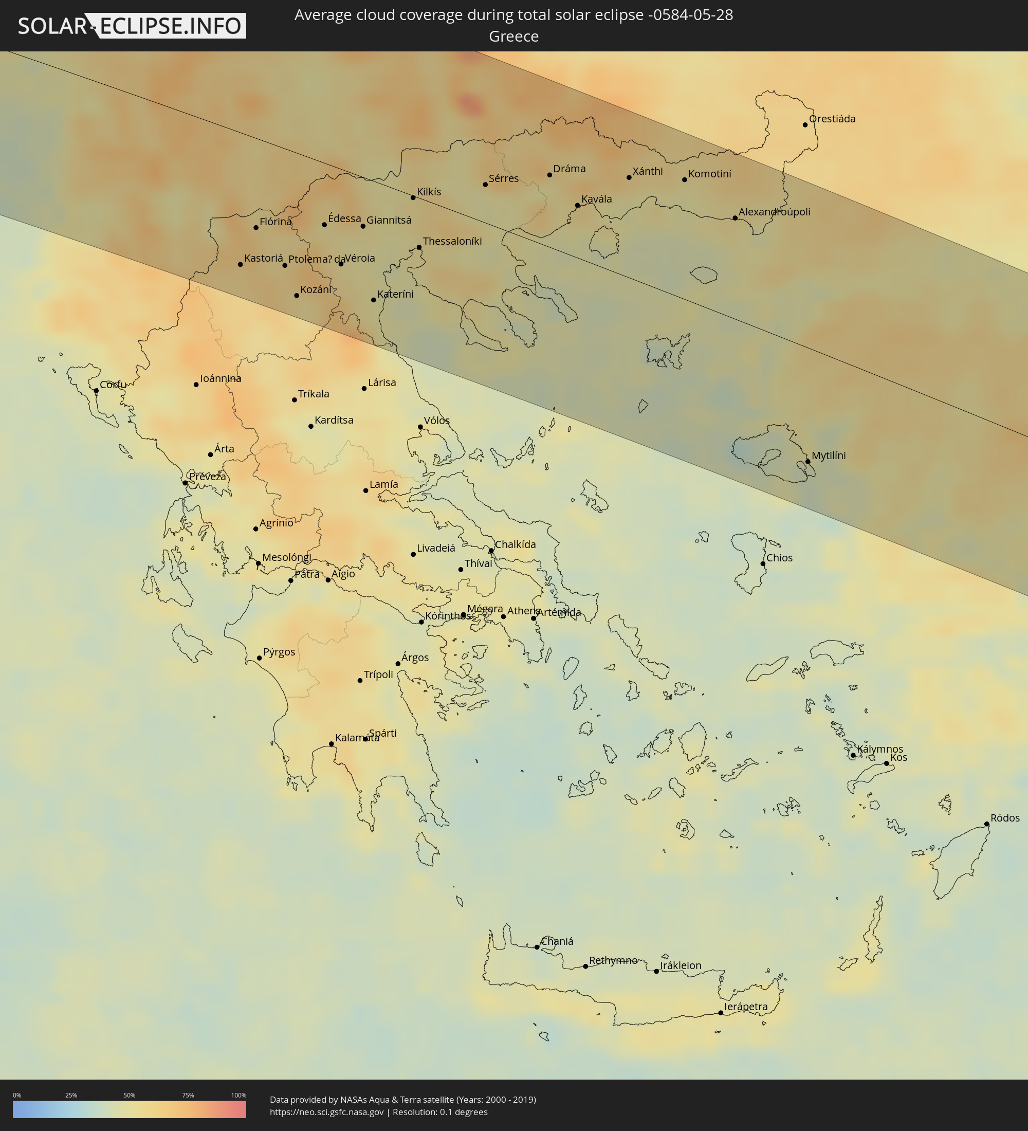
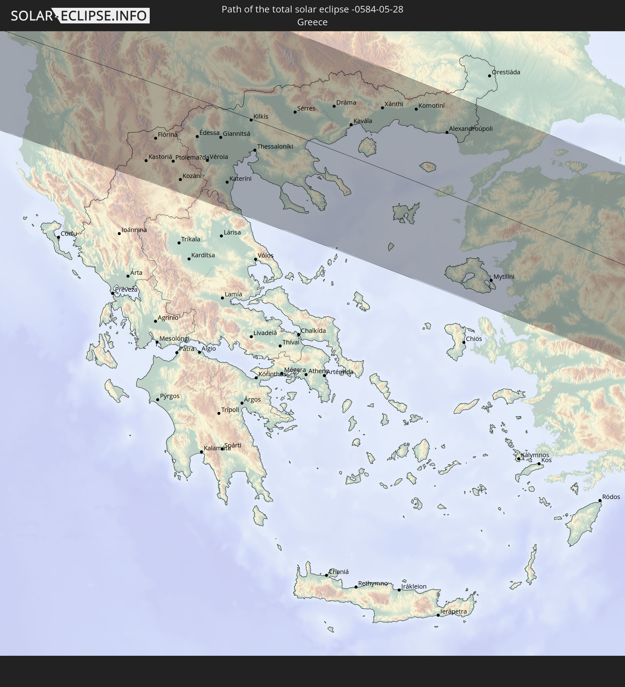 Griechenland
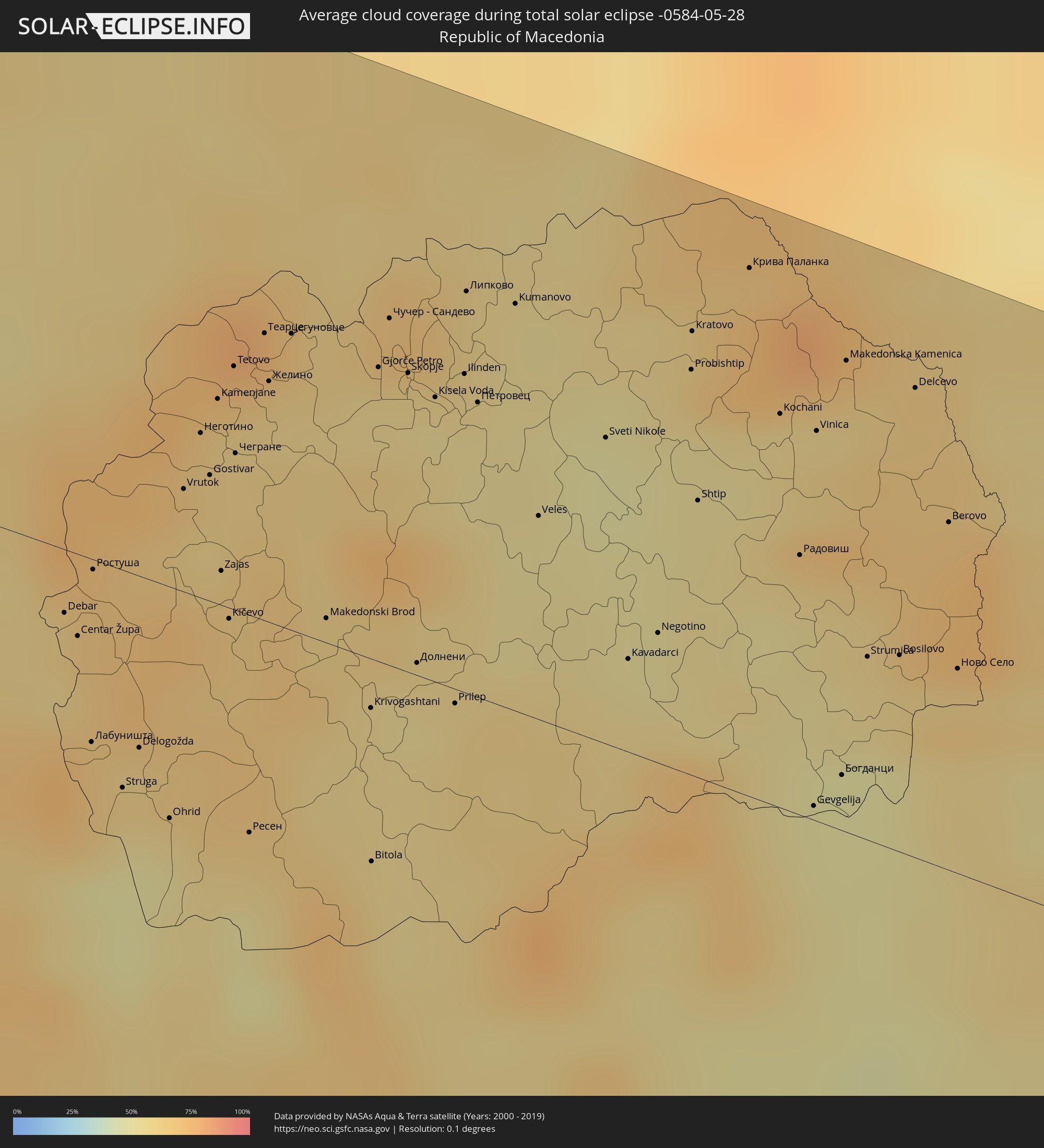
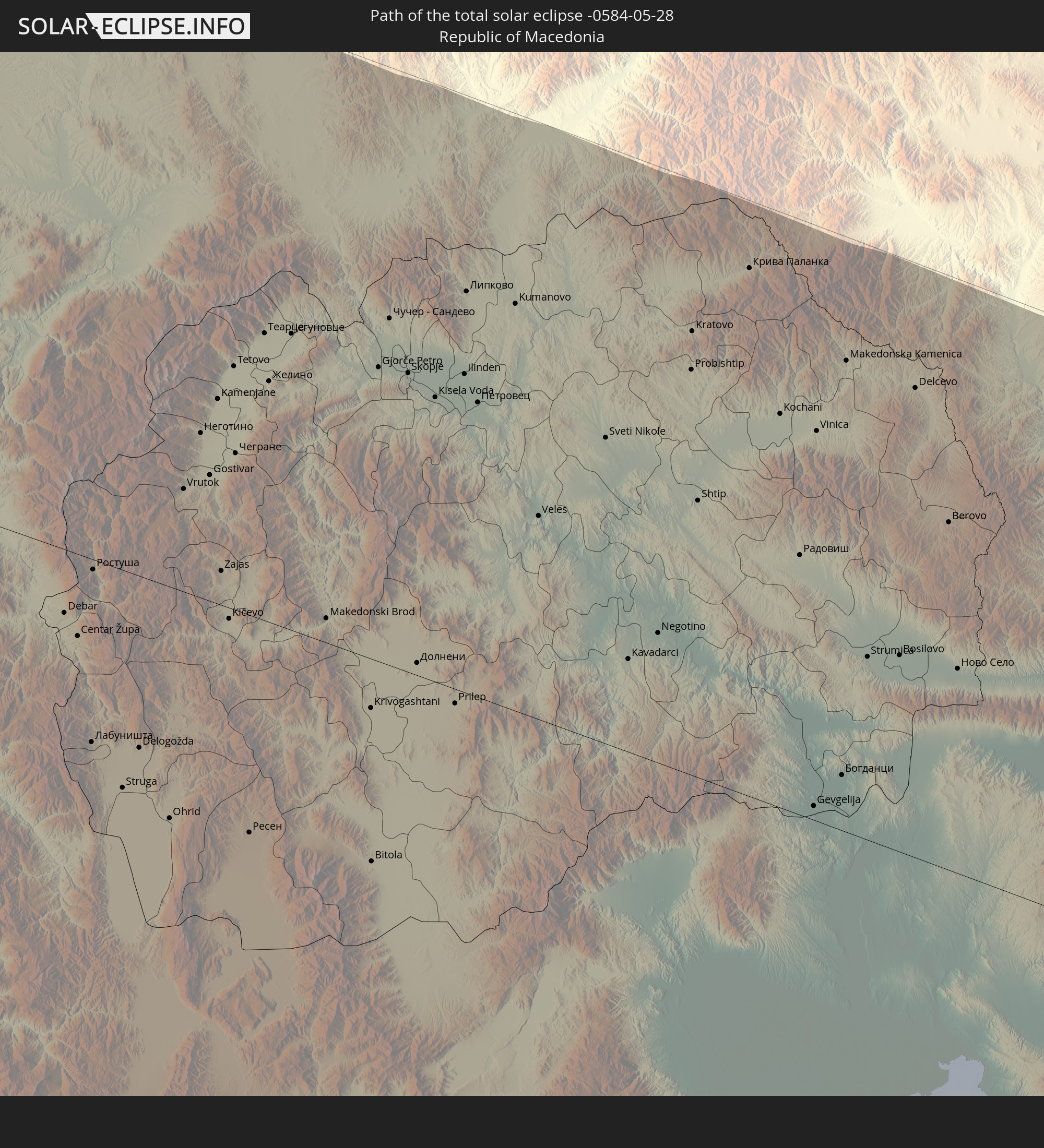 Mazedonien
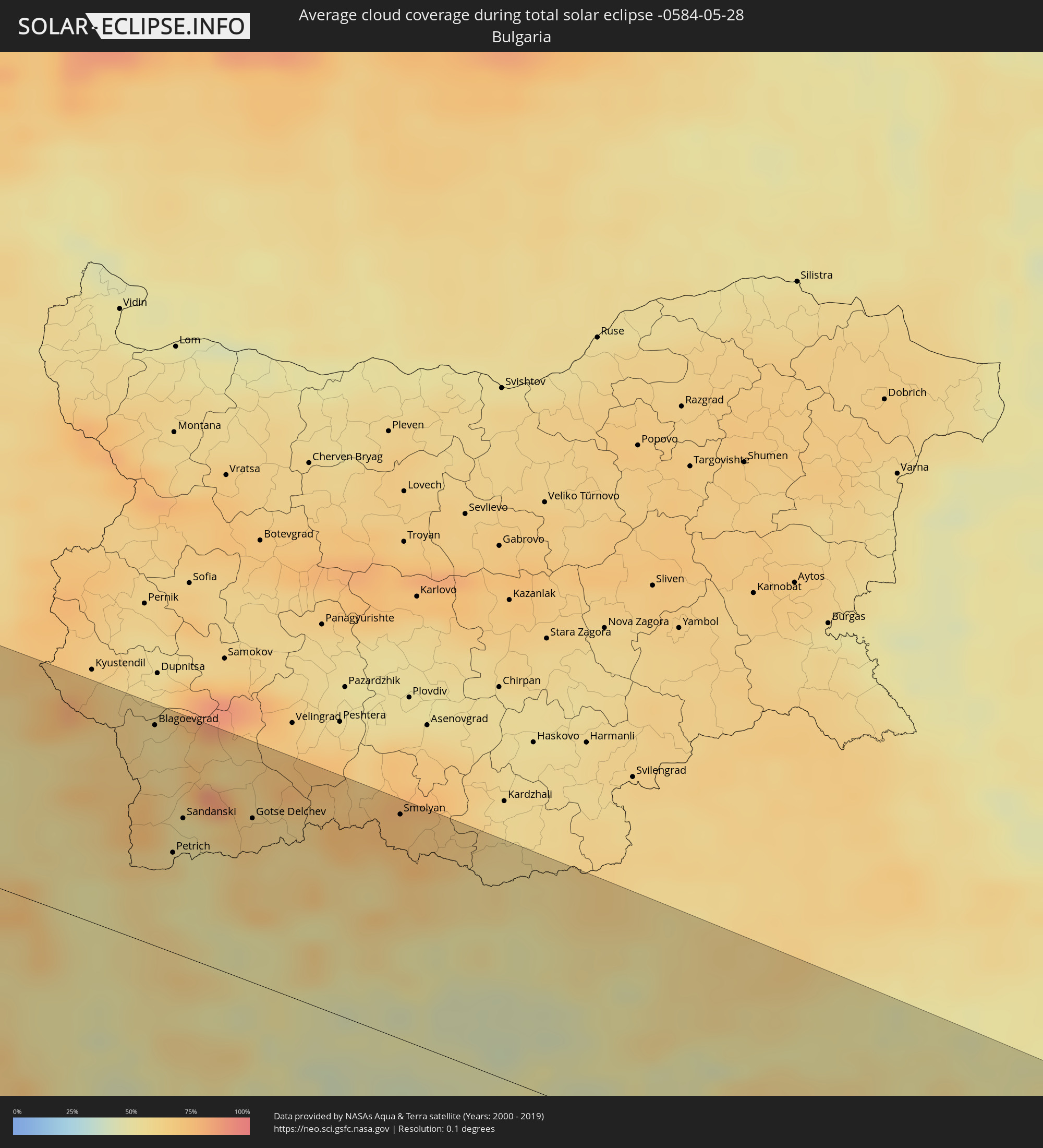
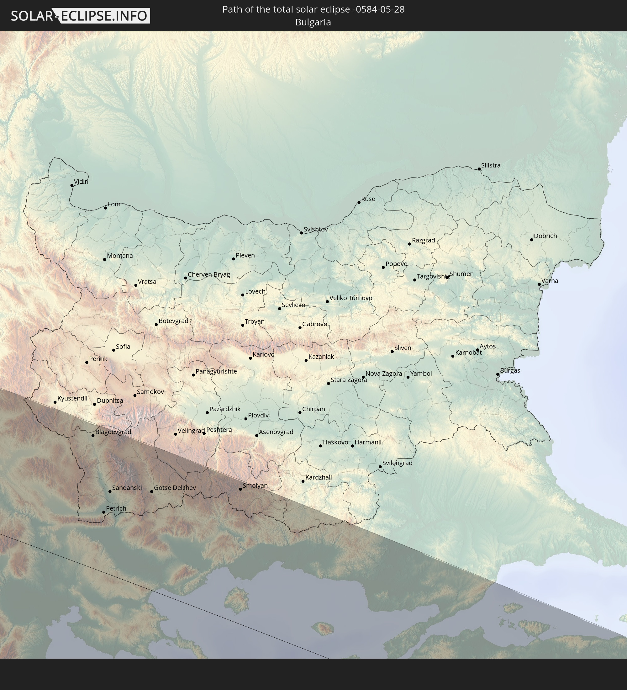 Bulgarien
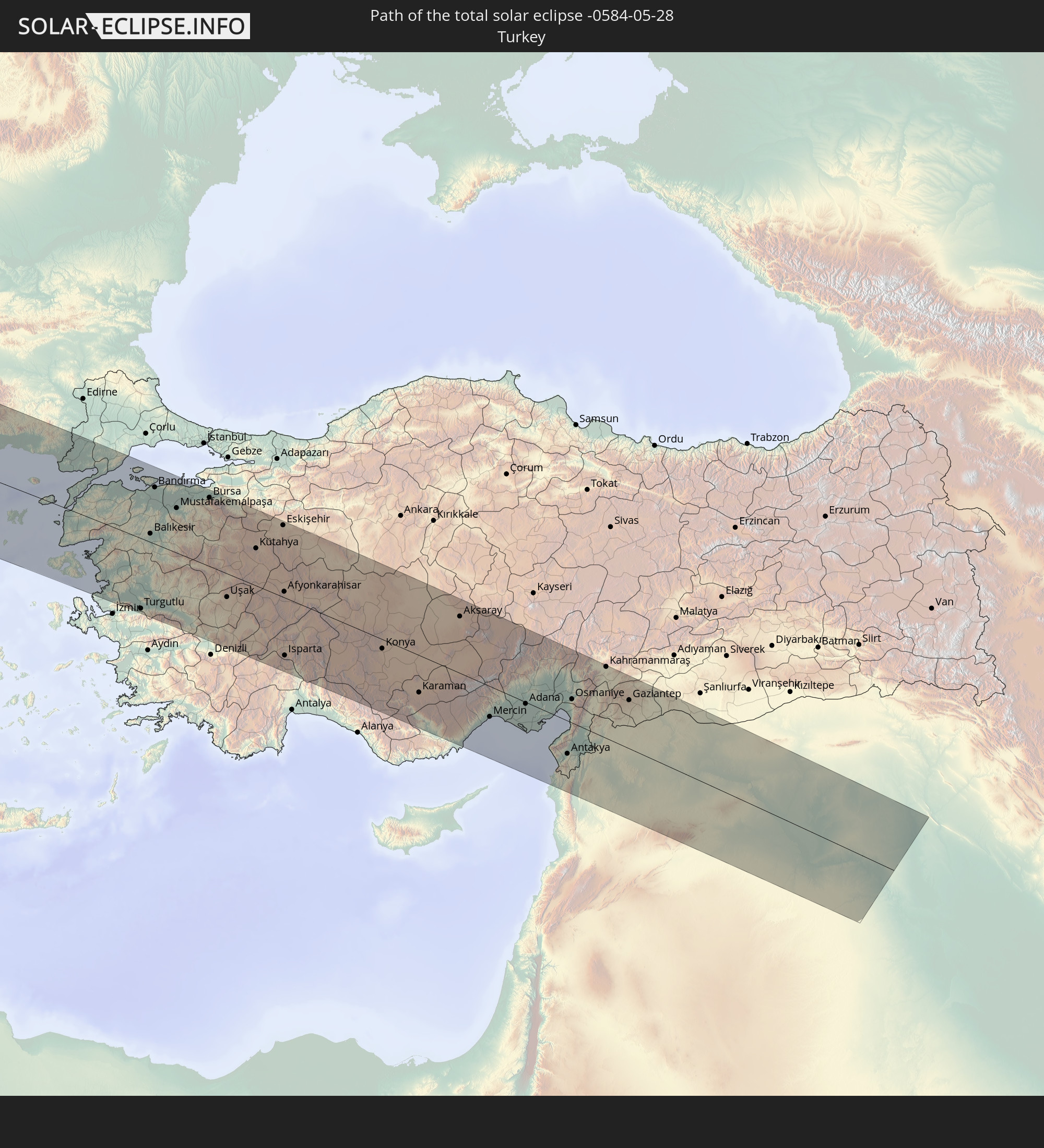 Türkei
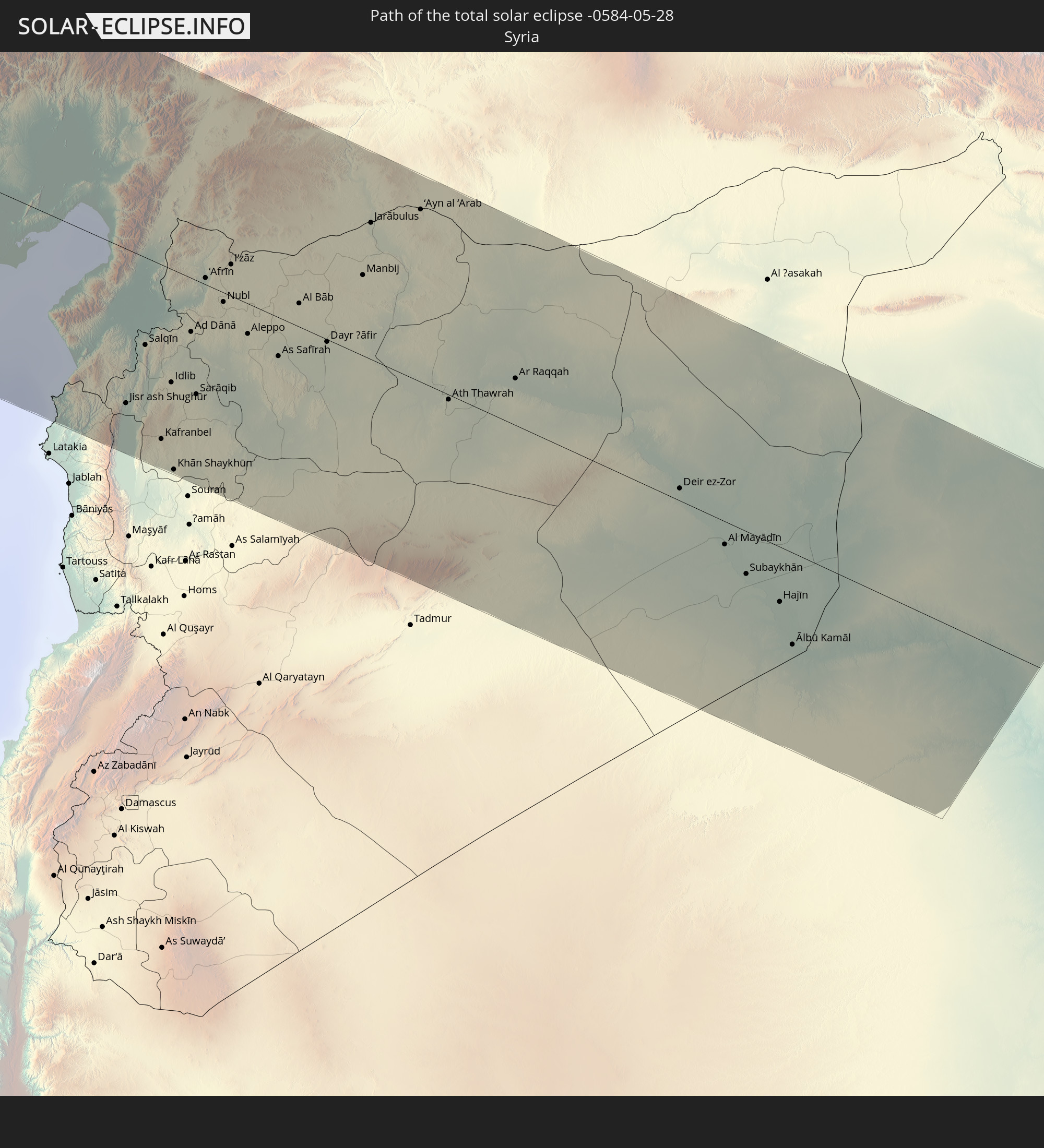 Syrien
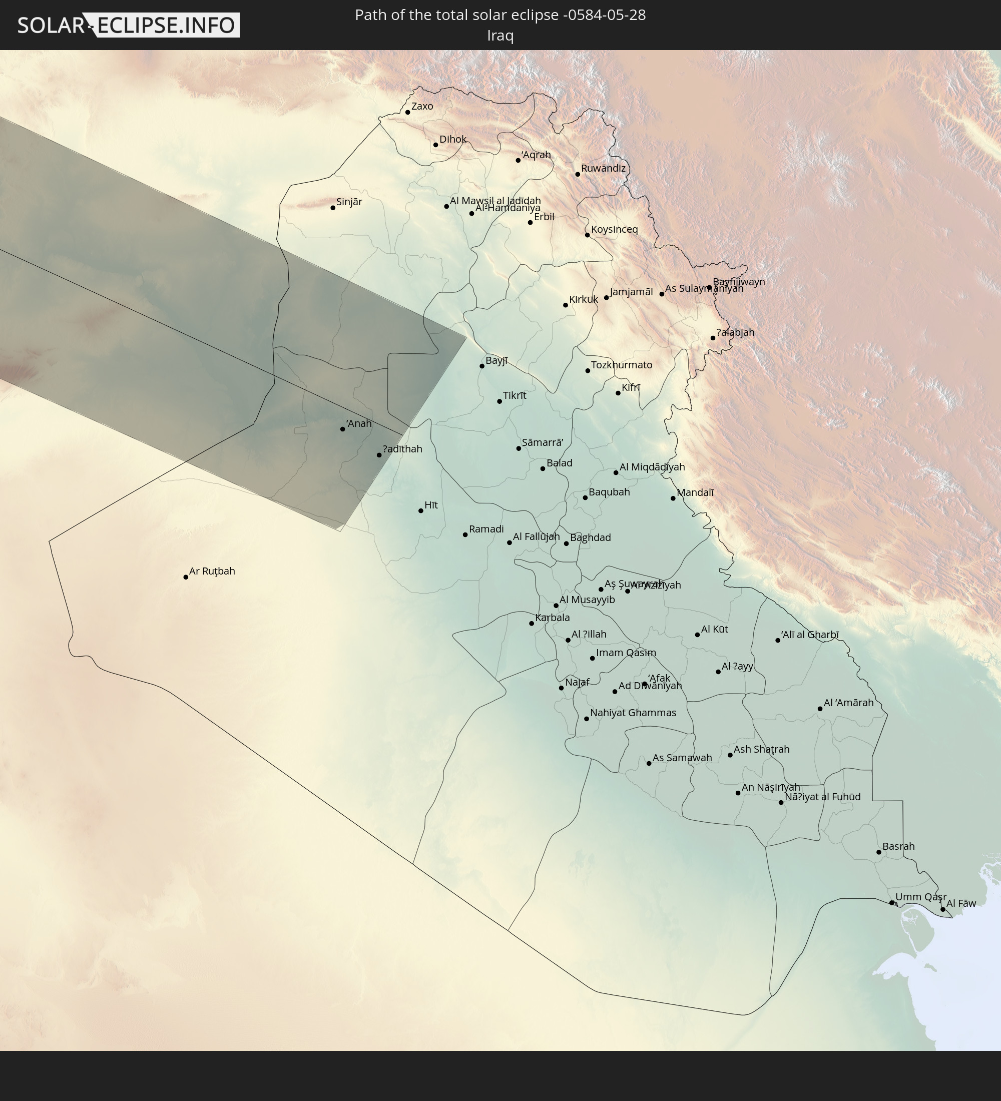 Irak
Irak
In den folgenden Ländern ist die Sonnenfinsternis partiell zu sehen
 Russland
 Vereinigte Staaten
 United States Minor Outlying Islands
 Kanada
 Mexiko
 Chile
Chile
 Grönland
 Guatemala
 Ecuador
 El Salvador
 Honduras
 Belize
 Nicaragua
 Costa Rica
 Kuba
Kuba
 Panama
 Kolumbien
 Kaimaninseln
 Peru
Peru
 Bahamas
 Jamaika
 Haiti
Haiti
 Brasilien
 Venezuela
 Turks- und Caicosinseln
 Dominikanische Republik
 Aruba
Aruba
 Bolivien
 Puerto Rico
 Amerikanische Jungferninseln
 Bermuda
 Britische Jungferninseln
 Anguilla
 Saint-Martin
 Saint-Barthélemy
 St. Kitts und Nevis
 Antigua und Barbuda
 Montserrat
 Trinidad und Tobago
 Guadeloupe
 Grenada
 Dominica
 St. Vincent und die Grenadinen
 Guyana
 Martinique
 St. Lucia
 Barbados
 Suriname
 Saint-Pierre und Miquelon
 Französisch-Guayana
 Portugal
 Kap Verde
 Island
 Spanien
 Senegal
 Mauretanien
 Marokko
 Mali
Mali
 Irland
 Spitzbergen
 Algerien
 Vereinigtes Königreich
 Färöer
 Burkina Faso
 Gibraltar
 Frankreich
 Isle of Man
 Guernsey
 Jersey
 Niger
Niger
 Andorra
 Belgien
 Nigeria
 Niederlande
 Norwegen
 Luxemburg
 Deutschland
 Schweiz
 Italien
 Monaco
 Tunesien
 Dänemark
 Kamerun
 Libyen
 Liechtenstein
 Österreich
 Schweden
 Tschechien
 San Marino
 Vatikanstadt
 Slowenien
 Tschad
 Kroatien
 Polen
Polen
 Malta
Malta
 Zentralafrikanische Republik
 Bosnien und Herzegowina
 Ungarn
 Slowakei
 Montenegro
 Serbien
 Albanien
 Åland Islands
 Griechenland
 Rumänien
 Mazedonien
 Finnland
 Litauen
 Lettland
 Estland
 Sudan
Sudan
 Ukraine
 Bulgarien
 Weißrussland
 Ägypten
 Türkei
 Moldawien
 Republik Zypern
 Staat Palästina
 Israel
 Saudi-Arabien
 Jordanien
 Libanon
 Syrien
 Irak
Irak
 Georgien
 Armenien
 Iran
Iran
 Aserbaidschan
 Kasachstan
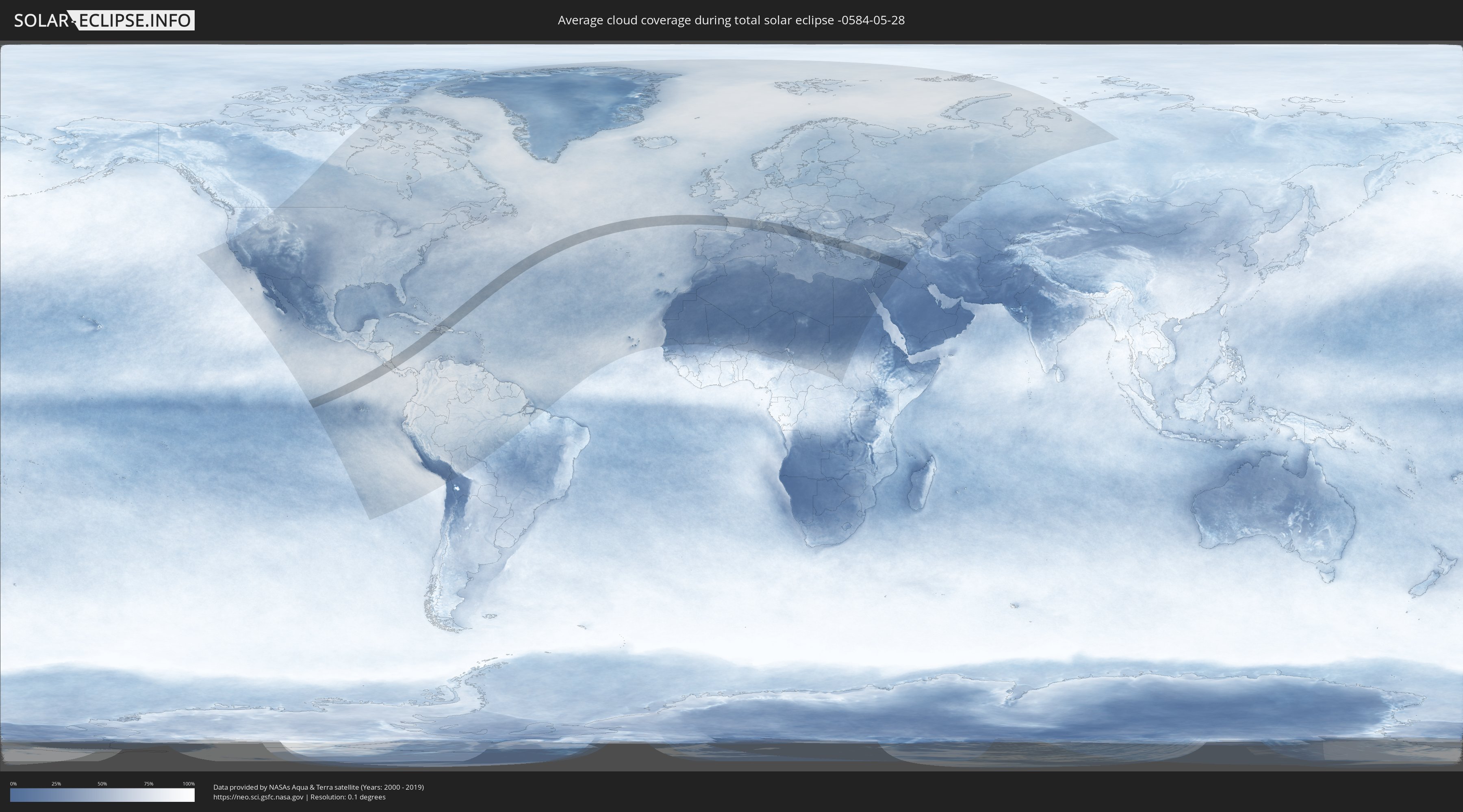
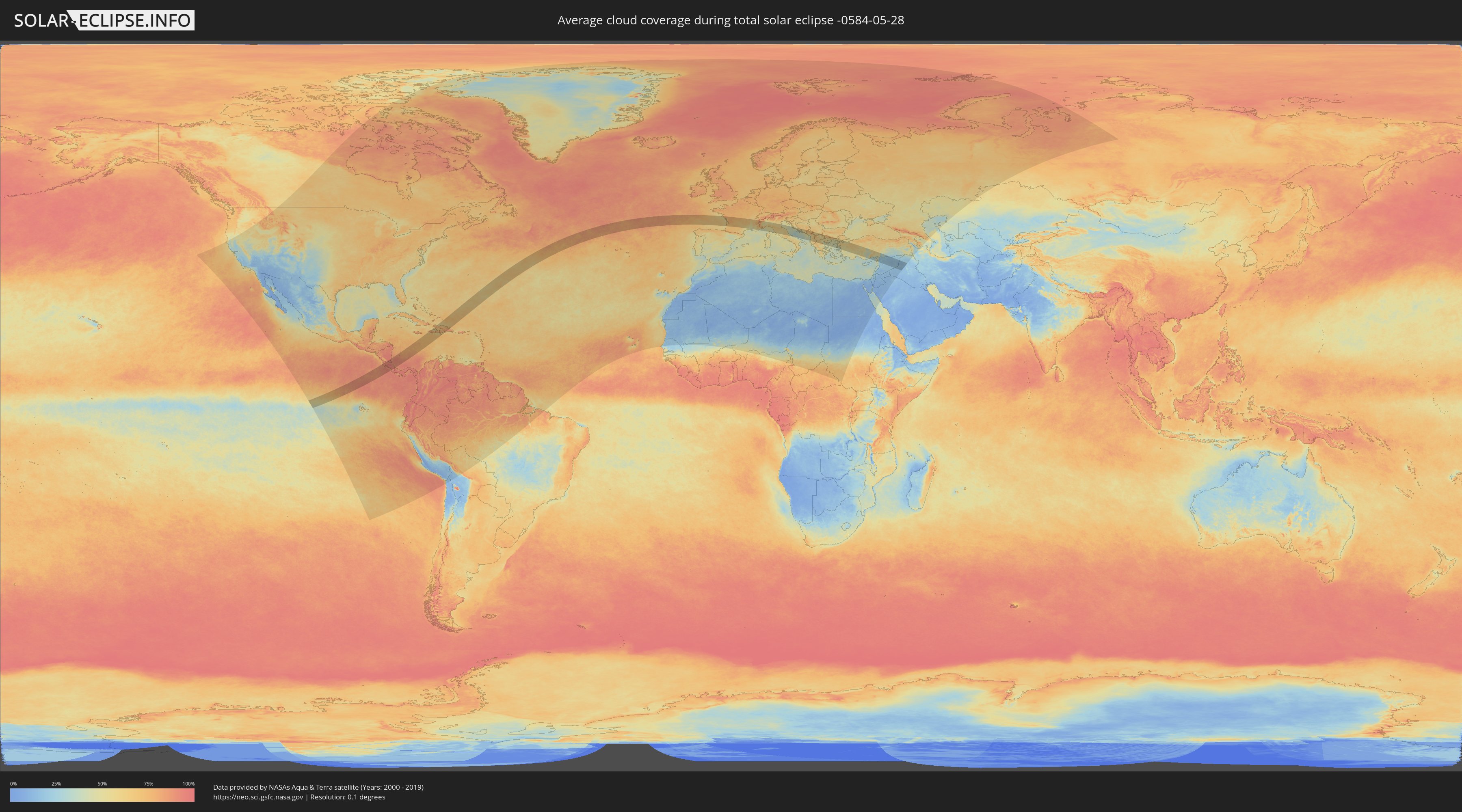
Wie wird das Wetter während der totalen Sonnenfinsternis am 28.05.-0584?
Wo ist der beste Ort, um die totale Sonnenfinsternis vom 28.05.-0584 zu beobachten?
Die folgenden Karten zeigen die durchschnittliche Bewölkung für den Tag, an dem die totale Sonnenfinsternis
stattfindet. Mit Hilfe der Karten lässt sich der Ort entlang des Finsternispfades eingrenzen,
der die besten Aussichen auf einen klaren wolkenfreien Himmel bietet.
Trotzdem muss man immer lokale Gegenenheiten beachten und sollte sich genau über das Wetter an seinem
gewählten Beobachtungsort informieren.
Die Daten stammen von den beiden NASA-Satelliten
AQUA und TERRA
und wurden über einen Zeitraum von 19 Jahren (2000 - 2019) gemittelt.
Detaillierte Länderkarten
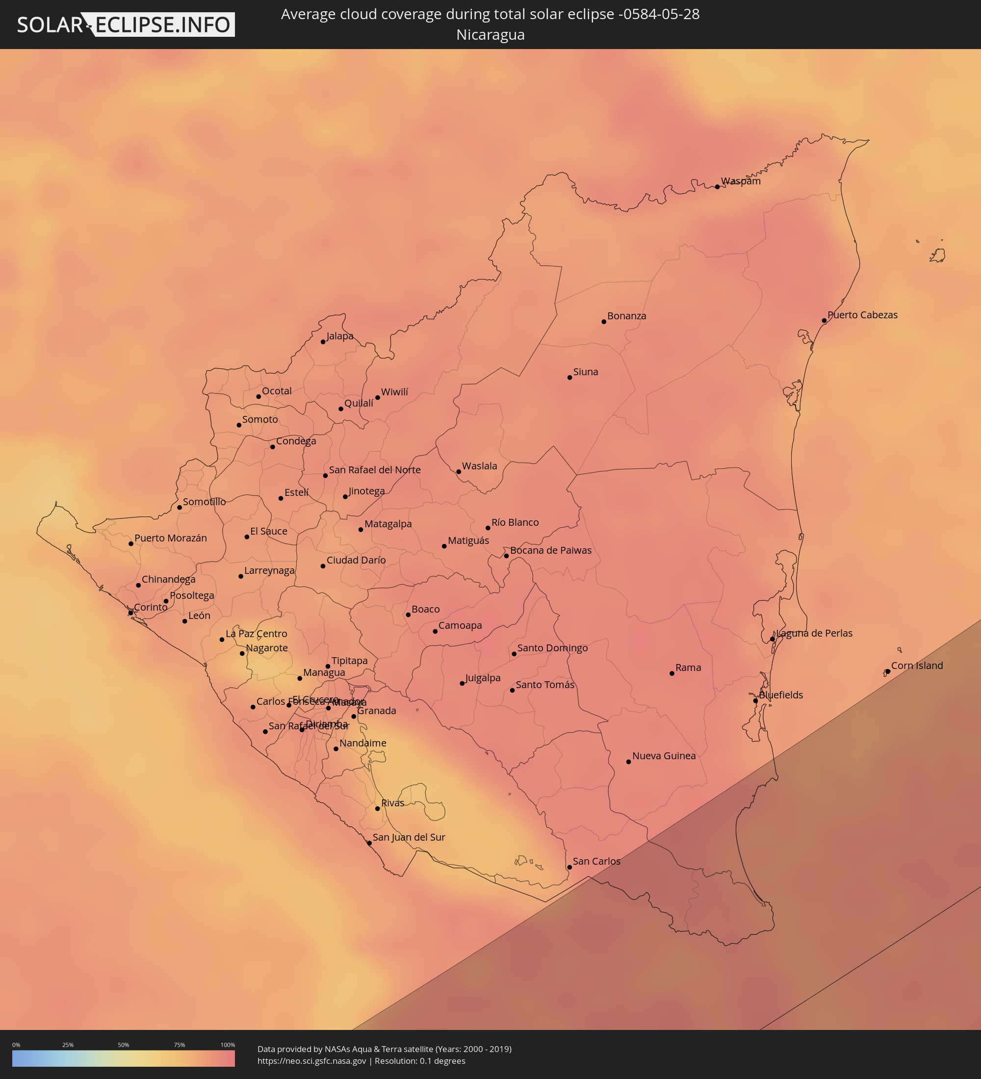 Nicaragua
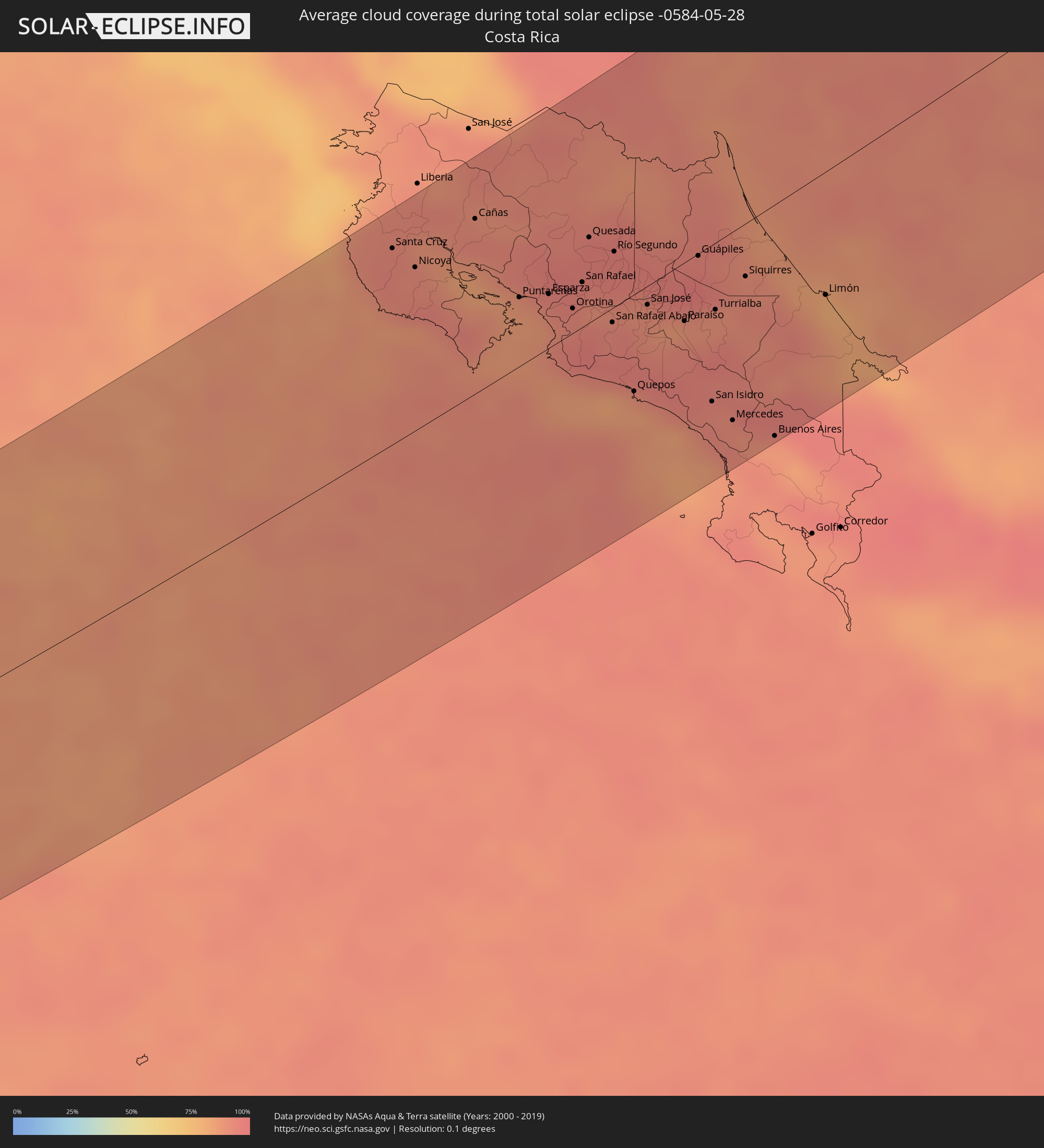 Costa Rica
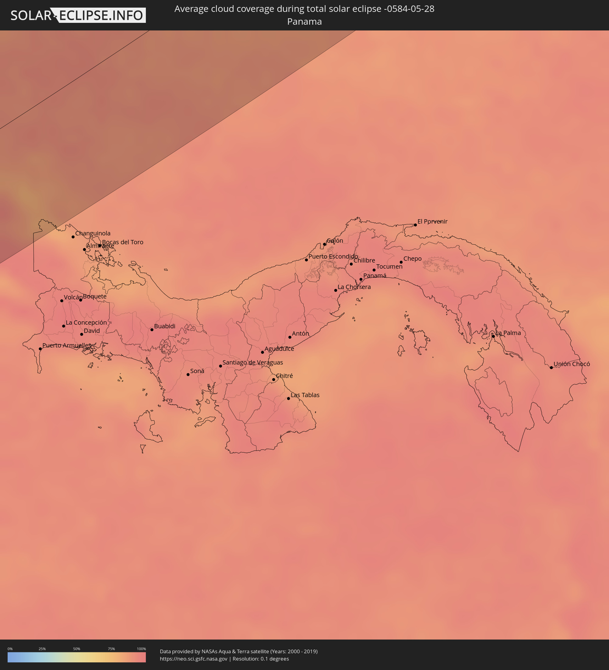 Panama
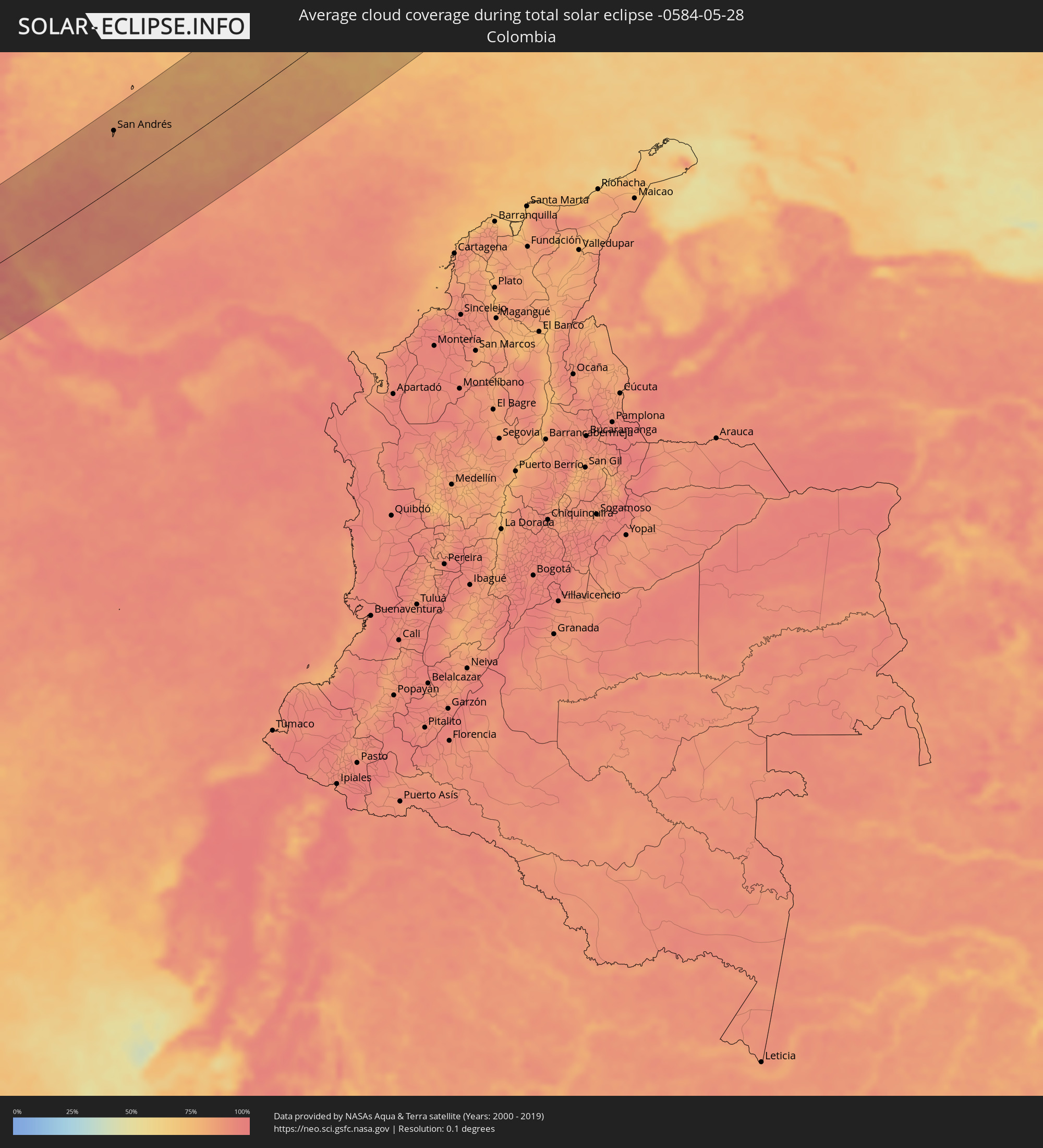 Kolumbien
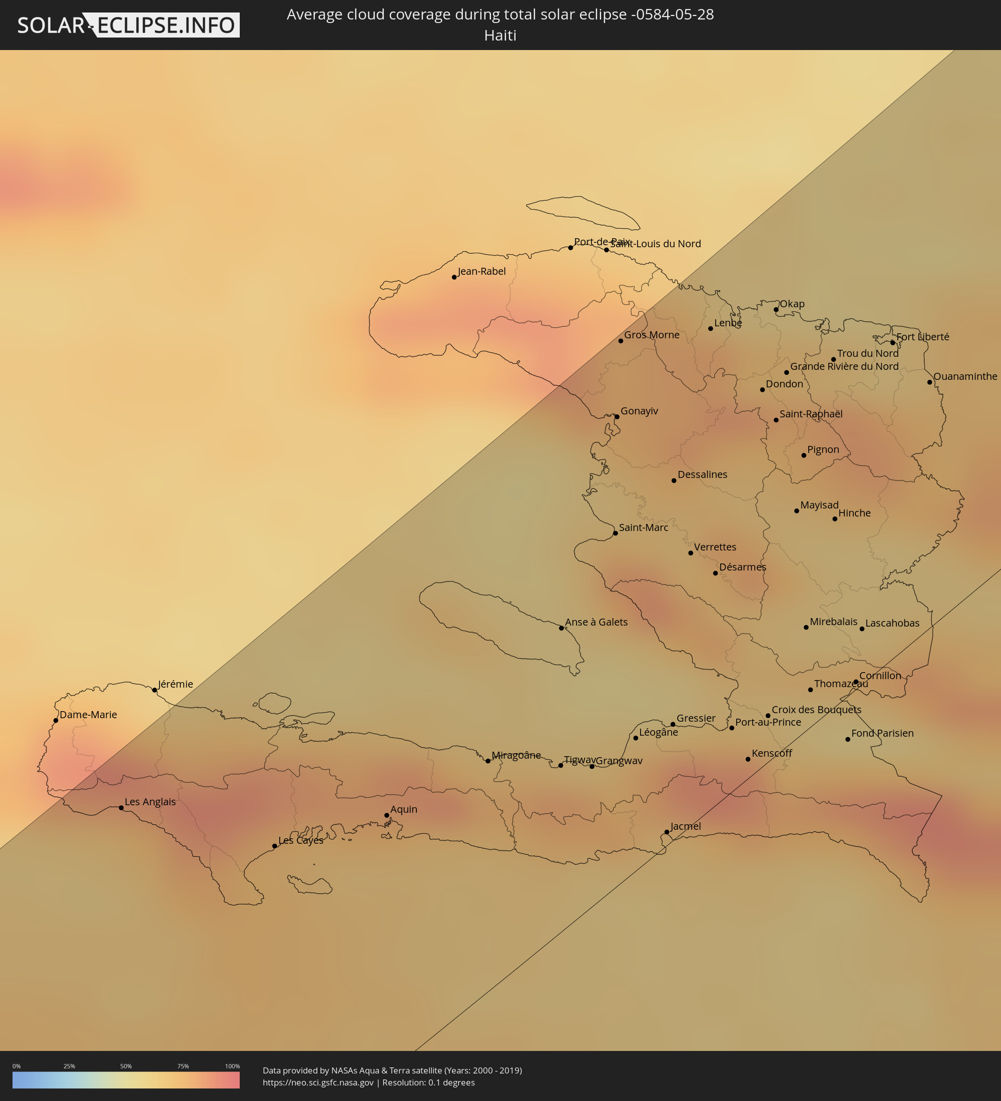 Haiti
Haiti
 Dominikanische Republik
 Frankreich
 Italien
 Monaco
 San Marino
 Kroatien
 Bosnien und Herzegowina
 Montenegro
 Serbien
 Albanien
 Griechenland
 Mazedonien
 Bulgarien
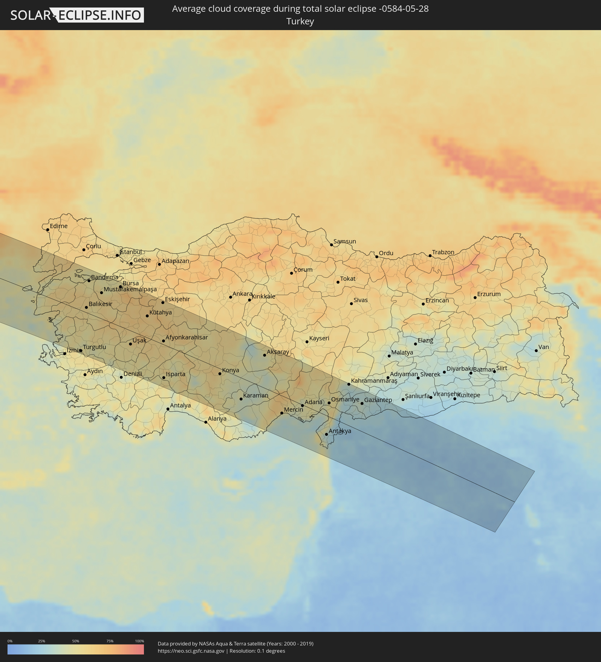 Türkei
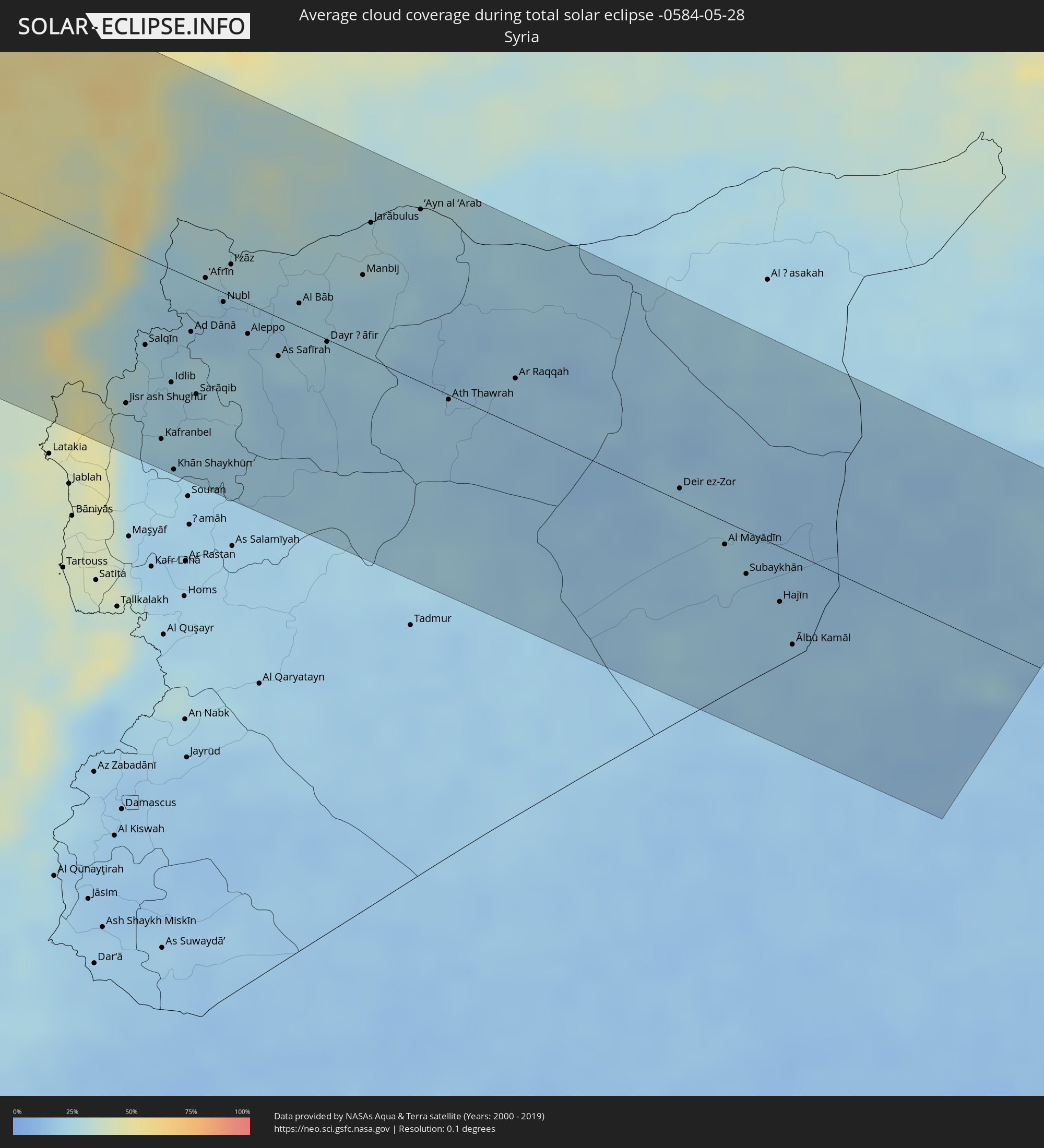 Syrien
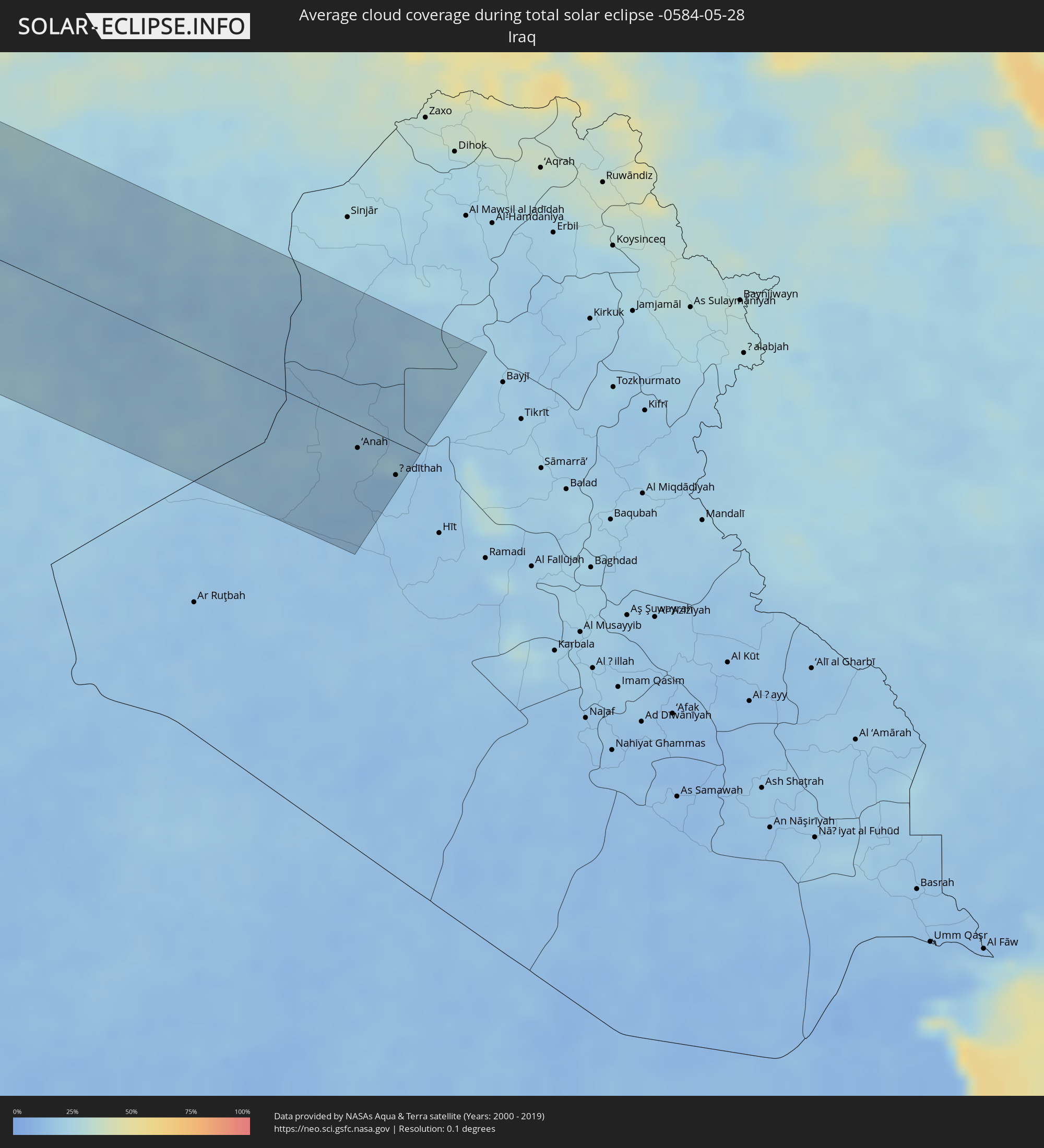 Irak
Irak
Orte im Finsternispfad
Die nachfolgene Tabelle zeigt Städte und Orte mit mehr als 5.000 Einwohnern, die sich im Finsternispfad befinden. Städte mit mehr als 100.000 Einwohnern sind dick gekennzeichnet. Mit einem Klick auf den Ort öffnet sich eine Detailkarte die die Lage des jeweiligen Ortes zusammen mit dem Verlauf der zentralen Finsternis präsentiert.
| Ort | Typ | Dauer der Verfinsterung | Ortszeit bei maximaler Verfinsterung | Entfernung zur Zentrallinie | Ø Bewölkung |
|
Cañas, Guanacaste
|
total | - | 07:18:06 UTC-05:36 | 96 km | 93% |
|
Puntarenas, Puntarenas
|
total | - | 07:17:37 UTC-05:36 | 38 km | 86% |
|
Quesada, Alajuela
|
total | - | 07:18:10 UTC-05:36 | 47 km | 96% |
|
San Rafael Abajo, San José
|
total | - | 07:17:37 UTC-05:36 | 8 km | 93% |
|
Alajuela, Alajuela
|
total | - | 07:17:51 UTC-05:36 | 5 km | 90% |
|
San José, San José
|
total | - | 07:17:48 UTC-05:36 | 10 km | 91% |
|
Paraíso, Cartago
|
total | - | 07:17:45 UTC-05:36 | 32 km | 92% |
|
Guápiles, Limón
|
total | - | 07:18:14 UTC-05:36 | 1 km | 97% |
|
San Isidro, San José
|
total | - | 07:17:14 UTC-05:36 | 85 km | 92% |
|
Turrialba, Cartago
|
total | - | 07:17:53 UTC-05:36 | 36 km | 89% |
|
Siquirres, Limón
|
total | - | 07:18:10 UTC-05:36 | 29 km | 91% |
|
Limón, Limón
|
total | - | 07:18:12 UTC-05:36 | 67 km | 79% |
|
San Andrés, Archipiélago de San Andrés, Providencia y Santa Catalina
|
total | - | 08:01:55 UTC-04:56 | 93 km | 84% |
|
Les Cayes, Sud
|
total | - | 08:21:45 UTC-04:49 | 81 km | 70% |
|
Miragoâne, Nippes
|
total | - | 08:22:38 UTC-04:49 | 58 km | 77% |
|
Tigwav, Ouest
|
total | - | 08:22:47 UTC-04:49 | 42 km | 80% |
|
Saint-Marc, Artibonite
|
total | - | 08:23:59 UTC-04:49 | 89 km | 81% |
|
Gonayiv, Artibonite
|
total | - | 08:24:32 UTC-04:49 | 117 km | 65% |
|
Léogâne, Ouest
|
total | - | 08:23:05 UTC-04:49 | 33 km | 78% |
|
Jacmel, Sud-Est
|
total | - | 08:22:44 UTC-04:49 | 3 km | 63% |
|
Verrettes, Artibonite
|
total | - | 08:24:04 UTC-04:49 | 68 km | 70% |
|
Port-au-Prince, Ouest
|
total | - | 08:23:22 UTC-04:49 | 16 km | 84% |
|
Okap, Nord
|
total | - | 08:25:25 UTC-04:49 | 111 km | 59% |
|
Saint-Raphaël, Nord
|
total | - | 08:24:54 UTC-04:49 | 84 km | 70% |
|
Thomazeau, Ouest
|
total | - | 08:23:44 UTC-04:49 | 9 km | 61% |
|
San Juan de la Maguana, San Juan
|
total | - | 08:33:41 UTC-04:40 | 36 km | 73% |
|
Santa Cruz de Barahona, Barahona
|
total | - | 08:32:50 UTC-04:40 | 96 km | 71% |
|
Mao, Valverde
|
total | - | 08:35:01 UTC-04:40 | 18 km | 63% |
|
Azua, Azua
|
total | - | 08:33:32 UTC-04:40 | 99 km | 72% |
|
Santiago de los Caballeros, Santiago
|
total | - | 08:35:10 UTC-04:40 | 17 km | 68% |
|
Puerto Plata, Puerto Plata
|
total | - | 08:35:44 UTC-04:40 | 12 km | 69% |
|
Concepción de La Vega, La Vega
|
total | - | 08:34:57 UTC-04:40 | 48 km | 71% |
|
Moca, Espaillat
|
total | - | 08:35:14 UTC-04:40 | 33 km | 74% |
|
Bonao, Monseñor Nouel
|
total | - | 08:34:35 UTC-04:40 | 80 km | 74% |
|
San Francisco de Macorís, Duarte
|
total | - | 08:35:19 UTC-04:40 | 60 km | 77% |
|
Villa Altagracia, San Cristóbal
|
total | - | 08:34:22 UTC-04:40 | 119 km | 82% |
|
Cotuí, Sánchez Ramírez
|
total | - | 08:35:00 UTC-04:40 | 88 km | 81% |
|
La Rochelle, Nouvelle-Aquitaine
|
total | - | 15:44:07 UTC+00:09 | 71 km | 61% |
|
Bordeaux, Nouvelle-Aquitaine
|
total | - | 15:45:41 UTC+00:09 | 69 km | 69% |
|
Limoges, Nouvelle-Aquitaine
|
total | - | 15:46:39 UTC+00:09 | 60 km | 70% |
|
Clermont-Ferrand, Auvergne-Rhône-Alpes
|
total | - | 15:48:19 UTC+00:09 | 77 km | 69% |
|
Nîmes, Occitania
|
total | - | 15:51:02 UTC+00:09 | 118 km | 50% |
|
Saint-Étienne, Auvergne-Rhône-Alpes
|
total | - | 15:49:42 UTC+00:09 | 58 km | 70% |
|
Avignon, Provence-Alpes-Côte d'Azur
|
total | - | 15:51:20 UTC+00:09 | 98 km | 48% |
|
Lyon, Auvergne-Rhône-Alpes
|
total | - | 15:49:47 UTC+00:09 | 99 km | 63% |
|
Valence, Auvergne-Rhône-Alpes
|
total | - | 15:50:33 UTC+00:09 | 11 km | 53% |
|
Grenoble, Auvergne-Rhône-Alpes
|
total | - | 15:50:59 UTC+00:09 | 49 km | 63% |
|
Antibes, Provence-Alpes-Côte d'Azur
|
total | - | 15:53:30 UTC+00:09 | 102 km | 47% |
|
Nice, Provence-Alpes-Côte d'Azur
|
total | - | 15:53:29 UTC+00:09 | 84 km | 46% |
|
Monaco
|
total | - | 15:53:34 UTC+00:09 | 78 km | 45% |
|
La Condamine
|
total | - | 15:53:34 UTC+00:09 | 78 km | 45% |
|
Monte-Carlo
|
total | - | 15:53:34 UTC+00:09 | 78 km | 45% |
|
Turin, Piedmont
|
total | - | 16:43:12 UTC+01:00 | 71 km | 59% |
|
Genoa, Liguria
|
total | - | 16:44:39 UTC+01:00 | 24 km | 59% |
|
Livorno, Tuscany
|
total | - | 16:46:24 UTC+01:00 | 44 km | 50% |
|
Parma, Emilia-Romagna
|
total | - | 16:45:14 UTC+01:00 | 91 km | 55% |
|
Reggio nell'Emilia, Emilia-Romagna
|
total | - | 16:45:31 UTC+01:00 | 87 km | 57% |
|
Modena, Emilia-Romagna
|
total | - | 16:45:45 UTC+01:00 | 87 km | 56% |
|
Prato, Tuscany
|
total | - | 16:46:34 UTC+01:00 | 8 km | 63% |
|
Florence, Tuscany
|
total | - | 16:46:46 UTC+01:00 | 0 km | 63% |
|
Bologna, Emilia-Romagna
|
total | - | 16:46:09 UTC+01:00 | 79 km | 55% |
|
Perugia, Umbria
|
total | - | 16:48:04 UTC+01:00 | 47 km | 57% |
|
Acquaviva, Acquaviva
|
total | - | 16:47:18 UTC+01:00 | 43 km | 60% |
|
Poggio di Chiesanuova, Chiesanuova
|
total | - | 16:47:20 UTC+01:00 | 39 km | 60% |
|
San Marino, San Marino
|
total | - | 16:47:19 UTC+01:00 | 43 km | 60% |
|
Borgo Maggiore, Borgo Maggiore
|
total | - | 16:47:19 UTC+01:00 | 43 km | 60% |
|
Fiorentino, Fiorentino
|
total | - | 16:47:21 UTC+01:00 | 40 km | 60% |
|
Domagnano, Domagnano
|
total | - | 16:47:19 UTC+01:00 | 44 km | 60% |
|
Serravalle, Serravalle
|
total | - | 16:47:19 UTC+01:00 | 47 km | 58% |
|
Monte Giardino, Montegiardino
|
total | - | 16:47:22 UTC+01:00 | 40 km | 60% |
|
Faetano, Faetano
|
total | - | 16:47:22 UTC+01:00 | 43 km | 60% |
|
Rimini, Emilia-Romagna
|
total | - | 16:47:17 UTC+01:00 | 58 km | 51% |
|
Pescara, Abruzzo
|
total | - | 16:49:41 UTC+01:00 | 76 km | 45% |
|
Vodice, Šibensko-Kniniska
|
total | - | 16:49:14 UTC+01:00 | 100 km | 51% |
|
Šibenik, Šibensko-Kniniska
|
total | - | 16:49:19 UTC+01:00 | 99 km | 54% |
|
Trogir, Splitsko-Dalmatinska
|
total | - | 16:49:41 UTC+01:00 | 85 km | 45% |
|
Kaštel Novi, Splitsko-Dalmatinska
|
total | - | 16:49:41 UTC+01:00 | 91 km | 49% |
|
Kaštel Stari, Splitsko-Dalmatinska
|
total | - | 16:49:42 UTC+01:00 | 91 km | 50% |
|
Split, Splitsko-Dalmatinska
|
total | - | 16:49:47 UTC+01:00 | 89 km | 47% |
|
Podstrana, Splitsko-Dalmatinska
|
total | - | 16:49:51 UTC+01:00 | 90 km | 52% |
|
Sinj, Splitsko-Dalmatinska
|
total | - | 16:49:41 UTC+01:00 | 115 km | 55% |
|
Omiš, Splitsko-Dalmatinska
|
total | - | 16:49:57 UTC+01:00 | 89 km | 44% |
|
Makarska, Splitsko-Dalmatinska
|
total | - | 16:50:14 UTC+01:00 | 81 km | 51% |
|
Ljubuški, Federation of Bosnia and Herzegovina
|
total | - | 16:50:34 UTC+01:00 | 84 km | 46% |
|
Široki Brijeg, Federation of Bosnia and Herzegovina
|
total | - | 16:50:24 UTC+01:00 | 105 km | 50% |
|
Metković, Dubrovačko-Neretvanska
|
total | - | 16:50:44 UTC+01:00 | 71 km | 46% |
|
Čapljina, Federation of Bosnia and Herzegovina
|
total | - | 16:50:41 UTC+01:00 | 79 km | 46% |
|
Čitluk, Federation of Bosnia and Herzegovina
|
total | - | 16:50:36 UTC+01:00 | 91 km | 48% |
|
Rodoč, Federation of Bosnia and Herzegovina
|
total | - | 16:50:33 UTC+01:00 | 103 km | 51% |
|
Mostar, Federation of Bosnia and Herzegovina
|
total | - | 16:50:32 UTC+01:00 | 106 km | 51% |
|
Crnići, Federation of Bosnia and Herzegovina
|
total | - | 16:50:45 UTC+01:00 | 85 km | 51% |
|
Potoci, Federation of Bosnia and Herzegovina
|
total | - | 16:50:29 UTC+01:00 | 115 km | 58% |
|
Stolac, Federation of Bosnia and Herzegovina
|
total | - | 16:50:50 UTC+01:00 | 83 km | 54% |
|
Dubrovnik, Dubrovačko-Neretvanska
|
total | - | 16:51:19 UTC+01:00 | 40 km | 52% |
|
Nevesinje, Republic of Srspka
|
total | - | 16:50:44 UTC+01:00 | 105 km | 62% |
|
Trebinje, Republic of Srspka
|
total | - | 16:51:21 UTC+01:00 | 53 km | 52% |
|
Bileća, Republic of Srspka
|
total | - | 16:51:14 UTC+01:00 | 73 km | 58% |
|
Herceg-Novi, Herceg Novi
|
total | - | 16:51:41 UTC+01:00 | 31 km | 56% |
|
Tivat, Tivat
|
total | - | 16:51:45 UTC+01:00 | 33 km | 53% |
|
Kotor, Kotor
|
total | - | 16:51:48 UTC+01:00 | 34 km | 58% |
|
Dobrota
|
total | - | 16:51:46 UTC+01:00 | 37 km | 59% |
|
Budva, Budva
|
total | - | 16:51:57 UTC+01:00 | 21 km | 55% |
|
Nikšić, Opština Nikšić
|
total | - | 16:51:31 UTC+01:00 | 75 km | 62% |
|
Bar, Bar
|
total | - | 16:52:14 UTC+01:00 | 8 km | 51% |
|
Danilovgrad, Danilovgrad
|
total | - | 16:51:49 UTC+01:00 | 58 km | 57% |
|
Ulcinj, Ulcinj
|
total | - | 16:52:26 UTC+01:00 | 6 km | 47% |
|
Podgorica, Podgorica
|
total | - | 16:51:58 UTC+01:00 | 49 km | 50% |
|
Durrës, Durrës
|
total | - | 17:12:25 UTC+01:19 | 64 km | 42% |
|
Shkodër, Shkodër
|
total | - | 17:11:45 UTC+01:19 | 16 km | 49% |
|
Kavajë, Tiranë
|
total | - | 17:12:35 UTC+01:19 | 75 km | 48% |
|
Lezhë, Lezhë
|
total | - | 17:12:04 UTC+01:19 | 10 km | 48% |
|
Lushnjë, Fier
|
total | - | 17:12:52 UTC+01:19 | 97 km | 51% |
|
Laç, Lezhë
|
total | - | 17:12:13 UTC+01:19 | 24 km | 53% |
|
Krujë, Durrës
|
total | - | 17:12:22 UTC+01:19 | 35 km | 57% |
|
Tirana, Tiranë
|
total | - | 17:12:33 UTC+01:19 | 53 km | 58% |
|
Berane, Berane
|
total | - | 16:51:48 UTC+01:00 | 107 km | 71% |
|
Berat, Berat
|
total | - | 17:13:11 UTC+01:19 | 115 km | 57% |
|
Elbasan, Elbasan
|
total | - | 17:12:51 UTC+01:19 | 69 km | 55% |
|
Rožaje, Opština Rožaje
|
total | - | 16:51:54 UTC+01:00 | 114 km | 74% |
|
Kukës, Kukës
|
total | - | 17:12:03 UTC+01:19 | 42 km | 58% |
|
Centar Župa, Centar Župa
|
total | - | 16:53:20 UTC+01:00 | 17 km | 65% |
|
Korçë, Korçë
|
total | - | 17:13:32 UTC+01:19 | 101 km | 62% |
|
Ohrid, Ohrid
|
total | - | 16:53:45 UTC+01:00 | 48 km | 52% |
|
Gostivar, Gostivar
|
total | - | 16:53:09 UTC+01:00 | 26 km | 59% |
|
Tetovo, Tetovo
|
total | - | 16:52:58 UTC+01:00 | 50 km | 61% |
|
Bitola, Bitola
|
total | - | 16:54:00 UTC+01:00 | 42 km | 65% |
|
Skopje, Karpoš
|
total | - | 16:53:07 UTC+01:00 | 62 km | 56% |
|
Prilep, Prilep
|
total | - | 16:53:46 UTC+01:00 | 3 km | 61% |
|
Ptolemaḯda, West Macedonia
|
total | - | 17:29:27 UTC+01:34 | 86 km | 59% |
|
Kumanovo, Kumanovo
|
total | - | 16:53:04 UTC+01:00 | 84 km | 55% |
|
Veles, Veles
|
total | - | 16:53:29 UTC+01:00 | 42 km | 53% |
|
Kozáni, West Macedonia
|
total | - | 17:29:41 UTC+01:34 | 106 km | 57% |
|
Kavadarci, Kavadarci
|
total | - | 16:53:49 UTC+01:00 | 19 km | 57% |
|
Shtip, Štip
|
total | - | 16:53:35 UTC+01:00 | 57 km | 54% |
|
Véroia, Central Macedonia
|
total | - | 17:29:35 UTC+01:34 | 70 km | 56% |
|
Kateríni, Central Macedonia
|
total | - | 17:29:54 UTC+01:34 | 88 km | 50% |
|
Strumica, Strumica
|
total | - | 16:54:00 UTC+01:00 | 38 km | 54% |
|
Thessaloníki, Central Macedonia
|
total | - | 17:29:41 UTC+01:34 | 37 km | 50% |
|
Blagoevgrad, Blagoevgrad
|
total | - | 17:53:34 UTC+02:00 | 112 km | 55% |
|
Simitli, Blagoevgrad
|
total | - | 17:53:42 UTC+02:00 | 98 km | 58% |
|
Petrich, Blagoevgrad
|
total | - | 17:54:11 UTC+02:00 | 51 km | 59% |
|
Sandanski, Blagoevgrad
|
total | - | 17:54:02 UTC+02:00 | 70 km | 55% |
|
Razlog, Blagoevgrad
|
total | - | 17:53:47 UTC+02:00 | 109 km | 61% |
|
Bansko, Blagoevgrad
|
total | - | 17:53:50 UTC+02:00 | 104 km | 80% |
|
Sérres, Central Macedonia
|
total | - | 17:29:25 UTC+01:34 | 28 km | 47% |
|
Gotse Delchev, Blagoevgrad
|
total | - | 17:54:09 UTC+02:00 | 83 km | 65% |
|
Dráma, East Macedonia and Thrace
|
total | - | 17:29:30 UTC+01:34 | 53 km | 54% |
|
Devin, Smolyan
|
total | - | 17:54:08 UTC+02:00 | 122 km | 69% |
|
Kavála, East Macedonia and Thrace
|
total | - | 17:29:45 UTC+01:34 | 38 km | 51% |
|
Smolyan, Smolyan
|
total | - | 17:54:21 UTC+02:00 | 114 km | 73% |
|
Xánthi, East Macedonia and Thrace
|
total | - | 17:29:40 UTC+01:34 | 73 km | 54% |
|
Madan, Smolyan
|
total | - | 17:54:29 UTC+02:00 | 113 km | 66% |
|
Nedelino, Smolyan
|
total | - | 17:54:33 UTC+02:00 | 112 km | 65% |
|
Zlatograd, Smolyan
|
total | - | 17:54:37 UTC+02:00 | 105 km | 60% |
|
Komotiní, East Macedonia and Thrace
|
total | - | 17:29:47 UTC+01:34 | 87 km | 48% |
|
Alexandroúpoli, East Macedonia and Thrace
|
total | - | 17:30:08 UTC+01:34 | 74 km | 52% |
|
Mytilíni, North Aegean
|
total | - | 17:31:49 UTC+01:34 | 85 km | 41% |
|
Manisa, Manisa
|
total | - | 17:54:27 UTC+01:56 | 109 km | 55% |
|
Balıkesir, Balıkesir
|
total | - | 17:53:35 UTC+01:56 | 13 km | 53% |
|
Bursa, Bursa
|
total | - | 17:53:13 UTC+01:56 | 108 km | 64% |
|
Eskişehir, Eskişehir
|
total | - | 17:53:41 UTC+01:56 | 113 km | 61% |
|
Konya, Konya
|
total | - | 17:55:22 UTC+01:56 | 15 km | 53% |
|
Mercin, Mersin
|
total | - | 17:56:10 UTC+01:56 | 49 km | 39% |
|
Tarsus, Mersin
|
total | - | 17:56:03 UTC+01:56 | 27 km | 38% |
|
Adana, Adana
|
total | - | 17:55:57 UTC+01:56 | 3 km | 46% |
|
Antakya, Hatay
|
total | - | 17:56:30 UTC+01:56 | 53 km | 31% |
|
Osmaniye, Osmaniye
|
total | - | 17:55:48 UTC+01:56 | 38 km | 49% |
|
Idlib, Idlib
|
total | - | 18:24:55 UTC+02:25 | 64 km | 23% |
|
Kahramanmaraş, Kahramanmaraş
|
total | - | 17:55:19 UTC+01:56 | 115 km | 32% |
|
I‘zāz, Aleppo
|
total | - | 18:24:22 UTC+02:25 | 18 km | 23% |
|
Aleppo, Aleppo
|
total | - | 18:24:39 UTC+02:25 | 17 km | 21% |
|
As Safīrah, Aleppo
|
total | - | 18:24:43 UTC+02:25 | 22 km | 24% |
|
Gaziantep, Gaziantep
|
total | - | 17:55:41 UTC+01:56 | 78 km | 34% |
|
Al Bāb, Aleppo
|
total | - | 18:24:28 UTC+02:25 | 13 km | 23% |
|
Manbij, Aleppo
|
total | - | 18:24:17 UTC+02:25 | 45 km | 21% |
|
‘Ayn al ‘Arab, Aleppo
|
total | - | 18:23:56 UTC+02:25 | 97 km | 25% |
|
Ath Thawrah, Ar-Raqqah
|
total | - | 18:24:43 UTC+02:25 | 3 km | 20% |
|
Ar Raqqah, Ar-Raqqah
|
total | - | 18:24:33 UTC+02:25 | 27 km | 21% |
|
Deir ez-Zor, Deir ez-Zor
|
total | - | 18:24:47 UTC+02:25 | 7 km | 18% |
|
Al Mayādīn, Deir ez-Zor
|
total | - | 18:24:57 UTC+02:25 | 13 km | 22% |
|
Ālbū Kamāl, Deir ez-Zor
|
total | - | 18:25:15 UTC+02:25 | 53 km | 18% |
|
Rāwah, Anbar
|
total | - | 18:57:24 UTC+02:57 | 11 km | 18% |
|
‘Anat al Qadīmah, Anbar
|
total | - | 18:57:24 UTC+02:57 | 11 km | 18% |
|
‘Anah, Anbar
|
total | - | 18:57:27 UTC+02:57 | 20 km | 19% |
|
Ḩadīthah, Anbar
|
total | - | 18:57:31 UTC+02:57 | 28 km | 15% |