Totale Sonnenfinsternis vom 30.09.-0609
| Wochentag: | Mittwoch |
| Maximale Dauer der Verfinsterung: | 03m16s |
| Maximale Breite des Finsternispfades: | 167 km |
| Saroszyklus: | 63 |
| Bedeckungsgrad: | 100% |
| Magnitude: | 1.0398 |
| Gamma: | 0.6092 |
Wo kann man die Sonnenfinsternis vom 30.09.-0609 sehen?
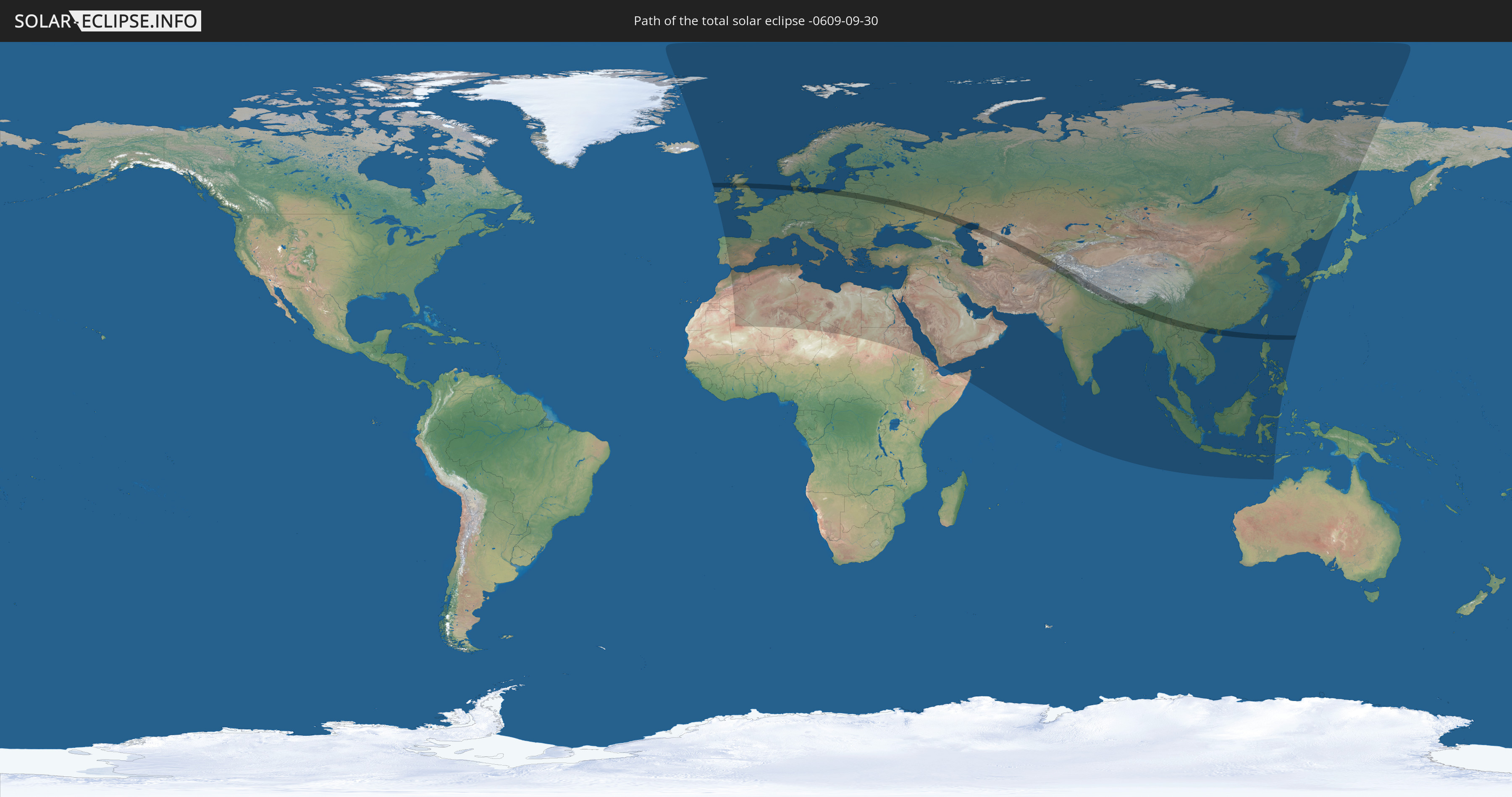
Die Sonnenfinsternis am 30.09.-0609 kann man in 117 Ländern als partielle Sonnenfinsternis beobachten.
Der Finsternispfad verläuft durch 24 Länder. Nur in diesen Ländern ist sie als totale Sonnenfinsternis zu sehen.
In den folgenden Ländern ist die Sonnenfinsternis total zu sehen
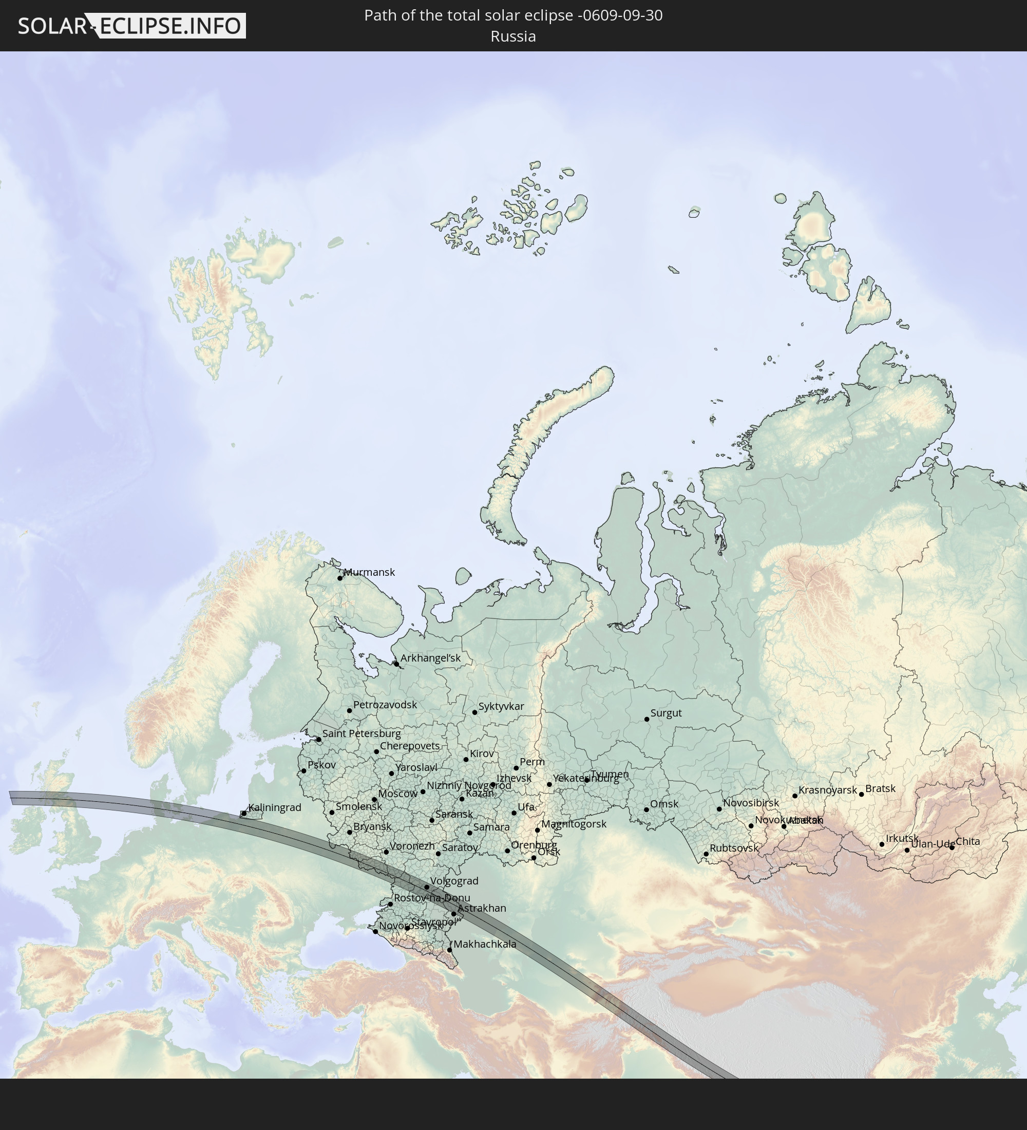 Russland
 Irland
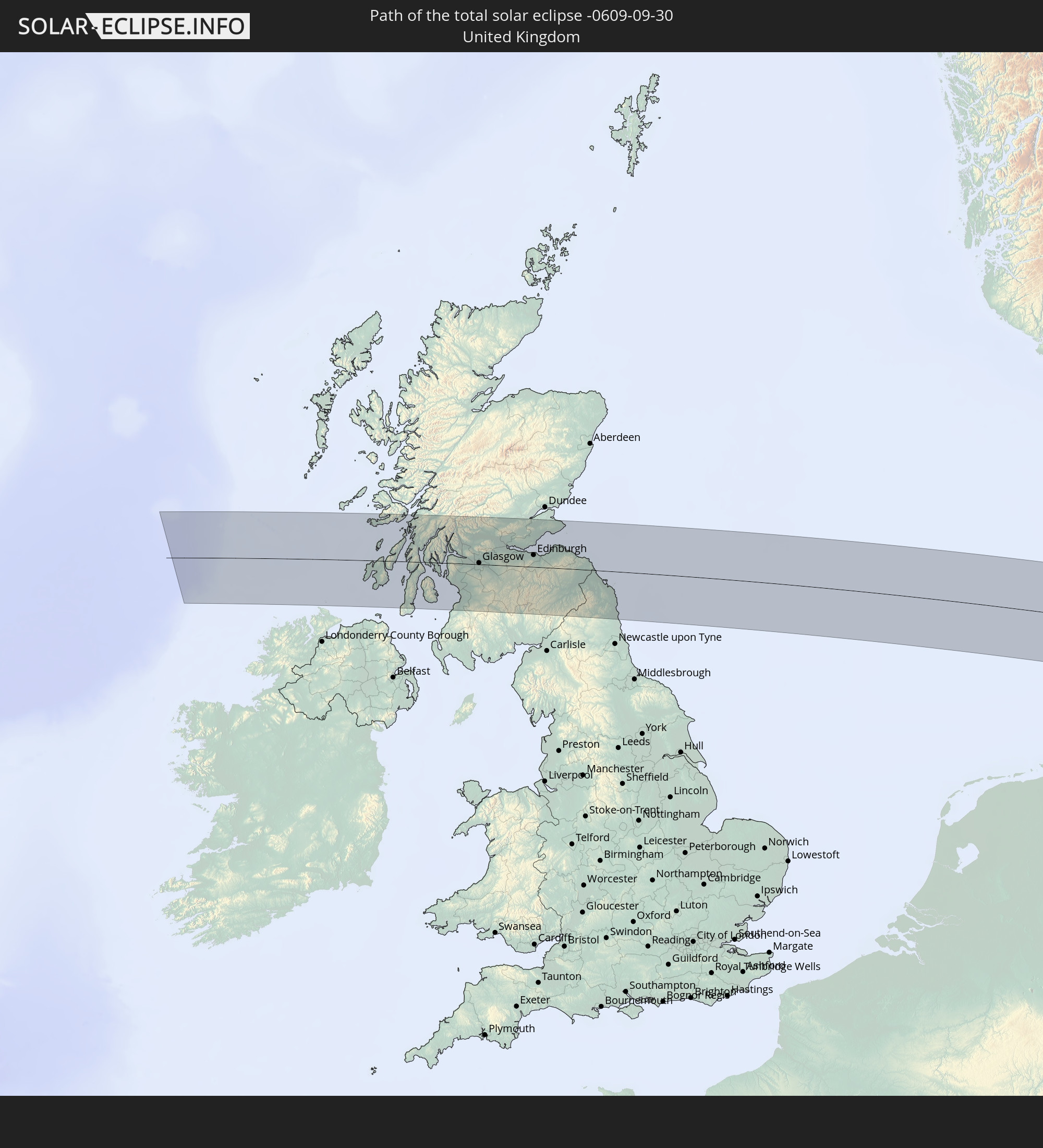 Vereinigtes Königreich
 Deutschland
 Dänemark
 Polen
Polen
 Litauen
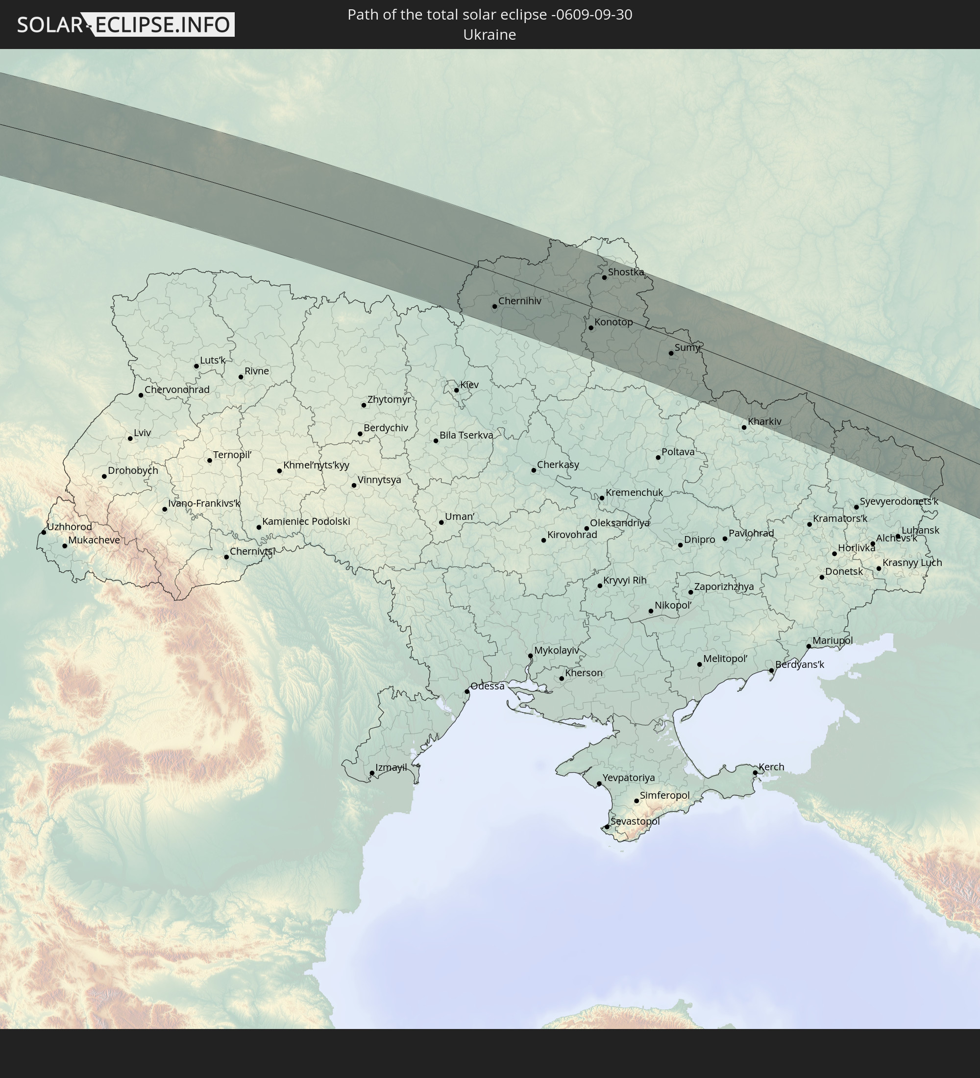 Ukraine
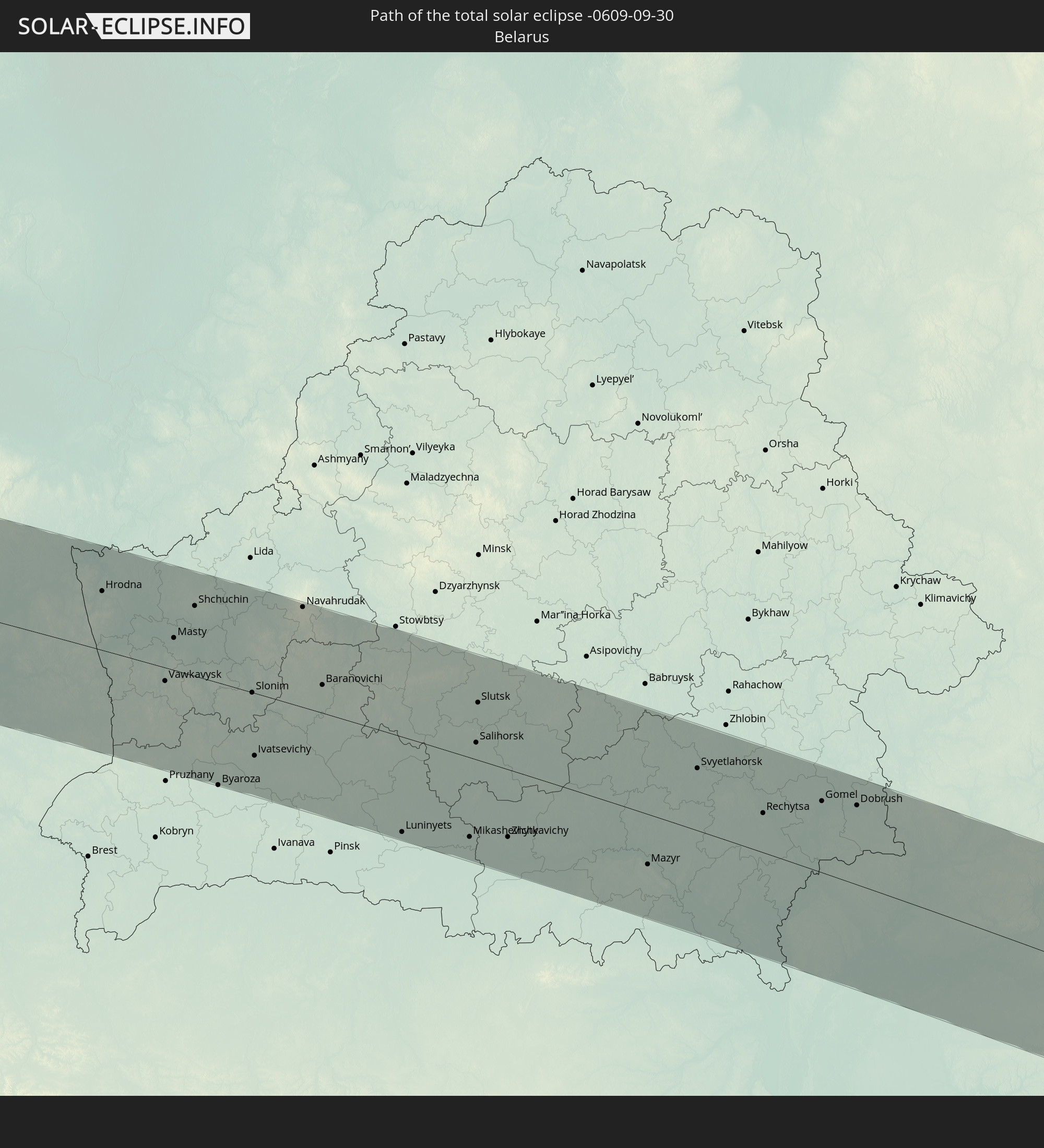 Weißrussland
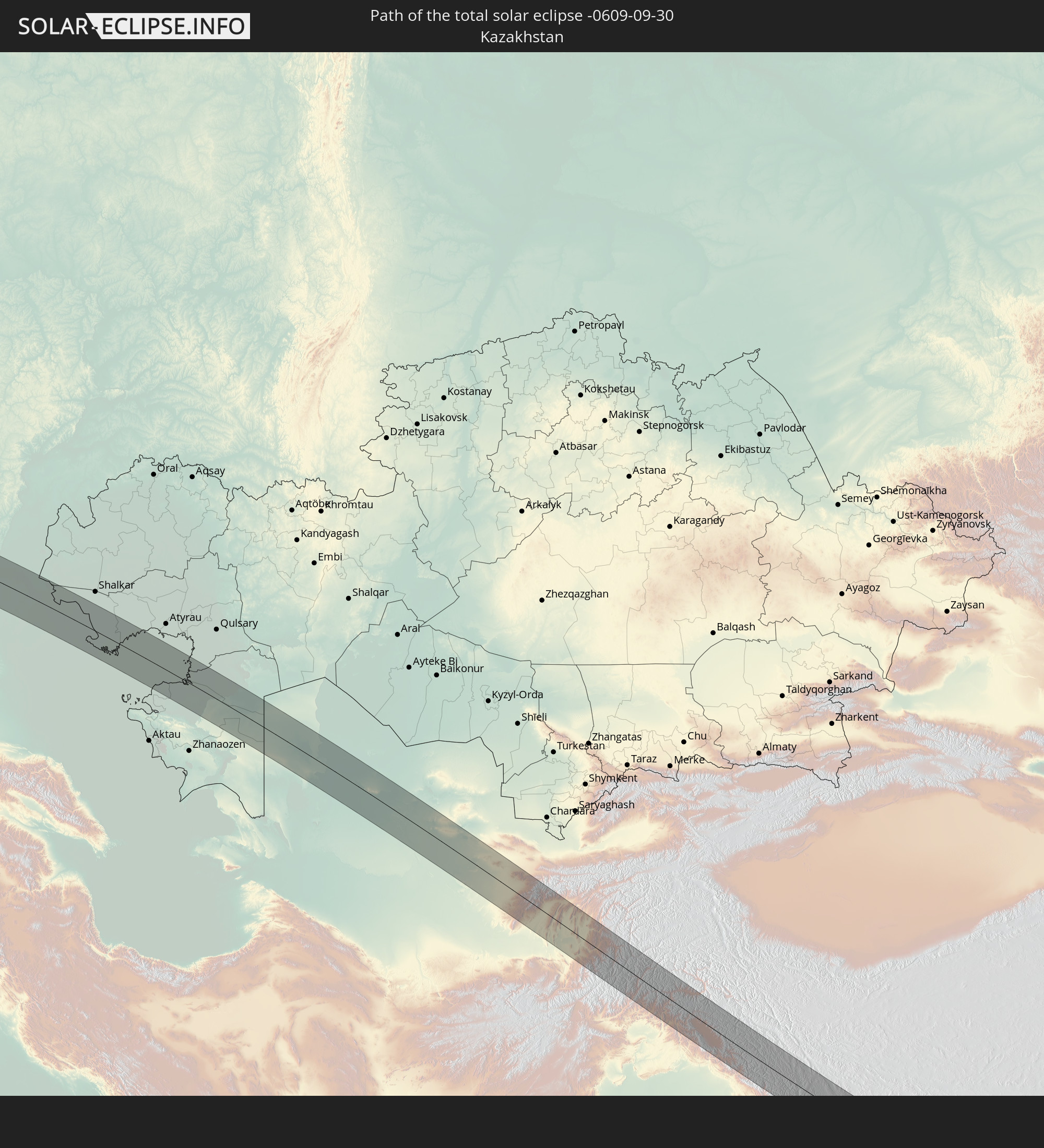 Kasachstan
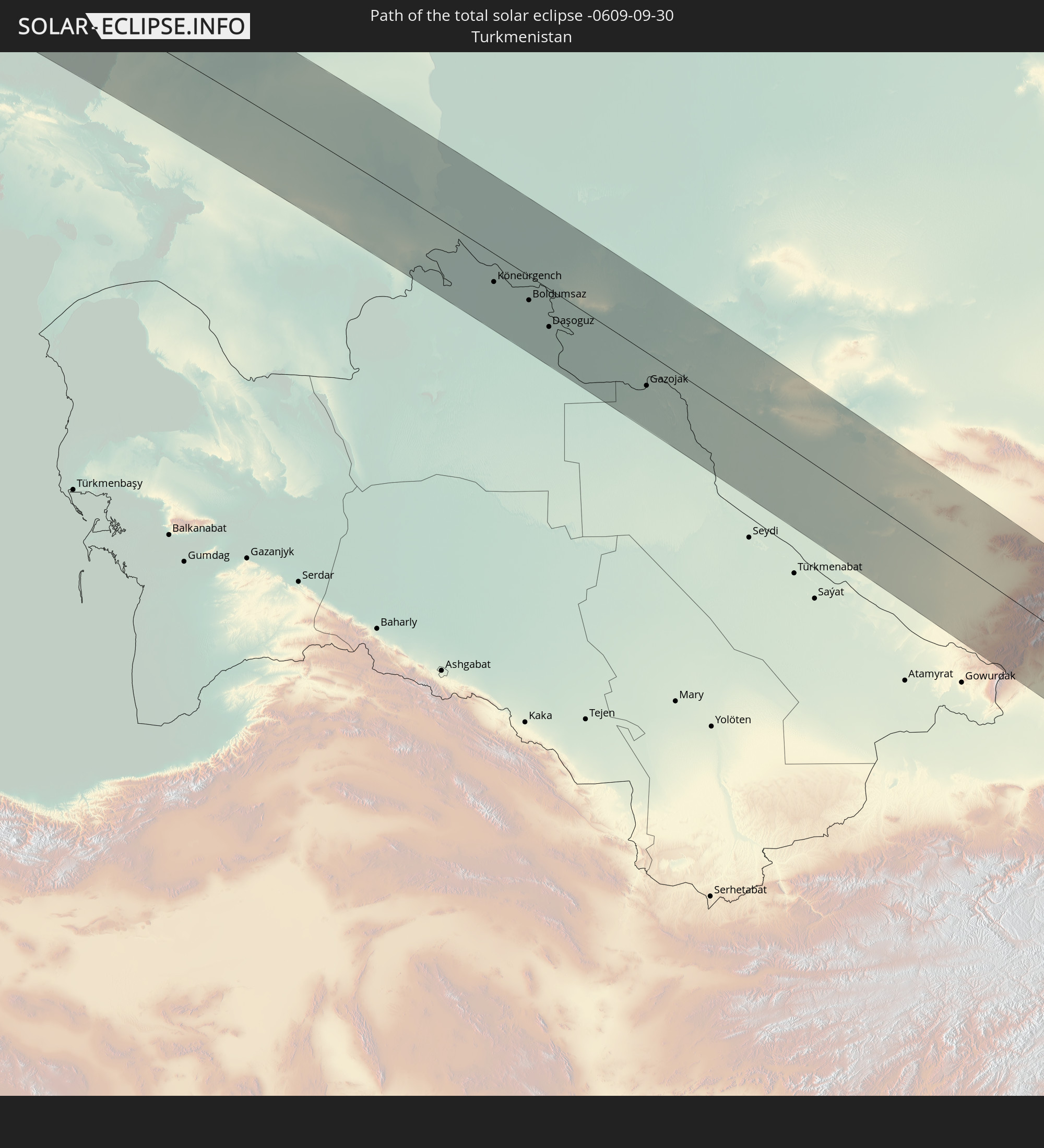 Turkmenistan
 Usbekistan
 Afghanistan
 Pakistan
 Tadschikistan
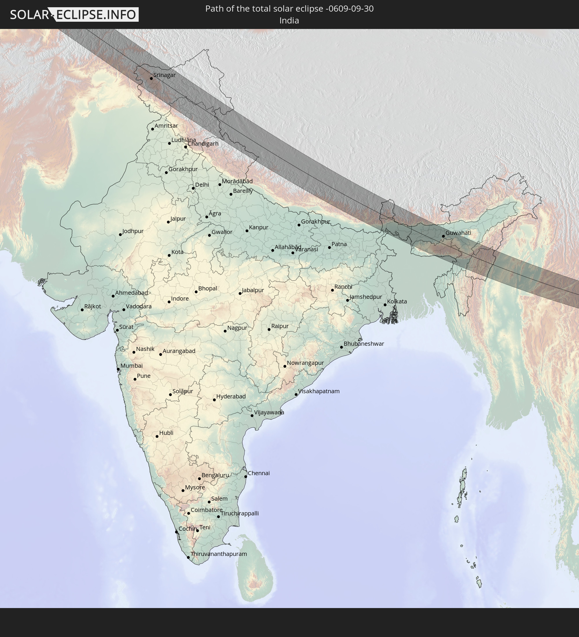 Indien
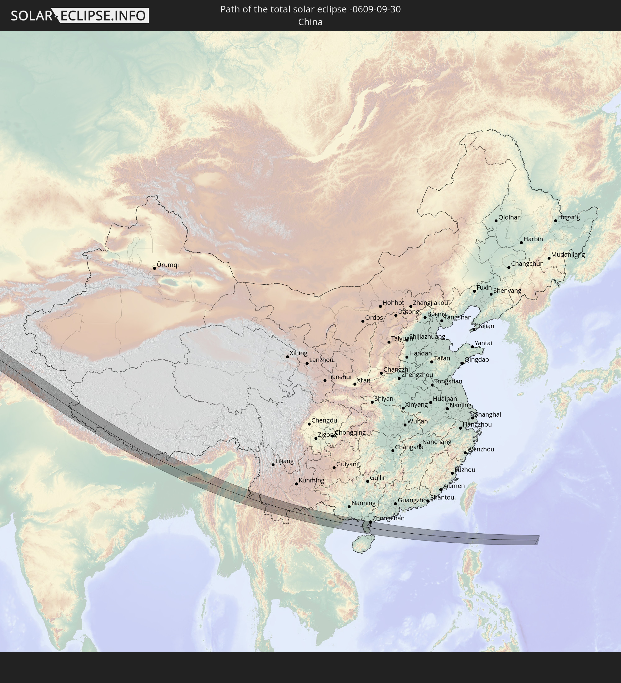 Volksrepublik China
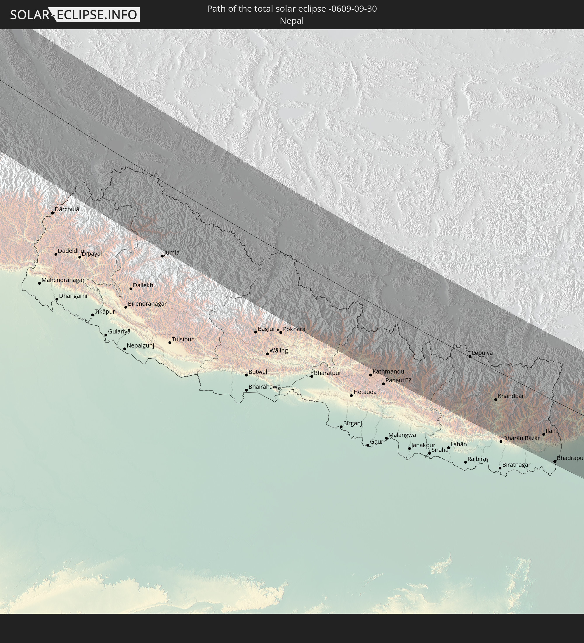 Nepal
Nepal
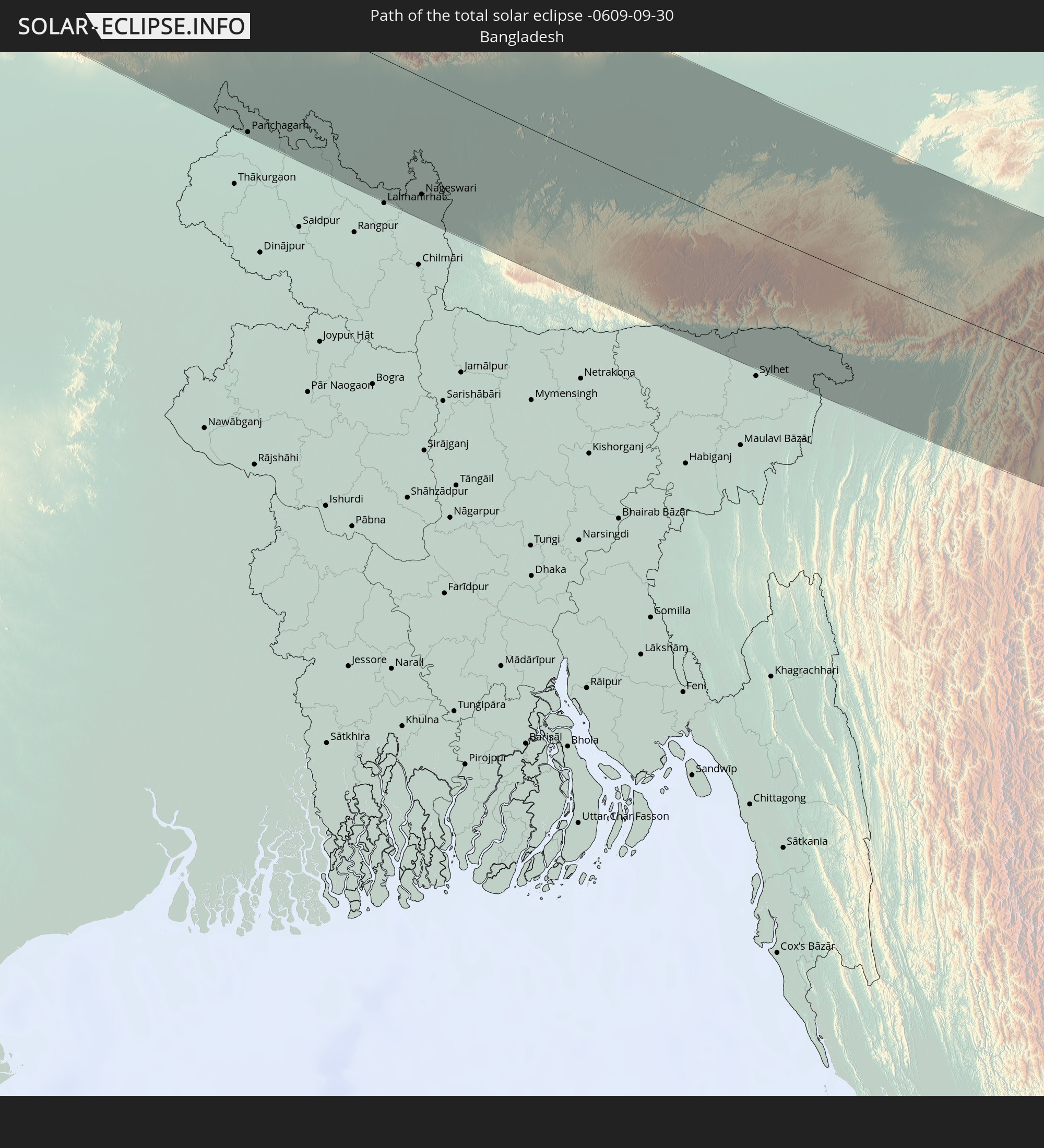 Bangladesch
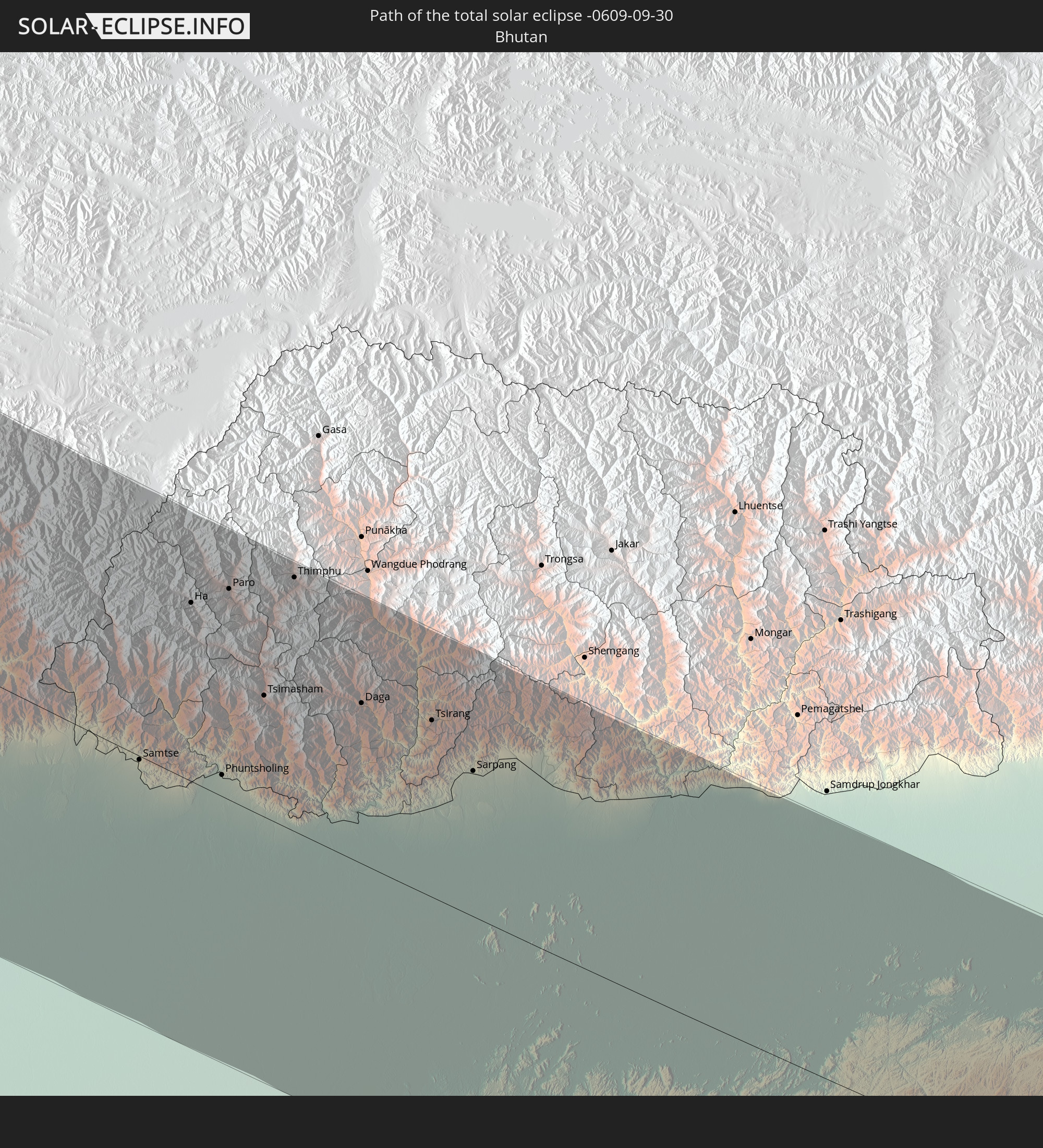 Bhutan
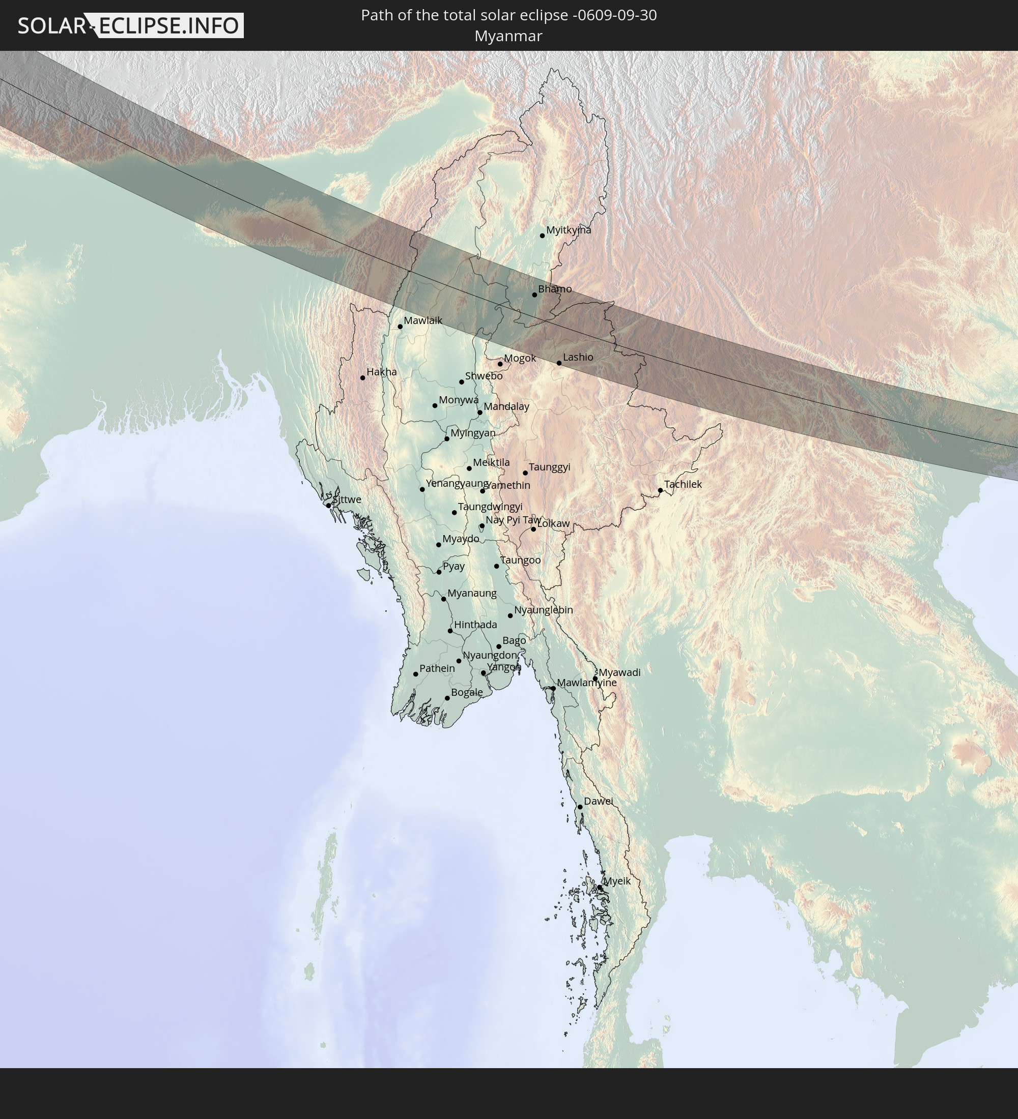 Myanmar
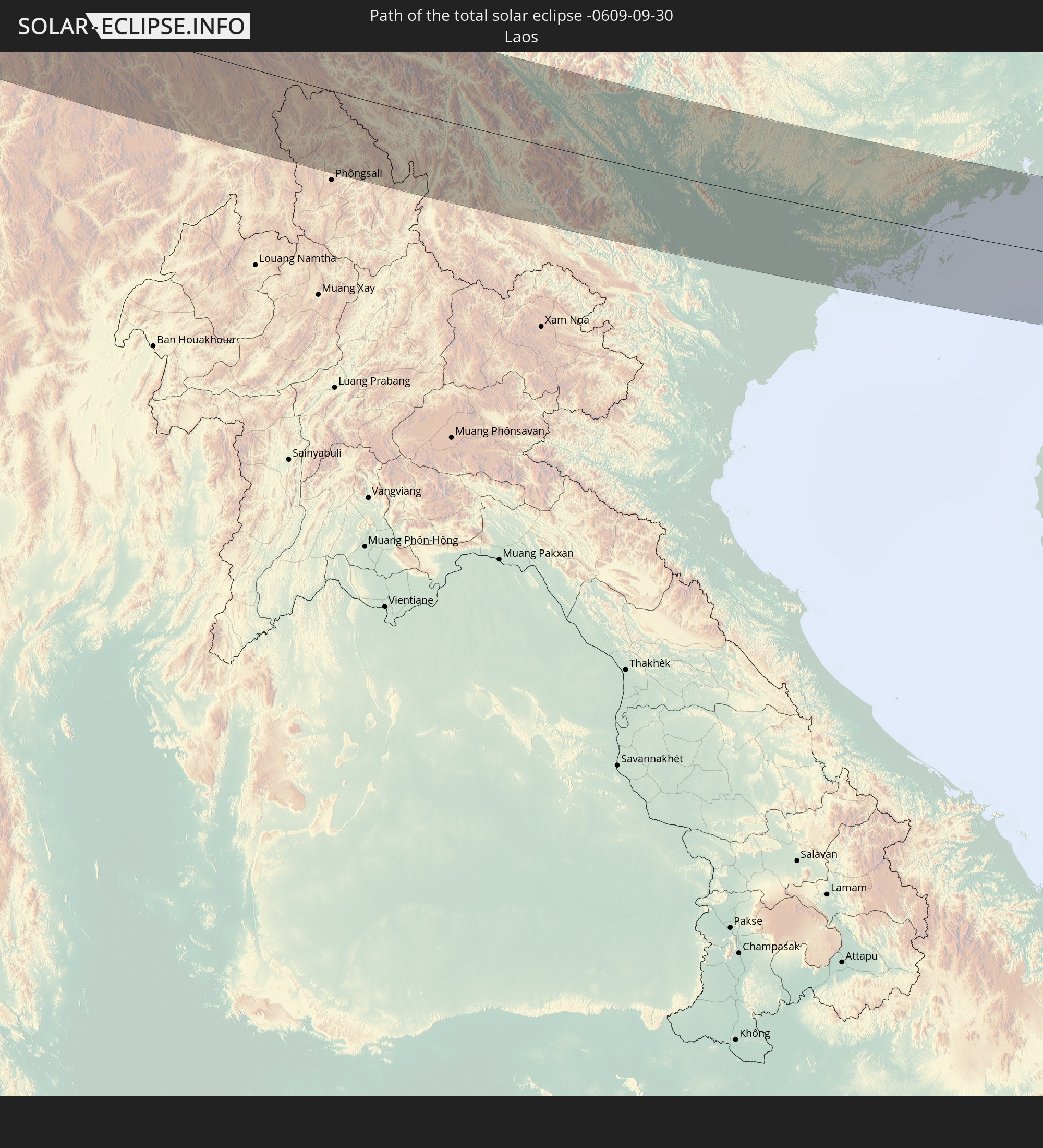 Laos
Laos
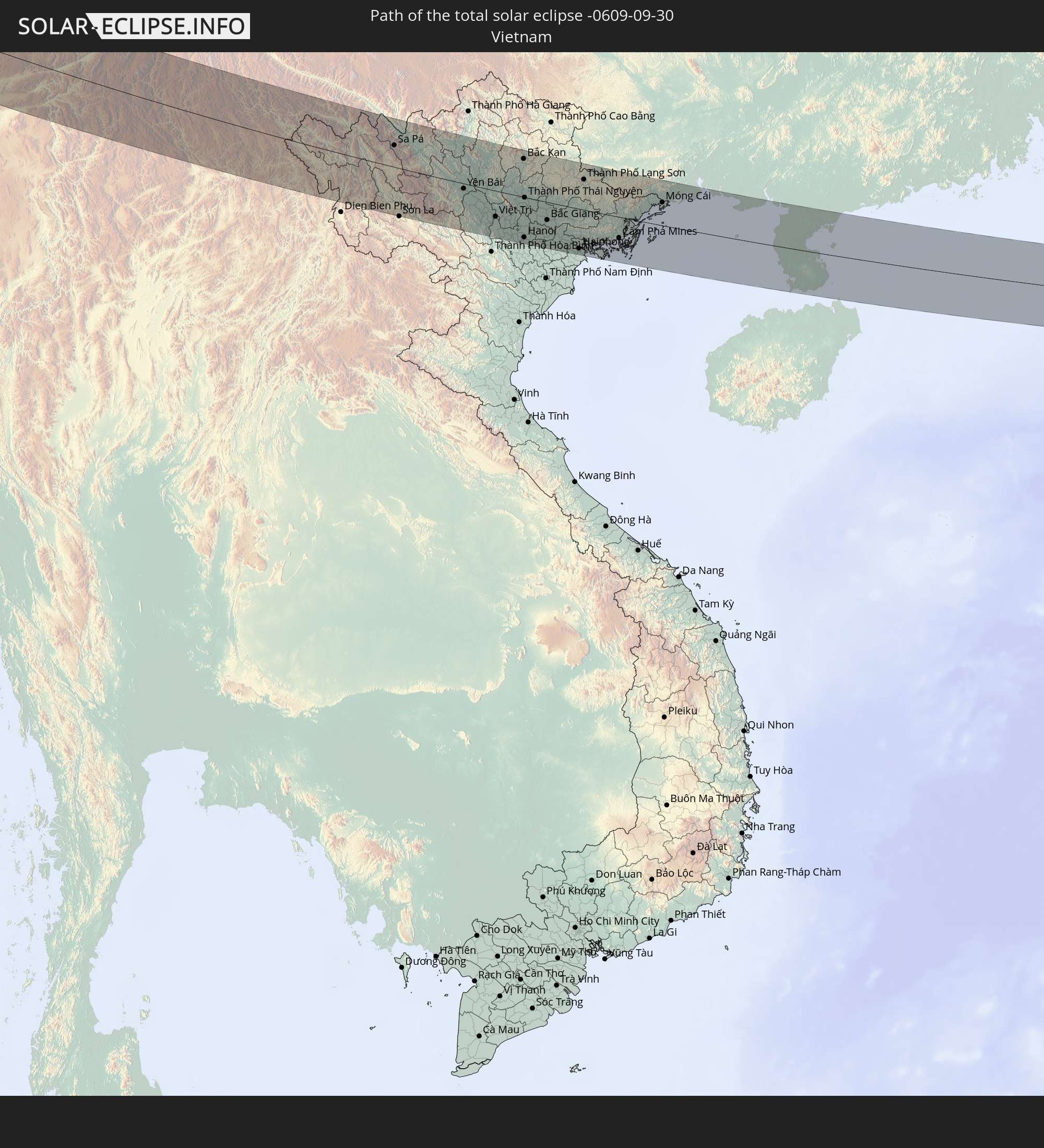 Vietnam
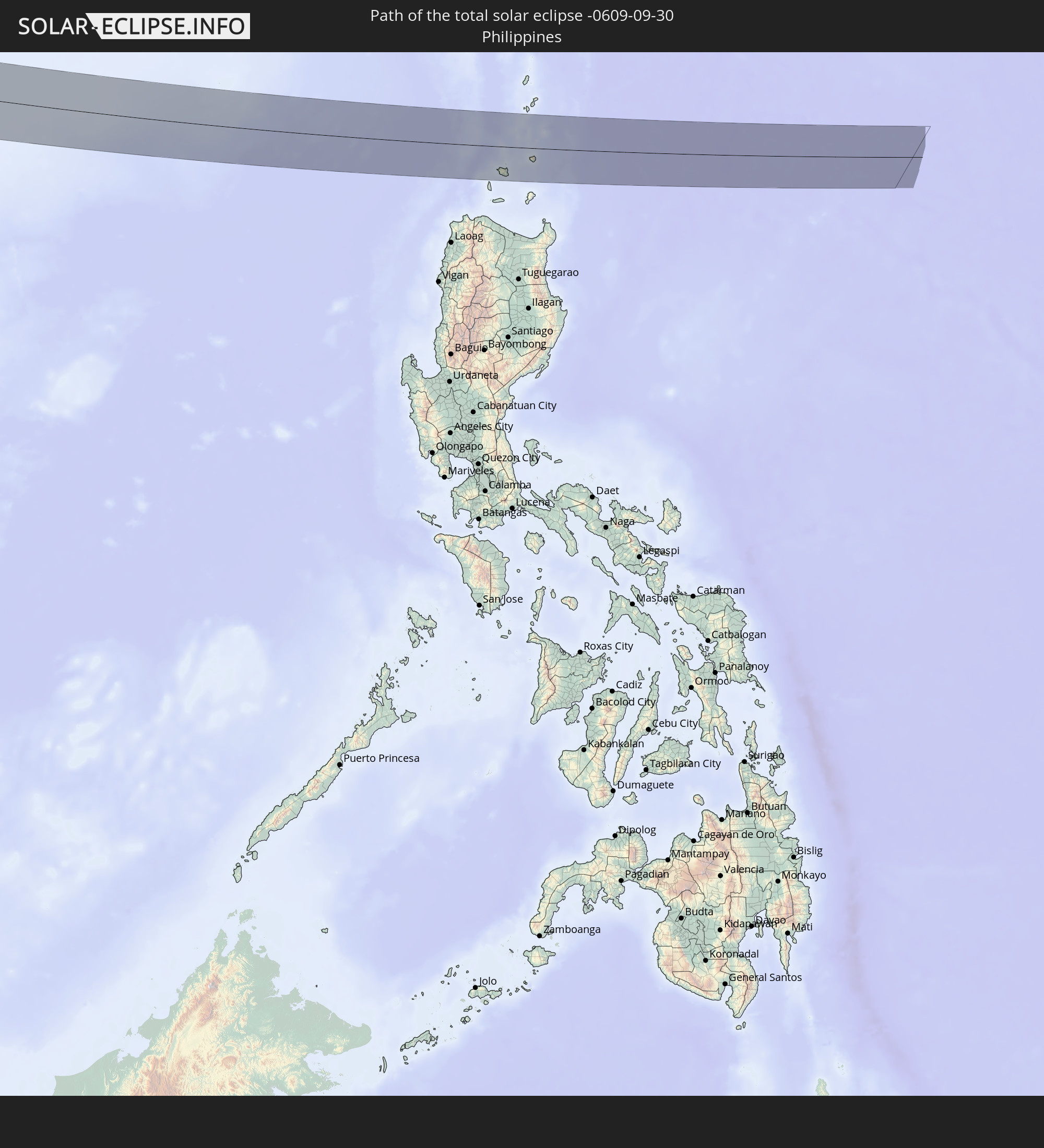 Philippinen
In den folgenden Ländern ist die Sonnenfinsternis partiell zu sehen
 Russland
 Grönland
 Portugal
 Spanien
 Mauretanien
 Marokko
 Mali
Mali
 Irland
 Spitzbergen
 Algerien
 Vereinigtes Königreich
 Färöer
 Gibraltar
 Frankreich
 Isle of Man
 Guernsey
 Jersey
 Niger
Niger
 Andorra
 Belgien
 Niederlande
 Norwegen
 Luxemburg
 Deutschland
 Schweiz
 Italien
 Monaco
 Tunesien
 Dänemark
 Libyen
 Liechtenstein
 Österreich
 Schweden
 Tschechien
 San Marino
 Vatikanstadt
 Slowenien
 Tschad
 Kroatien
 Polen
Polen
 Malta
Malta
 Bosnien und Herzegowina
 Ungarn
 Slowakei
 Montenegro
 Serbien
 Albanien
 Åland Islands
 Griechenland
 Rumänien
 Mazedonien
 Finnland
 Litauen
 Lettland
 Estland
 Sudan
Sudan
 Ukraine
 Bulgarien
 Weißrussland
 Ägypten
 Türkei
 Moldawien
 Republik Zypern
 Äthiopien
 Staat Palästina
 Israel
 Saudi-Arabien
 Jordanien
 Libanon
 Syrien
 Eritrea
 Irak
Irak
 Georgien
 Somalia
 Jemen
Jemen
 Armenien
 Iran
Iran
 Aserbaidschan
 Kasachstan
 Kuwait
 Bahrain
 Katar
Katar
 Vereinigte Arabische Emirate
 Oman
Oman
 Turkmenistan
 Usbekistan
 Afghanistan
 Pakistan
 Tadschikistan
 Indien
 Kirgisistan
 Malediven
 Volksrepublik China
 Sri Lanka
 Nepal
Nepal
 Mongolei
 Bangladesch
 Bhutan
 Myanmar
 Indonesien
 Kokosinseln
 Thailand
 Malaysia
 Laos
Laos
 Vietnam
 Kambodscha
 Singapur
 Weihnachtsinsel
 Australien
 Macau
Macau
 Hongkong
 Brunei
 Taiwan
 Philippinen
 Japan
Japan
 Nordkorea
 Südkorea
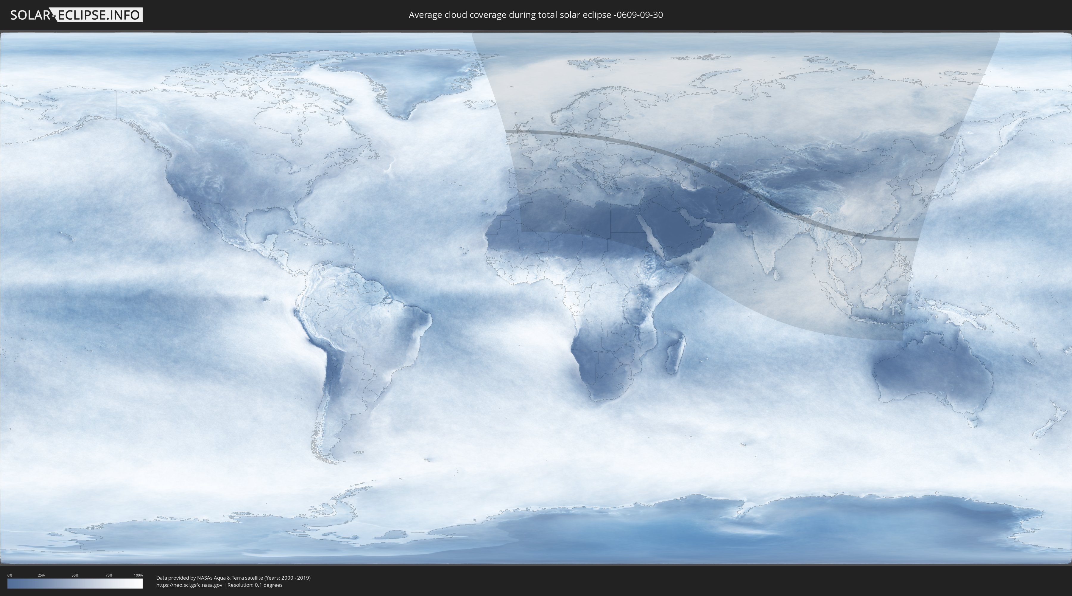
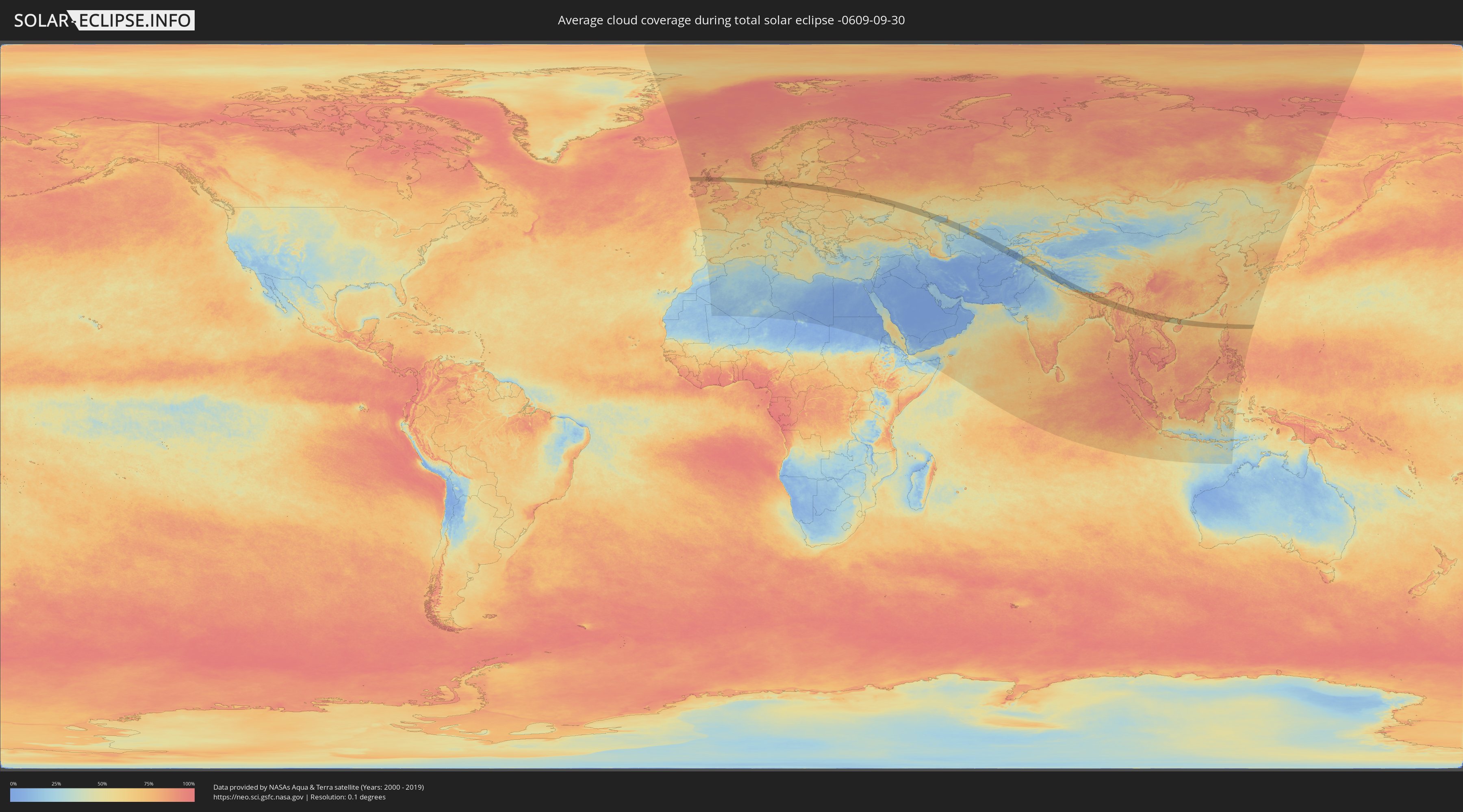
Wie wird das Wetter während der totalen Sonnenfinsternis am 30.09.-0609?
Wo ist der beste Ort, um die totale Sonnenfinsternis vom 30.09.-0609 zu beobachten?
Die folgenden Karten zeigen die durchschnittliche Bewölkung für den Tag, an dem die totale Sonnenfinsternis
stattfindet. Mit Hilfe der Karten lässt sich der Ort entlang des Finsternispfades eingrenzen,
der die besten Aussichen auf einen klaren wolkenfreien Himmel bietet.
Trotzdem muss man immer lokale Gegenenheiten beachten und sollte sich genau über das Wetter an seinem
gewählten Beobachtungsort informieren.
Die Daten stammen von den beiden NASA-Satelliten
AQUA und TERRA
und wurden über einen Zeitraum von 19 Jahren (2000 - 2019) gemittelt.
Detaillierte Länderkarten
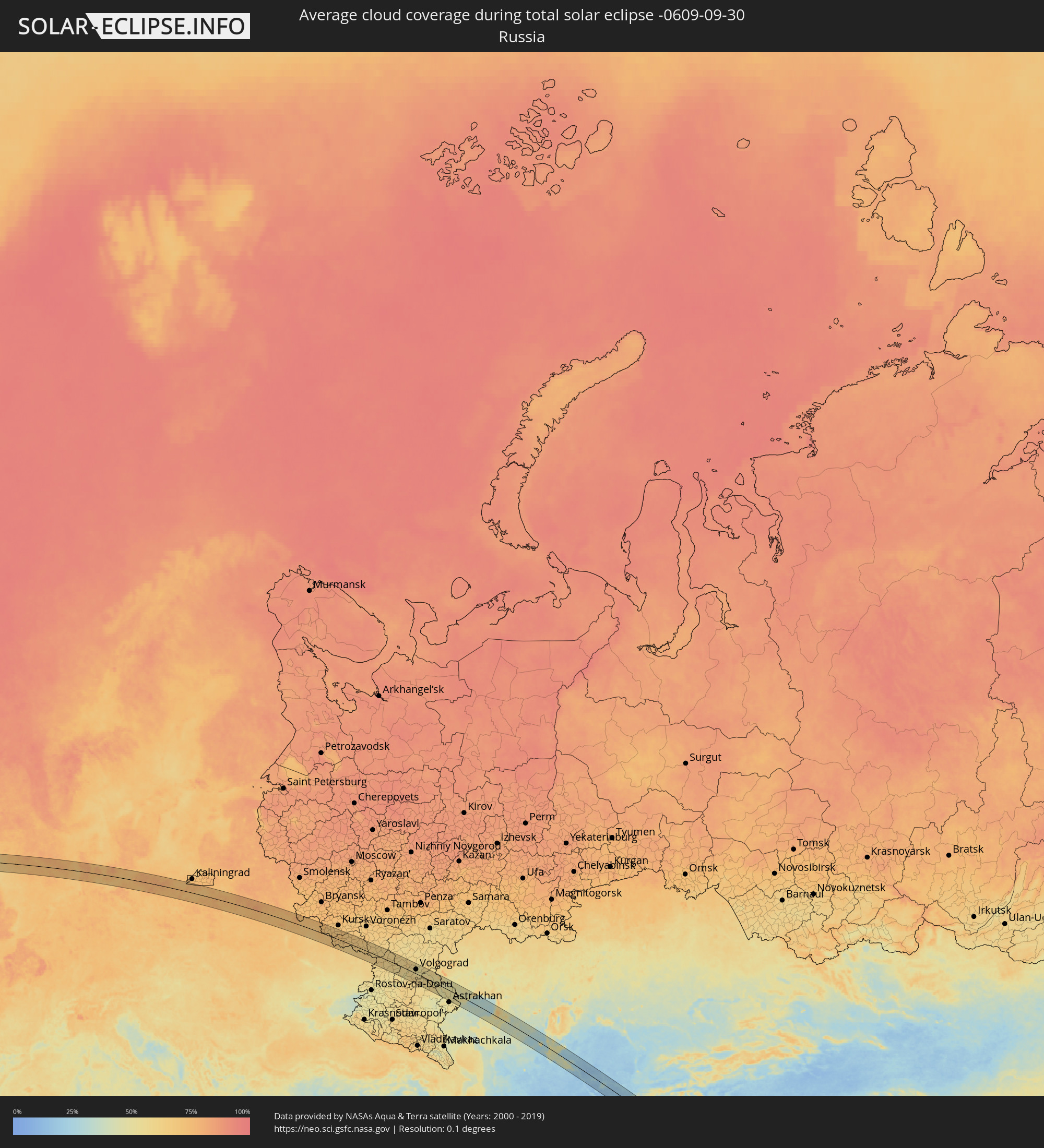 Russland
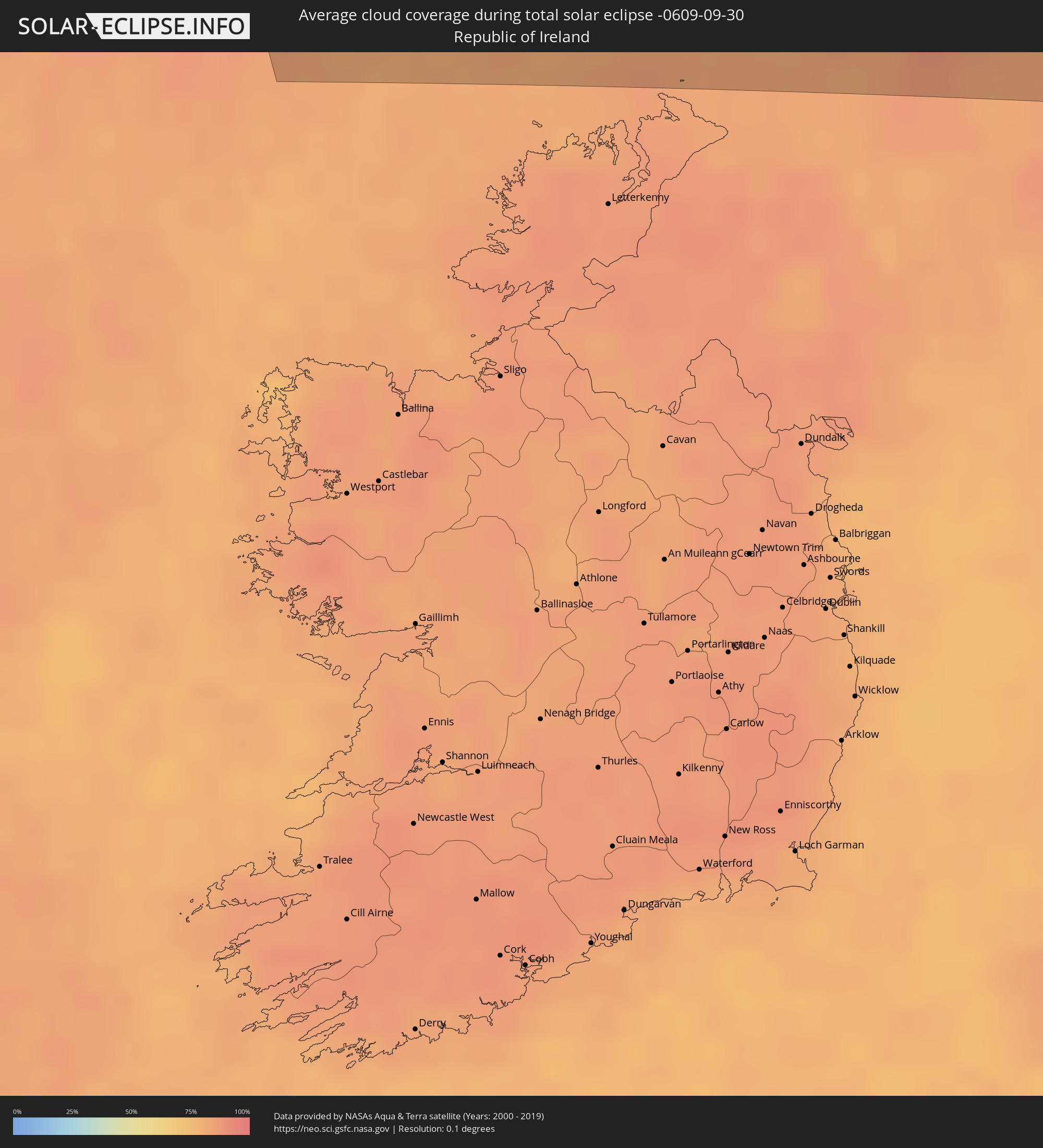 Irland
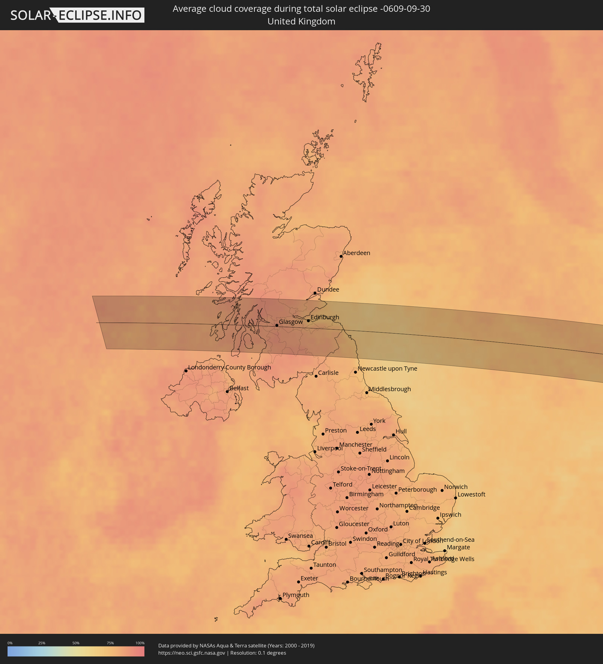 Vereinigtes Königreich
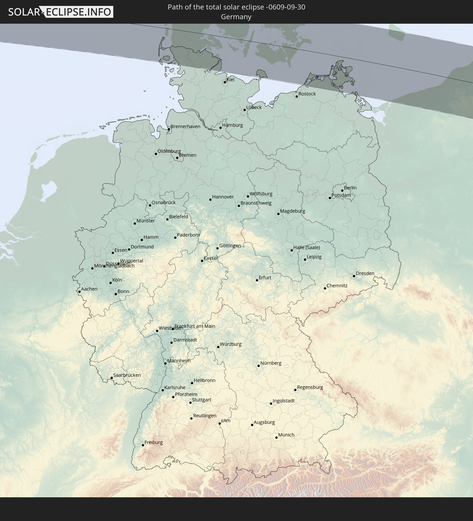
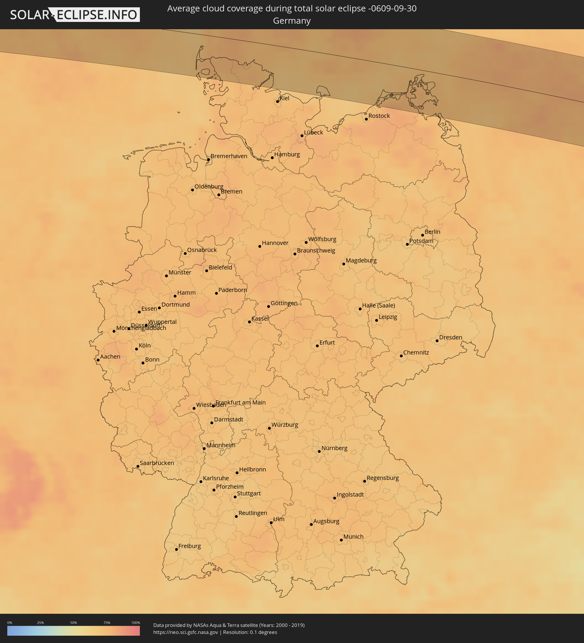 Deutschland
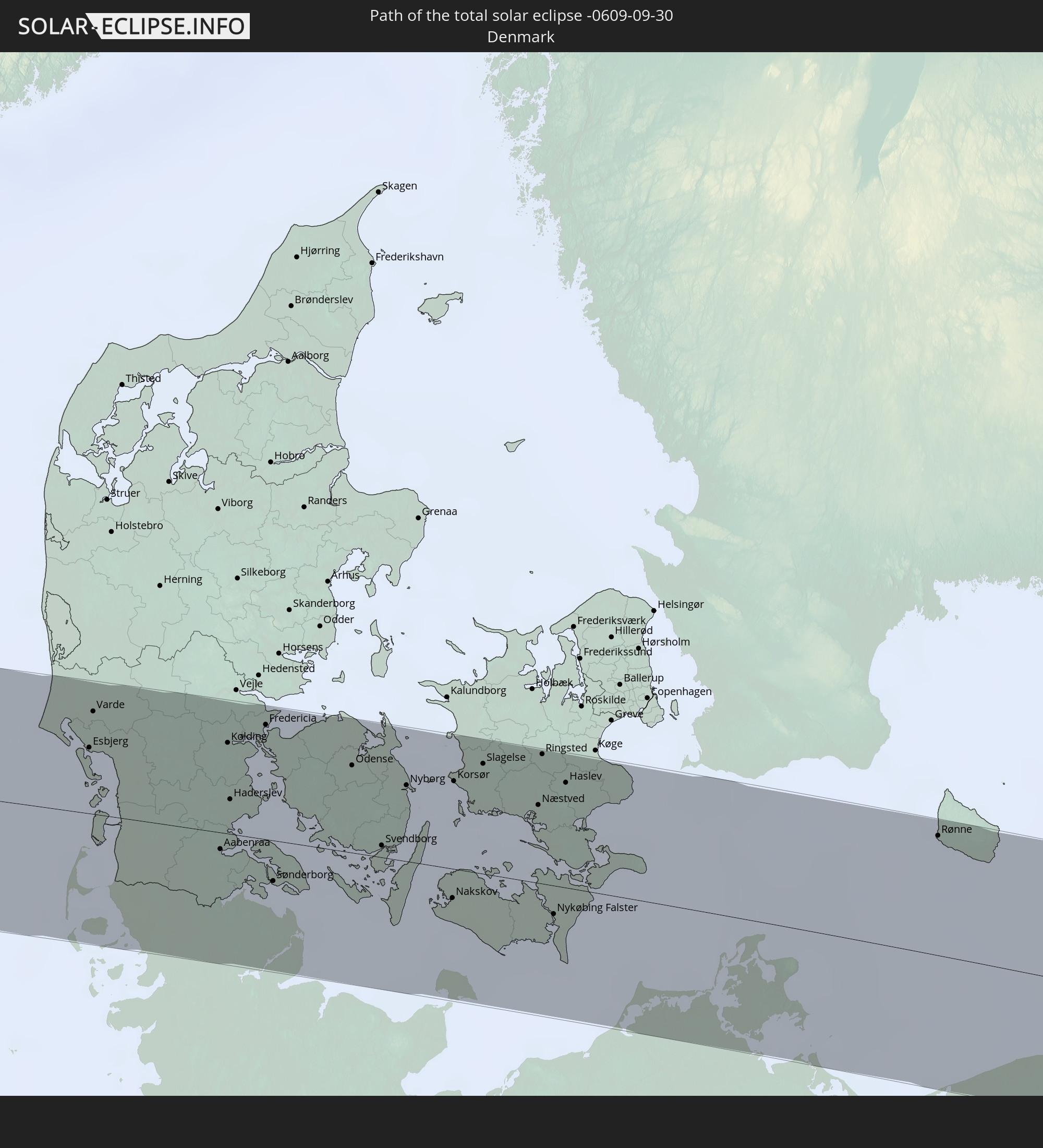
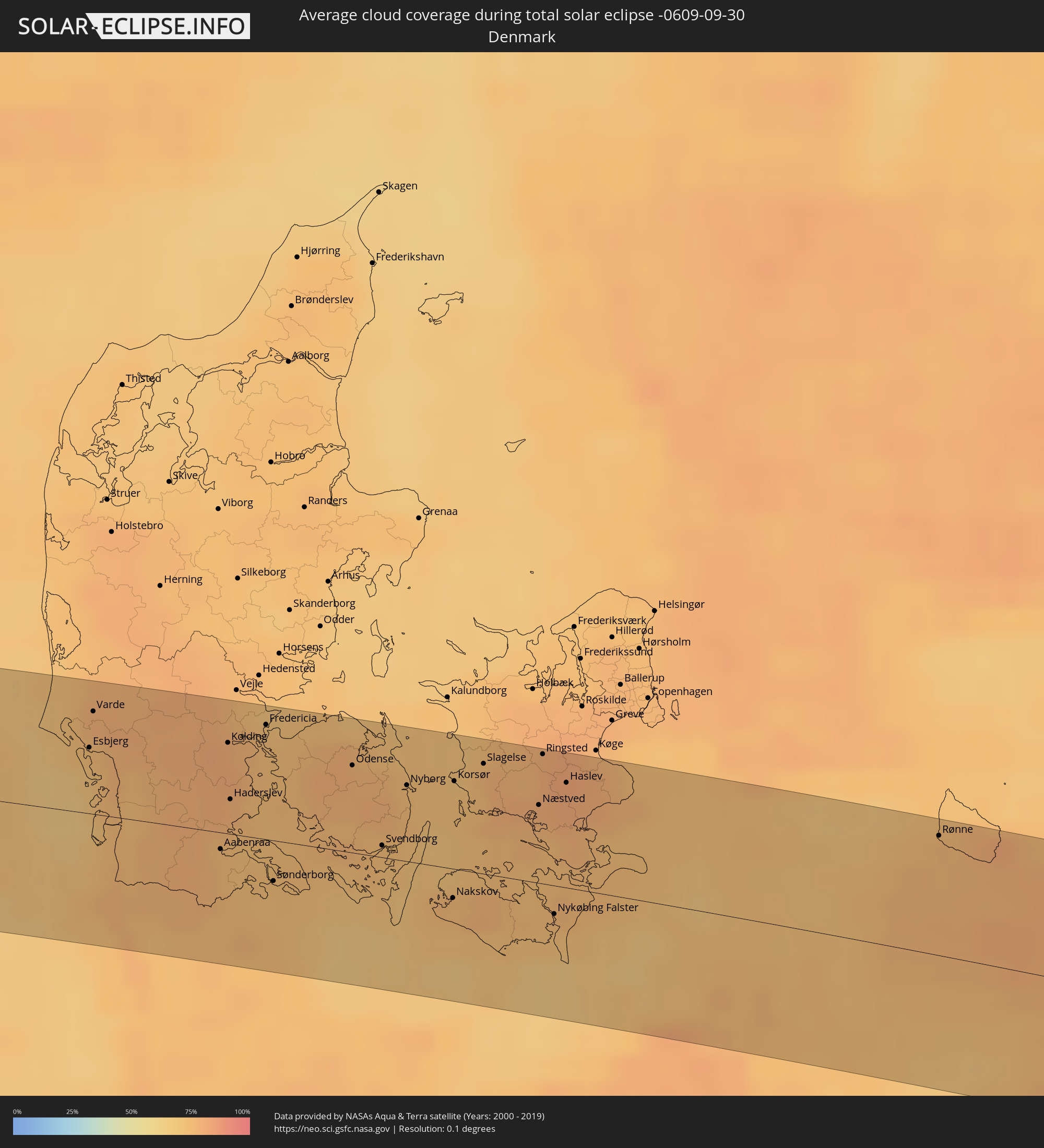 Dänemark
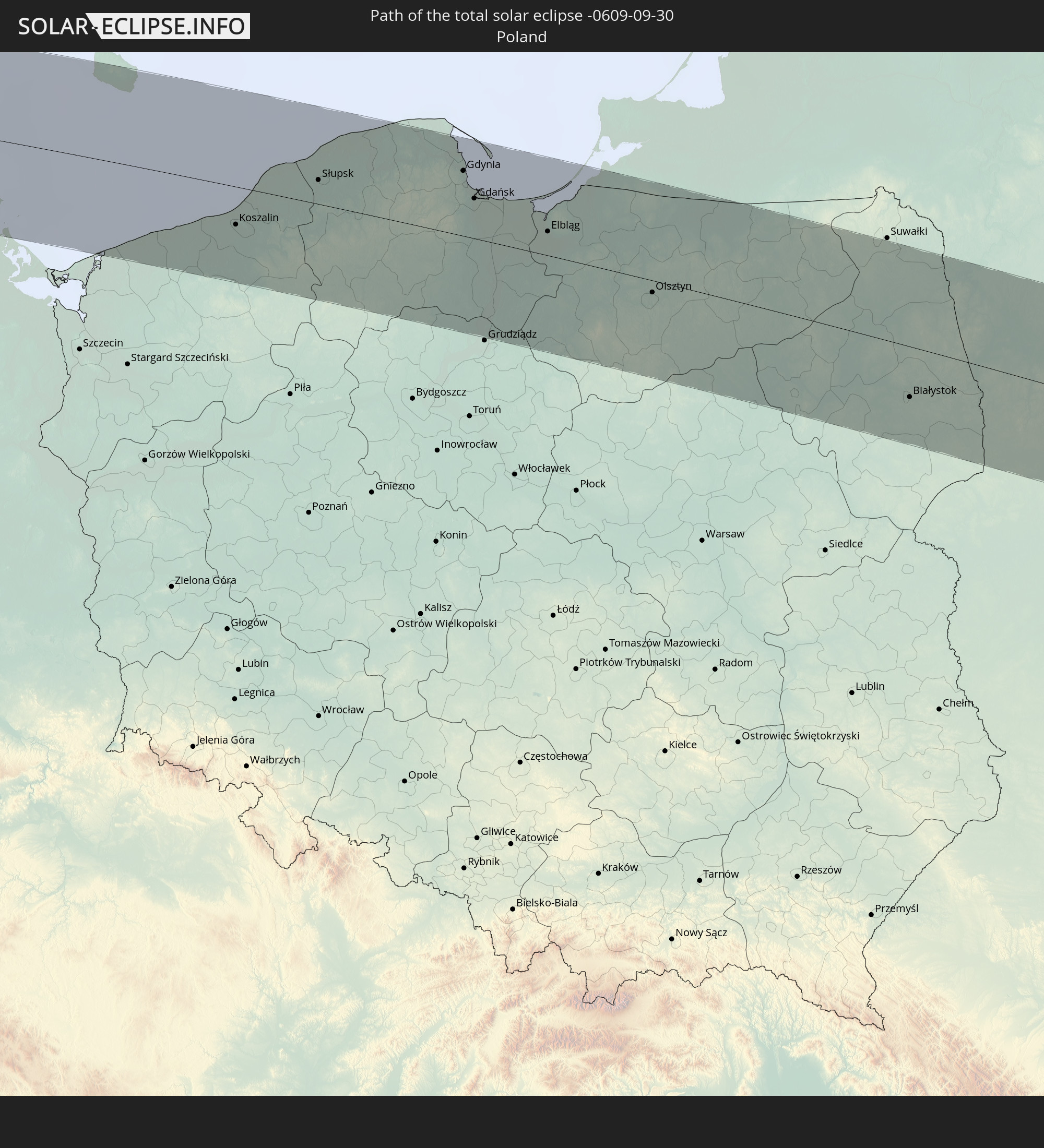
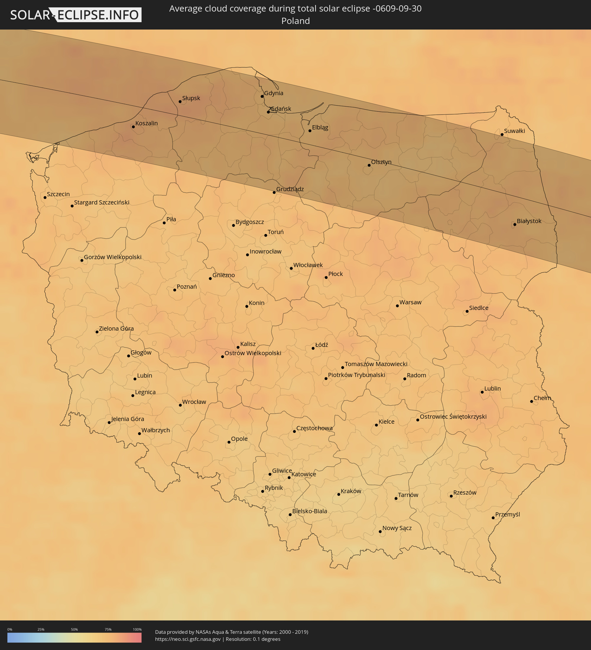 Polen
Polen
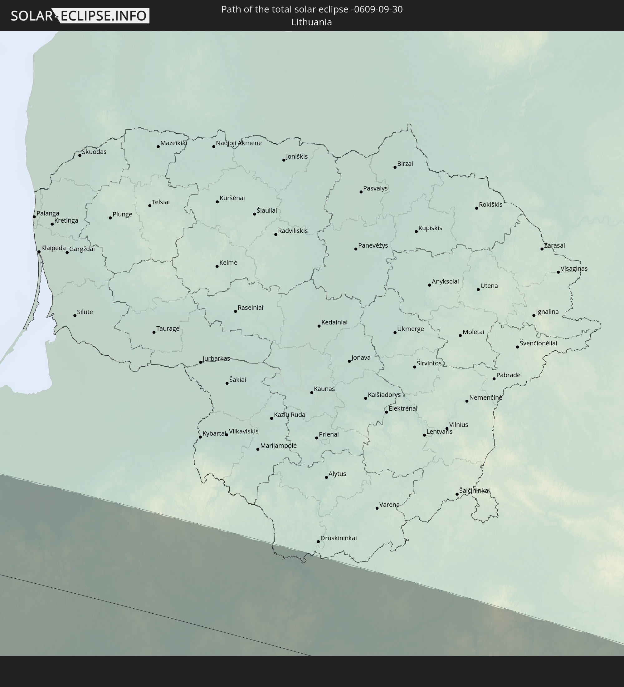
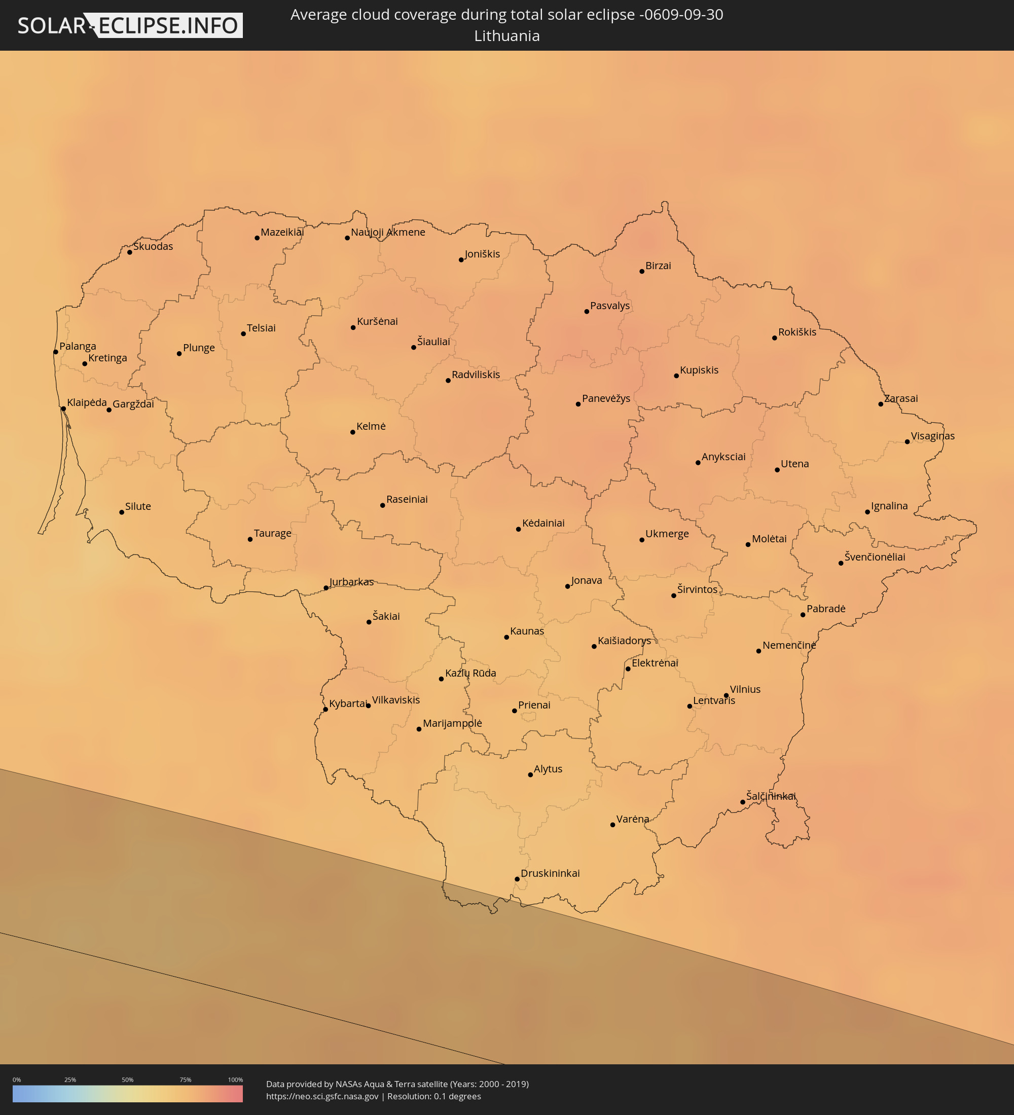 Litauen
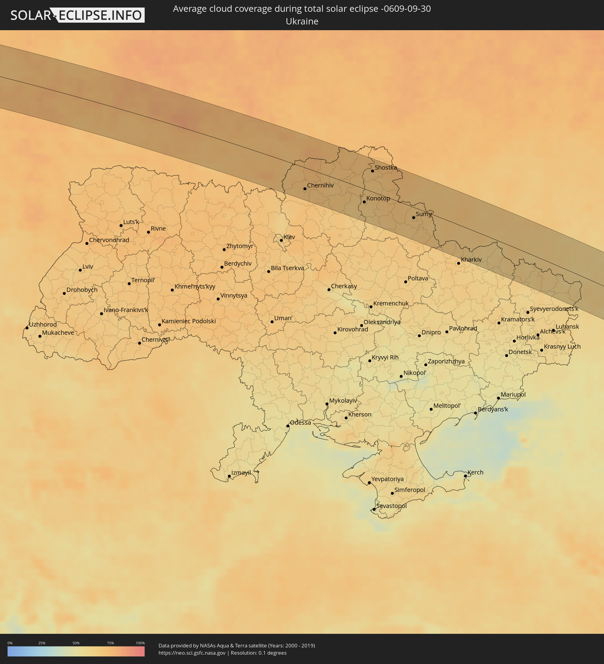 Ukraine
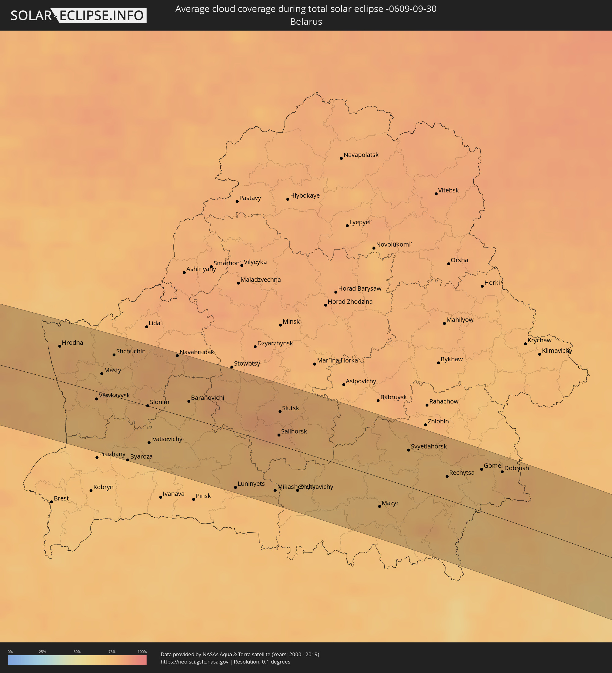 Weißrussland
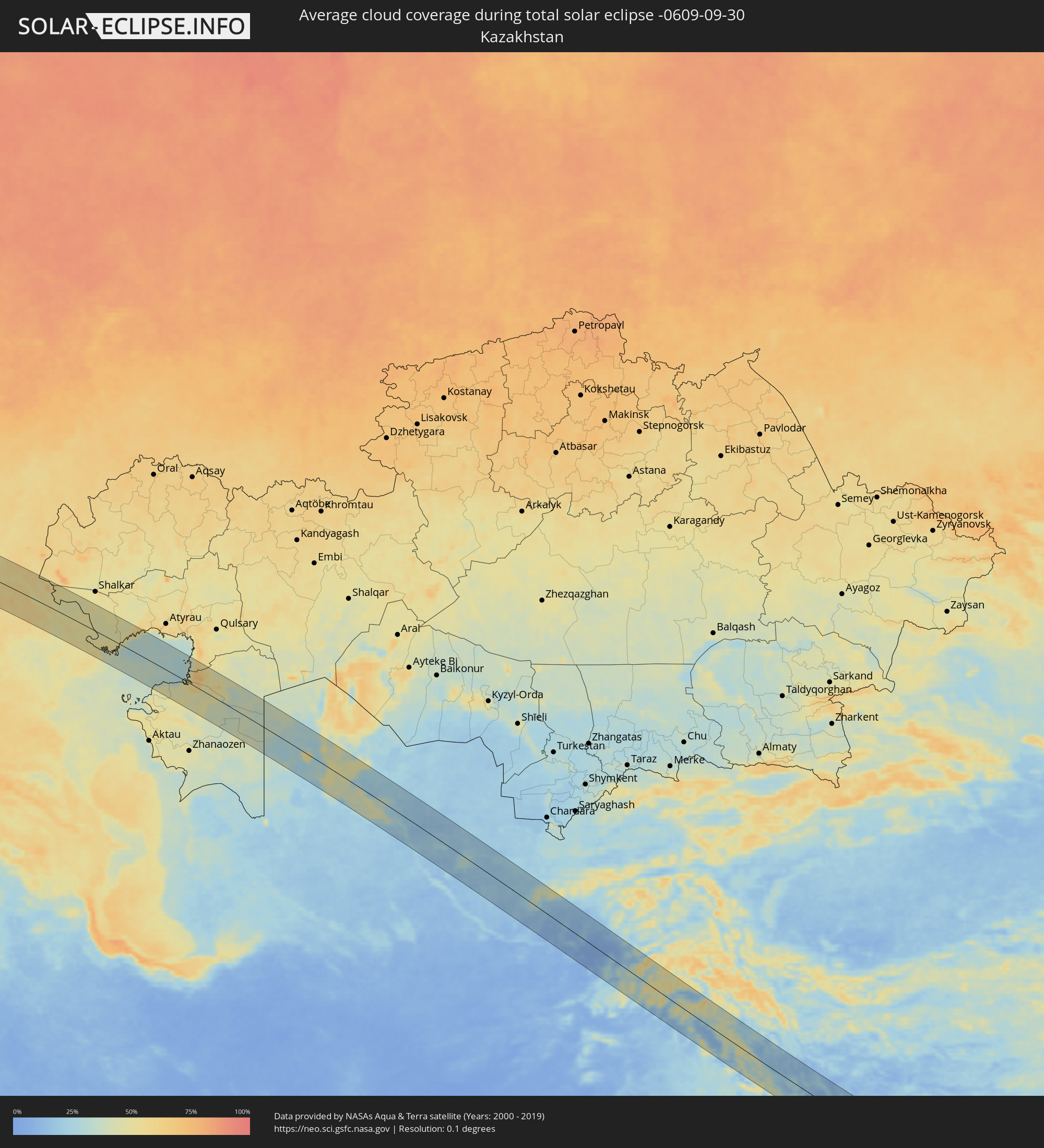 Kasachstan
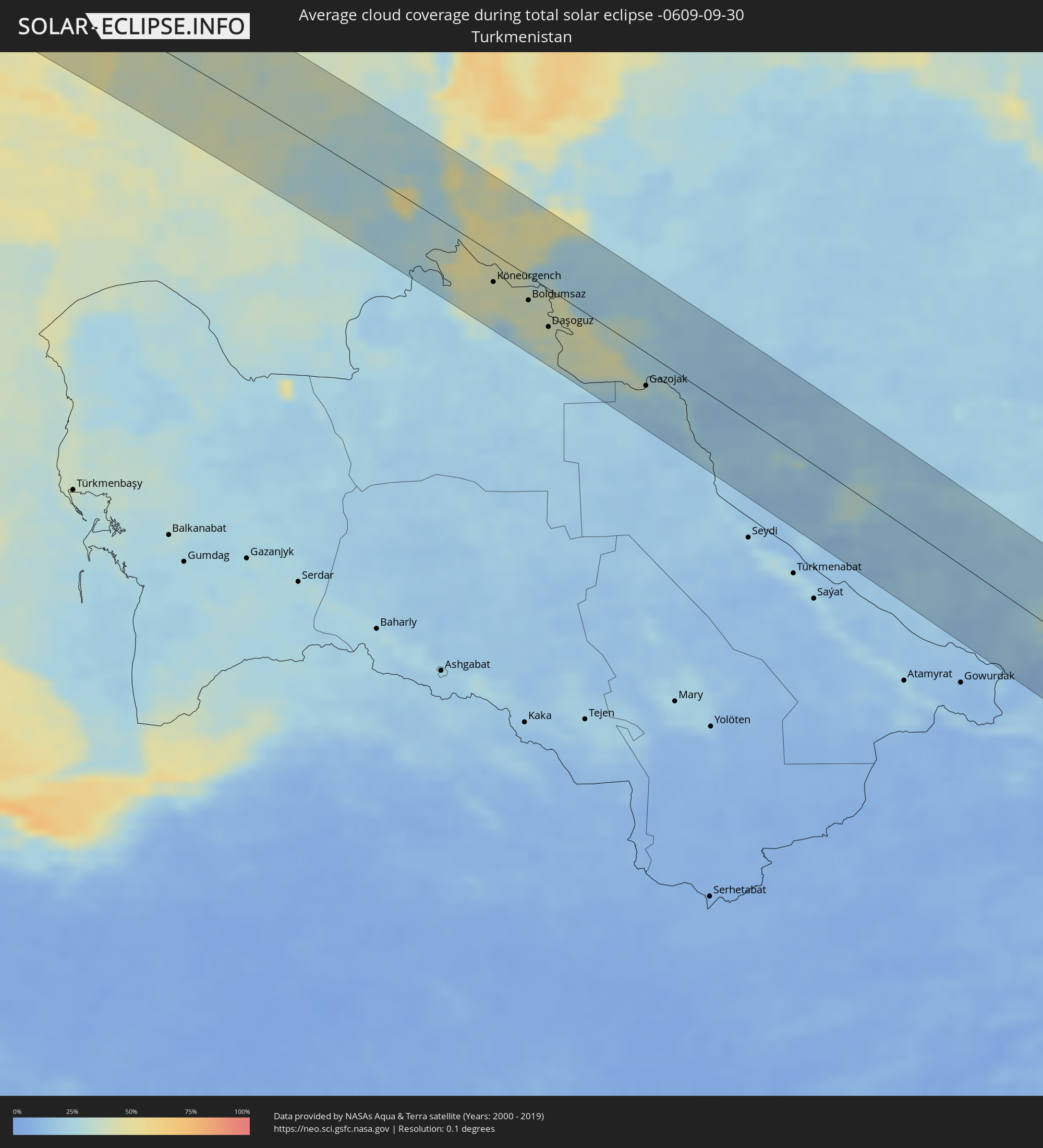 Turkmenistan
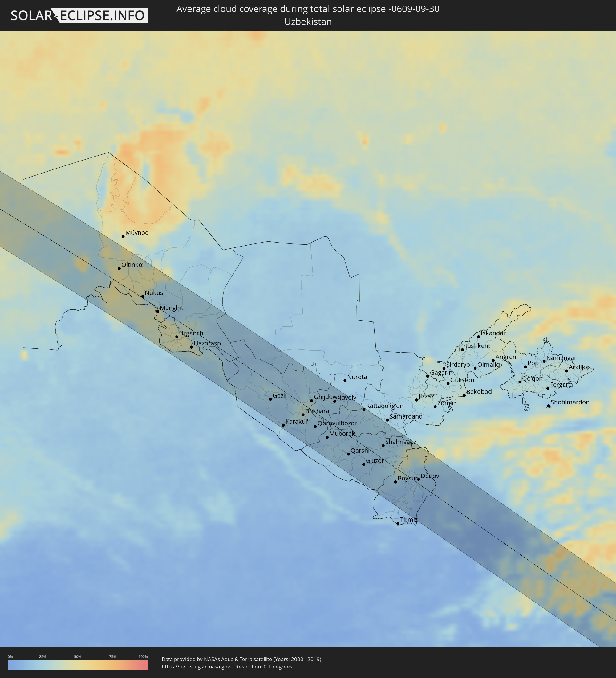 Usbekistan
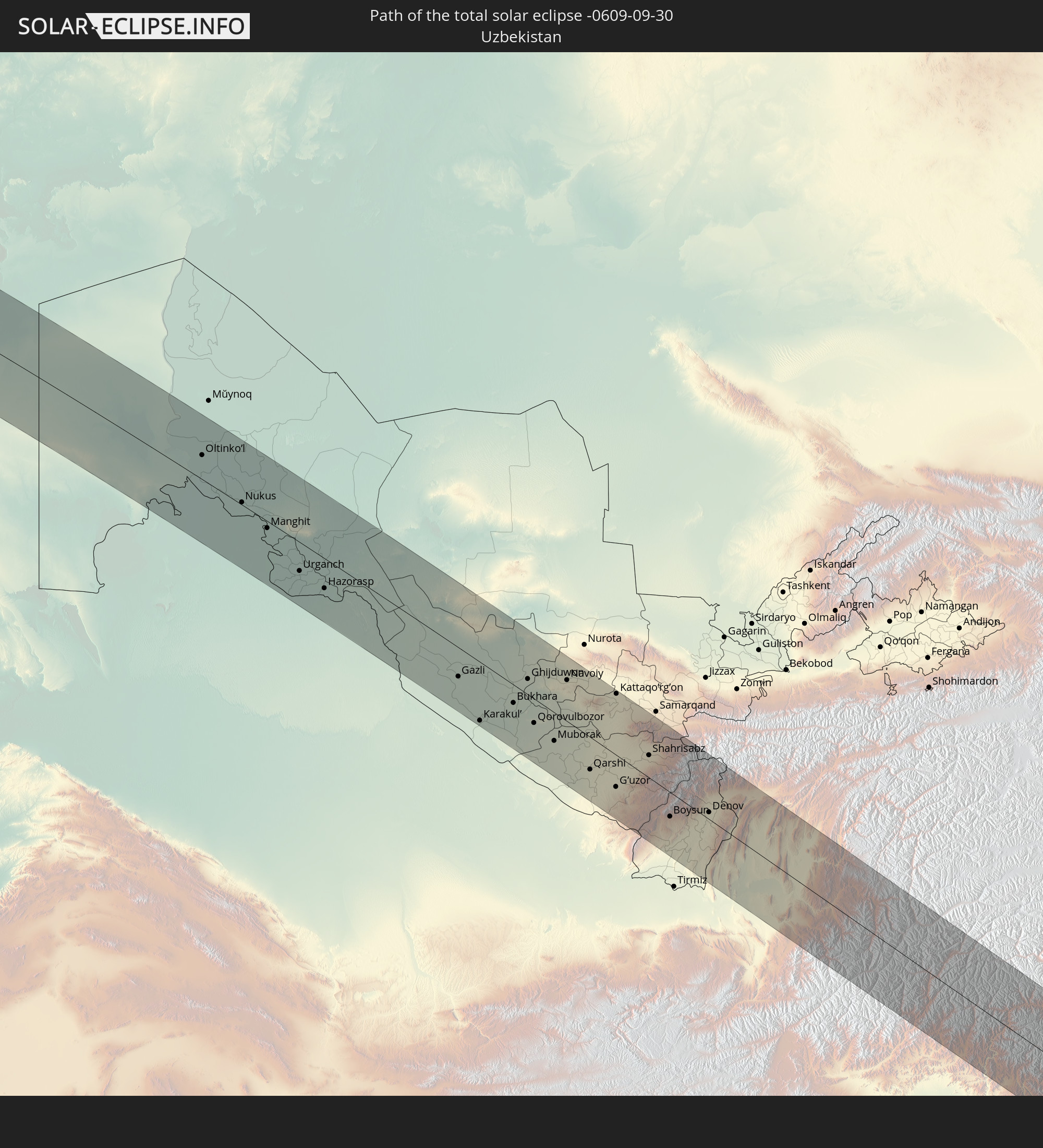
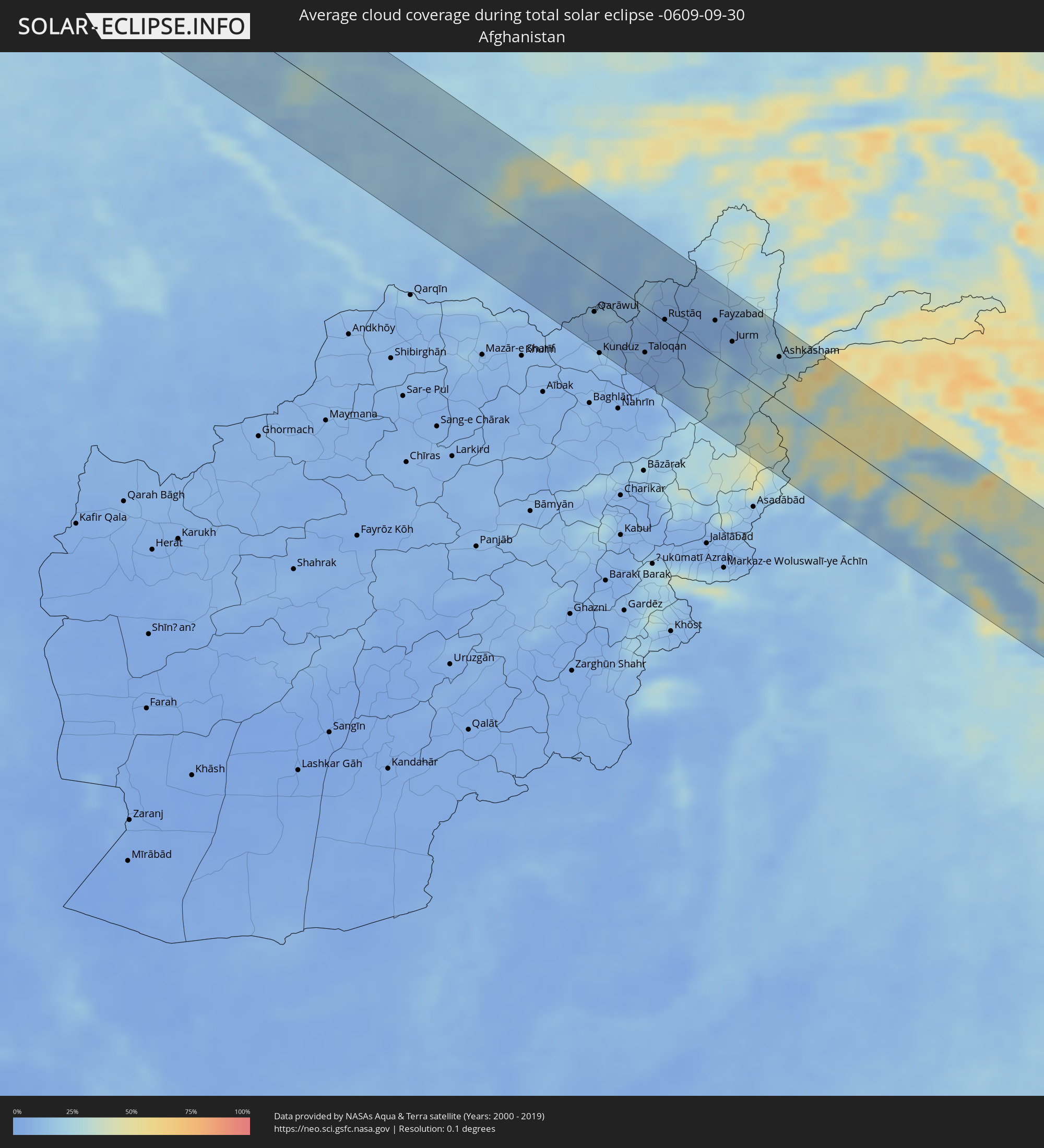 Afghanistan
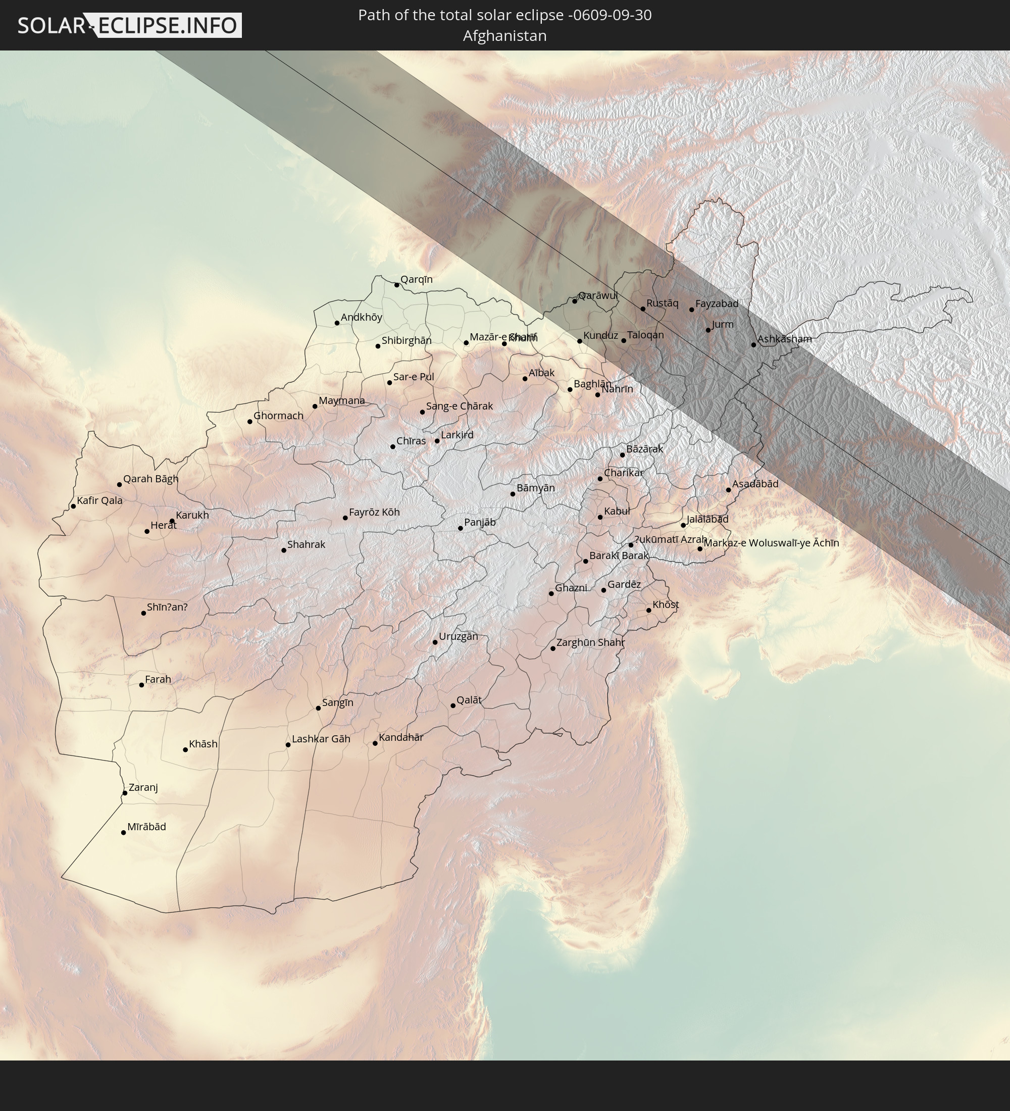
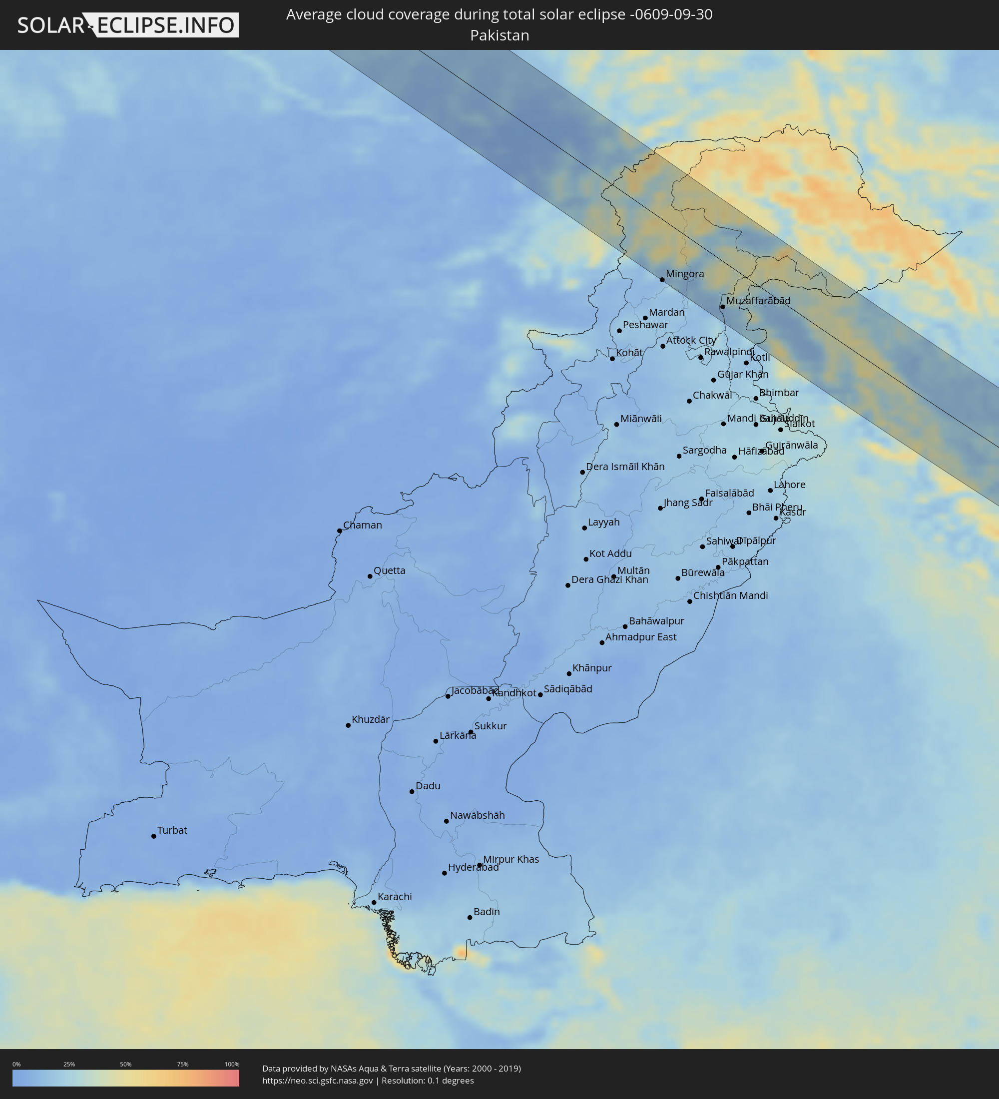 Pakistan
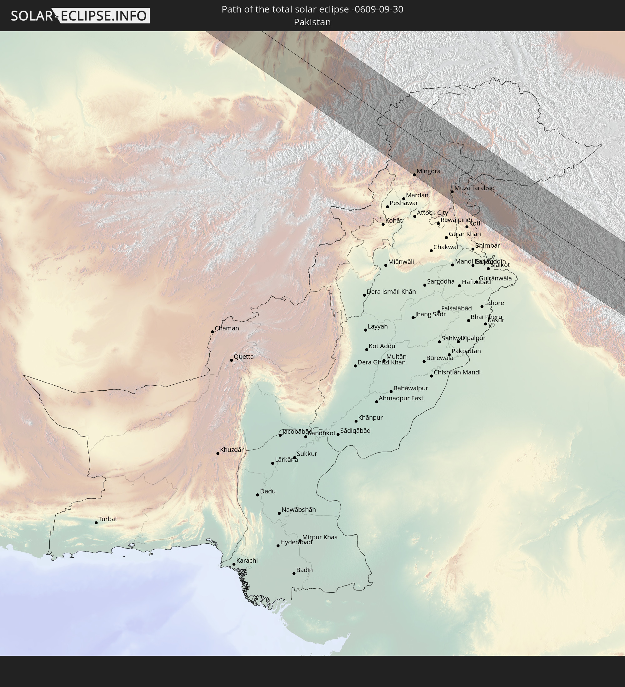
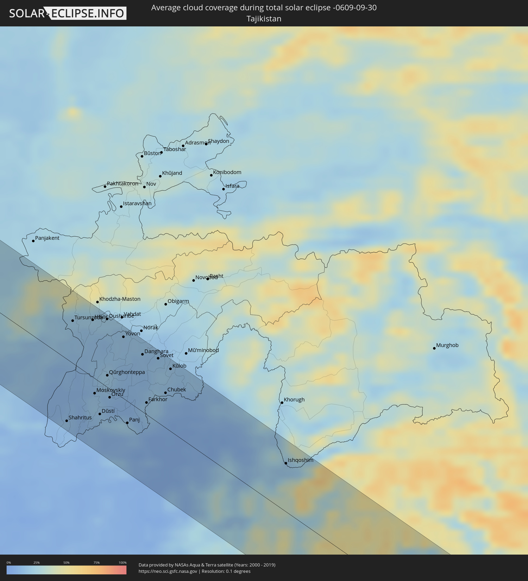 Tadschikistan
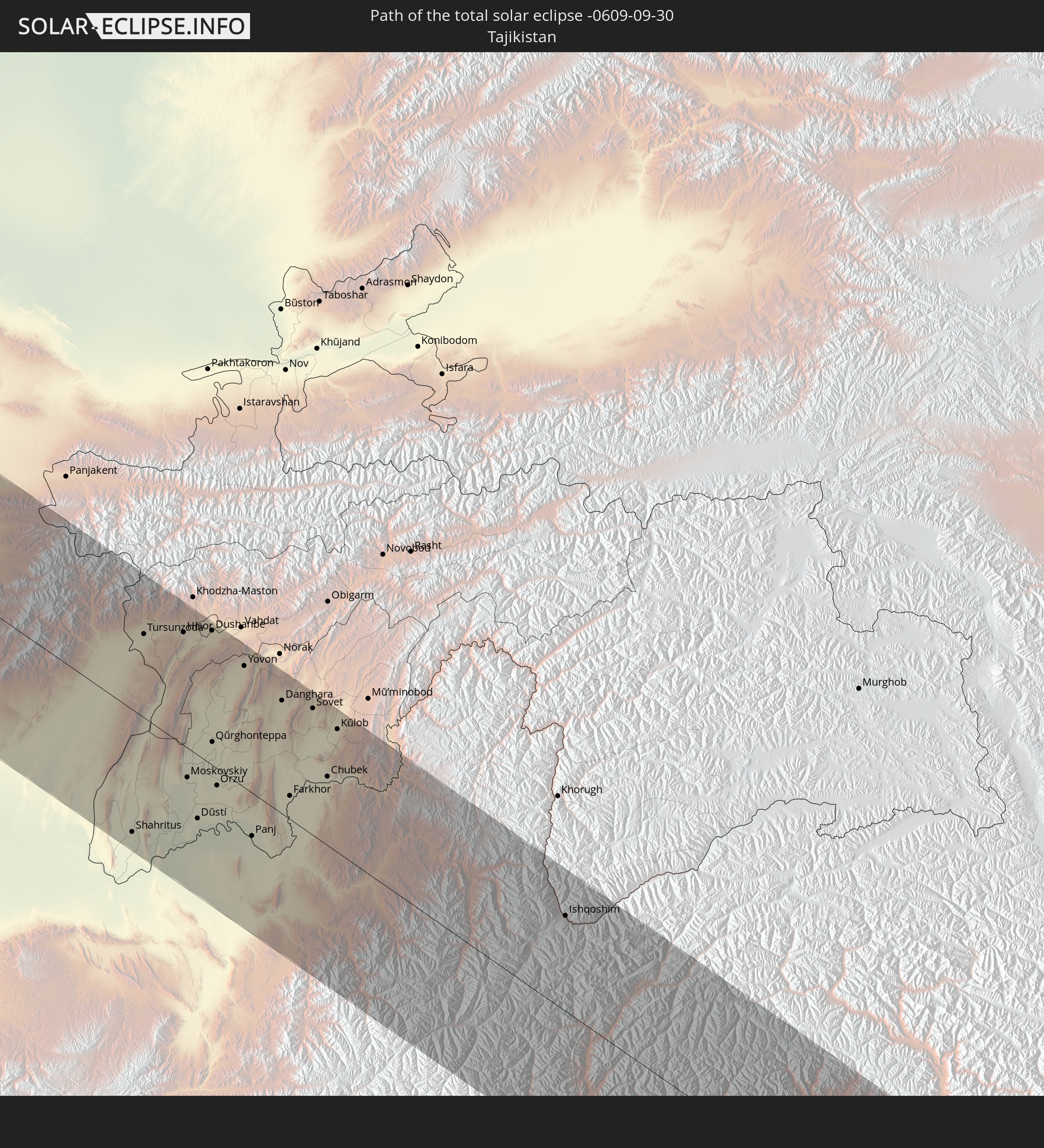
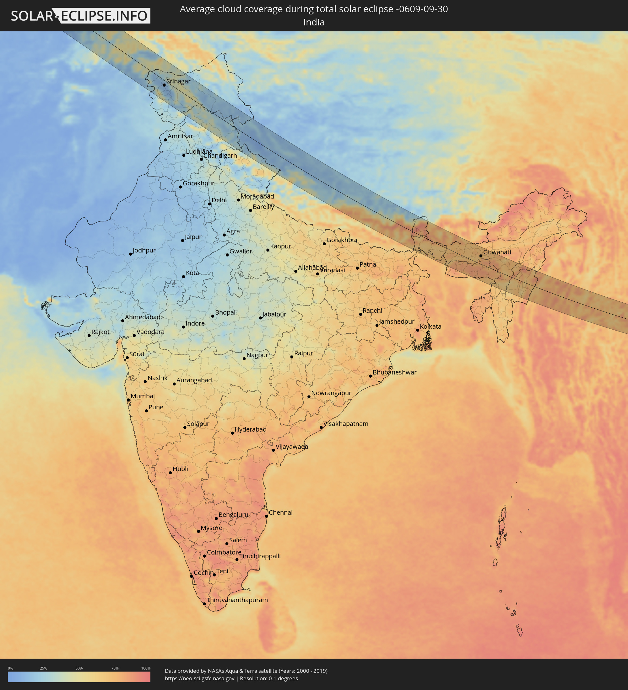 Indien
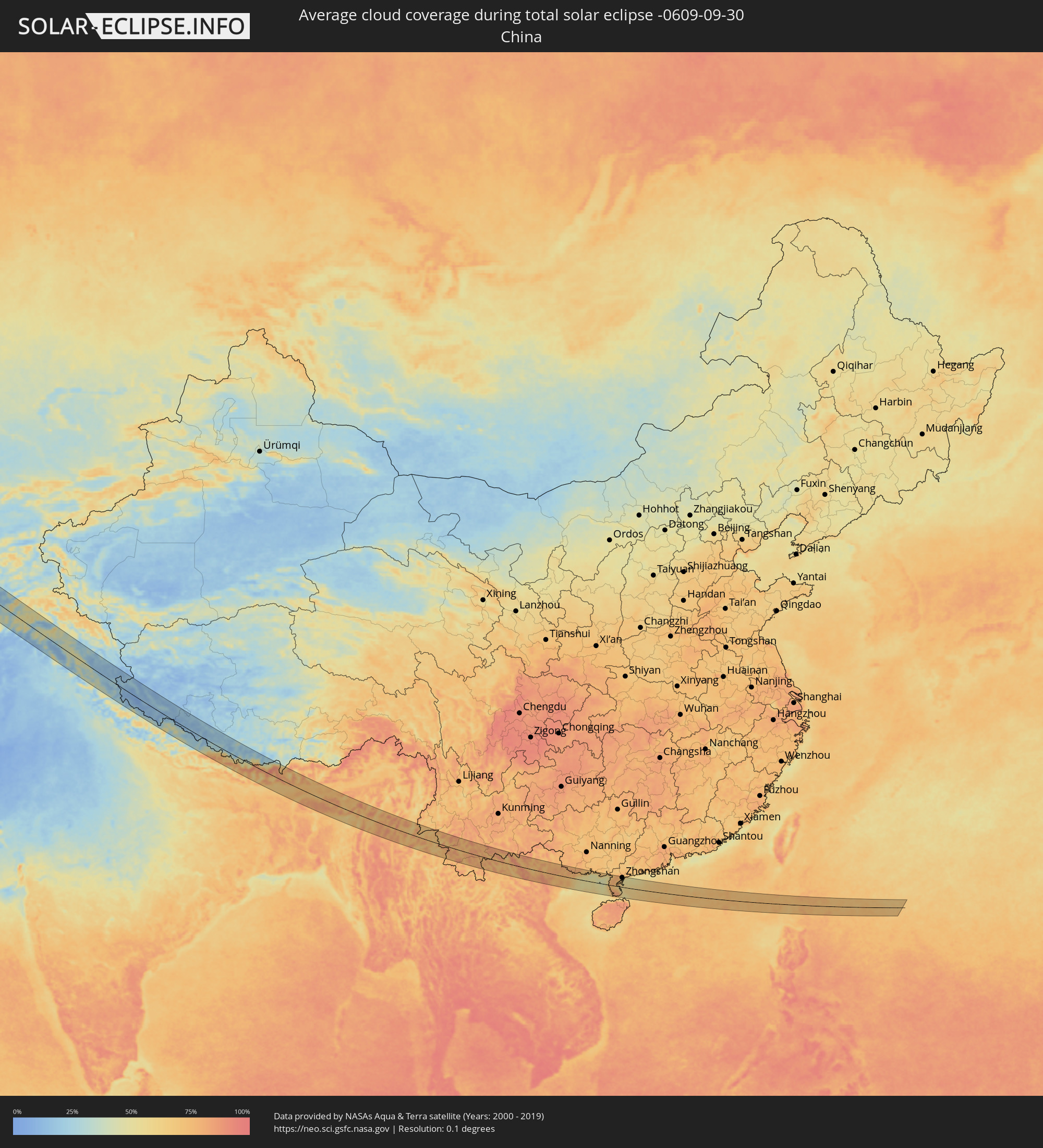 Volksrepublik China
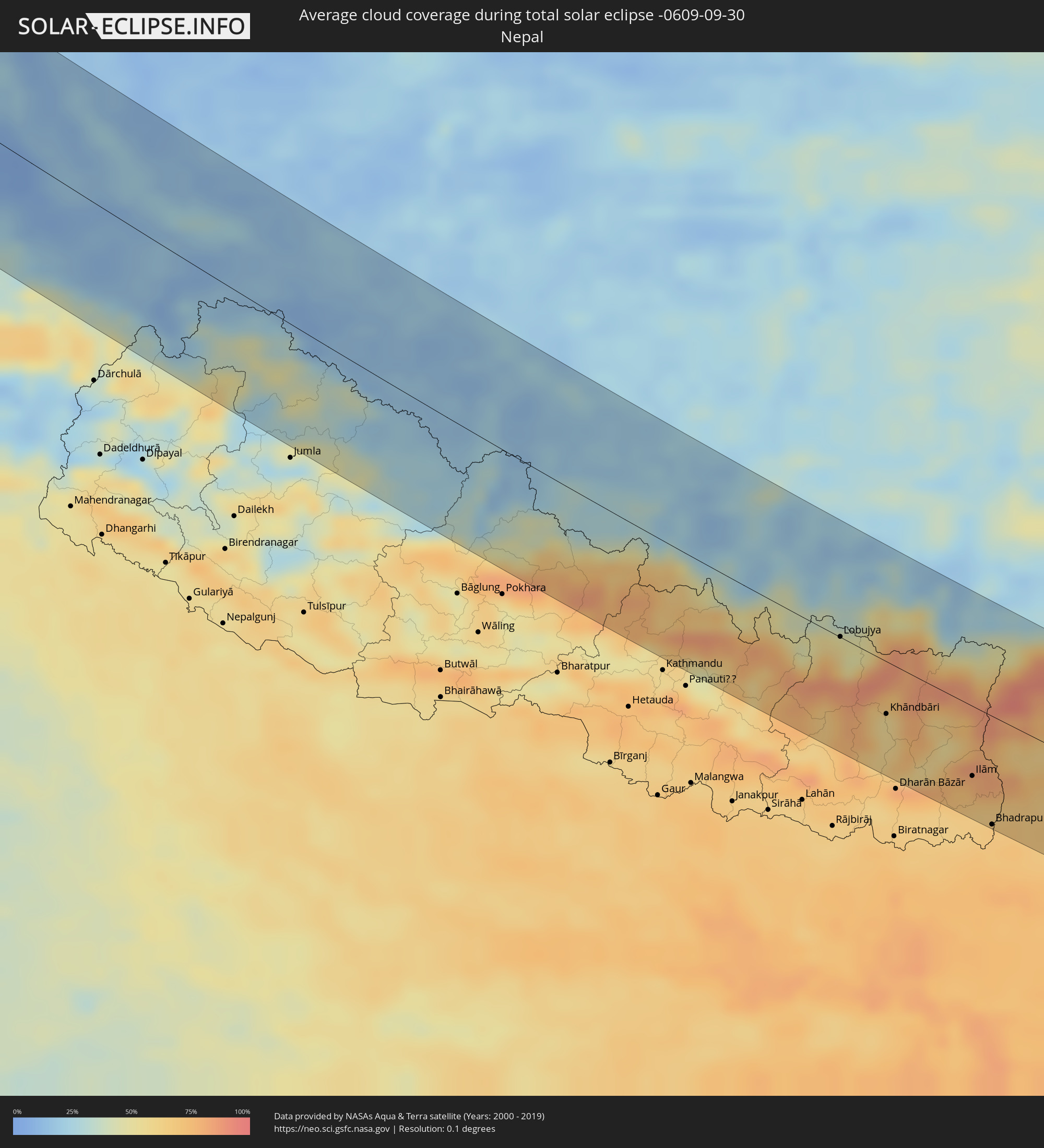 Nepal
Nepal
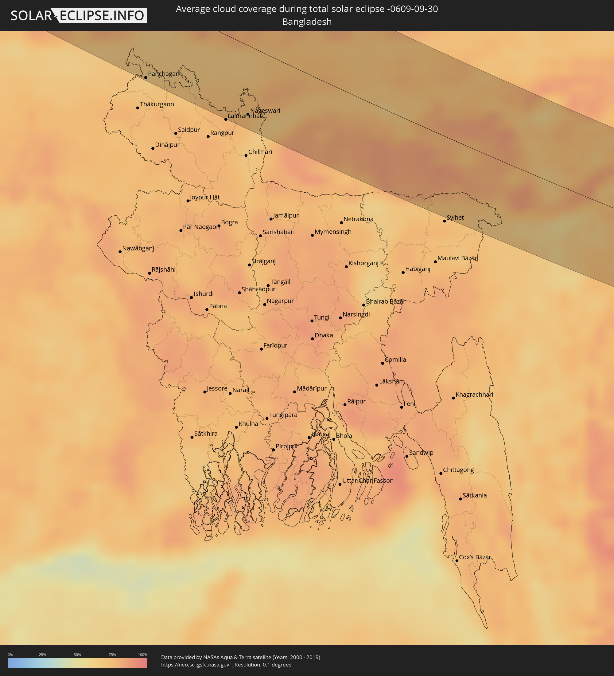 Bangladesch
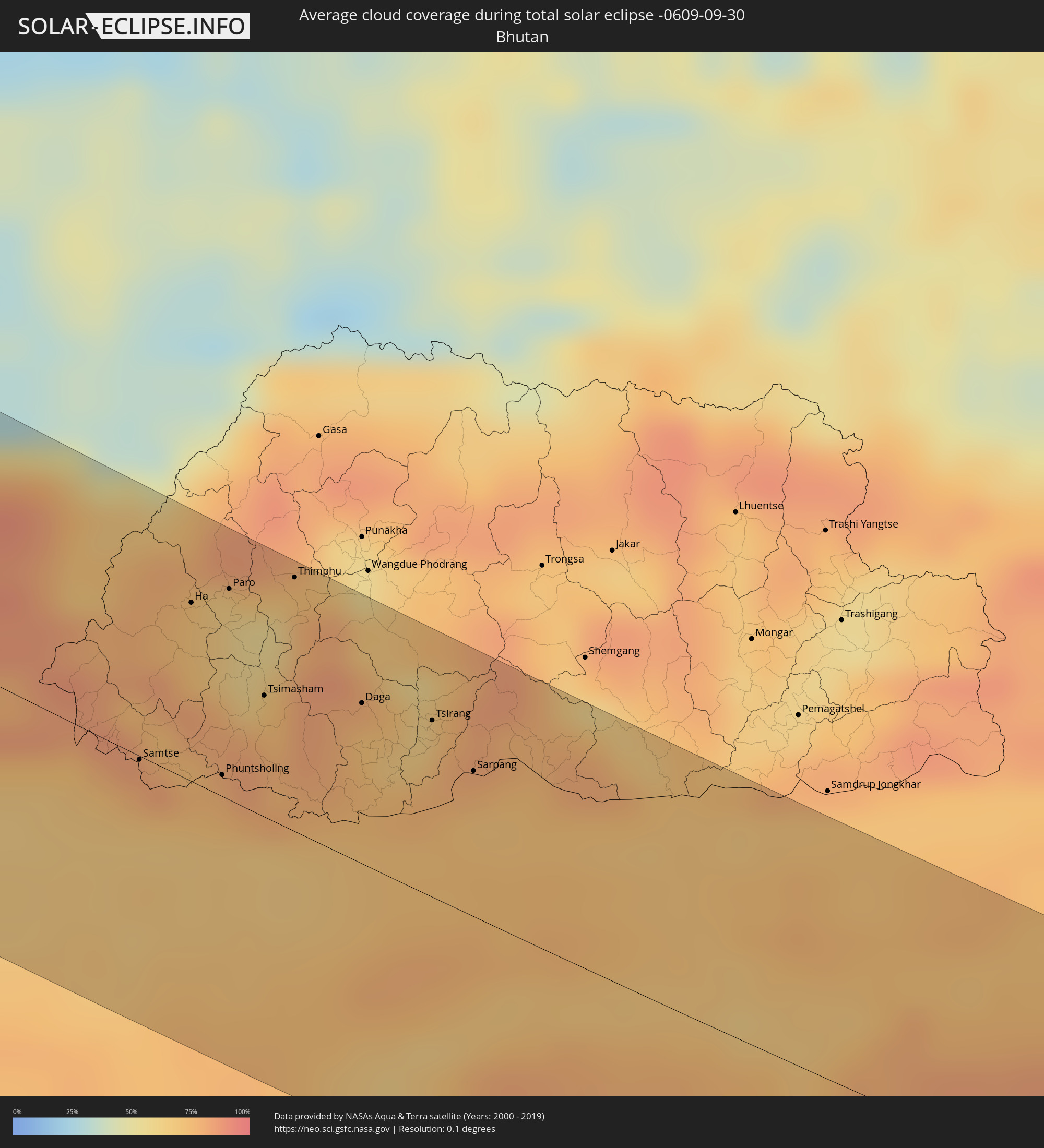 Bhutan
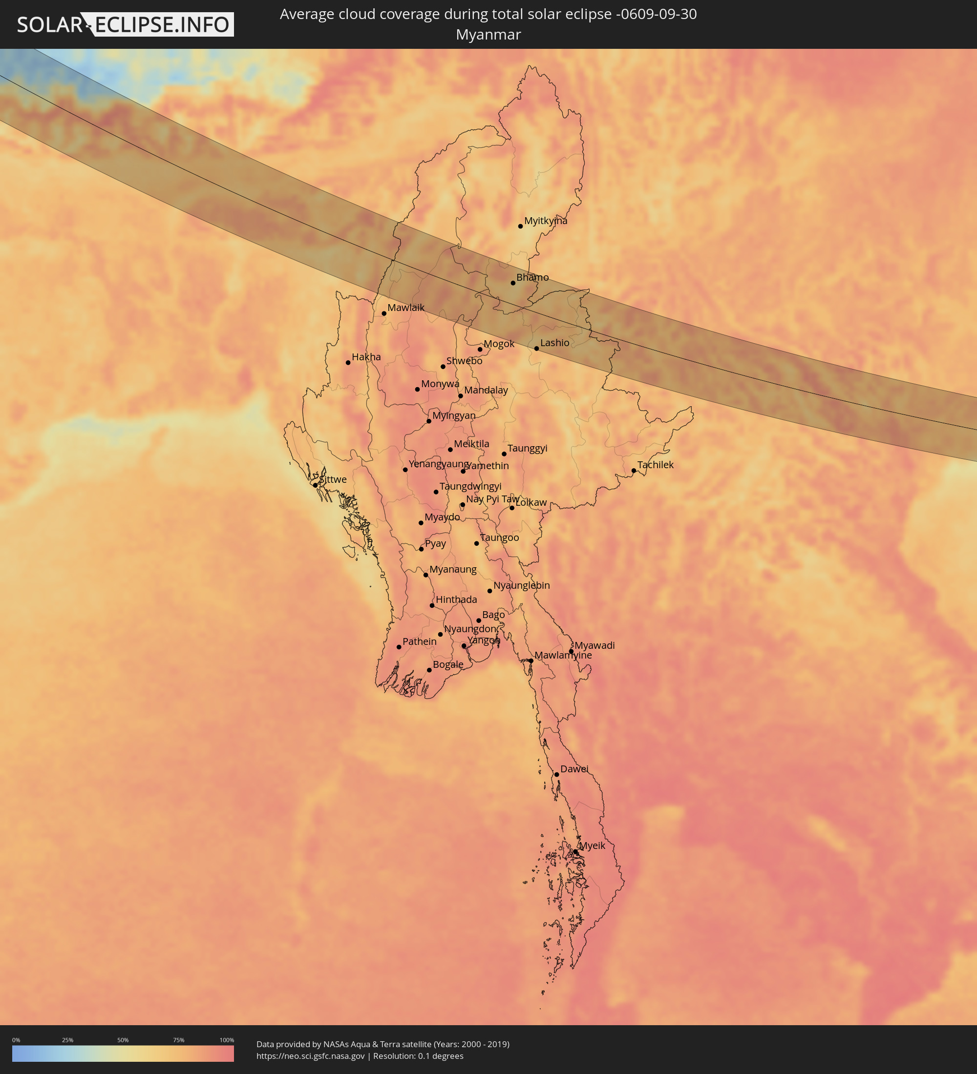 Myanmar
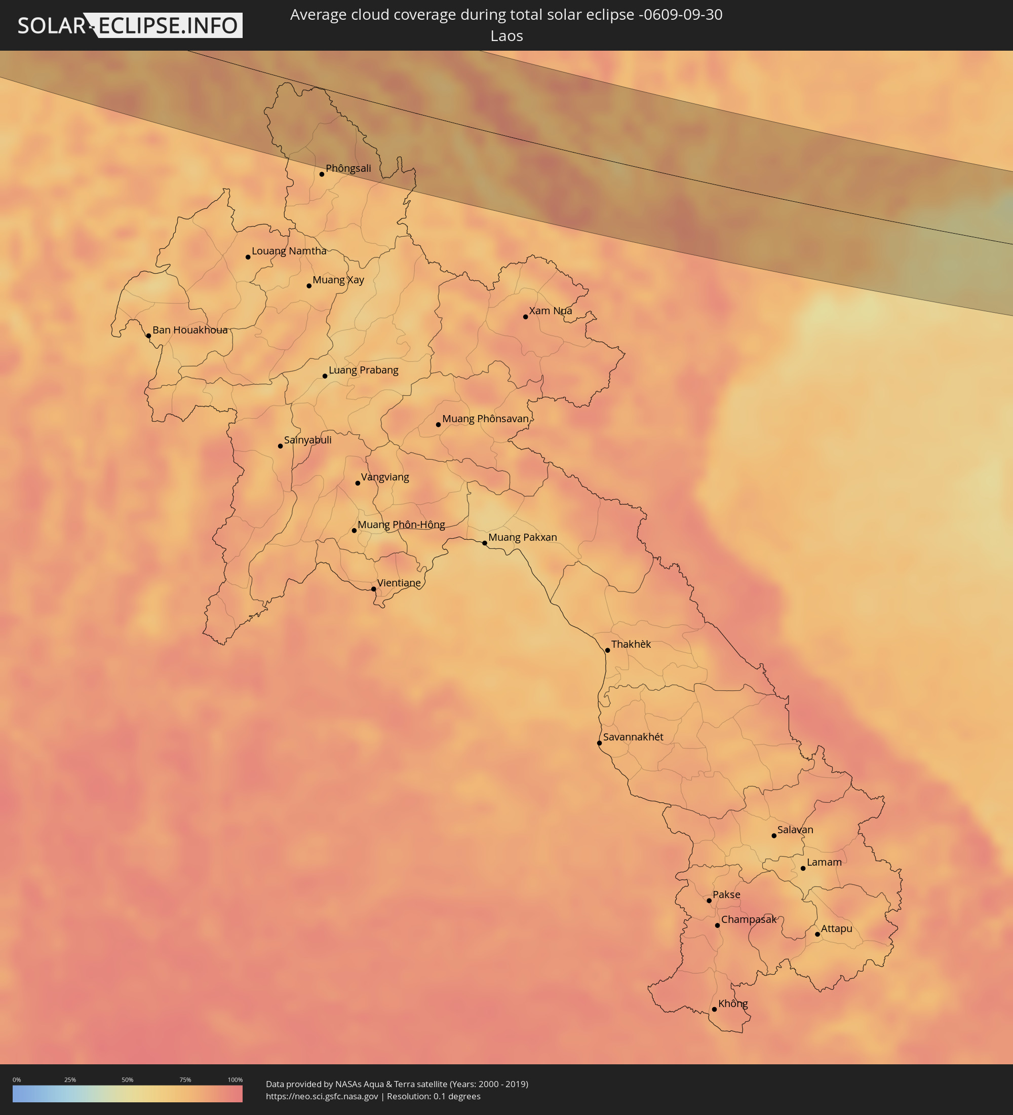 Laos
Laos
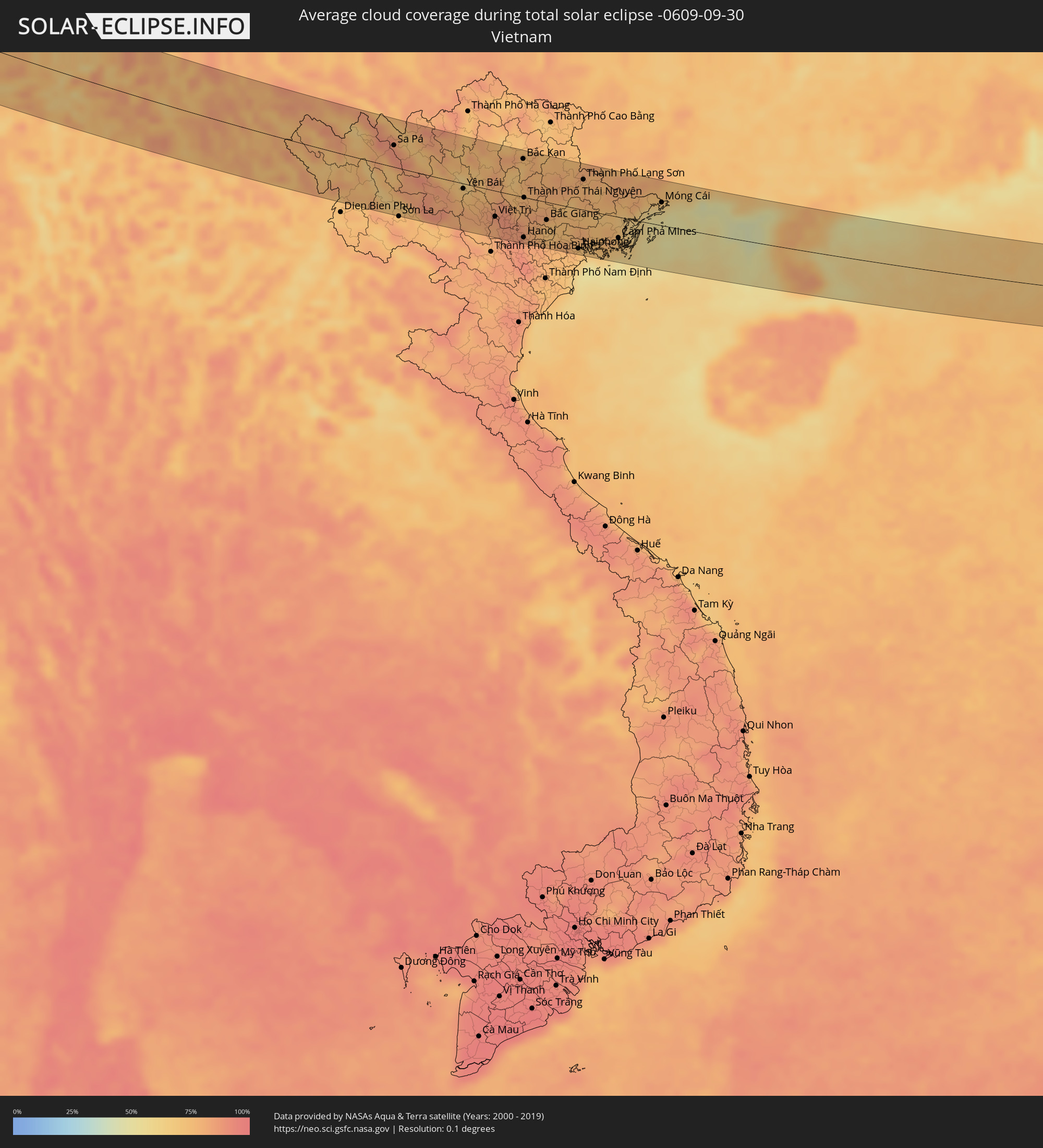 Vietnam
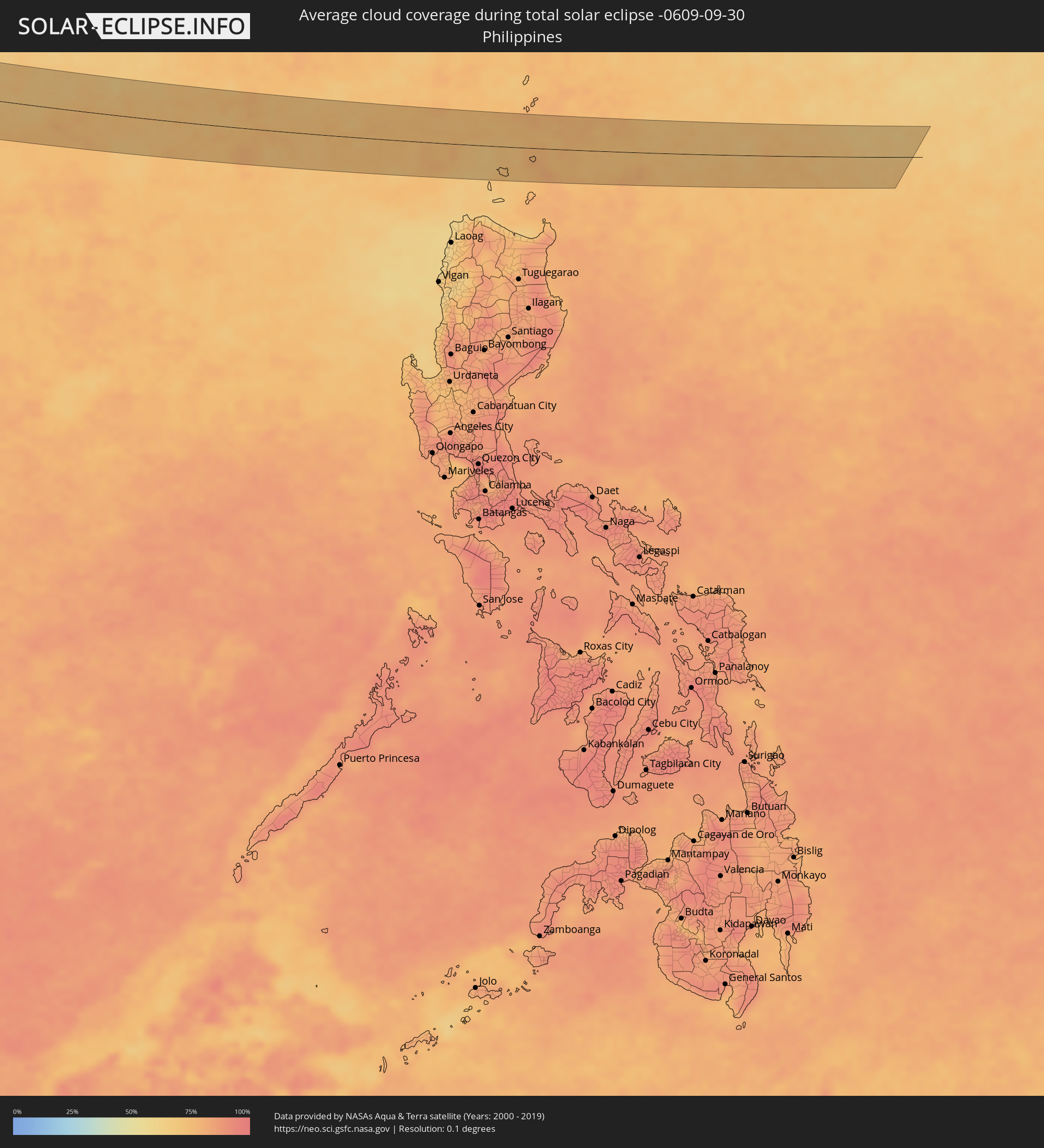 Philippinen
Orte im Finsternispfad
Die nachfolgene Tabelle zeigt Städte und Orte mit mehr als 5.000 Einwohnern, die sich im Finsternispfad befinden. Städte mit mehr als 100.000 Einwohnern sind dick gekennzeichnet. Mit einem Klick auf den Ort öffnet sich eine Detailkarte die die Lage des jeweiligen Ortes zusammen mit dem Verlauf der zentralen Finsternis präsentiert.
| Ort | Typ | Dauer der Verfinsterung | Ortszeit bei maximaler Verfinsterung | Entfernung zur Zentrallinie | Ø Bewölkung |
|
Greenock, Scotland
|
total | - | 06:35:28 UTC+00:00 | 10 km | 87% |
|
Ayr, Scotland
|
total | - | 06:34:56 UTC+00:00 | 44 km | 83% |
|
Kilmarnock, Scotland
|
total | - | 06:35:07 UTC+00:00 | 27 km | 87% |
|
Glasgow, Scotland
|
total | - | 06:35:25 UTC+00:00 | 2 km | 86% |
|
Hamilton, Scotland
|
total | - | 06:35:20 UTC+00:00 | 9 km | 86% |
|
Cumbernauld, Scotland
|
total | - | 06:35:32 UTC+00:00 | 11 km | 86% |
|
Livingston, Scotland
|
total | - | 06:35:33 UTC+00:00 | 8 km | 83% |
|
Dunfermline, Scotland
|
total | - | 06:35:44 UTC+00:00 | 27 km | 80% |
|
Edinburgh, Scotland
|
total | - | 06:35:38 UTC+00:00 | 14 km | 75% |
|
Kirkcaldy, Scotland
|
total | - | 06:35:50 UTC+00:00 | 33 km | 74% |
|
Westerland, Schleswig-Holstein
|
total | - | 07:37:13 UTC+01:00 | 33 km | 73% |
|
Esbjerg, South Denmark
|
total | - | 07:37:52 UTC+01:00 | 30 km | 76% |
|
Niebüll, Schleswig-Holstein
|
total | - | 07:37:17 UTC+01:00 | 42 km | 75% |
|
Leck, Schleswig-Holstein
|
total | - | 07:37:19 UTC+01:00 | 42 km | 76% |
|
Flensburg, Schleswig-Holstein
|
total | - | 07:37:30 UTC+01:00 | 36 km | 74% |
|
Kolding, South Denmark
|
total | - | 07:38:15 UTC+01:00 | 42 km | 78% |
|
Haderslev, South Denmark
|
total | - | 07:38:01 UTC+01:00 | 16 km | 78% |
|
Fredericia, South Denmark
|
total | - | 07:38:26 UTC+01:00 | 53 km | 72% |
|
Sønderborg, South Denmark
|
total | - | 07:37:46 UTC+01:00 | 19 km | 73% |
|
Kappeln, Schleswig-Holstein
|
total | - | 07:37:34 UTC+01:00 | 45 km | 72% |
|
Odense, South Denmark
|
total | - | 07:38:30 UTC+01:00 | 40 km | 77% |
|
Svendborg, South Denmark
|
total | - | 07:38:14 UTC+01:00 | 6 km | 74% |
|
Fehmarn, Schleswig-Holstein
|
total | - | 07:37:50 UTC+01:00 | 57 km | 71% |
|
Slagelse, Zealand
|
total | - | 07:38:54 UTC+01:00 | 51 km | 78% |
|
Næstved, Zealand
|
total | - | 07:38:53 UTC+01:00 | 36 km | 78% |
|
Ringsted, Zealand
|
total | - | 07:39:07 UTC+01:00 | 60 km | 81% |
|
Barth, Mecklenburg-Vorpommern
|
total | - | 07:38:26 UTC+01:00 | 48 km | 75% |
|
Stralsund, Mecklenburg-Vorpommern
|
total | - | 07:38:32 UTC+01:00 | 50 km | 77% |
|
Bergen auf Rügen, Mecklenburg-Vorpommern
|
total | - | 07:38:48 UTC+01:00 | 34 km | 77% |
|
Saßnitz, Mecklenburg-Vorpommern
|
total | - | 07:39:00 UTC+01:00 | 21 km | 74% |
|
Koszalin, West Pomeranian Voivodeship
|
total | - | 08:03:56 UTC+01:24 | 25 km | 79% |
|
Słupsk, Pomeranian Voivodeship
|
total | - | 08:04:39 UTC+01:24 | 16 km | 80% |
|
Gdynia, Pomeranian Voivodeship
|
total | - | 08:05:33 UTC+01:24 | 43 km | 73% |
|
Gdańsk, Pomeranian Voivodeship
|
total | - | 08:05:27 UTC+01:24 | 26 km | 73% |
|
Tczew, Pomeranian Voivodeship
|
total | - | 08:05:17 UTC+01:24 | 0 km | 74% |
|
Elbląg, Warmian-Masurian Voivodeship
|
total | - | 08:05:43 UTC+01:24 | 16 km | 72% |
|
Olsztyn, Warmian-Masurian Voivodeship
|
total | - | 08:06:03 UTC+01:24 | 8 km | 72% |
|
Łomża, Podlasie
|
total | - | 08:06:32 UTC+01:24 | 48 km | 75% |
|
Ełk, Warmian-Masurian Voivodeship
|
total | - | 08:07:18 UTC+01:24 | 27 km | 75% |
|
Białystok, Podlasie
|
total | - | 08:07:15 UTC+01:24 | 34 km | 76% |
|
Hrodna, Grodnenskaya
|
total | - | 08:34:10 UTC+01:50 | 37 km | 75% |
|
Vawkavysk, Grodnenskaya
|
total | - | 08:34:11 UTC+01:50 | 9 km | 74% |
|
Slonim, Grodnenskaya
|
total | - | 08:34:46 UTC+01:50 | 0 km | 74% |
|
Baranovichi, Brest
|
total | - | 08:35:19 UTC+01:50 | 18 km | 73% |
|
Salihorsk, Minsk
|
total | - | 08:36:15 UTC+01:50 | 11 km | 77% |
|
Slutsk, Minsk
|
total | - | 08:36:27 UTC+01:50 | 37 km | 79% |
|
Mazyr, Gomel
|
total | - | 08:37:09 UTC+01:50 | 32 km | 71% |
|
Svyetlahorsk, Gomel
|
total | - | 08:37:58 UTC+01:50 | 40 km | 72% |
|
Rechytsa, Gomel
|
total | - | 08:38:21 UTC+01:50 | 25 km | 72% |
|
Slavutych, Kiev
|
total | - | 08:50:11 UTC+02:02 | 56 km | 68% |
|
Gomel, Gomel
|
total | - | 08:38:54 UTC+01:50 | 46 km | 71% |
|
Chernihiv, Chernihiv
|
total | - | 08:50:40 UTC+02:02 | 45 km | 68% |
|
Bakhmach, Chernihiv
|
total | - | 08:51:55 UTC+02:02 | 43 km | 64% |
|
Konotop, Sumy
|
total | - | 08:52:19 UTC+02:02 | 28 km | 65% |
|
Krolevets’, Sumy
|
total | - | 08:52:39 UTC+02:02 | 8 km | 67% |
|
Shostka, Sumy
|
total | - | 08:52:55 UTC+02:02 | 43 km | 70% |
|
Putyvl’, Sumy
|
total | - | 08:53:00 UTC+02:02 | 2 km | 69% |
|
Hlukhiv, Sumy
|
total | - | 08:53:14 UTC+02:02 | 35 km | 70% |
|
Lebedyn, Sumy
|
total | - | 08:53:14 UTC+02:02 | 65 km | 66% |
|
Sumy, Sumy
|
total | - | 08:53:43 UTC+02:02 | 22 km | 68% |
|
Belgorod, Belgorod
|
total | - | 09:23:37 UTC+02:30 | 9 km | 66% |
|
Shebekino, Belgorod
|
total | - | 09:23:53 UTC+02:30 | 21 km | 64% |
|
Valuyki, Belgorod
|
total | - | 09:25:05 UTC+02:30 | 10 km | 65% |
|
Alekseyevka, Belgorod
|
total | - | 09:25:53 UTC+02:30 | 50 km | 64% |
|
Rossosh’, Voronezj
|
total | - | 09:26:43 UTC+02:30 | 30 km | 63% |
|
Kalach-na-Donu, Volgograd
|
total | - | 09:31:03 UTC+02:30 | 4 km | 53% |
|
Volgograd, Volgograd
|
total | - | 09:32:17 UTC+02:30 | 30 km | 50% |
|
Volzhskiy, Volgograd
|
total | - | 09:32:39 UTC+02:30 | 45 km | 53% |
|
Znamensk, Astrakhan
|
total | - | 10:23:55 UTC+03:20 | 56 km | 54% |
|
Akhtubinsk, Astrakhan
|
total | - | 10:24:28 UTC+03:20 | 41 km | 54% |
|
Maloye Ganyushkino, Atyraū
|
total | - | 10:33:50 UTC+03:25 | 18 km | 54% |
|
Oltinko’l, Karakalpakstan
|
total | - | 11:52:44 UTC+04:27 | 30 km | 50% |
|
Köneürgench, Daşoguz
|
total | - | 11:19:17 UTC+03:53 | 29 km | 42% |
|
Akdepe
|
total | - | 11:19:52 UTC+03:53 | 45 km | 40% |
|
Nukus, Karakalpakstan
|
total | - | 11:54:20 UTC+04:27 | 3 km | 40% |
|
Yylanly, Daşoguz
|
total | - | 11:20:29 UTC+03:53 | 53 km | 34% |
|
Boldumsaz, Daşoguz
|
total | - | 11:20:19 UTC+03:53 | 25 km | 41% |
|
Tagta, Daşoguz
|
total | - | 11:21:05 UTC+03:53 | 58 km | 41% |
|
Daşoguz, Daşoguz
|
total | - | 11:21:02 UTC+03:53 | 39 km | 36% |
|
Urganch, Xorazm
|
total | - | 11:56:46 UTC+04:27 | 35 km | 43% |
|
Gazojak, Lebap
|
total | - | 11:24:03 UTC+03:53 | 34 km | 28% |
|
Bukhara, Bukhara
|
total | - | 12:05:06 UTC+04:27 | 23 km | 29% |
|
Navoiy, Navoiy
|
total | - | 12:06:32 UTC+04:27 | 51 km | 20% |
|
Koson, Qashqadaryo
|
total | - | 12:07:58 UTC+04:27 | 35 km | 20% |
|
Qarshi, Qashqadaryo
|
total | - | 12:08:31 UTC+04:27 | 41 km | 19% |
|
Kattaqo’rg’on, Samarqand
|
total | - | 12:08:19 UTC+04:27 | 77 km | 22% |
|
Shahrisabz, Qashqadaryo
|
total | - | 12:10:15 UTC+04:27 | 28 km | 21% |
|
Denov, Surxondaryo
|
total | - | 12:13:06 UTC+04:27 | 9 km | 17% |
|
Tursunzoda, Republican Subordination
|
total | - | 12:20:46 UTC+04:35 | 48 km | 17% |
|
Hisor, Republican Subordination
|
total | - | 12:21:21 UTC+04:35 | 65 km | 17% |
|
Moskovskiy, Khatlon
|
total | - | 12:22:28 UTC+04:35 | 17 km | 15% |
|
Dushanbe, Dushanbe
|
total | - | 12:21:46 UTC+04:35 | 77 km | 17% |
|
Qarāwul, Kunduz
|
total | - | 11:48:06 UTC+04:00 | 43 km | 13% |
|
Qŭrghonteppa, Khatlon
|
total | - | 12:22:35 UTC+04:35 | 13 km | 16% |
|
Imām Şāḩib, Kunduz
|
total | - | 11:48:26 UTC+04:00 | 38 km | 15% |
|
Khanabad, Kunduz
|
total | - | 11:49:23 UTC+04:00 | 75 km | 10% |
|
Danghara, Khatlon
|
total | - | 12:23:19 UTC+04:35 | 65 km | 13% |
|
Farkhor, Khatlon
|
total | - | 12:24:09 UTC+04:35 | 14 km | 15% |
|
Ārt Khwājah, Takhar
|
total | - | 11:49:36 UTC+04:00 | 20 km | 5% |
|
Taloqan, Takhar
|
total | - | 11:50:08 UTC+04:00 | 49 km | 6% |
|
Vose’, Khatlon
|
total | - | 12:24:14 UTC+04:35 | 54 km | 15% |
|
Kŭlob, Khatlon
|
total | - | 12:24:22 UTC+04:35 | 71 km | 15% |
|
Rustāq, Takhar
|
total | - | 11:50:13 UTC+04:00 | 2 km | 6% |
|
Farkhār, Takhar
|
total | - | 11:50:57 UTC+04:00 | 47 km | 6% |
|
Fayzabad, Badakhshan
|
total | - | 11:51:38 UTC+04:00 | 39 km | 6% |
|
Jurm, Badakhshan
|
total | - | 11:52:26 UTC+04:00 | 29 km | 8% |
|
Ashkāsham, Badakhshan
|
total | - | 11:53:59 UTC+04:00 | 48 km | 16% |
|
Ishqoshim, Gorno-Badakhshan
|
total | - | 12:29:17 UTC+04:35 | 56 km | 17% |
|
Upper Dir, Khyber Pakhtunkhwa
|
total | - | 12:24:47 UTC+04:28 | 69 km | 19% |
|
Tāl, Khyber Pakhtunkhwa
|
total | - | 12:25:08 UTC+04:28 | 25 km | 37% |
|
Mingora, Khyber Pakhtunkhwa
|
total | - | 12:26:18 UTC+04:28 | 83 km | 15% |
|
Mānsehra, Khyber Pakhtunkhwa
|
total | - | 12:28:32 UTC+04:28 | 81 km | 16% |
|
Baffa, Khyber Pakhtunkhwa
|
total | - | 12:28:26 UTC+04:28 | 70 km | 12% |
|
Muzaffarābād, Azad Kashmir
|
total | - | 12:29:00 UTC+04:28 | 63 km | 12% |
|
Srinagar, Kashmir
|
total | - | 13:24:56 UTC+05:21 | 20 km | 12% |
|
Burang, Tibet Autonomous Region
|
total | - | 16:21:29 UTC+08:00 | 46 km | 12% |
|
Lobujya, Eastern Region
|
total | - | 14:16:20 UTC+05:41 | 1 km | 56% |
|
Khāndbāri, Eastern Region
|
total | - | 14:17:55 UTC+05:41 | 39 km | 57% |
|
Dhankutā, Eastern Region
|
total | - | 14:18:46 UTC+05:41 | 71 km | 67% |
|
Ilām, Eastern Region
|
total | - | 14:19:51 UTC+05:41 | 52 km | 73% |
|
Bhadrapur, Eastern Region
|
total | - | 14:20:43 UTC+05:41 | 81 km | 69% |
|
Dārjiling, West Bengal
|
total | - | 14:00:05 UTC+05:21 | 25 km | 80% |
|
Shiliguri, West Bengal
|
total | - | 14:00:52 UTC+05:21 | 50 km | 67% |
|
Panchagarh, Rangpur Division
|
total | - | 14:33:52 UTC+05:53 | 81 km | 70% |
|
Jalpāiguri, West Bengal
|
total | - | 14:01:40 UTC+05:21 | 55 km | 66% |
|
Samtse, Samchi
|
total | - | 14:39:02 UTC+05:58 | 1 km | 78% |
|
Ha, Haa District
|
total | - | 14:38:30 UTC+05:58 | 56 km | 72% |
|
Jaigaon, West Bengal
|
total | - | 14:02:07 UTC+05:21 | 6 km | 73% |
|
Phuntsholing, Chukha District
|
total | - | 14:02:07 UTC+05:21 | 7 km | 77% |
|
Paro, Paro
|
total | - | 14:38:38 UTC+05:58 | 66 km | 66% |
|
Tsimasham, Chukha District
|
total | - | 14:39:23 UTC+05:58 | 38 km | 79% |
|
Thimphu, Thimphu
|
total | - | 14:38:56 UTC+05:58 | 79 km | 71% |
|
Lungtenzampa, Thimphu
|
total | - | 14:38:56 UTC+05:58 | 79 km | 71% |
|
Nageswari, Rangpur Division
|
total | - | 14:36:13 UTC+05:53 | 69 km | 74% |
|
Daga, Dagana District
|
total | - | 14:39:56 UTC+05:58 | 50 km | 73% |
|
Tsirang, Chirang
|
total | - | 14:40:24 UTC+05:58 | 55 km | 69% |
|
Sarpang, Geylegphug
|
total | - | 14:40:52 UTC+05:58 | 46 km | 77% |
|
Chhātak, Sylhet
|
total | - | 14:40:41 UTC+05:53 | 80 km | 74% |
|
Guwahati, Assam
|
total | - | 14:06:44 UTC+05:21 | 39 km | 74% |
|
Shillong, Meghalaya
|
total | - | 14:07:56 UTC+05:21 | 18 km | 85% |
|
Silchar, Assam
|
total | - | 14:10:26 UTC+05:21 | 58 km | 66% |
|
Imphal, Manipur
|
total | - | 14:12:02 UTC+05:21 | 16 km | 67% |
|
Kohima, Nagaland
|
total | - | 14:10:51 UTC+05:21 | 80 km | 85% |
|
Bhamo, Kachin
|
total | - | 15:20:42 UTC+06:24 | 44 km | 62% |
|
Lashio, Shan
|
total | - | 15:23:23 UTC+06:24 | 77 km | 77% |
|
Sa Pá, Lào Cai
|
total | - | 16:12:27 UTC+07:06 | 33 km | 89% |
|
Yên Bái, Yên Bái
|
total | - | 16:14:18 UTC+07:06 | 8 km | 72% |
|
Việt Trì, Phú Thọ
|
total | - | 16:15:17 UTC+07:06 | 40 km | 83% |
|
Hanoi, Ha Nội
|
total | - | 16:16:04 UTC+07:06 | 63 km | 88% |
|
Thành Phố Thái Nguyên, Thái Nguyên
|
total | - | 16:15:15 UTC+07:06 | 1 km | 79% |
|
Haiphong, Hải Phòng
|
total | - | 16:16:57 UTC+07:06 | 62 km | 74% |
|
Thành Phố Uông Bí, Quảng Ninh
|
total | - | 16:16:47 UTC+07:06 | 42 km | 70% |
|
Thành Phố Hạ Long, Quảng Ninh
|
total | - | 16:17:08 UTC+07:06 | 45 km | 73% |
|
Cẩm Phả Mines, Quảng Ninh
|
total | - | 16:17:12 UTC+07:06 | 33 km | 68% |
|
Móng Cái, Quảng Ninh
|
total | - | 16:16:59 UTC+07:06 | 36 km | 58% |
|
Beihai, Guangxi Zhuang Autonomous Region
|
total | - | 17:11:10 UTC+08:00 | 53 km | 61% |
|
Xucheng, Guangdong
|
total | - | 17:13:27 UTC+08:00 | 55 km | 71% |
|
Zhanjiang, Guangdong
|
total | - | 17:12:16 UTC+08:00 | 53 km | 77% |
|
Zhongshan, Guangdong
|
total | - | 17:12:21 UTC+08:00 | 61 km | 62% |