Totale Sonnenfinsternis vom 26.04.-0638
| Wochentag: | Samstag |
| Maximale Dauer der Verfinsterung: | 05m26s |
| Maximale Breite des Finsternispfades: | 293 km |
| Saroszyklus: | 57 |
| Bedeckungsgrad: | 100% |
| Magnitude: | 1.0768 |
| Gamma: | 0.5412 |
Wo kann man die Sonnenfinsternis vom 26.04.-0638 sehen?
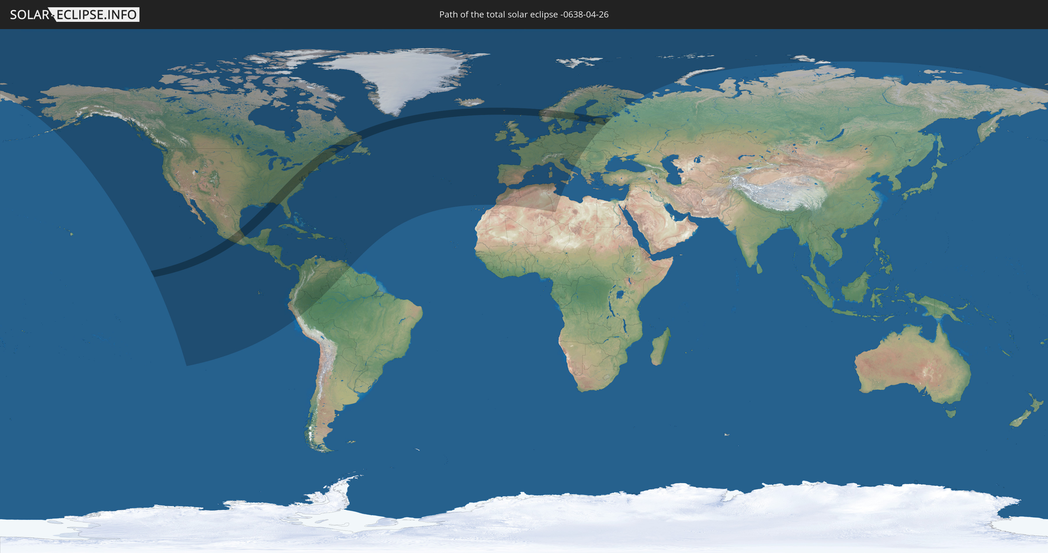
Die Sonnenfinsternis am 26.04.-0638 kann man in 91 Ländern als partielle Sonnenfinsternis beobachten.
Der Finsternispfad verläuft durch 12 Länder. Nur in diesen Ländern ist sie als totale Sonnenfinsternis zu sehen.
In den folgenden Ländern ist die Sonnenfinsternis total zu sehen
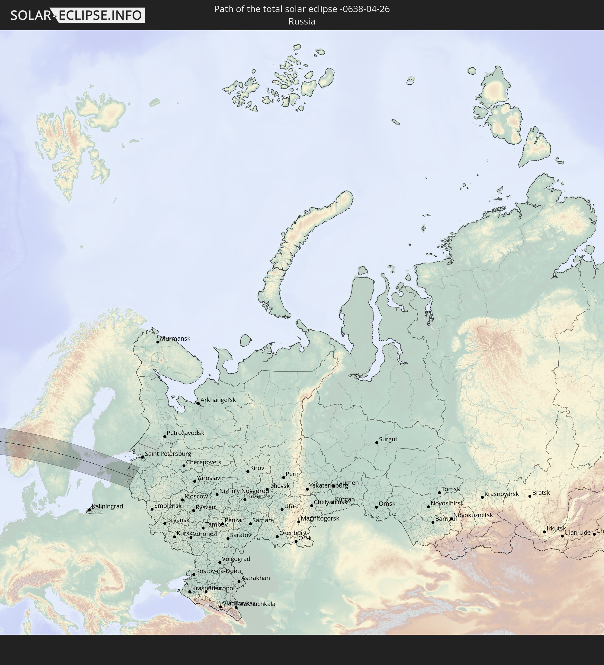 Russland
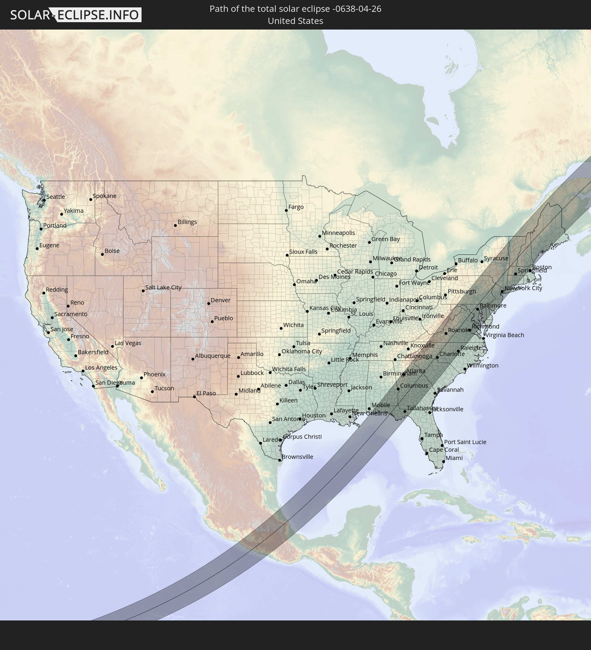 Vereinigte Staaten
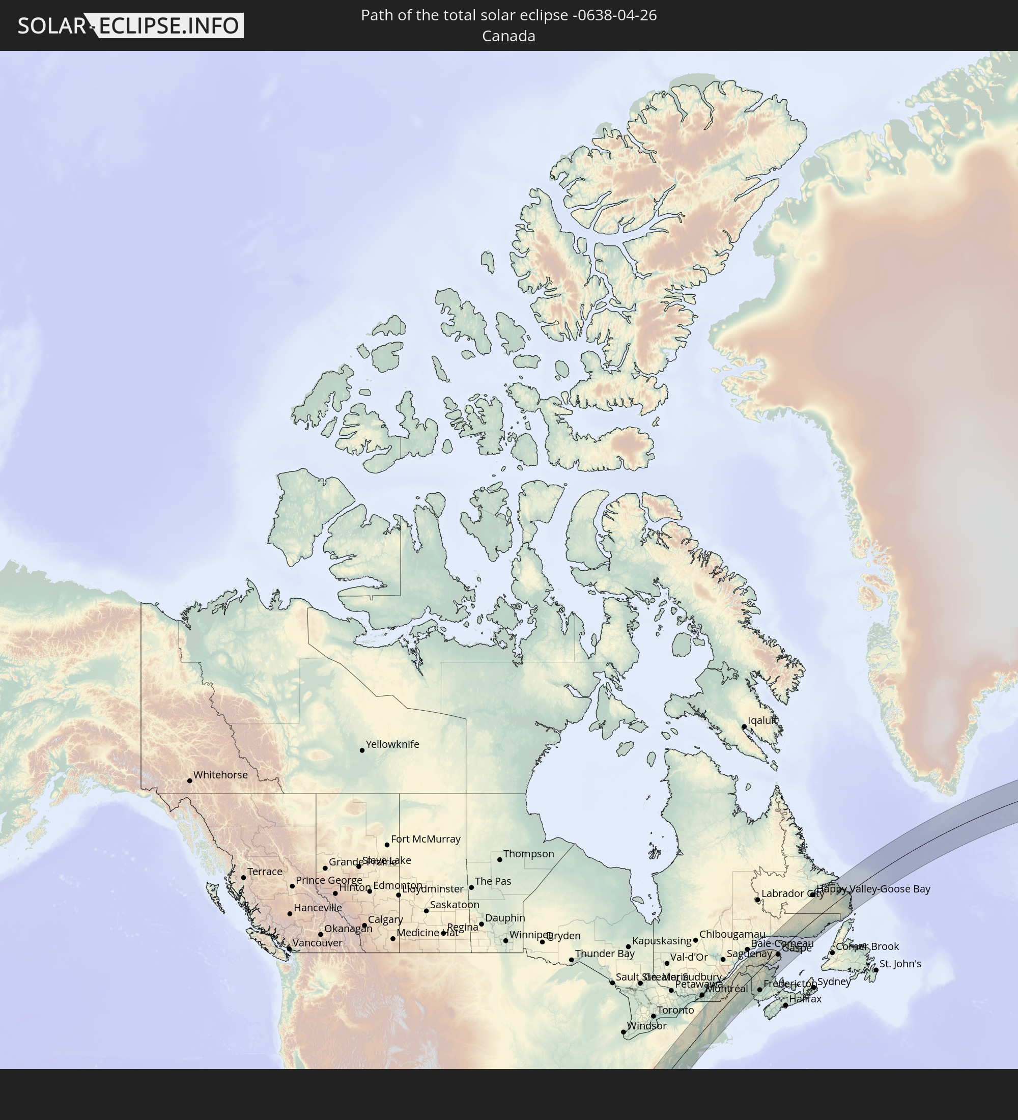 Kanada
 Mexiko
 Vereinigtes Königreich
 Färöer
 Norwegen
 Schweden
 Åland Islands
 Finnland
 Lettland
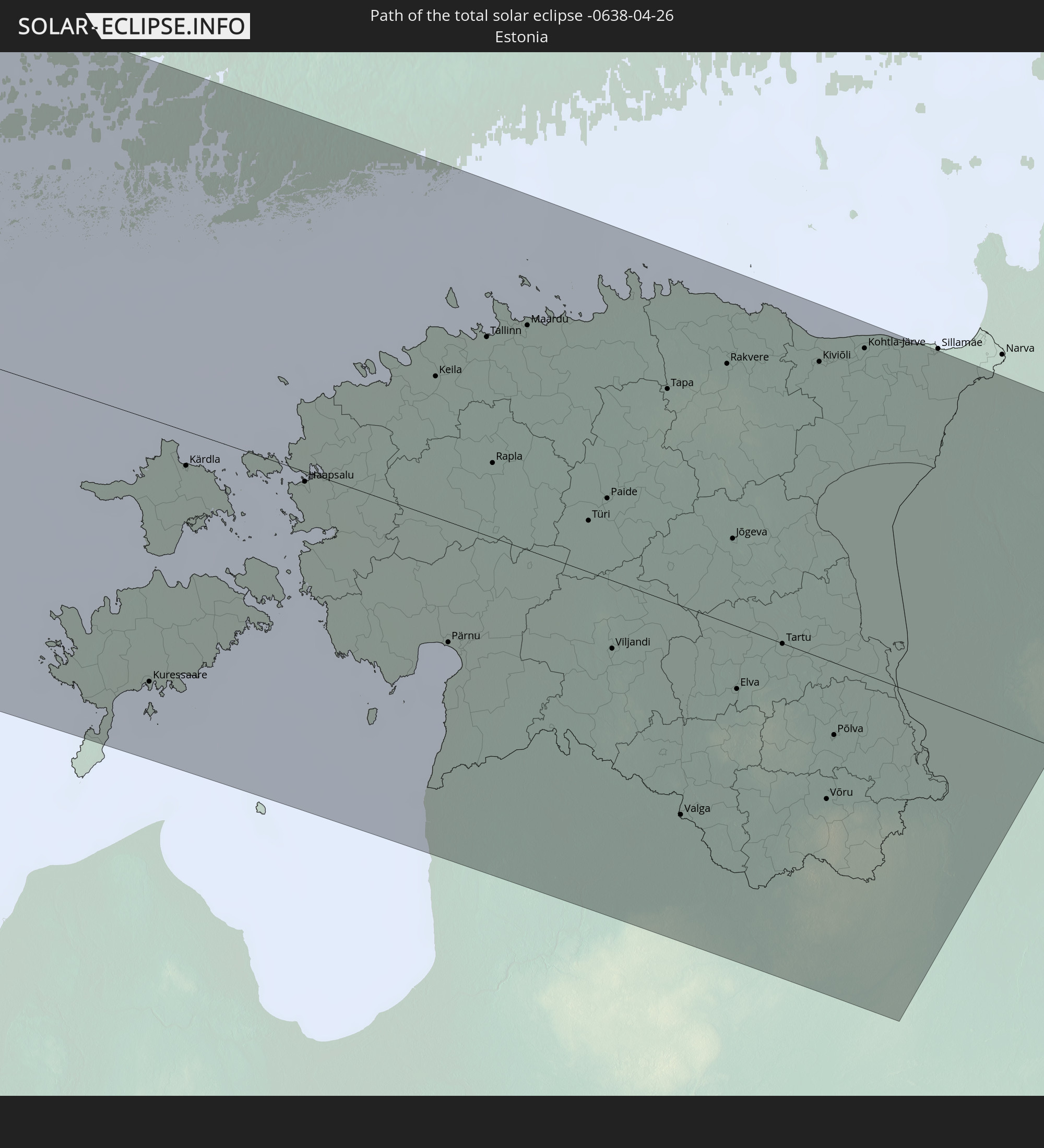 Estland
In den folgenden Ländern ist die Sonnenfinsternis partiell zu sehen
 Russland
 Vereinigte Staaten
 United States Minor Outlying Islands
 Kanada
 Mexiko
 Grönland
 Guatemala
 Ecuador
 El Salvador
 Honduras
 Belize
 Nicaragua
 Costa Rica
 Kuba
Kuba
 Panama
 Kolumbien
 Kaimaninseln
 Peru
Peru
 Bahamas
 Jamaika
 Haiti
Haiti
 Brasilien
 Venezuela
 Turks- und Caicosinseln
 Dominikanische Republik
 Aruba
Aruba
 Puerto Rico
 Amerikanische Jungferninseln
 Bermuda
 Britische Jungferninseln
 Anguilla
 Saint-Martin
 Saint-Barthélemy
 St. Kitts und Nevis
 Antigua und Barbuda
 Montserrat
 Trinidad und Tobago
 Guadeloupe
 Grenada
 Dominica
 St. Vincent und die Grenadinen
 Guyana
 Martinique
 St. Lucia
 Barbados
 Saint-Pierre und Miquelon
 Portugal
 Island
 Spanien
 Marokko
 Irland
 Spitzbergen
 Algerien
 Vereinigtes Königreich
 Färöer
 Gibraltar
 Frankreich
 Isle of Man
 Guernsey
 Jersey
 Andorra
 Belgien
 Niederlande
 Norwegen
 Luxemburg
 Deutschland
 Schweiz
 Italien
 Monaco
 Tunesien
 Dänemark
 Libyen
 Liechtenstein
 Österreich
 Schweden
 Tschechien
 San Marino
 Vatikanstadt
 Slowenien
 Kroatien
 Polen
Polen
 Bosnien und Herzegowina
 Ungarn
 Slowakei
 Serbien
 Åland Islands
 Finnland
 Litauen
 Lettland
 Estland
 Weißrussland
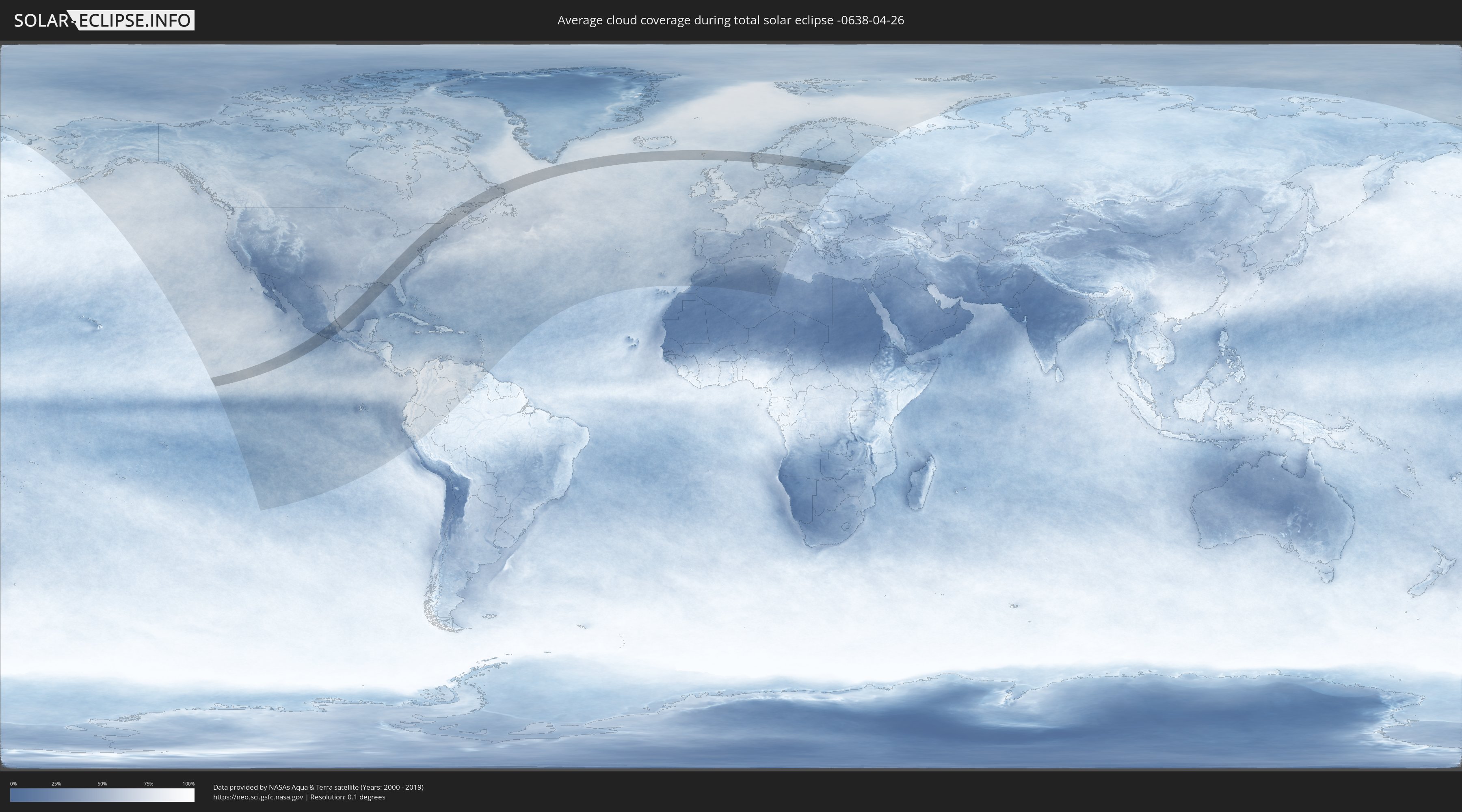
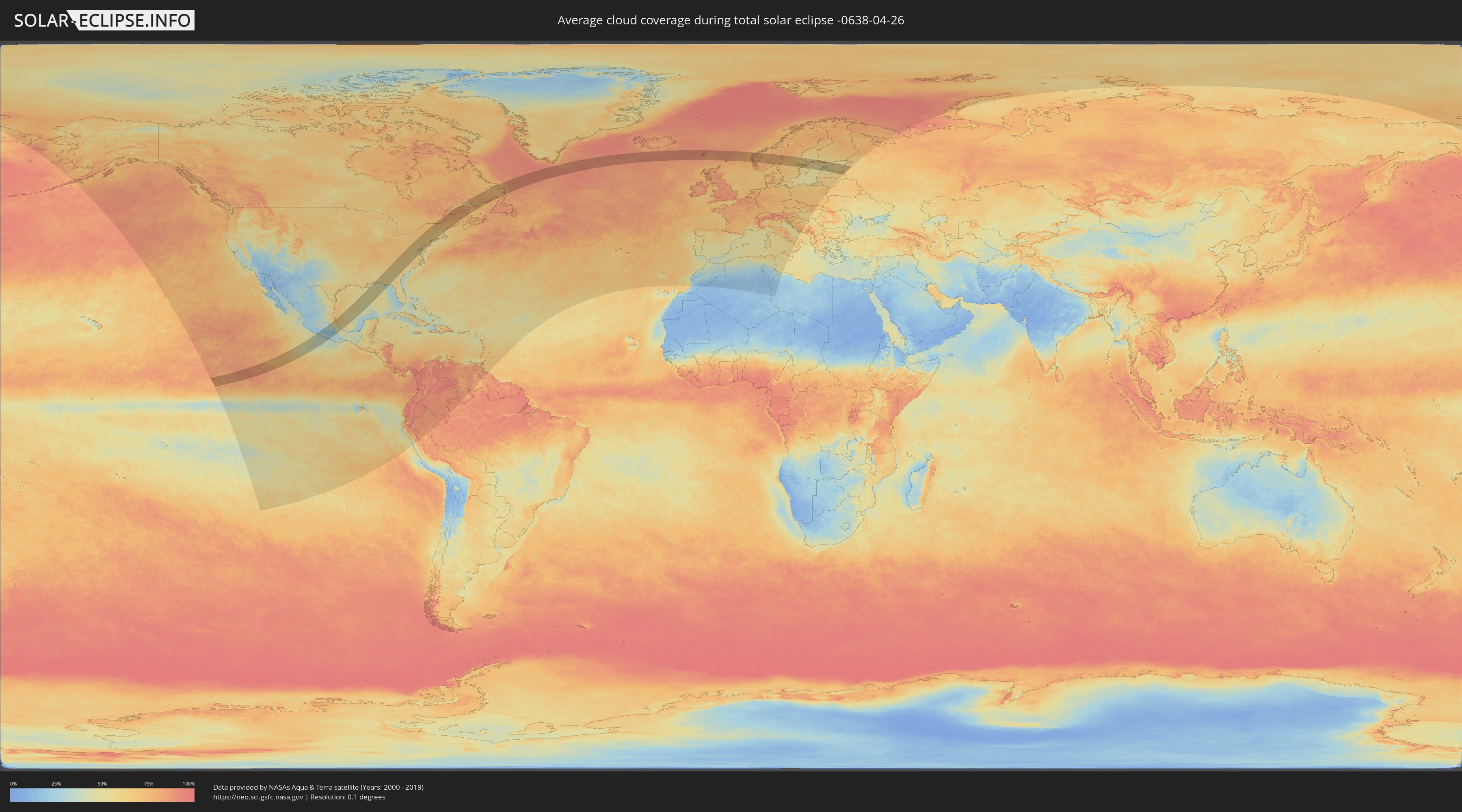
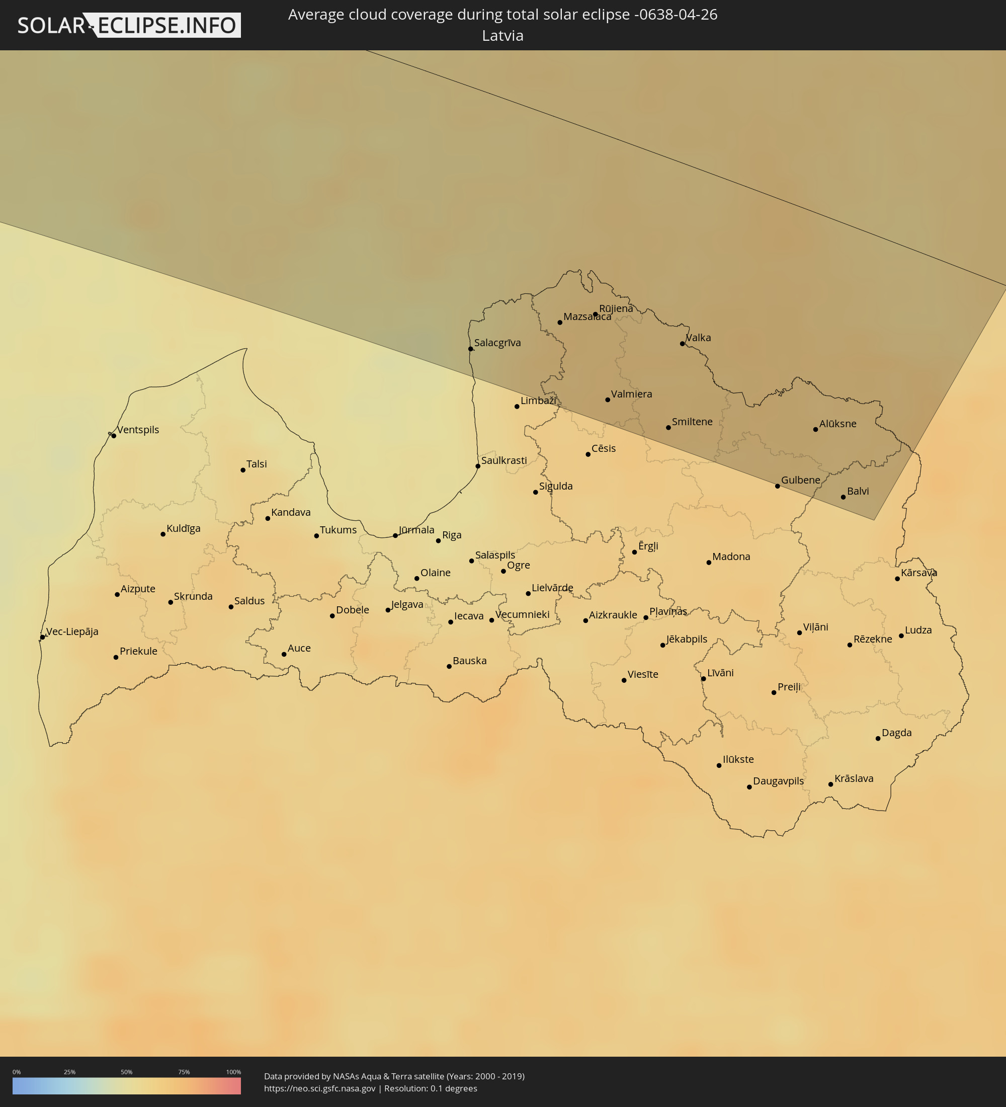
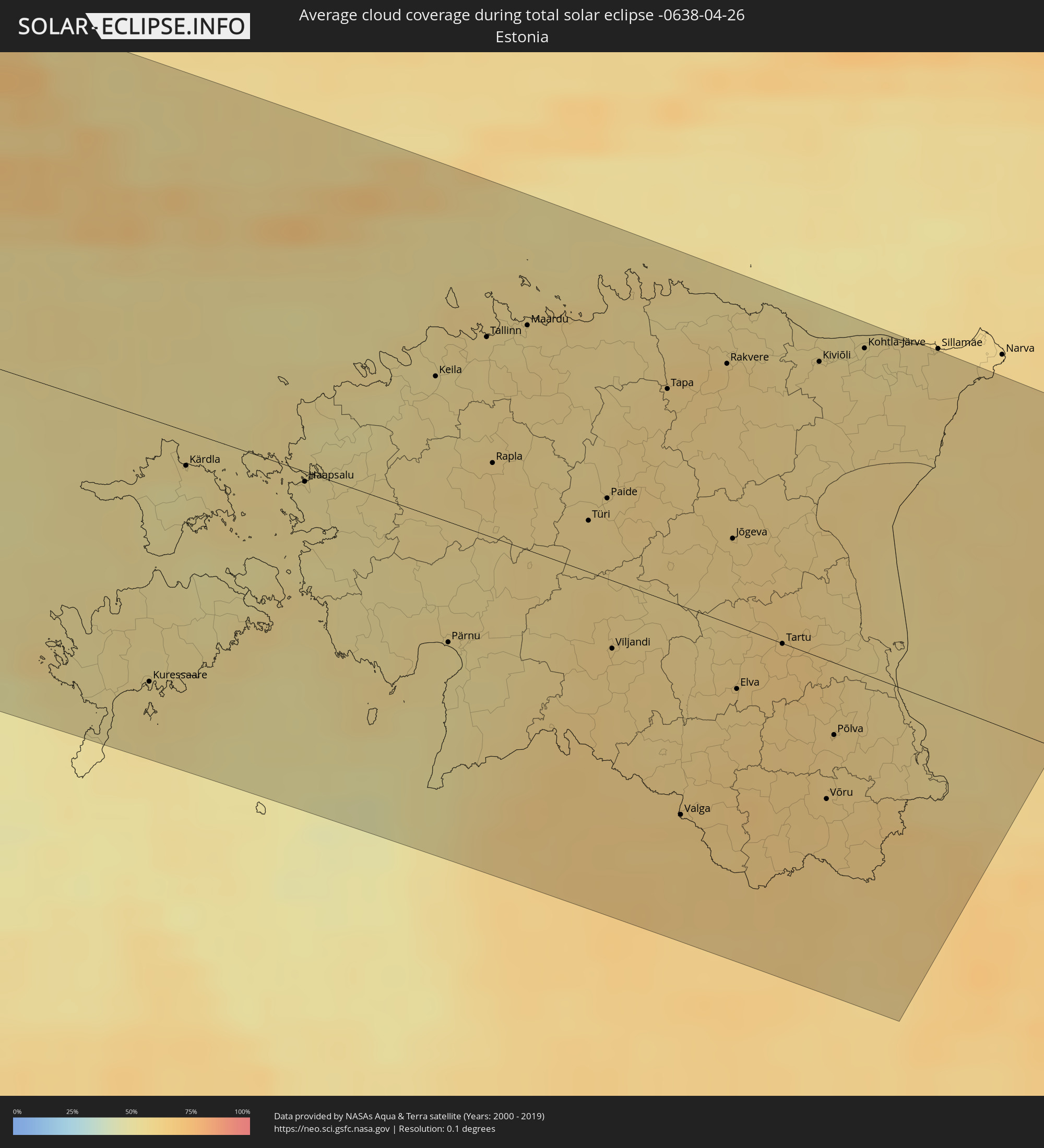
Wie wird das Wetter während der totalen Sonnenfinsternis am 26.04.-0638?
Wo ist der beste Ort, um die totale Sonnenfinsternis vom 26.04.-0638 zu beobachten?
Die folgenden Karten zeigen die durchschnittliche Bewölkung für den Tag, an dem die totale Sonnenfinsternis
stattfindet. Mit Hilfe der Karten lässt sich der Ort entlang des Finsternispfades eingrenzen,
der die besten Aussichen auf einen klaren wolkenfreien Himmel bietet.
Trotzdem muss man immer lokale Gegenenheiten beachten und sollte sich genau über das Wetter an seinem
gewählten Beobachtungsort informieren.
Die Daten stammen von den beiden NASA-Satelliten
AQUA und TERRA
und wurden über einen Zeitraum von 19 Jahren (2000 - 2019) gemittelt.
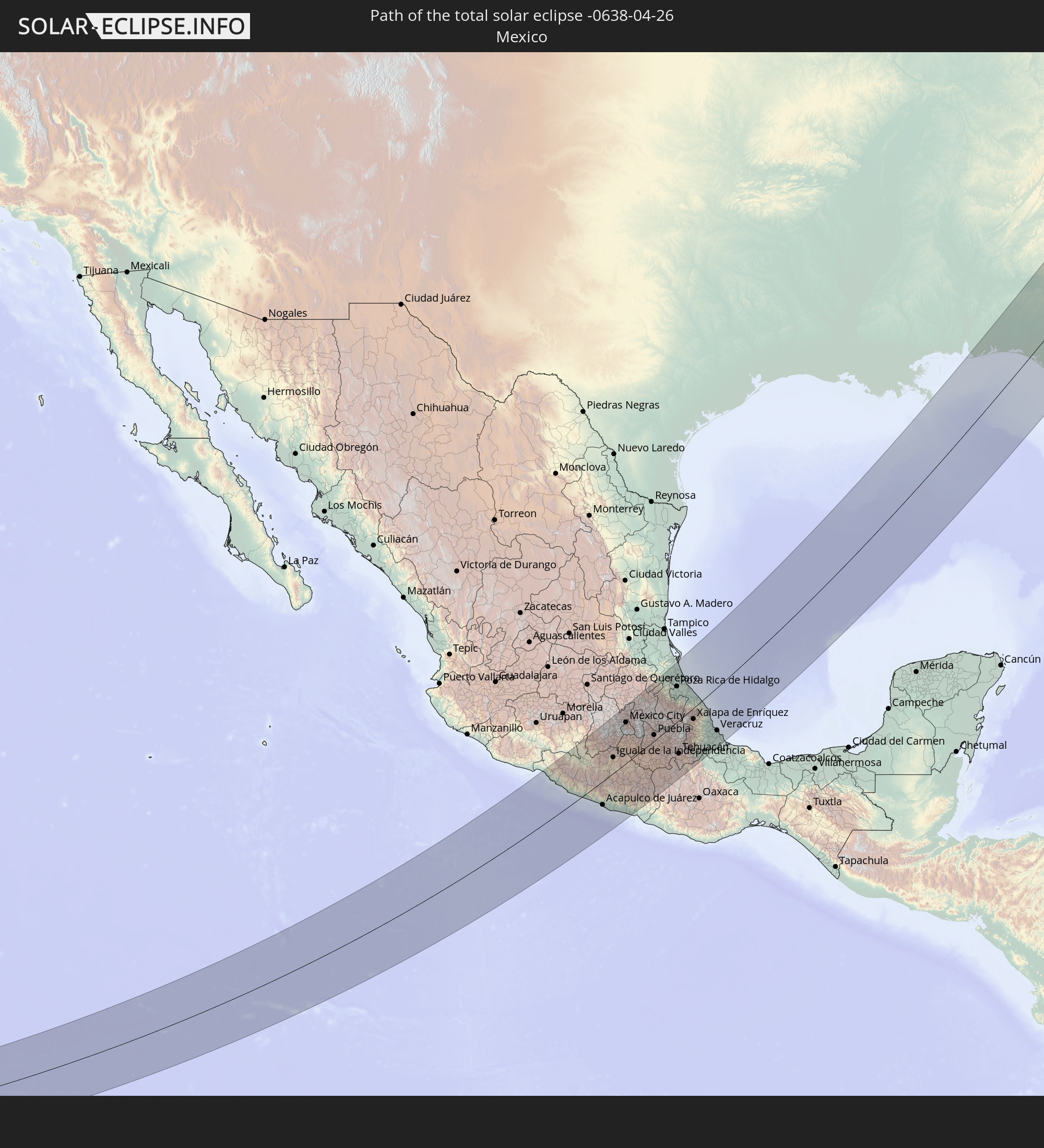
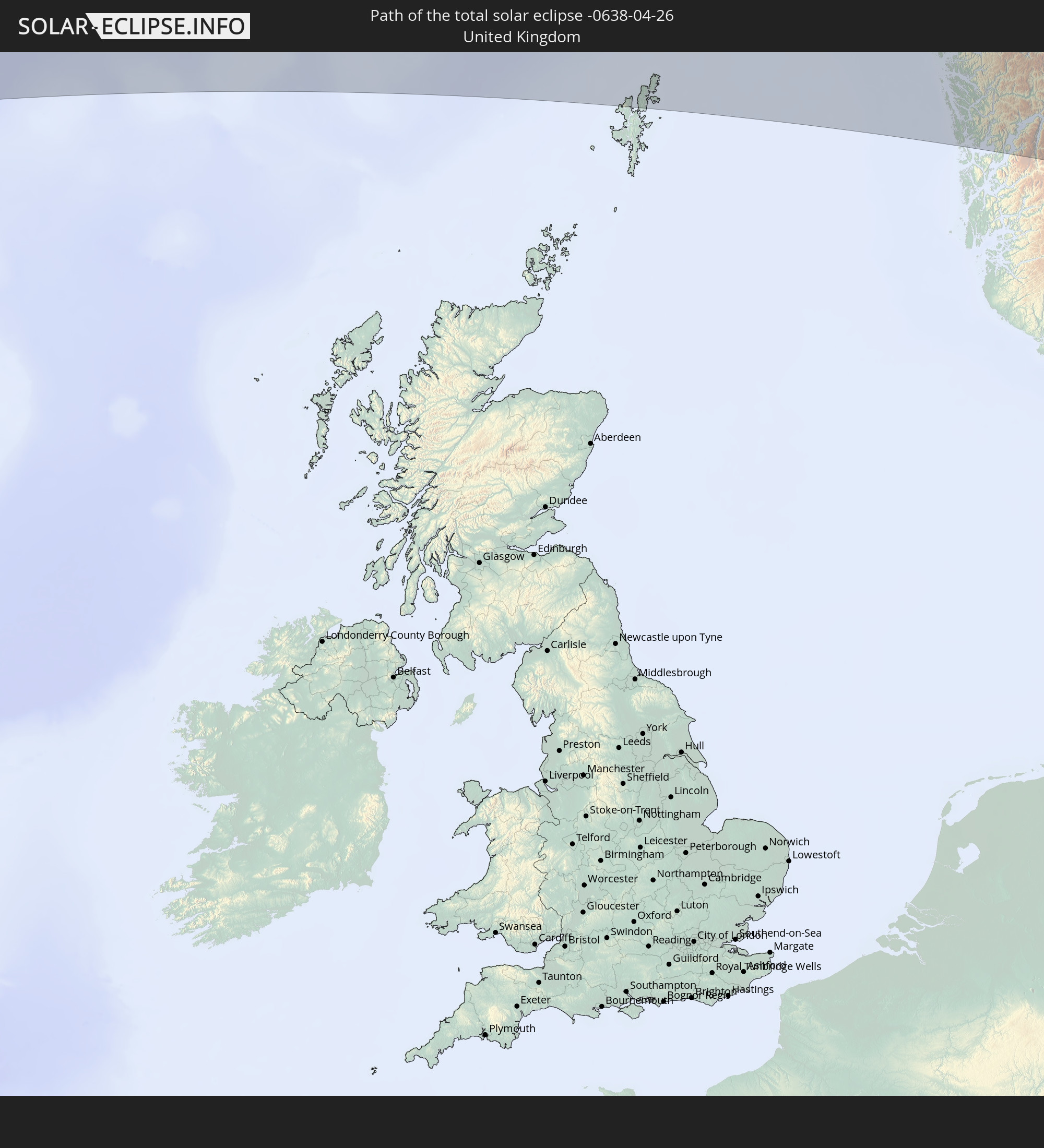
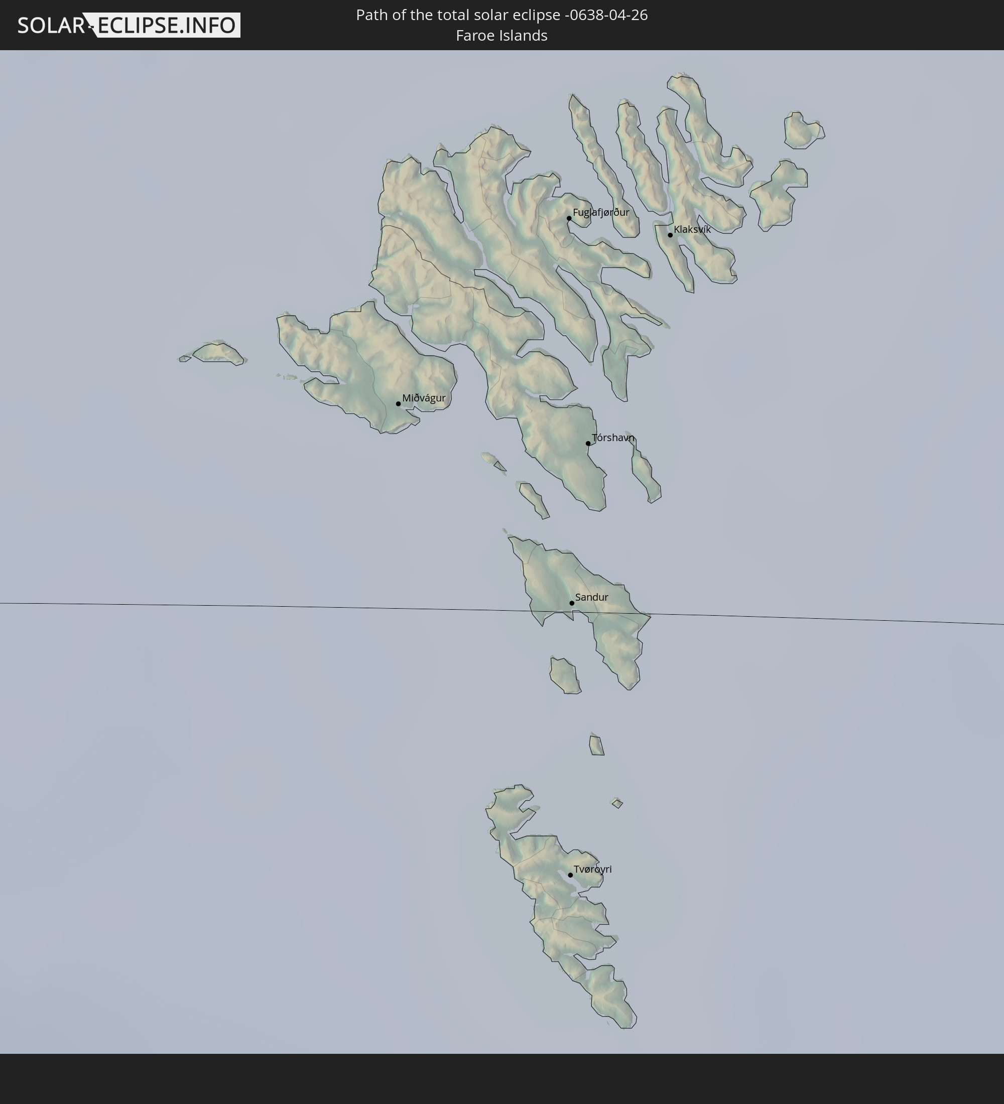
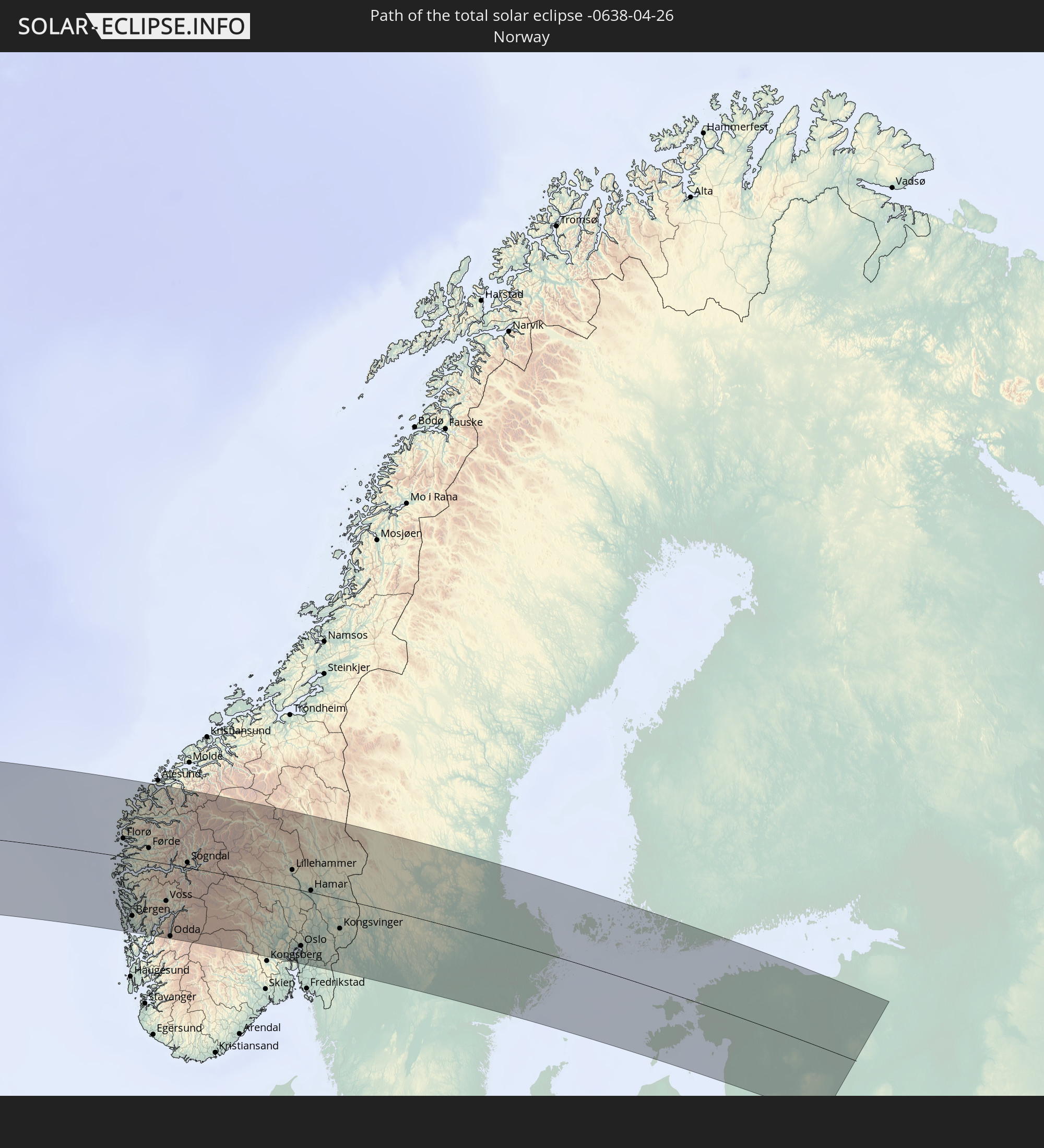
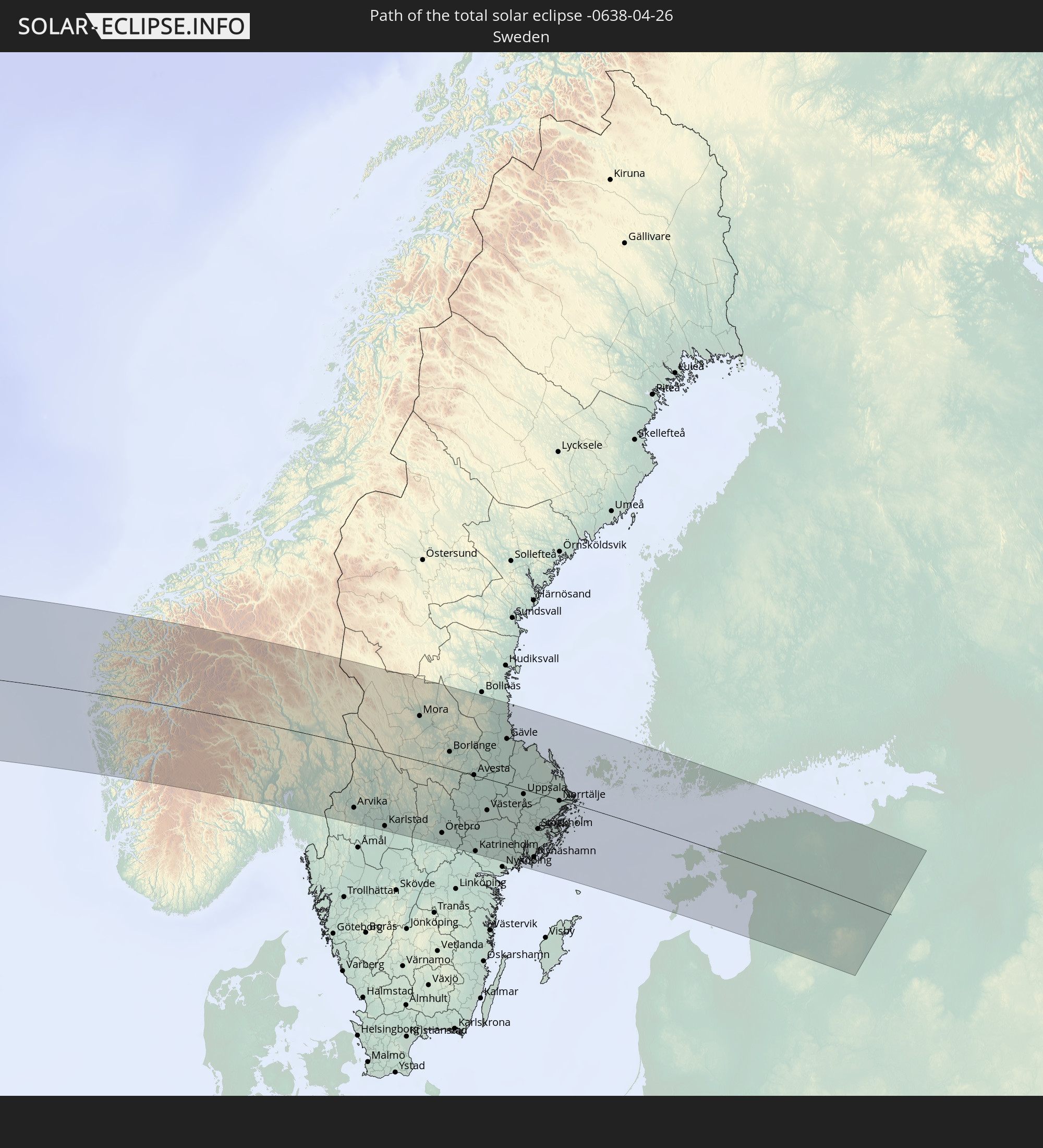
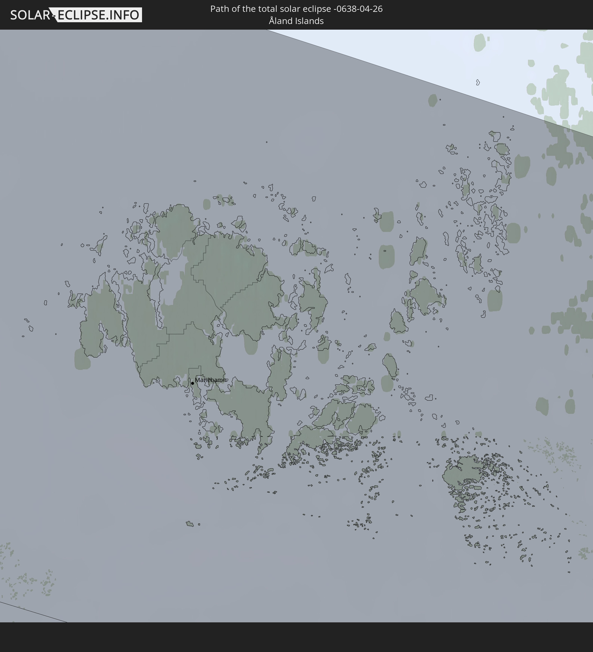
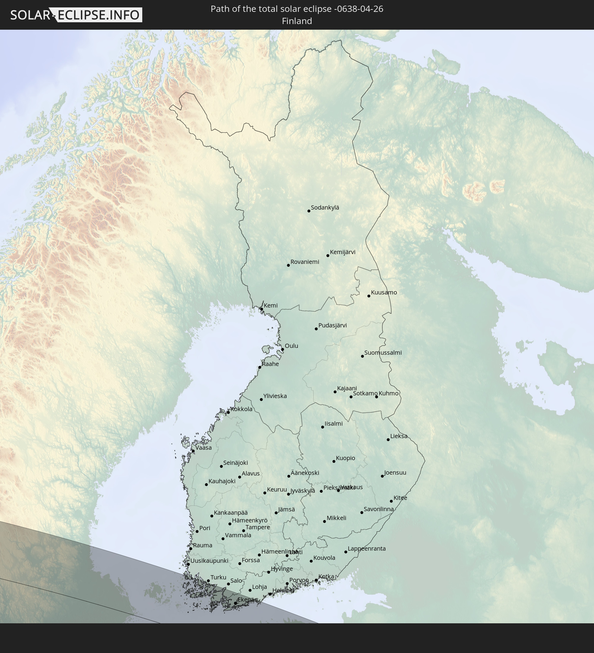
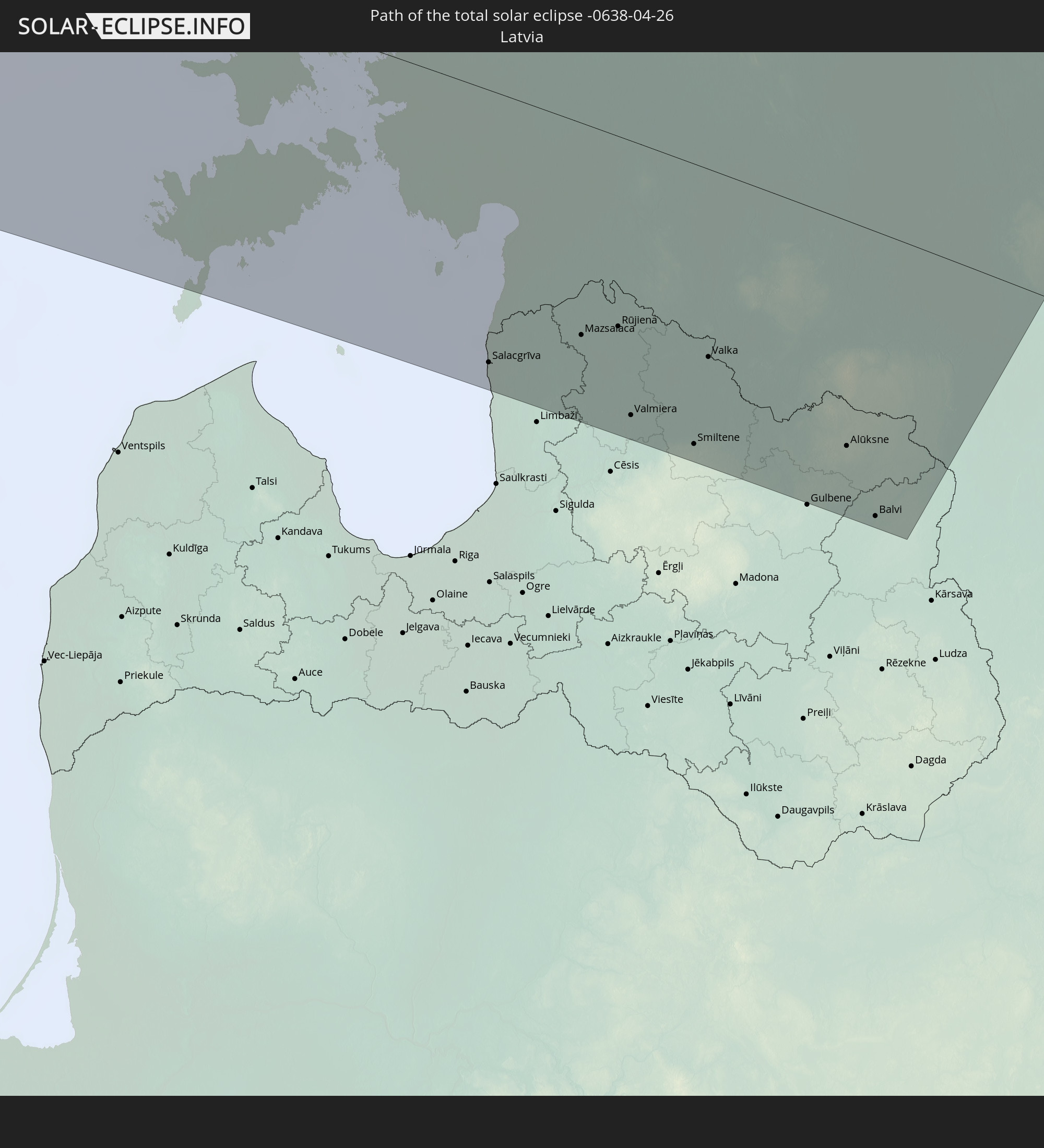
Detaillierte Länderkarten
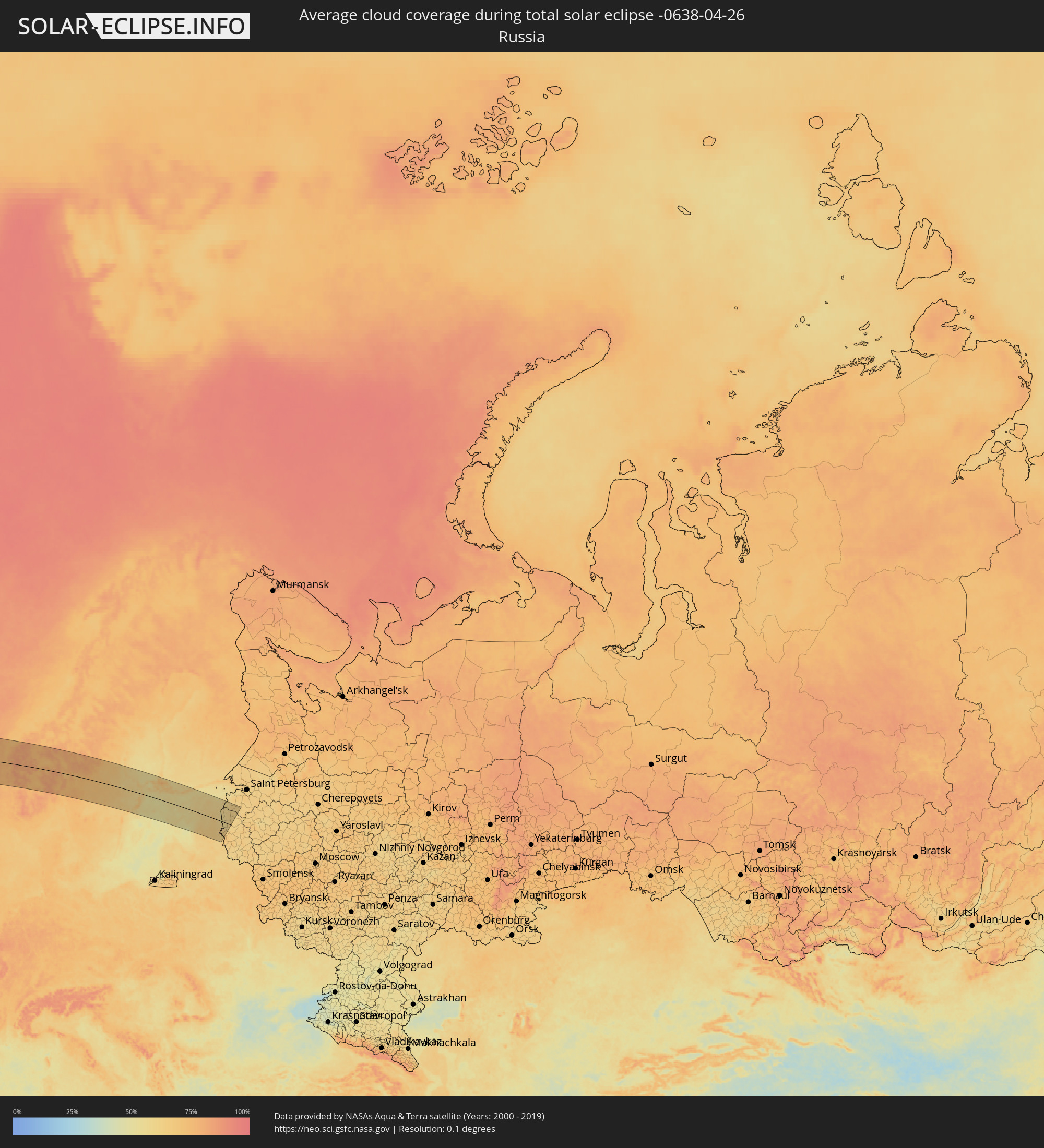 Russland
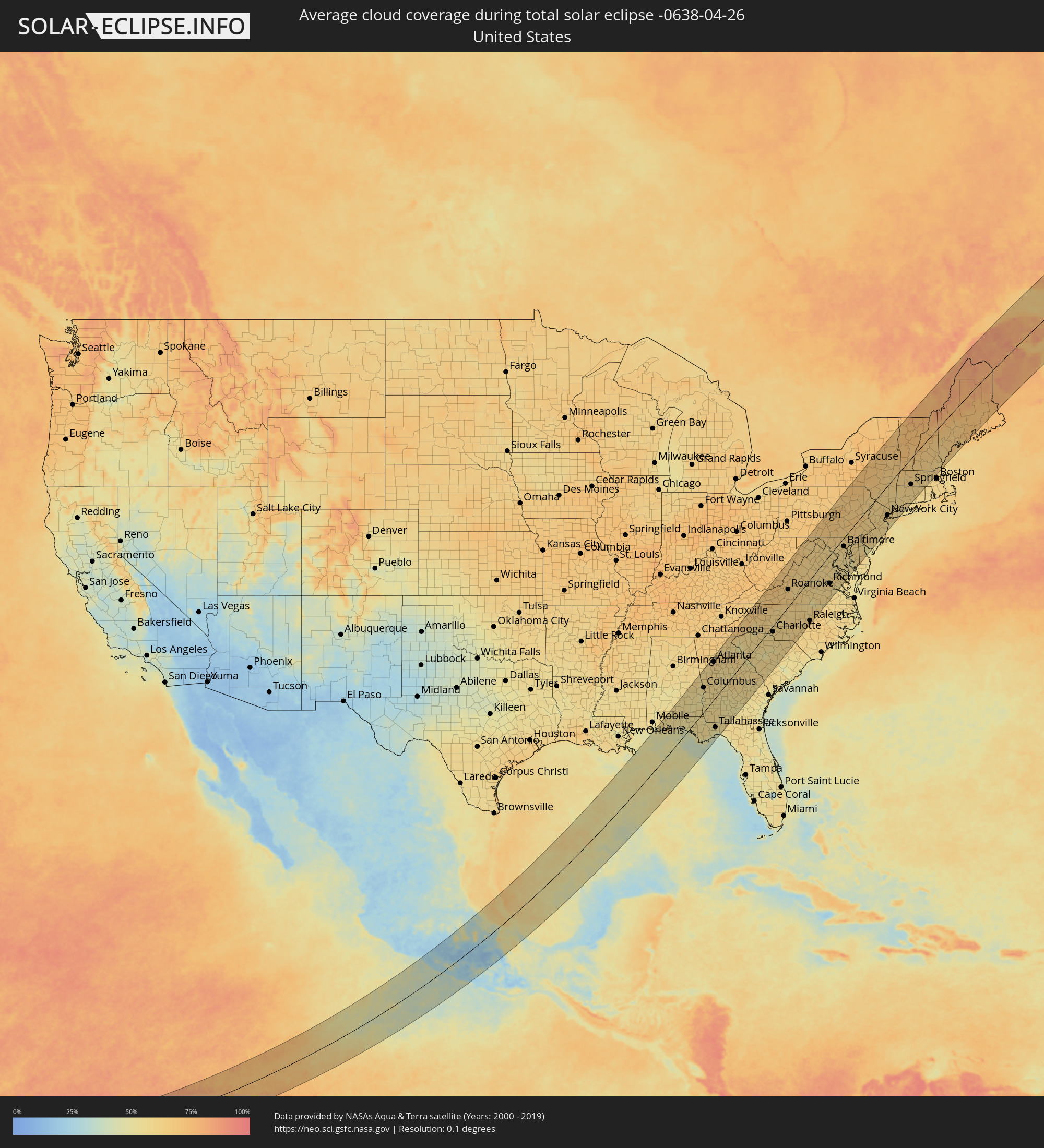 Vereinigte Staaten
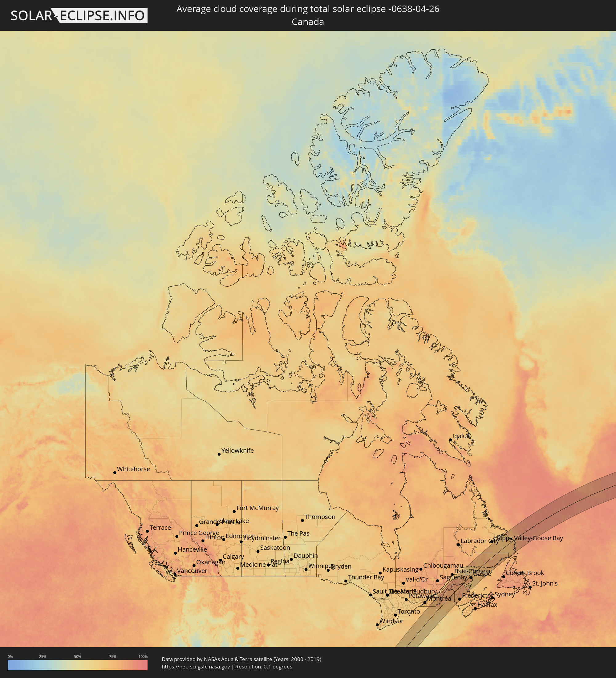 Kanada
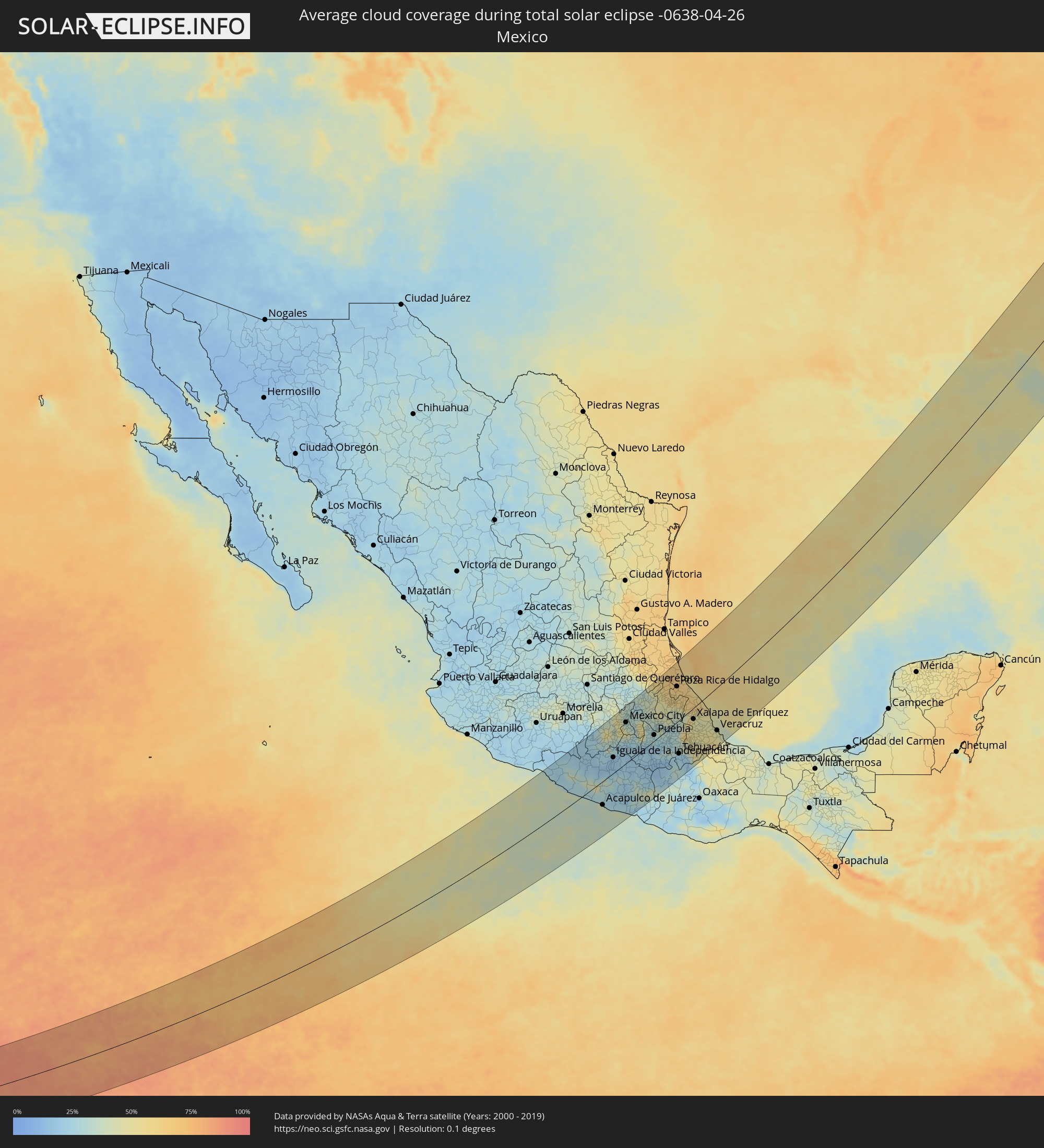 Mexiko
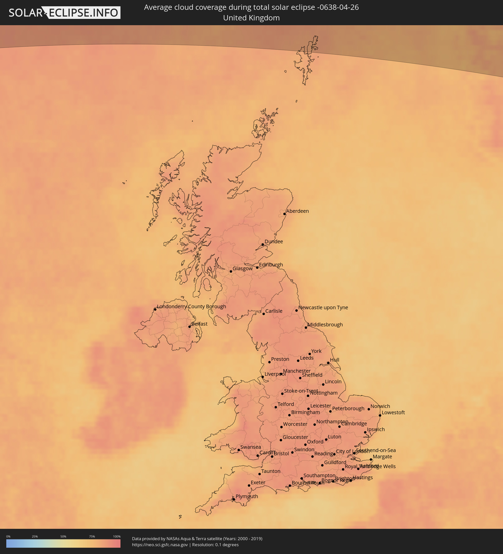 Vereinigtes Königreich
 Färöer
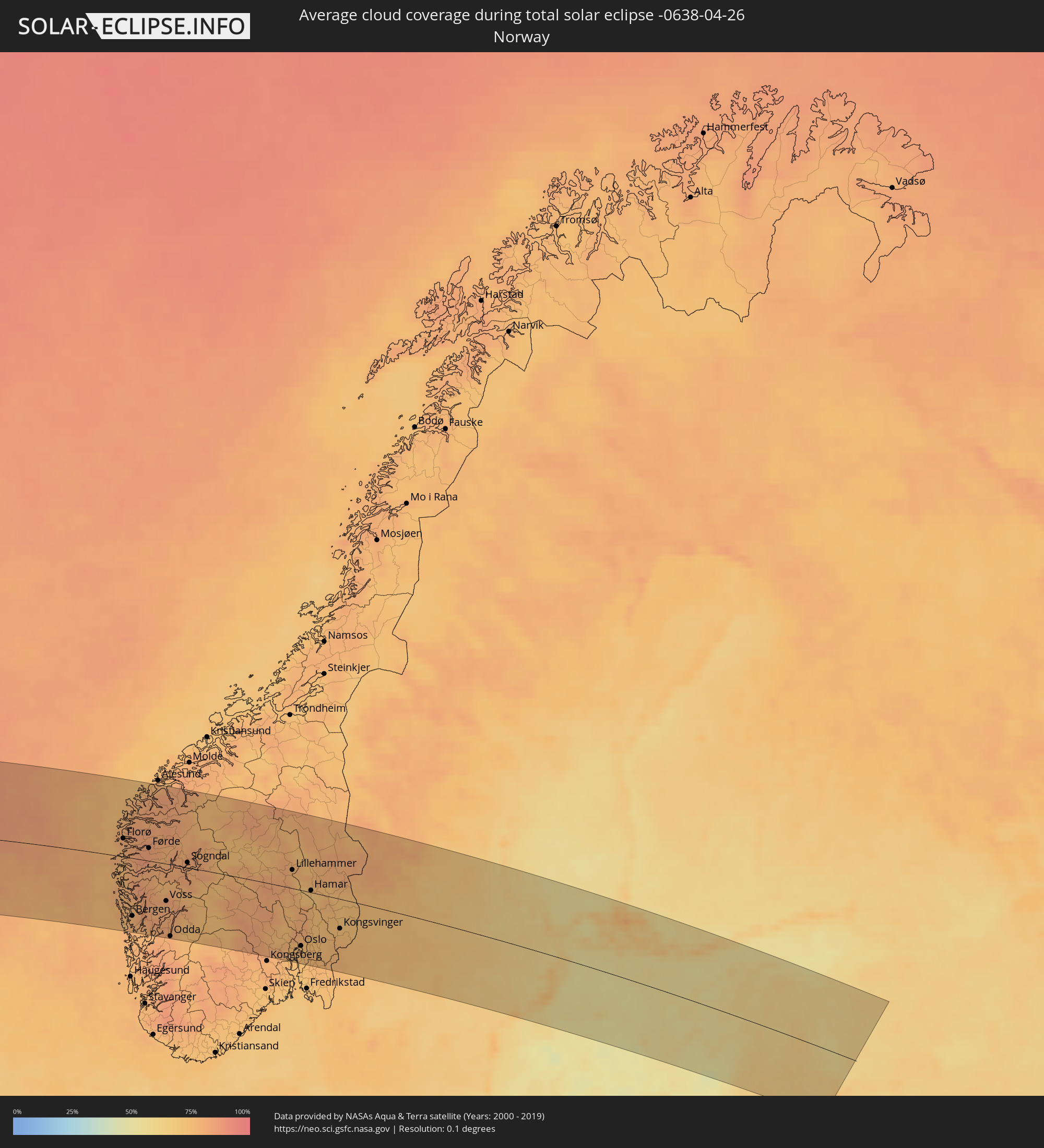 Norwegen
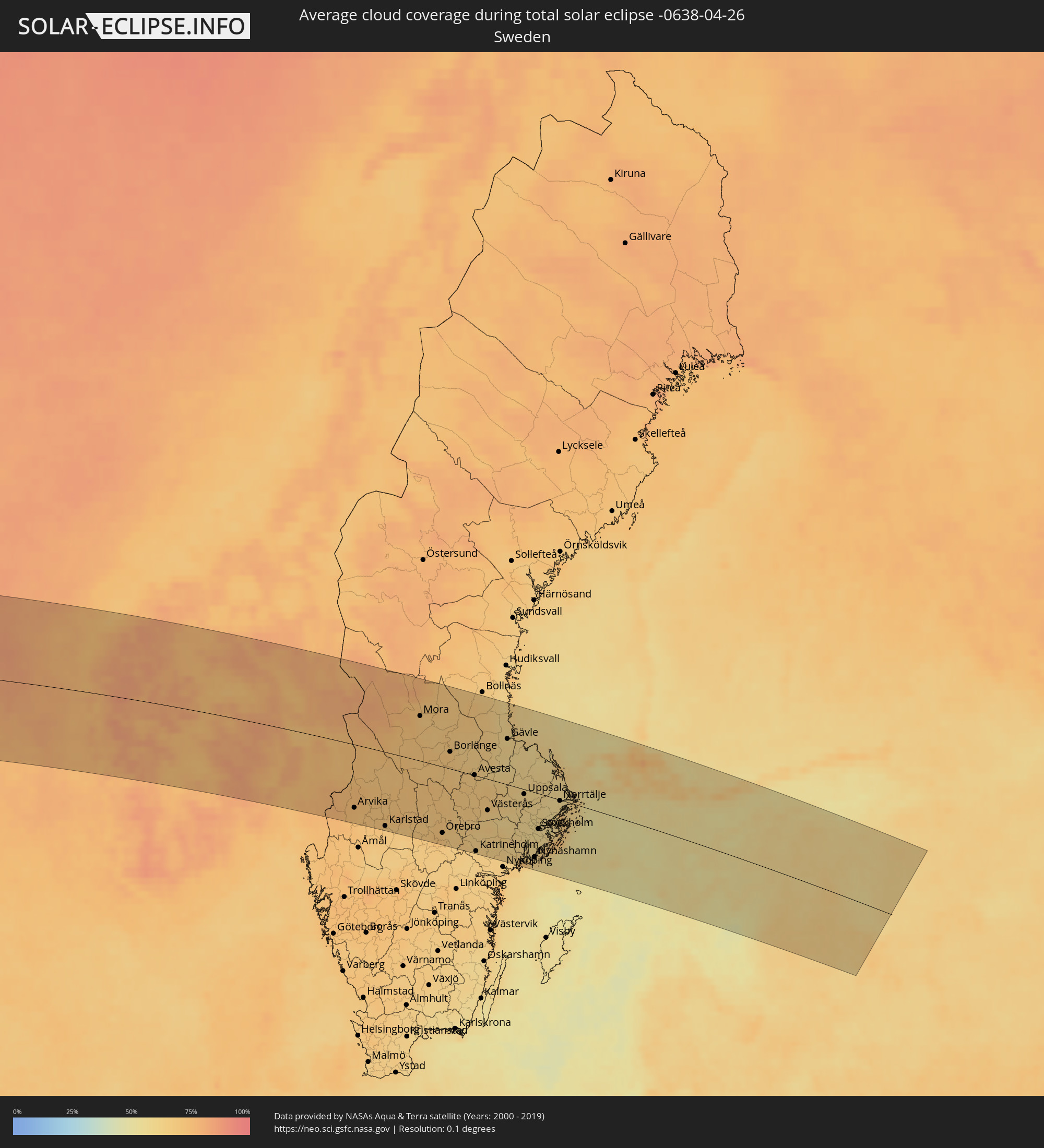 Schweden
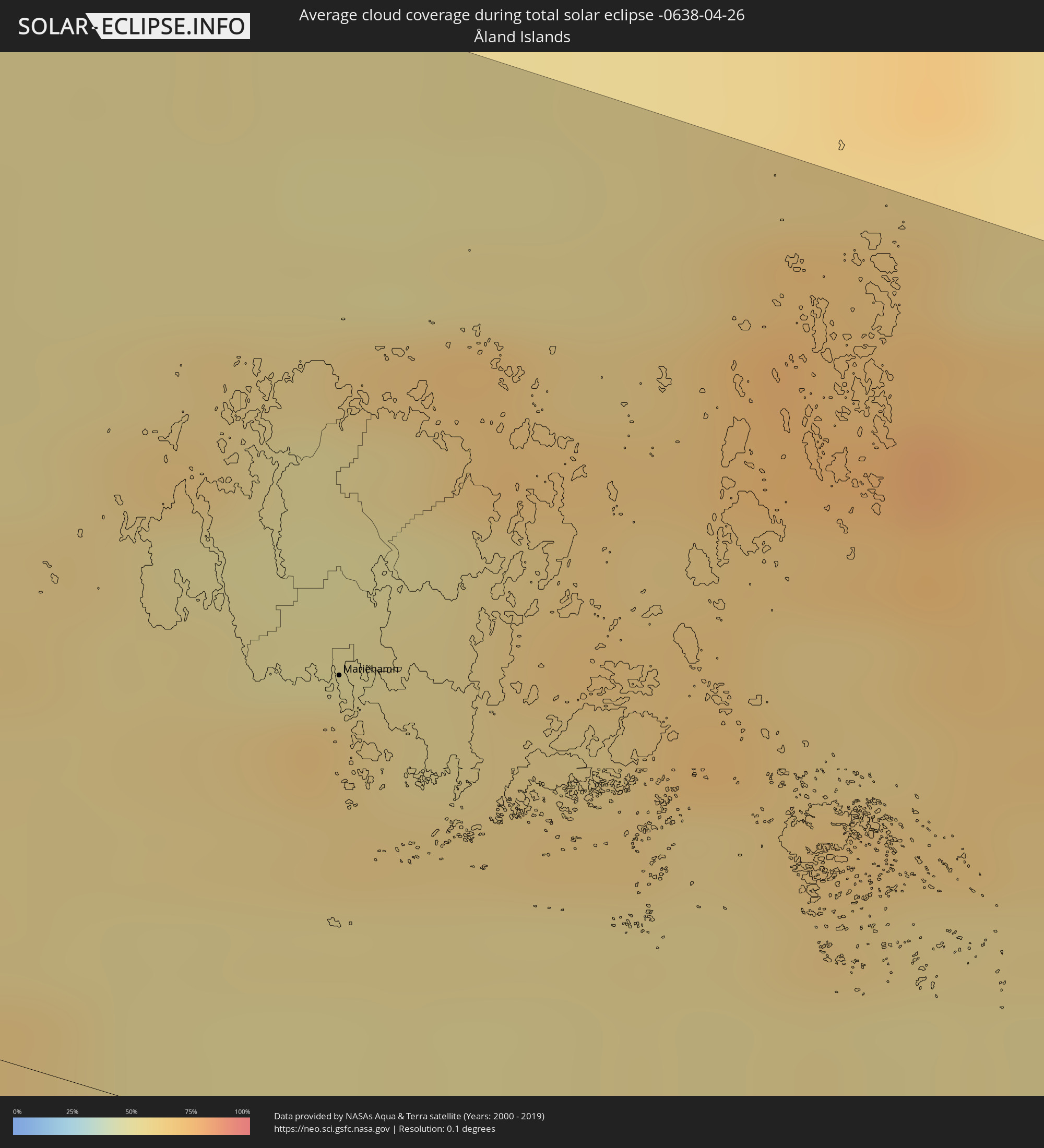 Åland Islands
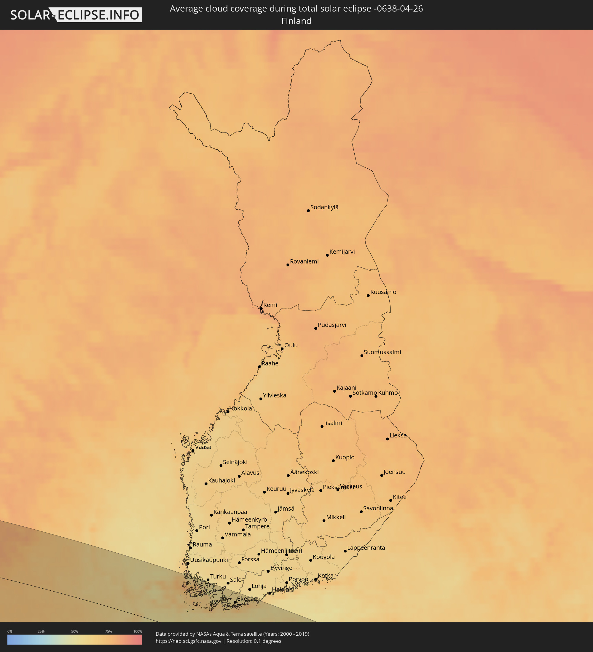 Finnland
 Lettland
 Estland
Orte im Finsternispfad
Die nachfolgene Tabelle zeigt Städte und Orte mit mehr als 5.000 Einwohnern, die sich im Finsternispfad befinden. Städte mit mehr als 100.000 Einwohnern sind dick gekennzeichnet. Mit einem Klick auf den Ort öffnet sich eine Detailkarte die die Lage des jeweiligen Ortes zusammen mit dem Verlauf der zentralen Finsternis präsentiert.
| Ort | Typ | Dauer der Verfinsterung | Ortszeit bei maximaler Verfinsterung | Entfernung zur Zentrallinie | Ø Bewölkung |
|
Acapulco de Juárez, Guerrero
|
total | - | 08:06:19 UTC-06:36 | 66 km | 39% |
|
Toluca, México
|
total | - | 08:10:34 UTC-06:36 | 133 km | 43% |
|
Chilpancingo, Guerrero
|
total | - | 08:07:43 UTC-06:36 | 29 km | 24% |
|
Ciudad López Mateos, México
|
total | - | 08:11:21 UTC-06:36 | 133 km | 42% |
|
Cuernavaca, Morelos
|
total | - | 08:10:14 UTC-06:36 | 74 km | 28% |
|
Tlalpan, Mexico City
|
total | - | 08:10:55 UTC-06:36 | 102 km | 45% |
|
Mexico City, Mexico City
|
total | - | 08:11:10 UTC-06:36 | 111 km | 35% |
|
Ecatepec, México
|
total | - | 08:11:32 UTC-06:36 | 123 km | 34% |
|
Santa María Chimalhuacán, México
|
total | - | 08:11:17 UTC-06:36 | 98 km | 32% |
|
Cuautla Morelos, Morelos
|
total | - | 08:10:13 UTC-06:36 | 44 km | 24% |
|
San Miguel Xico Viejo, México
|
total | - | 08:11:02 UTC-06:36 | 84 km | 32% |
|
Pachuca de Soto, Hidalgo
|
total | - | 08:12:39 UTC-06:36 | 143 km | 32% |
|
Puebla, Puebla
|
total | - | 08:11:08 UTC-06:36 | 15 km | 29% |
|
Poza Rica de Hidalgo, Veracruz
|
total | - | 08:14:18 UTC-06:36 | 93 km | 63% |
|
Tuxpan de Rodríguez Cano, Veracruz
|
total | - | 08:15:06 UTC-06:36 | 125 km | 59% |
|
Tehuacán, Puebla
|
total | - | 08:10:43 UTC-06:36 | 88 km | 23% |
|
Córdoba, Veracruz
|
total | - | 08:11:48 UTC-06:36 | 83 km | 46% |
|
Xalapa de Enríquez, Veracruz
|
total | - | 08:12:56 UTC-06:36 | 29 km | 47% |
|
Veracruz, Veracruz
|
total | - | 08:12:54 UTC-06:36 | 111 km | 47% |
|
Columbus, Georgia
|
total | - | 10:25:24 UTC-05:00 | 87 km | 58% |
|
Atlanta, Georgia
|
total | - | 10:28:34 UTC-05:00 | 132 km | 61% |
|
Tallahassee, Florida
|
total | - | 10:22:19 UTC-05:00 | 108 km | 51% |
|
Charlotte, North Carolina
|
total | - | 10:35:38 UTC-05:00 | 21 km | 60% |
|
Winston-Salem, North Carolina
|
total | - | 10:38:00 UTC-05:00 | 2 km | 62% |
|
Greensboro, North Carolina
|
total | - | 10:38:31 UTC-05:00 | 36 km | 60% |
|
Durham, North Carolina
|
total | - | 10:39:31 UTC-05:00 | 104 km | 62% |
|
Raleigh, North Carolina
|
total | - | 10:39:26 UTC-05:00 | 138 km | 62% |
|
Richmond, Virginia
|
total | - | 10:44:13 UTC-05:00 | 93 km | 60% |
|
Washington, D.C., Washington, D.C.
|
total | - | 10:47:09 UTC-05:00 | 27 km | 61% |
|
Baltimore, Maryland
|
total | - | 10:48:24 UTC-05:00 | 28 km | 60% |
|
Philadelphia, Pennsylvania
|
total | - | 10:51:26 UTC-05:00 | 76 km | 60% |
|
Paterson, New Jersey
|
total | - | 10:54:22 UTC-05:00 | 71 km | 63% |
|
Staten Island, New York
|
total | - | 10:53:49 UTC-05:00 | 98 km | 59% |
|
New York City, New York
|
total | - | 10:54:15 UTC-05:00 | 96 km | 61% |
|
The Bronx, New York
|
total | - | 10:54:39 UTC-05:00 | 95 km | 62% |
|
Jamaica, New York
|
total | - | 10:54:28 UTC-05:00 | 110 km | 59% |
|
Springfield, Massachusetts
|
total | - | 10:58:23 UTC-05:00 | 84 km | 64% |
|
Lac-Brome, Quebec
|
total | - | 11:03:15 UTC-05:00 | 140 km | 77% |
|
Magog, Quebec
|
total | - | 11:03:48 UTC-05:00 | 122 km | 75% |
|
Rock Forest, Quebec
|
total | - | 11:04:07 UTC-05:00 | 120 km | 76% |
|
Sherbrooke, Quebec
|
total | - | 11:04:19 UTC-05:00 | 117 km | 76% |
|
Worcester, Massachusetts
|
total | - | 10:59:41 UTC-05:00 | 121 km | 61% |
|
Coaticook, Quebec
|
total | - | 11:04:03 UTC-05:00 | 92 km | 76% |
|
Thetford-Mines, Quebec
|
total | - | 11:06:03 UTC-05:00 | 134 km | 79% |
|
Sainte-Marie, Quebec
|
total | - | 11:06:54 UTC-05:00 | 143 km | 79% |
|
Beauceville, Quebec
|
total | - | 11:06:54 UTC-05:00 | 113 km | 79% |
|
Saint-Georges, Quebec
|
total | - | 11:06:54 UTC-05:00 | 99 km | 79% |
|
Edmundston, New Brunswick
|
total | - | 11:57:10 UTC-04:14 | 64 km | 80% |
|
Matane, Quebec
|
total | - | 11:14:24 UTC-05:00 | 135 km | 84% |
|
Amqui, Quebec
|
total | - | 11:14:04 UTC-05:00 | 101 km | 87% |
|
Campbellton, New Brunswick
|
total | - | 12:00:04 UTC-04:14 | 26 km | 86% |
|
Fredericton, New Brunswick
|
total | - | 11:57:28 UTC-04:14 | 138 km | 74% |
|
Sainte-Anne-des-Monts, Quebec
|
total | - | 11:16:01 UTC-05:00 | 104 km | 82% |
|
Bathurst, New Brunswick
|
total | - | 12:00:54 UTC-04:14 | 59 km | 80% |
|
Miramichi, New Brunswick
|
total | - | 12:00:23 UTC-04:14 | 114 km | 78% |
|
Chandler, Quebec
|
total | - | 11:17:25 UTC-05:00 | 50 km | 73% |
|
Gaspé, Quebec
|
total | - | 11:18:12 UTC-05:00 | 21 km | 80% |
|
Miðvágur, Vágar
|
total | - | 16:41:15 UTC-00:27 | 24 km | 92% |
|
Fuglafjørður, Eysturoy
|
total | - | 16:41:11 UTC-00:27 | 46 km | 93% |
|
Tvøroyri, Suðuroy
|
total | - | 16:41:53 UTC-00:27 | 31 km | 90% |
|
Sandur, Sandoy
|
total | - | 16:41:36 UTC-00:27 | 1 km | 88% |
|
Tórshavn, Streymoy
|
total | - | 16:41:26 UTC-00:27 | 20 km | 90% |
|
Klaksvík, Norðoyar
|
total | - | 16:41:17 UTC-00:27 | 44 km | 92% |
|
Florø, Sogn og Fjordane
|
total | - | 18:11:51 UTC+01:00 | 31 km | 80% |
|
Bergen, Hordaland
|
total | - | 18:13:12 UTC+01:00 | 99 km | 77% |
|
Førde, Sogn og Fjordane
|
total | - | 18:12:08 UTC+01:00 | 22 km | 84% |
|
Drammen, Buskerud
|
total | - | 18:14:28 UTC+01:00 | 121 km | 75% |
|
Hønefoss, Buskerud
|
total | - | 18:14:01 UTC+01:00 | 74 km | 74% |
|
Lillehammer, Oppland
|
total | - | 18:13:01 UTC+01:00 | 31 km | 76% |
|
Nesoddtangen, Akershus
|
total | - | 18:14:23 UTC+01:00 | 103 km | 75% |
|
Gjøvik, Oppland
|
total | - | 18:13:23 UTC+01:00 | 1 km | 74% |
|
Oslo, Oslo
|
total | - | 18:14:20 UTC+01:00 | 96 km | 75% |
|
Ås, Akershus
|
total | - | 18:14:36 UTC+01:00 | 123 km | 73% |
|
Ski, Akershus
|
total | - | 18:14:33 UTC+01:00 | 116 km | 73% |
|
Brumunddal, Hedmark
|
total | - | 18:13:18 UTC+01:00 | 11 km | 71% |
|
Lillestrøm, Akershus
|
total | - | 18:14:19 UTC+01:00 | 88 km | 73% |
|
Hamar, Hedmark
|
total | - | 18:13:24 UTC+01:00 | 3 km | 70% |
|
Askim, Østfold
|
total | - | 18:14:43 UTC+01:00 | 127 km | 76% |
|
Jessheim, Akershus
|
total | - | 18:14:07 UTC+01:00 | 66 km | 73% |
|
Råholt, Akershus
|
total | - | 18:13:59 UTC+01:00 | 52 km | 73% |
|
Elverum, Hedmark
|
total | - | 18:13:21 UTC+01:00 | 19 km | 73% |
|
Kongsvinger, Hedmark
|
total | - | 18:14:07 UTC+01:00 | 51 km | 73% |
|
Karlstad, Värmland
|
total | - | 18:15:02 UTC+01:00 | 119 km | 68% |
|
Kristinehamn, Värmland
|
total | - | 18:15:08 UTC+01:00 | 118 km | 67% |
|
Karlskoga, Örebro
|
total | - | 18:15:07 UTC+01:00 | 111 km | 69% |
|
Örebro, Örebro
|
total | - | 18:15:11 UTC+01:00 | 107 km | 70% |
|
Borlänge, Dalarna
|
total | - | 18:13:53 UTC+01:00 | 27 km | 70% |
|
Falun, Dalarna
|
total | - | 18:13:46 UTC+01:00 | 42 km | 68% |
|
Katrineholm, Södermanland
|
total | - | 18:15:28 UTC+01:00 | 122 km | 65% |
|
Eskilstuna, Södermanland
|
total | - | 18:15:04 UTC+01:00 | 78 km | 65% |
|
Västerås, Västmanland
|
total | - | 18:14:48 UTC+01:00 | 50 km | 63% |
|
Sandviken, Gävleborg
|
total | - | 18:13:44 UTC+01:00 | 60 km | 63% |
|
Enköping, Uppsala
|
total | - | 18:14:46 UTC+01:00 | 40 km | 62% |
|
Gävle, Gävleborg
|
total | - | 18:13:40 UTC+01:00 | 72 km | 60% |
|
Södertälje, Stockholm
|
total | - | 18:15:13 UTC+01:00 | 79 km | 61% |
|
Uppsala, Uppsala
|
total | - | 18:14:31 UTC+01:00 | 8 km | 61% |
|
Upplands Väsby, Stockholm
|
total | - | 18:14:52 UTC+01:00 | 40 km | 57% |
|
Stockholm, Stockholm
|
total | - | 18:15:04 UTC+01:00 | 57 km | 57% |
|
Haninge, Stockholm
|
total | - | 18:15:14 UTC+01:00 | 74 km | 59% |
|
Åkersberga, Stockholm
|
total | - | 18:14:54 UTC+01:00 | 38 km | 59% |
|
Norrtälje, Stockholm
|
total | - | 18:14:35 UTC+01:00 | 2 km | 58% |
|
Mariehamn, Mariehamns stad
|
total | - | 18:53:58 UTC+01:39 | 55 km | 65% |
|
Länsi-Turunmaa, Southwest Finland
|
total | - | 18:53:34 UTC+01:39 | 117 km | 55% |
|
Pargas, Southwest Finland
|
total | - | 18:53:34 UTC+01:39 | 117 km | 55% |
|
Kuressaare, Saare
|
total | - | 18:54:50 UTC+01:39 | 96 km | 56% |
|
Hanko, Uusimaa
|
total | - | 18:53:59 UTC+01:39 | 79 km | 58% |
|
Perniö, Southwest Finland
|
total | - | 18:53:35 UTC+01:39 | 121 km | 57% |
|
Ekenäs, Uusimaa
|
total | - | 18:53:47 UTC+01:39 | 103 km | 60% |
|
Pohja, Uusimaa
|
total | - | 18:53:39 UTC+01:39 | 117 km | 57% |
|
Haapsalu, Lääne
|
total | - | 18:54:01 UTC+01:39 | 4 km | 55% |
|
Karis, Uusimaa
|
total | - | 18:53:40 UTC+01:39 | 117 km | 57% |
|
Ingå, Uusimaa
|
total | - | 18:53:39 UTC+01:39 | 121 km | 68% |
|
Salacgrīva, Salacgrīvas
|
total | - | 18:52:39 UTC+01:36 | 113 km | 52% |
|
Keila, Harjumaa
|
total | - | 18:53:32 UTC+01:39 | 51 km | 57% |
|
Pärnu, Pärnumaa
|
total | - | 18:54:27 UTC+01:39 | 44 km | 55% |
|
Tallinn, Harjumaa
|
total | - | 18:53:21 UTC+01:39 | 71 km | 58% |
|
Aloja, Aloja
|
total | - | 18:52:34 UTC+01:36 | 101 km | 63% |
|
Maardu, Harjumaa
|
total | - | 18:53:17 UTC+01:39 | 81 km | 56% |
|
Mazsalaca, Mazsalaca
|
total | - | 18:52:27 UTC+01:36 | 88 km | 64% |
|
Matīši, Burtnieki
|
total | - | 18:52:36 UTC+01:36 | 103 km | 63% |
|
Rūjiena, Rūjienas
|
total | - | 18:52:22 UTC+01:36 | 79 km | 63% |
|
Kocēni, Kocēni
|
total | - | 18:52:44 UTC+01:36 | 118 km | 63% |
|
Valmiera, Valmieras Rajons
|
total | - | 18:52:42 UTC+01:36 | 114 km | 64% |
|
Türi, Järvamaa
|
total | - | 18:53:53 UTC+01:39 | 19 km | 59% |
|
Naukšēni, Naukšēni
|
total | - | 18:52:22 UTC+01:36 | 78 km | 63% |
|
Murmuiža, Beverīna
|
total | - | 18:52:45 UTC+01:36 | 119 km | 65% |
|
Paide, Järvamaa
|
total | - | 18:53:48 UTC+01:39 | 29 km | 60% |
|
Viljandi, Viljandimaa
|
total | - | 18:54:18 UTC+01:39 | 25 km | 61% |
|
Strenči, Strenči
|
total | - | 18:52:35 UTC+01:36 | 100 km | 65% |
|
Smiltene, Smiltene
|
total | - | 18:52:44 UTC+01:36 | 117 km | 64% |
|
Tapa, Lääne-Virumaa
|
total | - | 18:53:21 UTC+01:39 | 76 km | 61% |
|
Valka, Valkas Rajons
|
total | - | 18:52:23 UTC+01:36 | 78 km | 64% |
|
Valga, Valgamaa
|
total | - | 18:54:48 UTC+01:39 | 77 km | 64% |
|
Rakvere, Lääne-Virumaa
|
total | - | 18:53:13 UTC+01:39 | 93 km | 60% |
|
Jõgeva, Jõgevamaa
|
total | - | 18:53:48 UTC+01:39 | 31 km | 60% |
|
Ape, Apes Novads
|
total | - | 18:52:30 UTC+01:36 | 89 km | 64% |
|
Tartu, Tartu
|
total | - | 18:54:06 UTC+01:39 | 0 km | 64% |
|
Kiviõli, Ida-Virumaa
|
total | - | 18:53:06 UTC+01:39 | 106 km | 58% |
|
Võru, Võrumaa
|
total | - | 18:54:35 UTC+01:39 | 51 km | 64% |
|
Alūksne, Alūksnes Rajons
|
total | - | 18:52:33 UTC+01:36 | 94 km | 62% |
|
Põlva, Põlvamaa
|
total | - | 18:54:22 UTC+01:39 | 26 km | 62% |
|
Balvi, Balvu Rajons
|
total | - | 18:52:47 UTC+01:36 | 119 km | 61% |
|
Kohtla-Järve, Ida-Virumaa
|
total | - | 18:53:00 UTC+01:39 | 117 km | 56% |
|
Jõhvi, Ida-Virumaa
|
total | - | 18:53:01 UTC+01:39 | 116 km | 55% |
|
Pechory, Pskov
|
total | - | 19:45:47 UTC+02:30 | 41 km | 65% |
|
Gdov, Pskov
|
total | - | 19:44:50 UTC+02:30 | 60 km | 58% |
|
Slantsy, Leningradskaya Oblast'
|
total | - | 19:44:25 UTC+02:30 | 105 km | 59% |