Totale Sonnenfinsternis vom 14.03.-0710
| Wochentag: | Sonntag |
| Maximale Dauer der Verfinsterung: | 04m26s |
| Maximale Breite des Finsternispfades: | 321 km |
| Saroszyklus: | 57 |
| Bedeckungsgrad: | 100% |
| Magnitude: | 1.0617 |
| Gamma: | 0.7877 |
Wo kann man die Sonnenfinsternis vom 14.03.-0710 sehen?
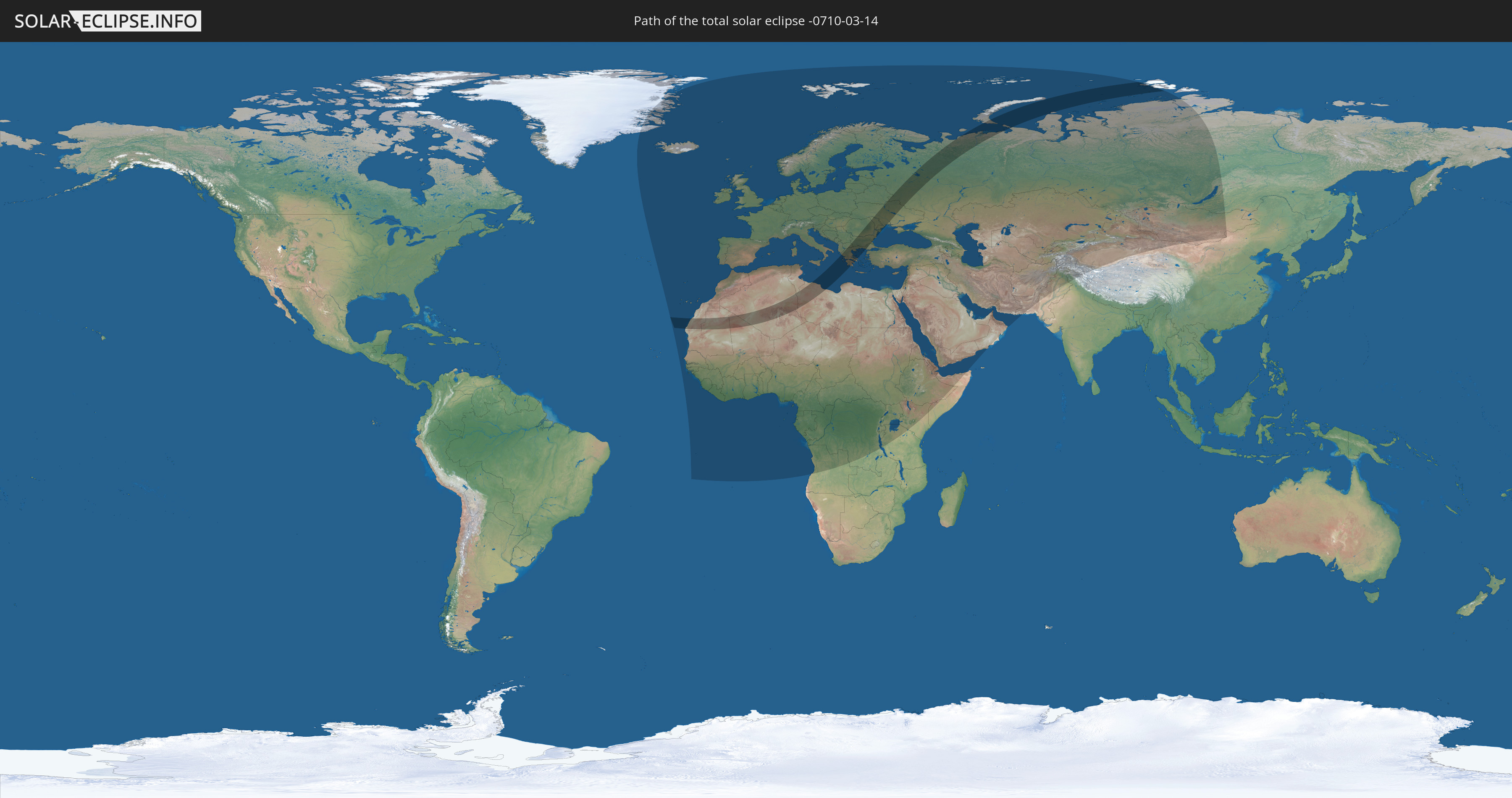
Die Sonnenfinsternis am 14.03.-0710 kann man in 121 Ländern als partielle Sonnenfinsternis beobachten.
Der Finsternispfad verläuft durch 14 Länder. Nur in diesen Ländern ist sie als totale Sonnenfinsternis zu sehen.
In den folgenden Ländern ist die Sonnenfinsternis total zu sehen
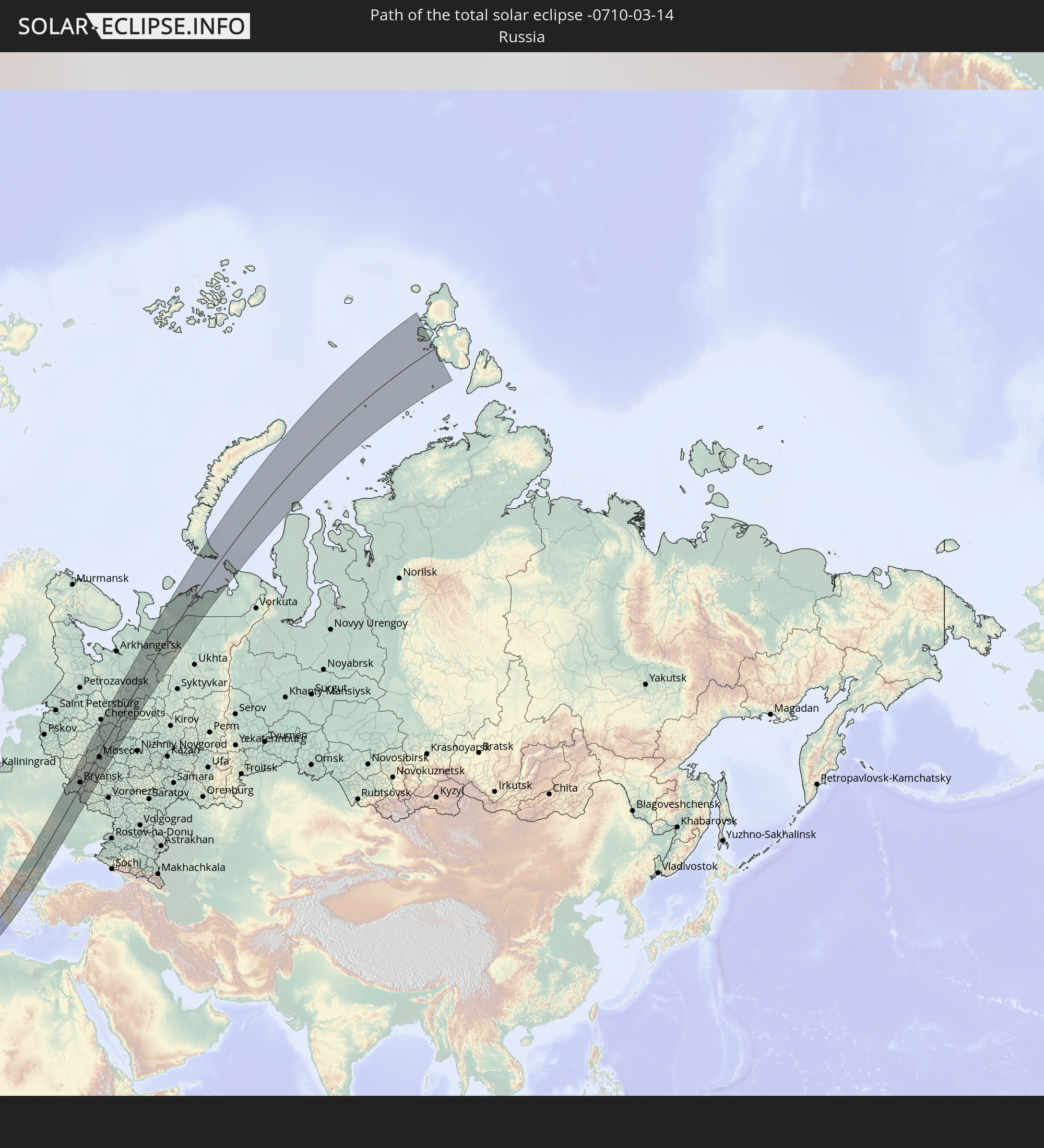 Russland
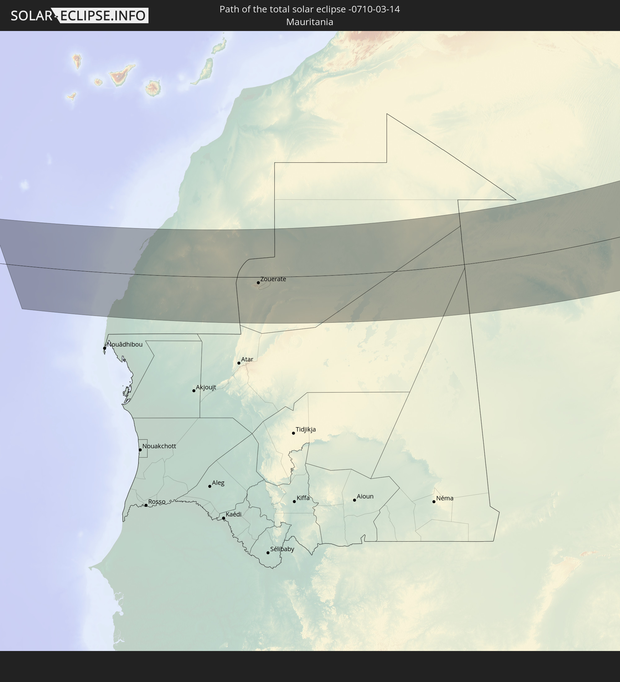 Mauretanien
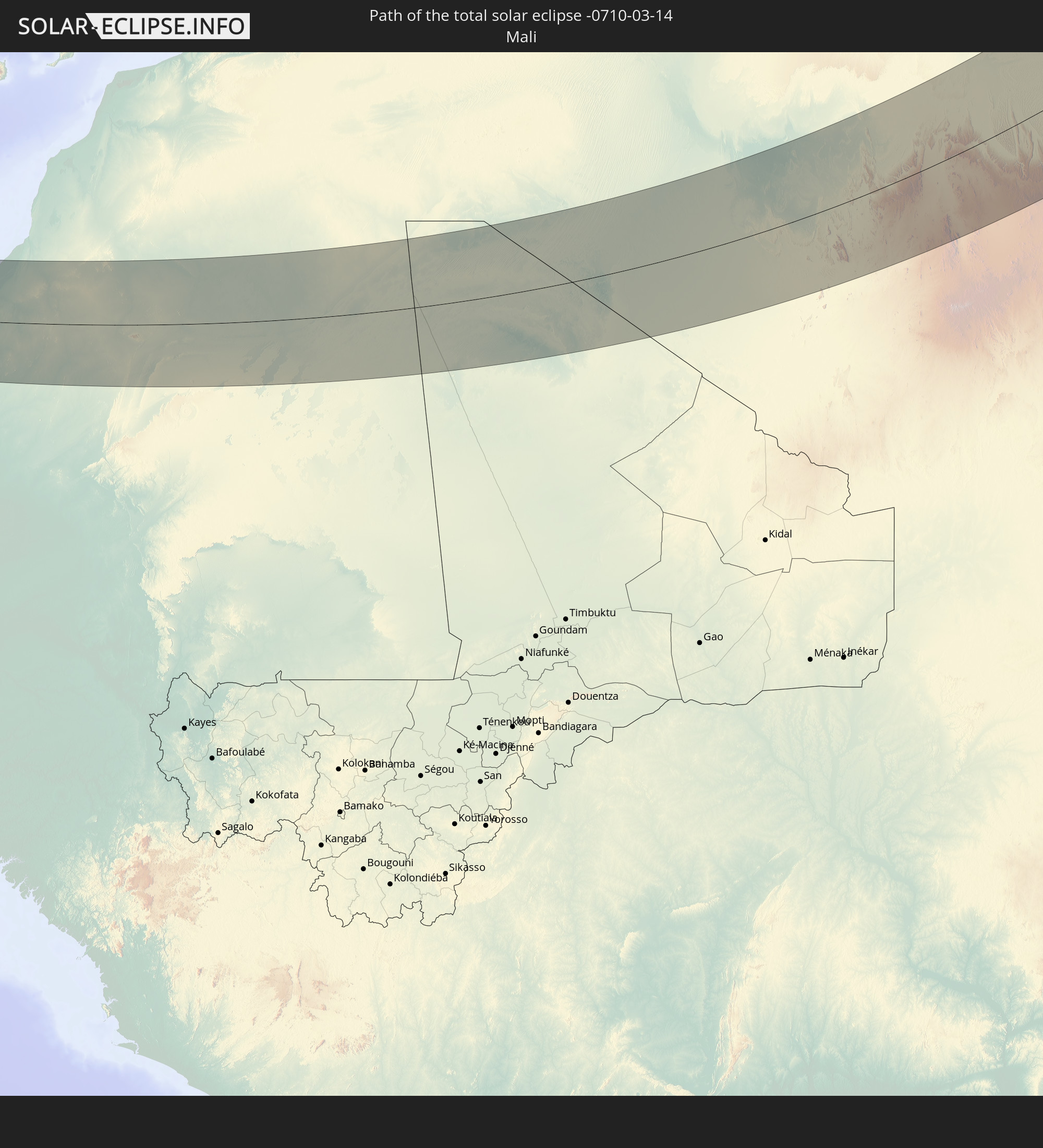 Mali
Mali
 Algerien
 Tunesien
 Libyen
 Griechenland
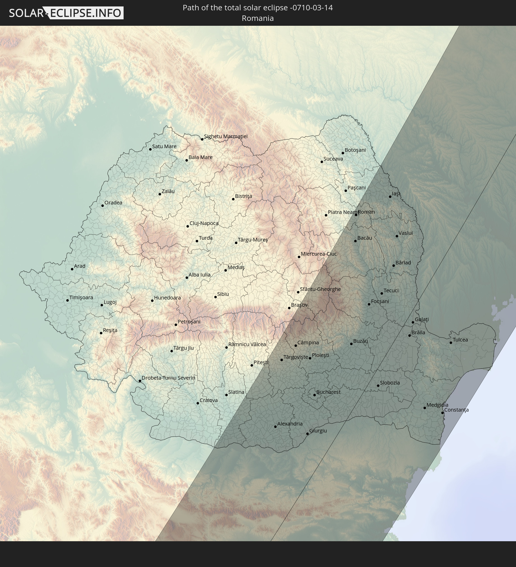 Rumänien
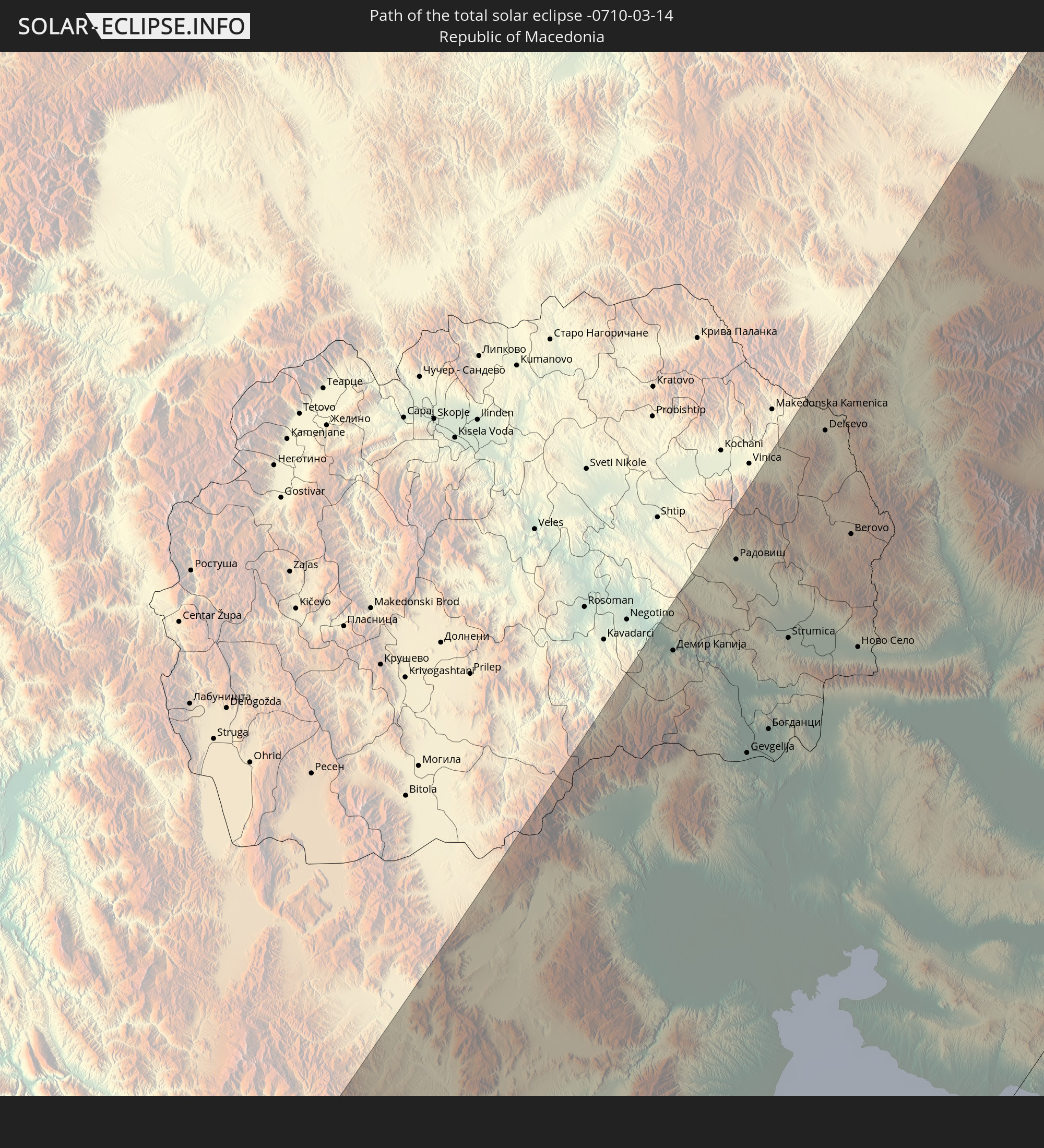 Mazedonien
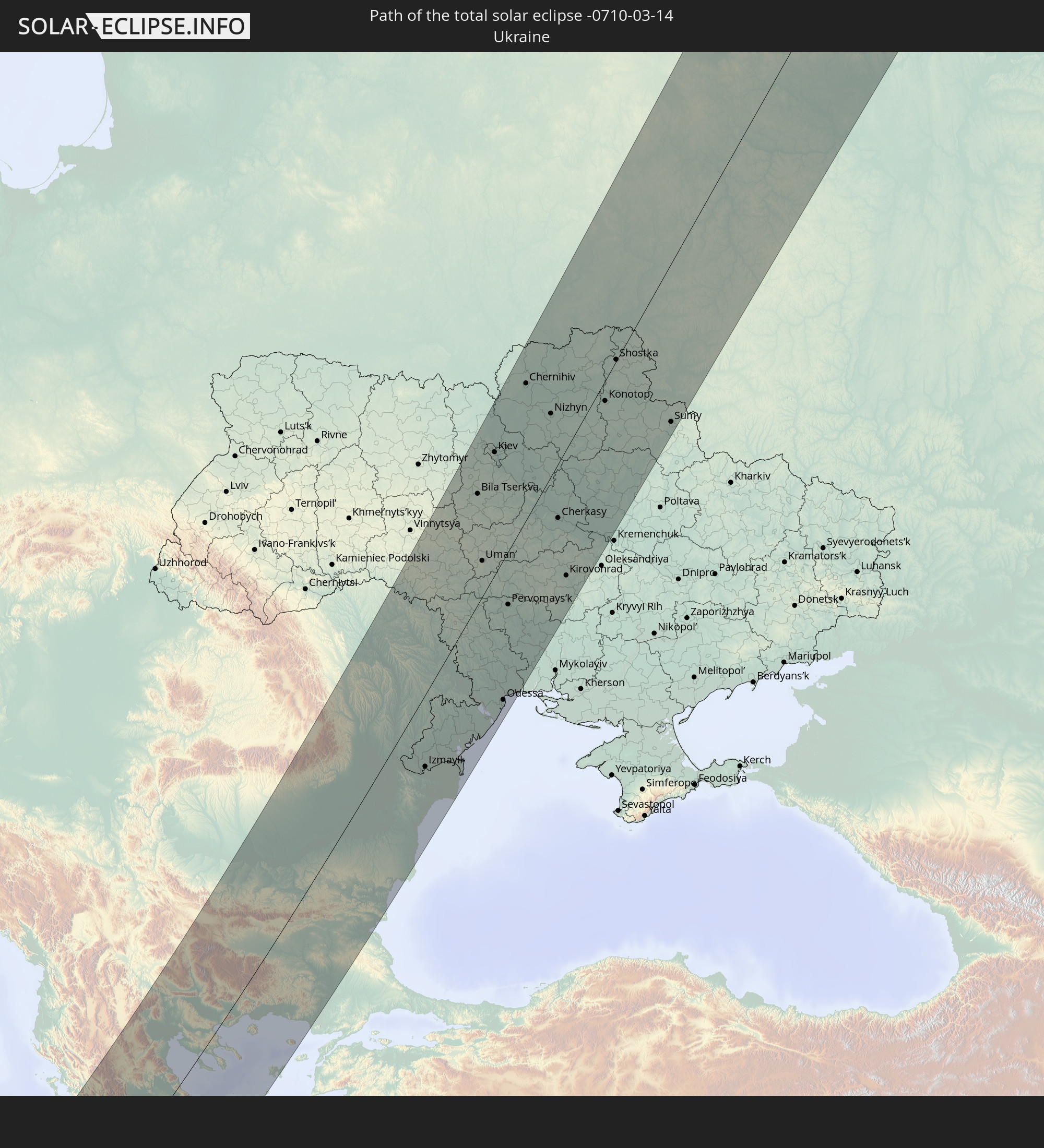 Ukraine
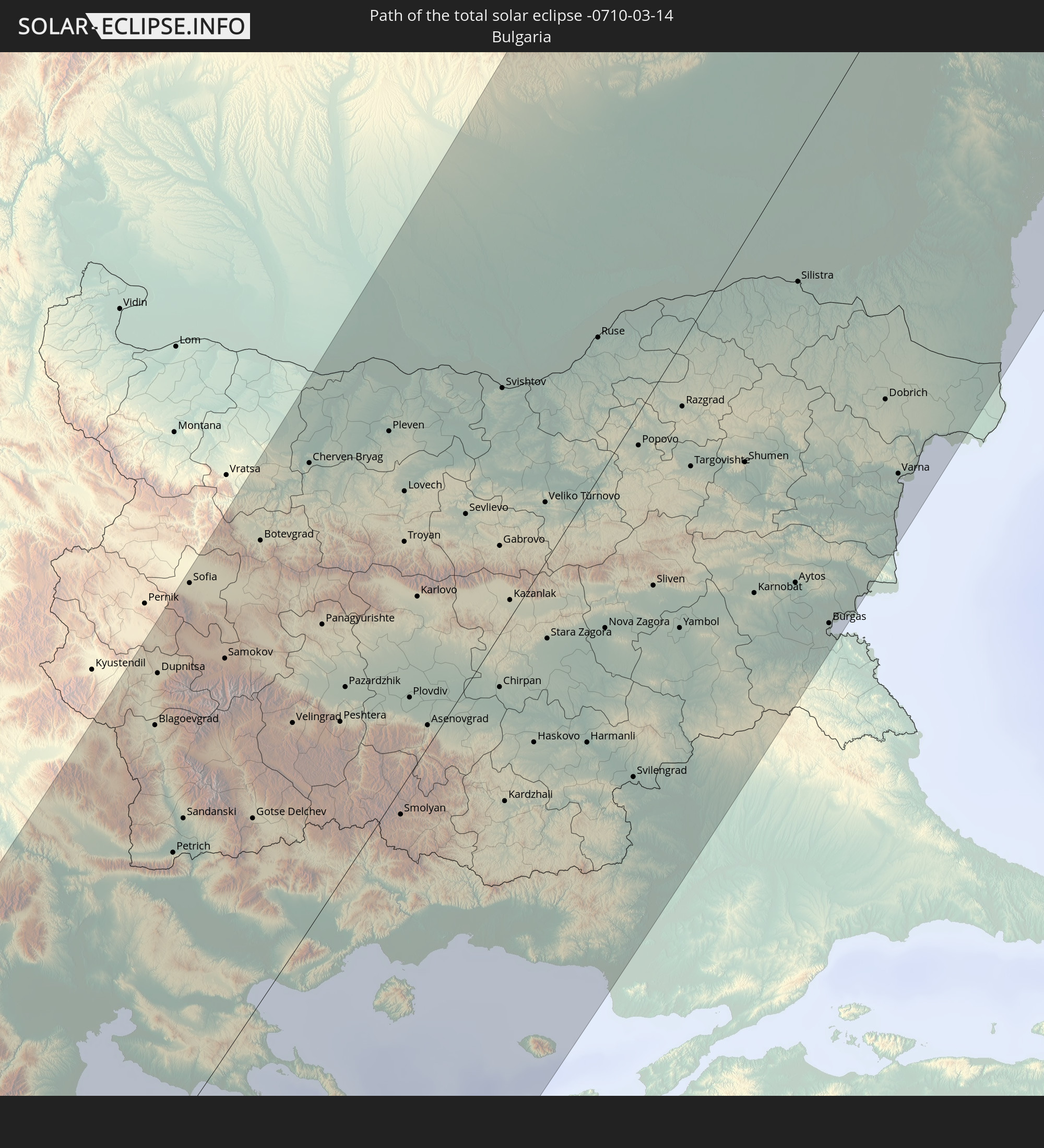 Bulgarien
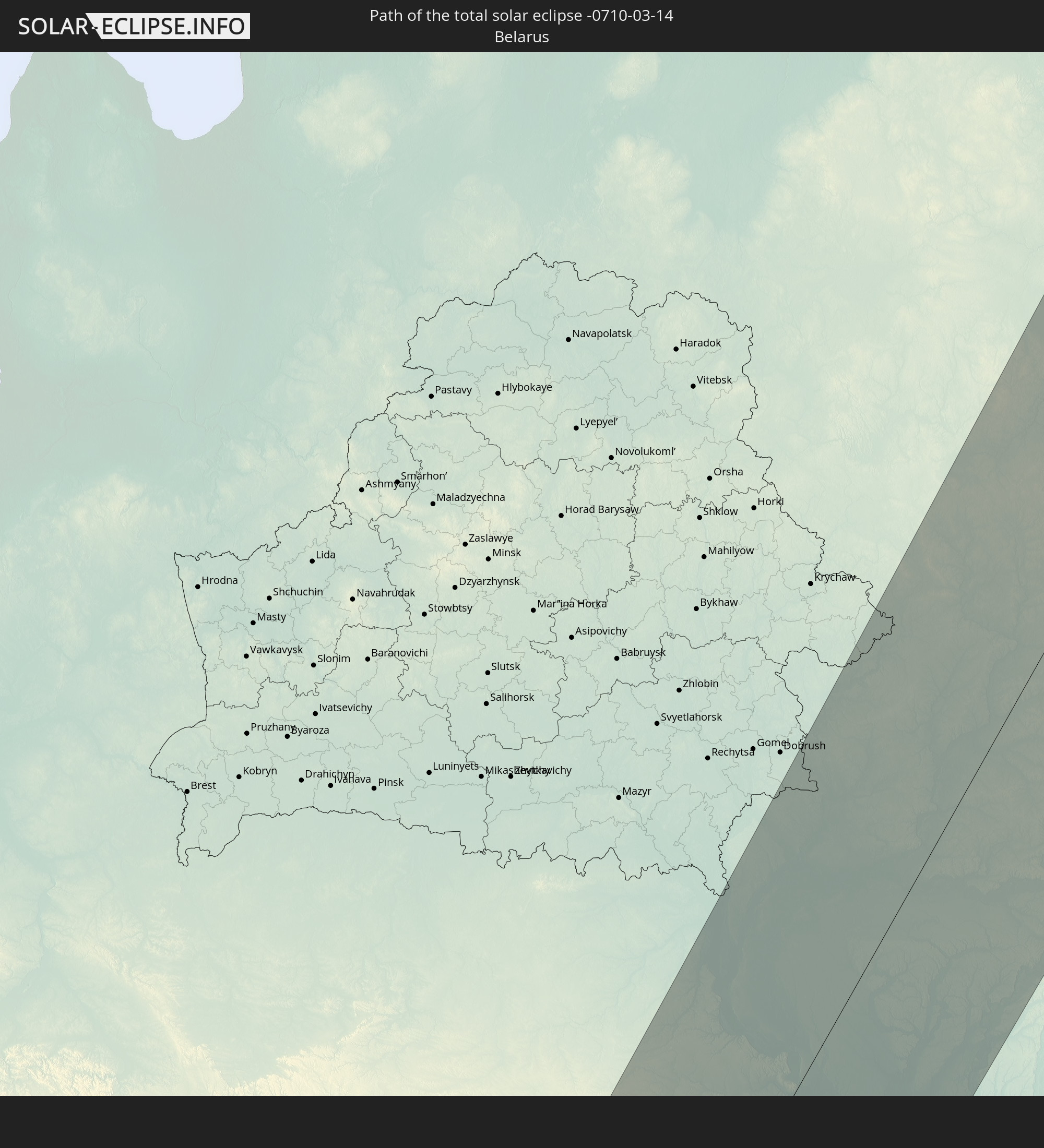 Weißrussland
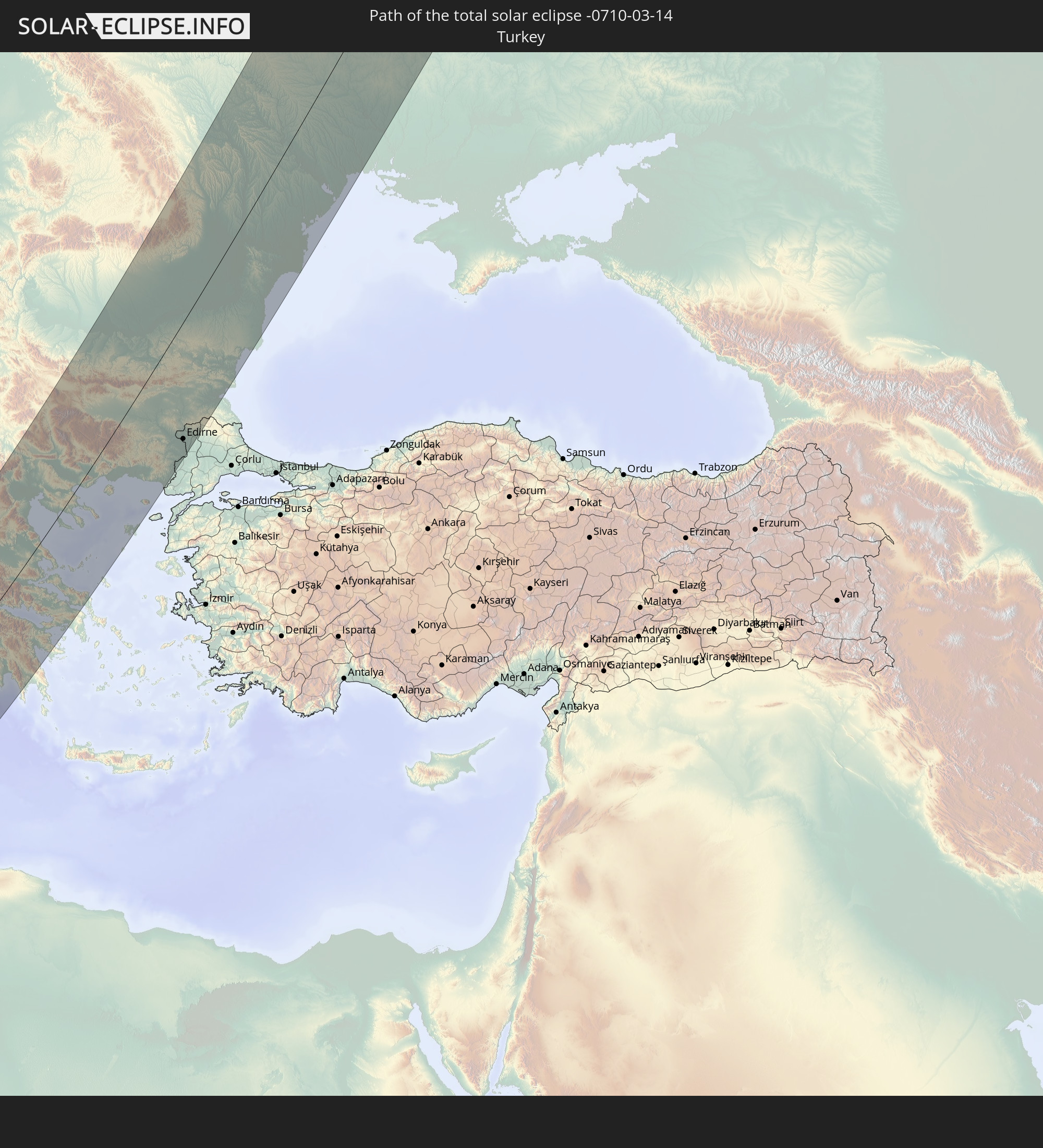 Türkei
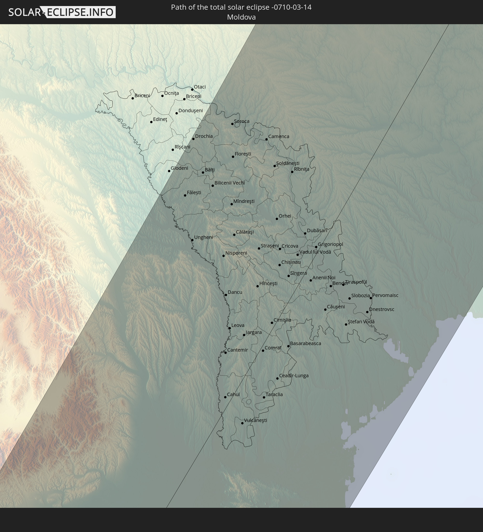 Moldawien
In den folgenden Ländern ist die Sonnenfinsternis partiell zu sehen
 Russland
 Grönland
 Portugal
 Island
 Spanien
 Senegal
 Mauretanien
 Gambia
 Guinea-Bissau
 Guinea
 St. Helena
 Sierra Leone
 Marokko
 Mali
Mali
 Liberia
 Irland
 Spitzbergen
 Algerien
 Vereinigtes Königreich
 Elfenbeinküste
 Färöer
 Burkina Faso
 Gibraltar
 Frankreich
 Isle of Man
 Ghana
Ghana
 Guernsey
 Jersey
 Togo
Togo
 Niger
Niger
 Benin
Benin
 Andorra
 Belgien
 Nigeria
 Niederlande
 Norwegen
 Äquatorialguinea
 Luxemburg
 Deutschland
 Schweiz
 São Tomé und Príncipe
 Italien
 Monaco
 Tunesien
 Dänemark
 Kamerun
 Gabun
Gabun
 Libyen
 Liechtenstein
 Österreich
 Schweden
 Republik Kongo
 Angola
 Tschechien
 Demokratische Republik Kongo
 San Marino
 Vatikanstadt
 Slowenien
 Tschad
 Kroatien
 Polen
Polen
 Malta
Malta
 Zentralafrikanische Republik
 Bosnien und Herzegowina
 Ungarn
 Slowakei
 Montenegro
 Serbien
 Albanien
 Åland Islands
 Griechenland
 Rumänien
 Mazedonien
 Finnland
 Litauen
 Lettland
 Estland
 Sudan
Sudan
 Ukraine
 Bulgarien
 Weißrussland
 Ägypten
 Türkei
 Moldawien
 Ruanda
 Burundi
 Tansania
 Uganda
 Republik Zypern
 Äthiopien
 Kenia
Kenia
 Staat Palästina
 Israel
 Saudi-Arabien
 Jordanien
 Libanon
 Syrien
 Eritrea
 Irak
Irak
 Georgien
 Somalia
 Dschibuti
 Jemen
Jemen
 Armenien
 Iran
Iran
 Aserbaidschan
 Kasachstan
 Kuwait
 Bahrain
 Katar
Katar
 Vereinigte Arabische Emirate
 Oman
Oman
 Turkmenistan
 Usbekistan
 Afghanistan
 Pakistan
 Tadschikistan
 Indien
 Kirgisistan
 Volksrepublik China
 Mongolei
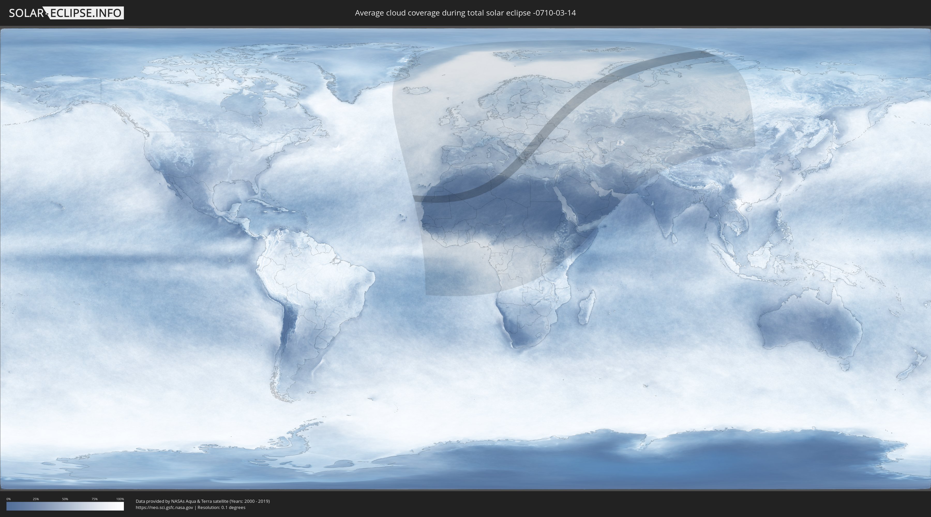
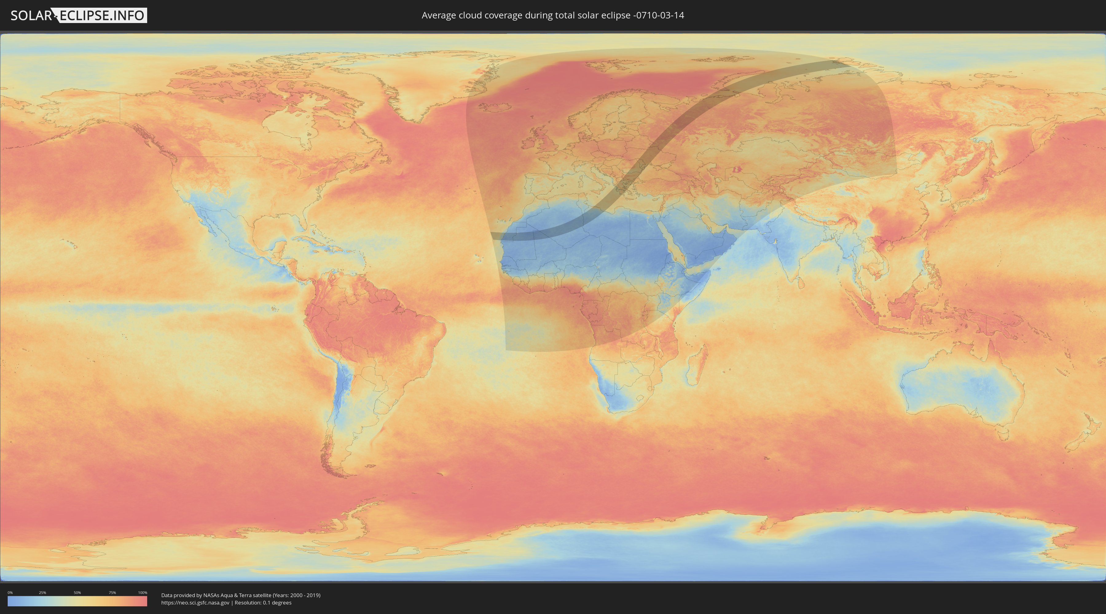
Wie wird das Wetter während der totalen Sonnenfinsternis am 14.03.-0710?
Wo ist der beste Ort, um die totale Sonnenfinsternis vom 14.03.-0710 zu beobachten?
Die folgenden Karten zeigen die durchschnittliche Bewölkung für den Tag, an dem die totale Sonnenfinsternis
stattfindet. Mit Hilfe der Karten lässt sich der Ort entlang des Finsternispfades eingrenzen,
der die besten Aussichen auf einen klaren wolkenfreien Himmel bietet.
Trotzdem muss man immer lokale Gegenenheiten beachten und sollte sich genau über das Wetter an seinem
gewählten Beobachtungsort informieren.
Die Daten stammen von den beiden NASA-Satelliten
AQUA und TERRA
und wurden über einen Zeitraum von 19 Jahren (2000 - 2019) gemittelt.
Detaillierte Länderkarten
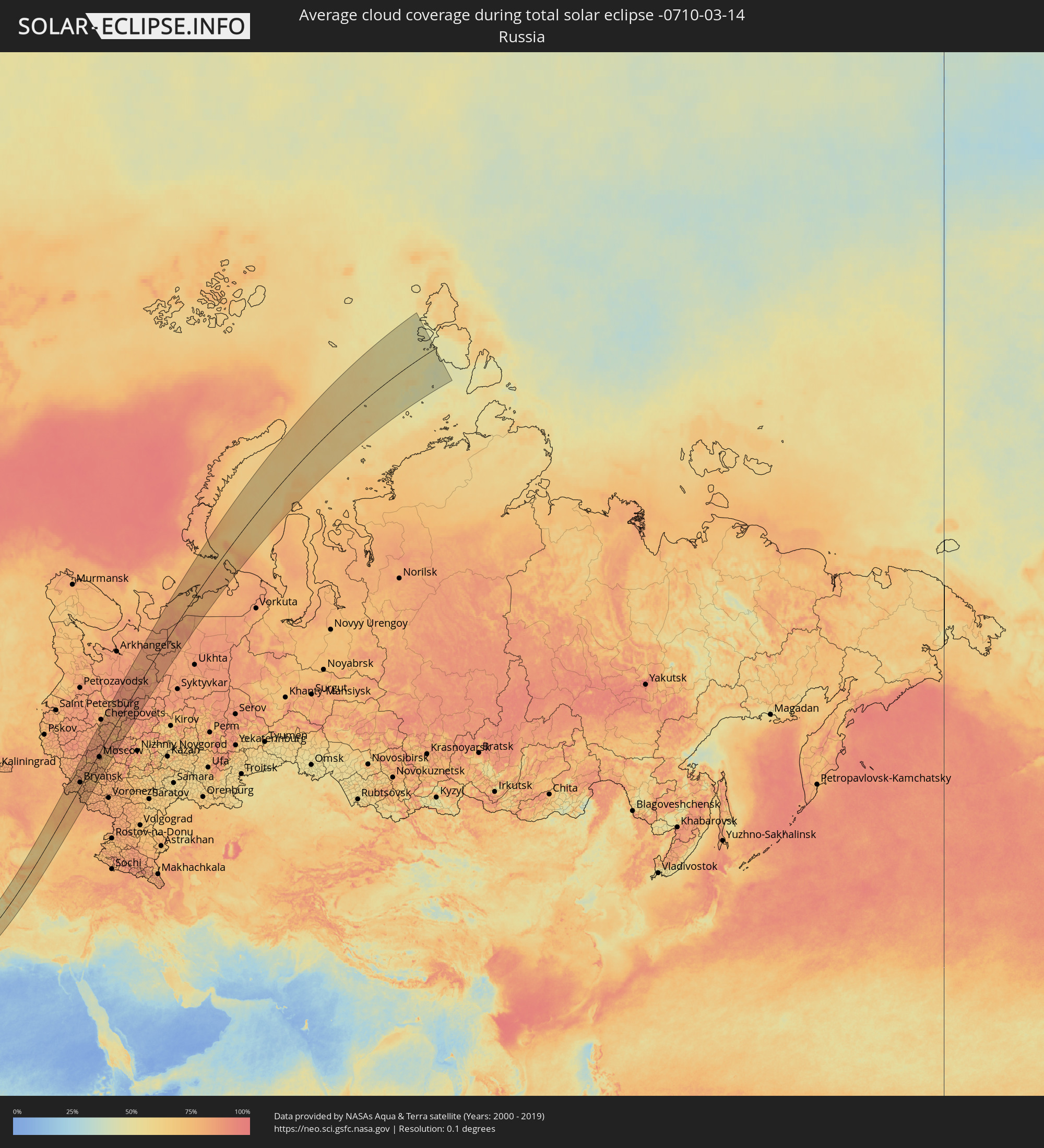 Russland
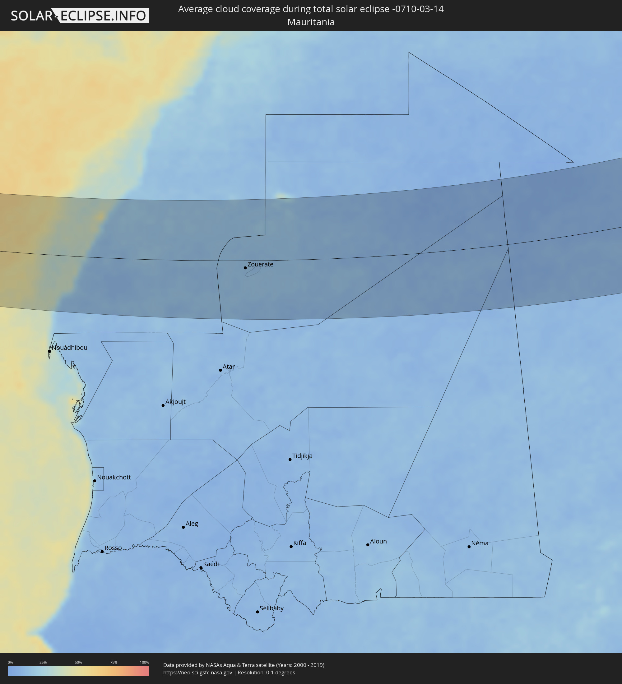 Mauretanien
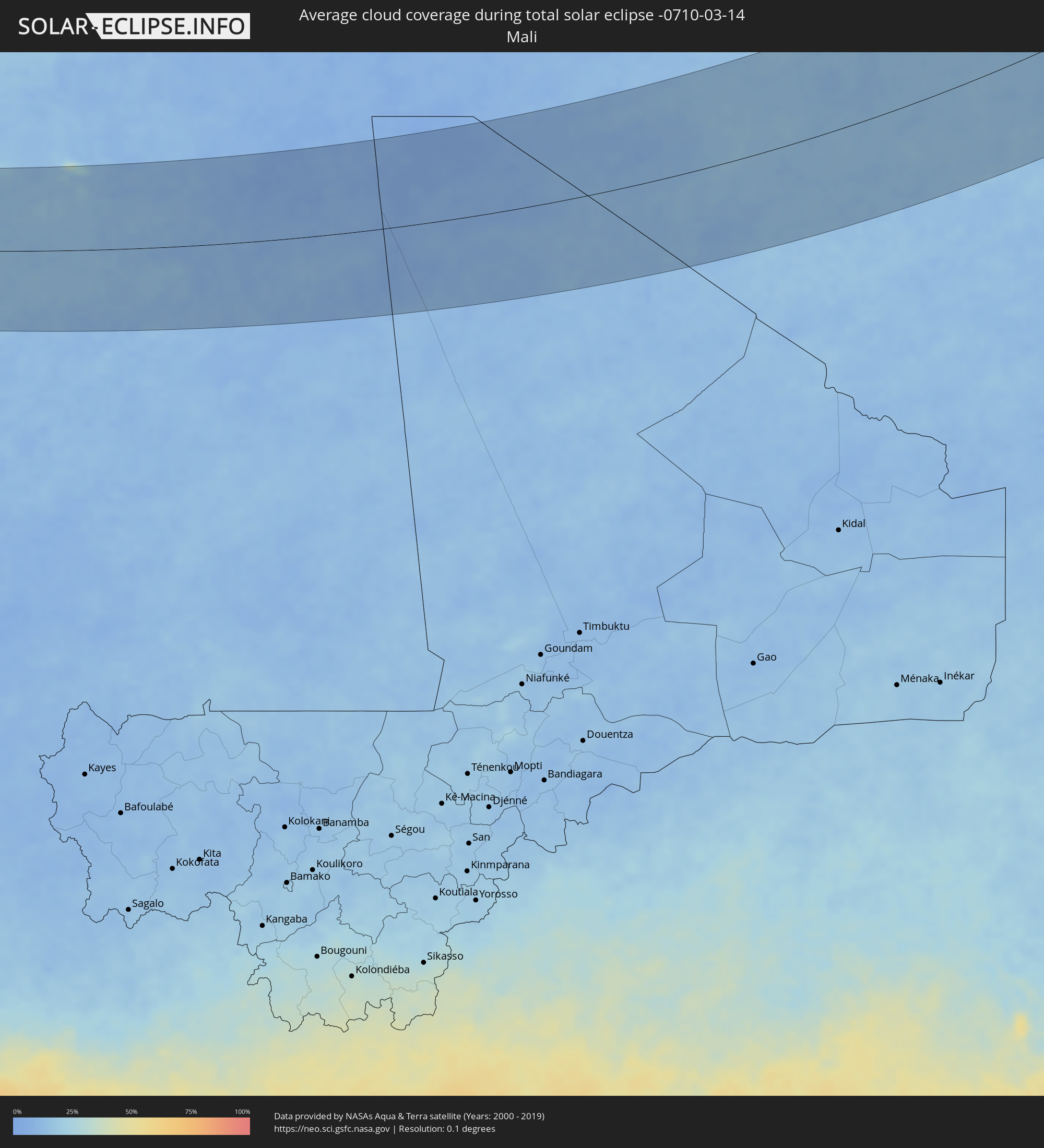 Mali
Mali
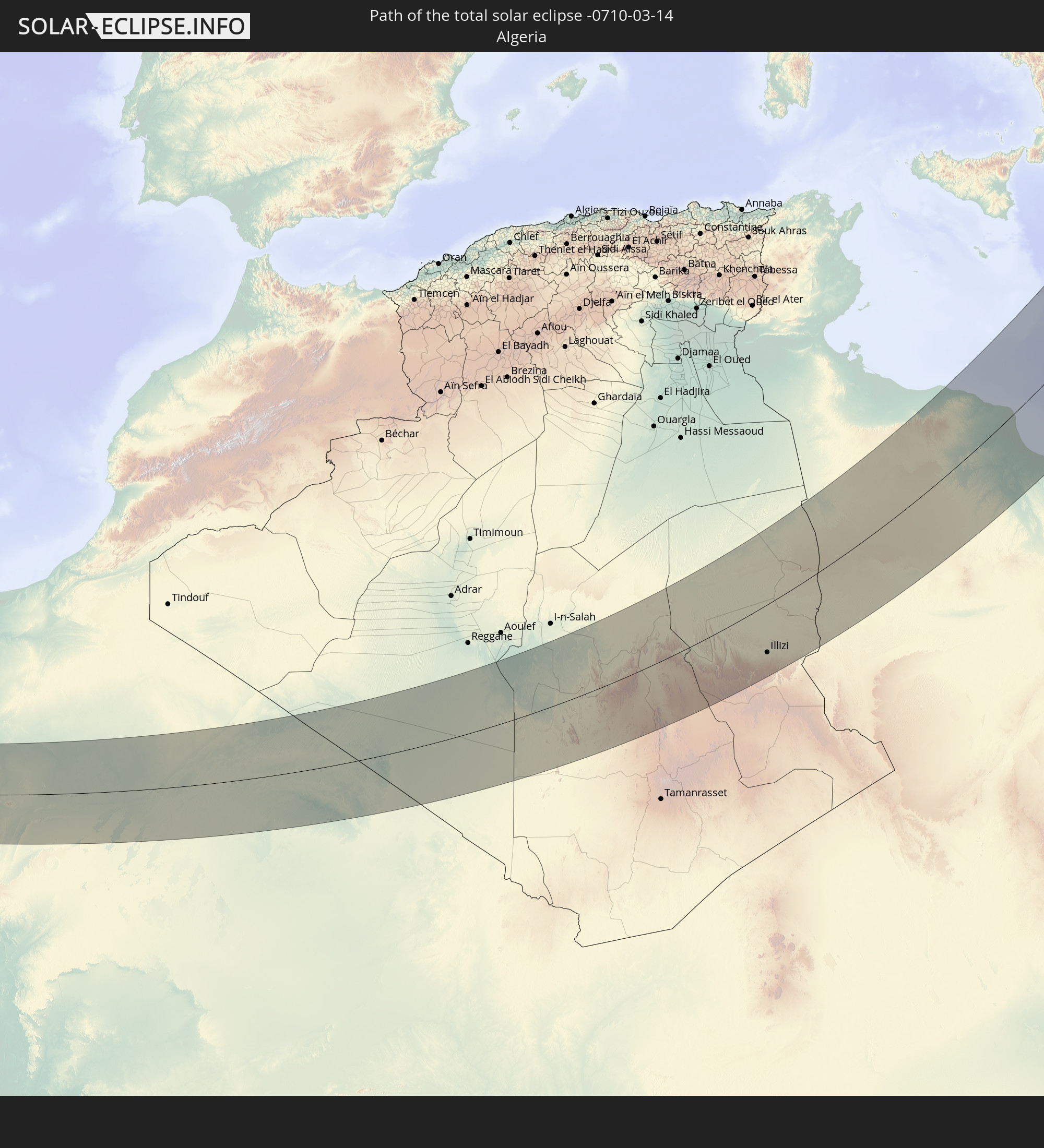
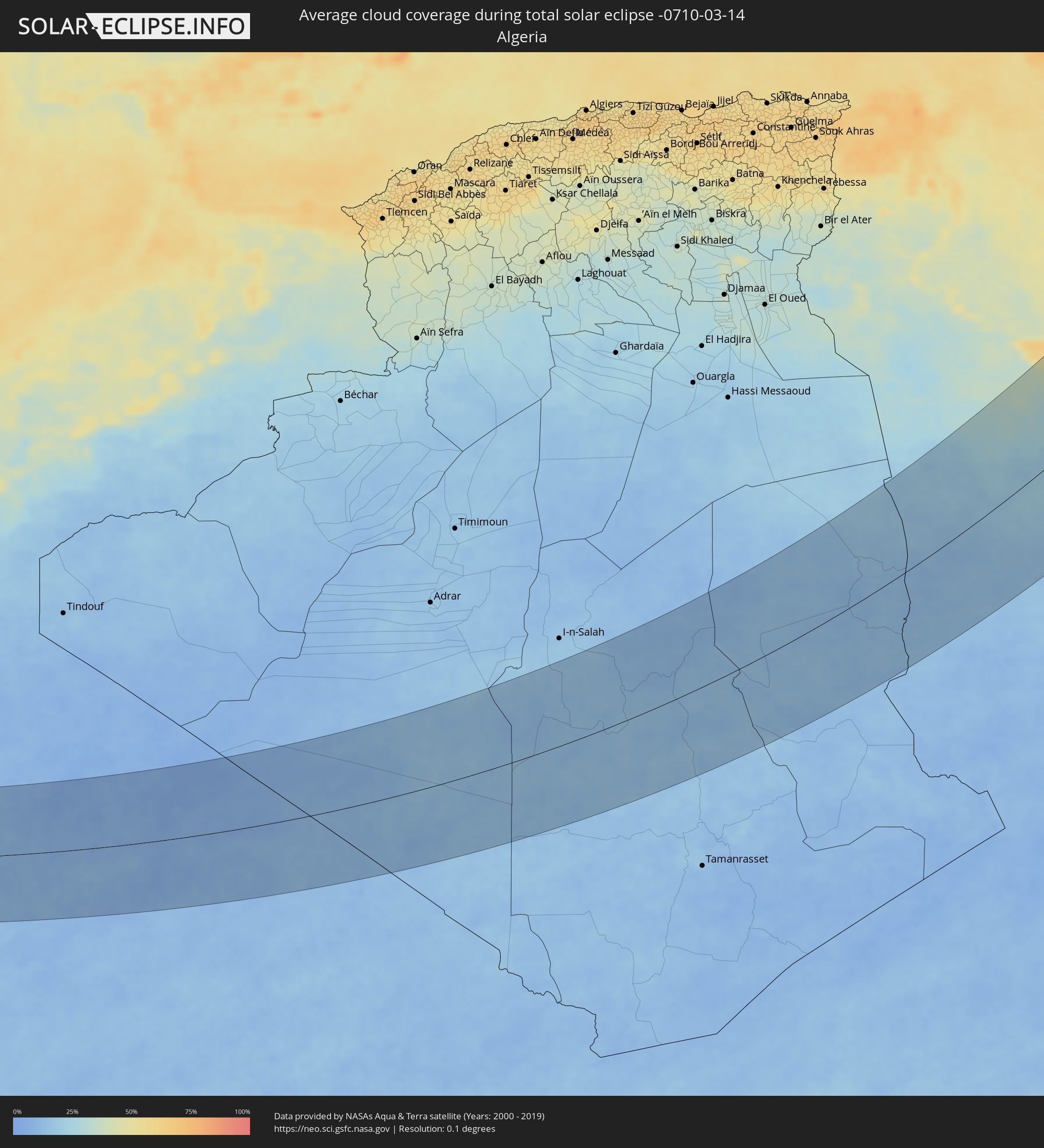 Algerien
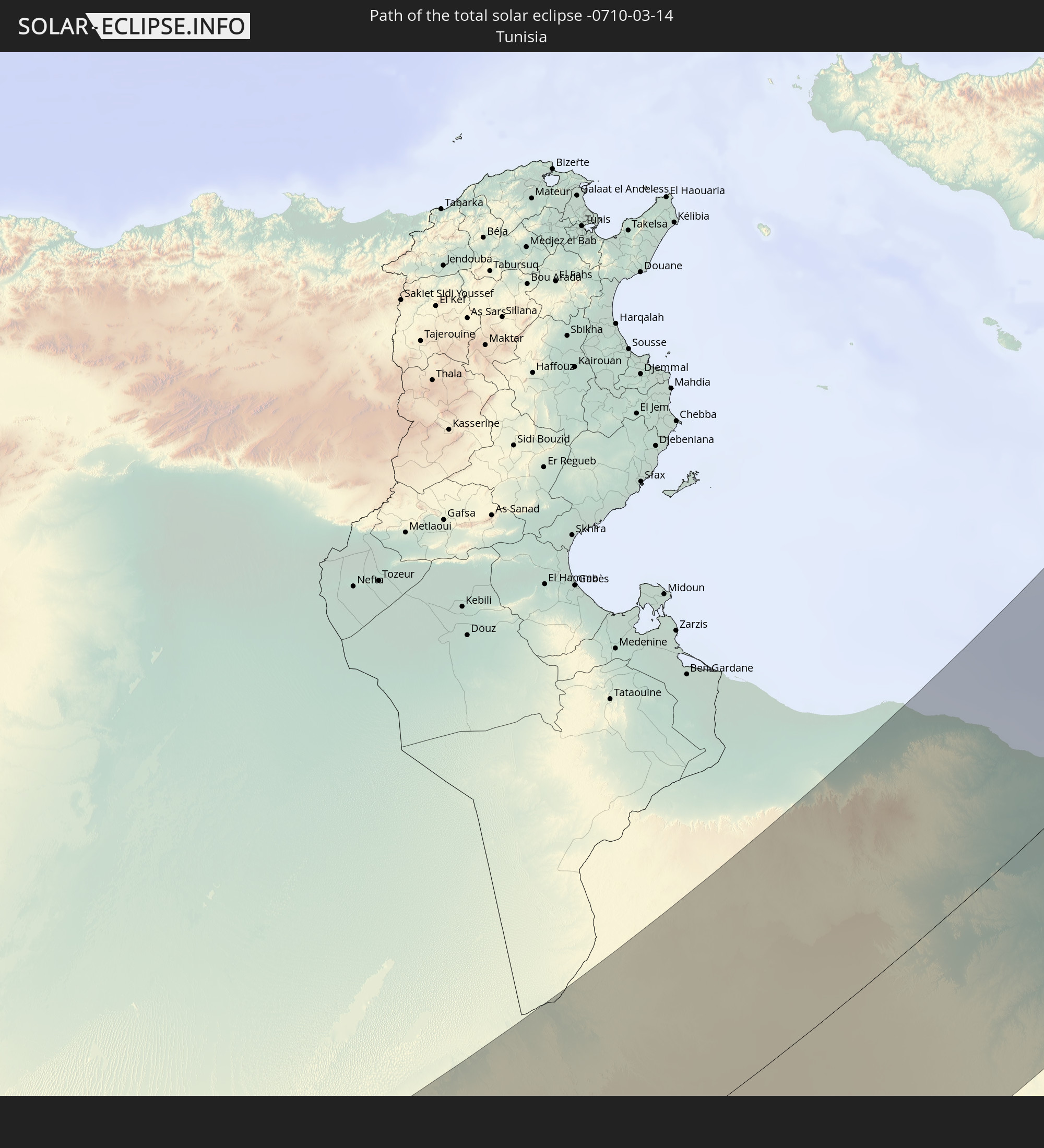
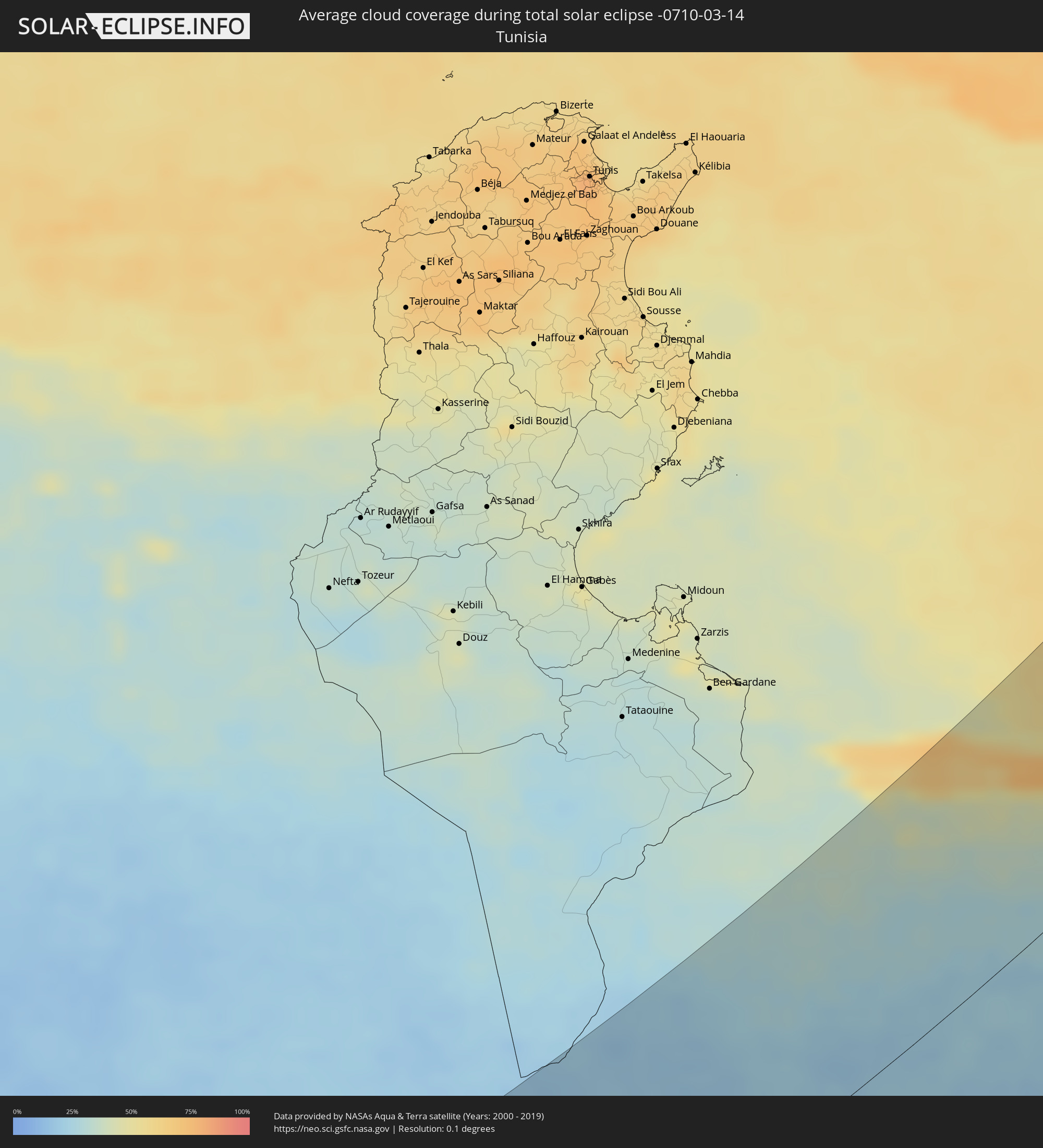 Tunesien
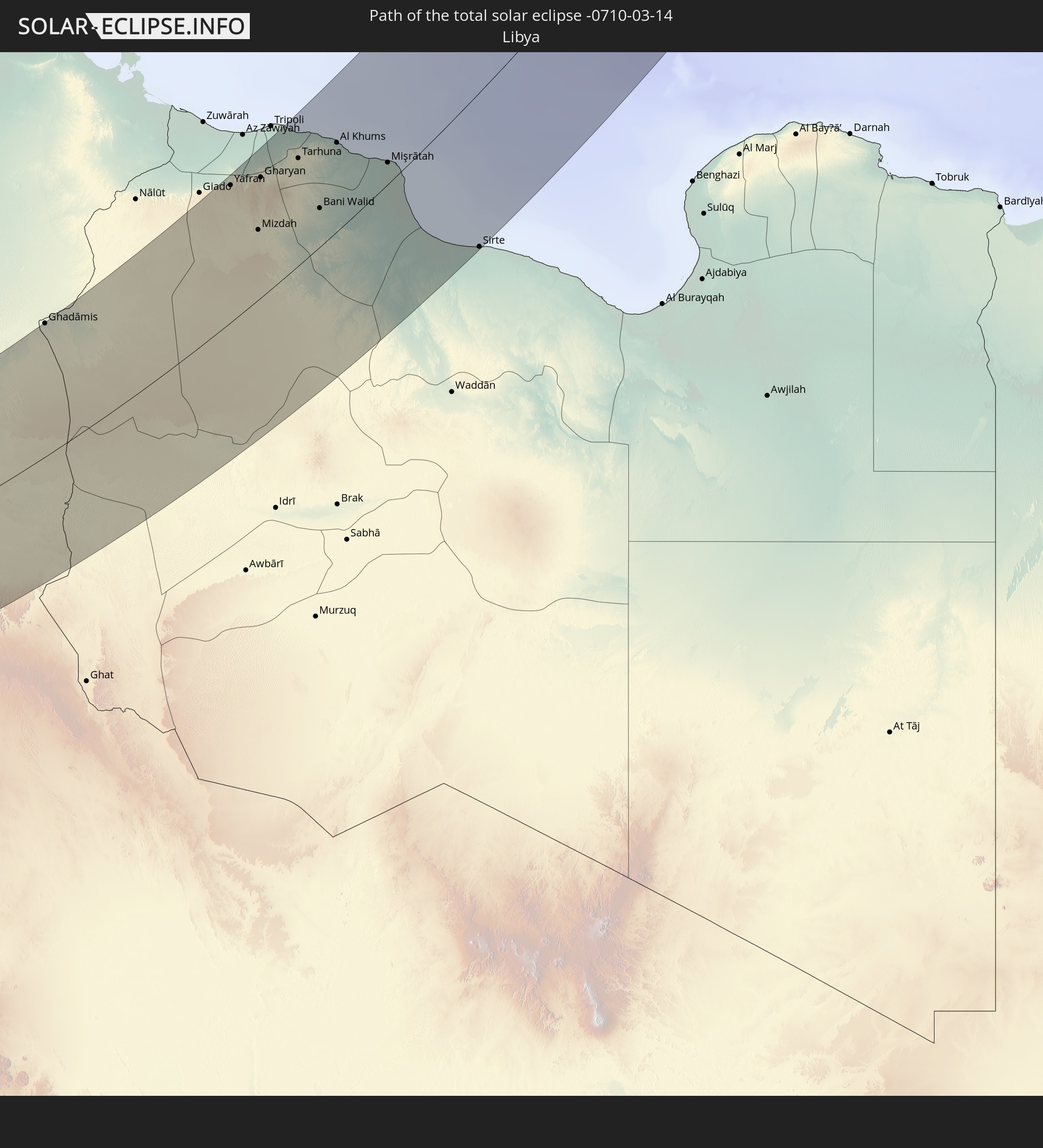
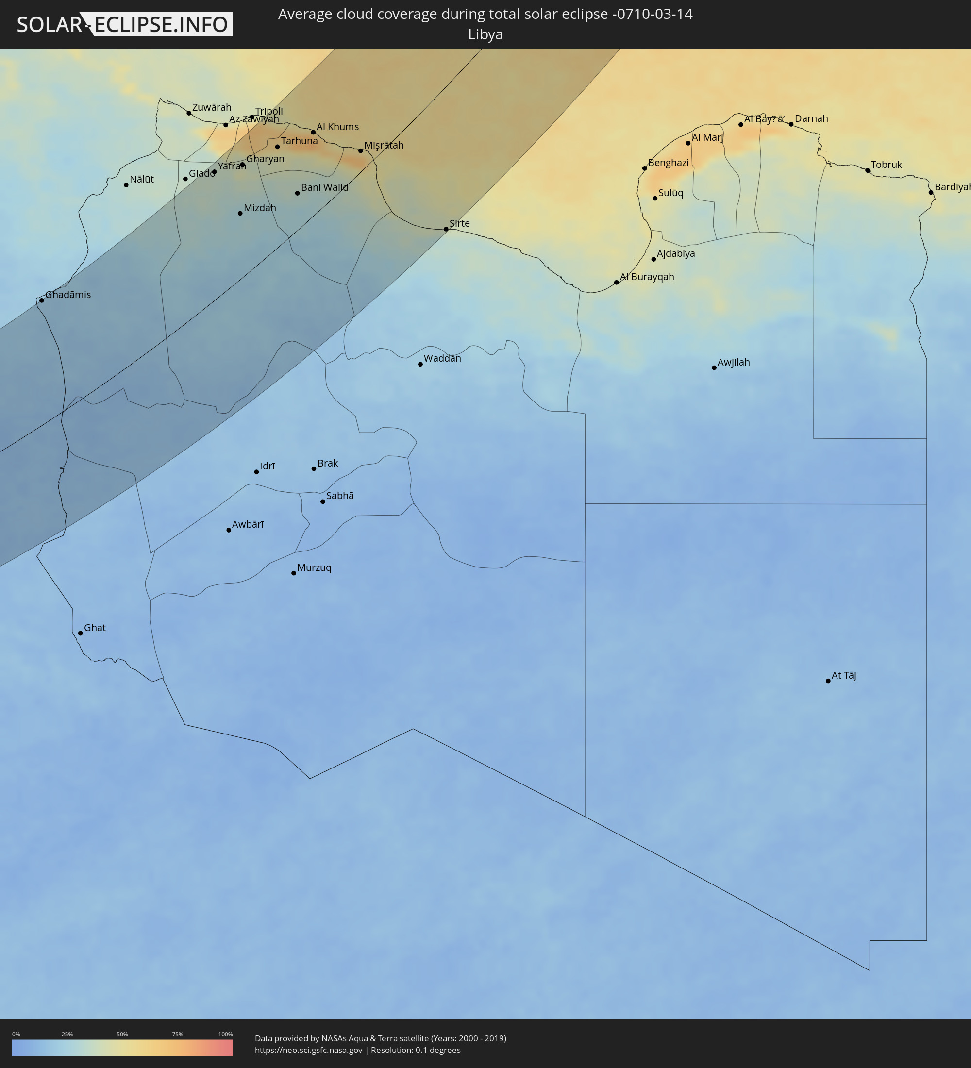 Libyen
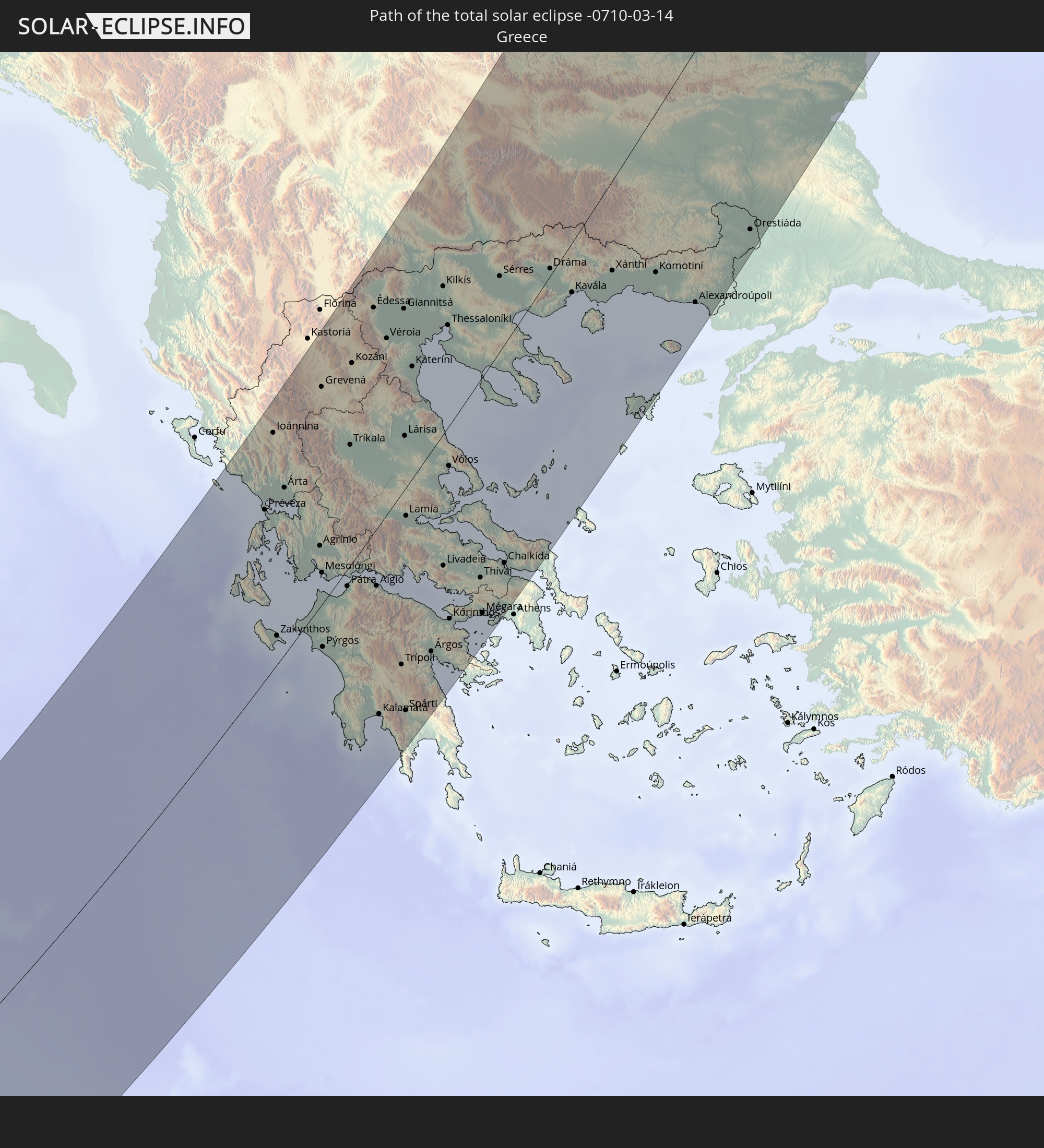
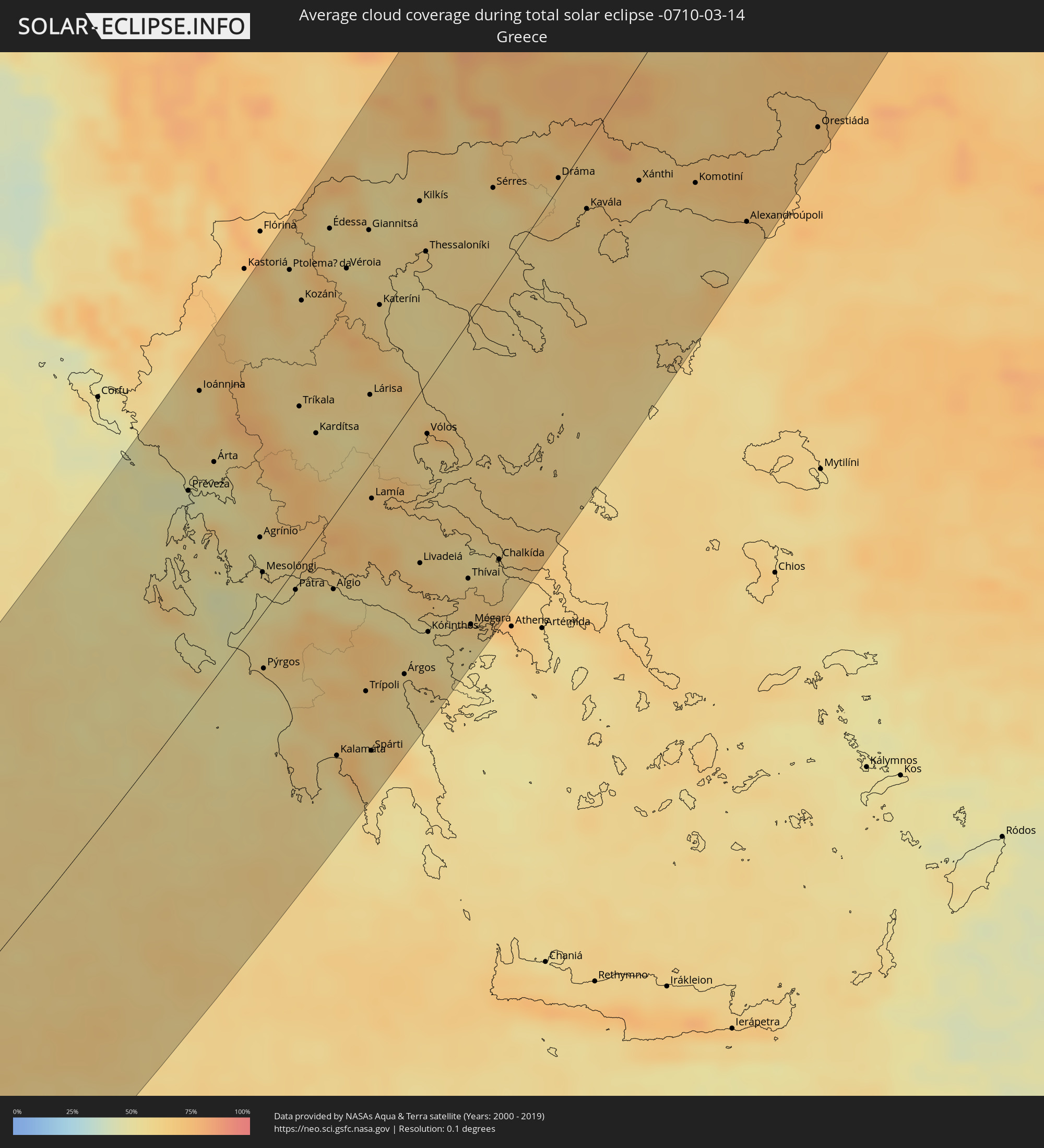 Griechenland
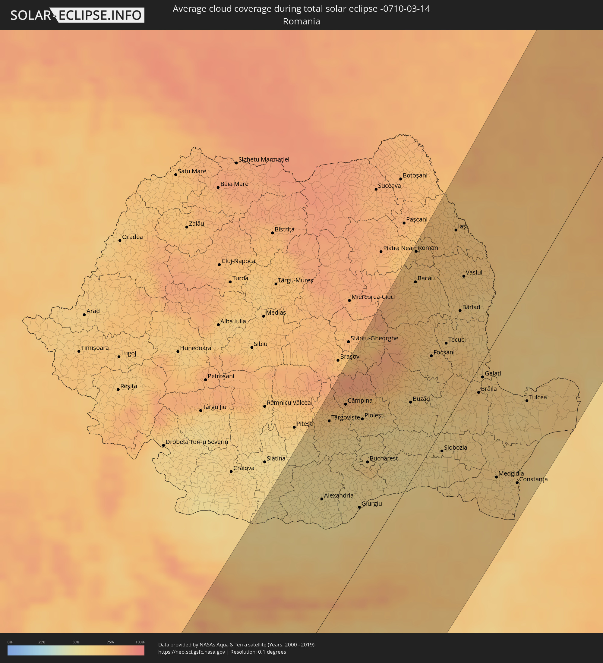 Rumänien
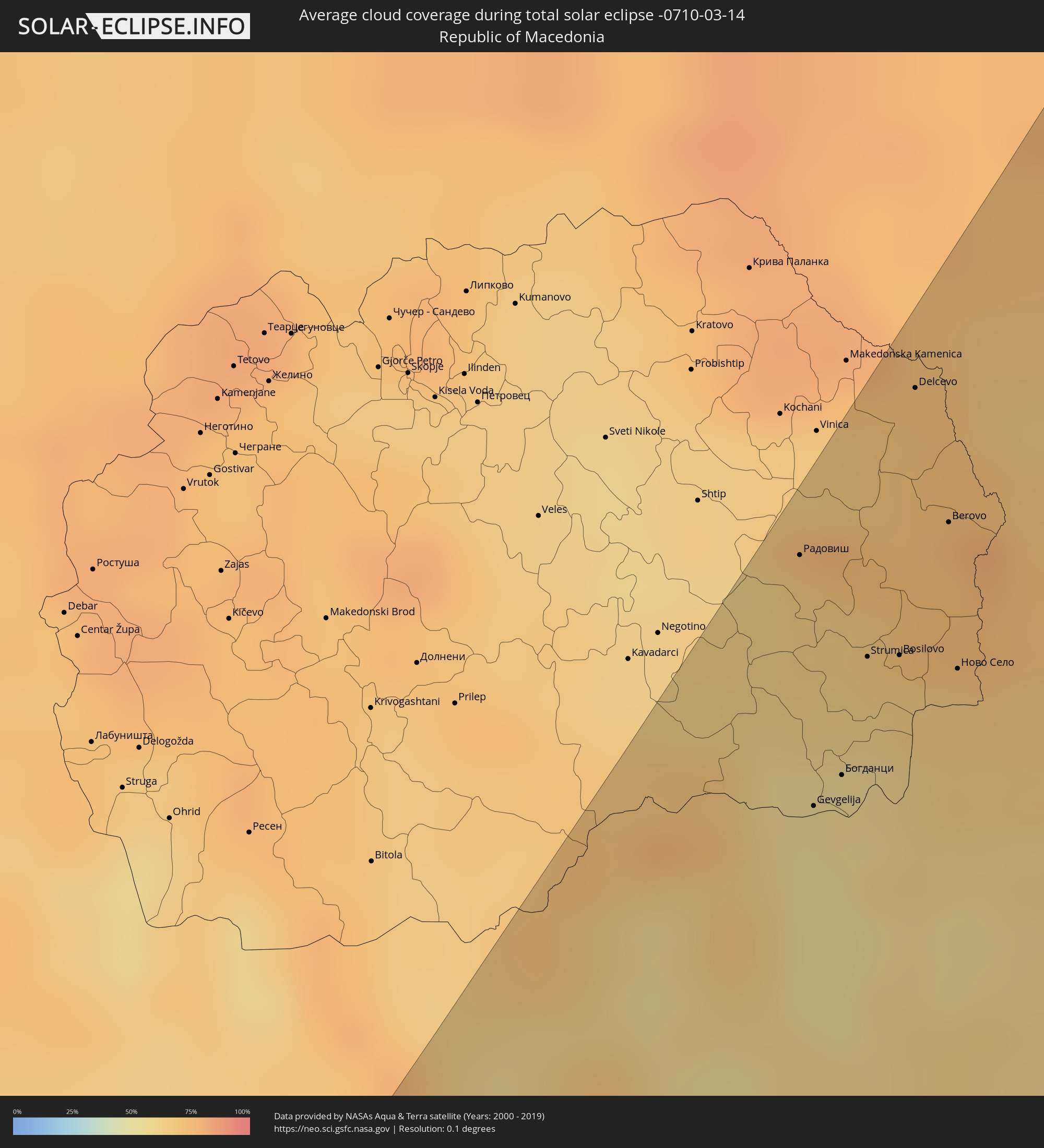 Mazedonien
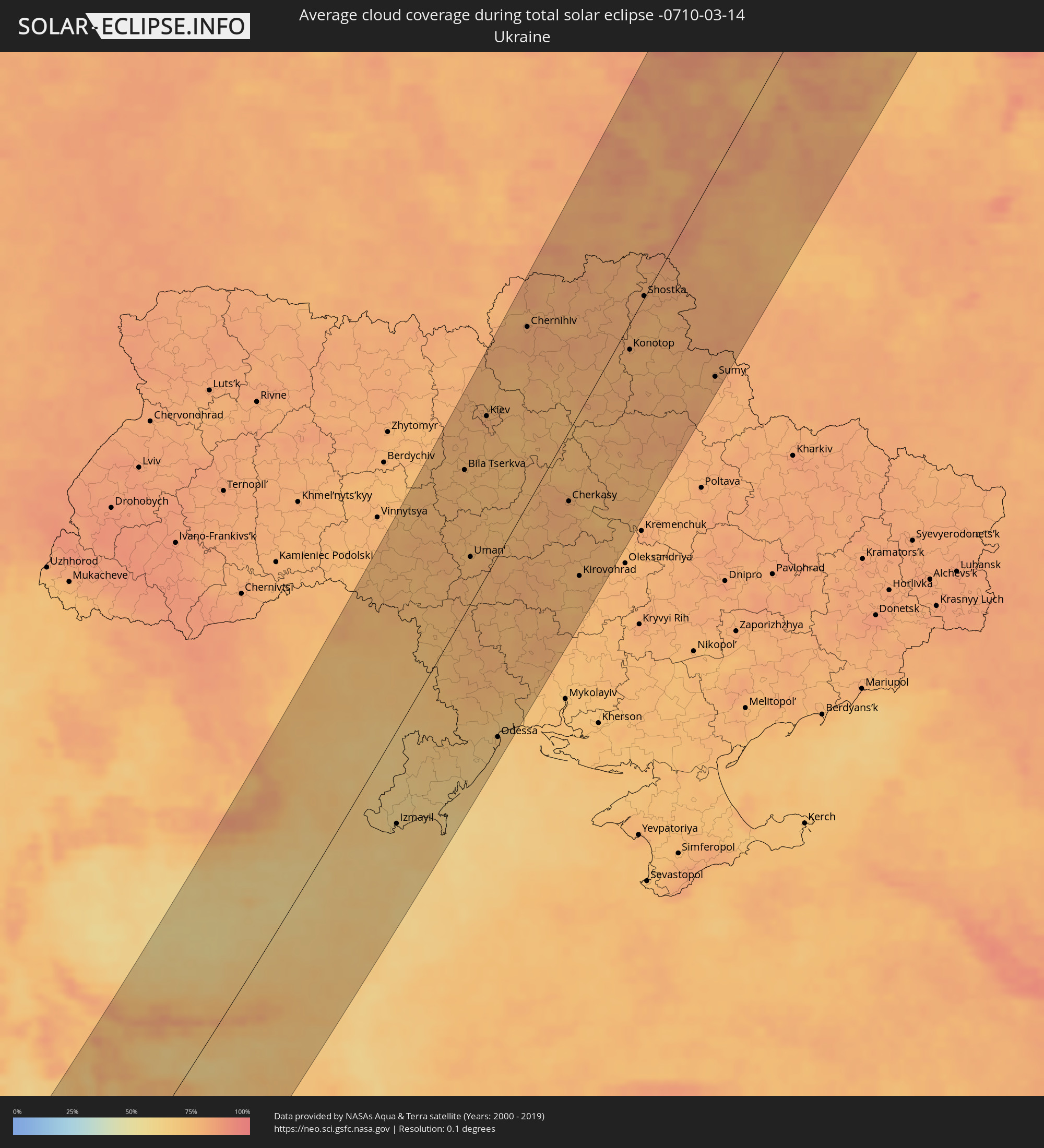 Ukraine
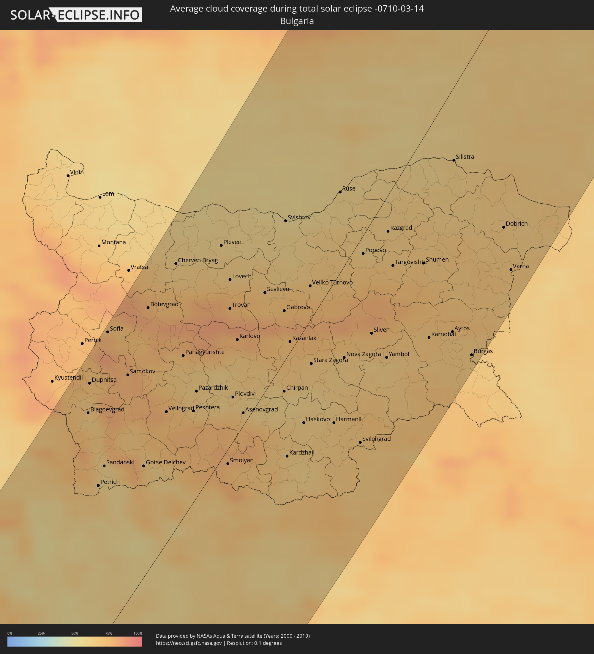 Bulgarien
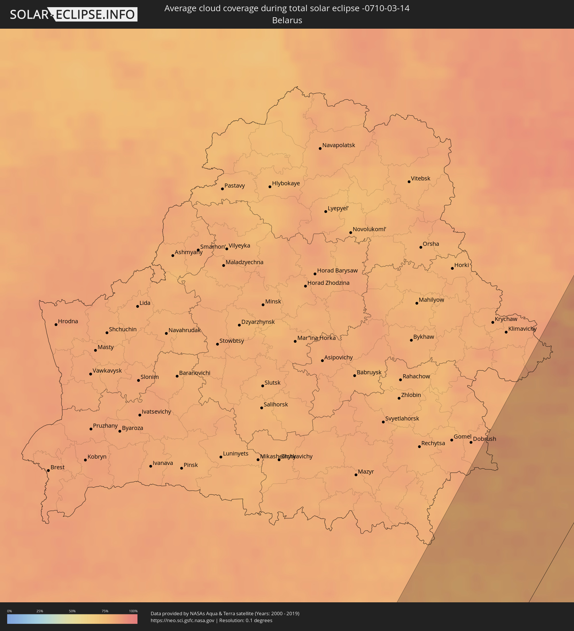 Weißrussland
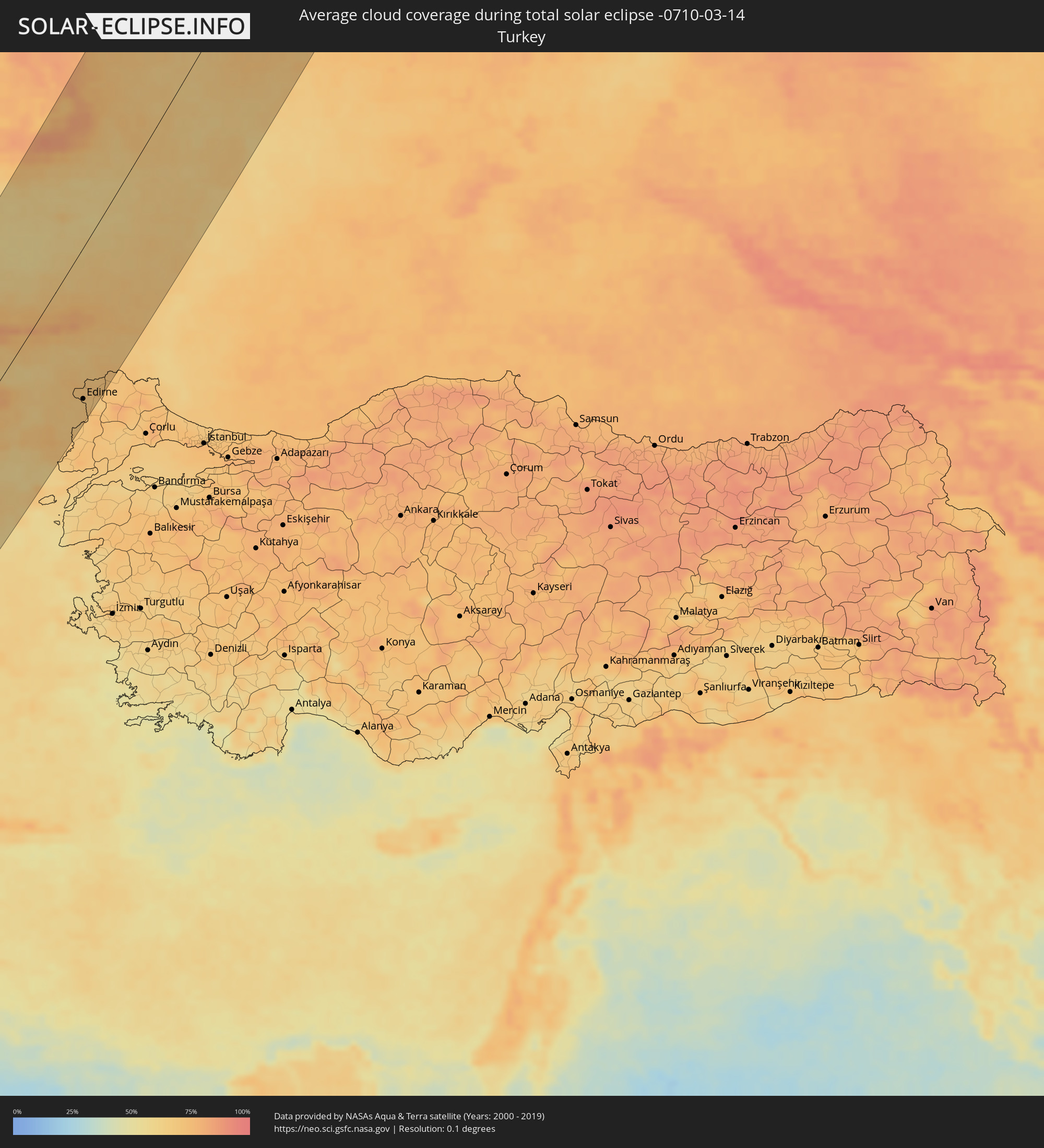 Türkei
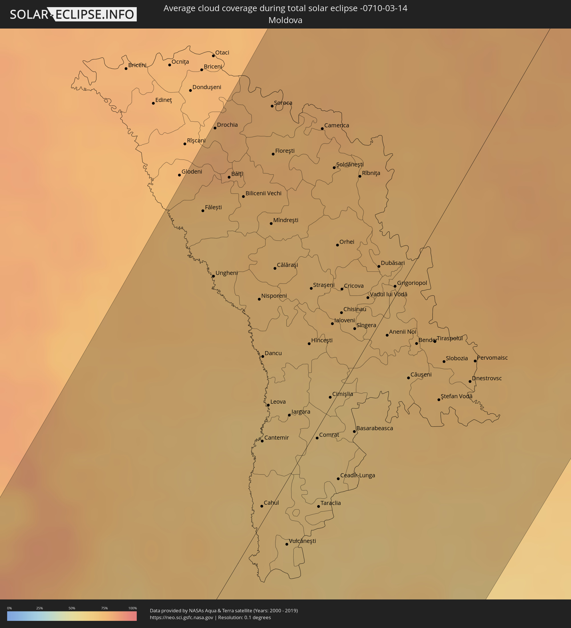 Moldawien
Orte im Finsternispfad
Die nachfolgene Tabelle zeigt Städte und Orte mit mehr als 5.000 Einwohnern, die sich im Finsternispfad befinden. Städte mit mehr als 100.000 Einwohnern sind dick gekennzeichnet. Mit einem Klick auf den Ort öffnet sich eine Detailkarte die die Lage des jeweiligen Ortes zusammen mit dem Verlauf der zentralen Finsternis präsentiert.
| Ort | Typ | Dauer der Verfinsterung | Ortszeit bei maximaler Verfinsterung | Entfernung zur Zentrallinie | Ø Bewölkung |
 Dakhla, Oued Ed-Dahab-Lagouira
|
total | - | 06:51:50 UTC-00:52 | 80 km | 40% |
|
Zouerate, Tiris Zemmour
|
total | - | 07:28:12 UTC-00:16 | 18 km | 13% |
|
Illizi, Illizi
|
total | - | 08:15:22 UTC+00:09 | 114 km | 14% |
|
Ghadāmis, Sha‘bīyat Nālūt
|
total | - | 09:06:36 UTC+00:52 | 175 km | 19% |
|
Zintan, Jabal al Gharbi District
|
total | - | 09:13:09 UTC+00:52 | 169 km | 34% |
|
Yafran, Jabal al Gharbi District
|
total | - | 09:13:44 UTC+00:52 | 163 km | 36% |
|
Mizdah, Jabal al Gharbi District
|
total | - | 09:13:09 UTC+00:52 | 83 km | 28% |
|
Al ‘Azīzīyah, Sha‘bīyat al Jafārah
|
total | - | 09:15:12 UTC+00:52 | 171 km | 49% |
|
Gharyan, Jabal al Gharbi District
|
total | - | 09:14:32 UTC+00:52 | 141 km | 42% |
|
Tarhuna, Al Marqab
|
total | - | 09:15:47 UTC+00:52 | 123 km | 44% |
|
Bani Walid, Mişrātah
|
total | - | 09:14:57 UTC+00:52 | 44 km | 30% |
|
Masallātah, Al Marqab
|
total | - | 09:16:35 UTC+00:52 | 114 km | 72% |
|
Al Khums, Al Marqab
|
total | - | 09:16:58 UTC+00:52 | 100 km | 70% |
|
Zliten, Mişrātah
|
total | - | 09:17:01 UTC+00:52 | 65 km | 60% |
|
Mişrātah, Mişrātah
|
total | - | 09:17:31 UTC+00:52 | 24 km | 69% |
|
Sirte, Surt
|
total | - | 09:17:18 UTC+00:52 | 168 km | 33% |
|
Ioánnina, Epirus
|
total | - | 10:20:09 UTC+01:34 | 144 km | 60% |
|
Agrínio, West Greece
|
total | - | 10:19:07 UTC+01:34 | 37 km | 52% |
|
Pátra, West Greece
|
total | - | 10:18:54 UTC+01:34 | 10 km | 54% |
|
Tríkala, Thessaly
|
total | - | 10:21:10 UTC+01:34 | 72 km | 57% |
|
Kalamáta, Peloponnese
|
total | - | 10:17:20 UTC+01:34 | 117 km | 54% |
|
Демир Капија, Demir Kapija
|
total | - | 09:50:00 UTC+01:00 | 152 km | 64% |
|
Konče, Konče
|
total | - | 09:50:19 UTC+01:00 | 148 km | 64% |
|
Lárisa, Thessaly
|
total | - | 10:22:10 UTC+01:34 | 31 km | 58% |
|
Lamía, Central Greece
|
total | - | 10:20:57 UTC+01:34 | 17 km | 63% |
|
Радовиш, Radoviš
|
total | - | 09:50:39 UTC+01:00 | 151 km | 66% |
|
Gevgelija, Gevgelija
|
total | - | 09:49:54 UTC+01:00 | 119 km | 54% |
|
Kateríni, Central Macedonia
|
total | - | 10:23:20 UTC+01:34 | 65 km | 63% |
|
Valandovo, Valandovo Municipality
|
total | - | 09:50:16 UTC+01:00 | 125 km | 57% |
|
Богданци, Bogdanci
|
total | - | 09:50:06 UTC+01:00 | 117 km | 57% |
|
Василево, Vasilevo
|
total | - | 09:50:37 UTC+01:00 | 129 km | 64% |
|
Strumica, Strumica
|
total | - | 09:50:34 UTC+01:00 | 127 km | 62% |
|
Star Dojran, Dojran
|
total | - | 09:50:15 UTC+01:00 | 106 km | 57% |
|
Bosilovo, Bosilovo
|
total | - | 09:50:41 UTC+01:00 | 121 km | 62% |
|
Delcevo, Delčevo
|
total | - | 09:51:35 UTC+01:00 | 150 km | 71% |
|
Berovo, Berovo
|
total | - | 09:51:16 UTC+01:00 | 128 km | 74% |
|
Ново Село, Novo Selo
|
total | - | 09:50:50 UTC+01:00 | 109 km | 68% |
|
Pehčevo, Pehčevo
|
total | - | 09:51:25 UTC+01:00 | 129 km | 76% |
|
Thessaloníki, Central Macedonia
|
total | - | 10:24:31 UTC+01:34 | 58 km | 57% |
|
Vólos, Thessaly
|
total | - | 10:22:25 UTC+01:34 | 23 km | 63% |
|
Blagoevgrad, Blagoevgrad
|
total | - | 10:52:05 UTC+02:00 | 129 km | 65% |
|
Sofia, Sofia-Capital
|
total | - | 10:53:28 UTC+02:00 | 154 km | 77% |
|
Sérres, Central Macedonia
|
total | - | 10:26:03 UTC+01:34 | 42 km | 58% |
|
Chalkída, Central Greece
|
total | - | 10:21:48 UTC+01:34 | 128 km | 56% |
|
Dráma, East Macedonia and Thrace
|
total | - | 10:26:57 UTC+01:34 | 4 km | 63% |
|
Pazardzhik, Pazardzhik
|
total | - | 10:53:59 UTC+02:00 | 54 km | 66% |
|
Kavála, East Macedonia and Thrace
|
total | - | 10:26:57 UTC+01:34 | 27 km | 62% |
|
Pleven, Pleven
|
total | - | 10:56:15 UTC+02:00 | 106 km | 64% |
|
Plovdiv, Plovdiv
|
total | - | 10:54:28 UTC+02:00 | 22 km | 64% |
|
Xánthi, East Macedonia and Thrace
|
total | - | 10:27:54 UTC+01:34 | 49 km | 71% |
|
Alexandria, Teleorman
|
total | - | 10:42:26 UTC+01:44 | 90 km | 57% |
|
Gabrovo, Gabrovo
|
total | - | 10:56:21 UTC+02:00 | 25 km | 76% |
|
Kazanlak, Stara Zagora
|
total | - | 10:56:02 UTC+02:00 | 5 km | 70% |
|
Komotiní, East Macedonia and Thrace
|
total | - | 10:28:34 UTC+01:34 | 86 km | 66% |
|
Târgovişte, Dâmboviţa
|
total | - | 10:43:59 UTC+01:44 | 135 km | 63% |
|
Haskovo, Khaskovo
|
total | - | 10:55:11 UTC+02:00 | 47 km | 64% |
|
Veliko Tŭrnovo, Veliko Tŭrnovo
|
total | - | 10:57:03 UTC+02:00 | 17 km | 71% |
|
Stara Zagora, Stara Zagora
|
total | - | 10:56:04 UTC+02:00 | 23 km | 66% |
|
Alexandroúpoli, East Macedonia and Thrace
|
total | - | 10:28:47 UTC+01:34 | 136 km | 62% |
|
Giurgiu, Giurgiu
|
total | - | 10:43:06 UTC+01:44 | 40 km | 62% |
|
Ruse, Ruse
|
total | - | 10:58:40 UTC+02:00 | 39 km | 62% |
|
Ploieşti, Prahova
|
total | - | 10:44:44 UTC+01:44 | 98 km | 65% |
|
Bucharest, Bucureşti
|
total | - | 10:44:05 UTC+01:44 | 63 km | 66% |
|
Sliven, Sliven
|
total | - | 10:57:22 UTC+02:00 | 55 km | 71% |
|
Yambol, Yambol
|
total | - | 10:57:17 UTC+02:00 | 79 km | 65% |
|
Edirne, Edirne
|
total | - | 10:53:03 UTC+01:56 | 132 km | 69% |
|
Buzău, Buzău
|
total | - | 10:46:04 UTC+01:44 | 54 km | 66% |
|
Bacău, Bacău
|
total | - | 10:48:10 UTC+01:44 | 128 km | 72% |
|
Shumen, Shumen
|
total | - | 10:59:01 UTC+02:00 | 61 km | 69% |
|
Roman, Neamţ
|
total | - | 10:48:40 UTC+01:44 | 146 km | 72% |
|
Focșani, Vrancea
|
total | - | 10:47:17 UTC+01:44 | 62 km | 68% |
|
Slobozia, Ialomiţa
|
total | - | 10:45:54 UTC+01:44 | 15 km | 62% |
|
Burgas, Burgas
|
total | - | 10:58:36 UTC+02:00 | 144 km | 66% |
|
Iaşi, Iaşi
|
total | - | 10:49:50 UTC+01:44 | 115 km | 72% |
|
Bârlad, Vaslui
|
total | - | 10:48:38 UTC+01:44 | 59 km | 67% |
|
Vaslui, Vaslui
|
total | - | 10:49:16 UTC+01:44 | 77 km | 69% |
|
Ungheni, Ungheni
|
total | - | 11:00:44 UTC+01:55 | 105 km | 70% |
|
Drochia, Drochia
|
total | - | 11:01:51 UTC+01:55 | 148 km | 78% |
|
Dobrich, Dobrich
|
total | - | 11:00:39 UTC+02:00 | 106 km | 68% |
|
Varna, Varna
|
total | - | 11:00:15 UTC+02:00 | 132 km | 69% |
|
Bălţi, Bălţi
|
total | - | 11:01:38 UTC+01:55 | 126 km | 75% |
|
Brăila, Brăila
|
total | - | 10:47:41 UTC+01:44 | 17 km | 68% |
|
Galaţi, Galaţi
|
total | - | 10:48:02 UTC+01:44 | 11 km | 68% |
|
Sîngerei, Sîngerei
|
total | - | 11:01:43 UTC+01:55 | 105 km | 70% |
|
Cahul, Cahul
|
total | - | 10:59:27 UTC+01:55 | 5 km | 68% |
|
Soroca, Raionul Soroca
|
total | - | 11:02:35 UTC+01:55 | 124 km | 75% |
|
Floreşti, Floreşti
|
total | - | 11:02:14 UTC+01:55 | 109 km | 75% |
|
Hînceşti, Hînceşti
|
total | - | 11:01:12 UTC+01:55 | 31 km | 67% |
|
Straşeni, Strășeni
|
total | - | 11:01:38 UTC+01:55 | 48 km | 70% |
|
Constanţa, Constanța
|
total | - | 10:46:59 UTC+01:44 | 124 km | 67% |
|
Comrat, Găgăuzia
|
total | - | 11:00:34 UTC+01:55 | 3 km | 62% |
|
Tulcea, Tulcea
|
total | - | 10:48:36 UTC+01:44 | 77 km | 63% |
|
Orhei, Orhei
|
total | - | 11:02:14 UTC+01:55 | 47 km | 71% |
|
Ceadîr-Lunga, Găgăuzia
|
total | - | 11:00:28 UTC+01:55 | 28 km | 62% |
|
Izmayil, Odessa
|
total | - | 11:06:34 UTC+02:02 | 69 km | 66% |
|
Chisinau, Chişinău
|
total | - | 11:01:46 UTC+01:55 | 24 km | 71% |
|
Rîbniţa, Stînga Nistrului
|
total | - | 11:02:57 UTC+01:55 | 56 km | 73% |
|
Dubăsari, Teleneşti
|
total | - | 11:02:30 UTC+01:55 | 18 km | 70% |
|
Căuşeni, Căuşeni
|
total | - | 11:01:58 UTC+01:55 | 33 km | 70% |
|
Tiraspolul, Stînga Nistrului
|
total | - | 11:02:31 UTC+01:55 | 36 km | 70% |
|
Bila Tserkva, Kiev
|
total | - | 11:13:54 UTC+02:02 | 96 km | 75% |
|
Uman’, Cherkasy
|
total | - | 11:12:44 UTC+02:02 | 32 km | 76% |
|
Kiev, Kyiv City
|
total | - | 11:15:08 UTC+02:02 | 105 km | 82% |
|
Odessa, Odessa
|
total | - | 11:10:29 UTC+02:02 | 129 km | 70% |
|
Brovary, Kiev
|
total | - | 11:15:33 UTC+02:02 | 91 km | 77% |
|
Pervomays’k, Mykolaiv
|
total | - | 11:12:38 UTC+02:02 | 48 km | 75% |
|
Boryspil’, Kiev
|
total | - | 11:15:31 UTC+02:02 | 73 km | 75% |
|
Chernihiv, Chernihiv
|
total | - | 11:17:13 UTC+02:02 | 114 km | 81% |
|
Nizhyn, Chernihiv
|
total | - | 11:17:24 UTC+02:02 | 53 km | 76% |
|
Smila, Cherkasy
|
total | - | 11:15:18 UTC+02:02 | 48 km | 79% |
|
Cherkasy, Cherkasy
|
total | - | 11:15:45 UTC+02:02 | 47 km | 77% |
|
Kirovohrad, Kirovohrad
|
total | - | 11:14:55 UTC+02:02 | 111 km | 77% |
|
Pryluky, Chernihiv
|
total | - | 11:17:28 UTC+02:02 | 3 km | 77% |
|
Konotop, Sumy
|
total | - | 11:19:07 UTC+02:02 | 17 km | 77% |
|
Shostka, Sumy
|
total | - | 11:20:05 UTC+02:02 | 1 km | 79% |
|
Bryansk, Brjansk
|
total | - | 11:50:41 UTC+02:30 | 23 km | 81% |
|
Sumy, Sumy
|
total | - | 11:20:37 UTC+02:02 | 131 km | 79% |
|
Tver, Tverskaya
|
total | - | 11:55:26 UTC+02:30 | 130 km | 82% |
|
Orël, Orjol
|
total | - | 11:52:17 UTC+02:30 | 92 km | 78% |
|
Kaluga, Kaluga
|
total | - | 11:53:54 UTC+02:30 | 16 km | 82% |
|
Zelenograd, Moscow
|
total | - | 11:56:02 UTC+02:30 | 14 km | 85% |
|
Khimki, Moscow Oblast
|
total | - | 11:56:13 UTC+02:30 | 5 km | 86% |
|
Yasenevo, Moscow
|
total | - | 11:56:05 UTC+02:30 | 25 km | 85% |
|
Podolsk, Moscow Oblast
|
total | - | 11:55:59 UTC+02:30 | 37 km | 83% |
|
Moscow, Moscow
|
total | - | 11:56:18 UTC+02:30 | 23 km | 90% |
|
Tula, Tula
|
total | - | 11:55:03 UTC+02:30 | 110 km | 82% |
|
Mytishchi, Moscow Oblast
|
total | - | 11:56:32 UTC+02:30 | 20 km | 90% |
|
Lyubertsy, Moscow Oblast
|
total | - | 11:56:31 UTC+02:30 | 42 km | 86% |
|
Rybinsk, Jaroslavl
|
total | - | 11:59:09 UTC+02:30 | 38 km | 81% |
|
Yaroslavl, Jaroslavl
|
total | - | 11:59:52 UTC+02:30 | 38 km | 81% |
|
Vologda, Vologda
|
total | - | 12:00:52 UTC+02:30 | 50 km | 79% |
|
Kostroma, Kostroma
|
total | - | 12:00:58 UTC+02:30 | 84 km | 76% |
|
Ivanovo, Ivanovo
|
total | - | 12:00:32 UTC+02:30 | 130 km | 83% |