Totale Sonnenfinsternis vom 14.03.-0729
| Wochentag: | Donnerstag |
| Maximale Dauer der Verfinsterung: | 02m52s |
| Maximale Breite des Finsternispfades: | 109 km |
| Saroszyklus: | 47 |
| Bedeckungsgrad: | 100% |
| Magnitude: | 1.032 |
| Gamma: | 0.1258 |
Wo kann man die Sonnenfinsternis vom 14.03.-0729 sehen?
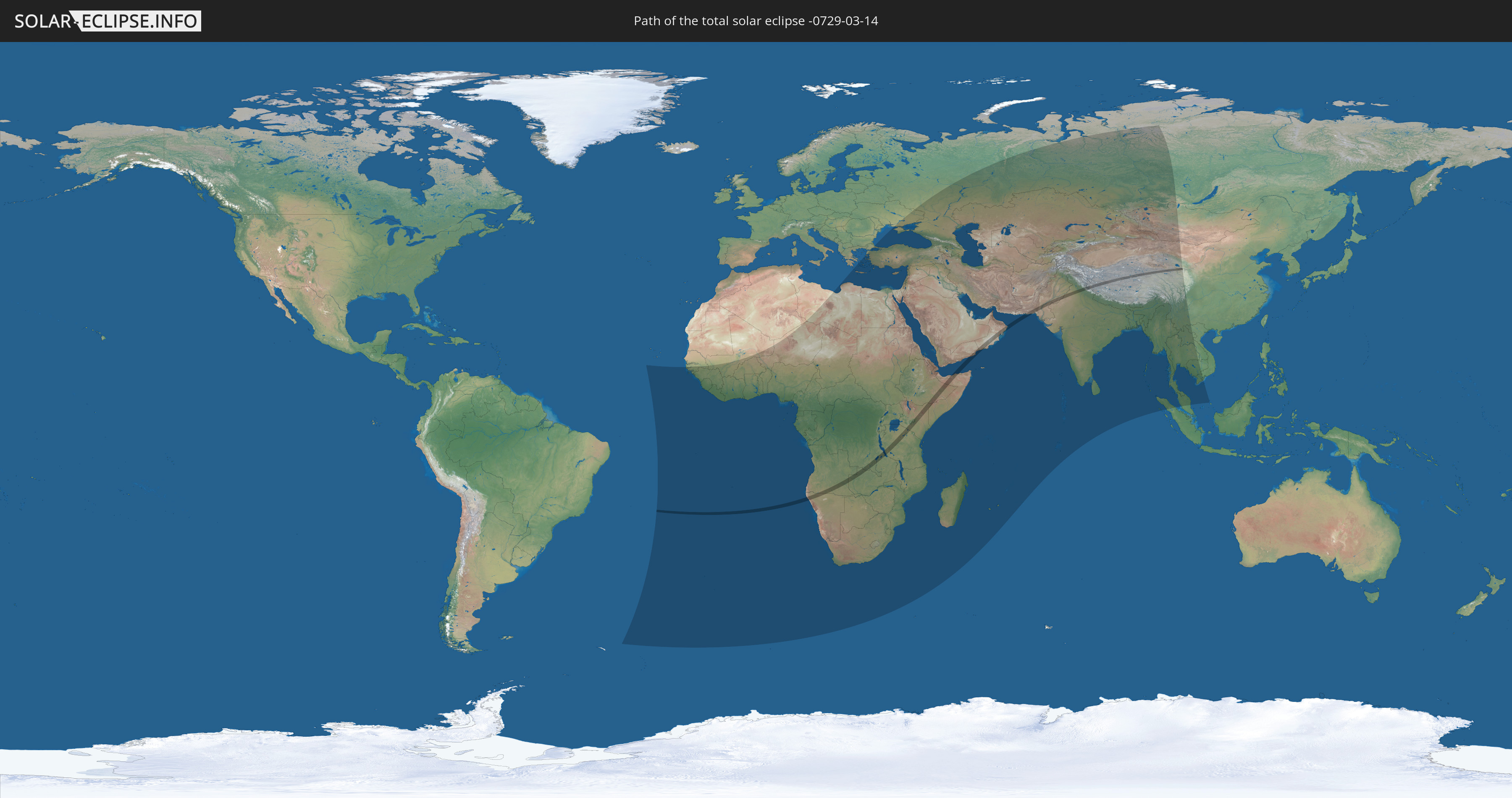
Die Sonnenfinsternis am 14.03.-0729 kann man in 97 Ländern als partielle Sonnenfinsternis beobachten.
Der Finsternispfad verläuft durch 13 Länder. Nur in diesen Ländern ist sie als totale Sonnenfinsternis zu sehen.
In den folgenden Ländern ist die Sonnenfinsternis total zu sehen
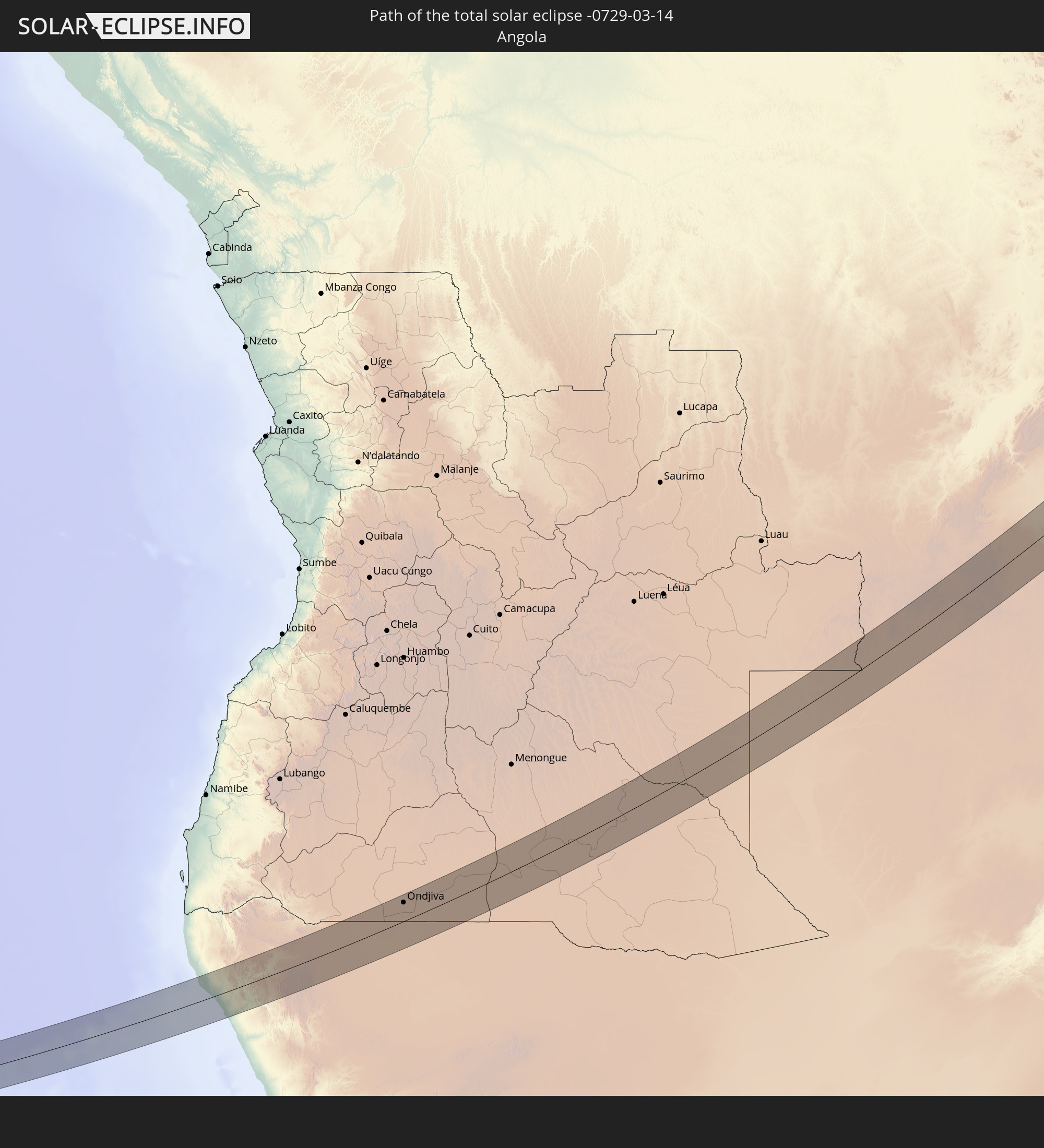 Angola
 Namibia
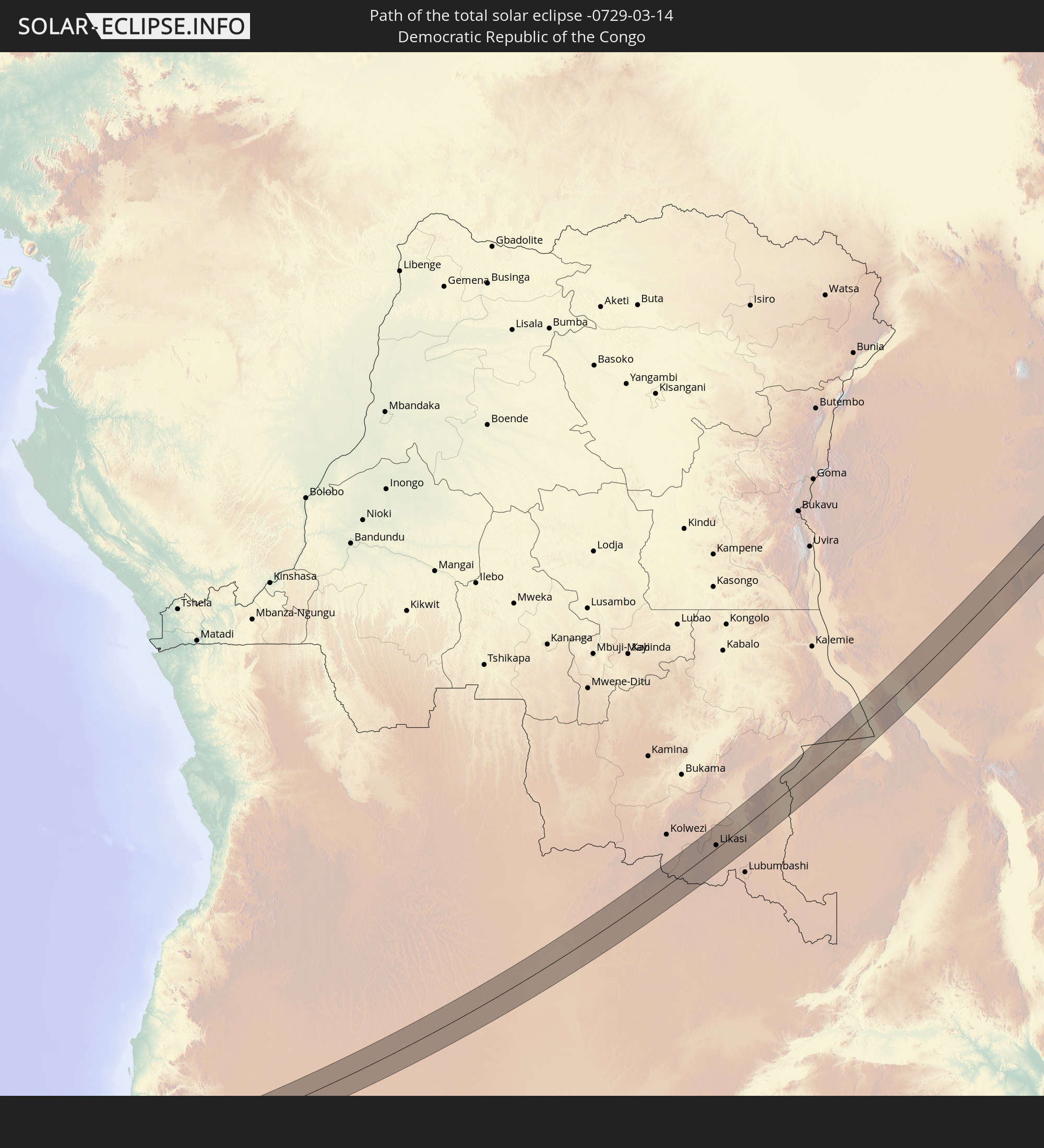 Demokratische Republik Kongo
 Sambia
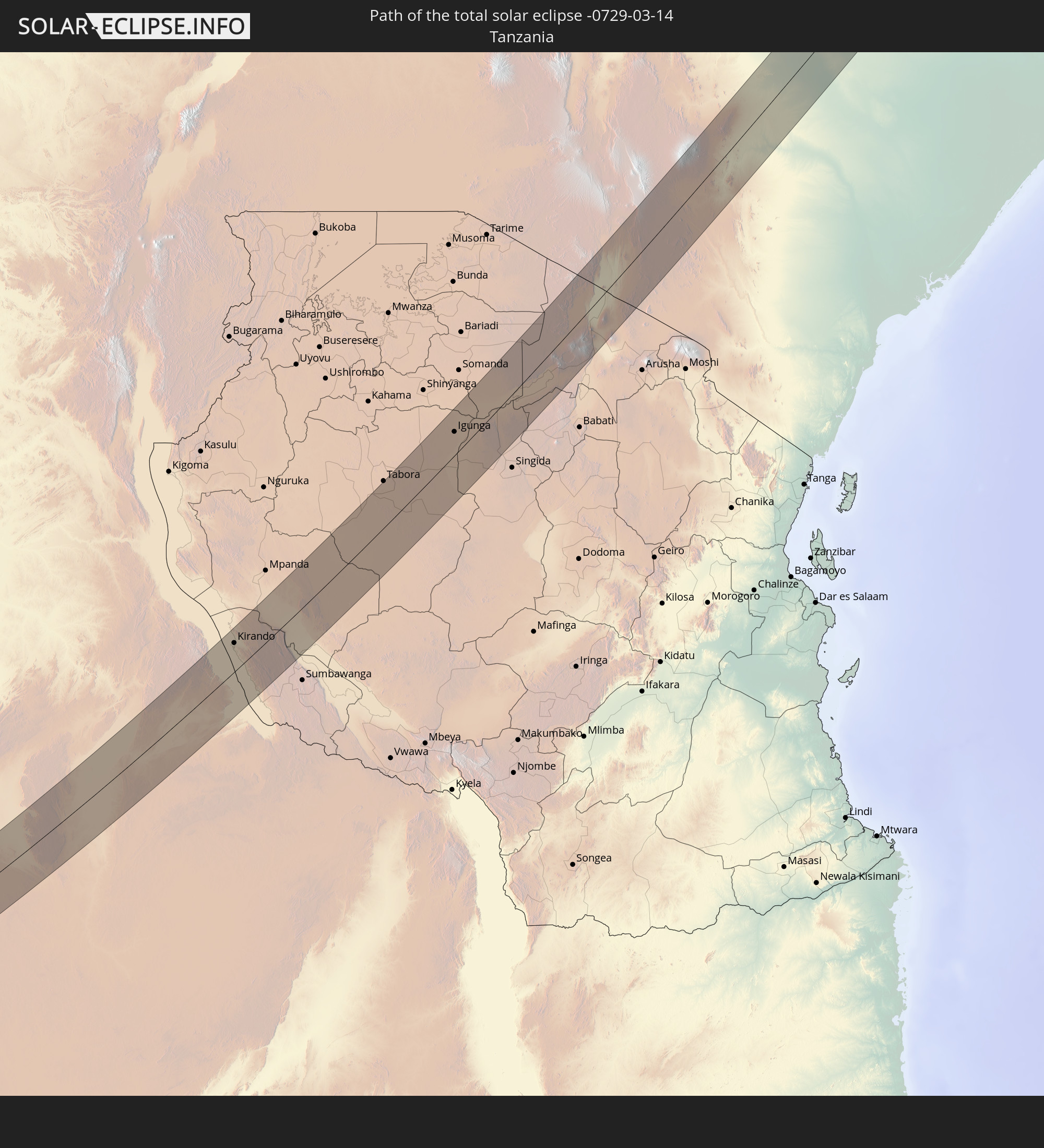 Tansania
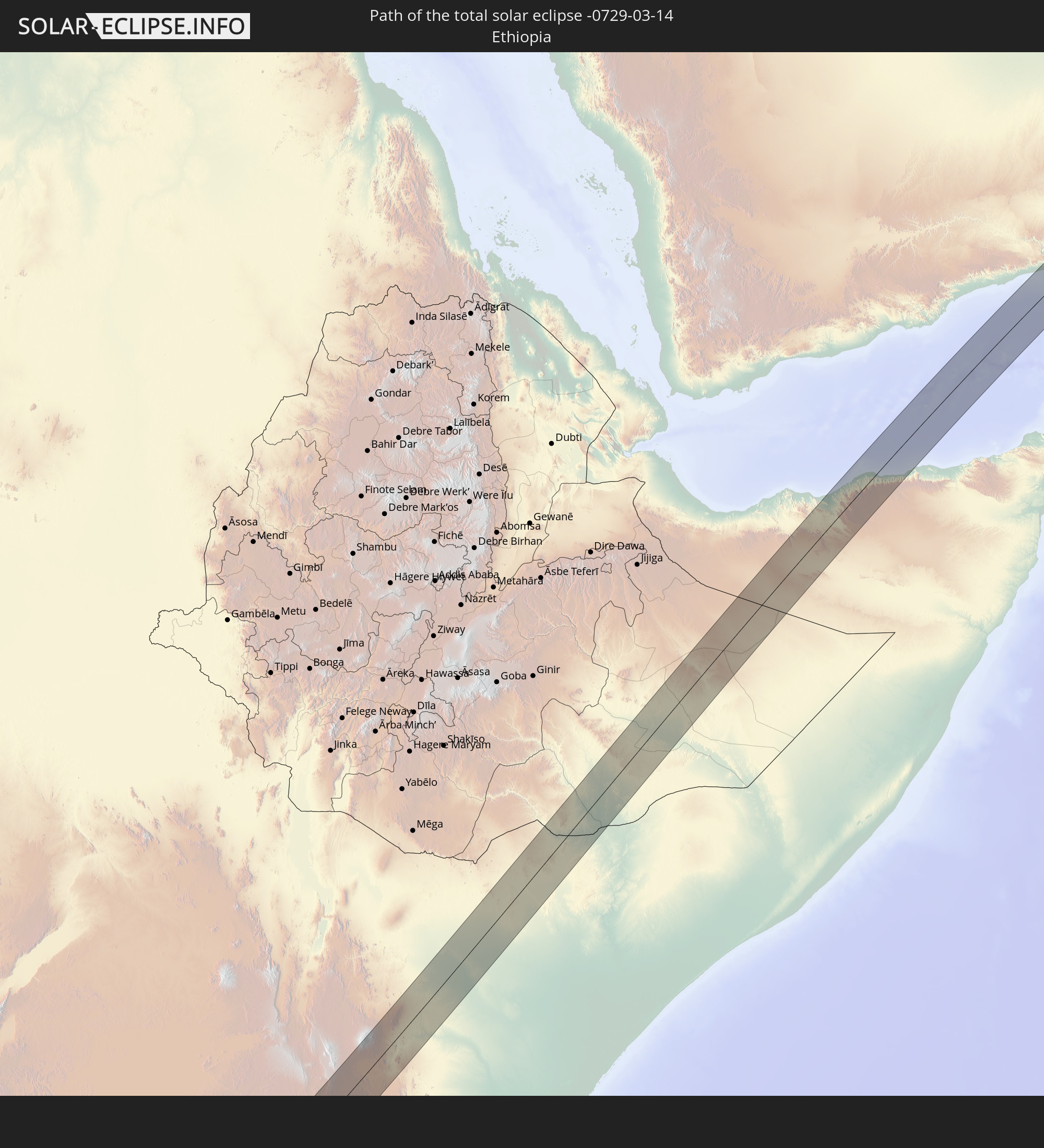 Äthiopien
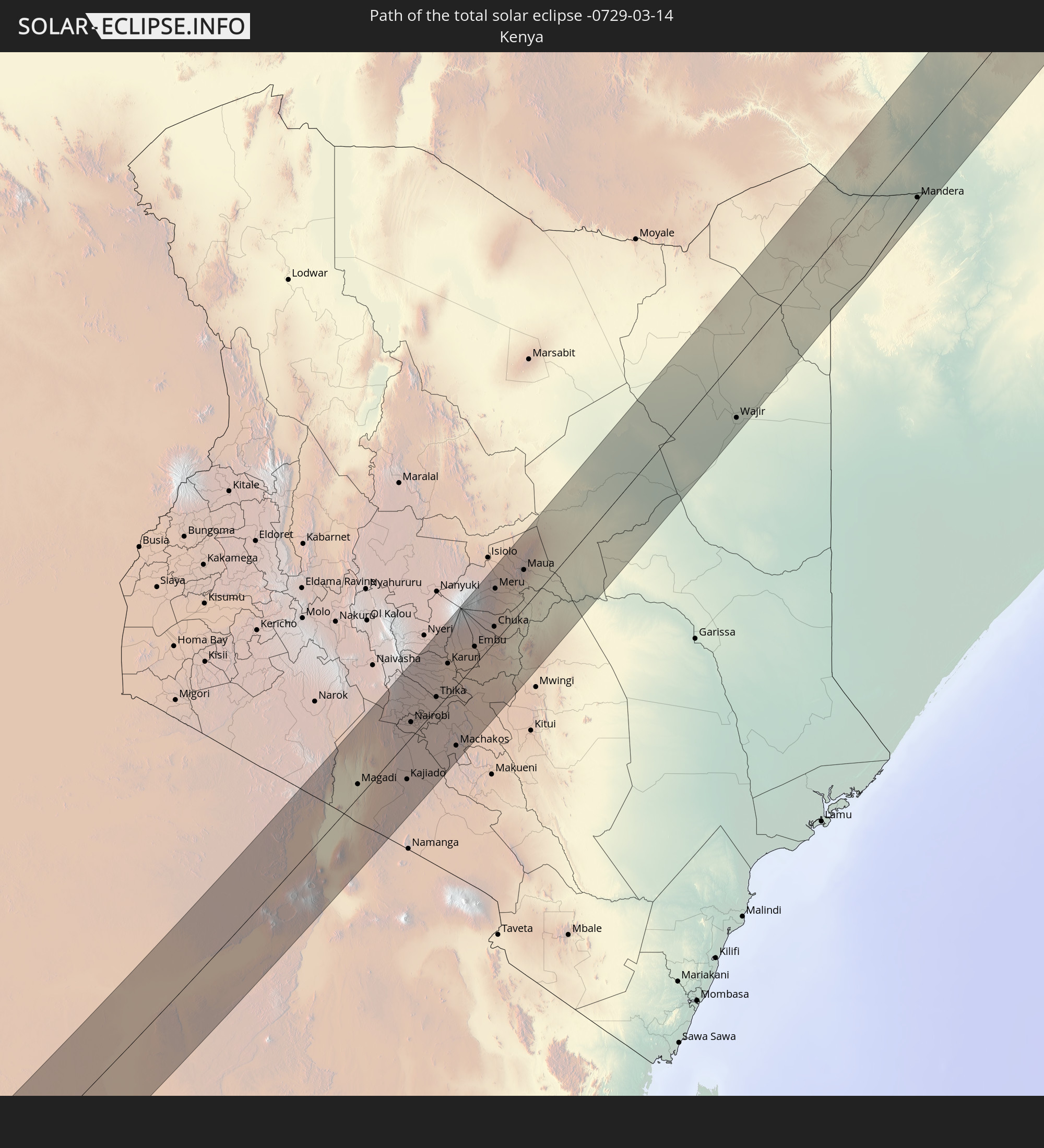 Kenia
Kenia
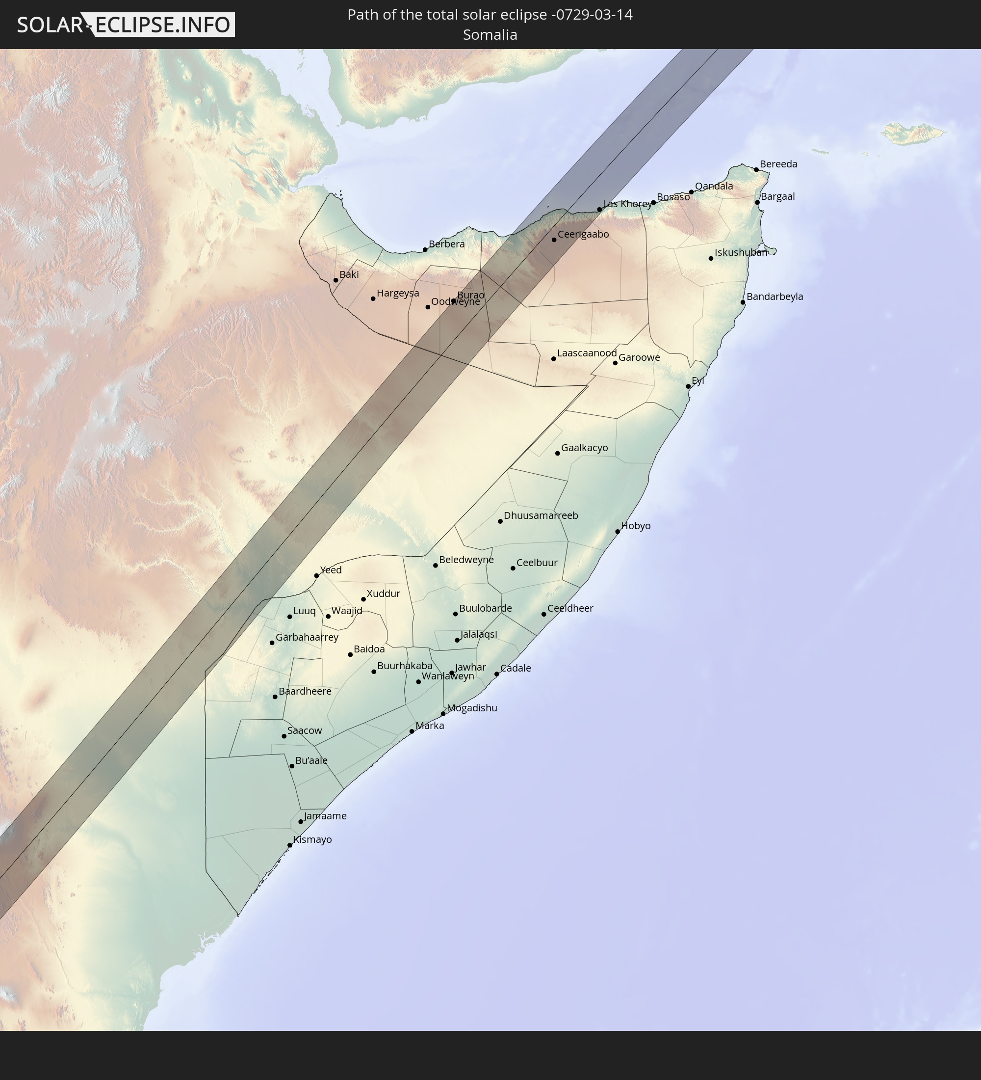 Somalia
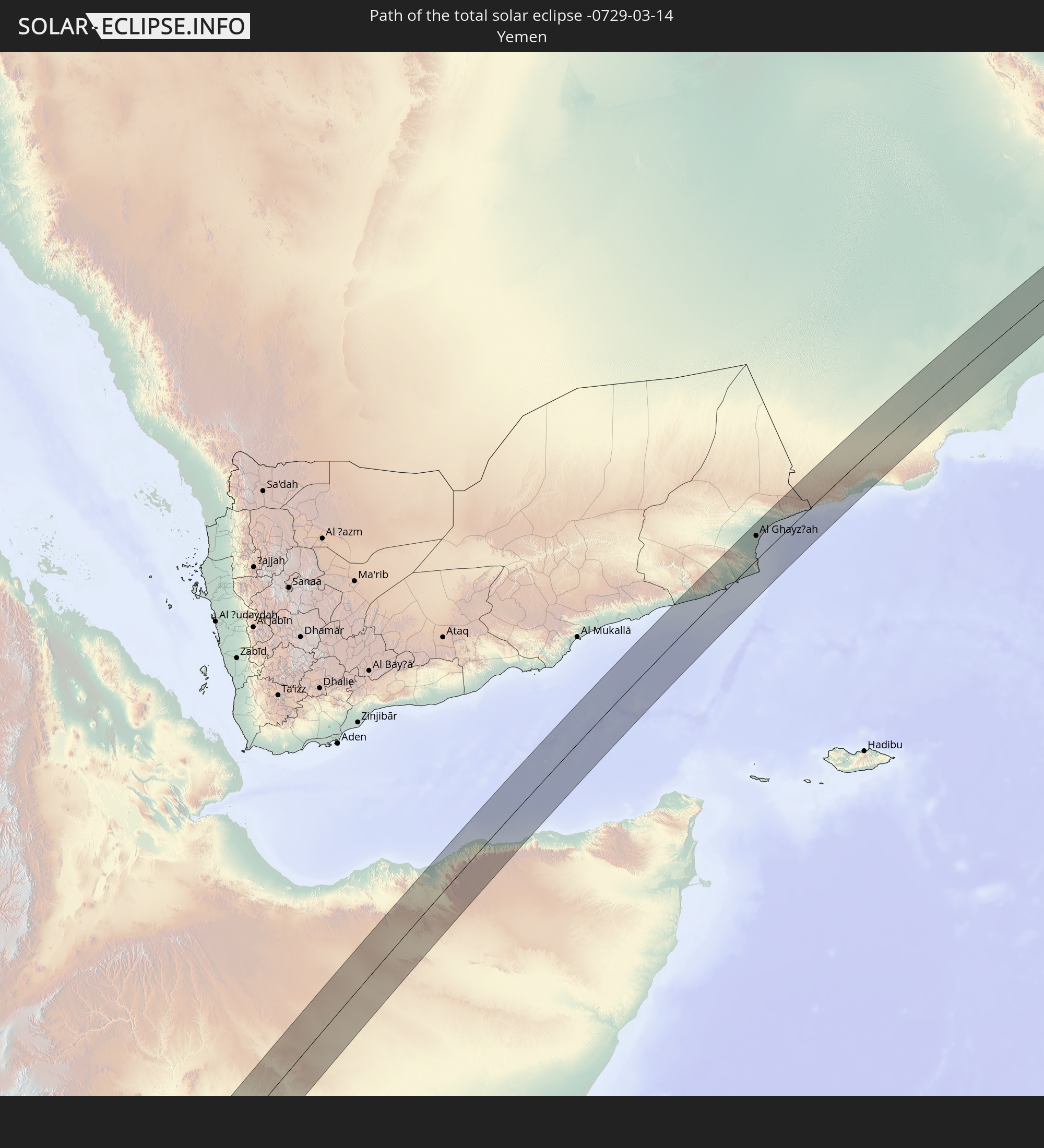 Jemen
Jemen
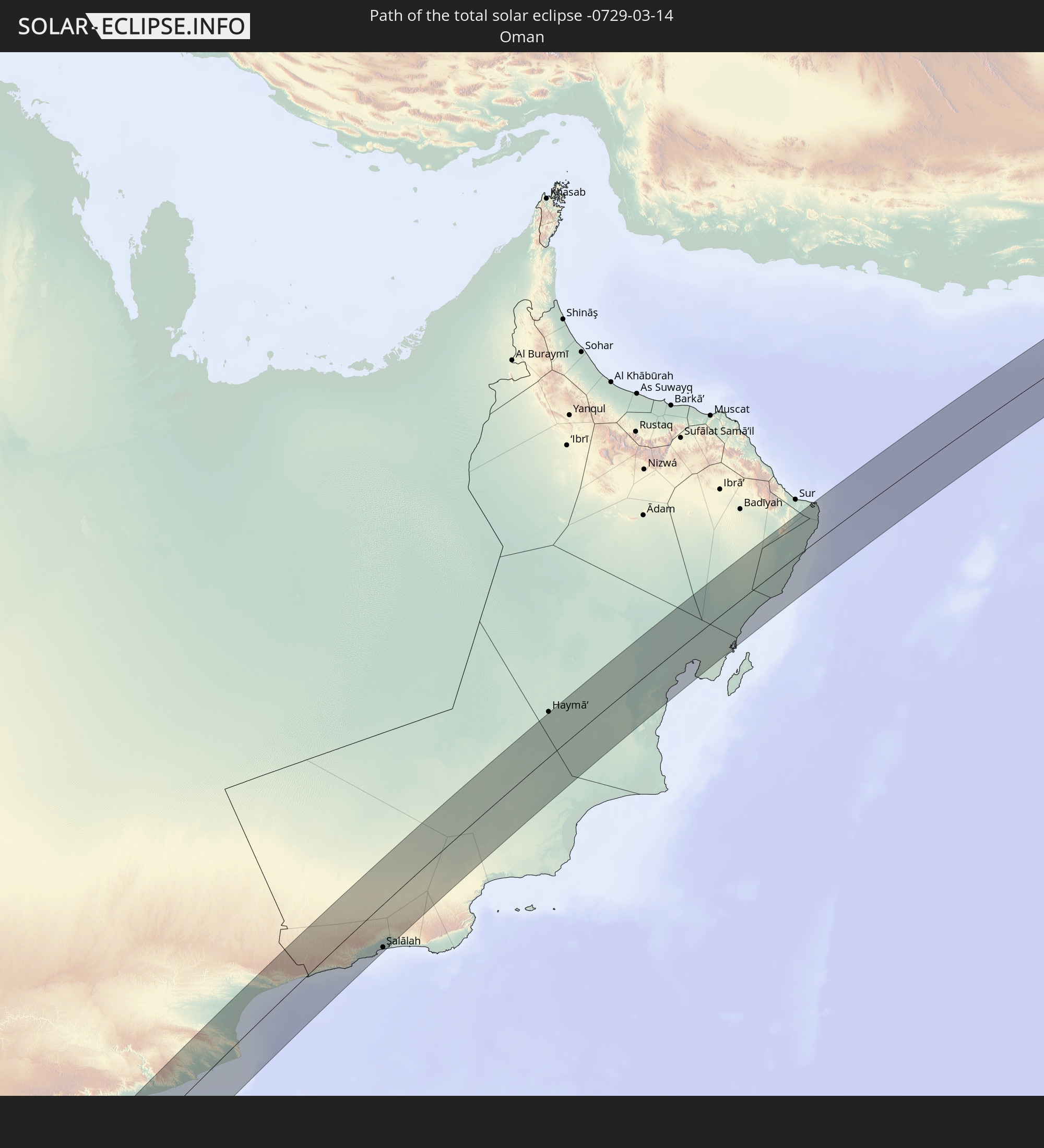 Oman
Oman
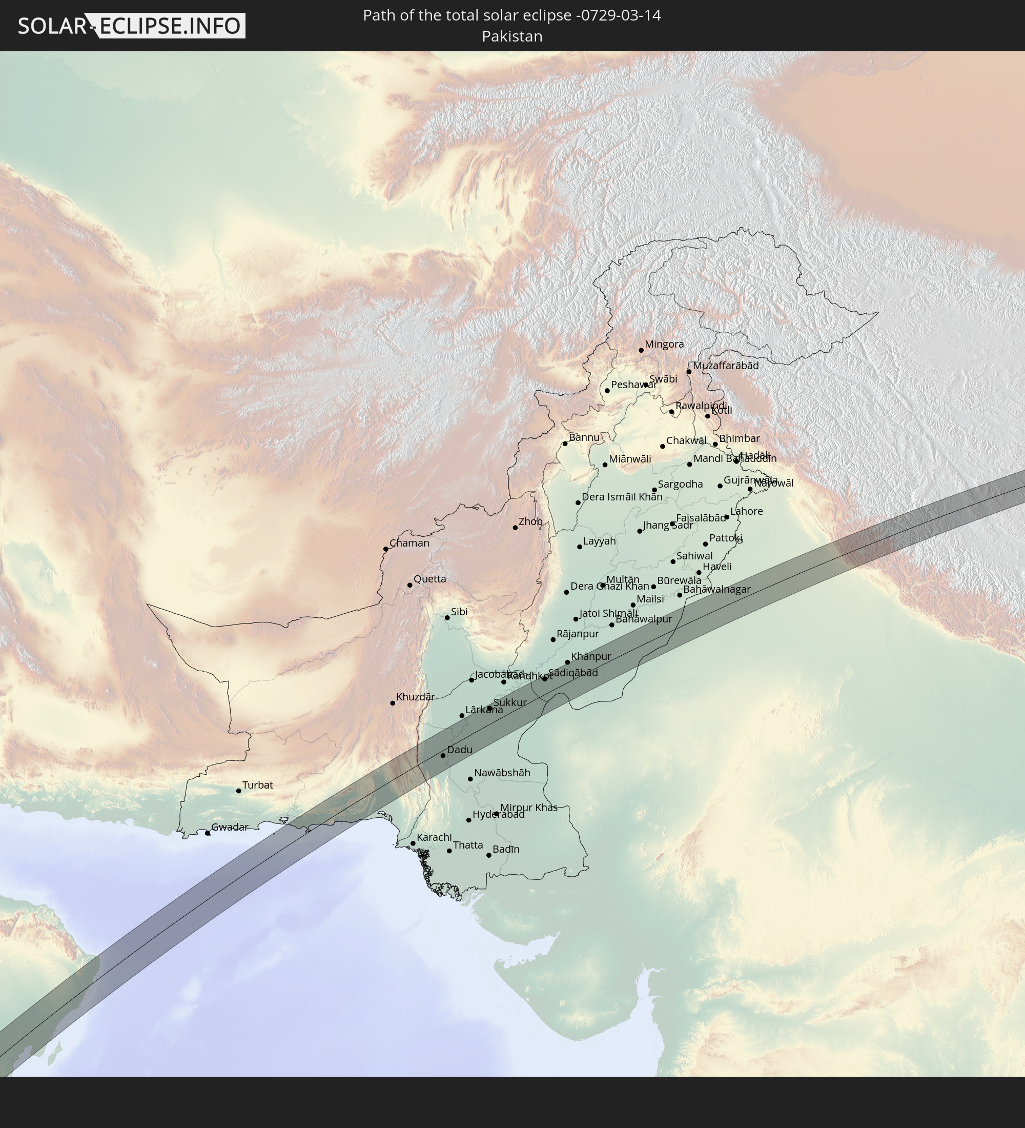 Pakistan
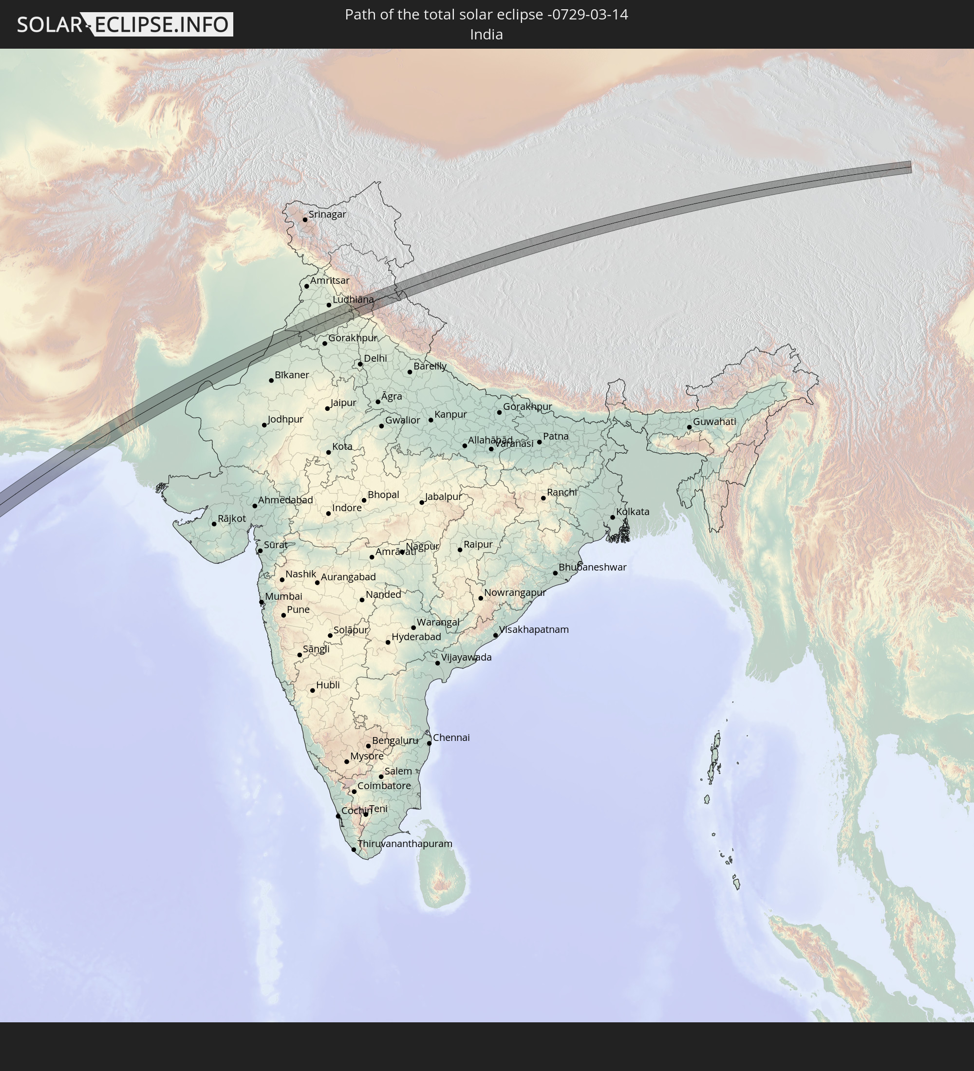 Indien
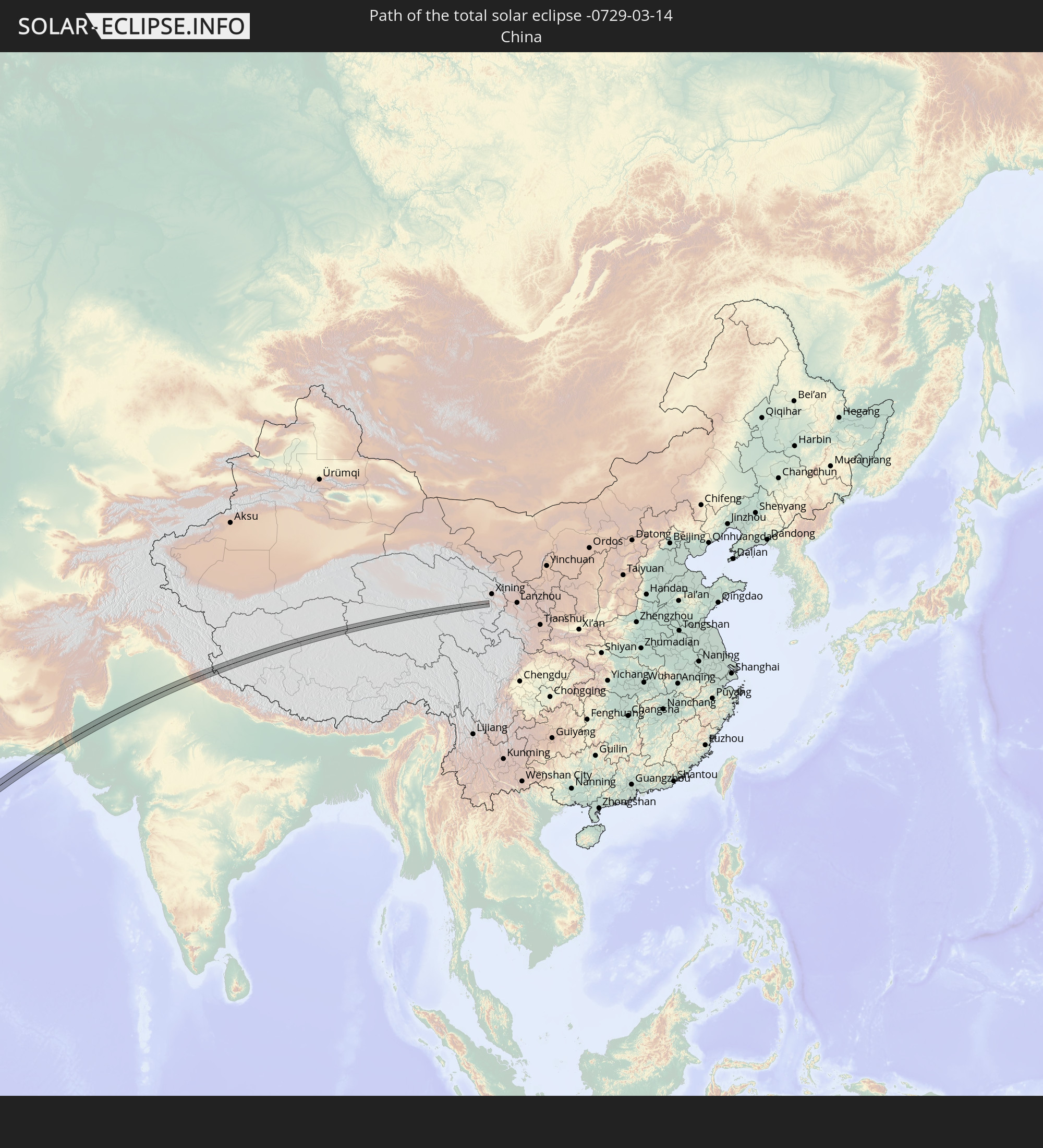 Volksrepublik China
In den folgenden Ländern ist die Sonnenfinsternis partiell zu sehen
 Russland
 Senegal
 Guinea-Bissau
 Guinea
 St. Helena
 Sierra Leone
 Mali
Mali
 Liberia
 Algerien
 Elfenbeinküste
 Burkina Faso
 Ghana
Ghana
 Togo
Togo
 Niger
Niger
 Benin
Benin
 Nigeria
 Äquatorialguinea
 São Tomé und Príncipe
 Kamerun
 Gabun
Gabun
 Libyen
 Republik Kongo
 Angola
 Namibia
 Demokratische Republik Kongo
 Tschad
 Zentralafrikanische Republik
 Südafrika
 Griechenland
 Botswana
 Sudan
Sudan
 Sambia
 Ukraine
 Ägypten
 Simbabwe
 Türkei
 Lesotho
 Ruanda
 Burundi
 Tansania
 Uganda
 Mosambik
 Swasiland
 Republik Zypern
 Malawi
 Äthiopien
 Kenia
Kenia
 Staat Palästina
 Israel
 Saudi-Arabien
 Jordanien
 Libanon
 Syrien
 Eritrea
 Irak
Irak
 Georgien
 Französische Süd- und Antarktisgebiete
 Somalia
 Dschibuti
 Jemen
Jemen
 Madagaskar
 Komoren
 Armenien
 Iran
Iran
 Aserbaidschan
 Mayotte
 Seychellen
 Kasachstan
 Kuwait
 Bahrain
 Katar
Katar
 Vereinigte Arabische Emirate
 Oman
Oman
 Turkmenistan
 Réunion
 Usbekistan
 Mauritius
 Afghanistan
 Pakistan
 Tadschikistan
 Indien
 Kirgisistan
 Britisches Territorium im Indischen Ozean
 Malediven
 Volksrepublik China
 Sri Lanka
 Nepal
Nepal
 Mongolei
 Bangladesch
 Bhutan
 Myanmar
 Indonesien
 Thailand
 Malaysia
 Laos
Laos
 Vietnam
 Kambodscha
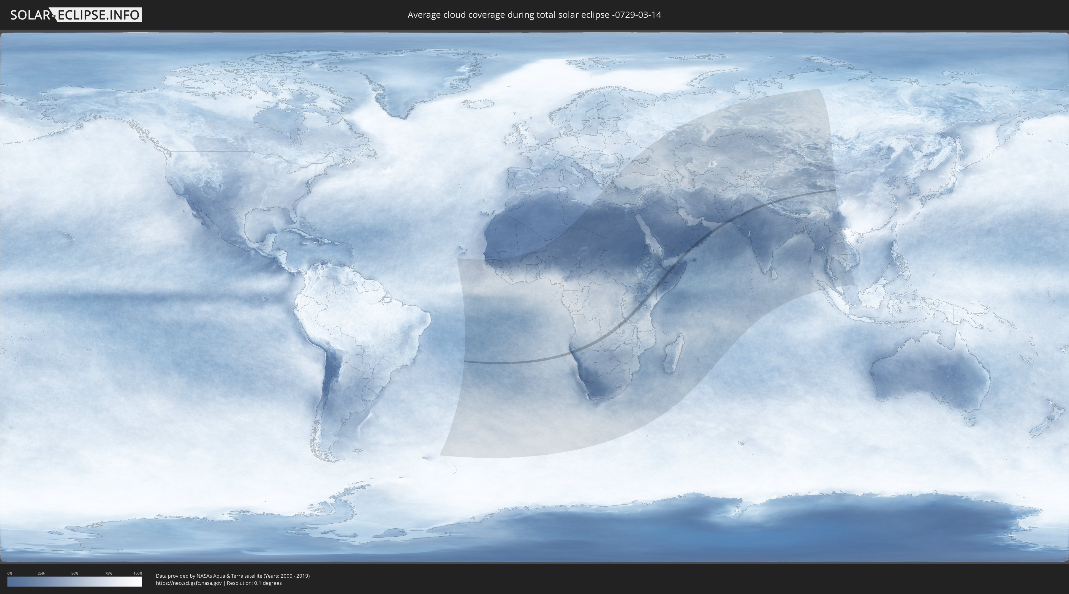
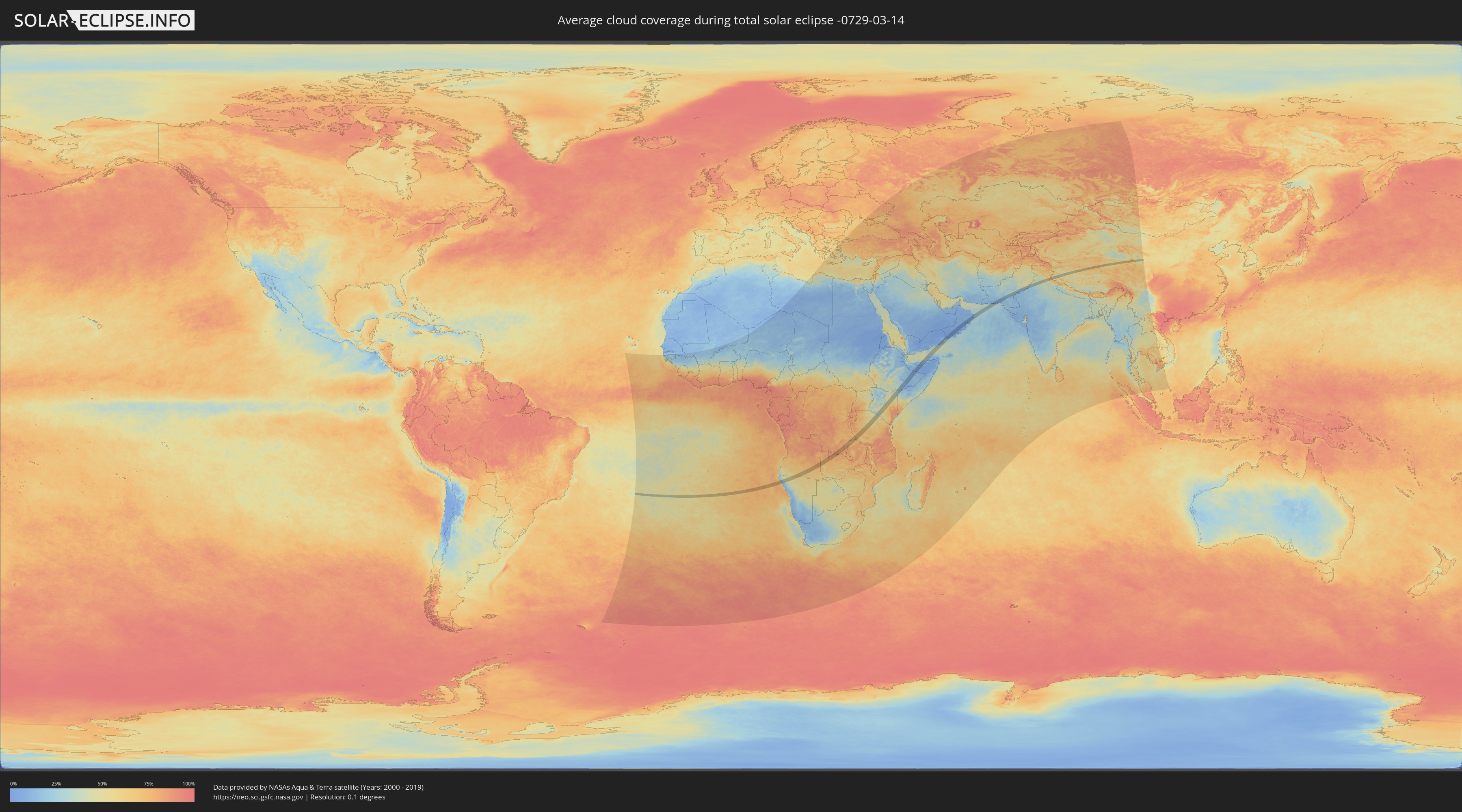
Wie wird das Wetter während der totalen Sonnenfinsternis am 14.03.-0729?
Wo ist der beste Ort, um die totale Sonnenfinsternis vom 14.03.-0729 zu beobachten?
Die folgenden Karten zeigen die durchschnittliche Bewölkung für den Tag, an dem die totale Sonnenfinsternis
stattfindet. Mit Hilfe der Karten lässt sich der Ort entlang des Finsternispfades eingrenzen,
der die besten Aussichen auf einen klaren wolkenfreien Himmel bietet.
Trotzdem muss man immer lokale Gegenenheiten beachten und sollte sich genau über das Wetter an seinem
gewählten Beobachtungsort informieren.
Die Daten stammen von den beiden NASA-Satelliten
AQUA und TERRA
und wurden über einen Zeitraum von 19 Jahren (2000 - 2019) gemittelt.
Detaillierte Länderkarten
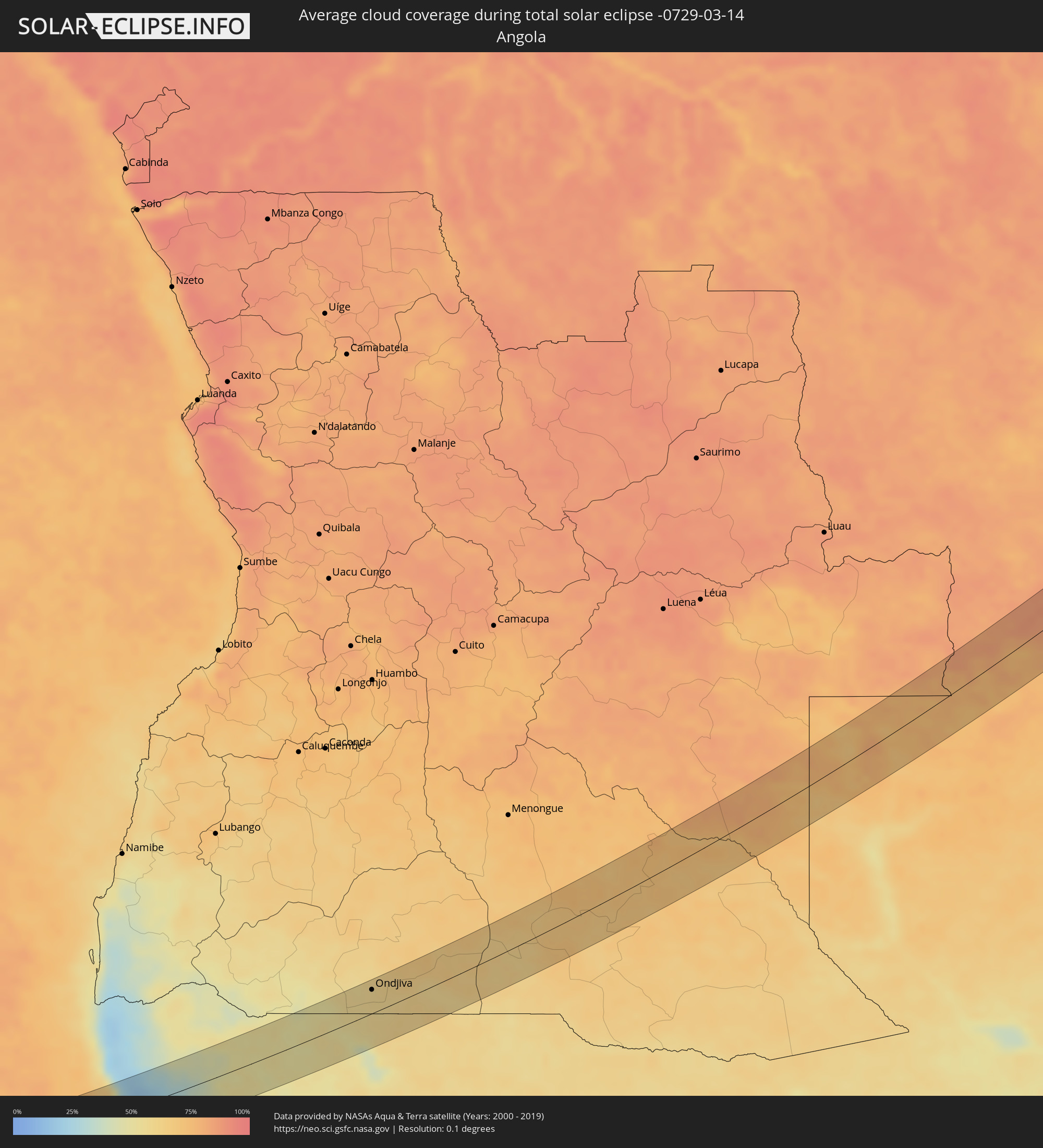 Angola
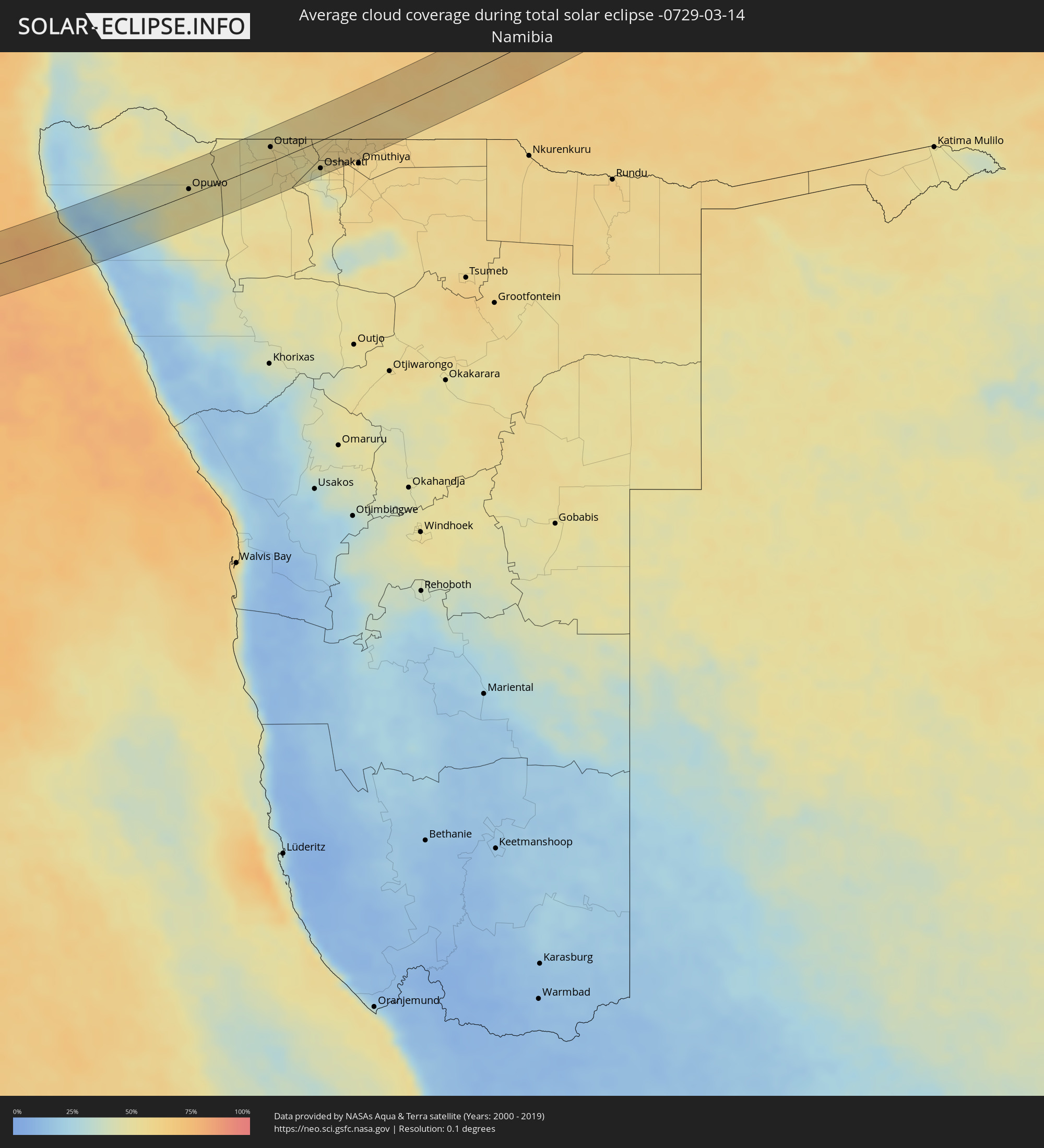 Namibia
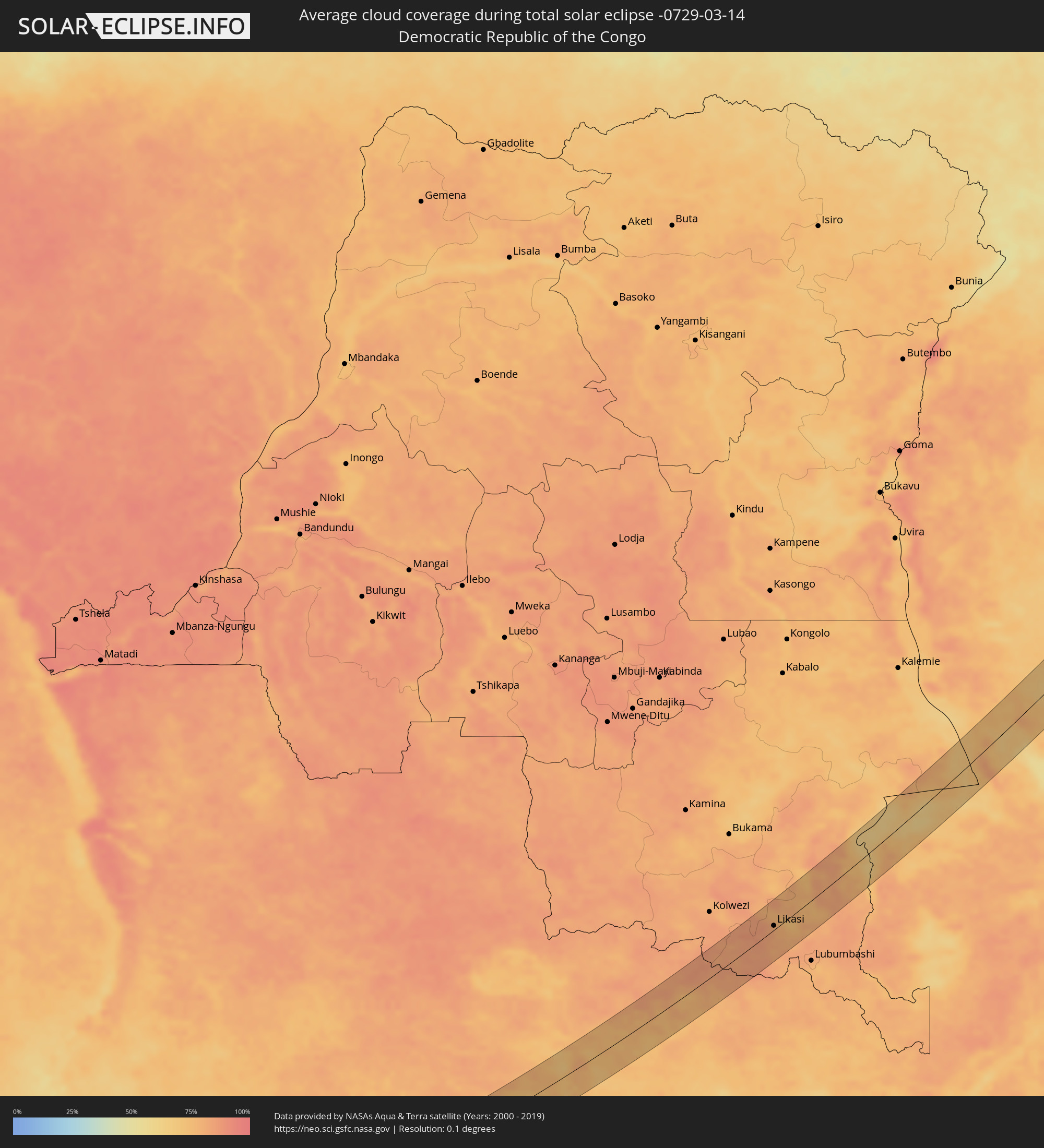 Demokratische Republik Kongo
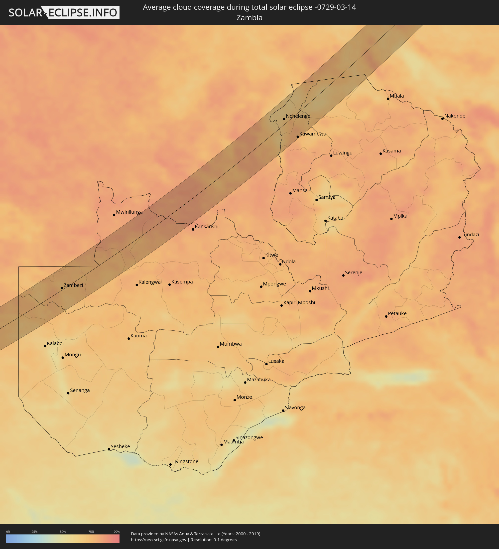 Sambia
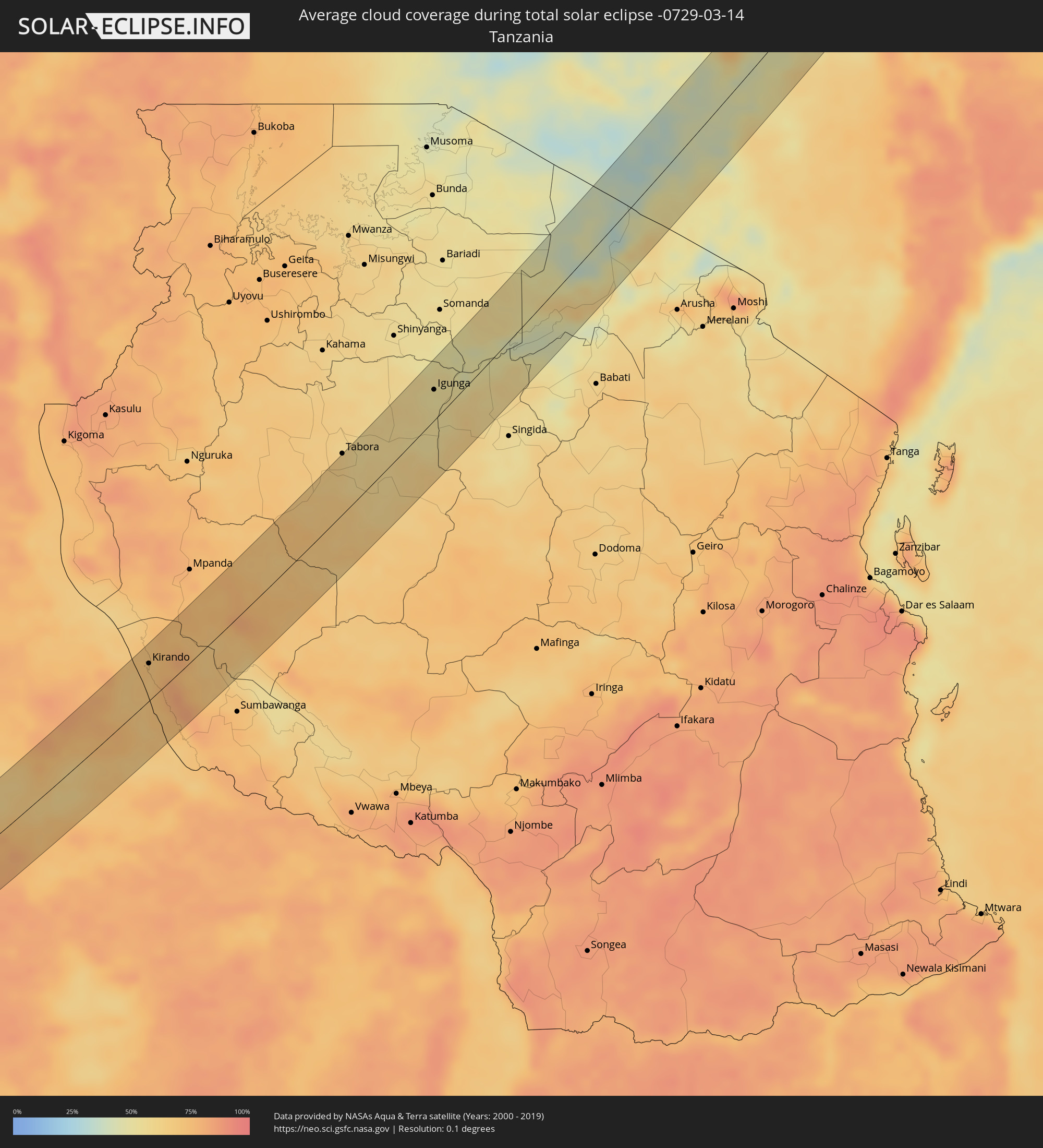 Tansania
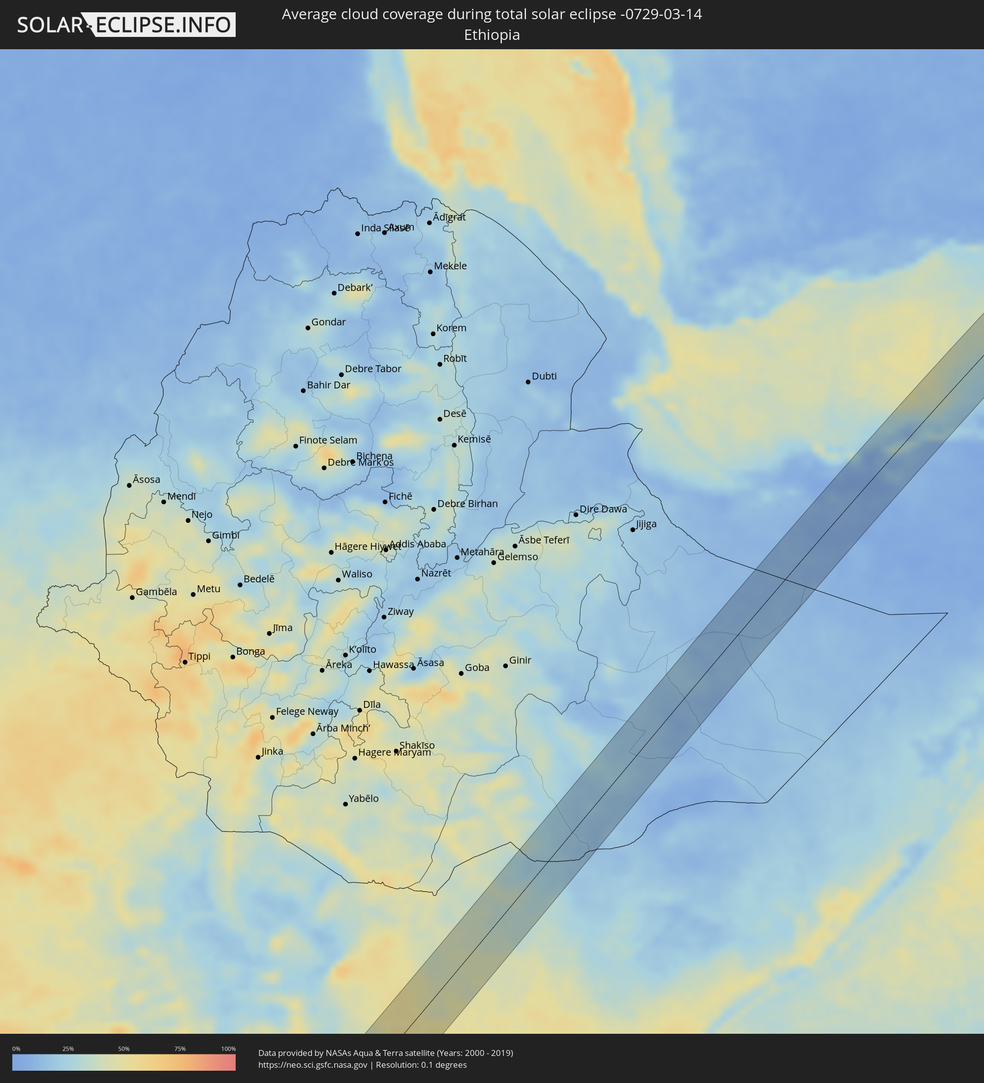 Äthiopien
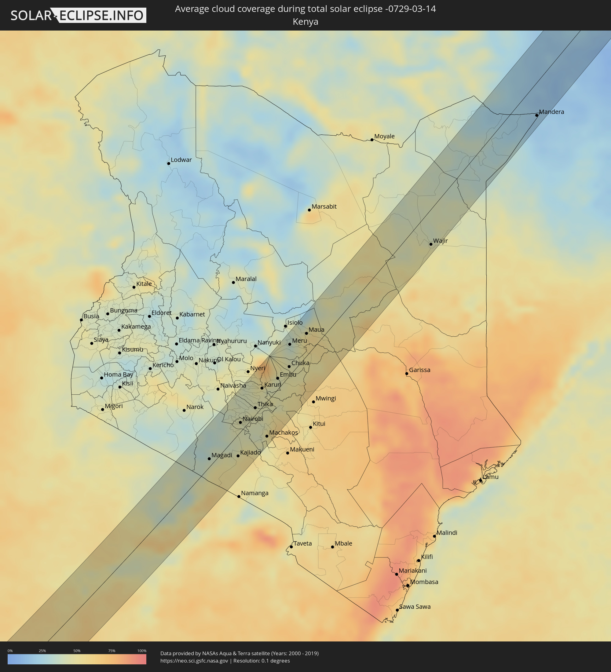 Kenia
Kenia
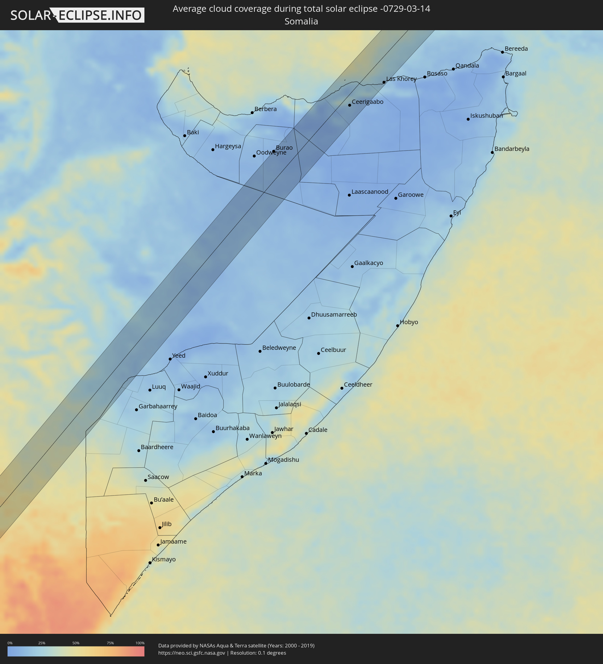 Somalia
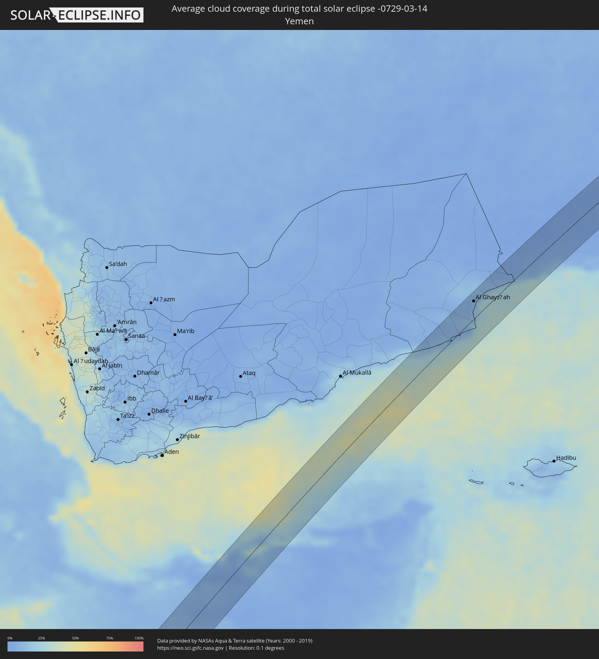 Jemen
Jemen
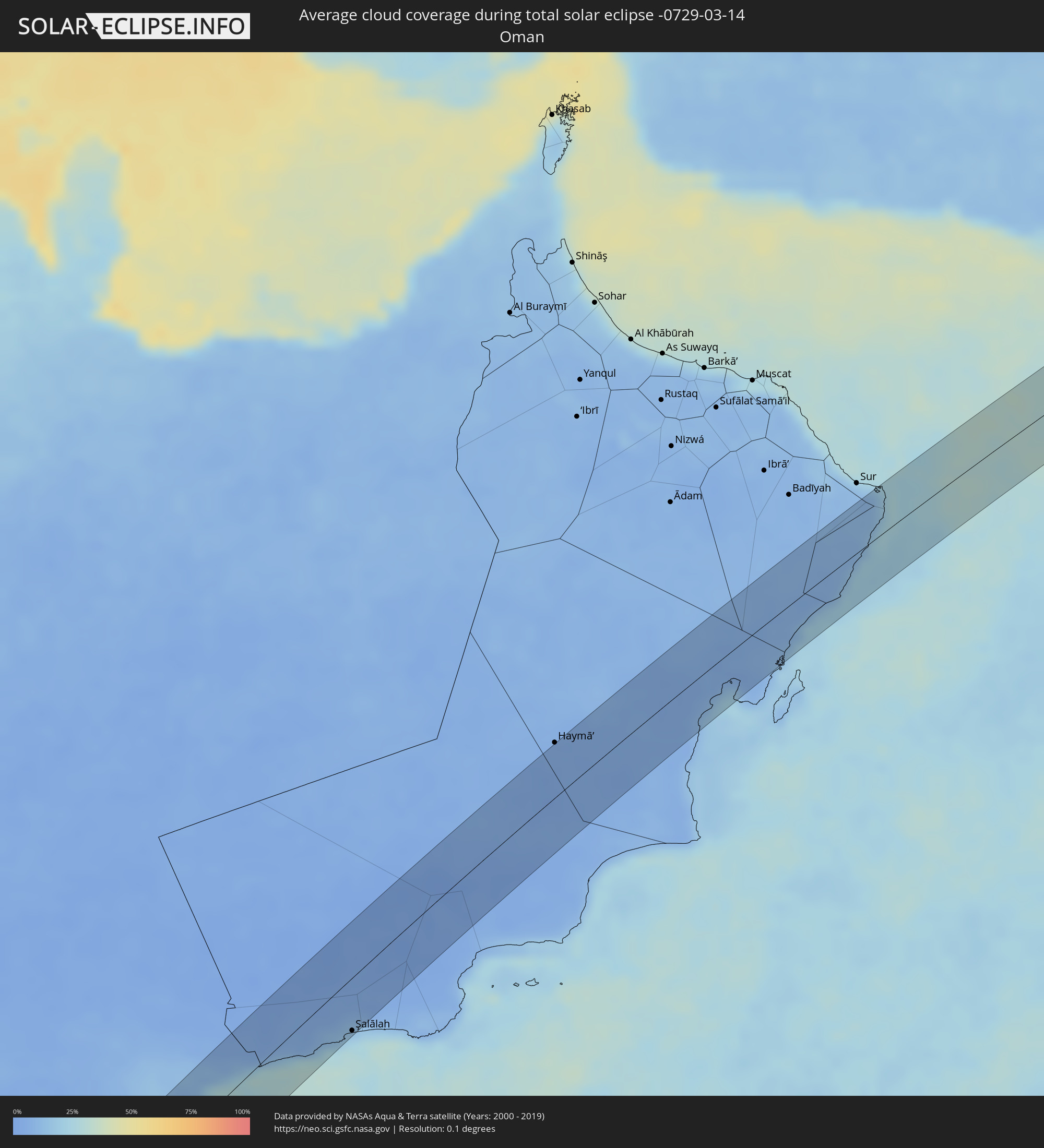 Oman
Oman
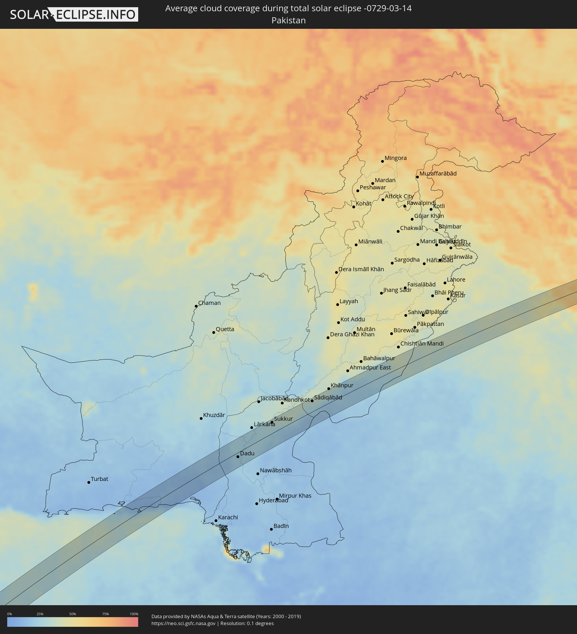 Pakistan
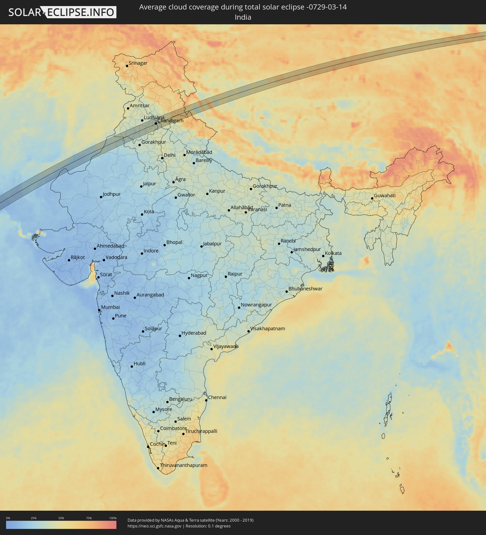 Indien
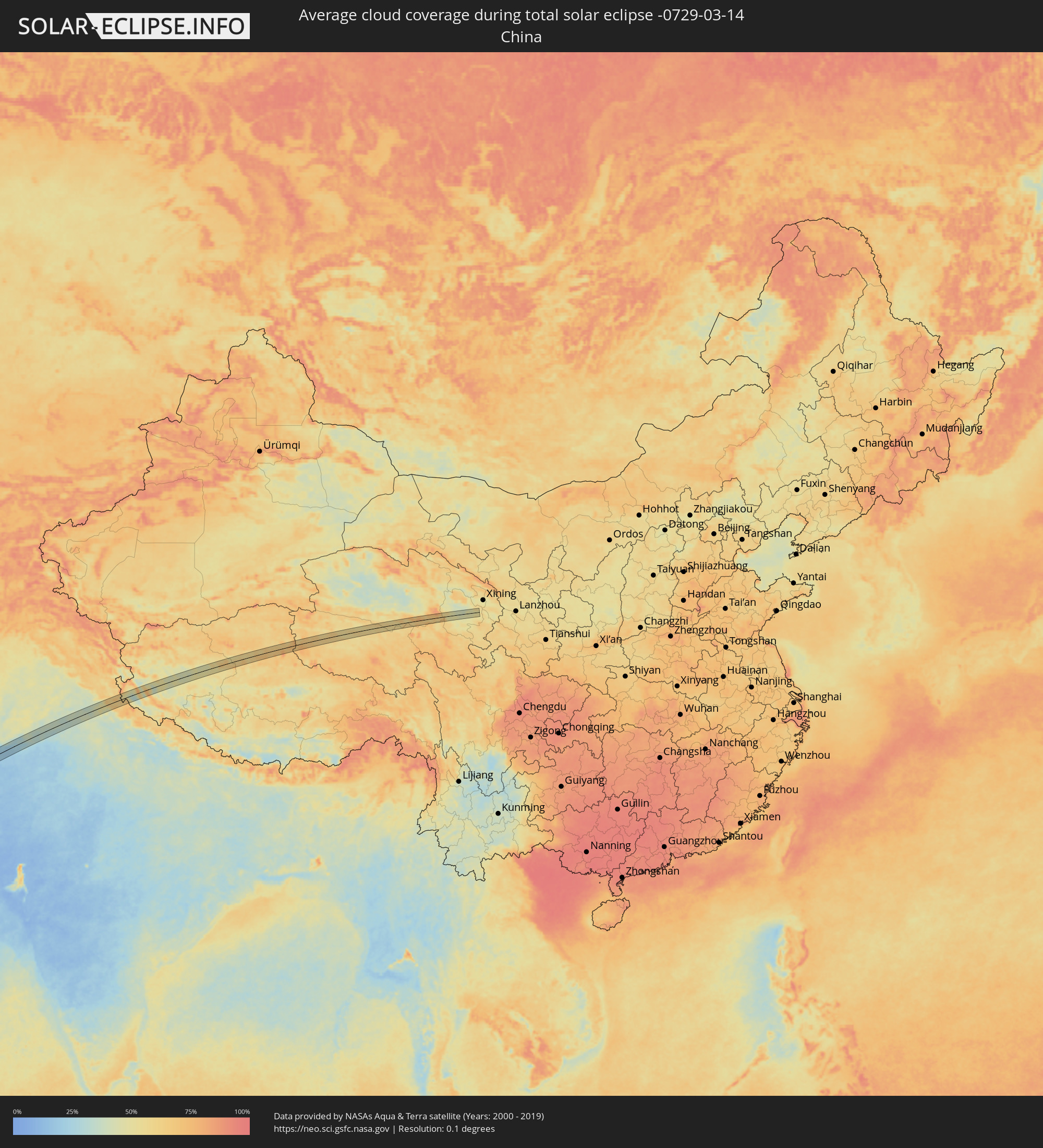 Volksrepublik China
Orte im Finsternispfad
Die nachfolgene Tabelle zeigt Städte und Orte mit mehr als 5.000 Einwohnern, die sich im Finsternispfad befinden. Städte mit mehr als 100.000 Einwohnern sind dick gekennzeichnet. Mit einem Klick auf den Ort öffnet sich eine Detailkarte die die Lage des jeweiligen Ortes zusammen mit dem Verlauf der zentralen Finsternis präsentiert.
| Ort | Typ | Dauer der Verfinsterung | Ortszeit bei maximaler Verfinsterung | Entfernung zur Zentrallinie | Ø Bewölkung |
|
Opuwo, Kunene
|
total | - | 09:36:11 UTC+01:30 | 8 km | 49% |
|
Outapi, Omusati
|
total | - | 09:38:25 UTC+01:30 | 20 km | 55% |
|
Oshakati, Oshana
|
total | - | 09:39:07 UTC+01:30 | 38 km | 49% |
|
Ondjiva, Cunene
|
total | - | 08:23:35 UTC+00:13 | 33 km | 58% |
|
Ongwediva, Oshana
|
total | - | 09:39:14 UTC+01:30 | 42 km | 57% |
|
Eenhana, Ohangwena
|
total | - | 09:40:25 UTC+01:30 | 34 km | 59% |
|
Zambezi, North-Western
|
total | - | 10:37:05 UTC+02:10 | 3 km | 74% |
|
Kambove, Katanga
|
total | - | 10:47:53 UTC+02:10 | 26 km | 83% |
|
Likasi, Katanga
|
total | - | 10:47:57 UTC+02:10 | 7 km | 82% |
|
Nchelenge, Luapula
|
total | - | 10:54:43 UTC+02:10 | 11 km | 68% |
|
Kawambwa, Luapula
|
total | - | 10:54:31 UTC+02:10 | 52 km | 77% |
|
Kirando, Rukwa
|
total | - | 11:19:00 UTC+02:27 | 35 km | 71% |
|
Nkove, Rukwa
|
total | - | 11:18:25 UTC+02:27 | 28 km | 74% |
|
Namanyere, Rukwa
|
total | - | 11:19:41 UTC+02:27 | 7 km | 71% |
|
Usevia, Katavi
|
total | - | 11:20:52 UTC+02:27 | 13 km | 68% |
|
Chala, Rukwa
|
total | - | 11:19:58 UTC+02:27 | 29 km | 69% |
|
Inyonga, Katavi
|
total | - | 11:23:16 UTC+02:27 | 20 km | 72% |
|
Sikonge, Tabora
|
total | - | 11:26:53 UTC+02:27 | 11 km | 66% |
|
Tabora, Tabora
|
total | - | 11:28:18 UTC+02:27 | 54 km | 62% |
|
Igunga, Tabora
|
total | - | 11:31:56 UTC+02:27 | 27 km | 51% |
|
Shelui, Singida
|
total | - | 11:32:22 UTC+02:27 | 5 km | 61% |
|
Ndago, Singida
|
total | - | 11:32:10 UTC+02:27 | 35 km | 58% |
|
Kiomboi, Singida
|
total | - | 11:32:55 UTC+02:27 | 11 km | 56% |
|
Ngorongoro, Arusha
|
total | - | 11:37:19 UTC+02:27 | 24 km | 63% |
|
Kiratu, Arusha
|
total | - | 11:37:28 UTC+02:27 | 46 km | 52% |
|
Magadi, Kajiado
|
total | - | 11:41:48 UTC+02:27 | 10 km | 42% |
|
Ngong, Kajiado
|
total | - | 11:43:43 UTC+02:27 | 19 km | 42% |
|
Kajiado, Kajiado
|
total | - | 11:42:52 UTC+02:27 | 27 km | 52% |
|
Nairobi, Nairobi Area
|
total | - | 11:44:12 UTC+02:27 | 11 km | 45% |
|
Kiambu, Kiambu
|
total | - | 11:44:29 UTC+02:27 | 18 km | 45% |
|
Pumwani, Nairobi Area
|
total | - | 11:44:16 UTC+02:27 | 8 km | 42% |
|
Athi River, Machakos
|
total | - | 11:44:08 UTC+02:27 | 15 km | 46% |
|
Thika, Nairobi Area
|
total | - | 11:45:15 UTC+02:27 | 8 km | 45% |
|
Murang’a, Murang'A
|
total | - | 11:46:06 UTC+02:27 | 25 km | 45% |
|
Karuri, Murang'A
|
total | - | 11:46:12 UTC+02:27 | 23 km | 45% |
|
Machakos, Machakos
|
total | - | 11:44:34 UTC+02:27 | 44 km | 48% |
|
Keruguya, Kirinyaga
|
total | - | 11:46:50 UTC+02:27 | 30 km | 52% |
|
Kangundo, Machakos
|
total | - | 11:45:12 UTC+02:27 | 34 km | 51% |
|
Embu, Embu
|
total | - | 11:47:06 UTC+02:27 | 13 km | 44% |
|
Chuka, Tharaka - Nithi
|
total | - | 11:47:55 UTC+02:27 | 11 km | 46% |
|
Meru, Meru
|
total | - | 11:48:46 UTC+02:27 | 38 km | 41% |
|
Maua, Isiolo
|
total | - | 11:49:44 UTC+02:27 | 27 km | 49% |
|
Wajir, Wajir
|
total | - | 11:57:10 UTC+02:27 | 43 km | 47% |
|
Mandera, Mandera
|
total | - | 12:05:23 UTC+02:27 | 40 km | 19% |
|
Burao, Togdheer
|
total | - | 12:23:53 UTC+02:27 | 50 km | 8% |
|
Ceerigaabo, Sanaag
|
total | - | 12:29:16 UTC+02:27 | 21 km | 12% |
|
Las Khorey, Sanaag
|
total | - | 12:31:44 UTC+02:27 | 48 km | 17% |
|
Al Ghayz̧ah, Al Mahrah
|
total | - | 13:26:50 UTC+03:06 | 31 km | 13% |
|
Şalālah, Z̧ufār
|
total | - | 14:05:22 UTC+03:41 | 44 km | 24% |
|
Dadu, Sindh
|
total | - | 15:20:36 UTC+04:28 | 12 km | 21% |
|
Mehar, Sindh
|
total | - | 15:20:58 UTC+04:28 | 29 km | 24% |
|
Sīta Road, Sindh
|
total | - | 15:20:54 UTC+04:28 | 13 km | 22% |
|
Moro, Sindh
|
total | - | 15:20:47 UTC+04:28 | 30 km | 22% |
|
New Bādāh, Sindh
|
total | - | 15:21:17 UTC+04:28 | 34 km | 25% |
|
Kandiāro, Sindh
|
total | - | 15:21:16 UTC+04:28 | 2 km | 24% |
|
Sethārja Old, Sindh
|
total | - | 15:21:37 UTC+04:28 | 0 km | 25% |
|
Gambat, Sindh
|
total | - | 15:21:46 UTC+04:28 | 11 km | 26% |
|
Pīr jo Goth, Sindh
|
total | - | 15:22:01 UTC+04:28 | 30 km | 28% |
|
Kot Diji, Sindh
|
total | - | 15:21:56 UTC+04:28 | 2 km | 22% |
|
Khairpur, Sindh
|
total | - | 15:22:07 UTC+04:28 | 17 km | 26% |
|
Sukkur, Sindh
|
total | - | 15:22:19 UTC+04:28 | 30 km | 30% |
|
Pāno Āqil, Sindh
|
total | - | 15:22:39 UTC+04:28 | 32 km | 35% |
|
Ghotki, Sindh
|
total | - | 15:22:56 UTC+04:28 | 37 km | 36% |
|
Mīrpur Mathelo, Sindh
|
total | - | 15:23:10 UTC+04:28 | 28 km | 35% |
|
Khairpur, Sindh
|
total | - | 15:23:20 UTC+04:28 | 25 km | 32% |
|
Sādiqābād, Punjab
|
total | - | 15:23:52 UTC+04:28 | 29 km | 31% |
|
Fort Abbās, Punjab
|
total | - | 15:26:39 UTC+04:28 | 2 km | 31% |
|
Haru Zbad, Punjab
|
total | - | 15:27:05 UTC+04:28 | 29 km | 38% |
|
Gangānagar, Rajasthan
|
total | - | 16:20:46 UTC+05:21 | 29 km | 37% |
|
Sūratgarh, Rajasthan
|
total | - | 16:20:31 UTC+05:21 | 32 km | 29% |
|
Hanumāngarh, Rajasthan
|
total | - | 16:20:58 UTC+05:21 | 23 km | 31% |
|
Malaut, Punjab
|
total | - | 16:21:21 UTC+05:21 | 35 km | 36% |
|
Dabwāli, Haryana
|
total | - | 16:21:26 UTC+05:21 | 2 km | 32% |
|
Bhatinda, Punjab
|
total | - | 16:21:41 UTC+05:21 | 16 km | 37% |
|
Rāmpura, Punjab
|
total | - | 16:21:55 UTC+05:21 | 10 km | 33% |
|
Mānsa, Punjab
|
total | - | 16:21:56 UTC+05:21 | 24 km | 34% |
|
Barnāla, Punjab
|
total | - | 16:22:11 UTC+05:21 | 10 km | 37% |
|
Sangrūr, Punjab
|
total | - | 16:22:21 UTC+05:21 | 15 km | 35% |
|
Māler Kotla, Punjab
|
total | - | 16:22:29 UTC+05:21 | 13 km | 37% |
|
Nābha, Punjab
|
total | - | 16:22:37 UTC+05:21 | 13 km | 37% |
|
Khanna, Punjab
|
total | - | 16:22:47 UTC+05:21 | 18 km | 40% |
|
Sirhind, Punjab
|
total | - | 16:22:53 UTC+05:21 | 6 km | 41% |
|
Patiāla, Punjab
|
total | - | 16:22:46 UTC+05:21 | 26 km | 38% |
|
Ropar, Punjab
|
total | - | 16:23:05 UTC+05:21 | 34 km | 35% |
|
Rājpura, Punjab
|
total | - | 16:22:58 UTC+05:21 | 19 km | 43% |
|
Chandigarh, Chandigarh
|
total | - | 16:23:11 UTC+05:21 | 1 km | 40% |
|
Shimla, Himachal Pradesh
|
total | - | 16:23:34 UTC+05:21 | 25 km | 44% |