Totale Sonnenfinsternis vom 16.05.-0770
| Wochentag: | Dienstag |
| Maximale Dauer der Verfinsterung: | 05m54s |
| Maximale Breite des Finsternispfades: | 352 km |
| Saroszyklus: | 35 |
| Bedeckungsgrad: | 100% |
| Magnitude: | 1.0732 |
| Gamma: | -0.7469 |
Wo kann man die Sonnenfinsternis vom 16.05.-0770 sehen?
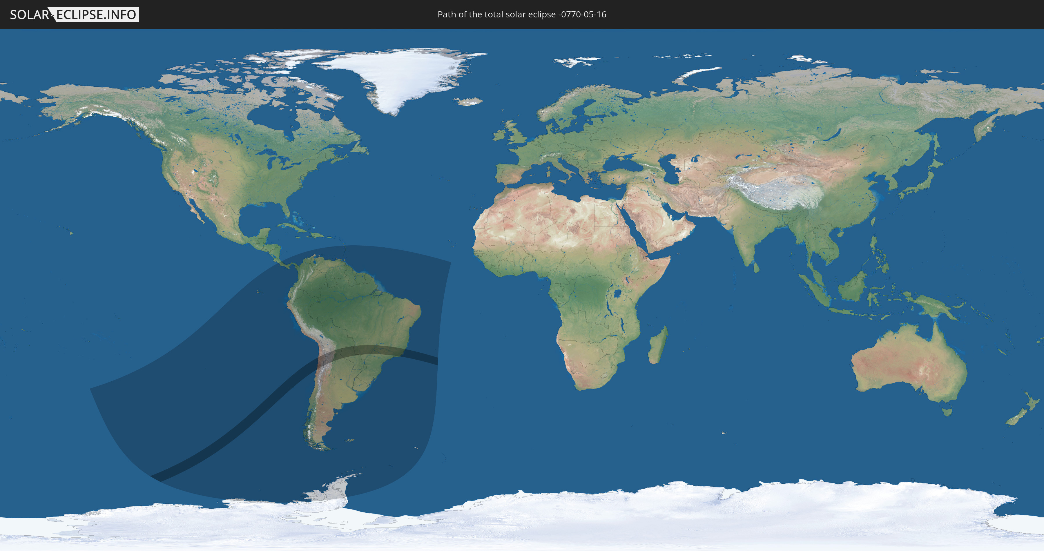
Die Sonnenfinsternis am 16.05.-0770 kann man in 27 Ländern als partielle Sonnenfinsternis beobachten.
Der Finsternispfad verläuft durch 5 Länder. Nur in diesen Ländern ist sie als totale Sonnenfinsternis zu sehen.
In den folgenden Ländern ist die Sonnenfinsternis total zu sehen
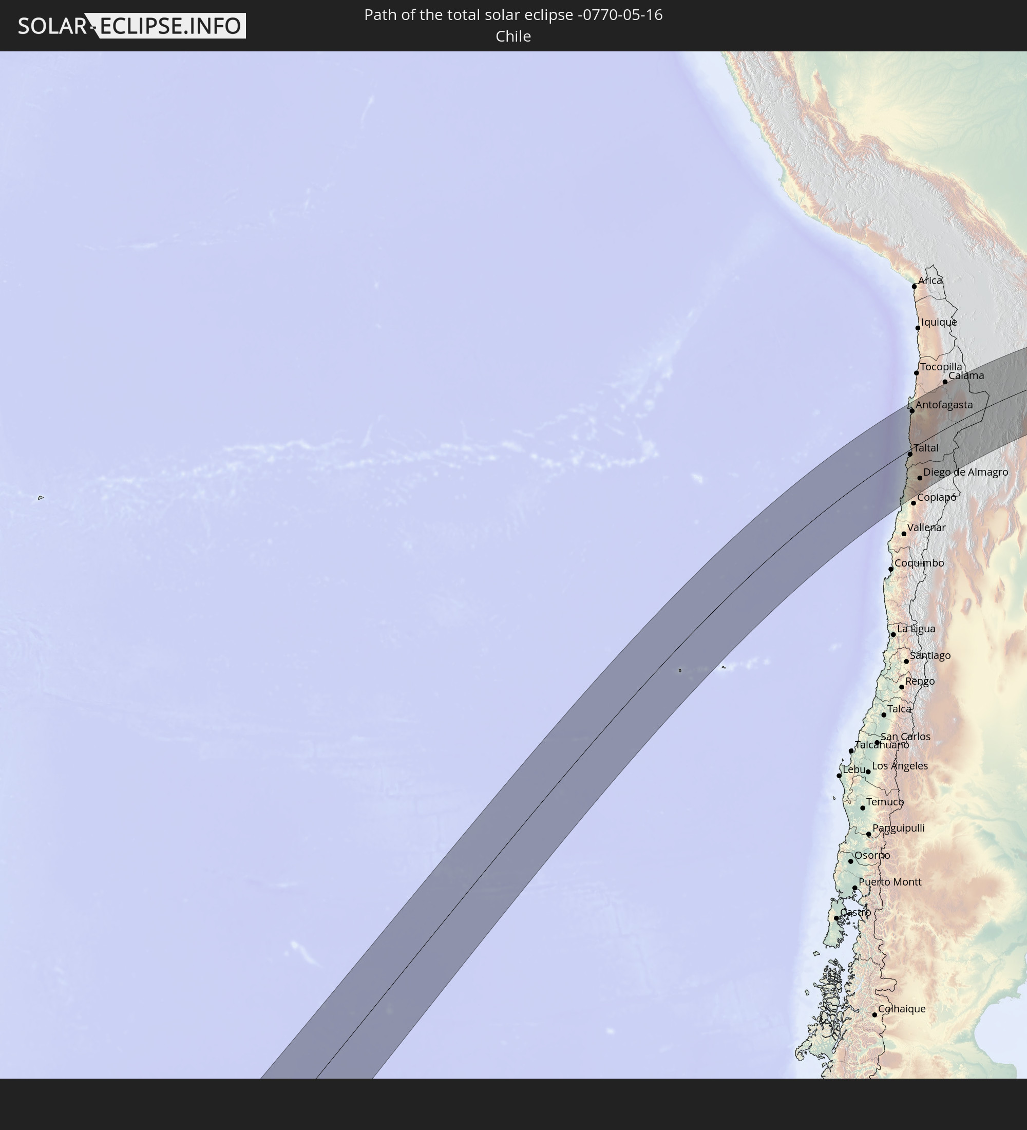 Chile
Chile
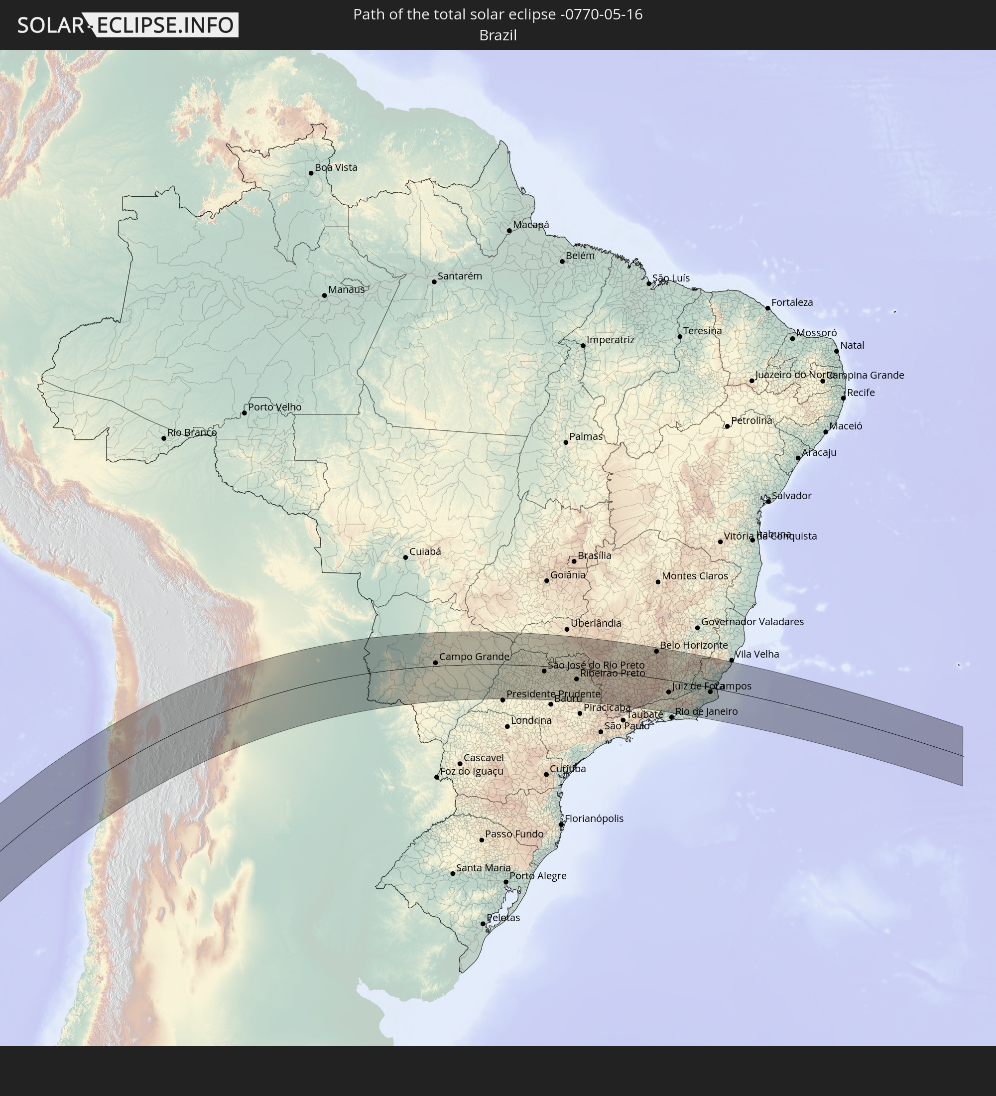 Brasilien
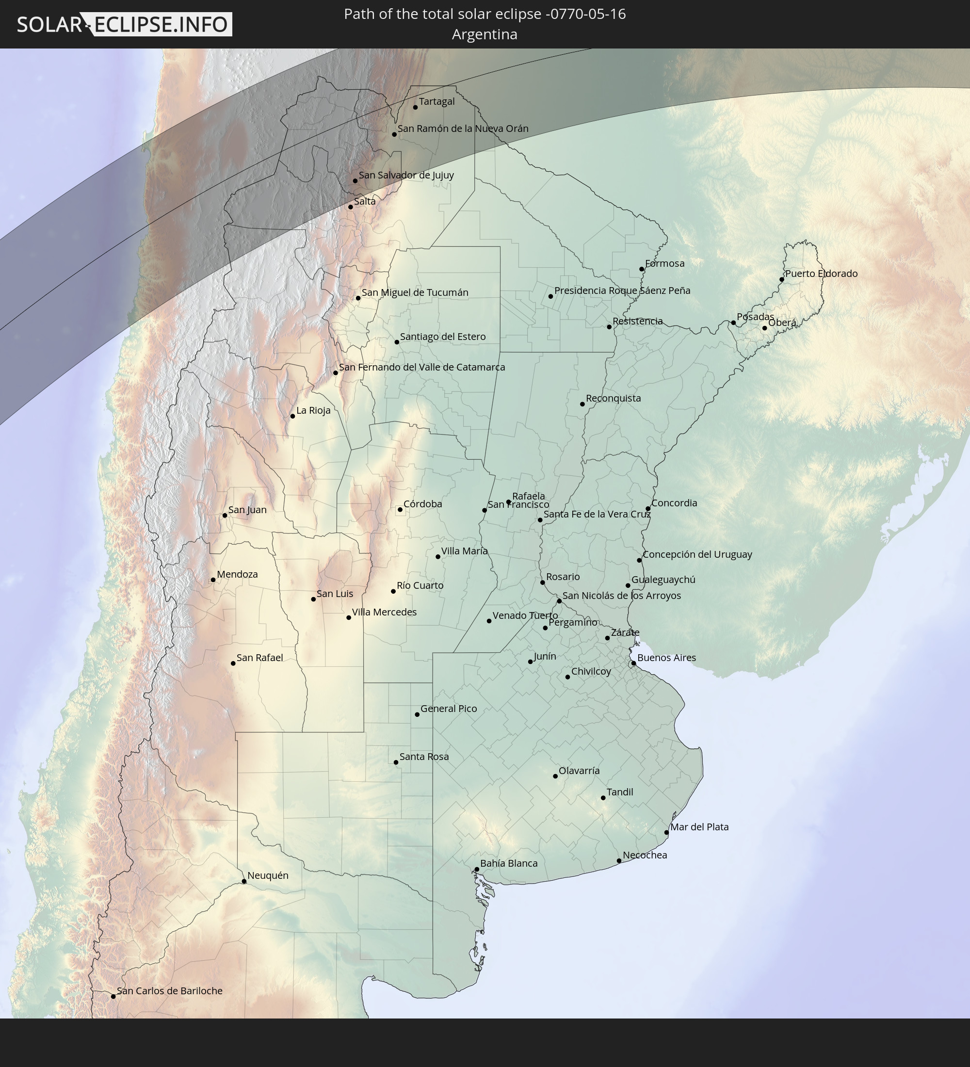 Argentinien
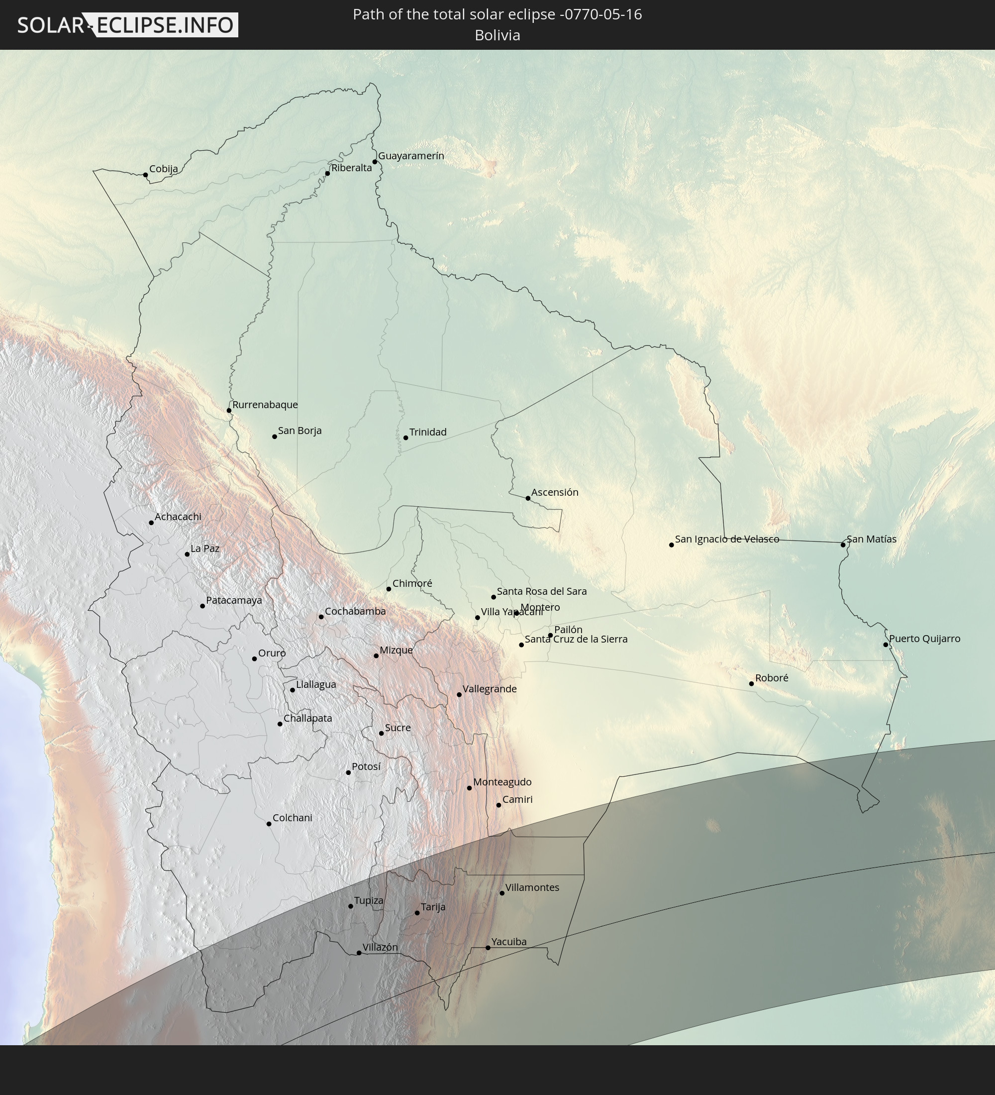 Bolivien
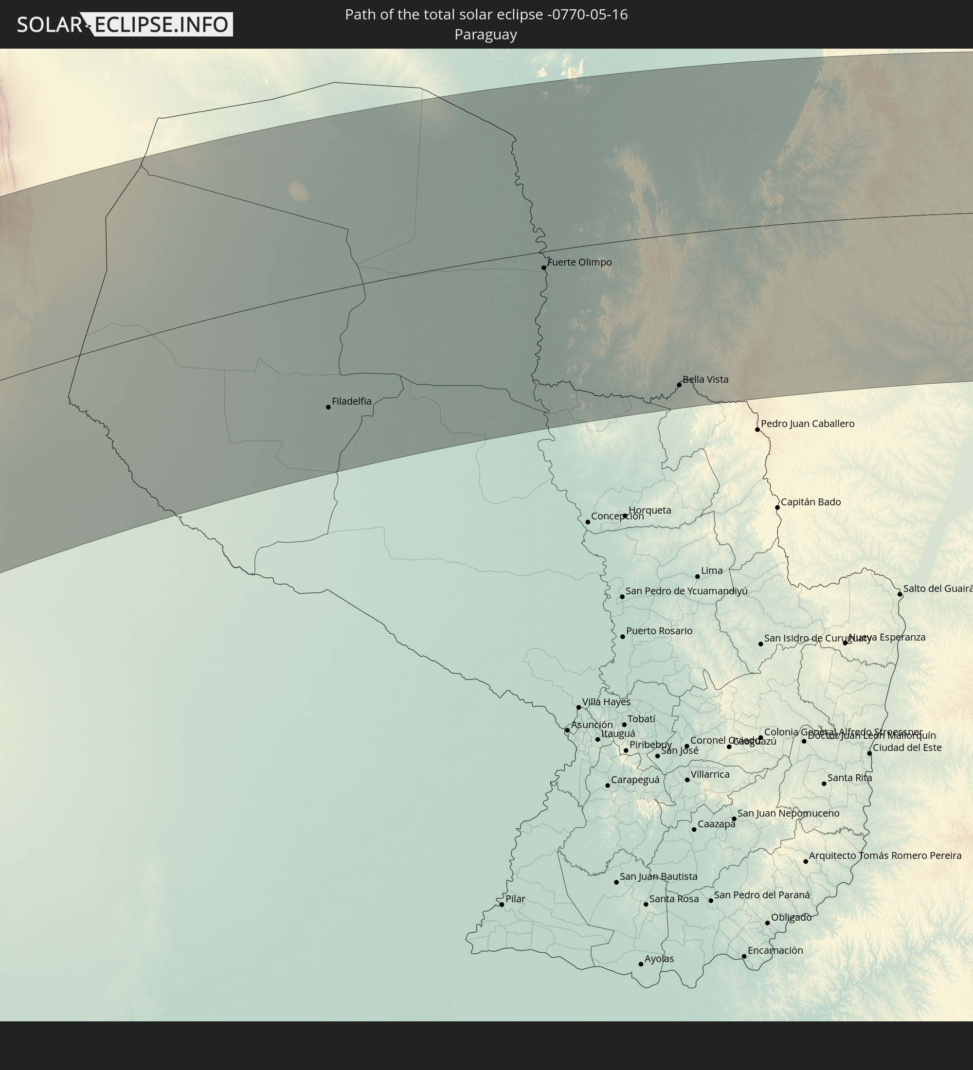 Paraguay
In den folgenden Ländern ist die Sonnenfinsternis partiell zu sehen
 Antarktika
 Pitcairninseln
 Chile
Chile
 Ecuador
 Costa Rica
 Panama
 Kolumbien
 Peru
Peru
 Brasilien
 Argentinien
 Venezuela
 Aruba
Aruba
 Bolivien
 Paraguay
 Trinidad und Tobago
 Grenada
 Dominica
 St. Vincent und die Grenadinen
 Falklandinseln
 Guyana
 Martinique
 St. Lucia
 Barbados
 Uruguay
 Suriname
 Französisch-Guayana
 Südgeorgien und die Südlichen Sandwichinseln
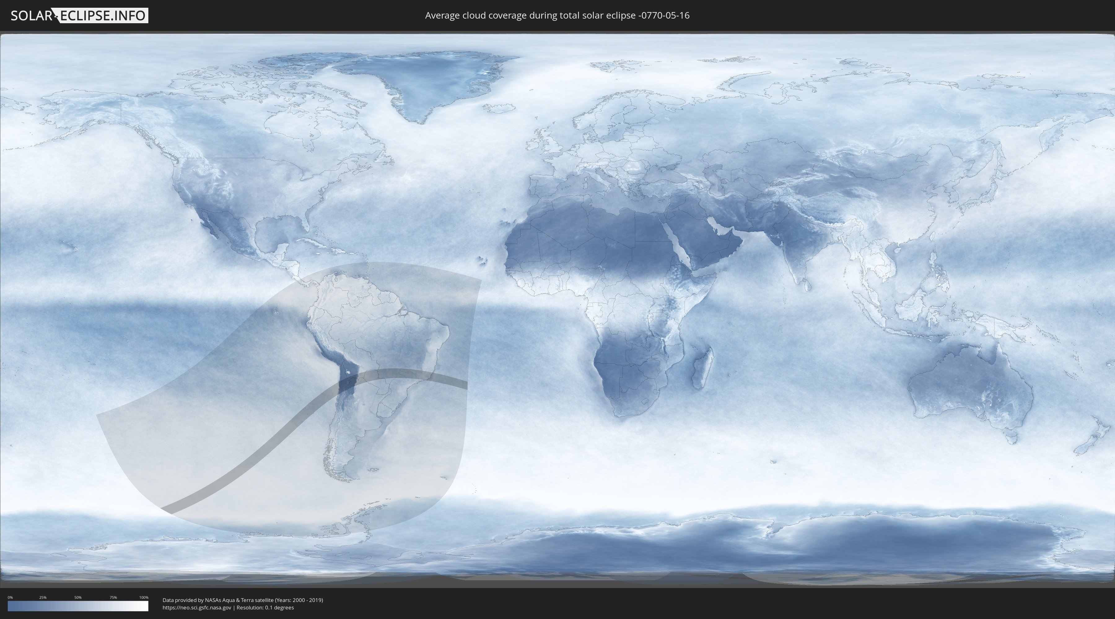
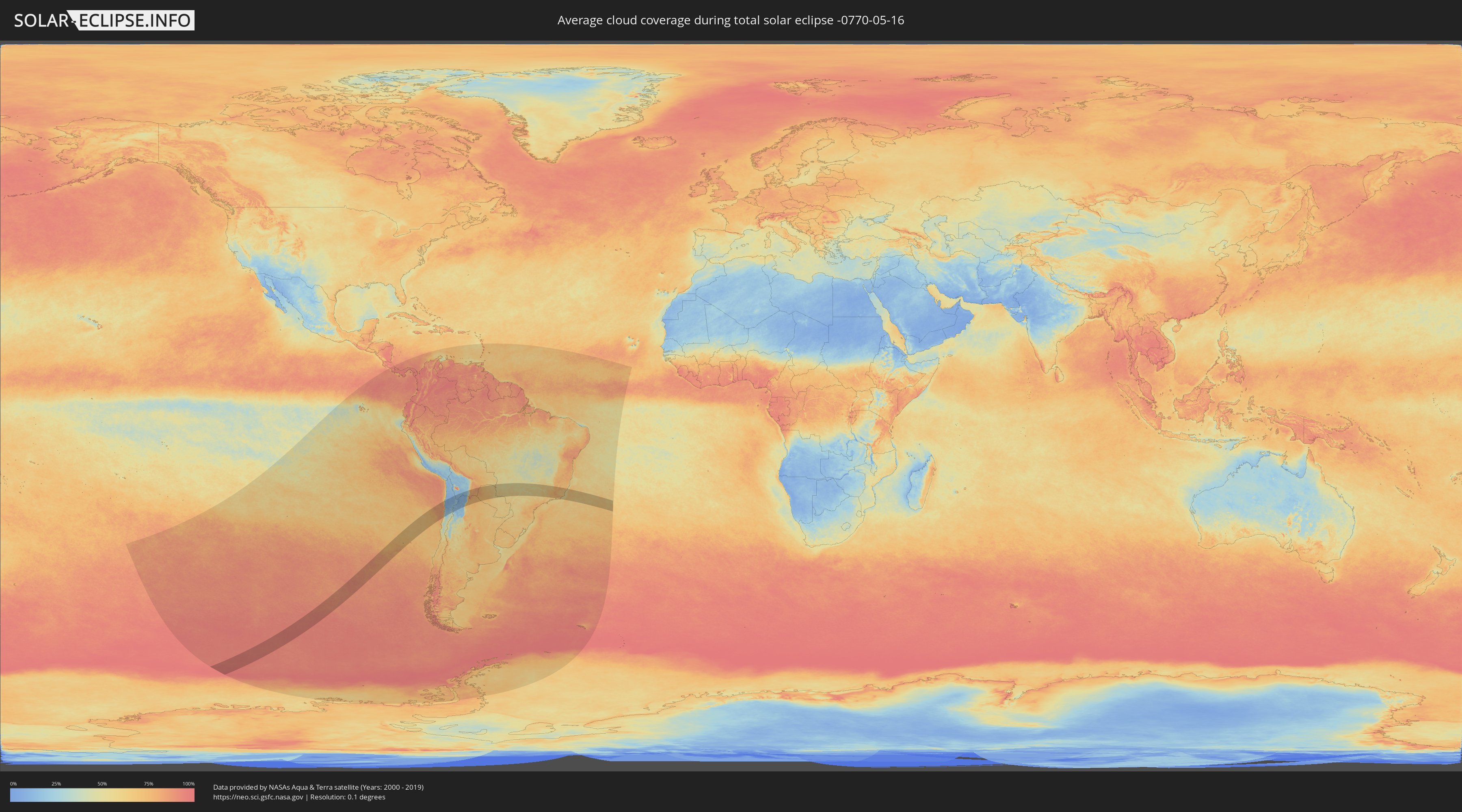
Wie wird das Wetter während der totalen Sonnenfinsternis am 16.05.-0770?
Wo ist der beste Ort, um die totale Sonnenfinsternis vom 16.05.-0770 zu beobachten?
Die folgenden Karten zeigen die durchschnittliche Bewölkung für den Tag, an dem die totale Sonnenfinsternis
stattfindet. Mit Hilfe der Karten lässt sich der Ort entlang des Finsternispfades eingrenzen,
der die besten Aussichen auf einen klaren wolkenfreien Himmel bietet.
Trotzdem muss man immer lokale Gegenenheiten beachten und sollte sich genau über das Wetter an seinem
gewählten Beobachtungsort informieren.
Die Daten stammen von den beiden NASA-Satelliten
AQUA und TERRA
und wurden über einen Zeitraum von 19 Jahren (2000 - 2019) gemittelt.
Detaillierte Länderkarten
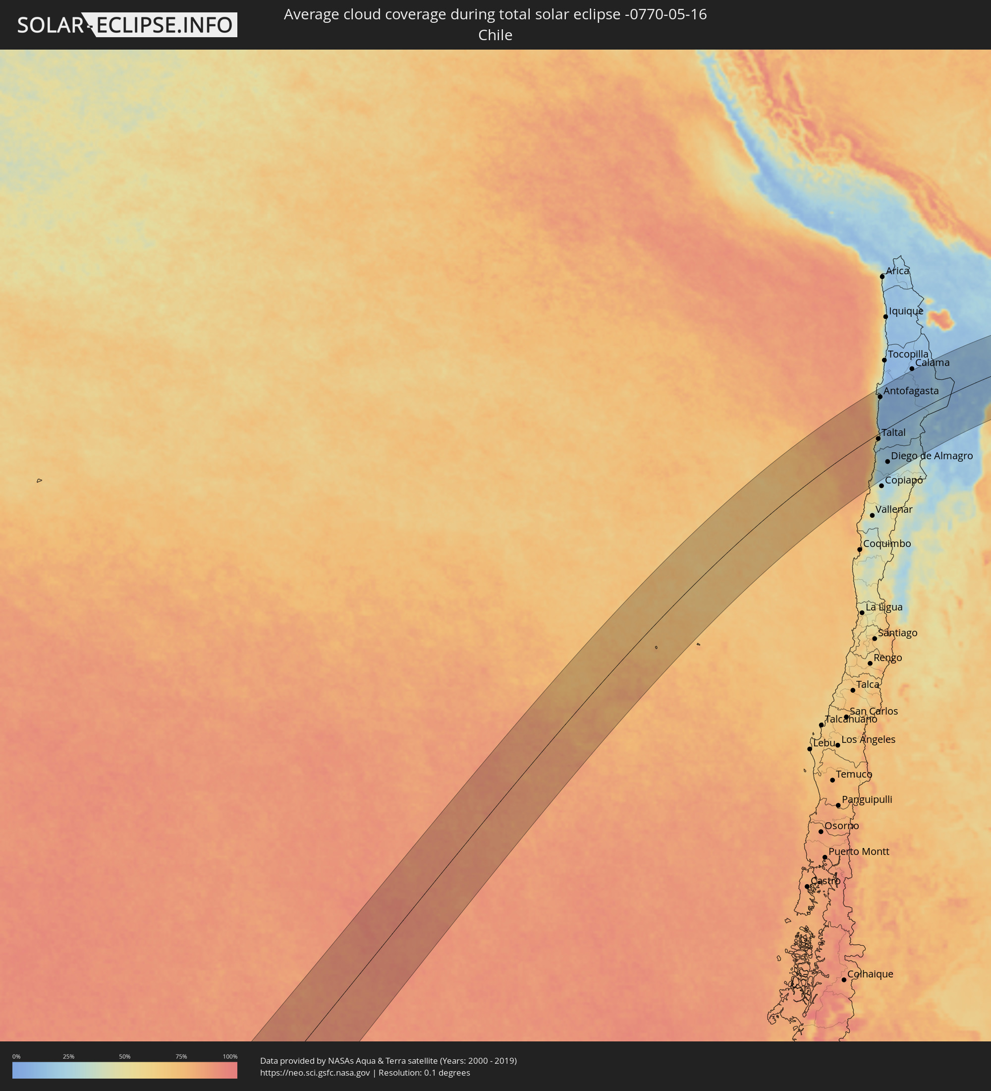 Chile
Chile
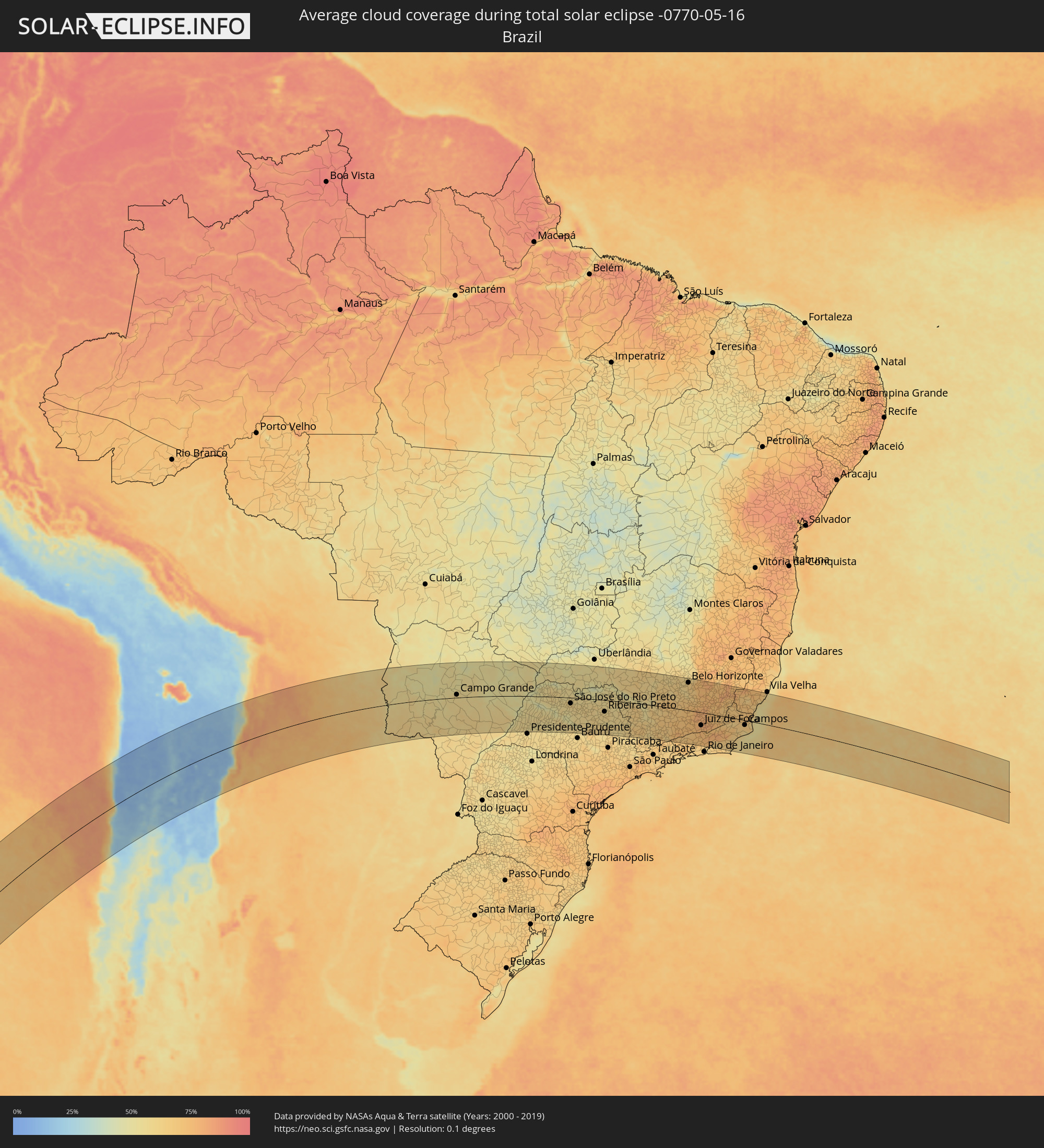 Brasilien
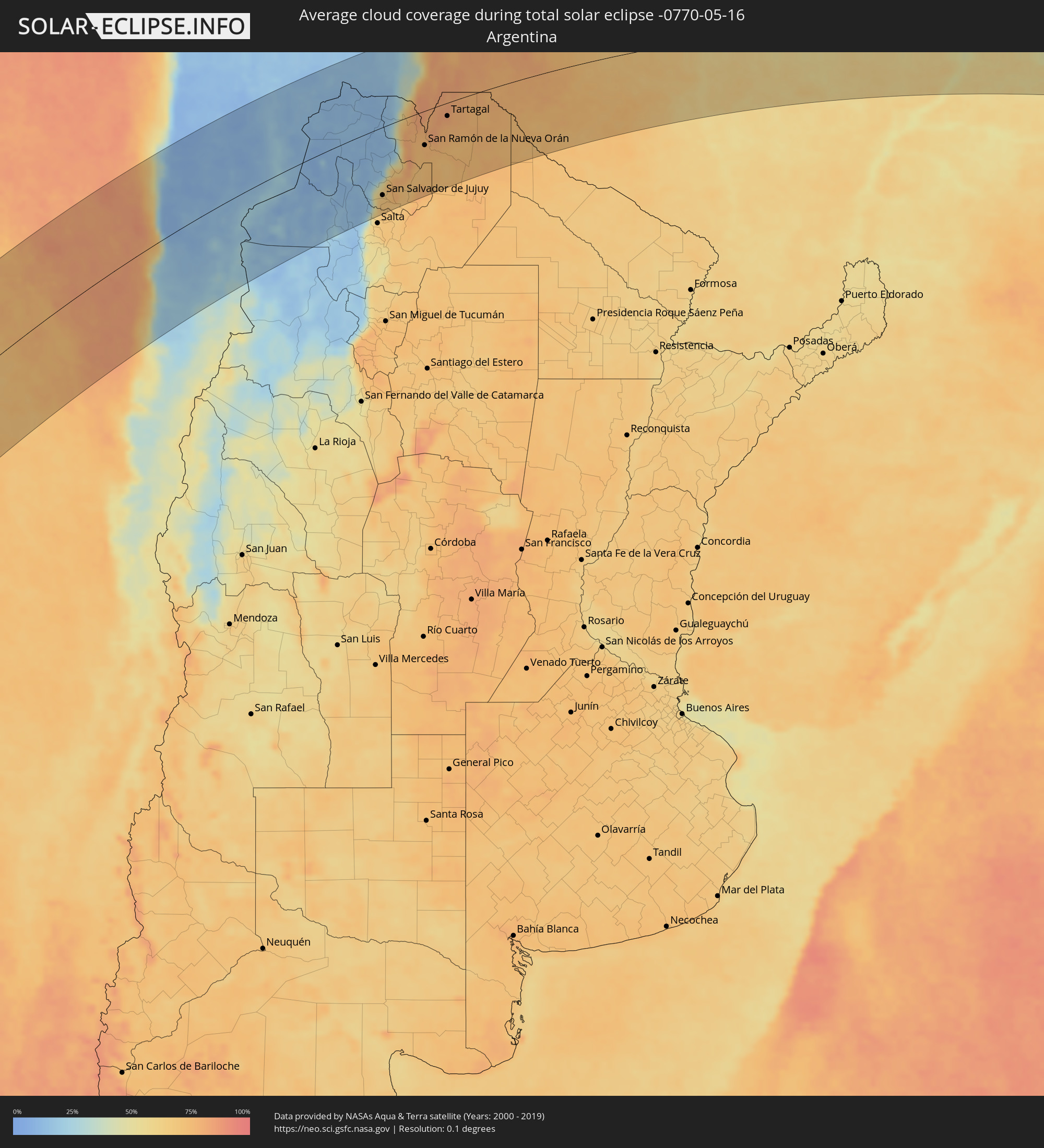 Argentinien
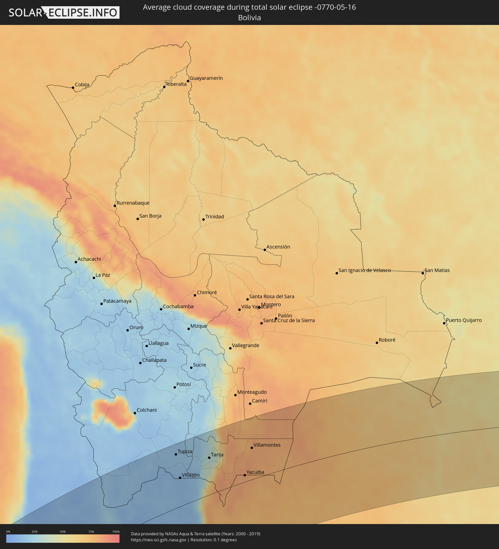 Bolivien
 Paraguay
Orte im Finsternispfad
Die nachfolgene Tabelle zeigt Städte und Orte mit mehr als 5.000 Einwohnern, die sich im Finsternispfad befinden. Städte mit mehr als 100.000 Einwohnern sind dick gekennzeichnet. Mit einem Klick auf den Ort öffnet sich eine Detailkarte die die Lage des jeweiligen Ortes zusammen mit dem Verlauf der zentralen Finsternis präsentiert.
| Ort | Typ | Dauer der Verfinsterung | Ortszeit bei maximaler Verfinsterung | Entfernung zur Zentrallinie | Ø Bewölkung |
|
Taltal, Antofagasta
|
total | - | 13:38:45 UTC-04:42 | 21 km | 48% |
|
Antofagasta, Antofagasta
|
total | - | 13:41:37 UTC-04:42 | 142 km | 21% |
|
Diego de Almagro, Atacama
|
total | - | 13:38:12 UTC-04:42 | 134 km | 22% |
|
Tupiza, Potosí
|
total | - | 14:04:45 UTC-04:32 | 152 km | 15% |
|
Abra Pampa, Jujuy Province
|
total | - | 14:18:37 UTC-04:16 | 19 km | 12% |
|
Villazón, Potosí
|
total | - | 14:04:00 UTC-04:32 | 80 km | 11% |
|
La Quiaca, Jujuy Province
|
total | - | 14:19:47 UTC-04:16 | 79 km | 11% |
|
Tilcara, Jujuy Province
|
total | - | 14:17:59 UTC-04:16 | 83 km | 16% |
|
Humahuaca, Jujuy Province
|
total | - | 14:18:34 UTC-04:16 | 44 km | 13% |
|
San Salvador de Jujuy, Jujuy Province
|
total | - | 14:17:08 UTC-04:16 | 148 km | 69% |
|
Palpalá, Jujuy Province
|
total | - | 14:17:12 UTC-04:16 | 158 km | 70% |
|
San Pedro, Jujuy Province
|
total | - | 14:17:56 UTC-04:16 | 169 km | 70% |
|
Ingenio La Esperanza, Jujuy Province
|
total | - | 14:17:59 UTC-04:16 | 169 km | 70% |
|
Fraile Pintado, Jujuy Province
|
total | - | 14:18:30 UTC-04:16 | 141 km | 71% |
|
Libertador General San Martín, Jujuy Province
|
total | - | 14:18:44 UTC-04:16 | 128 km | 75% |
|
Calilegua, Jujuy Province
|
total | - | 14:18:49 UTC-04:16 | 125 km | 75% |
|
Tarija, Tarija
|
total | - | 14:06:33 UTC-04:32 | 106 km | 34% |
|
Caimancito, Jujuy Province
|
total | - | 14:19:13 UTC-04:16 | 129 km | 72% |
|
Yuto, Jujuy Province
|
total | - | 14:19:36 UTC-04:16 | 123 km | 71% |
|
San Ramón de la Nueva Orán, Salta Province
|
total | - | 14:20:41 UTC-04:16 | 76 km | 75% |
|
Palma Sola, Jujuy Province
|
total | - | 14:19:27 UTC-04:16 | 163 km | 77% |
|
Embarcación, Salta Province
|
total | - | 14:21:00 UTC-04:16 | 92 km | 75% |
|
General Enrique Mosconi, Salta Province
|
total | - | 14:22:30 UTC-04:16 | 38 km | 77% |
|
Tartagal, Salta Province
|
total | - | 14:22:39 UTC-04:16 | 30 km | 80% |
|
Yacuiba, Tarija
|
total | - | 14:07:51 UTC-04:32 | 19 km | 82% |
|
Villamontes, Tarija
|
total | - | 14:09:25 UTC-04:32 | 92 km | 80% |
|
Filadelfia, Boquerón
|
total | - | 14:56:04 UTC-03:50 | 118 km | 71% |
|
Colonia Menno, Boquerón
|
total | - | 14:56:24 UTC-03:50 | 126 km | 73% |
|
Fuerte Olimpo, Alto Paraguay
|
total | - | 15:01:46 UTC-03:50 | 17 km | 54% |
|
Bella Vista, Amambay
|
total | - | 15:02:23 UTC-03:50 | 156 km | 58% |
|
Campo Grande, Mato Grosso do Sul
|
total | - | 15:20:01 UTC-03:38 | 14 km | 59% |
|
Araçatuba, São Paulo
|
total | - | 15:56:55 UTC-03:06 | 76 km | 57% |
|
São José do Rio Preto, São Paulo
|
total | - | 15:58:50 UTC-03:06 | 27 km | 62% |
|
Catanduva, São Paulo
|
total | - | 15:58:53 UTC-03:06 | 60 km | 58% |
|
Barretos, São Paulo
|
total | - | 16:00:12 UTC-03:06 | 7 km | 57% |
|
Araraquara, São Paulo
|
total | - | 15:58:57 UTC-03:06 | 127 km | 60% |
|
Sertãozinho, São Paulo
|
total | - | 16:00:05 UTC-03:06 | 52 km | 60% |
|
Uberaba, Minas Gerais
|
total | - | 16:02:04 UTC-03:06 | 102 km | 57% |
|
São Carlos, São Paulo
|
total | - | 15:58:59 UTC-03:06 | 149 km | 60% |
|
Ribeirão Preto, São Paulo
|
total | - | 16:00:15 UTC-03:06 | 55 km | 60% |
|
Franca, São Paulo
|
total | - | 16:01:37 UTC-03:06 | 20 km | 57% |
|
Araxá, Minas Gerais
|
total | - | 16:03:25 UTC-03:06 | 129 km | 60% |
|
Passos, Minas Gerais
|
total | - | 16:02:16 UTC-03:06 | 8 km | 59% |
|
Poços de Caldas, Minas Gerais
|
total | - | 16:00:51 UTC-03:06 | 110 km | 62% |
|
Pouso Alegre, Minas Gerais
|
total | - | 16:00:56 UTC-03:06 | 151 km | 62% |
|
Varginha, Minas Gerais
|
total | - | 16:02:26 UTC-03:06 | 69 km | 65% |
|
Divinópolis, Minas Gerais
|
total | - | 16:04:54 UTC-03:06 | 94 km | 65% |
|
Resende, Rio de Janeiro
|
total | - | 16:02:12 UTC-03:06 | 156 km | 68% |
|
Esmeraldas, Minas Gerais
|
total | - | 16:05:59 UTC-03:06 | 144 km | 59% |
|
Betim, Minas Gerais
|
total | - | 16:05:50 UTC-03:06 | 123 km | 61% |
|
Volta Redonda, Rio de Janeiro
|
total | - | 16:02:28 UTC-03:06 | 156 km | 70% |
|
Ribeirão das Neves, Minas Gerais
|
total | - | 16:06:12 UTC-03:06 | 147 km | 61% |
|
Ibirité, Minas Gerais
|
total | - | 16:05:54 UTC-03:06 | 120 km | 62% |
|
Belo Horizonte, Minas Gerais
|
total | - | 16:06:09 UTC-03:06 | 133 km | 64% |
|
Santa Luzia, Minas Gerais
|
total | - | 16:06:26 UTC-03:06 | 150 km | 66% |
|
Barra do Piraí, Rio de Janeiro
|
total | - | 16:02:50 UTC-03:06 | 146 km | 64% |
|
Conselheiro Lafaiete, Minas Gerais
|
total | - | 16:05:19 UTC-03:06 | 54 km | 70% |
|
Barbacena, Minas Gerais
|
total | - | 16:04:35 UTC-03:06 | 8 km | 74% |
|
Juiz de Fora, Minas Gerais
|
total | - | 16:04:16 UTC-03:06 | 61 km | 76% |
|
Petrópolis, Rio de Janeiro
|
total | - | 16:03:25 UTC-03:06 | 139 km | 66% |
|
Teresópolis, Rio de Janeiro
|
total | - | 16:03:44 UTC-03:06 | 126 km | 75% |
|
Ubá, Minas Gerais
|
total | - | 16:05:32 UTC-03:06 | 17 km | 72% |
|
Nova Friburgo, Rio de Janeiro
|
total | - | 16:04:21 UTC-03:06 | 103 km | 77% |
|
Muriaé, Minas Gerais
|
total | - | 16:06:03 UTC-03:06 | 26 km | 68% |
|
Rio das Ostras, Rio de Janeiro
|
total | - | 16:04:34 UTC-03:06 | 119 km | 61% |
|
Itaperuna, Rio de Janeiro
|
total | - | 16:06:23 UTC-03:06 | 27 km | 70% |
|
Macaé, Rio de Janeiro
|
total | - | 16:04:55 UTC-03:06 | 99 km | 62% |
|
Campos, Rio de Janeiro
|
total | - | 16:06:09 UTC-03:06 | 22 km | 68% |
|
Cachoeiro de Itapemirim, Espírito Santo
|
total | - | 16:07:32 UTC-03:06 | 81 km | 68% |
|
Guarapari, Espírito Santo
|
total | - | 16:08:18 UTC-03:06 | 115 km | 55% |