Totale Sonnenfinsternis vom 24.05.-0798
| Wochentag: | Mittwoch |
| Maximale Dauer der Verfinsterung: | 05m04s |
| Maximale Breite des Finsternispfades: | 184 km |
| Saroszyklus: | 44 |
| Bedeckungsgrad: | 100% |
| Magnitude: | 1.0554 |
| Gamma: | 0.1215 |
Wo kann man die Sonnenfinsternis vom 24.05.-0798 sehen?
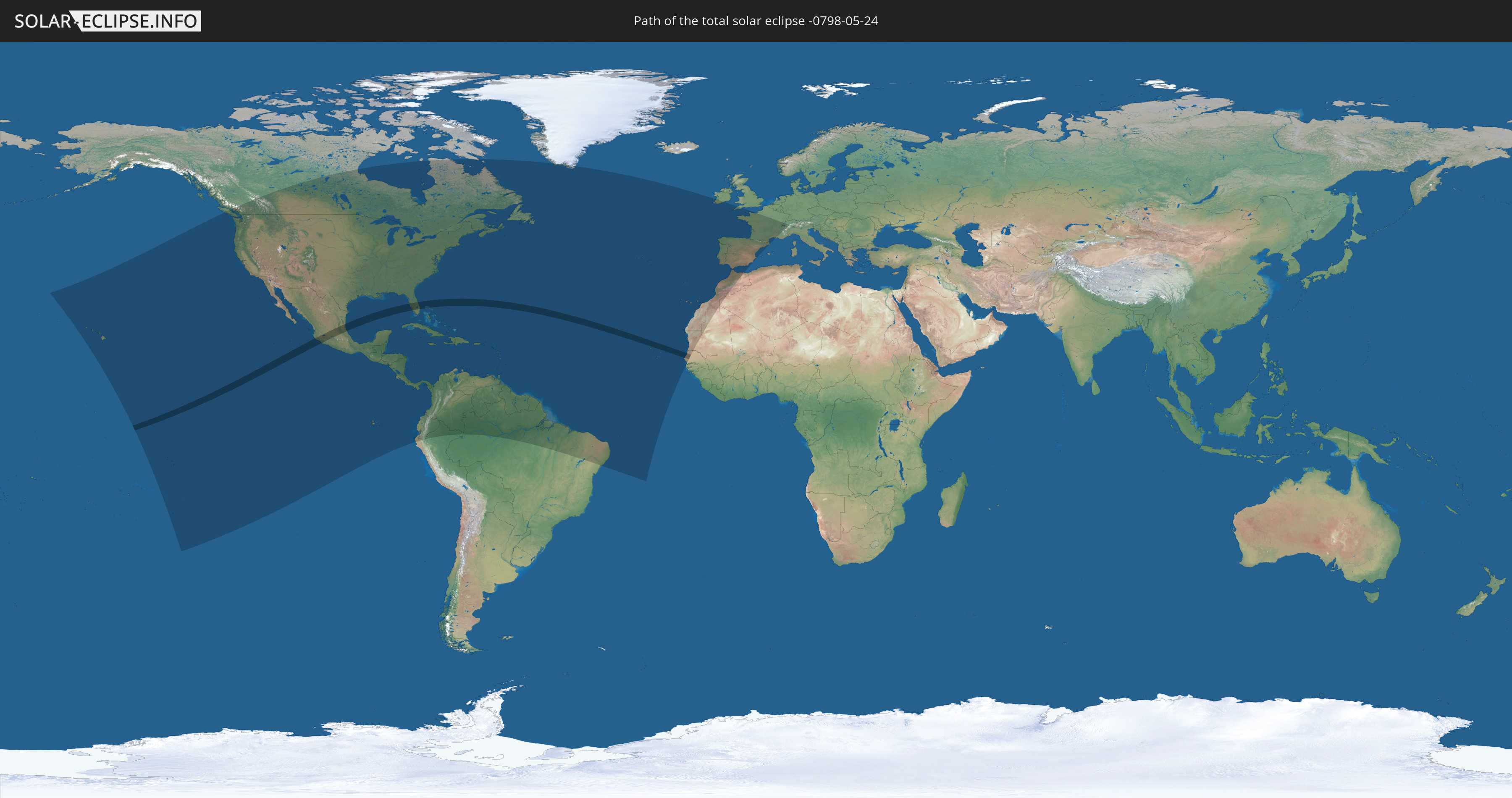
Die Sonnenfinsternis am 24.05.-0798 kann man in 66 Ländern als partielle Sonnenfinsternis beobachten.
Der Finsternispfad verläuft durch 4 Länder. Nur in diesen Ländern ist sie als totale Sonnenfinsternis zu sehen.
In den folgenden Ländern ist die Sonnenfinsternis total zu sehen
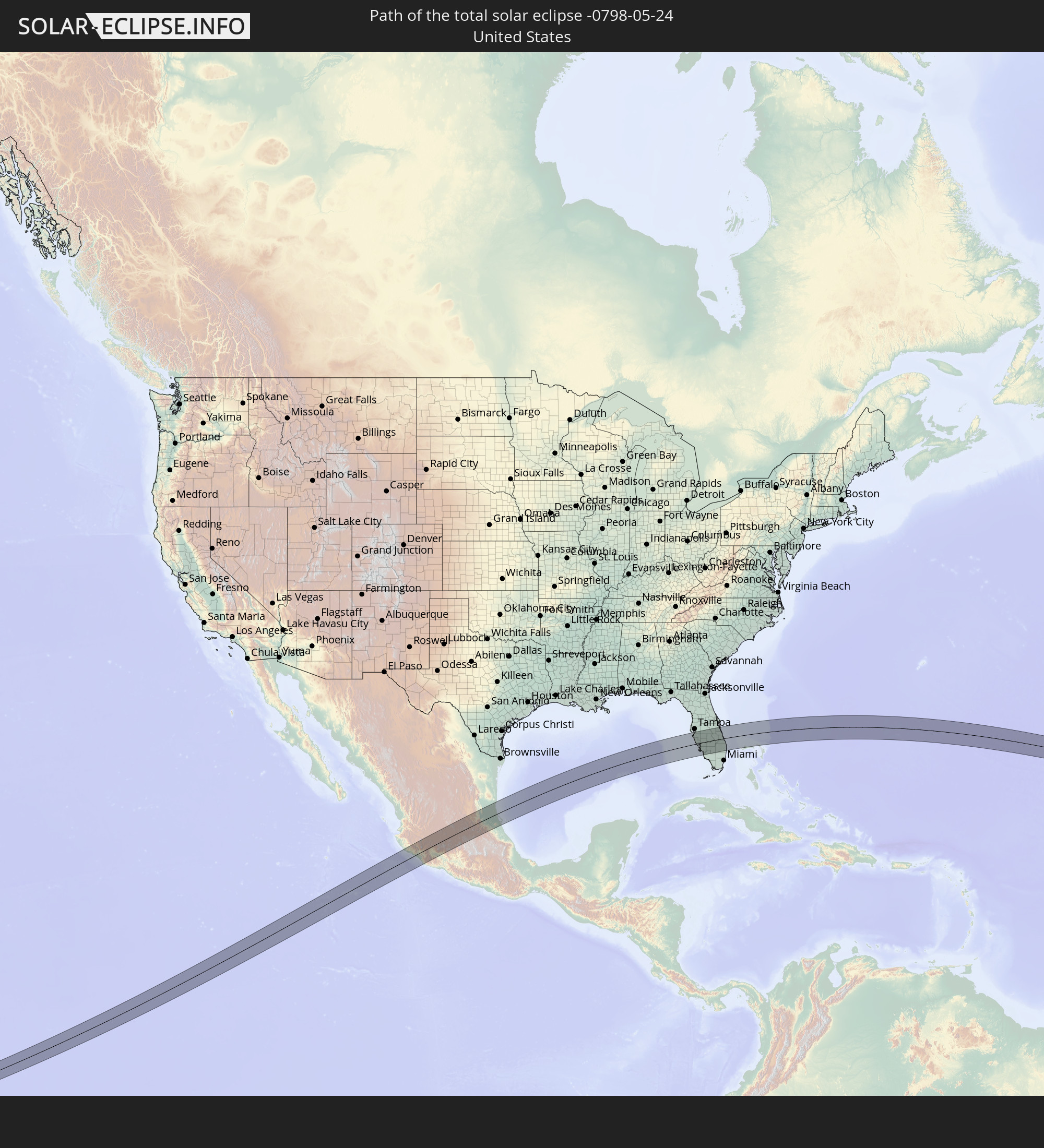 Vereinigte Staaten
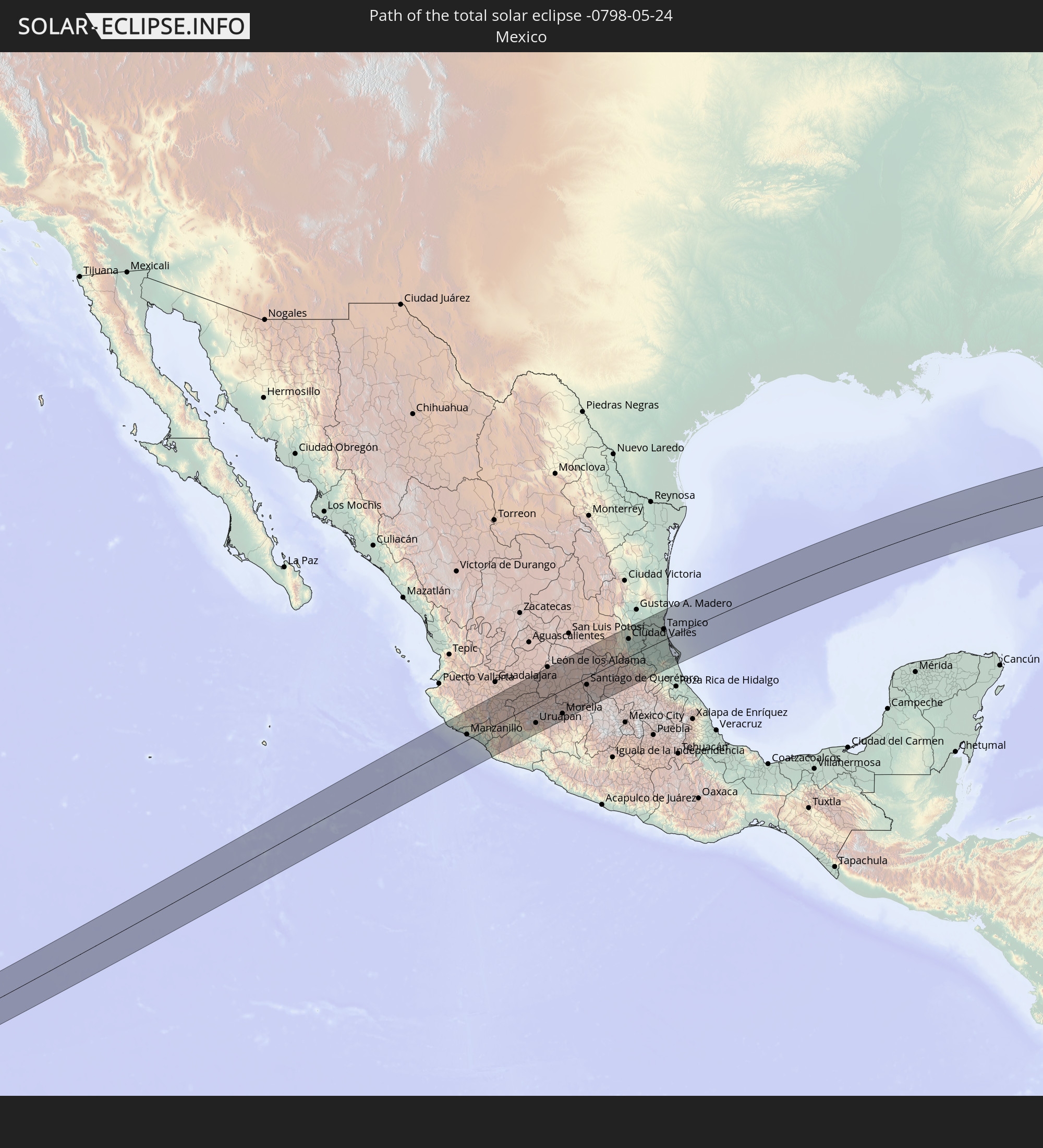 Mexiko
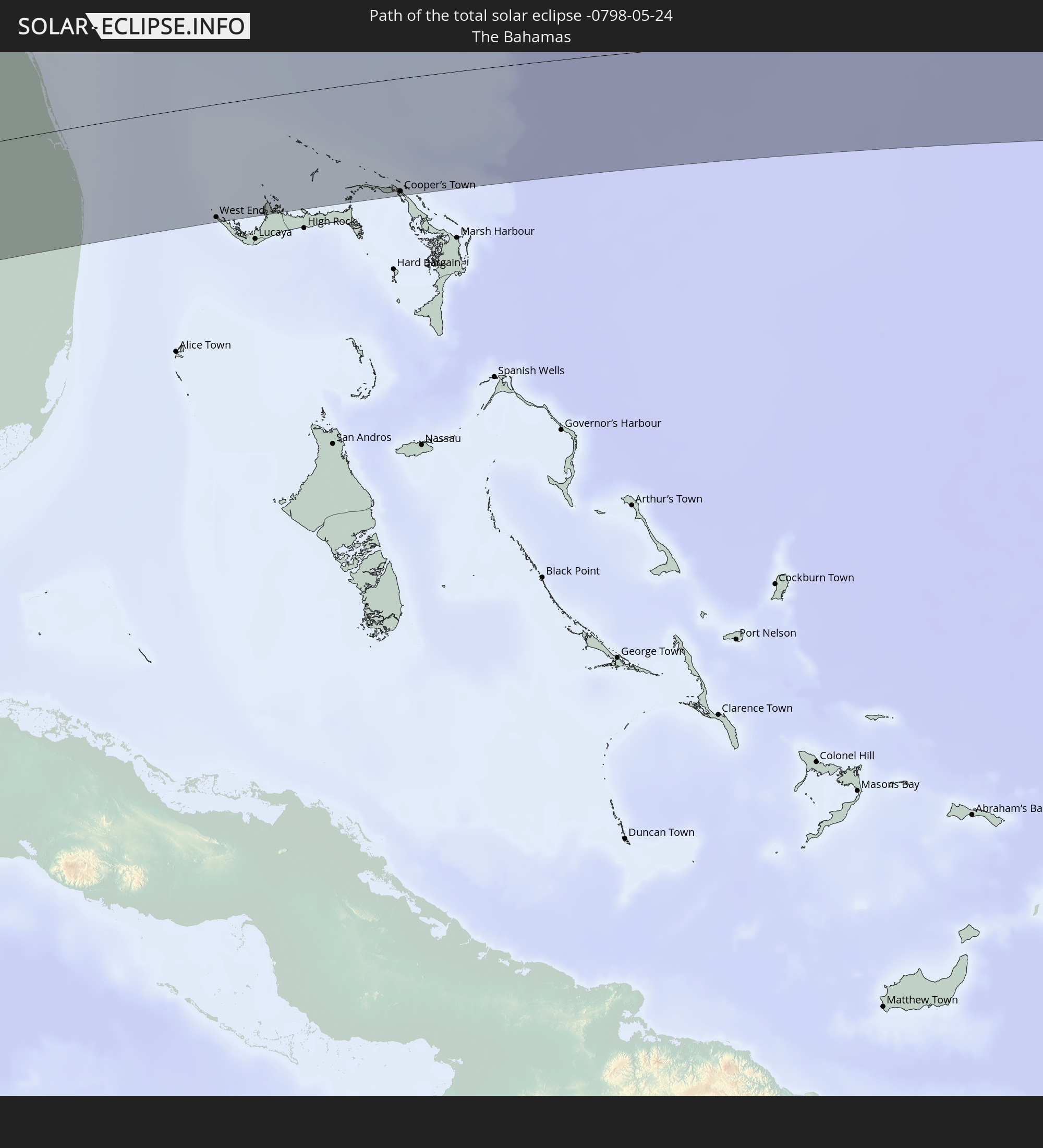 Bahamas
 Senegal
In den folgenden Ländern ist die Sonnenfinsternis partiell zu sehen
 Vereinigte Staaten
 United States Minor Outlying Islands
 Französisch-Polynesien
 Kanada
 Pitcairninseln
 Mexiko
 Grönland
 Guatemala
 Ecuador
 El Salvador
 Honduras
 Belize
 Nicaragua
 Costa Rica
 Kuba
Kuba
 Panama
 Kolumbien
 Kaimaninseln
 Peru
Peru
 Bahamas
 Jamaika
 Haiti
Haiti
 Brasilien
 Venezuela
 Turks- und Caicosinseln
 Dominikanische Republik
 Aruba
Aruba
 Puerto Rico
 Amerikanische Jungferninseln
 Bermuda
 Britische Jungferninseln
 Anguilla
 Saint-Martin
 Saint-Barthélemy
 St. Kitts und Nevis
 Antigua und Barbuda
 Montserrat
 Trinidad und Tobago
 Guadeloupe
 Grenada
 Dominica
 St. Vincent und die Grenadinen
 Guyana
 Martinique
 St. Lucia
 Barbados
 Suriname
 Saint-Pierre und Miquelon
 Französisch-Guayana
 Portugal
 Kap Verde
 Spanien
 Senegal
 Mauretanien
 Gambia
 Marokko
 Irland
 Algerien
 Vereinigtes Königreich
 Gibraltar
 Frankreich
 Guernsey
 Jersey
 Andorra
 Schweiz
 Italien
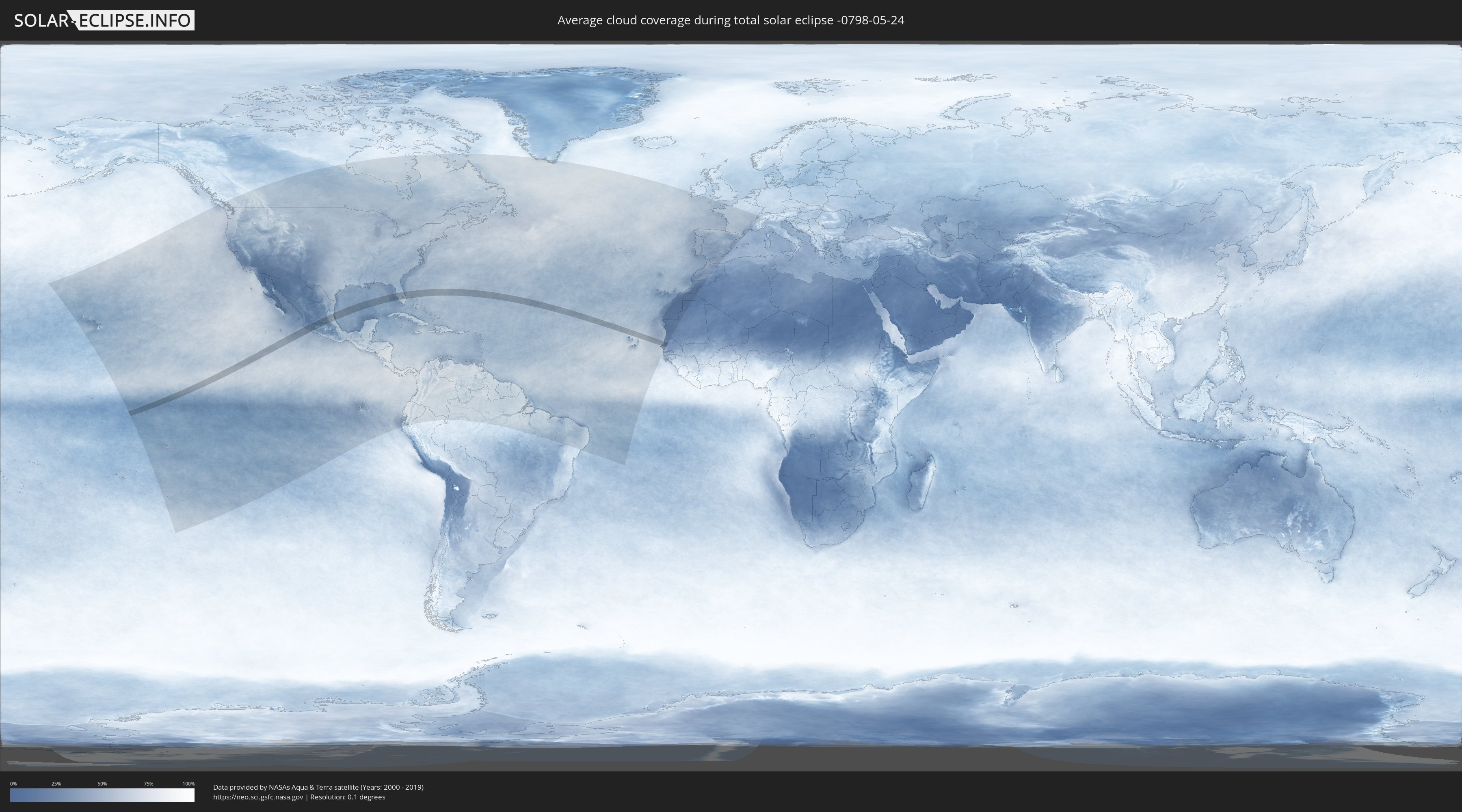
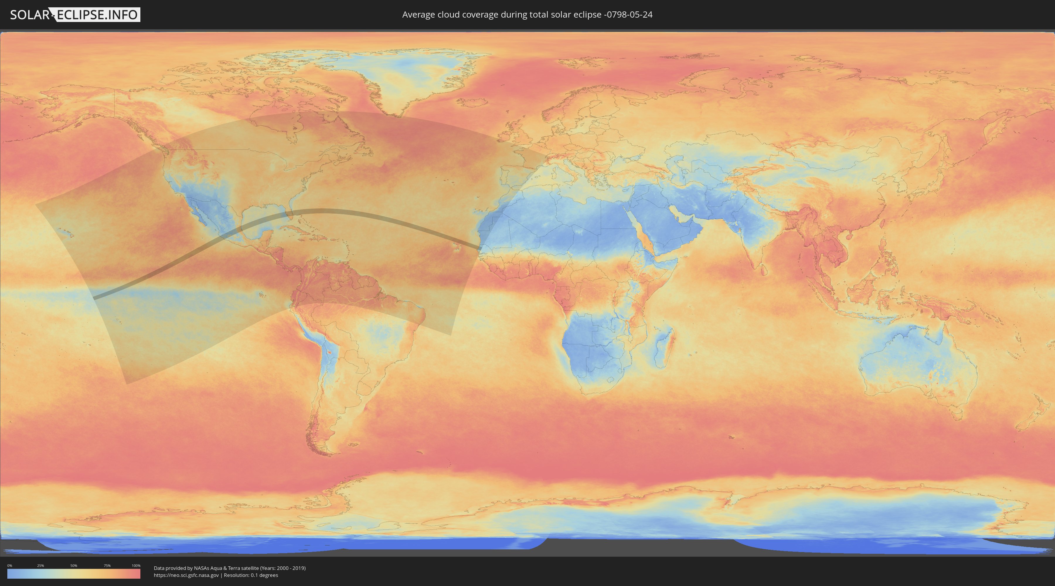
Wie wird das Wetter während der totalen Sonnenfinsternis am 24.05.-0798?
Wo ist der beste Ort, um die totale Sonnenfinsternis vom 24.05.-0798 zu beobachten?
Die folgenden Karten zeigen die durchschnittliche Bewölkung für den Tag, an dem die totale Sonnenfinsternis
stattfindet. Mit Hilfe der Karten lässt sich der Ort entlang des Finsternispfades eingrenzen,
der die besten Aussichen auf einen klaren wolkenfreien Himmel bietet.
Trotzdem muss man immer lokale Gegenenheiten beachten und sollte sich genau über das Wetter an seinem
gewählten Beobachtungsort informieren.
Die Daten stammen von den beiden NASA-Satelliten
AQUA und TERRA
und wurden über einen Zeitraum von 19 Jahren (2000 - 2019) gemittelt.
Detaillierte Länderkarten
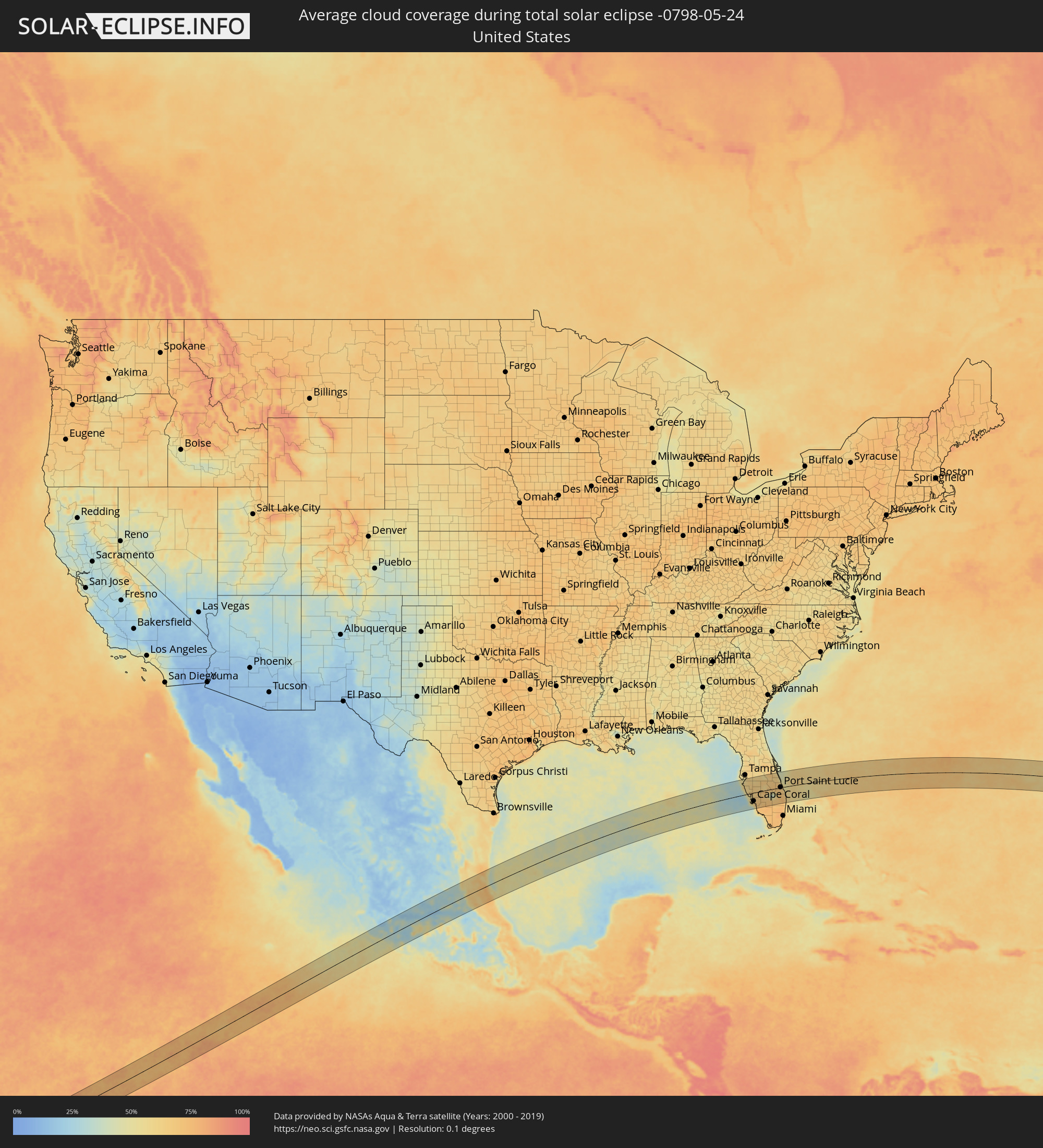 Vereinigte Staaten
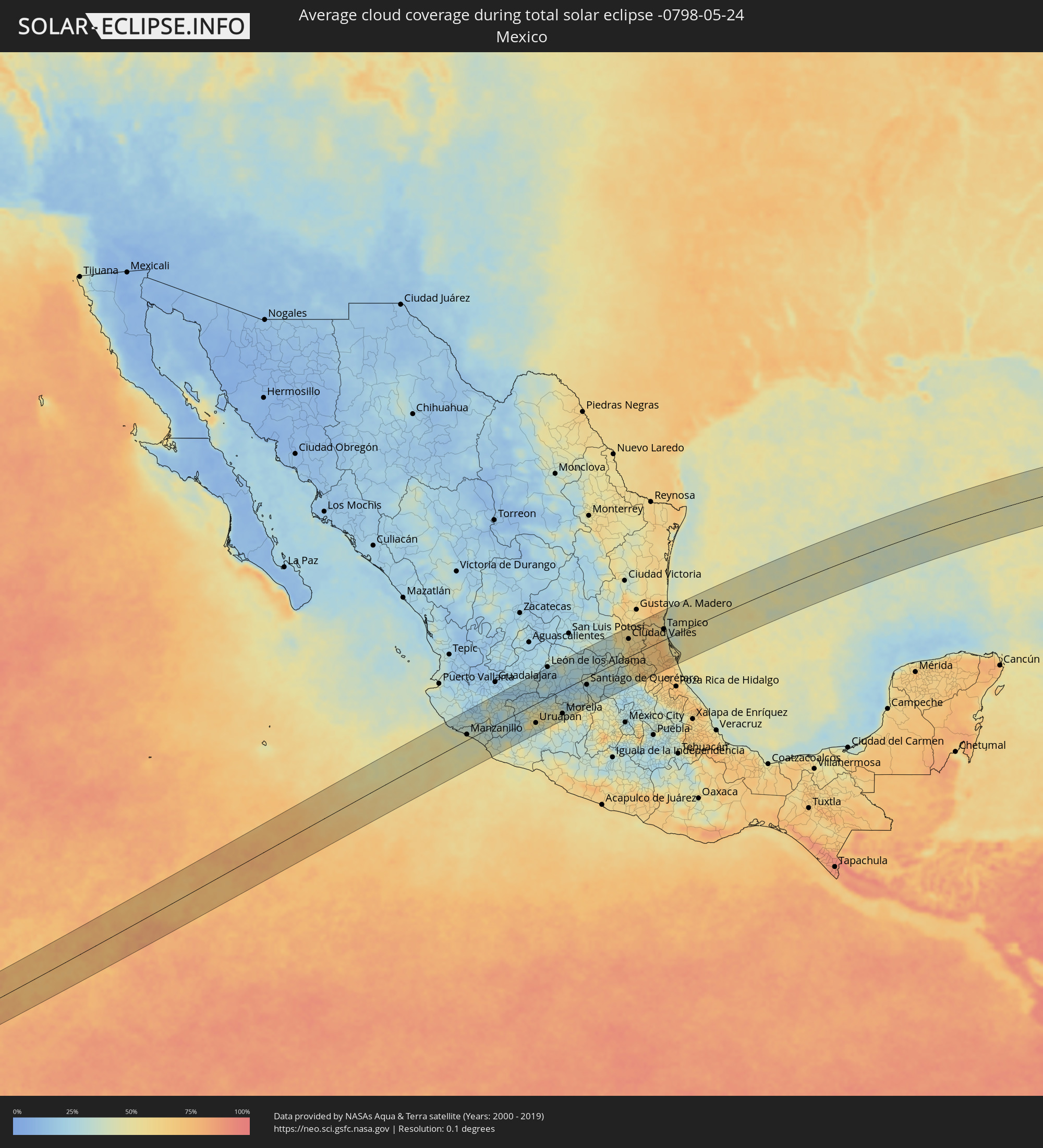 Mexiko
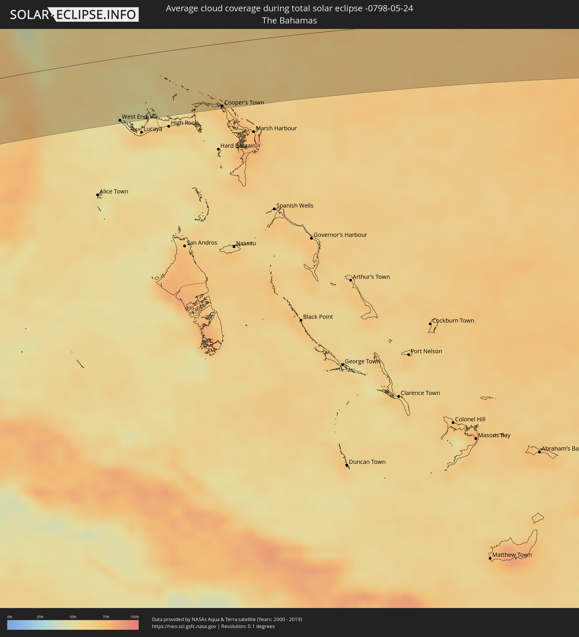 Bahamas
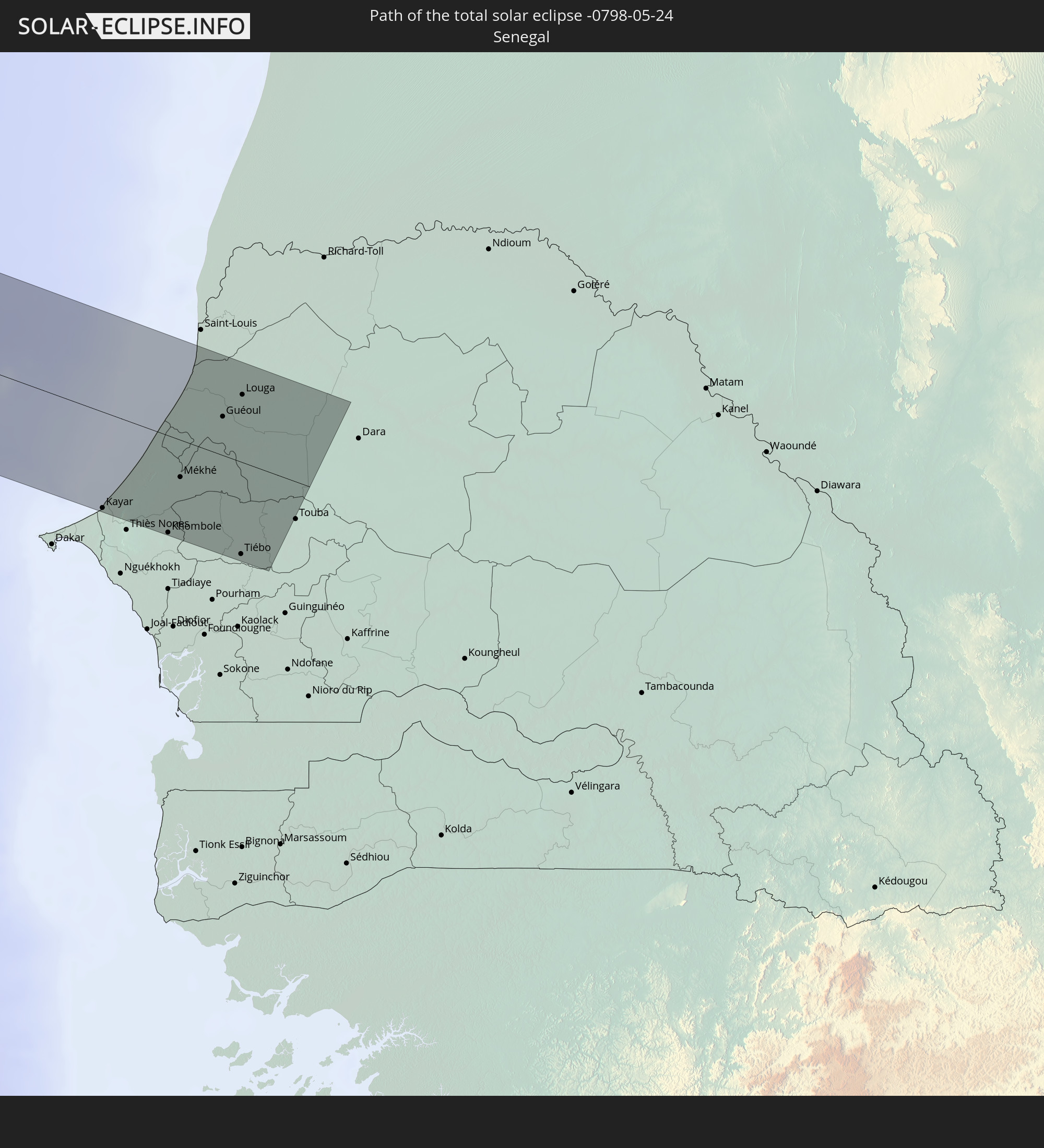
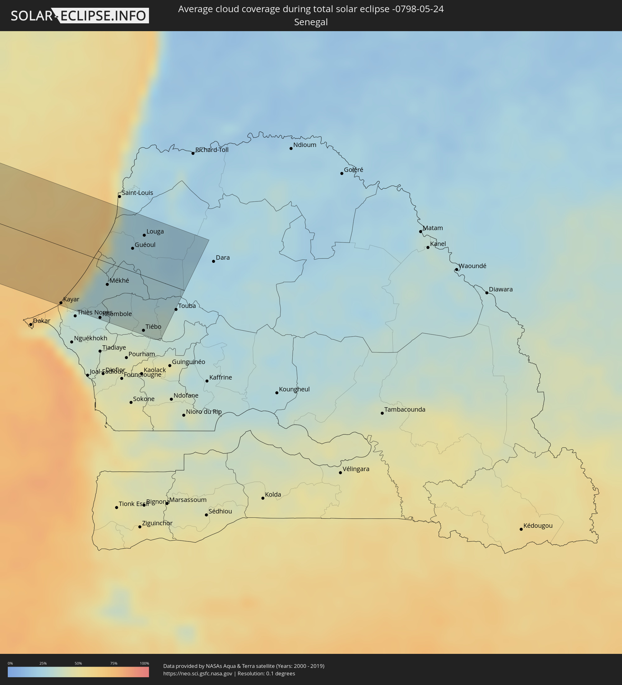 Senegal
Orte im Finsternispfad
Die nachfolgene Tabelle zeigt Städte und Orte mit mehr als 5.000 Einwohnern, die sich im Finsternispfad befinden. Städte mit mehr als 100.000 Einwohnern sind dick gekennzeichnet. Mit einem Klick auf den Ort öffnet sich eine Detailkarte die die Lage des jeweiligen Ortes zusammen mit dem Verlauf der zentralen Finsternis präsentiert.
| Ort | Typ | Dauer der Verfinsterung | Ortszeit bei maximaler Verfinsterung | Entfernung zur Zentrallinie | Ø Bewölkung |
|
Autlán de Navarro, Jalisco
|
total | - | 10:03:24 UTC-06:36 | 89 km | 23% |
|
Manzanillo, Colima
|
total | - | 10:02:29 UTC-06:36 | 17 km | 48% |
|
Tecoman, Colima
|
total | - | 10:03:09 UTC-06:36 | 18 km | 42% |
|
Colima, Colima
|
total | - | 10:03:54 UTC-06:36 | 7 km | 32% |
|
Sayula, Jalisco
|
total | - | 10:05:02 UTC-06:36 | 63 km | 30% |
|
Ciudad Guzmán, Jalisco
|
total | - | 10:05:04 UTC-06:36 | 38 km | 32% |
|
Tuxpan, Jalisco
|
total | - | 10:05:01 UTC-06:36 | 20 km | 25% |
|
Ocotlán, Jalisco
|
total | - | 10:07:21 UTC-06:36 | 69 km | 18% |
|
Sahuayo de Morelos, Michoacán
|
total | - | 10:07:03 UTC-06:36 | 37 km | 27% |
|
La Barca, Jalisco
|
total | - | 10:07:43 UTC-06:36 | 51 km | 20% |
|
Atotonilco el Alto, Jalisco
|
total | - | 10:08:09 UTC-06:36 | 75 km | 25% |
|
Apatzingán, Michoacán
|
total | - | 10:06:25 UTC-06:36 | 76 km | 32% |
|
Arandas, Jalisco
|
total | - | 10:08:42 UTC-06:36 | 83 km | 31% |
|
Zamora, Michoacán
|
total | - | 10:07:49 UTC-06:36 | 9 km | 29% |
|
Yurécuaro, Michoacán
|
total | - | 10:08:19 UTC-06:36 | 43 km | 21% |
|
Uruapan, Michoacán
|
total | - | 10:07:29 UTC-06:36 | 59 km | 39% |
|
La Piedad, Michoacán
|
total | - | 10:08:50 UTC-06:36 | 32 km | 23% |
|
San Francisco del Rincón, Guanajuato
|
total | - | 10:10:08 UTC-06:36 | 90 km | 24% |
|
Zacapú, Michoacán
|
total | - | 10:08:36 UTC-06:36 | 32 km | 44% |
|
Pénjamo, Guanajuato
|
total | - | 10:09:36 UTC-06:36 | 26 km | 23% |
|
Pátzcuaro, Michoacán
|
total | - | 10:08:34 UTC-06:36 | 70 km | 51% |
|
Abasolo, Guanajuato
|
total | - | 10:10:01 UTC-06:36 | 19 km | 22% |
|
Puruándiro, Michoacán
|
total | - | 10:09:33 UTC-06:36 | 18 km | 38% |
|
Silao, Guanajuato
|
total | - | 10:10:56 UTC-06:36 | 63 km | 24% |
|
Irapuato, Guanajuato
|
total | - | 10:10:42 UTC-06:36 | 33 km | 25% |
|
Guanajuato, Guanajuato
|
total | - | 10:11:23 UTC-06:36 | 62 km | 25% |
|
Valle de Santiago, Guanajuato
|
total | - | 10:10:39 UTC-06:36 | 3 km | 24% |
|
Salamanca, Guanajuato
|
total | - | 10:10:54 UTC-06:36 | 15 km | 21% |
|
Morelia, Michoacán
|
total | - | 10:09:43 UTC-06:36 | 72 km | 42% |
|
Uriangato, Guanajuato
|
total | - | 10:10:20 UTC-06:36 | 29 km | 32% |
|
Santa Cruz de Juventino Rosas, Guanajuato
|
total | - | 10:11:25 UTC-06:36 | 12 km | 20% |
|
Cortazar, Guanajuato
|
total | - | 10:11:16 UTC-06:36 | 6 km | 20% |
|
Dolores Hidalgo Cuna de la Independencia Nacional, Guanajuato
|
total | - | 10:12:16 UTC-06:36 | 60 km | 28% |
|
Salvatierra, Guanajuato
|
total | - | 10:11:04 UTC-06:36 | 36 km | 30% |
|
Celaya, Guanajuato
|
total | - | 10:11:38 UTC-06:36 | 8 km | 24% |
|
Comonfort, Guanajuato
|
total | - | 10:12:02 UTC-06:36 | 9 km | 22% |
|
San Miguel de Allende, Guanajuato
|
total | - | 10:12:20 UTC-06:36 | 27 km | 32% |
|
Acámbaro, Guanajuato
|
total | - | 10:11:09 UTC-06:36 | 61 km | 36% |
|
Apaseo el Alto, Guanajuato
|
total | - | 10:11:58 UTC-06:36 | 24 km | 25% |
|
San Luis de la Paz, Guanajuato
|
total | - | 10:13:21 UTC-06:36 | 55 km | 27% |
|
Maravatío de Ocampo, Michoacán
|
total | - | 10:11:33 UTC-06:36 | 88 km | 38% |
|
Santiago de Querétaro, Querétaro
|
total | - | 10:12:38 UTC-06:36 | 22 km | 24% |
|
San Juan del Río, Querétaro
|
total | - | 10:13:13 UTC-06:36 | 60 km | 28% |
|
Tequisquiapan, Querétaro
|
total | - | 10:13:38 UTC-06:36 | 51 km | 27% |
|
Ixmiquilpan, Hidalgo
|
total | - | 10:15:04 UTC-06:36 | 87 km | 22% |
|
Ciudad Valles, San Luis Potosí
|
total | - | 10:17:33 UTC-06:36 | 54 km | 59% |
|
Huejutla de Reyes, Hidalgo
|
total | - | 10:17:45 UTC-06:36 | 57 km | 64% |
|
Tantoyuca, Veracruz
|
total | - | 10:18:29 UTC-06:36 | 45 km | 68% |
|
Pánuco, Veracruz
|
total | - | 10:19:31 UTC-06:36 | 24 km | 68% |
|
Tampico, Tamaulipas
|
total | - | 10:20:32 UTC-06:36 | 33 km | 54% |
|
Longboat Key, Florida
|
total | - | 12:41:14 UTC-05:00 | 59 km | 43% |
|
Bradenton, Florida
|
total | - | 12:41:31 UTC-05:00 | 66 km | 58% |
|
Memphis, Florida
|
total | - | 12:41:34 UTC-05:00 | 70 km | 58% |
|
Siesta Key, Florida
|
total | - | 12:41:27 UTC-05:00 | 41 km | 57% |
|
Sarasota, Florida
|
total | - | 12:41:32 UTC-05:00 | 48 km | 57% |
|
North Sarasota, Florida
|
total | - | 12:41:35 UTC-05:00 | 52 km | 59% |
|
Gulf Gate Estates, Florida
|
total | - | 12:41:32 UTC-05:00 | 38 km | 57% |
|
Southgate, Florida
|
total | - | 12:41:34 UTC-05:00 | 44 km | 57% |
|
Bee Ridge, Florida
|
total | - | 12:41:38 UTC-05:00 | 41 km | 57% |
|
Laurel, Florida
|
total | - | 12:41:36 UTC-05:00 | 25 km | 44% |
|
Venice, Florida
|
total | - | 12:41:36 UTC-05:00 | 20 km | 44% |
|
Venice Gardens, Florida
|
total | - | 12:41:42 UTC-05:00 | 17 km | 55% |
|
Sun City Center, Florida
|
total | - | 12:42:14 UTC-05:00 | 86 km | 59% |
|
Rotonda, Florida
|
total | - | 12:41:54 UTC-05:00 | 6 km | 53% |
|
North Port, Florida
|
total | - | 12:42:09 UTC-05:00 | 10 km | 57% |
|
Port Charlotte, Florida
|
total | - | 12:42:30 UTC-05:00 | 1 km | 62% |
|
Cape Coral, Florida
|
total | - | 12:42:38 UTC-05:00 | 48 km | 64% |
|
McGregor, Florida
|
total | - | 12:42:44 UTC-05:00 | 49 km | 64% |
|
Arcadia, Florida
|
total | - | 12:43:15 UTC-05:00 | 21 km | 63% |
|
Southeast Arcadia, Florida
|
total | - | 12:43:15 UTC-05:00 | 18 km | 63% |
|
Bonita Springs, Florida
|
total | - | 12:42:58 UTC-05:00 | 76 km | 62% |
|
Gateway, Florida
|
total | - | 12:43:11 UTC-05:00 | 51 km | 68% |
|
Lehigh Acres, Florida
|
total | - | 12:43:33 UTC-05:00 | 48 km | 69% |
|
Lake Wales, Florida
|
total | - | 12:44:21 UTC-05:00 | 90 km | 60% |
|
Avon Park, Florida
|
total | - | 12:44:24 UTC-05:00 | 55 km | 67% |
|
Sebring, Florida
|
total | - | 12:44:31 UTC-05:00 | 43 km | 64% |
|
Immokalee, Florida
|
total | - | 12:44:00 UTC-05:00 | 75 km | 73% |
|
Clewiston, Florida
|
total | - | 12:45:29 UTC-05:00 | 47 km | 51% |
|
Belle Glade, Florida
|
total | - | 12:46:10 UTC-05:00 | 60 km | 66% |
|
Palm Bay, Florida
|
total | - | 12:47:02 UTC-05:00 | 86 km | 61% |
|
Micco, Florida
|
total | - | 12:47:12 UTC-05:00 | 68 km | 57% |
|
West Vero Corridor, Florida
|
total | - | 12:47:07 UTC-05:00 | 41 km | 66% |
|
Sebastian, Florida
|
total | - | 12:47:14 UTC-05:00 | 61 km | 59% |
|
Vero Beach South, Florida
|
total | - | 12:47:18 UTC-05:00 | 38 km | 61% |
|
Gifford, Florida
|
total | - | 12:47:20 UTC-05:00 | 44 km | 56% |
|
Lakewood Park, Florida
|
total | - | 12:47:18 UTC-05:00 | 29 km | 64% |
|
Lakewood Park, Florida
|
total | - | 12:47:20 UTC-05:00 | 22 km | 64% |
|
Fort Pierce North, Florida
|
total | - | 12:47:22 UTC-05:00 | 21 km | 64% |
|
Port Saint Lucie, Florida
|
total | - | 12:47:19 UTC-05:00 | 1 km | 69% |
|
Fort Pierce, Florida
|
total | - | 12:47:27 UTC-05:00 | 18 km | 65% |
|
Palm City, Florida
|
total | - | 12:47:29 UTC-05:00 | 14 km | 69% |
|
Wellington, Florida
|
total | - | 12:47:18 UTC-05:00 | 70 km | 75% |
|
Port Salerno, Florida
|
total | - | 12:47:39 UTC-05:00 | 18 km | 66% |
|
Hobe Sound, Florida
|
total | - | 12:47:46 UTC-05:00 | 28 km | 61% |
|
Jupiter, Florida
|
total | - | 12:47:50 UTC-05:00 | 43 km | 66% |
|
Boynton Beach, Florida
|
total | - | 12:47:43 UTC-05:00 | 88 km | 66% |
|
Lake Park, Florida
|
total | - | 12:47:50 UTC-05:00 | 58 km | 68% |
|
West Palm Beach, Florida
|
total | - | 12:47:50 UTC-05:00 | 67 km | 67% |
|
Lantana, Florida
|
total | - | 12:47:47 UTC-05:00 | 81 km | 69% |
|
Palm Beach, Florida
|
total | - | 12:47:53 UTC-05:00 | 69 km | 63% |
|
West End, West Grand Bahama
|
total | - | 12:41:13 UTC-05:09 | 88 km | 56% |
|
Cooper’s Town, North Abaco
|
total | - | 12:45:13 UTC-05:09 | 88 km | 70% |
|
Kayar, Thiès
|
total | - | 18:59:42 UTC-00:16 | 62 km | 39% |
|
Khombole, Thiès
|
total | - | 18:59:43 UTC-00:16 | 63 km | 31% |
|
Mékhé, Thiès
|
total | - | 18:59:33 UTC-00:16 | 24 km | 31% |
|
Guéoul, Louga
|
total | - | 18:59:21 UTC-00:16 | 25 km | 27% |
|
Diourbel, Diourbel
|
total | - | 18:59:42 UTC-00:16 | 59 km | 39% |
|
Tiébo, Diourbel
|
total | - | 18:59:43 UTC-00:16 | 60 km | 39% |
|
Louga, Louga
|
total | - | 18:59:16 UTC-00:16 | 44 km | 25% |