Totale Sonnenfinsternis vom 24.06.-0893
| Wochentag: | Sonntag |
| Maximale Dauer der Verfinsterung: | 03m59s |
| Maximale Breite des Finsternispfades: | 391 km |
| Saroszyklus: | 32 |
| Bedeckungsgrad: | 100% |
| Magnitude: | 1.0689 |
| Gamma: | 0.8142 |
Wo kann man die Sonnenfinsternis vom 24.06.-0893 sehen?
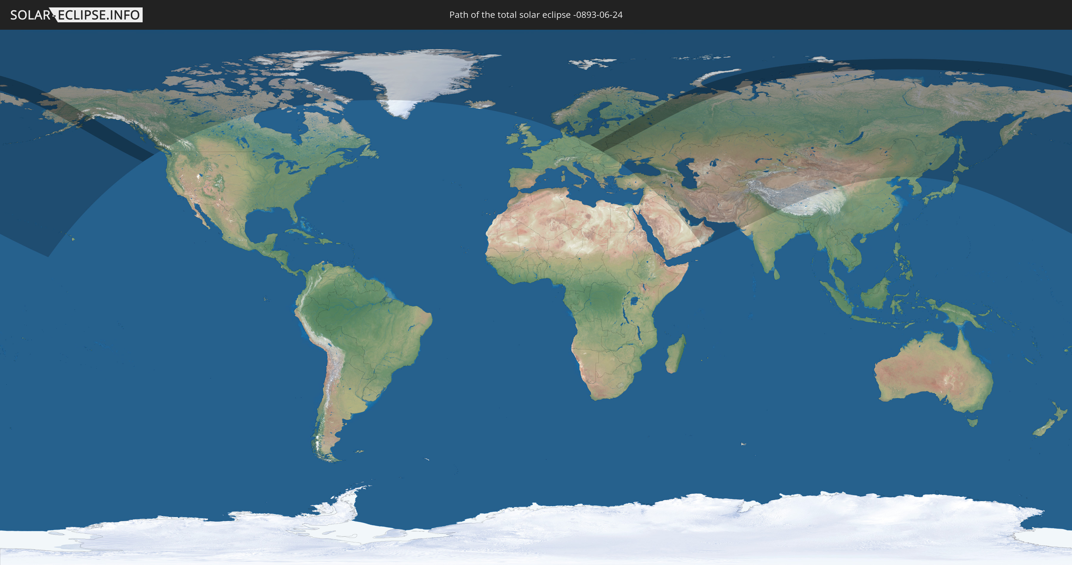
Die Sonnenfinsternis am 24.06.-0893 kann man in 50 Ländern als partielle Sonnenfinsternis beobachten.
Der Finsternispfad verläuft durch 8 Länder. Nur in diesen Ländern ist sie als totale Sonnenfinsternis zu sehen.
In den folgenden Ländern ist die Sonnenfinsternis total zu sehen
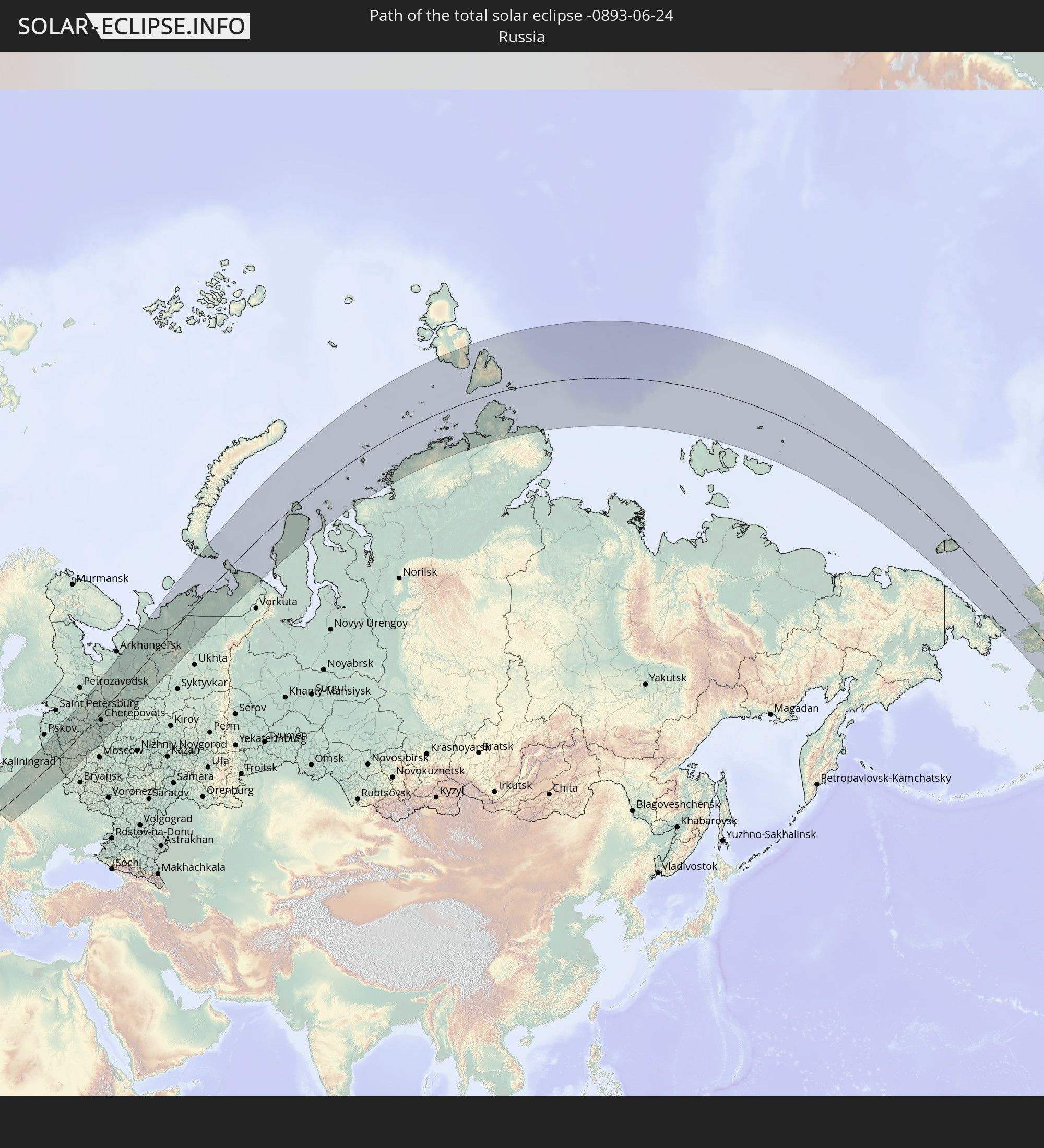 Russland
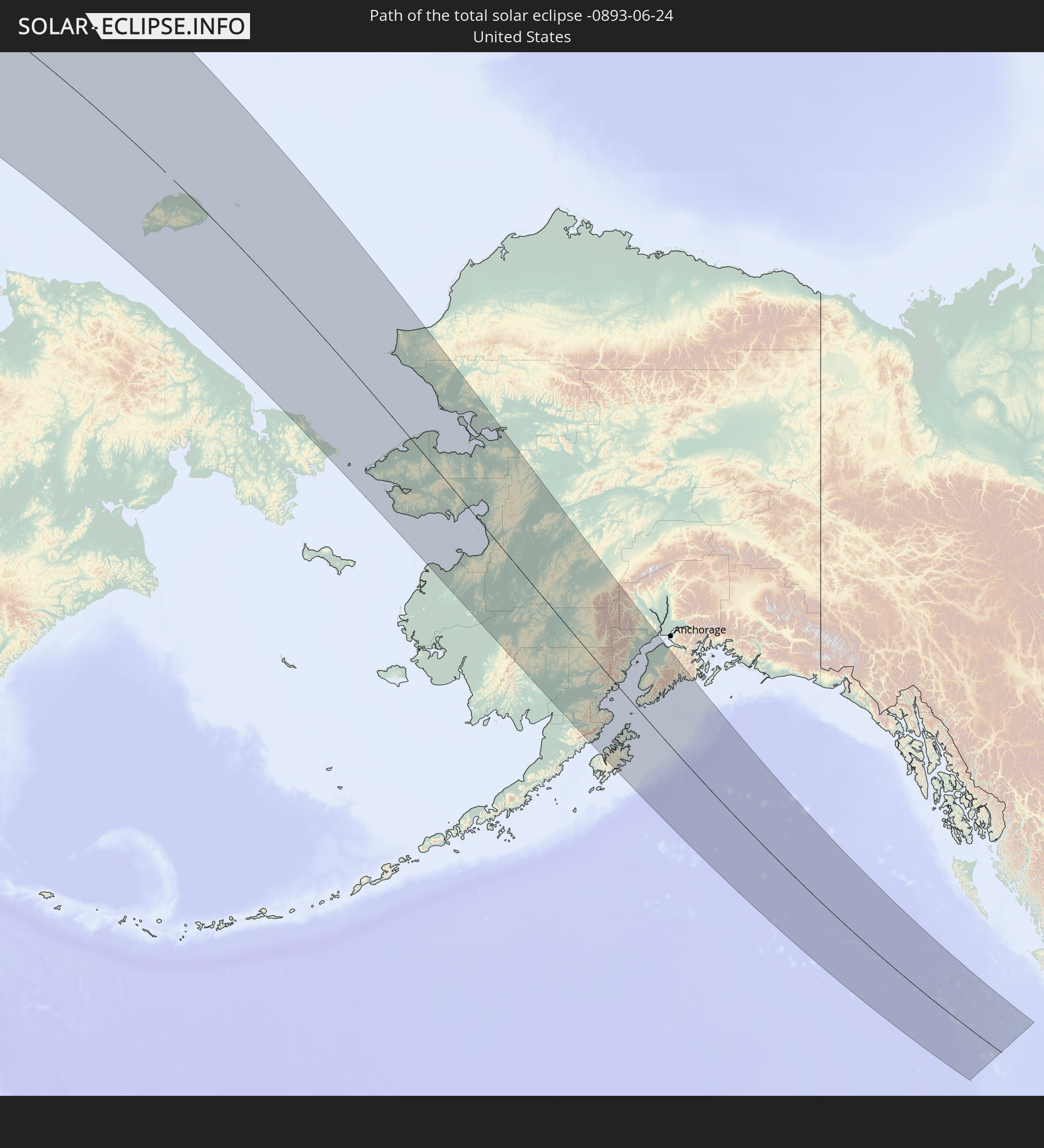 Vereinigte Staaten
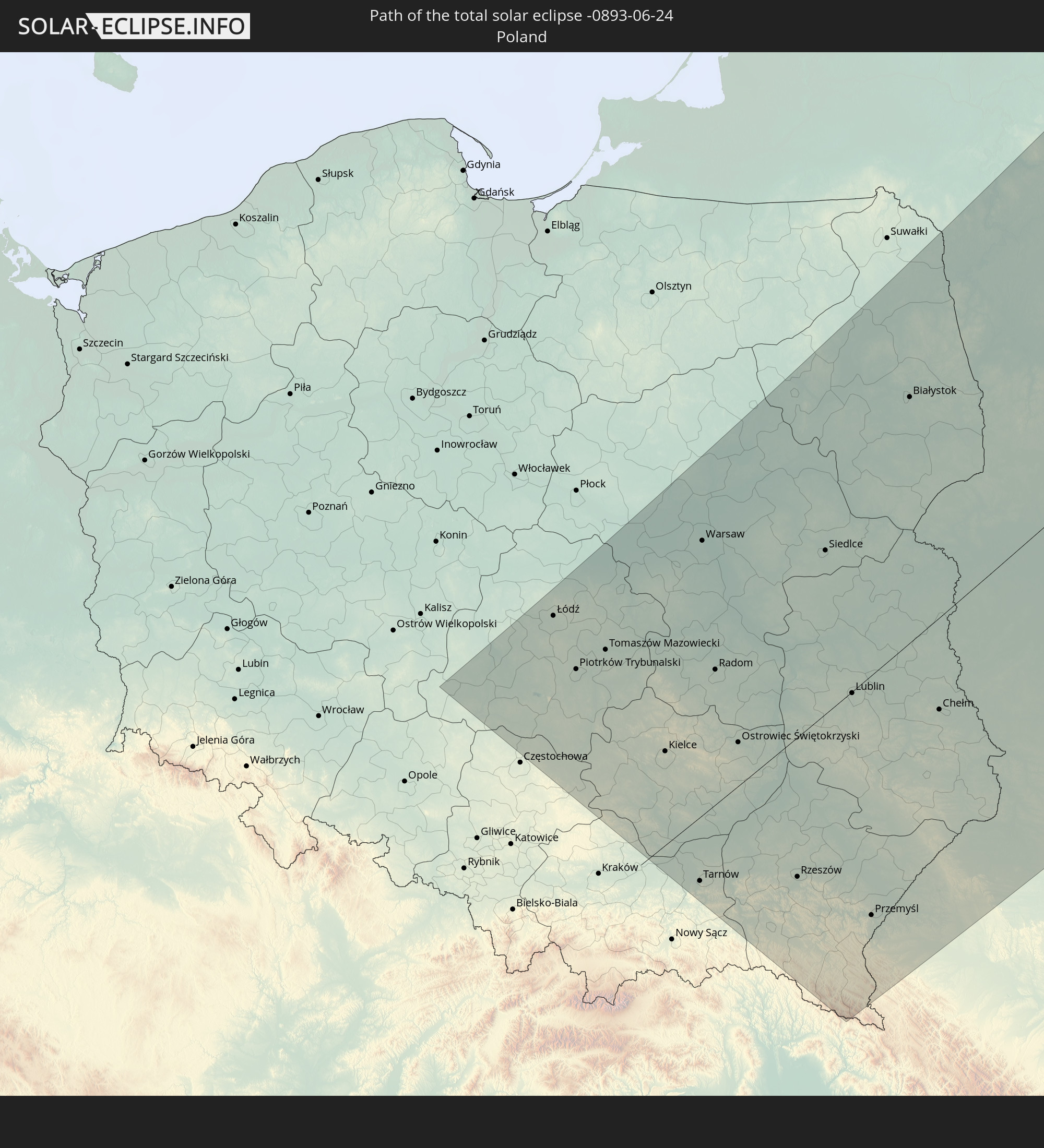 Polen
Polen
 Slowakei
 Litauen
 Lettland
 Ukraine
 Weißrussland
In den folgenden Ländern ist die Sonnenfinsternis partiell zu sehen
 Russland
 Vereinigte Staaten
 United States Minor Outlying Islands
 Kanada
 Grönland
 Island
 Spitzbergen
 Vereinigtes Königreich
 Färöer
 Norwegen
 Deutschland
 Dänemark
 Schweden
 Polen
Polen
 Slowakei
 Åland Islands
 Rumänien
 Finnland
 Litauen
 Lettland
 Estland
 Ukraine
 Weißrussland
 Türkei
 Moldawien
 Saudi-Arabien
 Syrien
 Irak
Irak
 Georgien
 Armenien
 Iran
Iran
 Aserbaidschan
 Kasachstan
 Kuwait
 Bahrain
 Katar
Katar
 Vereinigte Arabische Emirate
 Oman
Oman
 Turkmenistan
 Usbekistan
 Afghanistan
 Pakistan
 Tadschikistan
 Indien
 Kirgisistan
 Volksrepublik China
 Nepal
Nepal
 Mongolei
 Japan
Japan
 Nordkorea
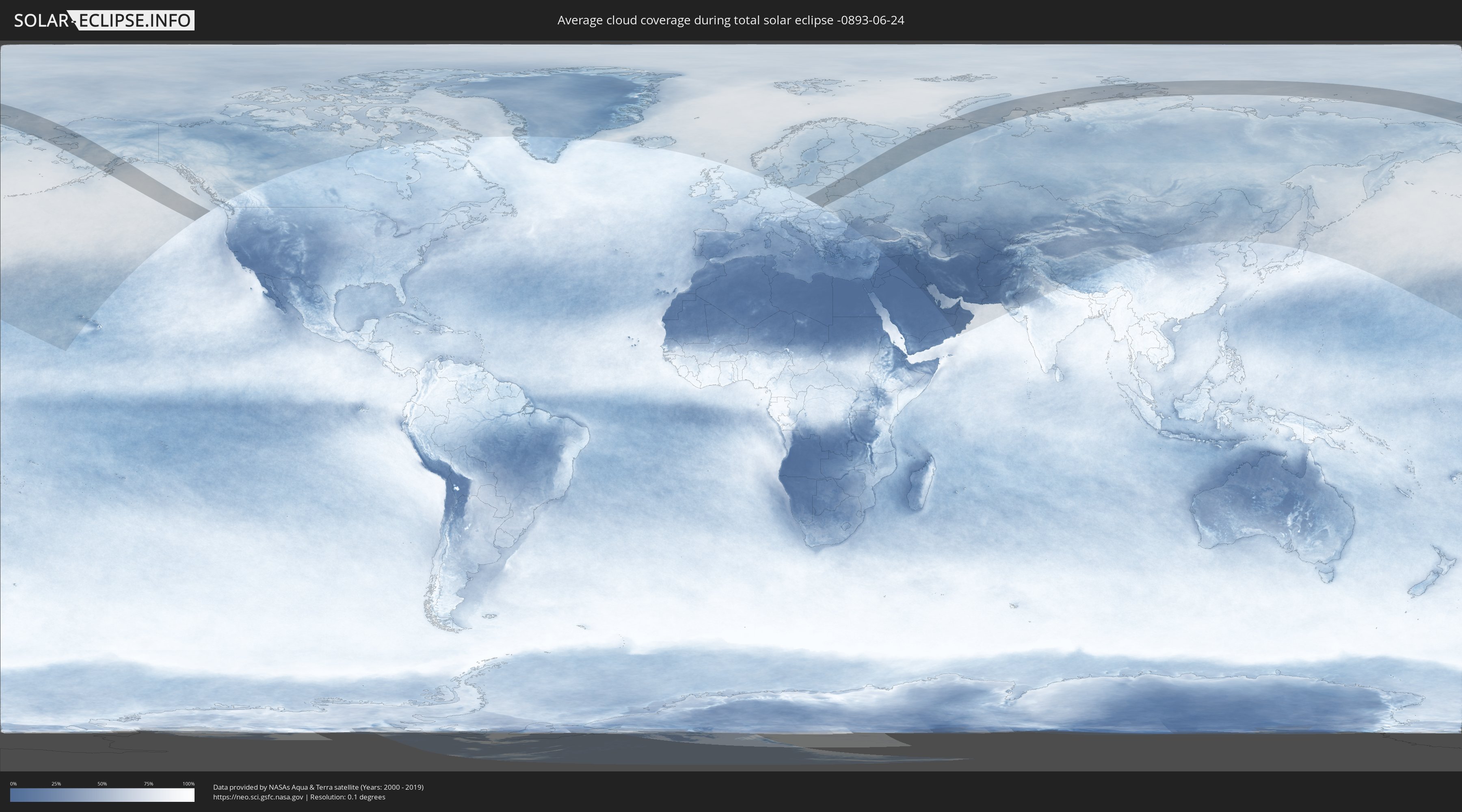
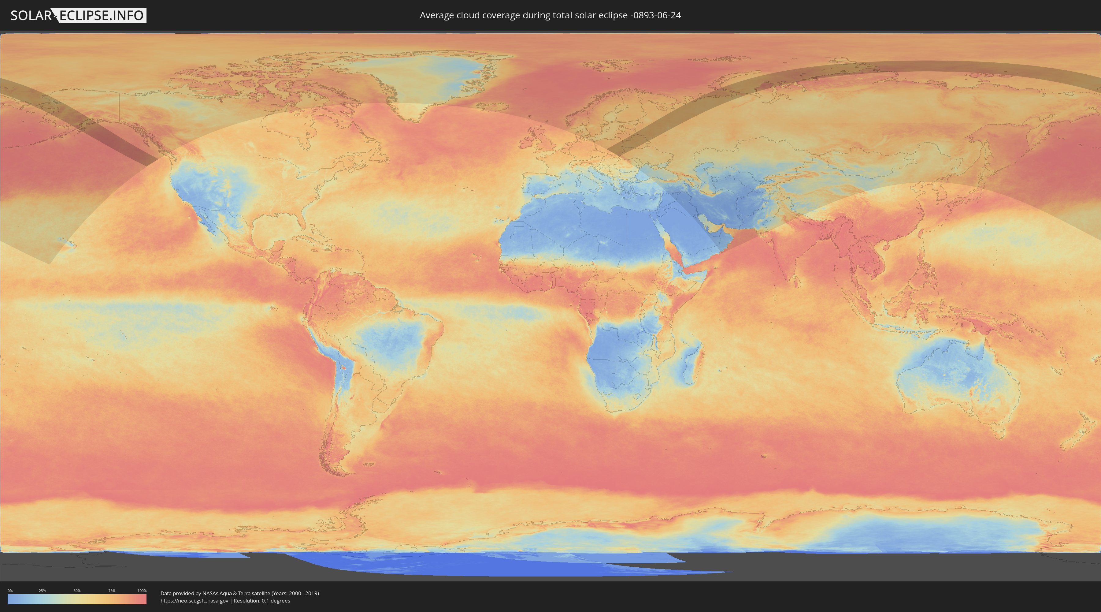
Wie wird das Wetter während der totalen Sonnenfinsternis am 24.06.-0893?
Wo ist der beste Ort, um die totale Sonnenfinsternis vom 24.06.-0893 zu beobachten?
Die folgenden Karten zeigen die durchschnittliche Bewölkung für den Tag, an dem die totale Sonnenfinsternis
stattfindet. Mit Hilfe der Karten lässt sich der Ort entlang des Finsternispfades eingrenzen,
der die besten Aussichen auf einen klaren wolkenfreien Himmel bietet.
Trotzdem muss man immer lokale Gegenenheiten beachten und sollte sich genau über das Wetter an seinem
gewählten Beobachtungsort informieren.
Die Daten stammen von den beiden NASA-Satelliten
AQUA und TERRA
und wurden über einen Zeitraum von 19 Jahren (2000 - 2019) gemittelt.
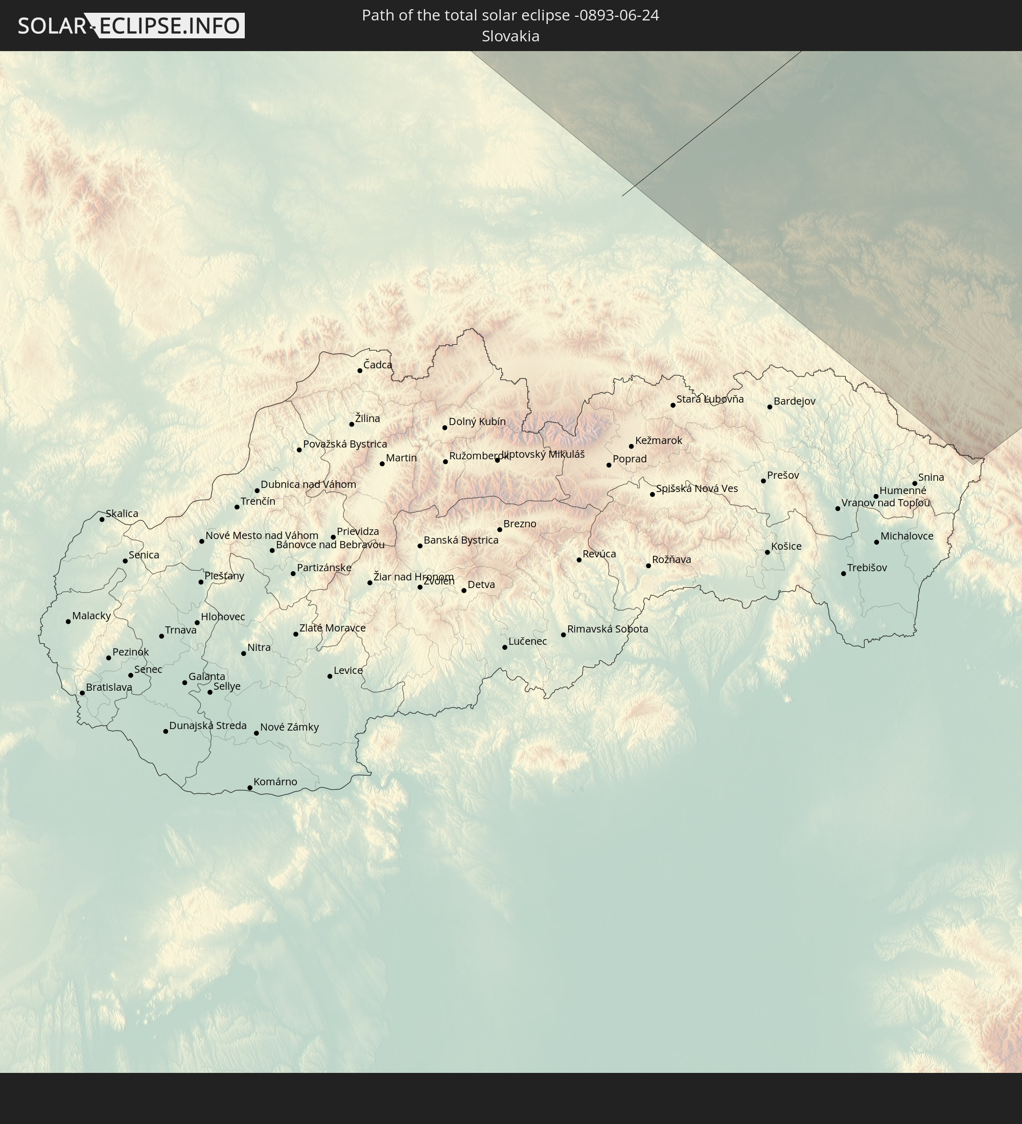
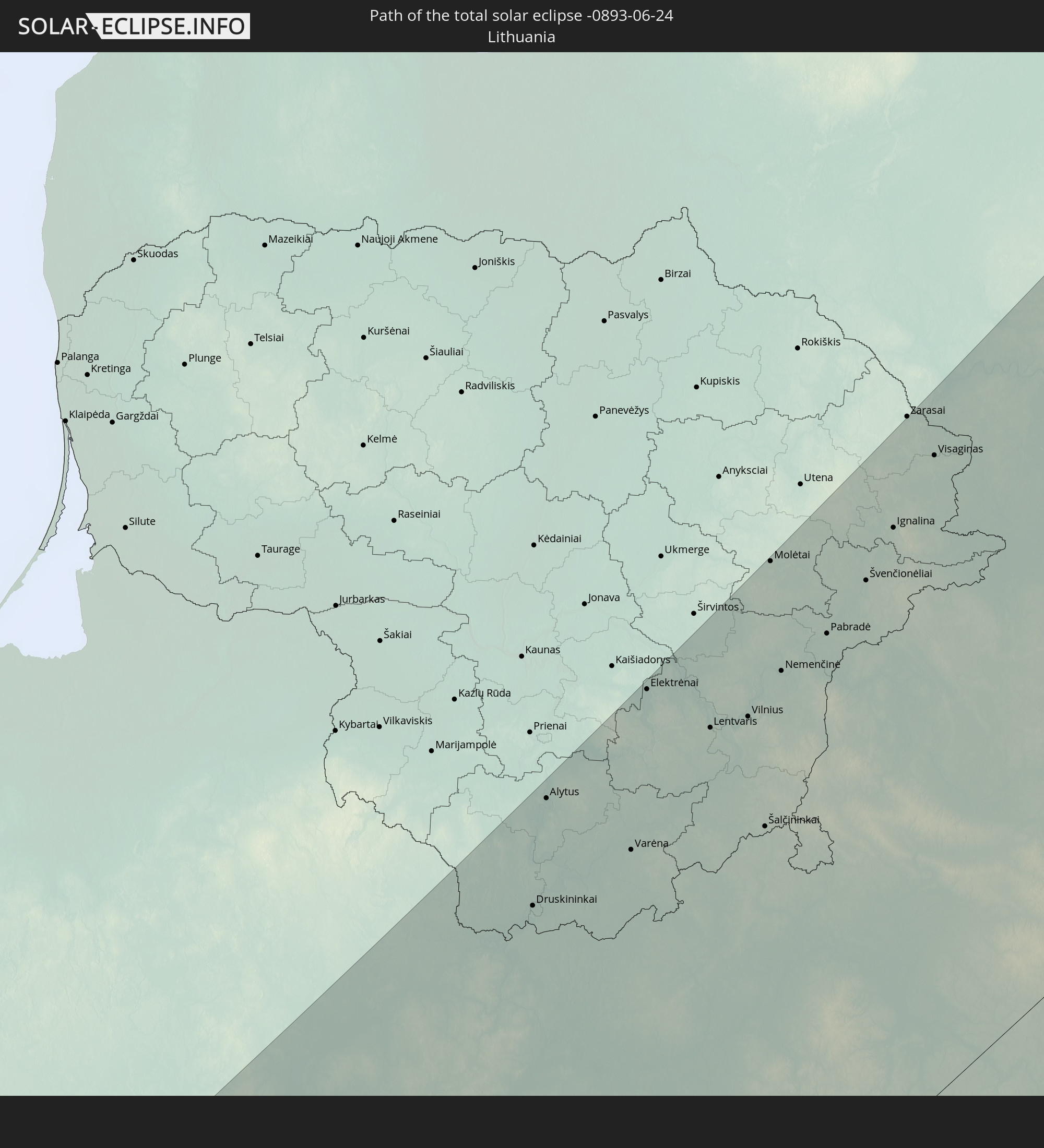
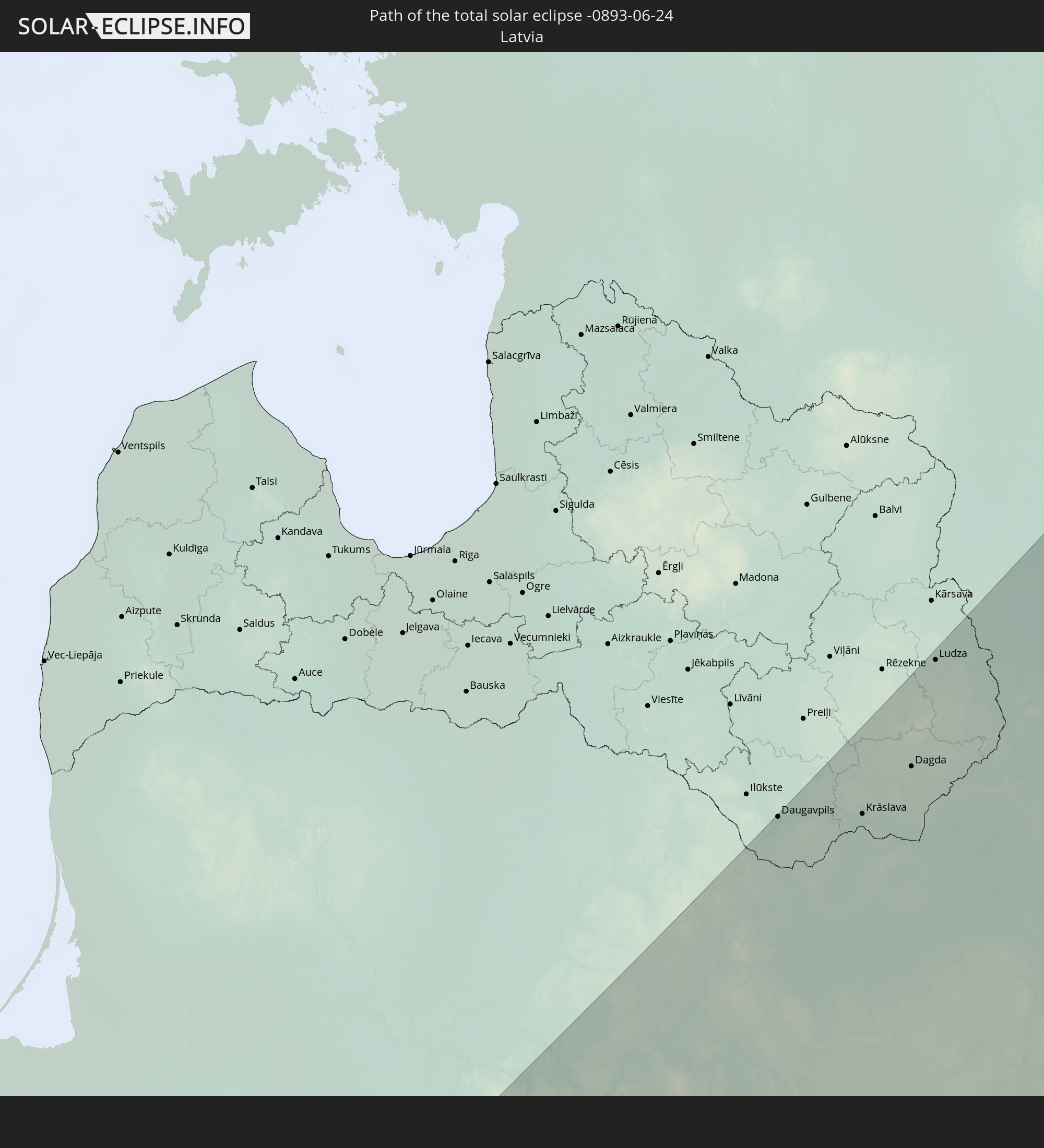
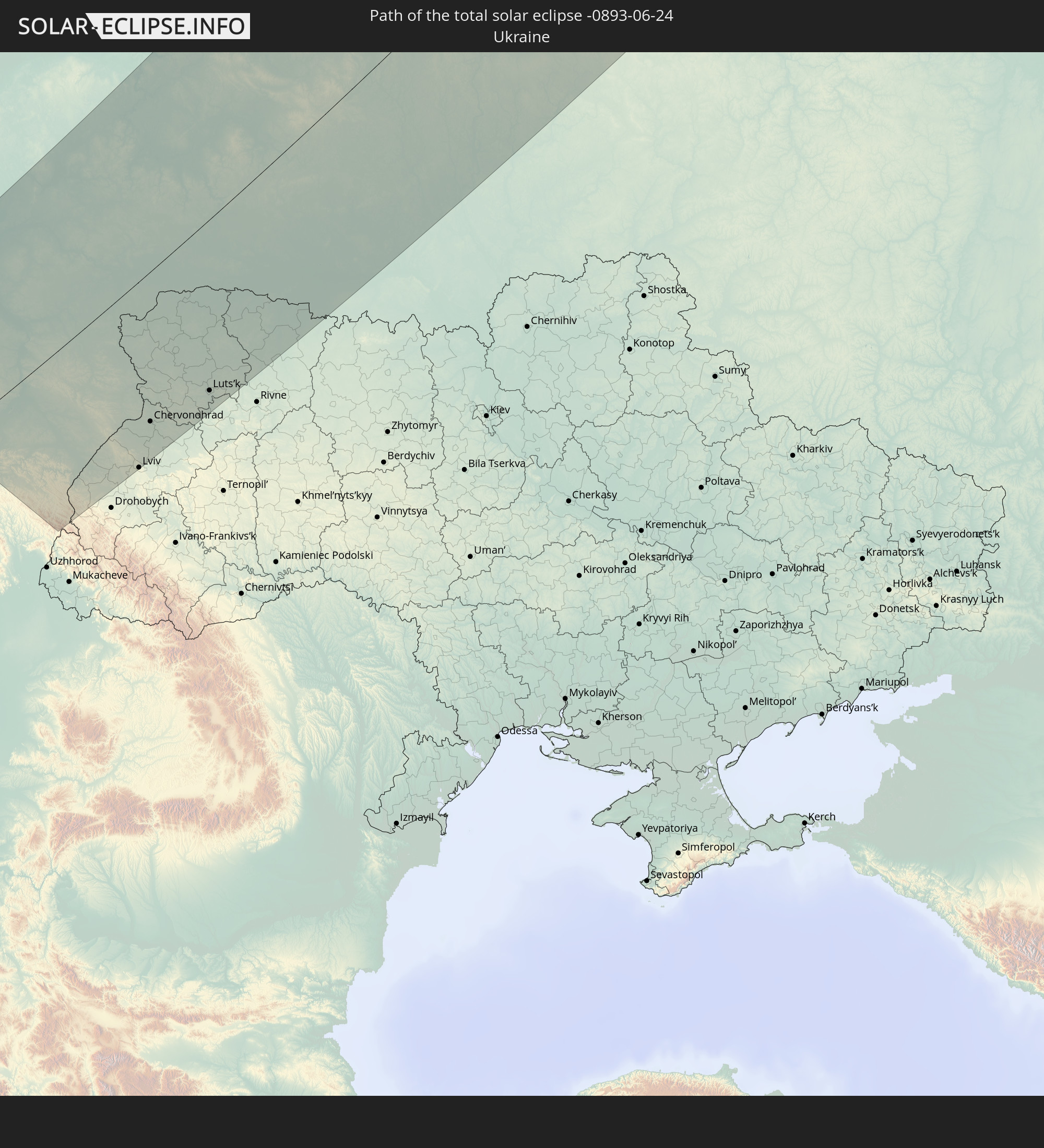
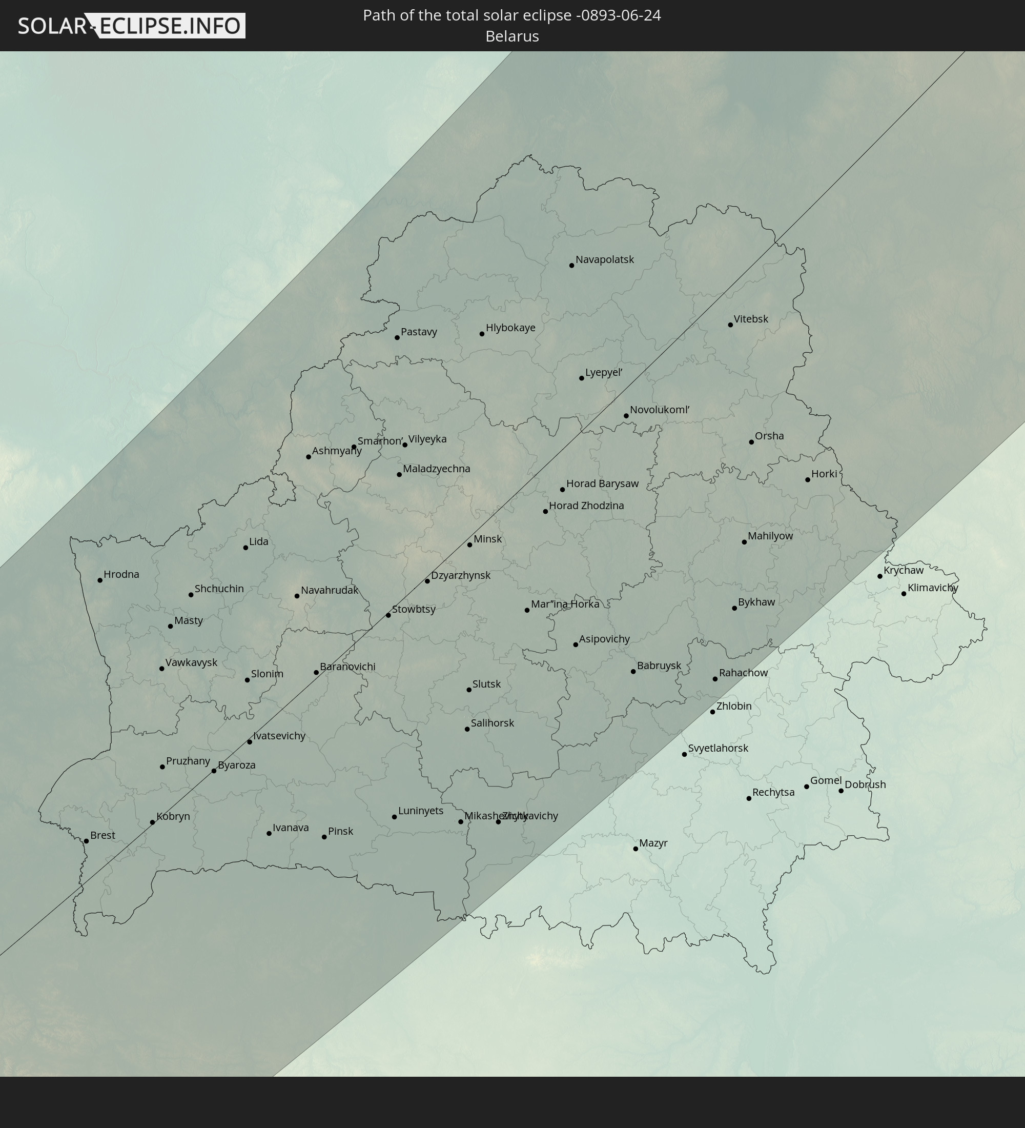
Detaillierte Länderkarten
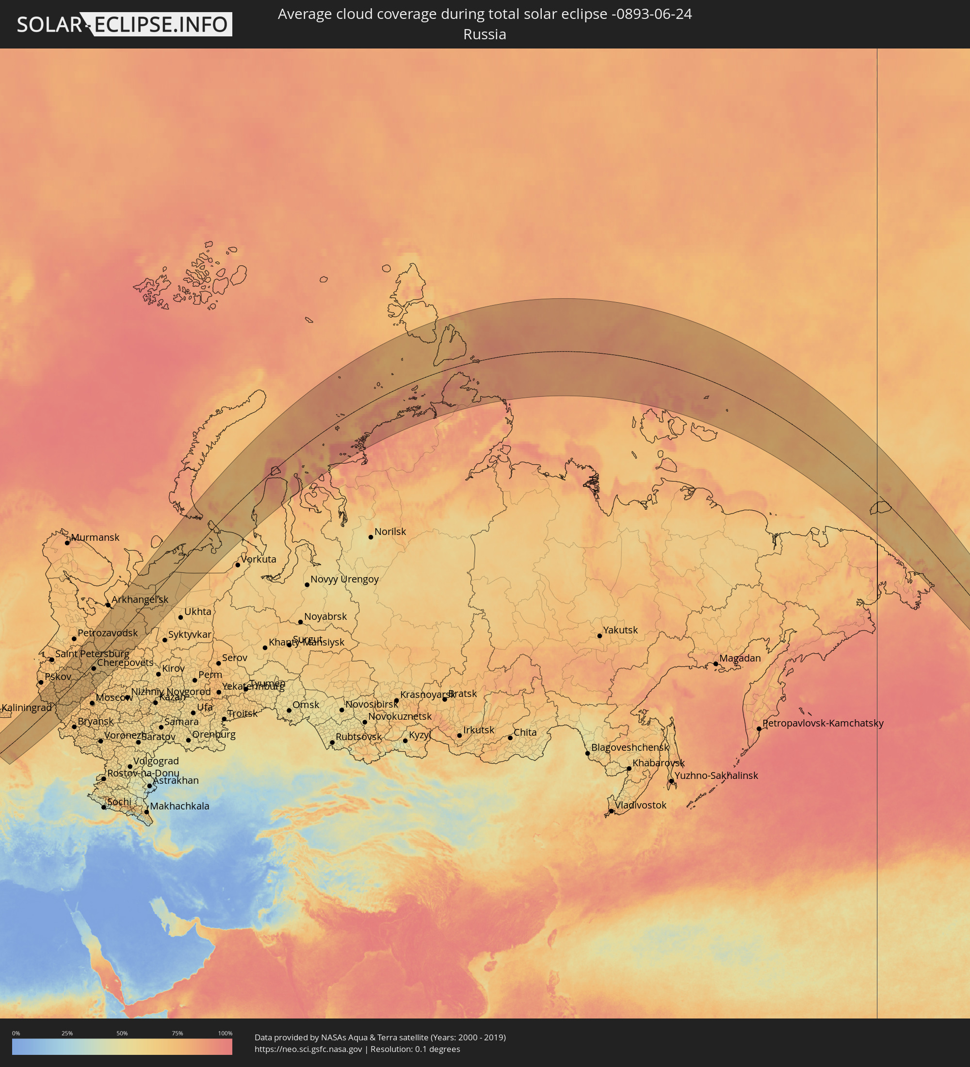 Russland
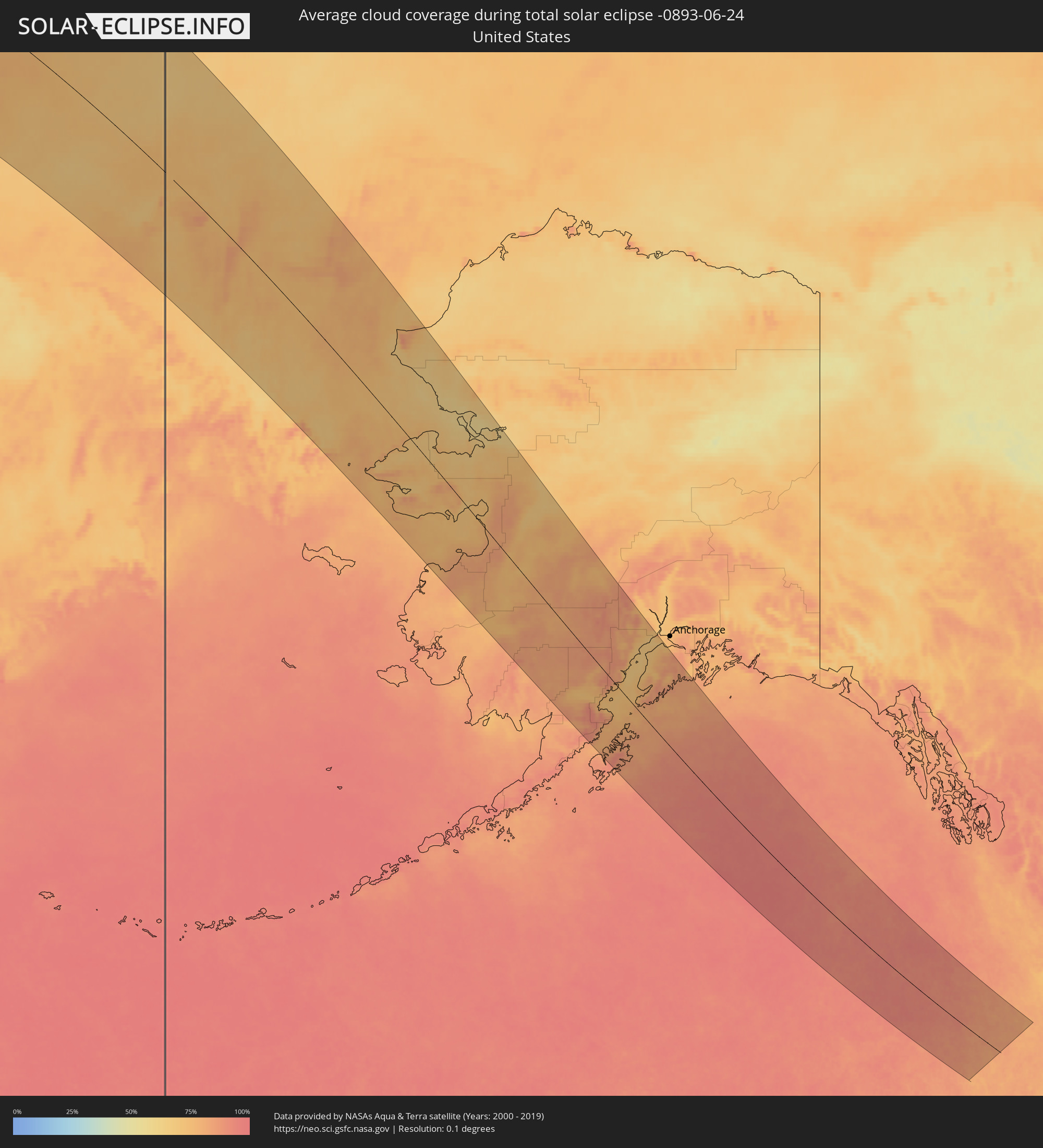 Vereinigte Staaten
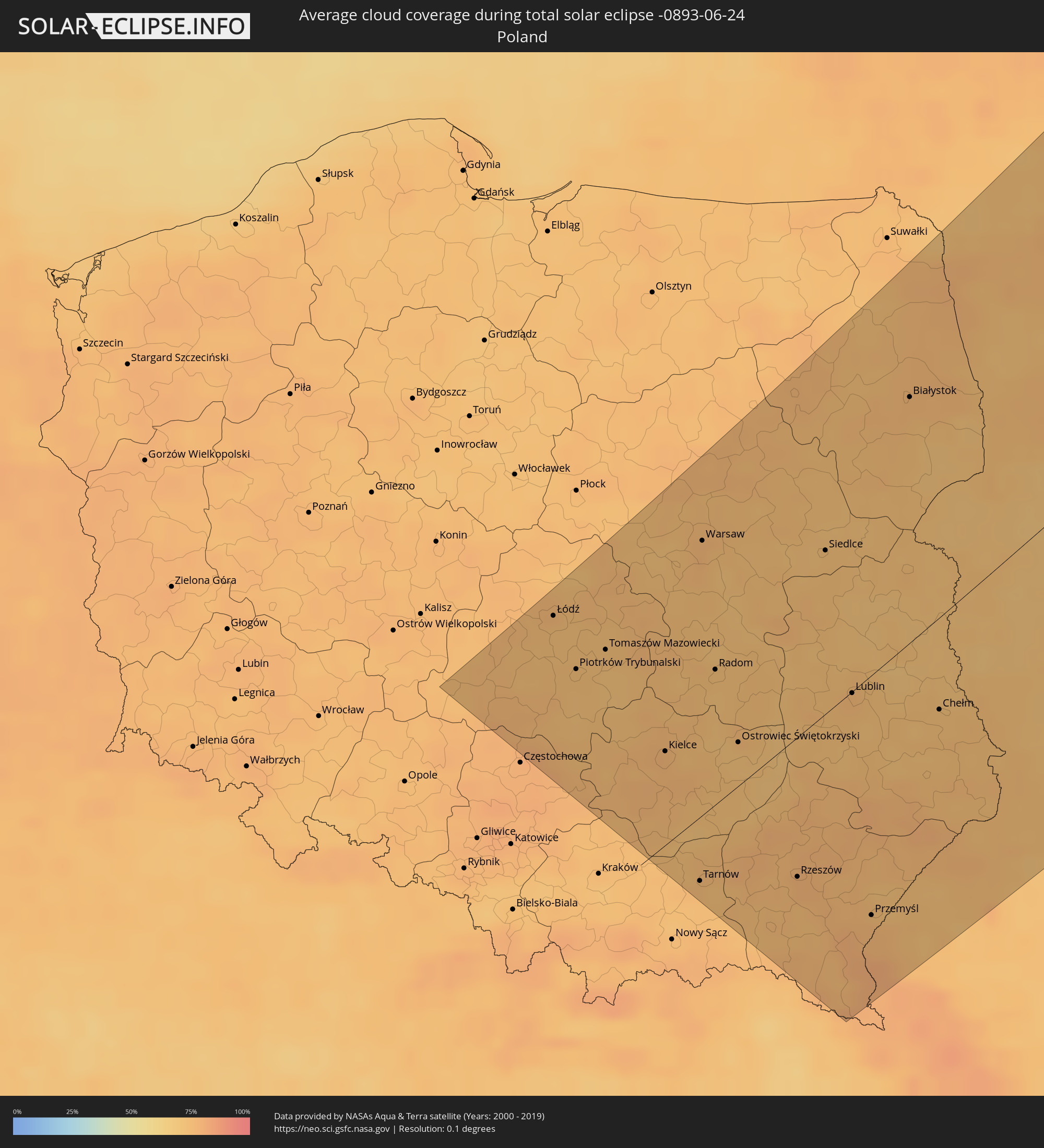 Polen
Polen
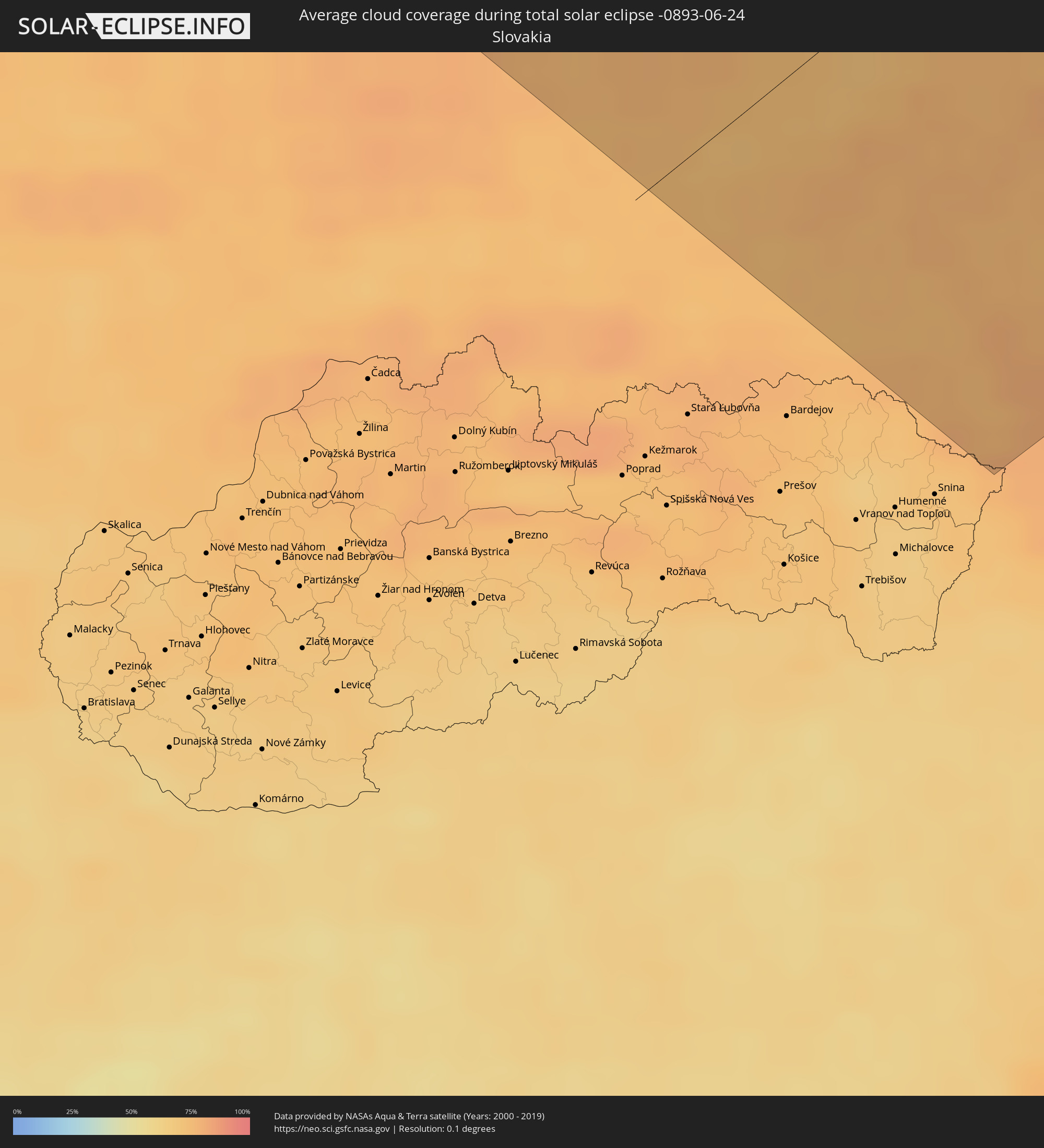 Slowakei
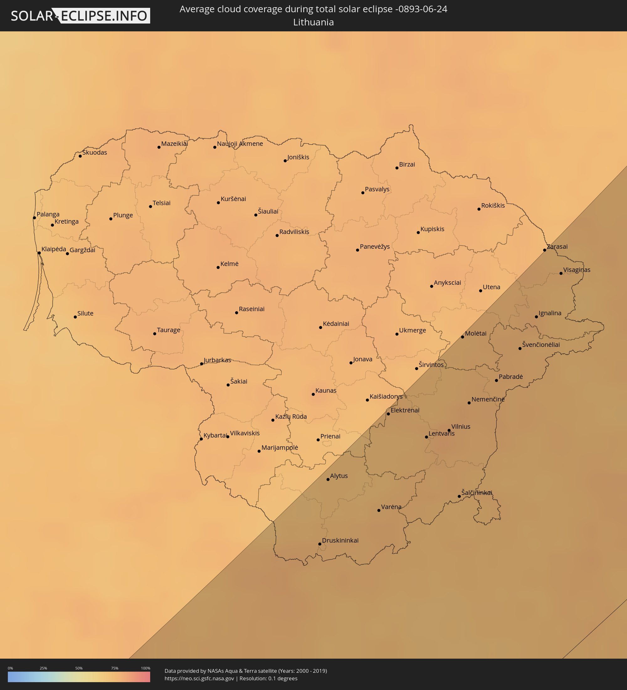 Litauen
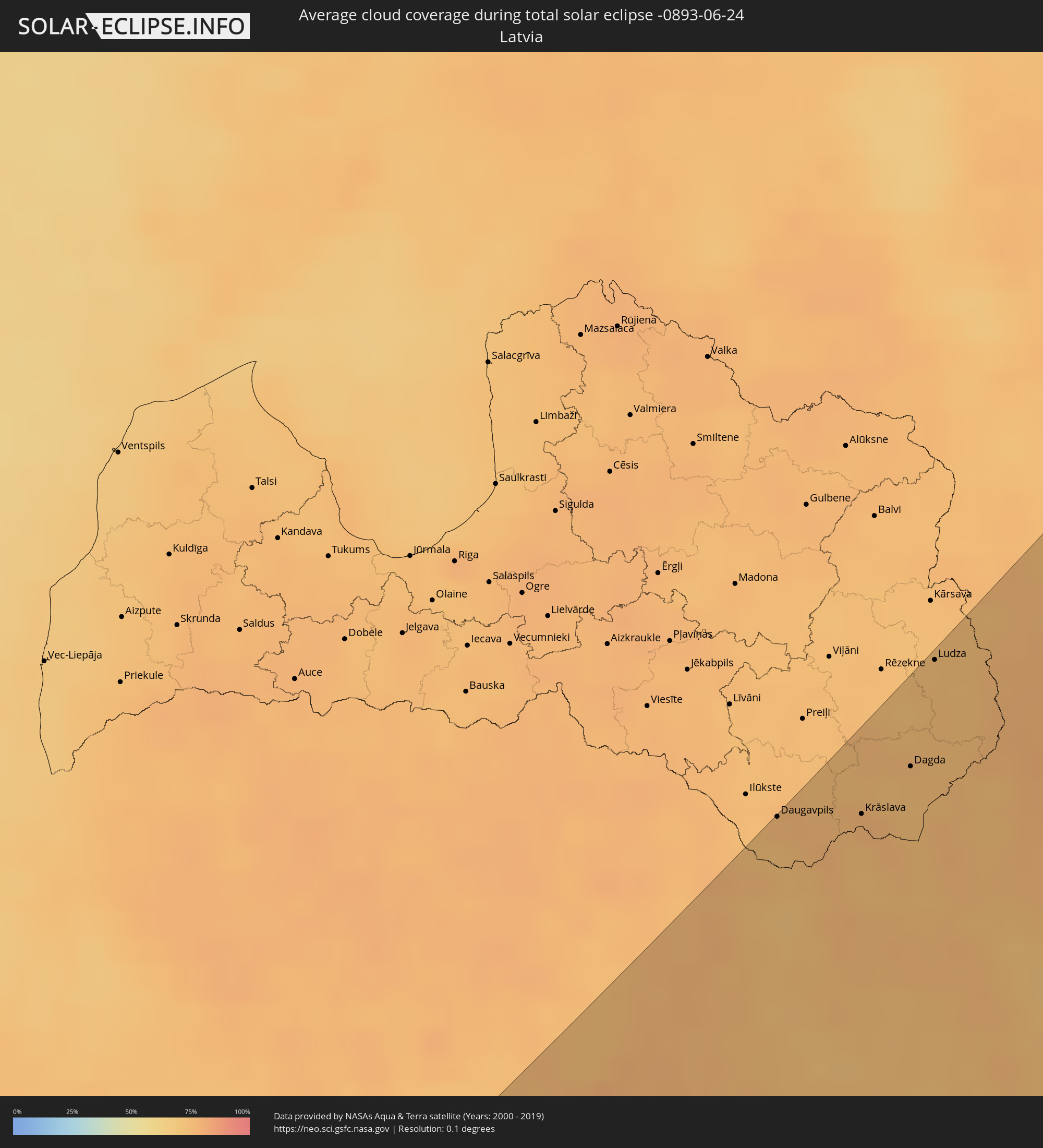 Lettland
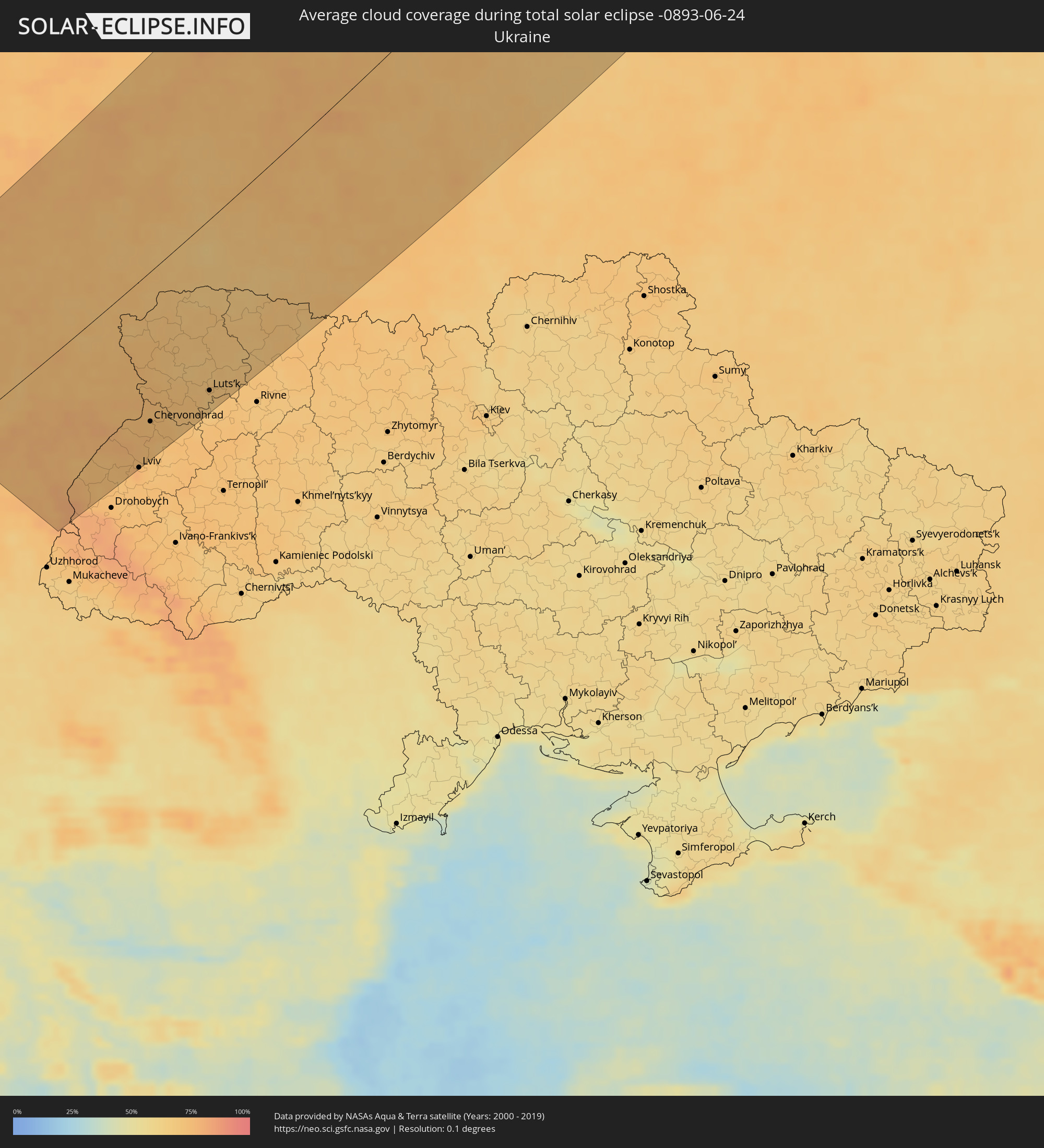 Ukraine
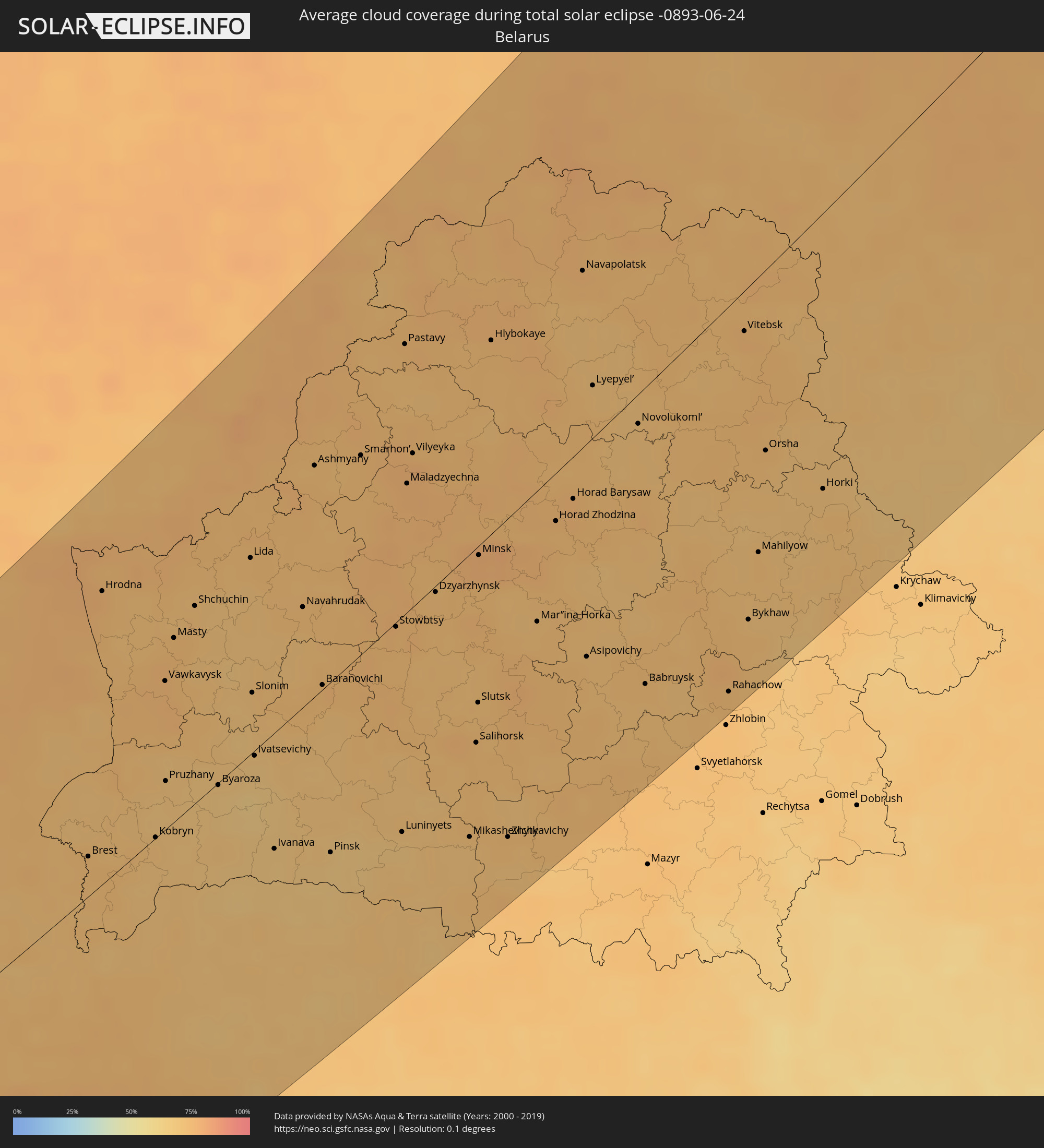 Weißrussland
Orte im Finsternispfad
Die nachfolgene Tabelle zeigt Städte und Orte mit mehr als 5.000 Einwohnern, die sich im Finsternispfad befinden. Städte mit mehr als 100.000 Einwohnern sind dick gekennzeichnet. Mit einem Klick auf den Ort öffnet sich eine Detailkarte die die Lage des jeweiligen Ortes zusammen mit dem Verlauf der zentralen Finsternis präsentiert.
| Ort | Typ | Dauer der Verfinsterung | Ortszeit bei maximaler Verfinsterung | Entfernung zur Zentrallinie | Ø Bewölkung |
|
Kodiak, Alaska
|
total | - | 18:18:10 UTC-10:00 | 118 km | 84% |
|
Homer, Alaska
|
total | - | 18:15:08 UTC-10:00 | 58 km | 78% |
|
Kalifornsky, Alaska
|
total | - | 18:13:52 UTC-10:00 | 122 km | 70% |
|
Kenai, Alaska
|
total | - | 18:13:39 UTC-10:00 | 133 km | 70% |
|
Sterling, Alaska
|
total | - | 18:13:38 UTC-10:00 | 153 km | 76% |
|
Bełchatów, Łódź Voivodeship
|
total | - | 03:52:31 UTC+01:24 | 154 km | 74% |
|
Radomsko, Łódź Voivodeship
|
total | - | 03:52:09 UTC+01:24 | 123 km | 74% |
|
Łódź, Łódź Voivodeship
|
total | - | 03:52:52 UTC+01:24 | 181 km | 76% |
|
Piotrków Trybunalski, Łódź Voivodeship
|
total | - | 03:52:22 UTC+01:24 | 141 km | 74% |
|
Tomaszów Mazowiecki, Łódź Voivodeship
|
total | - | 03:52:21 UTC+01:24 | 139 km | 72% |
|
Skierniewice, Łódź Voivodeship
|
total | - | 03:52:44 UTC+01:24 | 168 km | 75% |
|
Kielce, Świętokrzyskie
|
total | - | 03:51:19 UTC+01:24 | 54 km | 77% |
|
Pruszków, Masovian Voivodeship
|
total | - | 03:52:38 UTC+01:24 | 157 km | 74% |
|
Skarżysko-Kamienna, Świętokrzyskie
|
total | - | 03:51:27 UTC+01:24 | 64 km | 75% |
|
Legionowo, Masovian Voivodeship
|
total | - | 03:52:49 UTC+01:24 | 170 km | 75% |
|
Tarnów, Lesser Poland Voivodeship
|
total | - | 03:50:12 UTC+01:24 | 40 km | 75% |
|
Warsaw, Masovian Voivodeship
|
total | - | 03:52:36 UTC+01:24 | 152 km | 77% |
|
Starachowice, Świętokrzyskie
|
total | - | 03:51:15 UTC+01:24 | 48 km | 72% |
|
Radom, Masovian Voivodeship
|
total | - | 03:51:37 UTC+01:24 | 76 km | 73% |
|
Ostrowiec Świętokrzyski, Świętokrzyskie
|
total | - | 03:50:59 UTC+01:24 | 26 km | 72% |
|
Mielec, Subcarpathian Voivodeship
|
total | - | 03:50:16 UTC+01:24 | 35 km | 76% |
|
Tarnobrzeg, Subcarpathian Voivodeship
|
total | - | 03:50:26 UTC+01:24 | 19 km | 72% |
|
Krosno, Subcarpathian Voivodeship
|
total | - | 03:49:26 UTC+01:24 | 100 km | 75% |
|
Puławy, Lublin Voivodeship
|
total | - | 03:51:13 UTC+01:24 | 43 km | 73% |
|
Rzeszów, Subcarpathian Voivodeship
|
total | - | 03:49:42 UTC+01:24 | 82 km | 77% |
|
Stalowa Wola, Subcarpathian Voivodeship
|
total | - | 03:50:15 UTC+01:24 | 41 km | 76% |
|
Łomża, Podlasie
|
total | - | 03:53:08 UTC+01:24 | 184 km | 76% |
|
Siedlce, Masovian Voivodeship
|
total | - | 03:51:53 UTC+01:24 | 90 km | 73% |
|
Lublin, Lublin Voivodeship
|
total | - | 03:50:43 UTC+01:24 | 5 km | 76% |
|
Przemyśl, Subcarpathian Voivodeship
|
total | - | 03:49:01 UTC+01:24 | 136 km | 76% |
|
Biała Podlaska, Lublin Voivodeship
|
total | - | 03:51:20 UTC+01:24 | 41 km | 73% |
|
Mostys'ka, Lviv
|
total | - | 04:26:54 UTC+02:02 | 152 km | 75% |
|
Białystok, Podlasie
|
total | - | 03:52:34 UTC+01:24 | 130 km | 75% |
|
Sambir, Lviv
|
total | - | 04:26:34 UTC+02:02 | 179 km | 75% |
|
Zamość, Lublin Voivodeship
|
total | - | 03:49:48 UTC+01:24 | 77 km | 74% |
|
Sudova Vyshnya, Lviv
|
total | - | 04:26:47 UTC+02:02 | 163 km | 74% |
|
Yavoriv, Lviv
|
total | - | 04:26:56 UTC+02:02 | 150 km | 73% |
|
Chełm, Lublin Voivodeship
|
total | - | 03:50:09 UTC+01:24 | 51 km | 73% |
|
Novoyavorivs'k, Lviv
|
total | - | 04:26:50 UTC+02:02 | 160 km | 73% |
|
Rava-Rus’ka, Lviv
|
total | - | 04:27:08 UTC+02:02 | 136 km | 76% |
|
Horodok, Lviv
|
total | - | 04:26:38 UTC+02:02 | 176 km | 72% |
|
Brest, Brest
|
total | - | 04:17:08 UTC+01:50 | 23 km | 73% |
|
Ivano-Frankove, Lviv
|
total | - | 04:26:44 UTC+02:02 | 167 km | 74% |
|
Hrodna, Grodnenskaya
|
total | - | 04:18:54 UTC+01:50 | 147 km | 76% |
|
Rudne, Lviv
|
total | - | 04:26:33 UTC+02:02 | 184 km | 73% |
|
Druskininkai, Alytus County
|
total | - | 03:53:14 UTC+01:24 | 167 km | 75% |
|
Zhovkva, Lviv
|
total | - | 04:26:46 UTC+02:02 | 166 km | 75% |
|
Lviv, Lviv
|
total | - | 04:26:30 UTC+02:02 | 188 km | 75% |
|
Lyuboml’, Volyn
|
total | - | 04:28:02 UTC+02:02 | 70 km | 74% |
|
Alytus, Alytus County
|
total | - | 03:53:39 UTC+01:24 | 194 km | 73% |
|
Dublyany, Lviv
|
total | - | 04:26:32 UTC+02:02 | 185 km | 75% |
|
Novovolyns’k, Volyn
|
total | - | 04:27:25 UTC+02:02 | 118 km | 74% |
|
Chervonohrad, Lviv
|
total | - | 04:27:00 UTC+02:02 | 150 km | 73% |
|
Sokal’, Lviv
|
total | - | 04:27:04 UTC+02:02 | 144 km | 74% |
|
Volodymyr-Volyns’kyy, Volyn
|
total | - | 04:27:29 UTC+02:02 | 116 km | 74% |
|
Kobryn, Brest
|
total | - | 04:16:57 UTC+01:50 | 13 km | 71% |
|
Staryy Dobrotvir, Lviv
|
total | - | 04:26:45 UTC+02:02 | 170 km | 71% |
|
Vawkavysk, Grodnenskaya
|
total | - | 04:18:00 UTC+01:50 | 76 km | 75% |
|
Ratne, Volyn
|
total | - | 04:28:18 UTC+02:02 | 53 km | 71% |
|
Varėna, Alytus County
|
total | - | 03:53:12 UTC+01:24 | 156 km | 76% |
|
Elektrėnai, Vilnius County
|
total | - | 03:53:51 UTC+01:24 | 198 km | 74% |
|
Kovel’, Volyn
|
total | - | 04:27:42 UTC+02:02 | 102 km | 69% |
|
Vievis, Vilnius County
|
total | - | 03:53:46 UTC+01:24 | 190 km | 75% |
|
Trakai
|
total | - | 03:53:33 UTC+01:24 | 174 km | 74% |
|
Kamin’-Kashyrs’kyy, Volyn
|
total | - | 04:28:03 UTC+02:02 | 79 km | 71% |
|
Byaroza, Brest
|
total | - | 04:17:02 UTC+01:50 | 3 km | 68% |
|
Lentvaris, Vilnius County
|
total | - | 03:53:31 UTC+01:24 | 169 km | 77% |
|
Grigiškės
|
total | - | 03:53:32 UTC+01:24 | 170 km | 77% |
|
Pilaitė, Vilnius County
|
total | - | 03:53:31 UTC+01:24 | 167 km | 78% |
|
Lazdynai, Vilnius County
|
total | - | 03:53:28 UTC+01:24 | 163 km | 78% |
|
Justiniškės, Vilnius County
|
total | - | 03:53:31 UTC+01:24 | 167 km | 78% |
|
Pašilaičiai, Vilnius County
|
total | - | 03:53:33 UTC+01:24 | 168 km | 78% |
|
Fabijoniškės, Vilnius County
|
total | - | 03:53:32 UTC+01:24 | 167 km | 78% |
|
Vilkpėdė, Vilnius County
|
total | - | 03:53:27 UTC+01:24 | 162 km | 78% |
|
Šeškinė, Vilnius County
|
total | - | 03:53:30 UTC+01:24 | 165 km | 77% |
|
Naujamiestis, Vilnius County
|
total | - | 03:53:27 UTC+01:24 | 161 km | 77% |
|
Rozhyshche, Volyn
|
total | - | 04:27:06 UTC+02:02 | 151 km | 70% |
|
Vilnius, Vilnius County
|
total | - | 03:53:28 UTC+01:24 | 162 km | 77% |
|
Lida, Grodnenskaya
|
total | - | 04:18:29 UTC+01:50 | 98 km | 73% |
|
Rasos, Vilnius County
|
total | - | 03:53:26 UTC+01:24 | 159 km | 77% |
|
Slonim, Grodnenskaya
|
total | - | 04:17:32 UTC+01:50 | 32 km | 70% |
|
Ivatsevichy, Brest
|
total | - | 04:17:04 UTC+01:50 | 17 km | 68% |
|
Luts’k, Volyn
|
total | - | 04:26:53 UTC+02:02 | 168 km | 69% |
|
Šalčininkai
|
total | - | 03:52:57 UTC+01:24 | 127 km | 74% |
|
Molėtai, Utena County
|
total | - | 03:54:04 UTC+01:24 | 199 km | 74% |
|
Kivertsi, Volyn
|
total | - | 04:26:55 UTC+02:02 | 166 km | 70% |
|
Nemenčinė, Vilnius County
|
total | - | 03:53:34 UTC+01:24 | 167 km | 76% |
|
Pabradė, Vilnius County
|
total | - | 03:53:37 UTC+01:24 | 163 km | 76% |
|
Navahrudak, Grodnenskaya
|
total | - | 04:17:55 UTC+01:50 | 52 km | 73% |
|
Kuznetsovs’k, Rivne
|
total | - | 04:27:42 UTC+02:02 | 114 km | 68% |
|
Švenčionėliai
|
total | - | 03:53:45 UTC+01:24 | 168 km | 76% |
|
Baranovichi, Brest
|
total | - | 04:17:16 UTC+01:50 | 4 km | 73% |
|
Pinsk, Brest
|
total | - | 04:16:02 UTC+01:50 | 88 km | 67% |
|
Zarichne, Rivne
|
total | - | 04:27:44 UTC+02:02 | 113 km | 67% |
|
Volodymyrets’, Rivne
|
total | - | 04:27:16 UTC+02:02 | 149 km | 69% |
|
Švenčionys, Vilnius County
|
total | - | 03:53:39 UTC+01:24 | 158 km | 75% |
|
Ignalina
|
total | - | 03:53:54 UTC+01:24 | 174 km | 76% |
|
Smarhon’, Grodnenskaya
|
total | - | 04:18:44 UTC+01:50 | 95 km | 73% |
|
Visaginas, Utena County
|
total | - | 03:54:07 UTC+01:24 | 183 km | 73% |
|
Daugavpils, Daugavpils municipality
|
total | - | 04:07:00 UTC+01:36 | 201 km | 75% |
|
Dubrovytsya, Rivne
|
total | - | 04:27:15 UTC+02:02 | 153 km | 72% |
|
Sarny, Rivne
|
total | - | 04:26:58 UTC+02:02 | 175 km | 70% |
|
Luninyets, Brest
|
total | - | 04:15:52 UTC+01:50 | 109 km | 68% |
|
Maladzyechna, Minsk
|
total | - | 04:18:21 UTC+01:50 | 61 km | 76% |
|
Vilyeyka, Minsk
|
total | - | 04:18:33 UTC+01:50 | 74 km | 77% |
|
Aglona, Aglona
|
total | - | 04:07:07 UTC+01:36 | 199 km | 74% |
|
Dzyarzhynsk, Minsk
|
total | - | 04:17:28 UTC+01:50 | 10 km | 72% |
|
Krāslava, Krāslavas Rajons
|
total | - | 04:06:46 UTC+01:36 | 173 km | 77% |
|
Dagda, Dagda
|
total | - | 04:06:52 UTC+01:36 | 172 km | 74% |
|
Salihorsk, Minsk
|
total | - | 04:16:12 UTC+01:50 | 95 km | 73% |
|
Slutsk, Minsk
|
total | - | 04:16:29 UTC+01:50 | 78 km | 72% |
|
Minsk, Minsk City
|
total | - | 04:17:33 UTC+01:50 | 5 km | 77% |
|
Ludza, Ludzas Rajons
|
total | - | 04:07:22 UTC+01:36 | 198 km | 74% |
|
Cibla, Cibla
|
total | - | 04:07:20 UTC+01:36 | 191 km | 73% |
|
Zilupe, Zilupes
|
total | - | 04:07:02 UTC+01:36 | 168 km | 75% |
|
Horad Zhodzina, Minsk
|
total | - | 04:17:29 UTC+01:50 | 24 km | 73% |
|
Horad Barysaw, Minsk
|
total | - | 04:17:35 UTC+01:50 | 27 km | 75% |
|
Navapolatsk, Vitebsk
|
total | - | 04:19:11 UTC+01:50 | 80 km | 74% |
|
Asipovichy, Mogilev
|
total | - | 04:16:22 UTC+01:50 | 102 km | 73% |
|
Babruysk, Mogilev
|
total | - | 04:15:56 UTC+01:50 | 142 km | 71% |
|
Rahachow, Gomel
|
total | - | 04:15:33 UTC+01:50 | 182 km | 74% |
|
Vitebsk, Vitebsk
|
total | - | 04:18:10 UTC+01:50 | 18 km | 75% |
|
Mahilyow, Mogilev
|
total | - | 04:16:29 UTC+01:50 | 127 km | 72% |
|
Orsha, Vitebsk
|
total | - | 04:17:12 UTC+01:50 | 82 km | 72% |
|
Velikiye Luki, Pskov
|
total | - | 04:59:50 UTC+02:30 | 60 km | 73% |
|
Horki, Mogilev
|
total | - | 04:16:43 UTC+01:50 | 126 km | 71% |
|
Velikiy Novgorod, Novgorod
|
total | - | 05:02:32 UTC+02:30 | 192 km | 69% |
|
Staraya Russa, Novgorod
|
total | - | 05:01:47 UTC+02:30 | 148 km | 71% |
|
Smolensk, Smolensk
|
total | - | 04:57:16 UTC+02:30 | 132 km | 71% |
|
Yartsevo, Smolensk
|
total | - | 04:57:25 UTC+02:30 | 139 km | 71% |
|
Nelidovo, Tverskaya
|
total | - | 04:58:56 UTC+02:30 | 53 km | 75% |
|
Ostashkov, Tverskaya
|
total | - | 05:00:06 UTC+02:30 | 8 km | 72% |
|
Safonovo, Smolensk
|
total | - | 04:57:22 UTC+02:30 | 154 km | 70% |
|
Tikhvin, Leningradskaya Oblast'
|
total | - | 05:03:28 UTC+02:30 | 178 km | 73% |
|
Borovichi, Novgorod
|
total | - | 05:01:35 UTC+02:30 | 68 km | 72% |
|
Bologoye, Tverskaya
|
total | - | 05:00:49 UTC+02:30 | 24 km | 71% |
|
Pikalëvo, Leningradskaya Oblast'
|
total | - | 05:03:07 UTC+02:30 | 141 km | 74% |
|
Rzhev, Tverskaya
|
total | - | 04:58:31 UTC+02:30 | 114 km | 72% |
|
Vyshniy Volochëk, Tverskaya
|
total | - | 05:00:18 UTC+02:30 | 27 km | 70% |
|
Torzhok, Tverskaya
|
total | - | 04:59:25 UTC+02:30 | 81 km | 71% |
|
Udomlya, Tverskaya
|
total | - | 05:00:35 UTC+02:30 | 17 km | 74% |
|
Tver, Tverskaya
|
total | - | 04:58:55 UTC+02:30 | 137 km | 76% |
|
Bezhetsk, Tverskaya
|
total | - | 05:00:01 UTC+02:30 | 98 km | 68% |
|
Konakovo, Tverskaya
|
total | - | 04:58:28 UTC+02:30 | 186 km | 70% |
|
Cherepovets, Vologda
|
total | - | 05:01:42 UTC+02:30 | 48 km | 68% |
|
Uglich, Jaroslavl
|
total | - | 04:59:16 UTC+02:30 | 187 km | 65% |
|
Sheksna, Vologda
|
total | - | 05:01:41 UTC+02:30 | 66 km | 68% |
|
Rybinsk, Jaroslavl
|
total | - | 04:59:54 UTC+02:30 | 168 km | 65% |
|
Vologda, Vologda
|
total | - | 05:01:26 UTC+02:30 | 121 km | 70% |
|
Sokol, Vologda
|
total | - | 05:01:45 UTC+02:30 | 112 km | 70% |
|
Nyandoma, Arkhangelskaya
|
total | - | 05:05:05 UTC+02:30 | 49 km | 72% |
|
Mirnyy, Arkhangelskaya
|
total | - | 05:06:45 UTC+02:30 | 123 km | 73% |
|
Vel’sk, Arkhangelskaya
|
total | - | 05:03:53 UTC+02:30 | 72 km | 70% |
|
Mirnyy, Arkhangelskaya
|
total | - | 05:04:01 UTC+02:30 | 147 km | 74% |