Totale Sonnenfinsternis vom 29.02.-0896
| Wochentag: | Sonntag |
| Maximale Dauer der Verfinsterung: | 05m04s |
| Maximale Breite des Finsternispfades: | 223 km |
| Saroszyklus: | 35 |
| Bedeckungsgrad: | 100% |
| Magnitude: | 1.0652 |
| Gamma: | -0.3068 |
Wo kann man die Sonnenfinsternis vom 29.02.-0896 sehen?
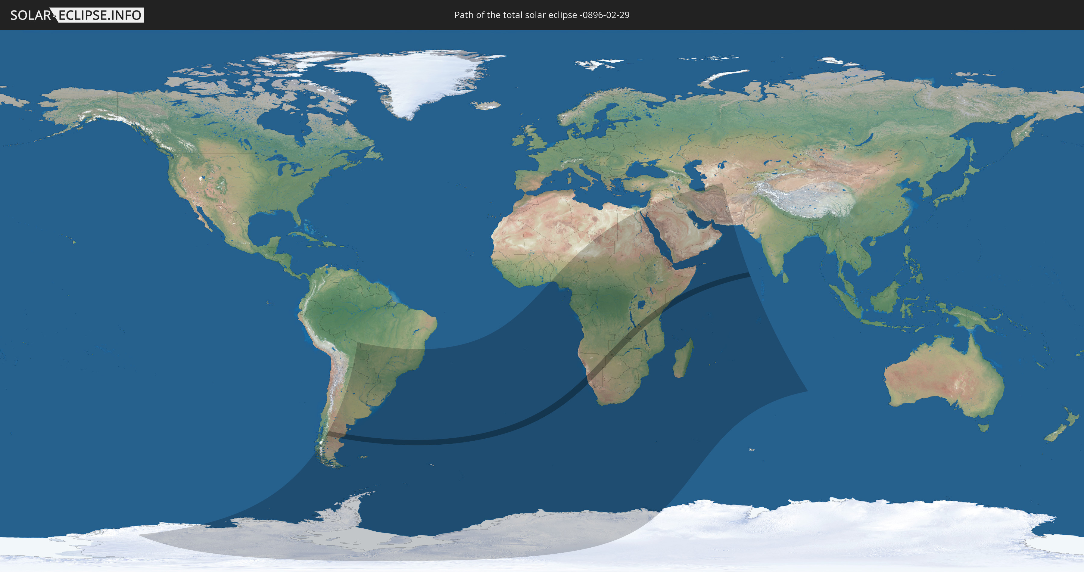
Die Sonnenfinsternis am 29.02.-0896 kann man in 66 Ländern als partielle Sonnenfinsternis beobachten.
Der Finsternispfad verläuft durch 11 Länder. Nur in diesen Ländern ist sie als totale Sonnenfinsternis zu sehen.
In den folgenden Ländern ist die Sonnenfinsternis total zu sehen
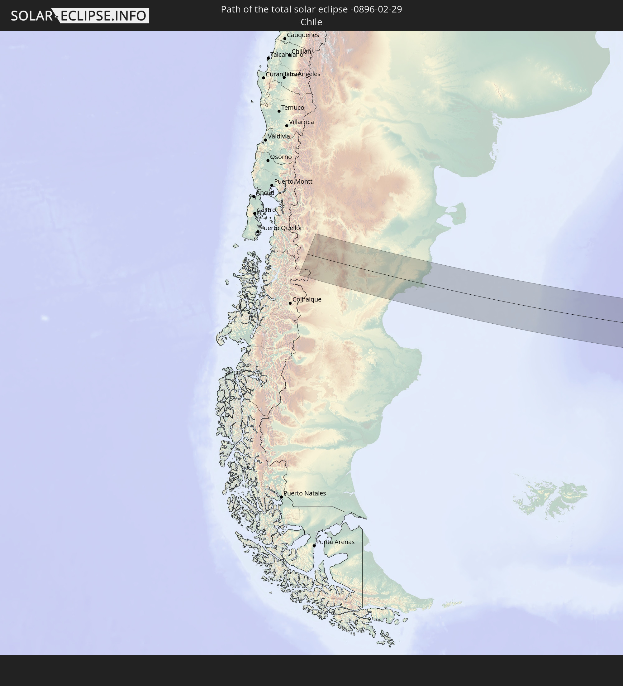 Chile
Chile
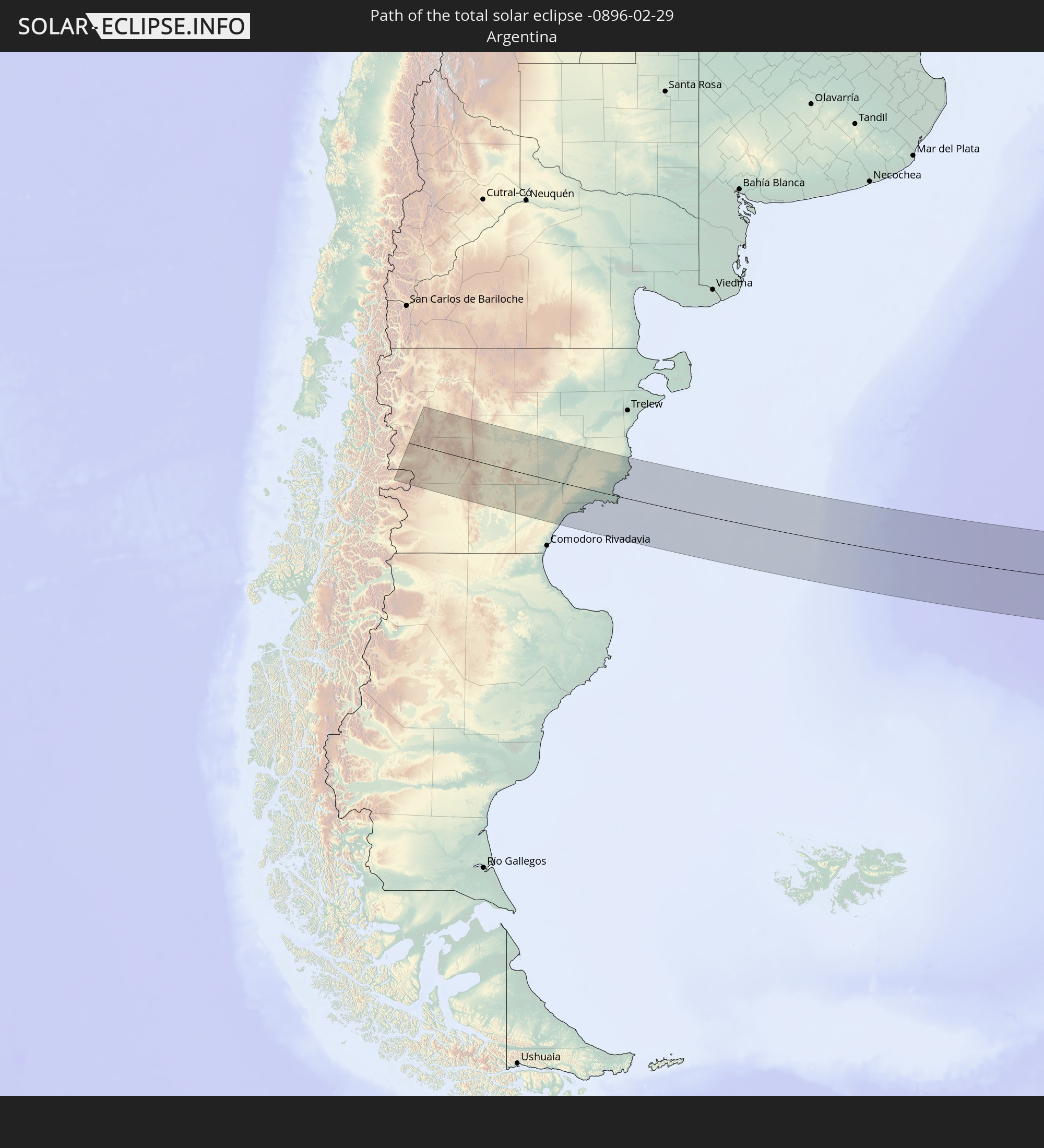 Argentinien
 Angola
 Namibia
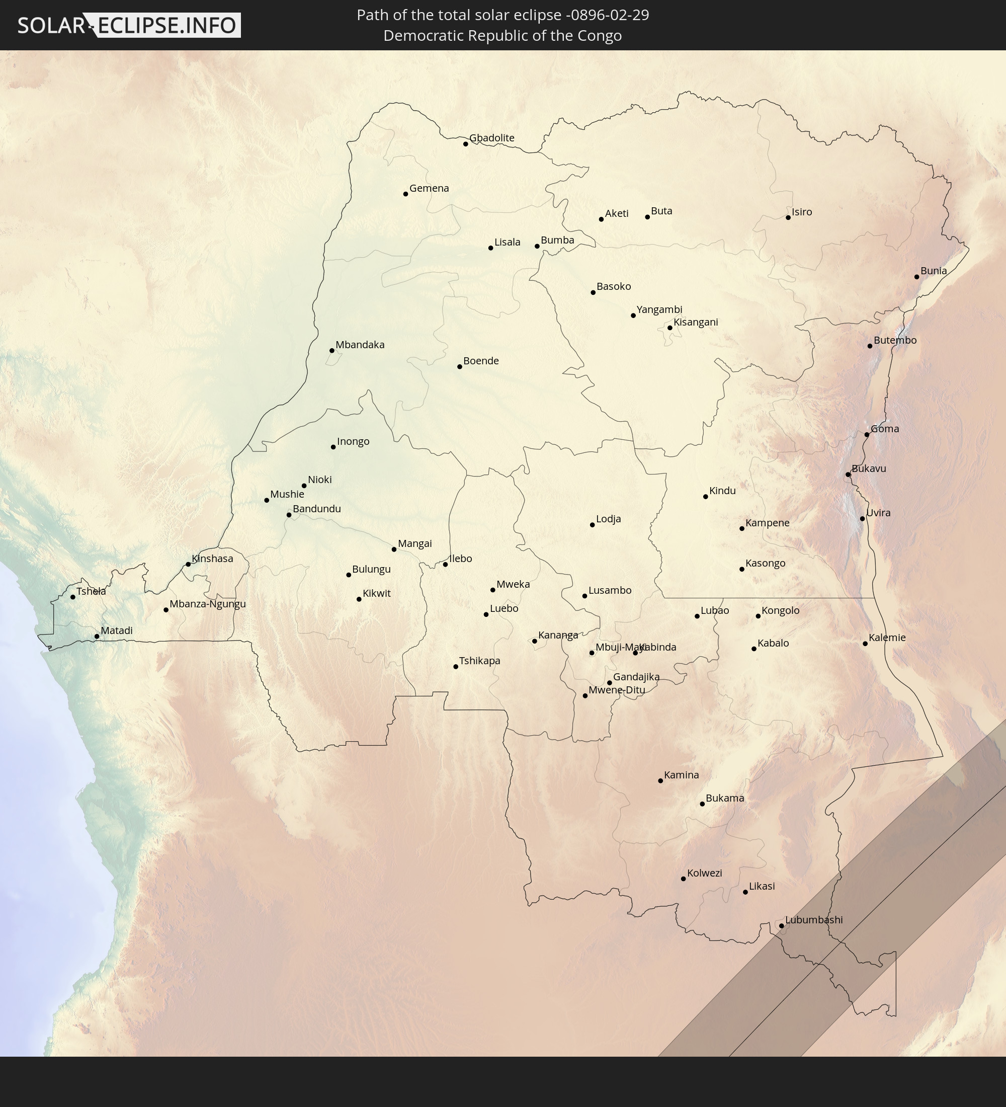 Demokratische Republik Kongo
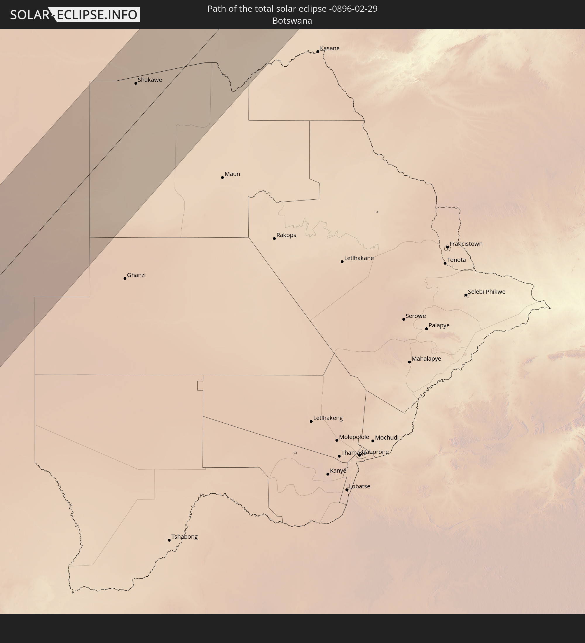 Botswana
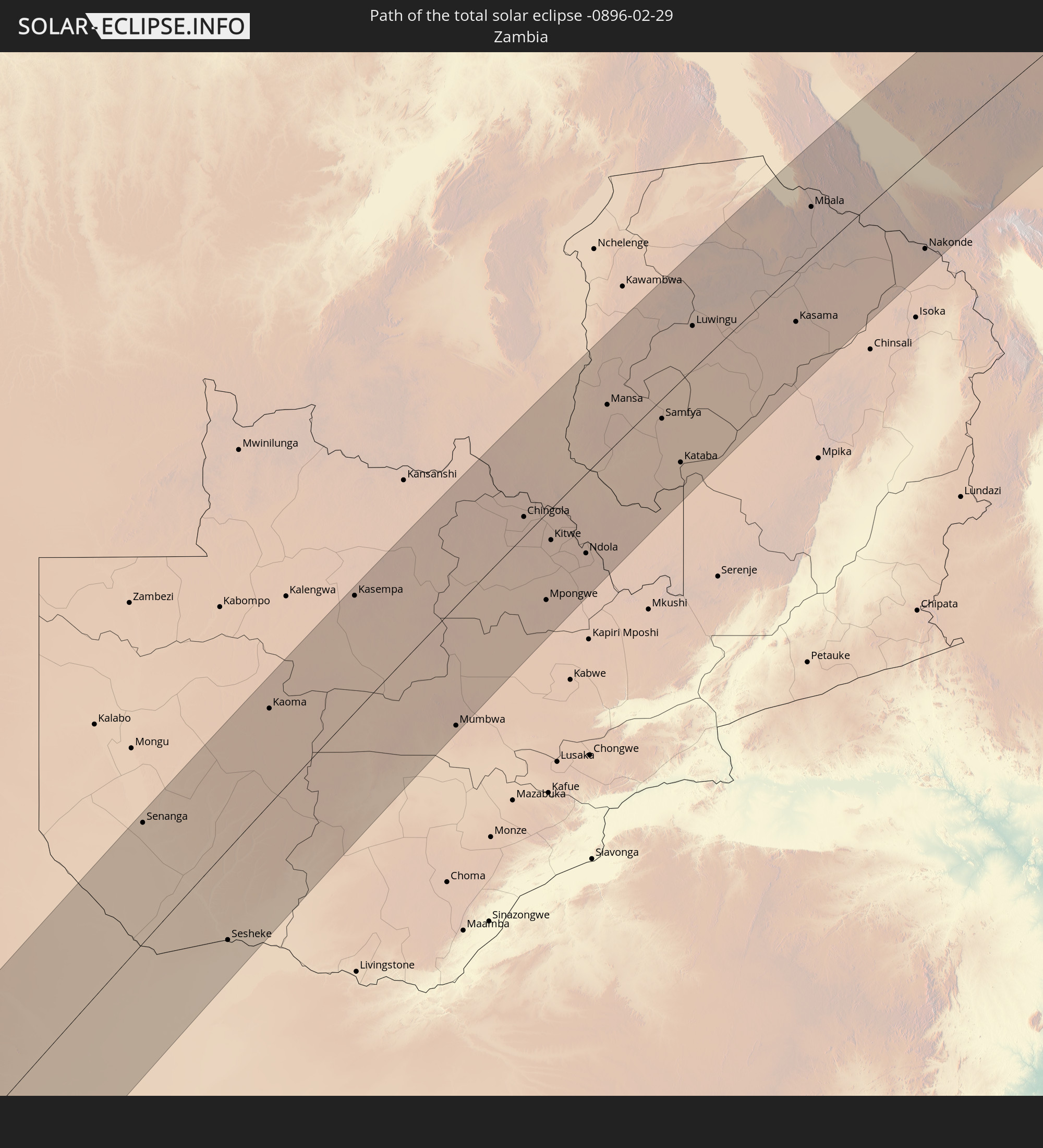 Sambia
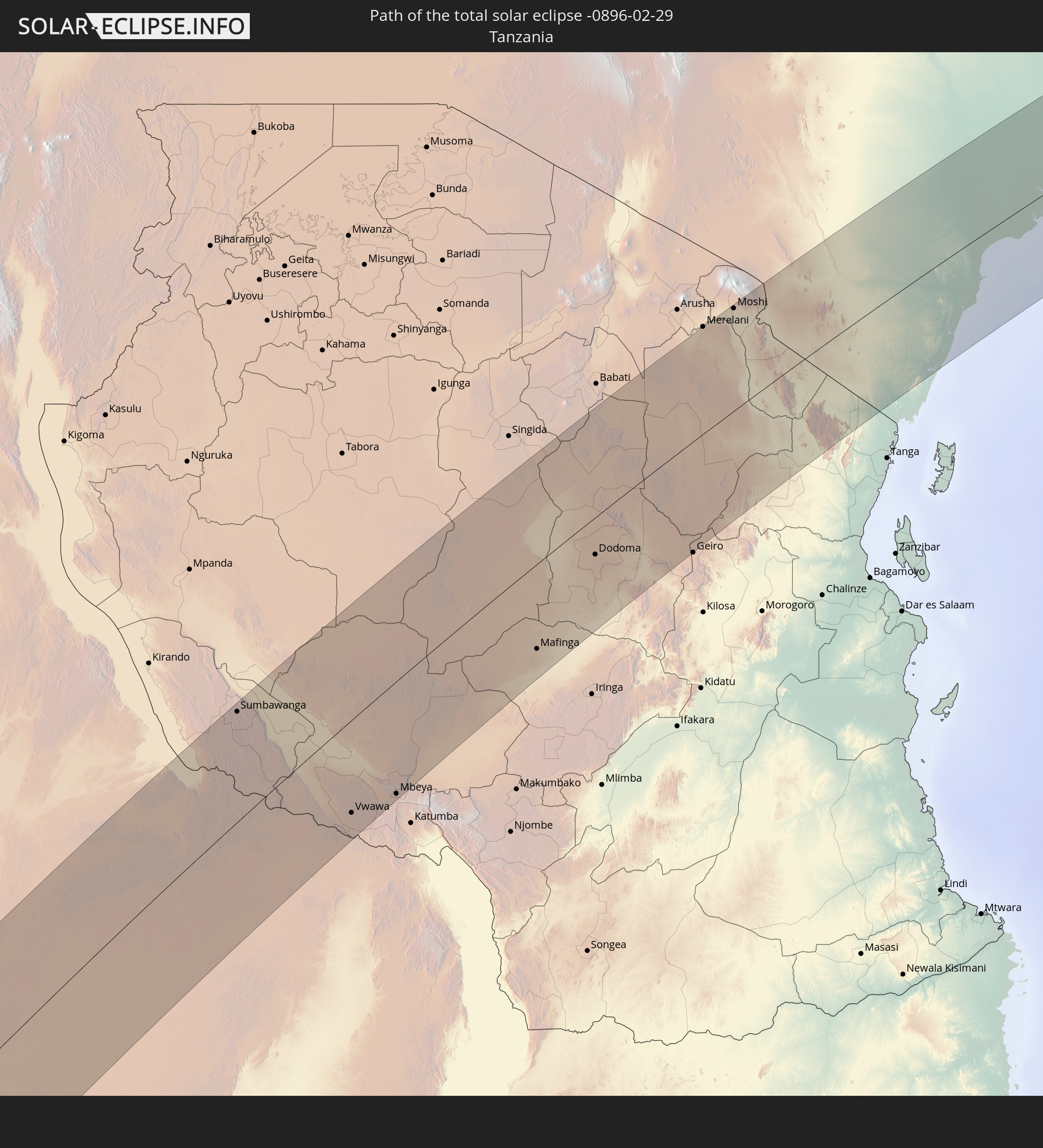 Tansania
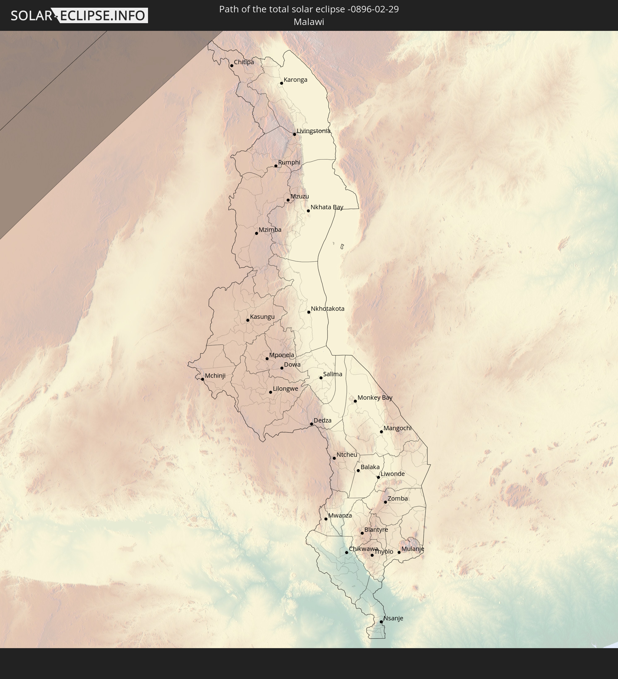 Malawi
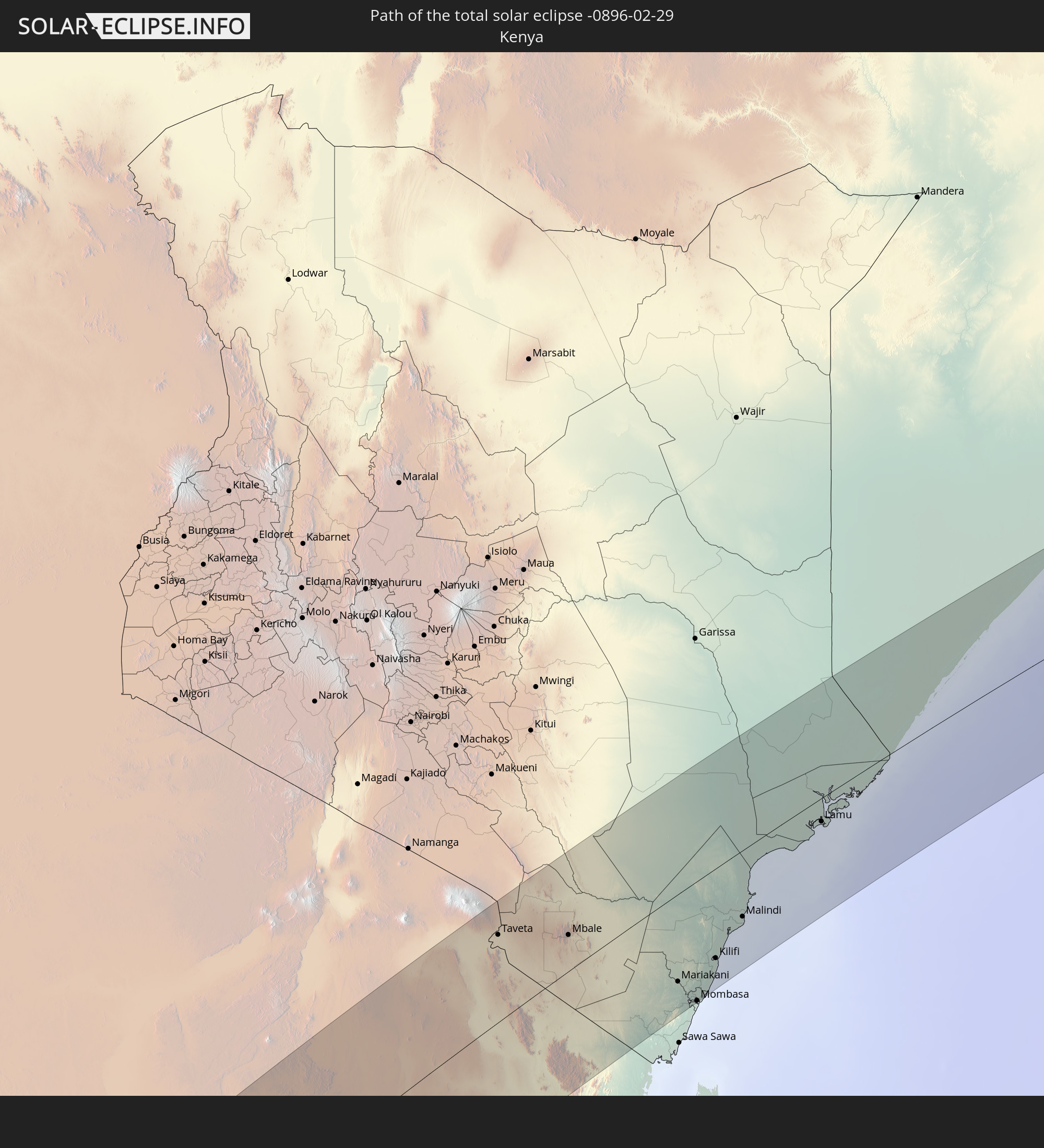 Kenia
Kenia
 Somalia
In den folgenden Ländern ist die Sonnenfinsternis partiell zu sehen
 Antarktika
 Chile
Chile
 Brasilien
 Argentinien
 Bolivien
 Paraguay
 Falklandinseln
 Uruguay
 Südgeorgien und die Südlichen Sandwichinseln
 St. Helena
 Niger
Niger
 Nigeria
 Bouvetinsel
 Äquatorialguinea
 São Tomé und Príncipe
 Kamerun
 Gabun
Gabun
 Libyen
 Republik Kongo
 Angola
 Namibia
 Demokratische Republik Kongo
 Tschad
 Zentralafrikanische Republik
 Südafrika
 Botswana
 Sudan
Sudan
 Sambia
 Ägypten
 Simbabwe
 Lesotho
 Ruanda
 Burundi
 Tansania
 Uganda
 Mosambik
 Swasiland
 Malawi
 Äthiopien
 Kenia
Kenia
 Staat Palästina
 Israel
 Saudi-Arabien
 Jordanien
 Eritrea
 Irak
Irak
 Französische Süd- und Antarktisgebiete
 Somalia
 Dschibuti
 Jemen
Jemen
 Madagaskar
 Komoren
 Iran
Iran
 Mayotte
 Seychellen
 Kuwait
 Bahrain
 Katar
Katar
 Vereinigte Arabische Emirate
 Oman
Oman
 Turkmenistan
 Réunion
 Mauritius
 Afghanistan
 Pakistan
 Britisches Territorium im Indischen Ozean
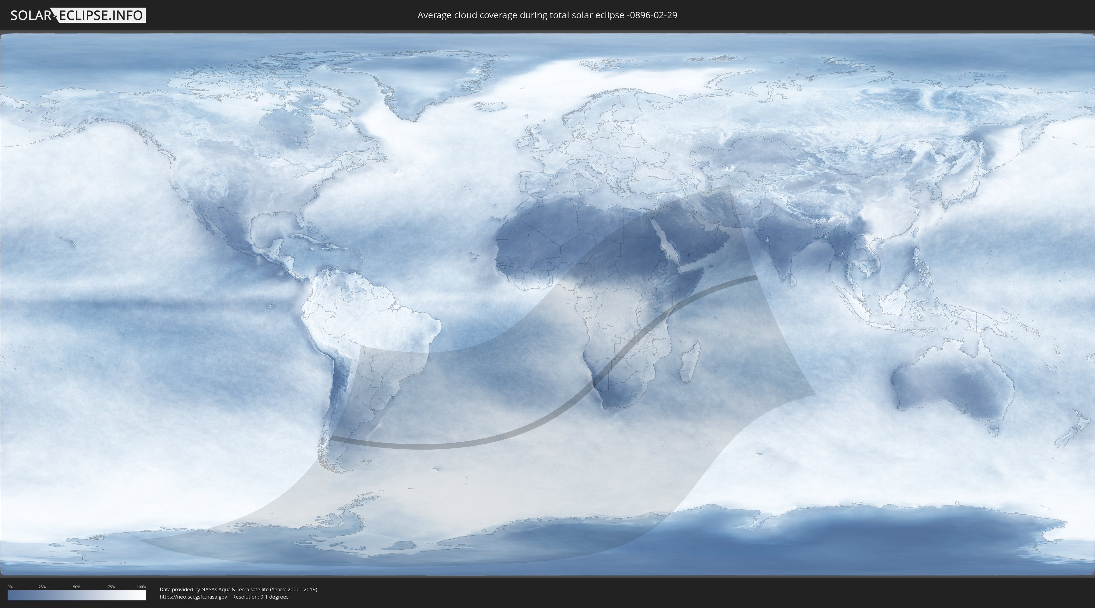
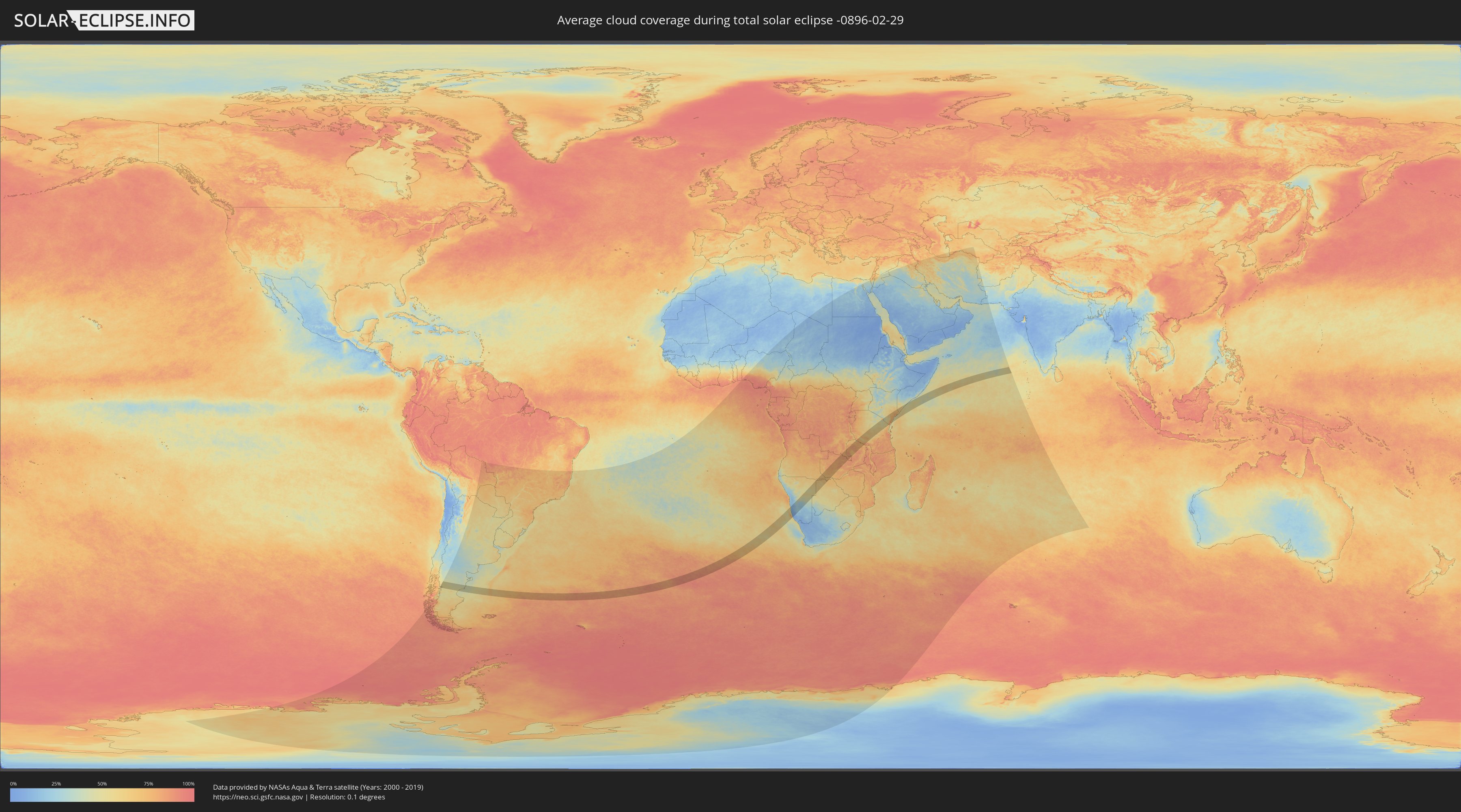
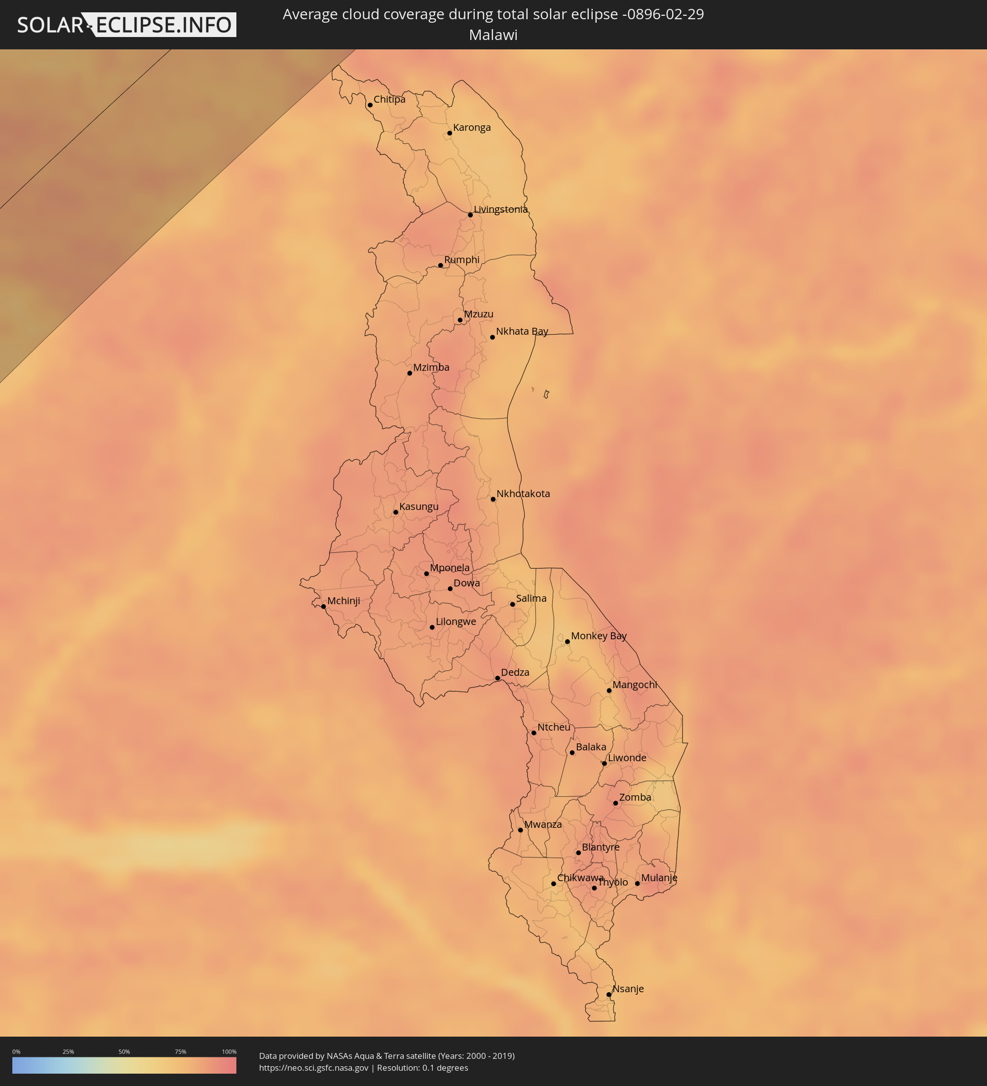
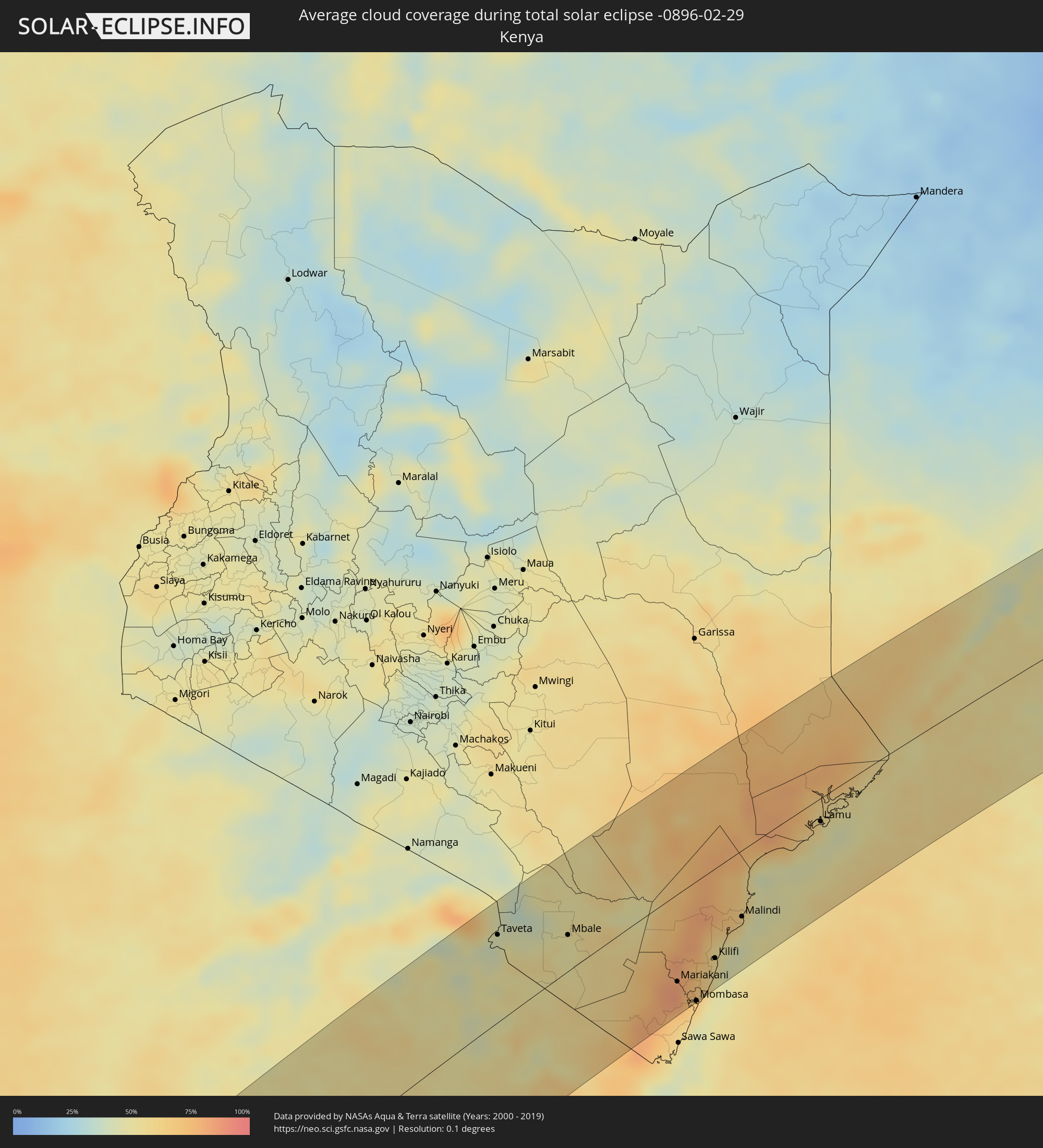
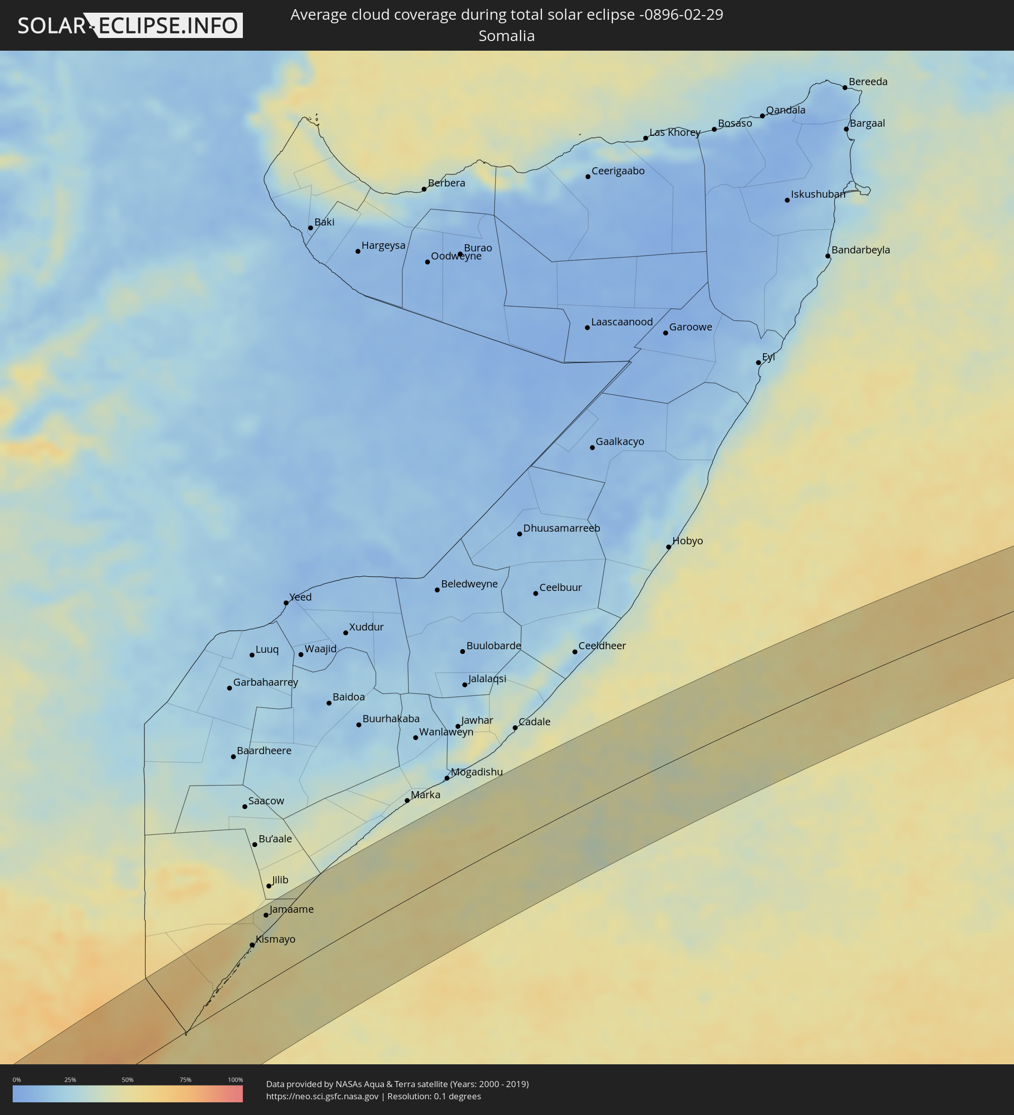
Wie wird das Wetter während der totalen Sonnenfinsternis am 29.02.-0896?
Wo ist der beste Ort, um die totale Sonnenfinsternis vom 29.02.-0896 zu beobachten?
Die folgenden Karten zeigen die durchschnittliche Bewölkung für den Tag, an dem die totale Sonnenfinsternis
stattfindet. Mit Hilfe der Karten lässt sich der Ort entlang des Finsternispfades eingrenzen,
der die besten Aussichen auf einen klaren wolkenfreien Himmel bietet.
Trotzdem muss man immer lokale Gegenenheiten beachten und sollte sich genau über das Wetter an seinem
gewählten Beobachtungsort informieren.
Die Daten stammen von den beiden NASA-Satelliten
AQUA und TERRA
und wurden über einen Zeitraum von 19 Jahren (2000 - 2019) gemittelt.
Detaillierte Länderkarten
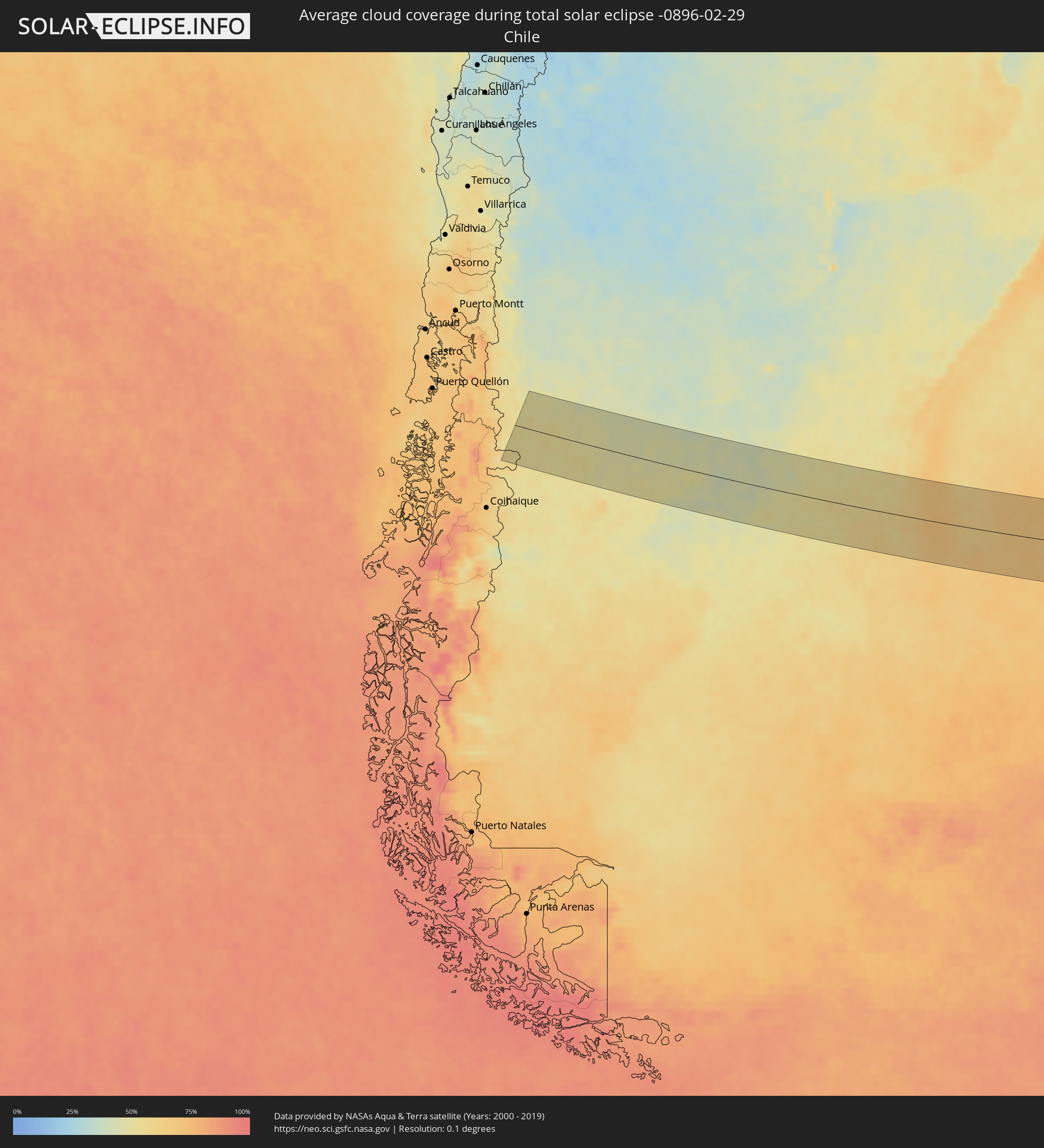 Chile
Chile
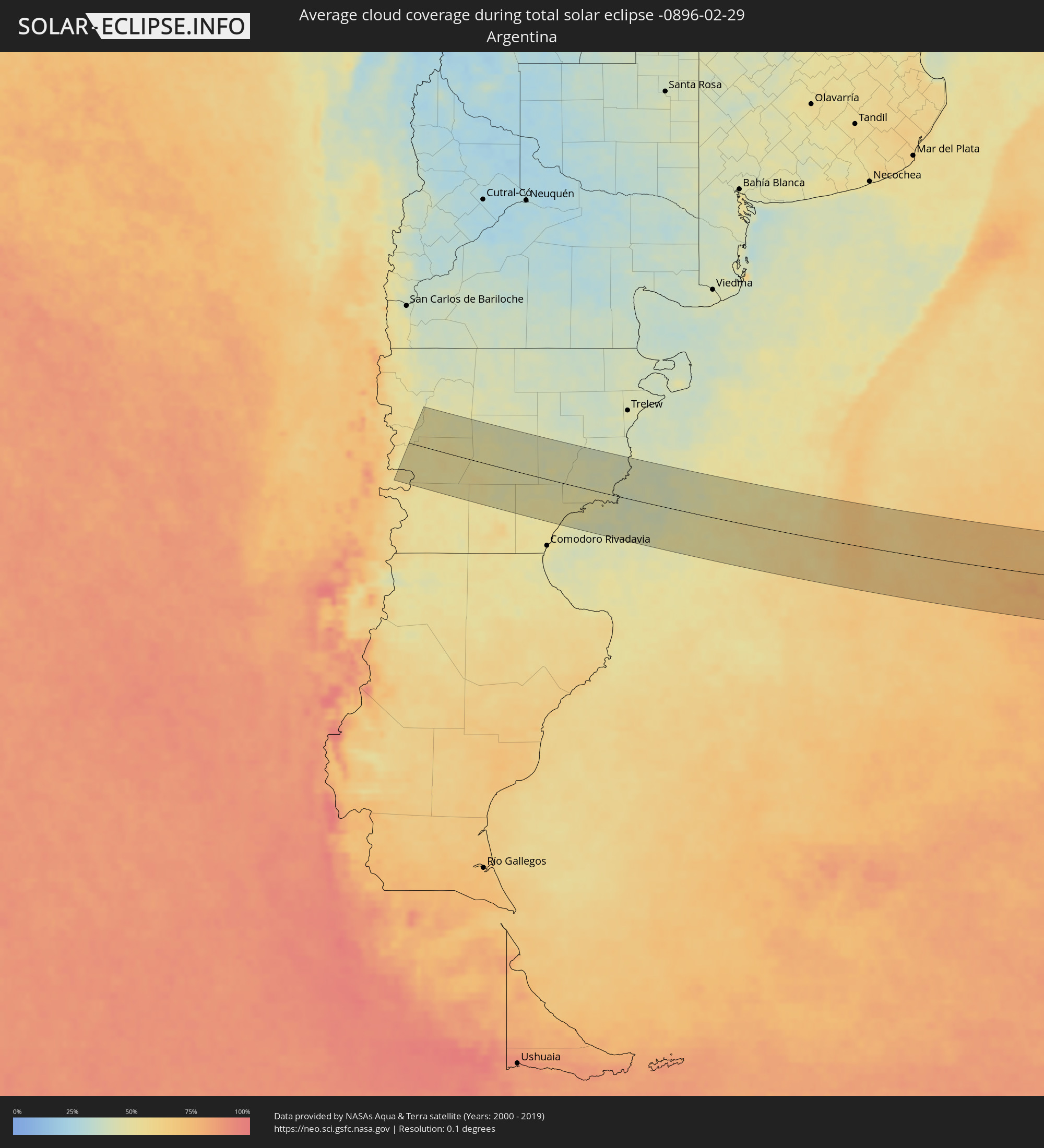 Argentinien
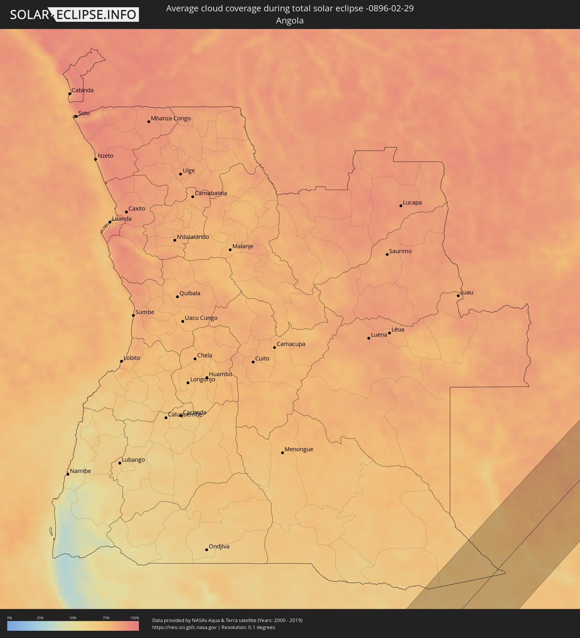 Angola
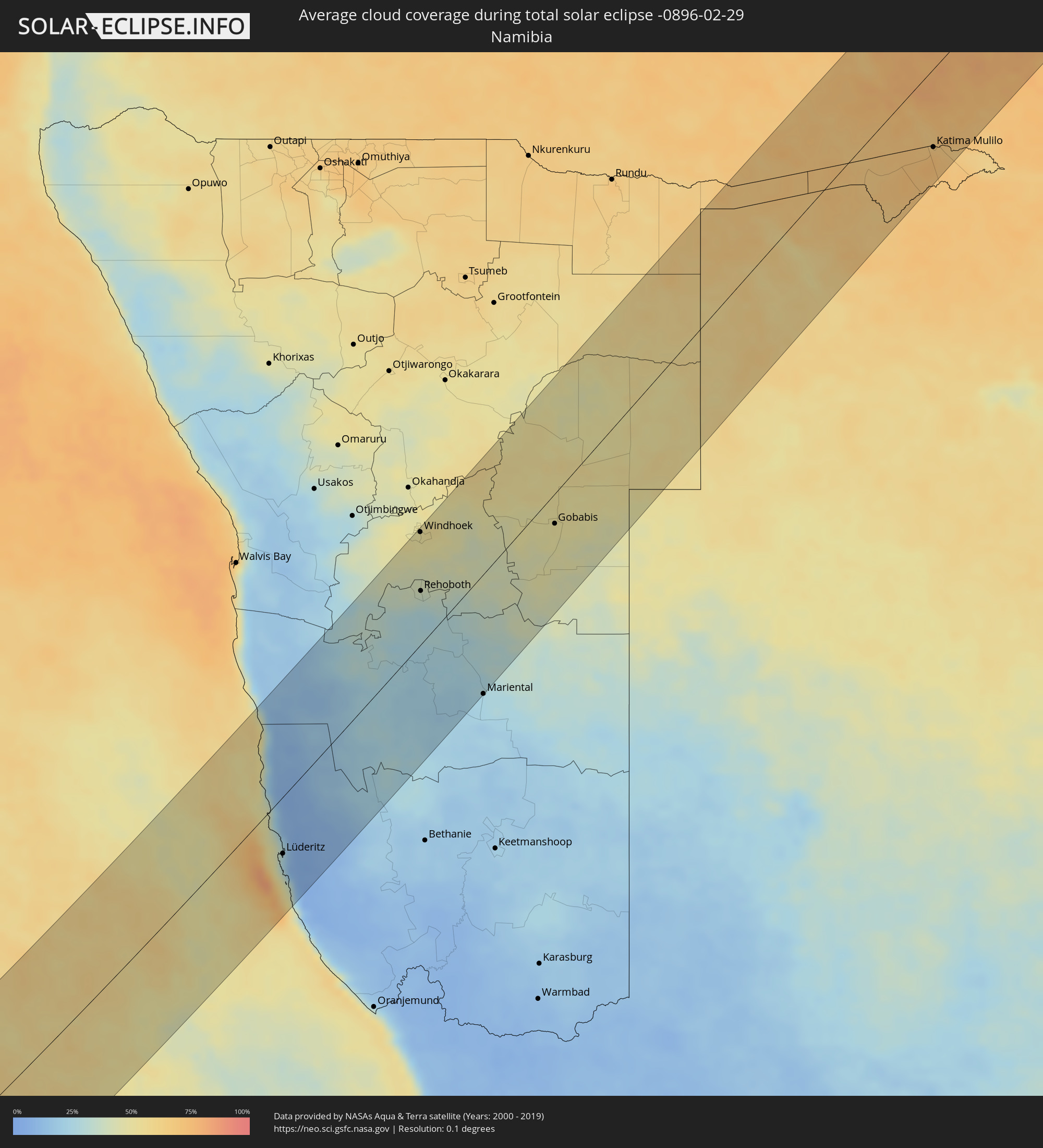 Namibia
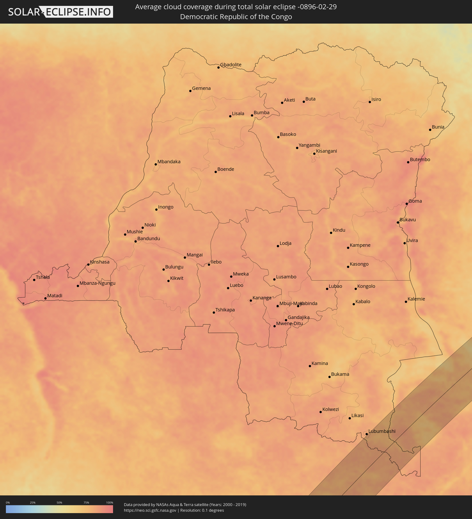 Demokratische Republik Kongo
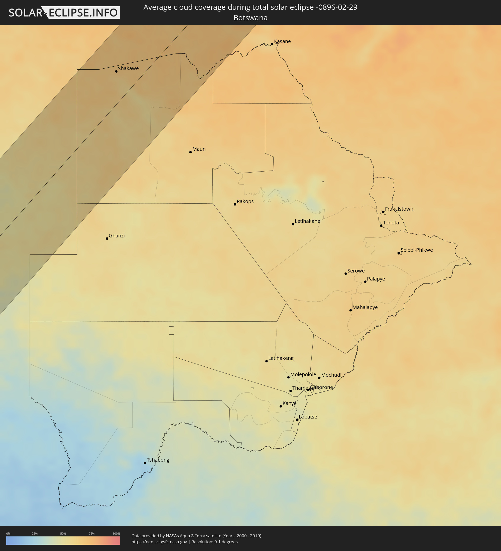 Botswana
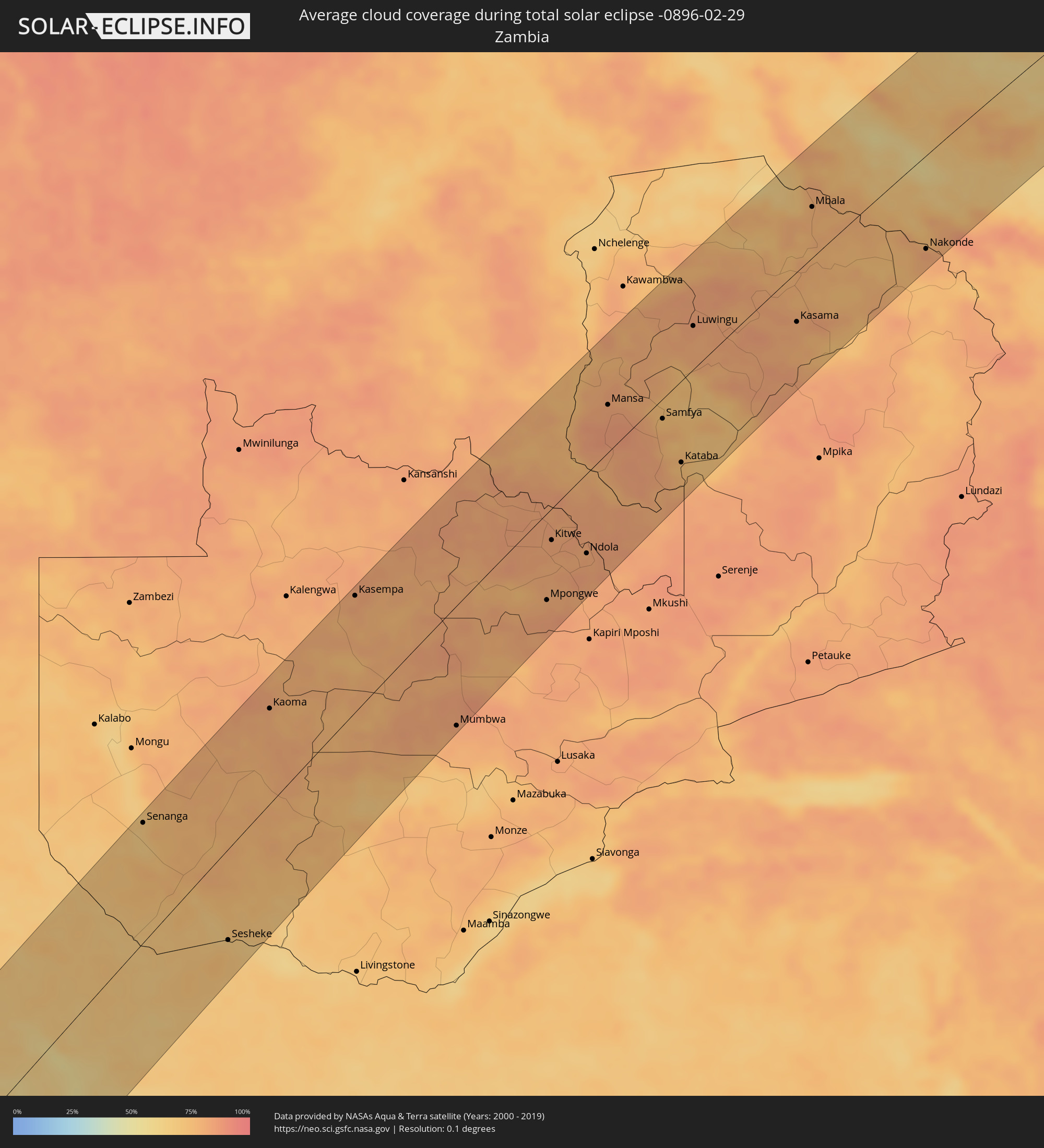 Sambia
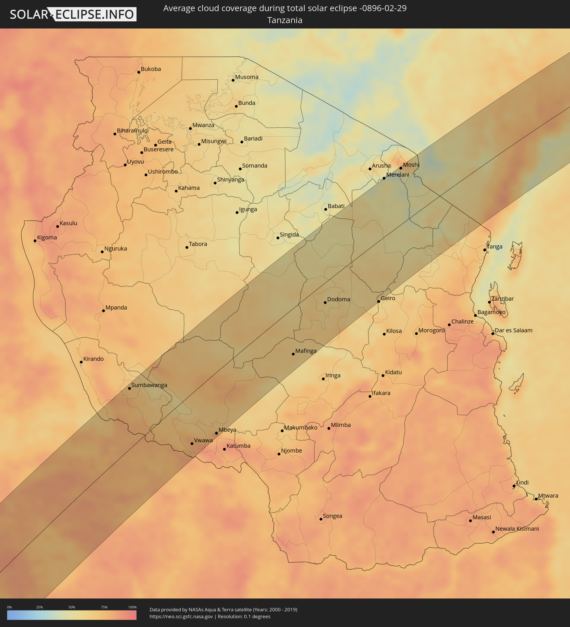 Tansania
 Malawi
 Kenia
Kenia
 Somalia
Orte im Finsternispfad
Die nachfolgene Tabelle zeigt Städte und Orte mit mehr als 5.000 Einwohnern, die sich im Finsternispfad befinden. Städte mit mehr als 100.000 Einwohnern sind dick gekennzeichnet. Mit einem Klick auf den Ort öffnet sich eine Detailkarte die die Lage des jeweiligen Ortes zusammen mit dem Verlauf der zentralen Finsternis präsentiert.
| Ort | Typ | Dauer der Verfinsterung | Ortszeit bei maximaler Verfinsterung | Entfernung zur Zentrallinie | Ø Bewölkung |
|
Lüderitz, Karas
|
total | - | 13:28:55 UTC+01:30 | 54 km | 12% |
|
Windhoek, Khomas
|
total | - | 13:39:54 UTC+01:30 | 108 km | 50% |
|
Rehoboth, Hardap
|
total | - | 13:38:26 UTC+01:30 | 51 km | 36% |
|
Gobabis, Omaheke
|
total | - | 13:43:06 UTC+01:30 | 29 km | 47% |
|
Shakawe, North-West
|
total | - | 14:35:53 UTC+02:10 | 48 km | 64% |
|
Senanga, Western
|
total | - | 14:42:24 UTC+02:10 | 104 km | 70% |
|
Katima Mulilo, Zambezi
|
total | - | 14:00:45 UTC+01:30 | 78 km | 70% |
|
Sesheke, Western
|
total | - | 14:41:10 UTC+02:10 | 79 km | 70% |
|
Kaoma, Western
|
total | - | 14:47:08 UTC+02:10 | 84 km | 80% |
|
Kasempa, North-Western
|
total | - | 14:51:05 UTC+02:10 | 105 km | 82% |
|
Mumbwa, Central
|
total | - | 14:49:46 UTC+02:10 | 108 km | 82% |
|
Kalulushi, Copperbelt
|
total | - | 14:55:09 UTC+02:10 | 23 km | 81% |
|
Mpongwe, Copperbelt
|
total | - | 14:53:58 UTC+02:10 | 80 km | 82% |
|
Kitwe, Copperbelt
|
total | - | 14:55:23 UTC+02:10 | 29 km | 82% |
|
Mufulira, Copperbelt
|
total | - | 14:55:53 UTC+02:10 | 12 km | 83% |
|
Luanshya, Copperbelt
|
total | - | 14:55:00 UTC+02:10 | 71 km | 82% |
|
Ndola, Copperbelt
|
total | - | 14:55:37 UTC+02:10 | 74 km | 82% |
|
Mansa, Luapula
|
total | - | 14:59:12 UTC+02:10 | 45 km | 82% |
|
Samfya, Luapula
|
total | - | 14:59:41 UTC+02:10 | 19 km | 75% |
|
Kataba, Copperbelt
|
total | - | 14:59:00 UTC+02:10 | 77 km | 73% |
|
Luwingu, Northern
|
total | - | 15:02:08 UTC+02:10 | 42 km | 82% |
|
Mpulungu, Northern
|
total | - | 15:06:10 UTC+02:10 | 75 km | 71% |
|
Kasama, Northern
|
total | - | 15:03:40 UTC+02:10 | 49 km | 80% |
|
Mbala, Northern
|
total | - | 15:06:18 UTC+02:10 | 50 km | 78% |
|
Mungwi, Northern
|
total | - | 15:03:57 UTC+02:10 | 60 km | 82% |
|
Matai, Rukwa
|
total | - | 15:24:21 UTC+02:27 | 83 km | 73% |
|
Sumbawanga, Rukwa
|
total | - | 15:25:02 UTC+02:27 | 104 km | 71% |
|
Laela, Rukwa
|
total | - | 15:24:28 UTC+02:27 | 22 km | 68% |
|
Nakonde, Muchinga Province
|
total | - | 15:06:56 UTC+02:10 | 93 km | 82% |
|
Tunduma, Mbeya
|
total | - | 15:23:58 UTC+02:27 | 91 km | 81% |
|
Vwawa, Mbeya
|
total | - | 15:24:28 UTC+02:27 | 88 km | 80% |
|
Mlowo, Mbeya
|
total | - | 15:24:43 UTC+02:27 | 82 km | 80% |
|
Mbeya, Mbeya
|
total | - | 15:25:23 UTC+02:27 | 108 km | 77% |
|
Mgandu, Singida
|
total | - | 15:31:02 UTC+02:27 | 94 km | 67% |
|
Dunda, Mbeya
|
total | - | 15:27:33 UTC+02:27 | 99 km | 65% |
|
Itigi, Singida
|
total | - | 15:31:47 UTC+02:27 | 91 km | 61% |
|
Mafinga, Iringa
|
total | - | 15:29:49 UTC+02:27 | 83 km | 61% |
|
Kintinku, Singida
|
total | - | 15:32:13 UTC+02:27 | 23 km | 64% |
|
Dodoma, Dodoma
|
total | - | 15:32:14 UTC+02:27 | 37 km | 59% |
|
Kondoa, Dodoma
|
total | - | 15:34:18 UTC+02:27 | 71 km | 52% |
|
Kisasa, Dodoma
|
total | - | 15:32:16 UTC+02:27 | 41 km | 59% |
|
Kongwa, Dodoma
|
total | - | 15:32:49 UTC+02:27 | 86 km | 62% |
|
Mpwapwa, Dodoma
|
total | - | 15:32:38 UTC+02:27 | 104 km | 58% |
|
Naberera, Manyara
|
total | - | 15:36:25 UTC+02:27 | 56 km | 51% |
|
Merelani, Arusha
|
total | - | 15:37:26 UTC+02:27 | 110 km | 53% |
|
Moshi, Kilimanjaro
|
total | - | 15:38:04 UTC+02:27 | 105 km | 44% |
|
Lembeni, Kilimanjaro
|
total | - | 15:37:39 UTC+02:27 | 48 km | 48% |
|
Taveta
|
total | - | 15:38:17 UTC+02:27 | 78 km | 43% |
|
Kwakoa, Kilimanjaro
|
total | - | 15:37:46 UTC+02:27 | 43 km | 46% |
|
Same, Kilimanjaro
|
total | - | 15:37:19 UTC+02:27 | 15 km | 46% |
|
Makanya, Kilimanjaro
|
total | - | 15:36:57 UTC+02:27 | 19 km | 50% |
|
Mwembe, Kilimanjaro
|
total | - | 15:37:18 UTC+02:27 | 0 km | 57% |
|
Hedaru, Kilimanjaro
|
total | - | 15:36:48 UTC+02:27 | 35 km | 53% |
|
Ndungu, Kilimanjaro
|
total | - | 15:37:08 UTC+02:27 | 33 km | 47% |
|
Kihurio, Kilimanjaro
|
total | - | 15:37:00 UTC+02:27 | 43 km | 45% |
|
Makuyuni, Tanga
|
total | - | 15:36:37 UTC+02:27 | 69 km | 56% |
|
Mwanga, Tanga
|
total | - | 15:36:36 UTC+02:27 | 82 km | 61% |
|
Mazinde, Tanga
|
total | - | 15:36:37 UTC+02:27 | 83 km | 61% |
|
Matui, Tanga
|
total | - | 15:36:39 UTC+02:27 | 85 km | 64% |
|
Lushoto, Tanga
|
total | - | 15:36:42 UTC+02:27 | 86 km | 64% |
|
Wundanyi, Taita Taveta
|
total | - | 15:38:51 UTC+02:27 | 34 km | 48% |
|
Soni, Tanga
|
total | - | 15:36:40 UTC+02:27 | 97 km | 68% |
|
Mbale, Vihiga
|
total | - | 15:38:52 UTC+02:27 | 33 km | 48% |
|
Voi, Taita Taveta
|
total | - | 15:39:01 UTC+02:27 | 22 km | 56% |
|
Kinango, Kwale
|
total | - | 15:38:32 UTC+02:27 | 94 km | 81% |
|
Kwale, Kwale
|
total | - | 15:38:36 UTC+02:27 | 106 km | 64% |
|
Mariakani, Kwale
|
total | - | 15:39:04 UTC+02:27 | 79 km | 85% |
|
Mombasa, Mombasa
|
total | - | 15:38:56 UTC+02:27 | 109 km | 55% |
|
Kilifi, Kilifi
|
total | - | 15:39:43 UTC+02:27 | 82 km | 65% |
|
Takaungu, Kilifi
|
total | - | 15:39:39 UTC+02:27 | 87 km | 49% |
|
Hola, Tana River
|
total | - | 15:42:56 UTC+02:27 | 105 km | 67% |
|
Malindi, Kilifi
|
total | - | 15:40:32 UTC+02:27 | 61 km | 61% |
|
Witu, Lamu
|
total | - | 15:41:58 UTC+02:27 | 4 km | 76% |
|
Lamu, Lamu
|
total | - | 15:42:28 UTC+02:27 | 22 km | 54% |
|
Kismayo, Lower Juba
|
total | - | 15:46:14 UTC+02:27 | 61 km | 53% |
|
Jamaame, Lower Juba
|
total | - | 15:46:55 UTC+02:27 | 91 km | 44% |