Totale Sonnenfinsternis vom 22.05.-0947
| Wochentag: | Freitag |
| Maximale Dauer der Verfinsterung: | 05m25s |
| Maximale Breite des Finsternispfades: | 314 km |
| Saroszyklus: | 32 |
| Bedeckungsgrad: | 100% |
| Magnitude: | 1.078 |
| Gamma: | 0.594 |
Wo kann man die Sonnenfinsternis vom 22.05.-0947 sehen?
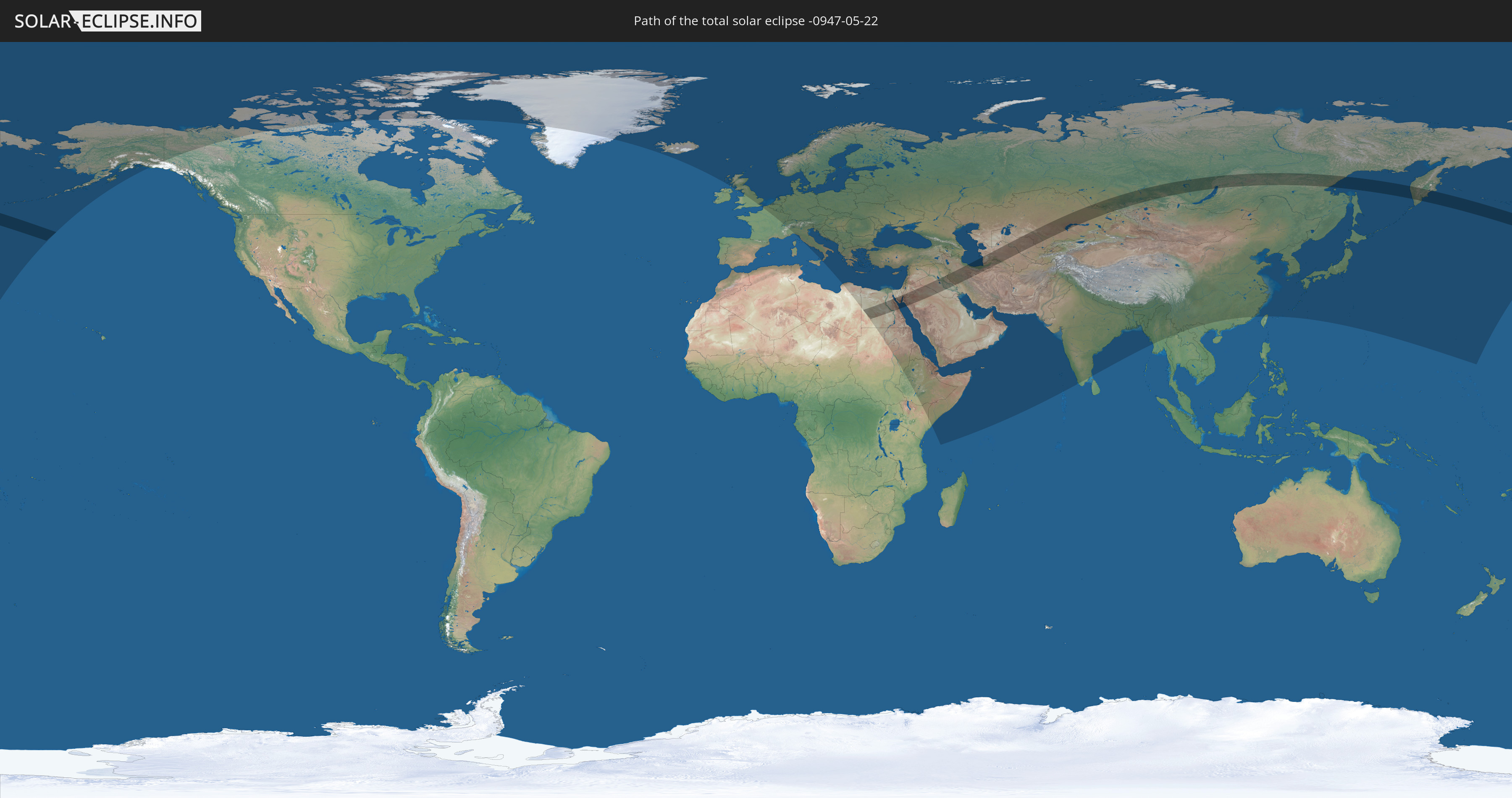
Die Sonnenfinsternis am 22.05.-0947 kann man in 95 Ländern als partielle Sonnenfinsternis beobachten.
Der Finsternispfad verläuft durch 10 Länder. Nur in diesen Ländern ist sie als totale Sonnenfinsternis zu sehen.
In den folgenden Ländern ist die Sonnenfinsternis total zu sehen
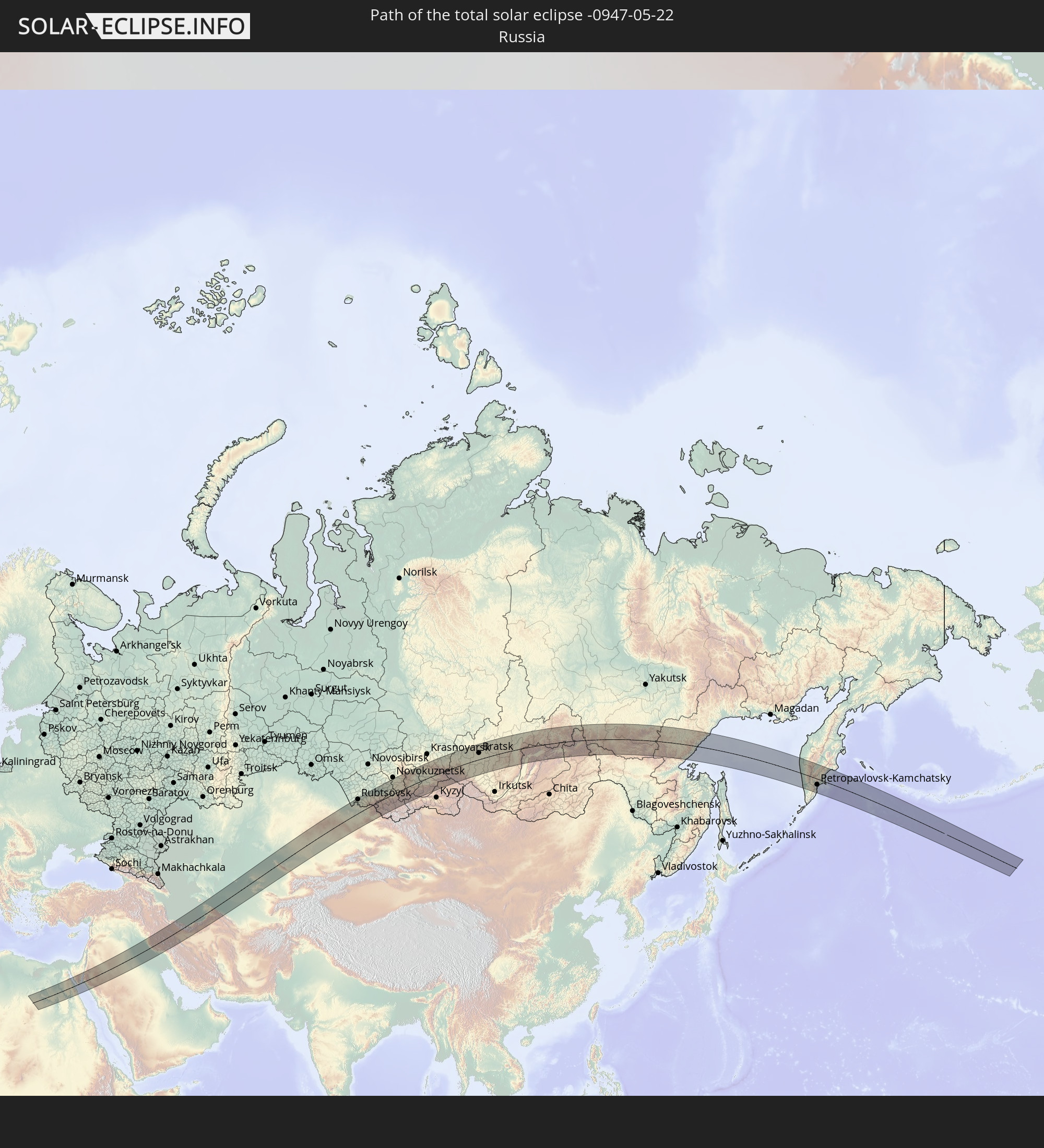 Russland
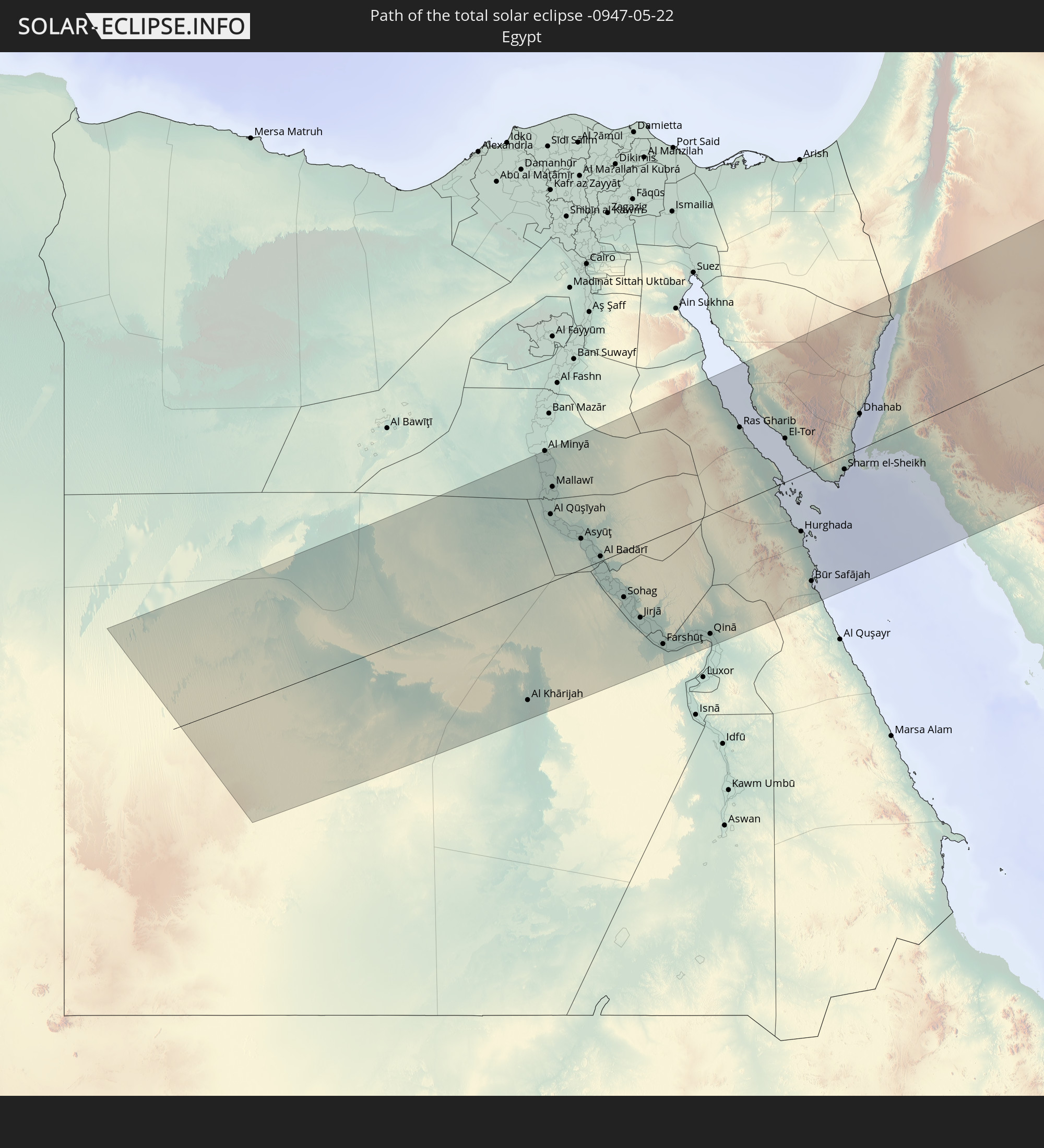 Ägypten
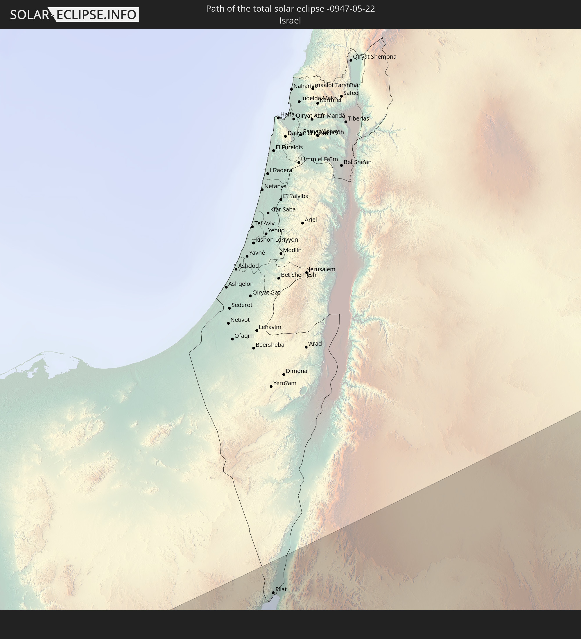 Israel
 Saudi-Arabien
 Jordanien
 Irak
Irak
 Iran
Iran
 Kasachstan
 Turkmenistan
 Usbekistan
In den folgenden Ländern ist die Sonnenfinsternis partiell zu sehen
 Russland
 Vereinigte Staaten
 United States Minor Outlying Islands
 Kanada
 Grönland
 Island
 Spitzbergen
 Vereinigtes Königreich
 Färöer
 Frankreich
 Belgien
 Niederlande
 Norwegen
 Luxemburg
 Deutschland
 Schweiz
 Italien
 Dänemark
 Libyen
 Liechtenstein
 Österreich
 Schweden
 Tschechien
 San Marino
 Vatikanstadt
 Slowenien
 Kroatien
 Polen
Polen
 Bosnien und Herzegowina
 Ungarn
 Slowakei
 Montenegro
 Serbien
 Albanien
 Åland Islands
 Griechenland
 Rumänien
 Mazedonien
 Finnland
 Litauen
 Lettland
 Estland
 Sudan
Sudan
 Ukraine
 Bulgarien
 Weißrussland
 Ägypten
 Türkei
 Moldawien
 Republik Zypern
 Äthiopien
 Kenia
Kenia
 Staat Palästina
 Israel
 Saudi-Arabien
 Jordanien
 Libanon
 Syrien
 Eritrea
 Irak
Irak
 Georgien
 Somalia
 Dschibuti
 Jemen
Jemen
 Armenien
 Iran
Iran
 Aserbaidschan
 Kasachstan
 Kuwait
 Bahrain
 Katar
Katar
 Vereinigte Arabische Emirate
 Oman
Oman
 Turkmenistan
 Usbekistan
 Afghanistan
 Pakistan
 Tadschikistan
 Indien
 Kirgisistan
 Malediven
 Volksrepublik China
 Nepal
Nepal
 Mongolei
 Bangladesch
 Bhutan
 Myanmar
 Thailand
 Laos
Laos
 Vietnam
 Taiwan
 Japan
Japan
 Nordkorea
 Südkorea
 Marshallinseln
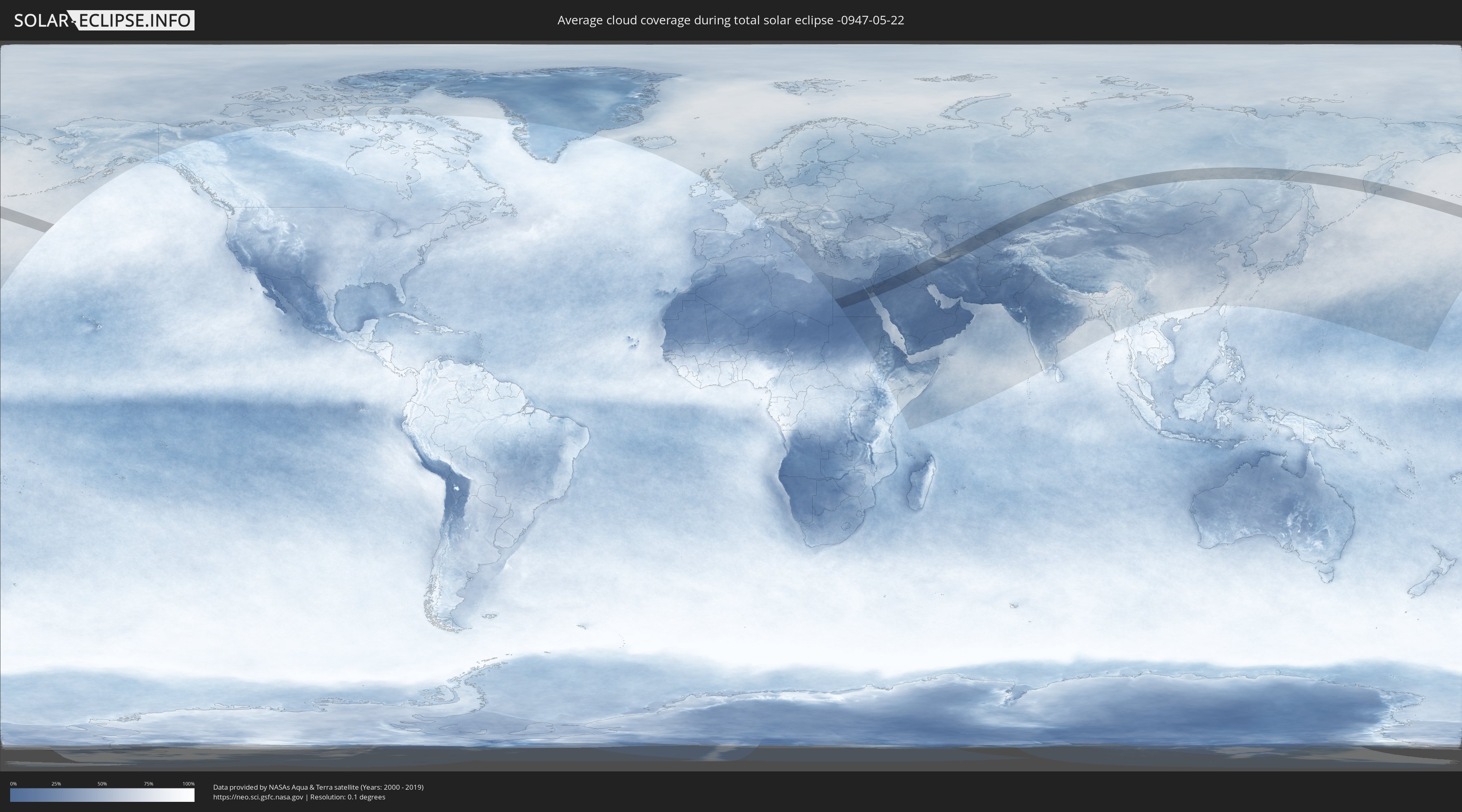
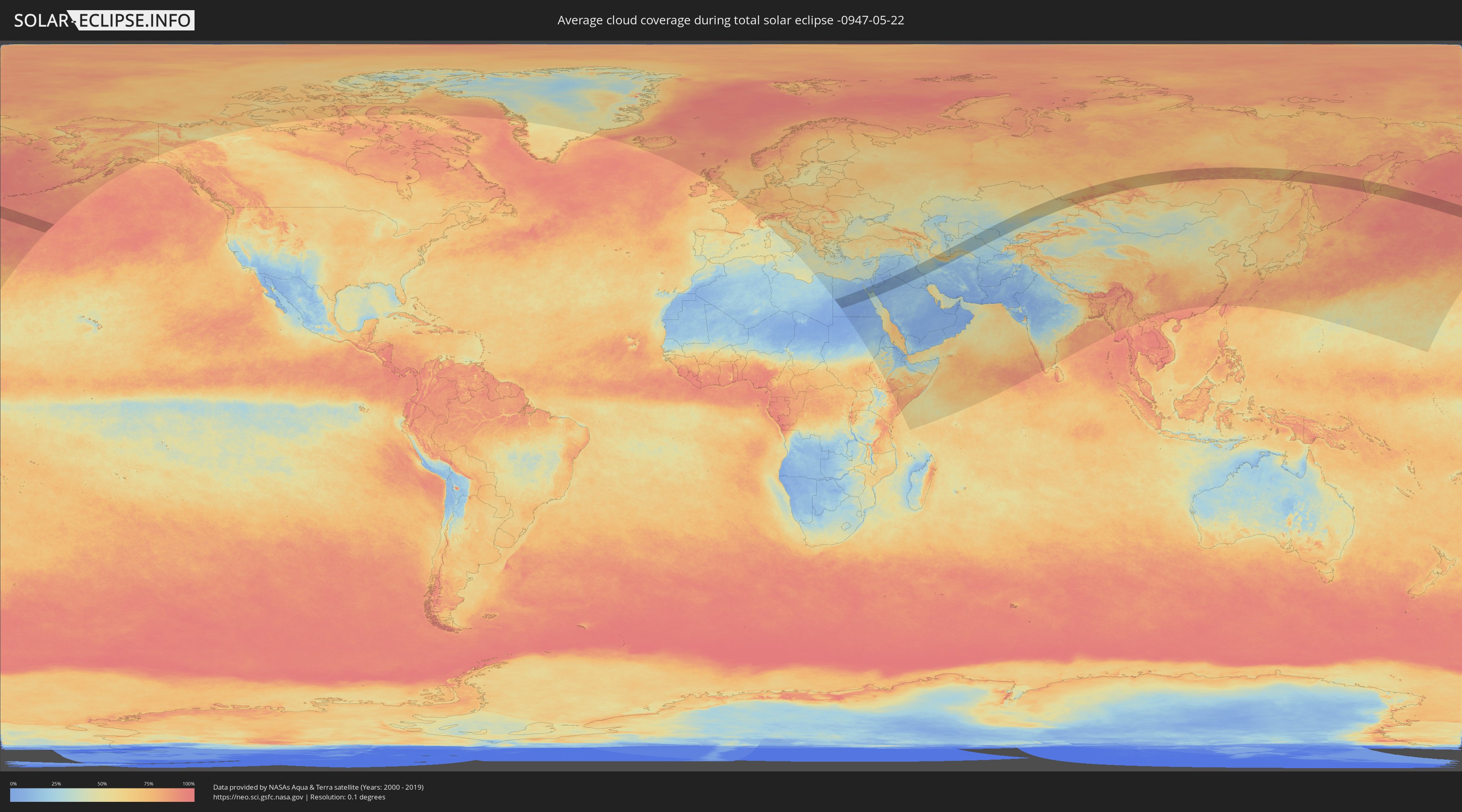
Wie wird das Wetter während der totalen Sonnenfinsternis am 22.05.-0947?
Wo ist der beste Ort, um die totale Sonnenfinsternis vom 22.05.-0947 zu beobachten?
Die folgenden Karten zeigen die durchschnittliche Bewölkung für den Tag, an dem die totale Sonnenfinsternis
stattfindet. Mit Hilfe der Karten lässt sich der Ort entlang des Finsternispfades eingrenzen,
der die besten Aussichen auf einen klaren wolkenfreien Himmel bietet.
Trotzdem muss man immer lokale Gegenenheiten beachten und sollte sich genau über das Wetter an seinem
gewählten Beobachtungsort informieren.
Die Daten stammen von den beiden NASA-Satelliten
AQUA und TERRA
und wurden über einen Zeitraum von 19 Jahren (2000 - 2019) gemittelt.
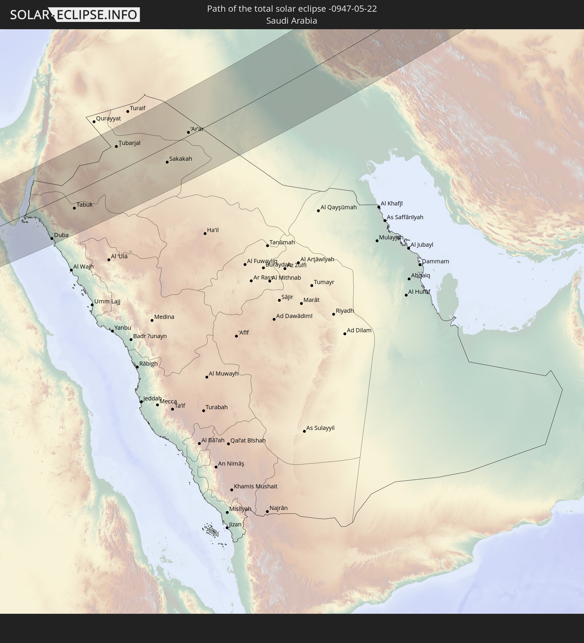
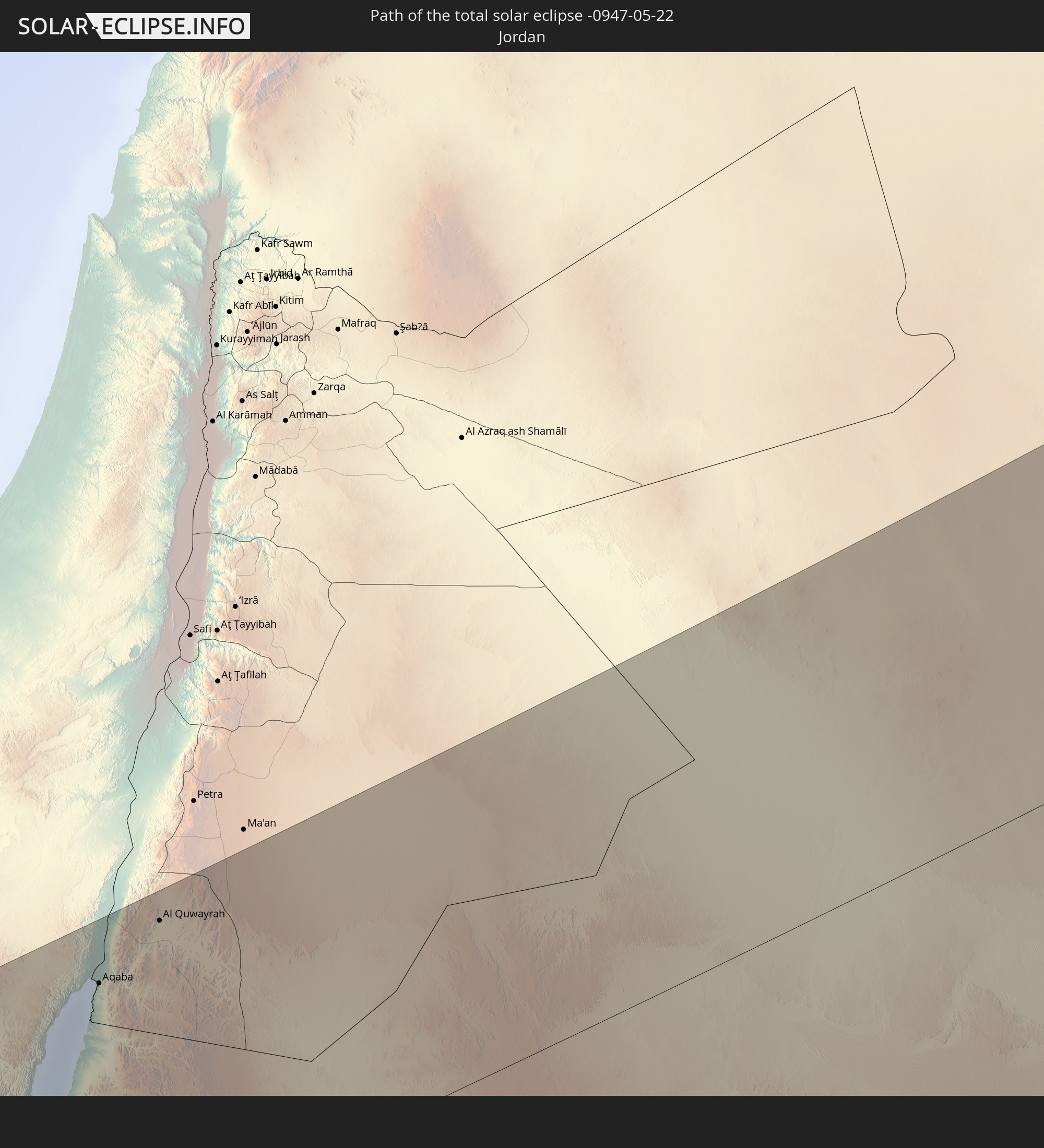
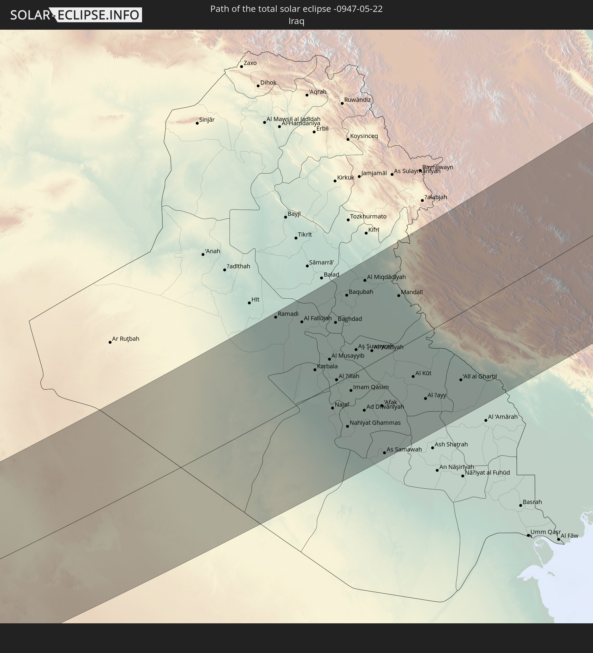
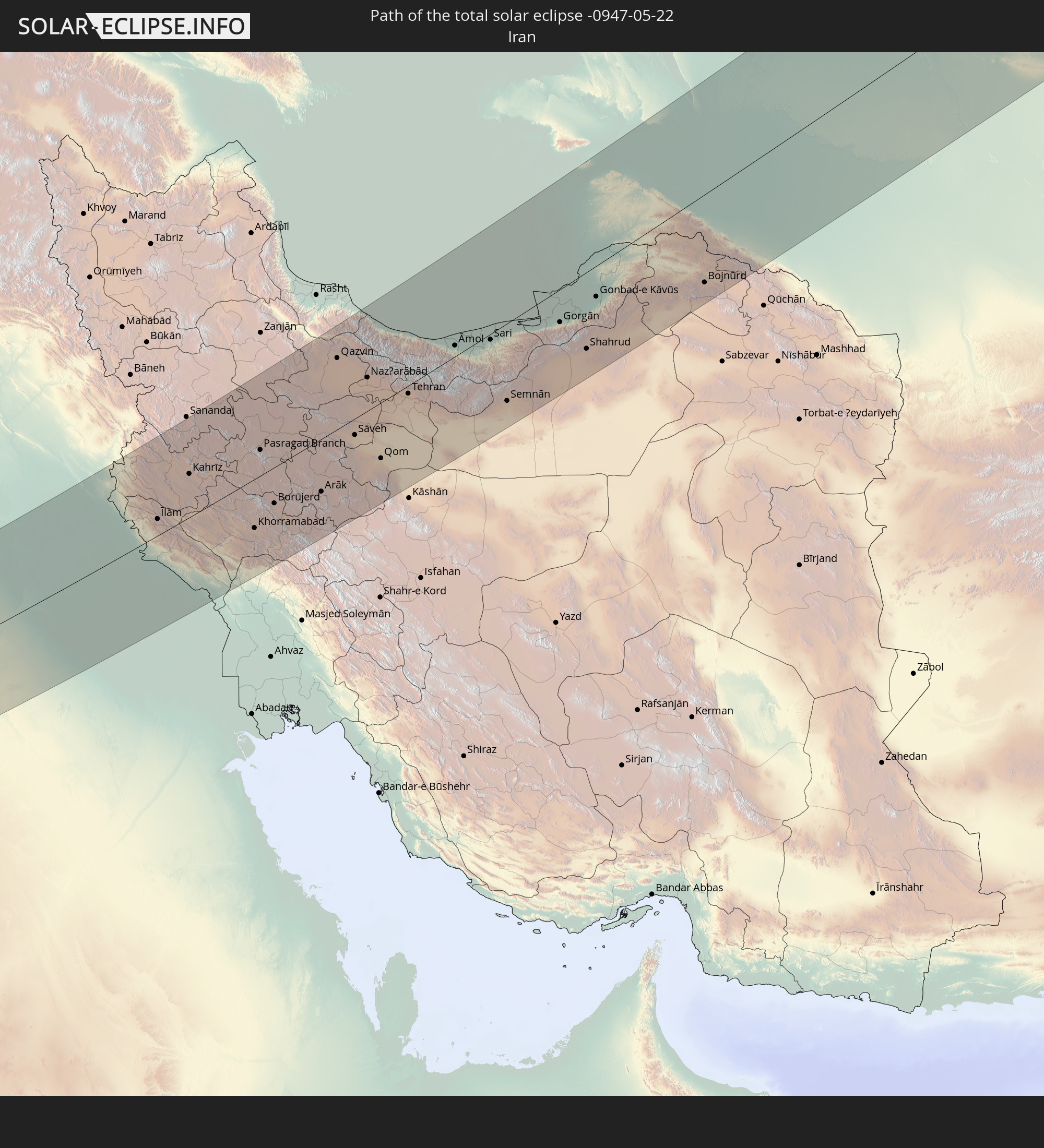
Detaillierte Länderkarten
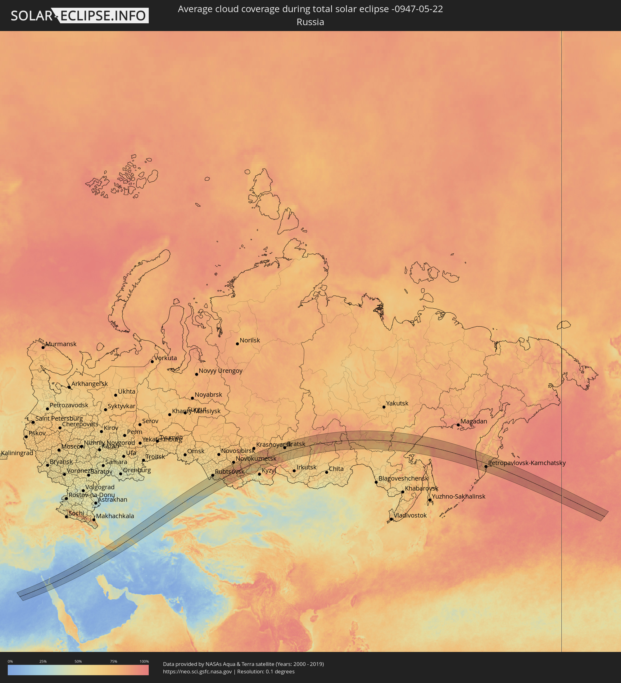 Russland
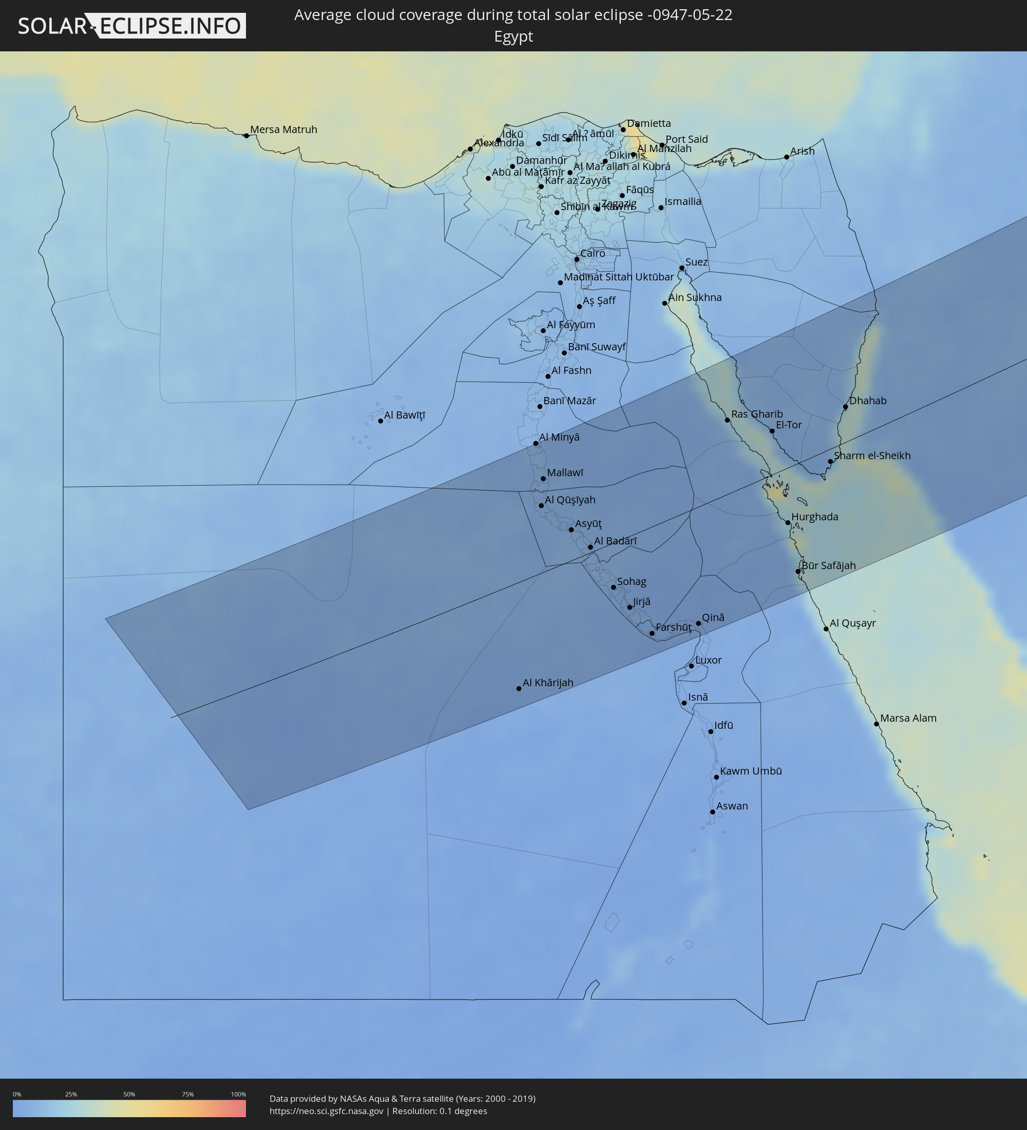 Ägypten
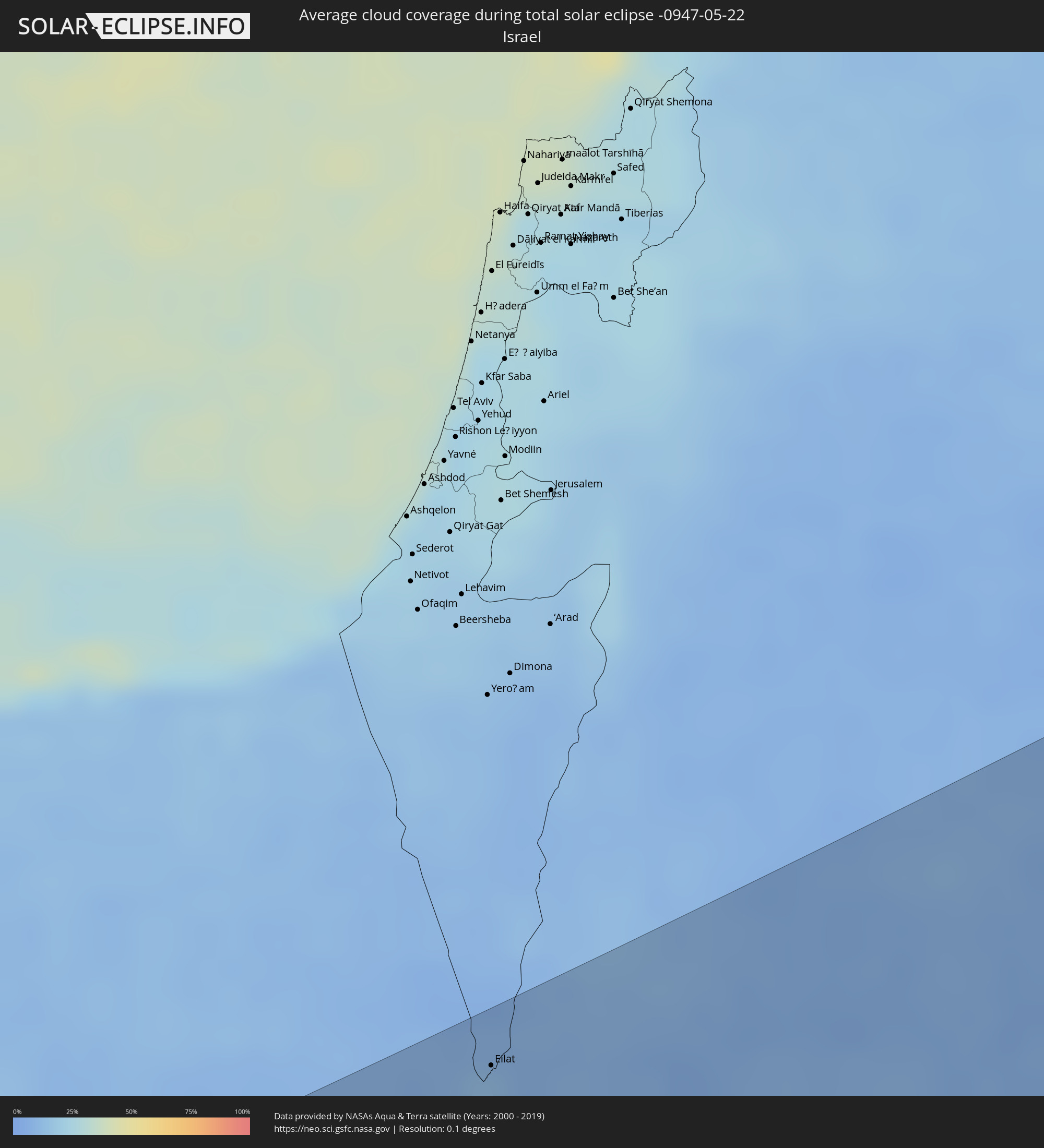 Israel
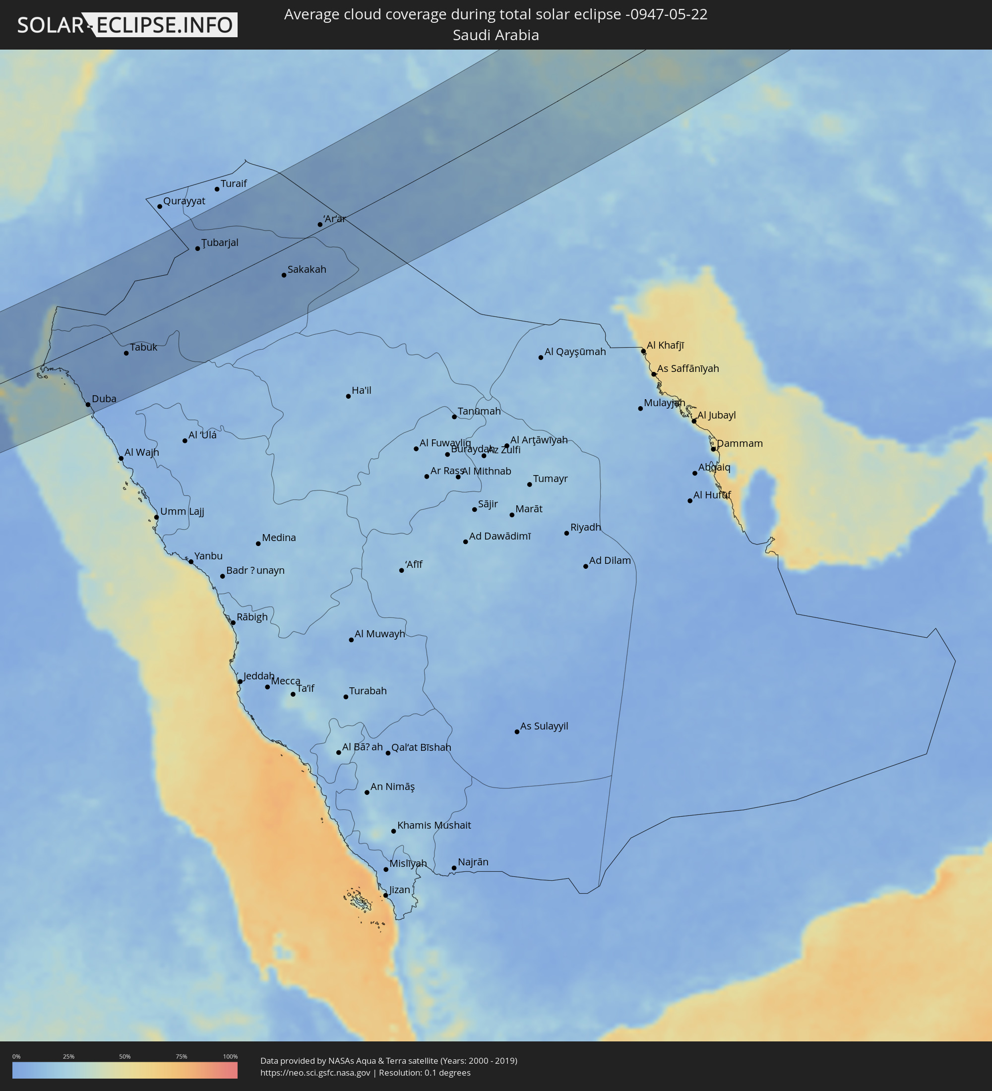 Saudi-Arabien
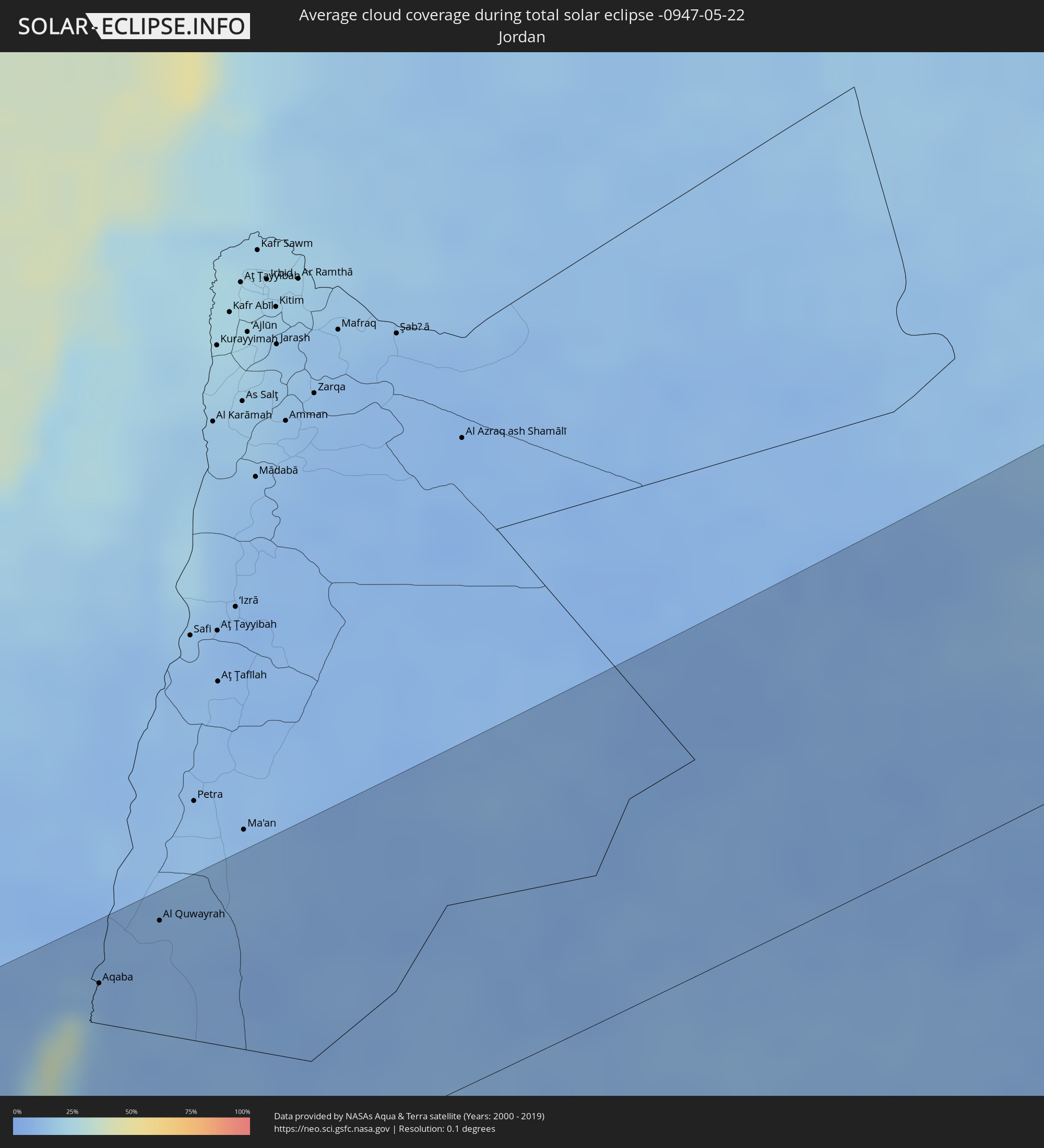 Jordanien
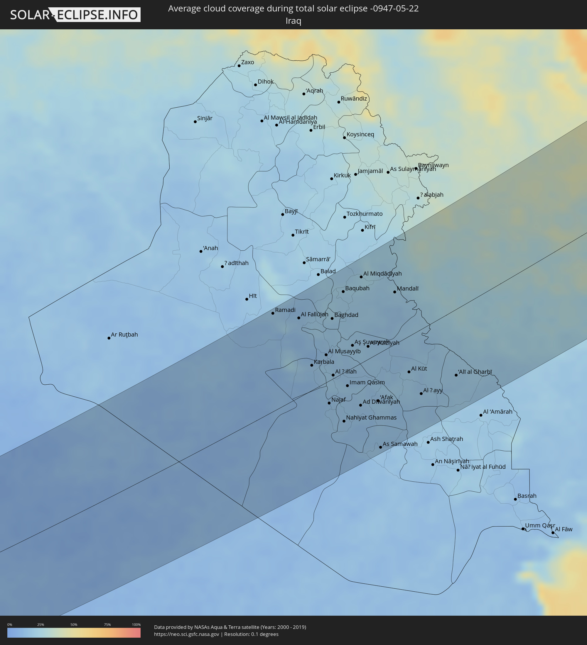 Irak
Irak
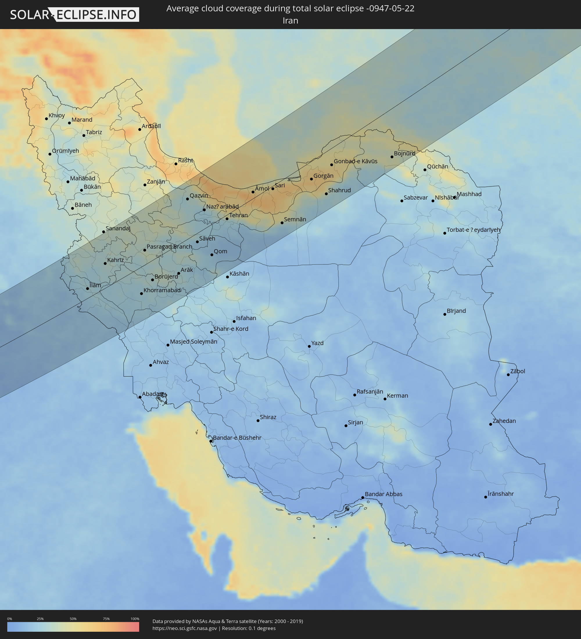 Iran
Iran
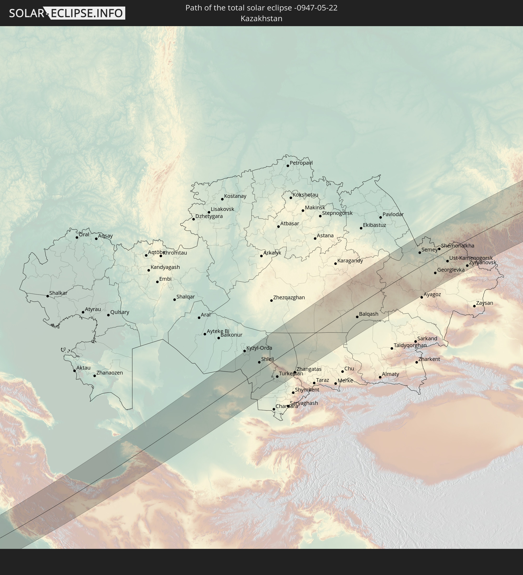
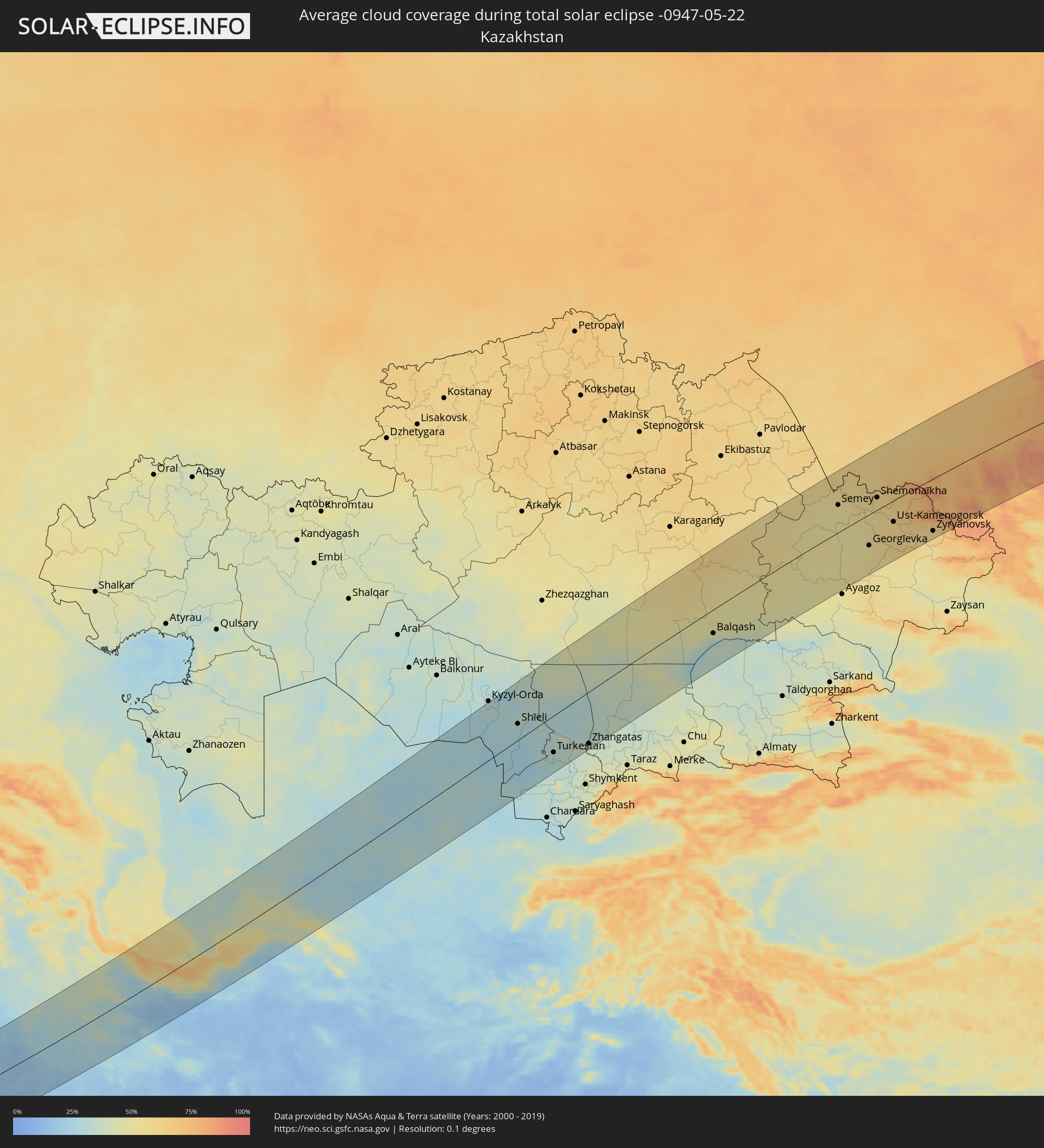 Kasachstan
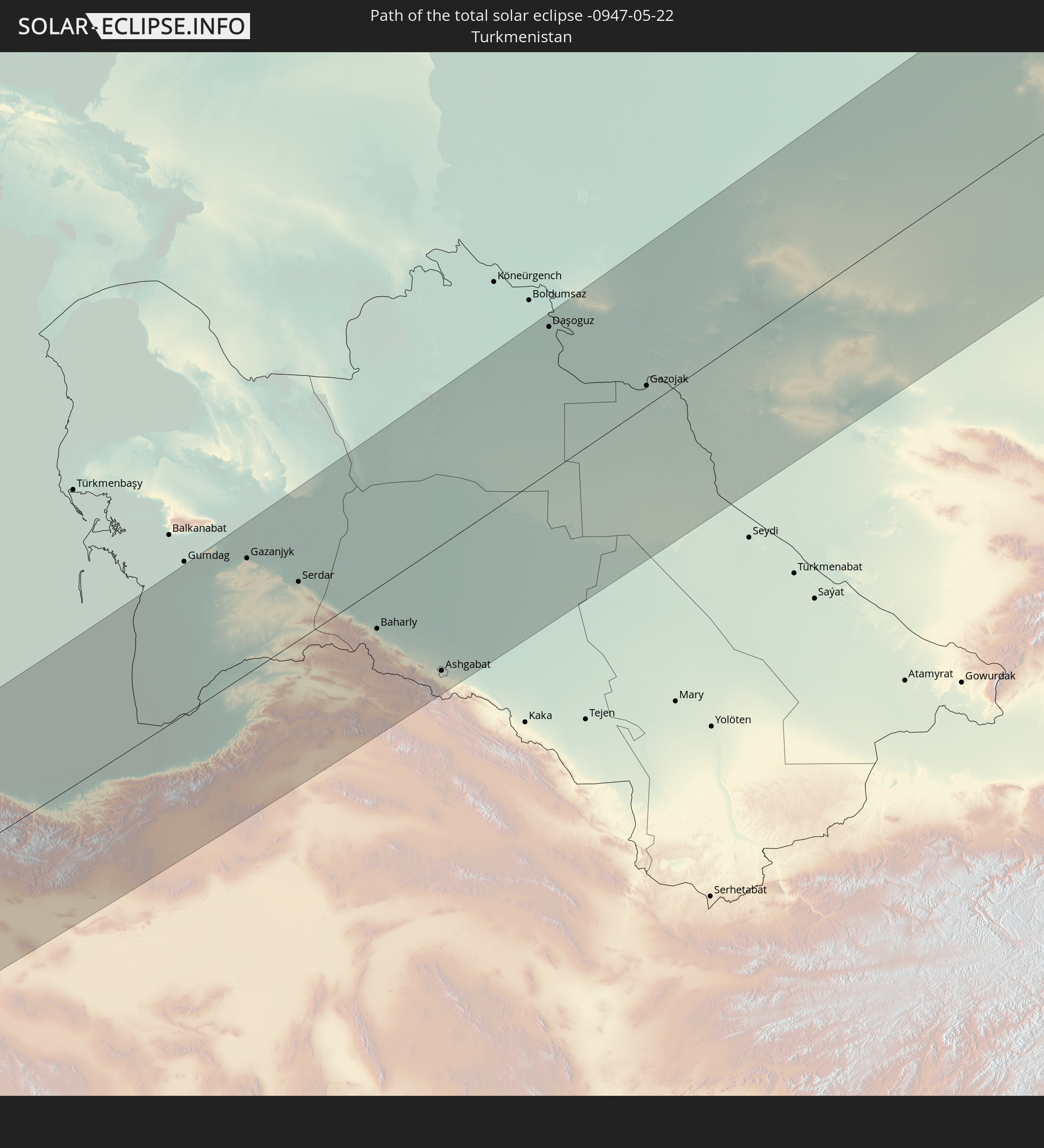
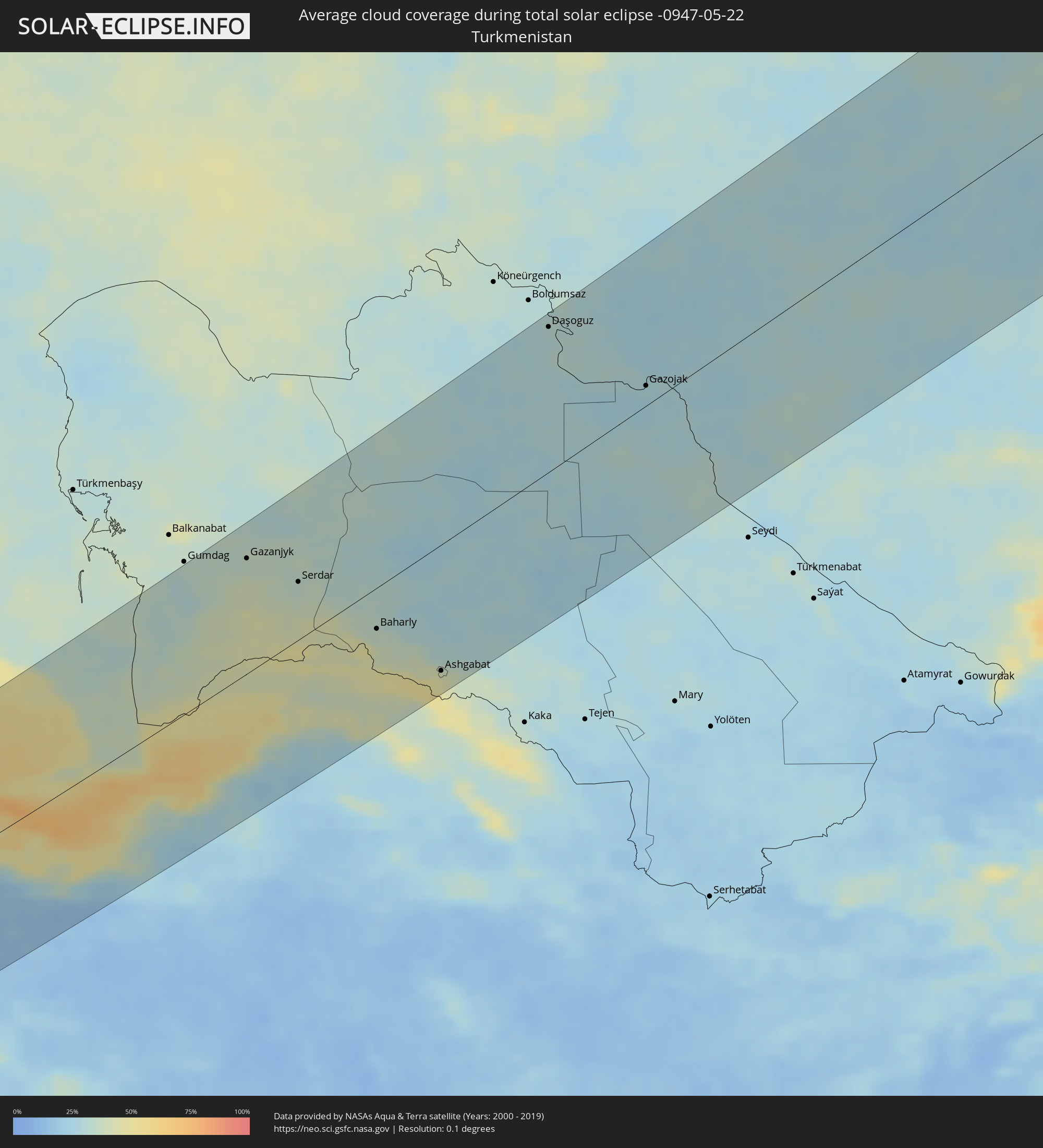 Turkmenistan
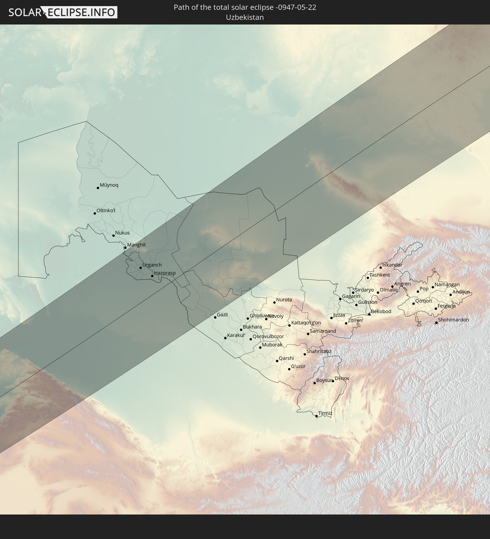
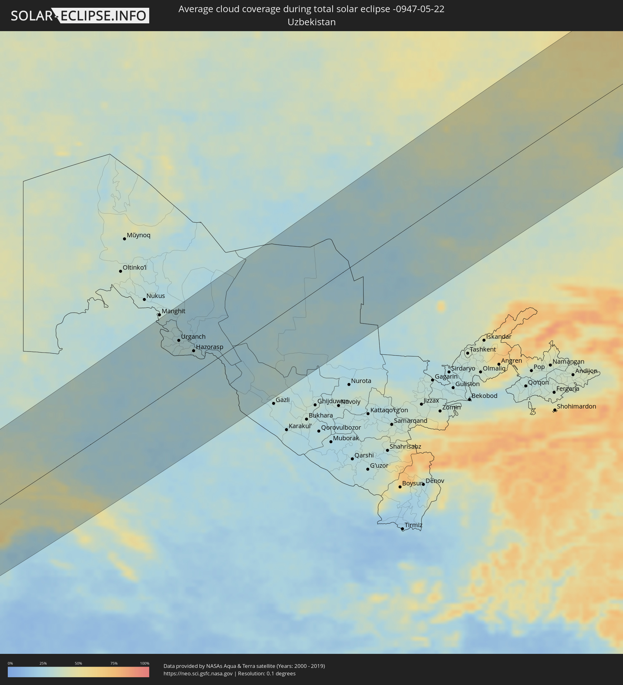 Usbekistan
Orte im Finsternispfad
Die nachfolgene Tabelle zeigt Städte und Orte mit mehr als 5.000 Einwohnern, die sich im Finsternispfad befinden. Städte mit mehr als 100.000 Einwohnern sind dick gekennzeichnet. Mit einem Klick auf den Ort öffnet sich eine Detailkarte die die Lage des jeweiligen Ortes zusammen mit dem Verlauf der zentralen Finsternis präsentiert.
| Ort | Typ | Dauer der Verfinsterung | Ortszeit bei maximaler Verfinsterung | Entfernung zur Zentrallinie | Ø Bewölkung |
|
Al Khārijah, New Valley
|
total | - | 05:29:26 UTC+02:00 | 121 km | 4% |
|
Al Minyā, Minya
|
total | - | 05:32:23 UTC+02:00 | 147 km | 9% |
|
Dayrūţ, Asyut
|
total | - | 05:31:43 UTC+02:00 | 88 km | 7% |
|
Al Qūşīyah, Asyut
|
total | - | 05:31:35 UTC+02:00 | 75 km | 6% |
|
Abū Qurqāş, Minya
|
total | - | 05:32:09 UTC+02:00 | 125 km | 7% |
|
Mallawī, Minya
|
total | - | 05:31:55 UTC+02:00 | 106 km | 7% |
|
Manfalūţ, Asyut
|
total | - | 05:31:24 UTC+02:00 | 58 km | 7% |
|
Abnūb, Asyut
|
total | - | 05:31:19 UTC+02:00 | 48 km | 8% |
|
Asyūţ, Asyut
|
total | - | 05:31:13 UTC+02:00 | 39 km | 8% |
|
Abū Tīj, Asyut
|
total | - | 05:31:01 UTC+02:00 | 20 km | 9% |
|
Juhaynah, Sohag
|
total | - | 05:30:34 UTC+02:00 | 33 km | 7% |
|
Ţahţā, Sohag
|
total | - | 05:30:40 UTC+02:00 | 23 km | 9% |
|
Sohag, Sohag
|
total | - | 05:30:23 UTC+02:00 | 50 km | 6% |
|
Al Manshāh, Sohag
|
total | - | 05:30:16 UTC+02:00 | 63 km | 6% |
|
Jirjā, Sohag
|
total | - | 05:30:06 UTC+02:00 | 81 km | 4% |
|
Al Balyanā, Sohag
|
total | - | 05:29:57 UTC+02:00 | 96 km | 6% |
|
Farshūţ, Qena
|
total | - | 05:29:43 UTC+02:00 | 122 km | 3% |
|
Dishnā, Qena
|
total | - | 05:29:43 UTC+02:00 | 125 km | 3% |
|
Qinā, Qena
|
total | - | 05:29:43 UTC+02:00 | 130 km | 4% |
|
Hurghada, Red Sea
|
total | - | 05:30:46 UTC+02:00 | 61 km | 17% |
|
Eilat, Southern District
|
total | - | 05:54:03 UTC+02:20 | 127 km | 12% |
|
Aqaba, Aqaba
|
total | - | 05:57:04 UTC+02:23 | 121 km | 17% |
|
Al Quwayrah, Ma’an
|
total | - | 05:57:22 UTC+02:23 | 137 km | 8% |
|
Duba, Tabuk
|
total | - | 06:37:28 UTC+03:06 | 128 km | 17% |
|
Tabuk, Tabuk
|
total | - | 06:38:38 UTC+03:06 | 57 km | 6% |
|
Ţubarjal, Al Jawf
|
total | - | 06:41:11 UTC+03:06 | 86 km | 6% |
|
Sakakah, Al Jawf
|
total | - | 06:40:28 UTC+03:06 | 53 km | 7% |
|
Şuwayr, Al Jawf
|
total | - | 06:40:39 UTC+03:06 | 50 km | 8% |
|
‘Ar‘ar, Northern Borders
|
total | - | 06:41:49 UTC+03:06 | 10 km | 9% |
|
Ramadi, Anbar
|
total | - | 06:36:06 UTC+02:57 | 149 km | 16% |
|
Al Fallūjah, Anbar
|
total | - | 06:36:03 UTC+02:57 | 120 km | 16% |
|
Karbala, Karbalāʼ
|
total | - | 06:35:03 UTC+02:57 | 44 km | 14% |
|
Abū Ghurayb, Mayorality of Baghdad
|
total | - | 06:36:03 UTC+02:57 | 97 km | 18% |
|
Al Hindīyah, Karbalāʼ
|
total | - | 06:34:59 UTC+02:57 | 22 km | 16% |
|
Al Musayyib, Bābil
|
total | - | 06:35:19 UTC+02:57 | 41 km | 16% |
|
Najaf, An Najaf
|
total | - | 06:34:16 UTC+02:57 | 39 km | 15% |
|
Baghdad, Mayorality of Baghdad
|
total | - | 06:36:08 UTC+02:57 | 92 km | 17% |
|
Al Ḩillah, Bābil
|
total | - | 06:34:53 UTC+02:57 | 5 km | 18% |
|
Kufa, An Najaf
|
total | - | 06:34:19 UTC+02:57 | 36 km | 15% |
|
Khāliş, Diyālá
|
total | - | 06:36:49 UTC+02:57 | 132 km | 20% |
|
Ash Shāmīyah, Al Qādisīyah
|
total | - | 06:34:12 UTC+02:57 | 52 km | 15% |
|
Baqubah, Diyālá
|
total | - | 06:36:45 UTC+02:57 | 125 km | 20% |
|
Ad Dīwānīyah, Al Qādisīyah
|
total | - | 06:34:18 UTC+02:57 | 64 km | 15% |
|
Al Miqdādīyah, Diyālá
|
total | - | 06:37:08 UTC+02:57 | 128 km | 23% |
|
Al ‘Azīzīyah, Wāsiţ
|
total | - | 06:35:37 UTC+02:57 | 26 km | 16% |
|
Ar Rumaythah, Al Muthanná
|
total | - | 06:33:41 UTC+02:57 | 122 km | 14% |
|
As Samawah, Al Muthanná
|
total | - | 06:33:26 UTC+02:57 | 145 km | 15% |
|
Al Kūt, Wāsiţ
|
total | - | 06:35:11 UTC+02:57 | 54 km | 19% |
|
Al Ḩayy, Wāsiţ
|
total | - | 06:34:44 UTC+02:57 | 98 km | 17% |
|
Īlām, Īlām
|
total | - | 07:05:03 UTC+03:25 | 28 km | 25% |
|
Kahrīz, Kermānshāh
|
total | - | 07:06:17 UTC+03:25 | 69 km | 31% |
|
Khorramabad, Lorestān
|
total | - | 07:05:16 UTC+03:25 | 78 km | 23% |
|
Pasragad Branch, Hamadān
|
total | - | 07:07:13 UTC+03:25 | 46 km | 38% |
|
Borūjerd, Lorestān
|
total | - | 07:05:59 UTC+03:25 | 57 km | 28% |
|
Malāyer, Hamadān
|
total | - | 07:06:36 UTC+03:25 | 31 km | 34% |
|
Arāk, Markazi
|
total | - | 07:06:32 UTC+03:25 | 86 km | 29% |
|
Qazvin, Qazvīn
|
total | - | 07:09:56 UTC+03:25 | 111 km | 31% |
|
Sāveh, Markazi
|
total | - | 07:08:09 UTC+03:25 | 25 km | 19% |
|
Naz̧arābād, Alborz
|
total | - | 07:09:40 UTC+03:25 | 52 km | 27% |
|
Qom, Qom
|
total | - | 07:07:45 UTC+03:25 | 87 km | 20% |
|
Karaj, Alborz
|
total | - | 07:09:36 UTC+03:25 | 25 km | 30% |
|
Tehran, Tehrān
|
total | - | 07:09:33 UTC+03:25 | 20 km | 27% |
|
Qarchak, Tehrān
|
total | - | 07:09:12 UTC+03:25 | 49 km | 23% |
|
Āmol, Māzandarān
|
total | - | 07:11:06 UTC+03:25 | 17 km | 64% |
|
Bābol, Māzandarān
|
total | - | 07:11:22 UTC+03:25 | 26 km | 55% |
|
Sari, Māzandarān
|
total | - | 07:11:33 UTC+03:25 | 9 km | 64% |
|
Gorgān, Golestān
|
total | - | 07:12:36 UTC+03:25 | 51 km | 66% |
|
Shahrud, Semnān
|
total | - | 07:12:11 UTC+03:25 | 116 km | 30% |
|
Gazanjyk, Balkan
|
total | - | 07:44:46 UTC+03:53 | 125 km | 36% |
|
Serdar, Balkan
|
total | - | 07:44:44 UTC+03:53 | 64 km | 35% |
|
Bojnūrd, Khorāsān-e Shomālī
|
total | - | 07:15:05 UTC+03:25 | 128 km | 41% |
|
Baharly, Ahal
|
total | - | 07:44:29 UTC+03:53 | 47 km | 35% |
|
Abadan, Ahal
|
total | - | 07:44:19 UTC+03:53 | 116 km | 42% |
|
Ashgabat, Ahal
|
total | - | 07:44:15 UTC+03:53 | 135 km | 41% |
|
Annau, Ahal
|
total | - | 07:44:14 UTC+03:53 | 147 km | 41% |
|
Tagta, Daşoguz
|
total | - | 07:51:18 UTC+03:53 | 135 km | 29% |
|
Daşoguz, Daşoguz
|
total | - | 07:51:38 UTC+03:53 | 148 km | 29% |
|
Showot, Xorazm
|
total | - | 08:25:55 UTC+04:27 | 116 km | 31% |
|
Qŭshkŭpir, Xorazm
|
total | - | 08:25:44 UTC+04:27 | 103 km | 32% |
|
Khiwa, Xorazm
|
total | - | 08:25:30 UTC+04:27 | 87 km | 30% |
|
Gurlan, Xorazm
|
total | - | 08:26:17 UTC+04:27 | 131 km | 31% |
|
Urganch, Xorazm
|
total | - | 08:25:58 UTC+04:27 | 94 km | 31% |
|
Beruniy, Karakalpakstan
|
total | - | 08:26:16 UTC+04:27 | 98 km | 28% |
|
Novyy Turtkul’, Karakalpakstan
|
total | - | 08:26:13 UTC+04:27 | 72 km | 28% |
|
Hazorasp, Xorazm
|
total | - | 08:25:53 UTC+04:27 | 49 km | 28% |
|
Gazojak, Lebap
|
total | - | 07:51:32 UTC+03:53 | 21 km | 28% |
|
Tasböget, Qyzylorda
|
total | - | 08:29:02 UTC+04:21 | 156 km | 31% |
|
Shīeli, Qyzylorda
|
total | - | 08:29:02 UTC+04:21 | 46 km | 29% |
|
Yanykurgan, Qyzylorda
|
total | - | 08:29:03 UTC+04:21 | 23 km | 29% |
|
Turkestan, Ongtüstik Qazaqstan
|
total | - | 08:28:57 UTC+04:21 | 103 km | 33% |
|
Kentau, Ongtüstik Qazaqstan
|
total | - | 08:29:32 UTC+04:21 | 94 km | 33% |
|
Kantagi, Ongtüstik Qazaqstan
|
total | - | 08:29:38 UTC+04:21 | 97 km | 31% |
|
Chulakkurgan, Ongtüstik Qazaqstan
|
total | - | 08:30:35 UTC+04:21 | 102 km | 33% |
|
Zhangatas, Zhambyl
|
total | - | 08:30:47 UTC+04:21 | 147 km | 36% |
|
Aktau, Qaraghandy
|
total | - | 08:41:05 UTC+04:21 | 136 km | 54% |
|
Aqadyr, Qaraghandy
|
total | - | 08:41:28 UTC+04:21 | 156 km | 58% |
|
Priozersk
|
total | - | 08:38:50 UTC+04:21 | 87 km | 35% |
|
Balqash, Qaraghandy
|
total | - | 08:41:31 UTC+04:21 | 64 km | 36% |
|
Semey, East Kazakhstan
|
total | - | 08:52:50 UTC+04:21 | 71 km | 50% |
|
Rubtsovsk, Altai Krai
|
total | - | 10:44:59 UTC+06:11 | 143 km | 60% |
|
Georgīevka, East Kazakhstan
|
total | - | 08:52:53 UTC+04:21 | 82 km | 52% |
|
Shemonaīkha, East Kazakhstan
|
total | - | 08:55:04 UTC+04:21 | 34 km | 57% |
|
Glubokoye, East Kazakhstan
|
total | - | 08:54:54 UTC+04:21 | 30 km | 55% |
|
Belūsovka, East Kazakhstan
|
total | - | 08:55:09 UTC+04:21 | 42 km | 57% |
|
Ust-Kamenogorsk, East Kazakhstan
|
total | - | 08:55:02 UTC+04:21 | 59 km | 57% |
|
Ridder, East Kazakhstan
|
total | - | 08:56:40 UTC+04:21 | 53 km | 75% |
|
Zyryanovsk, East Kazakhstan
|
total | - | 08:56:50 UTC+04:21 | 138 km | 59% |
|
Biysk, Altai Krai
|
total | - | 10:51:05 UTC+06:11 | 108 km | 67% |
|
Gorno-Altaysk, Altai Republic
|
total | - | 10:51:17 UTC+06:11 | 29 km | 70% |
|
Osinniki, Kemerovo
|
total | - | 10:54:59 UTC+06:11 | 149 km | 70% |
|
Myski, Kemerovo
|
total | - | 10:55:37 UTC+06:11 | 145 km | 71% |
|
Mezhdurechensk, Kemerovo
|
total | - | 10:55:56 UTC+06:11 | 135 km | 71% |
|
Chernogorsk, Khakasiya
|
total | - | 11:00:08 UTC+06:11 | 58 km | 67% |
|
Sayanogorsk, Khakasiya
|
total | - | 10:59:35 UTC+06:11 | 27 km | 69% |
|
Abakan, Khakasiya
|
total | - | 11:00:13 UTC+06:11 | 44 km | 67% |
|
Minusinsk, Krasnoyarskiy
|
total | - | 11:00:33 UTC+06:11 | 36 km | 68% |
|
Tayshet, Irkutsk
|
total | - | 11:56:05 UTC+06:57 | 114 km | 73% |
|
Nizhneudinsk, Irkutsk
|
total | - | 11:56:48 UTC+06:57 | 15 km | 71% |
|
Tulun, Irkutsk
|
total | - | 11:58:42 UTC+06:57 | 84 km | 69% |
|
Bratsk, Irkutsk
|
total | - | 12:00:49 UTC+06:57 | 65 km | 74% |
|
Zheleznogorsk-Ilimskiy, Irkutsk
|
total | - | 12:04:11 UTC+06:57 | 70 km | 76% |
|
Ust’-Kut, Irkutsk
|
total | - | 12:06:20 UTC+06:57 | 68 km | 77% |
|
Severobaykal’sk, Respublika Buryatiya
|
total | - | 12:10:46 UTC+06:57 | 105 km | 73% |
|
Neryungri, Sakha
|
total | - | 14:11:12 UTC+08:38 | 82 km | 78% |
|
Yelizovo, Kamtsjatka
|
total | - | 16:37:38 UTC+10:34 | 53 km | 71% |
|
Petropavlovsk-Kamchatsky, Kamtsjatka
|
total | - | 16:37:56 UTC+10:34 | 61 km | 82% |