Totale Sonnenfinsternis vom 04.10.-0954
| Wochentag: | Freitag |
| Maximale Dauer der Verfinsterung: | 03m17s |
| Maximale Breite des Finsternispfades: | 141 km |
| Saroszyklus: | 38 |
| Bedeckungsgrad: | 100% |
| Magnitude: | 1.0398 |
| Gamma: | 0.3499 |
Wo kann man die Sonnenfinsternis vom 04.10.-0954 sehen?
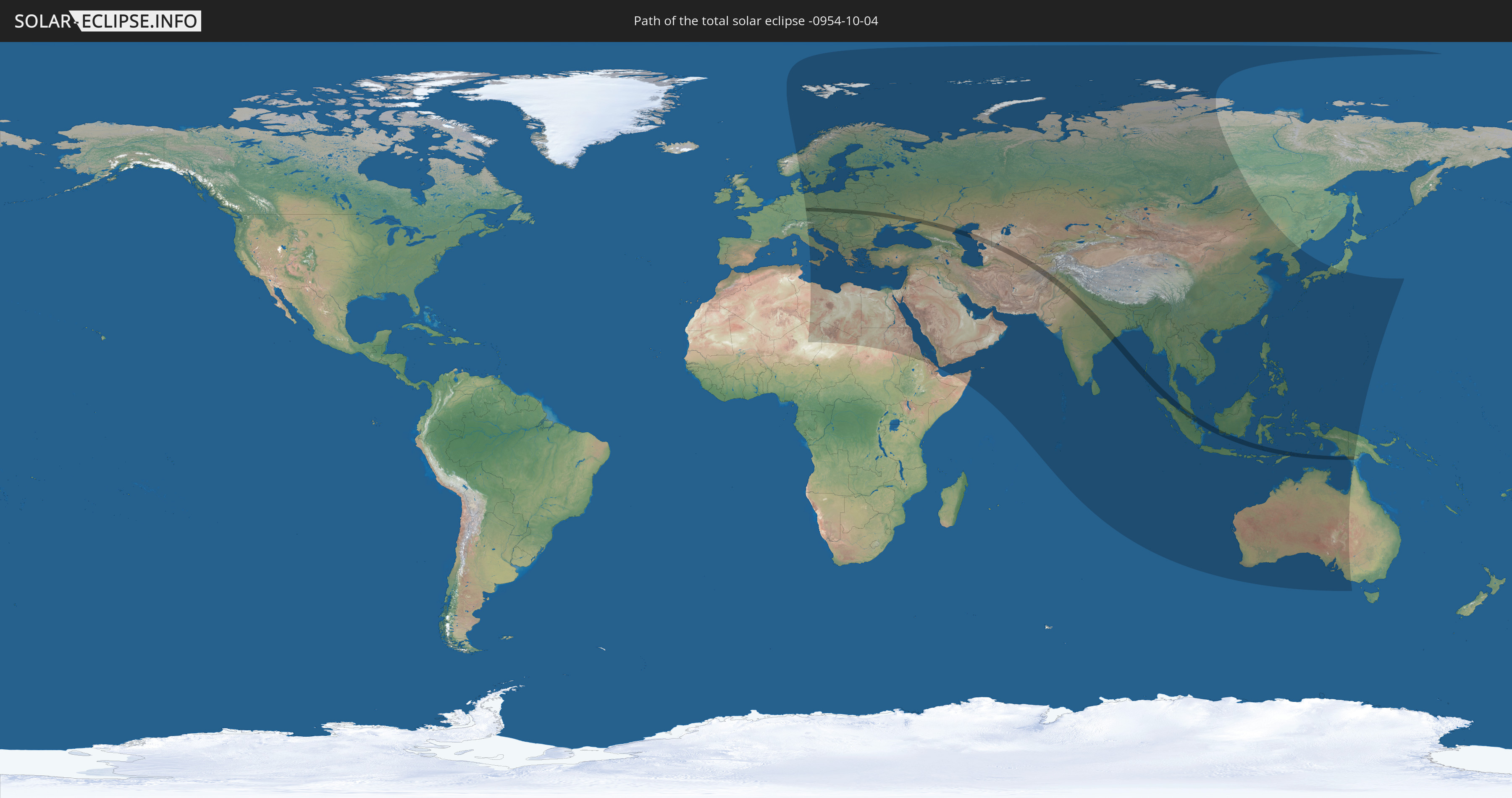
Die Sonnenfinsternis am 04.10.-0954 kann man in 101 Ländern als partielle Sonnenfinsternis beobachten.
Der Finsternispfad verläuft durch 18 Länder. Nur in diesen Ländern ist sie als totale Sonnenfinsternis zu sehen.
In den folgenden Ländern ist die Sonnenfinsternis total zu sehen
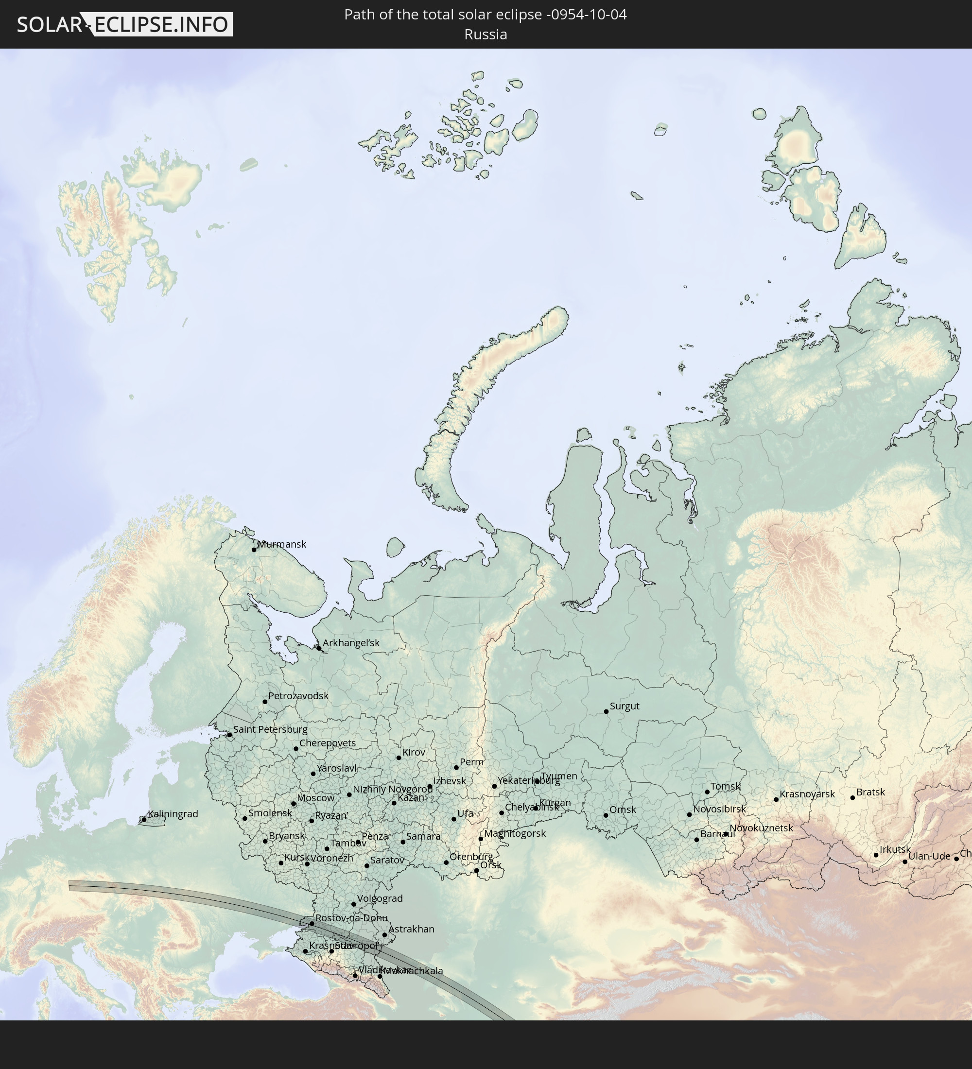 Russland
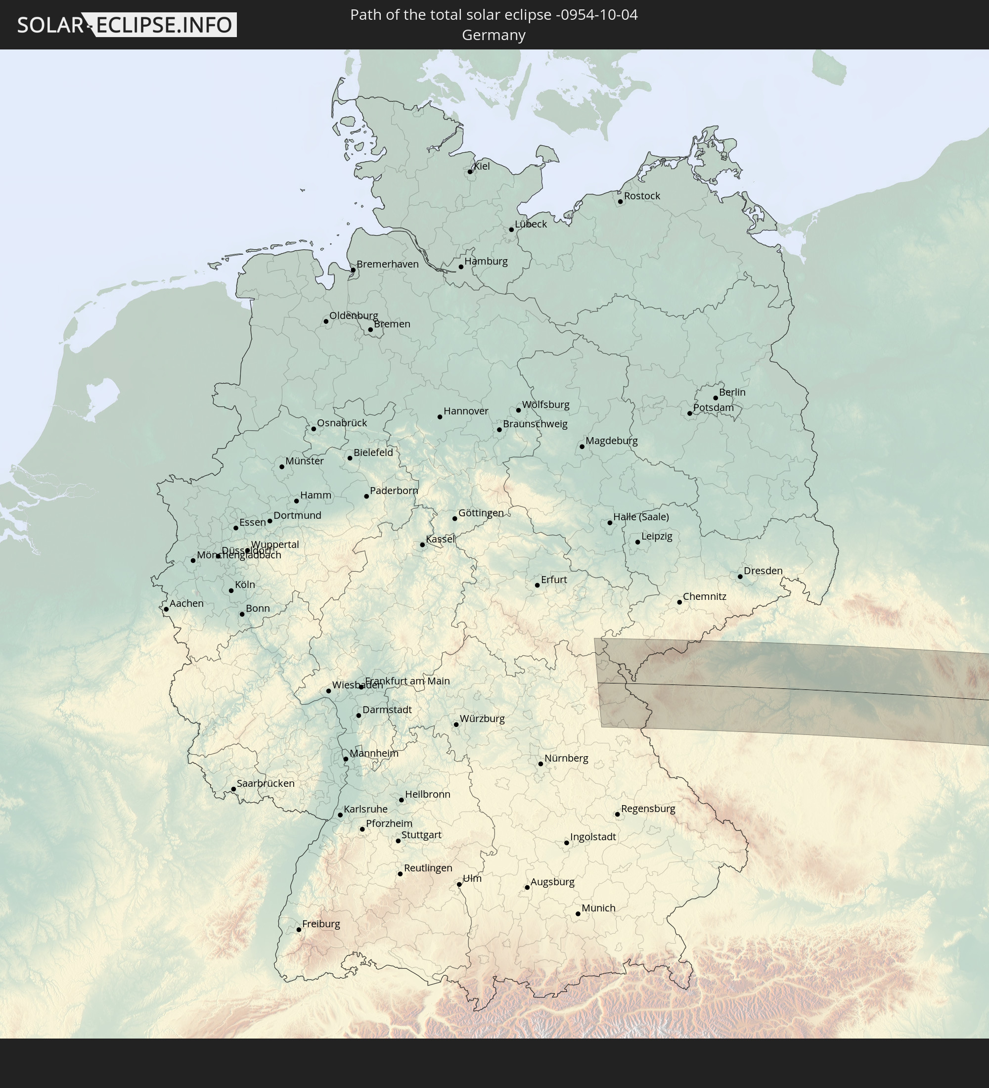 Deutschland
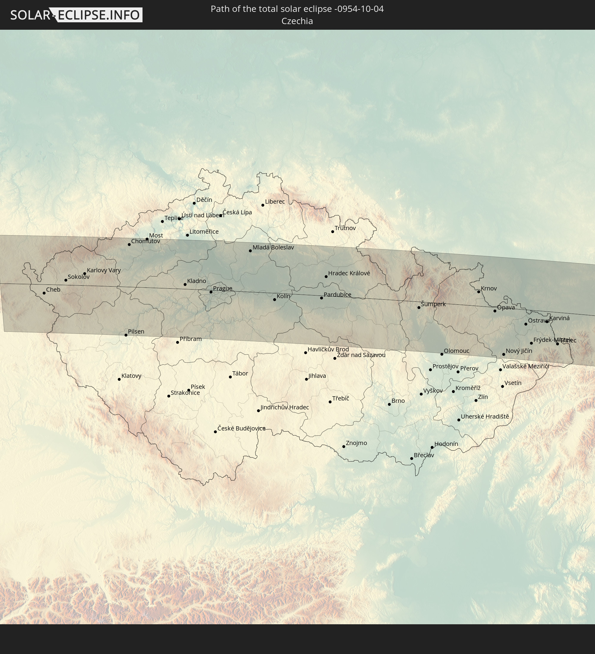 Tschechien
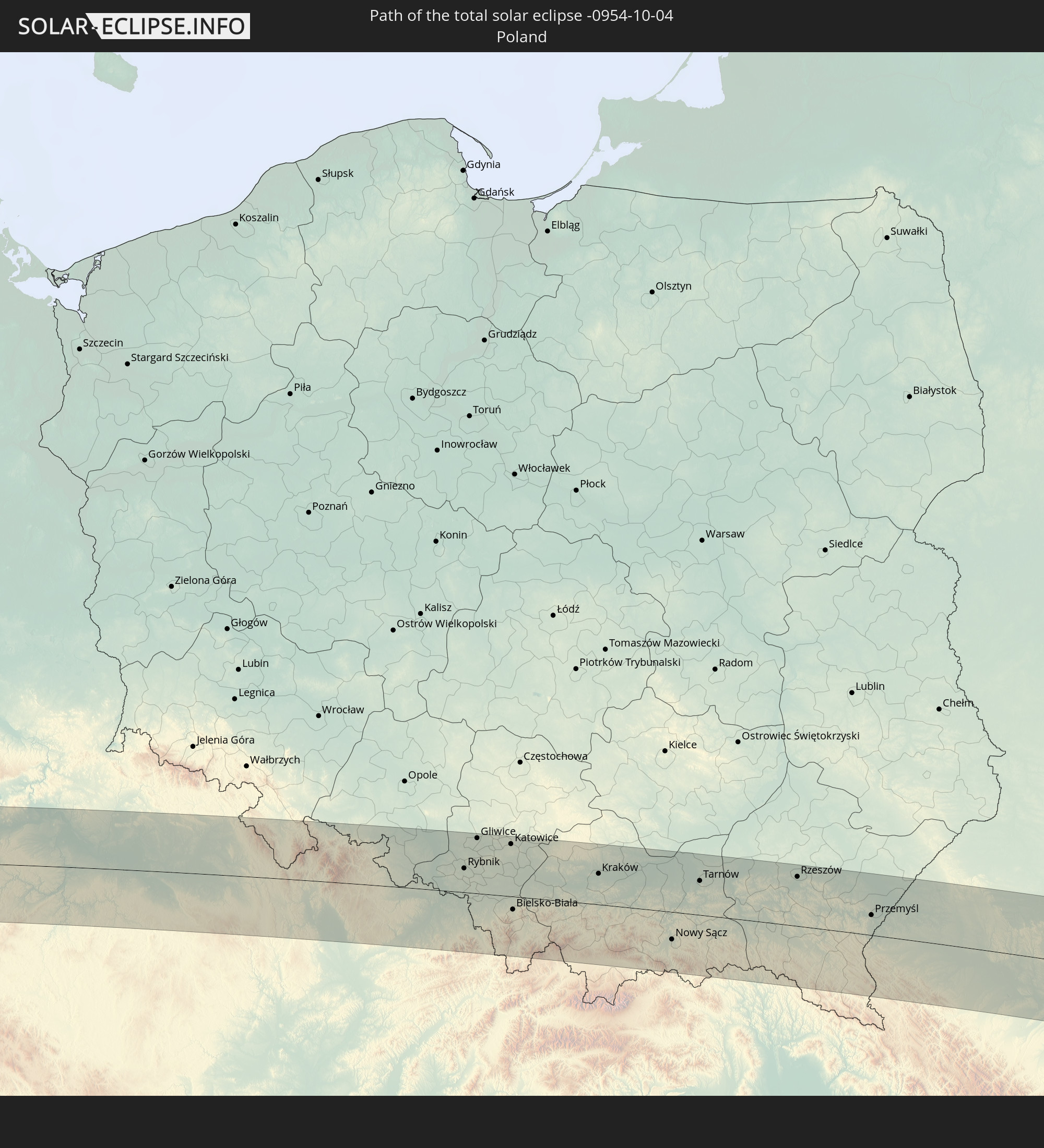 Polen
Polen
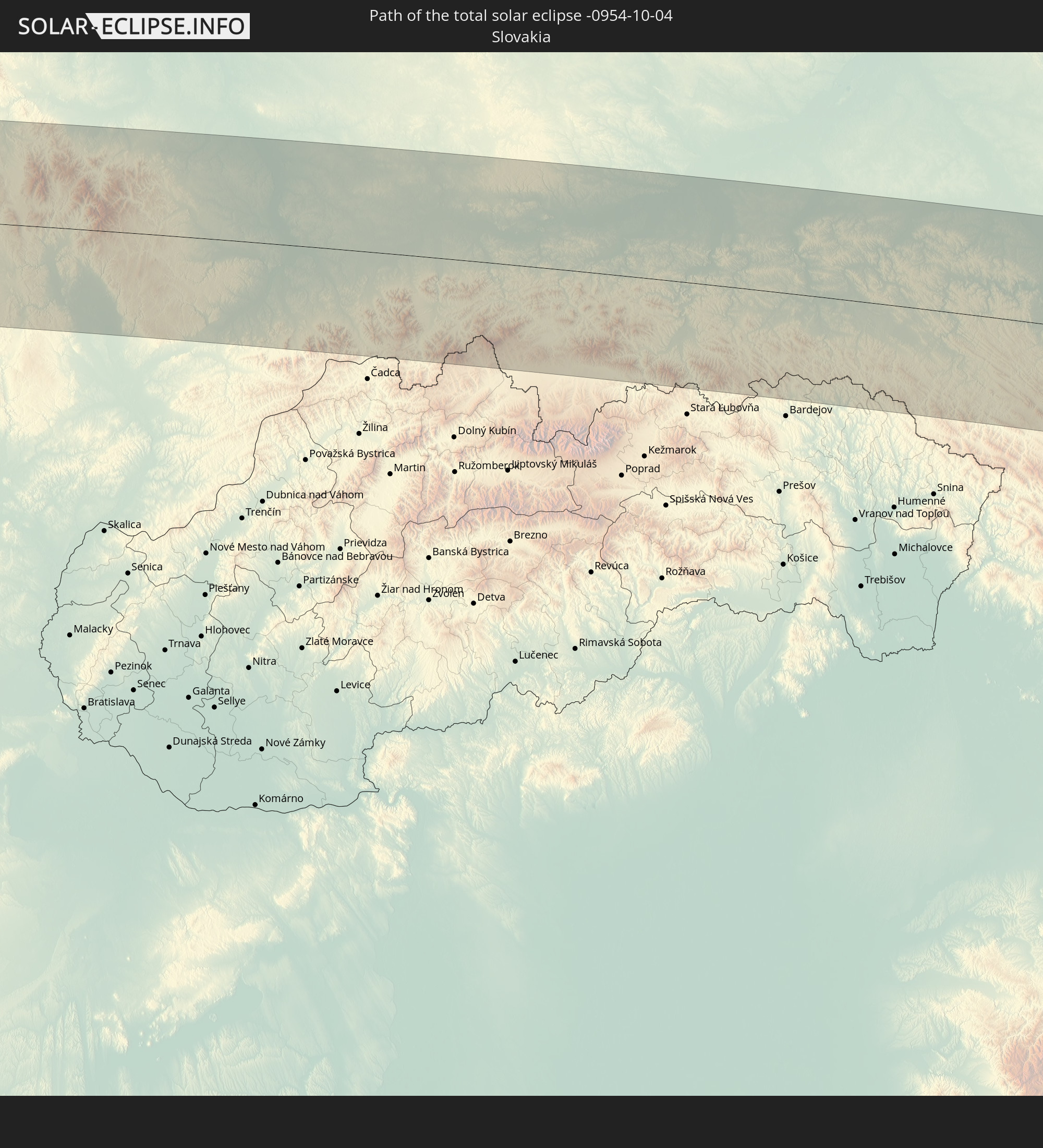 Slowakei
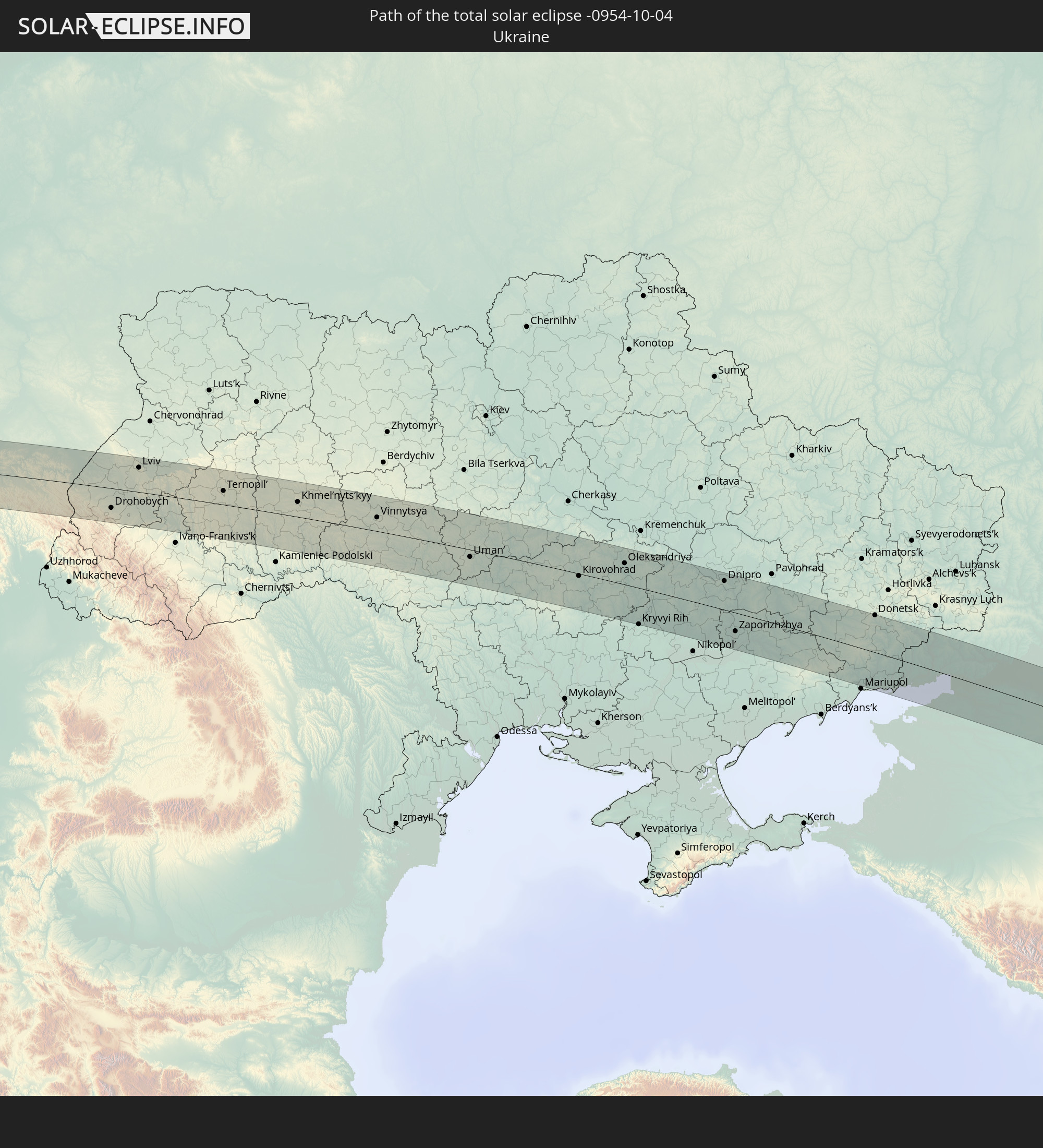 Ukraine
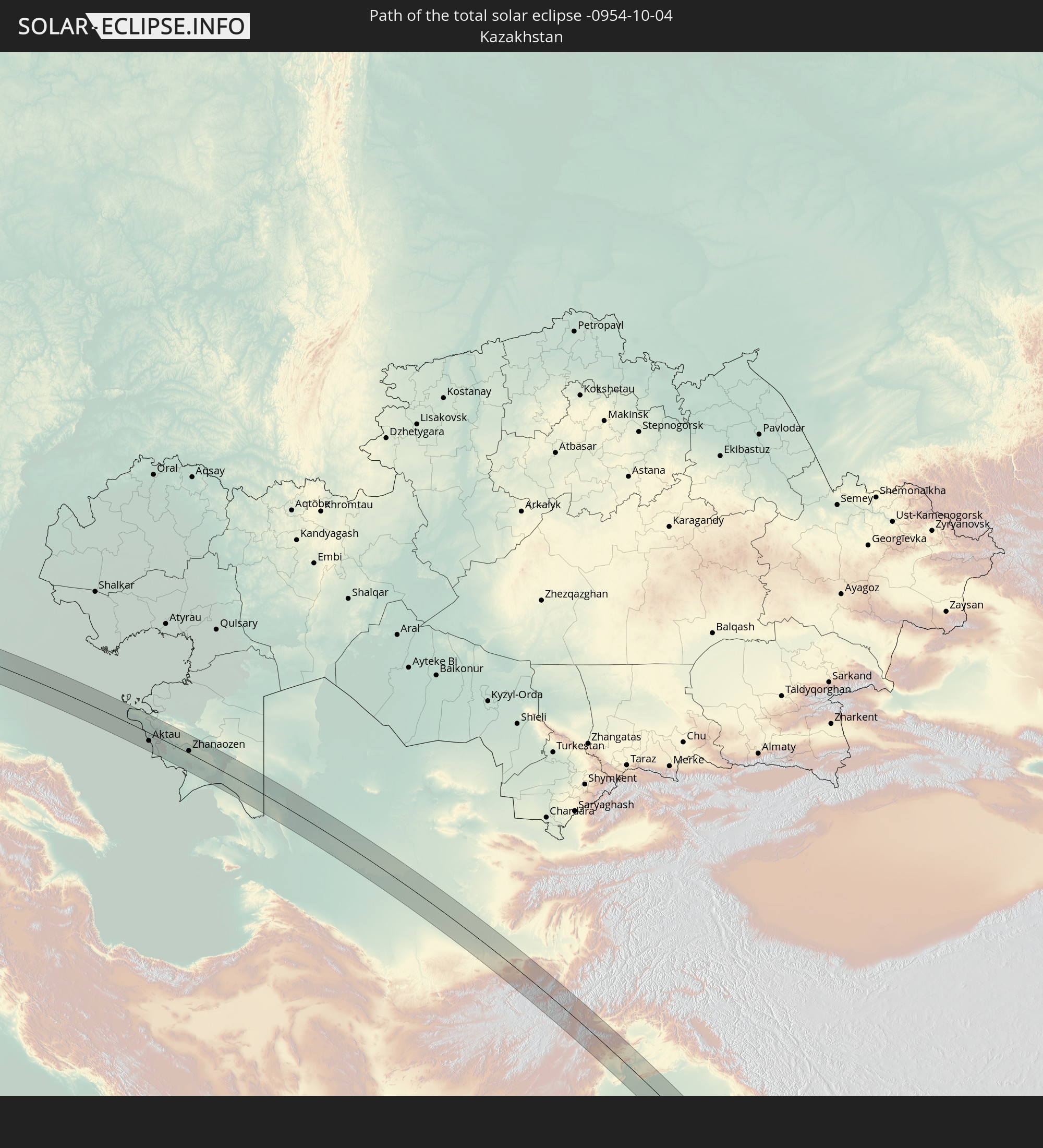 Kasachstan
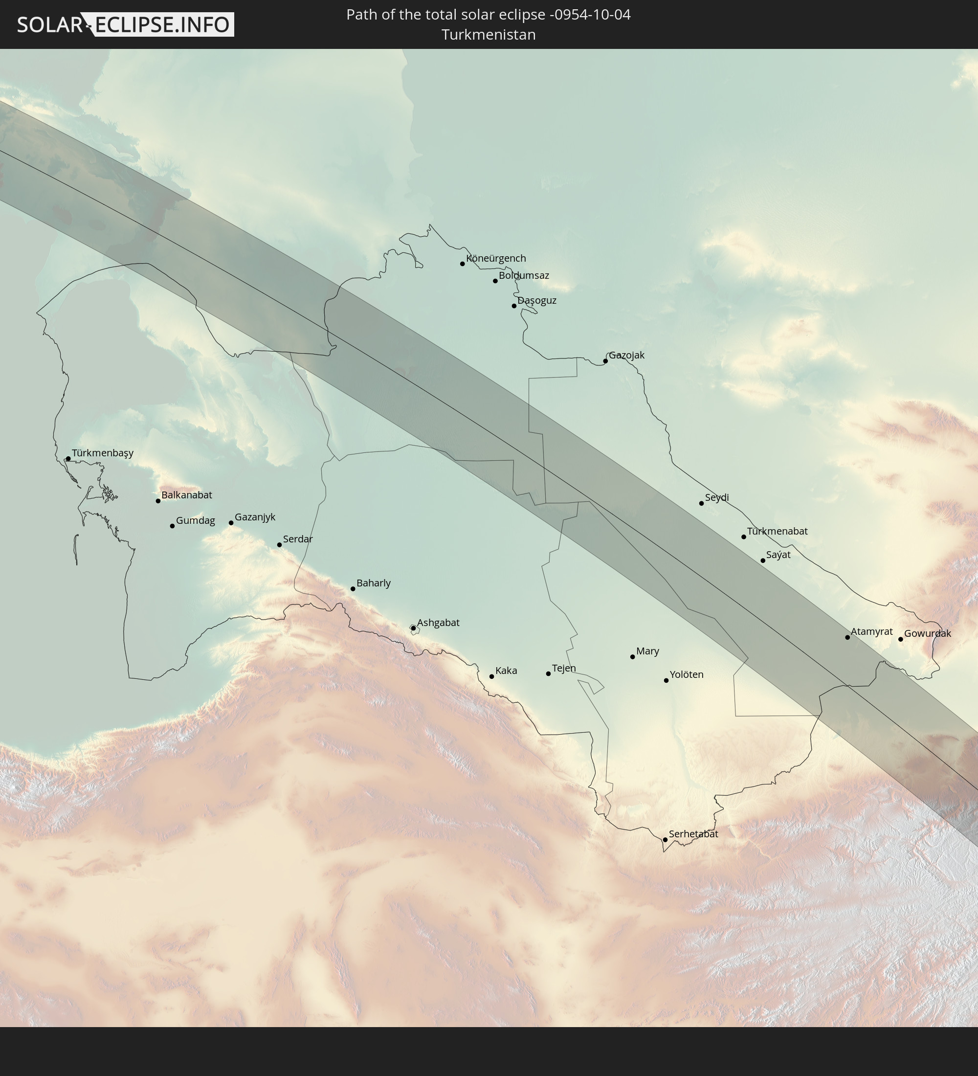 Turkmenistan
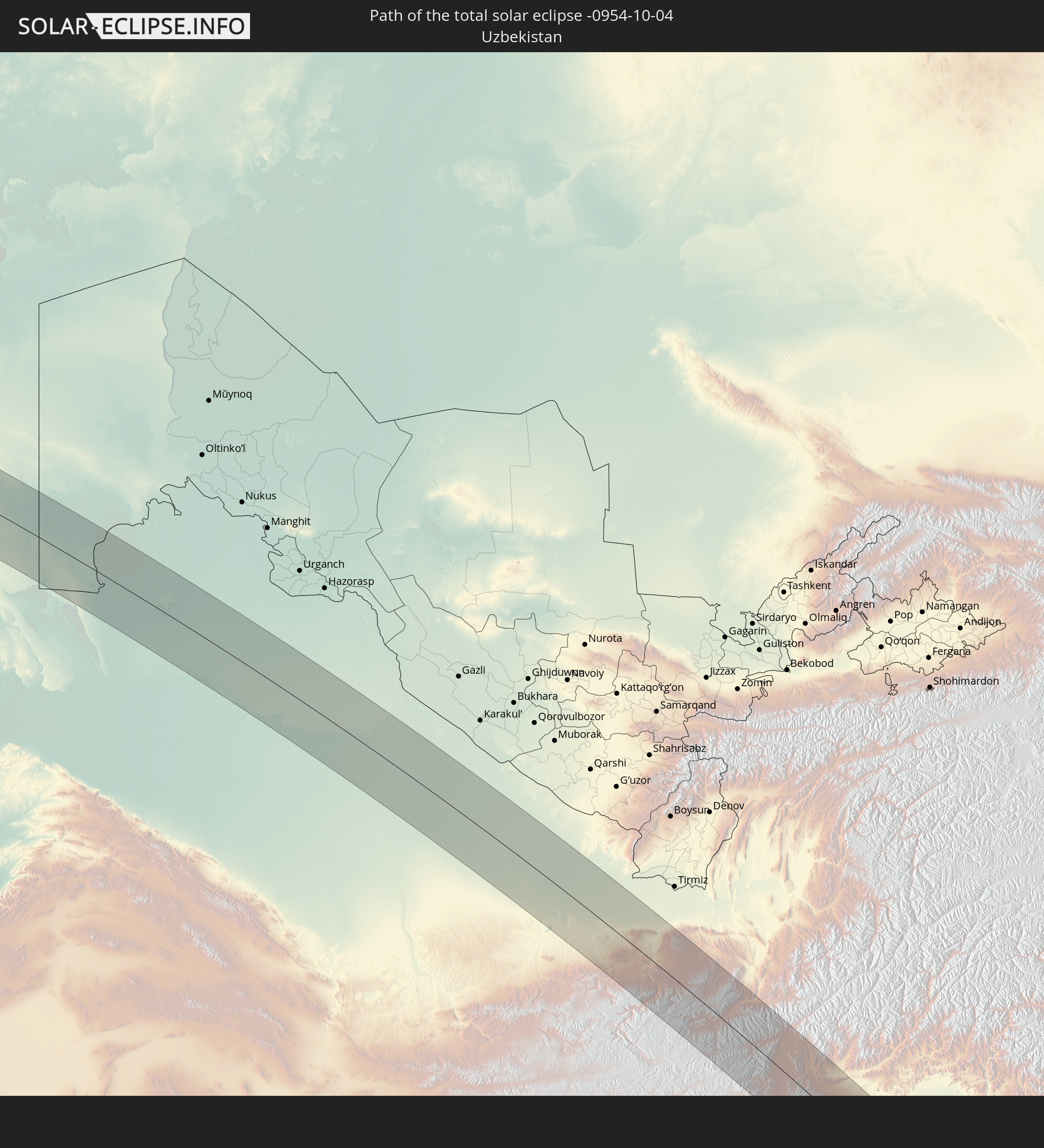 Usbekistan
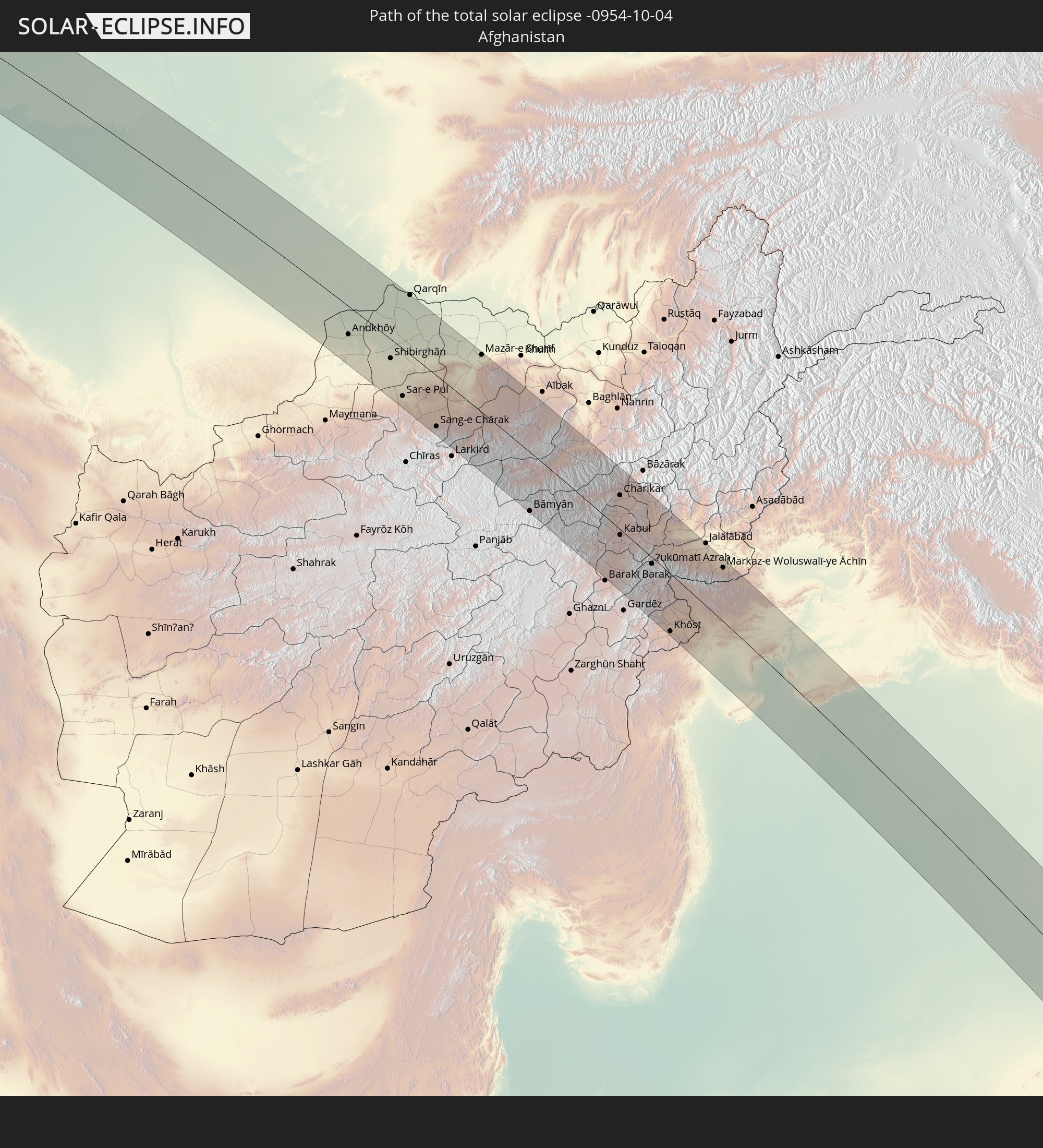 Afghanistan
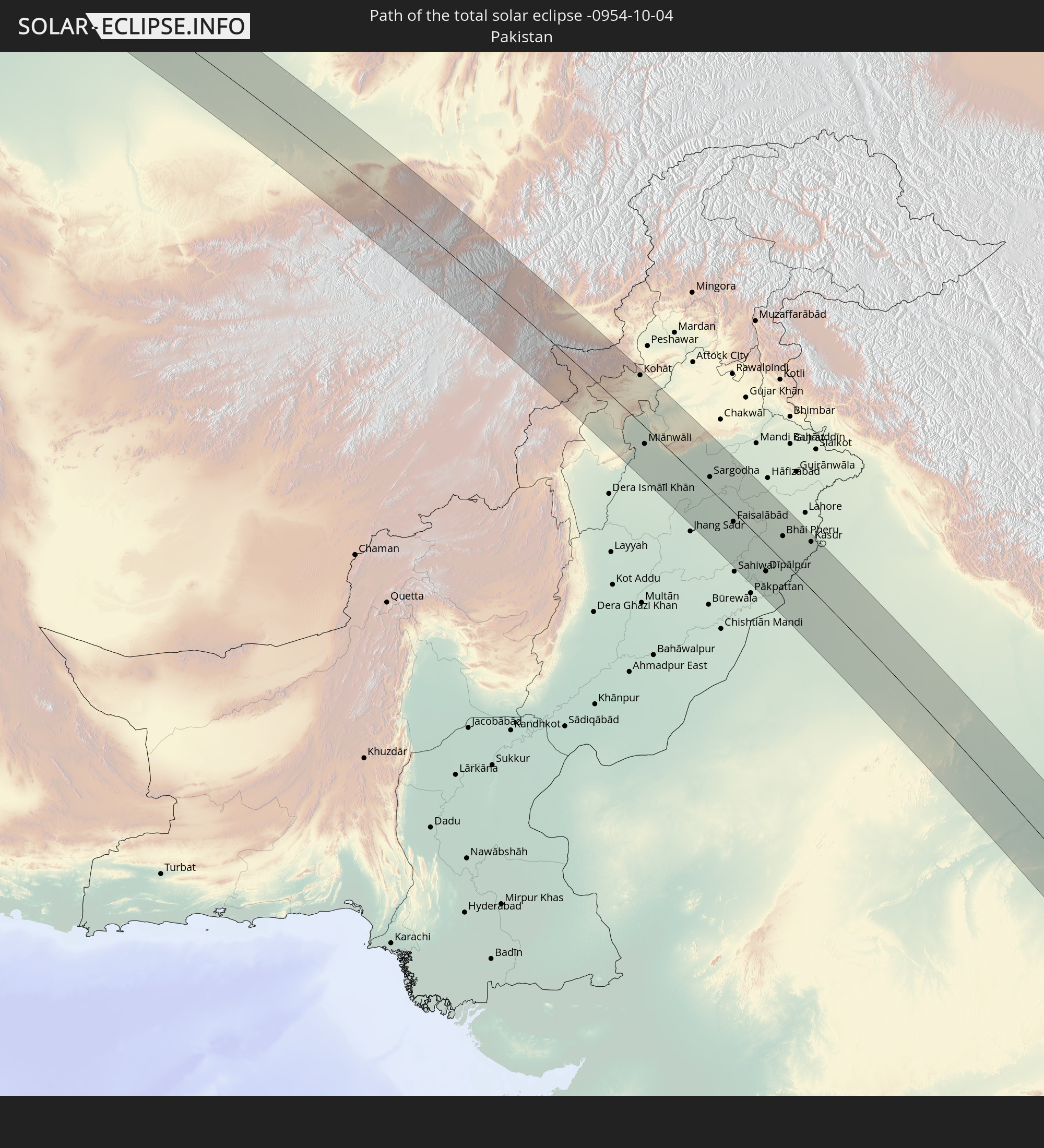 Pakistan
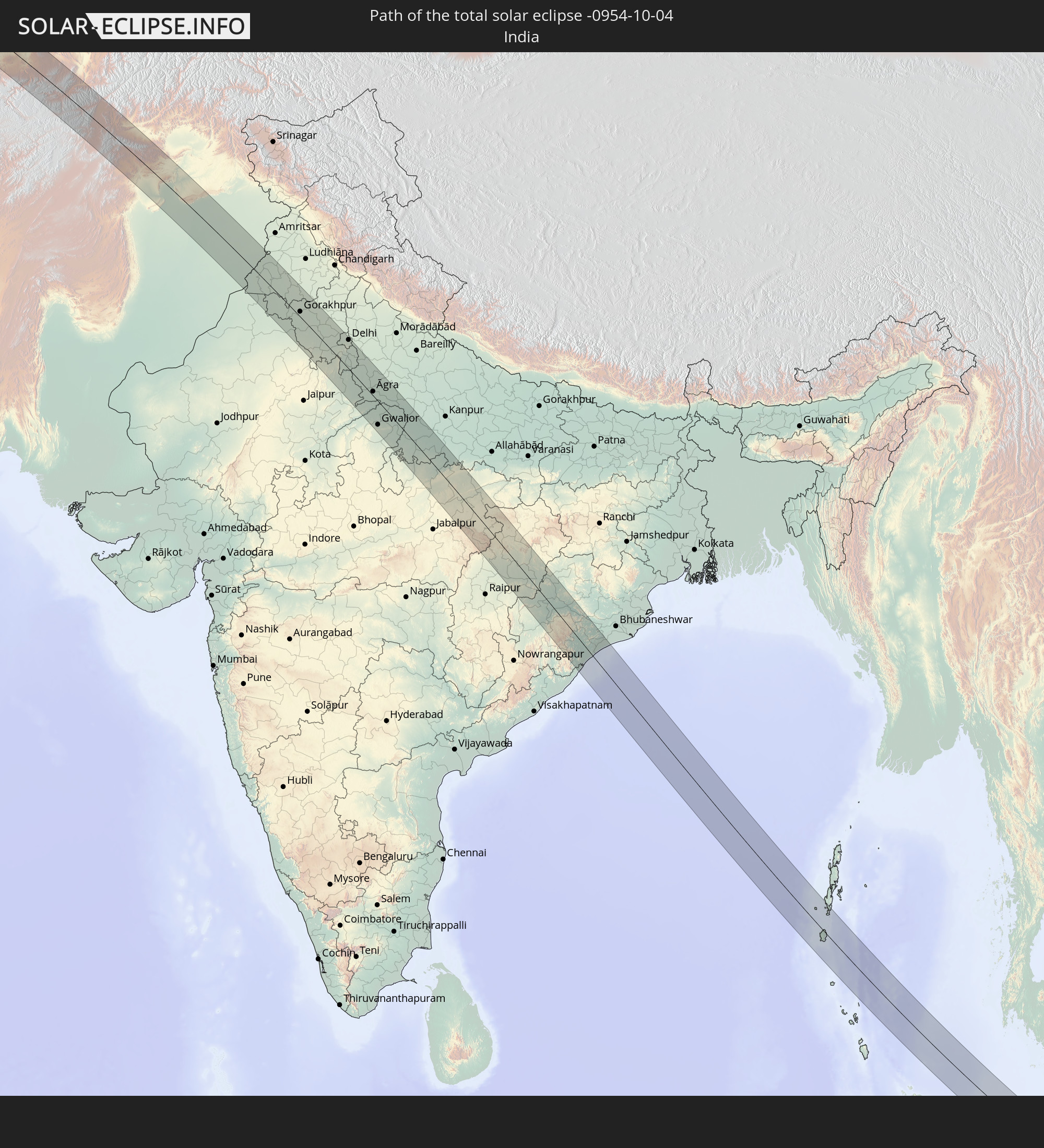 Indien
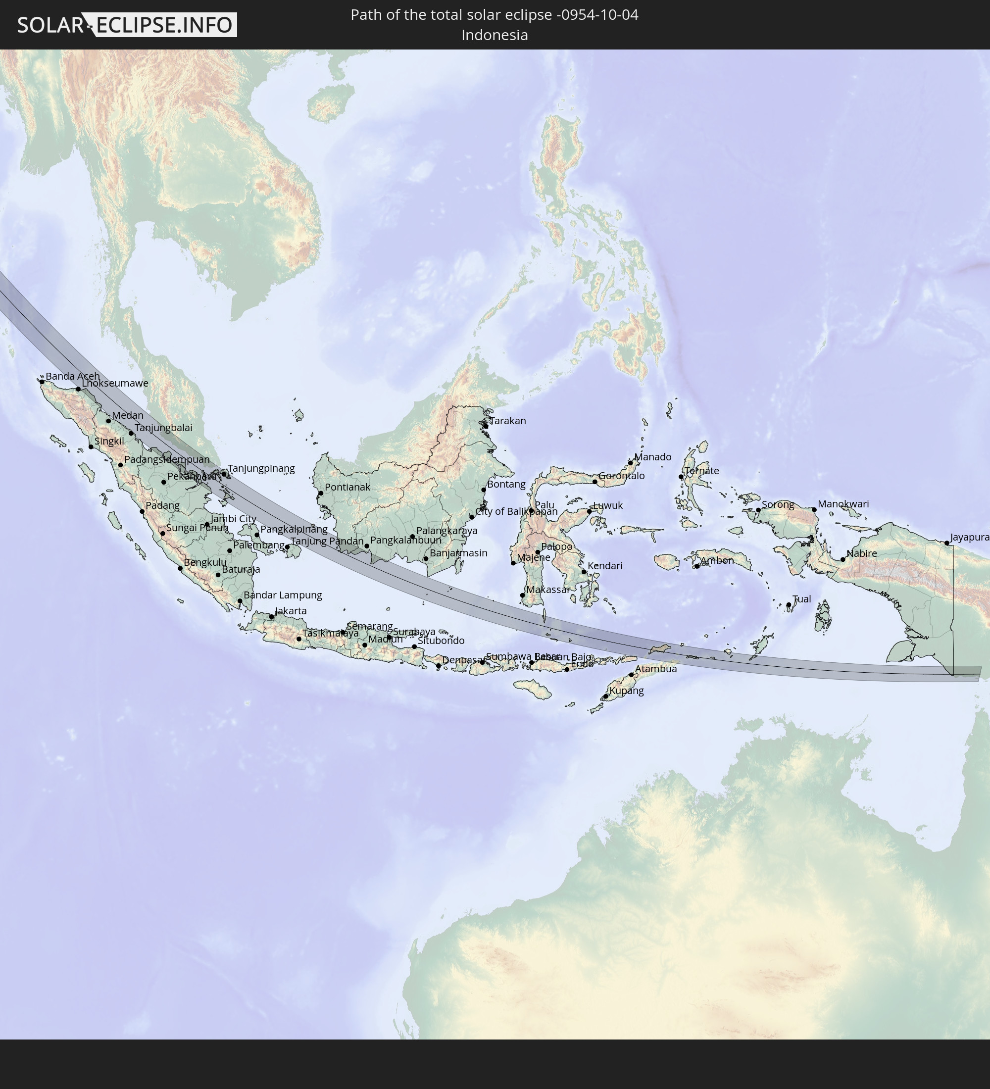 Indonesien
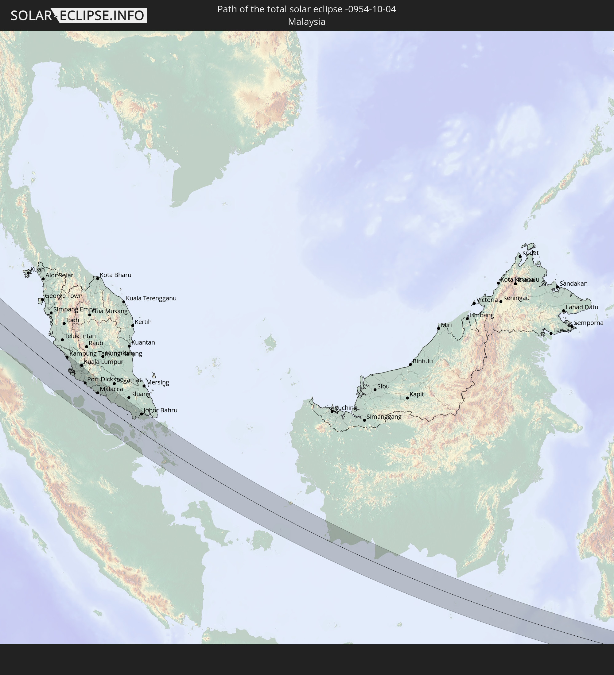 Malaysia
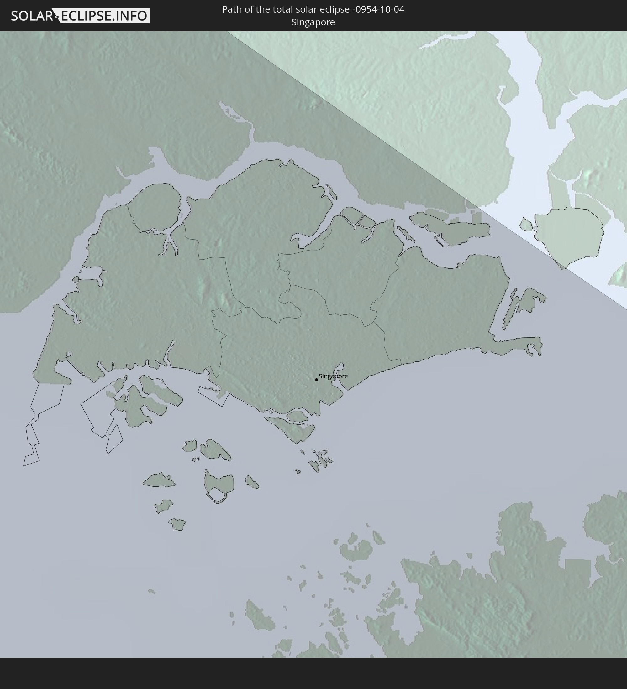 Singapur
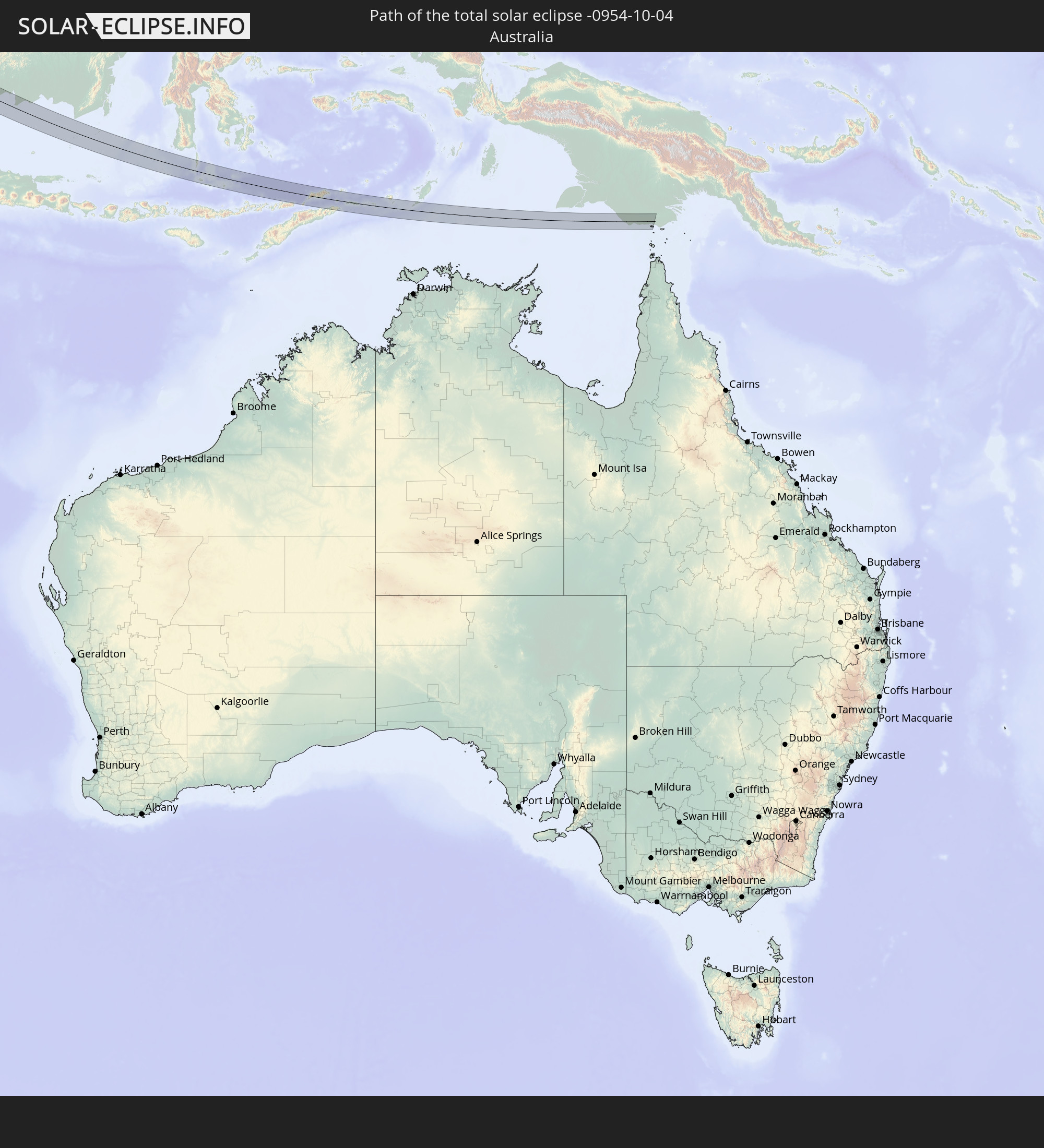 Australien
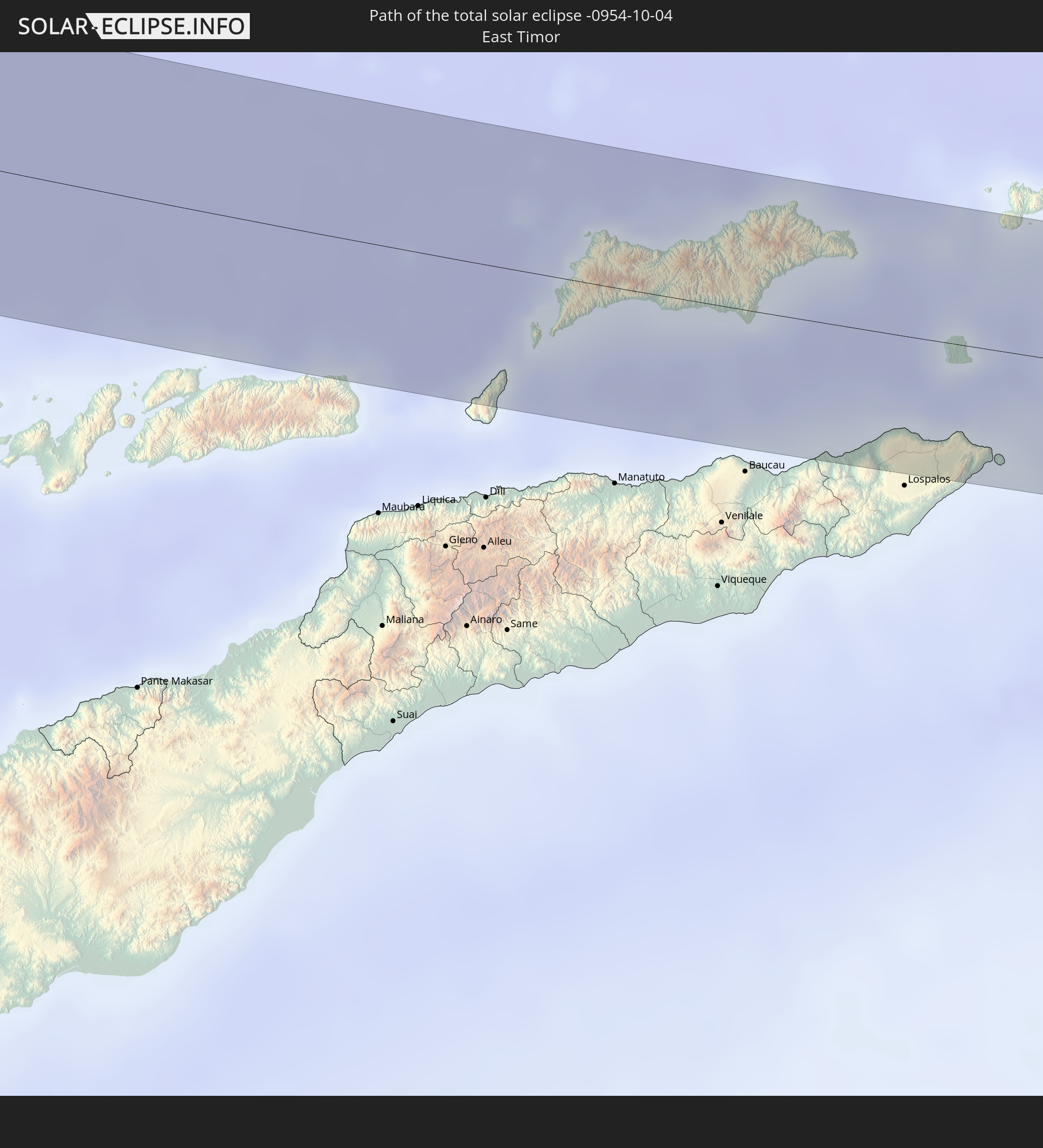 Osttimor
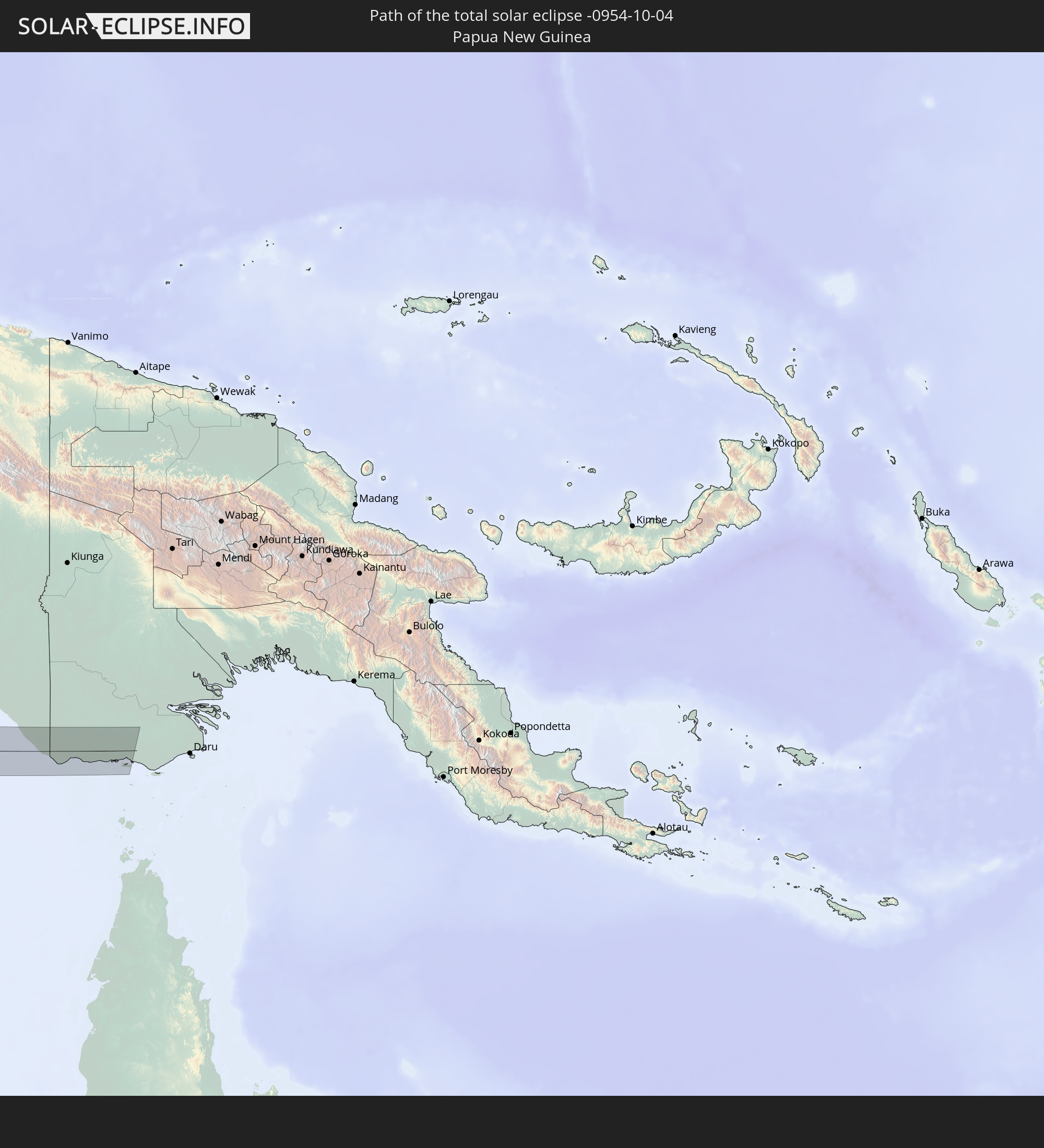 Papua-Neuguinea
In den folgenden Ländern ist die Sonnenfinsternis partiell zu sehen
 Russland
 Spitzbergen
 Niger
Niger
 Norwegen
 Deutschland
 Italien
 Dänemark
 Libyen
 Österreich
 Schweden
 Tschechien
 San Marino
 Slowenien
 Tschad
 Kroatien
 Polen
Polen
 Malta
Malta
 Bosnien und Herzegowina
 Ungarn
 Slowakei
 Montenegro
 Serbien
 Albanien
 Åland Islands
 Griechenland
 Rumänien
 Mazedonien
 Finnland
 Litauen
 Lettland
 Estland
 Sudan
Sudan
 Ukraine
 Bulgarien
 Weißrussland
 Ägypten
 Türkei
 Moldawien
 Republik Zypern
 Äthiopien
 Staat Palästina
 Israel
 Saudi-Arabien
 Jordanien
 Libanon
 Syrien
 Eritrea
 Irak
Irak
 Georgien
 Somalia
 Dschibuti
 Jemen
Jemen
 Armenien
 Iran
Iran
 Aserbaidschan
 Kasachstan
 Kuwait
 Bahrain
 Katar
Katar
 Vereinigte Arabische Emirate
 Oman
Oman
 Turkmenistan
 Usbekistan
 Afghanistan
 Pakistan
 Tadschikistan
 Indien
 Kirgisistan
 Britisches Territorium im Indischen Ozean
 Malediven
 Volksrepublik China
 Sri Lanka
 Nepal
Nepal
 Mongolei
 Bangladesch
 Bhutan
 Myanmar
 Indonesien
 Kokosinseln
 Thailand
 Malaysia
 Laos
Laos
 Vietnam
 Kambodscha
 Singapur
 Weihnachtsinsel
 Australien
 Macau
Macau
 Hongkong
 Brunei
 Taiwan
 Philippinen
 Japan
Japan
 Osttimor
 Nordkorea
 Südkorea
 Palau
Palau
 Föderierte Staaten von Mikronesien
 Papua-Neuguinea
 Guam
Guam
 Nördliche Marianen
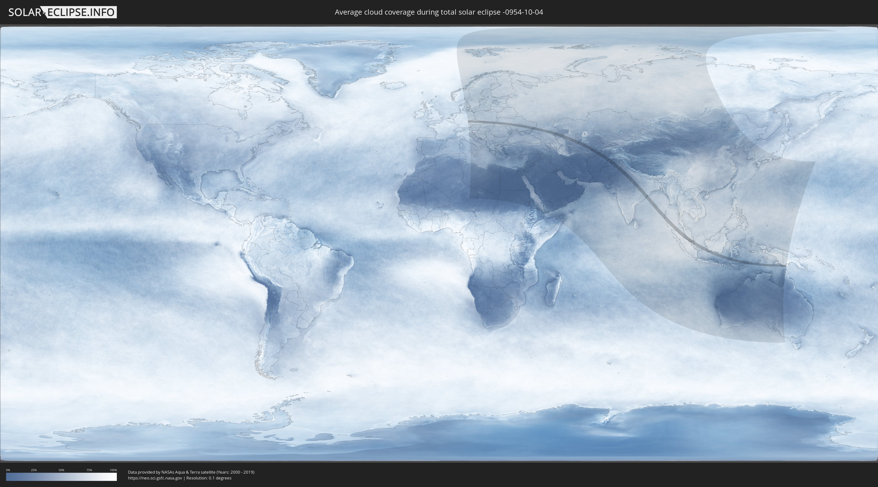
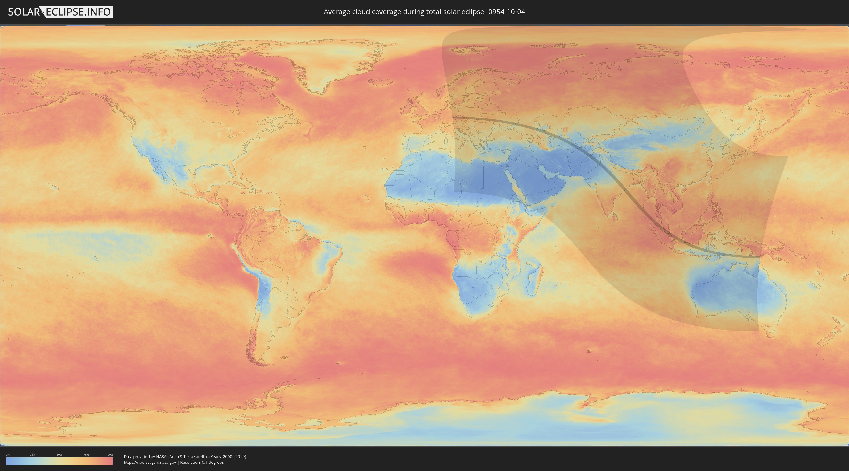
Wie wird das Wetter während der totalen Sonnenfinsternis am 04.10.-0954?
Wo ist der beste Ort, um die totale Sonnenfinsternis vom 04.10.-0954 zu beobachten?
Die folgenden Karten zeigen die durchschnittliche Bewölkung für den Tag, an dem die totale Sonnenfinsternis
stattfindet. Mit Hilfe der Karten lässt sich der Ort entlang des Finsternispfades eingrenzen,
der die besten Aussichen auf einen klaren wolkenfreien Himmel bietet.
Trotzdem muss man immer lokale Gegenenheiten beachten und sollte sich genau über das Wetter an seinem
gewählten Beobachtungsort informieren.
Die Daten stammen von den beiden NASA-Satelliten
AQUA und TERRA
und wurden über einen Zeitraum von 19 Jahren (2000 - 2019) gemittelt.
Detaillierte Länderkarten
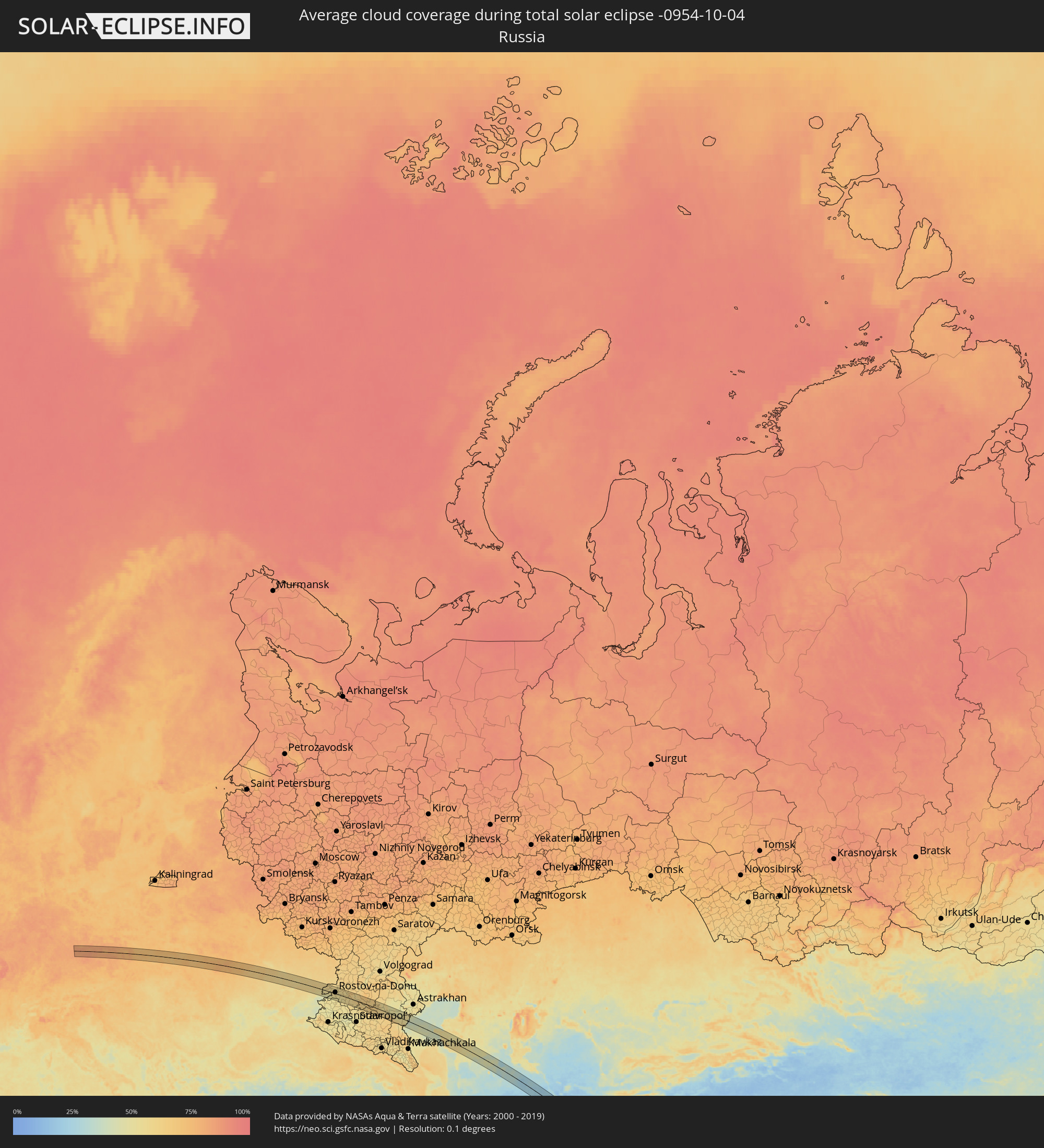 Russland
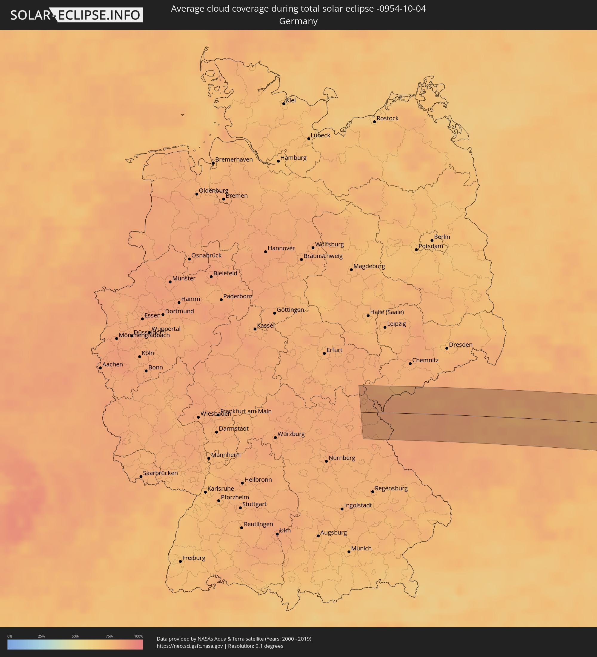 Deutschland
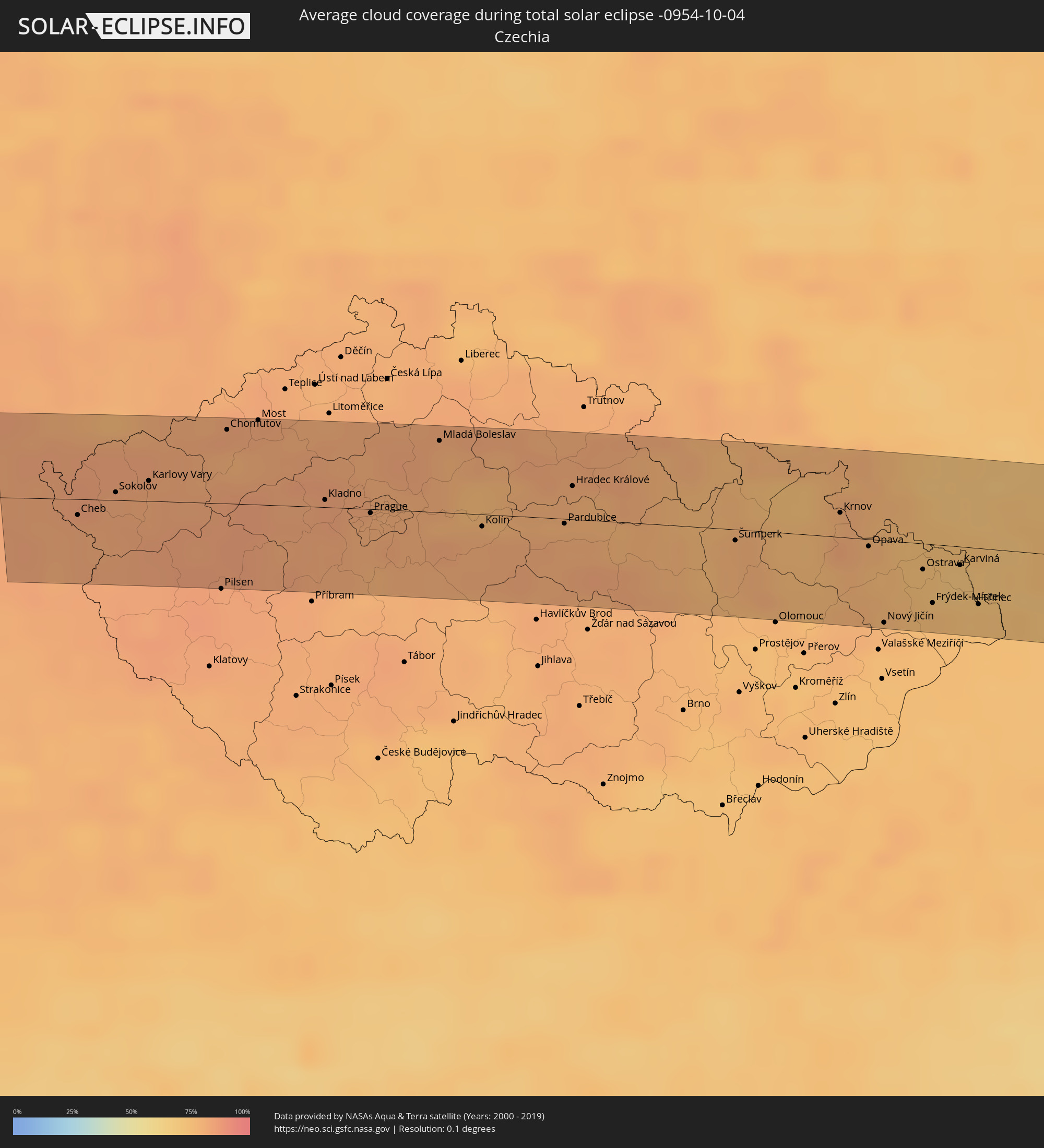 Tschechien
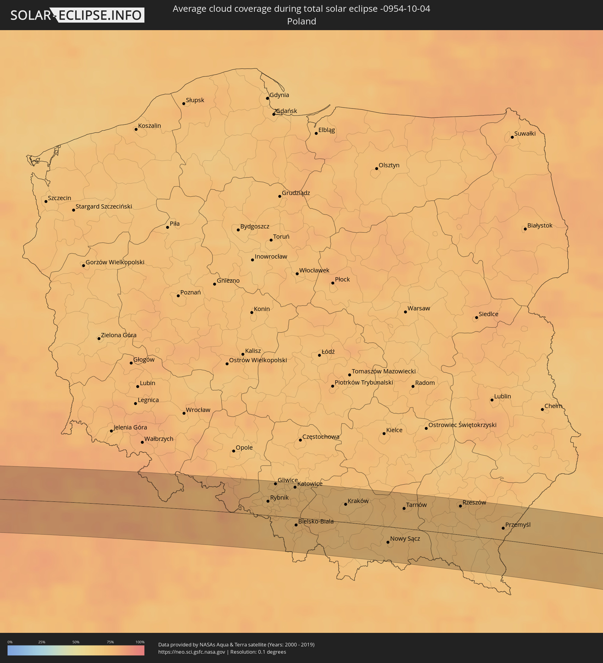 Polen
Polen
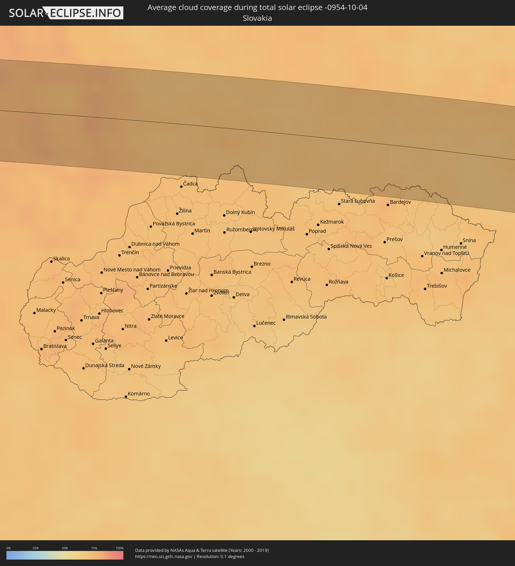 Slowakei
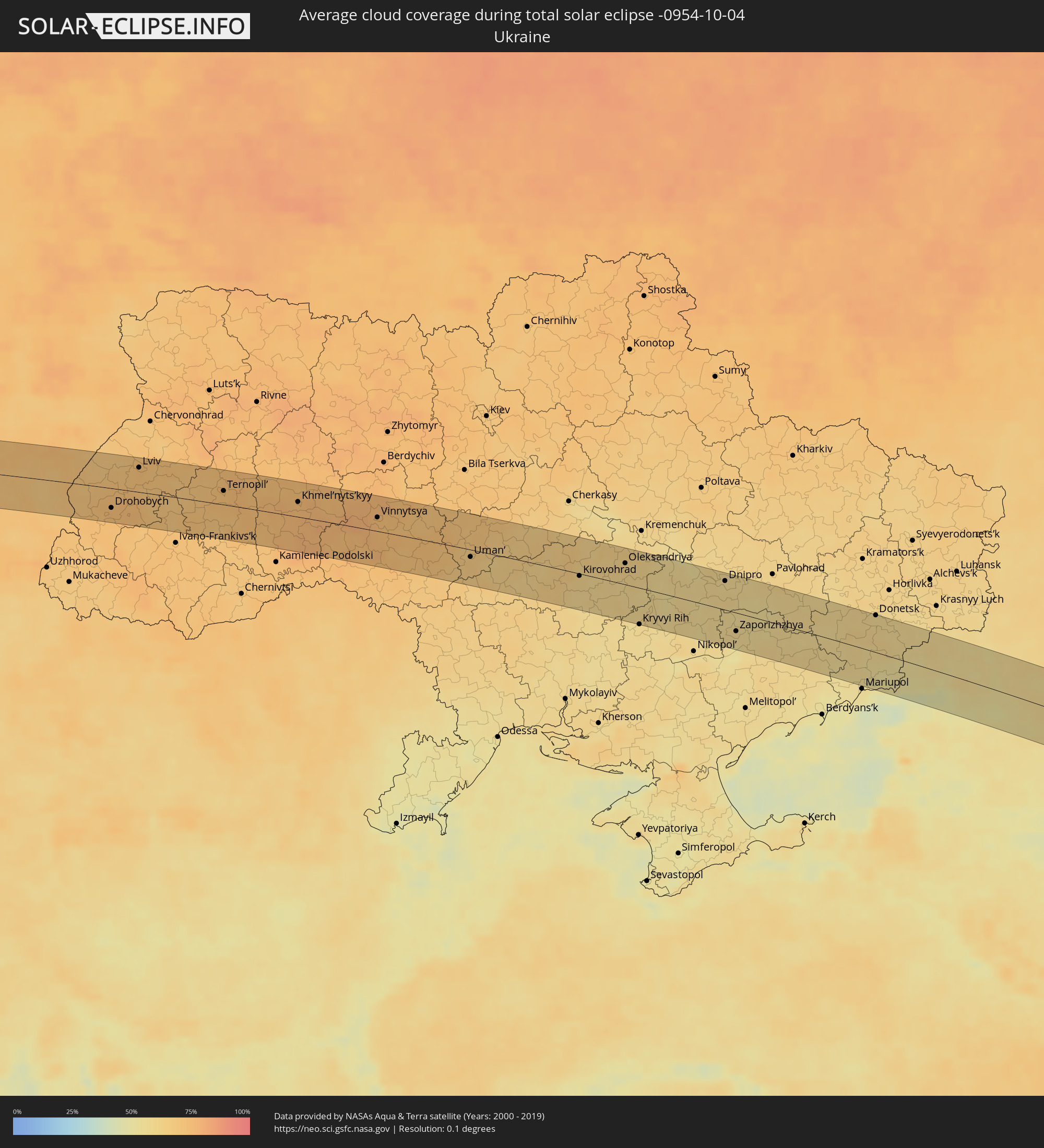 Ukraine
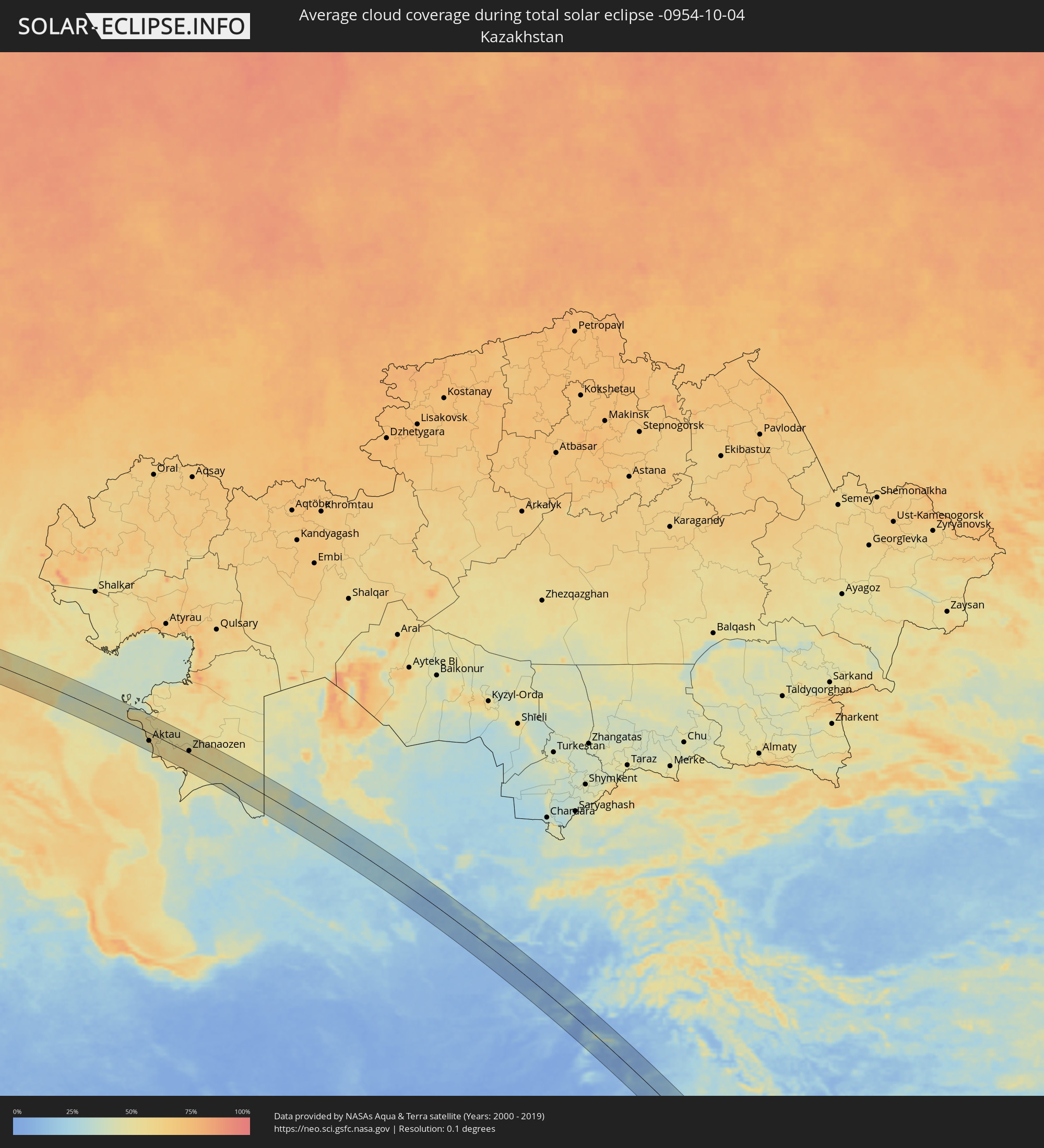 Kasachstan
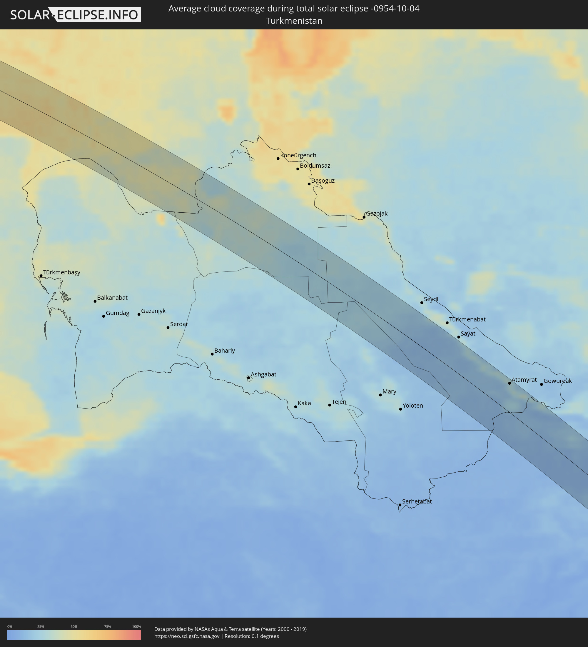 Turkmenistan
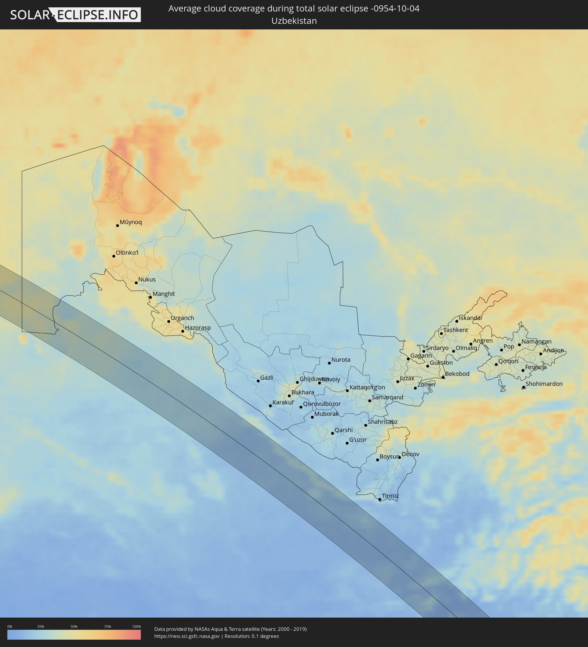 Usbekistan
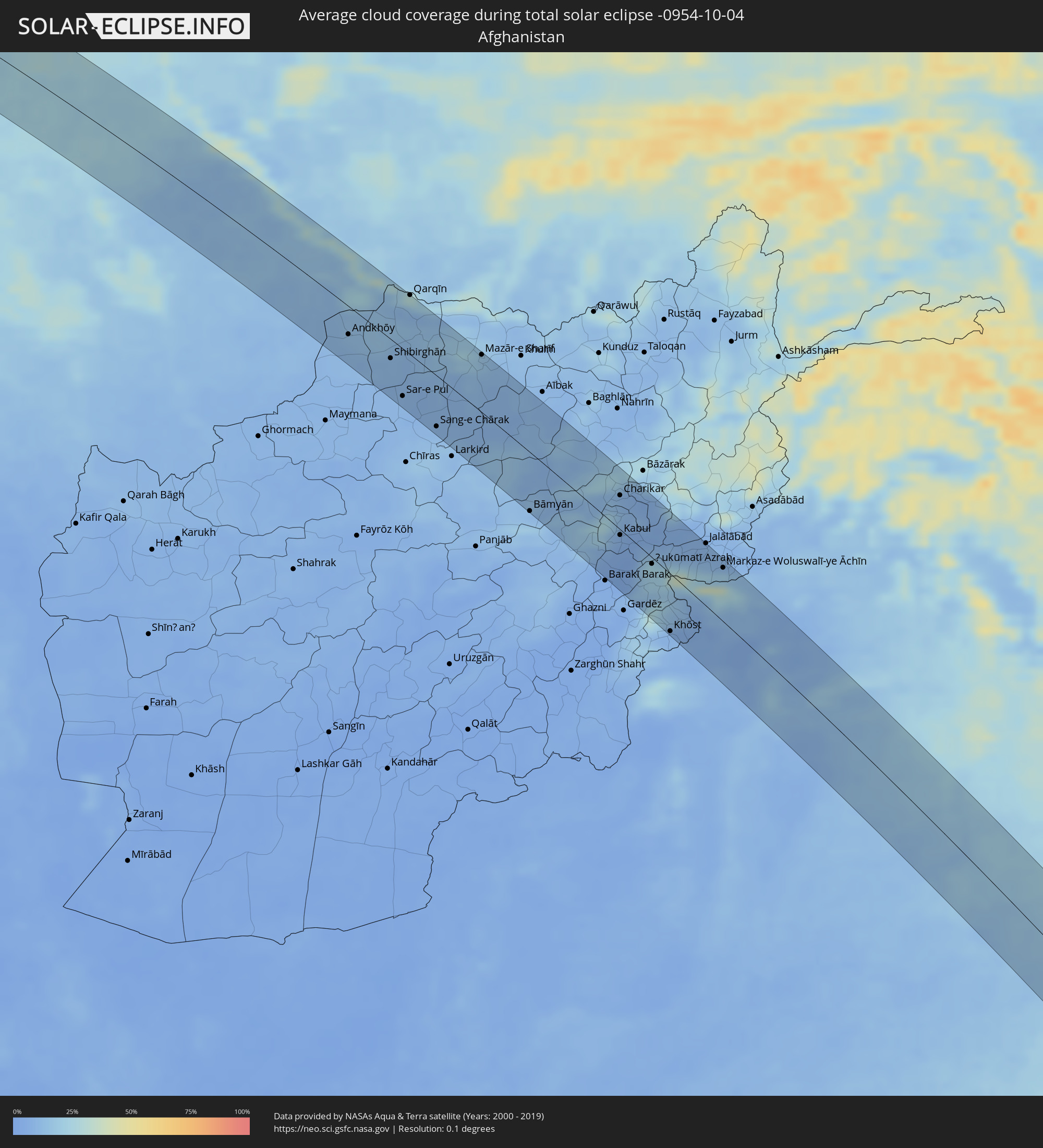 Afghanistan
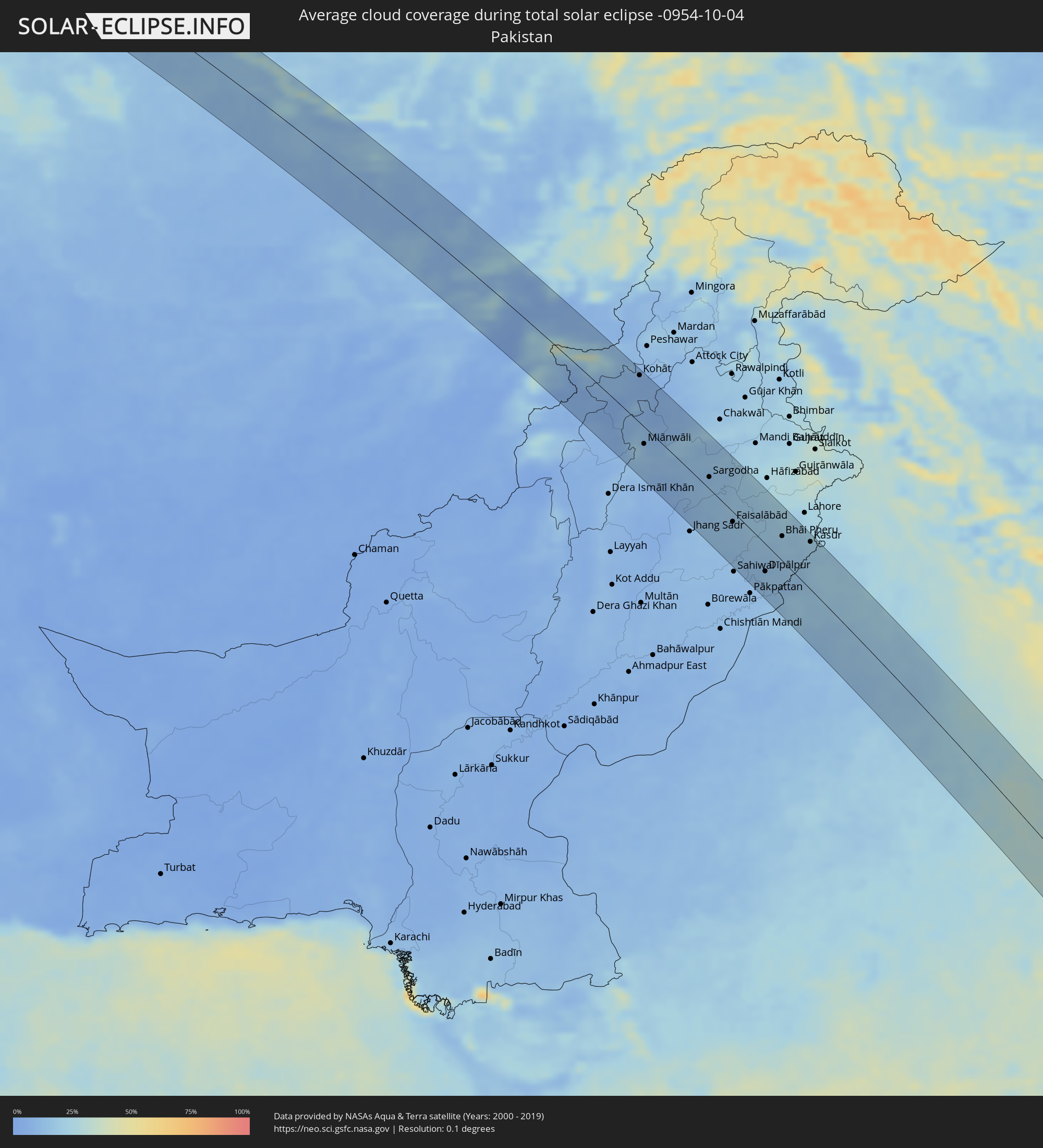 Pakistan
 Indien
 Indonesien
 Malaysia
 Singapur
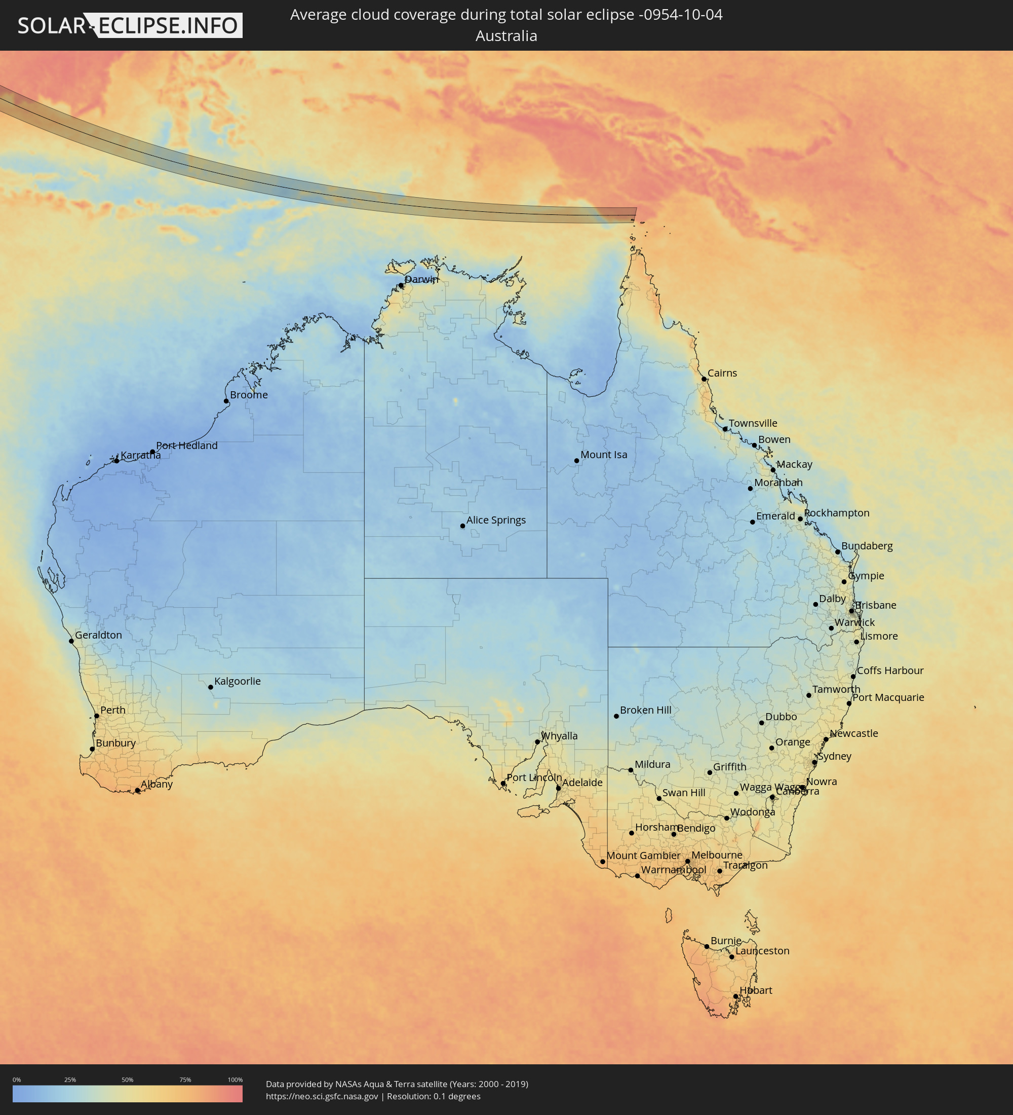 Australien
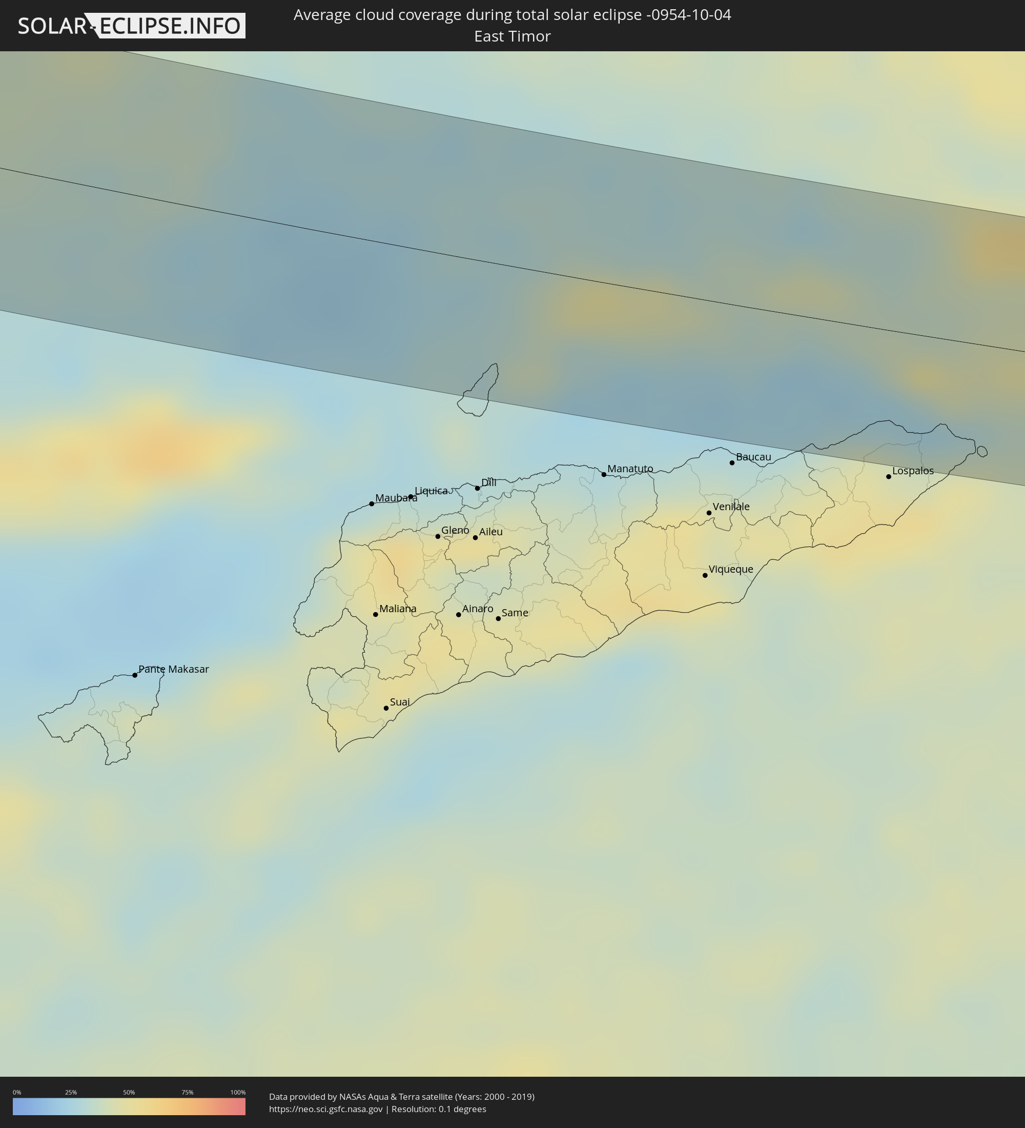 Osttimor
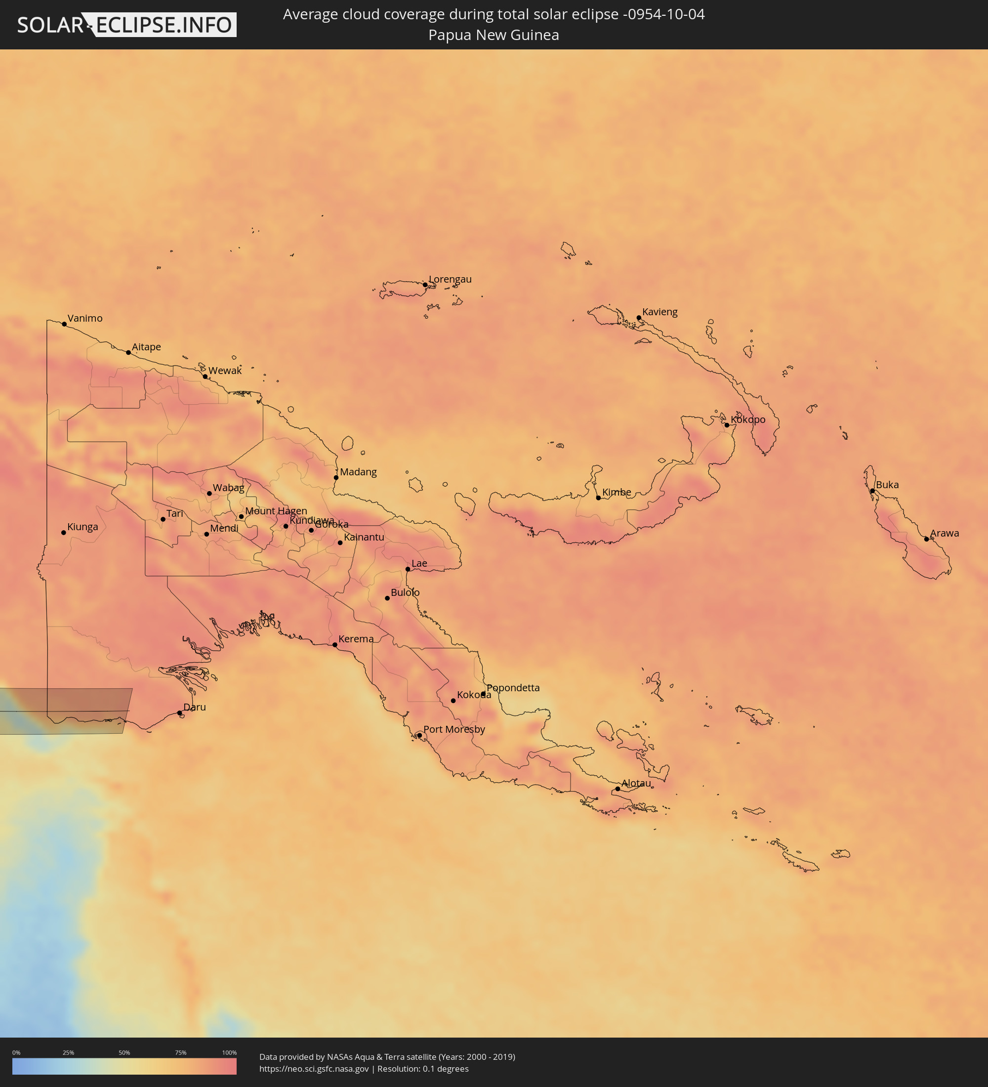 Papua-Neuguinea
Orte im Finsternispfad
Die nachfolgene Tabelle zeigt Städte und Orte mit mehr als 5.000 Einwohnern, die sich im Finsternispfad befinden. Städte mit mehr als 100.000 Einwohnern sind dick gekennzeichnet. Mit einem Klick auf den Ort öffnet sich eine Detailkarte die die Lage des jeweiligen Ortes zusammen mit dem Verlauf der zentralen Finsternis präsentiert.
| Ort | Typ | Dauer der Verfinsterung | Ortszeit bei maximaler Verfinsterung | Entfernung zur Zentrallinie | Ø Bewölkung |
|
Hof, Bavaria
|
total | - | 06:10:08 UTC+01:00 | 17 km | 81% |
|
Oberkotzau, Bavaria
|
total | - | 06:10:06 UTC+01:00 | 12 km | 81% |
|
Marktredwitz, Bavaria
|
total | - | 06:09:57 UTC+01:00 | 18 km | 82% |
|
Selb, Bavaria
|
total | - | 06:10:03 UTC+01:00 | 9 km | 82% |
|
Plauen, Saxony
|
total | - | 06:10:15 UTC+01:00 | 39 km | 81% |
|
Berg, Bavaria
|
total | - | 06:09:49 UTC+01:00 | 39 km | 83% |
|
Arzberg, Bavaria
|
total | - | 06:09:59 UTC+01:00 | 11 km | 81% |
|
Mitterteich, Bavaria
|
total | - | 06:09:55 UTC+01:00 | 22 km | 81% |
|
Adorf, Saxony
|
total | - | 06:10:09 UTC+01:00 | 19 km | 83% |
|
Waldsassen, Bavaria
|
total | - | 06:09:57 UTC+01:00 | 17 km | 81% |
|
Markneukirchen, Saxony
|
total | - | 06:10:08 UTC+01:00 | 18 km | 83% |
|
Tirschenreuth, Bavaria
|
total | - | 06:09:52 UTC+01:00 | 30 km | 81% |
|
Cheb, Karlovarský
|
total | - | 06:10:00 UTC+01:00 | 8 km | 82% |
|
Auerbach, Saxony
|
total | - | 06:10:16 UTC+01:00 | 40 km | 81% |
|
Rodewisch, Saxony
|
total | - | 06:10:17 UTC+01:00 | 42 km | 81% |
|
Klingenthal, Saxony
|
total | - | 06:10:10 UTC+01:00 | 23 km | 83% |
|
Eibenstock, Saxony
|
total | - | 06:10:16 UTC+01:00 | 39 km | 81% |
|
Karlovy Vary, Karlovarský
|
total | - | 06:10:06 UTC+01:00 | 10 km | 82% |
|
Chomutov, Ústecký
|
total | - | 06:10:16 UTC+01:00 | 37 km | 83% |
|
Most, Ústecký
|
total | - | 06:10:18 UTC+01:00 | 42 km | 82% |
|
Kladno, Central Bohemia
|
total | - | 06:10:06 UTC+01:00 | 4 km | 83% |
|
Prague, Praha
|
total | - | 06:10:04 UTC+01:00 | 2 km | 80% |
|
Mladá Boleslav, Central Bohemia
|
total | - | 06:10:18 UTC+01:00 | 36 km | 80% |
|
Kolín, Central Bohemia
|
total | - | 06:10:05 UTC+01:00 | 6 km | 80% |
|
Pardubice, Pardubický
|
total | - | 06:10:08 UTC+01:00 | 2 km | 80% |
|
Hradec Králové, Královéhradecký
|
total | - | 06:10:15 UTC+01:00 | 17 km | 80% |
|
Šumperk, Olomoucký
|
total | - | 06:10:12 UTC+01:00 | 5 km | 79% |
|
Opava, Moravskoslezský
|
total | - | 06:10:17 UTC+01:00 | 4 km | 77% |
|
Racibórz, Silesian Voivodeship
|
total | - | 06:34:25 UTC+01:24 | 15 km | 76% |
|
Kędzierzyn-Koźle, Opole Voivodeship
|
total | - | 06:34:34 UTC+01:24 | 44 km | 75% |
|
Ostrava, Moravskoslezský
|
total | - | 06:10:16 UTC+01:00 | 13 km | 74% |
|
Frýdek-Místek, Moravskoslezský
|
total | - | 06:10:11 UTC+01:00 | 29 km | 75% |
|
Karviná, Moravskoslezský
|
total | - | 06:10:19 UTC+01:00 | 9 km | 70% |
|
Rybnik, Silesian Voivodeship
|
total | - | 06:34:28 UTC+01:24 | 18 km | 73% |
|
Jastrzębie Zdrój, Silesian Voivodeship
|
total | - | 06:34:23 UTC+01:24 | 2 km | 73% |
|
Třinec, Moravskoslezský
|
total | - | 06:10:13 UTC+01:00 | 28 km | 72% |
|
Gliwice, Silesian Voivodeship
|
total | - | 06:34:36 UTC+01:24 | 41 km | 71% |
|
Katowice, Silesian Voivodeship
|
total | - | 06:34:37 UTC+01:24 | 39 km | 71% |
|
Bielsko-Biala, Silesian Voivodeship
|
total | - | 06:34:22 UTC+01:24 | 10 km | 70% |
|
Oświęcim, Lesser Poland Voivodeship
|
total | - | 06:34:31 UTC+01:24 | 15 km | 74% |
|
Jaworzno, Silesian Voivodeship
|
total | - | 06:34:38 UTC+01:24 | 34 km | 72% |
|
Kraków, Lesser Poland Voivodeship
|
total | - | 06:34:38 UTC+01:24 | 23 km | 69% |
|
Nowy Sącz, Lesser Poland Voivodeship
|
total | - | 06:34:30 UTC+01:24 | 20 km | 71% |
|
Tarnów, Lesser Poland Voivodeship
|
total | - | 06:34:47 UTC+01:24 | 25 km | 72% |
|
Dębica, Subcarpathian Voivodeship
|
total | - | 06:34:53 UTC+01:24 | 33 km | 72% |
|
Krosno, Subcarpathian Voivodeship
|
total | - | 06:34:44 UTC+01:24 | 4 km | 71% |
|
Rzeszów, Subcarpathian Voivodeship
|
total | - | 06:34:59 UTC+01:24 | 36 km | 71% |
|
Przemyśl, Subcarpathian Voivodeship
|
total | - | 06:35:00 UTC+01:24 | 15 km | 72% |
|
Drohobych, Lviv
|
total | - | 07:12:59 UTC+02:02 | 26 km | 73% |
|
Stryi, Lviv
|
total | - | 07:13:01 UTC+02:02 | 32 km | 74% |
|
Lviv, Lviv
|
total | - | 07:13:22 UTC+02:02 | 33 km | 73% |
|
Ternopil’, Ternopil
|
total | - | 07:13:37 UTC+02:02 | 18 km | 72% |
|
Khmel’nyts’kyy, Khmelnytskyi
|
total | - | 07:13:56 UTC+02:02 | 20 km | 74% |
|
Zhmerynka, Vinnyts'ka
|
total | - | 07:14:05 UTC+02:02 | 8 km | 75% |
|
Vinnytsya, Vinnyts'ka
|
total | - | 07:14:18 UTC+02:02 | 18 km | 74% |
|
Uman’, Cherkasy
|
total | - | 07:14:40 UTC+02:02 | 10 km | 68% |
|
Kirovohrad, Kirovohrad
|
total | - | 07:15:21 UTC+02:02 | 3 km | 61% |
|
Oleksandriya, Kirovohrad
|
total | - | 07:15:47 UTC+02:02 | 28 km | 63% |
|
Kryvyi Rih, Dnipropetrovsk
|
total | - | 07:15:34 UTC+02:02 | 49 km | 58% |
|
Zhovti Vody, Dnipropetrovsk
|
total | - | 07:15:48 UTC+02:02 | 0 km | 58% |
|
Dniprodzerzhyns’k, Dnipropetrovsk
|
total | - | 07:16:22 UTC+02:02 | 38 km | 58% |
|
Dnipro, Dnipropetrovsk
|
total | - | 07:16:31 UTC+02:02 | 39 km | 58% |
|
Zaporizhzhya, Zaporizhia
|
total | - | 07:16:22 UTC+02:02 | 25 km | 57% |
|
Donetsk, Donetsk
|
total | - | 07:17:46 UTC+02:02 | 50 km | 58% |
|
Matveyev Kurgan, Rostov Oblast
|
total | - | 07:46:25 UTC+02:30 | 24 km | 58% |
|
Taganrog, Rostov Oblast
|
total | - | 07:46:20 UTC+02:30 | 10 km | 50% |
|
Azov, Rostov Oblast
|
total | - | 07:46:35 UTC+02:30 | 12 km | 53% |
|
Persianovka, Rostov Oblast
|
total | - | 07:46:43 UTC+02:30 | 33 km | 55% |
|
Chaltyr, Rostov Oblast
|
total | - | 07:46:41 UTC+02:30 | 9 km | 58% |
|
Rostov-na-Donu, Rostov Oblast
|
total | - | 07:46:48 UTC+02:30 | 9 km | 57% |
|
Novocherkassk, Rostov Oblast
|
total | - | 07:47:04 UTC+02:30 | 37 km | 56% |
|
Zernograd, Rostov Oblast
|
total | - | 07:47:02 UTC+02:30 | 18 km | 52% |
|
Bagayevskaya, Rostov Oblast
|
total | - | 07:47:13 UTC+02:30 | 34 km | 57% |
|
Yegorlykskaya, Rostov Oblast
|
total | - | 07:47:11 UTC+02:30 | 39 km | 57% |
|
Sal’sk, Rostov Oblast
|
total | - | 07:47:43 UTC+02:30 | 27 km | 58% |
|
Proletarsk, Rostov Oblast
|
total | - | 07:47:53 UTC+02:30 | 2 km | 61% |
|
Orlovskiy, Rostov Oblast
|
total | - | 07:48:08 UTC+02:30 | 28 km | 57% |
|
Divnoye, Stavropol'skiy
|
total | - | 07:48:47 UTC+02:30 | 39 km | 63% |
|
Elista, Kalmykiya
|
total | - | 07:49:28 UTC+02:30 | 28 km | 62% |
|
Kaspiyskiy, Kalmykiya
|
total | - | 07:51:39 UTC+02:30 | 25 km | 53% |
|
Fort-Shevchenko, Mangghystaū
|
total | - | 08:49:05 UTC+03:25 | 30 km | 58% |
|
Aktau, Mangghystaū
|
total | - | 08:49:55 UTC+03:25 | 24 km | 55% |
|
Yeraliyev, Mangghystaū
|
total | - | 08:50:26 UTC+03:25 | 53 km | 58% |
|
Zhetibay, Mangghystaū
|
total | - | 08:50:45 UTC+03:25 | 3 km | 53% |
|
Zhanaozen, Mangghystaū
|
total | - | 08:51:30 UTC+03:25 | 7 km | 56% |
|
Andkhōy, Faryab
|
total | - | 09:42:42 UTC+04:00 | 29 km | 12% |
|
Atamyrat, Lebap
|
total | - | 09:35:40 UTC+03:53 | 53 km | 22% |
|
Shibirghān, Jowzjan
|
total | - | 09:43:45 UTC+04:00 | 20 km | 11% |
|
Sar-e Pul, Sar-e Pol
|
total | - | 09:44:22 UTC+04:00 | 49 km | 9% |
|
Qarqīn, Jowzjan
|
total | - | 09:43:31 UTC+04:00 | 62 km | 14% |
|
Sang-e Chārak, Sar-e Pol
|
total | - | 09:45:21 UTC+04:00 | 53 km | 12% |
|
Balkh, Balkh
|
total | - | 09:45:10 UTC+04:00 | 52 km | 23% |
|
Mazār-e Sharīf, Balkh
|
total | - | 09:45:30 UTC+04:00 | 60 km | 15% |
|
Bāmyān, Bamyan
|
total | - | 09:48:12 UTC+04:00 | 61 km | 12% |
|
Paghmān, Kabul
|
total | - | 09:50:00 UTC+04:00 | 14 km | 13% |
|
Pul-e ‘Alam, Logar
|
total | - | 09:50:43 UTC+04:00 | 59 km | 4% |
|
Charikar, Parwan
|
total | - | 09:49:52 UTC+04:00 | 35 km | 9% |
|
Kabul, Kabul
|
total | - | 09:50:22 UTC+04:00 | 6 km | 5% |
|
Jabal os Saraj, Parwan
|
total | - | 09:49:51 UTC+04:00 | 48 km | 8% |
|
Ḩukūmatī Azrah, Logar
|
total | - | 09:51:24 UTC+04:00 | 7 km | 24% |
|
Khōst, Khowst
|
total | - | 09:52:42 UTC+04:00 | 59 km | 7% |
|
Markaz-e Woluswalī-ye Āchīn, Nangarhar
|
total | - | 09:52:58 UTC+04:00 | 55 km | 20% |
|
Kohāt, Khyber Pakhtunkhwa
|
total | - | 10:22:50 UTC+04:28 | 57 km | 8% |
|
Miānwāli, Punjab
|
total | - | 10:24:07 UTC+04:28 | 20 km | 17% |
|
Khushāb, Punjab
|
total | - | 10:25:41 UTC+04:28 | 11 km | 13% |
|
Sargodha, Punjab
|
total | - | 10:26:25 UTC+04:28 | 14 km | 13% |
|
Gojra, Punjab
|
total | - | 10:27:38 UTC+04:28 | 59 km | 13% |
|
Bhalwāl, Punjab
|
total | - | 10:26:32 UTC+04:28 | 45 km | 15% |
|
Chiniot, Punjab
|
total | - | 10:27:20 UTC+04:28 | 6 km | 16% |
|
Faisalābād, Punjab
|
total | - | 10:27:53 UTC+04:28 | 12 km | 15% |
|
Bahāwalnagar, Punjab
|
total | - | 10:29:29 UTC+04:28 | 60 km | 11% |
|
Jarānwāla, Punjab
|
total | - | 10:28:31 UTC+04:28 | 5 km | 16% |
|
Okāra, Punjab
|
total | - | 10:29:14 UTC+04:28 | 36 km | 12% |
|
Shahkot, Punjab
|
total | - | 10:28:17 UTC+04:28 | 27 km | 17% |
|
Dīpālpur, Punjab
|
total | - | 10:29:44 UTC+04:28 | 33 km | 15% |
|
Pattoki, Punjab
|
total | - | 10:29:34 UTC+04:28 | 8 km | 16% |
|
Bhāi Pheru, Punjab
|
total | - | 10:29:29 UTC+04:28 | 29 km | 18% |
|
Kasūr, Punjab
|
total | - | 10:30:21 UTC+04:28 | 56 km | 18% |
|
Gorakhpur, Haryana
|
total | - | 11:27:32 UTC+05:21 | 11 km | 17% |
|
Hisar, Haryana
|
total | - | 11:28:02 UTC+05:21 | 7 km | 16% |
|
Rohtak, Haryana
|
total | - | 11:29:48 UTC+05:21 | 34 km | 19% |
|
Alwar, Rajasthan
|
total | - | 11:31:53 UTC+05:21 | 64 km | 22% |
|
Delhi, NCT
|
total | - | 11:31:11 UTC+05:21 | 62 km | 28% |
|
Farīdābād, Haryana
|
total | - | 11:31:41 UTC+05:21 | 50 km | 27% |
|
Mathura, Uttar Pradesh
|
total | - | 11:33:40 UTC+05:21 | 8 km | 28% |
|
Āgra, Uttar Pradesh
|
total | - | 11:34:44 UTC+05:21 | 9 km | 30% |
|
Alīgarh, Uttar Pradesh
|
total | - | 11:33:43 UTC+05:21 | 65 km | 28% |
|
Gwalior, Madhya Pradesh
|
total | - | 11:36:32 UTC+05:21 | 50 km | 29% |
|
Fīrozābād, Uttar Pradesh
|
total | - | 11:35:24 UTC+05:21 | 35 km | 31% |
|
Etāwah, Uttar Pradesh
|
total | - | 11:37:01 UTC+05:21 | 53 km | 28% |
|
Satna, Madhya Pradesh
|
total | - | 11:43:44 UTC+05:21 | 30 km | 40% |
|
Bilāspur, Chhattisgarh
|
total | - | 11:50:30 UTC+05:21 | 44 km | 59% |
|
Korba, Chhattisgarh
|
total | - | 11:50:55 UTC+05:21 | 17 km | 60% |
|
Brahmapur, Odisha
|
total | - | 12:00:20 UTC+05:21 | 28 km | 64% |
|
Teluk Nibung, North Sumatra
|
total | - | 14:44:22 UTC+07:07 | 69 km | 92% |
|
Kuala Selangor, Selangor
|
total | - | 14:34:06 UTC+06:55 | 61 km | 92% |
|
Kampong Dungun, Perak
|
total | - | 14:34:27 UTC+06:55 | 54 km | 87% |
|
Klang, Selangor
|
total | - | 14:34:59 UTC+06:55 | 46 km | 95% |
|
Banting, Selangor
|
total | - | 14:35:27 UTC+06:55 | 31 km | 89% |
|
Kampung Baru Subang, Selangor
|
total | - | 14:34:53 UTC+06:55 | 62 km | 97% |
|
Putrajaya, Putrajaya
|
total | - | 14:35:31 UTC+06:55 | 54 km | 96% |
|
Sepang, Selangor
|
total | - | 14:36:02 UTC+06:55 | 37 km | 91% |
|
Port Dickson, Negeri Sembilan
|
total | - | 14:36:24 UTC+06:55 | 27 km | 85% |
|
Semenyih, Selangor
|
total | - | 14:35:43 UTC+06:55 | 66 km | 97% |
|
Seremban, Negeri Sembilan
|
total | - | 14:36:15 UTC+06:55 | 53 km | 95% |
|
Malacca, Melaka
|
total | - | 14:37:39 UTC+06:55 | 25 km | 83% |
|
Muar, Johor
|
total | - | 14:38:23 UTC+06:55 | 33 km | 82% |
|
Batu Pahat, Johor
|
total | - | 14:39:15 UTC+06:55 | 40 km | 89% |
|
Pontian Kechil, Johor
|
total | - | 14:40:32 UTC+06:55 | 36 km | 85% |
|
Taman Senai, Johor
|
total | - | 14:40:42 UTC+06:55 | 63 km | 96% |
|
Johor Bahru, Johor
|
total | - | 14:41:06 UTC+06:55 | 58 km | 95% |
|
Singapore, Central Singapore
|
total | - | 14:41:32 UTC+06:55 | 48 km | 89% |
|
Tanjungpinang, Riau Islands
|
total | - | 14:54:48 UTC+07:07 | 51 km | 90% |
|
Kijang, Riau Islands
|
total | - | 14:55:04 UTC+07:07 | 60 km | 92% |