Totale Sonnenfinsternis vom 28.12.-0959
| Wochentag: | Sonntag |
| Maximale Dauer der Verfinsterung: | 01m39s |
| Maximale Breite des Finsternispfades: | 132 km |
| Saroszyklus: | 26 |
| Bedeckungsgrad: | 100% |
| Magnitude: | 1.0187 |
| Gamma: | 0.8746 |
Wo kann man die Sonnenfinsternis vom 28.12.-0959 sehen?
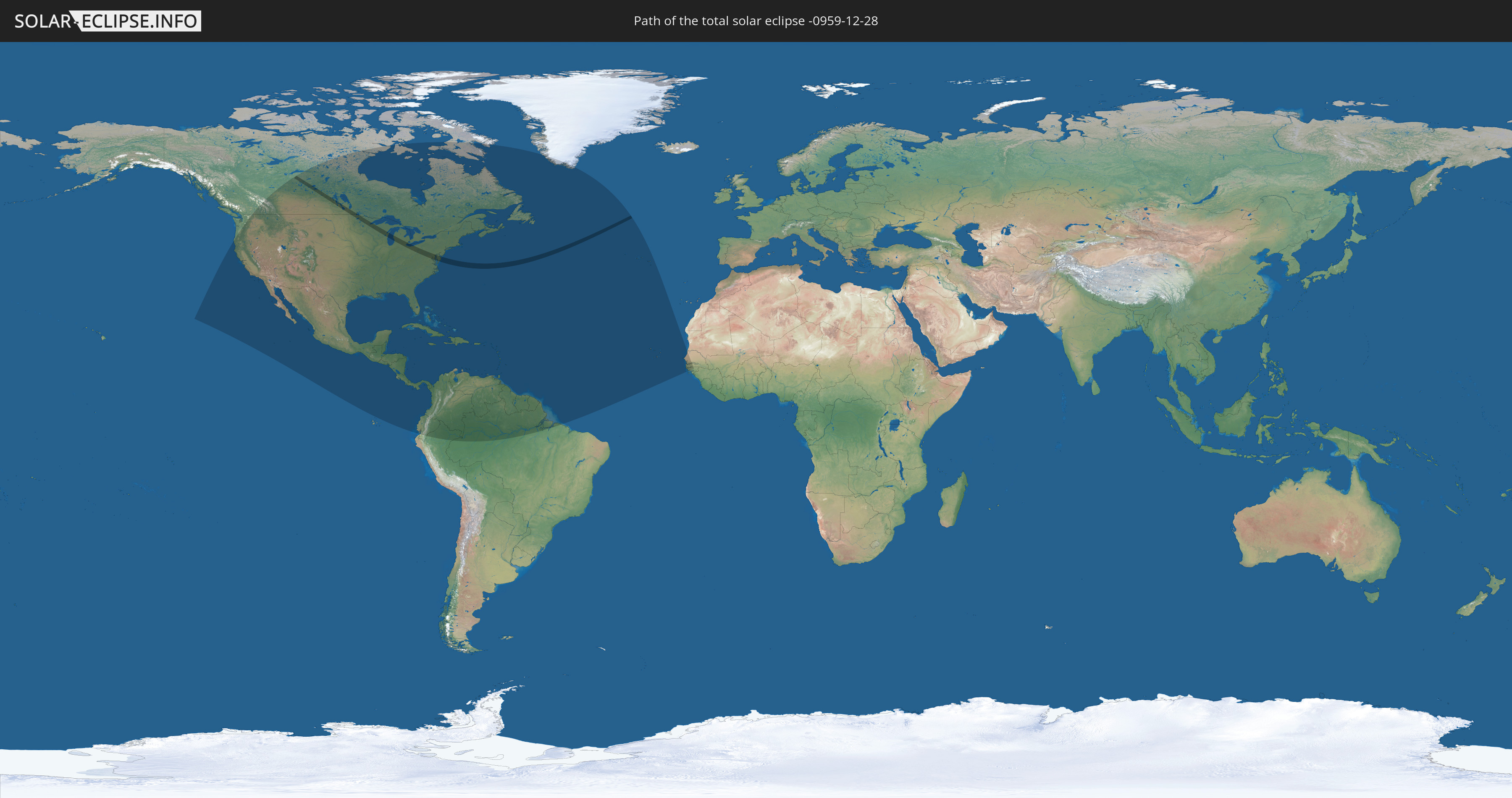
Die Sonnenfinsternis am 28.12.-0959 kann man in 53 Ländern als partielle Sonnenfinsternis beobachten.
Der Finsternispfad verläuft durch 2 Länder. Nur in diesen Ländern ist sie als totale Sonnenfinsternis zu sehen.
In den folgenden Ländern ist die Sonnenfinsternis total zu sehen
 Vereinigte Staaten
 Kanada
In den folgenden Ländern ist die Sonnenfinsternis partiell zu sehen
 Vereinigte Staaten
 United States Minor Outlying Islands
 Kanada
 Mexiko
 Grönland
 Guatemala
 Ecuador
 El Salvador
 Honduras
 Belize
 Nicaragua
 Costa Rica
 Kuba
Kuba
 Panama
 Kolumbien
 Kaimaninseln
 Peru
Peru
 Bahamas
 Jamaika
 Haiti
Haiti
 Brasilien
 Venezuela
 Turks- und Caicosinseln
 Dominikanische Republik
 Aruba
Aruba
 Puerto Rico
 Amerikanische Jungferninseln
 Bermuda
 Britische Jungferninseln
 Anguilla
 Saint-Martin
 Saint-Barthélemy
 St. Kitts und Nevis
 Antigua und Barbuda
 Montserrat
 Trinidad und Tobago
 Guadeloupe
 Grenada
 Dominica
 St. Vincent und die Grenadinen
 Guyana
 Martinique
 St. Lucia
 Barbados
 Suriname
 Saint-Pierre und Miquelon
 Französisch-Guayana
 Portugal
 Kap Verde
 Senegal
 Mauretanien
 Gambia
 Guinea-Bissau
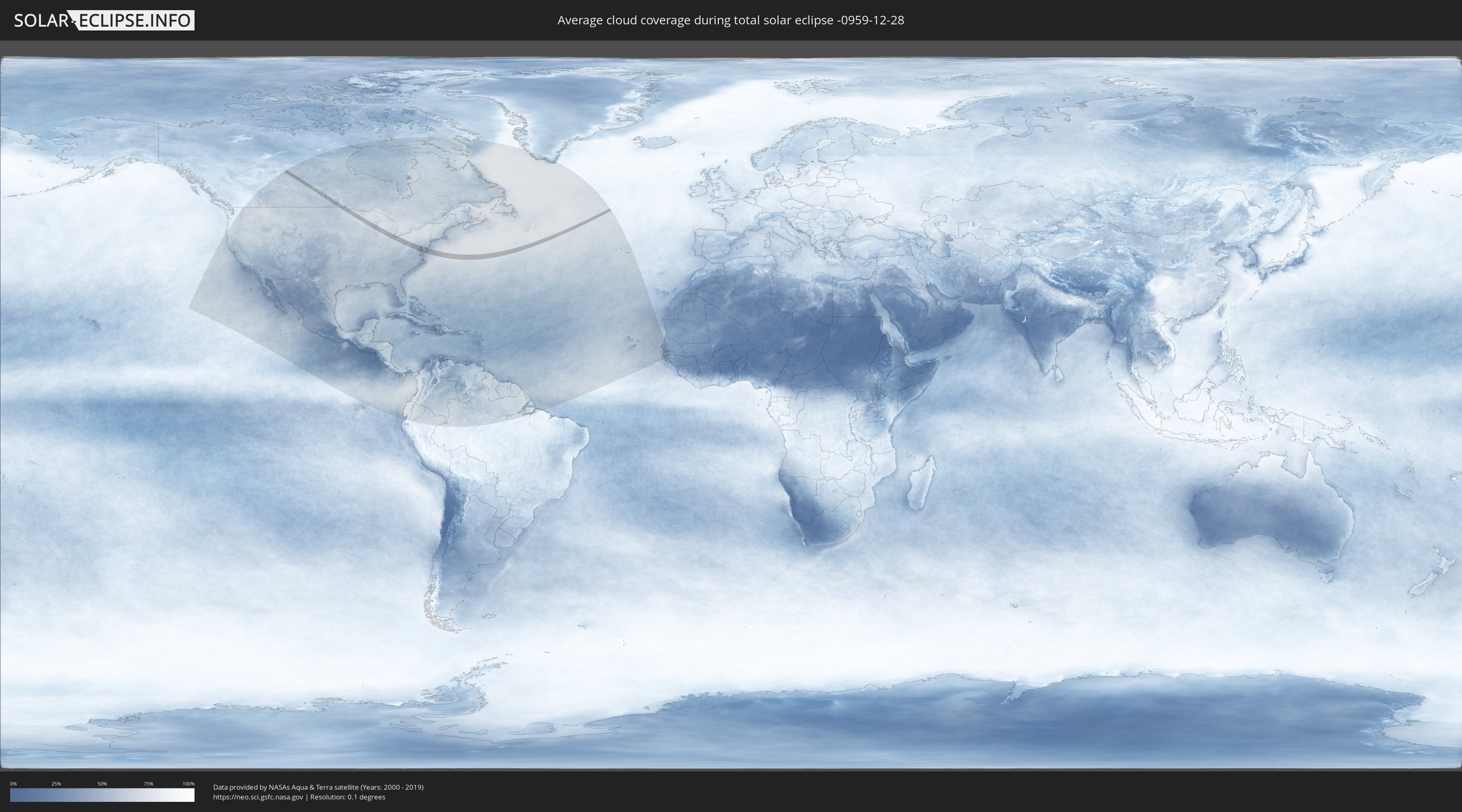
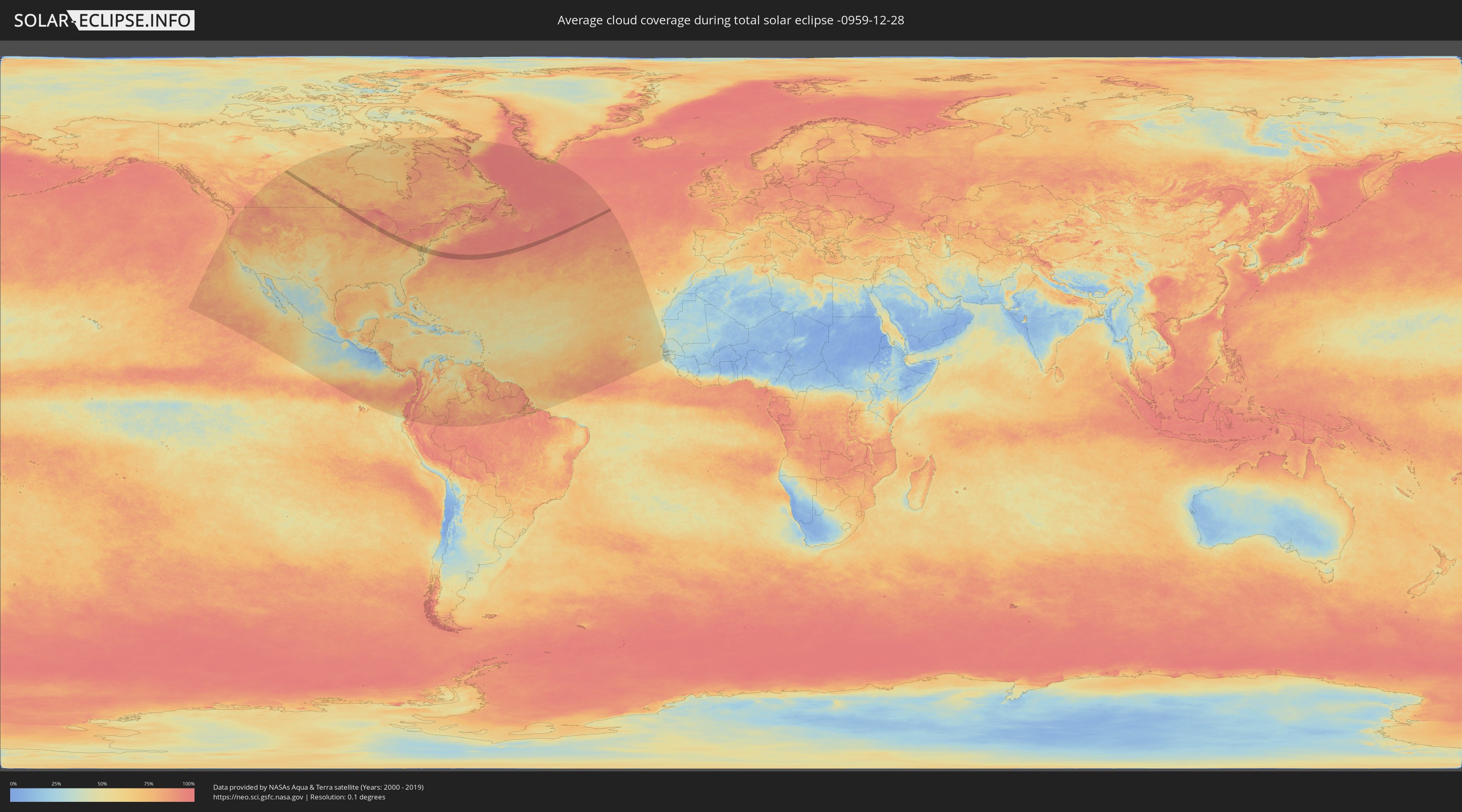
Wie wird das Wetter während der totalen Sonnenfinsternis am 28.12.-0959?
Wo ist der beste Ort, um die totale Sonnenfinsternis vom 28.12.-0959 zu beobachten?
Die folgenden Karten zeigen die durchschnittliche Bewölkung für den Tag, an dem die totale Sonnenfinsternis
stattfindet. Mit Hilfe der Karten lässt sich der Ort entlang des Finsternispfades eingrenzen,
der die besten Aussichen auf einen klaren wolkenfreien Himmel bietet.
Trotzdem muss man immer lokale Gegenenheiten beachten und sollte sich genau über das Wetter an seinem
gewählten Beobachtungsort informieren.
Die Daten stammen von den beiden NASA-Satelliten
AQUA und TERRA
und wurden über einen Zeitraum von 19 Jahren (2000 - 2019) gemittelt.
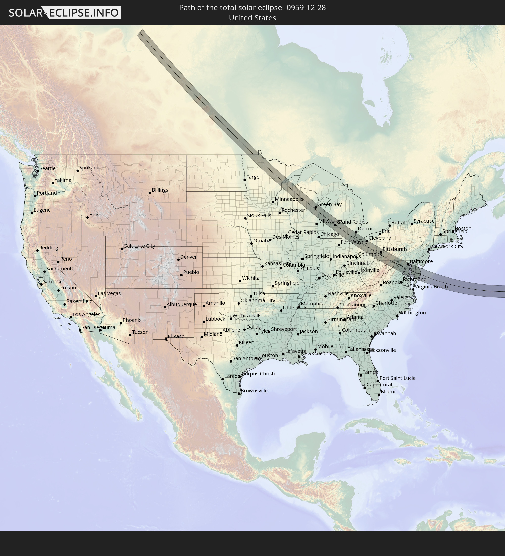
Detaillierte Länderkarten
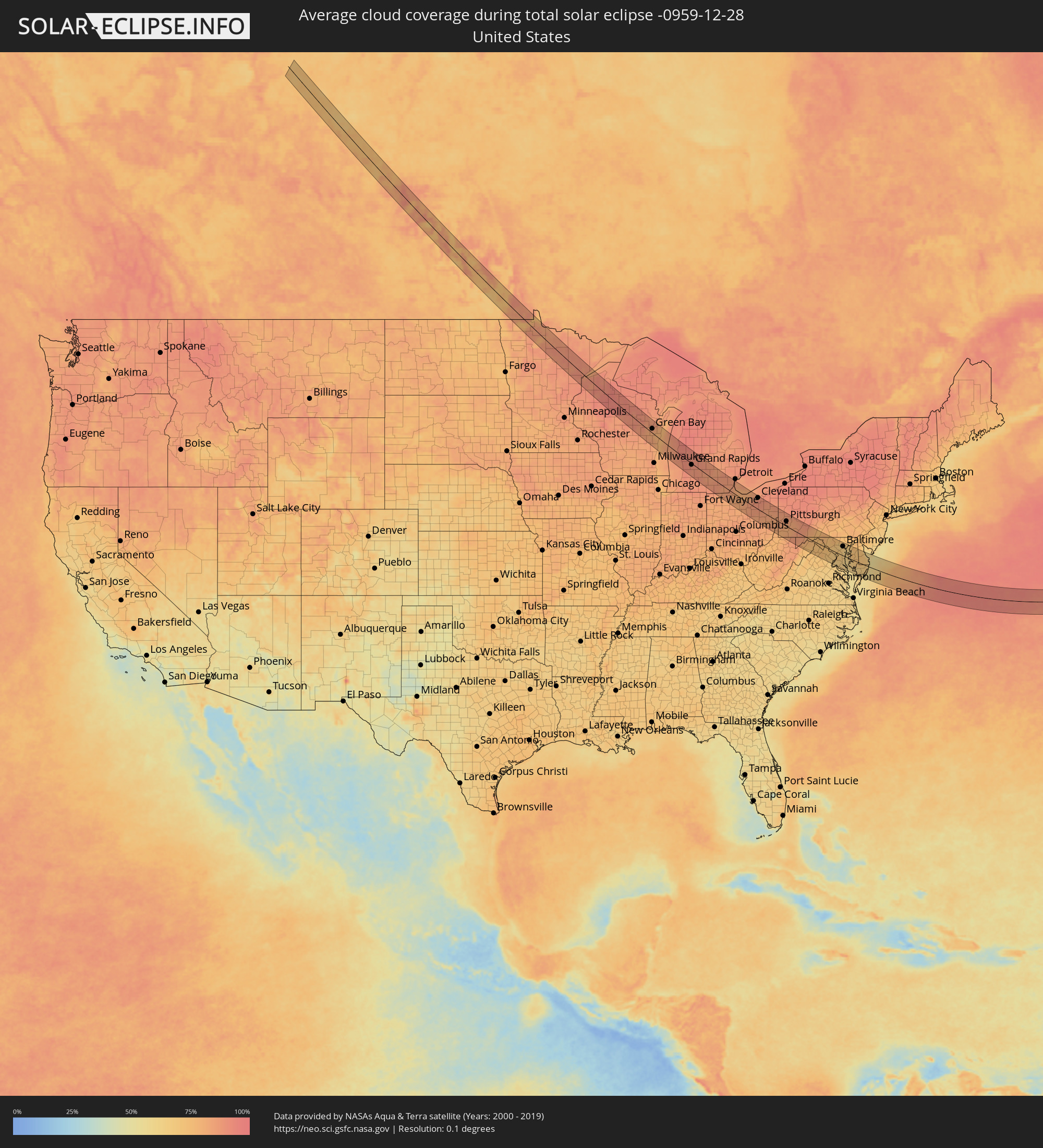 Vereinigte Staaten
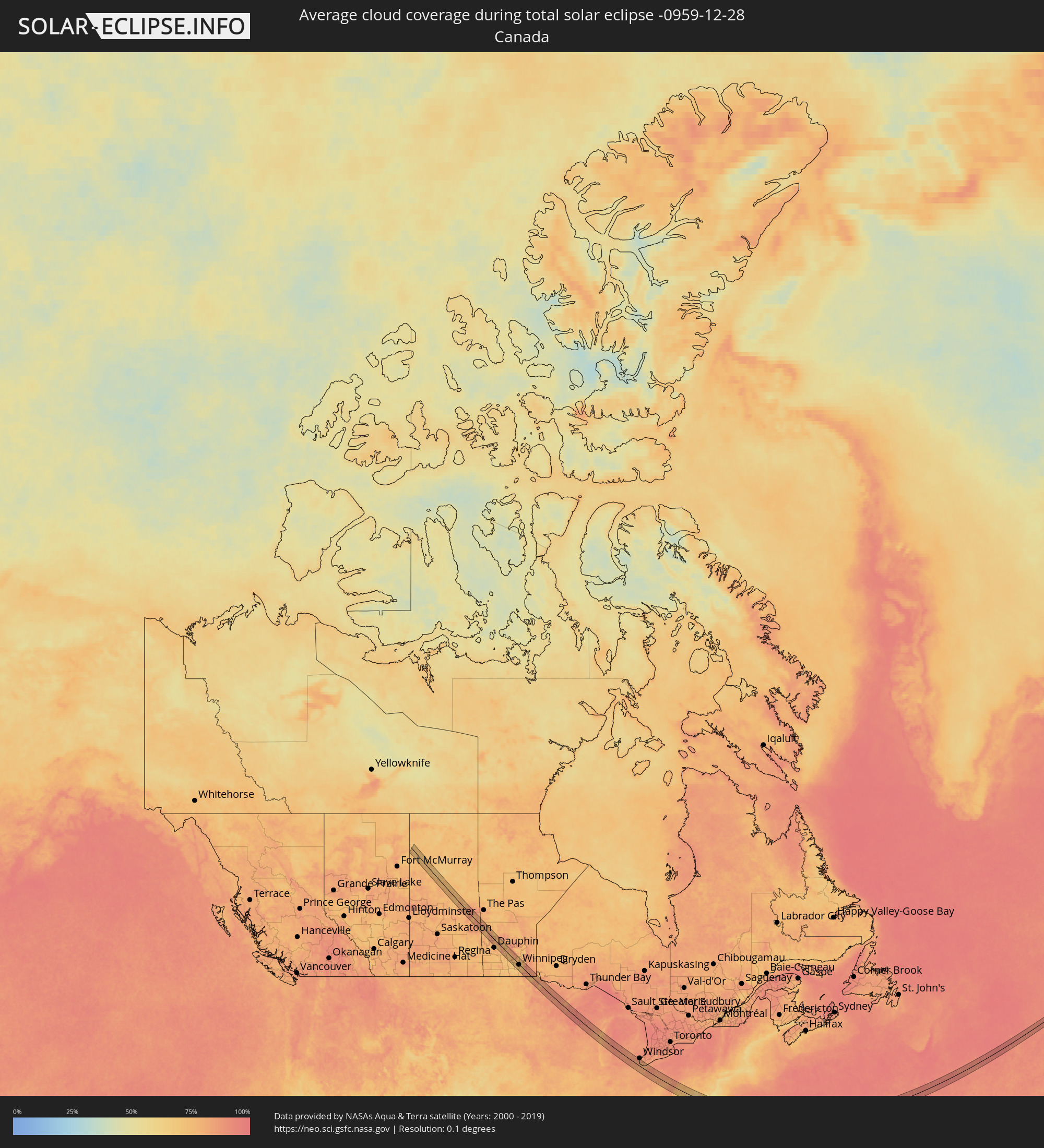 Kanada
Orte im Finsternispfad
Die nachfolgene Tabelle zeigt Städte und Orte mit mehr als 5.000 Einwohnern, die sich im Finsternispfad befinden. Städte mit mehr als 100.000 Einwohnern sind dick gekennzeichnet. Mit einem Klick auf den Ort öffnet sich eine Detailkarte die die Lage des jeweiligen Ortes zusammen mit dem Verlauf der zentralen Finsternis präsentiert.
| Ort | Typ | Dauer der Verfinsterung | Ortszeit bei maximaler Verfinsterung | Entfernung zur Zentrallinie | Ø Bewölkung |
|
Winnipeg, Manitoba
|
total | - | 10:27:29 UTC-06:00 | 2 km | 77% |
|
Selkirk, Manitoba
|
total | - | 10:28:00 UTC-06:00 | 31 km | 78% |
|
Steinbach, Manitoba
|
total | - | 10:27:47 UTC-06:00 | 8 km | 80% |
|
Grand Rapids, Minnesota
|
total | - | 10:30:25 UTC-06:00 | 33 km | 88% |
|
Hibbing, Minnesota
|
total | - | 10:31:21 UTC-06:00 | 12 km | 89% |
|
Cloquet, Minnesota
|
total | - | 10:31:38 UTC-06:00 | 22 km | 88% |
|
Duluth, Minnesota
|
total | - | 10:32:11 UTC-06:00 | 1 km | 85% |
|
Merrill, Wisconsin
|
total | - | 10:35:03 UTC-06:00 | 11 km | 88% |
|
Wausau, Wisconsin
|
total | - | 10:35:02 UTC-06:00 | 27 km | 88% |
|
Appleton, Wisconsin
|
total | - | 10:36:43 UTC-06:00 | 26 km | 84% |
|
Green Bay, Wisconsin
|
total | - | 10:37:28 UTC-06:00 | 16 km | 82% |
|
Sheboygan, Wisconsin
|
total | - | 10:37:42 UTC-06:00 | 36 km | 79% |
|
Manitowoc, Wisconsin
|
total | - | 10:37:55 UTC-06:00 | 4 km | 79% |
|
Muskegon, Michigan
|
total | - | 11:40:03 UTC-05:00 | 9 km | 91% |
|
Grand Haven, Michigan
|
total | - | 11:40:02 UTC-05:00 | 24 km | 90% |
|
Holland, Michigan
|
total | - | 11:40:10 UTC-05:00 | 42 km | 91% |
|
Allendale, Michigan
|
total | - | 11:40:30 UTC-05:00 | 18 km | 91% |
|
Grand Rapids, Michigan
|
total | - | 11:41:00 UTC-05:00 | 5 km | 89% |
|
Battle Creek, Michigan
|
total | - | 11:41:43 UTC-05:00 | 40 km | 89% |
|
Ionia, Michigan
|
total | - | 11:42:05 UTC-05:00 | 26 km | 89% |
|
Lansing, Michigan
|
total | - | 11:42:57 UTC-05:00 | 28 km | 87% |
|
Jackson, Michigan
|
total | - | 11:43:08 UTC-05:00 | 9 km | 86% |
|
Adrian, Michigan
|
total | - | 11:43:44 UTC-05:00 | 24 km | 85% |
|
Ann Arbor, Michigan
|
total | - | 11:44:21 UTC-05:00 | 25 km | 86% |
|
South Lyon, Michigan
|
total | - | 11:44:33 UTC-05:00 | 46 km | 87% |
|
Bowling Green, Ohio
|
total | - | 11:44:22 UTC-05:00 | 54 km | 81% |
|
Toledo, Ohio
|
total | - | 11:44:36 UTC-05:00 | 22 km | 84% |
|
Monroe, Michigan
|
total | - | 11:44:56 UTC-05:00 | 8 km | 85% |
|
Livonia, Michigan
|
total | - | 11:45:06 UTC-05:00 | 52 km | 87% |
|
Taylor, Michigan
|
total | - | 11:45:14 UTC-05:00 | 44 km | 87% |
|
Grosse Ile, Michigan
|
total | - | 11:45:27 UTC-05:00 | 40 km | 84% |
|
Fremont, Ohio
|
total | - | 11:45:22 UTC-05:00 | 31 km | 81% |
|
Amherstburg, Ontario
|
total | - | 11:45:37 UTC-05:00 | 43 km | 85% |
|
Sandusky, Ohio
|
total | - | 11:46:11 UTC-05:00 | 3 km | 81% |
|
Norwalk, Ohio
|
total | - | 11:46:20 UTC-05:00 | 18 km | 82% |
|
Vermilion, Ohio
|
total | - | 11:46:50 UTC-05:00 | 10 km | 82% |
|
Ashland, Ohio
|
total | - | 11:46:52 UTC-05:00 | 40 km | 85% |
|
Lorain, Ohio
|
total | - | 11:47:11 UTC-05:00 | 21 km | 84% |
|
Wooster, Ohio
|
total | - | 11:47:36 UTC-05:00 | 28 km | 85% |
|
Westlake, Ohio
|
total | - | 11:47:42 UTC-05:00 | 34 km | 87% |
|
Medina, Ohio
|
total | - | 11:47:47 UTC-05:00 | 6 km | 86% |
|
Strongsville, Ohio
|
total | - | 11:47:51 UTC-05:00 | 24 km | 89% |
|
Wadsworth, Ohio
|
total | - | 11:48:02 UTC-05:00 | 2 km | 87% |
|
Cleveland, Ohio
|
total | - | 11:48:08 UTC-05:00 | 48 km | 89% |
|
Brecksville, Ohio
|
total | - | 11:48:15 UTC-05:00 | 34 km | 89% |
|
Akron, Ohio
|
total | - | 11:48:27 UTC-05:00 | 16 km | 88% |
|
Green, Ohio
|
total | - | 11:48:31 UTC-05:00 | 5 km | 85% |
|
New Philadelphia, Ohio
|
total | - | 11:48:33 UTC-05:00 | 36 km | 82% |
|
Solon, Ohio
|
total | - | 11:48:38 UTC-05:00 | 49 km | 89% |
|
Canton, Ohio
|
total | - | 11:48:42 UTC-05:00 | 4 km | 84% |
|
Kent, Ohio
|
total | - | 11:48:46 UTC-05:00 | 30 km | 87% |
|
Alliance, Ohio
|
total | - | 11:49:15 UTC-05:00 | 19 km | 83% |
|
Salem, Ohio
|
total | - | 11:49:45 UTC-05:00 | 29 km | 83% |
|
Wheeling, West Virginia
|
total | - | 11:49:59 UTC-05:00 | 45 km | 80% |
|
Youngstown, Ohio
|
total | - | 11:50:10 UTC-05:00 | 57 km | 87% |
|
Weirton, West Virginia
|
total | - | 11:50:16 UTC-05:00 | 6 km | 82% |
|
East Liverpool, Ohio
|
total | - | 11:50:18 UTC-05:00 | 14 km | 83% |
|
Washington, Pennsylvania
|
total | - | 11:50:57 UTC-05:00 | 14 km | 81% |
|
Carnot-Moon, Pennsylvania
|
total | - | 11:51:01 UTC-05:00 | 20 km | 85% |
|
Cranberry Township, Pennsylvania
|
total | - | 11:51:15 UTC-05:00 | 41 km | 84% |
|
Pittsburgh, Pennsylvania
|
total | - | 11:51:28 UTC-05:00 | 22 km | 83% |
|
South Park Township, Pennsylvania
|
total | - | 11:51:28 UTC-05:00 | 8 km | 81% |
|
Morgantown, West Virginia
|
total | - | 11:51:33 UTC-05:00 | 55 km | 82% |
|
Monroeville, Pennsylvania
|
total | - | 11:51:53 UTC-05:00 | 29 km | 83% |
|
New Kensington, Pennsylvania
|
total | - | 11:51:56 UTC-05:00 | 44 km | 85% |
|
Uniontown, Pennsylvania
|
total | - | 11:52:02 UTC-05:00 | 19 km | 83% |
|
Greensburg, Pennsylvania
|
total | - | 11:52:24 UTC-05:00 | 28 km | 82% |
|
Johnstown, Pennsylvania
|
total | - | 11:53:40 UTC-05:00 | 56 km | 88% |
|
Cumberland, Maryland
|
total | - | 11:54:01 UTC-05:00 | 4 km | 79% |
|
Front Royal, Virginia
|
total | - | 11:55:16 UTC-05:00 | 54 km | 67% |
|
Winchester, Virginia
|
total | - | 11:55:19 UTC-05:00 | 26 km | 74% |
|
Martinsburg, West Virginia
|
total | - | 11:55:43 UTC-05:00 | 9 km | 75% |
|
Warrenton, Virginia
|
total | - | 11:56:08 UTC-05:00 | 59 km | 69% |
|
Hagerstown, Maryland
|
total | - | 11:56:13 UTC-05:00 | 37 km | 75% |
|
Waynesboro, Pennsylvania
|
total | - | 11:56:30 UTC-05:00 | 53 km | 77% |
|
Linton Hall, Virginia
|
total | - | 11:56:37 UTC-05:00 | 46 km | 69% |
|
Ashburn, Virginia
|
total | - | 11:56:46 UTC-05:00 | 14 km | 72% |
|
Centreville, Virginia
|
total | - | 11:56:55 UTC-05:00 | 32 km | 70% |
|
Frederick, Maryland
|
total | - | 11:56:53 UTC-05:00 | 26 km | 73% |
|
Reston, Virginia
|
total | - | 11:57:05 UTC-05:00 | 16 km | 68% |
|
Dale City, Virginia
|
total | - | 11:57:11 UTC-05:00 | 48 km | 66% |
|
Green Valley, Maryland
|
total | - | 11:57:08 UTC-05:00 | 20 km | 70% |
|
Germantown, Maryland
|
total | - | 11:57:13 UTC-05:00 | 7 km | 69% |
|
Annandale, Virginia
|
total | - | 11:57:25 UTC-05:00 | 25 km | 68% |
|
Aspen Hill, Maryland
|
total | - | 11:57:39 UTC-05:00 | 5 km | 68% |
|
Washington, D.C., Washington, D.C.
|
total | - | 11:57:45 UTC-05:00 | 12 km | 71% |
|
Westminster, Maryland
|
total | - | 11:57:45 UTC-05:00 | 58 km | 74% |
|
Waldorf, Maryland
|
total | - | 11:58:00 UTC-05:00 | 36 km | 64% |
|
Clinton, Maryland
|
total | - | 11:58:04 UTC-05:00 | 20 km | 69% |
|
South Laurel, Maryland
|
total | - | 11:58:08 UTC-05:00 | 12 km | 70% |
|
Columbia, Maryland
|
total | - | 11:58:08 UTC-05:00 | 30 km | 69% |
|
Owings Mills, Maryland
|
total | - | 11:58:14 UTC-05:00 | 50 km | 68% |
|
Bowie, Maryland
|
total | - | 11:58:24 UTC-05:00 | 4 km | 67% |
|
Severn, Maryland
|
total | - | 11:58:27 UTC-05:00 | 25 km | 67% |
|
Baltimore, Maryland
|
total | - | 11:58:36 UTC-05:00 | 43 km | 68% |
|
Riviera Beach, Maryland
|
total | - | 11:58:51 UTC-05:00 | 35 km | 62% |
|
California, Maryland
|
total | - | 11:58:59 UTC-05:00 | 53 km | 63% |
|
Annapolis, Maryland
|
total | - | 11:58:55 UTC-05:00 | 16 km | 64% |
|
Perry Hall, Maryland
|
total | - | 11:58:54 UTC-05:00 | 61 km | 67% |
|
Cambridge, Maryland
|
total | - | 11:59:53 UTC-05:00 | 11 km | 65% |
|
Easton, Maryland
|
total | - | 11:59:51 UTC-05:00 | 10 km | 68% |
|
Salisbury, Maryland
|
total | - | 12:00:58 UTC-05:00 | 16 km | 67% |
|
Milford, Delaware
|
total | - | 12:01:14 UTC-05:00 | 47 km | 72% |
|
Ocean Pines, Maryland
|
total | - | 12:01:56 UTC-05:00 | 2 km | 68% |