Totale Sonnenfinsternis vom 31.05.-0975
| Wochentag: | Sonntag |
| Maximale Dauer der Verfinsterung: | 04m22s |
| Maximale Breite des Finsternispfades: | 160 km |
| Saroszyklus: | 41 |
| Bedeckungsgrad: | 100% |
| Magnitude: | 1.048 |
| Gamma: | 0.0261 |
Wo kann man die Sonnenfinsternis vom 31.05.-0975 sehen?
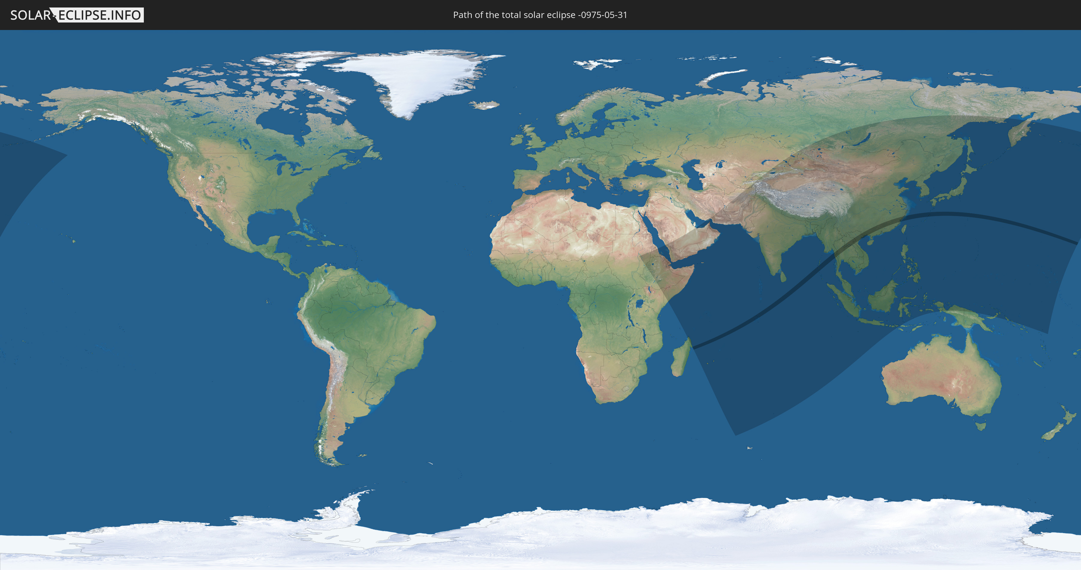
Die Sonnenfinsternis am 31.05.-0975 kann man in 60 Ländern als partielle Sonnenfinsternis beobachten.
Der Finsternispfad verläuft durch 9 Länder. Nur in diesen Ländern ist sie als totale Sonnenfinsternis zu sehen.
In den folgenden Ländern ist die Sonnenfinsternis total zu sehen
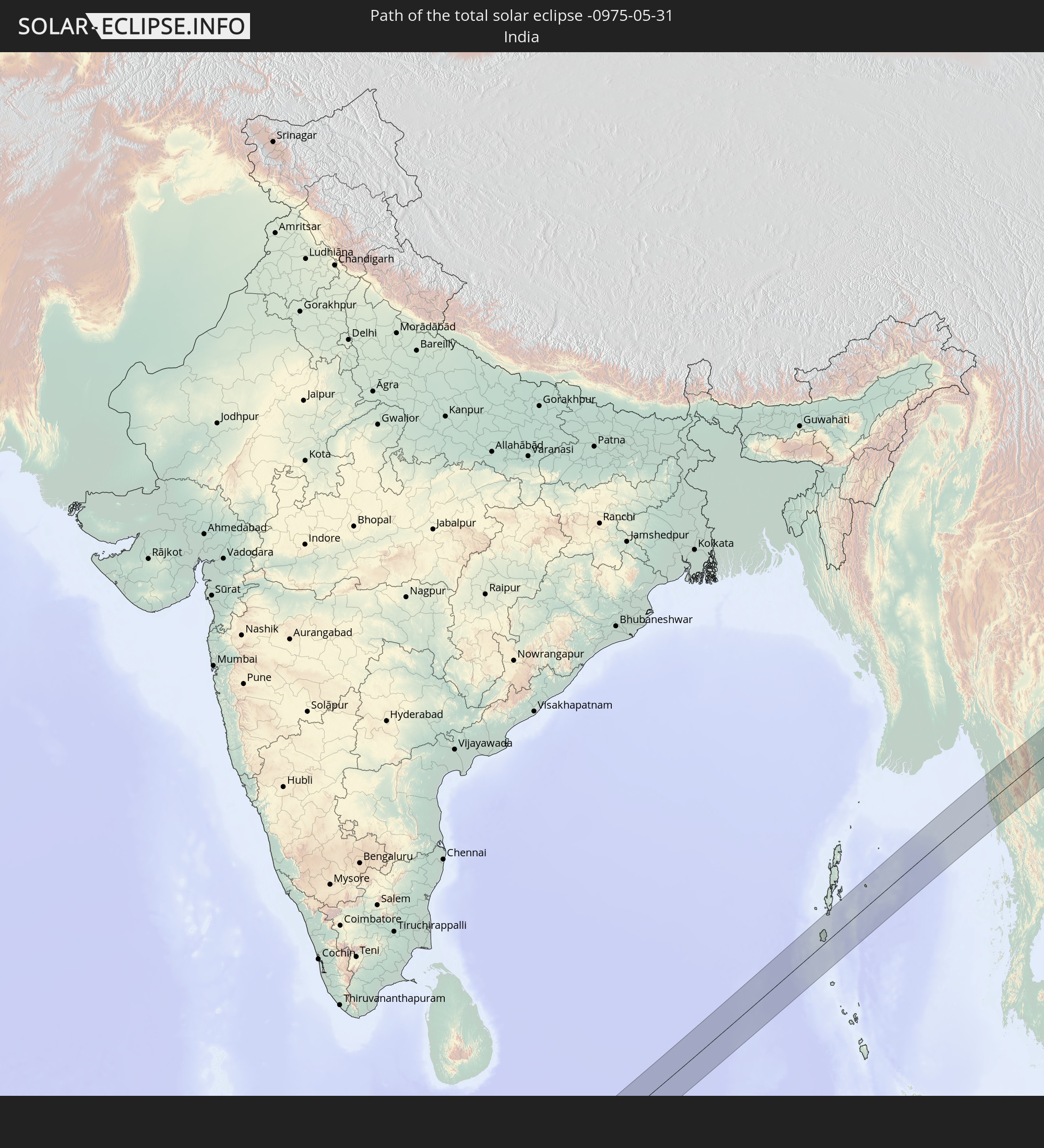 Indien
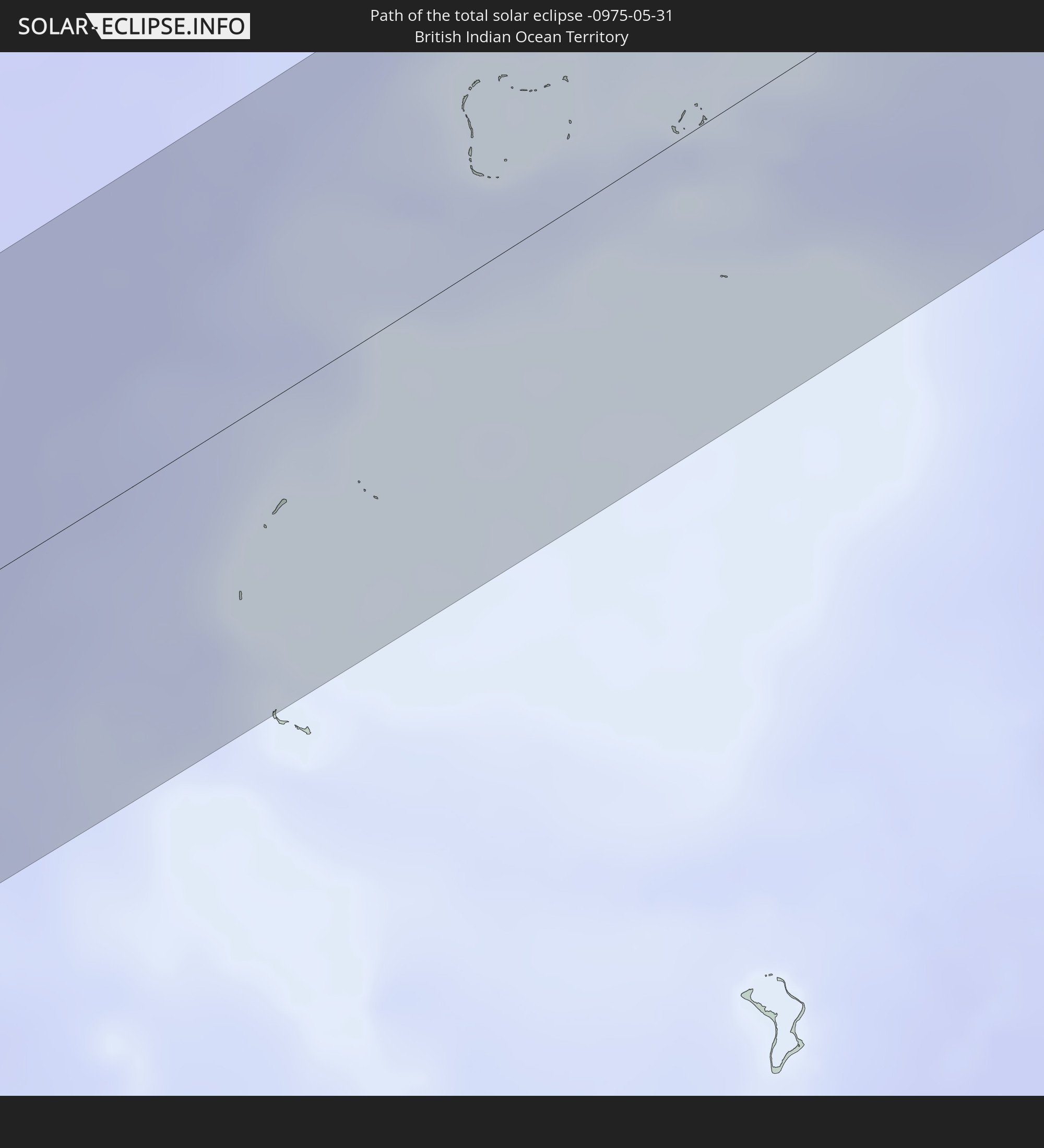 Britisches Territorium im Indischen Ozean
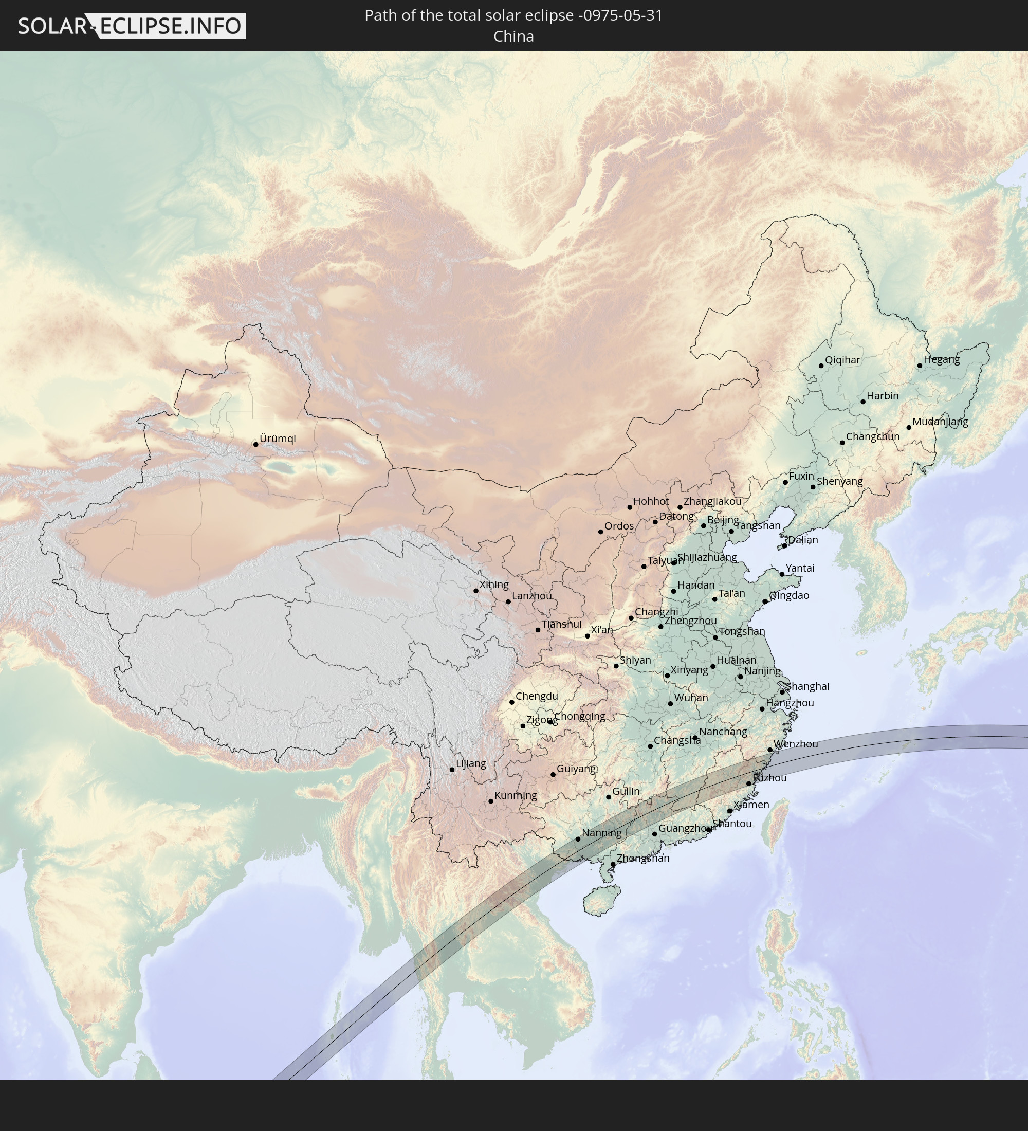 Volksrepublik China
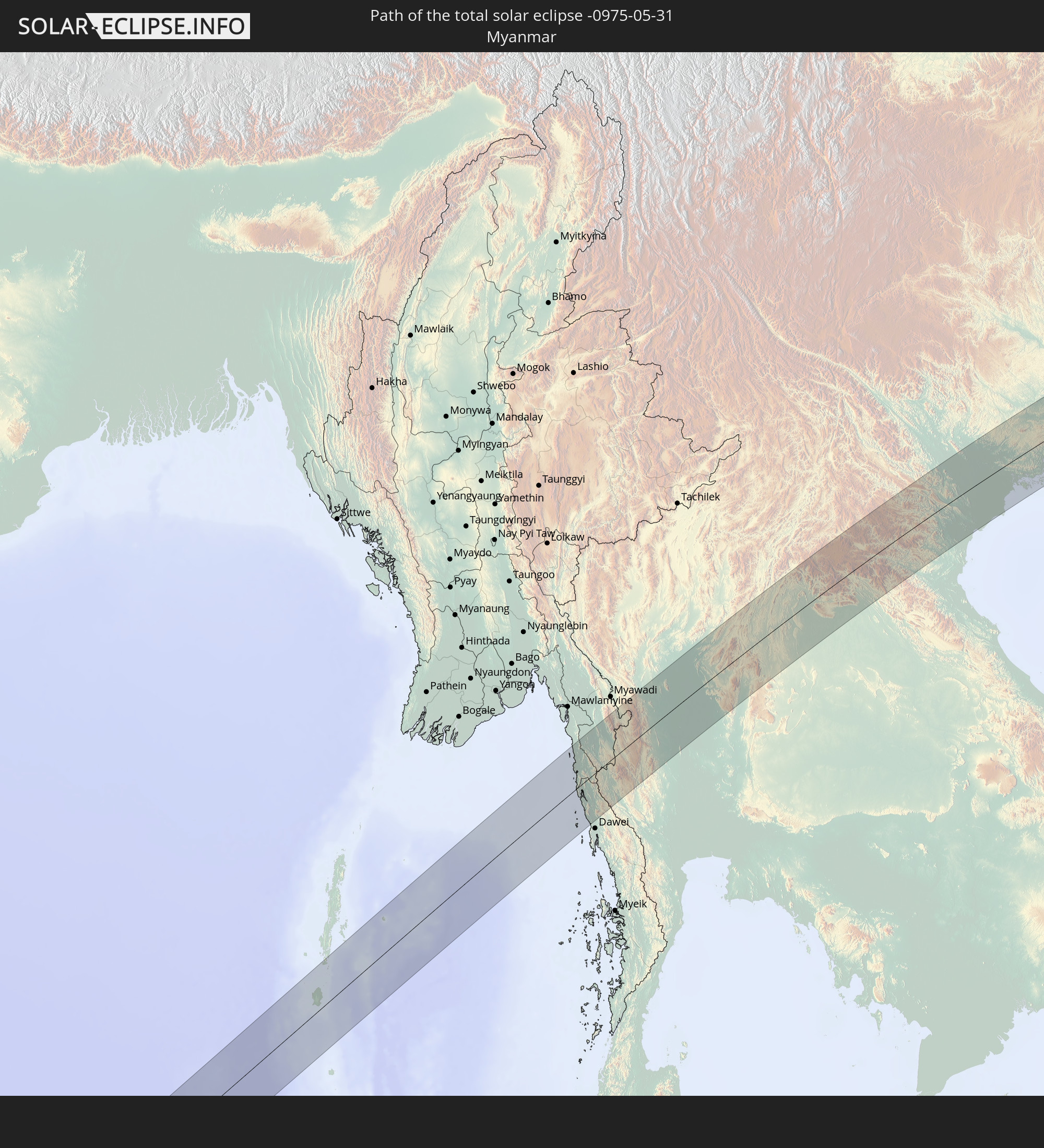 Myanmar
 Thailand
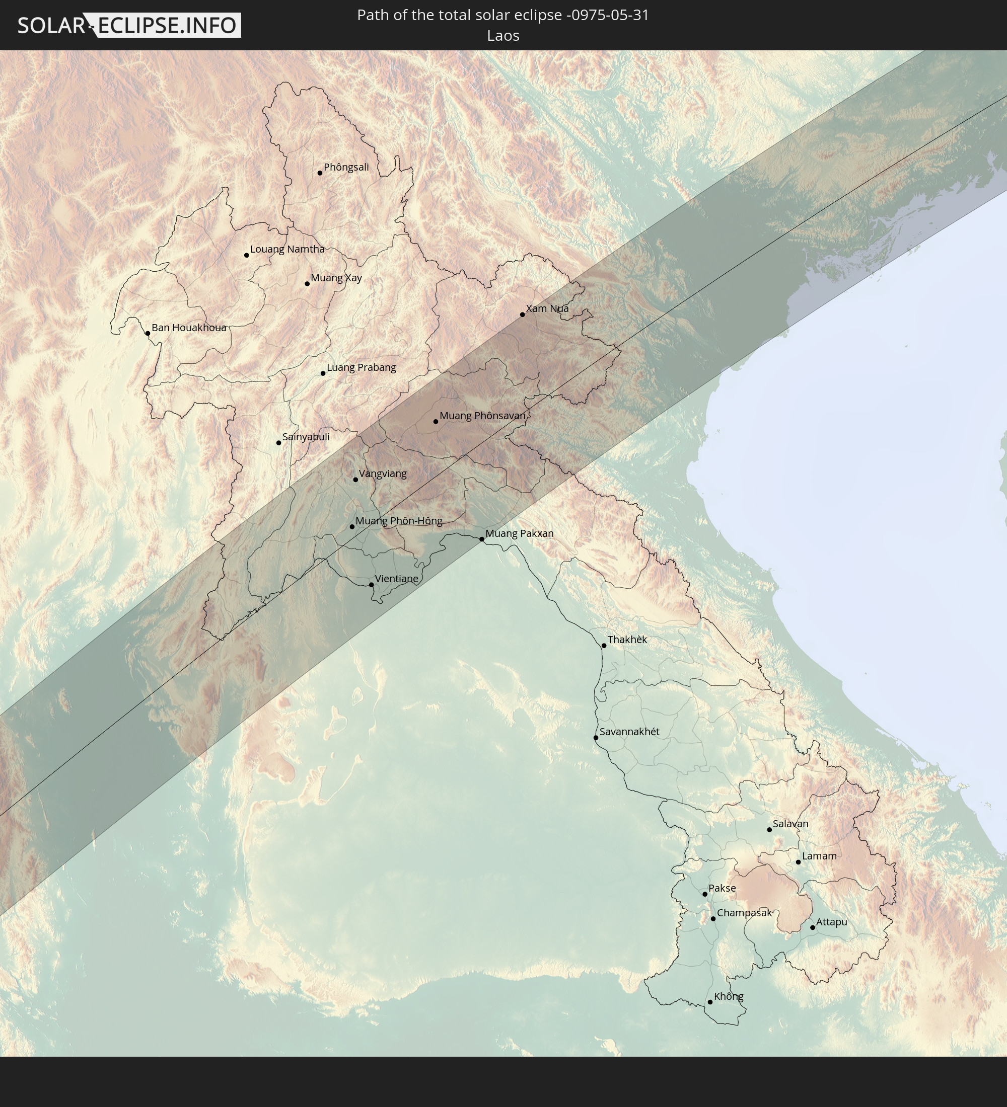 Laos
Laos
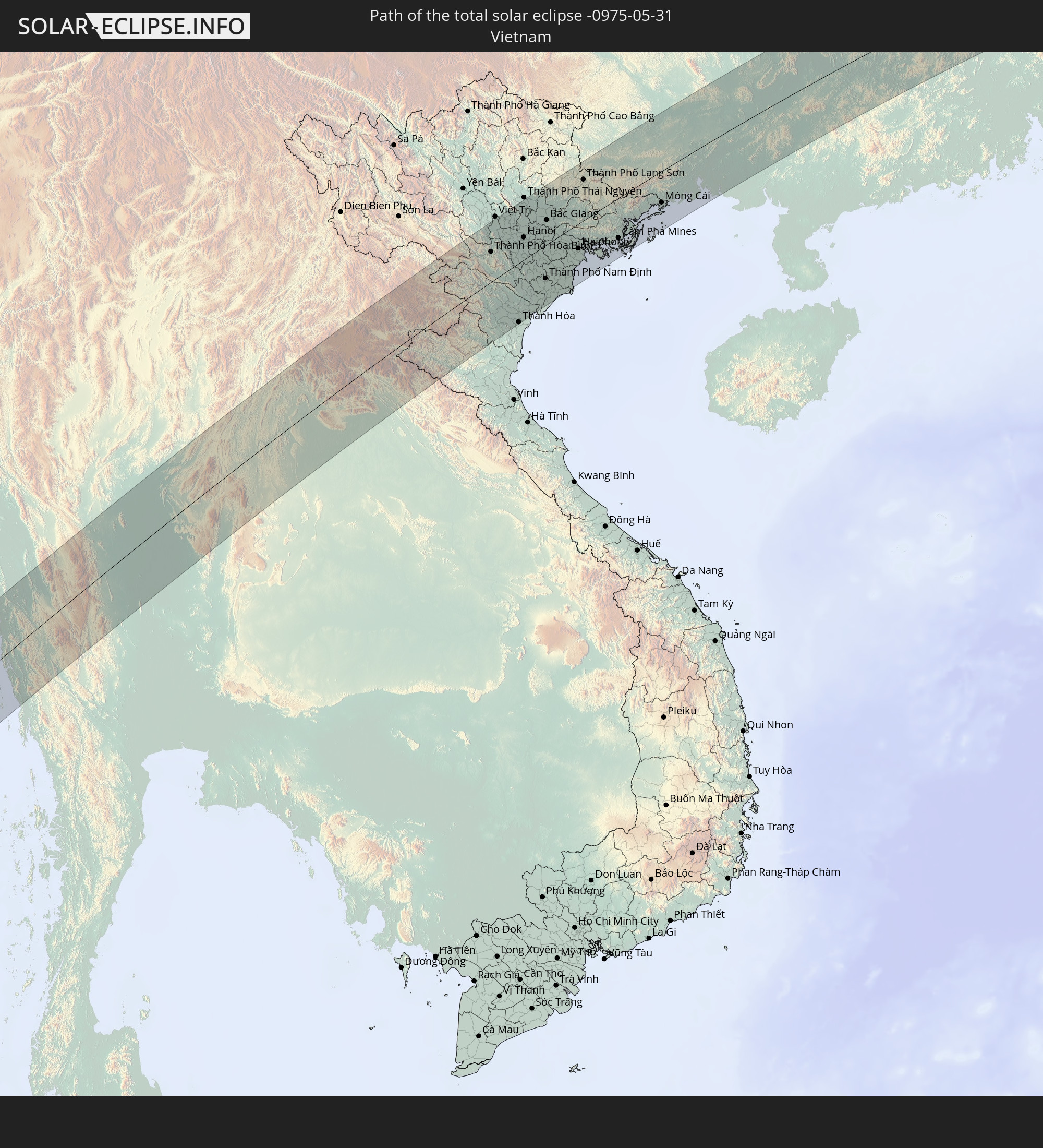 Vietnam
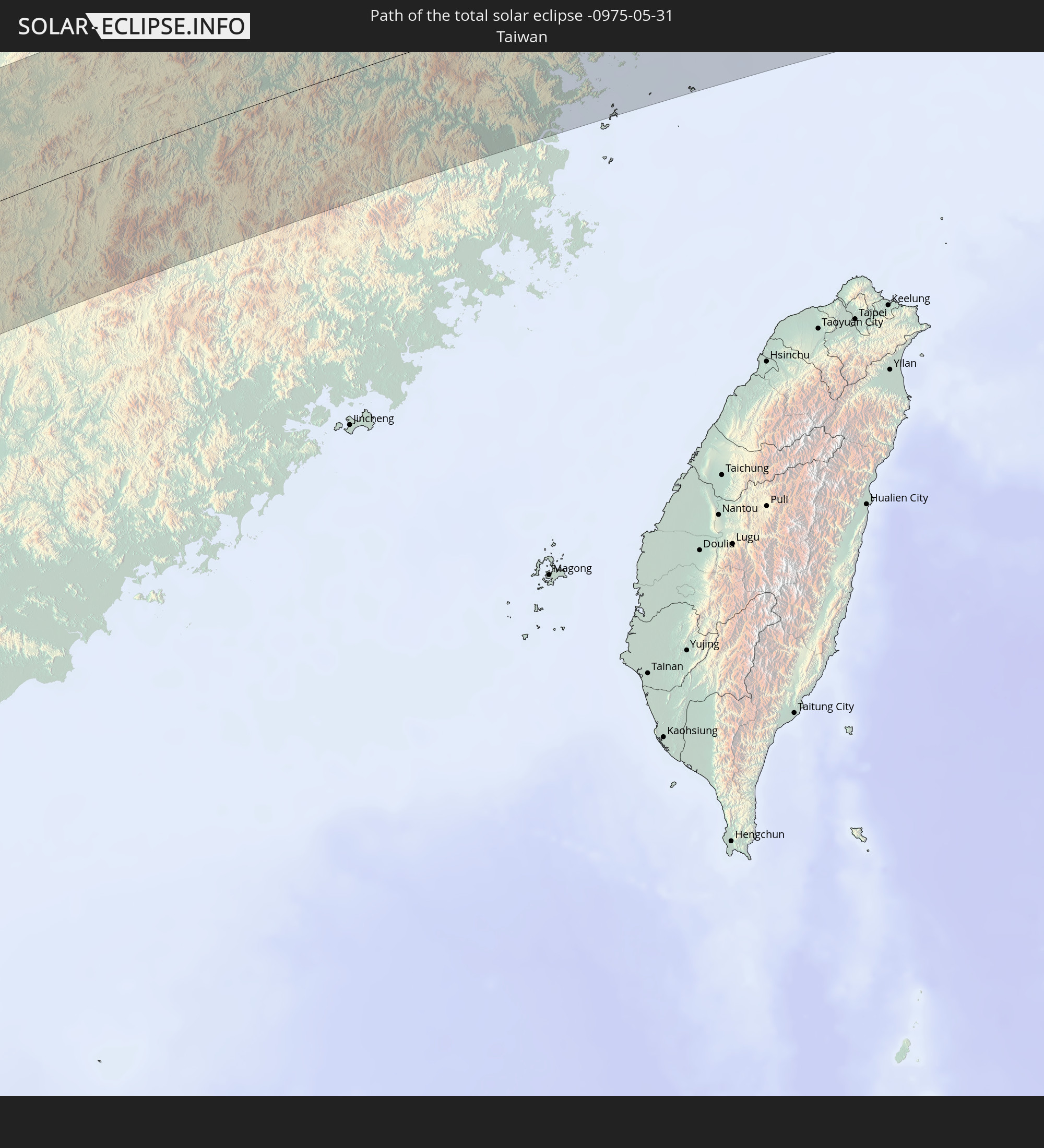 Taiwan
 Japan
Japan
In den folgenden Ländern ist die Sonnenfinsternis partiell zu sehen
 Russland
 Vereinigte Staaten
 United States Minor Outlying Islands
 Kiribati
 Sudan
Sudan
 Äthiopien
 Kenia
Kenia
 Saudi-Arabien
 Eritrea
 Französische Süd- und Antarktisgebiete
 Somalia
 Dschibuti
 Jemen
Jemen
 Madagaskar
 Iran
Iran
 Seychellen
 Kasachstan
 Vereinigte Arabische Emirate
 Oman
Oman
 Réunion
 Mauritius
 Afghanistan
 Pakistan
 Tadschikistan
 Indien
 Kirgisistan
 Britisches Territorium im Indischen Ozean
 Malediven
 Volksrepublik China
 Sri Lanka
 Nepal
Nepal
 Mongolei
 Bangladesch
 Bhutan
 Myanmar
 Indonesien
 Kokosinseln
 Thailand
 Malaysia
 Laos
Laos
 Vietnam
 Kambodscha
 Singapur
 Weihnachtsinsel
 Macau
Macau
 Hongkong
 Brunei
 Taiwan
 Philippinen
 Japan
Japan
 Nordkorea
 Südkorea
 Palau
Palau
 Föderierte Staaten von Mikronesien
 Papua-Neuguinea
 Guam
Guam
 Nördliche Marianen
 Salomonen
 Marshallinseln
 Nauru
Nauru
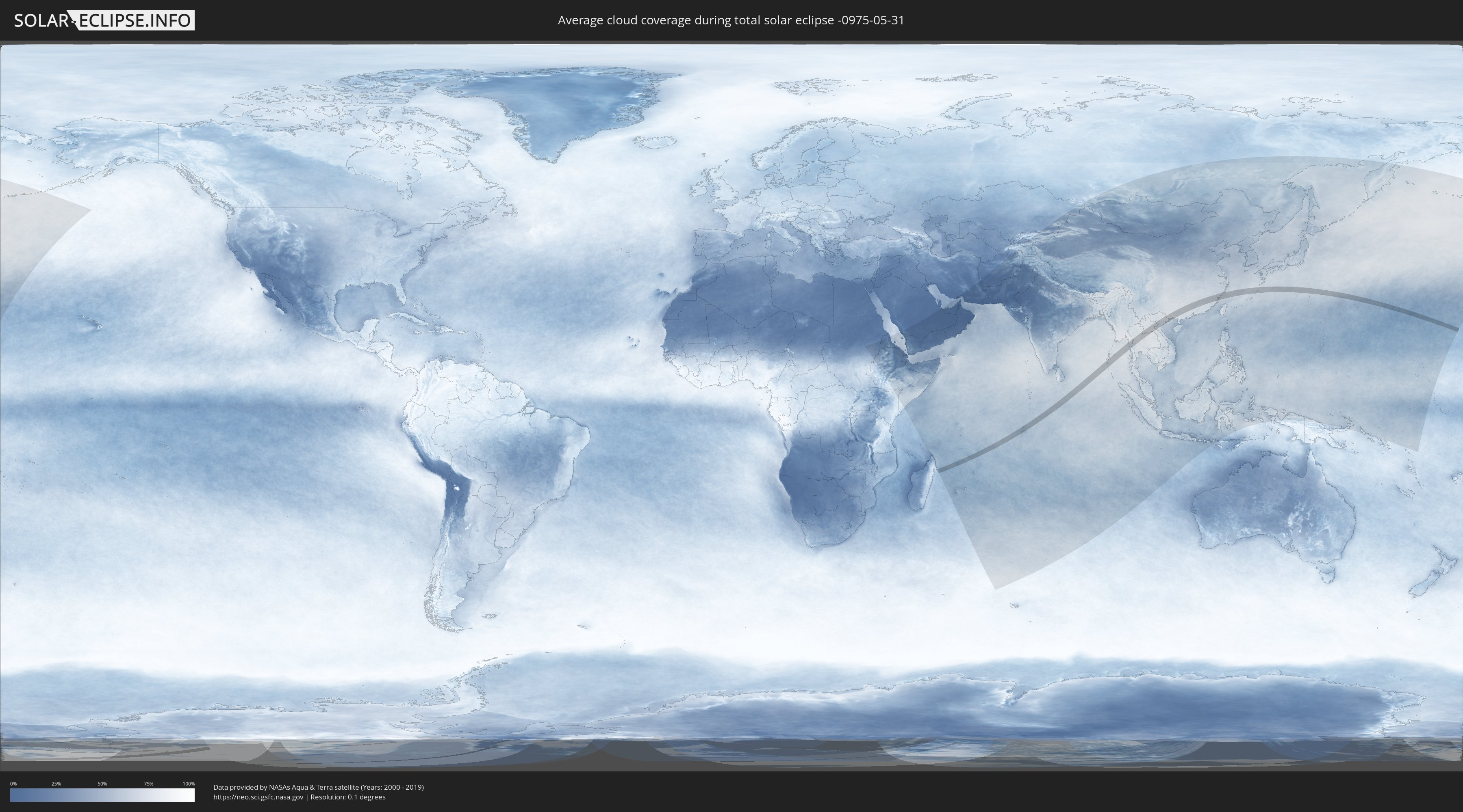
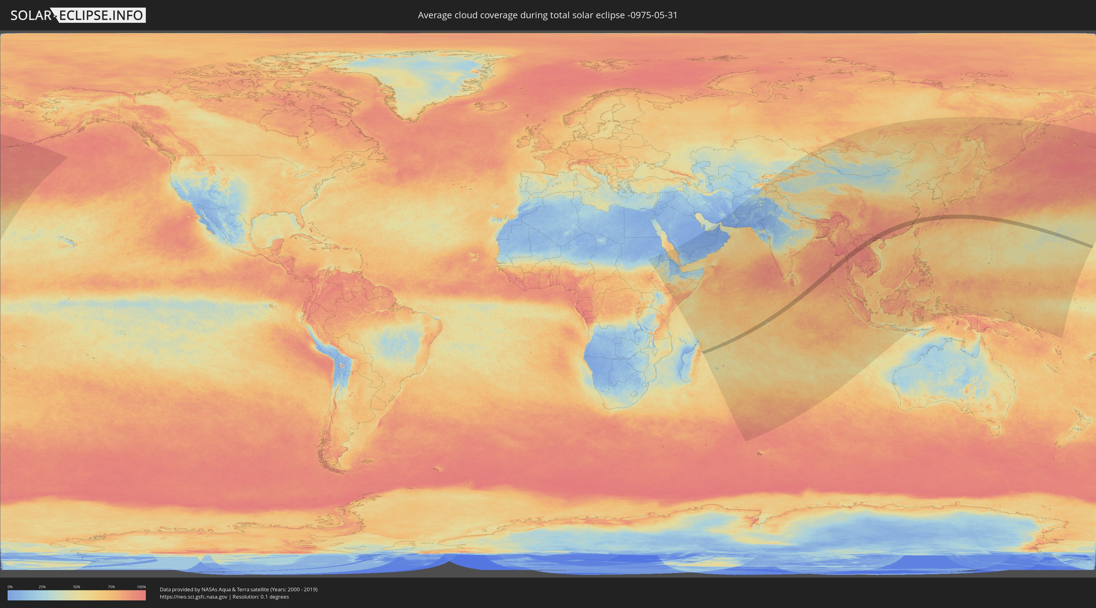
Wie wird das Wetter während der totalen Sonnenfinsternis am 31.05.-0975?
Wo ist der beste Ort, um die totale Sonnenfinsternis vom 31.05.-0975 zu beobachten?
Die folgenden Karten zeigen die durchschnittliche Bewölkung für den Tag, an dem die totale Sonnenfinsternis
stattfindet. Mit Hilfe der Karten lässt sich der Ort entlang des Finsternispfades eingrenzen,
der die besten Aussichen auf einen klaren wolkenfreien Himmel bietet.
Trotzdem muss man immer lokale Gegenenheiten beachten und sollte sich genau über das Wetter an seinem
gewählten Beobachtungsort informieren.
Die Daten stammen von den beiden NASA-Satelliten
AQUA und TERRA
und wurden über einen Zeitraum von 19 Jahren (2000 - 2019) gemittelt.
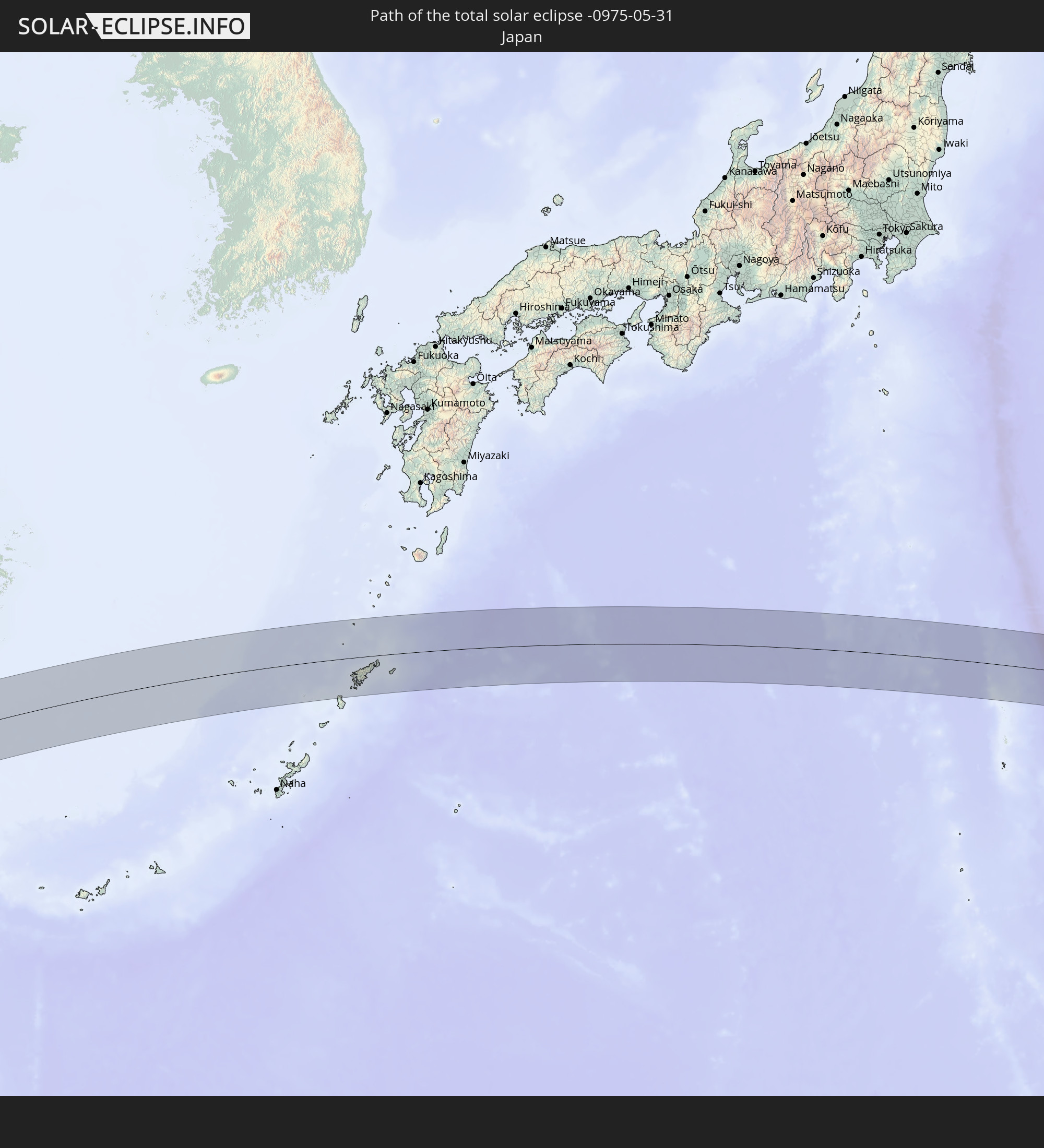
Detaillierte Länderkarten
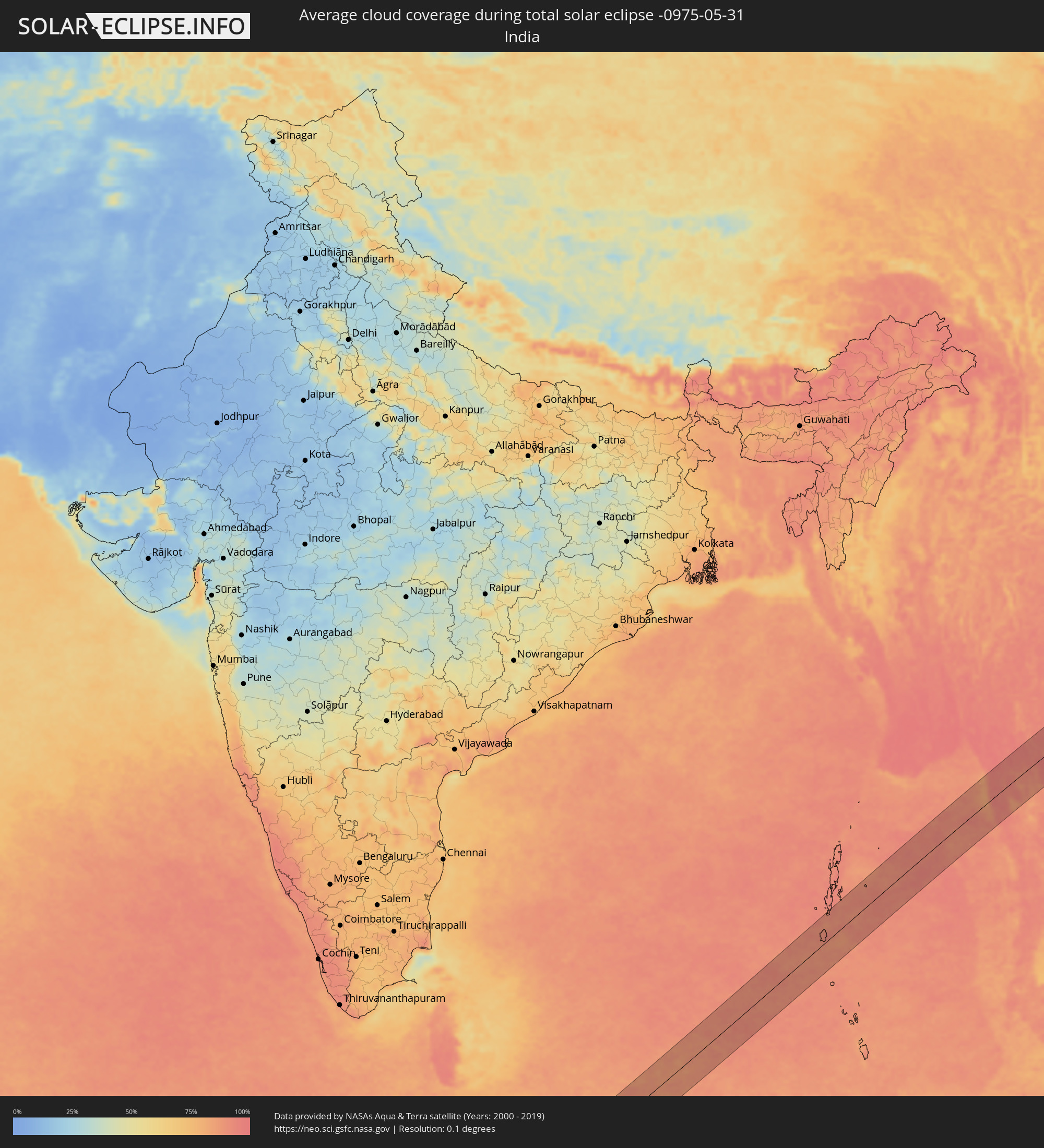 Indien
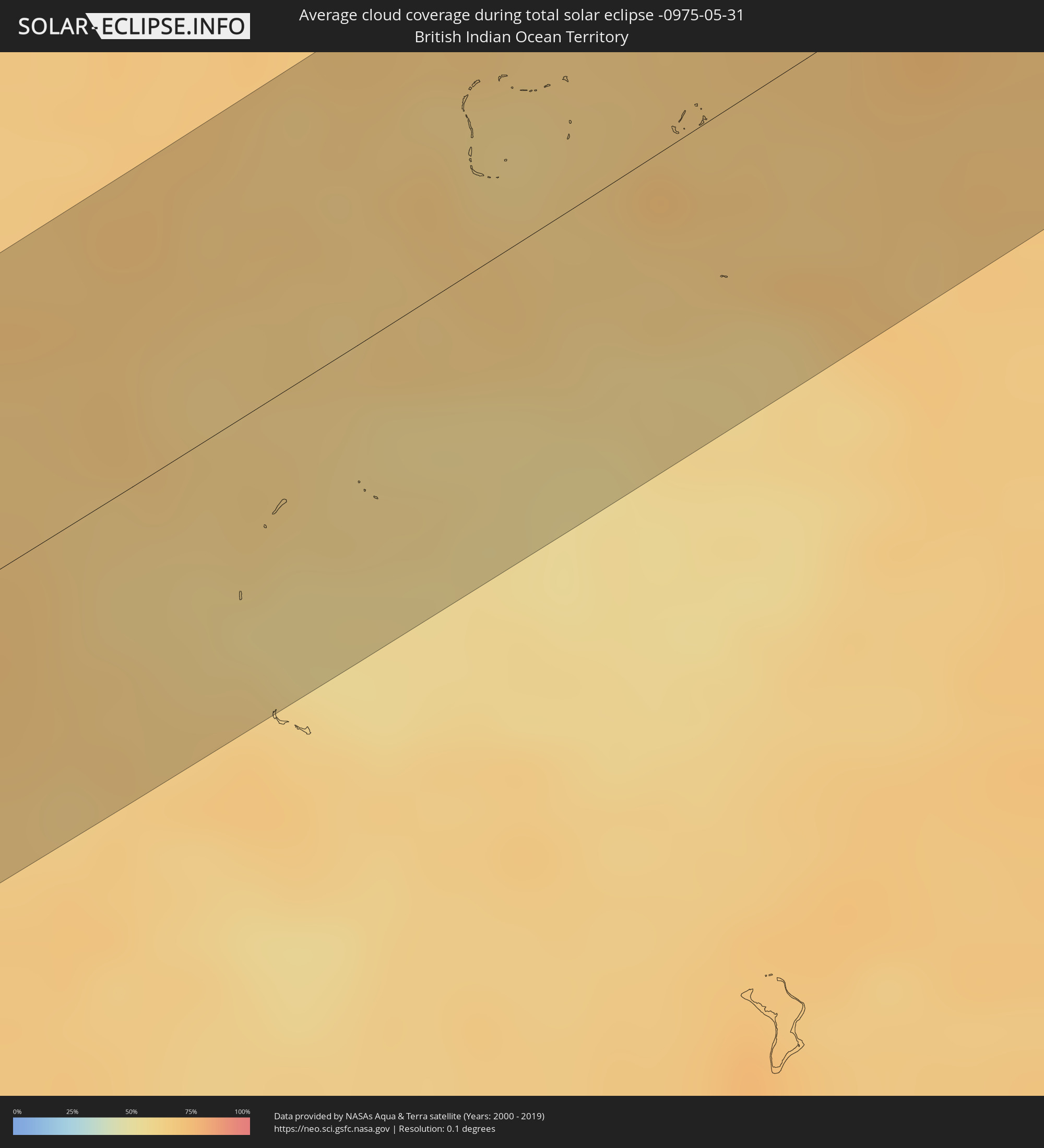 Britisches Territorium im Indischen Ozean
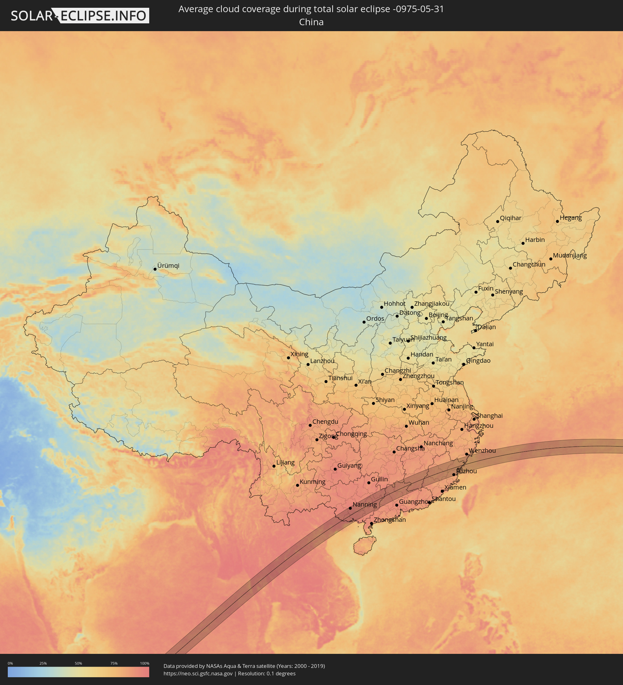 Volksrepublik China
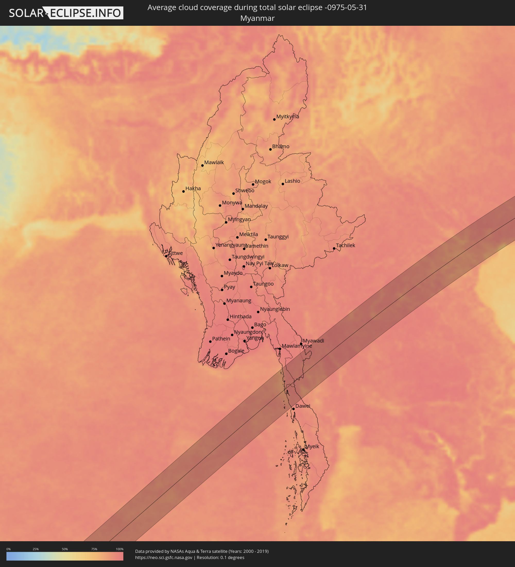 Myanmar
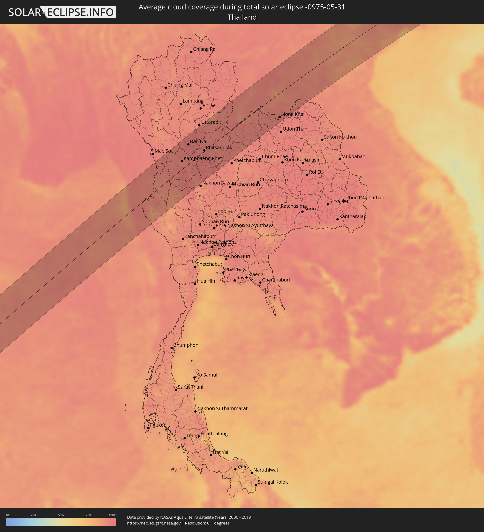 Thailand
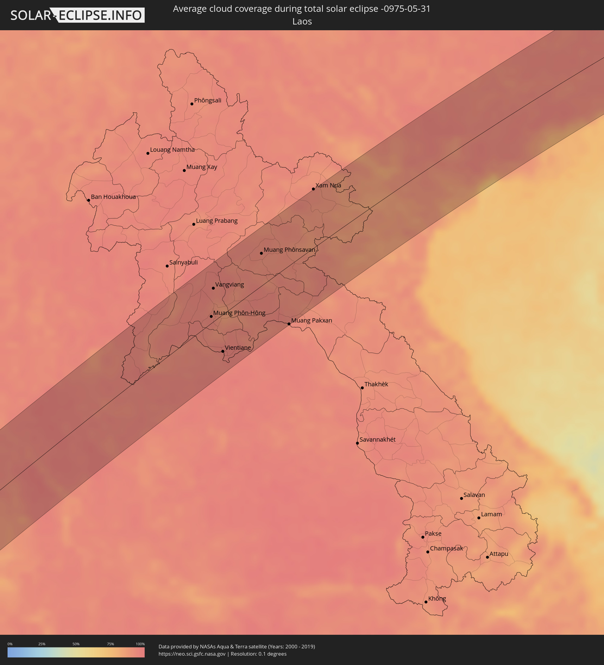 Laos
Laos
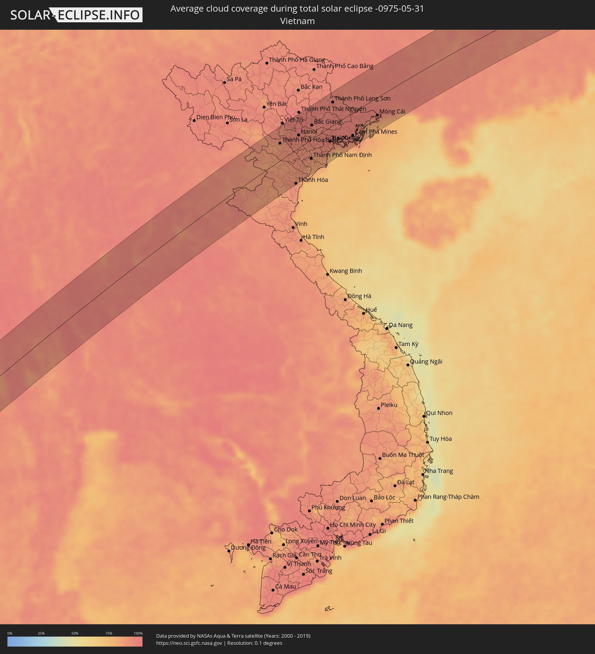 Vietnam
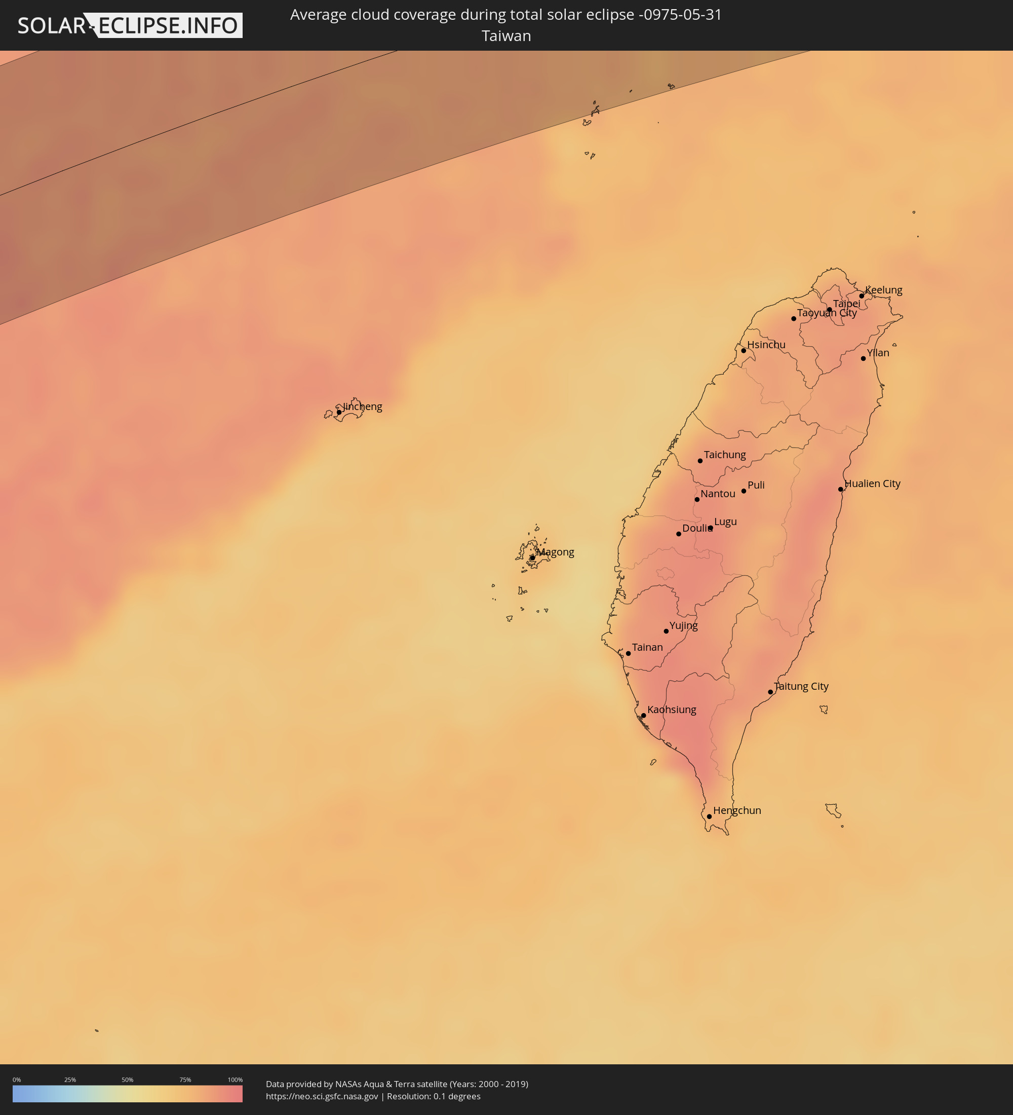 Taiwan
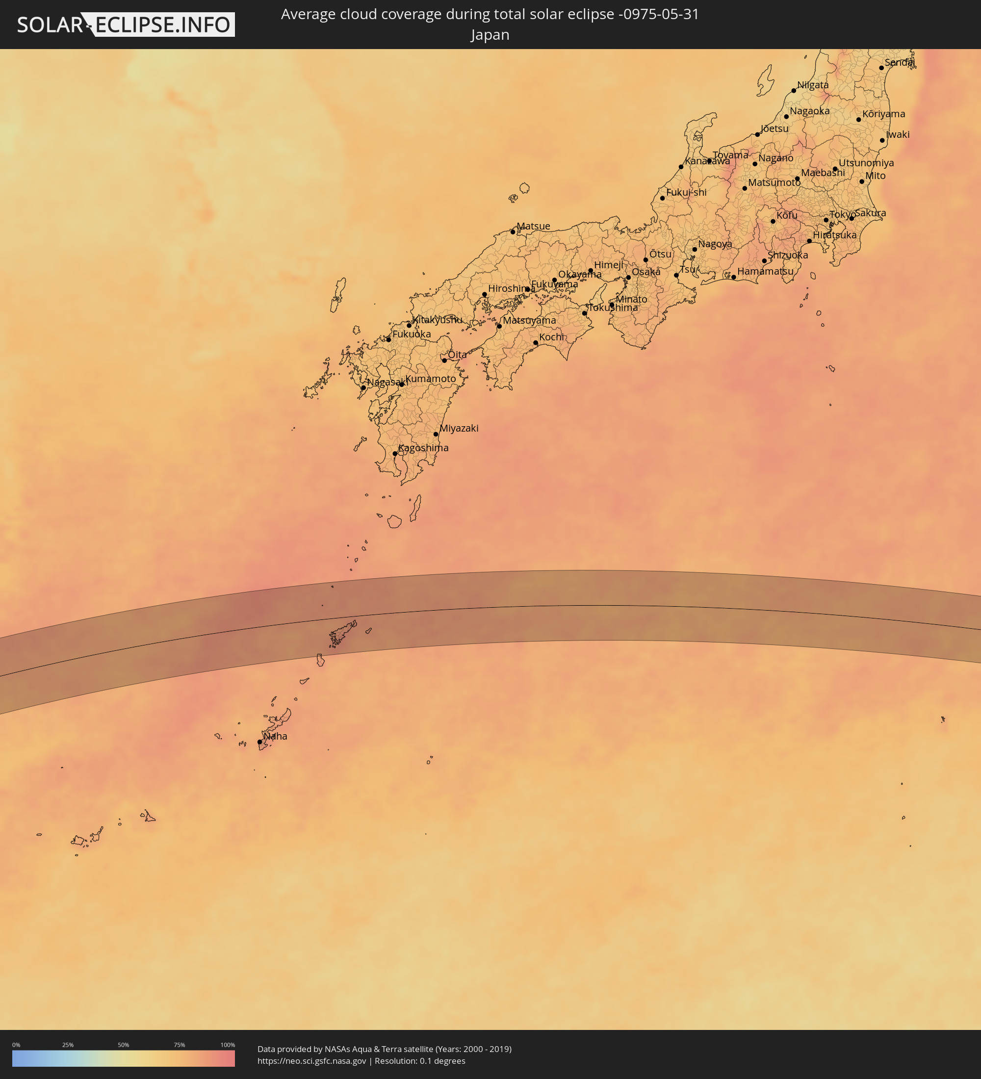 Japan
Japan
Orte im Finsternispfad
Die nachfolgene Tabelle zeigt Städte und Orte mit mehr als 5.000 Einwohnern, die sich im Finsternispfad befinden. Städte mit mehr als 100.000 Einwohnern sind dick gekennzeichnet. Mit einem Klick auf den Ort öffnet sich eine Detailkarte die die Lage des jeweiligen Ortes zusammen mit dem Verlauf der zentralen Finsternis präsentiert.
| Ort | Typ | Dauer der Verfinsterung | Ortszeit bei maximaler Verfinsterung | Entfernung zur Zentrallinie | Ø Bewölkung |
|
Sangkhla Buri, Kanchanaburi
|
total | - | 10:47:47 UTC+06:42 | 20 km | 89% |
|
Kamphaeng Phet, Kamphaeng Phet
|
total | - | 10:52:25 UTC+06:42 | 21 km | 92% |
|
Ban Dan Lan Hoi, Sukhothai
|
total | - | 10:53:29 UTC+06:42 | 63 km | 96% |
|
Lan Sak, Uthai Thani
|
total | - | 10:50:39 UTC+06:42 | 71 km | 92% |
|
Ban Na, Sukhothai
|
total | - | 10:53:50 UTC+06:42 | 54 km | 96% |
|
Lat Yao, Nakhon Sawan
|
total | - | 10:51:38 UTC+06:42 | 60 km | 96% |
|
Khiri Mat, Sukhothai
|
total | - | 10:53:38 UTC+06:42 | 33 km | 96% |
|
Sukhothai, Sukhothai
|
total | - | 10:54:00 UTC+06:42 | 47 km | 97% |
|
Sawankhalok, Sukhothai
|
total | - | 10:54:35 UTC+06:42 | 73 km | 97% |
|
Lan Krabue, Kamphaeng Phet
|
total | - | 10:53:19 UTC+06:42 | 10 km | 95% |
|
Khanu Woralaksaburi, Kamphaeng Phet
|
total | - | 10:52:21 UTC+06:42 | 38 km | 92% |
|
Bang Rakam, Phitsanulok
|
total | - | 10:54:10 UTC+06:42 | 5 km | 97% |
|
Phitsanulok, Phitsanulok
|
total | - | 10:54:36 UTC+06:42 | 2 km | 95% |
|
Bang Krathum, Phitsanulok
|
total | - | 10:54:14 UTC+06:42 | 22 km | 95% |
|
Phichit, Phichit
|
total | - | 10:54:05 UTC+06:42 | 37 km | 95% |
|
Bang Mun Nak, Phichit
|
total | - | 10:53:24 UTC+06:42 | 76 km | 92% |
|
Taphan Hin, Phichit
|
total | - | 10:53:50 UTC+06:42 | 61 km | 94% |
|
Wang Sai Phun, Phichit
|
total | - | 10:54:23 UTC+06:42 | 55 km | 97% |
|
Thap Khlo, Phichit
|
total | - | 10:54:06 UTC+06:42 | 79 km | 96% |
|
Nakhon Thai, Phitsanulok
|
total | - | 10:56:20 UTC+06:42 | 12 km | 96% |
|
Lom Sak, Phetchabun
|
total | - | 10:56:37 UTC+06:42 | 67 km | 94% |
|
Loei, Loei
|
total | - | 10:58:59 UTC+06:42 | 36 km | 95% |
|
Wang Saphung, Loei
|
total | - | 10:58:43 UTC+06:42 | 56 km | 94% |
|
Nam Som, Changwat Udon Thani
|
total | - | 11:00:30 UTC+06:42 | 41 km | 95% |
|
Muang Phôn-Hông, Vientiane Province
|
total | - | 11:02:18 UTC+06:42 | 9 km | 94% |
|
Vangviang, Vientiane Province
|
total | - | 11:03:08 UTC+06:42 | 45 km | 94% |
|
Tha Bo, Nong Khai
|
total | - | 11:01:31 UTC+06:42 | 59 km | 93% |
|
Si Chiang Mai, Nong Khai
|
total | - | 11:01:43 UTC+06:42 | 50 km | 94% |
|
Vientiane, Vientiane
|
total | - | 11:01:46 UTC+06:42 | 50 km | 94% |
|
Nong Khai, Nong Khai
|
total | - | 11:01:56 UTC+06:42 | 67 km | 94% |
|
Muang Phônsavan, Xiangkhoang
|
total | - | 11:05:47 UTC+06:42 | 44 km | 91% |
|
Muang Pakxan, Bolikhamsai Province
|
total | - | 11:04:55 UTC+06:42 | 80 km | 91% |
|
Xam Nua, Houaphan
|
total | - | 11:09:22 UTC+06:42 | 80 km | 92% |
|
Thành Phố Hòa Bình, Hòa Bình
|
total | - | 11:37:37 UTC+07:06 | 40 km | 87% |
|
Sơn Tây, Ha Nội
|
total | - | 11:38:33 UTC+07:06 | 60 km | 93% |
|
Vĩnh Yên, Vĩnh Phúc
|
total | - | 11:39:04 UTC+07:06 | 70 km | 94% |
|
Thanh Hóa, Thanh Hóa
|
total | - | 11:36:54 UTC+07:06 | 79 km | 89% |
|
Hà Đông, Ha Nội
|
total | - | 11:38:55 UTC+07:06 | 29 km | 92% |
|
Hanoi, Ha Nội
|
total | - | 11:39:09 UTC+07:06 | 30 km | 92% |
|
Bỉm Sơn, Thanh Hóa
|
total | - | 11:37:36 UTC+07:06 | 59 km | 88% |
|
Thành Phố Phủ Lý, Hà Nam
|
total | - | 11:38:31 UTC+07:06 | 19 km | 89% |
|
Thành Phố Ninh Bình, Ninh Bình
|
total | - | 11:38:11 UTC+07:06 | 49 km | 87% |
|
Hưng Yên, Hưng Yên
|
total | - | 11:39:00 UTC+07:06 | 17 km | 88% |
|
Bắc Ninh, Bắc Ninh
|
total | - | 11:39:58 UTC+07:06 | 31 km | 91% |
|
Thành Phố Nam Định, Nam Định
|
total | - | 11:38:57 UTC+07:06 | 44 km | 83% |
|
Bắc Giang, Bắc Giang
|
total | - | 11:40:23 UTC+07:06 | 33 km | 92% |
|
Thành Phố Hải Dương, Hải Dương
|
total | - | 11:40:10 UTC+07:06 | 6 km | 92% |
|
Thành Phố Thái Bình, Thái Bình
|
total | - | 11:39:22 UTC+07:06 | 52 km | 85% |
|
Haiphong, Hải Phòng
|
total | - | 11:40:53 UTC+07:06 | 33 km | 93% |
|
Thành Phố Lạng Sơn, Lạng Sơn
|
total | - | 11:42:41 UTC+07:06 | 55 km | 92% |
|
Thành Phố Uông Bí, Quảng Ninh
|
total | - | 11:41:22 UTC+07:06 | 22 km | 92% |
|
Cát Bà, Hải Phòng
|
total | - | 11:41:32 UTC+07:06 | 67 km | 74% |
|
Thành Phố Hạ Long, Quảng Ninh
|
total | - | 11:41:57 UTC+07:06 | 47 km | 90% |
|
Baihe, Guangxi Zhuang Autonomous Region
|
total | - | 12:37:35 UTC+08:00 | 55 km | 91% |
|
Cẩm Phả Mines, Quảng Ninh
|
total | - | 11:42:37 UTC+07:06 | 54 km | 89% |
|
Móng Cái, Quảng Ninh
|
total | - | 11:45:03 UTC+07:06 | 43 km | 89% |
|
Nanning, Guangxi Zhuang Autonomous Region
|
total | - | 12:41:15 UTC+08:00 | 61 km | 95% |
|
Pumiao, Guangxi Zhuang Autonomous Region
|
total | - | 12:41:34 UTC+08:00 | 47 km | 93% |
|
Qinzhou, Guangxi Zhuang Autonomous Region
|
total | - | 12:40:42 UTC+08:00 | 36 km | 93% |
|
Luxu, Guangxi Zhuang Autonomous Region
|
total | - | 12:43:03 UTC+08:00 | 75 km | 92% |
|
Guigang, Guangxi Zhuang Autonomous Region
|
total | - | 12:44:48 UTC+08:00 | 21 km | 90% |
|
Guiping, Guangxi Zhuang Autonomous Region
|
total | - | 12:46:23 UTC+08:00 | 27 km | 85% |
|
Yulin, Guangxi Zhuang Autonomous Region
|
total | - | 12:45:27 UTC+08:00 | 51 km | 92% |
|
Lingcheng, Guangxi Zhuang Autonomous Region
|
total | - | 12:46:03 UTC+08:00 | 53 km | 92% |
|
Pingnan, Guangxi Zhuang Autonomous Region
|
total | - | 12:47:22 UTC+08:00 | 26 km | 90% |
|
Nandu, Guangxi Zhuang Autonomous Region
|
total | - | 12:47:26 UTC+08:00 | 63 km | 91% |
|
Jinji, Guangxi Zhuang Autonomous Region
|
total | - | 12:47:59 UTC+08:00 | 26 km | 91% |
|
Wuzhou, Guangxi Zhuang Autonomous Region
|
total | - | 12:49:34 UTC+08:00 | 25 km | 91% |
|
Babu, Guangxi Zhuang Autonomous Region
|
total | - | 12:51:21 UTC+08:00 | 58 km | 92% |
|
Ducheng, Guangdong
|
total | - | 12:49:45 UTC+08:00 | 58 km | 90% |
|
Nanfeng, Guangdong
|
total | - | 12:51:06 UTC+08:00 | 23 km | 89% |
|
Huaicheng, Guangdong
|
total | - | 12:52:18 UTC+08:00 | 21 km | 91% |
|
Lianzhou, Guangdong
|
total | - | 12:53:56 UTC+08:00 | 56 km | 89% |
|
Lecheng, Guangdong
|
total | - | 12:56:46 UTC+08:00 | 48 km | 89% |
|
Shaoguan, Guangdong
|
total | - | 12:56:56 UTC+08:00 | 5 km | 87% |
|
Maba, Guangdong
|
total | - | 12:56:49 UTC+08:00 | 8 km | 85% |
|
Shixing, Guangdong
|
total | - | 12:58:18 UTC+08:00 | 1 km | 86% |
|
Xiongzhou, Guangdong
|
total | - | 12:59:05 UTC+08:00 | 7 km | 86% |
|
Sanming, Fujian
|
total | - | 13:08:29 UTC+08:00 | 0 km | 84% |
|
Nanping, Fujian
|
total | - | 13:10:12 UTC+08:00 | 24 km | 84% |
|
Jian’ou, Fujian
|
total | - | 13:10:56 UTC+08:00 | 61 km | 83% |
|
Gufeng, Fujian
|
total | - | 13:12:23 UTC+08:00 | 26 km | 81% |
|
Shangjie, Fujian
|
total | - | 13:12:09 UTC+08:00 | 67 km | 84% |
|
Shanyang, Fujian
|
total | - | 13:12:42 UTC+08:00 | 6 km | 84% |
|
Fuzhou, Fujian
|
total | - | 13:12:25 UTC+08:00 | 74 km | 83% |
|
Huotong, Fujian
|
total | - | 13:13:22 UTC+08:00 | 7 km | 83% |
|
Ningde, Fujian
|
total | - | 13:13:28 UTC+08:00 | 17 km | 83% |
|
Qidu, Fujian
|
total | - | 13:13:37 UTC+08:00 | 6 km | 82% |
|
Dongdai, Fujian
|
total | - | 13:13:20 UTC+08:00 | 64 km | 80% |
|
Chengyang, Fujian
|
total | - | 13:14:07 UTC+08:00 | 25 km | 81% |
|
Xiabaishi, Fujian
|
total | - | 13:13:58 UTC+08:00 | 5 km | 81% |
|
Dinghai, Fujian
|
total | - | 13:13:47 UTC+08:00 | 65 km | 76% |
|
Fuding, Fujian
|
total | - | 13:15:39 UTC+08:00 | 35 km | 80% |
|
Kunyang, Zhejiang
|
total | - | 13:16:44 UTC+08:00 | 61 km | 84% |
|
Jinxiang, Zhejiang
|
total | - | 13:16:40 UTC+08:00 | 35 km | 82% |
|
Naze, Kagoshima
|
total | - | 14:36:50 UTC+09:00 | 24 km | 88% |