Totale Sonnenfinsternis vom 01.09.-1008
| Wochentag: | Donnerstag |
| Maximale Dauer der Verfinsterung: | 03m30s |
| Maximale Breite des Finsternispfades: | 149 km |
| Saroszyklus: | 38 |
| Bedeckungsgrad: | 100% |
| Magnitude: | 1.0428 |
| Gamma: | 0.2814 |
Wo kann man die Sonnenfinsternis vom 01.09.-1008 sehen?
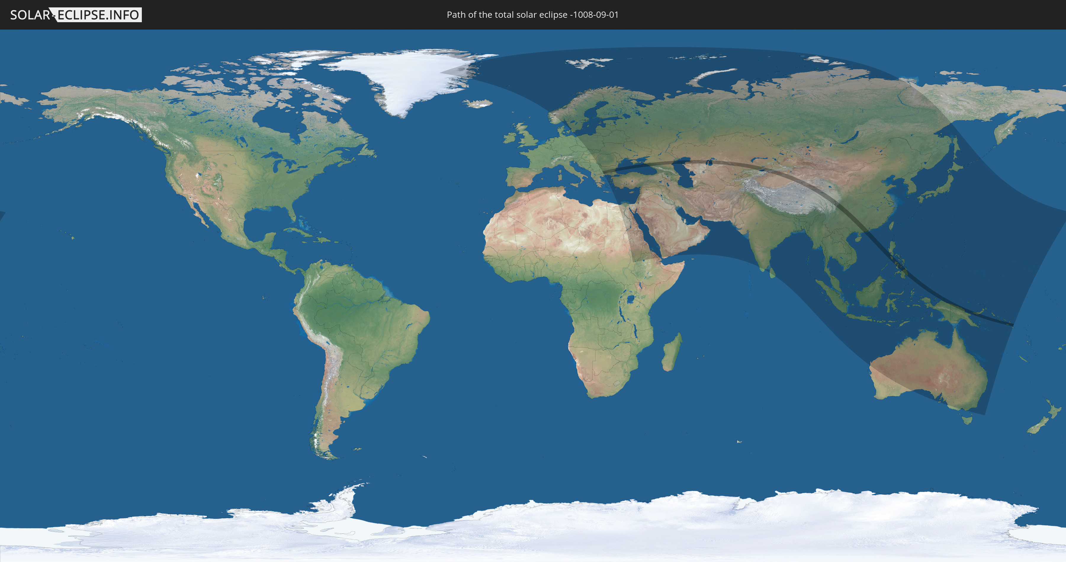
Die Sonnenfinsternis am 01.09.-1008 kann man in 87 Ländern als partielle Sonnenfinsternis beobachten.
Der Finsternispfad verläuft durch 13 Länder. Nur in diesen Ländern ist sie als totale Sonnenfinsternis zu sehen.
In den folgenden Ländern ist die Sonnenfinsternis total zu sehen
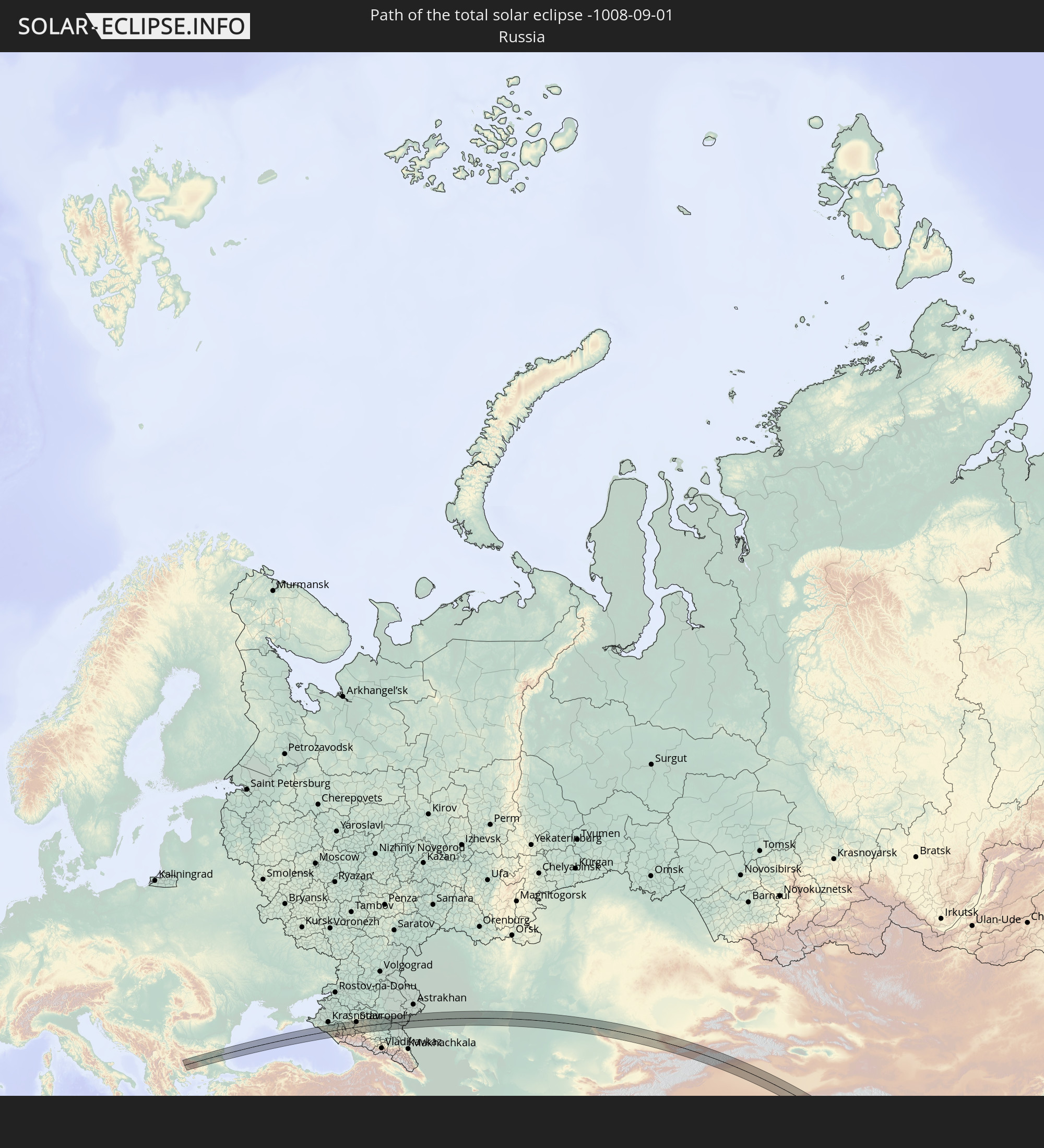 Russland
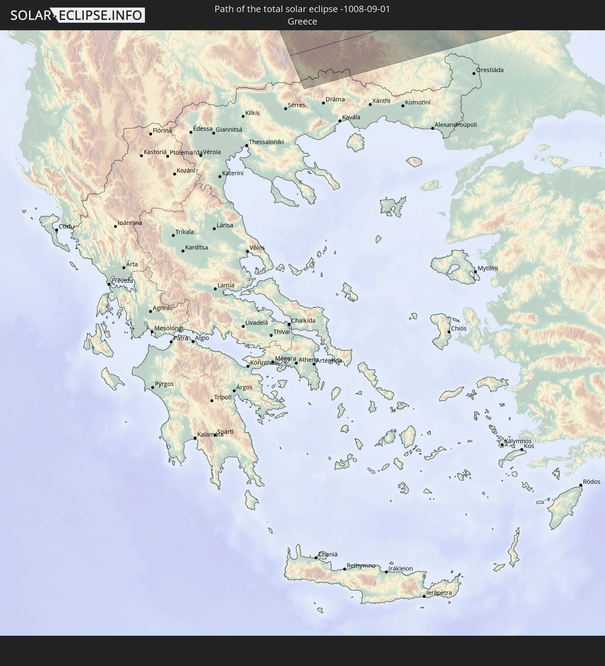 Griechenland
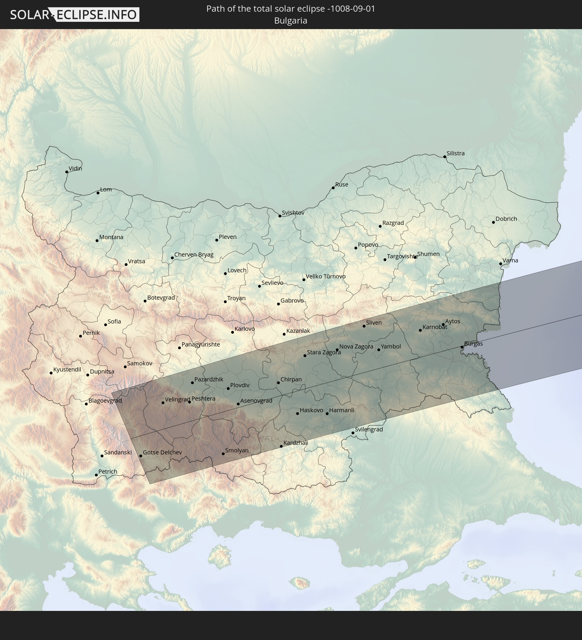 Bulgarien
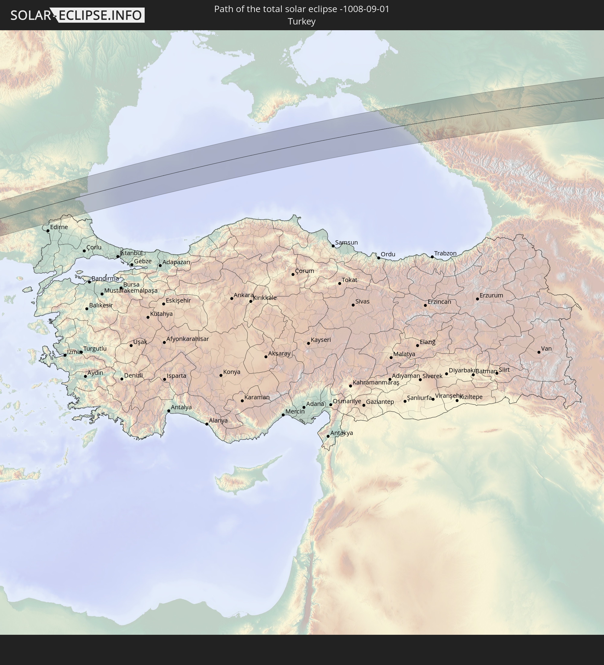 Türkei
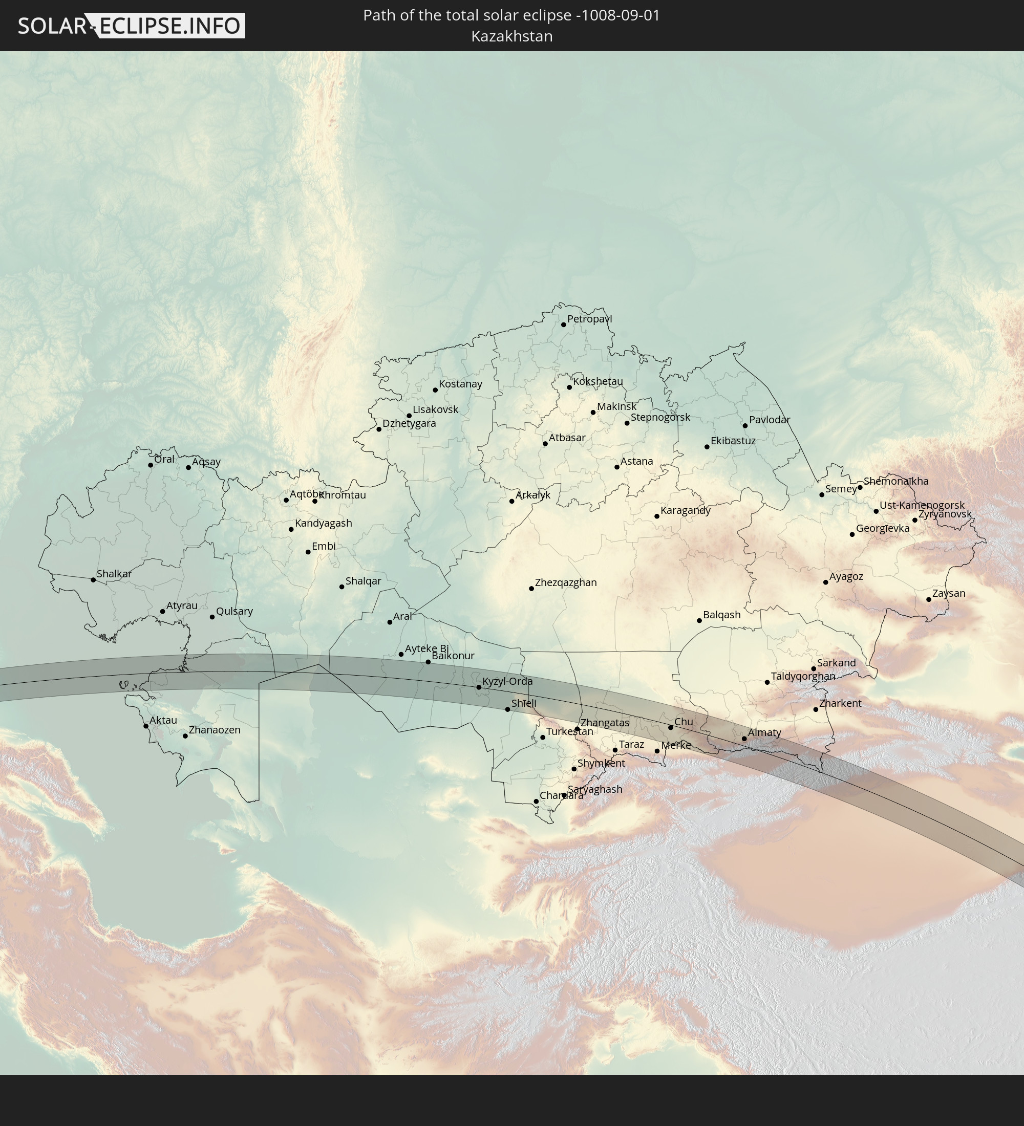 Kasachstan
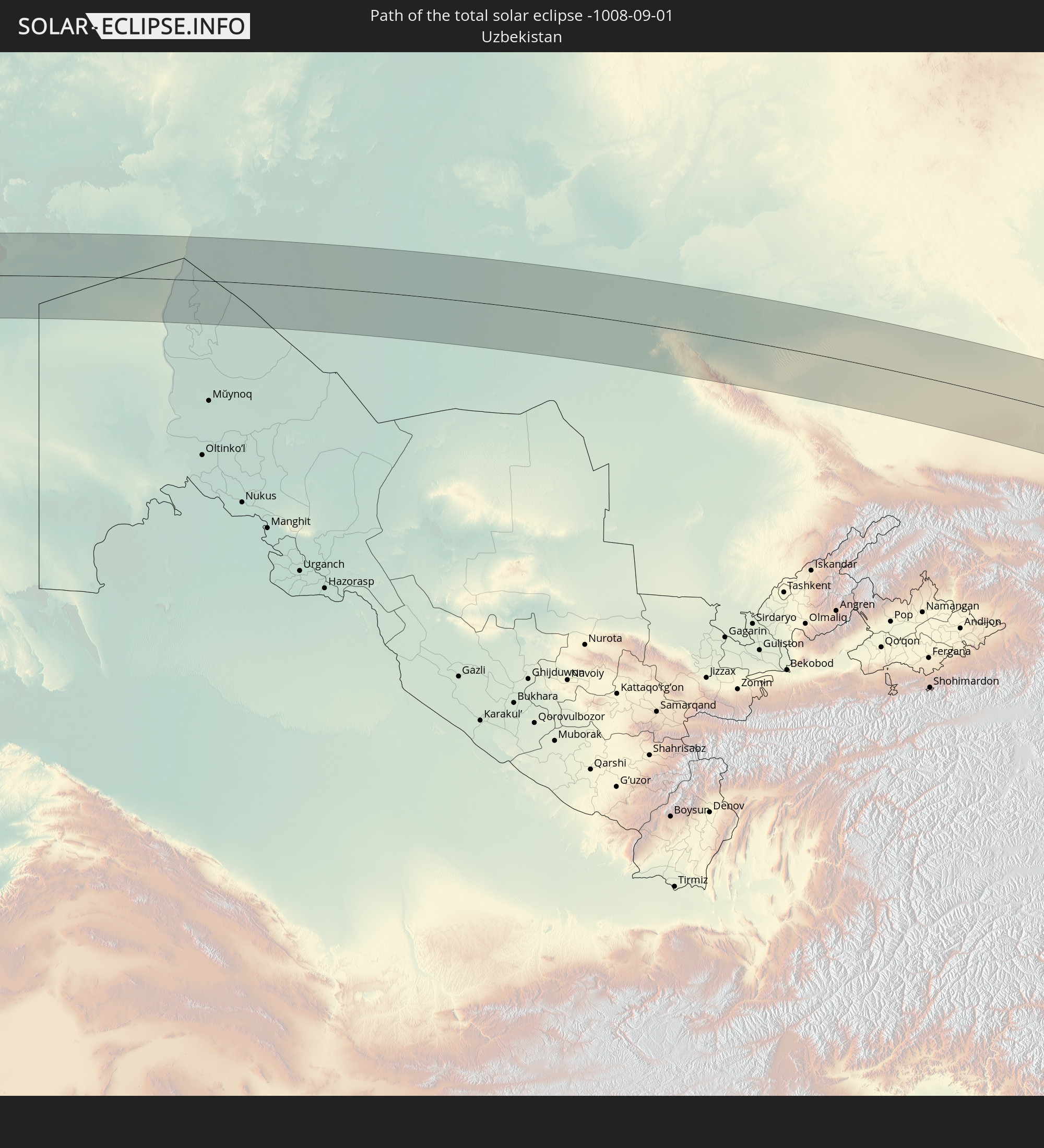 Usbekistan
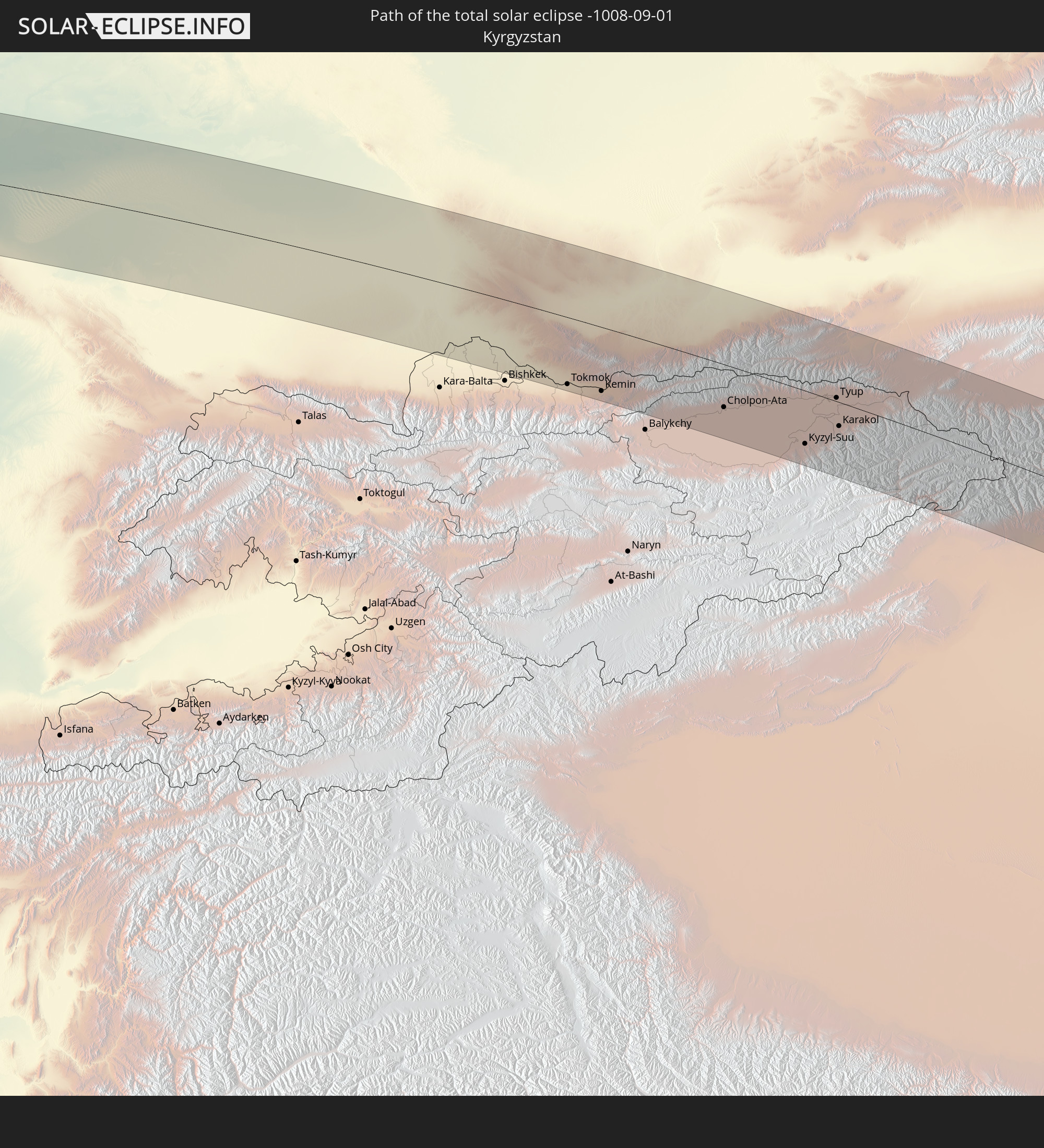 Kirgisistan
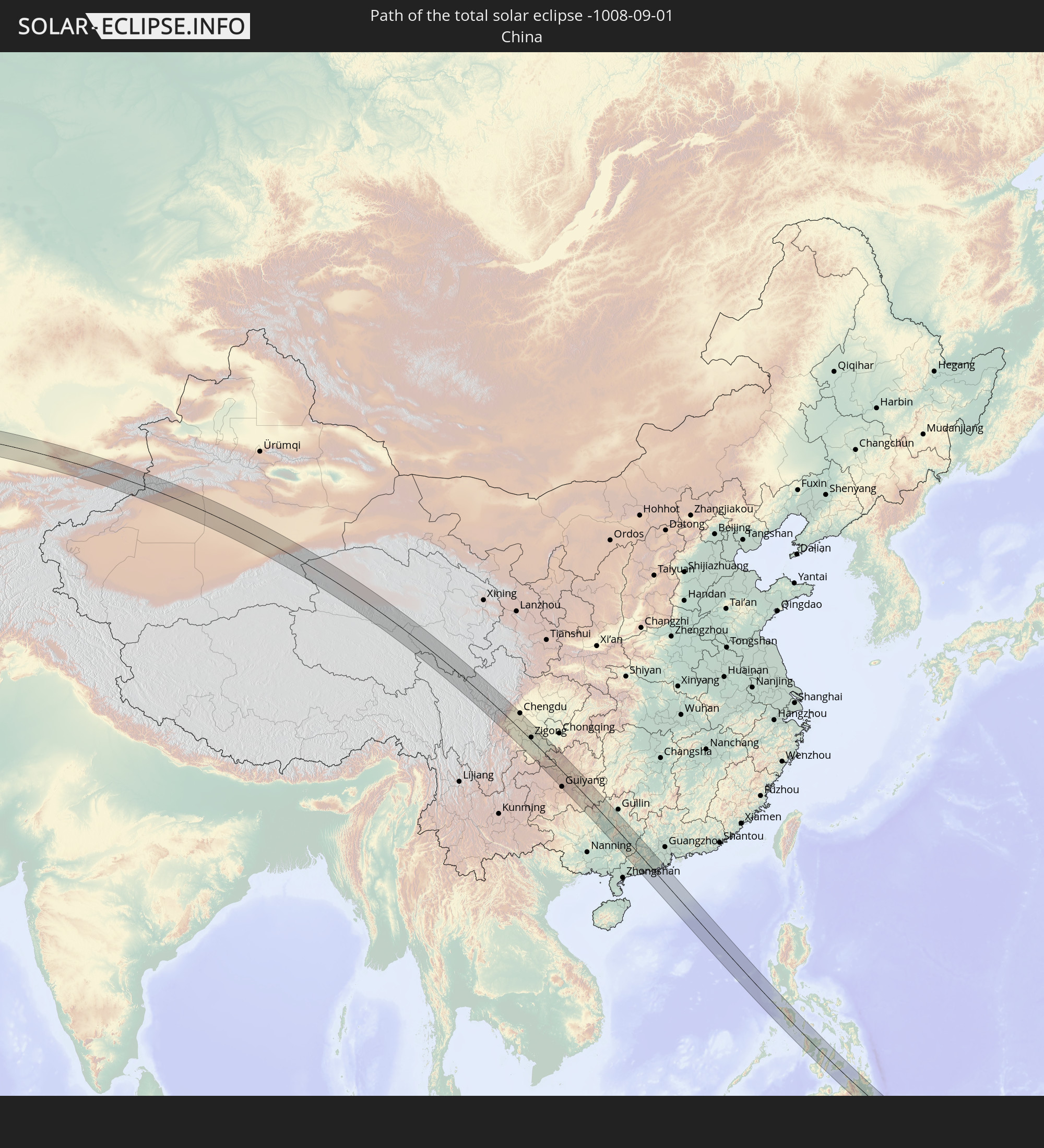 Volksrepublik China
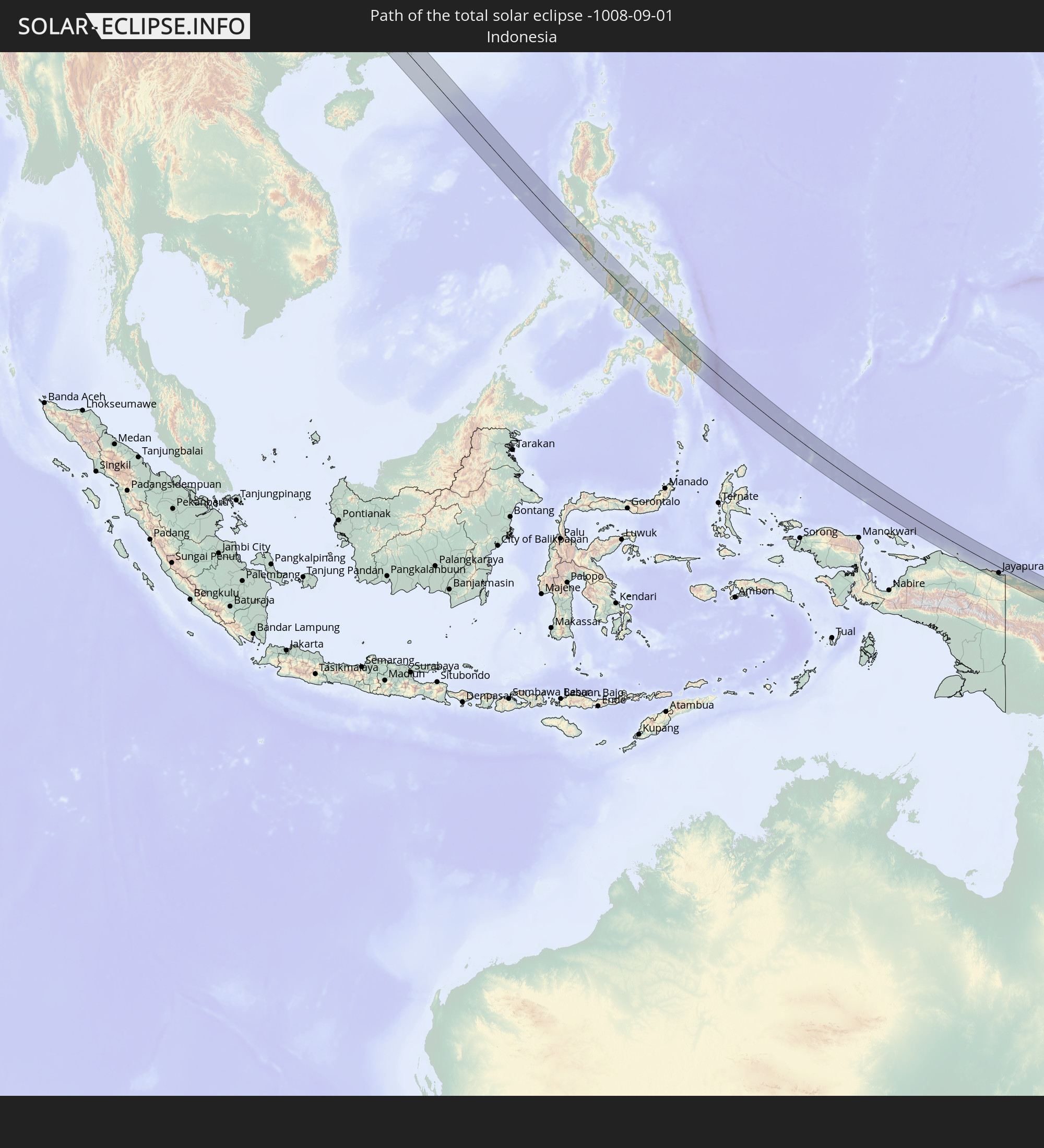 Indonesien
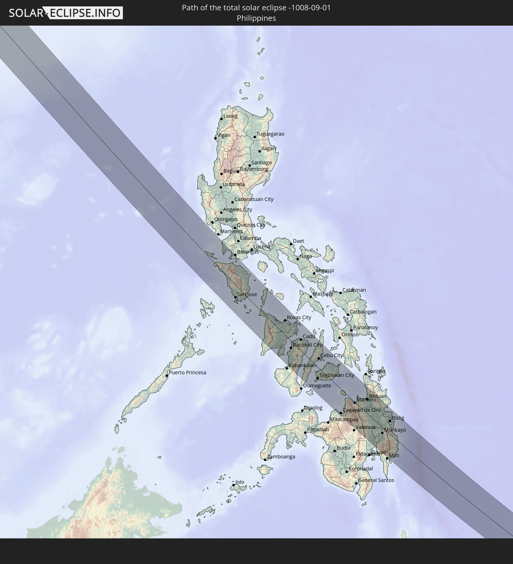 Philippinen
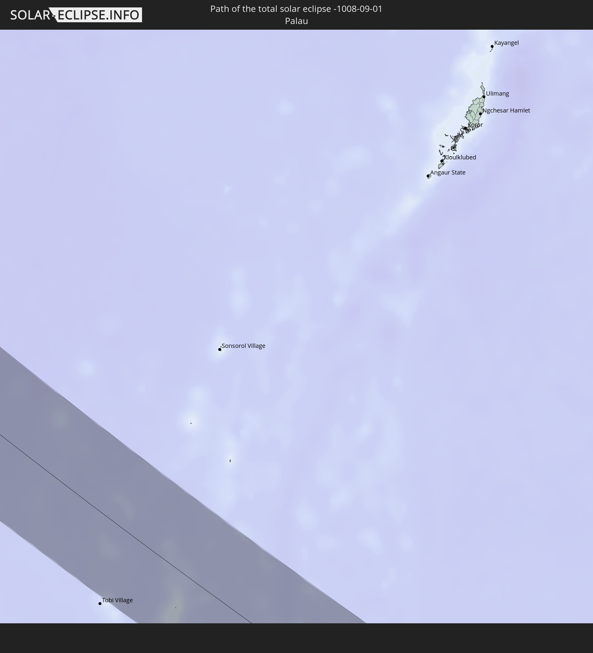 Palau
Palau
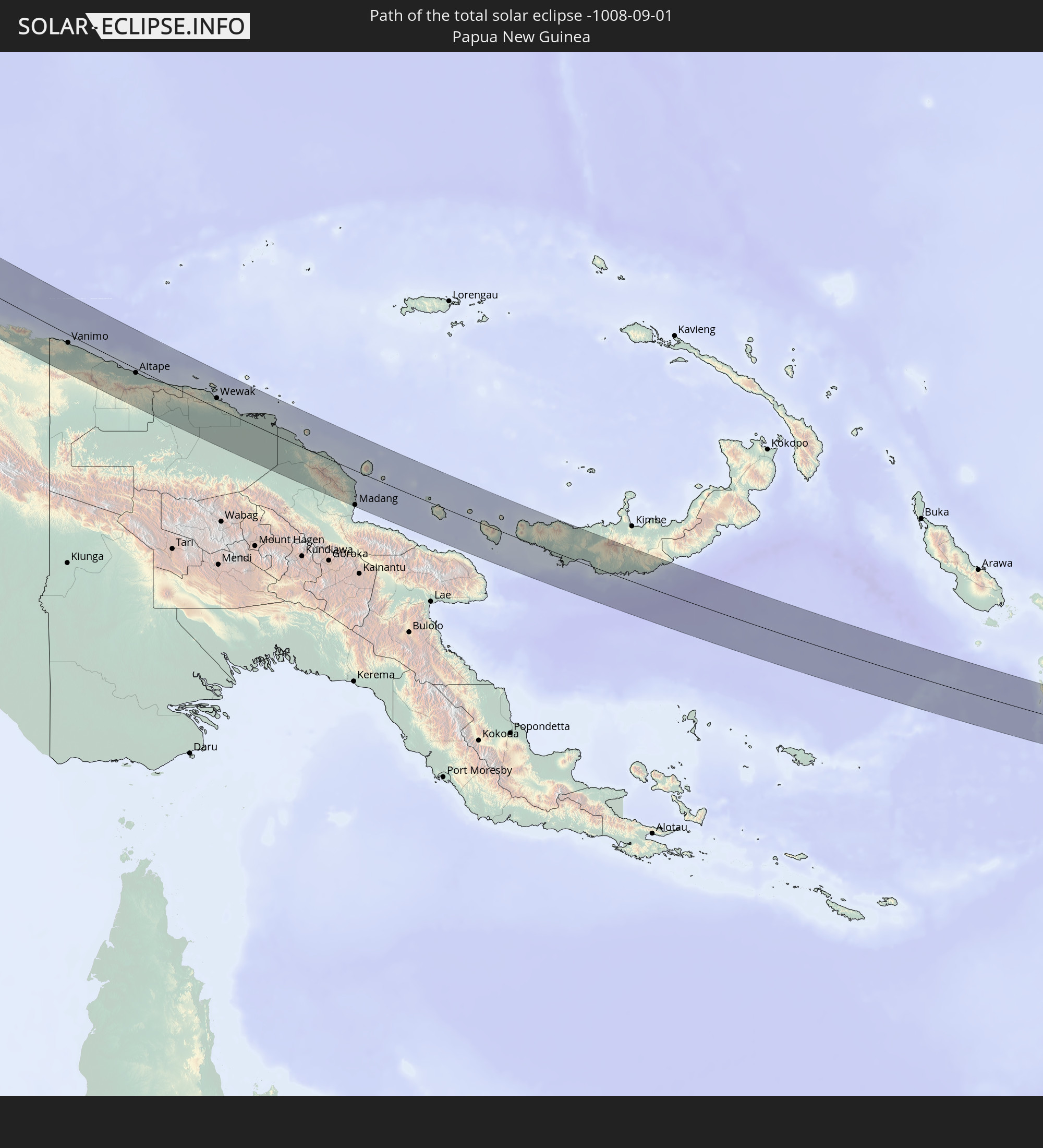 Papua-Neuguinea
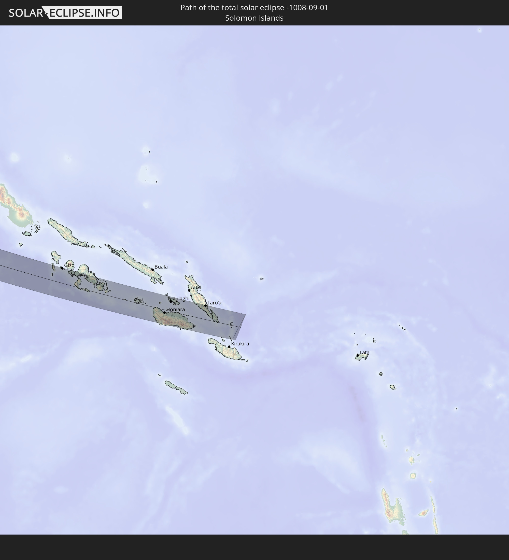 Salomonen
In den folgenden Ländern ist die Sonnenfinsternis partiell zu sehen
 Russland
 United States Minor Outlying Islands
 Grönland
 Spitzbergen
 Norwegen
 Dänemark
 Schweden
 Tschechien
 Polen
Polen
 Ungarn
 Slowakei
 Serbien
 Åland Islands
 Griechenland
 Rumänien
 Finnland
 Litauen
 Lettland
 Estland
 Sudan
Sudan
 Ukraine
 Bulgarien
 Weißrussland
 Ägypten
 Türkei
 Moldawien
 Republik Zypern
 Äthiopien
 Staat Palästina
 Israel
 Saudi-Arabien
 Jordanien
 Libanon
 Syrien
 Eritrea
 Irak
Irak
 Georgien
 Jemen
Jemen
 Armenien
 Iran
Iran
 Aserbaidschan
 Kasachstan
 Kuwait
 Bahrain
 Katar
Katar
 Vereinigte Arabische Emirate
 Oman
Oman
 Turkmenistan
 Usbekistan
 Afghanistan
 Pakistan
 Tadschikistan
 Indien
 Kirgisistan
 Volksrepublik China
 Sri Lanka
 Nepal
Nepal
 Mongolei
 Bangladesch
 Bhutan
 Myanmar
 Indonesien
 Thailand
 Malaysia
 Laos
Laos
 Vietnam
 Kambodscha
 Singapur
 Weihnachtsinsel
 Australien
 Macau
Macau
 Hongkong
 Brunei
 Taiwan
 Philippinen
 Japan
Japan
 Osttimor
 Nordkorea
 Südkorea
 Palau
Palau
 Föderierte Staaten von Mikronesien
 Papua-Neuguinea
 Guam
Guam
 Nördliche Marianen
 Salomonen
 Neukaledonien
 Marshallinseln
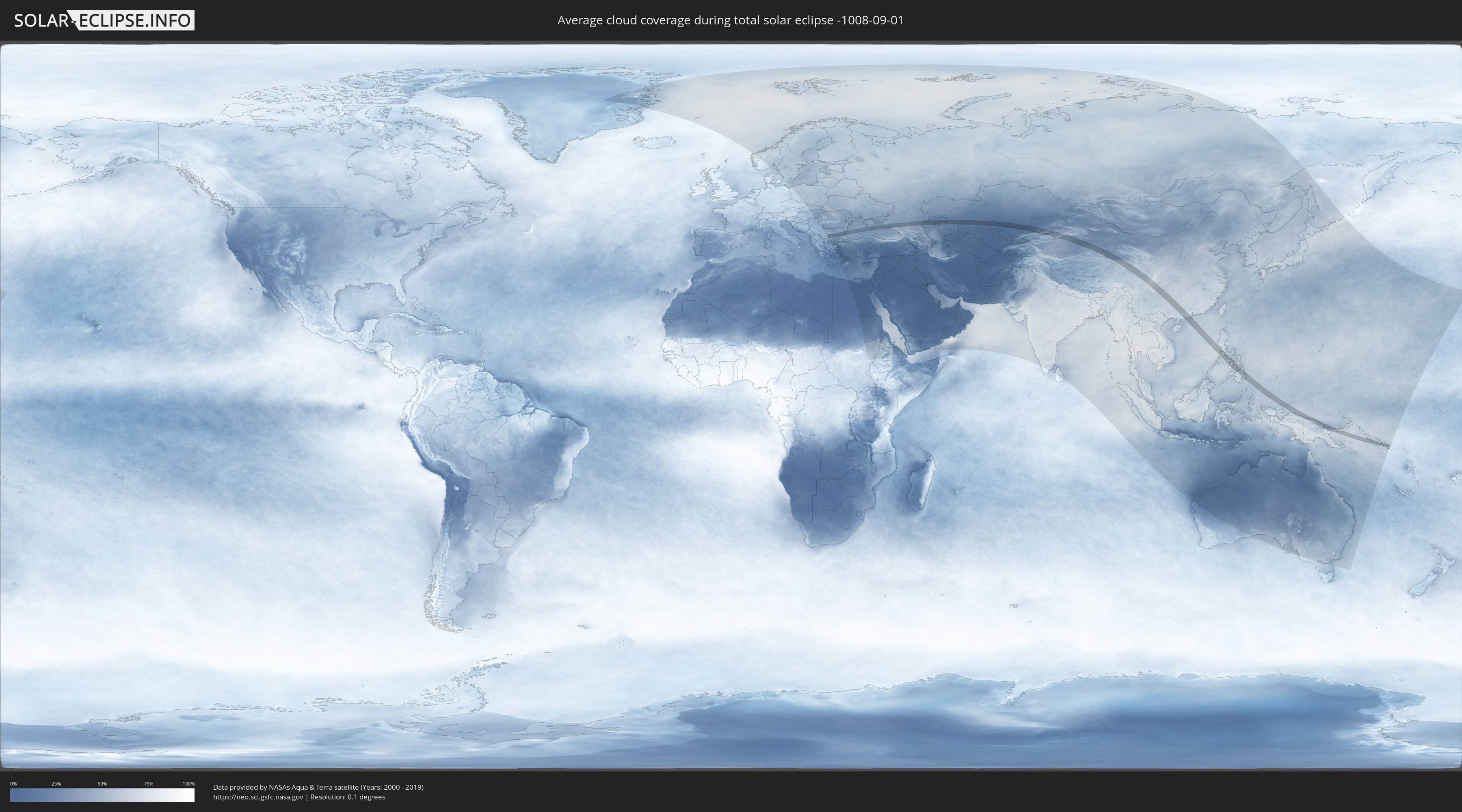
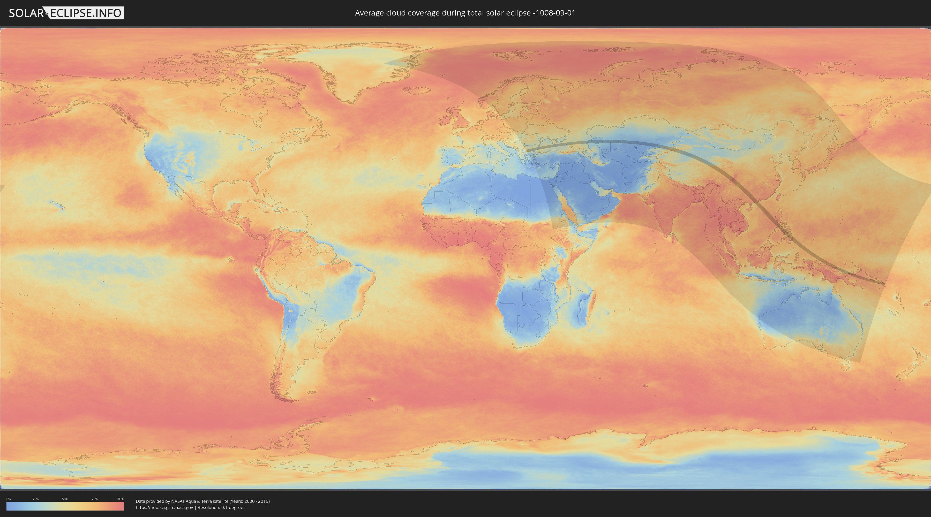
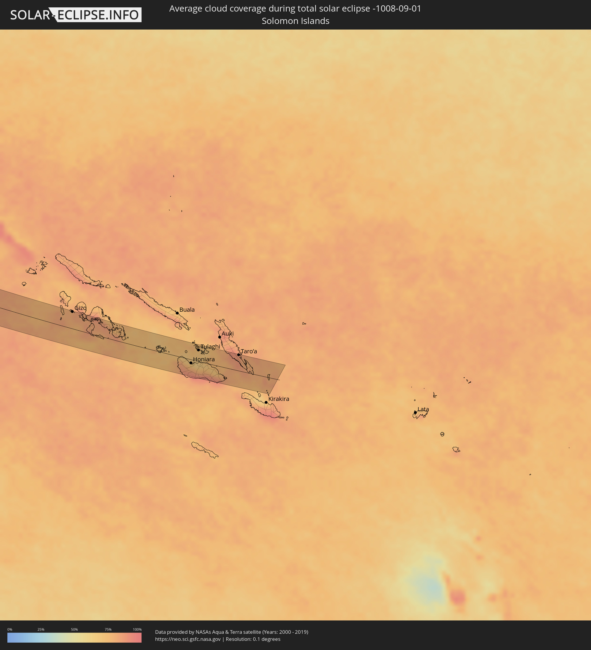
Wie wird das Wetter während der totalen Sonnenfinsternis am 01.09.-1008?
Wo ist der beste Ort, um die totale Sonnenfinsternis vom 01.09.-1008 zu beobachten?
Die folgenden Karten zeigen die durchschnittliche Bewölkung für den Tag, an dem die totale Sonnenfinsternis
stattfindet. Mit Hilfe der Karten lässt sich der Ort entlang des Finsternispfades eingrenzen,
der die besten Aussichen auf einen klaren wolkenfreien Himmel bietet.
Trotzdem muss man immer lokale Gegenenheiten beachten und sollte sich genau über das Wetter an seinem
gewählten Beobachtungsort informieren.
Die Daten stammen von den beiden NASA-Satelliten
AQUA und TERRA
und wurden über einen Zeitraum von 19 Jahren (2000 - 2019) gemittelt.
Detaillierte Länderkarten
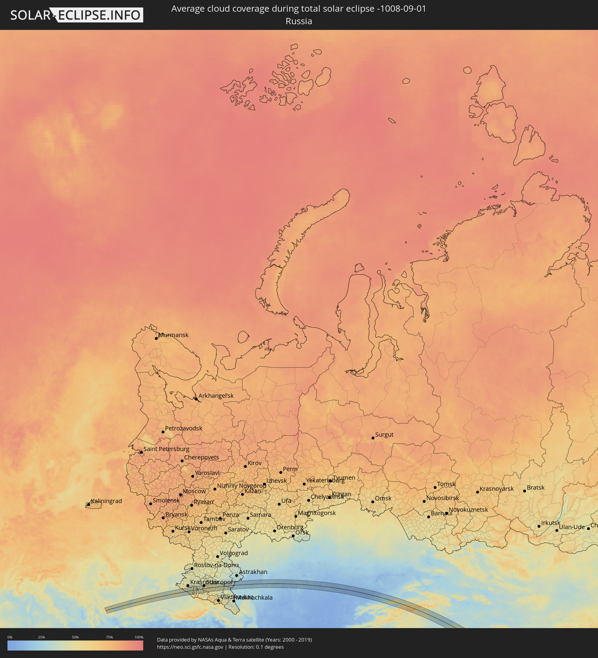 Russland
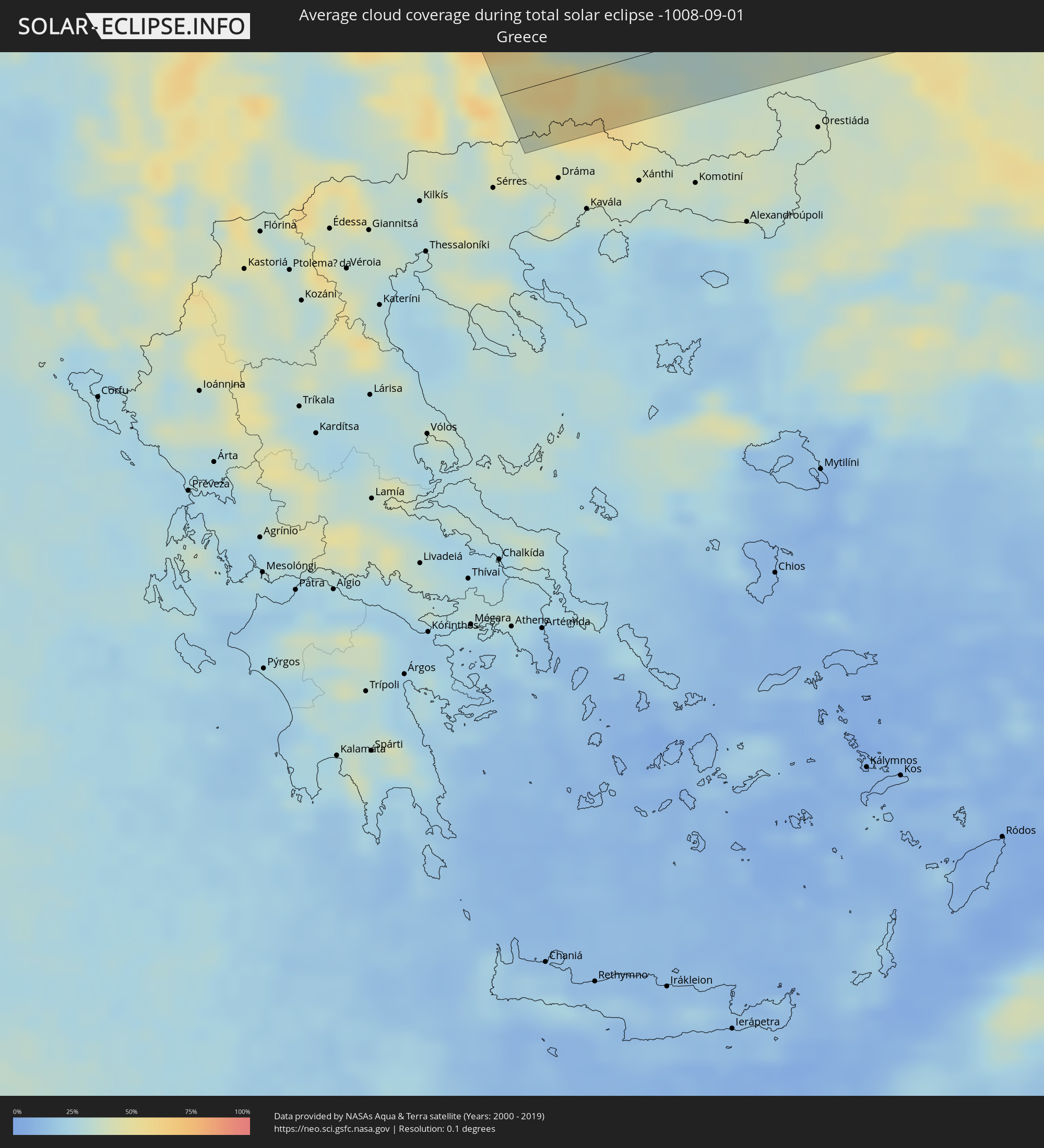 Griechenland
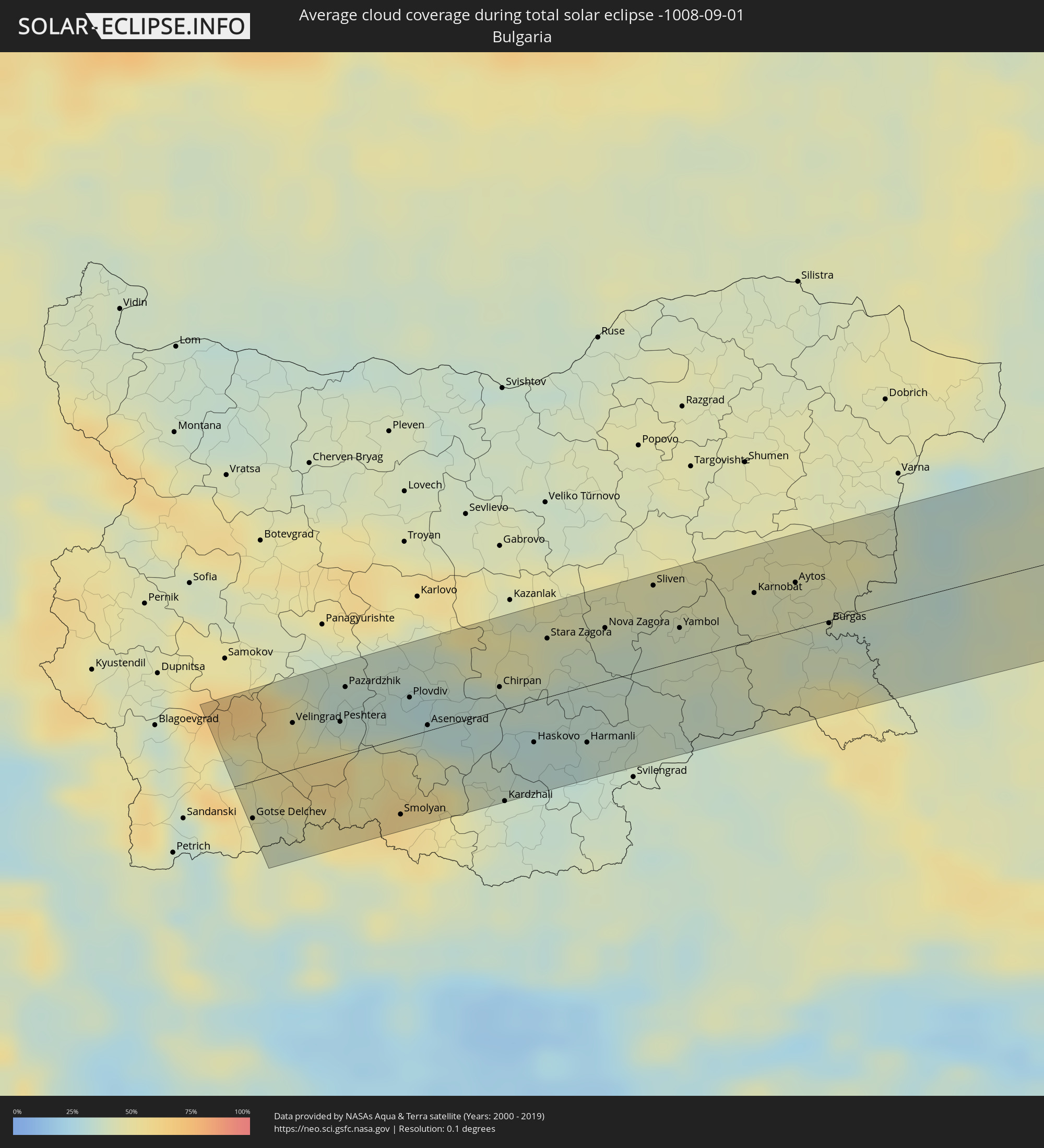 Bulgarien
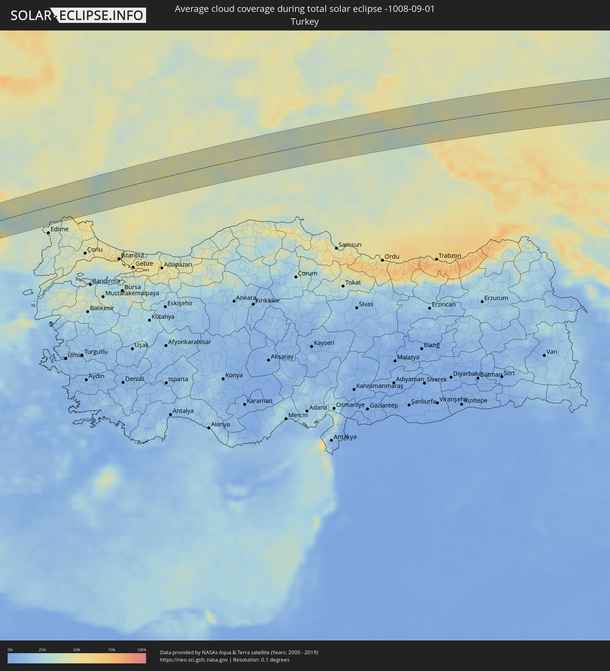 Türkei
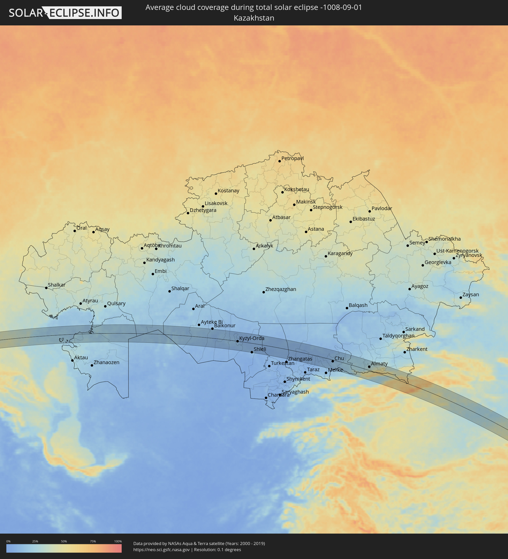 Kasachstan
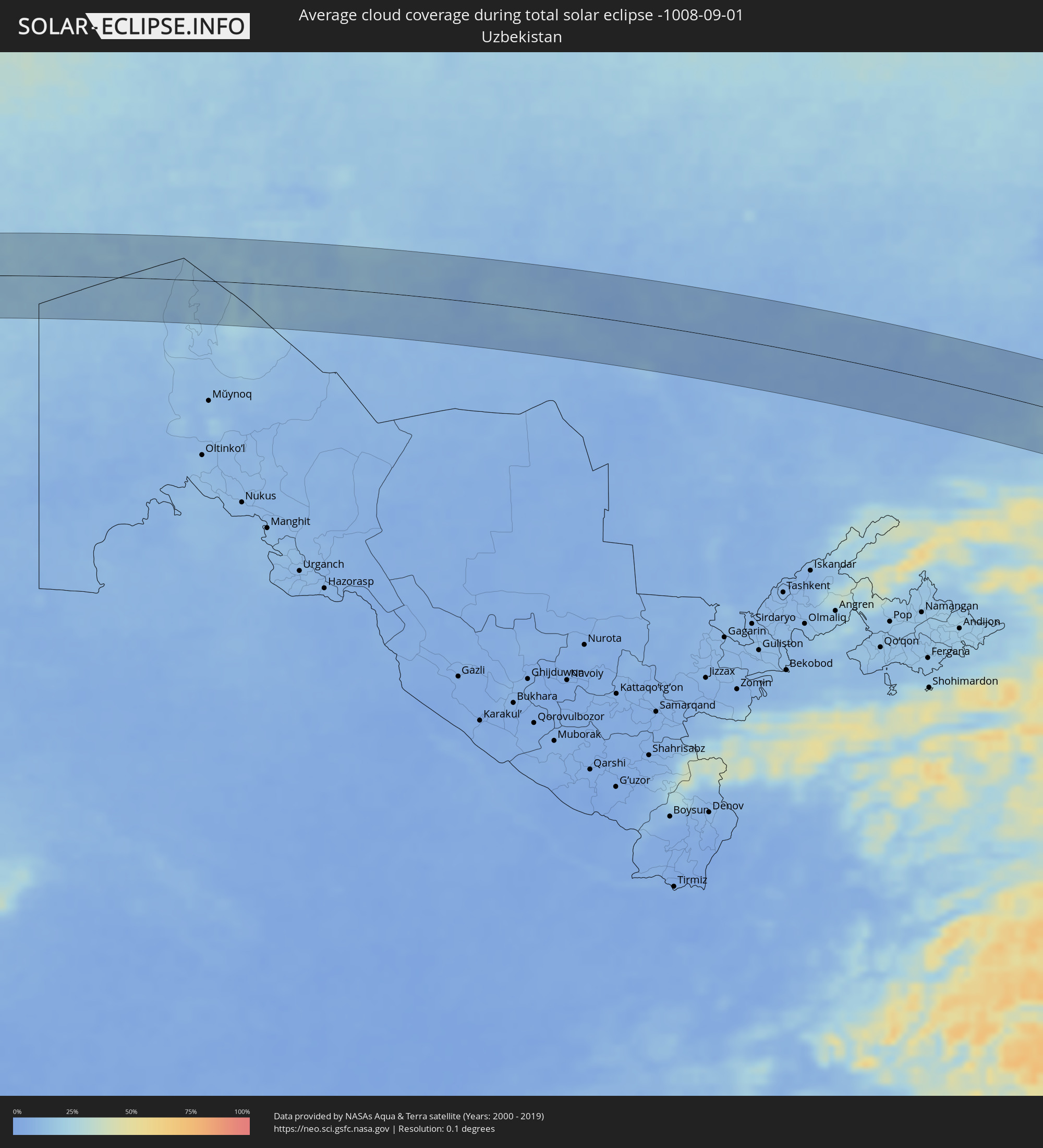 Usbekistan
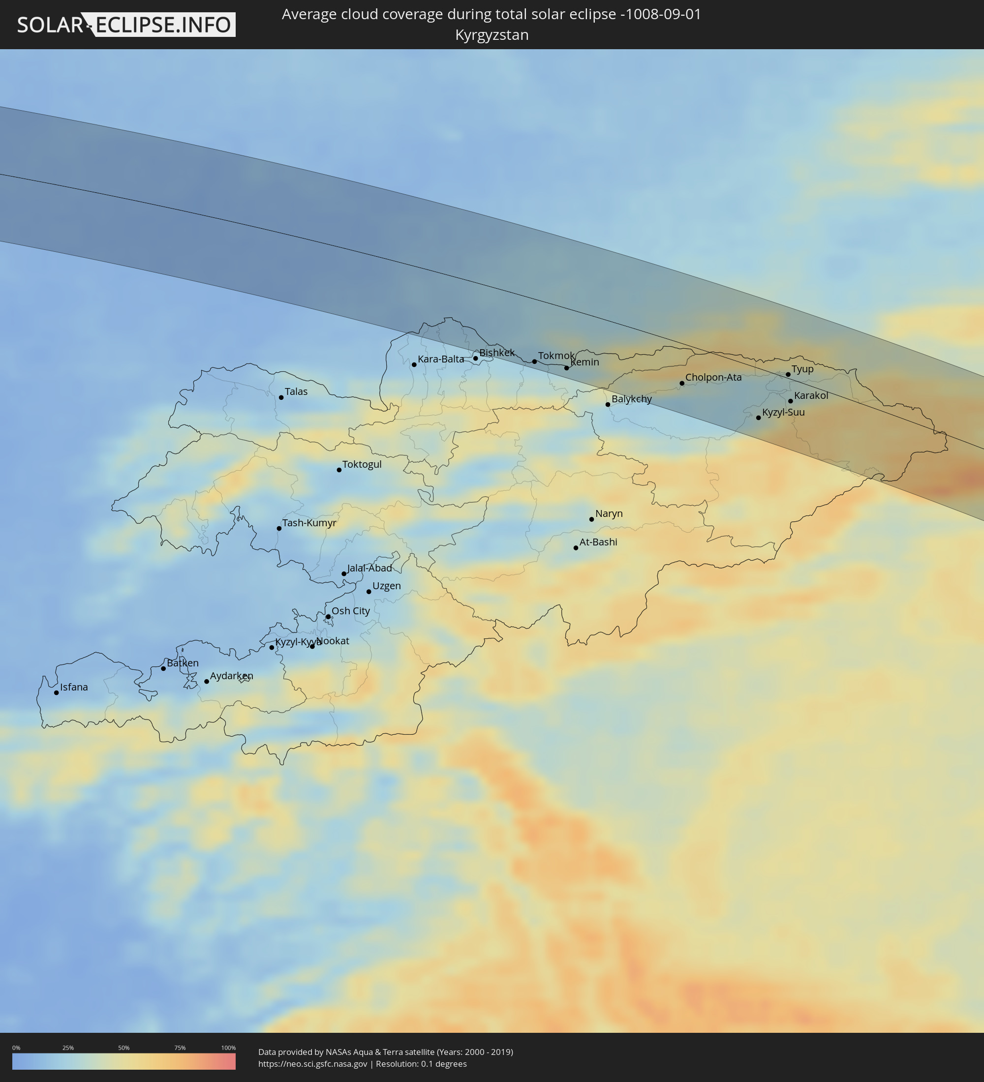 Kirgisistan
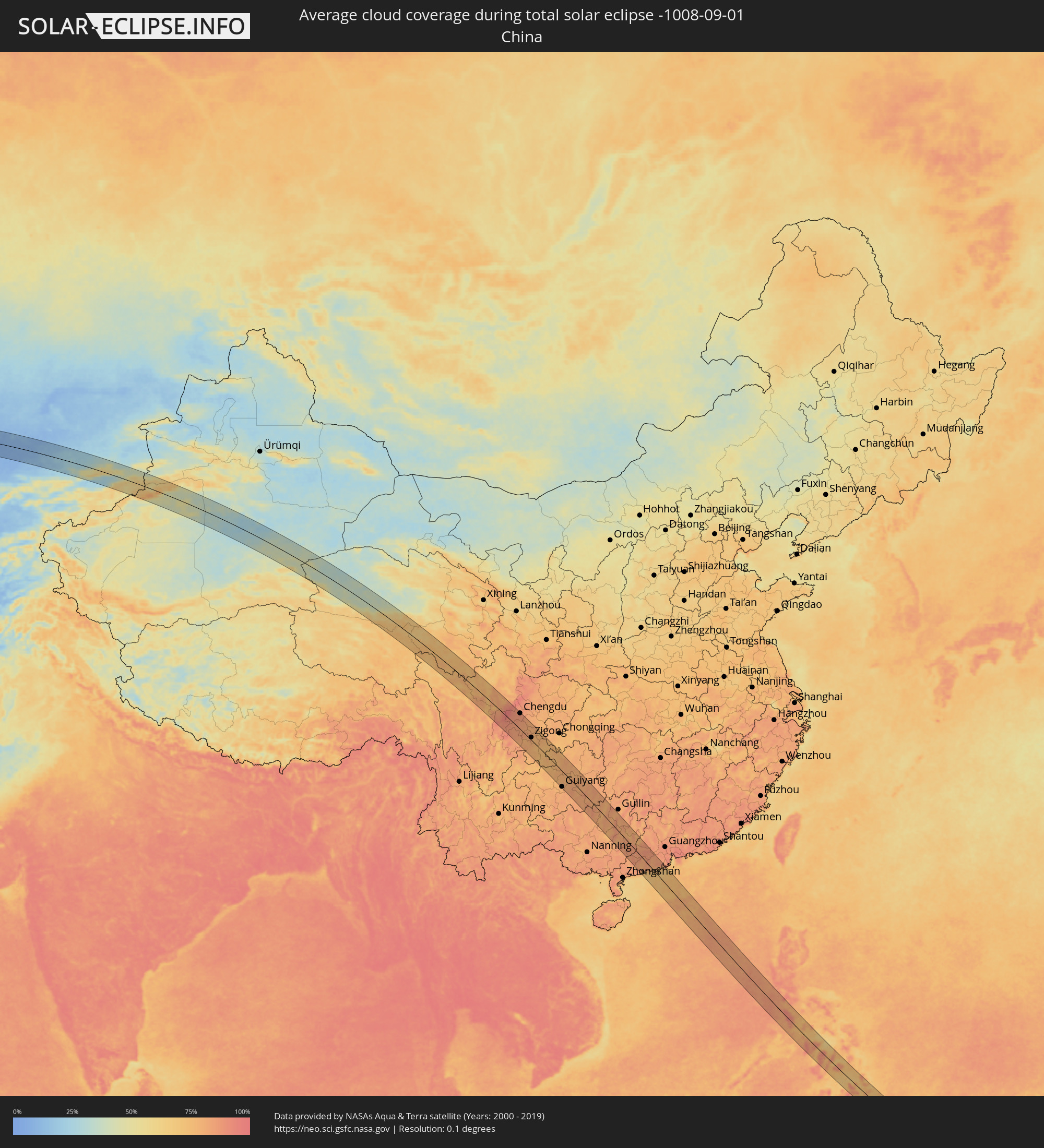 Volksrepublik China
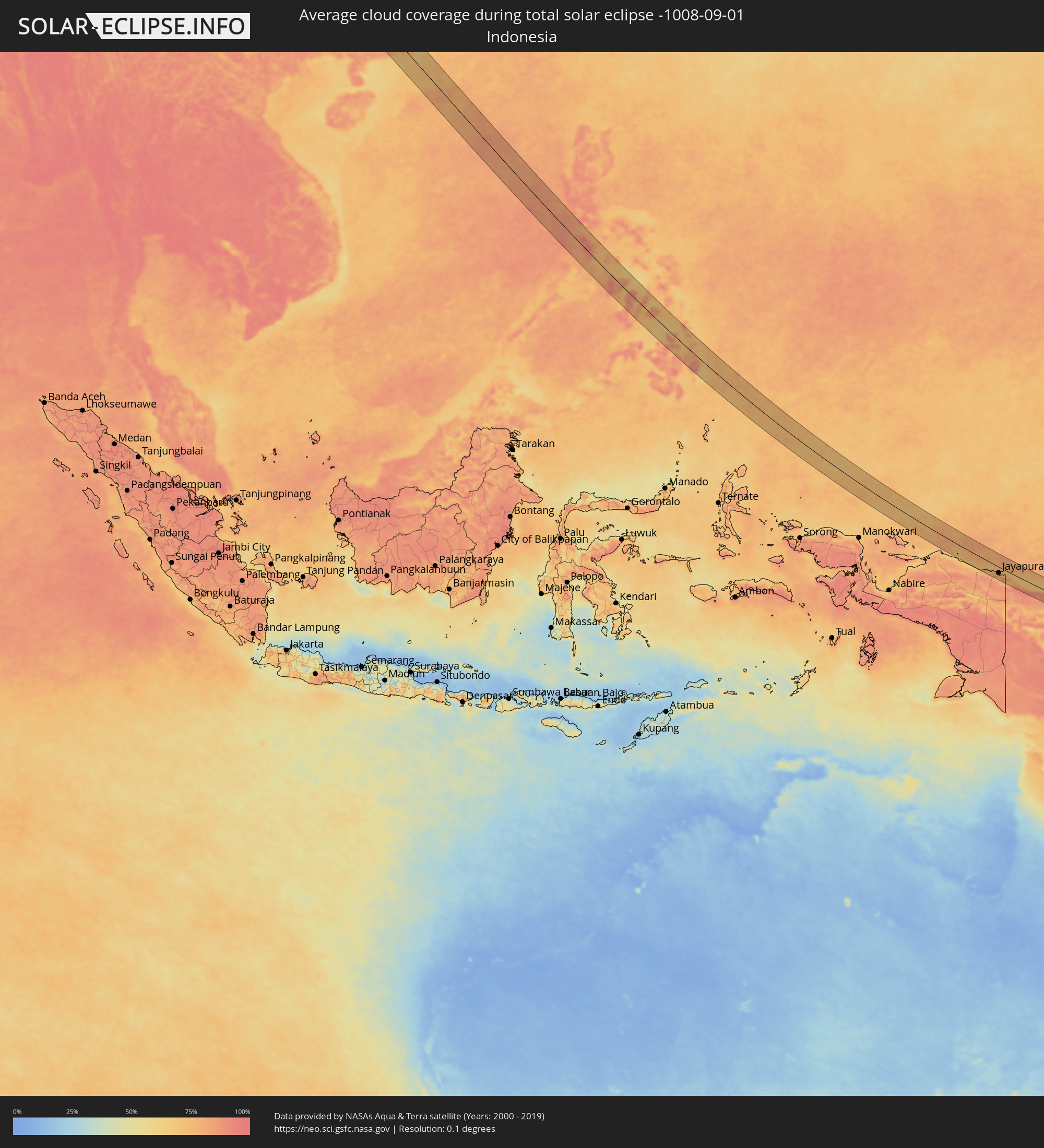 Indonesien
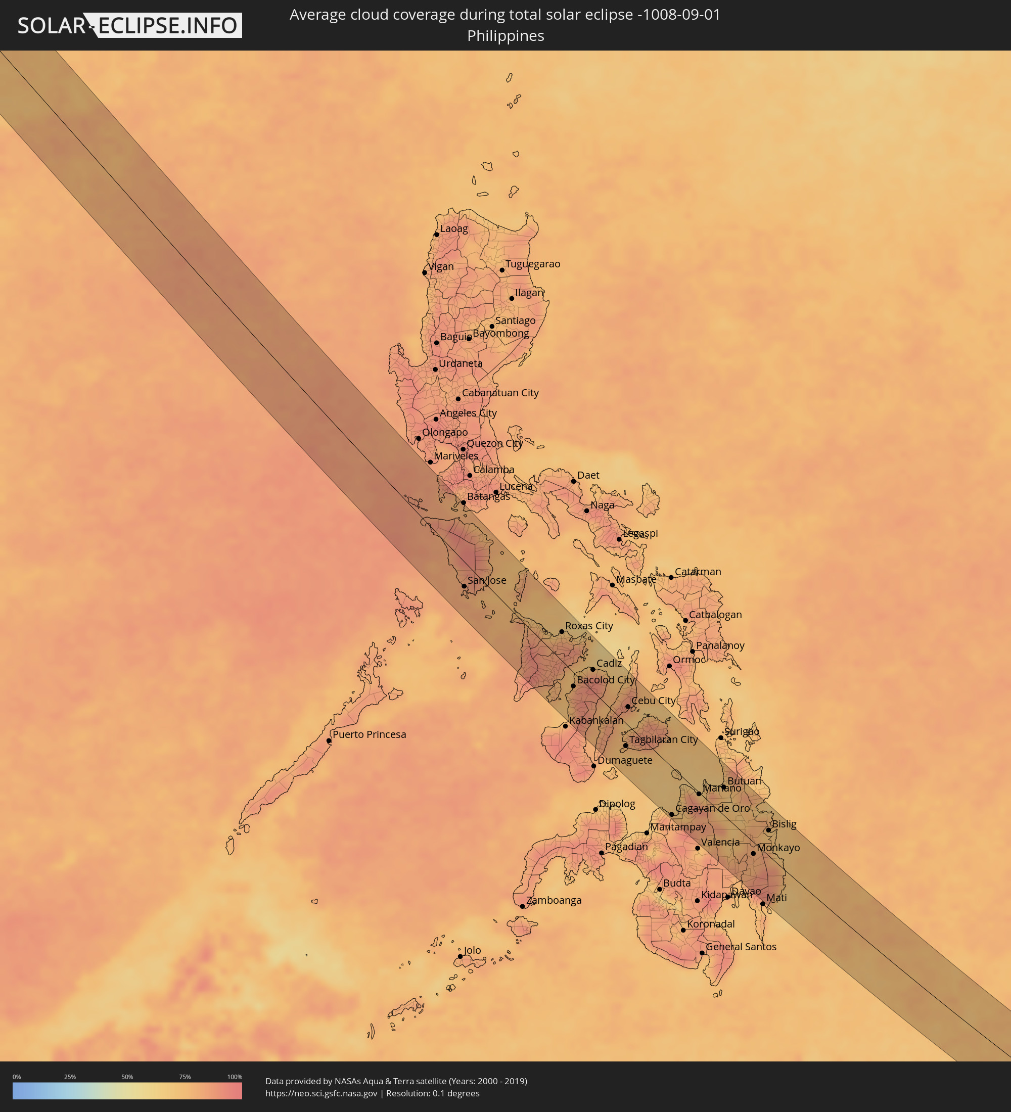 Philippinen
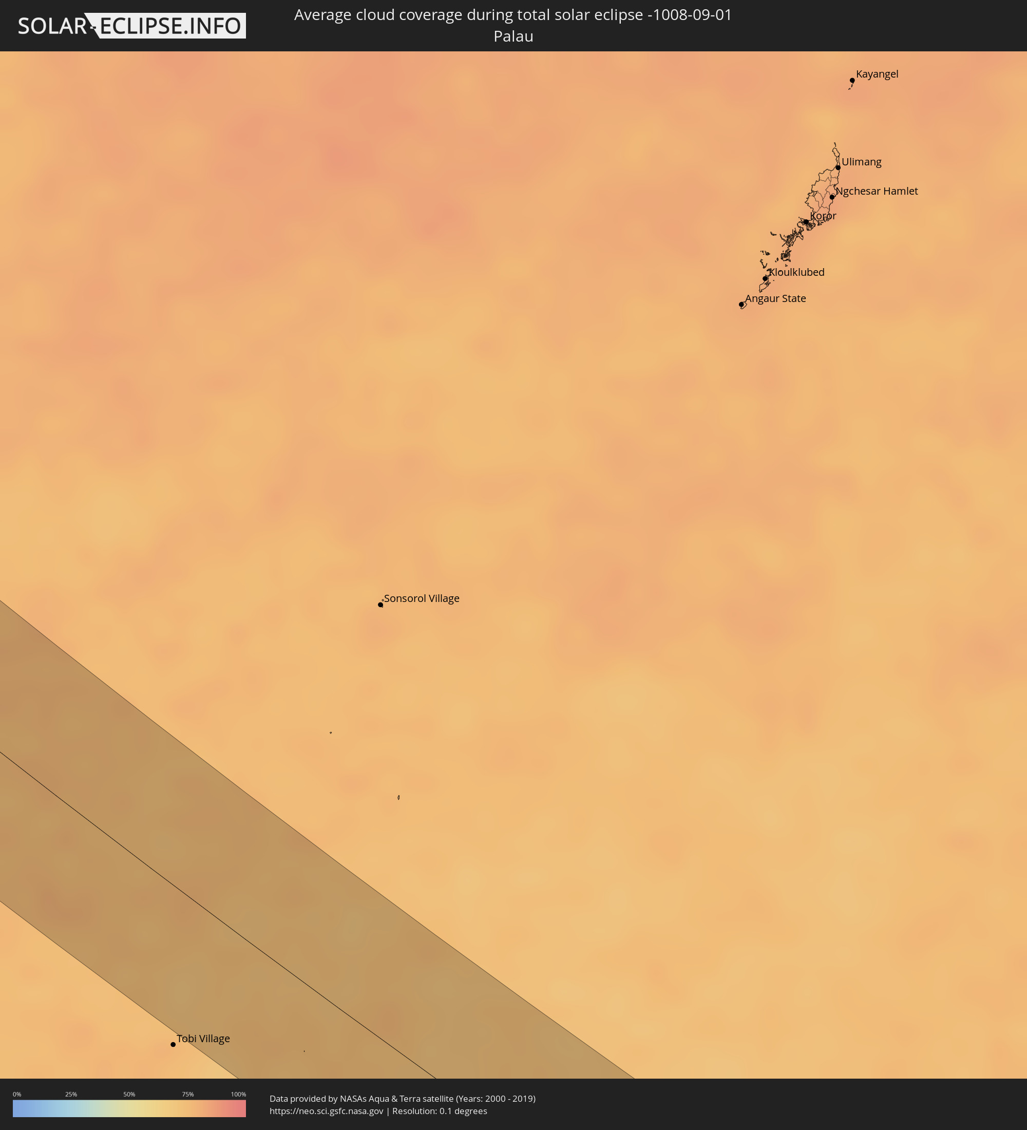 Palau
Palau
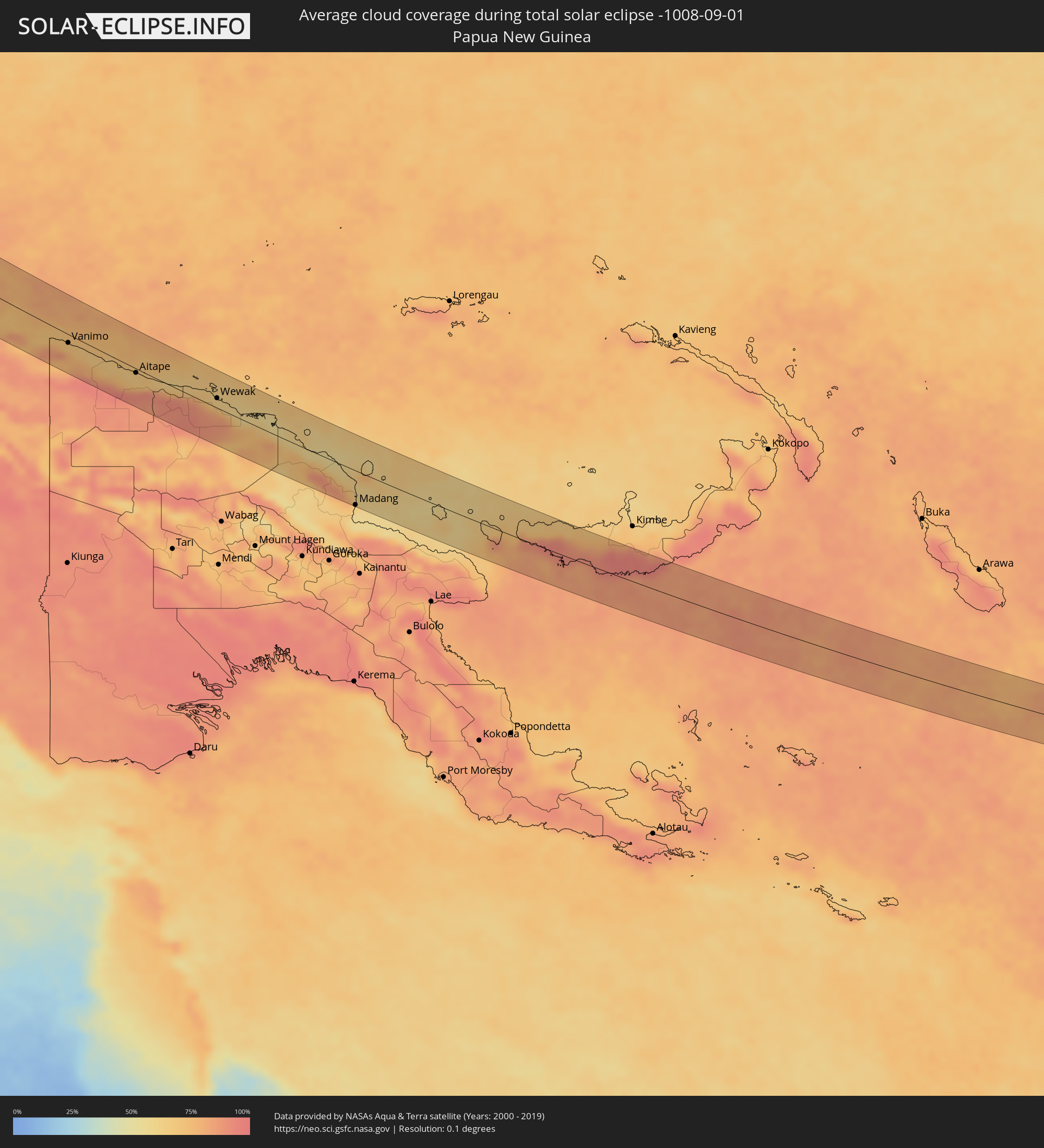 Papua-Neuguinea
 Salomonen
Orte im Finsternispfad
Die nachfolgene Tabelle zeigt Städte und Orte mit mehr als 5.000 Einwohnern, die sich im Finsternispfad befinden. Städte mit mehr als 100.000 Einwohnern sind dick gekennzeichnet. Mit einem Klick auf den Ort öffnet sich eine Detailkarte die die Lage des jeweiligen Ortes zusammen mit dem Verlauf der zentralen Finsternis präsentiert.
| Ort | Typ | Dauer der Verfinsterung | Ortszeit bei maximaler Verfinsterung | Entfernung zur Zentrallinie | Ø Bewölkung |
|
Gotse Delchev, Blagoevgrad
|
total | - | 05:43:05 UTC+02:00 | 19 km | 47% |
|
Velingrad, Pazardzhik
|
total | - | 05:43:20 UTC+02:00 | 24 km | 50% |
|
Peshtera, Pazardzhik
|
total | - | 05:43:18 UTC+02:00 | 18 km | 48% |
|
Pazardzhik, Pazardzhik
|
total | - | 05:43:24 UTC+02:00 | 35 km | 34% |
|
Stamboliyski, Plovdiv
|
total | - | 05:43:20 UTC+02:00 | 23 km | 35% |
|
Smolyan, Smolyan
|
total | - | 05:42:58 UTC+02:00 | 39 km | 57% |
|
Plovdiv, Plovdiv
|
total | - | 05:43:19 UTC+02:00 | 20 km | 29% |
|
Asenovgrad, Plovdiv
|
total | - | 05:43:13 UTC+02:00 | 3 km | 34% |
|
Rakovski, Plovdiv
|
total | - | 05:43:24 UTC+02:00 | 31 km | 36% |
|
Chirpan, Stara Zagora
|
total | - | 05:43:18 UTC+02:00 | 12 km | 34% |
|
Kardzhali, Kŭrdzhali
|
total | - | 05:42:56 UTC+02:00 | 48 km | 37% |
|
Haskovo, Khaskovo
|
total | - | 05:43:06 UTC+02:00 | 21 km | 32% |
|
Stara Zagora, Stara Zagora
|
total | - | 05:43:25 UTC+02:00 | 30 km | 43% |
|
Harmanli, Khaskovo
|
total | - | 05:43:04 UTC+02:00 | 29 km | 33% |
|
Radnevo, Stara Zagora
|
total | - | 05:43:18 UTC+02:00 | 9 km | 36% |
|
Nova Zagora, Sliven
|
total | - | 05:43:25 UTC+02:00 | 27 km | 40% |
|
Sliven, Sliven
|
total | - | 05:43:31 UTC+02:00 | 42 km | 44% |
|
Yambol, Yambol
|
total | - | 05:43:23 UTC+02:00 | 17 km | 40% |
|
Elhovo, Yambol
|
total | - | 05:43:10 UTC+02:00 | 19 km | 36% |
|
Karnobat, Burgas
|
total | - | 05:43:27 UTC+02:00 | 24 km | 44% |
|
Aytos, Burgas
|
total | - | 05:43:28 UTC+02:00 | 24 km | 44% |
|
Burgas, Burgas
|
total | - | 05:43:20 UTC+02:00 | 2 km | 35% |
|
Pomorie, Burgas
|
total | - | 05:43:21 UTC+02:00 | 1 km | 37% |
|
Gelendzhik, Krasnodarskiy
|
total | - | 06:15:48 UTC+02:30 | 35 km | 45% |
|
Tuapse, Krasnodarskiy
|
total | - | 06:15:42 UTC+02:30 | 28 km | 36% |
|
Goryachiy Klyuch, Krasnodarskiy
|
total | - | 06:16:04 UTC+02:30 | 29 km | 39% |
|
Lazarevskoye, Krasnodarskiy
|
total | - | 06:15:37 UTC+02:30 | 53 km | 37% |
|
Khadyzhensk, Krasnodarskiy
|
total | - | 06:16:01 UTC+02:30 | 1 km | 37% |
|
Apsheronsk, Krasnodarskiy
|
total | - | 06:16:06 UTC+02:30 | 3 km | 37% |
|
Belorechensk, Krasnodarskiy
|
total | - | 06:16:21 UTC+02:30 | 34 km | 44% |
|
Giaginskaya, Adygeya
|
total | - | 06:16:27 UTC+02:30 | 42 km | 44% |
|
Maykop, Adygeya
|
total | - | 06:16:17 UTC+02:30 | 14 km | 45% |
|
Kurganinsk, Krasnodarskiy
|
total | - | 06:16:36 UTC+02:30 | 38 km | 42% |
|
Labinsk, Krasnodarskiy
|
total | - | 06:16:28 UTC+02:30 | 9 km | 40% |
|
Mostovskoy, Krasnodarskiy
|
total | - | 06:16:20 UTC+02:30 | 16 km | 43% |
|
Armavir, Krasnodarskiy
|
total | - | 06:16:49 UTC+02:30 | 43 km | 44% |
|
Otradnaya, Krasnodarskiy
|
total | - | 06:16:31 UTC+02:30 | 27 km | 45% |
|
Nevinnomyssk, Stavropol'skiy
|
total | - | 06:16:49 UTC+02:30 | 5 km | 44% |
|
Stavropol’, Stavropol'skiy
|
total | - | 06:17:06 UTC+02:30 | 40 km | 46% |
|
Cherkessk, Karachayevo-Cherkesiya
|
total | - | 06:16:34 UTC+02:30 | 52 km | 46% |
|
Aleksandrovskoye, Stavropol'skiy
|
total | - | 06:17:12 UTC+02:30 | 7 km | 47% |
|
Blagodarnyy, Stavropol'skiy
|
total | - | 06:17:36 UTC+02:30 | 31 km | 45% |
|
Zelenokumsk, Stavropol'skiy
|
total | - | 06:17:17 UTC+02:30 | 50 km | 49% |
|
Budënnovsk, Stavropol'skiy
|
total | - | 06:17:39 UTC+02:30 | 11 km | 46% |
|
Arzgir, Stavropol'skiy
|
total | - | 06:18:04 UTC+02:30 | 53 km | 42% |
|
Neftekumsk, Stavropol'skiy
|
total | - | 06:17:56 UTC+02:30 | 22 km | 45% |
|
Beyneu, Mangghystaū
|
total | - | 07:18:40 UTC+03:25 | 4 km | 18% |
|
Zhosaly, Qyzylorda
|
total | - | 08:22:06 UTC+04:21 | 55 km | 12% |
|
Dzhalagash, Qyzylorda
|
total | - | 08:22:30 UTC+04:21 | 16 km | 13% |
|
Terenozek, Qyzylorda
|
total | - | 08:22:47 UTC+04:21 | 15 km | 13% |
|
Kyzyl-Orda, Qyzylorda
|
total | - | 08:23:12 UTC+04:21 | 2 km | 13% |
|
Kyzylorda, Qyzylorda
|
total | - | 08:23:13 UTC+04:21 | 1 km | 13% |
|
Tasböget, Qyzylorda
|
total | - | 08:23:14 UTC+04:21 | 9 km | 11% |
|
Shīeli, Qyzylorda
|
total | - | 08:24:14 UTC+04:21 | 63 km | 10% |
|
Moyynkum, Zhambyl
|
total | - | 08:30:56 UTC+04:21 | 47 km | 10% |
|
Chu, Zhambyl
|
total | - | 08:31:53 UTC+04:21 | 11 km | 18% |
|
Georgiyevka, Zhambyl
|
total | - | 08:33:04 UTC+04:21 | 51 km | 23% |
|
Kant, Chüy
|
total | - | 09:09:47 UTC+04:58 | 64 km | 24% |
|
Tokmok, Chüy
|
total | - | 09:10:21 UTC+04:58 | 60 km | 26% |
|
Kemin, Chüy
|
total | - | 09:10:50 UTC+04:58 | 57 km | 28% |
|
Burunday, Almaty Oblysy
|
total | - | 08:35:43 UTC+04:21 | 32 km | 28% |
|
Almaty, Almaty Qalasy
|
total | - | 08:35:49 UTC+04:21 | 23 km | 30% |
|
Pervomayskiy, Almaty Oblysy
|
total | - | 08:35:49 UTC+04:21 | 36 km | 28% |
|
Otegen Batyra, Almaty Oblysy
|
total | - | 08:35:55 UTC+04:21 | 42 km | 29% |
|
Cholpon-Ata, Issyk-Kul Region
|
total | - | 09:12:39 UTC+04:58 | 38 km | 24% |
|
Talghar, Almaty Oblysy
|
total | - | 08:36:12 UTC+04:21 | 35 km | 34% |
|
Esik, Almaty Oblysy
|
total | - | 08:36:28 UTC+04:21 | 46 km | 34% |
|
Turgen, Almaty Oblysy
|
total | - | 08:36:38 UTC+04:21 | 54 km | 34% |
|
Kyzyl-Suu, Issyk-Kul Region
|
total | - | 09:13:55 UTC+04:58 | 47 km | 43% |
|
Tyup, Issyk-Kul Region
|
total | - | 09:14:18 UTC+04:58 | 3 km | 31% |
|
Karakol, Issyk-Kul Region
|
total | - | 09:14:24 UTC+04:58 | 21 km | 40% |
|
Ak-Suu, Issyk-Kul Region
|
total | - | 09:14:34 UTC+04:58 | 17 km | 43% |
|
Kegen, Almaty Oblysy
|
total | - | 08:38:50 UTC+04:21 | 57 km | 40% |
|
Kuqa, Xinjiang Uyghur Autonomous Region
|
total | - | 12:22:32 UTC+08:00 | 34 km | 46% |
|
Leshan, Sichuan
|
total | - | 13:11:40 UTC+08:00 | 39 km | 84% |
|
Luocheng, Sichuan
|
total | - | 13:12:27 UTC+08:00 | 35 km | 82% |
|
Chengdu, Sichuan
|
total | - | 13:10:17 UTC+08:00 | 70 km | 88% |
|
Yibin, Sichuan
|
total | - | 13:14:36 UTC+08:00 | 44 km | 78% |
|
Yanjiang, Sichuan
|
total | - | 13:12:15 UTC+08:00 | 65 km | 81% |
|
Zigong, Sichuan
|
total | - | 13:13:51 UTC+08:00 | 12 km | 80% |
|
Neijiang, Sichuan
|
total | - | 13:13:55 UTC+08:00 | 51 km | 77% |
|
Guiyang, Guizhou
|
total | - | 13:22:20 UTC+08:00 | 69 km | 79% |
|
Loushanguan, Guizhou
|
total | - | 13:19:35 UTC+08:00 | 59 km | 79% |
|
Zunyi, Guizhou
|
total | - | 13:20:34 UTC+08:00 | 30 km | 80% |
|
Duyun, Guizhou
|
total | - | 13:24:19 UTC+08:00 | 36 km | 81% |
|
Guiping, Guangxi Zhuang Autonomous Region
|
total | - | 13:34:19 UTC+08:00 | 64 km | 79% |
|
Yangshuo, Guangxi Zhuang Autonomous Region
|
total | - | 13:32:15 UTC+08:00 | 71 km | 82% |
|
Xinyi, Guangdong
|
total | - | 13:37:50 UTC+08:00 | 74 km | 81% |
|
Wuzhou, Guangxi Zhuang Autonomous Region
|
total | - | 13:36:12 UTC+08:00 | 36 km | 83% |
|
Ducheng, Guangdong
|
total | - | 13:37:02 UTC+08:00 | 35 km | 84% |
|
Yangchun, Guangdong
|
total | - | 13:39:37 UTC+08:00 | 26 km | 82% |
|
Tangping, Guangdong
|
total | - | 13:40:08 UTC+08:00 | 24 km | 84% |
|
Yangjiang, Guangdong
|
total | - | 13:40:32 UTC+08:00 | 35 km | 83% |
|
Yunfu, Guangdong
|
total | - | 13:38:30 UTC+08:00 | 50 km | 88% |
|
Encheng, Guangdong
|
total | - | 13:40:25 UTC+08:00 | 16 km | 85% |
|
Taishan, Guangdong
|
total | - | 13:41:03 UTC+08:00 | 57 km | 87% |
|
Nasugbu, Calabarzon
|
total | - | 14:09:08 UTC+08:00 | 66 km | 83% |
|
Balayan, Calabarzon
|
total | - | 14:09:31 UTC+08:00 | 64 km | 80% |
|
San Jose, Mimaropa
|
total | - | 14:13:02 UTC+08:00 | 32 km | 81% |
|
Calapan, Mimaropa
|
total | - | 14:11:08 UTC+08:00 | 59 km | 77% |
|
Kalibo (poblacion), Western Visayas
|
total | - | 14:15:55 UTC+08:00 | 18 km | 74% |
|
Iloilo, Western Visayas
|
total | - | 14:18:05 UTC+08:00 | 46 km | 79% |
|
Roxas City, Western Visayas
|
total | - | 14:16:38 UTC+08:00 | 39 km | 77% |
|
Bago City, Western Visayas
|
total | - | 14:18:43 UTC+08:00 | 38 km | 72% |
|
Bacolod City, Western Visayas
|
total | - | 14:18:36 UTC+08:00 | 19 km | 88% |
|
Victorias, Western Visayas
|
total | - | 14:18:19 UTC+08:00 | 9 km | 85% |
|
Cadiz, Western Visayas
|
total | - | 14:18:29 UTC+08:00 | 29 km | 91% |
|
Ualog, Western Visayas
|
total | - | 14:19:19 UTC+08:00 | 8 km | 84% |
|
Toledo, Central Visayas
|
total | - | 14:19:58 UTC+08:00 | 11 km | 78% |
|
Tagbilaran City, Central Visayas
|
total | - | 14:21:33 UTC+08:00 | 31 km | 77% |
|
Cebu City, Central Visayas
|
total | - | 14:20:23 UTC+08:00 | 25 km | 79% |
|
Danao, Central Visayas
|
total | - | 14:20:10 UTC+08:00 | 52 km | 78% |
|
Cagayan de Oro, Northern Mindanao
|
total | - | 14:24:36 UTC+08:00 | 66 km | 80% |
|
Mariano, Northern Mindanao
|
total | - | 14:24:30 UTC+08:00 | 2 km | 79% |
|
Malaybalay, Northern Mindanao
|
total | - | 14:25:43 UTC+08:00 | 57 km | 82% |
|
Butuan, Caraga
|
total | - | 14:24:46 UTC+08:00 | 39 km | 74% |
|
Tagum, Davao
|
total | - | 14:27:43 UTC+08:00 | 65 km | 76% |
|
Monkayo, Davao
|
total | - | 14:27:20 UTC+08:00 | 16 km | 80% |
|
Bislig, Caraga
|
total | - | 14:26:55 UTC+08:00 | 36 km | 71% |
|
Abepura, Papua
|
total | - | 16:16:50 UTC+09:22 | 39 km | 72% |
|
Jayapura, Papua
|
total | - | 16:16:49 UTC+09:22 | 28 km | 76% |
|
Vanimo, Sandaun
|
total | - | 16:54:26 UTC+10:00 | 13 km | 79% |
|
Vanimo, Sandaun
|
total | - | 16:54:28 UTC+10:00 | 13 km | 79% |
|
Aitape, Sandaun
|
total | - | 16:55:29 UTC+10:00 | 7 km | 71% |
|
Wewak, East Sepik
|
total | - | 16:56:27 UTC+10:00 | 15 km | 67% |
|
Madang, Madang
|
total | - | 16:58:56 UTC+10:00 | 55 km | 57% |
|
Gizo, Western Province
|
total | - | 17:42:58 UTC+10:39 | 47 km | 80% |
|
Honiara, Guadalcanal
|
total | - | 17:43:47 UTC+10:39 | 10 km | 71% |
|
Tulaghi, Central Province
|
total | - | 17:43:33 UTC+10:39 | 31 km | 71% |
|
Taro’a, Choiseul
|
total | - | 17:43:32 UTC+10:39 | 44 km | 86% |