Totale Sonnenfinsternis vom 29.03.-1037
| Wochentag: | Sonntag |
| Maximale Dauer der Verfinsterung: | 06m25s |
| Maximale Breite des Finsternispfades: | 246 km |
| Saroszyklus: | 32 |
| Bedeckungsgrad: | 100% |
| Magnitude: | 1.0737 |
| Gamma: | 0.2467 |
Wo kann man die Sonnenfinsternis vom 29.03.-1037 sehen?
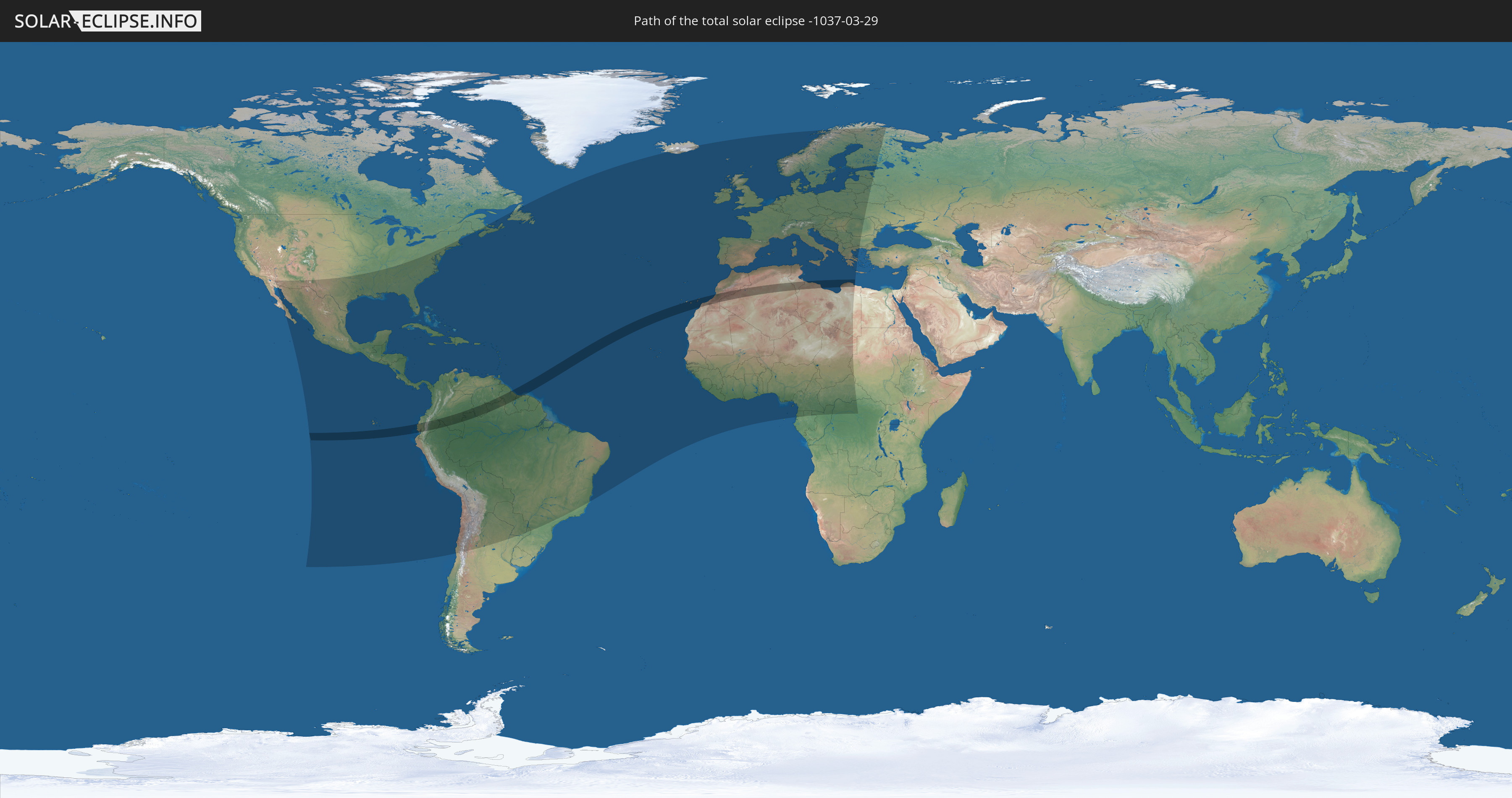
Die Sonnenfinsternis am 29.03.-1037 kann man in 128 Ländern als partielle Sonnenfinsternis beobachten.
Der Finsternispfad verläuft durch 12 Länder. Nur in diesen Ländern ist sie als totale Sonnenfinsternis zu sehen.
In den folgenden Ländern ist die Sonnenfinsternis total zu sehen
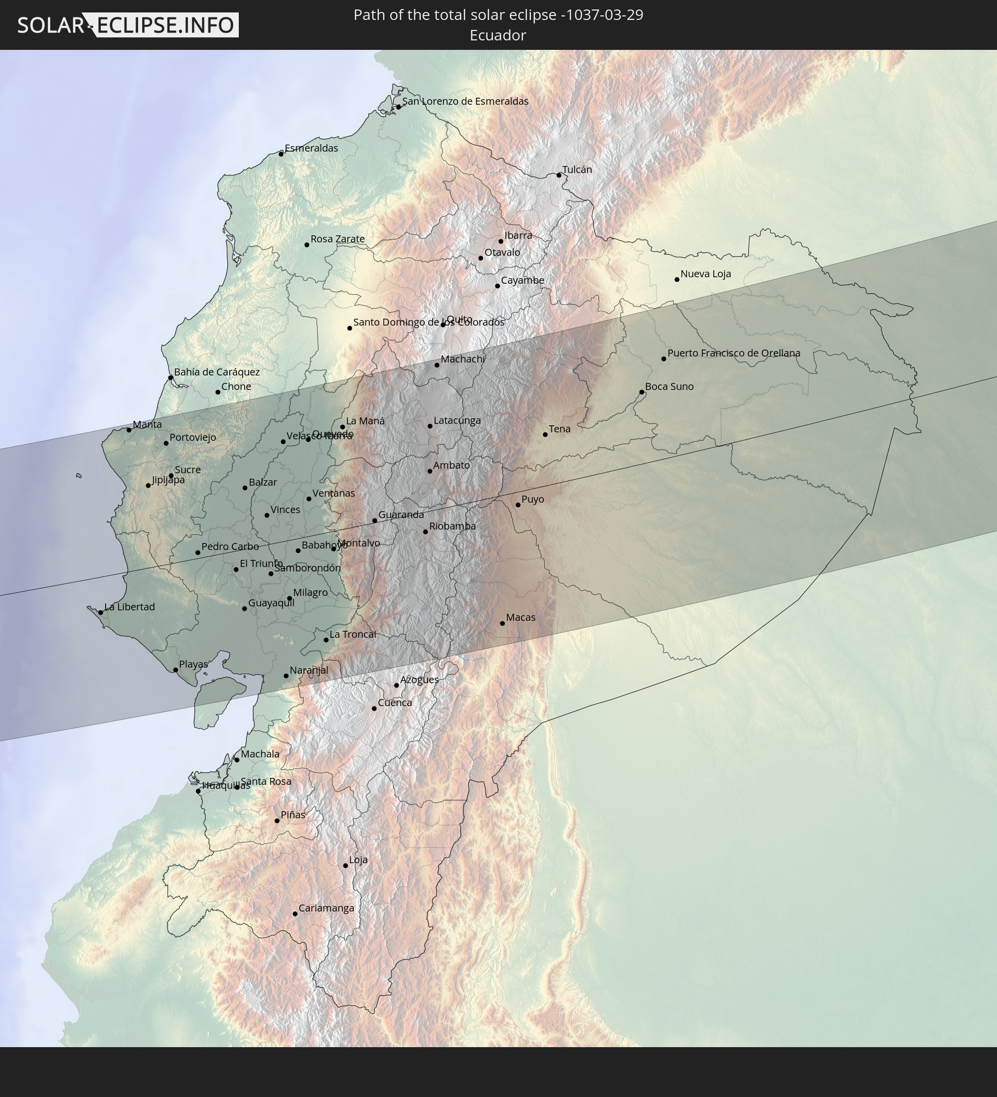 Ecuador
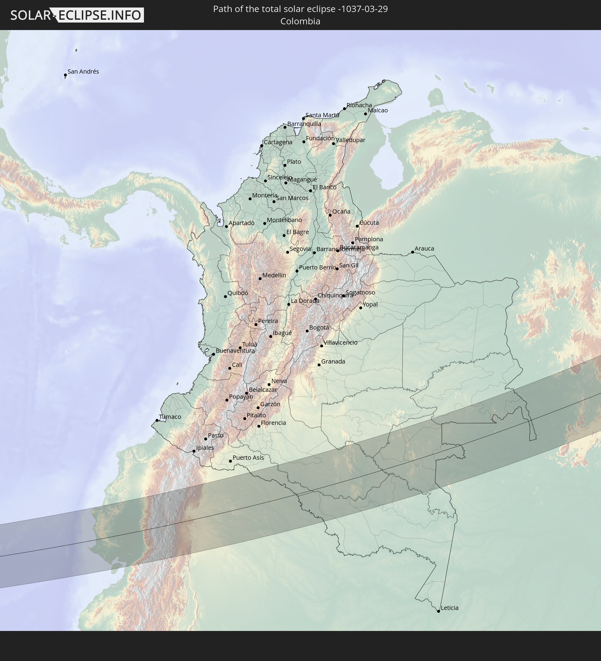 Kolumbien
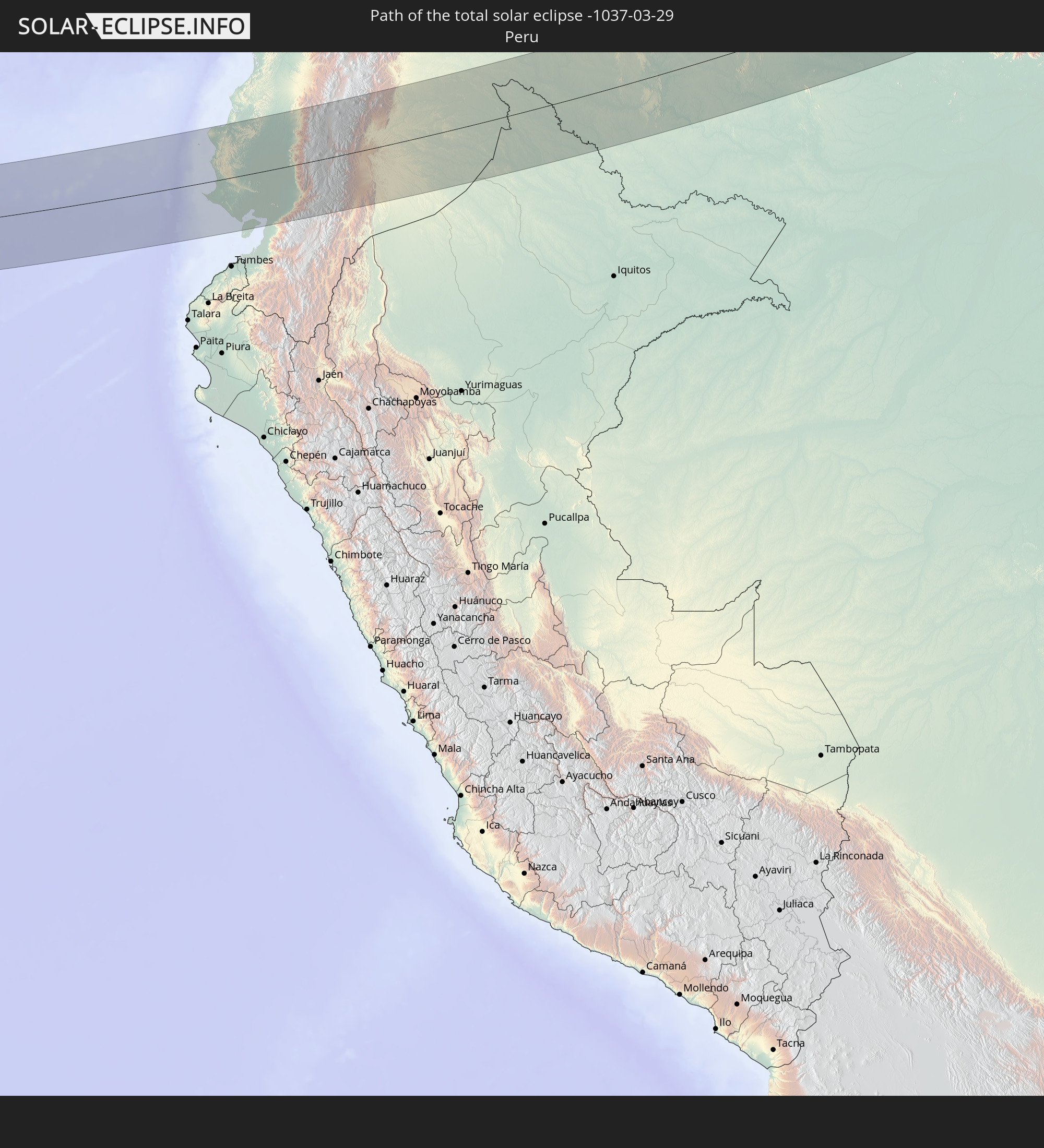 Peru
Peru
 Brasilien
 Venezuela
 Guyana
 Suriname
 Spanien
 Marokko
 Algerien
 Tunesien
 Libyen
In den folgenden Ländern ist die Sonnenfinsternis partiell zu sehen
 Russland
 Vereinigte Staaten
 United States Minor Outlying Islands
 Kanada
 Mexiko
 Chile
Chile
 Guatemala
 Ecuador
 El Salvador
 Honduras
 Belize
 Nicaragua
 Costa Rica
 Kuba
Kuba
 Panama
 Kolumbien
 Kaimaninseln
 Peru
Peru
 Bahamas
 Jamaika
 Haiti
Haiti
 Brasilien
 Argentinien
 Venezuela
 Turks- und Caicosinseln
 Dominikanische Republik
 Aruba
Aruba
 Bolivien
 Puerto Rico
 Amerikanische Jungferninseln
 Bermuda
 Britische Jungferninseln
 Anguilla
 Saint-Martin
 Saint-Barthélemy
 St. Kitts und Nevis
 Paraguay
 Antigua und Barbuda
 Montserrat
 Trinidad und Tobago
 Guadeloupe
 Grenada
 Dominica
 St. Vincent und die Grenadinen
 Guyana
 Martinique
 St. Lucia
 Barbados
 Suriname
 Saint-Pierre und Miquelon
 Französisch-Guayana
 Portugal
 Kap Verde
 Island
 Spanien
 Senegal
 Mauretanien
 Gambia
 Guinea-Bissau
 Guinea
 Sierra Leone
 Marokko
 Mali
Mali
 Liberia
 Irland
 Algerien
 Vereinigtes Königreich
 Elfenbeinküste
 Färöer
 Burkina Faso
 Gibraltar
 Frankreich
 Isle of Man
 Ghana
Ghana
 Guernsey
 Jersey
 Togo
Togo
 Niger
Niger
 Benin
Benin
 Andorra
 Belgien
 Nigeria
 Niederlande
 Norwegen
 Äquatorialguinea
 Luxemburg
 Deutschland
 Schweiz
 São Tomé und Príncipe
 Italien
 Monaco
 Tunesien
 Dänemark
 Kamerun
 Gabun
Gabun
 Libyen
 Liechtenstein
 Österreich
 Schweden
 Republik Kongo
 Tschechien
 Demokratische Republik Kongo
 San Marino
 Vatikanstadt
 Slowenien
 Tschad
 Kroatien
 Polen
Polen
 Malta
Malta
 Zentralafrikanische Republik
 Bosnien und Herzegowina
 Ungarn
 Slowakei
 Montenegro
 Serbien
 Albanien
 Åland Islands
 Griechenland
 Rumänien
 Mazedonien
 Finnland
 Litauen
 Lettland
 Estland
 Sudan
Sudan
 Ukraine
 Bulgarien
 Weißrussland
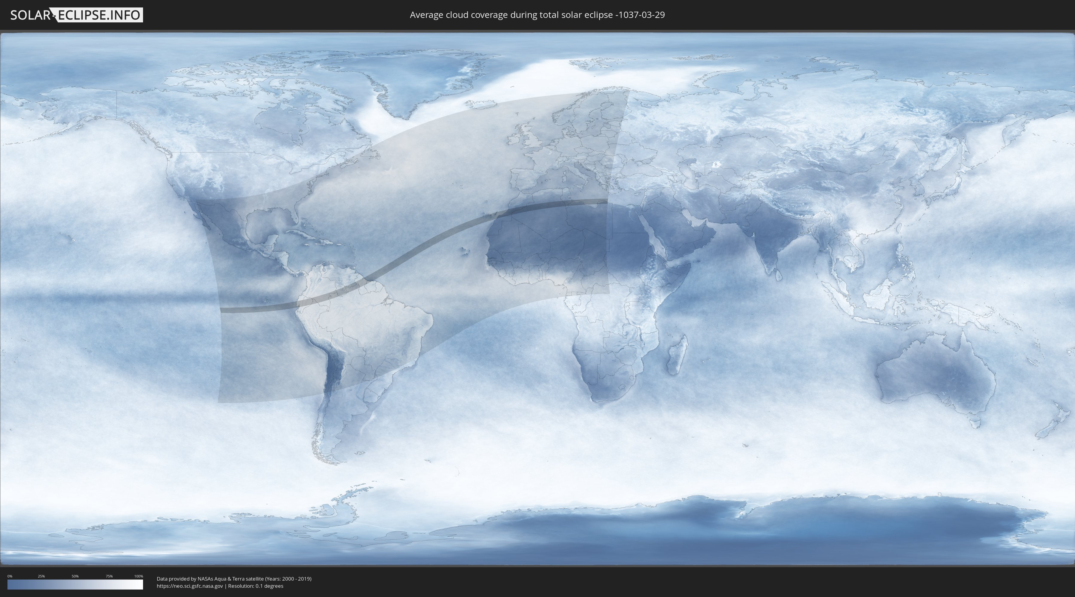
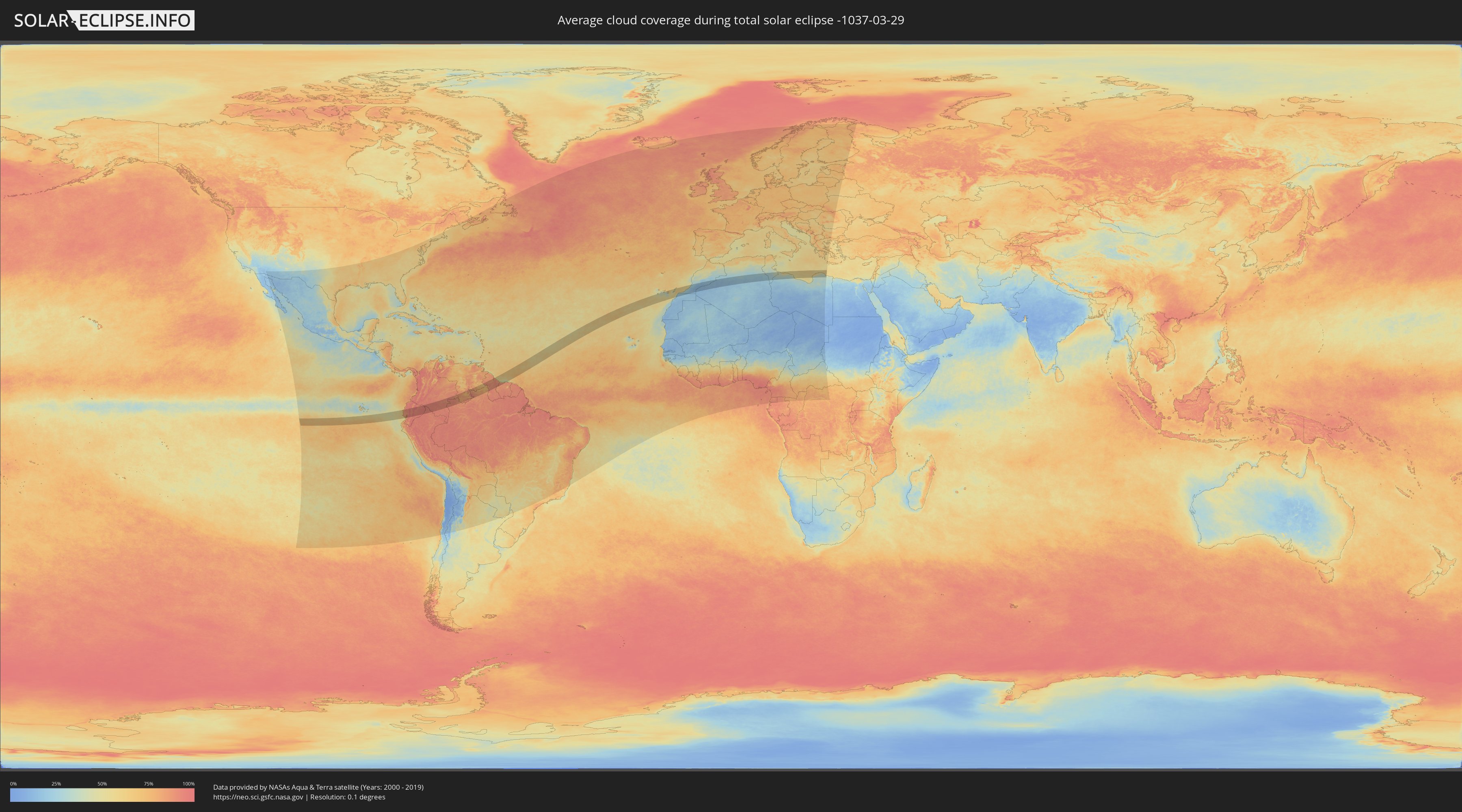
Wie wird das Wetter während der totalen Sonnenfinsternis am 29.03.-1037?
Wo ist der beste Ort, um die totale Sonnenfinsternis vom 29.03.-1037 zu beobachten?
Die folgenden Karten zeigen die durchschnittliche Bewölkung für den Tag, an dem die totale Sonnenfinsternis
stattfindet. Mit Hilfe der Karten lässt sich der Ort entlang des Finsternispfades eingrenzen,
der die besten Aussichen auf einen klaren wolkenfreien Himmel bietet.
Trotzdem muss man immer lokale Gegenenheiten beachten und sollte sich genau über das Wetter an seinem
gewählten Beobachtungsort informieren.
Die Daten stammen von den beiden NASA-Satelliten
AQUA und TERRA
und wurden über einen Zeitraum von 19 Jahren (2000 - 2019) gemittelt.
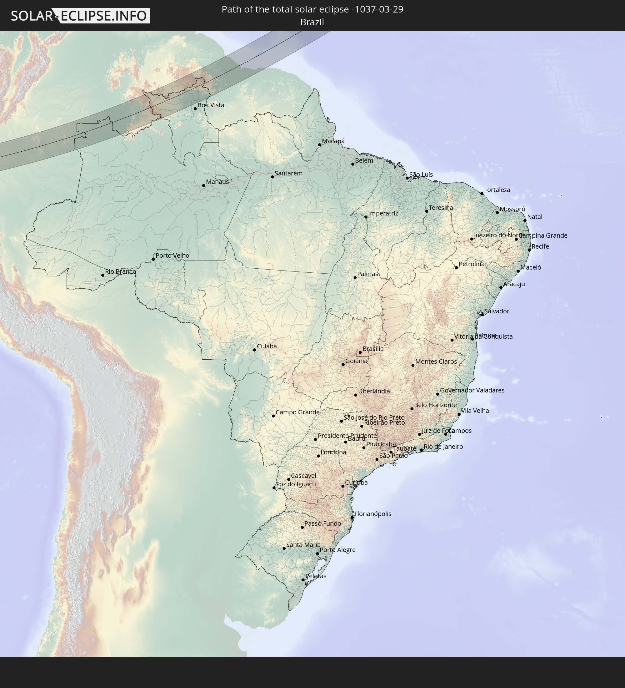
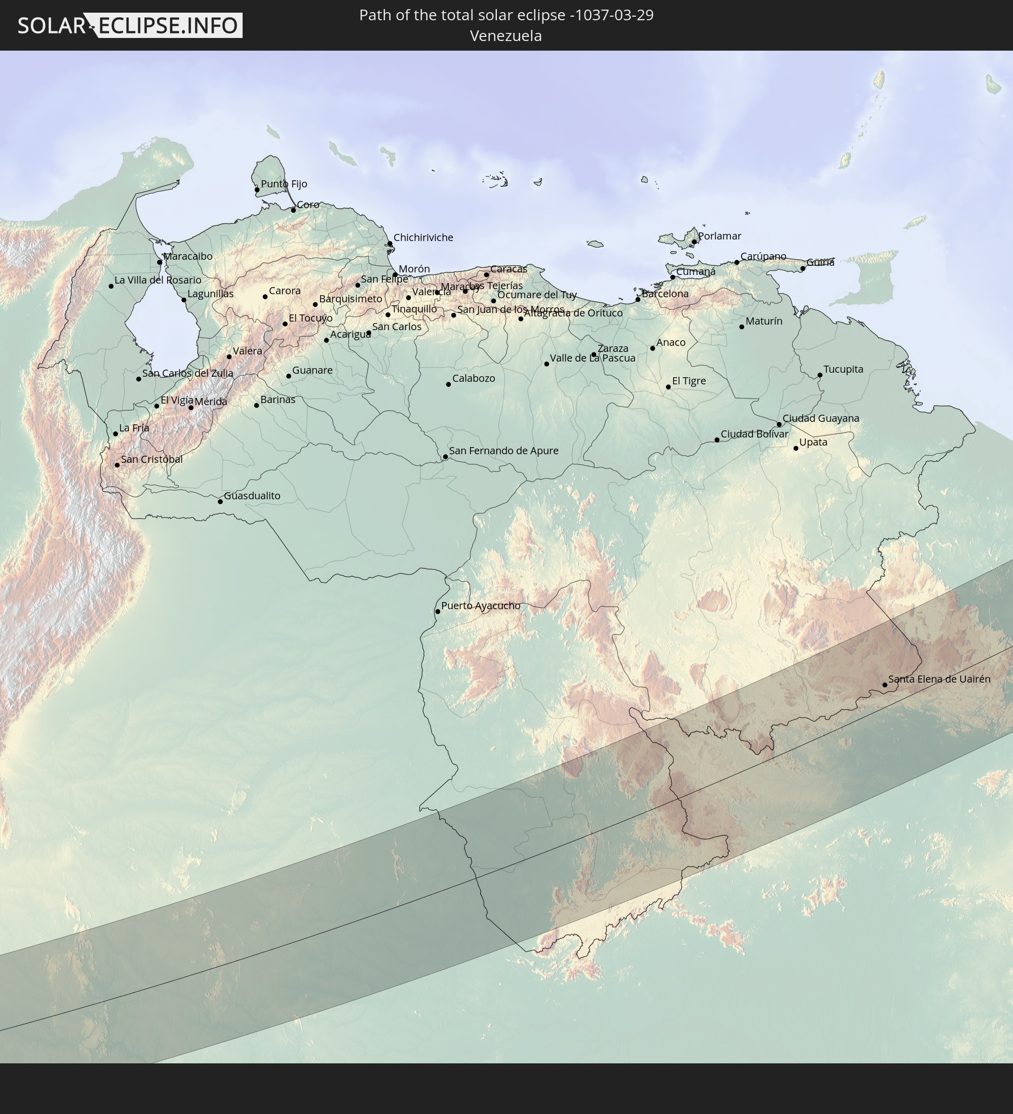
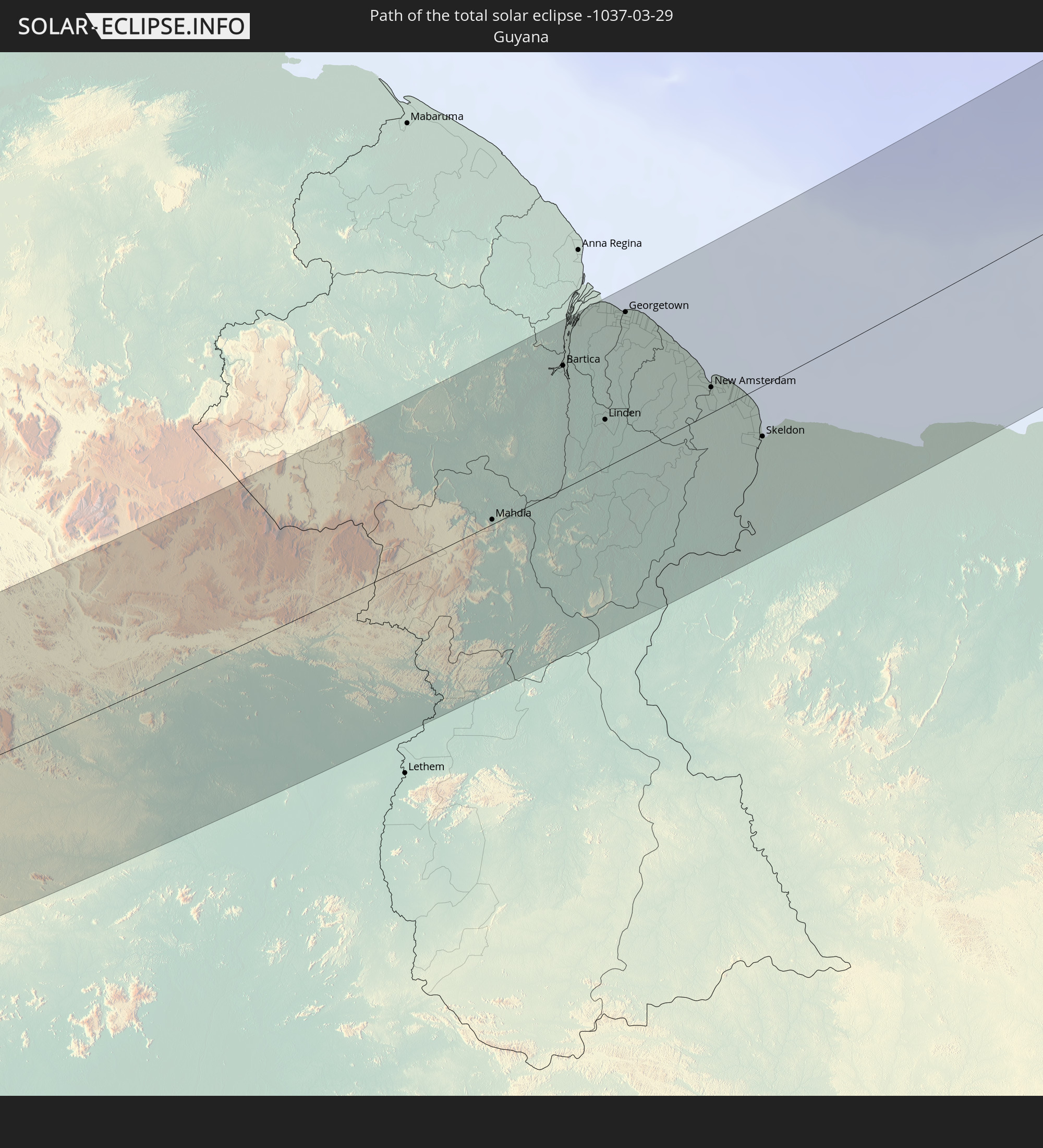
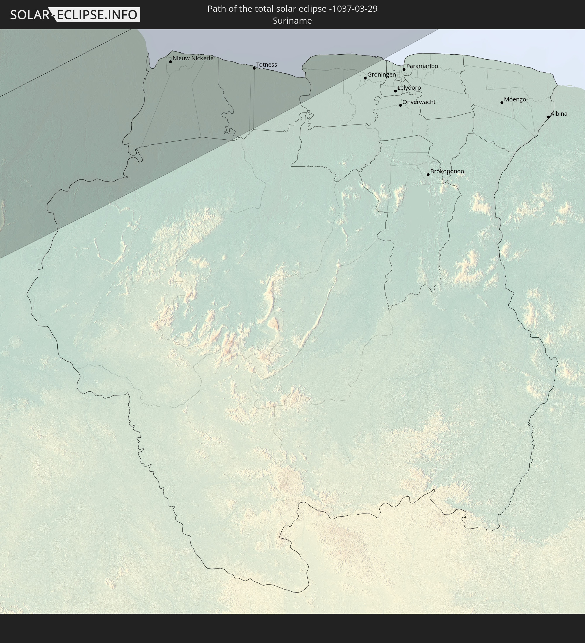
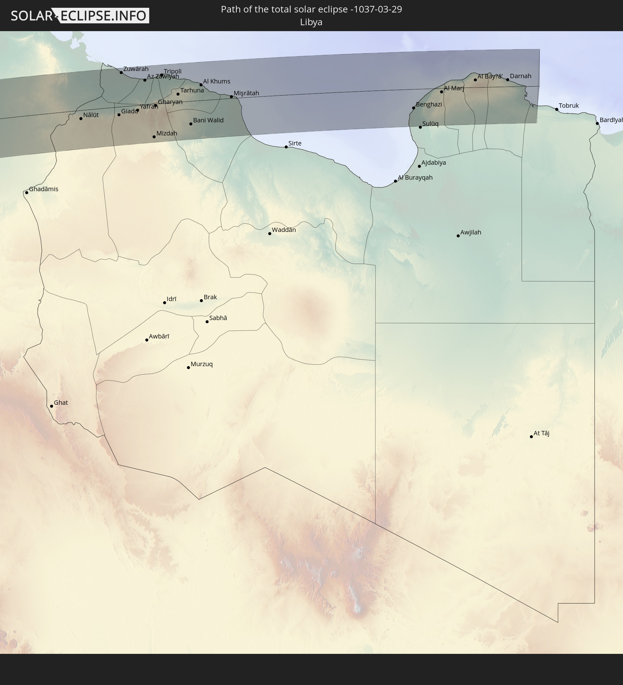
Detaillierte Länderkarten
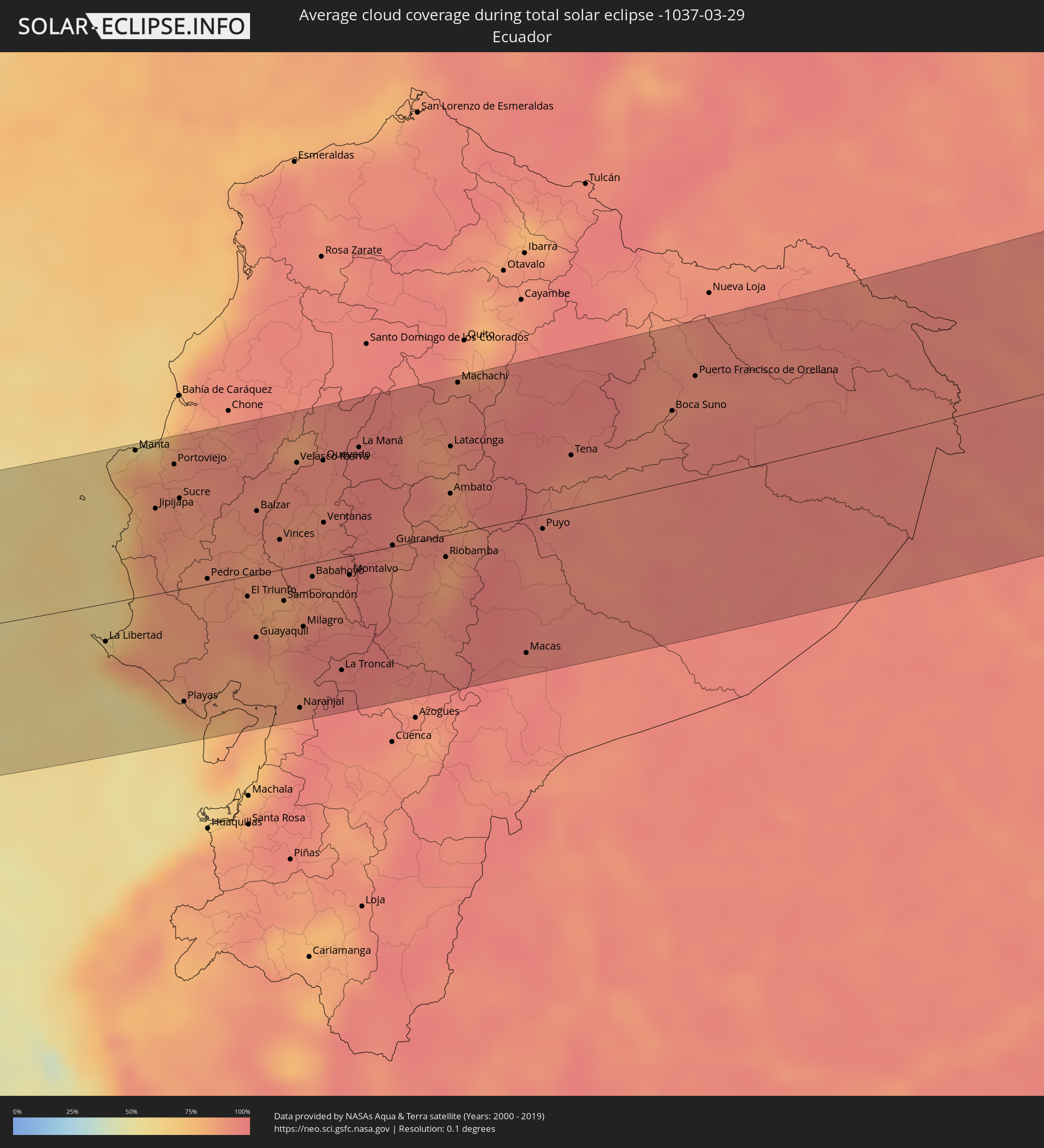 Ecuador
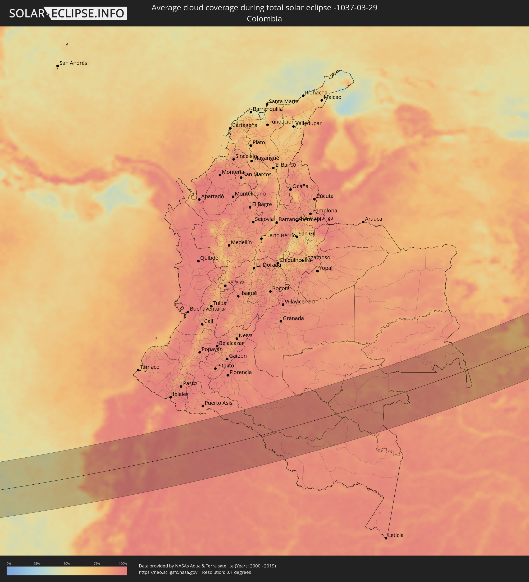 Kolumbien
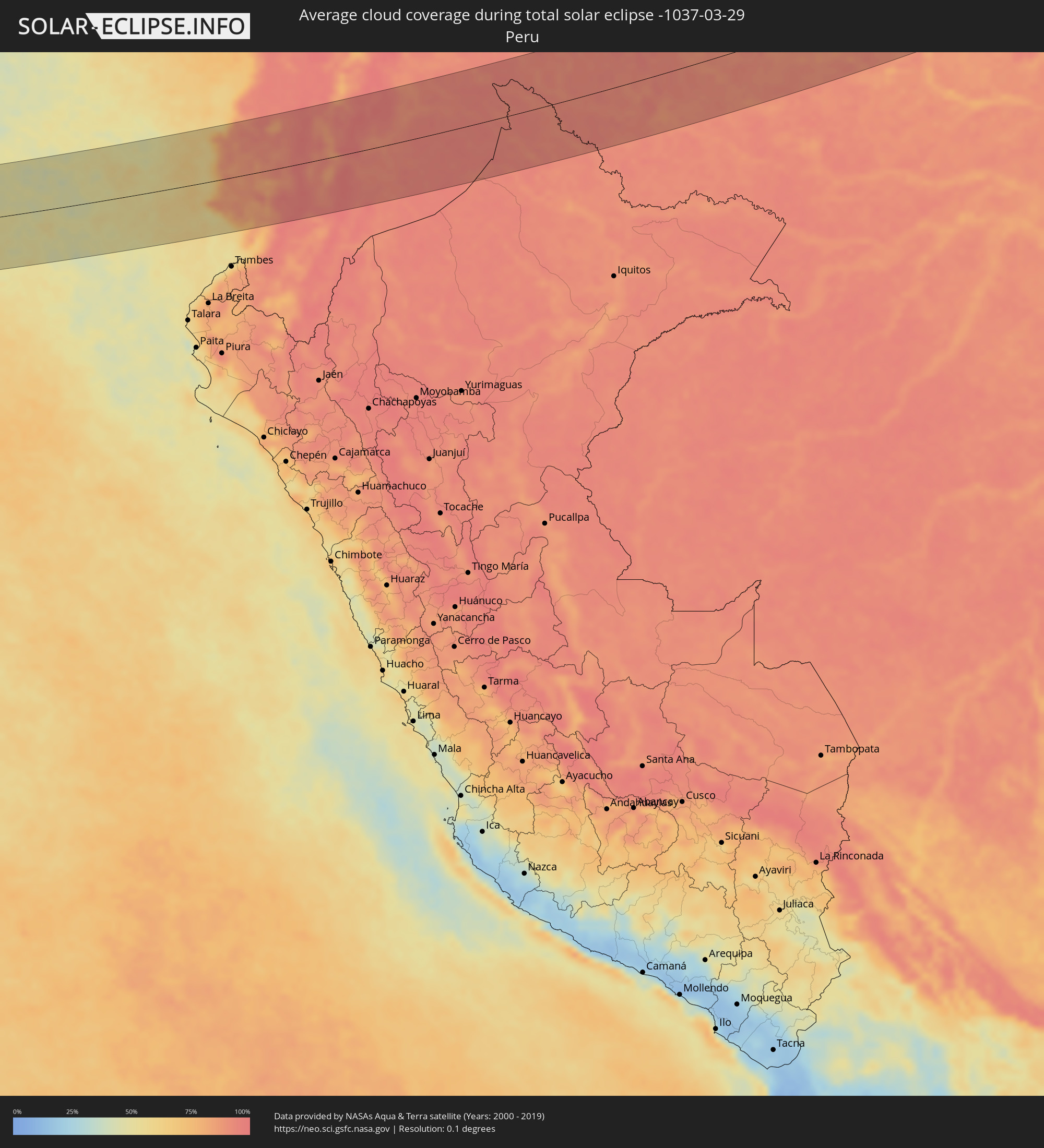 Peru
Peru
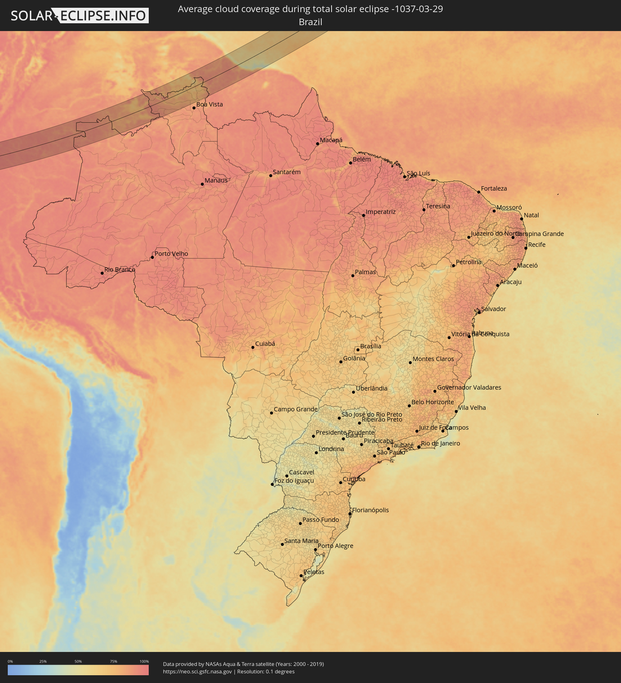 Brasilien
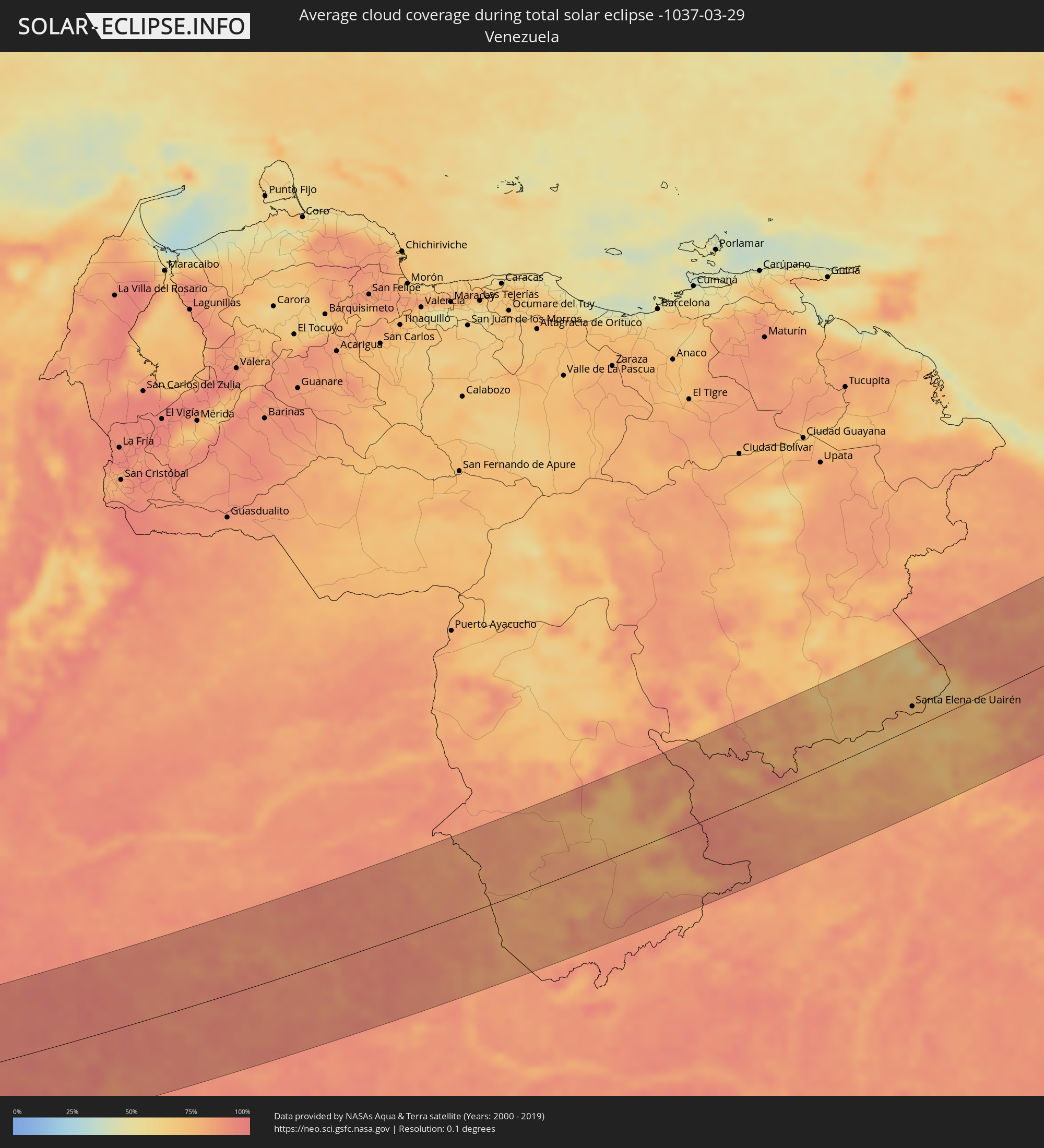 Venezuela
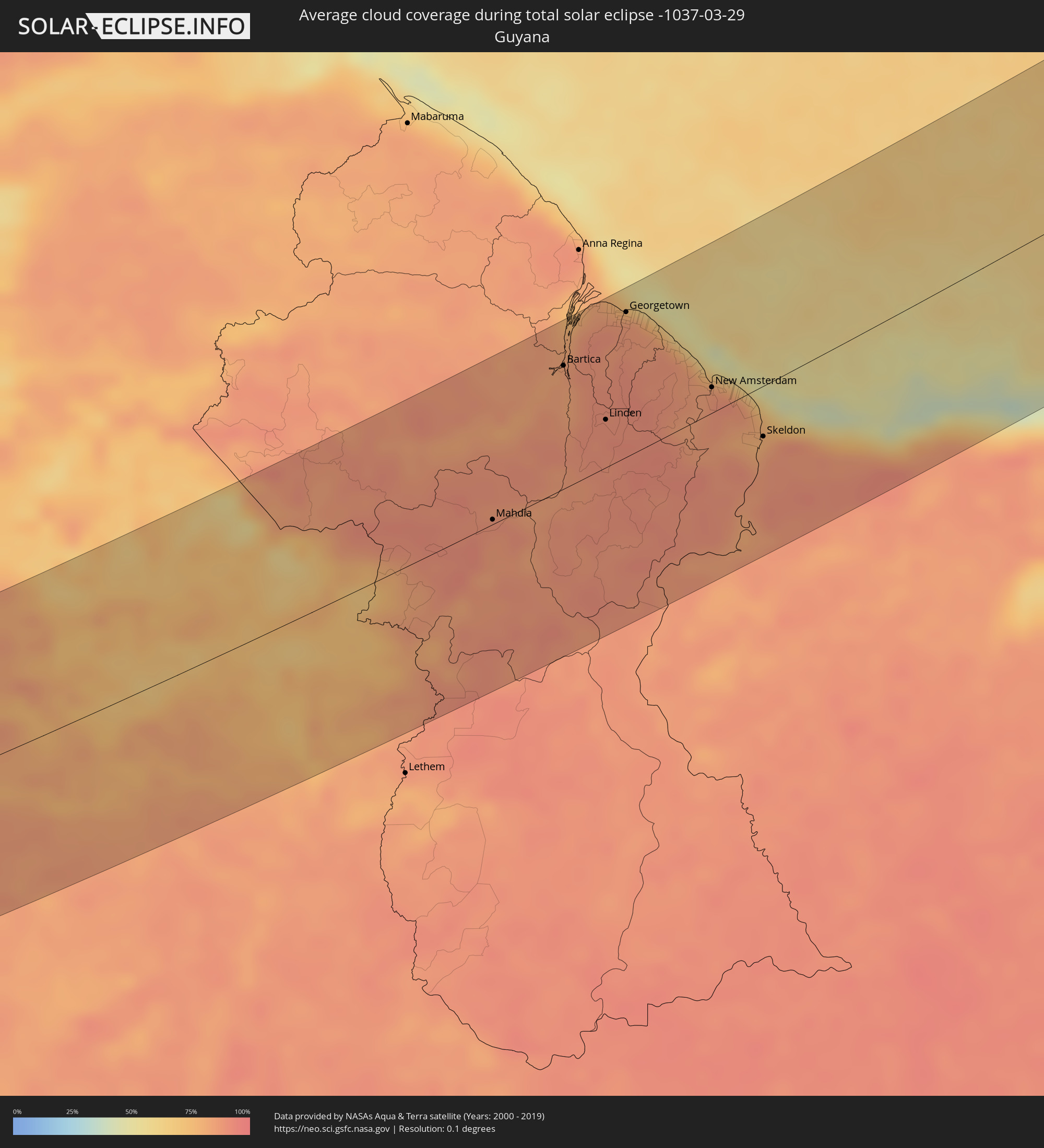 Guyana
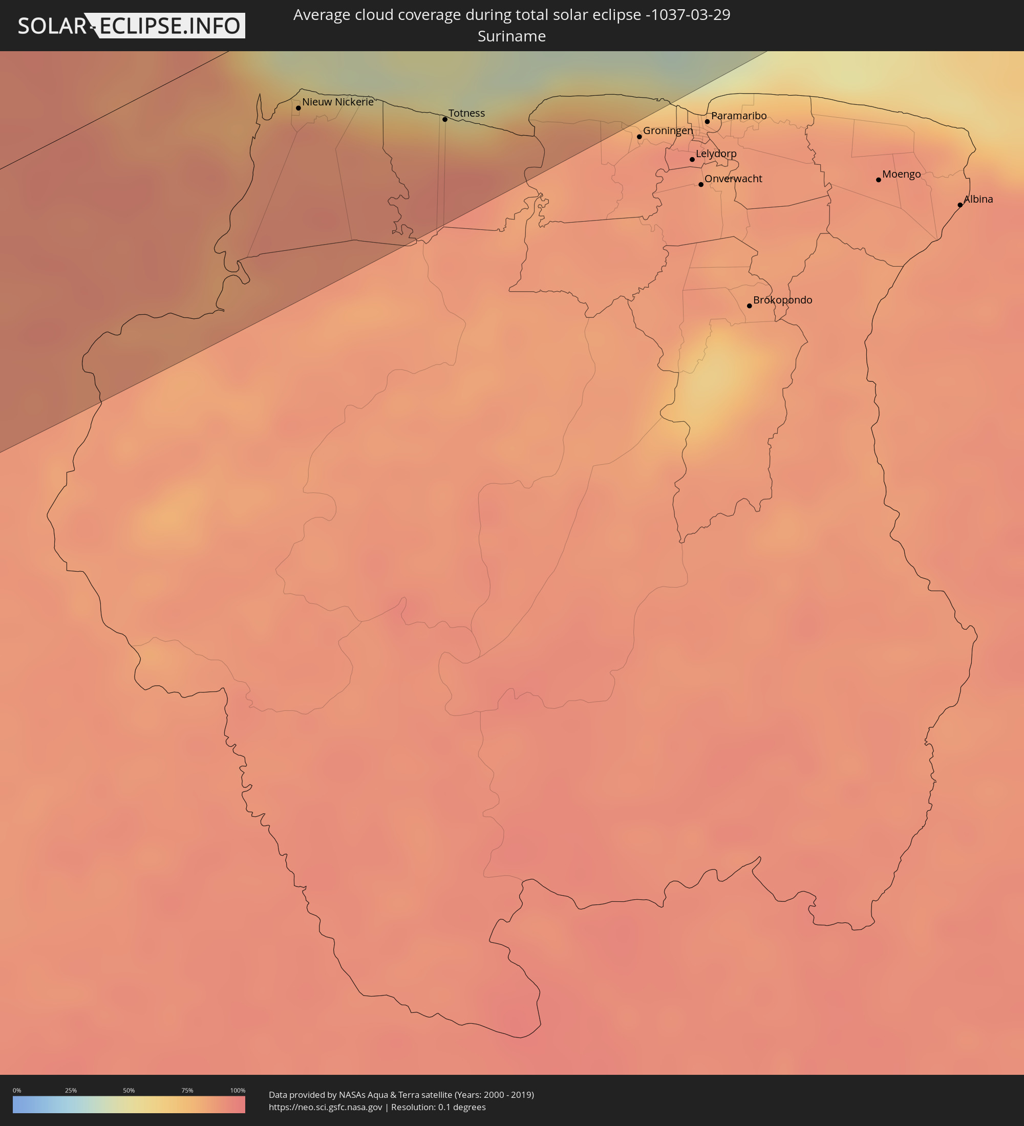 Suriname
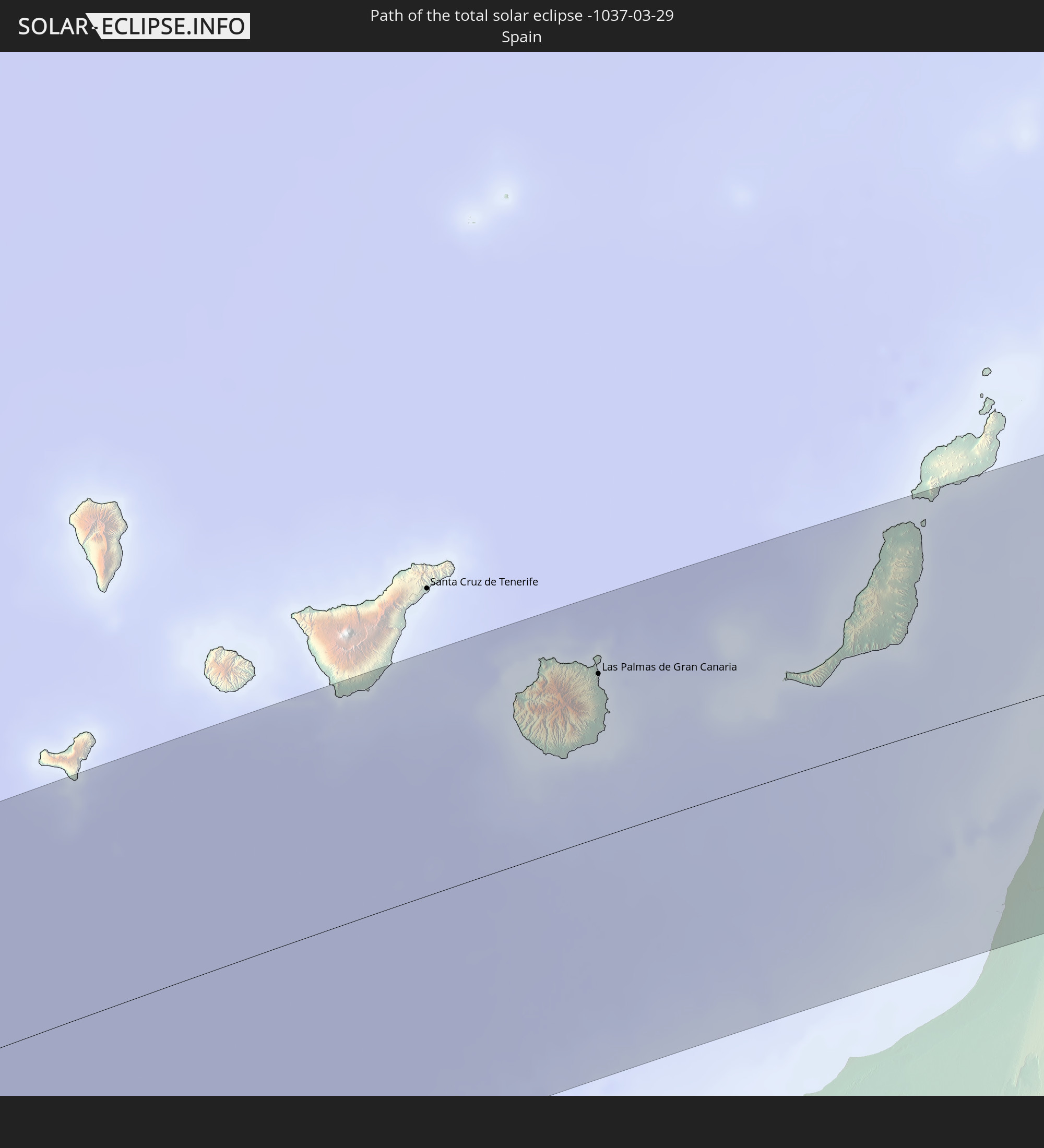
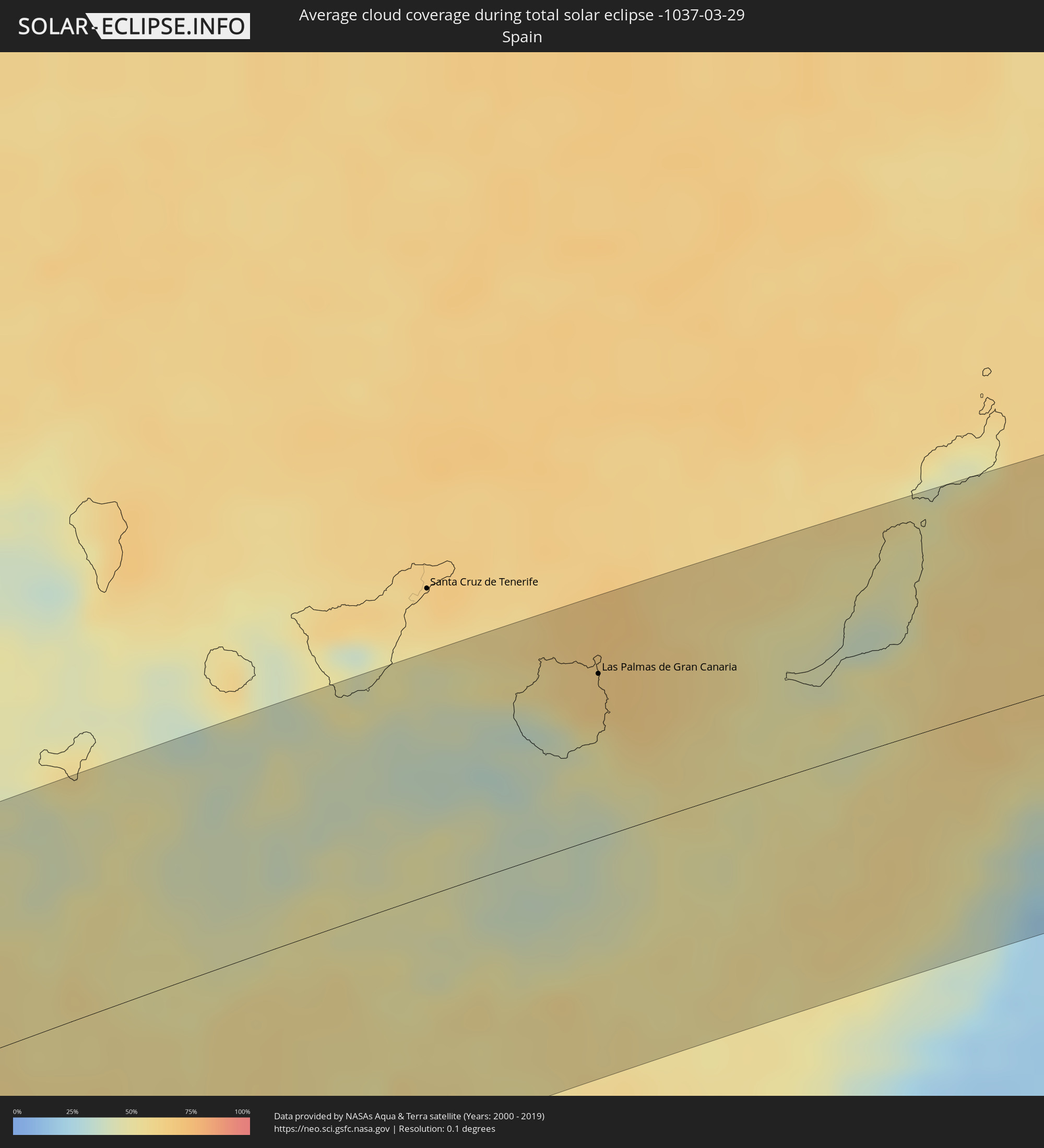 Spanien
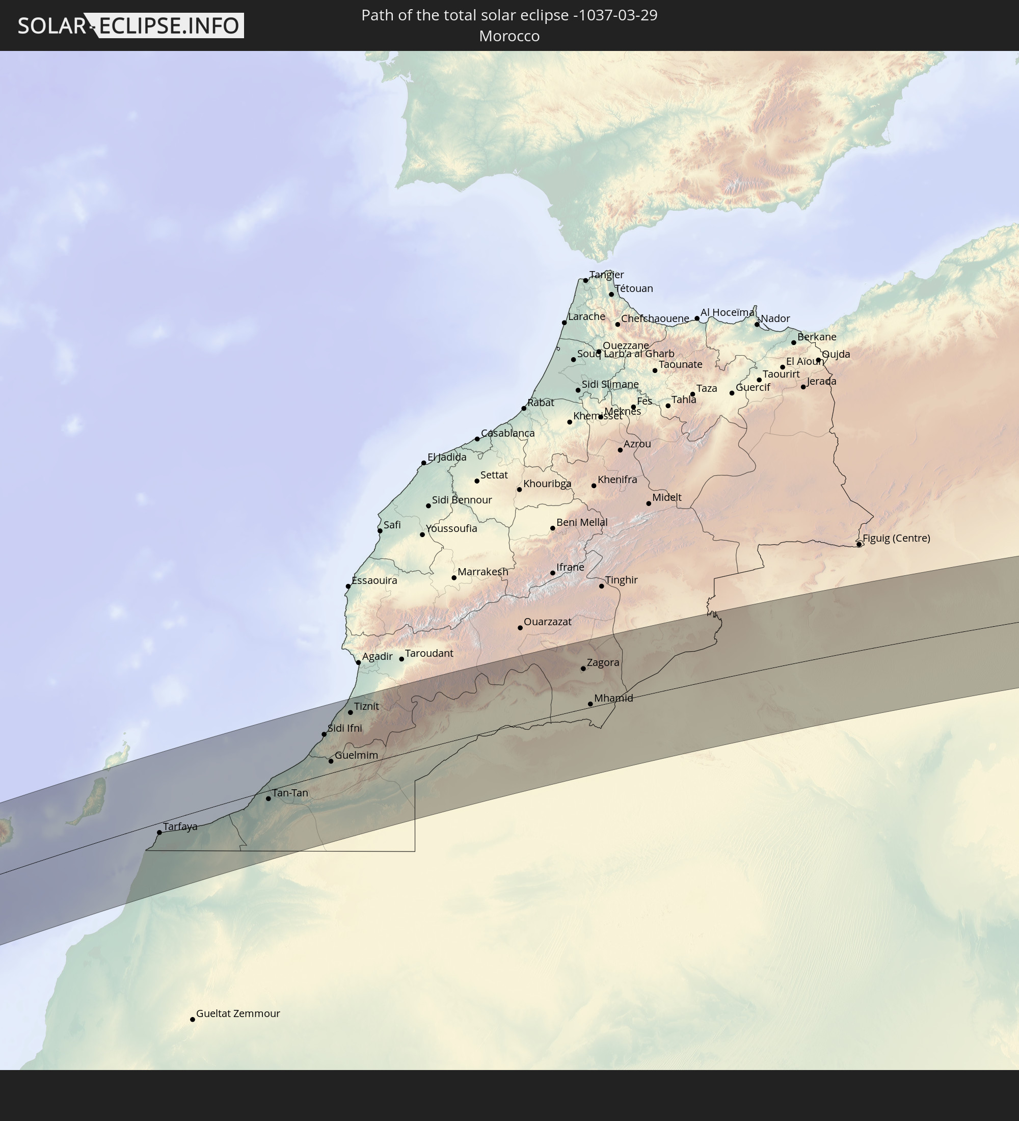
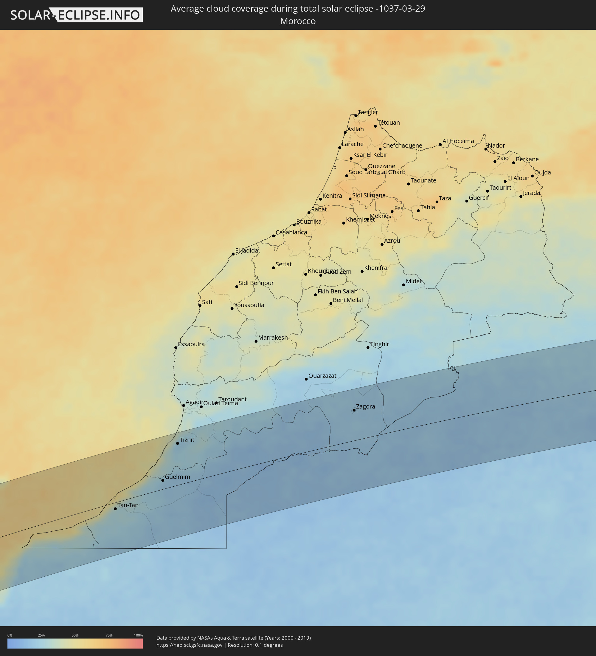 Marokko
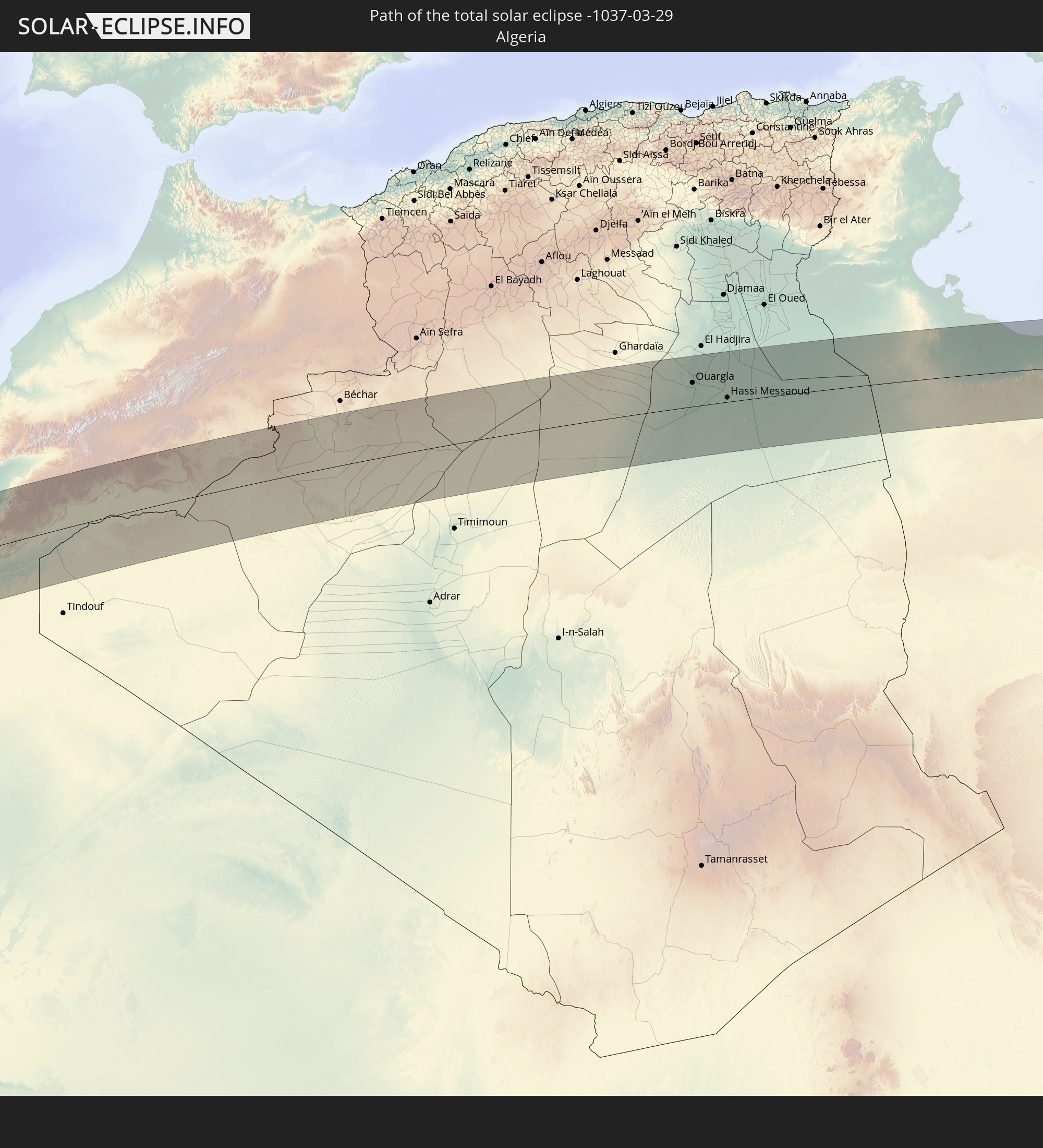
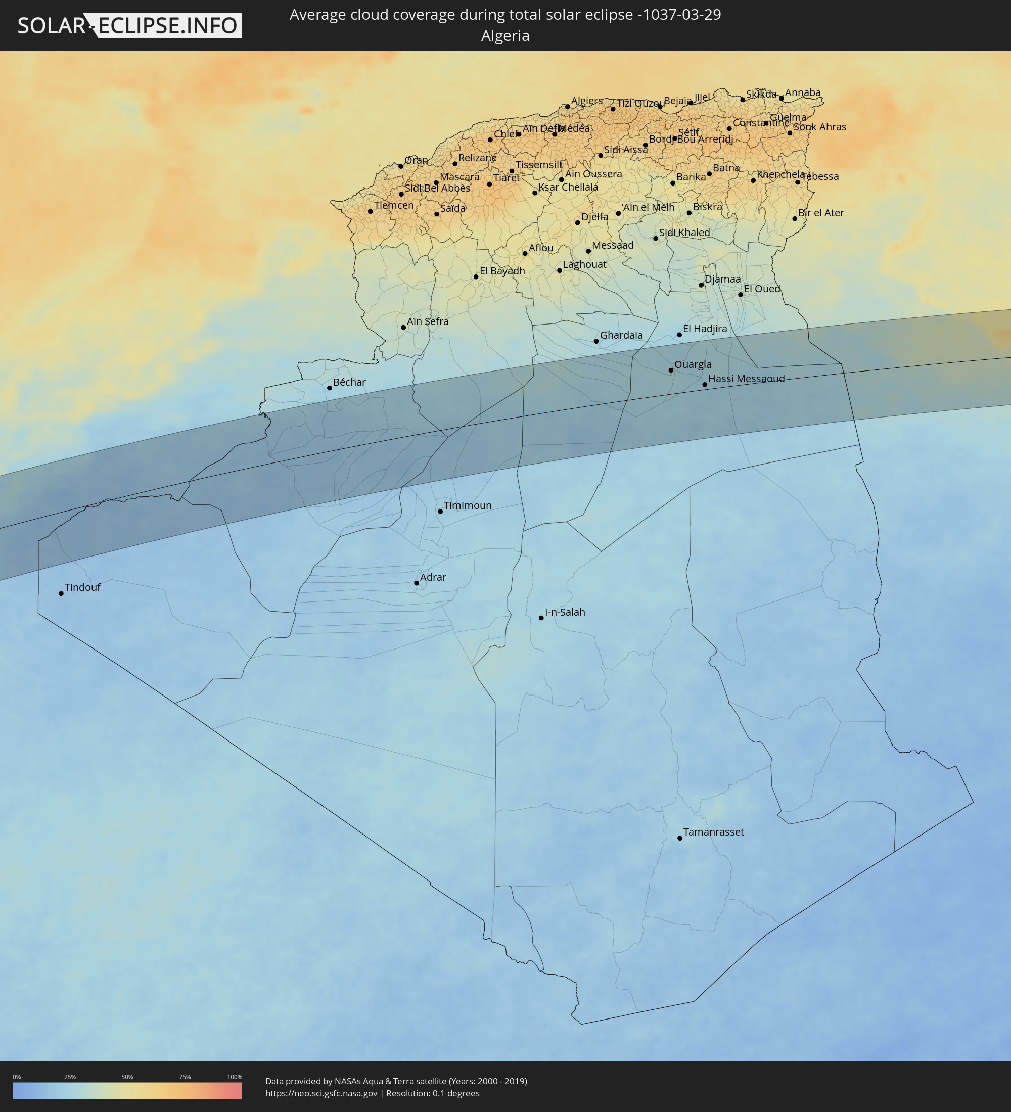 Algerien
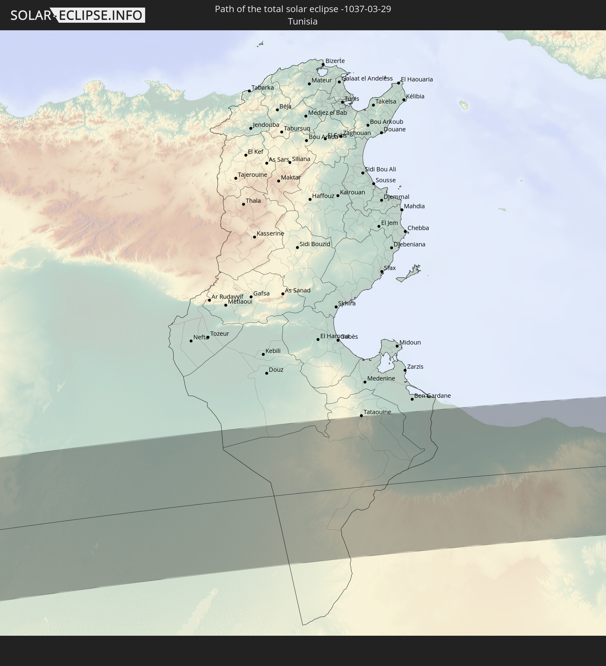
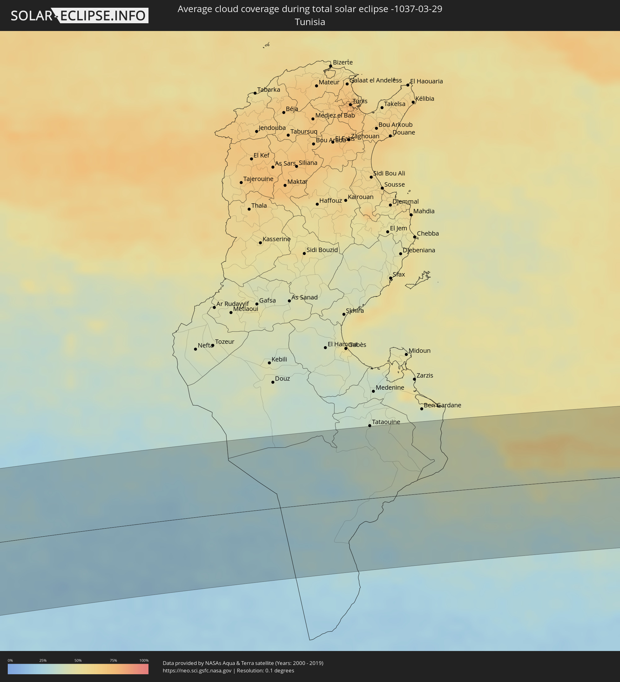 Tunesien
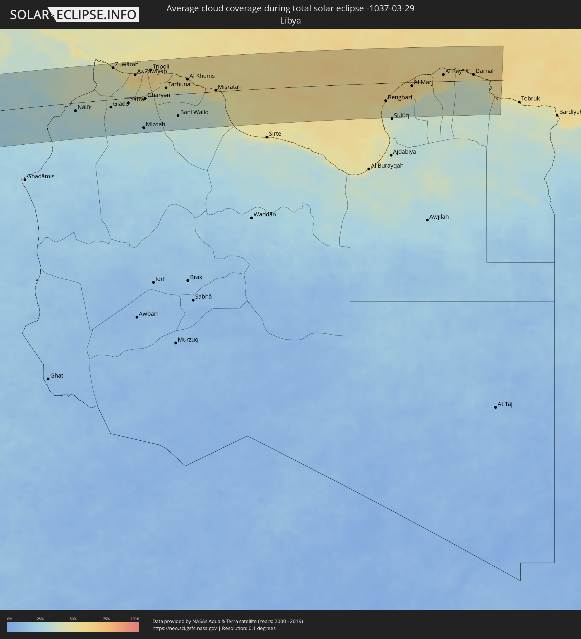 Libyen
Orte im Finsternispfad
Die nachfolgene Tabelle zeigt Städte und Orte mit mehr als 5.000 Einwohnern, die sich im Finsternispfad befinden. Städte mit mehr als 100.000 Einwohnern sind dick gekennzeichnet. Mit einem Klick auf den Ort öffnet sich eine Detailkarte die die Lage des jeweiligen Ortes zusammen mit dem Verlauf der zentralen Finsternis präsentiert.
| Ort | Typ | Dauer der Verfinsterung | Ortszeit bei maximaler Verfinsterung | Entfernung zur Zentrallinie | Ø Bewölkung |
|
La Libertad, Guayas
|
total | - | 08:11:56 UTC-05:14 | 28 km | 81% |
|
Manta, Manabí
|
total | - | 08:13:10 UTC-05:14 | 107 km | 85% |
|
Jipijapa, Manabí
|
total | - | 08:12:59 UTC-05:14 | 62 km | 88% |
|
Portoviejo, Manabí
|
total | - | 08:13:22 UTC-05:14 | 92 km | 89% |
|
Playas, Guayas
|
total | - | 08:12:09 UTC-05:14 | 82 km | 75% |
|
El Triunfo, Guayas
|
total | - | 08:13:09 UTC-05:14 | 15 km | 84% |
|
Guayaquil, Guayas
|
total | - | 08:12:59 UTC-05:14 | 46 km | 88% |
|
Balzar, Guayas
|
total | - | 08:13:41 UTC-05:14 | 46 km | 90% |
|
Vinces, Los Ríos
|
total | - | 08:13:41 UTC-05:14 | 22 km | 89% |
|
Velasco Ibarra, Guayas
|
total | - | 08:14:14 UTC-05:14 | 75 km | 94% |
|
Naranjal, Guayas
|
total | - | 08:12:55 UTC-05:14 | 103 km | 96% |
|
Milagro, Guayas
|
total | - | 08:13:22 UTC-05:14 | 45 km | 96% |
|
Babahoyo, Los Ríos
|
total | - | 08:13:43 UTC-05:14 | 10 km | 87% |
|
Quevedo, Los Ríos
|
total | - | 08:14:26 UTC-05:14 | 73 km | 91% |
|
Ventanas, Los Ríos
|
total | - | 08:14:06 UTC-05:14 | 28 km | 91% |
|
La Troncal, Cañar
|
total | - | 08:13:25 UTC-05:14 | 82 km | 96% |
|
Riobamba, Chimborazo
|
total | - | 08:14:47 UTC-05:14 | 16 km | 86% |
|
Ambato, Tungurahua
|
total | - | 08:15:11 UTC-05:14 | 30 km | 85% |
|
Latacunga, Cotopaxi
|
total | - | 08:15:28 UTC-05:14 | 64 km | 89% |
|
Puerto Francisco de Orellana, Orellana
|
total | - | 08:17:48 UTC-05:14 | 75 km | 90% |
|
Puerto Leguízamo, Putumayo
|
total | - | 08:38:36 UTC-04:56 | 45 km | 91% |
|
Mitú, Vaupés
|
total | - | 08:46:44 UTC-04:56 | 58 km | 84% |
|
Santa Elena de Uairén, Bolívar
|
total | - | 09:36:15 UTC-04:27 | 31 km | 74% |
|
Mahdia, Potaro-Siparuni
|
total | - | 10:16:20 UTC-03:52 | 3 km | 89% |
|
Bartica, Cuyuni-Mazaruni
|
total | - | 10:19:09 UTC-03:52 | 91 km | 85% |
|
Linden, Upper Demerara-Berbice
|
total | - | 10:19:15 UTC-03:52 | 35 km | 90% |
|
Vreed-en-Hoop, Essequibo Islands-West Demerara
|
total | - | 10:20:41 UTC-03:52 | 109 km | 86% |
|
Georgetown, Demerara-Mahaica
|
total | - | 10:20:46 UTC-03:52 | 106 km | 86% |
|
Fort Wellington, Mahaica-Berbice
|
total | - | 10:21:22 UTC-03:52 | 37 km | 78% |
|
Rosignol, Mahaica-Berbice
|
total | - | 10:21:20 UTC-03:52 | 22 km | 85% |
|
New Amsterdam, East Berbice-Corentyne
|
total | - | 10:21:21 UTC-03:52 | 19 km | 89% |
|
Skeldon, East Berbice-Corentyne
|
total | - | 10:21:40 UTC-03:52 | 37 km | 82% |
|
Nieuw Nickerie, Nickerie
|
total | - | 10:34:05 UTC-03:40 | 41 km | 87% |
|
Totness, Coronie
|
total | - | 10:35:28 UTC-03:40 | 79 km | 66% |
|
San Isidro, Canary Islands
|
total | - | 15:05:42 UTC-01:01 | 109 km | 49% |
|
Mogán, Canary Islands
|
total | - | 15:06:50 UTC-01:01 | 62 km | 40% |
|
Puerto Rico, Canary Islands
|
total | - | 15:06:50 UTC-01:01 | 52 km | 39% |
|
Gáldar, Canary Islands
|
total | - | 15:06:59 UTC-01:01 | 88 km | 45% |
|
Guia, Canary Islands
|
total | - | 15:07:00 UTC-01:01 | 86 km | 54% |
|
Maspalomas, Canary Islands
|
total | - | 15:07:00 UTC-01:01 | 45 km | 46% |
|
Playa del Ingles, Canary Islands
|
total | - | 15:07:00 UTC-01:01 | 44 km | 46% |
|
Teror, Canary Islands
|
total | - | 15:07:06 UTC-01:01 | 75 km | 62% |
|
Santa Lucía, Canary Islands
|
total | - | 15:07:05 UTC-01:01 | 59 km | 45% |
|
Santa Brígida, Canary Islands
|
total | - | 15:07:09 UTC-01:01 | 71 km | 52% |
|
Valsequillo de Gran Canaria, Canary Islands
|
total | - | 15:07:10 UTC-01:01 | 66 km | 52% |
|
Las Palmas de Gran Canaria, Canary Islands
|
total | - | 15:07:18 UTC-01:01 | 75 km | 62% |
|
Pájara, Canary Islands
|
total | - | 15:09:04 UTC-01:01 | 62 km | 38% |
|
Tuineje, Canary Islands
|
total | - | 15:09:09 UTC-01:01 | 57 km | 45% |
|
Antigua, Canary Islands
|
total | - | 15:09:12 UTC-01:01 | 67 km | 39% |
|
La Oliva, Canary Islands
|
total | - | 15:09:20 UTC-01:01 | 84 km | 48% |
|
Corralejo, Canary Islands
|
total | - | 15:09:26 UTC-01:01 | 95 km | 47% |
|
Puerto del Rosario, Canary Islands
|
total | - | 15:09:25 UTC-01:01 | 71 km | 47% |
|
Playa Blanca, Canary Islands
|
total | - | 15:09:30 UTC-01:01 | 108 km | 48% |
|
Puerto del Carmen, Canary Islands
|
total | - | 15:09:43 UTC-01:01 | 110 km | 54% |
 Laayoune Plage
|
total | - | 15:18:35 UTC-00:52 | 92 km | 26% |
|
Laâyoune / El Aaiún, Oued Ed-Dahab-Lagouira
|
total | - | 15:18:54 UTC-00:52 | 93 km | 22% |
|
Tarfaya, Laâyoune-Boujdour-Sakia El Hamra
|
total | - | 15:41:48 UTC-00:30 | 16 km | 33% |
|
Tan-Tan, Guelmim-Es Smara
|
total | - | 15:44:05 UTC-00:30 | 14 km | 27% |
|
Sidi Ifni, Souss-Massa-Drâa
|
total | - | 15:45:12 UTC-00:30 | 63 km | 38% |
|
Guelmim, Guelmim-Es Smara
|
total | - | 15:45:19 UTC-00:30 | 18 km | 19% |
|
Tiznit, Souss-Massa-Drâa
|
total | - | 15:45:41 UTC-00:30 | 85 km | 22% |
|
Zagora, Souss-Massa-Drâa
|
total | - | 15:49:39 UTC-00:30 | 62 km | 19% |
|
Mhamid, Souss-Massa-Drâa
|
total | - | 15:49:49 UTC-00:30 | 4 km | 18% |
|
Ouargla, Ouargla
|
total | - | 16:37:11 UTC+00:09 | 48 km | 27% |
|
Rouissat, Ouargla
|
total | - | 16:37:13 UTC+00:09 | 45 km | 28% |
|
Hassi Messaoud, Ouargla
|
total | - | 16:37:40 UTC+00:09 | 9 km | 24% |
|
Nālūt, Sha‘bīyat Nālūt
|
total | - | 17:23:07 UTC+00:52 | 22 km | 30% |
|
Zuwārah, An Nuqāţ al Khams
|
total | - | 17:23:04 UTC+00:52 | 86 km | 41% |
|
Zintan, Jabal al Gharbi District
|
total | - | 17:23:31 UTC+00:52 | 26 km | 33% |
|
Şabrātah, Az Zāwiyah
|
total | - | 17:23:15 UTC+00:52 | 68 km | 55% |
|
Yafran, Jabal al Gharbi District
|
total | - | 17:23:33 UTC+00:52 | 13 km | 37% |
|
Az Zāwīyah, Az Zāwiyah
|
total | - | 17:23:20 UTC+00:52 | 62 km | 60% |
|
Mizdah, Jabal al Gharbi District
|
total | - | 17:23:56 UTC+00:52 | 86 km | 28% |
|
Gharyan, Jabal al Gharbi District
|
total | - | 17:23:40 UTC+00:52 | 5 km | 43% |
|
Tripoli, Tripoli
|
total | - | 17:23:26 UTC+00:52 | 72 km | 58% |
|
Tagiura, Tripoli
|
total | - | 17:23:28 UTC+00:52 | 71 km | 59% |
|
Tarhuna, Al Marqab
|
total | - | 17:23:44 UTC+00:52 | 20 km | 42% |
|
Bani Walid, Mişrātah
|
total | - | 17:24:06 UTC+00:52 | 59 km | 32% |
|
Al Khums, Al Marqab
|
total | - | 17:23:49 UTC+00:52 | 39 km | 53% |
|
Zliten, Mişrātah
|
total | - | 17:23:58 UTC+00:52 | 17 km | 51% |
|
Mişrātah, Mişrātah
|
total | - | 17:24:07 UTC+00:52 | 3 km | 51% |
|
Benghazi, Banghāzī
|
total | - | 17:25:02 UTC+00:52 | 49 km | 51% |
|
Al Abyār, Al Marj
|
total | - | 17:25:03 UTC+00:52 | 42 km | 56% |
|
Al Marj, Al Marj
|
total | - | 17:24:57 UTC+00:52 | 10 km | 61% |
|
Al Bayḑā’, Al Jabal al Akhḑar
|
total | - | 17:24:53 UTC+00:52 | 18 km | 59% |
|
Darnah, Darnah
|
total | - | 17:24:55 UTC+00:52 | 17 km | 53% |