Totale Sonnenfinsternis vom 07.04.-1065
| Wochentag: | Dienstag |
| Maximale Dauer der Verfinsterung: | 02m06s |
| Maximale Breite des Finsternispfades: | 89 km |
| Saroszyklus: | 41 |
| Bedeckungsgrad: | 100% |
| Magnitude: | 1.0242 |
| Gamma: | 0.4057 |
Wo kann man die Sonnenfinsternis vom 07.04.-1065 sehen?
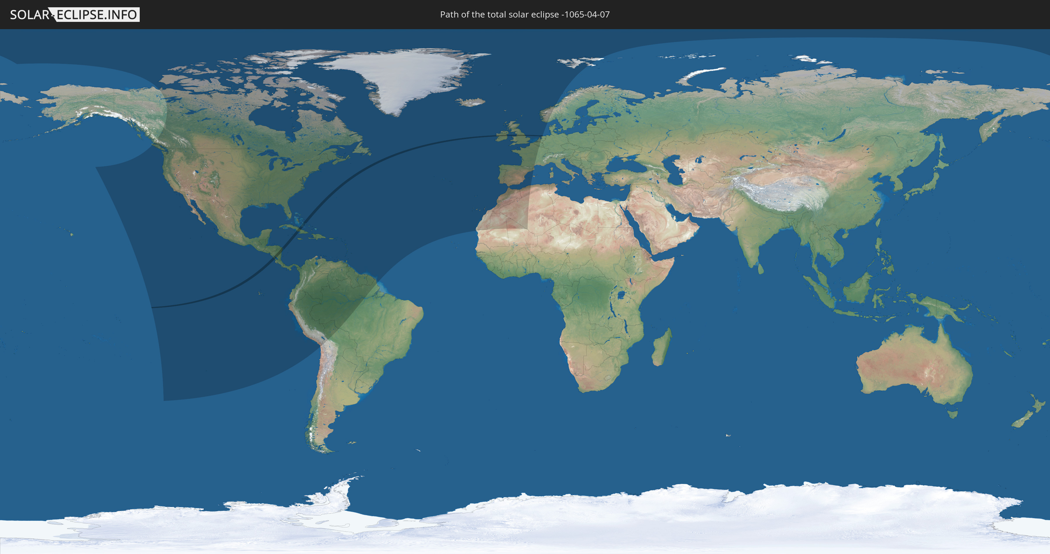
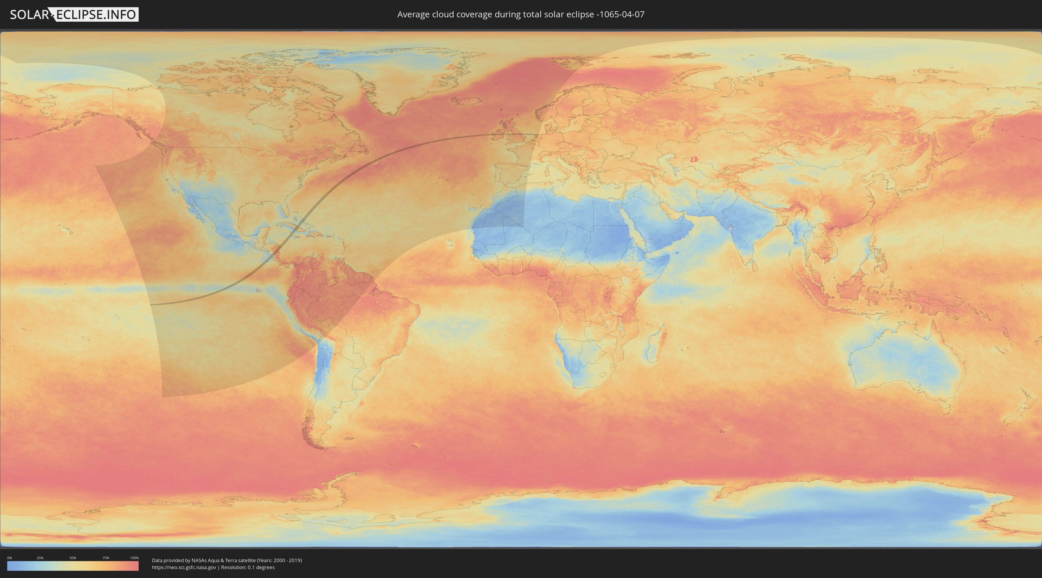
Die Sonnenfinsternis am 07.04.-1065 kann man in 69 Ländern als partielle Sonnenfinsternis beobachten.
Der Finsternispfad verläuft durch 7 Länder. Nur in diesen Ländern ist sie als totale Sonnenfinsternis zu sehen.
In den folgenden Ländern ist die Sonnenfinsternis total zu sehen
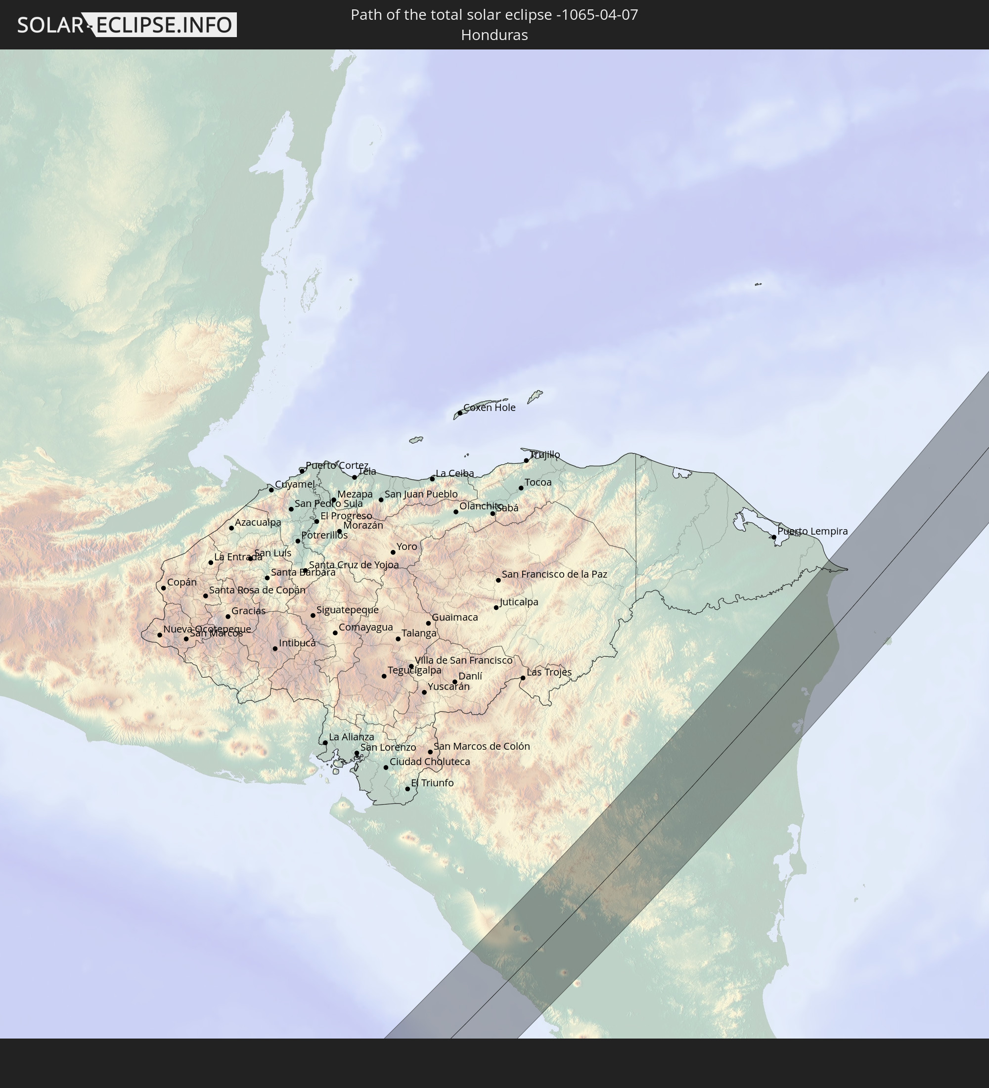 Honduras
 Nicaragua
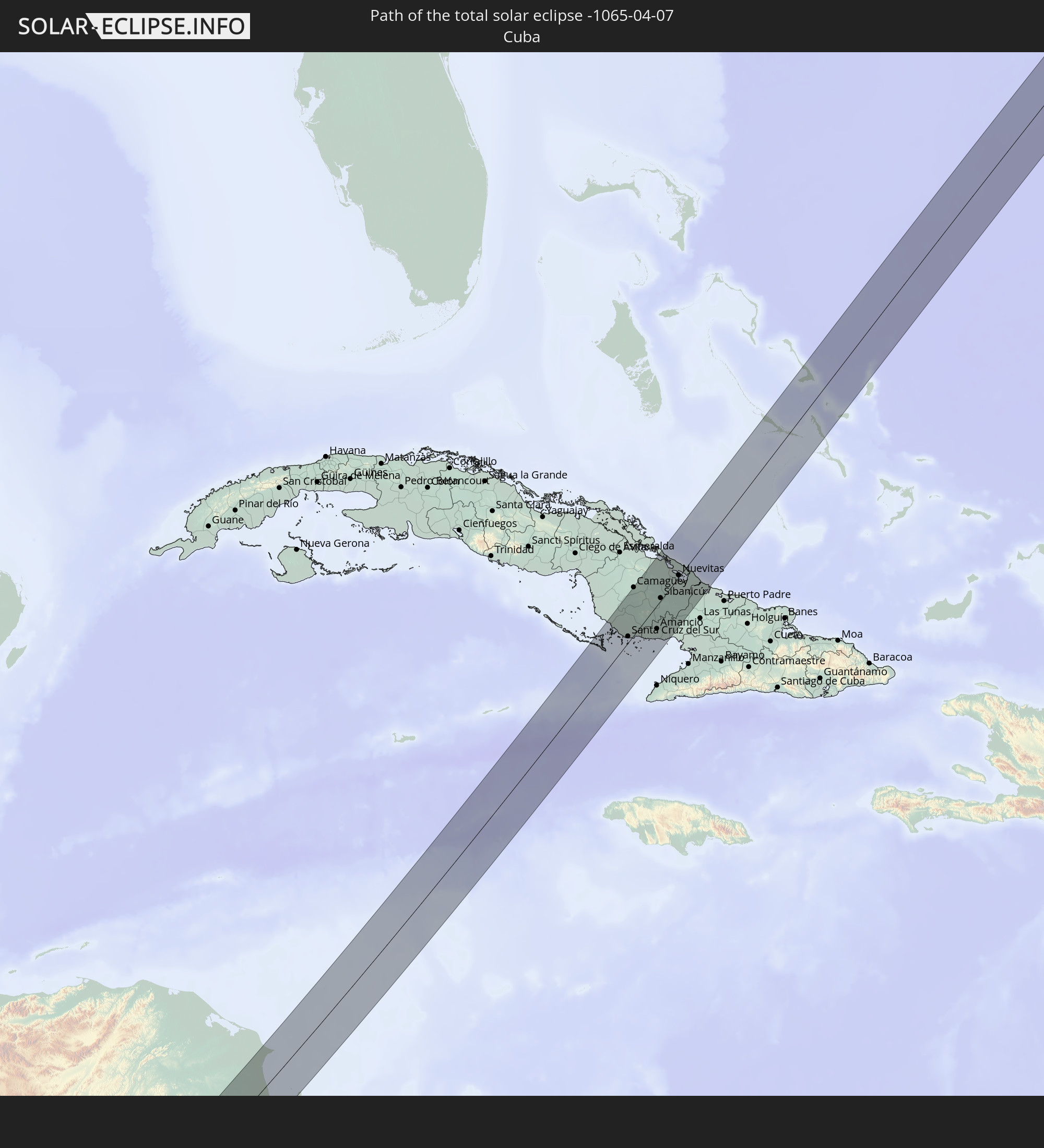 Kuba
Kuba
 Bahamas
 Irland
 Vereinigtes Königreich
 Niederlande
In den folgenden Ländern ist die Sonnenfinsternis partiell zu sehen
 Vereinigte Staaten
 United States Minor Outlying Islands
 Kanada
 Mexiko
 Chile
Chile
 Grönland
 Guatemala
 Ecuador
 El Salvador
 Honduras
 Belize
 Nicaragua
 Costa Rica
 Kuba
Kuba
 Panama
 Kolumbien
 Kaimaninseln
 Peru
Peru
 Bahamas
 Jamaika
 Haiti
Haiti
 Brasilien
 Venezuela
 Turks- und Caicosinseln
 Dominikanische Republik
 Aruba
Aruba
 Bolivien
 Puerto Rico
 Amerikanische Jungferninseln
 Bermuda
 Britische Jungferninseln
 Anguilla
 Saint-Martin
 Saint-Barthélemy
 St. Kitts und Nevis
 Antigua und Barbuda
 Montserrat
 Trinidad und Tobago
 Guadeloupe
 Grenada
 Dominica
 St. Vincent und die Grenadinen
 Guyana
 Martinique
 St. Lucia
 Barbados
 Suriname
 Saint-Pierre und Miquelon
 Französisch-Guayana
 Portugal
 Island
 Spanien
 Mauretanien
 Marokko
 Mali
Mali
 Irland
 Spitzbergen
 Algerien
 Vereinigtes Königreich
 Färöer
 Gibraltar
 Frankreich
 Isle of Man
 Guernsey
 Jersey
 Andorra
 Belgien
 Niederlande
 Norwegen
Wie wird das Wetter während der totalen Sonnenfinsternis am 07.04.-1065?
Wo ist der beste Ort, um die totale Sonnenfinsternis vom 07.04.-1065 zu beobachten?
Die folgenden Karten zeigen die durchschnittliche Bewölkung für den Tag, an dem die totale Sonnenfinsternis
stattfindet. Mit Hilfe der Karten lässt sich der Ort entlang des Finsternispfades eingrenzen,
der die besten Aussichen auf einen klaren wolkenfreien Himmel bietet.
Trotzdem muss man immer lokale Gegenenheiten beachten und sollte sich genau über das Wetter an seinem
gewählten Beobachtungsort informieren.
Die Daten stammen von den beiden NASA-Satelliten
AQUA und TERRA
und wurden über einen Zeitraum von 19 Jahren (2000 - 2019) gemittelt.

Detaillierte Länderkarten
 Honduras
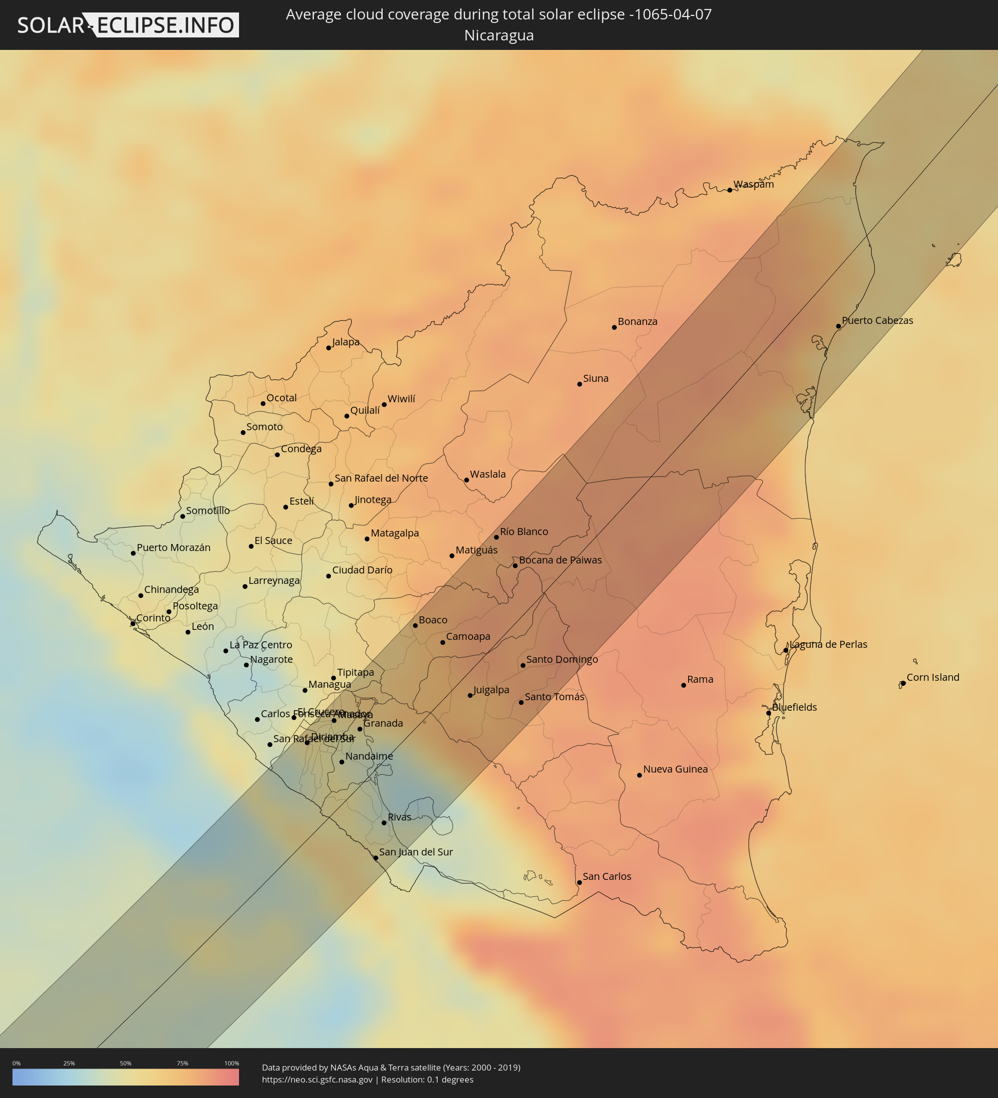 Nicaragua
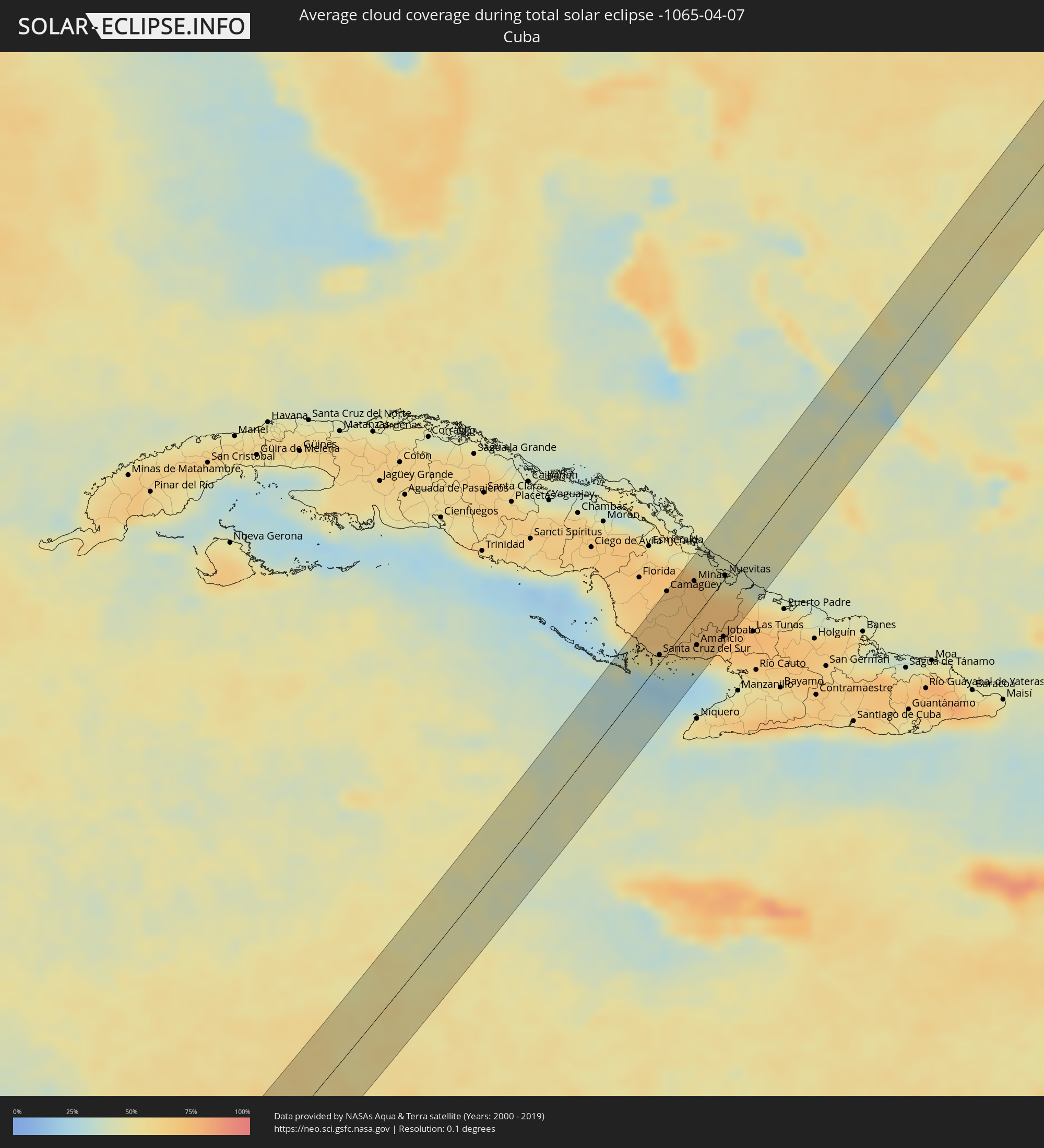 Kuba
Kuba
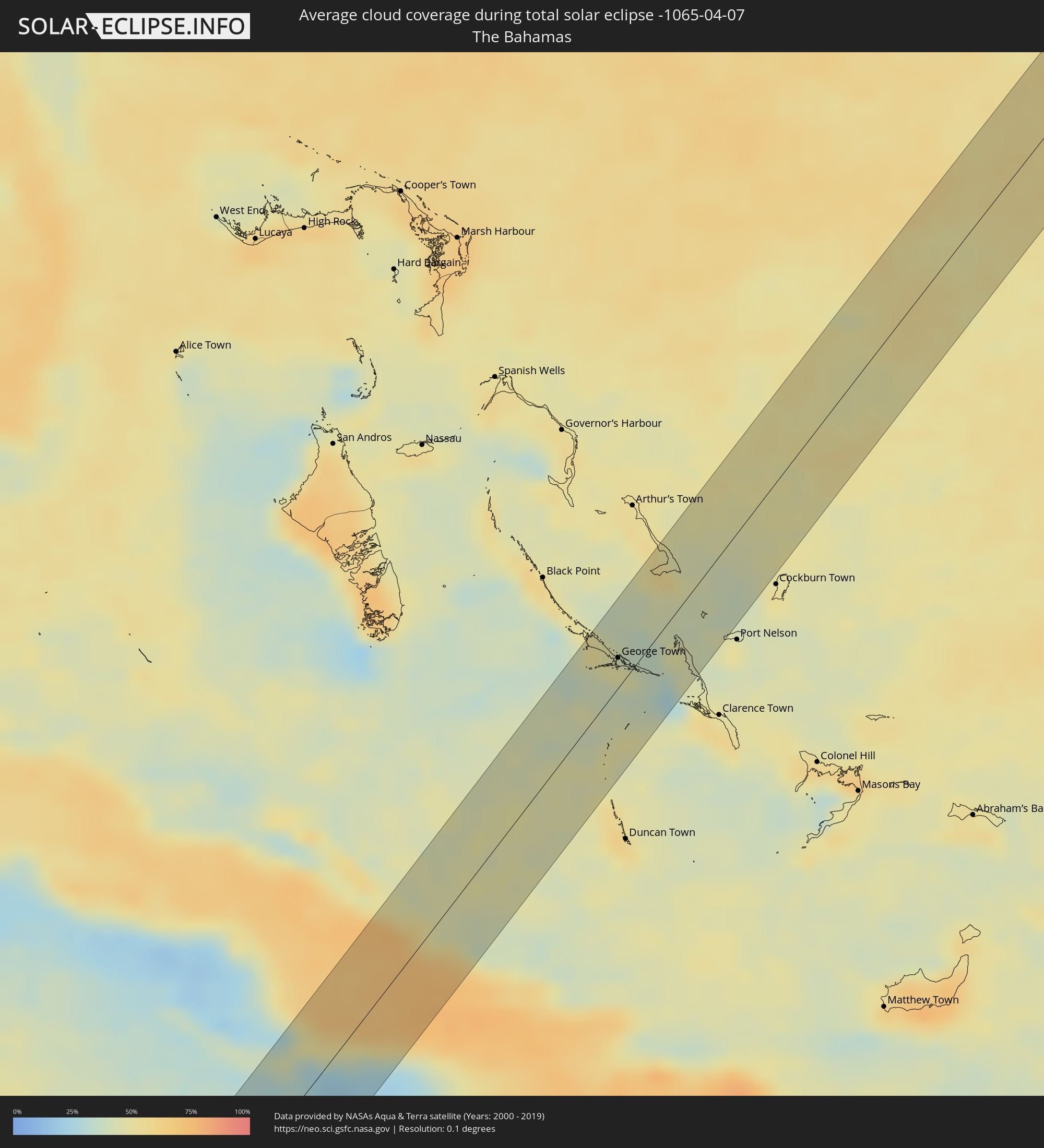 Bahamas
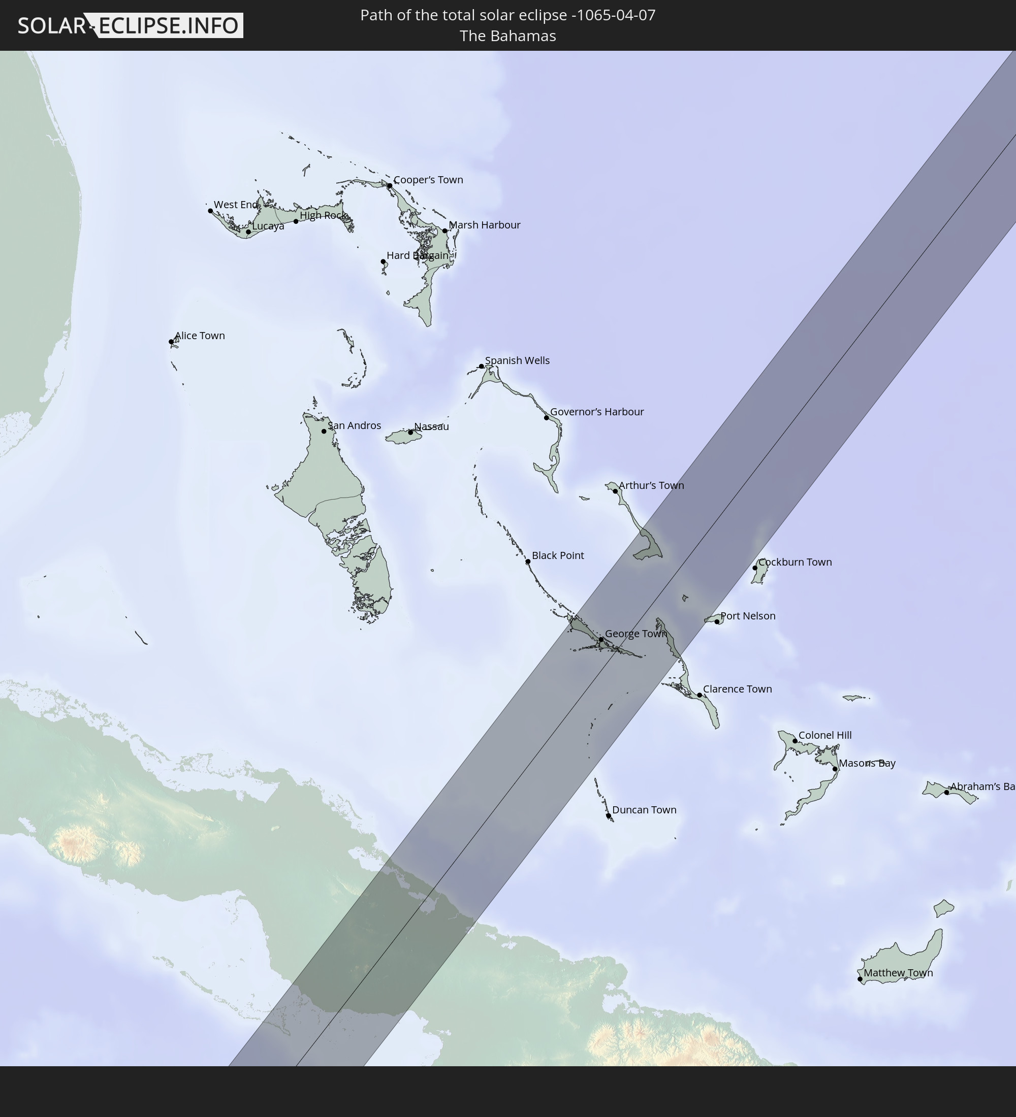
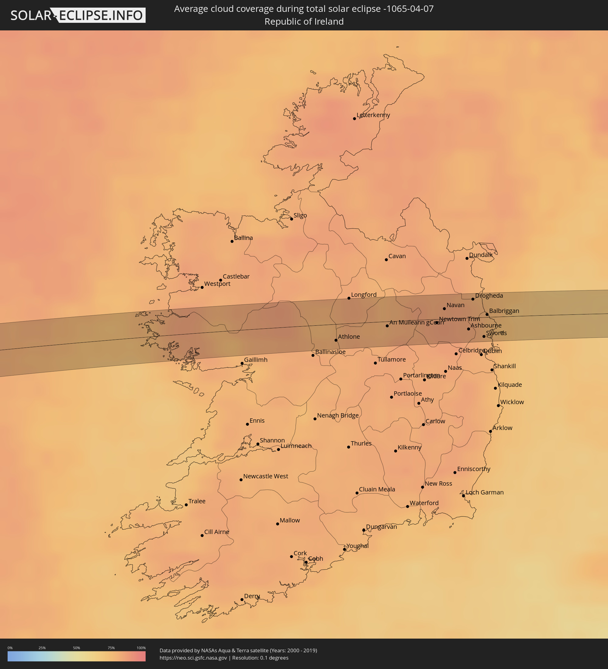 Irland
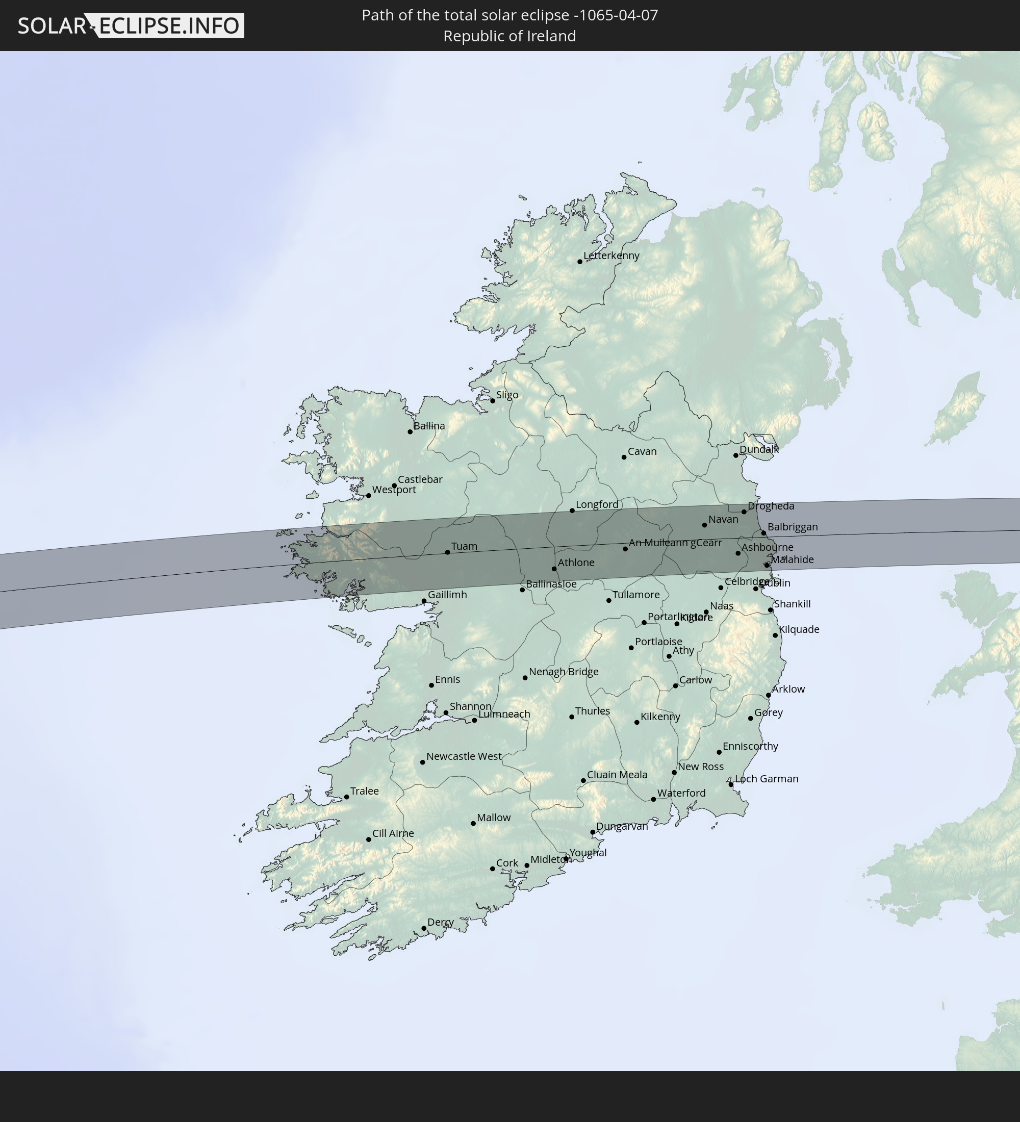
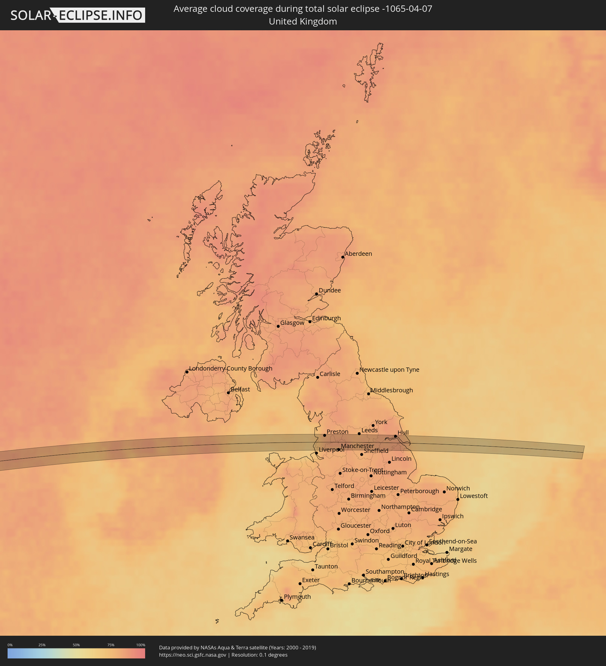 Vereinigtes Königreich
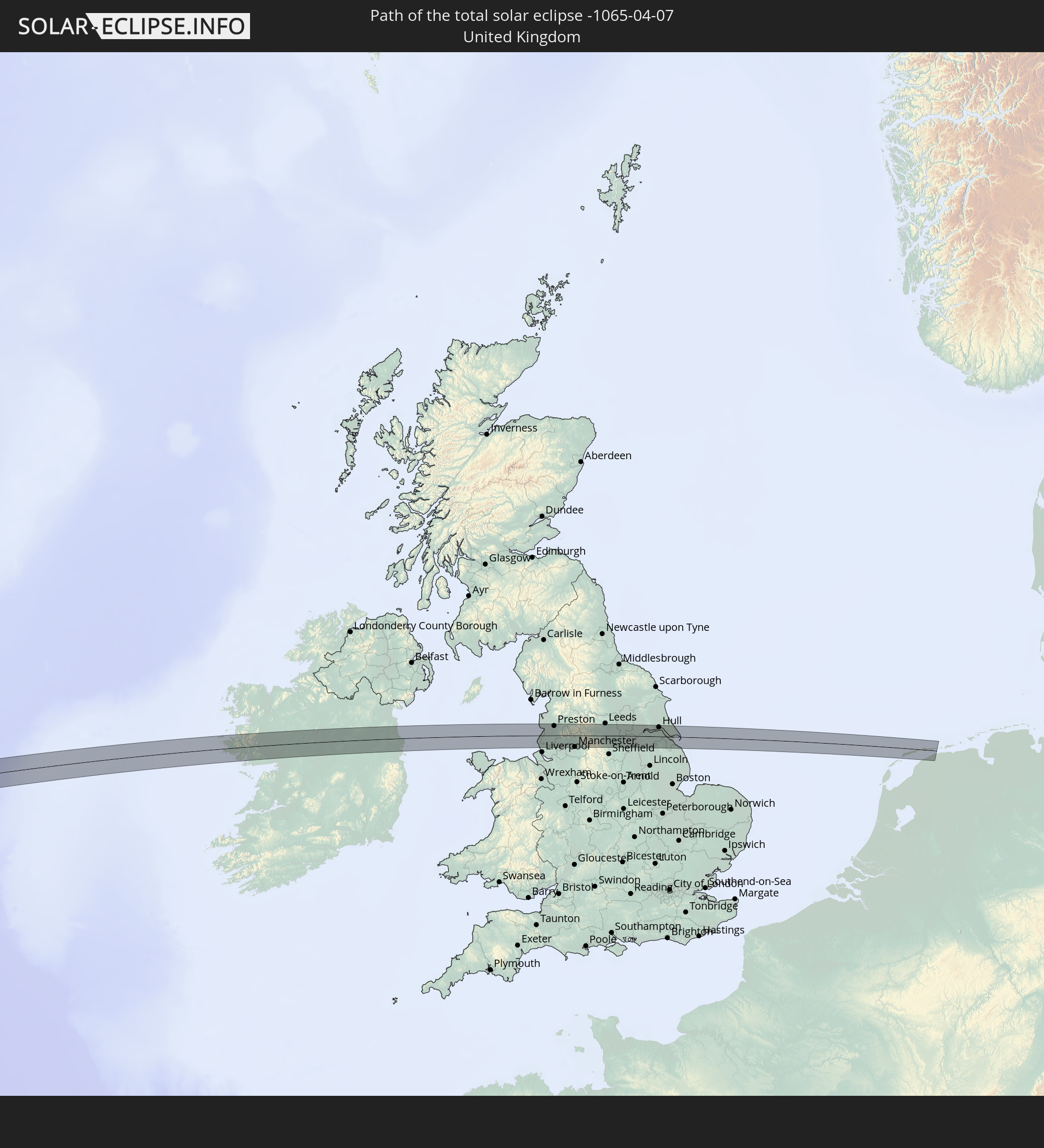
 Niederlande
Orte im Finsternispfad
Die nachfolgene Tabelle zeigt Städte und Orte mit mehr als 5.000 Einwohnern, die sich im Finsternispfad befinden. Städte mit mehr als 100.000 Einwohnern sind dick gekennzeichnet. Mit einem Klick auf den Ort öffnet sich eine Detailkarte die die Lage des jeweiligen Ortes zusammen mit dem Verlauf der zentralen Finsternis präsentiert.
| Ort | Typ | Dauer der Verfinsterung | Ortszeit bei maximaler Verfinsterung | Entfernung zur Zentrallinie | Ø Bewölkung |
|
Diriamba, Carazo
|
total | - | 09:49:08 UTC-05:45 | 39 km | 44% |
|
Dolores, Carazo
|
total | - | 09:49:10 UTC-05:45 | 37 km | 44% |
|
Santa Teresa, Carazo
|
total | - | 09:48:55 UTC-05:45 | 28 km | 45% |
|
San Marcos, Carazo
|
total | - | 09:49:17 UTC-05:45 | 40 km | 44% |
|
Jinotepe, Carazo
|
total | - | 09:49:10 UTC-05:45 | 35 km | 43% |
|
La Concepción, Masaya
|
total | - | 09:49:22 UTC-05:45 | 41 km | 44% |
|
Masatepe, Masaya
|
total | - | 09:49:24 UTC-05:45 | 36 km | 50% |
|
Nindirí, Masaya
|
total | - | 09:49:37 UTC-05:45 | 41 km | 48% |
|
Nandasmo, Masaya
|
total | - | 09:49:27 UTC-05:45 | 35 km | 50% |
|
Niquinohomo, Masaya
|
total | - | 09:49:27 UTC-05:45 | 31 km | 50% |
|
Masaya, Masaya
|
total | - | 09:49:35 UTC-05:45 | 37 km | 48% |
|
Nandaime, Granada
|
total | - | 09:49:11 UTC-05:45 | 17 km | 51% |
|
Diriomo, Granada
|
total | - | 09:49:27 UTC-05:45 | 26 km | 50% |
|
Tisma, Masaya
|
total | - | 09:49:56 UTC-05:45 | 39 km | 48% |
|
Granada, Granada
|
total | - | 09:49:42 UTC-05:45 | 23 km | 44% |
|
Belén, Rivas
|
total | - | 09:48:54 UTC-05:45 | 16 km | 55% |
|
San Juan del Sur, Rivas
|
total | - | 09:48:24 UTC-05:45 | 37 km | 57% |
|
Potosí, Rivas
|
total | - | 09:48:56 UTC-05:45 | 19 km | 55% |
|
Rivas, Rivas
|
total | - | 09:48:51 UTC-05:45 | 26 km | 47% |
|
San Jorge, Rivas
|
total | - | 09:48:56 UTC-05:45 | 26 km | 47% |
|
San Lorenzo, Boaco
|
total | - | 09:51:05 UTC-05:45 | 34 km | 69% |
|
Boaco, Boaco
|
total | - | 09:51:18 UTC-05:45 | 41 km | 64% |
|
Camoapa, Boaco
|
total | - | 09:51:20 UTC-05:45 | 23 km | 73% |
|
Juigalpa, Chontales
|
total | - | 09:50:58 UTC-05:45 | 10 km | 79% |
|
El Ayote, Chontales
|
total | - | 09:51:15 UTC-05:45 | 10 km | 73% |
|
Río Blanco, Matagalpa
|
total | - | 09:52:56 UTC-05:45 | 42 km | 78% |
|
Acoyapa, Chontales
|
total | - | 09:50:58 UTC-05:45 | 36 km | 79% |
|
Bocana de Paiwas, Atlántico Sur
|
total | - | 09:52:47 UTC-05:45 | 22 km | 83% |
|
Santo Tomás, Chontales
|
total | - | 09:51:18 UTC-05:45 | 35 km | 79% |
|
Santo Domingo, Chontales
|
total | - | 09:51:43 UTC-05:45 | 21 km | 81% |
|
Villa Sandino, Chontales
|
total | - | 09:51:24 UTC-05:45 | 44 km | 81% |
|
Puerto Cabezas, Atlántico Norte (RAAN)
|
total | - | 09:58:08 UTC-05:45 | 23 km | 59% |
|
Santa Cruz del Sur, Camagüey
|
total | - | 10:37:05 UTC-05:29 | 6 km | 38% |
|
Camagüey, Camagüey
|
total | - | 10:38:39 UTC-05:29 | 44 km | 69% |
|
Jimaguayú, Camagüey
|
total | - | 10:38:30 UTC-05:29 | 27 km | 69% |
|
Minas, Camagüey
|
total | - | 10:39:24 UTC-05:29 | 26 km | 71% |
|
Amancio, Las Tunas
|
total | - | 10:38:00 UTC-05:29 | 22 km | 54% |
|
Sibanicú, Camagüey
|
total | - | 10:39:00 UTC-05:29 | 2 km | 72% |
|
Colombia, Las Tunas
|
total | - | 10:38:37 UTC-05:29 | 23 km | 73% |
|
Guáimaro, Camagüey
|
total | - | 10:38:53 UTC-05:29 | 25 km | 74% |
|
Jobabo, Las Tunas
|
total | - | 10:38:41 UTC-05:29 | 40 km | 71% |
|
Nuevitas, Camagüey
|
total | - | 10:40:06 UTC-05:29 | 2 km | 56% |
|
Manatí, Las Tunas
|
total | - | 10:40:09 UTC-05:29 | 41 km | 62% |
|
George Town, Exuma
|
total | - | 11:06:53 UTC-05:09 | 15 km | 43% |
|
Tuam, Connaught
|
total | - | 17:28:34 UTC-00:25 | 0 km | 80% |
|
Roscommon, Connaught
|
total | - | 17:28:38 UTC-00:25 | 10 km | 77% |
|
Athlone, Leinster
|
total | - | 17:28:50 UTC-00:25 | 13 km | 81% |
|
Longford, Leinster
|
total | - | 17:28:39 UTC-00:25 | 19 km | 82% |
|
An Muileann gCearr, Leinster
|
total | - | 17:28:53 UTC-00:25 | 4 km | 80% |
|
Newtown Trim, Leinster
|
total | - | 17:28:59 UTC-00:25 | 3 km | 84% |
|
Navan, Leinster
|
total | - | 17:28:56 UTC-00:25 | 8 km | 83% |
|
Ratoath, Leinster
|
total | - | 17:29:05 UTC-00:25 | 9 km | 84% |
|
Ashbourne, Leinster
|
total | - | 17:29:05 UTC-00:25 | 9 km | 82% |
|
Drogheda, Leinster
|
total | - | 17:28:56 UTC-00:25 | 14 km | 80% |
|
Laytown, Leinster
|
total | - | 17:28:59 UTC-00:25 | 10 km | 78% |
|
Swords, Leinster
|
total | - | 17:29:10 UTC-00:25 | 15 km | 79% |
|
Kinsealy-Drinan, Leinster
|
total | - | 17:29:11 UTC-00:25 | 17 km | 78% |
|
Balbriggan, Leinster
|
total | - | 17:29:03 UTC-00:25 | 2 km | 78% |
|
Lusk, Leinster
|
total | - | 17:29:07 UTC-00:25 | 8 km | 79% |
|
Malahide, Leinster
|
total | - | 17:29:11 UTC-00:25 | 16 km | 79% |
|
Donabate, Leinster
|
total | - | 17:29:09 UTC-00:25 | 12 km | 79% |
|
Skerries, Leinster
|
total | - | 17:29:05 UTC-00:25 | 2 km | 75% |
|
An Ros, Leinster
|
total | - | 17:29:08 UTC-00:25 | 8 km | 77% |
|
Crosby, England
|
total | - | 17:54:59 UTC+00:00 | 18 km | 71% |
|
Southport, England
|
total | - | 17:54:51 UTC+00:00 | 1 km | 71% |
|
Freckleton, England
|
total | - | 17:54:47 UTC+00:00 | 13 km | 75% |
|
Tarleton, England
|
total | - | 17:54:51 UTC+00:00 | 5 km | 78% |
|
Skelmersdale, England
|
total | - | 17:54:58 UTC+00:00 | 10 km | 78% |
|
Preston, England
|
total | - | 17:54:48 UTC+00:00 | 14 km | 80% |
|
Euxton, England
|
total | - | 17:54:53 UTC+00:00 | 4 km | 81% |
|
Coppull, England
|
total | - | 17:54:55 UTC+00:00 | 1 km | 81% |
|
Adlington, England
|
total | - | 17:54:56 UTC+00:00 | 3 km | 79% |
|
Bolton, England
|
total | - | 17:54:58 UTC+00:00 | 6 km | 79% |
|
Rishton, England
|
total | - | 17:54:50 UTC+00:00 | 15 km | 82% |
|
Clayton le Moors, England
|
total | - | 17:54:50 UTC+00:00 | 15 km | 82% |
|
Accrington, England
|
total | - | 17:54:51 UTC+00:00 | 13 km | 82% |
|
Tottington, England
|
total | - | 17:54:57 UTC+00:00 | 3 km | 79% |
|
Manchester, England
|
total | - | 17:55:04 UTC+00:00 | 17 km | 78% |
|
Rochdale, England
|
total | - | 17:54:58 UTC+00:00 | 2 km | 79% |
|
Queensbury, England
|
total | - | 17:54:53 UTC+00:00 | 15 km | 80% |
|
Meltham, England
|
total | - | 17:55:02 UTC+00:00 | 6 km | 83% |
|
Meltham Mills, England
|
total | - | 17:55:02 UTC+00:00 | 5 km | 80% |
|
Huddersfield, England
|
total | - | 17:54:59 UTC+00:00 | 2 km | 80% |
|
Penistone, England
|
total | - | 17:55:06 UTC+00:00 | 12 km | 78% |
|
Clayton West, England
|
total | - | 17:55:03 UTC+00:00 | 4 km | 79% |
|
Wakefield, England
|
total | - | 17:54:59 UTC+00:00 | 6 km | 80% |
|
Hoyland Nether, England
|
total | - | 17:55:08 UTC+00:00 | 15 km | 78% |
|
Darfield, England
|
total | - | 17:55:07 UTC+00:00 | 11 km | 78% |
|
Hemsworth, England
|
total | - | 17:55:03 UTC+00:00 | 2 km | 80% |
|
Knottingley, England
|
total | - | 17:54:59 UTC+00:00 | 8 km | 81% |
|
Carcroft, England
|
total | - | 17:55:06 UTC+00:00 | 5 km | 80% |
|
Doncaster, England
|
total | - | 17:55:09 UTC+00:00 | 12 km | 81% |
|
Selby, England
|
total | - | 17:54:57 UTC+00:00 | 17 km | 80% |
|
Goole, England
|
total | - | 17:55:02 UTC+00:00 | 8 km | 82% |
|
Scalby, England
|
total | - | 17:54:59 UTC+00:00 | 16 km | 81% |
|
Scunthorpe, England
|
total | - | 17:55:09 UTC+00:00 | 5 km | 83% |
|
Brough, England
|
total | - | 17:55:02 UTC+00:00 | 11 km | 82% |
|
North Ferriby, England
|
total | - | 17:55:02 UTC+00:00 | 11 km | 84% |
|
Barton upon Humber, England
|
total | - | 17:55:05 UTC+00:00 | 6 km | 83% |
|
Hull, England
|
total | - | 17:55:02 UTC+00:00 | 14 km | 84% |
|
Cleethorpes, England
|
total | - | 17:55:12 UTC+00:00 | 6 km | 79% |
|
Humberston, England
|
total | - | 17:55:14 UTC+00:00 | 10 km | 81% |
|
Easington, England
|
total | - | 17:55:08 UTC+00:00 | 4 km | 77% |