Totale Sonnenfinsternis vom 20.06.-1069
| Wochentag: | Montag |
| Maximale Dauer der Verfinsterung: | 04m16s |
| Maximale Breite des Finsternispfades: | 155 km |
| Saroszyklus: | 39 |
| Bedeckungsgrad: | 100% |
| Magnitude: | 1.0463 |
| Gamma: | 0.0736 |
Wo kann man die Sonnenfinsternis vom 20.06.-1069 sehen?
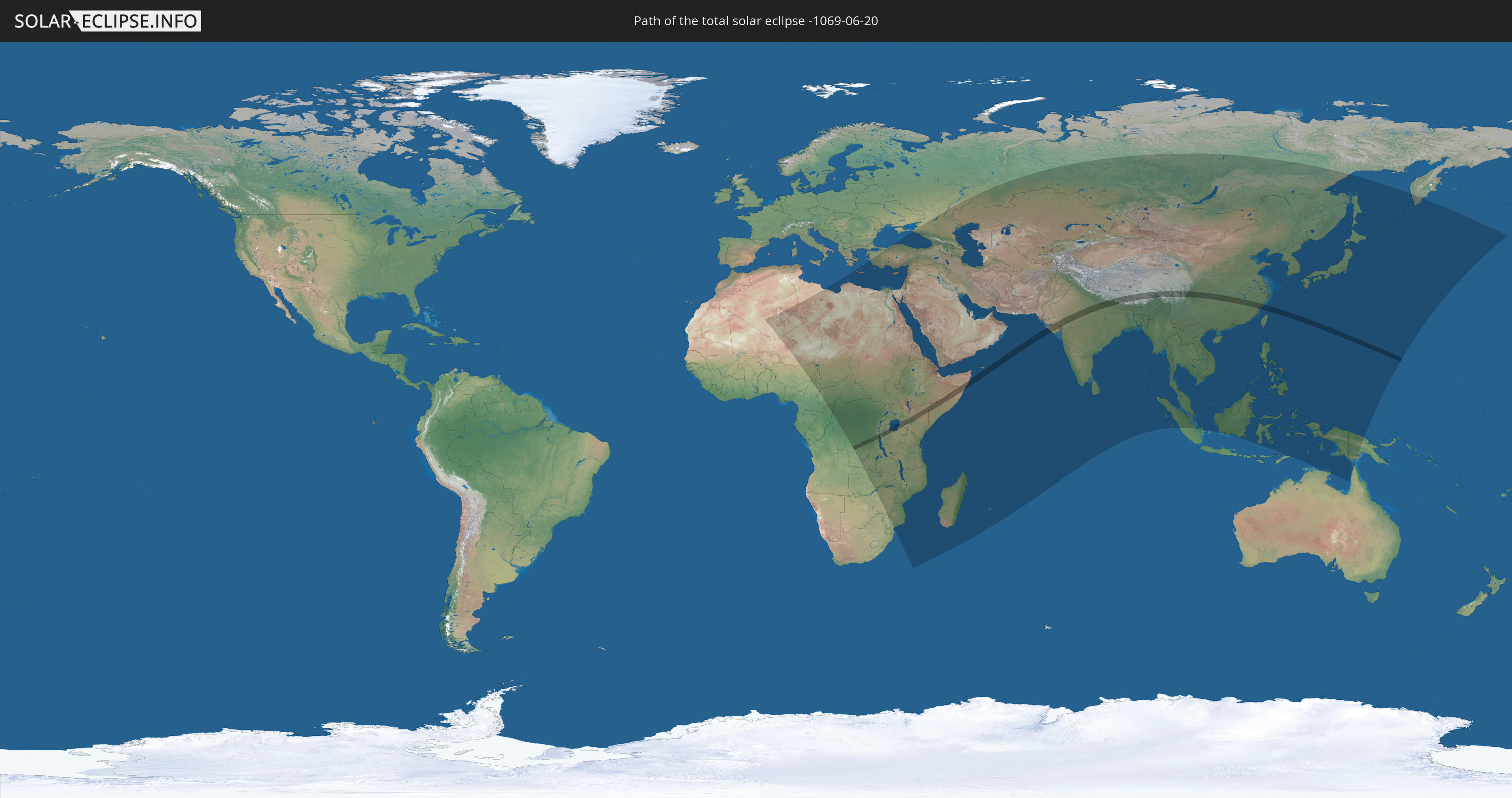
Die Sonnenfinsternis am 20.06.-1069 kann man in 92 Ländern als partielle Sonnenfinsternis beobachten.
Der Finsternispfad verläuft durch 13 Länder. Nur in diesen Ländern ist sie als totale Sonnenfinsternis zu sehen.
In den folgenden Ländern ist die Sonnenfinsternis total zu sehen
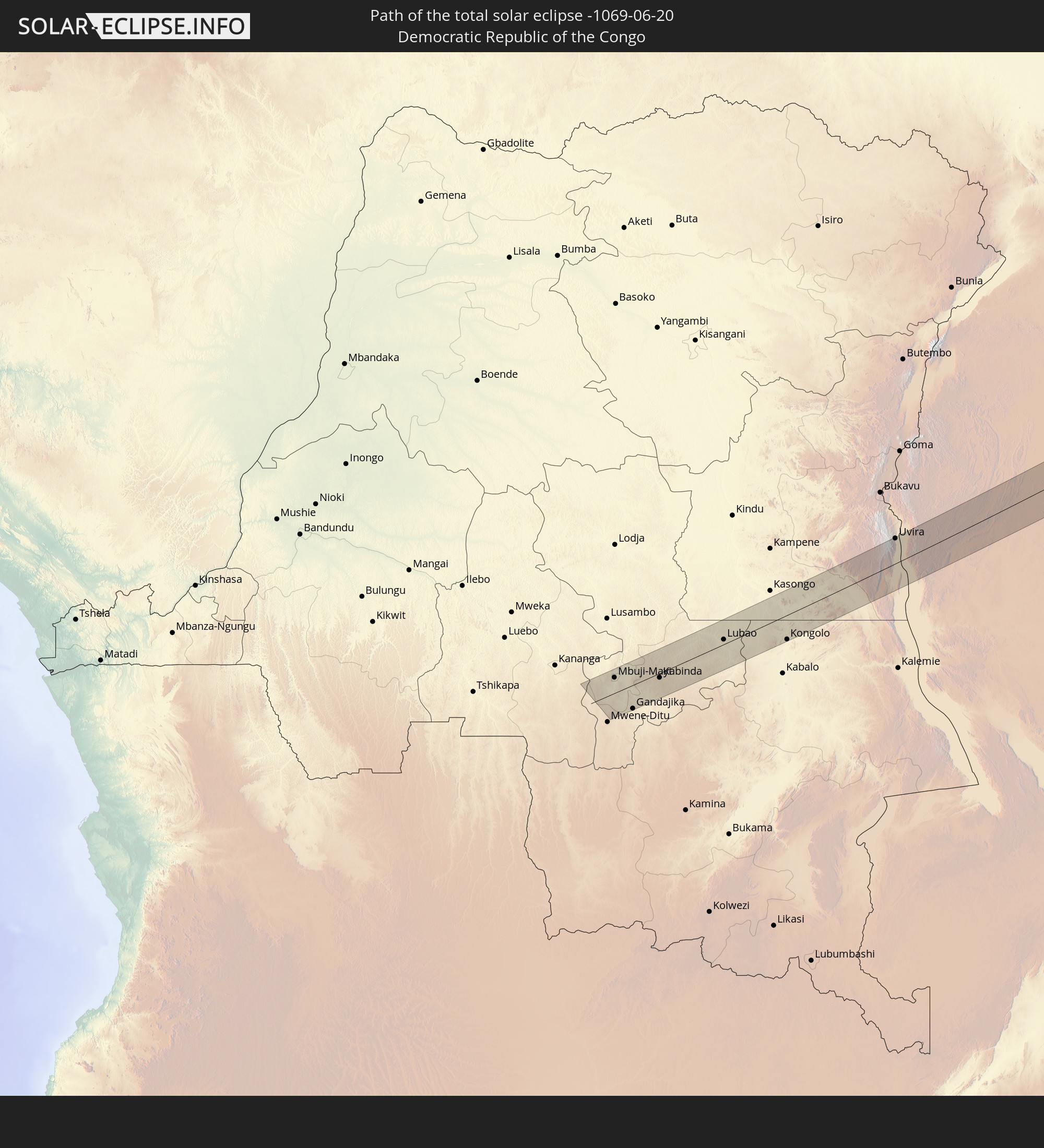 Demokratische Republik Kongo
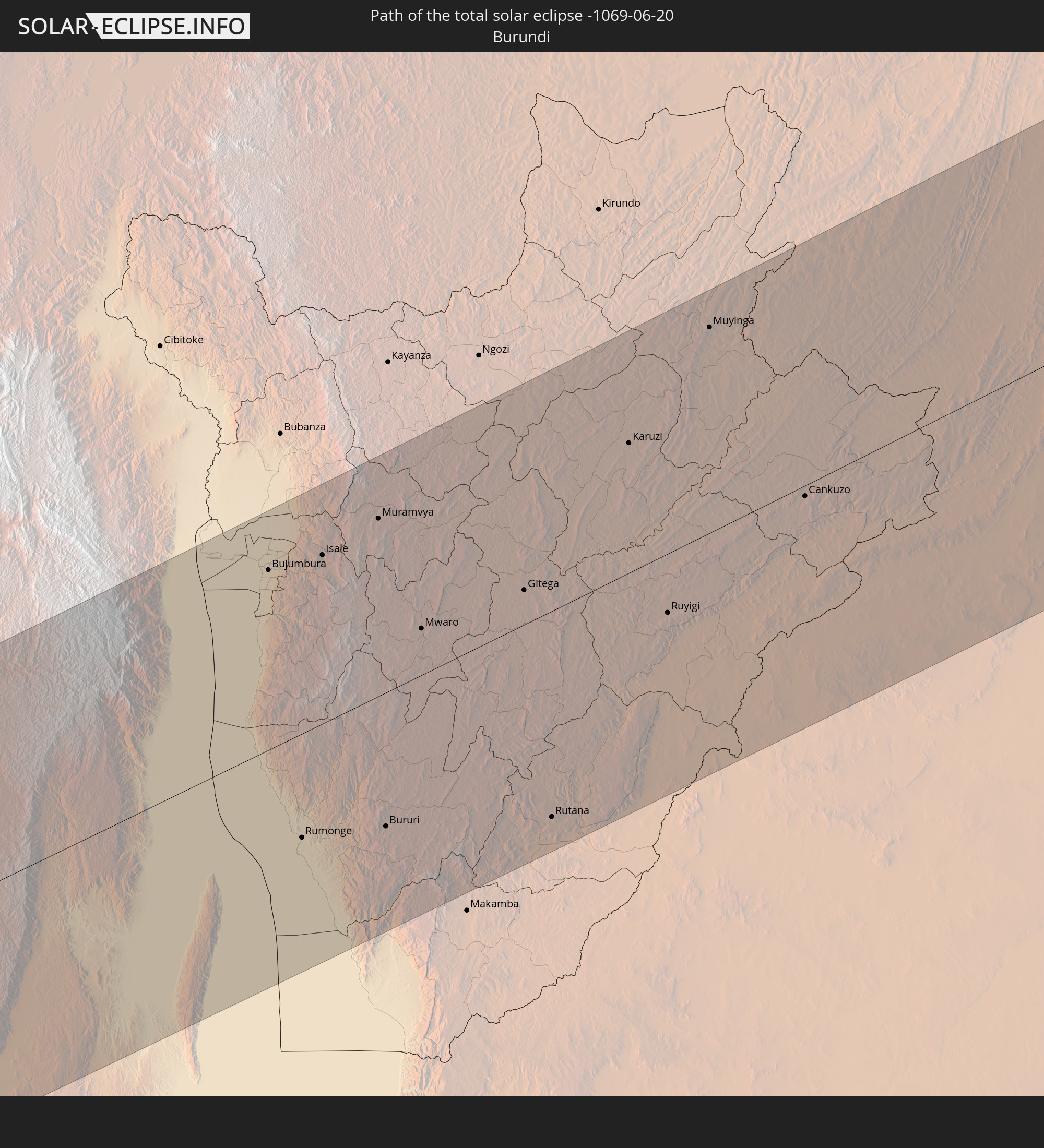 Burundi
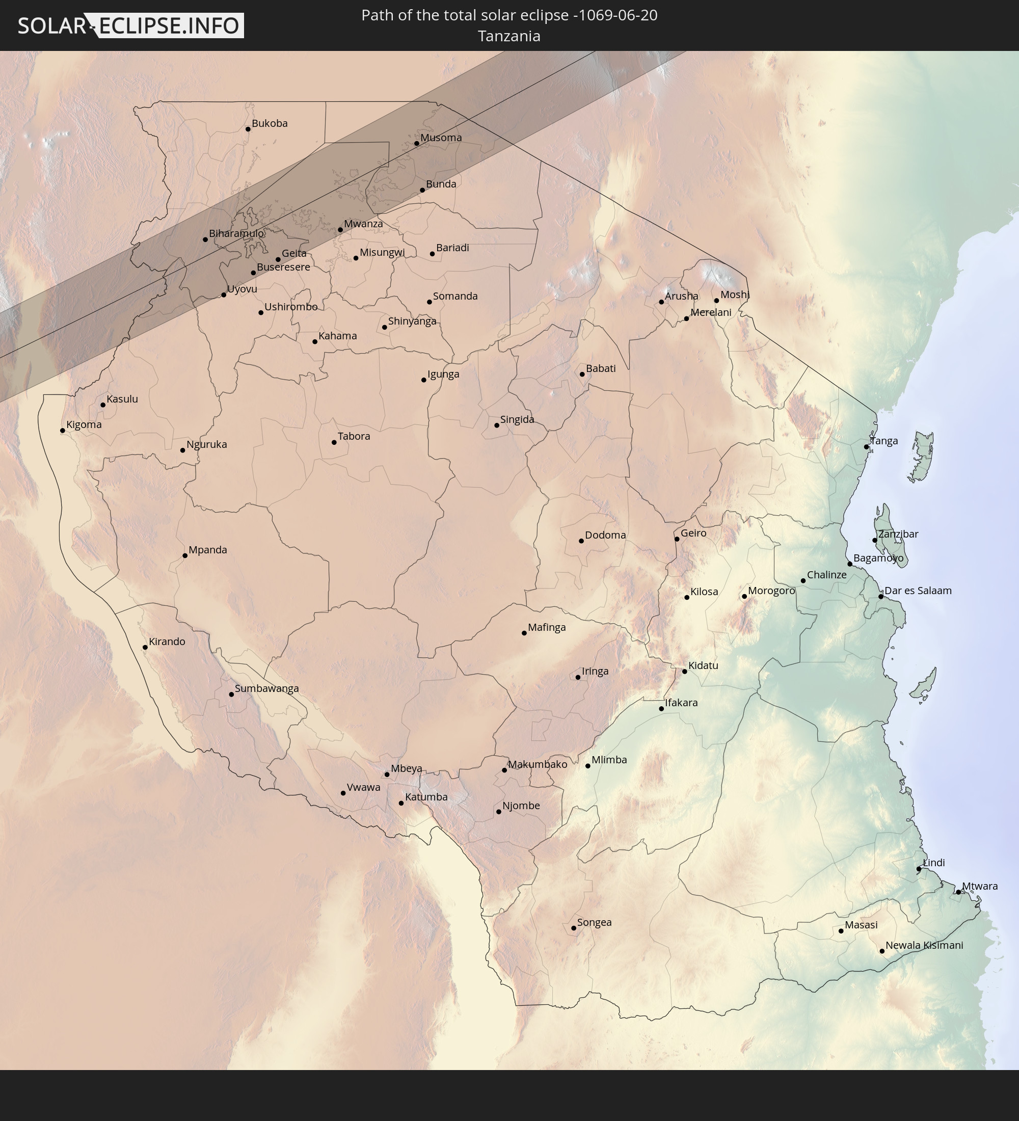 Tansania
 Uganda
 Äthiopien
 Kenia
Kenia
 Somalia
 Indien
 Volksrepublik China
 Nepal
Nepal
 Taiwan
 Japan
Japan
 Nördliche Marianen
In den folgenden Ländern ist die Sonnenfinsternis partiell zu sehen
 Russland
 Algerien
 Niger
Niger
 Nigeria
 Kamerun
 Libyen
 Republik Kongo
 Demokratische Republik Kongo
 Tschad
 Zentralafrikanische Republik
 Südafrika
 Griechenland
 Sudan
Sudan
 Sambia
 Ägypten
 Simbabwe
 Türkei
 Ruanda
 Burundi
 Tansania
 Uganda
 Mosambik
 Republik Zypern
 Malawi
 Äthiopien
 Kenia
Kenia
 Staat Palästina
 Israel
 Saudi-Arabien
 Jordanien
 Libanon
 Syrien
 Eritrea
 Irak
Irak
 Georgien
 Französische Süd- und Antarktisgebiete
 Somalia
 Dschibuti
 Jemen
Jemen
 Madagaskar
 Komoren
 Armenien
 Iran
Iran
 Aserbaidschan
 Mayotte
 Seychellen
 Kasachstan
 Kuwait
 Bahrain
 Katar
Katar
 Vereinigte Arabische Emirate
 Oman
Oman
 Turkmenistan
 Réunion
 Usbekistan
 Mauritius
 Afghanistan
 Pakistan
 Tadschikistan
 Indien
 Kirgisistan
 Britisches Territorium im Indischen Ozean
 Malediven
 Volksrepublik China
 Sri Lanka
 Nepal
Nepal
 Mongolei
 Bangladesch
 Bhutan
 Myanmar
 Indonesien
 Thailand
 Malaysia
 Laos
Laos
 Vietnam
 Kambodscha
 Singapur
 Australien
 Macau
Macau
 Hongkong
 Brunei
 Taiwan
 Philippinen
 Japan
Japan
 Osttimor
 Nordkorea
 Südkorea
 Palau
Palau
 Föderierte Staaten von Mikronesien
 Papua-Neuguinea
 Guam
Guam
 Nördliche Marianen
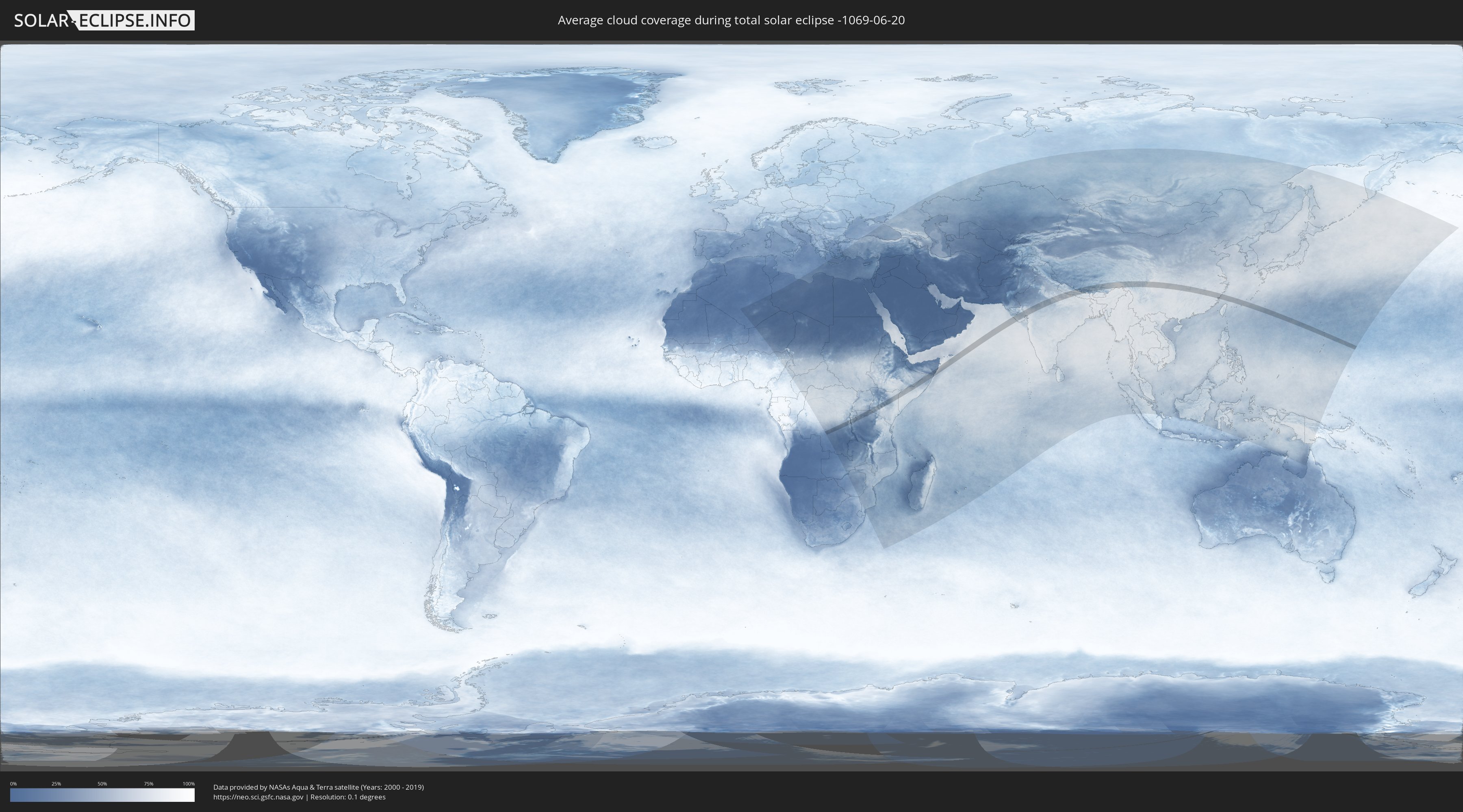
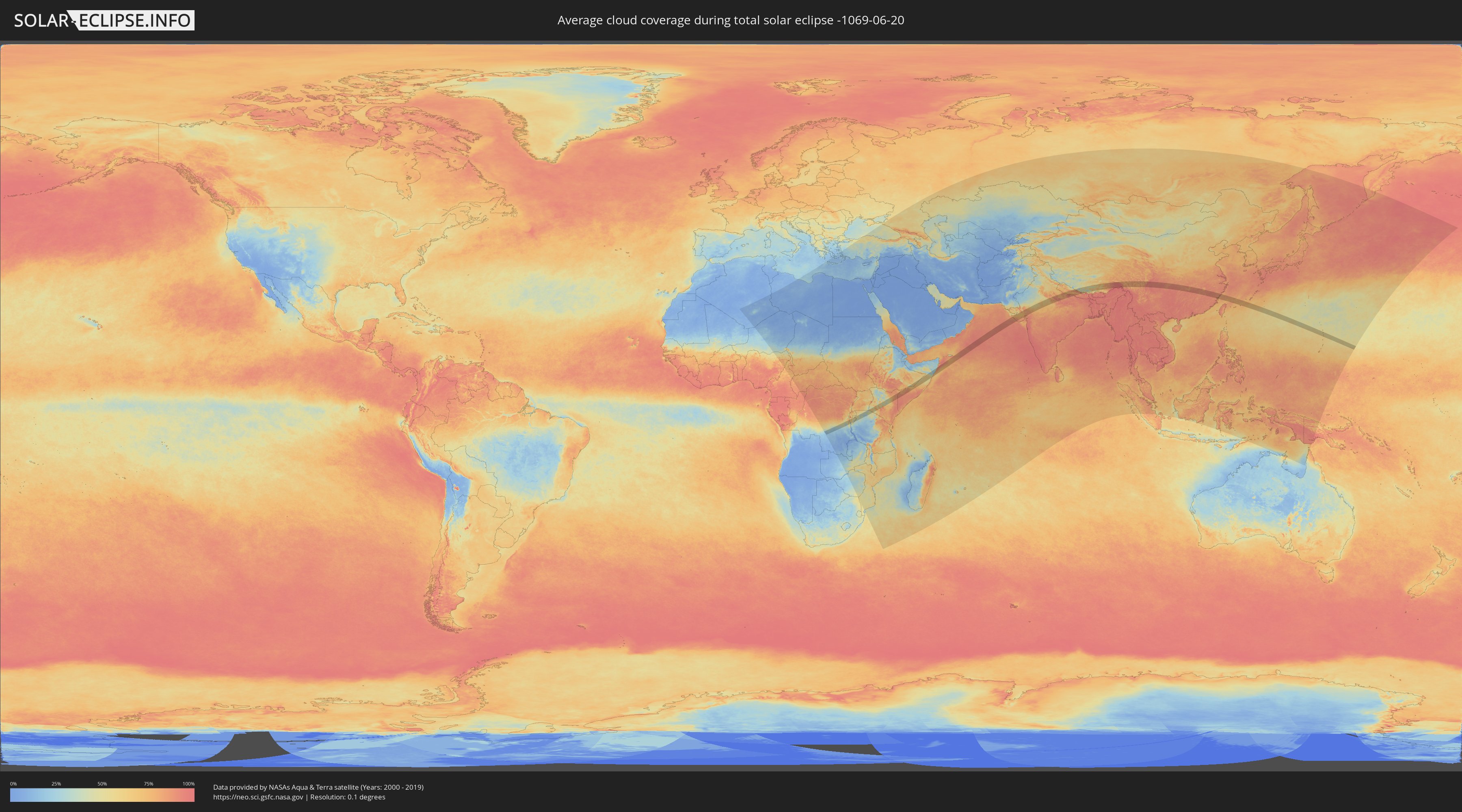
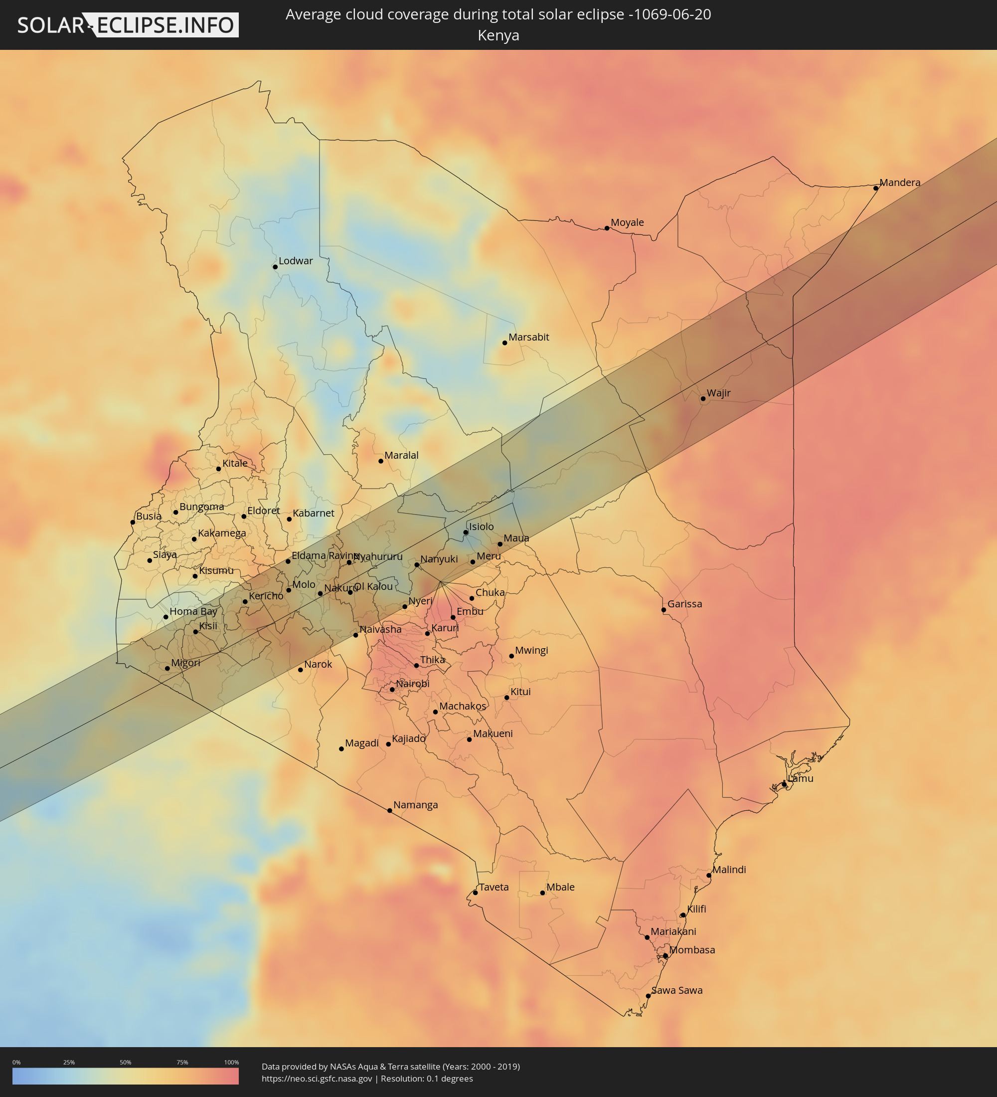
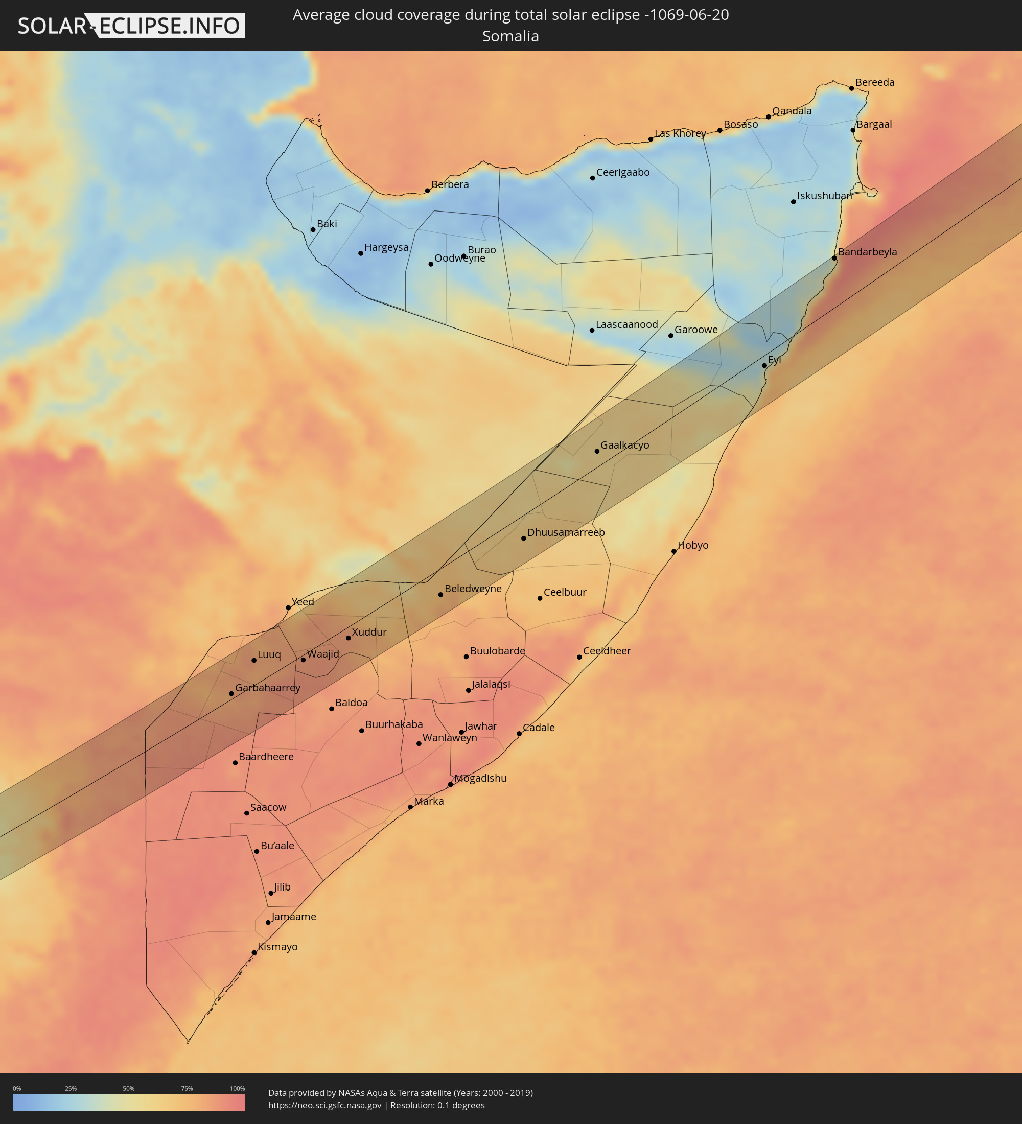
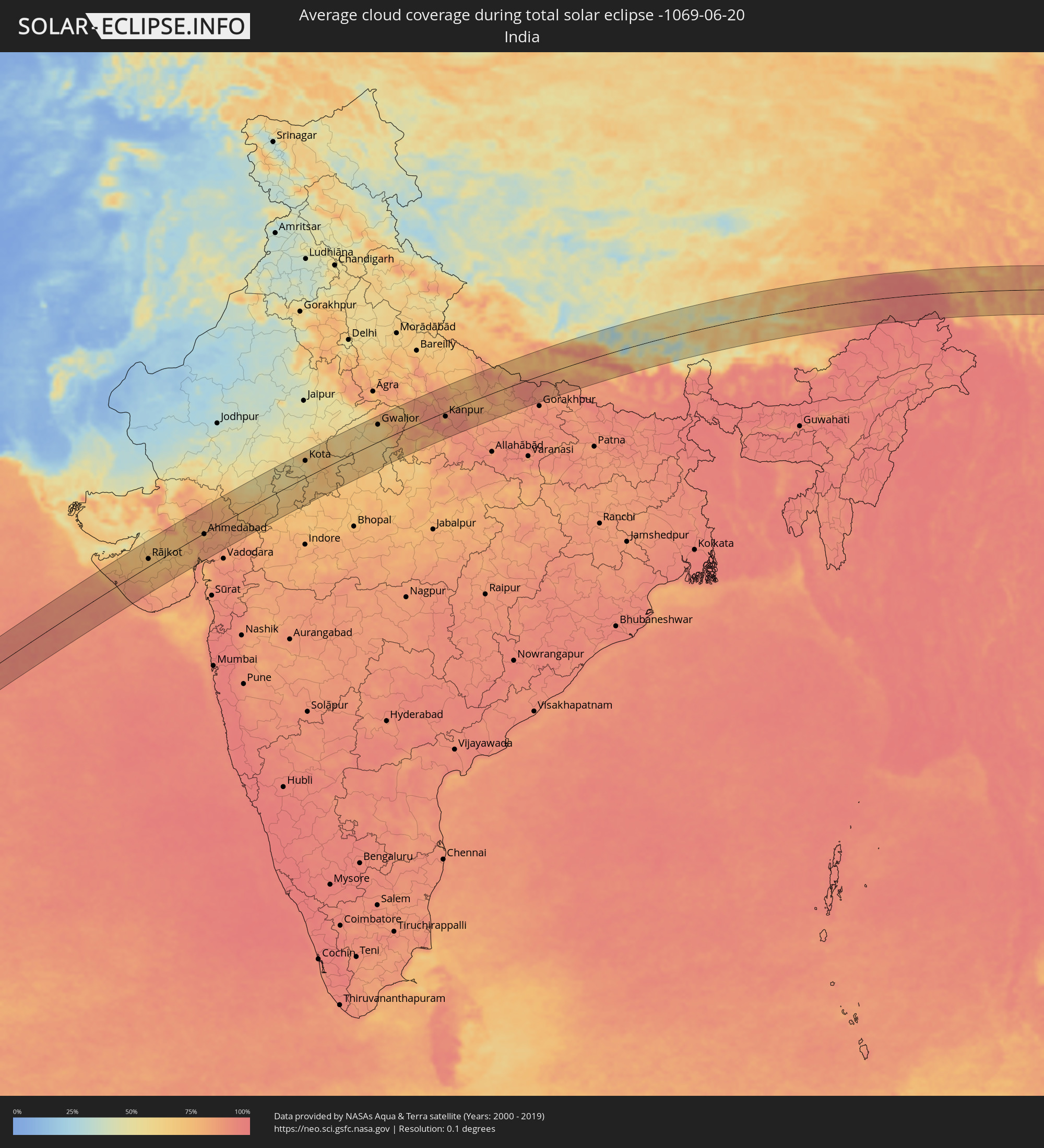
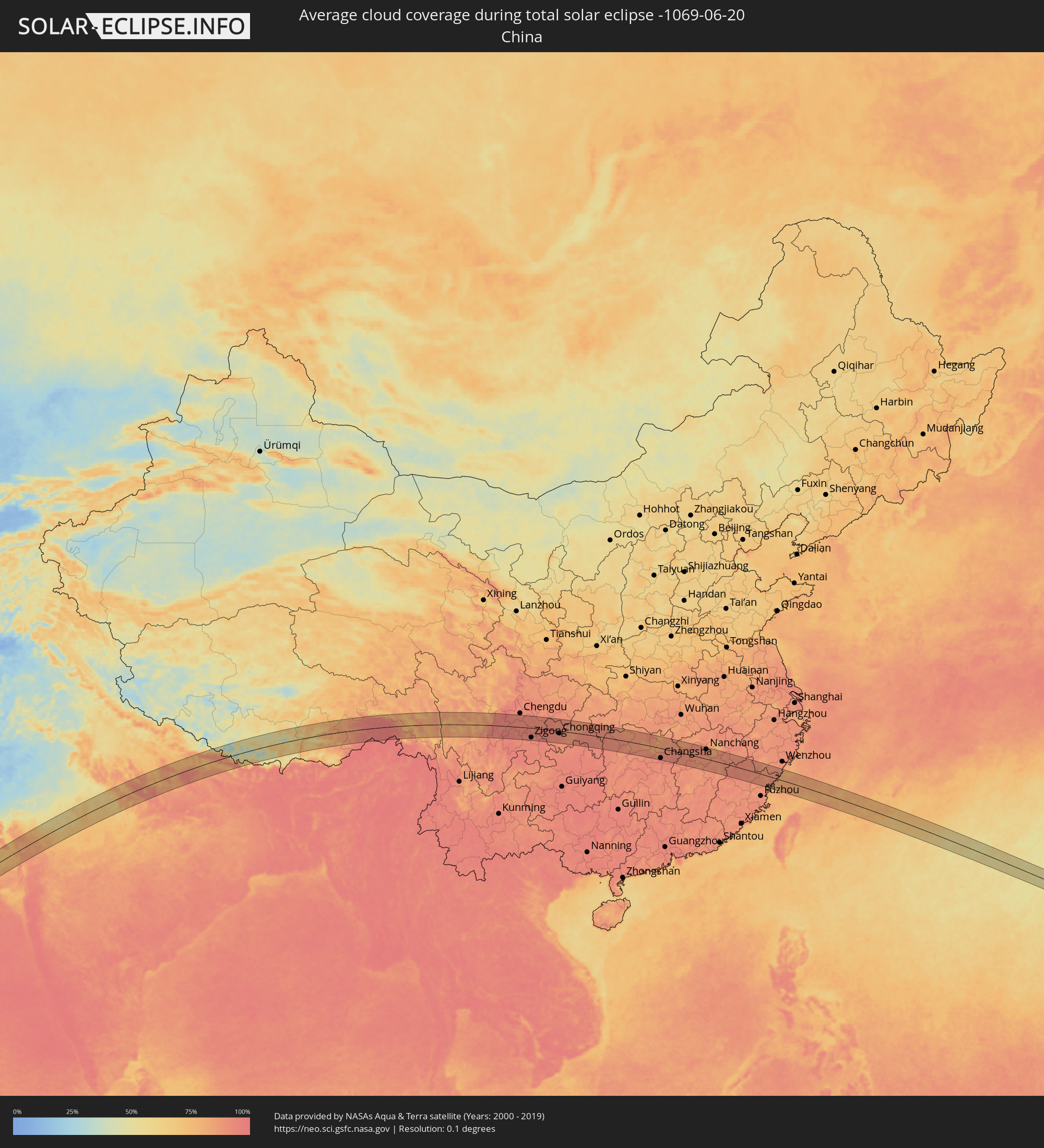
Wie wird das Wetter während der totalen Sonnenfinsternis am 20.06.-1069?
Wo ist der beste Ort, um die totale Sonnenfinsternis vom 20.06.-1069 zu beobachten?
Die folgenden Karten zeigen die durchschnittliche Bewölkung für den Tag, an dem die totale Sonnenfinsternis
stattfindet. Mit Hilfe der Karten lässt sich der Ort entlang des Finsternispfades eingrenzen,
der die besten Aussichen auf einen klaren wolkenfreien Himmel bietet.
Trotzdem muss man immer lokale Gegenenheiten beachten und sollte sich genau über das Wetter an seinem
gewählten Beobachtungsort informieren.
Die Daten stammen von den beiden NASA-Satelliten
AQUA und TERRA
und wurden über einen Zeitraum von 19 Jahren (2000 - 2019) gemittelt.
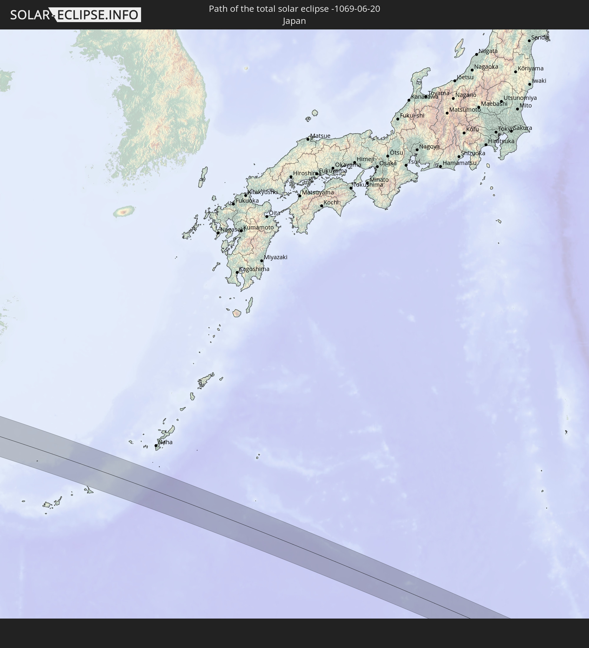
Detaillierte Länderkarten
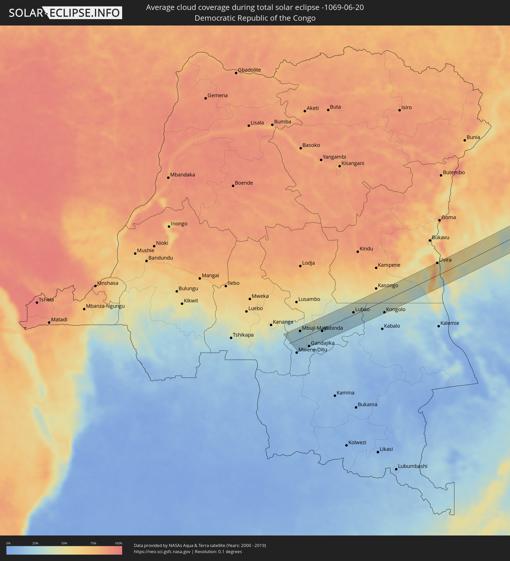 Demokratische Republik Kongo
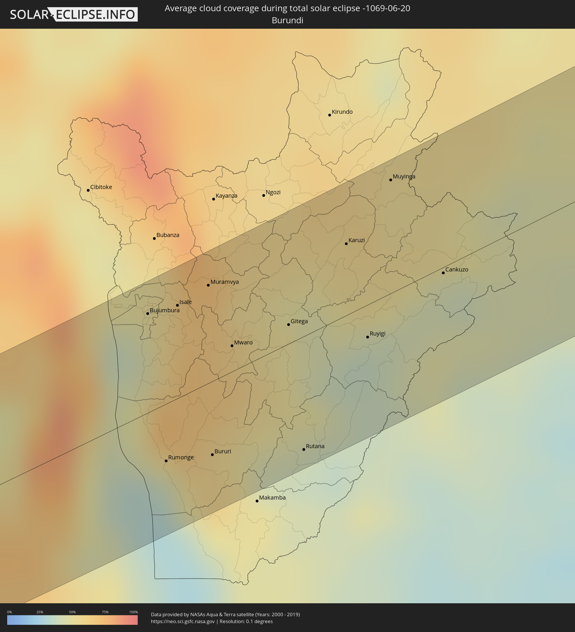 Burundi
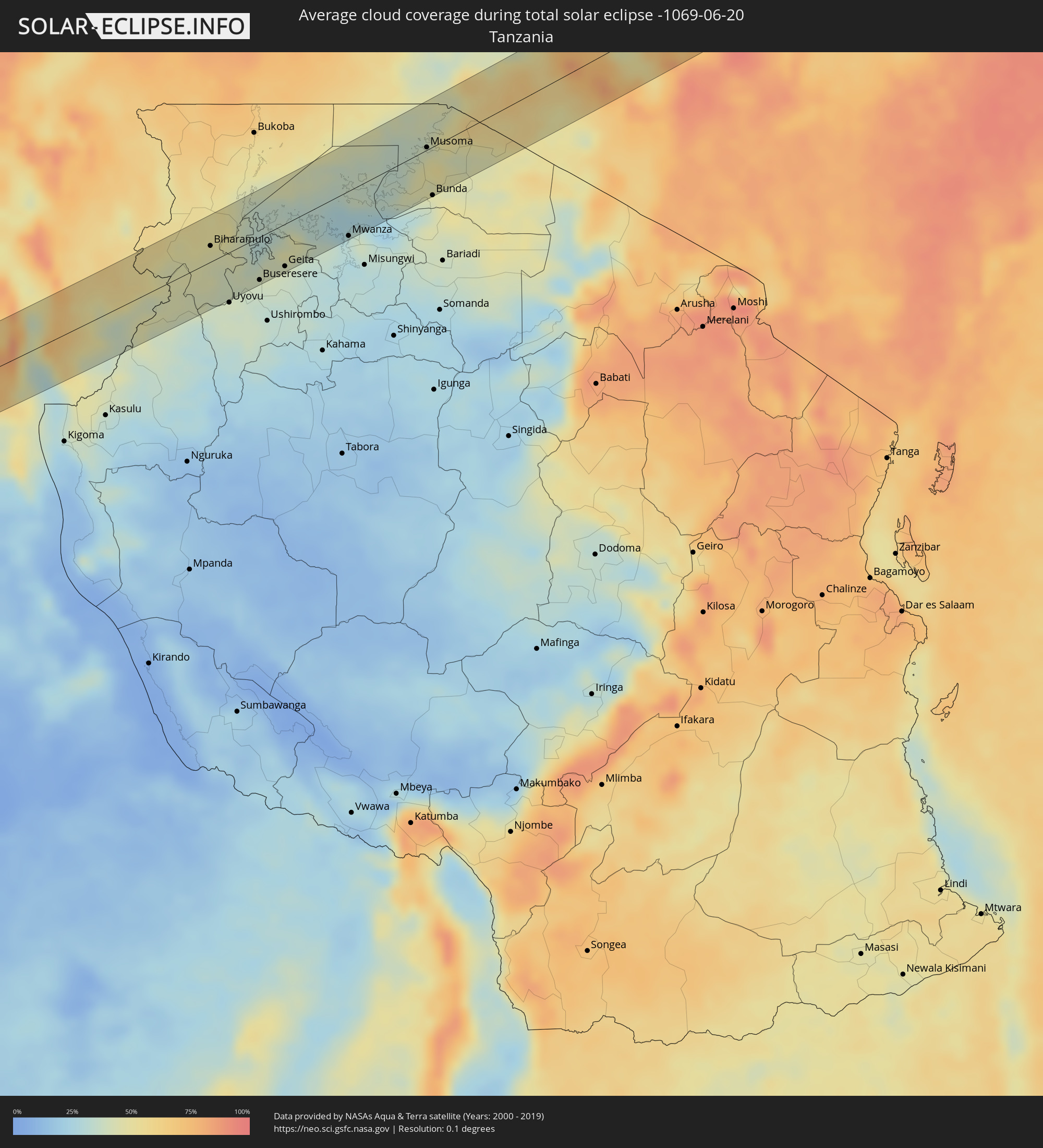 Tansania
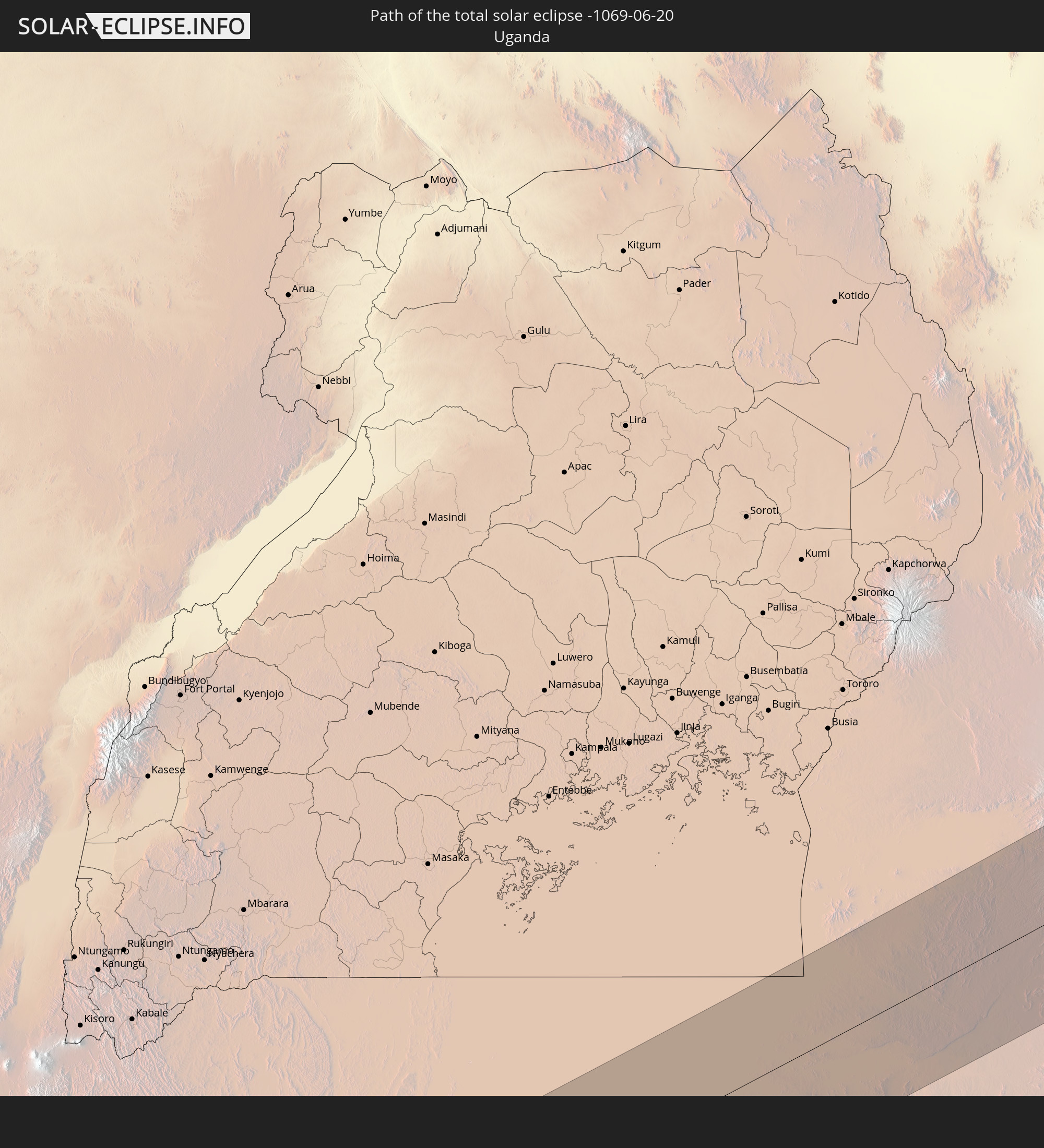
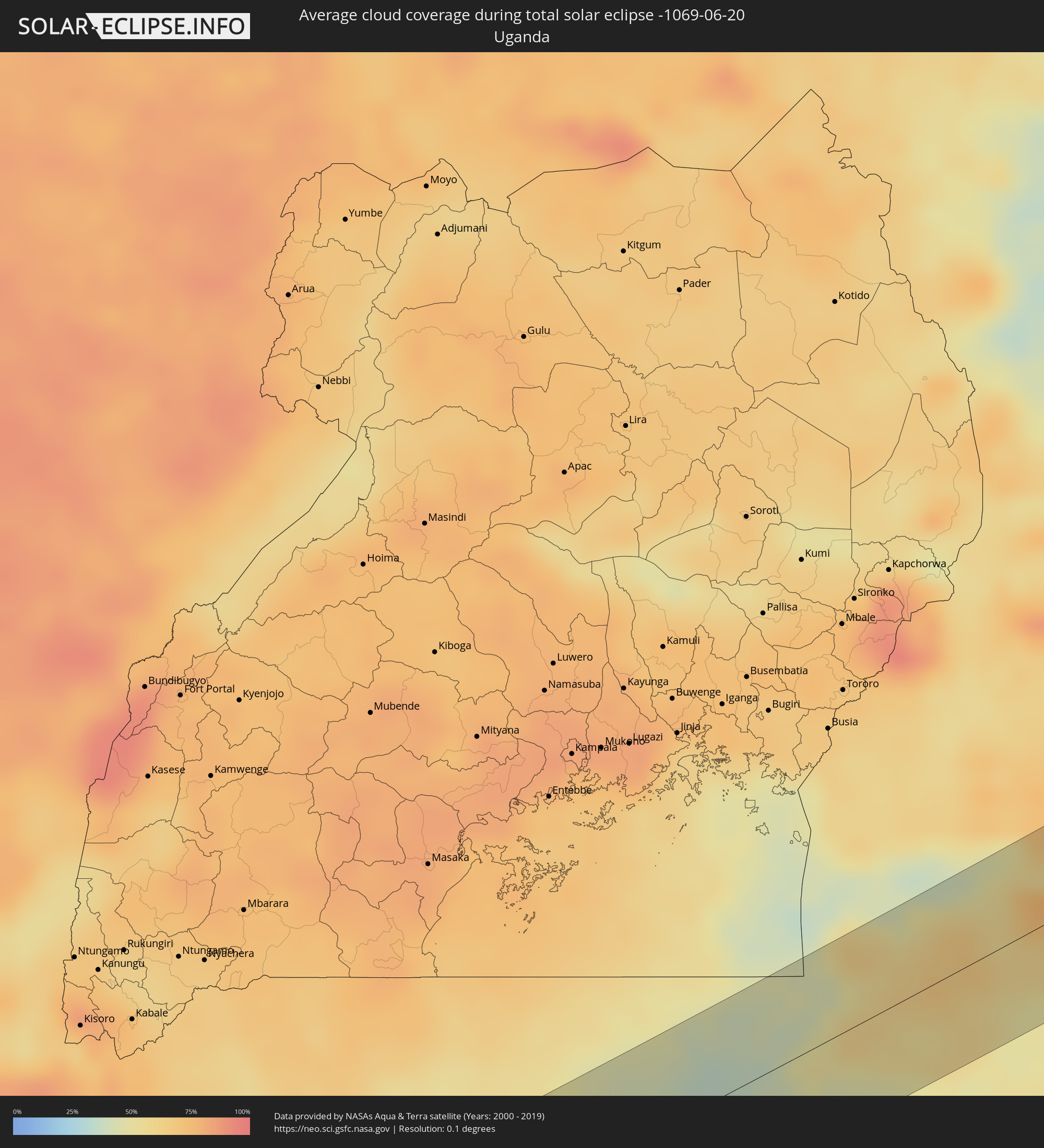 Uganda
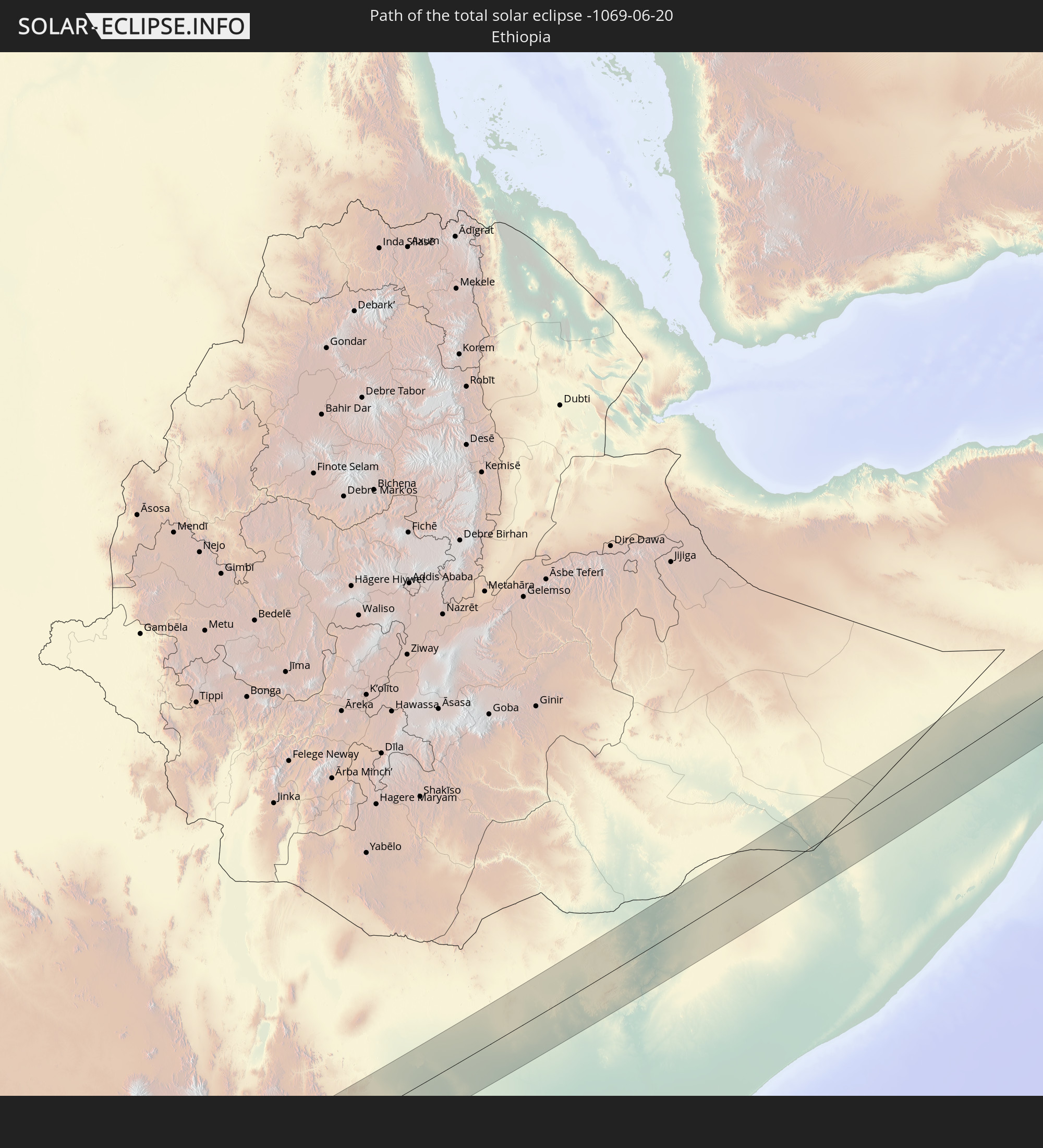
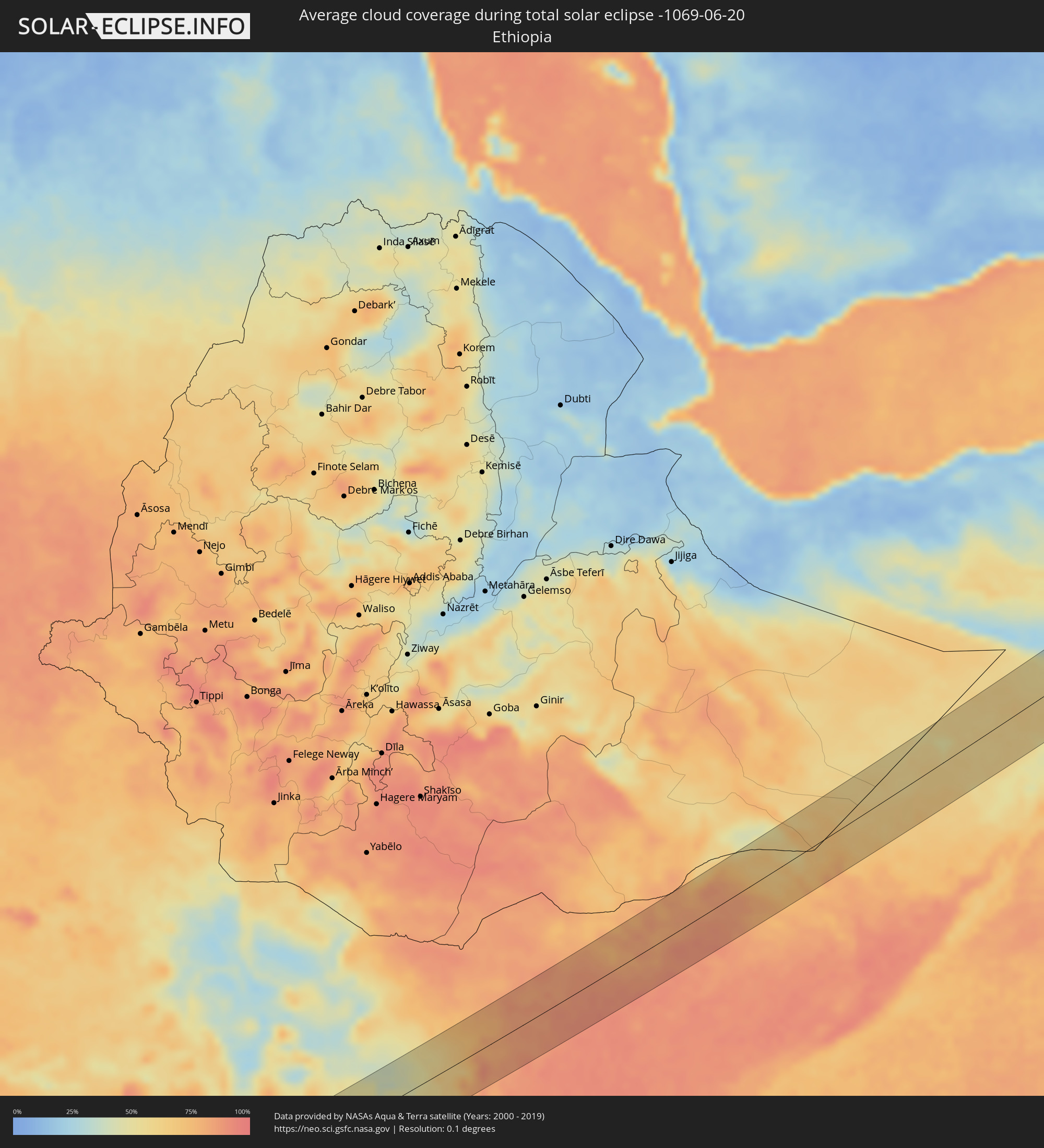 Äthiopien
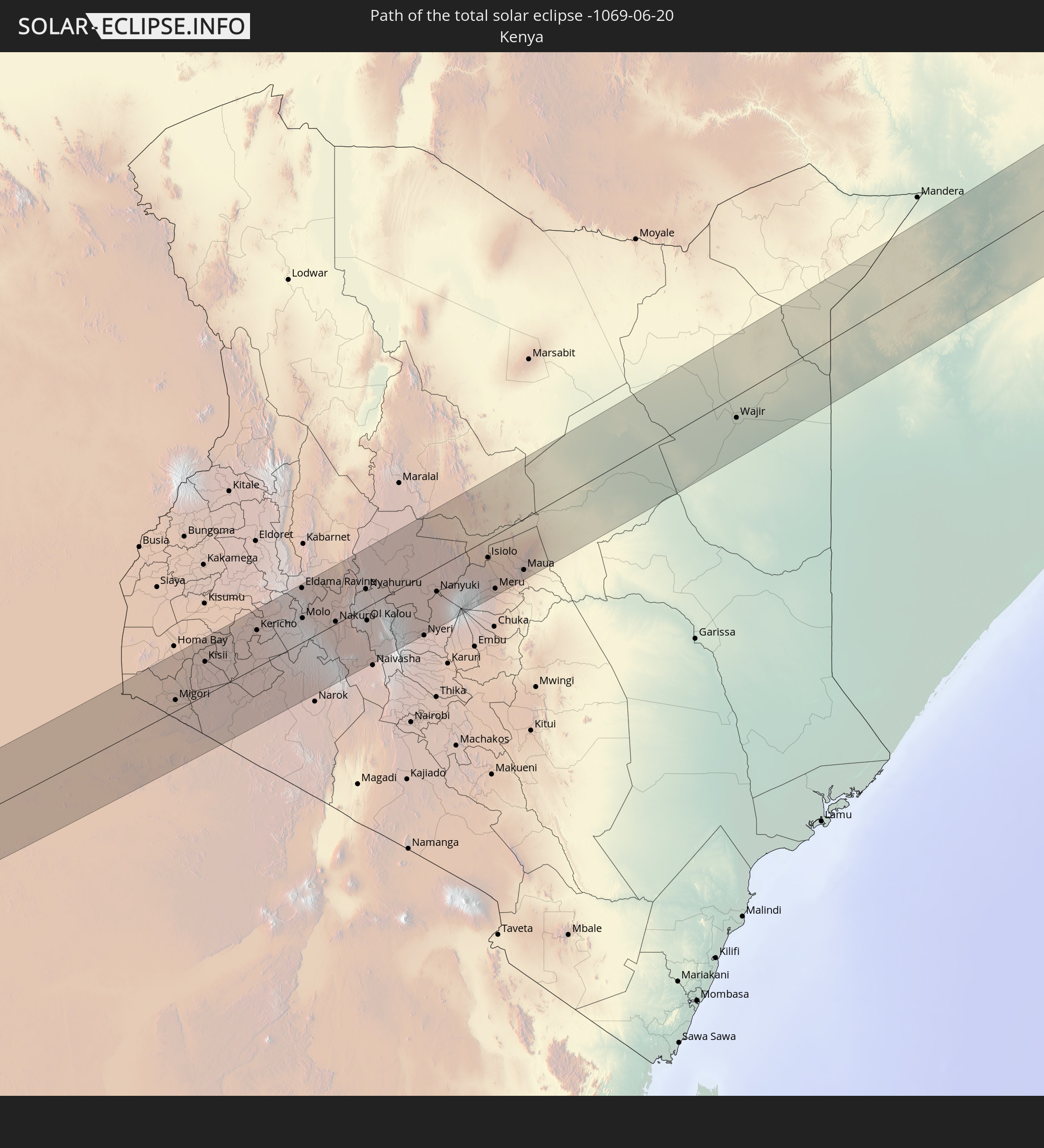
 Kenia
Kenia
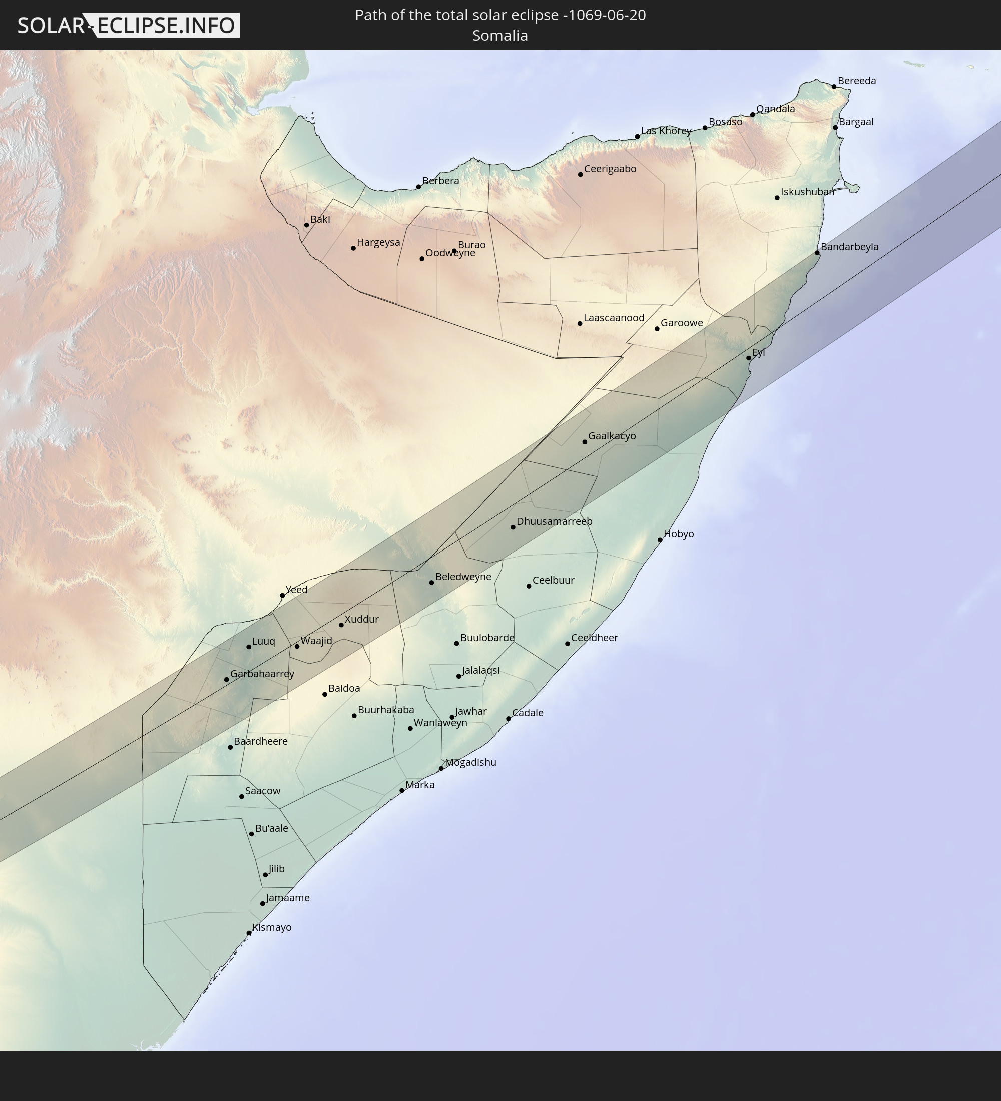
 Somalia
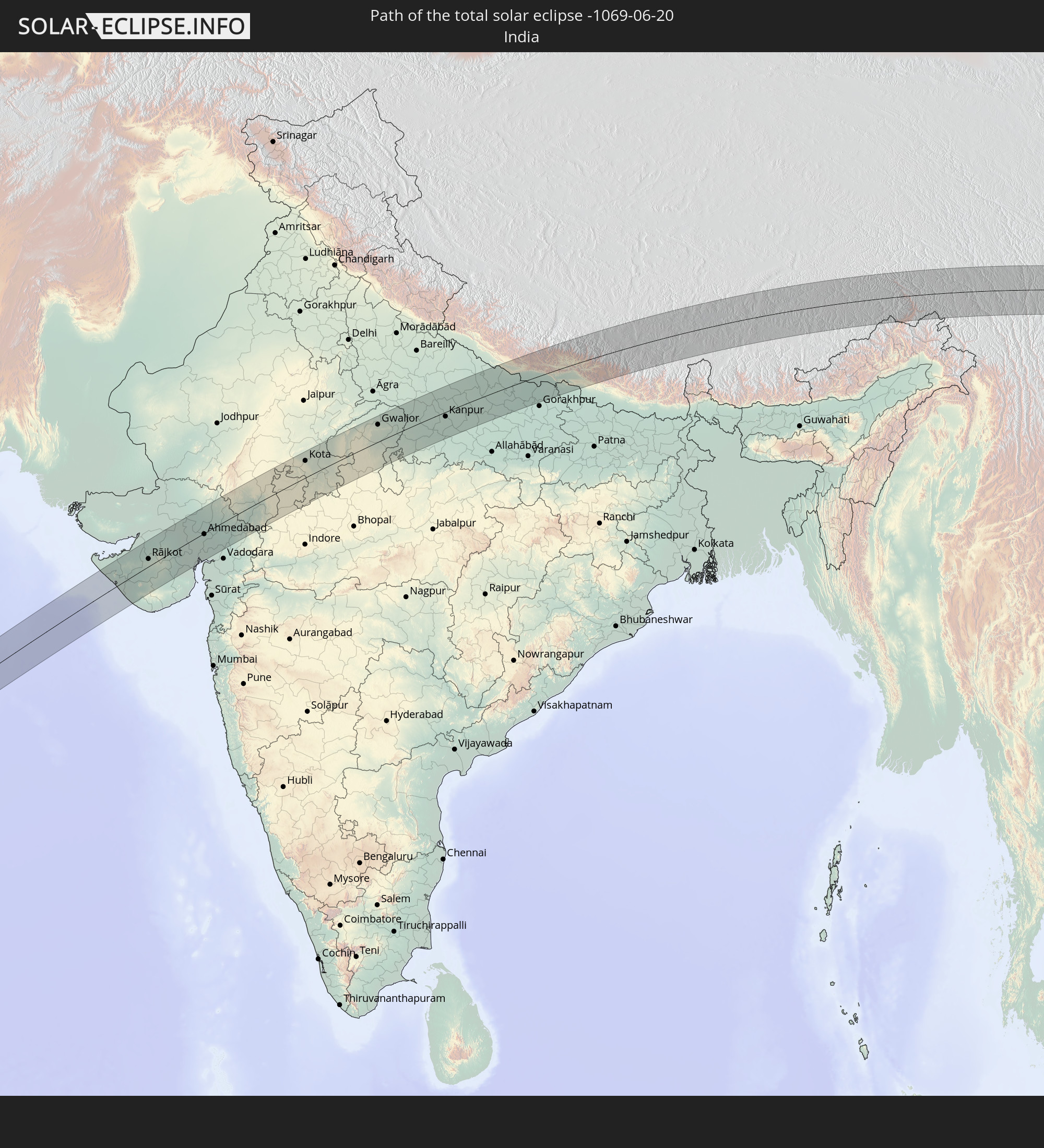
 Indien
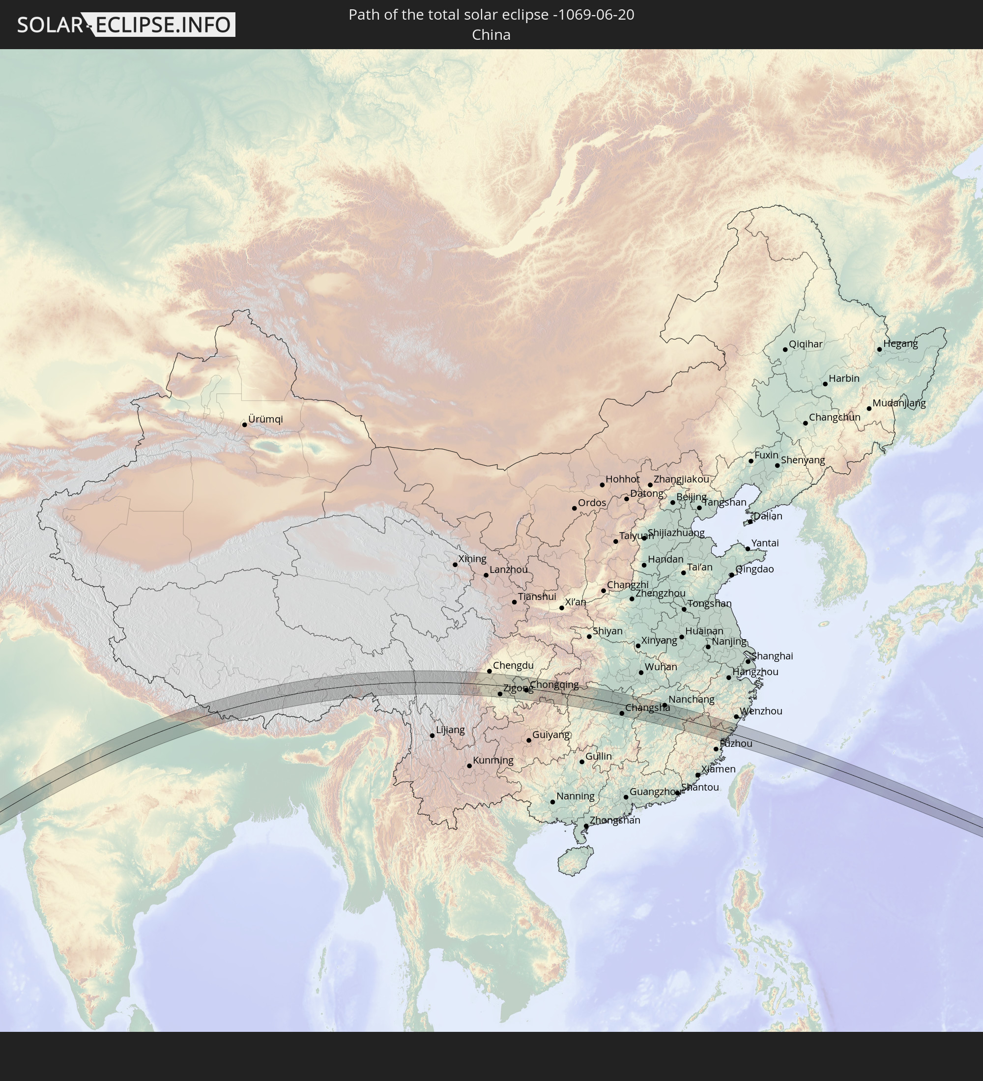
 Volksrepublik China
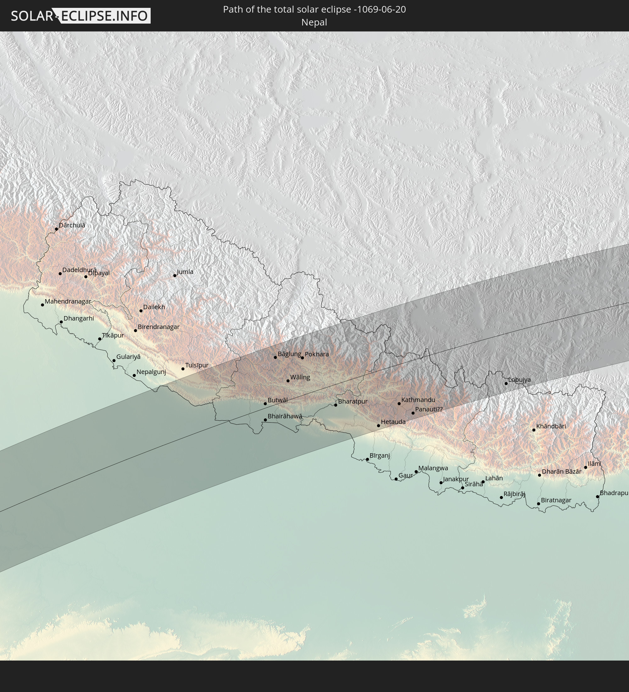
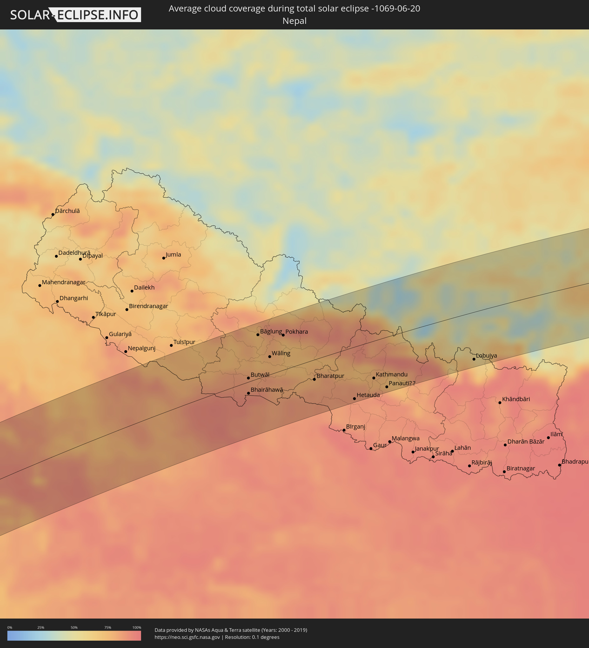 Nepal
Nepal
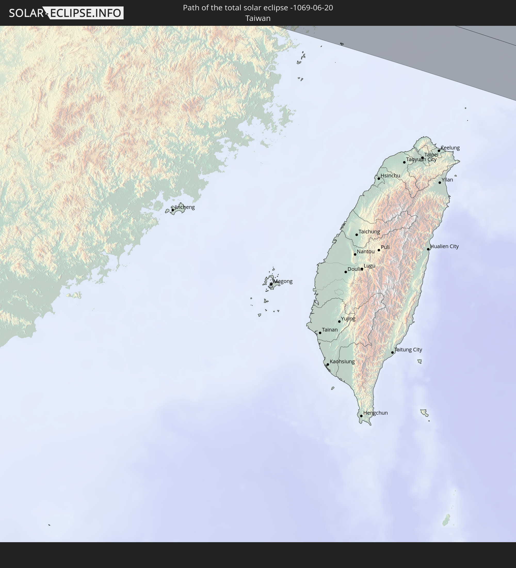
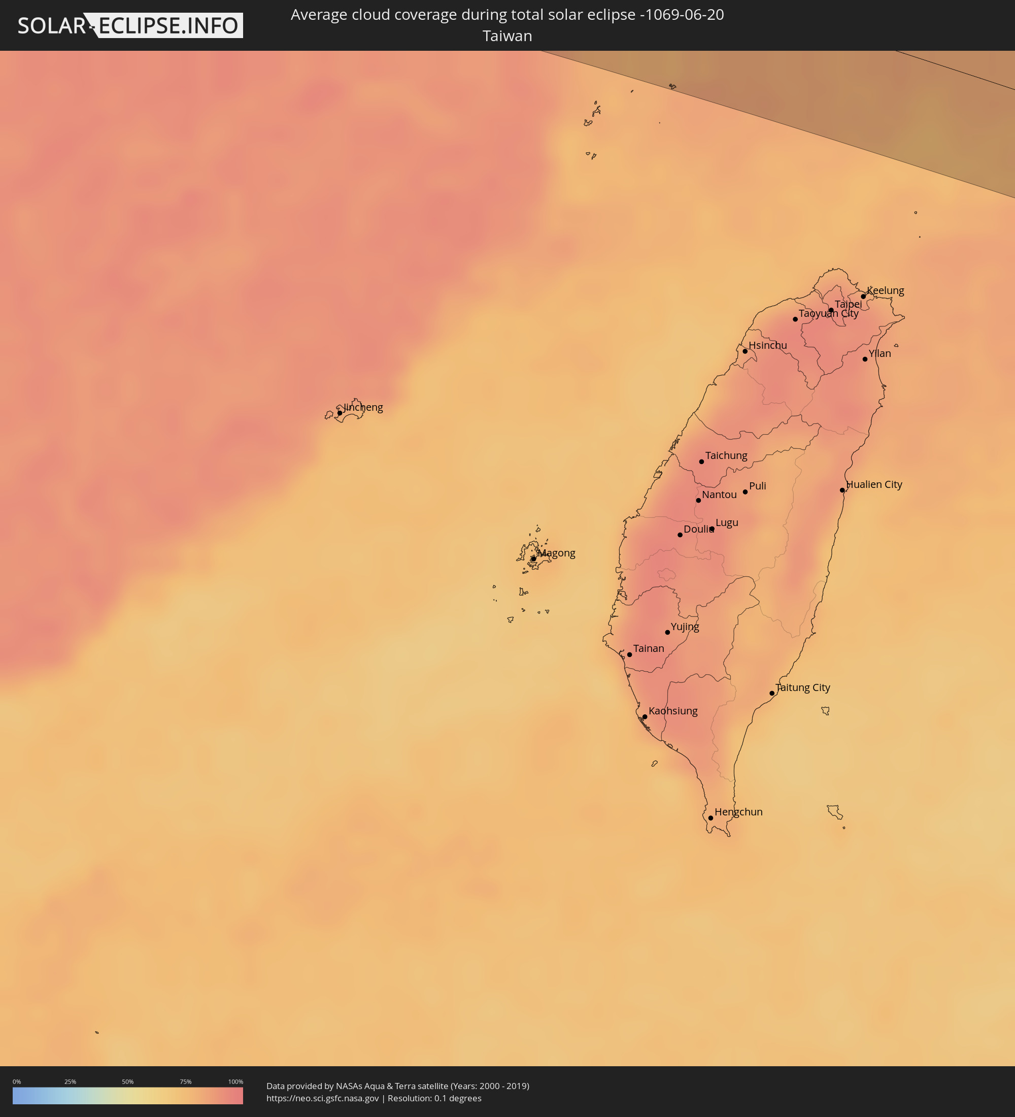 Taiwan
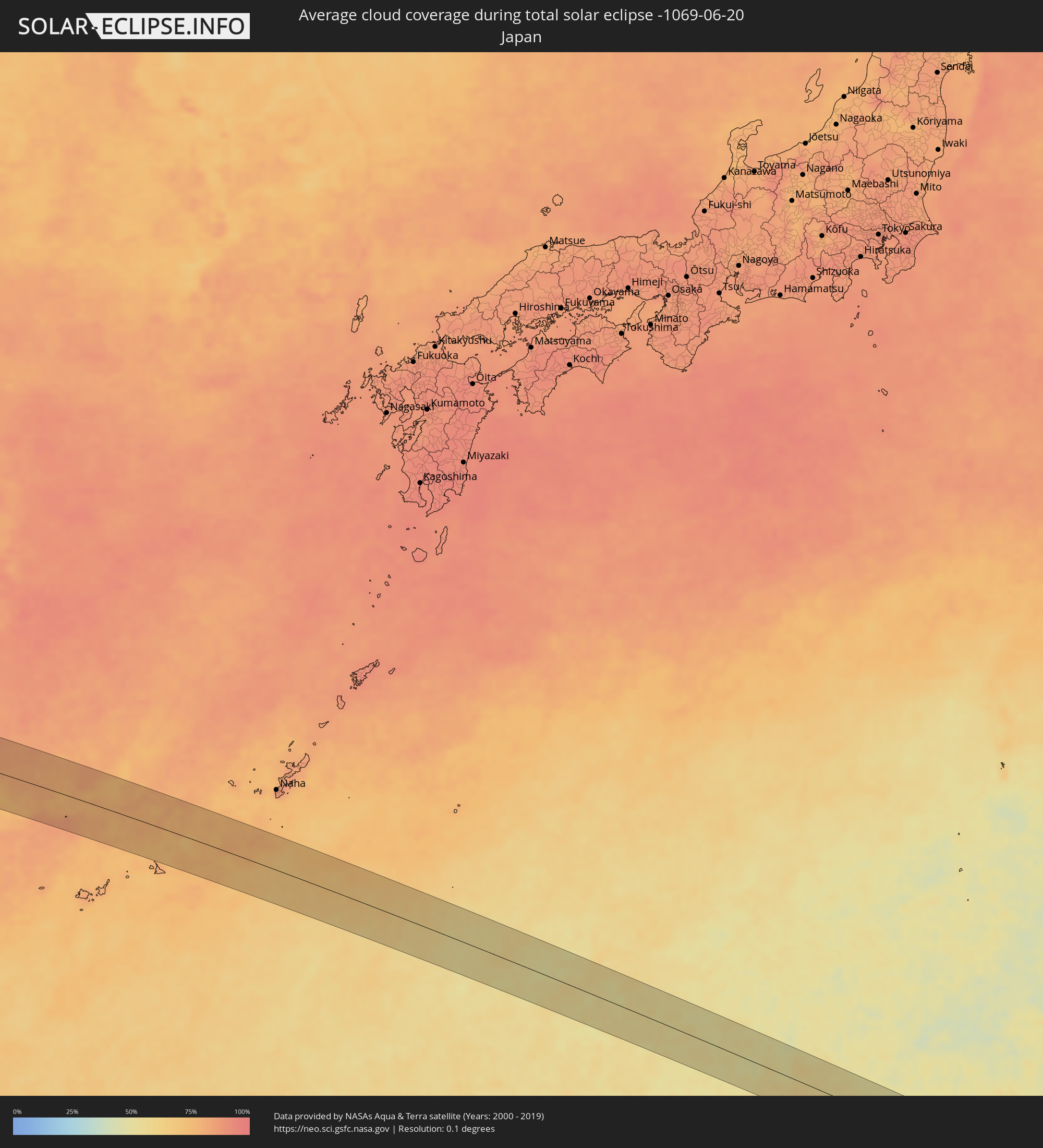 Japan
Japan
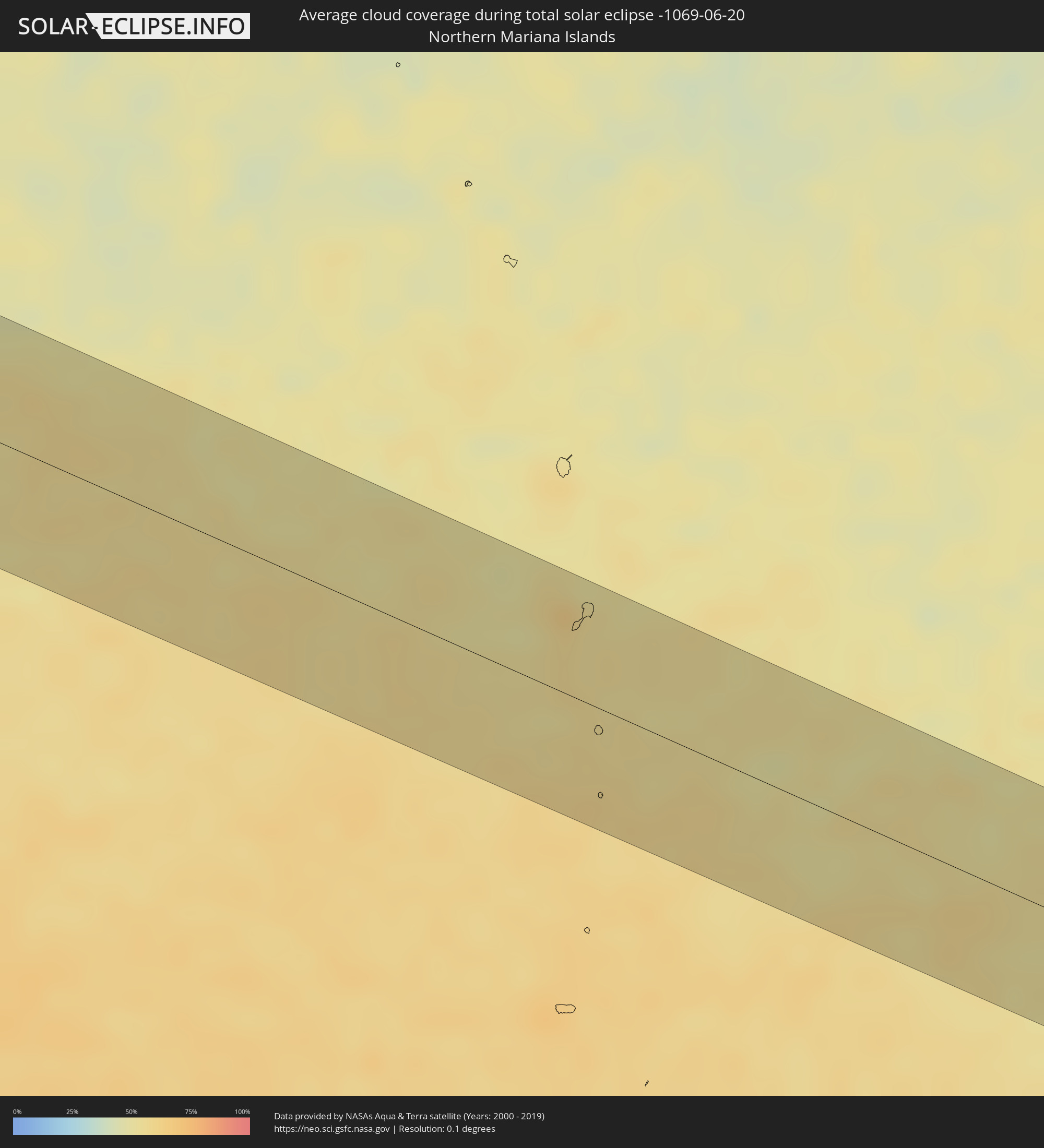 Nördliche Marianen
Orte im Finsternispfad
Die nachfolgene Tabelle zeigt Städte und Orte mit mehr als 5.000 Einwohnern, die sich im Finsternispfad befinden. Städte mit mehr als 100.000 Einwohnern sind dick gekennzeichnet. Mit einem Klick auf den Ort öffnet sich eine Detailkarte die die Lage des jeweiligen Ortes zusammen mit dem Verlauf der zentralen Finsternis präsentiert.
| Ort | Typ | Dauer der Verfinsterung | Ortszeit bei maximaler Verfinsterung | Entfernung zur Zentrallinie | Ø Bewölkung |
|
Mbuji-Mayi, Kasaï-Oriental
|
total | - | 06:41:54 UTC+02:10 | 31 km | 22% |
|
Gandajika, Kasaï-Oriental
|
total | - | 06:41:36 UTC+02:10 | 47 km | 18% |
|
Kabinda, Kasaï-Oriental
|
total | - | 06:41:46 UTC+02:10 | 9 km | 22% |
|
Lubao, Kasaï-Oriental
|
total | - | 06:41:57 UTC+02:10 | 9 km | 26% |
|
Kongolo, Katanga
|
total | - | 06:41:50 UTC+02:10 | 49 km | 25% |
|
Uvira, South Kivu
|
total | - | 06:42:47 UTC+02:10 | 49 km | 64% |
|
Bujumbura, Bujumbura Mairie
|
total | - | 06:42:48 UTC+02:10 | 40 km | 57% |
|
Rumonge, Rumonge
|
total | - | 06:42:28 UTC+02:10 | 23 km | 33% |
|
Isale, Bujumbura Rural
|
total | - | 06:42:49 UTC+02:10 | 37 km | 66% |
|
Muramvya, Muramvya
|
total | - | 06:42:51 UTC+02:10 | 39 km | 66% |
|
Bururi, Bururi
|
total | - | 06:42:29 UTC+02:10 | 30 km | 59% |
|
Mwaro, Mwaro
|
total | - | 06:42:43 UTC+02:10 | 10 km | 63% |
|
Gitega, Gitega
|
total | - | 06:42:46 UTC+02:10 | 8 km | 49% |
|
Rutana, Rutana
|
total | - | 06:42:30 UTC+02:10 | 46 km | 38% |
|
Karuzi, Karuzi
|
total | - | 06:42:58 UTC+02:10 | 29 km | 54% |
|
Ruyigi, Ruyigi
|
total | - | 06:42:45 UTC+02:10 | 13 km | 37% |
|
Muyinga, Muyinga
|
total | - | 06:43:07 UTC+02:10 | 45 km | 54% |
|
Mabamba, Kigoma
|
total | - | 06:59:37 UTC+02:27 | 38 km | 44% |
|
Bugarama, Kagera
|
total | - | 07:00:03 UTC+02:27 | 34 km | 53% |
|
Cankuzo, Cankuzo
|
total | - | 06:42:54 UTC+02:10 | 2 km | 40% |
|
Rulenge, Kagera
|
total | - | 07:00:08 UTC+02:27 | 44 km | 52% |
|
Kibondo, Kigoma
|
total | - | 06:59:38 UTC+02:27 | 47 km | 37% |
|
Kakonko, Kigoma
|
total | - | 06:59:49 UTC+02:27 | 29 km | 41% |
|
Biharamulo, Kagera
|
total | - | 07:00:13 UTC+02:27 | 18 km | 46% |
|
Chato, Geita
|
total | - | 07:00:15 UTC+02:27 | 5 km | 31% |
|
Buseresere, Geita
|
total | - | 07:00:02 UTC+02:27 | 49 km | 37% |
|
Katoro, Geita
|
total | - | 07:00:02 UTC+02:27 | 50 km | 37% |
|
Geita, Geita
|
total | - | 07:00:09 UTC+02:27 | 48 km | 36% |
|
Mwanza, Mwanza
|
total | - | 07:00:26 UTC+02:27 | 51 km | 33% |
|
Muriti, Mara
|
total | - | 07:00:46 UTC+02:27 | 1 km | 37% |
|
Nansio, Mara
|
total | - | 07:00:41 UTC+02:27 | 21 km | 30% |
|
Nakatunguru, Mara
|
total | - | 07:00:42 UTC+02:27 | 20 km | 30% |
|
Kibara, Mara
|
total | - | 07:00:44 UTC+02:27 | 43 km | 28% |
|
Mugango, Mara
|
total | - | 07:01:04 UTC+02:27 | 10 km | 47% |
|
Musoma, Mara
|
total | - | 07:01:12 UTC+02:27 | 3 km | 46% |
|
Bunda, Mara
|
total | - | 07:00:51 UTC+02:27 | 55 km | 45% |
|
Butiama, Mara
|
total | - | 07:01:03 UTC+02:27 | 32 km | 46% |
|
Nyamuswa, Mara
|
total | - | 07:00:58 UTC+02:27 | 48 km | 42% |
|
Tarime, Mara
|
total | - | 07:01:23 UTC+02:27 | 12 km | 47% |
|
Migori, Migori
|
total | - | 07:01:36 UTC+02:27 | 11 km | 56% |
|
Sirari, Mara
|
total | - | 07:01:28 UTC+02:27 | 8 km | 54% |
|
Kihancha, Migori
|
total | - | 07:01:32 UTC+02:27 | 9 km | 55% |
|
Oyugis, Homa Bay
|
total | - | 07:02:02 UTC+02:27 | 51 km | 58% |
|
Kisii, Kisii
|
total | - | 07:01:55 UTC+02:27 | 33 km | 65% |
|
Nyamira, Nyamira
|
total | - | 07:01:58 UTC+02:27 | 25 km | 60% |
|
Kericho, Kericho
|
total | - | 07:02:14 UTC+02:27 | 36 km | 75% |
|
Bomet, Bomet
|
total | - | 07:01:57 UTC+02:27 | 8 km | 57% |
|
Eldama Ravine, Baringo
|
total | - | 07:02:38 UTC+02:27 | 53 km | 64% |
|
Molo, Nakuru
|
total | - | 07:02:25 UTC+02:27 | 23 km | 68% |
|
Rongai, Nakuru
|
total | - | 07:02:30 UTC+02:27 | 24 km | 51% |
|
Nakuru, Nakuru
|
total | - | 07:02:28 UTC+02:27 | 2 km | 49% |
|
Nyahururu, Laikipia
|
total | - | 07:02:46 UTC+02:27 | 18 km | 61% |
|
Ol Kalou, Nyandarua
|
total | - | 07:02:32 UTC+02:27 | 13 km | 67% |
|
Naro Moru, Laikipia
|
total | - | 07:02:46 UTC+02:27 | 38 km | 61% |
|
Nanyuki, Laikipia
|
total | - | 07:02:55 UTC+02:27 | 23 km | 64% |
|
Isiolo, Isiolo
|
total | - | 07:03:19 UTC+02:27 | 18 km | 34% |
|
Meru, Meru
|
total | - | 07:03:06 UTC+02:27 | 52 km | 73% |
|
Maua, Isiolo
|
total | - | 07:03:20 UTC+02:27 | 49 km | 77% |
|
Wajir, Wajir
|
total | - | 07:05:15 UTC+02:27 | 21 km | 82% |
|
Garbahaarrey, Gedo
|
total | - | 07:07:34 UTC+02:27 | 6 km | 79% |
|
Luuq, Gedo
|
total | - | 07:08:10 UTC+02:27 | 33 km | 84% |
|
Waajid, Bakool
|
total | - | 07:08:31 UTC+02:27 | 8 km | 86% |
|
Xuddur, Bakool
|
total | - | 07:09:10 UTC+02:27 | 16 km | 84% |
|
Beledweyne, Hiiraan
|
total | - | 07:10:31 UTC+02:27 | 36 km | 76% |
|
Dhuusamarreeb, Galguduud
|
total | - | 07:12:05 UTC+02:27 | 32 km | 64% |
|
Gaalkacyo, Mudug
|
total | - | 07:14:08 UTC+02:27 | 20 km | 57% |
|
Eyl, Nugaal
|
total | - | 07:17:23 UTC+02:27 | 15 km | 42% |
|
Bandarbeyla, Bari
|
total | - | 07:20:04 UTC+02:27 | 63 km | 47% |
|
Porbandar, Gujarat
|
total | - | 10:59:23 UTC+05:21 | 24 km | 80% |
|
Jūnāgadh, Gujarat
|
total | - | 11:00:57 UTC+05:21 | 34 km | 87% |
|
Jetpur, Gujarat
|
total | - | 11:01:40 UTC+05:21 | 21 km | 81% |
|
Rājkot, Gujarat
|
total | - | 11:02:51 UTC+05:21 | 21 km | 73% |
|
Surendranagar, Gujarat
|
total | - | 11:05:21 UTC+05:21 | 17 km | 70% |
|
Ahmedabad, Gujarat
|
total | - | 11:07:51 UTC+05:21 | 3 km | 78% |
|
Ghandinagar, Gujarat
|
total | - | 11:08:21 UTC+05:21 | 10 km | 81% |
|
Nadiād, Gujarat
|
total | - | 11:07:58 UTC+05:21 | 49 km | 83% |
|
Ānand, Gujarat
|
total | - | 11:07:58 UTC+05:21 | 68 km | 85% |
|
Mandsaur, Madhya Pradesh
|
total | - | 11:15:03 UTC+05:21 | 25 km | 65% |
|
Kota, Rajasthan
|
total | - | 11:18:26 UTC+05:21 | 49 km | 59% |
|
Guna, Madhya Pradesh
|
total | - | 11:21:14 UTC+05:21 | 71 km | 70% |
|
Shivpuri, Madhya Pradesh
|
total | - | 11:23:08 UTC+05:21 | 9 km | 67% |
|
Gwalior, Madhya Pradesh
|
total | - | 11:25:26 UTC+05:21 | 50 km | 59% |
|
Jhānsi, Uttar Pradesh
|
total | - | 11:25:26 UTC+05:21 | 45 km | 65% |
|
Bhind, Madhya Pradesh
|
total | - | 11:27:21 UTC+05:21 | 59 km | 71% |
|
Etāwah, Uttar Pradesh
|
total | - | 11:28:12 UTC+05:21 | 71 km | 73% |
|
Orai, Uttar Pradesh
|
total | - | 11:28:18 UTC+05:21 | 27 km | 81% |
|
Kanpur, Uttar Pradesh
|
total | - | 11:31:07 UTC+05:21 | 13 km | 76% |
|
Unnāo, Uttar Pradesh
|
total | - | 11:31:34 UTC+05:21 | 10 km | 89% |
|
Lucknow, Uttar Pradesh
|
total | - | 11:33:01 UTC+05:21 | 3 km | 79% |
|
Raebareli, Uttar Pradesh
|
total | - | 11:33:06 UTC+05:21 | 71 km | 87% |
|
Bahraigh, Uttar Pradesh
|
total | - | 11:35:32 UTC+05:21 | 55 km | 83% |
|
Gondā City, Uttar Pradesh
|
total | - | 11:35:58 UTC+05:21 | 4 km | 83% |
|
Fyzābād, Uttar Pradesh
|
total | - | 11:36:05 UTC+05:21 | 48 km | 78% |
|
Butwāl, Western Region
|
total | - | 12:00:30 UTC+05:41 | 5 km | 87% |
|
Bhairāhawā, Western Region
|
total | - | 12:00:18 UTC+05:41 | 16 km | 92% |
|
Tānsen, Western Region
|
total | - | 12:00:55 UTC+05:41 | 19 km | 81% |
|
Bāglung, Western Region
|
total | - | 12:01:25 UTC+05:41 | 61 km | 74% |
|
Wāling, Western Region
|
total | - | 12:01:35 UTC+05:41 | 25 km | 76% |
|
Bhattarai Danda, Western Region
|
total | - | 12:01:55 UTC+05:41 | 9 km | 76% |
|
Pokhara, Western Region
|
total | - | 12:02:23 UTC+05:41 | 48 km | 76% |
|
Bharatpur, Central Region
|
total | - | 12:03:02 UTC+05:41 | 28 km | 80% |
|
Hetauda, Central Region
|
total | - | 12:04:22 UTC+05:41 | 73 km | 88% |
|
Kirtipur, Central Region
|
total | - | 12:05:14 UTC+05:41 | 54 km | 78% |
|
Pātan, Central Region
|
total | - | 12:05:20 UTC+05:41 | 55 km | 78% |
|
Kathmandu, Central Region
|
total | - | 12:05:22 UTC+05:41 | 52 km | 78% |
|
Hari Bdr Tamang House, Central Region
|
total | - | 12:05:40 UTC+05:41 | 64 km | 85% |
|
kankrabari Dovan, Central Region
|
total | - | 12:05:40 UTC+05:41 | 64 km | 85% |
|
Panauti̇̄, Central Region
|
total | - | 12:05:46 UTC+05:41 | 70 km | 85% |
|
Banepā, Central Region
|
total | - | 12:05:50 UTC+05:41 | 66 km | 85% |
|
Lobujya, Eastern Region
|
total | - | 12:09:31 UTC+05:41 | 67 km | 70% |
|
Rikaze, Tibet Autonomous Region
|
total | - | 14:34:33 UTC+08:00 | 25 km | 40% |
|
Lhasa, Tibet Autonomous Region
|
total | - | 14:40:26 UTC+08:00 | 26 km | 56% |
|
Kangding, Sichuan
|
total | - | 15:06:38 UTC+08:00 | 3 km | 87% |
|
Leshan, Sichuan
|
total | - | 15:10:40 UTC+08:00 | 41 km | 92% |
|
Yanjiang, Sichuan
|
total | - | 15:12:21 UTC+08:00 | 28 km | 92% |
|
Zigong, Sichuan
|
total | - | 15:12:53 UTC+08:00 | 57 km | 91% |
|
Neijiang, Sichuan
|
total | - | 15:13:24 UTC+08:00 | 28 km | 93% |
|
Yongchuan, Chongqing
|
total | - | 15:15:11 UTC+08:00 | 45 km | 93% |
|
Hechuan, Chongqing
|
total | - | 15:15:40 UTC+08:00 | 29 km | 92% |
|
Beibei, Chongqing
|
total | - | 15:16:05 UTC+08:00 | 13 km | 93% |
|
Yudong, Chongqing
|
total | - | 15:16:26 UTC+08:00 | 35 km | 92% |
|
Chongqing, Chongqing
|
total | - | 15:16:25 UTC+08:00 | 15 km | 91% |
|
Fuling, Chongqing
|
total | - | 15:18:00 UTC+08:00 | 11 km | 86% |
|
Zhangjiajie, Hunan
|
total | - | 15:24:01 UTC+08:00 | 6 km | 91% |
|
Changde, Hunan
|
total | - | 15:26:09 UTC+08:00 | 7 km | 87% |
|
Jinshi, Hunan
|
total | - | 15:26:08 UTC+08:00 | 72 km | 87% |
|
Yiyang, Hunan
|
total | - | 15:27:32 UTC+08:00 | 30 km | 91% |
|
Changsha, Hunan
|
total | - | 15:28:50 UTC+08:00 | 60 km | 93% |
|
Yueyang, Hunan
|
total | - | 15:28:17 UTC+08:00 | 71 km | 85% |
|
Guankou, Hunan
|
total | - | 15:29:56 UTC+08:00 | 50 km | 93% |
|
Yichun, Jiangxi
|
total | - | 15:31:23 UTC+08:00 | 68 km | 92% |
|
Xinyu, Jiangxi
|
total | - | 15:32:13 UTC+08:00 | 59 km | 91% |
|
Nanchang, Jiangxi
|
total | - | 15:33:00 UTC+08:00 | 58 km | 91% |
|
Shaowu, Fujian
|
total | - | 15:36:17 UTC+08:00 | 46 km | 91% |
|
Jinxiang, Zhejiang
|
total | - | 15:40:17 UTC+08:00 | 50 km | 85% |