Totale Sonnenfinsternis vom 09.07.-1079
| Wochentag: | Montag |
| Maximale Dauer der Verfinsterung: | 06m36s |
| Maximale Breite des Finsternispfades: | 304 km |
| Saroszyklus: | 48 |
| Bedeckungsgrad: | 100% |
| Magnitude: | 1.0723 |
| Gamma: | -0.6363 |
Wo kann man die Sonnenfinsternis vom 09.07.-1079 sehen?
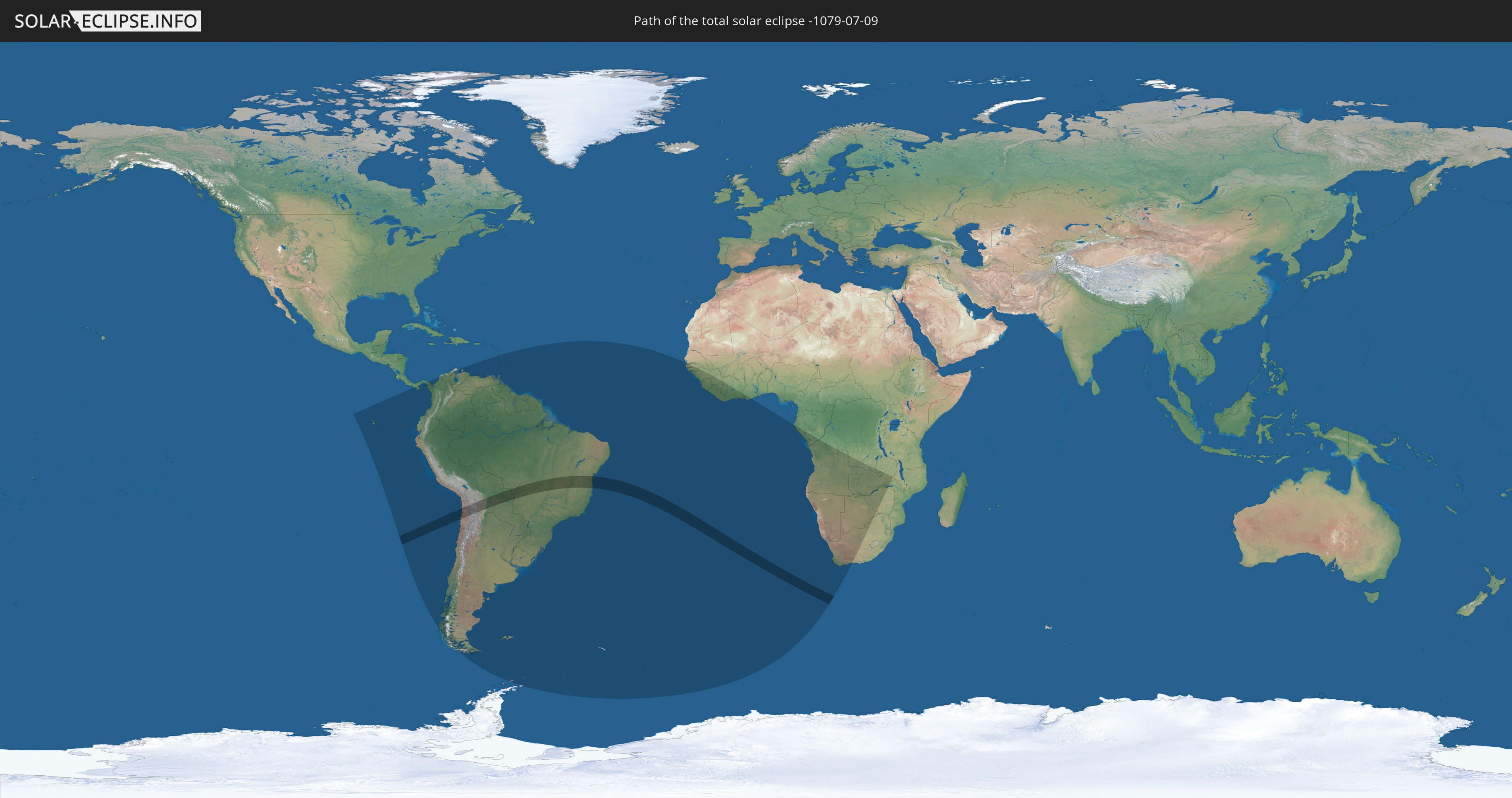
Die Sonnenfinsternis am 09.07.-1079 kann man in 48 Ländern als partielle Sonnenfinsternis beobachten.
Der Finsternispfad verläuft durch 5 Länder. Nur in diesen Ländern ist sie als totale Sonnenfinsternis zu sehen.
In den folgenden Ländern ist die Sonnenfinsternis total zu sehen
 Chile
Chile
 Brasilien
 Argentinien
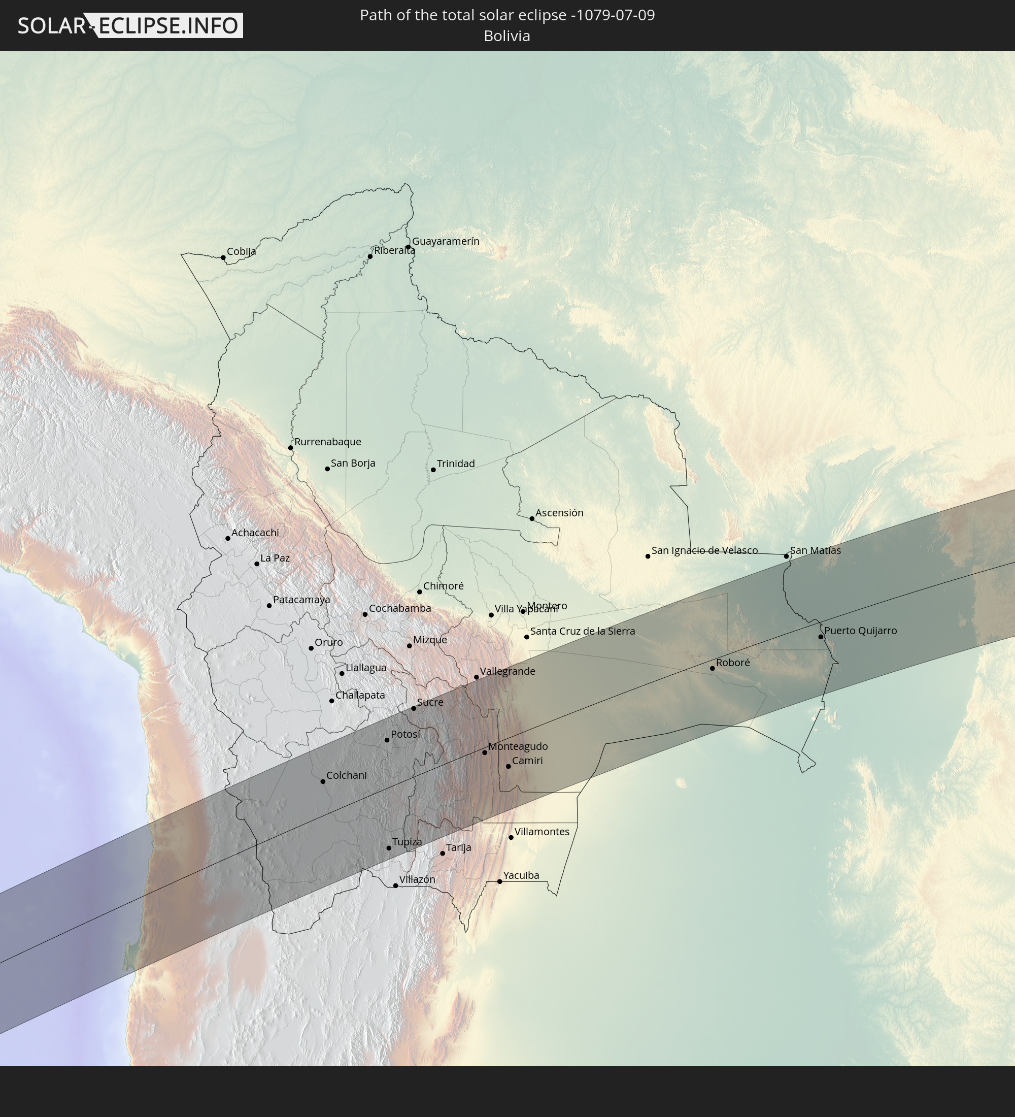 Bolivien
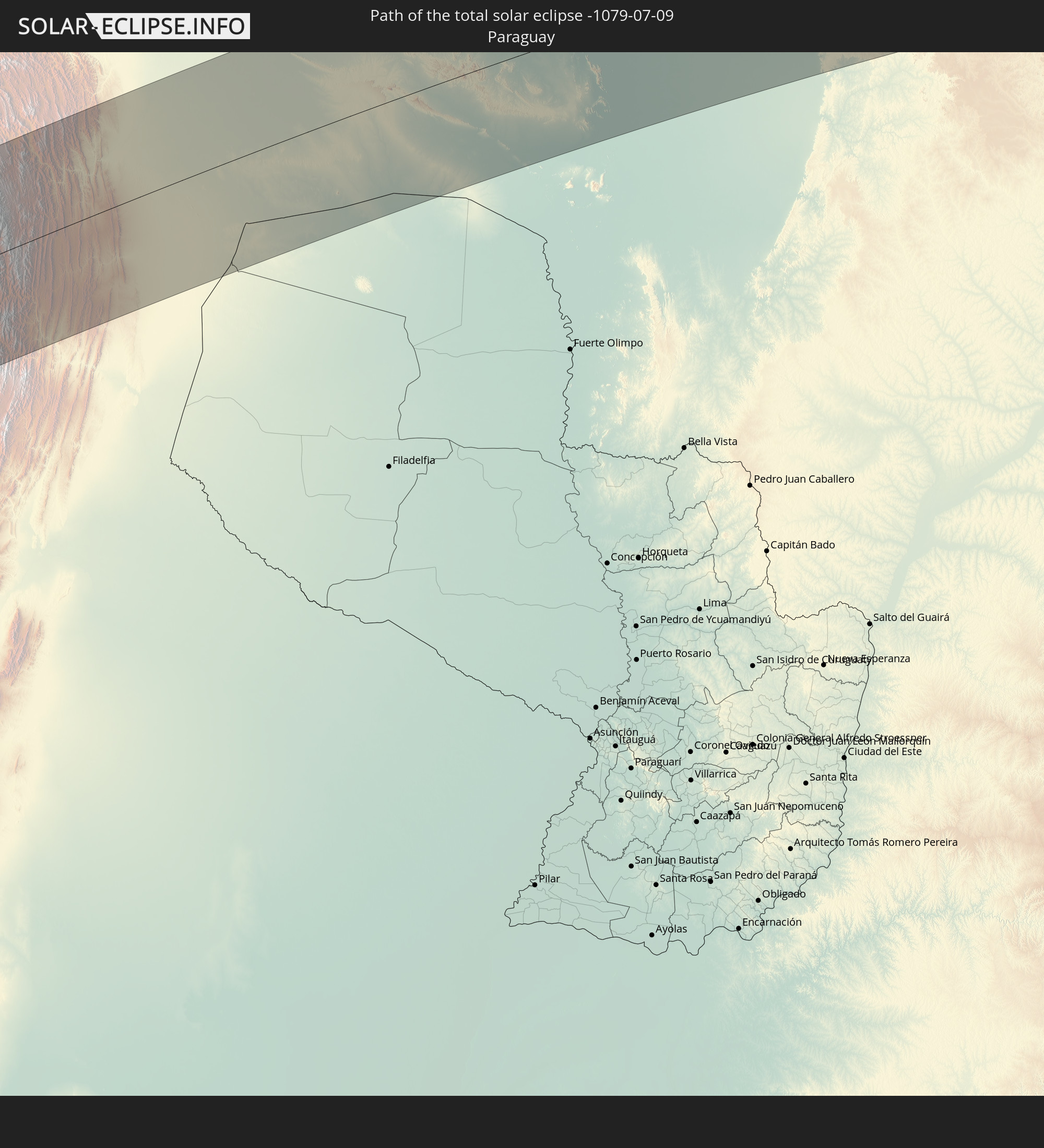 Paraguay
In den folgenden Ländern ist die Sonnenfinsternis partiell zu sehen
 Antarktika
 Chile
Chile
 Ecuador
 Panama
 Kolumbien
 Peru
Peru
 Brasilien
 Argentinien
 Venezuela
 Aruba
Aruba
 Bolivien
 Paraguay
 Trinidad und Tobago
 Grenada
 Dominica
 St. Vincent und die Grenadinen
 Falklandinseln
 Guyana
 Martinique
 St. Lucia
 Barbados
 Uruguay
 Suriname
 Französisch-Guayana
 Südgeorgien und die Südlichen Sandwichinseln
 Kap Verde
 Senegal
 Gambia
 Guinea-Bissau
 Guinea
 St. Helena
 Sierra Leone
 Liberia
 Elfenbeinküste
 Ghana
Ghana
 Bouvetinsel
 Äquatorialguinea
 São Tomé und Príncipe
 Gabun
Gabun
 Republik Kongo
 Angola
 Namibia
 Demokratische Republik Kongo
 Südafrika
 Botswana
 Sambia
 Simbabwe
 Mosambik
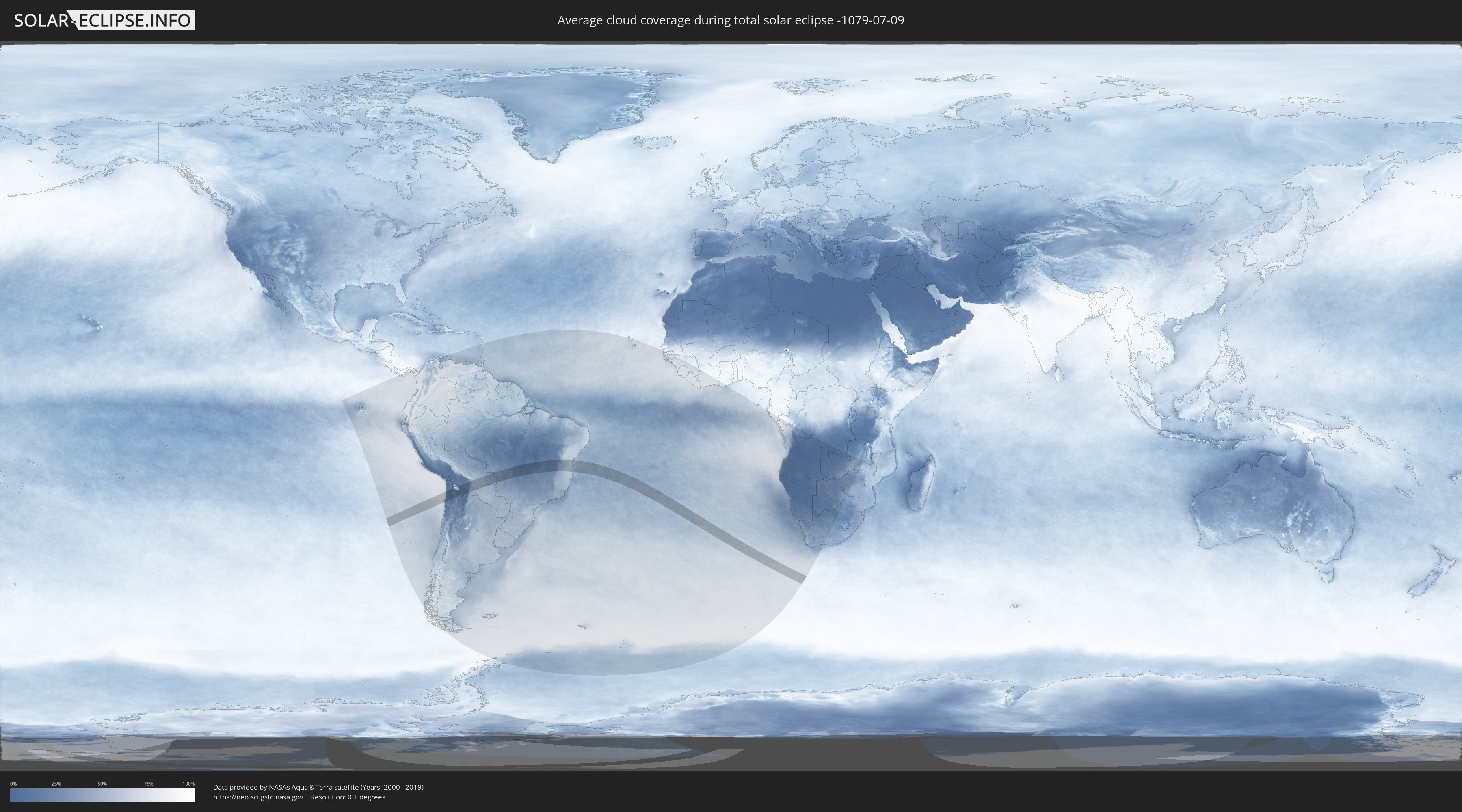
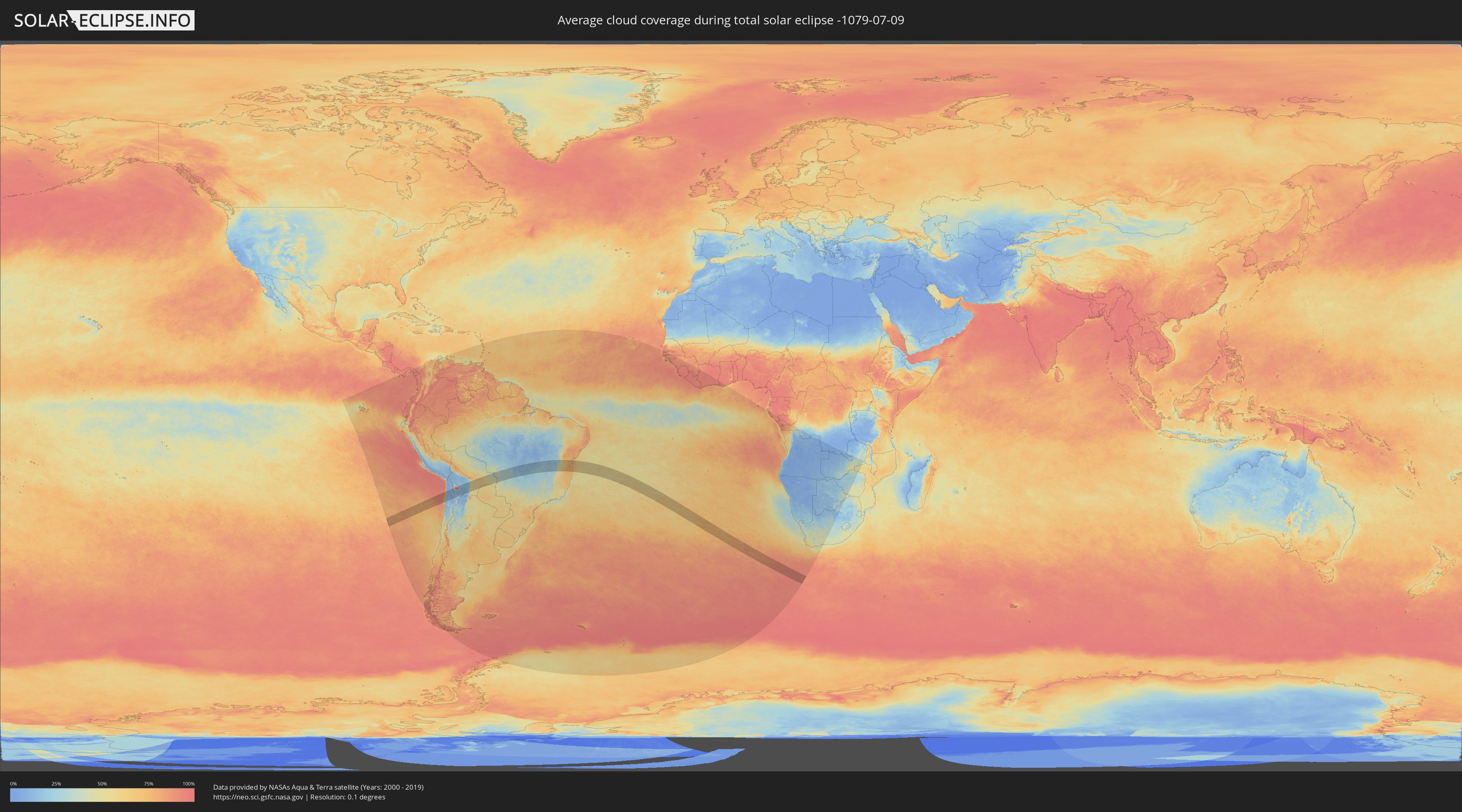
Wie wird das Wetter während der totalen Sonnenfinsternis am 09.07.-1079?
Wo ist der beste Ort, um die totale Sonnenfinsternis vom 09.07.-1079 zu beobachten?
Die folgenden Karten zeigen die durchschnittliche Bewölkung für den Tag, an dem die totale Sonnenfinsternis
stattfindet. Mit Hilfe der Karten lässt sich der Ort entlang des Finsternispfades eingrenzen,
der die besten Aussichen auf einen klaren wolkenfreien Himmel bietet.
Trotzdem muss man immer lokale Gegenenheiten beachten und sollte sich genau über das Wetter an seinem
gewählten Beobachtungsort informieren.
Die Daten stammen von den beiden NASA-Satelliten
AQUA und TERRA
und wurden über einen Zeitraum von 19 Jahren (2000 - 2019) gemittelt.
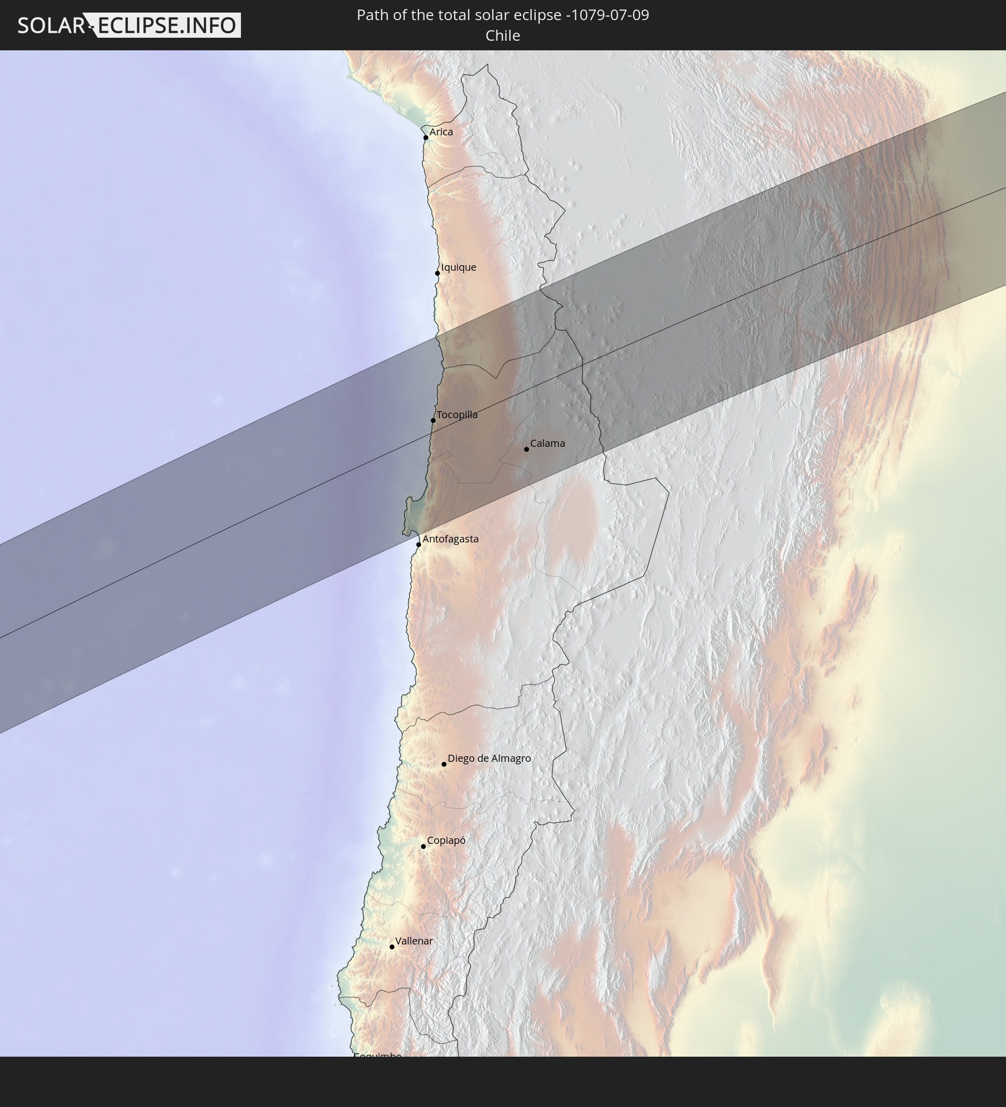
Detaillierte Länderkarten
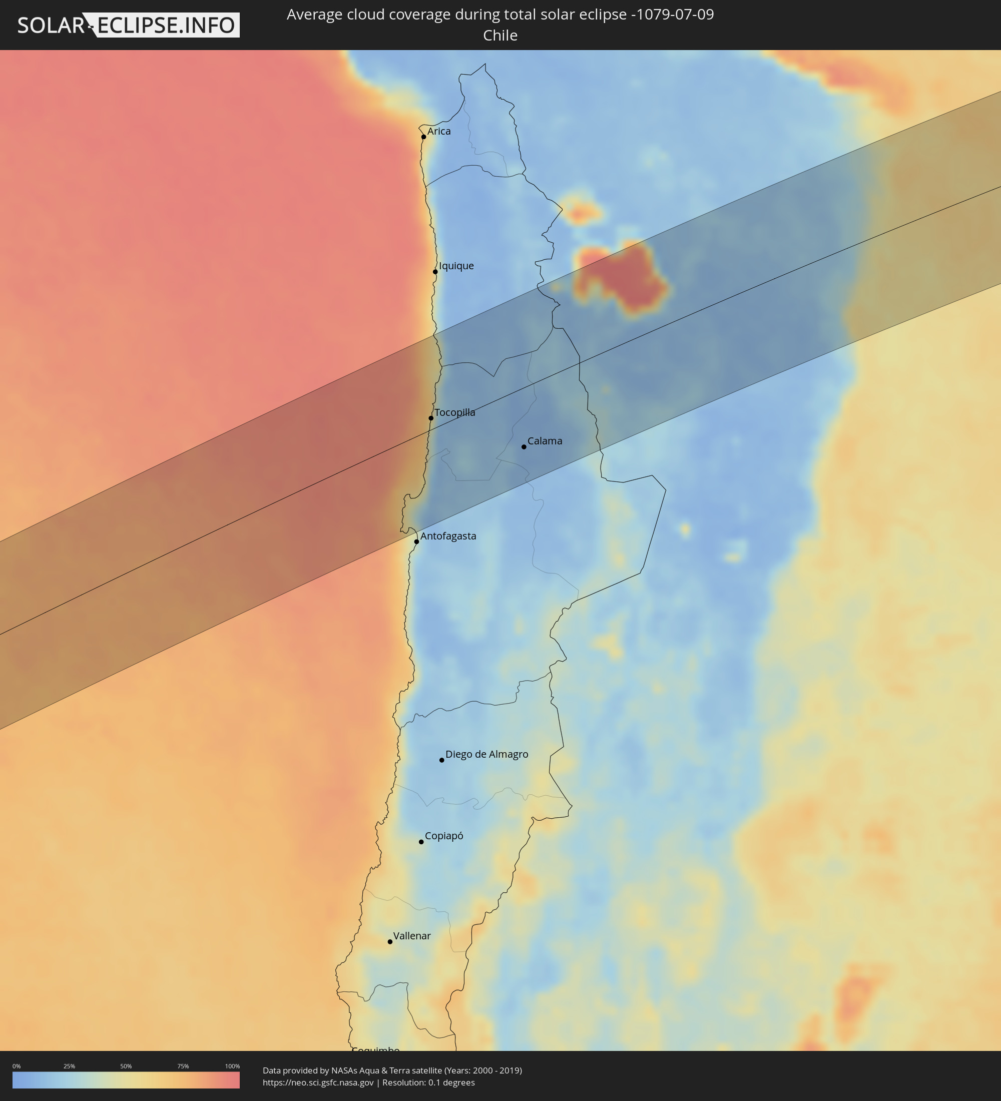 Chile
Chile
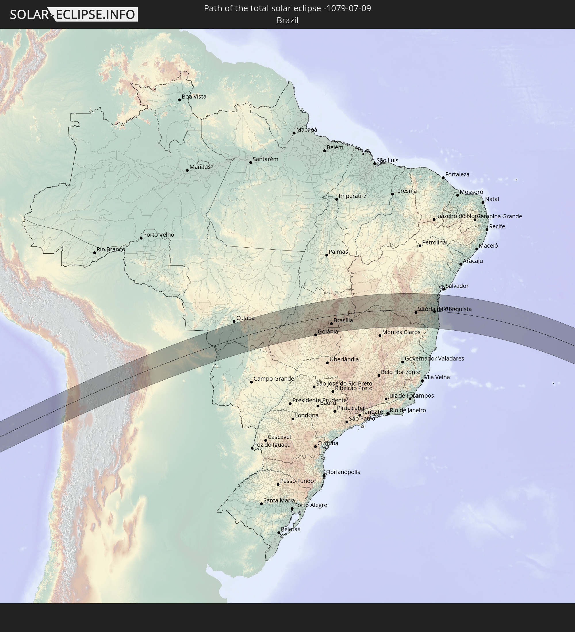
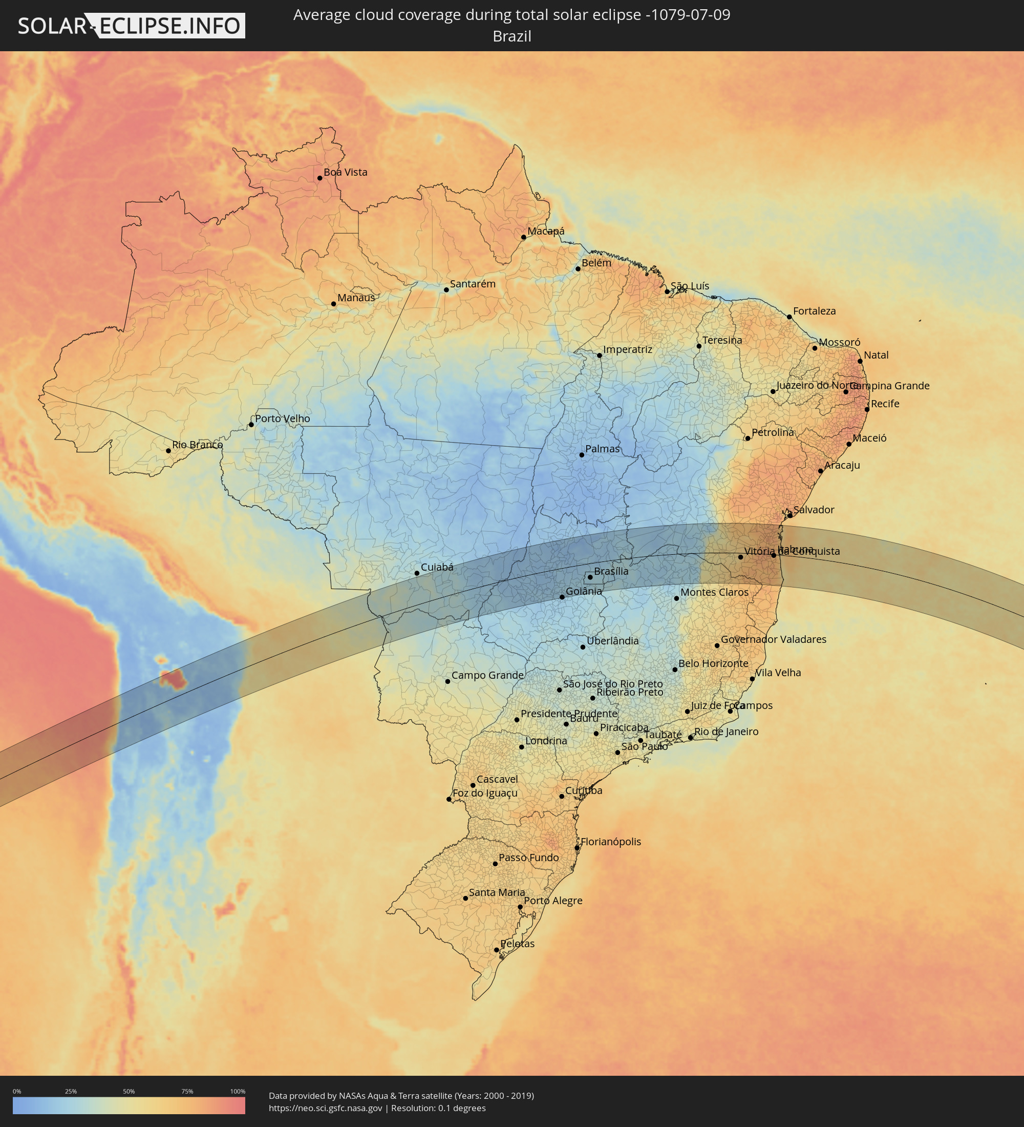 Brasilien
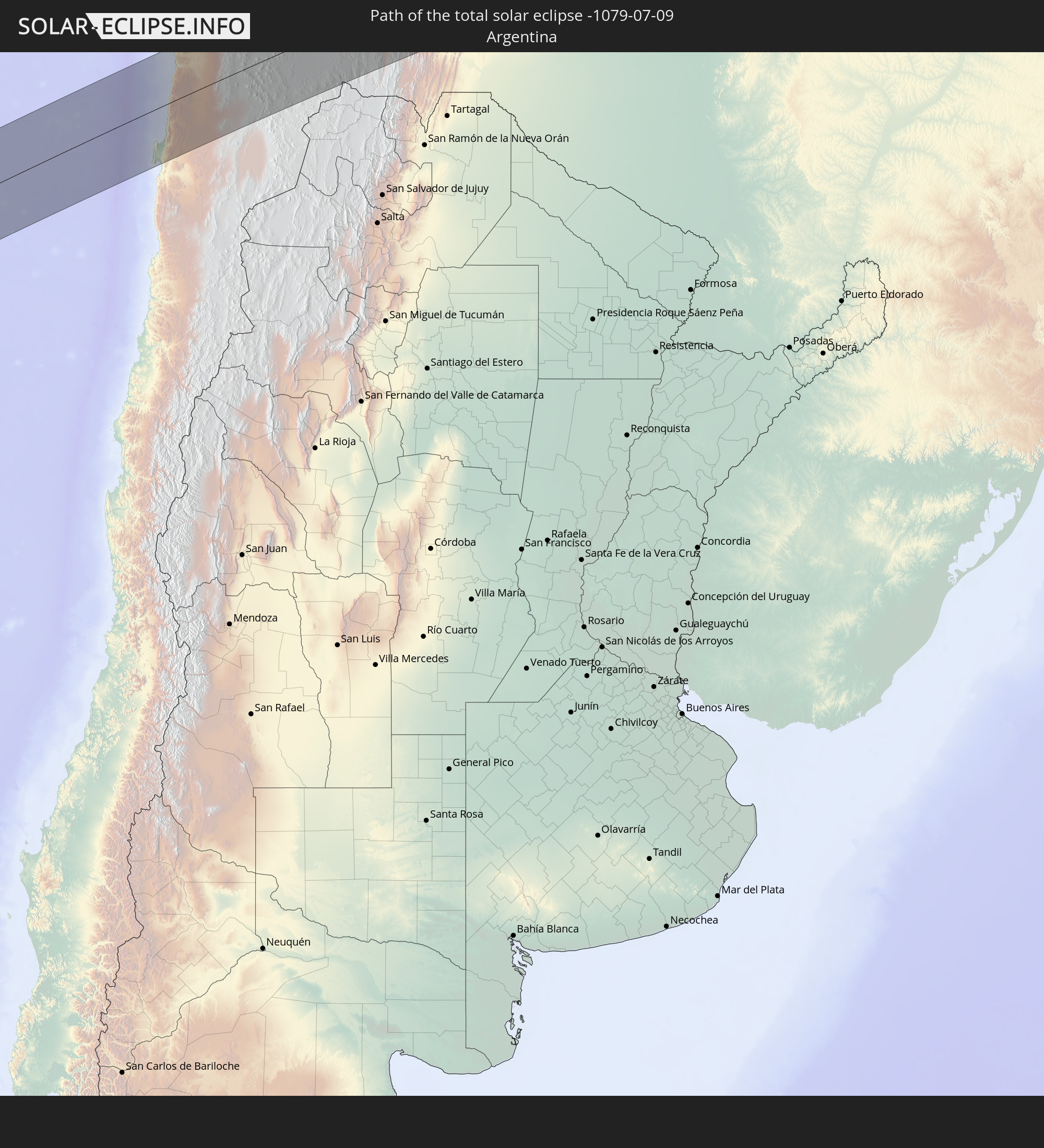
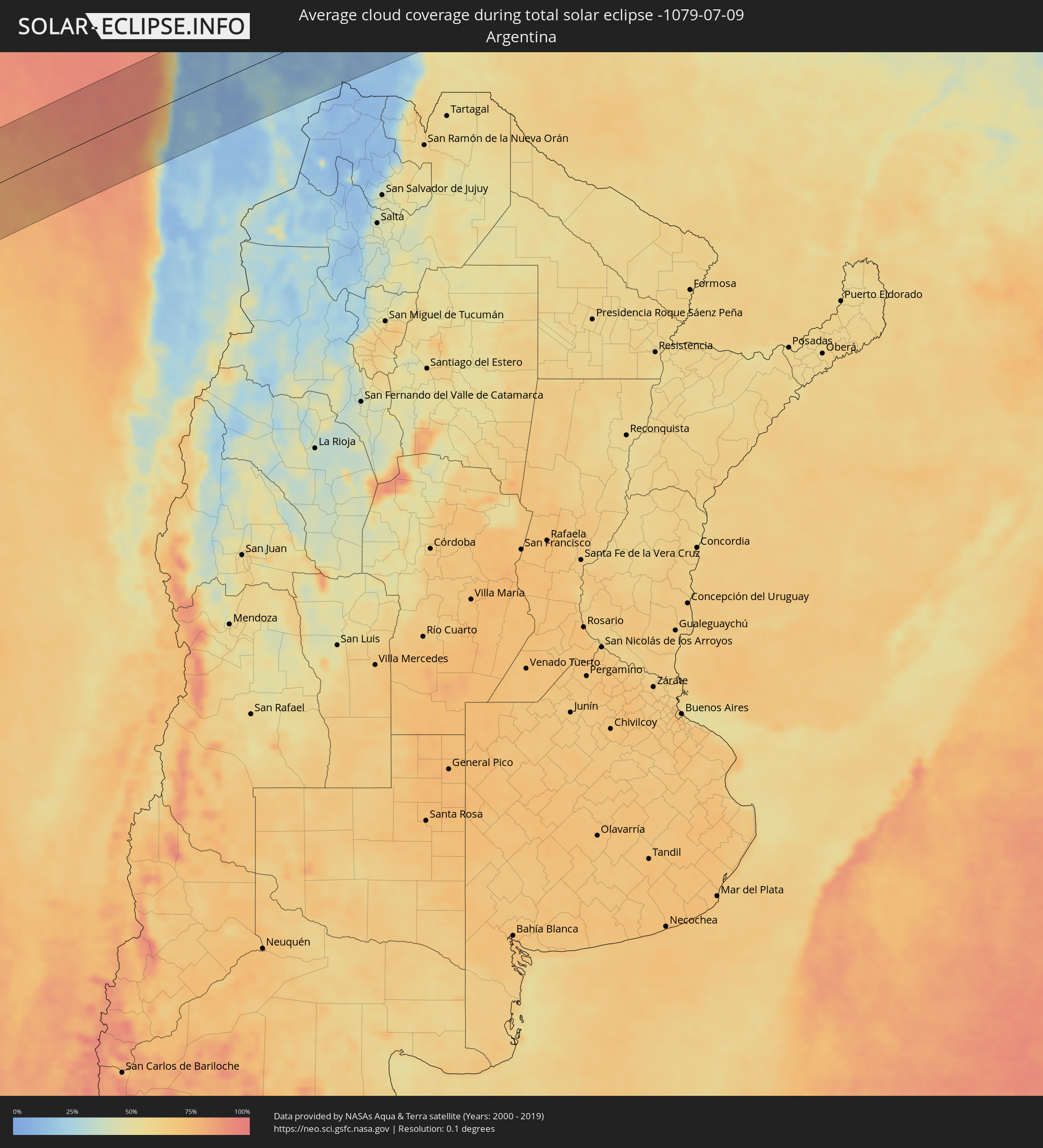 Argentinien
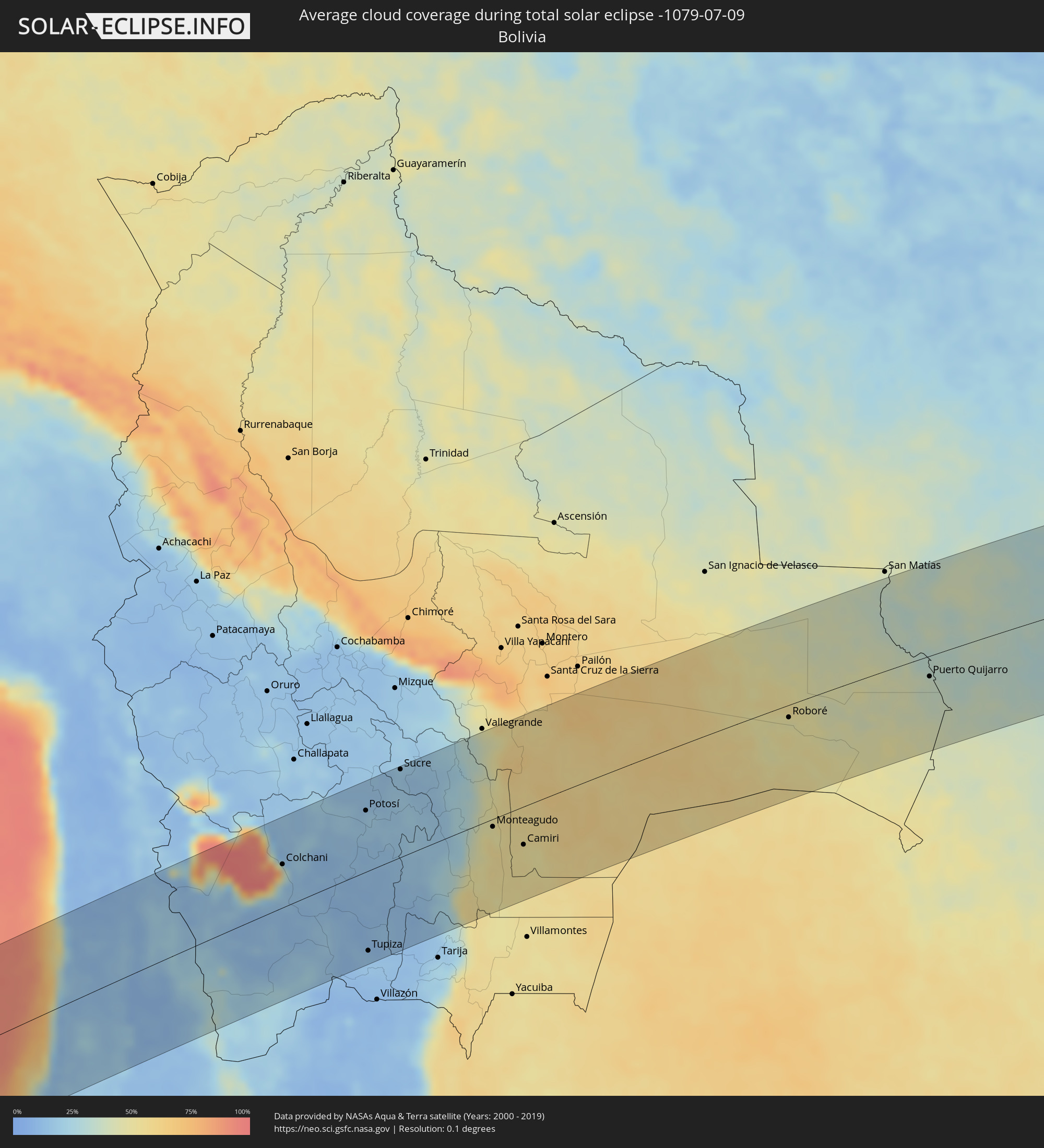 Bolivien
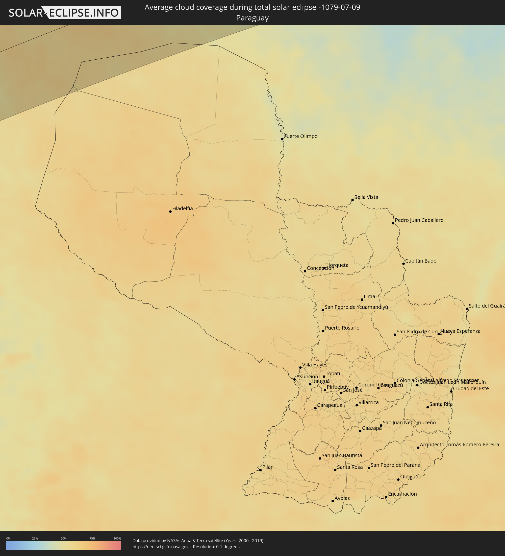 Paraguay
Orte im Finsternispfad
Die nachfolgene Tabelle zeigt Städte und Orte mit mehr als 5.000 Einwohnern, die sich im Finsternispfad befinden. Städte mit mehr als 100.000 Einwohnern sind dick gekennzeichnet. Mit einem Klick auf den Ort öffnet sich eine Detailkarte die die Lage des jeweiligen Ortes zusammen mit dem Verlauf der zentralen Finsternis präsentiert.
| Ort | Typ | Dauer der Verfinsterung | Ortszeit bei maximaler Verfinsterung | Entfernung zur Zentrallinie | Ø Bewölkung |
|
Tocopilla, Antofagasta
|
total | - | 07:53:00 UTC-04:42 | 14 km | 47% |
|
Calama, Antofagasta
|
total | - | 07:54:38 UTC-04:42 | 78 km | 10% |
|
Colchani, Potosí
|
total | - | 08:05:34 UTC-04:32 | 59 km | 35% |
|
Uyuni, Potosí
|
total | - | 08:05:49 UTC-04:32 | 38 km | 14% |
|
Potosí, Potosí
|
total | - | 08:06:34 UTC-04:32 | 84 km | 17% |
|
Tupiza, Potosí
|
total | - | 08:07:54 UTC-04:32 | 108 km | 13% |
|
Sucre, Chuquisaca
|
total | - | 08:06:51 UTC-04:32 | 120 km | 18% |
|
Monteagudo, Chuquisaca
|
total | - | 08:09:07 UTC-04:32 | 11 km | 50% |
|
Camiri, Santa Cruz
|
total | - | 08:09:54 UTC-04:32 | 52 km | 52% |
|
Roboré, Santa Cruz
|
total | - | 08:14:34 UTC-04:32 | 17 km | 48% |
|
Puerto Quijarro, Santa Cruz
|
total | - | 08:17:41 UTC-04:32 | 29 km | 38% |
|
Poconé, Mato Grosso
|
total | - | 09:13:01 UTC-03:38 | 95 km | 35% |
|
Lucas, Mato Grosso
|
total | - | 09:14:22 UTC-03:38 | 65 km | 29% |
|
Jaciara, Mato Grosso
|
total | - | 09:16:03 UTC-03:38 | 75 km | 26% |
|
Rondonópolis, Mato Grosso
|
total | - | 09:17:00 UTC-03:38 | 11 km | 31% |
|
Barra do Garças, Mato Grosso
|
total | - | 09:21:40 UTC-03:38 | 8 km | 16% |
|
Aragarças, Goiás
|
total | - | 09:21:41 UTC-03:38 | 7 km | 16% |
|
Iporá, Goiás
|
total | - | 09:56:32 UTC-03:06 | 80 km | 18% |
|
São Luís de Montes Belos, Goiás
|
total | - | 09:58:17 UTC-03:06 | 106 km | 22% |
|
Goiás, Goiás
|
total | - | 09:58:29 UTC-03:06 | 47 km | 17% |
|
Anicuns, Goiás
|
total | - | 09:59:13 UTC-03:06 | 108 km | 19% |
|
Itapuranga, Goiás
|
total | - | 09:58:42 UTC-03:06 | 11 km | 14% |
|
Itaberaí, Goiás
|
total | - | 09:59:18 UTC-03:06 | 63 km | 17% |
|
Rubiataba, Goiás
|
total | - | 09:58:49 UTC-03:06 | 30 km | 16% |
|
Ceres, Goiás
|
total | - | 09:59:23 UTC-03:06 | 10 km | 19% |
|
Itapaci, Goiás
|
total | - | 09:59:18 UTC-03:06 | 48 km | 16% |
|
Inhumas, Goiás
|
total | - | 10:00:15 UTC-03:06 | 107 km | 19% |
|
Trindade, Goiás
|
total | - | 10:00:27 UTC-03:06 | 139 km | 21% |
|
Goianira, Goiás
|
total | - | 10:00:30 UTC-03:06 | 123 km | 20% |
|
Jaraguá, Goiás
|
total | - | 10:00:17 UTC-03:06 | 44 km | 21% |
|
Nerópolis, Goiás
|
total | - | 10:00:56 UTC-03:06 | 118 km | 21% |
|
Uruaçu, Goiás
|
total | - | 10:00:02 UTC-03:06 | 87 km | 12% |
|
Goianésia, Goiás
|
total | - | 10:00:32 UTC-03:06 | 1 km | 16% |
|
Anápolis, Goiás
|
total | - | 10:01:32 UTC-03:06 | 114 km | 23% |
|
Niquelândia, Goiás
|
total | - | 10:01:39 UTC-03:06 | 80 km | 16% |
|
Padre Bernardo, Goiás
|
total | - | 10:02:29 UTC-03:06 | 1 km | 19% |
|
Luziânia, Goiás
|
total | - | 10:03:57 UTC-03:06 | 124 km | 26% |
|
Brasília, Federal District
|
total | - | 10:03:43 UTC-03:06 | 73 km | 25% |
|
Planaltina, Federal District
|
total | - | 10:04:19 UTC-03:06 | 60 km | 26% |
|
Planaltina, Goiás
|
total | - | 10:04:18 UTC-03:06 | 42 km | 25% |
|
Formosa, Goiás
|
total | - | 10:05:03 UTC-03:06 | 56 km | 26% |
|
Buritis, Minas Gerais
|
total | - | 10:07:25 UTC-03:06 | 78 km | 24% |
|
Posse, Goiás
|
total | - | 10:06:41 UTC-03:06 | 90 km | 23% |
|
São Francisco, Minas Gerais
|
total | - | 10:11:43 UTC-03:06 | 132 km | 25% |
|
Januária, Minas Gerais
|
total | - | 10:12:47 UTC-03:06 | 85 km | 22% |
|
Santa Maria da Vitória, Bahia
|
total | - | 10:44:30 UTC-02:34 | 147 km | 21% |
|
Barreiro do Jaíba, Minas Gerais
|
total | - | 10:14:57 UTC-03:06 | 104 km | 26% |
|
Janaúba, Minas Gerais
|
total | - | 10:15:50 UTC-03:06 | 126 km | 25% |
|
Espinosa, Minas Gerais
|
total | - | 10:16:39 UTC-03:06 | 31 km | 33% |
|
Guanambi, Bahia
|
total | - | 10:48:49 UTC-02:34 | 48 km | 26% |
|
Caetité, Bahia
|
total | - | 10:49:34 UTC-02:34 | 64 km | 40% |
|
Taiobeiras, Minas Gerais
|
total | - | 10:18:49 UTC-03:06 | 130 km | 54% |
|
Livramento do Brumado, Bahia
|
total | - | 10:51:05 UTC-02:34 | 110 km | 46% |
|
Brumado, Bahia
|
total | - | 10:51:55 UTC-02:34 | 48 km | 56% |
|
Águas Vermelhas, Minas Gerais
|
total | - | 10:20:57 UTC-03:06 | 123 km | 63% |
|
Pedra Azul, Minas Gerais
|
total | - | 10:21:35 UTC-03:06 | 152 km | 67% |
|
Vitória da Conquista, Bahia
|
total | - | 10:54:39 UTC-02:34 | 24 km | 67% |
|
Itambé, Bahia
|
total | - | 10:55:30 UTC-02:34 | 66 km | 75% |
|
Maracás, Bahia
|
total | - | 10:54:58 UTC-02:34 | 136 km | 75% |
|
Poções, Bahia
|
total | - | 10:55:48 UTC-02:34 | 15 km | 69% |
|
Itapetinga, Bahia
|
total | - | 10:56:35 UTC-02:34 | 64 km | 76% |
|
Jequié, Bahia
|
total | - | 10:56:13 UTC-02:34 | 91 km | 73% |
|
Itororó, Bahia
|
total | - | 10:57:00 UTC-02:34 | 49 km | 79% |
|
Jaguaquara, Bahia
|
total | - | 10:56:21 UTC-02:34 | 128 km | 78% |
|
Ipiaú, Bahia
|
total | - | 10:57:22 UTC-02:34 | 62 km | 75% |
|
Ibicaraí, Bahia
|
total | - | 10:58:15 UTC-02:34 | 18 km | 76% |
|
Coaraci, Bahia
|
total | - | 10:58:13 UTC-02:34 | 7 km | 80% |
|
Gandu, Bahia
|
total | - | 10:57:52 UTC-02:34 | 107 km | 80% |
|
Ubaitaba, Bahia
|
total | - | 10:58:41 UTC-02:34 | 45 km | 77% |
|
Mascote, Bahia
|
total | - | 10:59:30 UTC-02:34 | 93 km | 75% |
|
Buerarema, Bahia
|
total | - | 10:59:08 UTC-02:34 | 26 km | 76% |
|
Uruçuca, Bahia
|
total | - | 10:58:58 UTC-02:34 | 15 km | 77% |
|
Itabuna, Bahia
|
total | - | 10:59:05 UTC-02:34 | 7 km | 77% |
|
Ituberá, Bahia
|
total | - | 10:58:50 UTC-02:34 | 111 km | 66% |
|
Una, Bahia
|
total | - | 11:00:00 UTC-02:34 | 62 km | 70% |
|
Valença, Bahia
|
total | - | 10:58:51 UTC-02:34 | 152 km | 72% |
|
Ilhéus, Bahia
|
total | - | 10:59:48 UTC-02:34 | 6 km | 62% |
|
Canavieiras, Bahia
|
total | - | 11:00:36 UTC-02:34 | 103 km | 58% |