Totale Sonnenfinsternis vom 16.04.-1177
| Wochentag: | Freitag |
| Maximale Dauer der Verfinsterung: | 04m33s |
| Maximale Breite des Finsternispfades: | 228 km |
| Saroszyklus: | 39 |
| Bedeckungsgrad: | 100% |
| Magnitude: | 1.0599 |
| Gamma: | 0.5187 |
Wo kann man die Sonnenfinsternis vom 16.04.-1177 sehen?
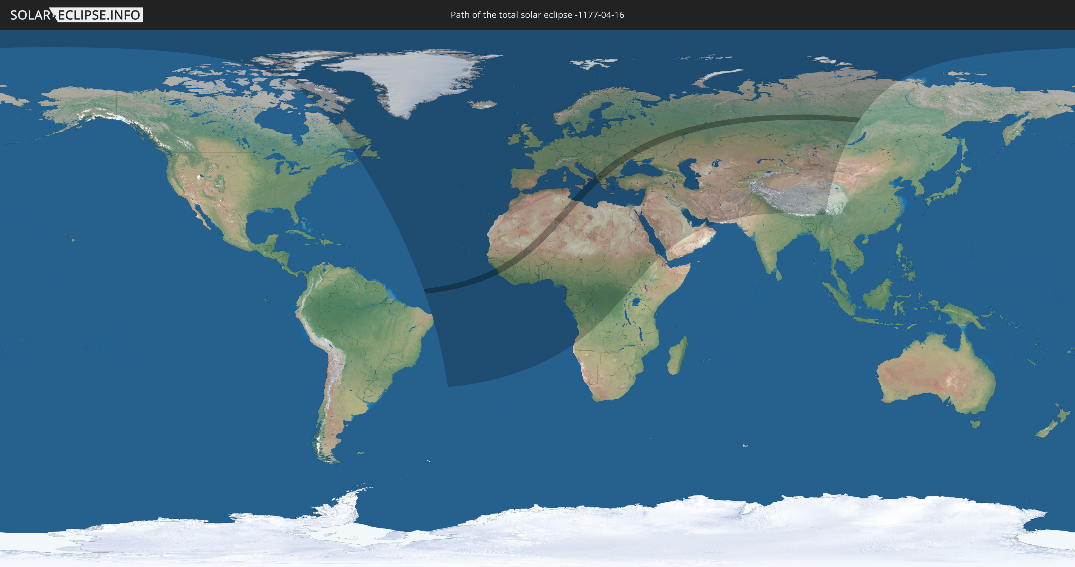
Die Sonnenfinsternis am 16.04.-1177 kann man in 120 Ländern als partielle Sonnenfinsternis beobachten.
Der Finsternispfad verläuft durch 18 Länder. Nur in diesen Ländern ist sie als totale Sonnenfinsternis zu sehen.
In den folgenden Ländern ist die Sonnenfinsternis total zu sehen
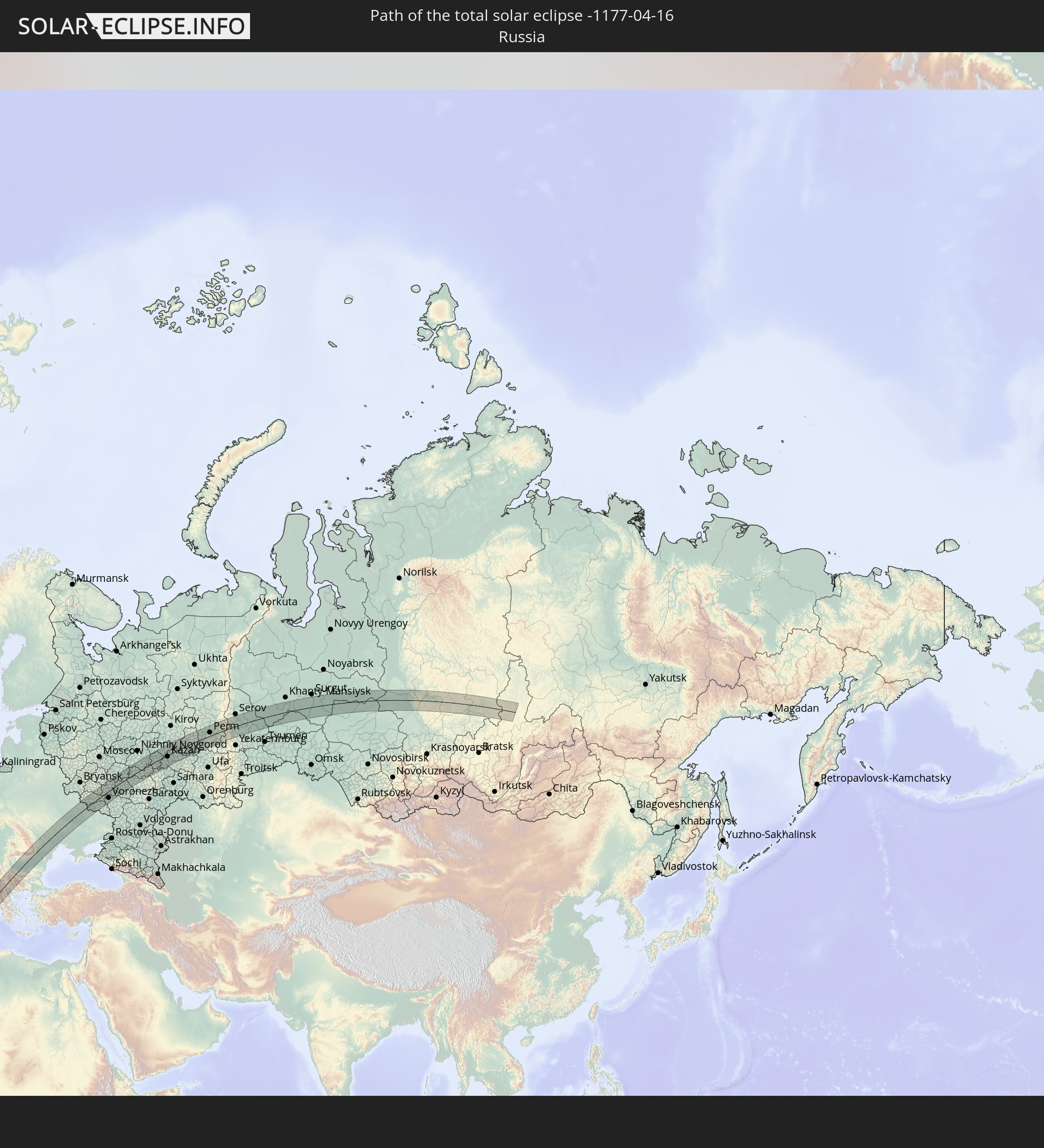 Russland
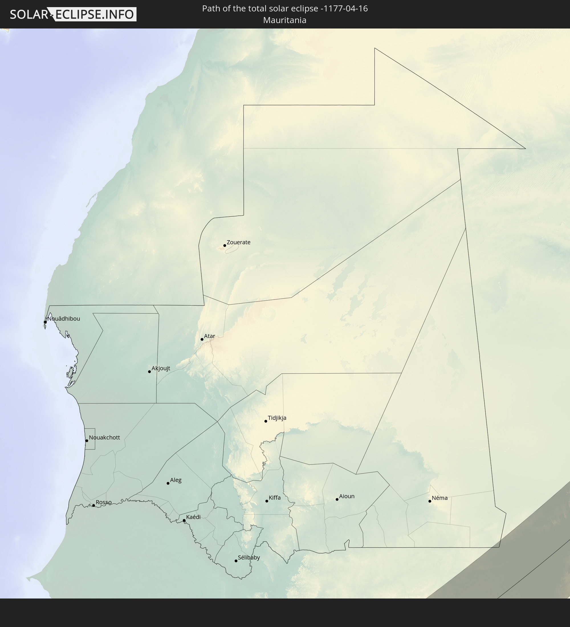 Mauretanien
 Guinea
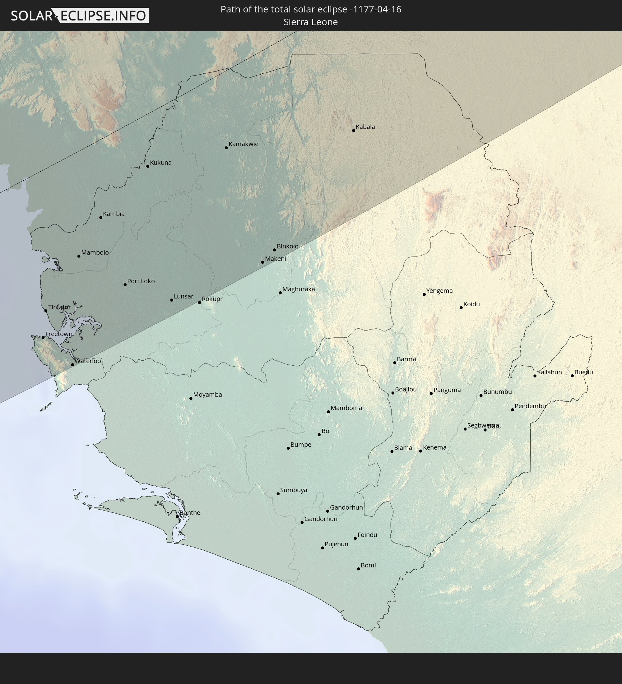 Sierra Leone
 Mali
Mali
 Algerien
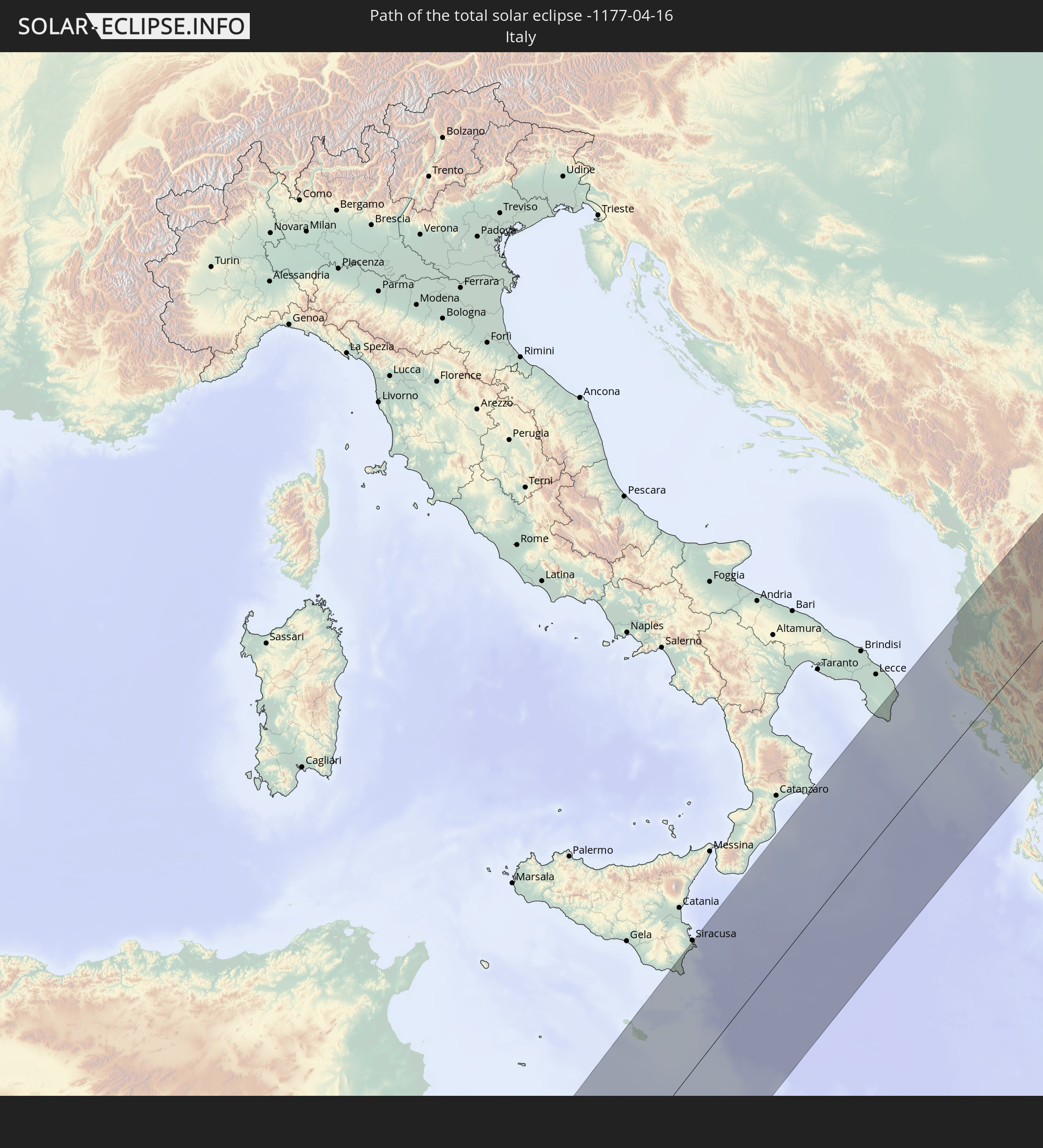 Italien
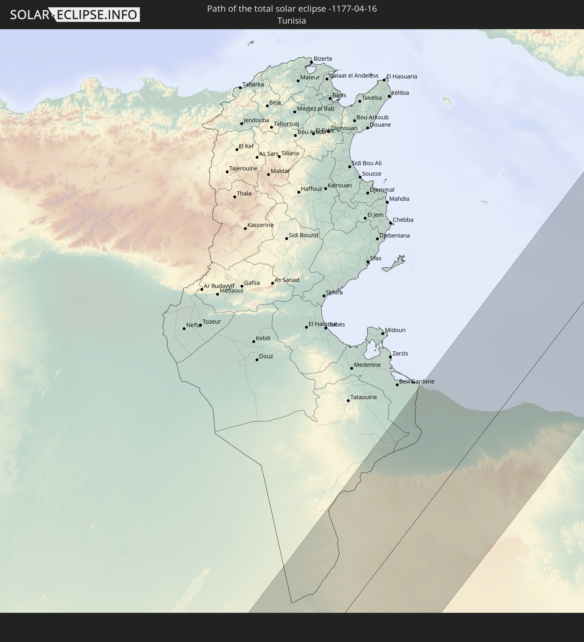 Tunesien
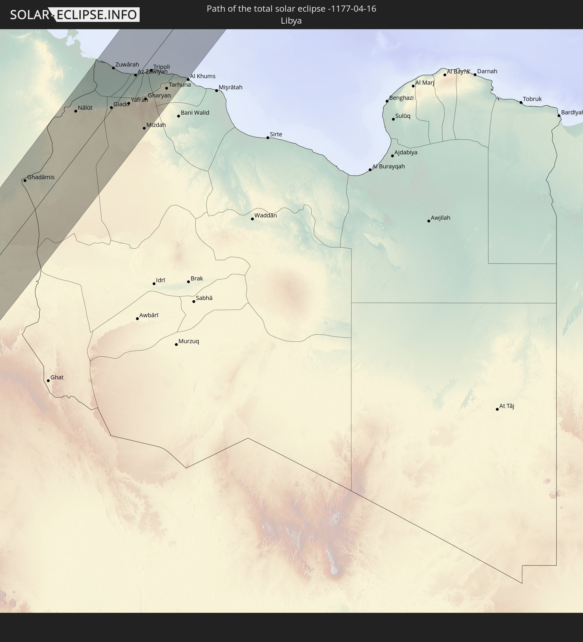 Libyen
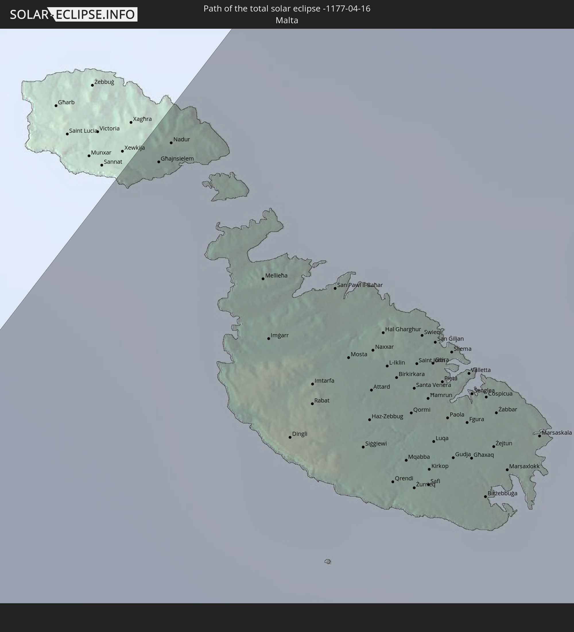 Malta
Malta
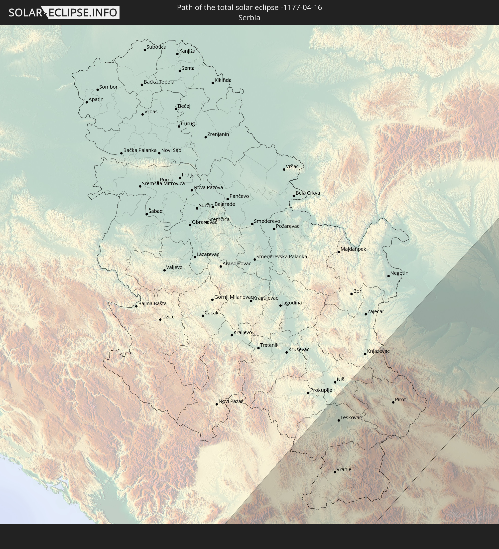 Serbien
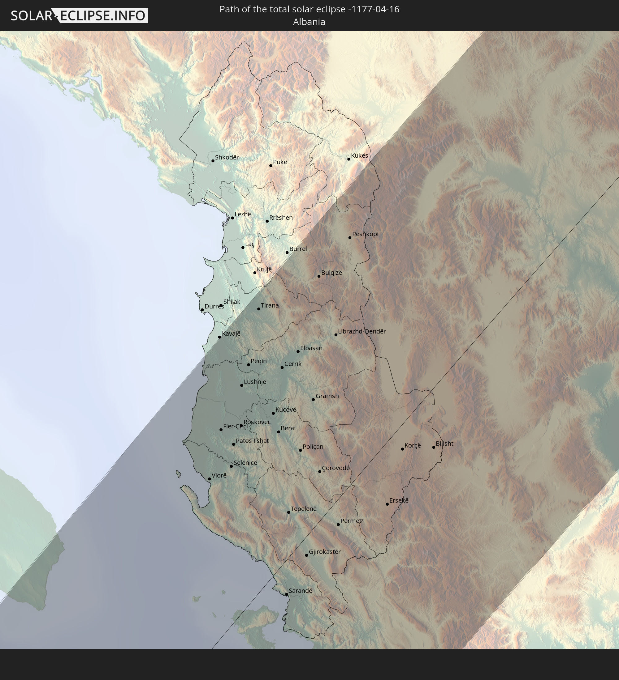 Albanien
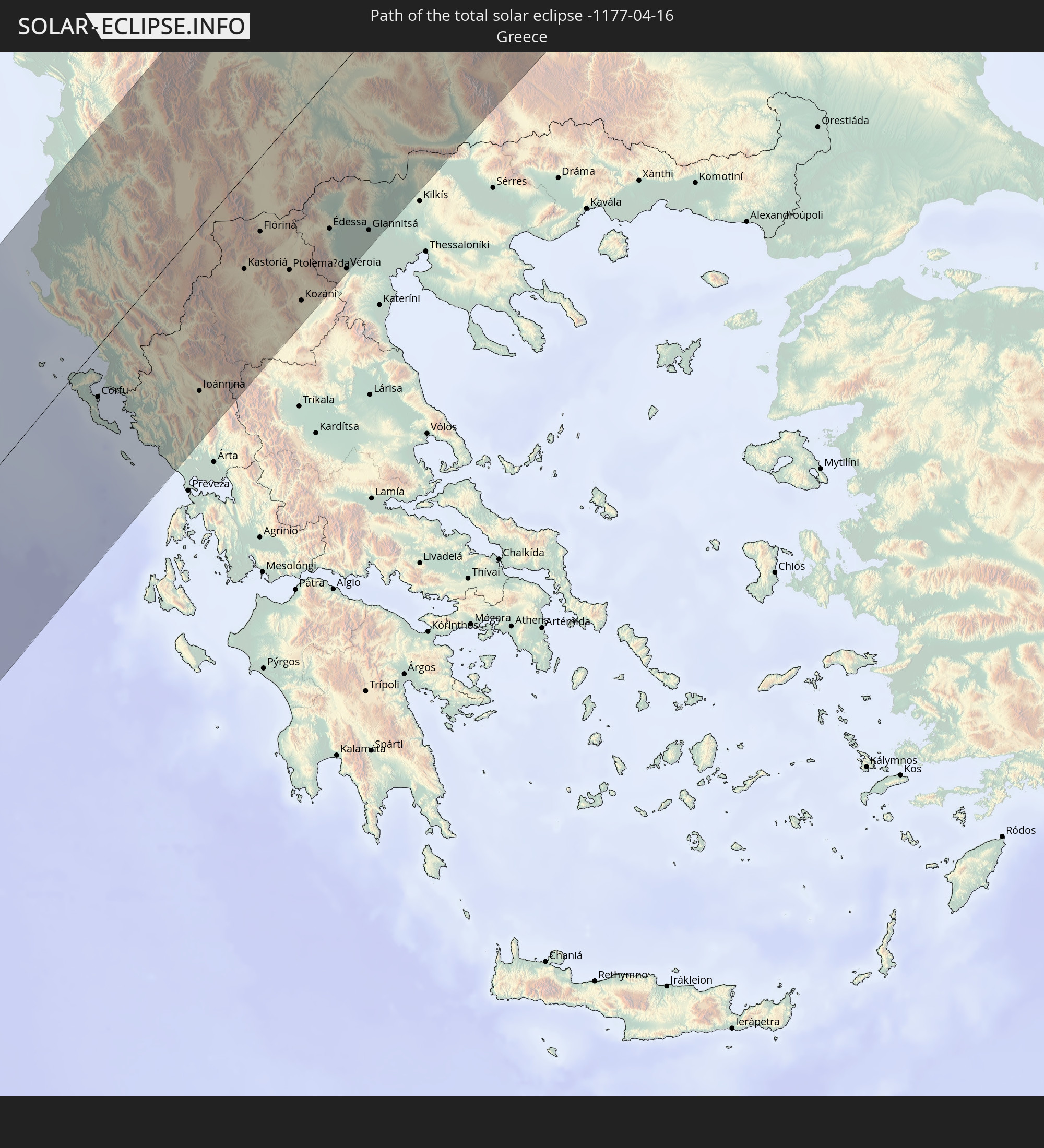 Griechenland
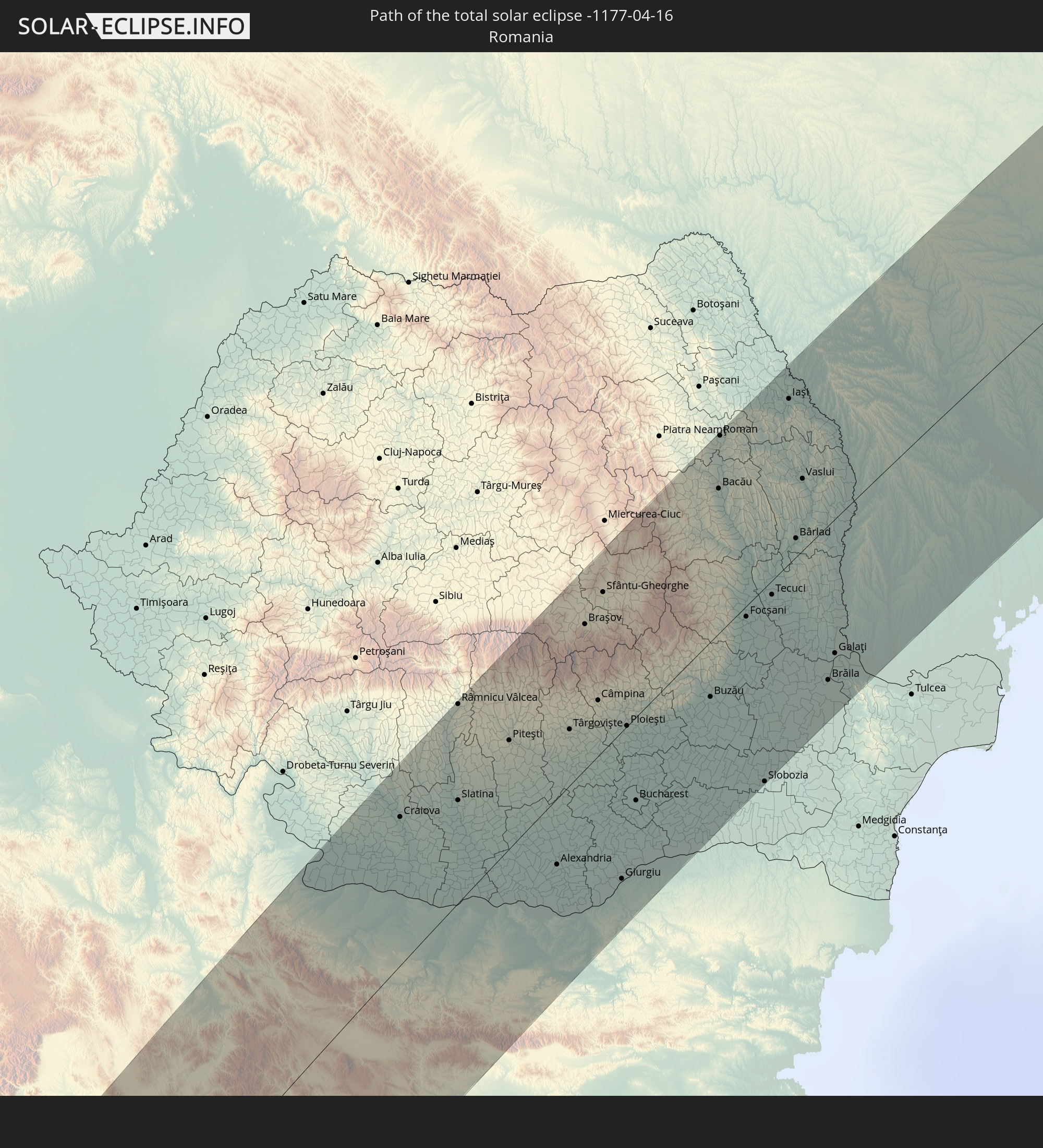 Rumänien
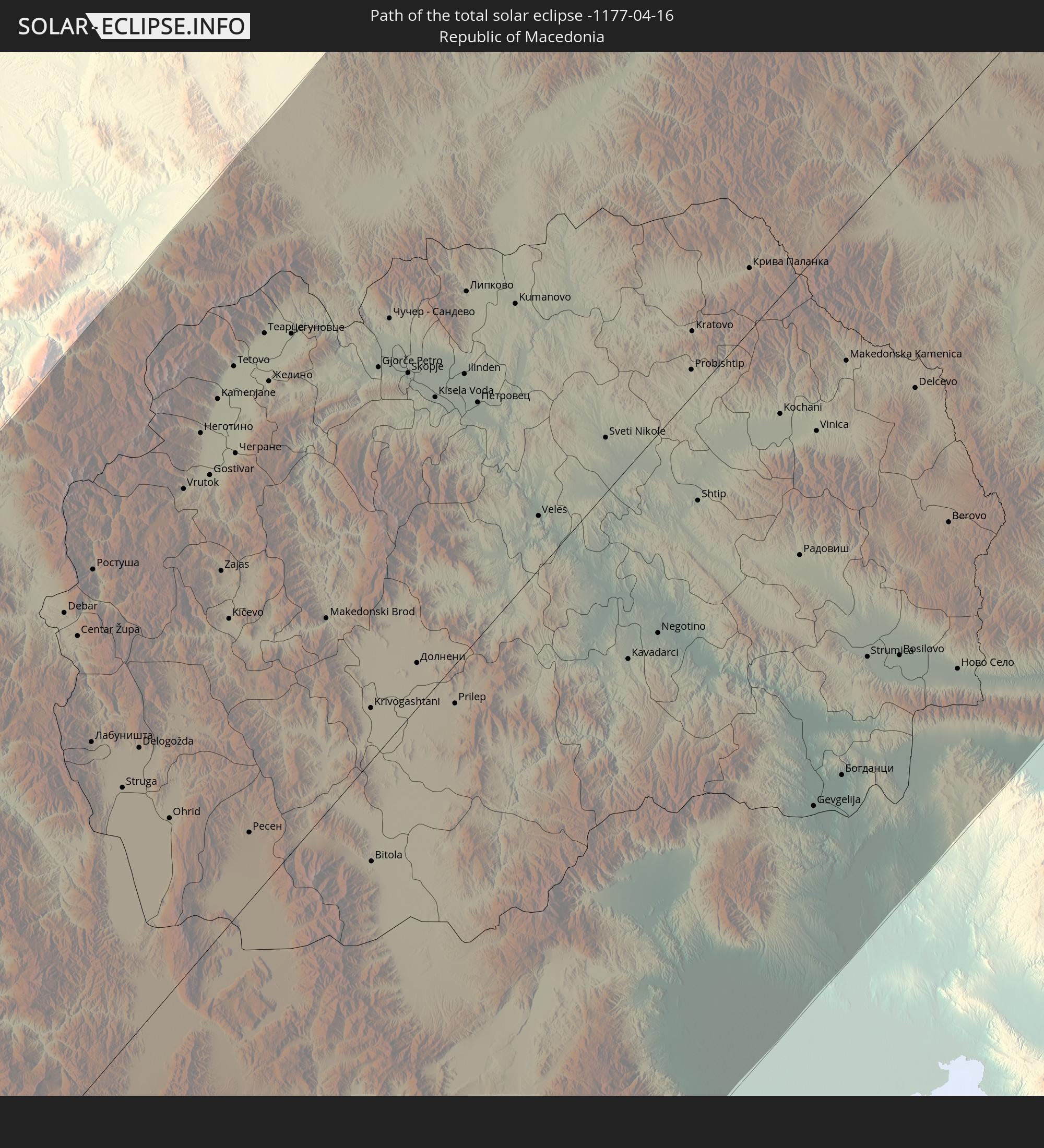 Mazedonien
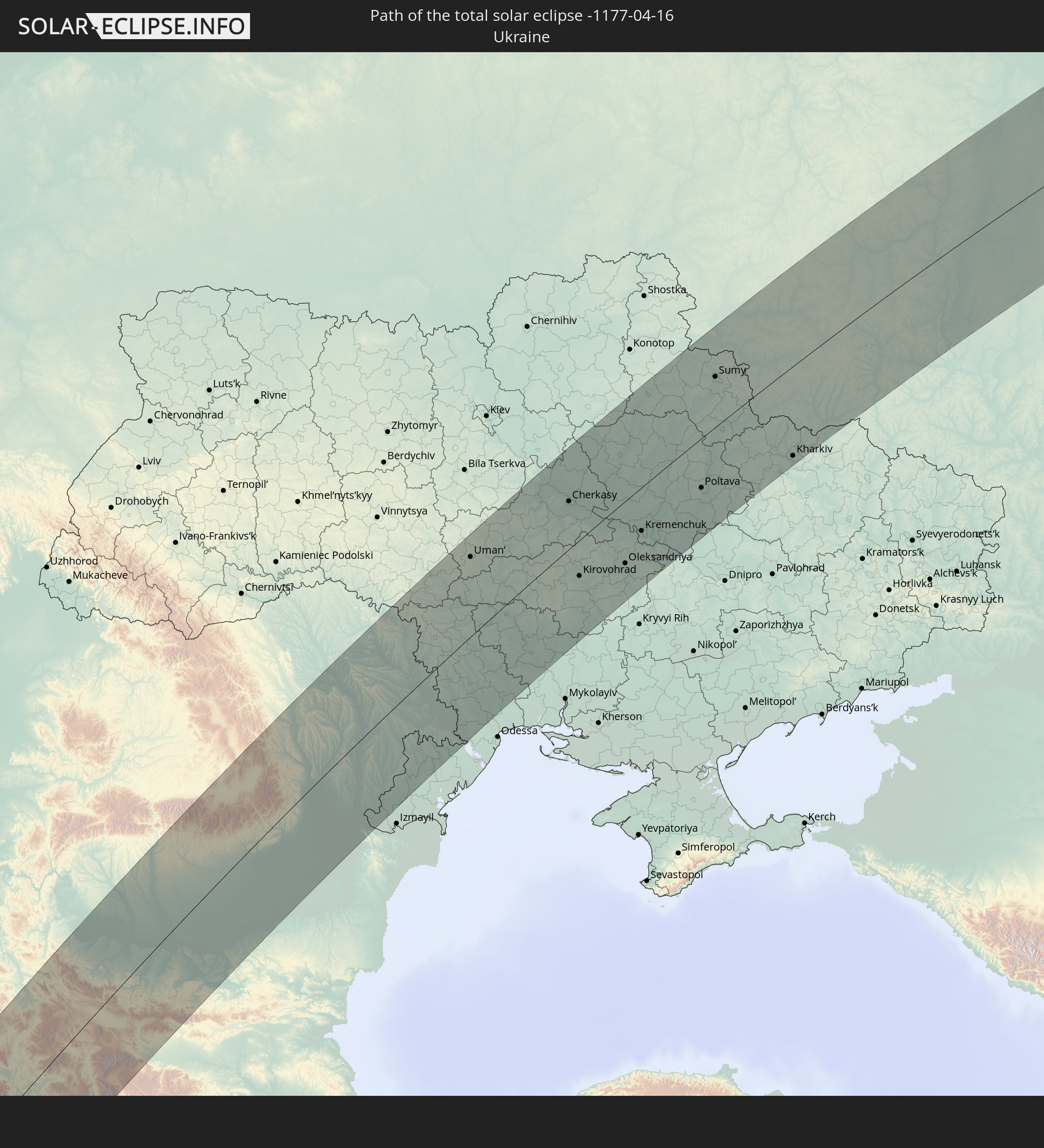 Ukraine
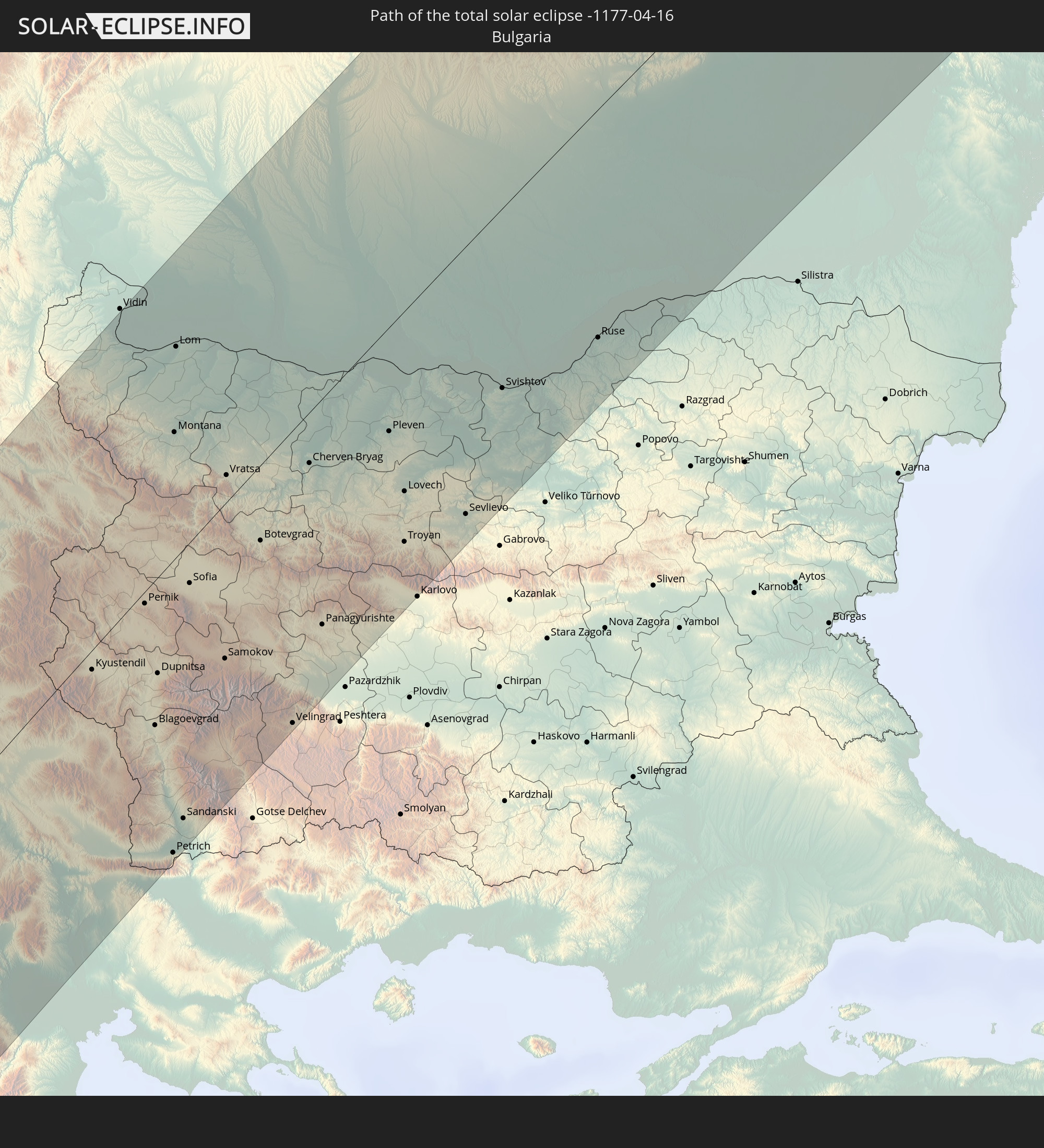 Bulgarien
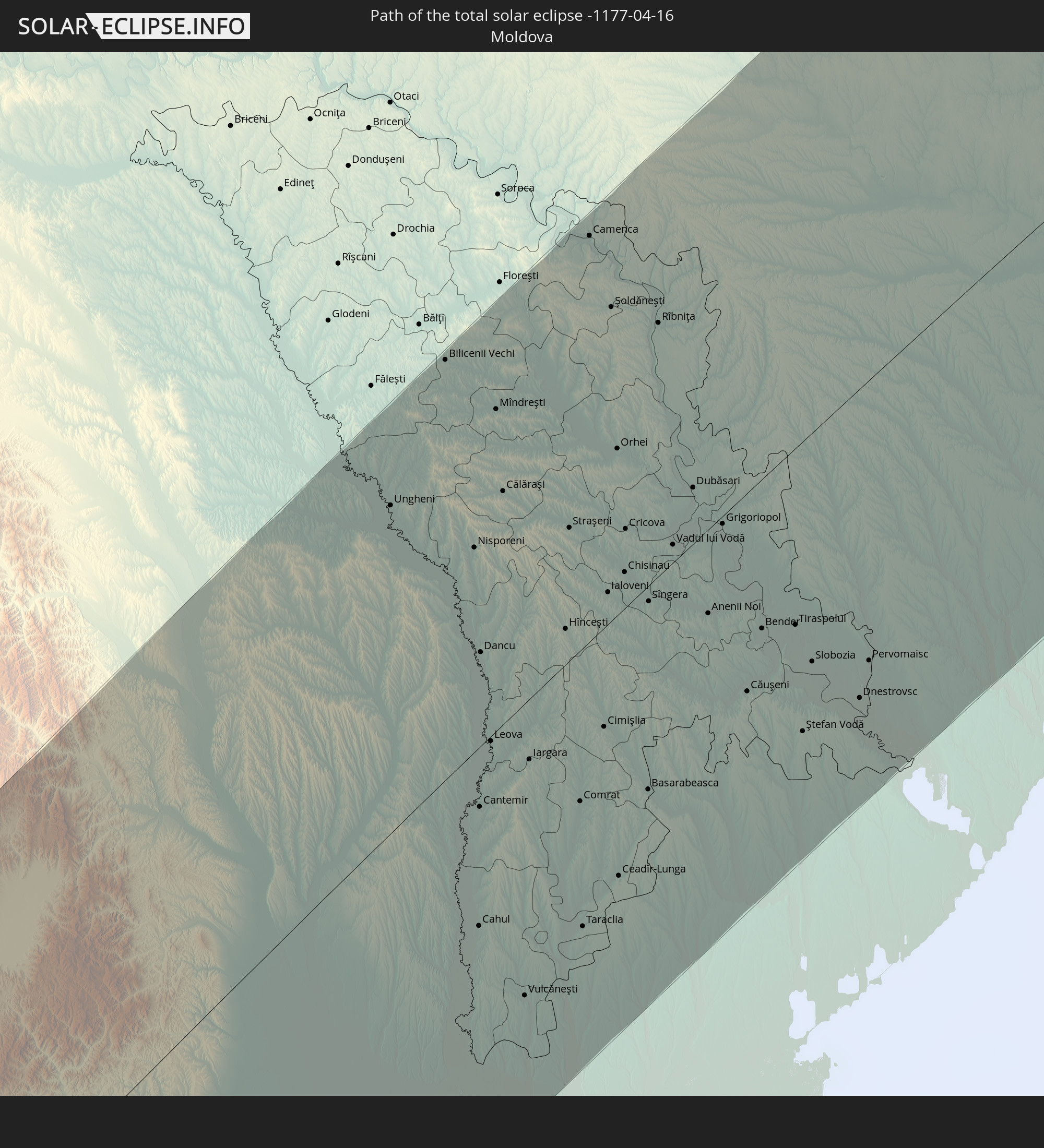 Moldawien
In den folgenden Ländern ist die Sonnenfinsternis partiell zu sehen
 Russland
 Kanada
 Grönland
 Brasilien
 Saint-Pierre und Miquelon
 Portugal
 Kap Verde
 Island
 Spanien
 Senegal
 Mauretanien
 Gambia
 Guinea-Bissau
 Guinea
 St. Helena
 Sierra Leone
 Marokko
 Mali
Mali
 Liberia
 Irland
 Spitzbergen
 Algerien
 Vereinigtes Königreich
 Elfenbeinküste
 Färöer
 Burkina Faso
 Gibraltar
 Frankreich
 Isle of Man
 Ghana
Ghana
 Guernsey
 Jersey
 Togo
Togo
 Niger
Niger
 Benin
Benin
 Andorra
 Belgien
 Nigeria
 Niederlande
 Norwegen
 Äquatorialguinea
 Luxemburg
 Deutschland
 Schweiz
 São Tomé und Príncipe
 Italien
 Monaco
 Tunesien
 Dänemark
 Kamerun
 Gabun
Gabun
 Libyen
 Liechtenstein
 Österreich
 Schweden
 Republik Kongo
 Angola
 Tschechien
 Demokratische Republik Kongo
 San Marino
 Vatikanstadt
 Slowenien
 Tschad
 Kroatien
 Polen
Polen
 Malta
Malta
 Zentralafrikanische Republik
 Bosnien und Herzegowina
 Ungarn
 Slowakei
 Montenegro
 Serbien
 Albanien
 Åland Islands
 Griechenland
 Rumänien
 Mazedonien
 Finnland
 Litauen
 Lettland
 Estland
 Sudan
Sudan
 Ukraine
 Bulgarien
 Weißrussland
 Ägypten
 Türkei
 Moldawien
 Uganda
 Republik Zypern
 Äthiopien
 Staat Palästina
 Israel
 Saudi-Arabien
 Jordanien
 Libanon
 Syrien
 Eritrea
 Irak
Irak
 Georgien
 Jemen
Jemen
 Armenien
 Iran
Iran
 Aserbaidschan
 Kasachstan
 Kuwait
 Bahrain
 Katar
Katar
 Vereinigte Arabische Emirate
 Oman
Oman
 Turkmenistan
 Usbekistan
 Afghanistan
 Pakistan
 Tadschikistan
 Indien
 Kirgisistan
 Volksrepublik China
 Nepal
Nepal
 Mongolei
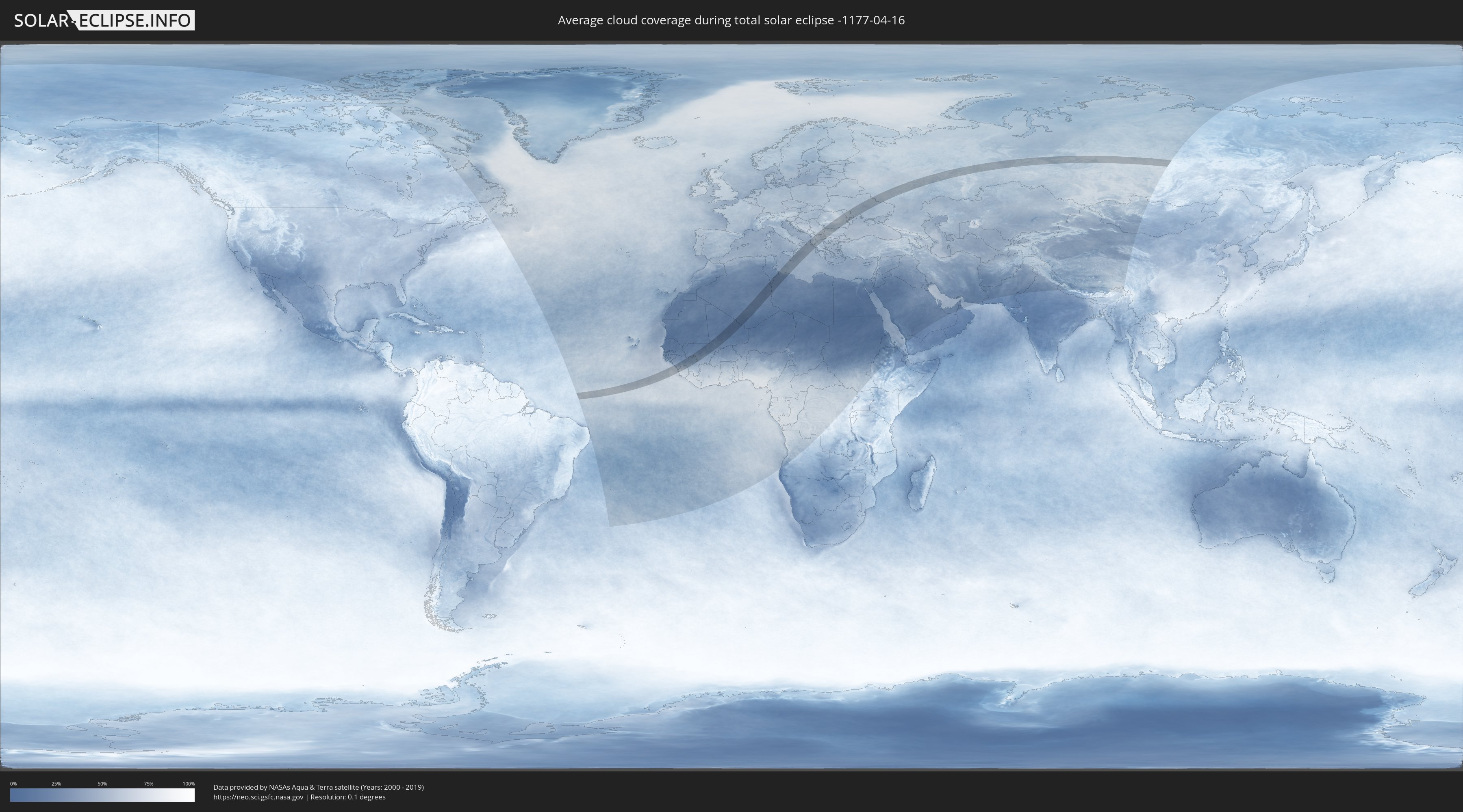
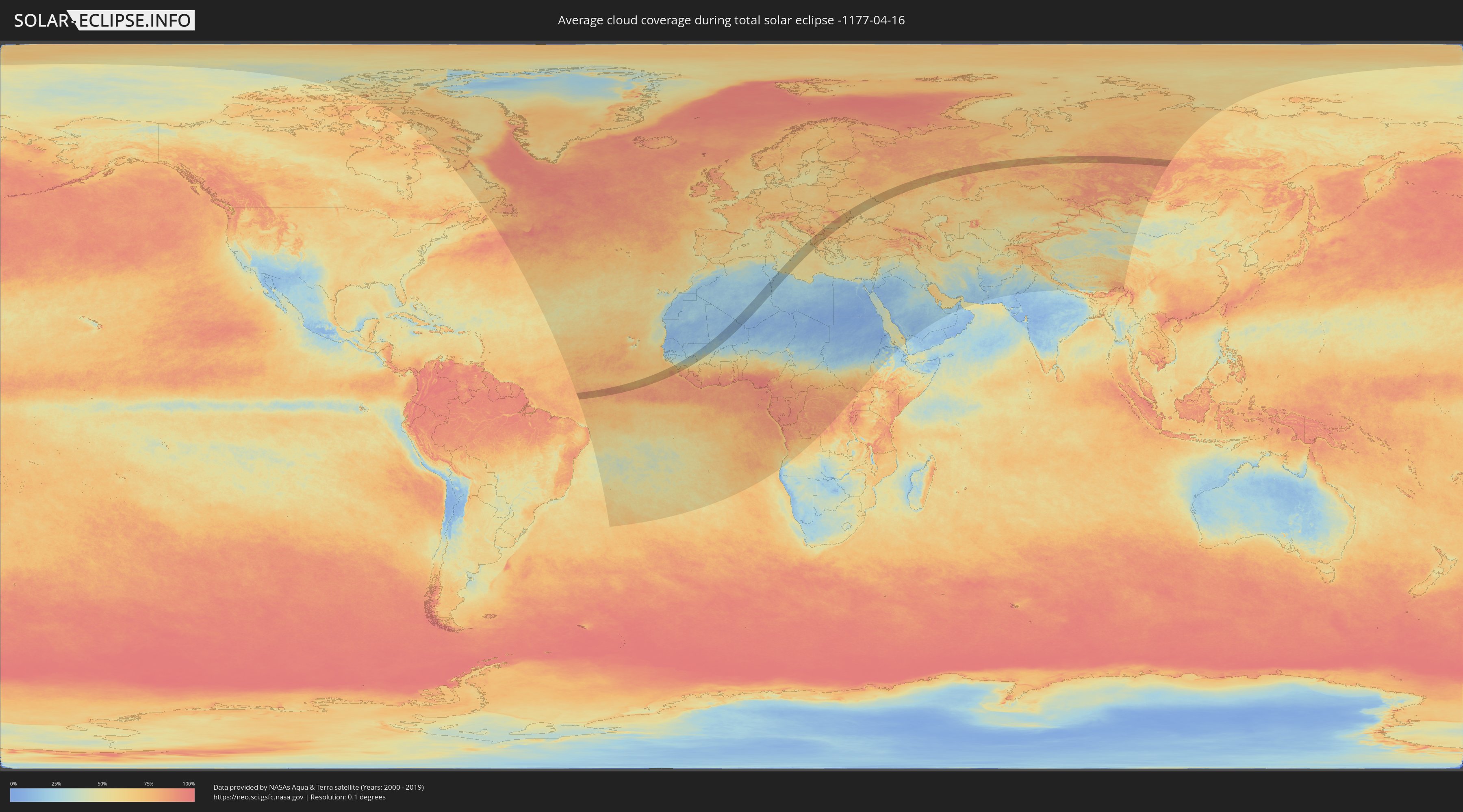
Wie wird das Wetter während der totalen Sonnenfinsternis am 16.04.-1177?
Wo ist der beste Ort, um die totale Sonnenfinsternis vom 16.04.-1177 zu beobachten?
Die folgenden Karten zeigen die durchschnittliche Bewölkung für den Tag, an dem die totale Sonnenfinsternis
stattfindet. Mit Hilfe der Karten lässt sich der Ort entlang des Finsternispfades eingrenzen,
der die besten Aussichen auf einen klaren wolkenfreien Himmel bietet.
Trotzdem muss man immer lokale Gegenenheiten beachten und sollte sich genau über das Wetter an seinem
gewählten Beobachtungsort informieren.
Die Daten stammen von den beiden NASA-Satelliten
AQUA und TERRA
und wurden über einen Zeitraum von 19 Jahren (2000 - 2019) gemittelt.
Detaillierte Länderkarten
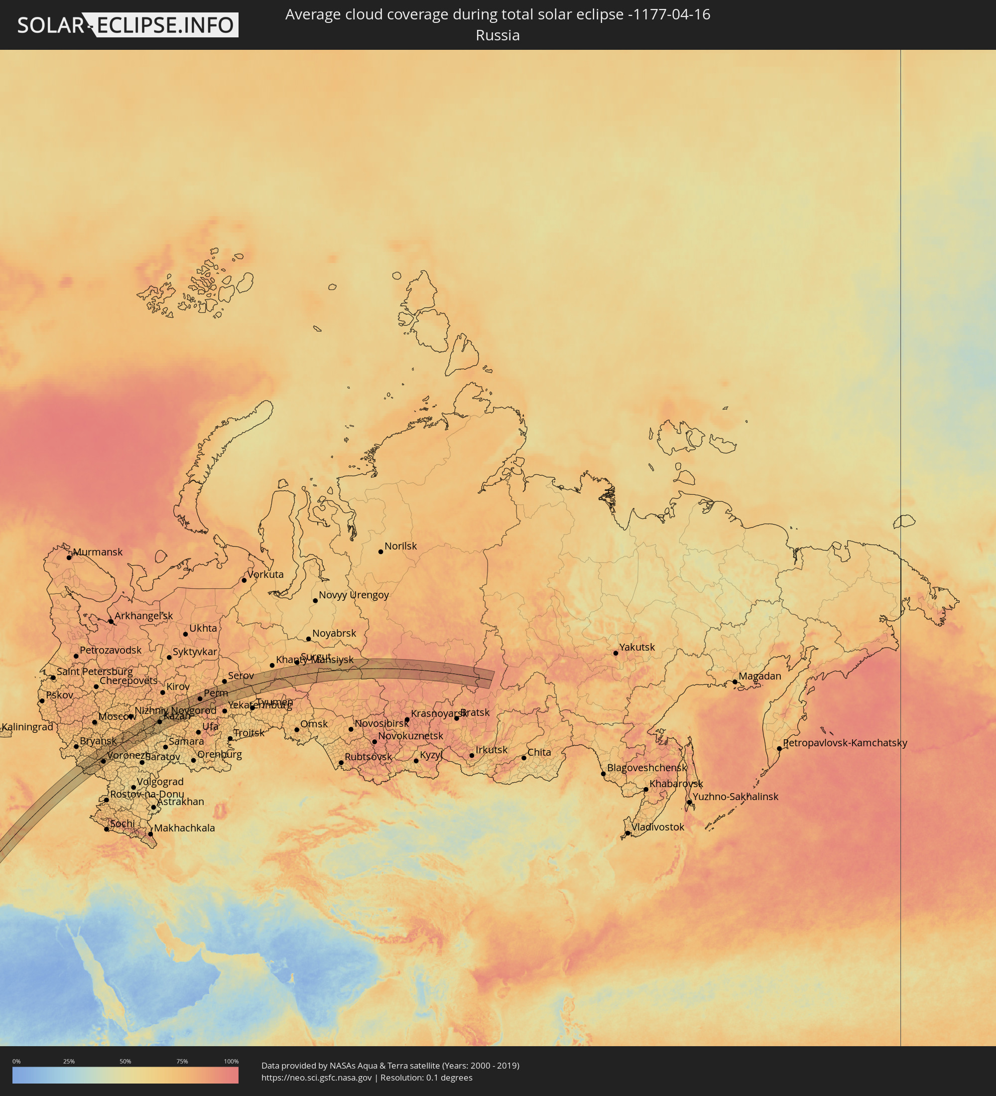 Russland
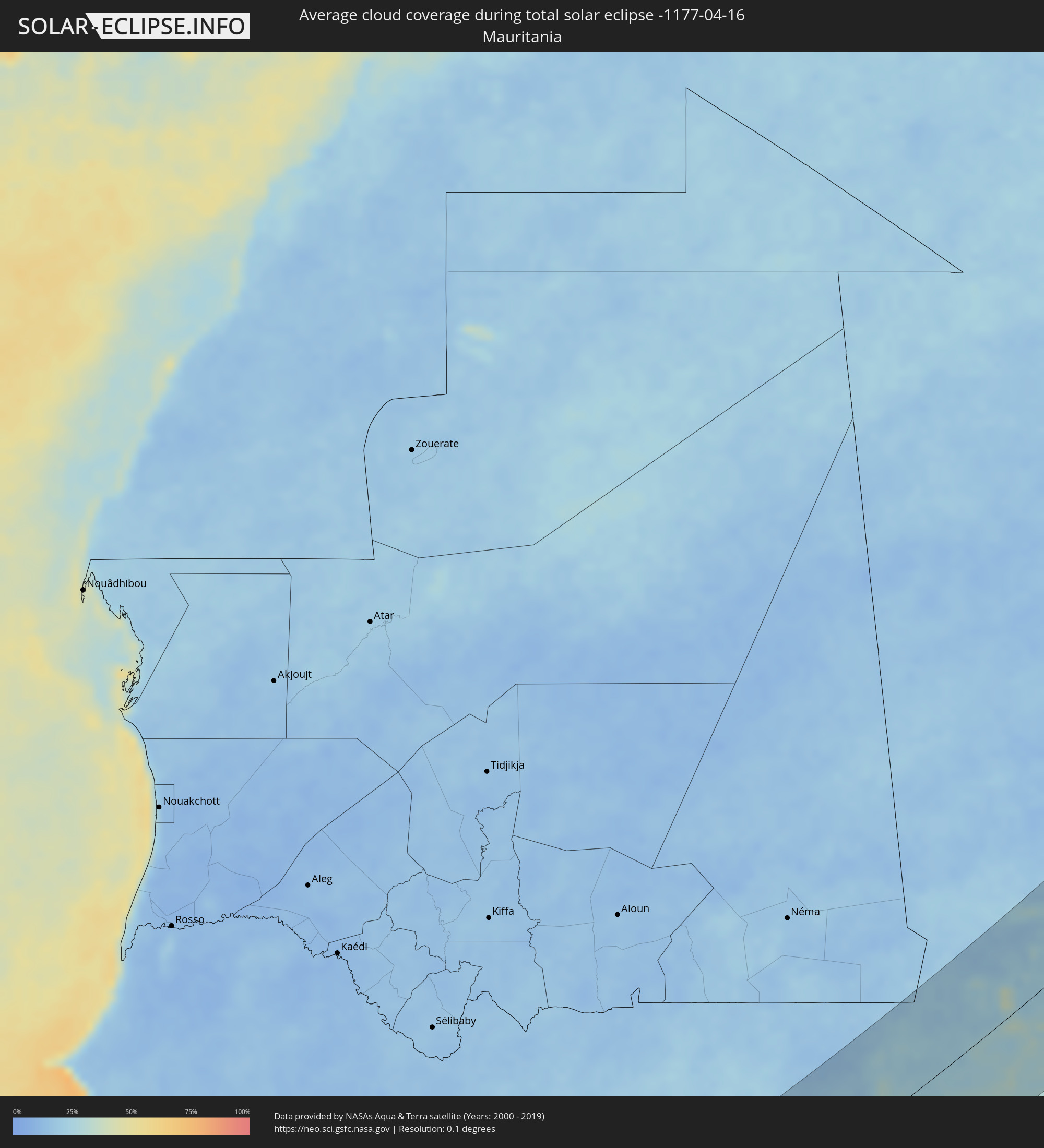 Mauretanien
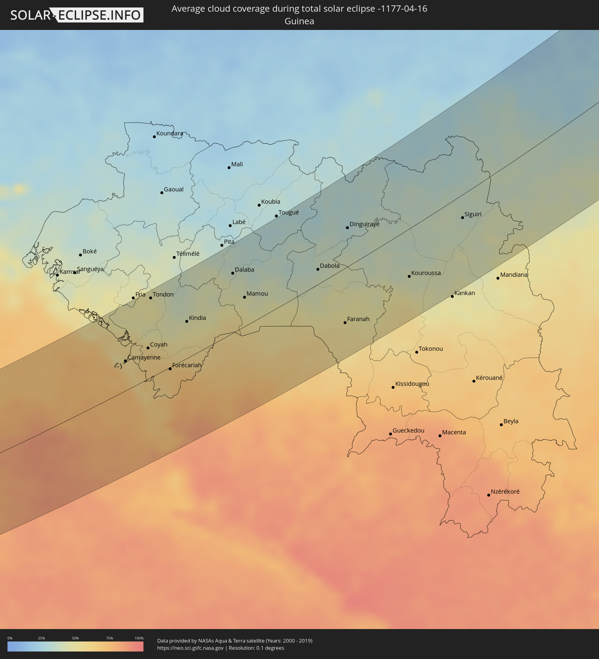 Guinea
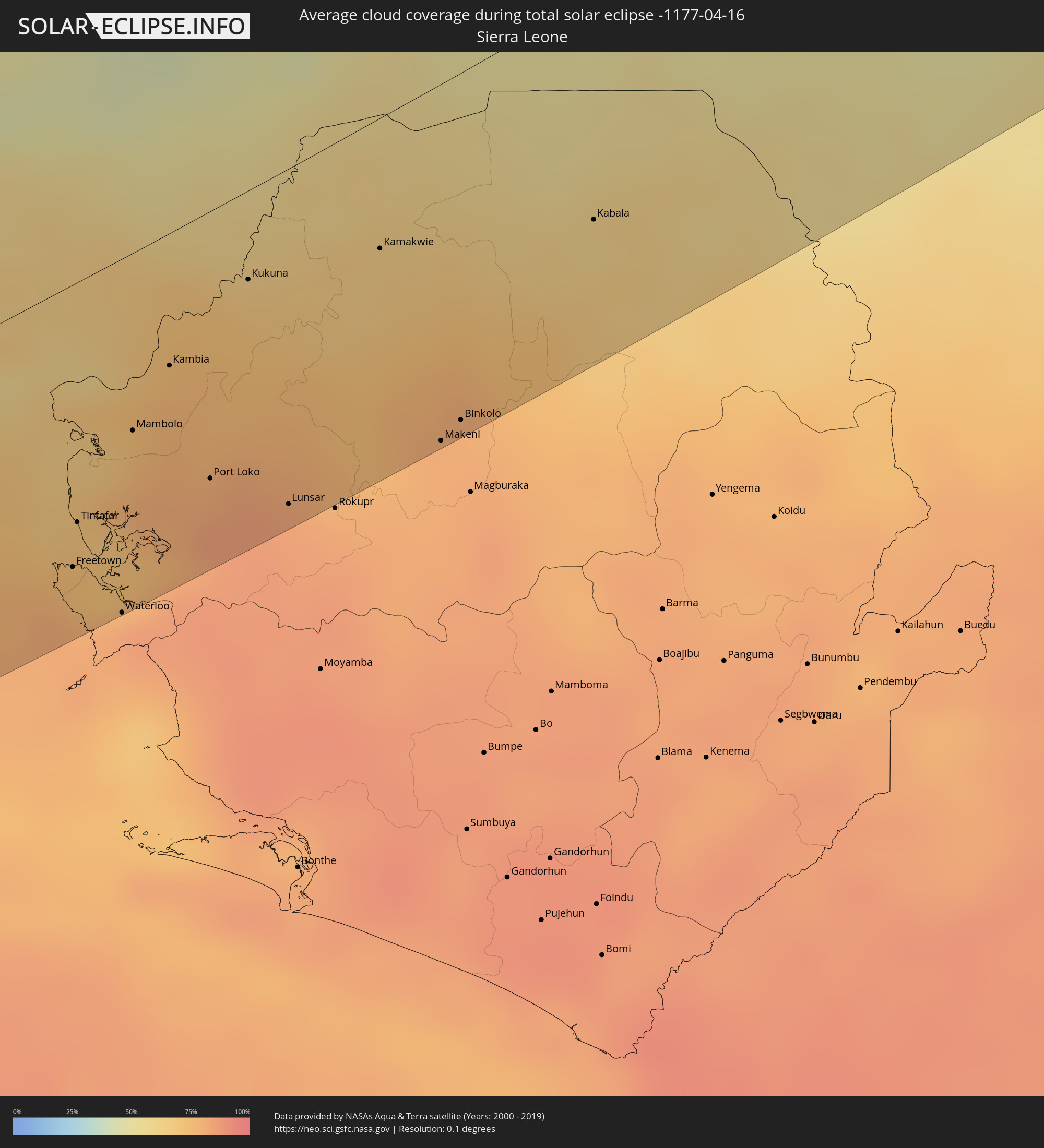 Sierra Leone
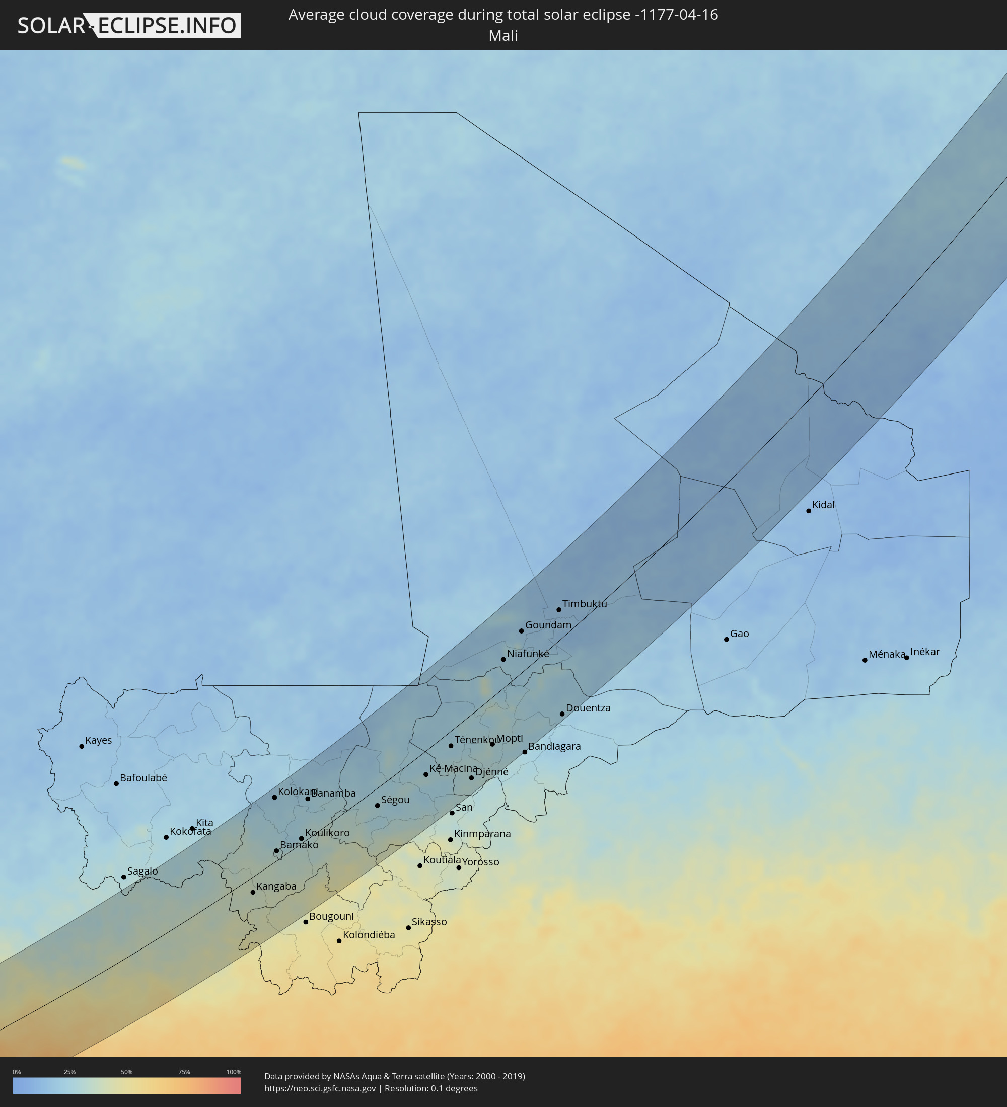 Mali
Mali
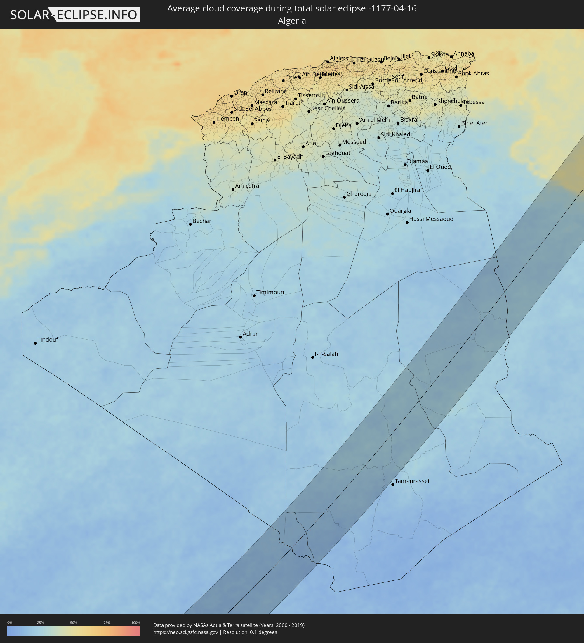 Algerien
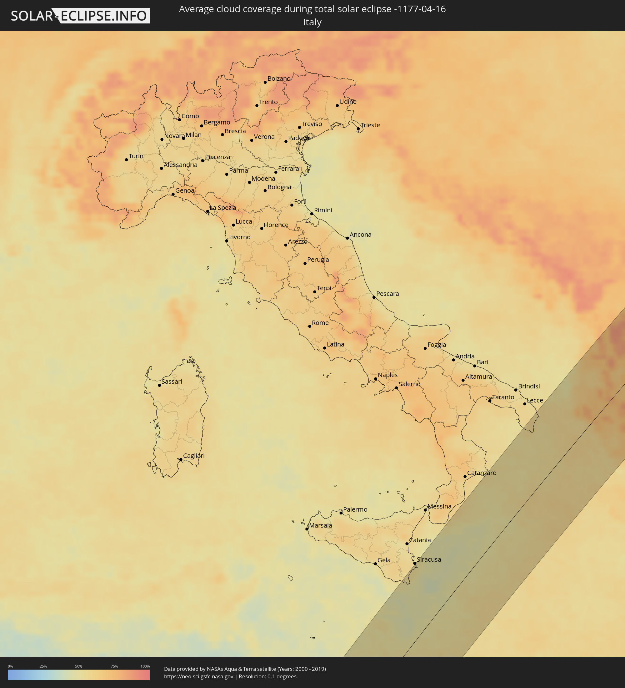 Italien
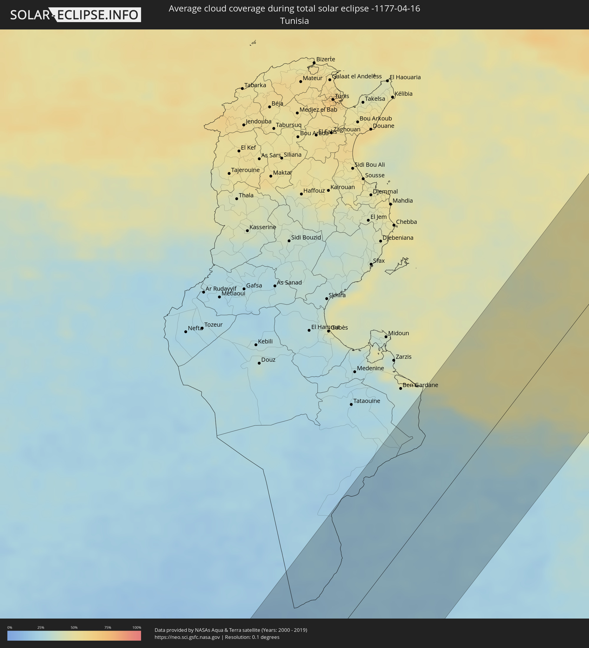 Tunesien
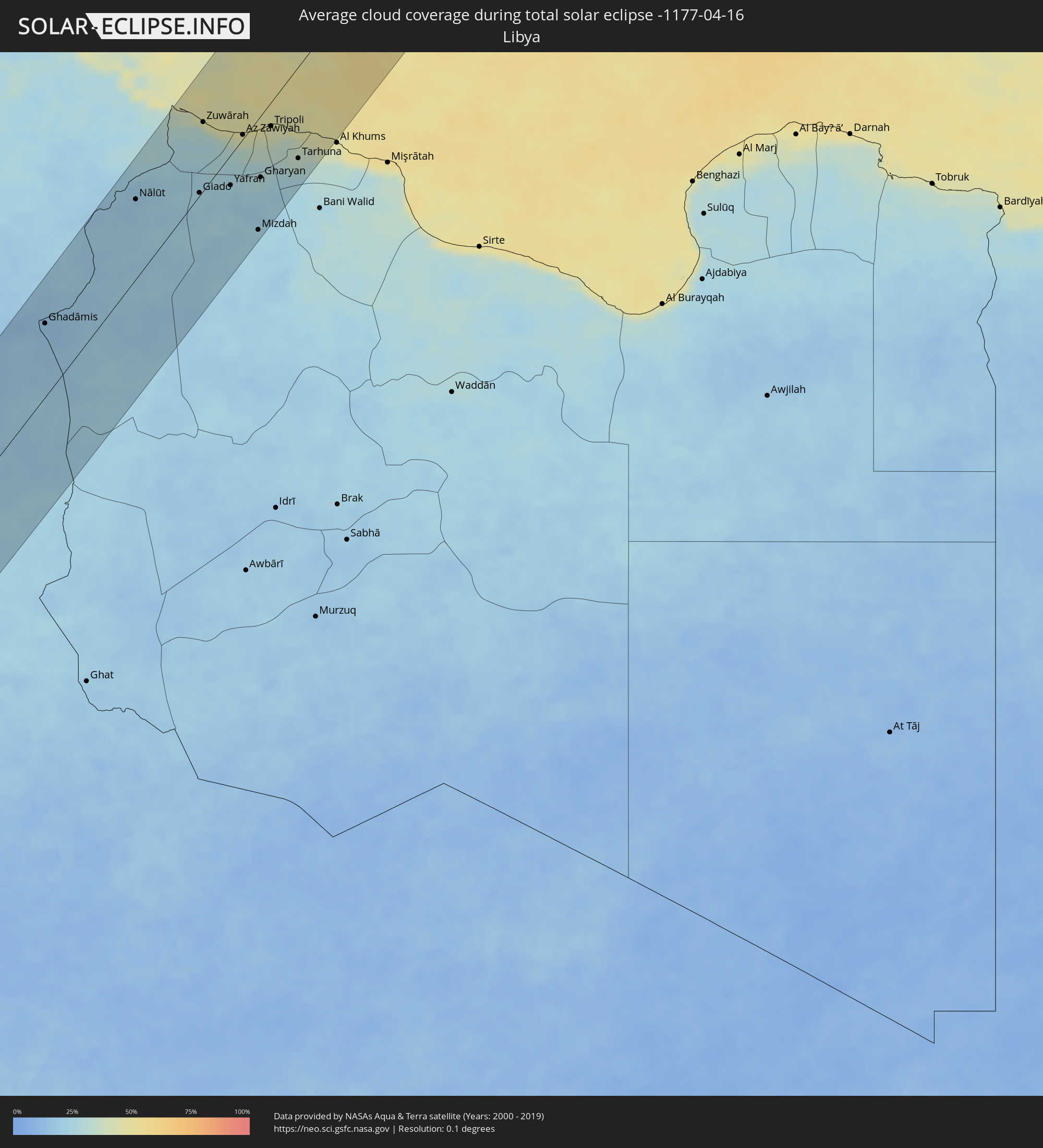 Libyen
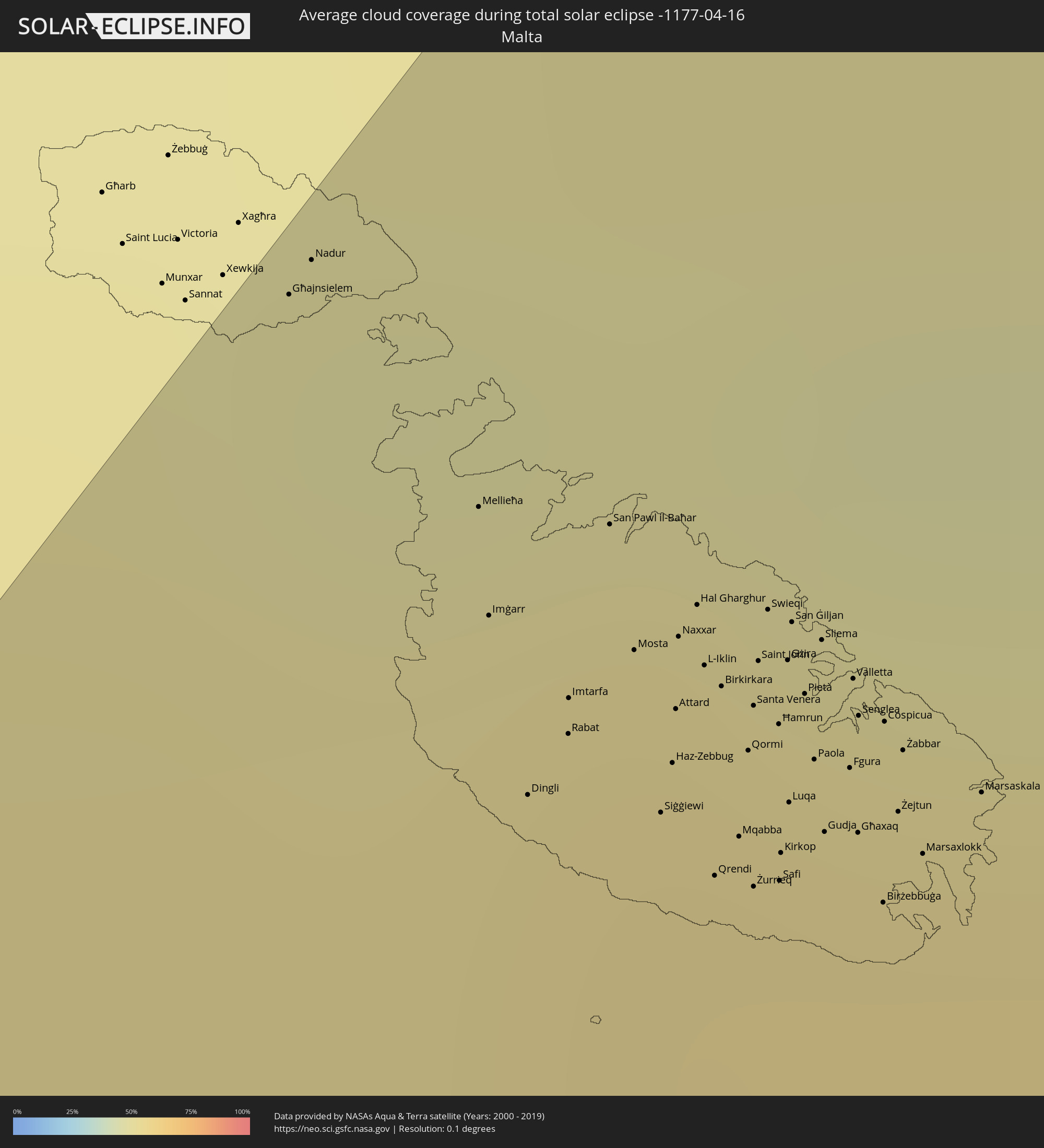 Malta
Malta
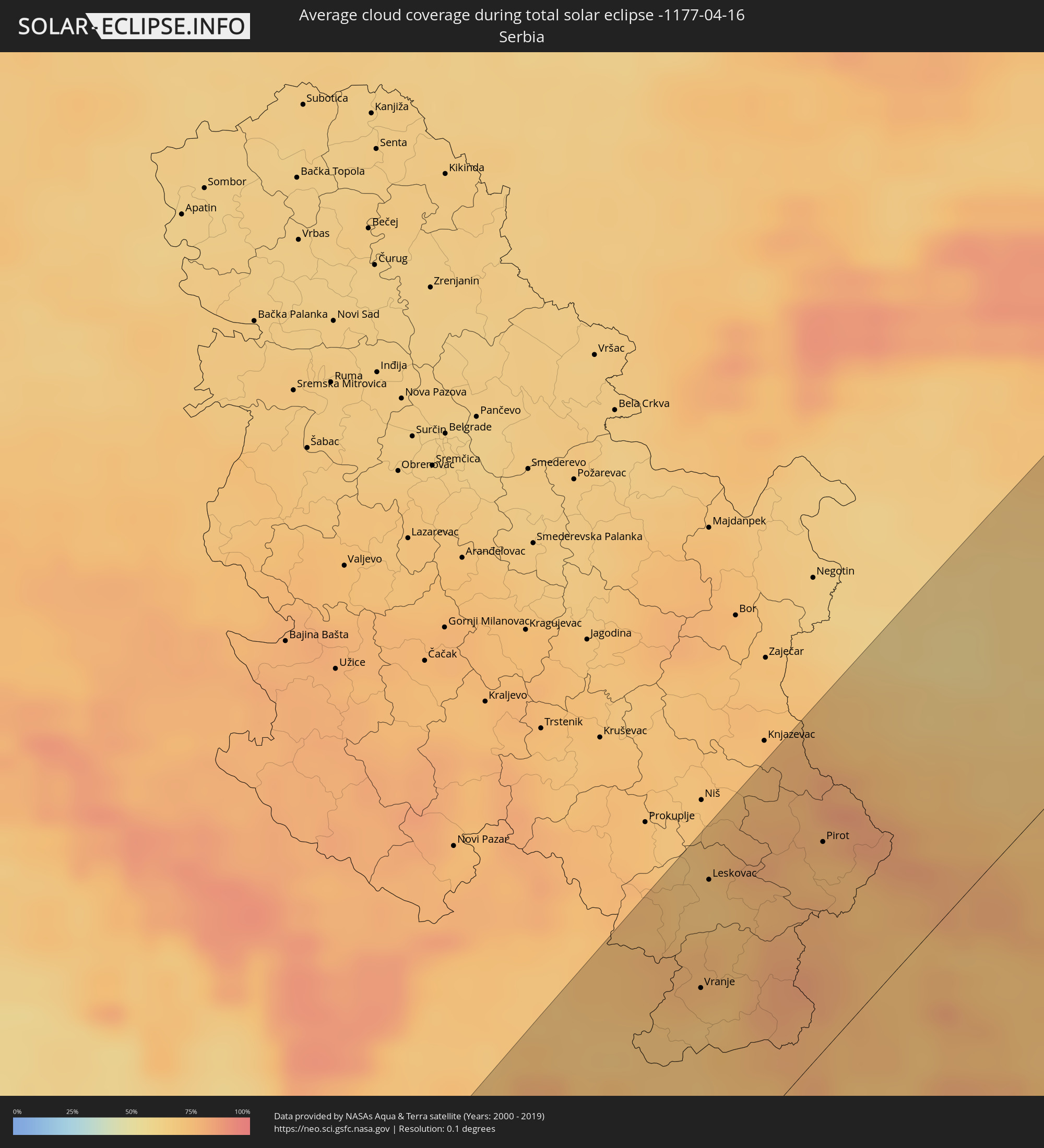 Serbien
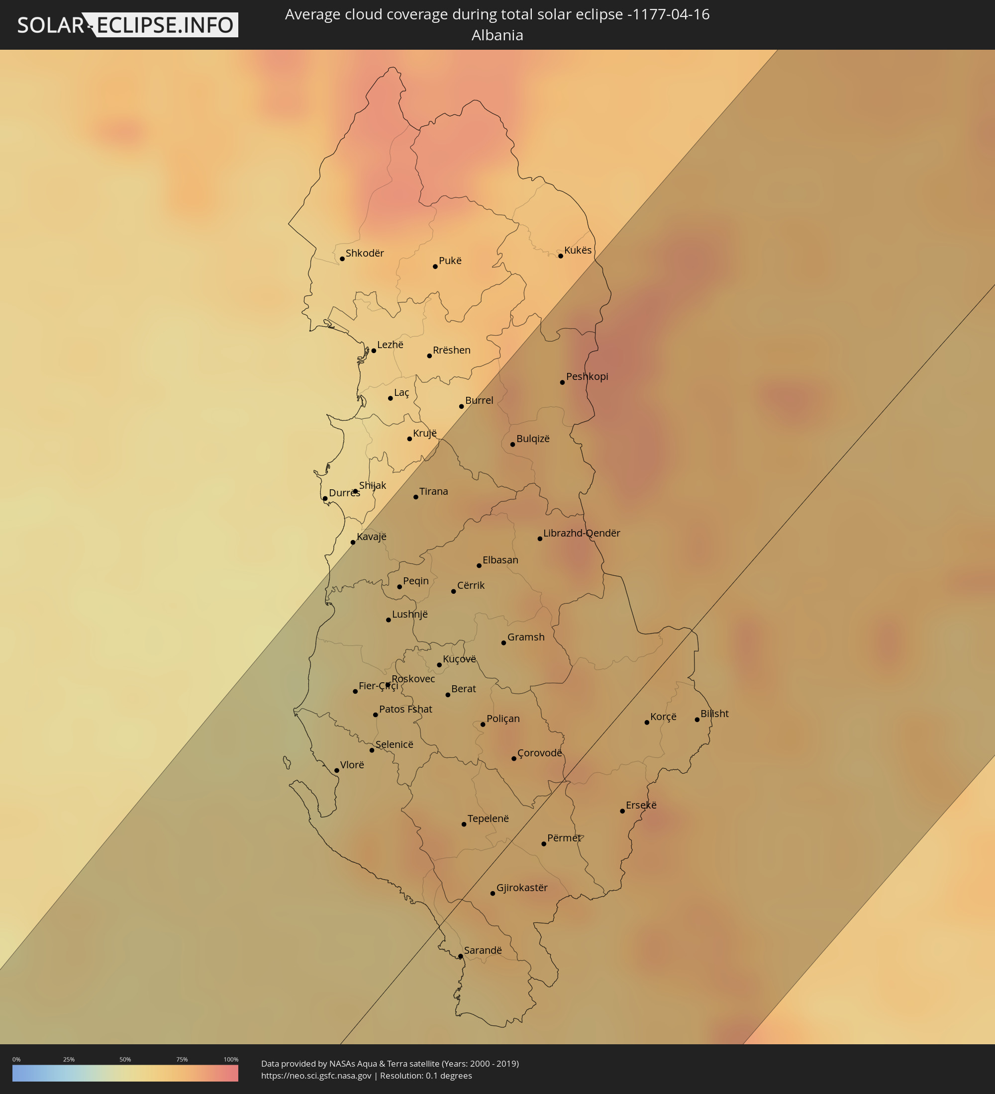 Albanien
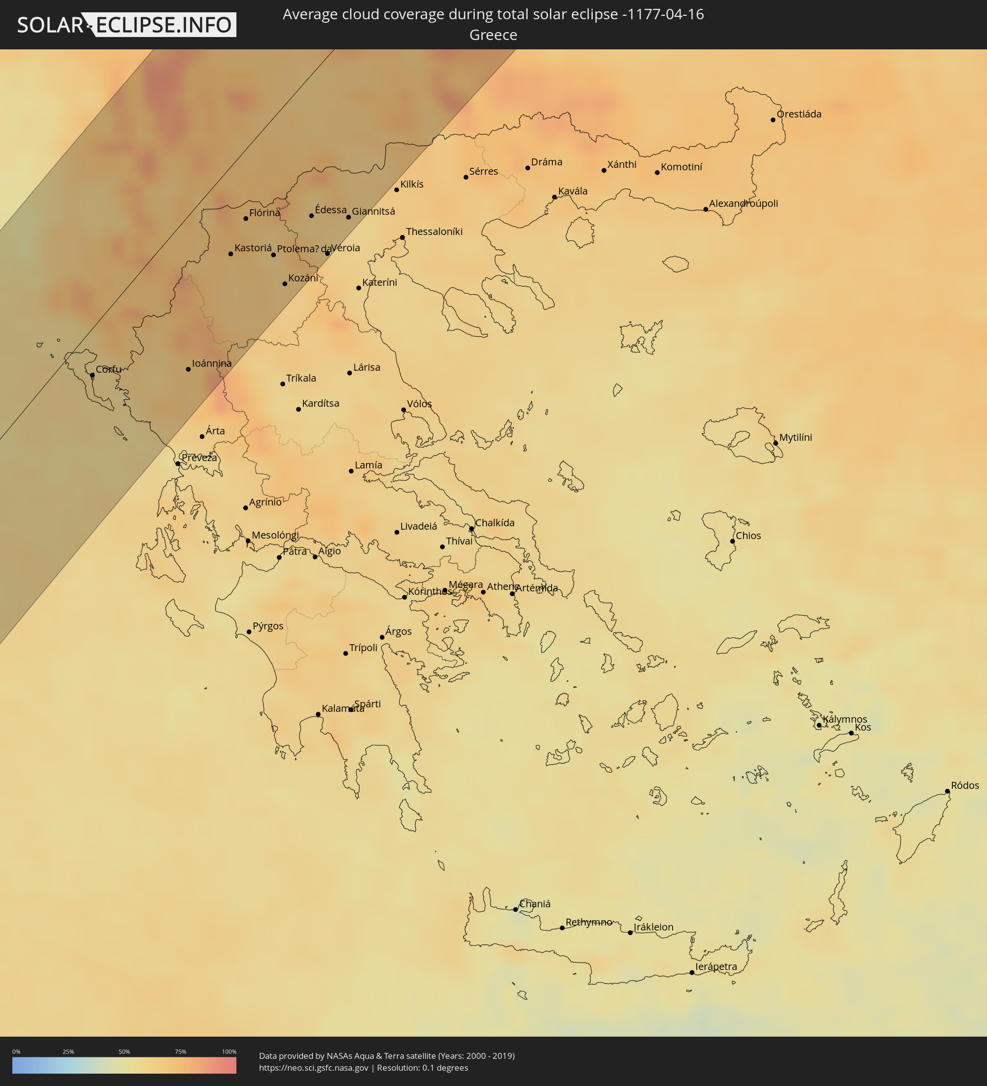 Griechenland
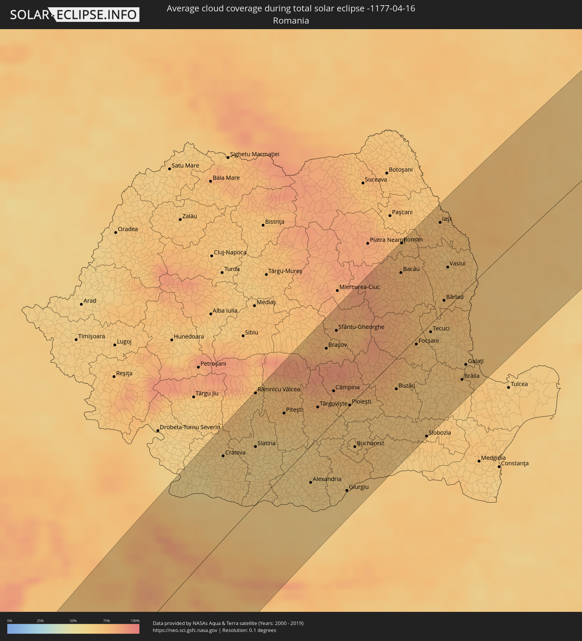 Rumänien
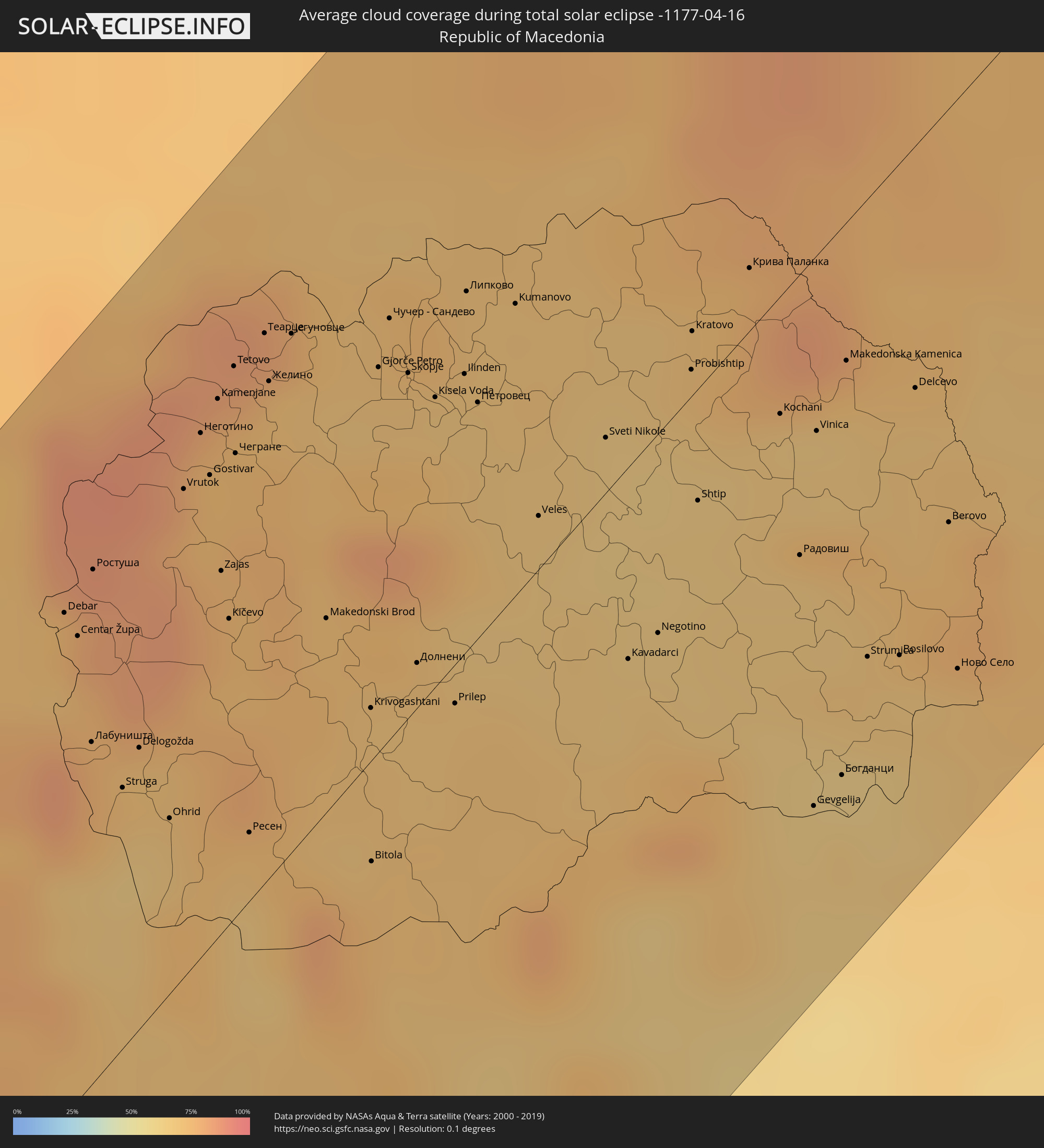 Mazedonien
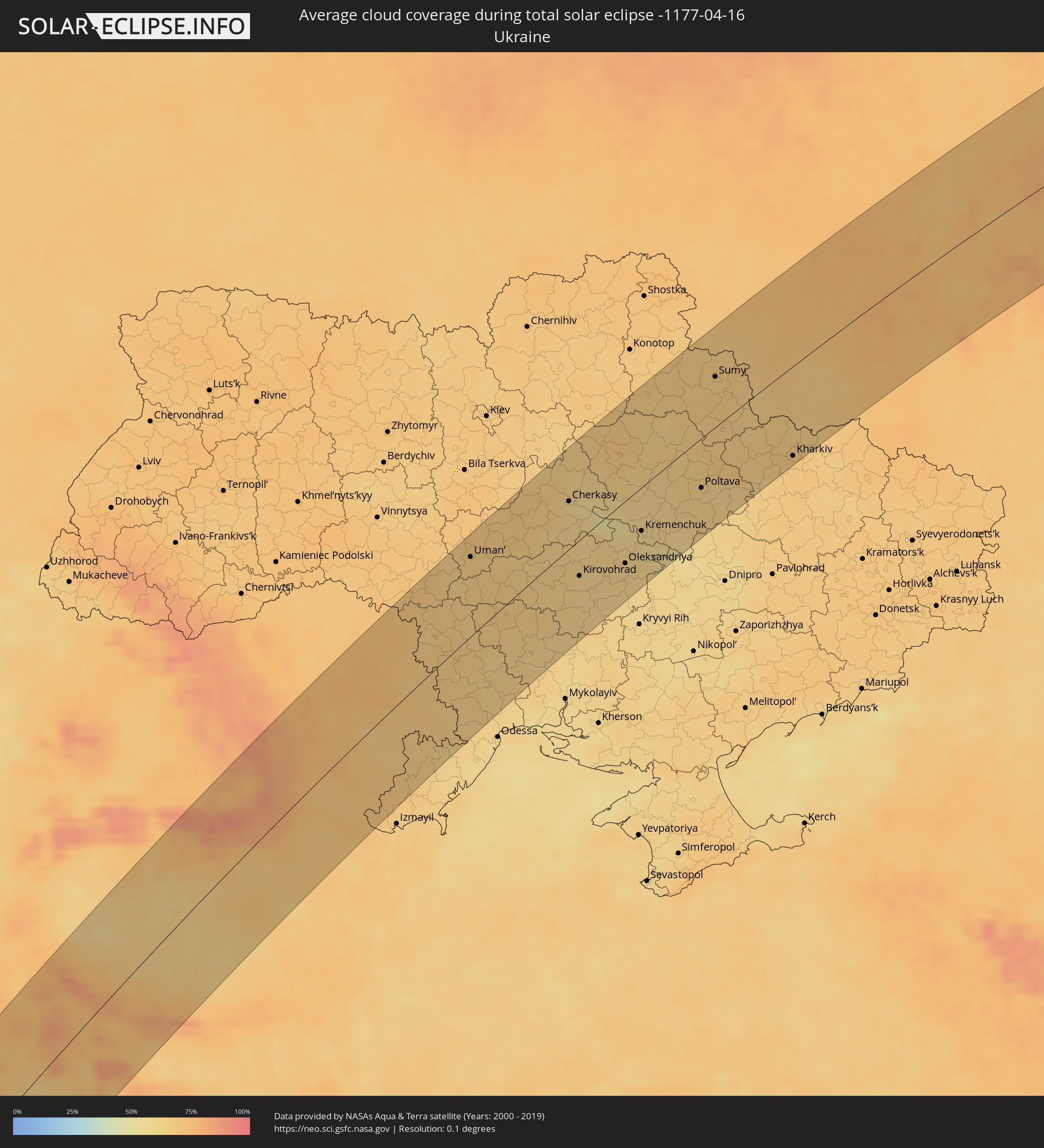 Ukraine
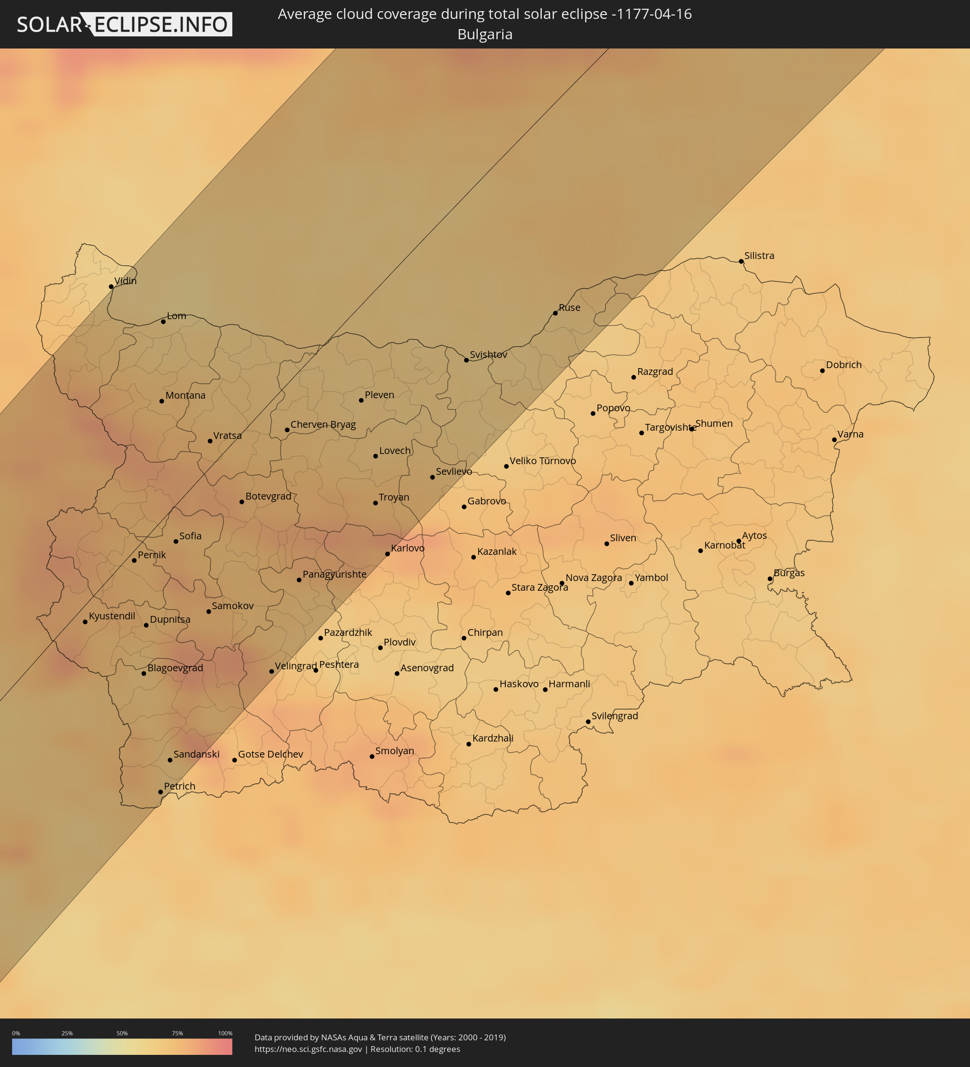 Bulgarien
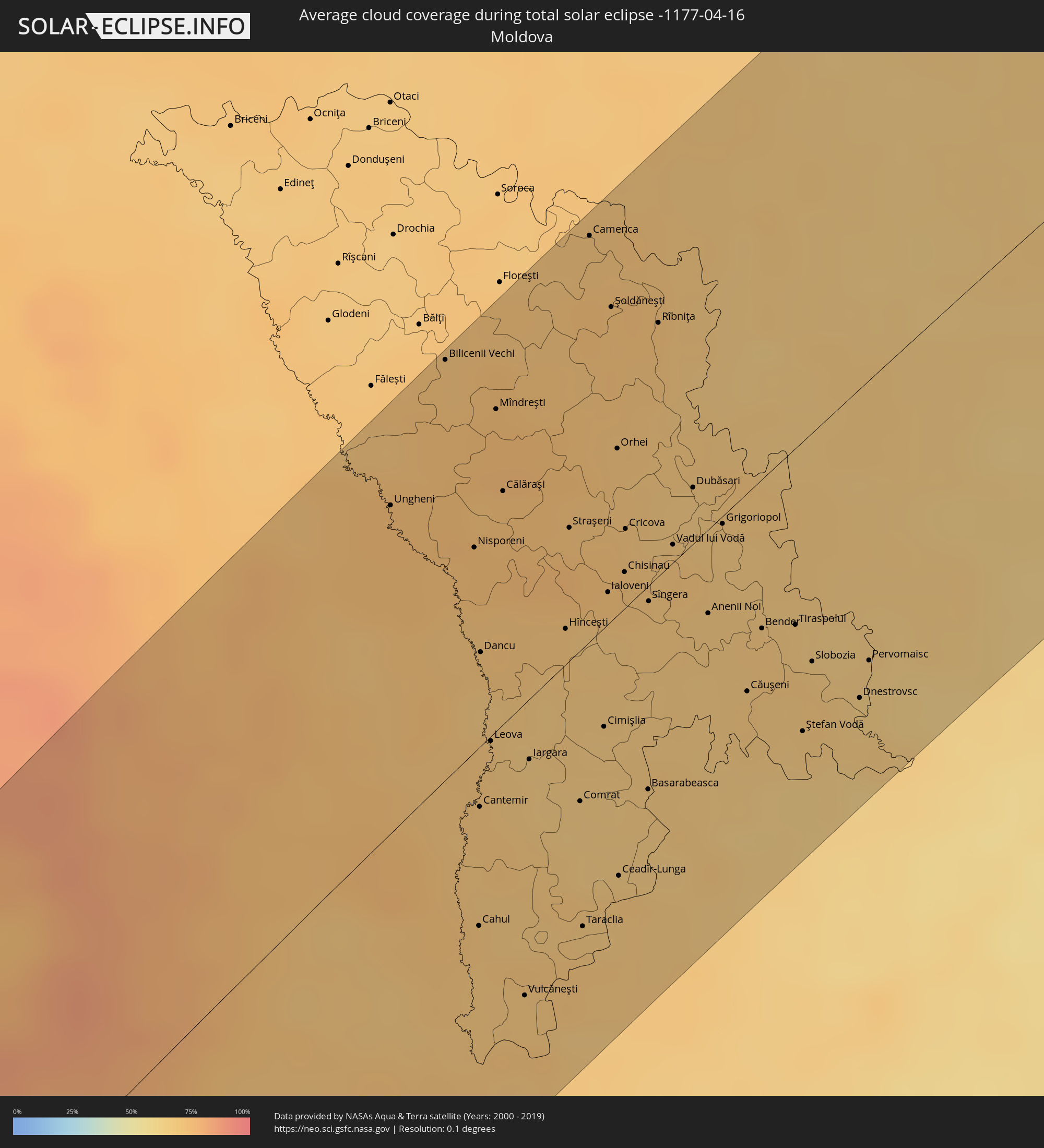 Moldawien
Orte im Finsternispfad
Die nachfolgene Tabelle zeigt Städte und Orte mit mehr als 5.000 Einwohnern, die sich im Finsternispfad befinden. Städte mit mehr als 100.000 Einwohnern sind dick gekennzeichnet. Mit einem Klick auf den Ort öffnet sich eine Detailkarte die die Lage des jeweiligen Ortes zusammen mit dem Verlauf der zentralen Finsternis präsentiert.
| Ort | Typ | Dauer der Verfinsterung | Ortszeit bei maximaler Verfinsterung | Entfernung zur Zentrallinie | Ø Bewölkung |
|
Camayenne, Conakry
|
total | - | 08:31:04 UTC-00:16 | 39 km | 67% |
|
Dubréka, Kindia
|
total | - | 08:31:35 UTC-00:16 | 55 km | 55% |
|
Coyah, Kindia
|
total | - | 08:31:32 UTC-00:16 | 40 km | 60% |
|
Tondon, Kindia
|
total | - | 08:32:36 UTC-00:16 | 103 km | 49% |
|
Freetown, Western Area
|
total | - | 08:29:38 UTC-00:16 | 91 km | 81% |
|
Freetown, Western Area
|
total | - | 08:29:45 UTC-00:16 | 89 km | 74% |
|
Tintafor, Northern Province
|
total | - | 08:29:59 UTC-00:16 | 75 km | 73% |
|
Forécariah, Kindia
|
total | - | 08:31:19 UTC-00:16 | 2 km | 65% |
|
Waterloo, Western Area
|
total | - | 08:29:38 UTC-00:16 | 111 km | 81% |
|
Mambolo, Northern Province
|
total | - | 08:30:33 UTC-00:16 | 56 km | 77% |
|
Kambia, Northern Province
|
total | - | 08:30:57 UTC-00:16 | 41 km | 77% |
|
Kindia, Kindia
|
total | - | 08:32:27 UTC-00:16 | 47 km | 46% |
|
Port Loko, Northern Province
|
total | - | 08:30:29 UTC-00:16 | 83 km | 81% |
|
Kukuna, Northern Province
|
total | - | 08:31:33 UTC-00:16 | 28 km | 70% |
|
Lunsar, Northern Province
|
total | - | 08:30:32 UTC-00:16 | 104 km | 83% |
|
Dalaba, Mamou
|
total | - | 08:33:54 UTC-00:16 | 76 km | 40% |
|
Kamakwie, Northern Province
|
total | - | 08:32:00 UTC-00:16 | 40 km | 66% |
|
Mamou, Mamou
|
total | - | 08:33:31 UTC-00:16 | 37 km | 47% |
|
Makeni, Northern Province
|
total | - | 08:31:11 UTC-00:16 | 110 km | 80% |
|
Binkolo, Northern Province
|
total | - | 08:31:20 UTC-00:16 | 107 km | 79% |
|
Kabala, Northern Province
|
total | - | 08:32:39 UTC-00:16 | 68 km | 61% |
|
Dabola, Faranah
|
total | - | 08:34:50 UTC-00:16 | 19 km | 41% |
|
Faranah, Faranah
|
total | - | 08:33:59 UTC-00:16 | 69 km | 53% |
|
Dinguiraye, Faranah
|
total | - | 08:36:03 UTC-00:16 | 48 km | 32% |
|
Kouroussa, Kankan
|
total | - | 08:35:38 UTC-00:16 | 60 km | 43% |
|
Siguiri, Kankan
|
total | - | 08:37:30 UTC-00:16 | 29 km | 40% |
|
Kangaba, Koulikoro
|
total | - | 08:39:00 UTC-00:16 | 26 km | 38% |
|
Kati, Koulikoro
|
total | - | 08:40:42 UTC-00:16 | 27 km | 31% |
|
Kolokani, Koulikoro
|
total | - | 08:42:11 UTC-00:16 | 100 km | 22% |
|
Bamako, Bamako
|
total | - | 08:40:36 UTC-00:16 | 14 km | 31% |
|
Koulikoro, Koulikoro
|
total | - | 08:41:22 UTC-00:16 | 6 km | 28% |
|
Banamba, Koulikoro
|
total | - | 08:42:40 UTC-00:16 | 61 km | 24% |
|
Ségou, Ségou
|
total | - | 08:43:36 UTC-00:16 | 28 km | 27% |
|
Markala, Ségou
|
total | - | 08:44:13 UTC-00:16 | 14 km | 27% |
|
Ké-Macina, Ségou
|
total | - | 08:45:22 UTC-00:16 | 37 km | 29% |
|
Djénné, Mopti
|
total | - | 08:46:03 UTC-00:16 | 96 km | 31% |
|
Mopti, Mopti
|
total | - | 08:47:29 UTC-00:16 | 71 km | 32% |
|
Goundam, Tombouctou
|
total | - | 08:51:35 UTC-00:16 | 59 km | 22% |
|
Timbuktu, Tombouctou
|
total | - | 08:52:58 UTC-00:16 | 42 km | 15% |
|
Illizi, Illizi
|
total | - | 09:52:02 UTC+00:09 | 99 km | 23% |
|
Nālūt, Sha‘bīyat Nālūt
|
total | - | 10:49:34 UTC+00:52 | 75 km | 21% |
|
Zuwārah, An Nuqāţ al Khams
|
total | - | 10:53:09 UTC+00:52 | 64 km | 31% |
|
Zintan, Jabal al Gharbi District
|
total | - | 10:51:30 UTC+00:52 | 17 km | 24% |
|
Şabrātah, Az Zāwiyah
|
total | - | 10:53:28 UTC+00:52 | 24 km | 39% |
|
Yafran, Jabal al Gharbi District
|
total | - | 10:52:09 UTC+00:52 | 28 km | 25% |
|
Şurmān, Az Zāwiyah
|
total | - | 10:53:31 UTC+00:52 | 15 km | 43% |
|
Az Zāwīyah, Az Zāwiyah
|
total | - | 10:53:44 UTC+00:52 | 4 km | 44% |
|
Mizdah, Jabal al Gharbi District
|
total | - | 10:51:38 UTC+00:52 | 104 km | 24% |
|
Gharyan, Jabal al Gharbi District
|
total | - | 10:53:04 UTC+00:52 | 58 km | 29% |
|
Tripoli, Tripoli
|
total | - | 10:54:38 UTC+00:52 | 22 km | 43% |
|
Tagiura, Tripoli
|
total | - | 10:54:52 UTC+00:52 | 34 km | 42% |
|
Tarhuna, Al Marqab
|
total | - | 10:54:27 UTC+00:52 | 85 km | 30% |
|
Masallātah, Al Marqab
|
total | - | 10:55:19 UTC+00:52 | 100 km | 41% |
|
Nadur, In-Nadur
|
total | - | 11:09:13 UTC+01:00 | 111 km | 51% |
|
Imtarfa, L-Imtarfa
|
total | - | 11:09:07 UTC+01:00 | 94 km | 54% |
|
Lija, Lija
|
total | - | 11:09:12 UTC+01:00 | 91 km | 54% |
|
Hal Gharghur, Ħal Għargħur
|
total | - | 11:09:15 UTC+01:00 | 92 km | 54% |
|
Qrendi, Il-Qrendi
|
total | - | 11:09:06 UTC+01:00 | 86 km | 53% |
|
Birkirkara, Birkirkara
|
total | - | 11:09:13 UTC+01:00 | 90 km | 54% |
|
Mqabba, L-Imqabba
|
total | - | 11:09:08 UTC+01:00 | 86 km | 53% |
|
Safi, Safi
|
total | - | 11:09:08 UTC+01:00 | 84 km | 53% |
|
Kirkop, Kirkop
|
total | - | 11:09:09 UTC+01:00 | 84 km | 53% |
|
Ta’ Xbiex, Ta’ Xbiex
|
total | - | 11:09:16 UTC+01:00 | 88 km | 54% |
|
Floriana, Il-Furjana
|
total | - | 11:09:16 UTC+01:00 | 86 km | 54% |
|
Vittoriosa, Il-Birgu
|
total | - | 11:09:17 UTC+01:00 | 85 km | 54% |
|
Xgħajra, Ix-Xgħajra
|
total | - | 11:09:19 UTC+01:00 | 83 km | 54% |
|
Pachino, Sicily
|
total | - | 11:11:32 UTC+01:00 | 101 km | 48% |
|
Avola, Sicily
|
total | - | 11:11:56 UTC+01:00 | 110 km | 54% |
|
Ruffano, Apulia
|
total | - | 11:21:21 UTC+01:00 | 110 km | 56% |
|
Presicce, Apulia
|
total | - | 11:21:15 UTC+01:00 | 103 km | 58% |
|
Alessano, Apulia
|
total | - | 11:21:20 UTC+01:00 | 98 km | 58% |
|
Tricase, Apulia
|
total | - | 11:21:26 UTC+01:00 | 99 km | 56% |
|
Corsano, Apulia
|
total | - | 11:21:23 UTC+01:00 | 96 km | 56% |
|
Gagliano del Capo, Apulia
|
total | - | 11:21:19 UTC+01:00 | 92 km | 54% |
|
Poggiardo, Apulia
|
total | - | 11:21:39 UTC+01:00 | 107 km | 60% |
|
Vlorë, Vlorë
|
total | - | 11:43:10 UTC+01:19 | 63 km | 59% |
|
Fier-Çifçi, Fier
|
total | - | 11:43:39 UTC+01:19 | 76 km | 63% |
|
Lushnjë, Fier
|
total | - | 11:44:11 UTC+01:19 | 83 km | 64% |
|
Tirana, Tiranë
|
total | - | 11:44:54 UTC+01:19 | 103 km | 67% |
|
Corfu, Ionian Islands
|
total | - | 11:58:02 UTC+01:34 | 26 km | 59% |
|
Berat, Berat
|
total | - | 11:44:11 UTC+01:19 | 50 km | 67% |
|
Sarandë, Vlorë
|
total | - | 11:43:01 UTC+01:19 | 13 km | 60% |
|
Tepelenë, Gjirokastër
|
total | - | 11:43:40 UTC+01:19 | 16 km | 72% |
|
Elbasan, Elbasan
|
total | - | 11:44:58 UTC+01:19 | 71 km | 64% |
|
Gjirokastër, Gjirokastër
|
total | - | 11:43:31 UTC+01:19 | 7 km | 76% |
|
Çorovodë, Berat
|
total | - | 11:44:16 UTC+01:19 | 18 km | 69% |
|
Igoumenítsa, Epirus
|
total | - | 11:58:22 UTC+01:34 | 57 km | 57% |
|
Librazhd-Qendër, Elbasan
|
total | - | 11:45:26 UTC+01:19 | 61 km | 72% |
|
Peshkopi, Dibër
|
total | - | 11:46:16 UTC+01:19 | 90 km | 72% |
|
Centar Župa, Centar Župa
|
total | - | 11:26:49 UTC+01:00 | 67 km | 77% |
|
Korçë, Korçë
|
total | - | 11:45:13 UTC+01:19 | 9 km | 70% |
|
Ohrid, Ohrid
|
total | - | 11:26:39 UTC+01:00 | 25 km | 68% |
|
Ioánnina, Epirus
|
total | - | 11:59:27 UTC+01:34 | 83 km | 68% |
|
Anatolí, Epirus
|
total | - | 11:59:25 UTC+01:34 | 86 km | 67% |
|
Gostivar, Gostivar
|
total | - | 11:27:46 UTC+01:00 | 68 km | 74% |
|
Tetovo, Tetovo
|
total | - | 11:28:09 UTC+01:00 | 80 km | 73% |
|
Kastoriá, West Macedonia
|
total | - | 12:01:18 UTC+01:34 | 47 km | 67% |
|
Bitola, Bitola
|
total | - | 11:27:16 UTC+01:00 | 15 km | 75% |
|
Flórina, West Macedonia
|
total | - | 12:01:53 UTC+01:34 | 38 km | 70% |
|
Grevená, West Macedonia
|
total | - | 12:00:54 UTC+01:34 | 90 km | 65% |
|
Skopje, Karpoš
|
total | - | 11:28:46 UTC+01:00 | 50 km | 69% |
|
Prilep, Prilep
|
total | - | 11:28:02 UTC+01:00 | 6 km | 71% |
|
Ptolemaḯda, West Macedonia
|
total | - | 12:01:53 UTC+01:34 | 74 km | 65% |
|
Kumanovo, Kumanovo
|
total | - | 11:29:21 UTC+01:00 | 42 km | 69% |
|
Veles, Veles
|
total | - | 11:28:51 UTC+01:00 | 8 km | 66% |
|
Kozáni, West Macedonia
|
total | - | 12:01:44 UTC+01:34 | 97 km | 64% |
|
Vranje, Central Serbia
|
total | - | 11:30:11 UTC+01:00 | 61 km | 73% |
|
Leskovac, Central Serbia
|
total | - | 11:30:50 UTC+01:00 | 92 km | 70% |
|
Kavadarci, Kavadarci
|
total | - | 11:28:48 UTC+01:00 | 28 km | 67% |
|
Édessa, Central Macedonia
|
total | - | 12:02:49 UTC+01:34 | 77 km | 64% |
|
Náousa, Central Macedonia
|
total | - | 12:02:36 UTC+01:34 | 91 km | 69% |
|
Shtip, Štip
|
total | - | 11:29:29 UTC+01:00 | 16 km | 65% |
|
Véroia, Central Macedonia
|
total | - | 12:02:39 UTC+01:34 | 107 km | 65% |
|
Giannitsá, Central Macedonia
|
total | - | 12:03:19 UTC+01:34 | 100 km | 61% |
|
Kochani, Kočani
|
total | - | 11:30:02 UTC+01:00 | 17 km | 67% |
|
Pirot, Central Serbia
|
total | - | 11:31:55 UTC+01:00 | 64 km | 75% |
|
Strumica, Strumica
|
total | - | 11:29:42 UTC+01:00 | 67 km | 66% |
|
Kyustendil, Kyustendil
|
total | - | 12:30:55 UTC+02:00 | 7 km | 73% |
|
Pernik, Pernik
|
total | - | 12:31:49 UTC+02:00 | 4 km | 74% |
|
Blagoevgrad, Blagoevgrad
|
total | - | 12:31:08 UTC+02:00 | 52 km | 67% |
|
Dupnitsa, Kyustendil
|
total | - | 12:31:29 UTC+02:00 | 34 km | 72% |
|
Petrich, Blagoevgrad
|
total | - | 12:30:27 UTC+02:00 | 105 km | 70% |
|
Montana, Montana
|
total | - | 12:33:08 UTC+02:00 | 45 km | 73% |
|
Sofia, Sofia-Capital
|
total | - | 12:32:20 UTC+02:00 | 15 km | 77% |
|
Samokov, Sofia Province
|
total | - | 12:32:11 UTC+02:00 | 55 km | 78% |
|
Vratsa, Vratsa
|
total | - | 12:33:20 UTC+02:00 | 10 km | 77% |
|
Craiova, Dolj
|
total | - | 12:19:26 UTC+01:44 | 79 km | 63% |
|
Râmnicu Vâlcea, Vâlcea
|
total | - | 12:21:08 UTC+01:44 | 106 km | 69% |
|
Slatina, Olt County
|
total | - | 12:20:21 UTC+01:44 | 55 km | 61% |
|
Pleven, Pleven
|
total | - | 12:35:03 UTC+02:00 | 37 km | 66% |
|
Lovech, Lovech
|
total | - | 12:34:50 UTC+02:00 | 65 km | 72% |
|
Piteşti, Argeş
|
total | - | 12:21:30 UTC+01:44 | 58 km | 71% |
|
Svishtov, Veliko Tŭrnovo
|
total | - | 12:36:18 UTC+02:00 | 65 km | 62% |
|
Târgovişte, Dâmboviţa
|
total | - | 12:22:23 UTC+01:44 | 30 km | 69% |
|
Braşov, Braşov
|
total | - | 12:23:24 UTC+01:44 | 78 km | 84% |
|
Ruse, Ruse
|
total | - | 12:37:26 UTC+02:00 | 82 km | 64% |
|
Ploieşti, Prahova
|
total | - | 12:23:10 UTC+01:44 | 0 km | 69% |
|
Bucharest, Bucureşti
|
total | - | 12:22:41 UTC+01:44 | 45 km | 71% |
|
Buzău, Buzău
|
total | - | 12:24:28 UTC+01:44 | 30 km | 73% |
|
Bacău, Bacău
|
total | - | 12:26:05 UTC+01:44 | 77 km | 77% |
|
Iaşi, Iaşi
|
total | - | 12:27:34 UTC+01:44 | 88 km | 73% |
|
Ungheni, Ungheni
|
total | - | 12:38:28 UTC+01:55 | 81 km | 75% |
|
Brăila, Brăila
|
total | - | 12:26:08 UTC+01:44 | 84 km | 71% |
|
Bilicenii Vechi, Sîngerei
|
total | - | 12:39:12 UTC+01:55 | 104 km | 72% |
|
Galaţi, Galaţi
|
total | - | 12:26:25 UTC+01:44 | 73 km | 70% |
|
Cahul, Cahul
|
total | - | 12:37:41 UTC+01:55 | 45 km | 69% |
|
Hînceşti, Hînceşti
|
total | - | 12:39:07 UTC+01:55 | 9 km | 69% |
|
Straşeni, Strășeni
|
total | - | 12:39:26 UTC+01:55 | 33 km | 75% |
|
Comrat, Găgăuzia
|
total | - | 12:38:41 UTC+01:55 | 38 km | 67% |
|
Orhei, Orhei
|
total | - | 12:39:56 UTC+01:55 | 41 km | 70% |
|
Ceadîr-Lunga, Găgăuzia
|
total | - | 12:38:40 UTC+01:55 | 66 km | 69% |
|
Chisinau, Chişinău
|
total | - | 12:39:37 UTC+01:55 | 9 km | 71% |
|
Rîbniţa, Stînga Nistrului
|
total | - | 12:40:31 UTC+01:55 | 63 km | 71% |
|
Dubăsari, Teleneşti
|
total | - | 12:40:16 UTC+01:55 | 14 km | 67% |
|
Căuşeni, Căuşeni
|
total | - | 12:39:59 UTC+01:55 | 50 km | 68% |
|
Tiraspolul, Stînga Nistrului
|
total | - | 12:40:28 UTC+01:55 | 44 km | 69% |
|
Uman’, Cherkasy
|
total | - | 12:49:56 UTC+02:02 | 82 km | 66% |
|
Pervomays’k, Mykolaiv
|
total | - | 12:50:08 UTC+02:02 | 8 km | 65% |
|
Smila, Cherkasy
|
total | - | 12:52:21 UTC+02:02 | 40 km | 63% |
|
Cherkasy, Cherkasy
|
total | - | 12:52:43 UTC+02:02 | 49 km | 60% |
|
Kirovohrad, Kirovohrad
|
total | - | 12:52:16 UTC+02:02 | 37 km | 61% |
|
Lubny, Poltava
|
total | - | 12:54:14 UTC+02:02 | 55 km | 67% |
|
Oleksandriya, Kirovohrad
|
total | - | 12:53:26 UTC+02:02 | 65 km | 61% |
|
Kremenchuk, Poltava
|
total | - | 12:54:06 UTC+02:02 | 45 km | 59% |
|
Komsomolsk, Poltava
|
total | - | 12:54:19 UTC+02:02 | 60 km | 57% |
|
Poltava, Poltava
|
total | - | 12:55:48 UTC+02:02 | 52 km | 64% |
|
Sumy, Sumy
|
total | - | 12:56:54 UTC+02:02 | 52 km | 64% |
|
Okhtyrka, Sumy
|
total | - | 12:56:40 UTC+02:02 | 6 km | 67% |
|
Kursk, Kursk
|
total | - | 13:27:07 UTC+02:30 | 64 km | 72% |
|
Kharkiv, Kharkiv
|
total | - | 12:58:03 UTC+02:02 | 94 km | 68% |
|
Belgorod, Belgorod
|
total | - | 13:27:00 UTC+02:30 | 52 km | 67% |
|
Staryy Oskol, Belgorod
|
total | - | 13:28:46 UTC+02:30 | 44 km | 74% |
|
Voronezh, Voronezj
|
total | - | 13:30:25 UTC+02:30 | 65 km | 74% |
|
Lipetsk, Lipetsk
|
total | - | 13:31:10 UTC+02:30 | 5 km | 73% |
|
Tambov, Tambov
|
total | - | 13:33:11 UTC+02:30 | 54 km | 75% |
|
Saransk, Mordoviya
|
total | - | 13:37:11 UTC+02:30 | 48 km | 71% |
|
Cheboksary, Chuvashia
|
total | - | 13:39:08 UTC+02:30 | 76 km | 79% |
|
Kazan, Tatarstan
|
total | - | 13:40:48 UTC+02:30 | 13 km | 72% |
|
Izhevsk, Udmurtiya
|
total | - | 14:34:03 UTC+03:20 | 16 km | 74% |
|
Perm, Perm
|
total | - | 15:18:12 UTC+04:02 | 31 km | 74% |
|
Nizhniy Tagil, Sverdlovsk
|
total | - | 15:20:50 UTC+04:02 | 56 km | 73% |
|
Nizhnevartovsk, Khanty-Mansiyskiy Avtonomnyy Okrug
|
total | - | 15:27:17 UTC+04:02 | 55 km | 69% |