Totale Sonnenfinsternis vom 28.08.-1184
| Wochentag: | Freitag |
| Maximale Dauer der Verfinsterung: | 04m16s |
| Maximale Breite des Finsternispfades: | 241 km |
| Saroszyklus: | 45 |
| Bedeckungsgrad: | 100% |
| Magnitude: | 1.0587 |
| Gamma: | 0.5979 |
Wo kann man die Sonnenfinsternis vom 28.08.-1184 sehen?
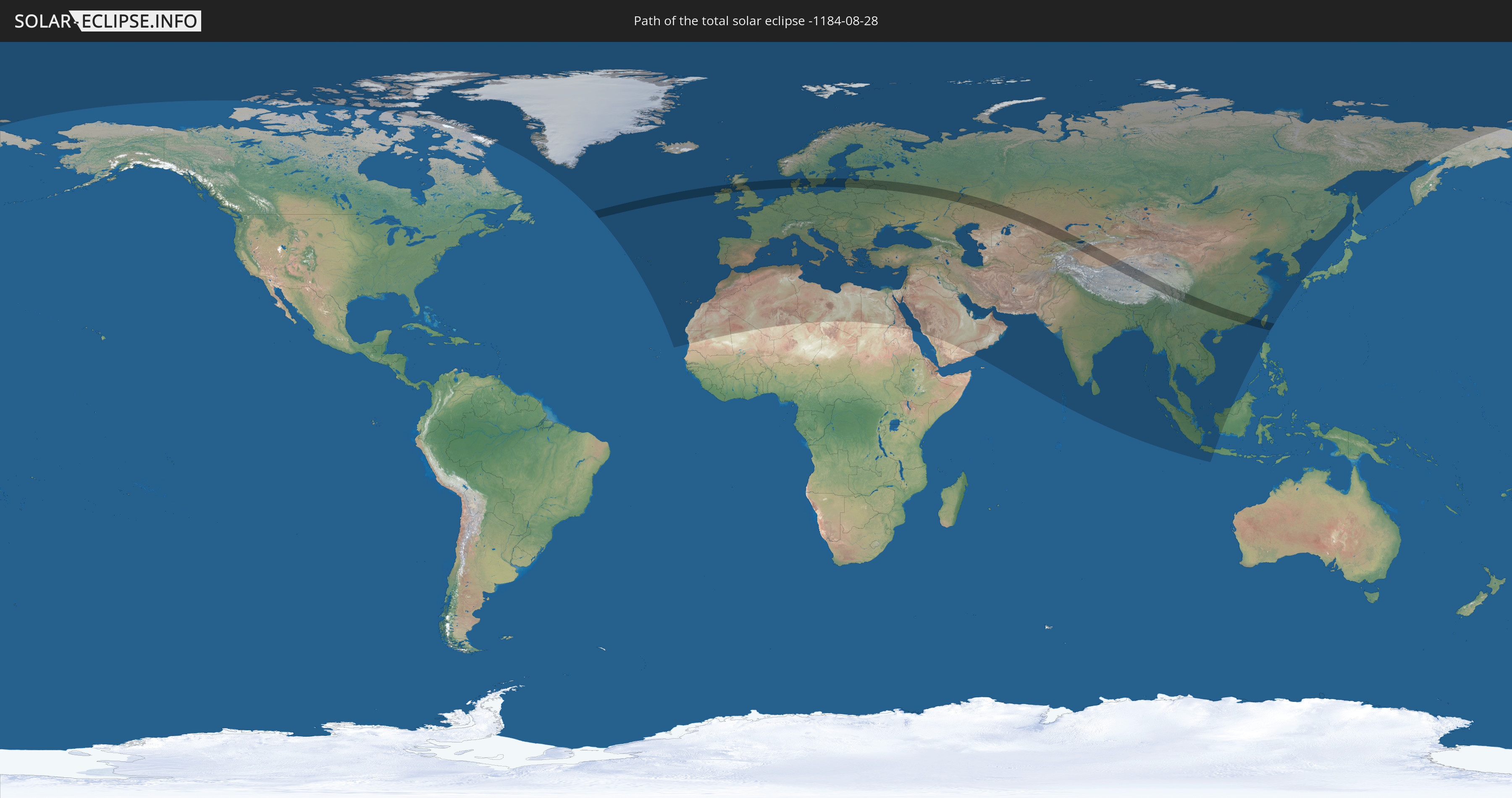
Die Sonnenfinsternis am 28.08.-1184 kann man in 112 Ländern als partielle Sonnenfinsternis beobachten.
Der Finsternispfad verläuft durch 13 Länder. Nur in diesen Ländern ist sie als totale Sonnenfinsternis zu sehen.
In den folgenden Ländern ist die Sonnenfinsternis total zu sehen
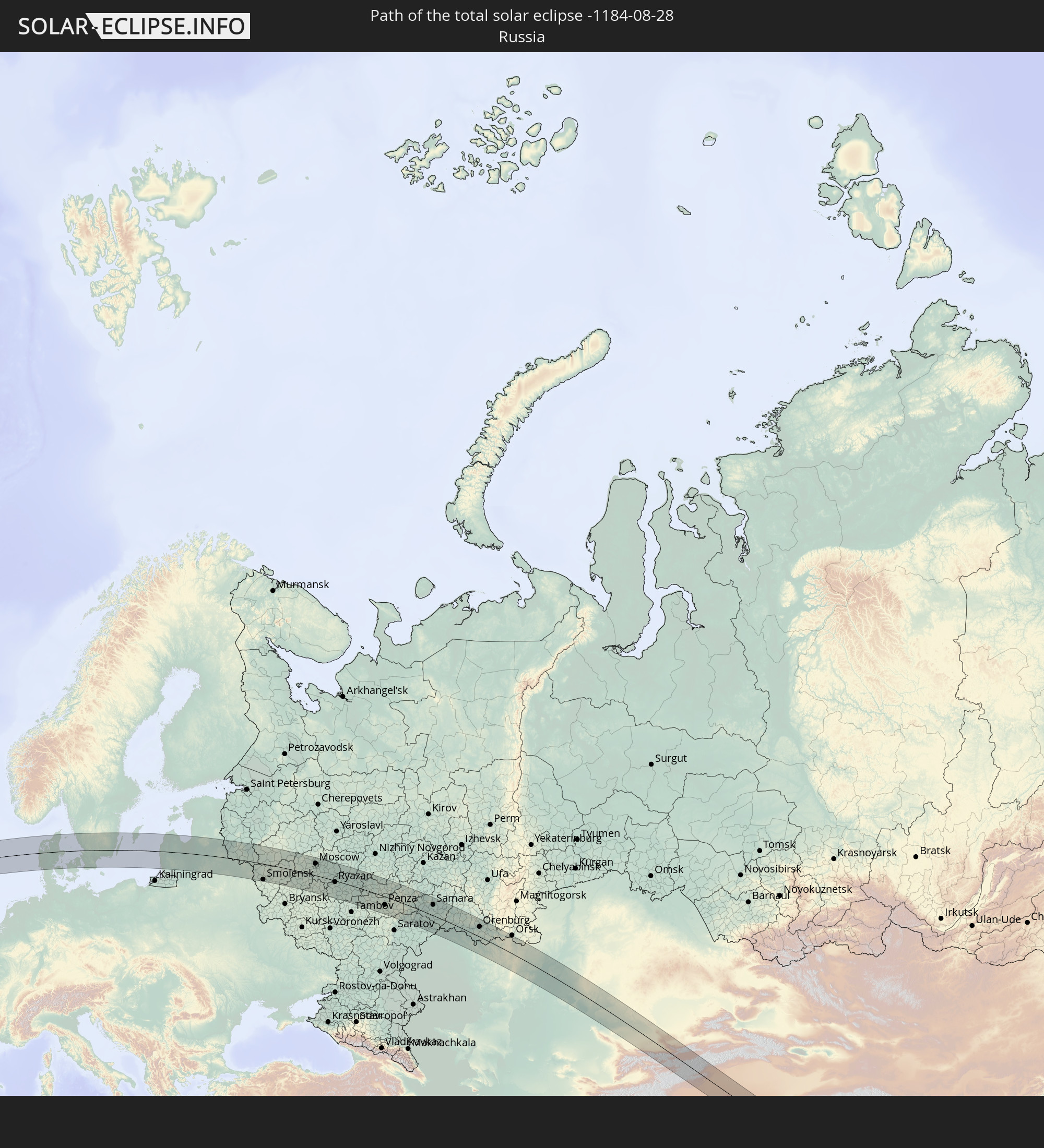 Russland
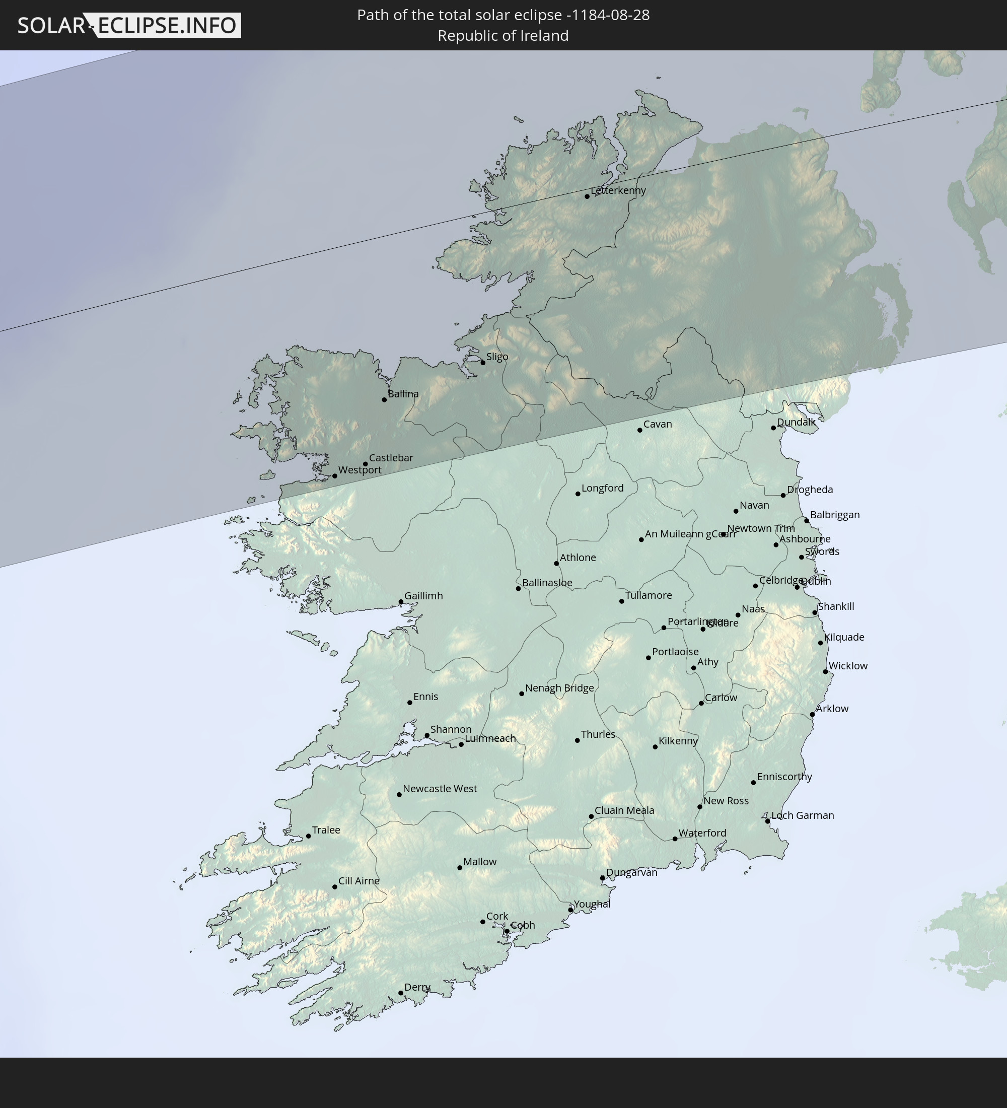 Irland
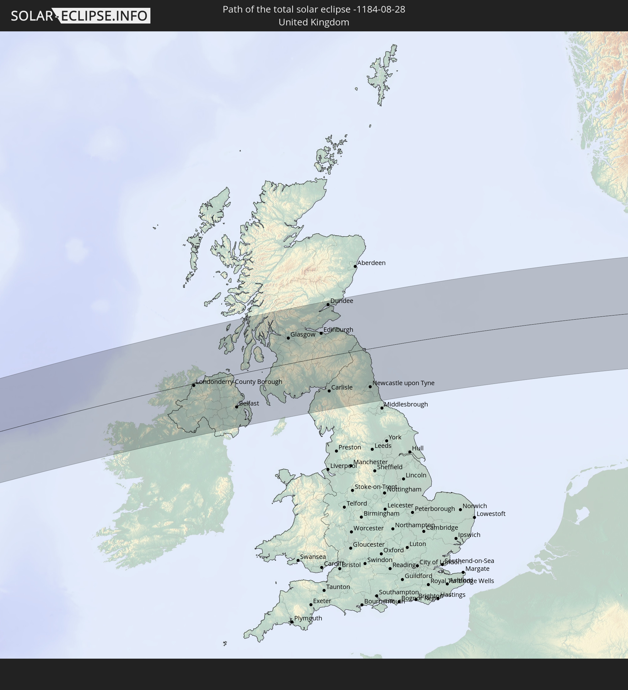 Vereinigtes Königreich
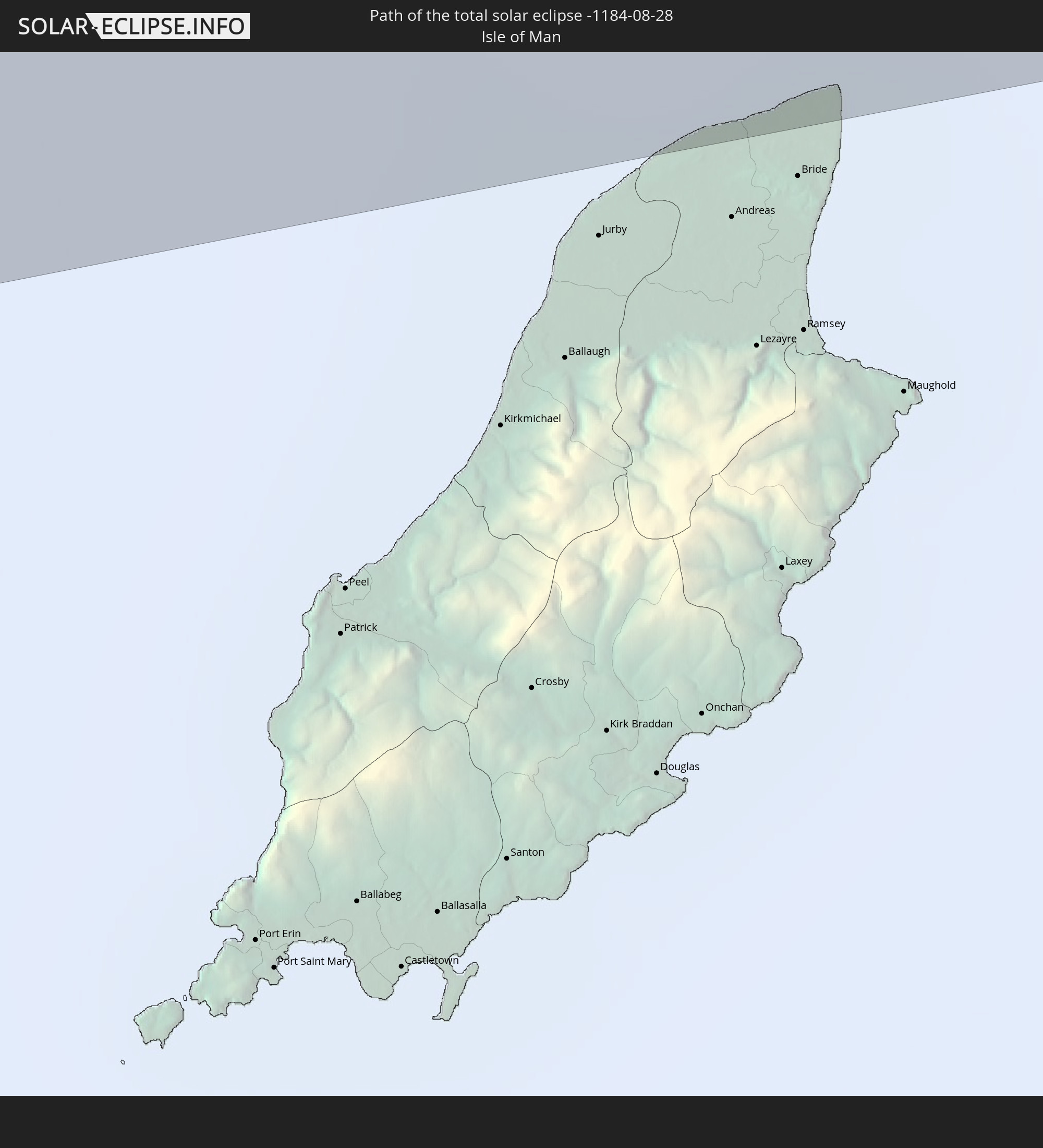 Isle of Man
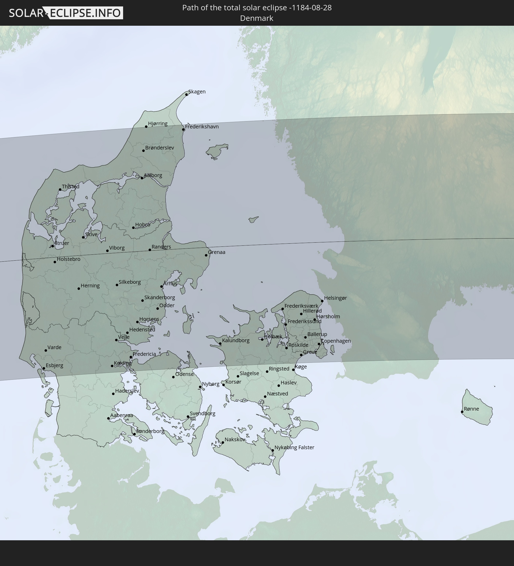 Dänemark
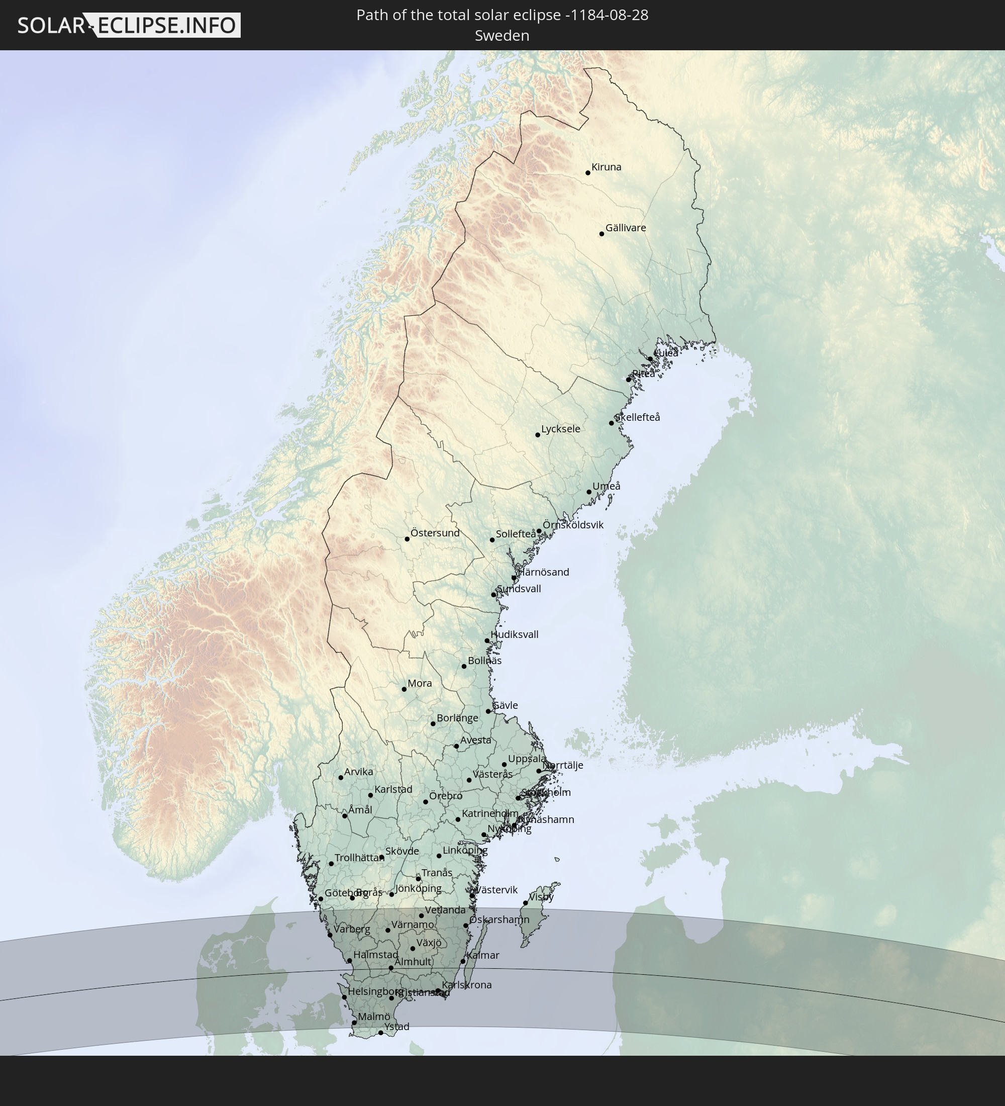 Schweden
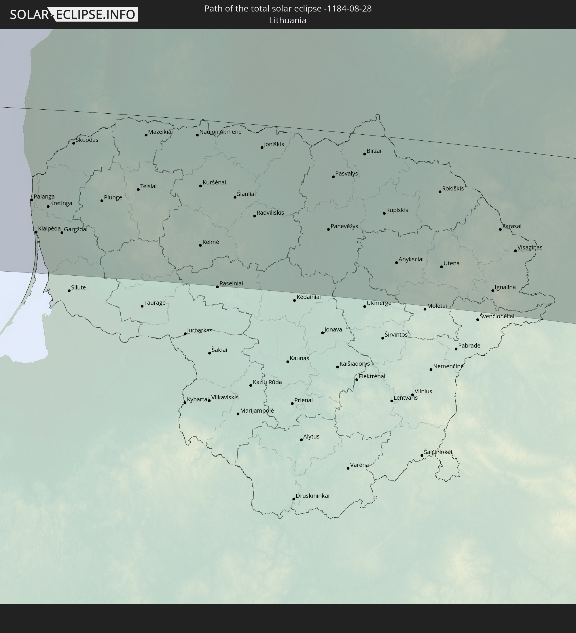 Litauen
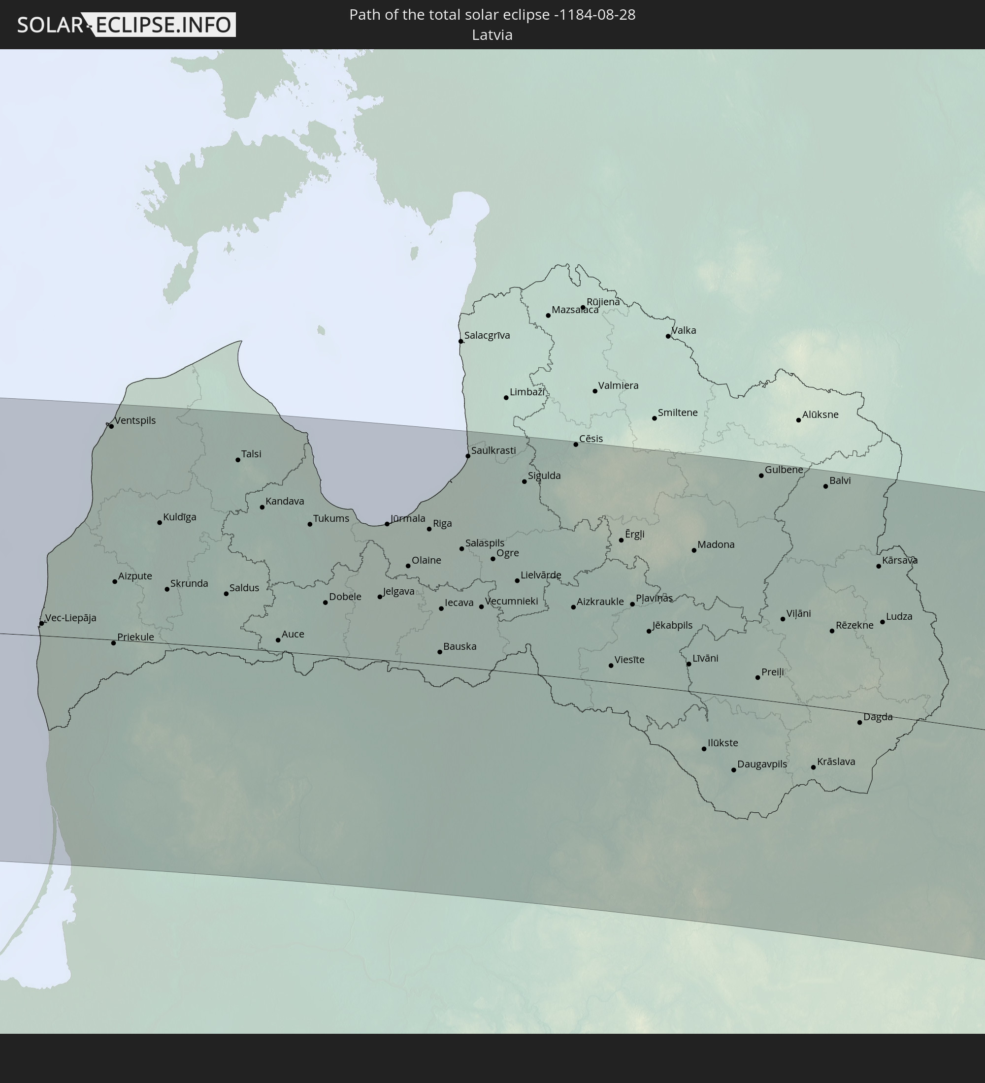 Lettland
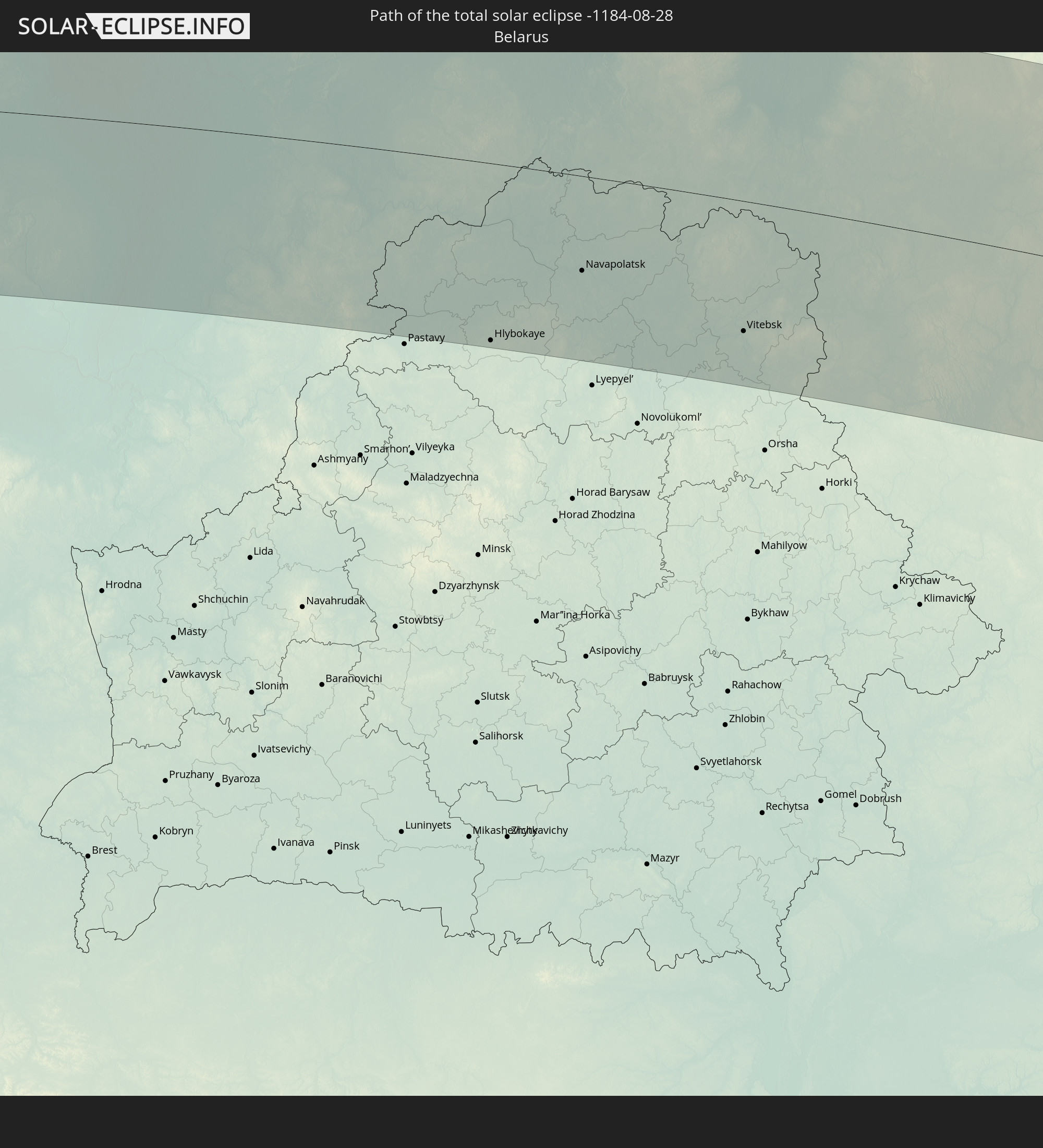 Weißrussland
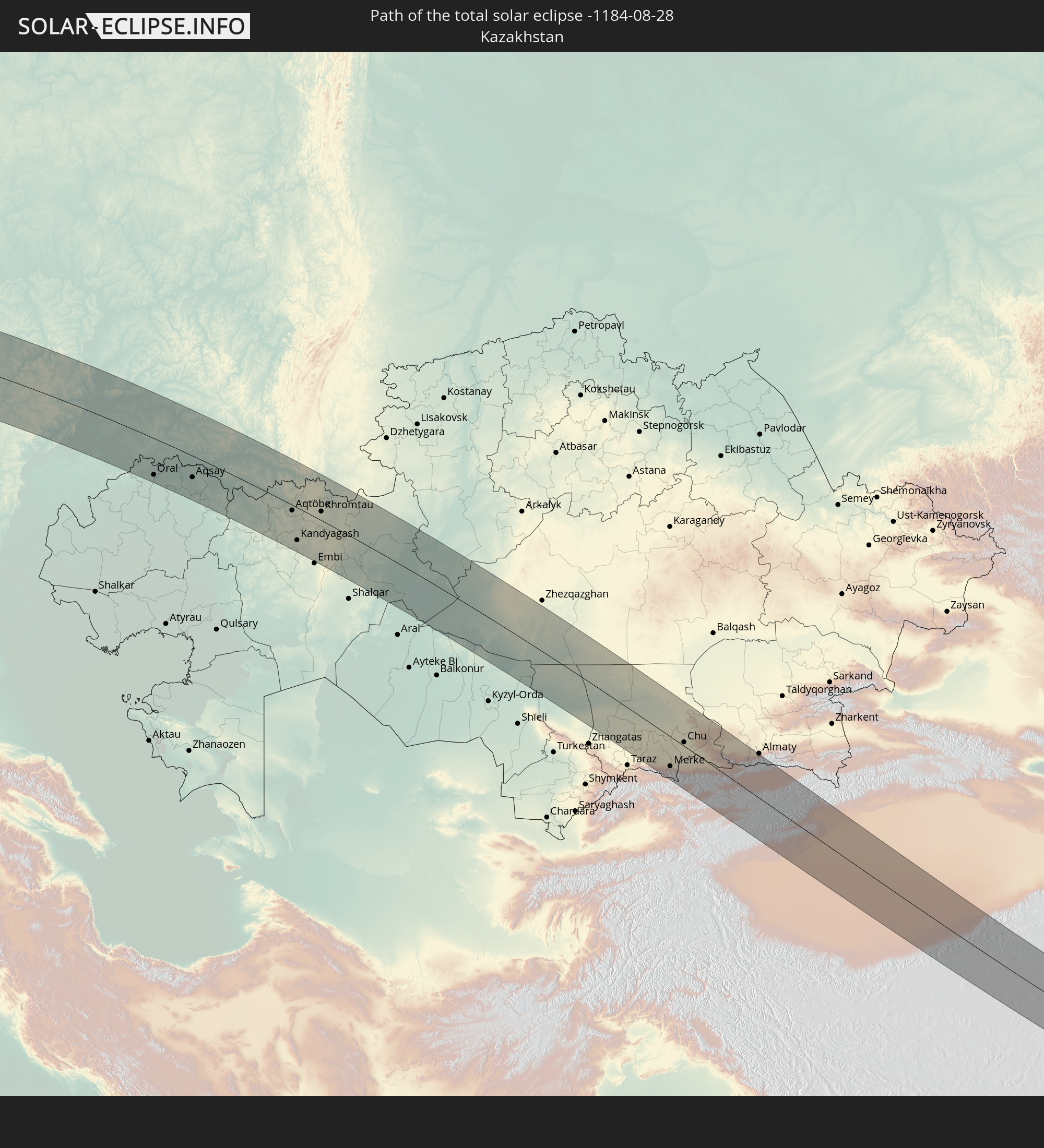 Kasachstan
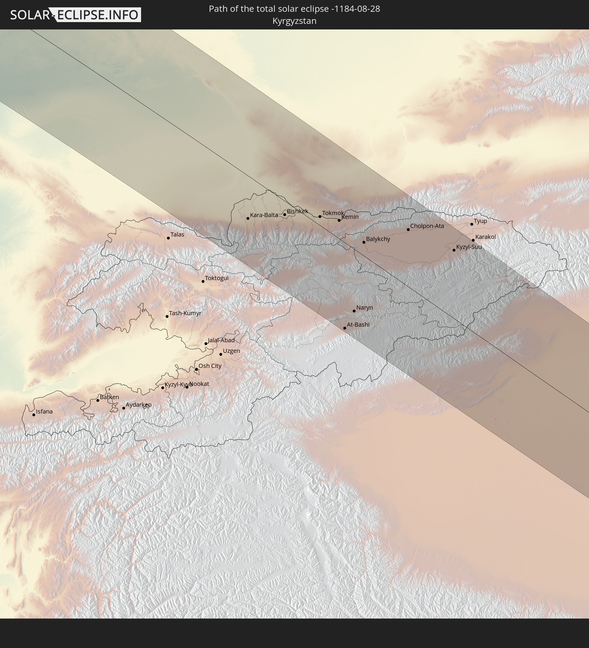 Kirgisistan
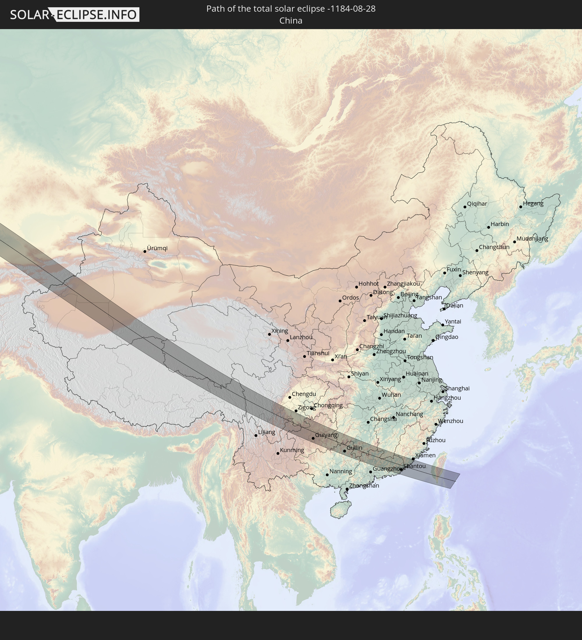 Volksrepublik China
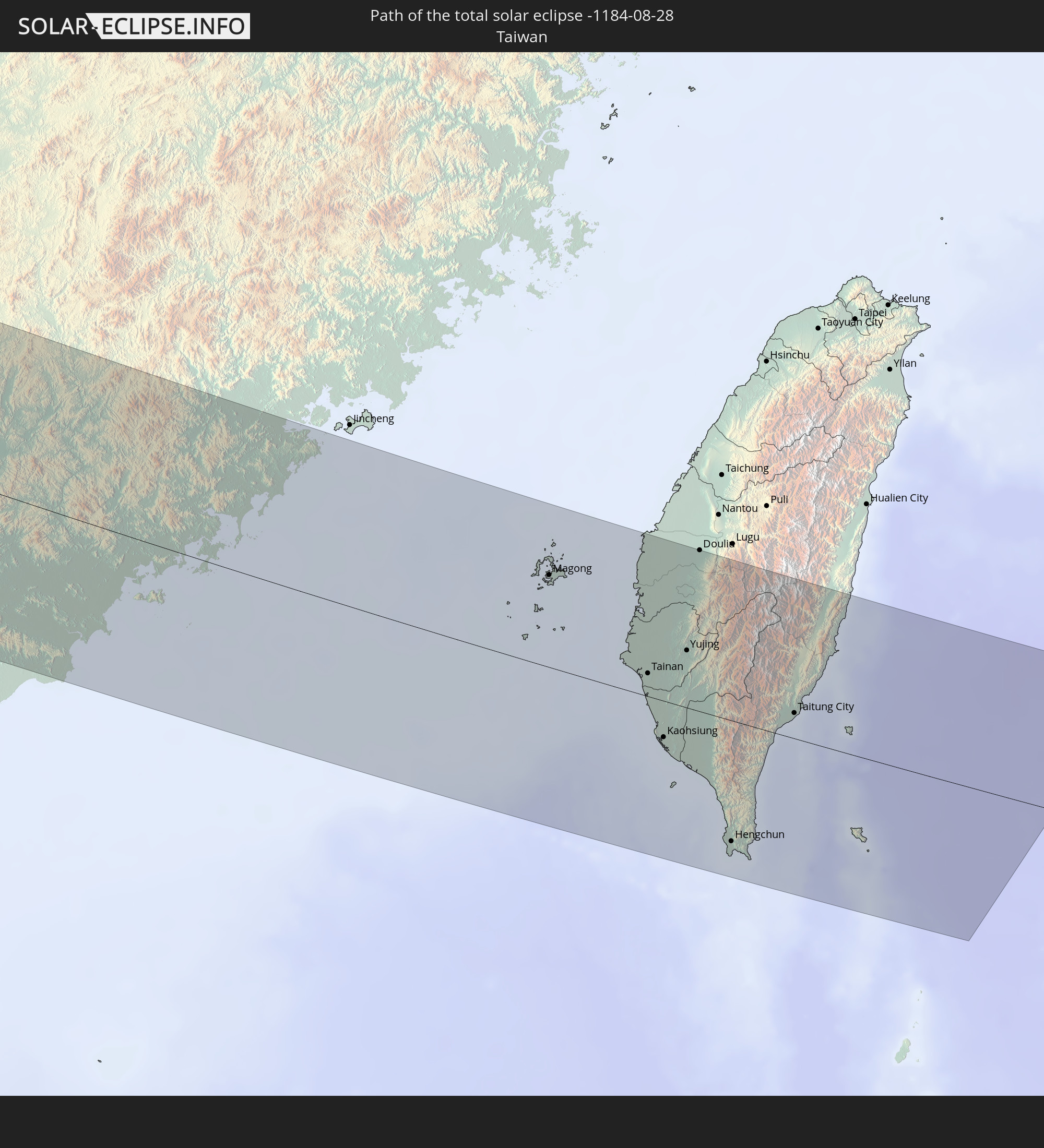 Taiwan
In den folgenden Ländern ist die Sonnenfinsternis partiell zu sehen
 Russland
 Kanada
 Grönland
 Portugal
 Island
 Spanien
 Mauretanien
 Marokko
 Mali
Mali
 Irland
 Spitzbergen
 Algerien
 Vereinigtes Königreich
 Färöer
 Gibraltar
 Frankreich
 Isle of Man
 Guernsey
 Jersey
 Niger
Niger
 Andorra
 Belgien
 Niederlande
 Norwegen
 Luxemburg
 Deutschland
 Schweiz
 Italien
 Monaco
 Tunesien
 Dänemark
 Libyen
 Liechtenstein
 Österreich
 Schweden
 Tschechien
 San Marino
 Vatikanstadt
 Slowenien
 Tschad
 Kroatien
 Polen
Polen
 Malta
Malta
 Bosnien und Herzegowina
 Ungarn
 Slowakei
 Montenegro
 Serbien
 Albanien
 Åland Islands
 Griechenland
 Rumänien
 Mazedonien
 Finnland
 Litauen
 Lettland
 Estland
 Sudan
Sudan
 Ukraine
 Bulgarien
 Weißrussland
 Ägypten
 Türkei
 Moldawien
 Republik Zypern
 Staat Palästina
 Israel
 Saudi-Arabien
 Jordanien
 Libanon
 Syrien
 Irak
Irak
 Georgien
 Jemen
Jemen
 Armenien
 Iran
Iran
 Aserbaidschan
 Kasachstan
 Kuwait
 Bahrain
 Katar
Katar
 Vereinigte Arabische Emirate
 Oman
Oman
 Turkmenistan
 Usbekistan
 Afghanistan
 Pakistan
 Tadschikistan
 Indien
 Kirgisistan
 Malediven
 Volksrepublik China
 Sri Lanka
 Nepal
Nepal
 Mongolei
 Bangladesch
 Bhutan
 Myanmar
 Indonesien
 Thailand
 Malaysia
 Laos
Laos
 Vietnam
 Kambodscha
 Singapur
 Macau
Macau
 Hongkong
 Taiwan
 Philippinen
 Japan
Japan
 Nordkorea
 Südkorea
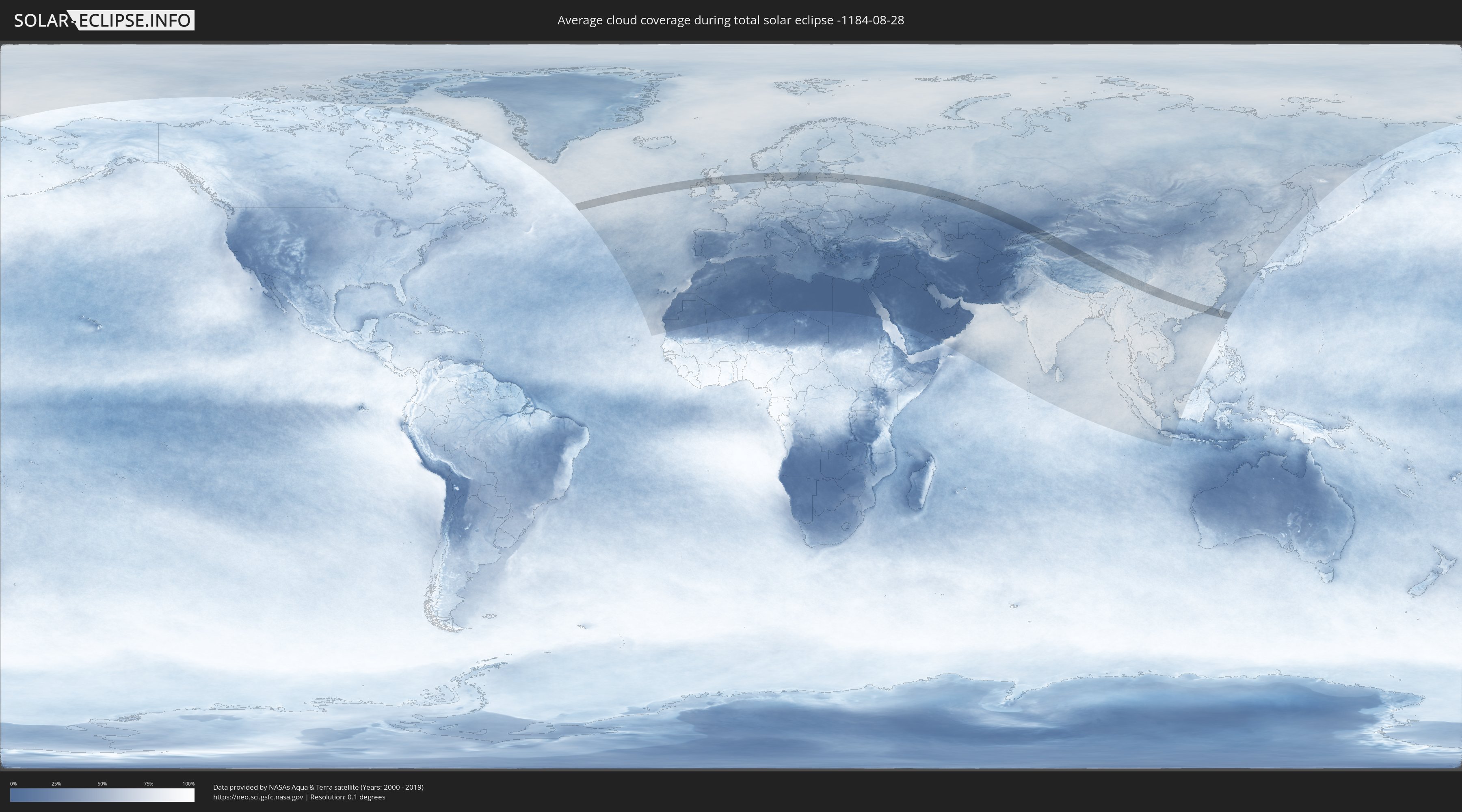
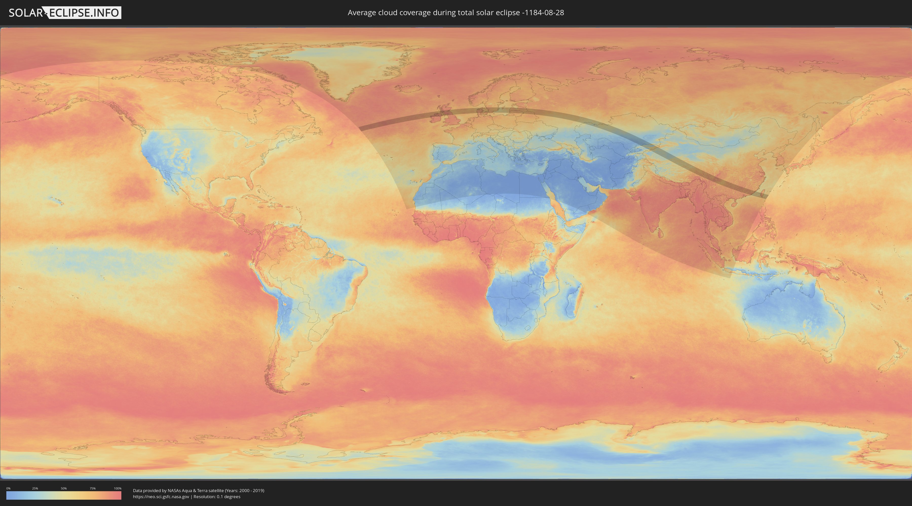
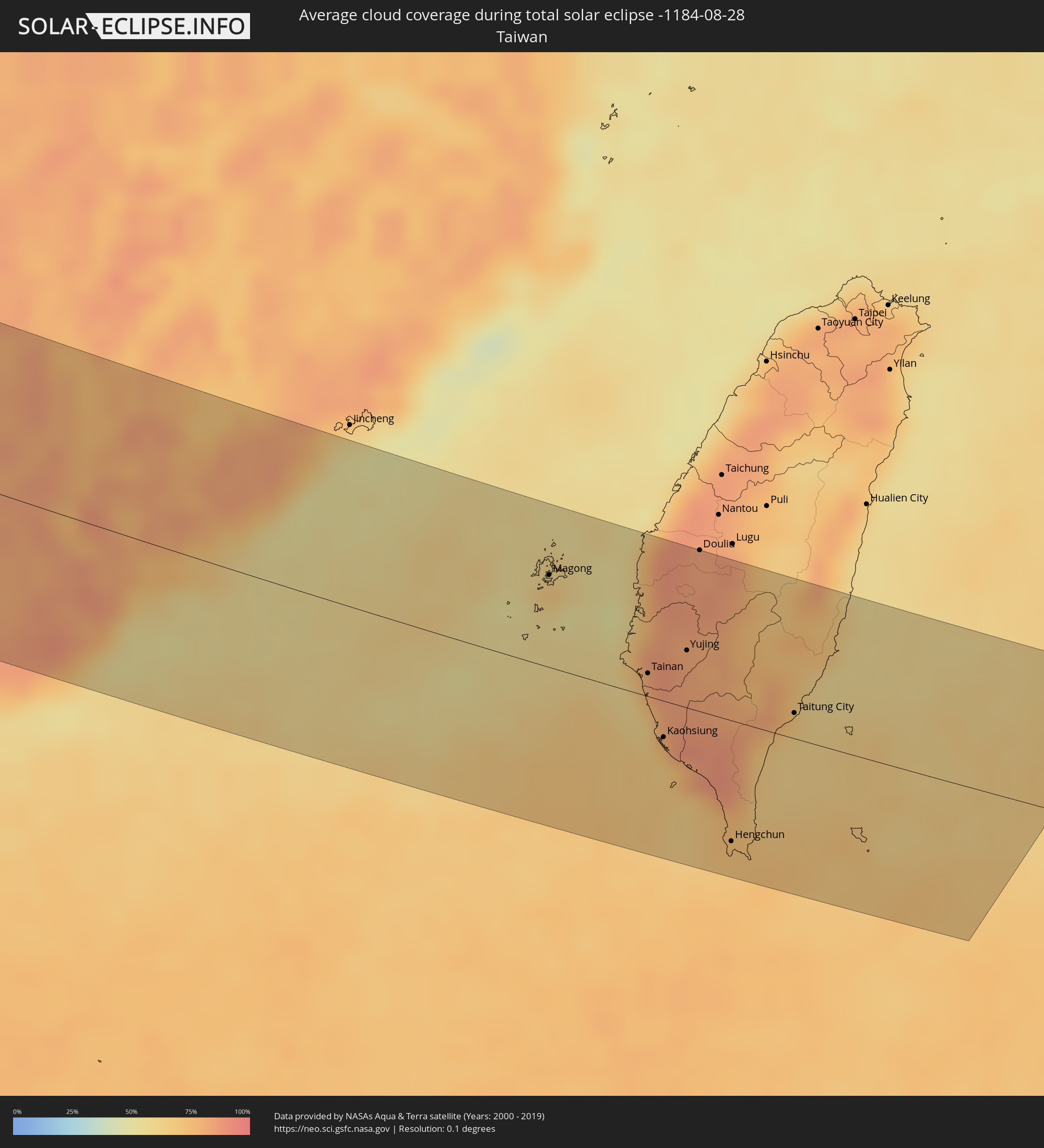
Wie wird das Wetter während der totalen Sonnenfinsternis am 28.08.-1184?
Wo ist der beste Ort, um die totale Sonnenfinsternis vom 28.08.-1184 zu beobachten?
Die folgenden Karten zeigen die durchschnittliche Bewölkung für den Tag, an dem die totale Sonnenfinsternis
stattfindet. Mit Hilfe der Karten lässt sich der Ort entlang des Finsternispfades eingrenzen,
der die besten Aussichen auf einen klaren wolkenfreien Himmel bietet.
Trotzdem muss man immer lokale Gegenenheiten beachten und sollte sich genau über das Wetter an seinem
gewählten Beobachtungsort informieren.
Die Daten stammen von den beiden NASA-Satelliten
AQUA und TERRA
und wurden über einen Zeitraum von 19 Jahren (2000 - 2019) gemittelt.
Detaillierte Länderkarten
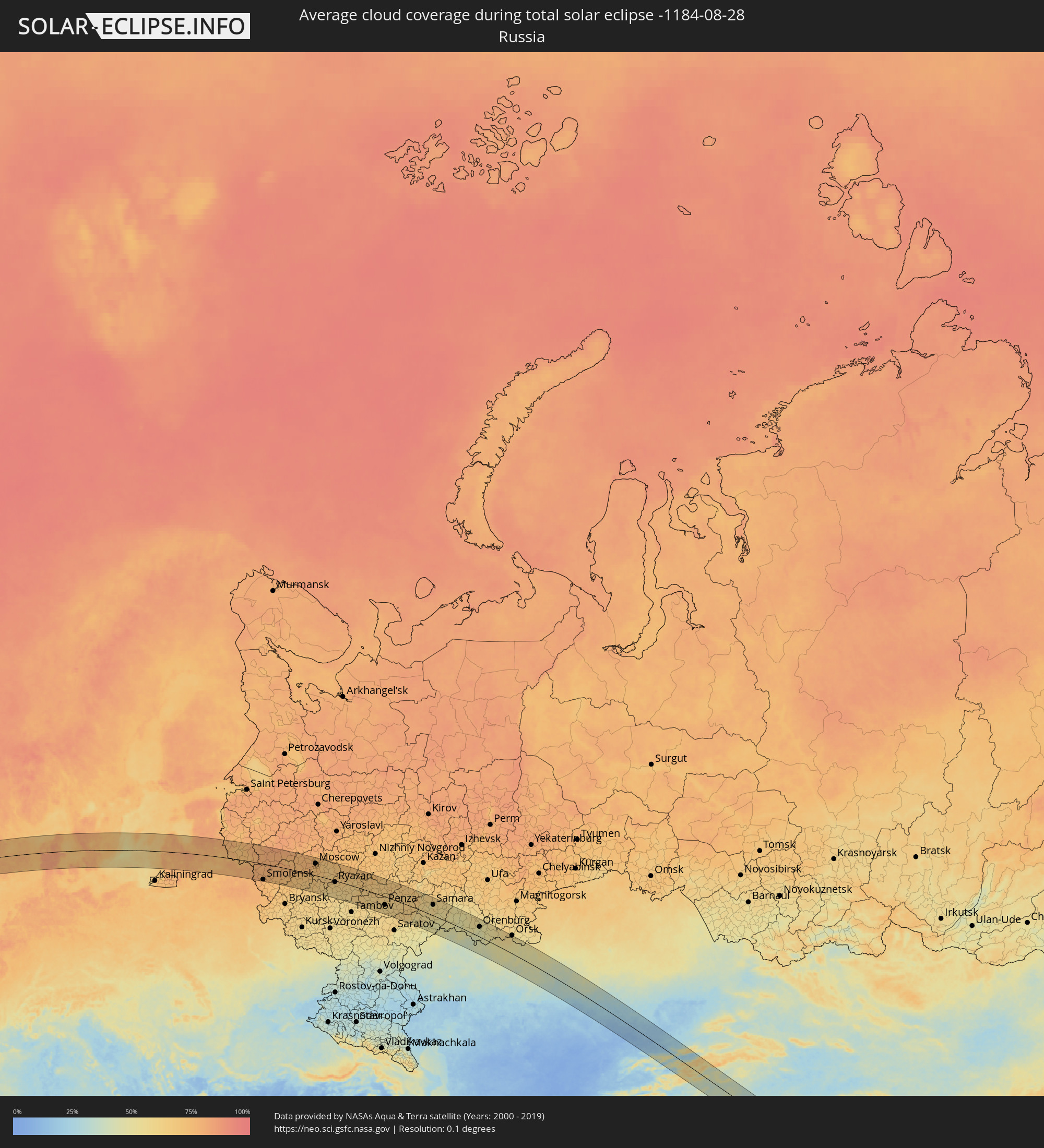 Russland
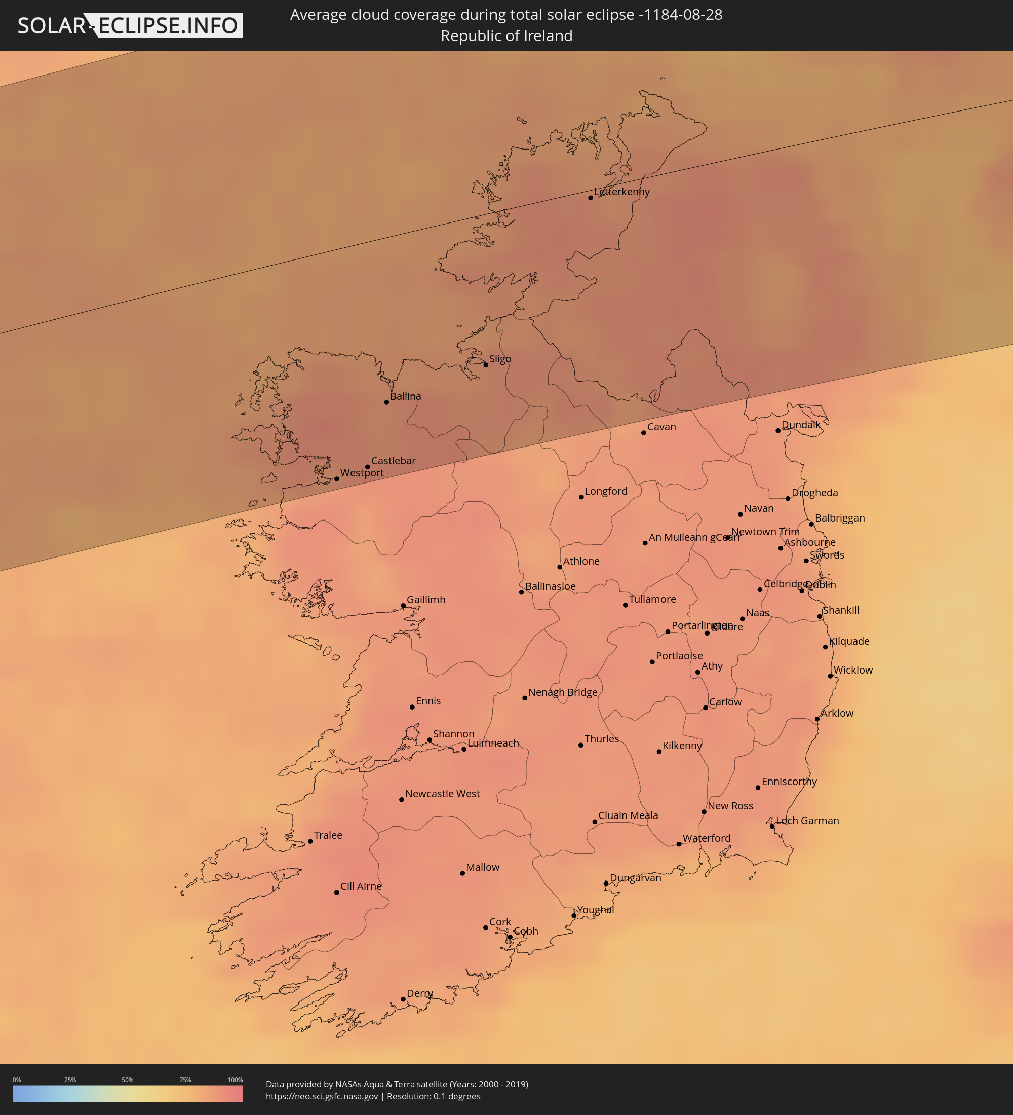 Irland
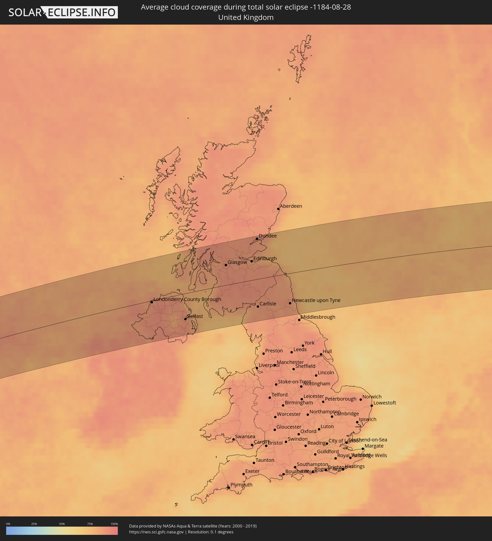 Vereinigtes Königreich
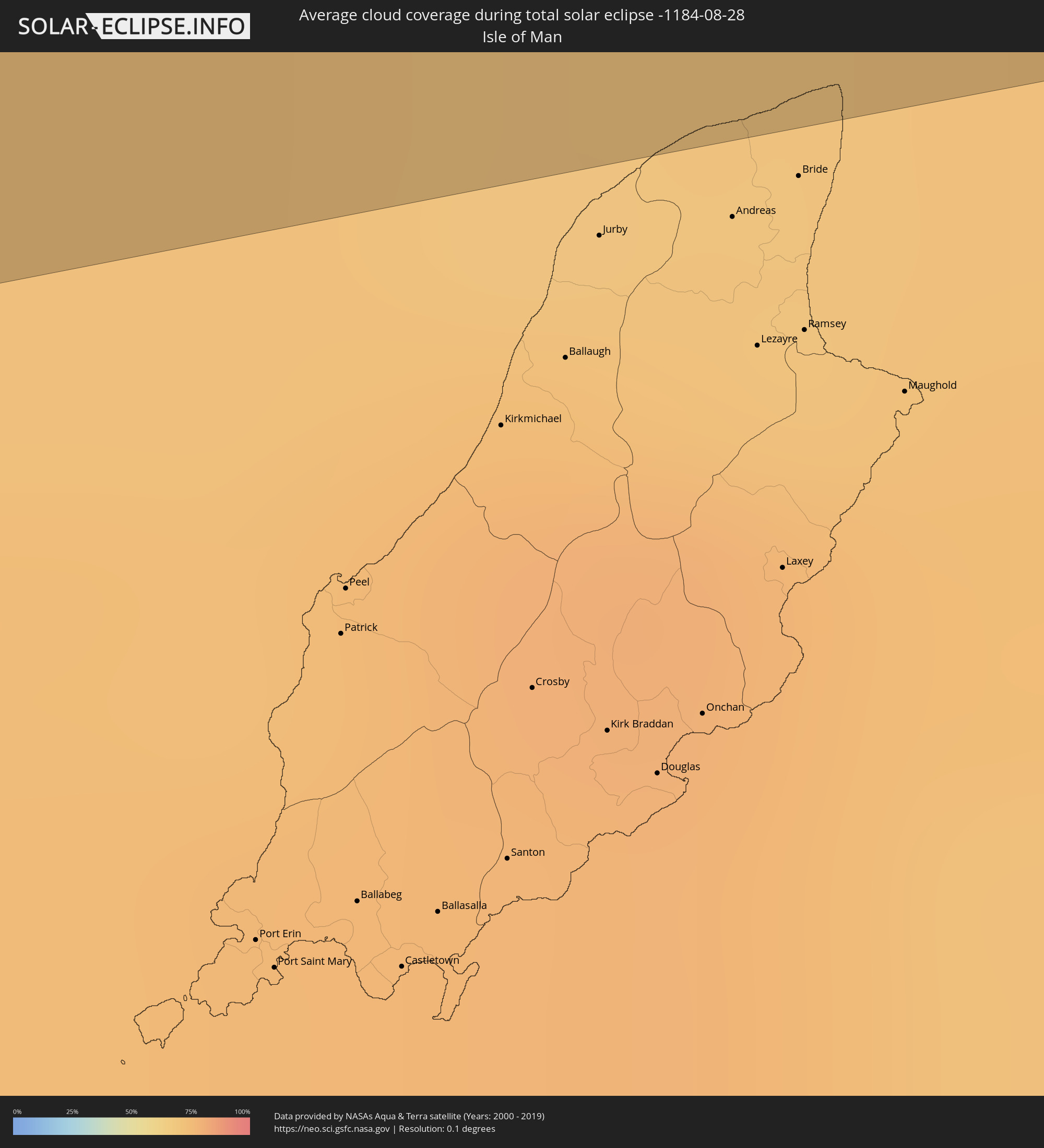 Isle of Man
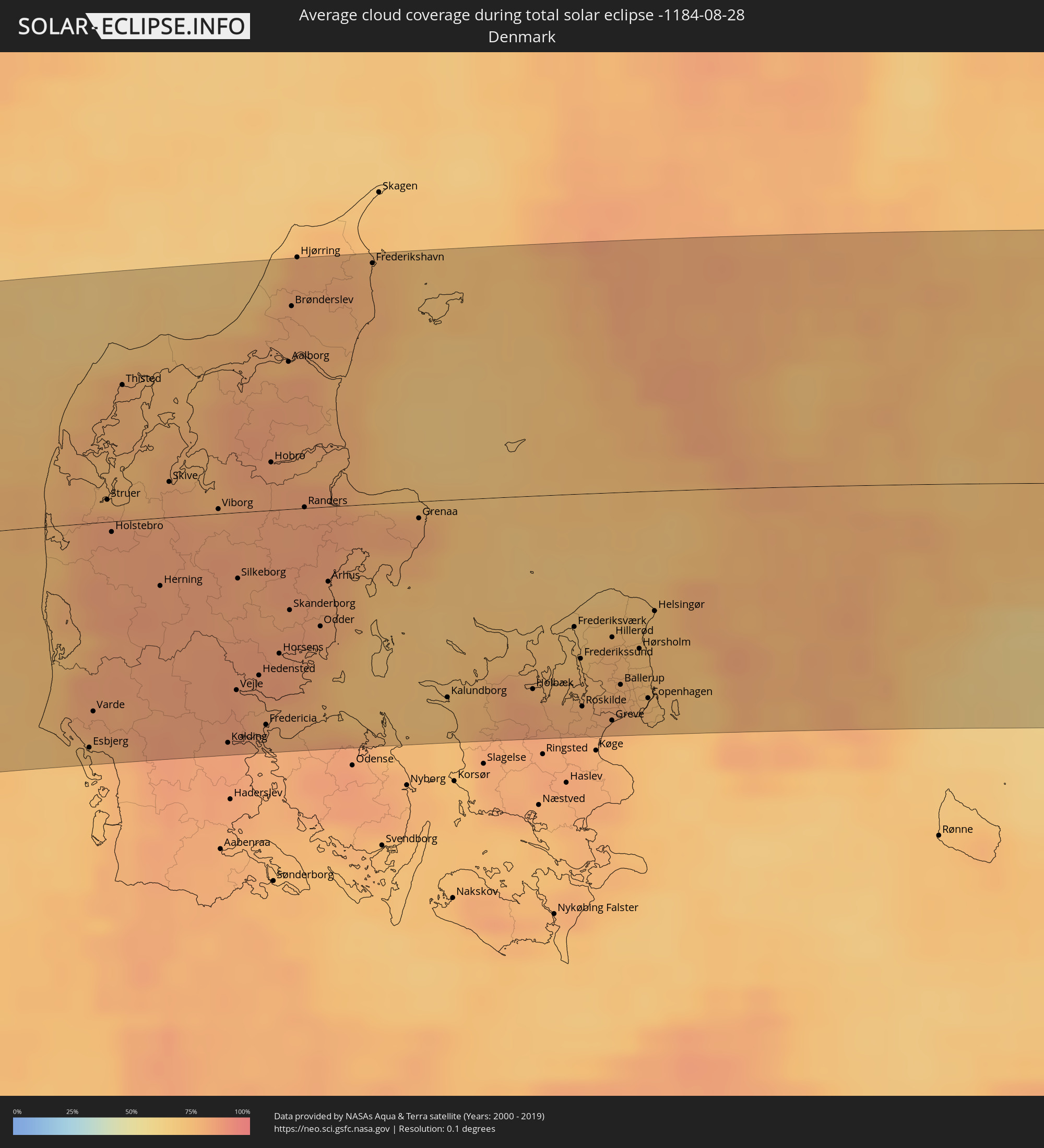 Dänemark
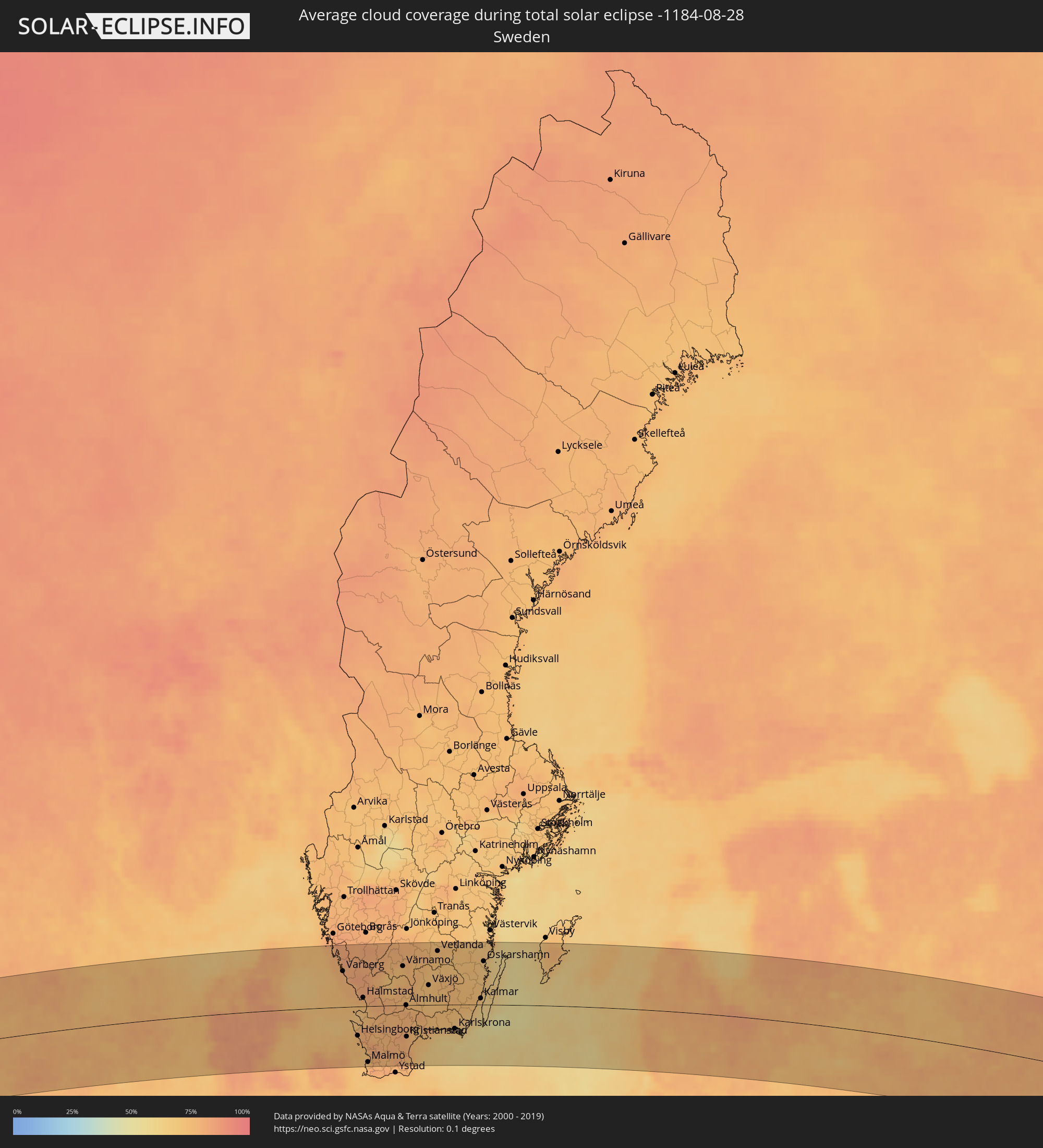 Schweden
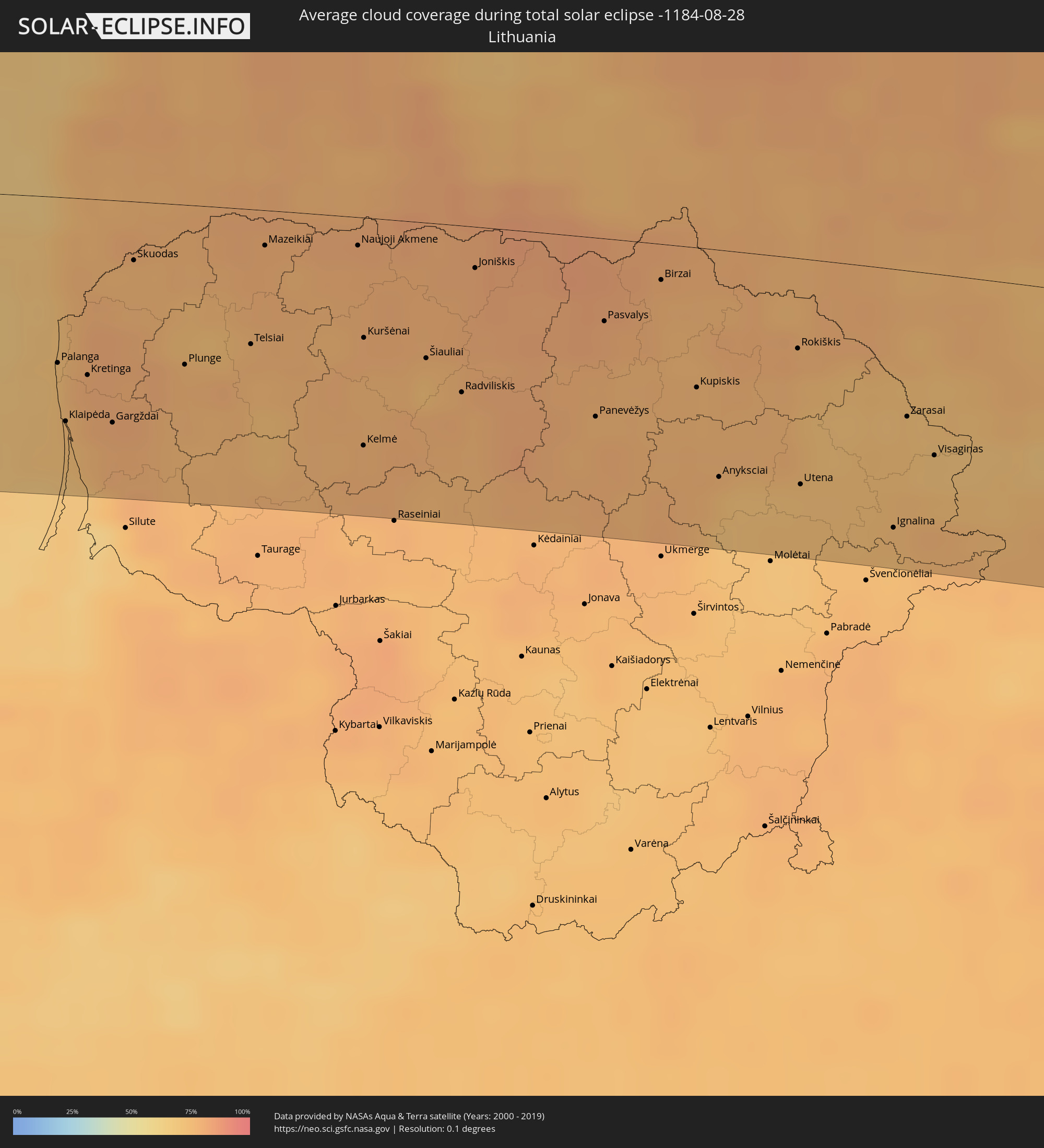 Litauen
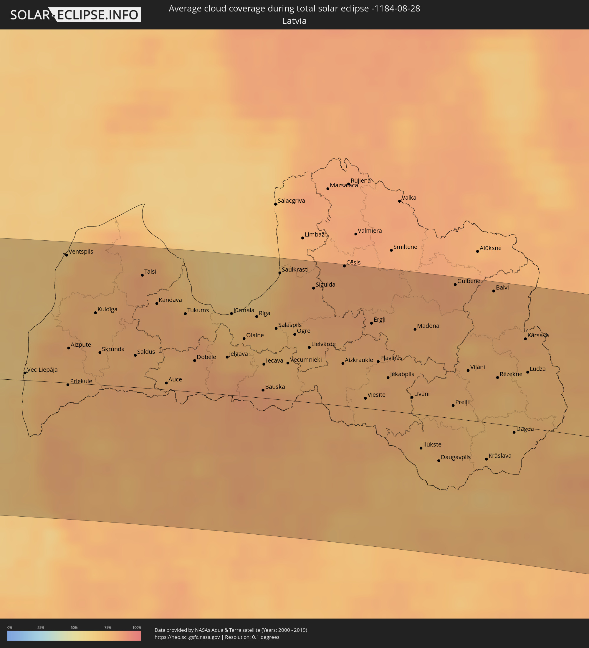 Lettland
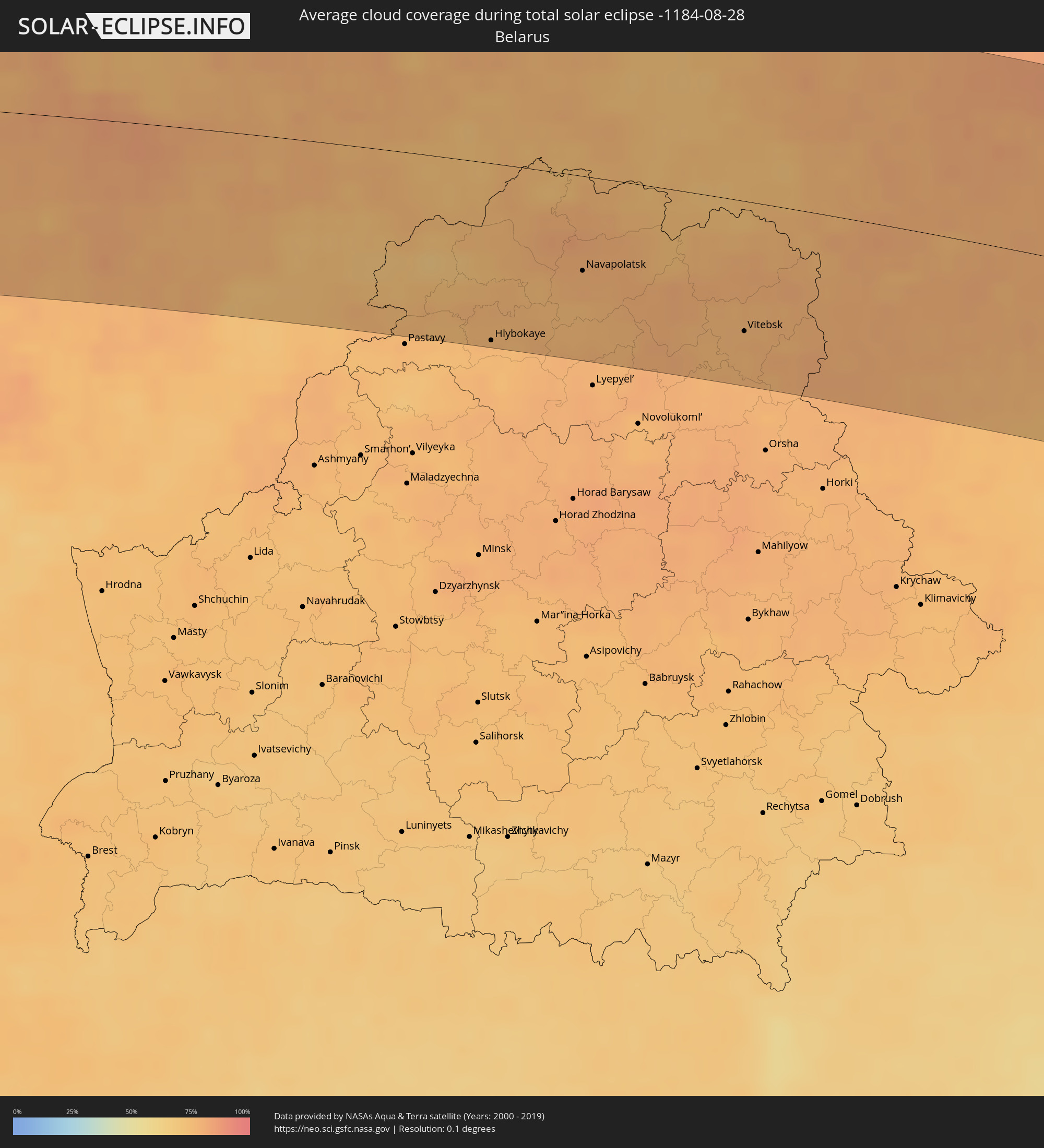 Weißrussland
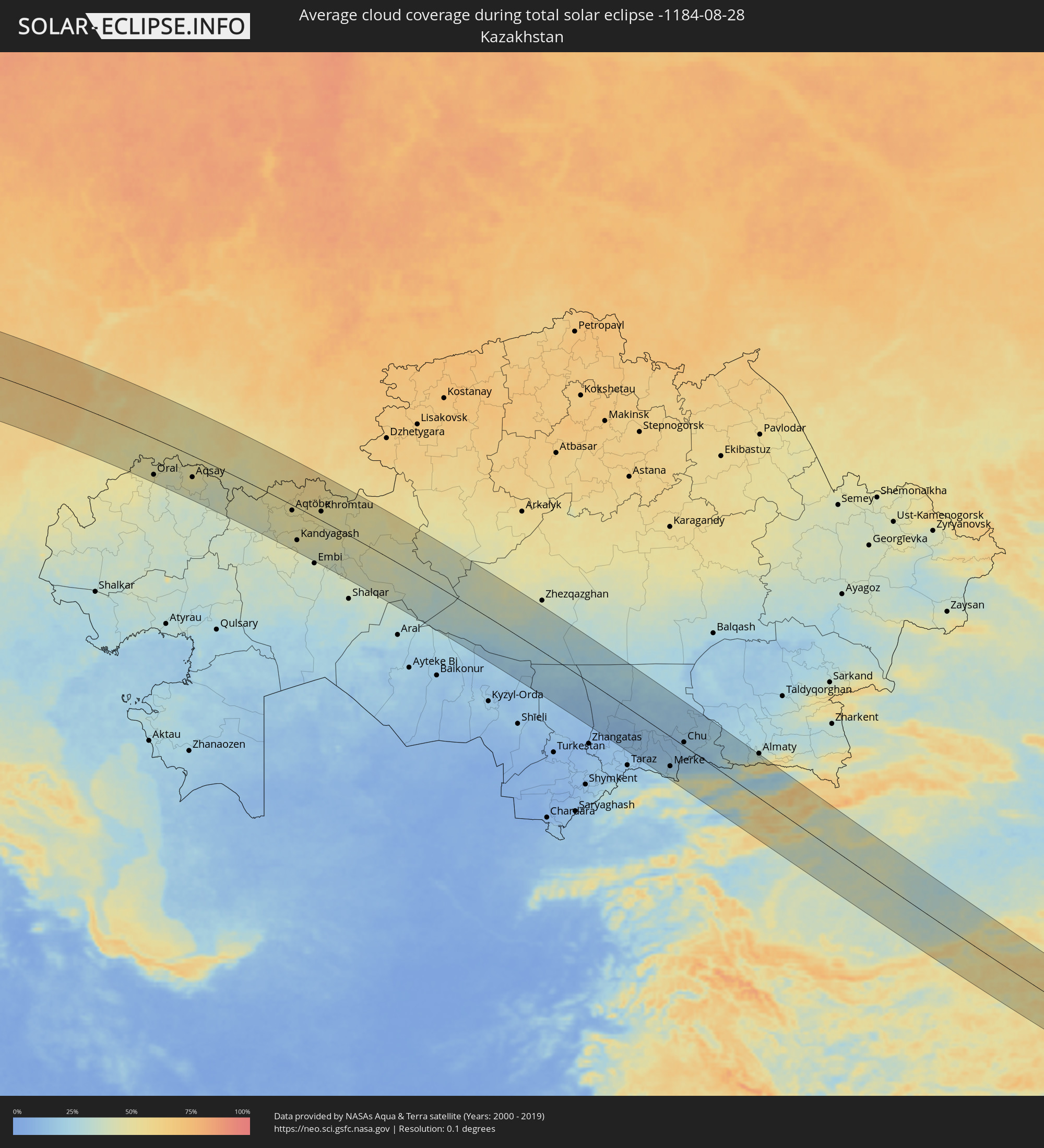 Kasachstan
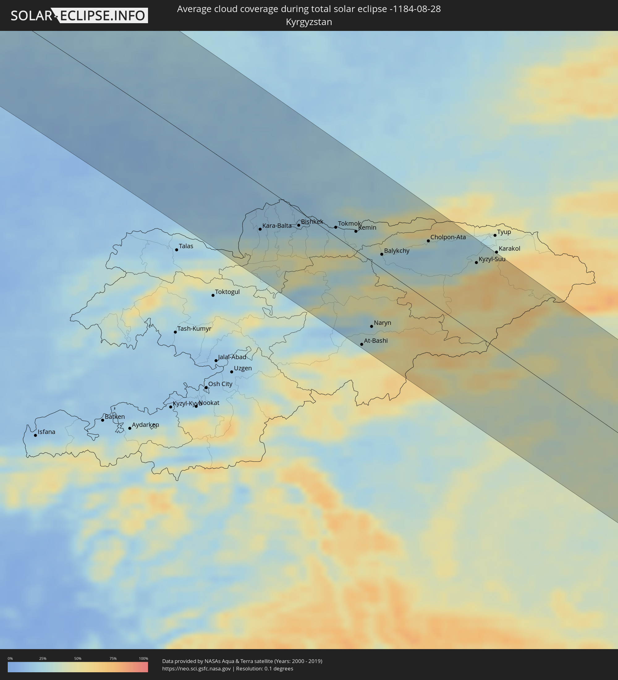 Kirgisistan
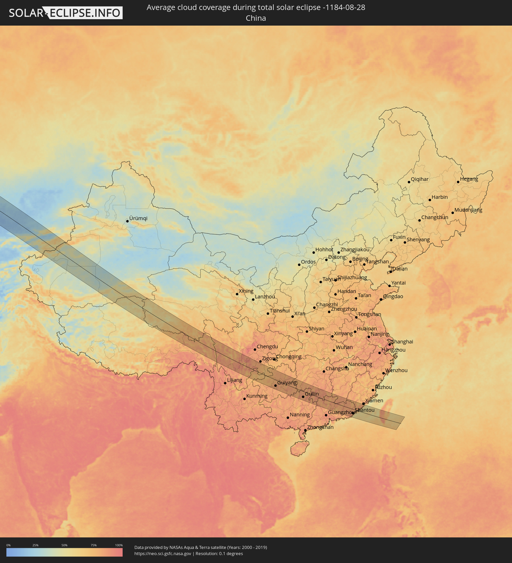 Volksrepublik China
 Taiwan
Orte im Finsternispfad
Die nachfolgene Tabelle zeigt Städte und Orte mit mehr als 5.000 Einwohnern, die sich im Finsternispfad befinden. Städte mit mehr als 100.000 Einwohnern sind dick gekennzeichnet. Mit einem Klick auf den Ort öffnet sich eine Detailkarte die die Lage des jeweiligen Ortes zusammen mit dem Verlauf der zentralen Finsternis präsentiert.
| Ort | Typ | Dauer der Verfinsterung | Ortszeit bei maximaler Verfinsterung | Entfernung zur Zentrallinie | Ø Bewölkung |
|
Westport, Connaught
|
total | - | 07:10:09 UTC-00:25 | 102 km | 88% |
|
Castlebar, Connaught
|
total | - | 07:10:17 UTC-00:25 | 100 km | 89% |
|
Ballina, Connaught
|
total | - | 07:10:40 UTC-00:25 | 73 km | 85% |
|
Sligo, Connaught
|
total | - | 07:11:06 UTC-00:25 | 67 km | 85% |
|
Letterkenny, Ulster
|
total | - | 07:12:13 UTC-00:25 | 4 km | 87% |
|
Buncrana, Ulster
|
total | - | 07:12:33 UTC-00:25 | 12 km | 85% |
|
Londonderry County Borough, Northern Ireland
|
total | - | 07:37:47 UTC+00:00 | 4 km | 88% |
|
Monaghan, Ulster
|
total | - | 07:11:37 UTC-00:25 | 90 km | 89% |
|
Craigavon, Northern Ireland
|
total | - | 07:37:26 UTC+00:00 | 77 km | 90% |
|
Belfast, Northern Ireland
|
total | - | 07:37:48 UTC+00:00 | 67 km | 87% |
|
Bangor, Northern Ireland
|
total | - | 07:37:59 UTC+00:00 | 64 km | 81% |
|
Ayr, Scotland
|
total | - | 07:39:25 UTC+00:00 | 11 km | 84% |
|
Glasgow, Scotland
|
total | - | 07:40:06 UTC+00:00 | 50 km | 87% |
|
Hamilton, Scotland
|
total | - | 07:40:04 UTC+00:00 | 37 km | 89% |
|
Cumbernauld, Scotland
|
total | - | 07:40:19 UTC+00:00 | 56 km | 88% |
|
Livingston, Scotland
|
total | - | 07:40:28 UTC+00:00 | 46 km | 87% |
|
Perth, Scotland
|
total | - | 07:41:07 UTC+00:00 | 99 km | 87% |
|
Edinburgh, Scotland
|
total | - | 07:40:40 UTC+00:00 | 47 km | 84% |
|
Kirkcaldy, Scotland
|
total | - | 07:40:53 UTC+00:00 | 65 km | 84% |
|
Dundee, Scotland
|
total | - | 07:41:25 UTC+00:00 | 101 km | 86% |
|
Carlisle, England
|
total | - | 07:39:28 UTC+00:00 | 71 km | 86% |
|
Newcastle upon Tyne, England
|
total | - | 07:40:12 UTC+00:00 | 78 km | 85% |
|
Durham, England
|
total | - | 07:39:59 UTC+00:00 | 100 km | 85% |
|
Sunderland, England
|
total | - | 07:40:14 UTC+00:00 | 88 km | 82% |
|
Esbjerg, South Denmark
|
total | - | 08:46:54 UTC+01:00 | 103 km | 78% |
|
Holstebro, Central Jutland
|
total | - | 08:48:00 UTC+01:00 | 5 km | 84% |
|
Herning, Central Jutland
|
total | - | 08:48:00 UTC+01:00 | 31 km | 84% |
|
Viborg, Central Jutland
|
total | - | 08:48:39 UTC+01:00 | 2 km | 80% |
|
Kolding, South Denmark
|
total | - | 08:47:41 UTC+01:00 | 105 km | 85% |
|
Vejle, South Denmark
|
total | - | 08:47:57 UTC+01:00 | 81 km | 86% |
|
Silkeborg, Central Jutland
|
total | - | 08:48:27 UTC+01:00 | 30 km | 83% |
|
Fredericia, South Denmark
|
total | - | 08:47:58 UTC+01:00 | 98 km | 79% |
|
Horsens, Central Jutland
|
total | - | 08:48:21 UTC+01:00 | 66 km | 84% |
|
Aalborg, North Denmark
|
total | - | 08:49:40 UTC+01:00 | 66 km | 82% |
|
Randers, Central Jutland
|
total | - | 08:49:08 UTC+01:00 | 0 km | 83% |
|
Århus, Central Jutland
|
total | - | 08:48:56 UTC+01:00 | 34 km | 81% |
|
Kungsbacka, Halland
|
total | - | 08:51:43 UTC+01:00 | 108 km | 81% |
|
Roskilde, Zealand
|
total | - | 08:49:51 UTC+01:00 | 97 km | 80% |
|
Varberg, Halland
|
total | - | 08:51:28 UTC+01:00 | 65 km | 78% |
|
Greve, Zealand
|
total | - | 08:49:58 UTC+01:00 | 104 km | 78% |
|
Falkenberg, Halland
|
total | - | 08:51:27 UTC+01:00 | 42 km | 77% |
|
Hørsholm, Capital Region
|
total | - | 08:50:26 UTC+01:00 | 72 km | 74% |
|
Copenhagen, Capital Region
|
total | - | 08:50:16 UTC+01:00 | 95 km | 73% |
|
Helsingør, Capital Region
|
total | - | 08:50:40 UTC+01:00 | 55 km | 74% |
|
Helsingborg, Skåne
|
total | - | 08:50:45 UTC+01:00 | 54 km | 74% |
|
Landskrona, Skåne
|
total | - | 08:50:41 UTC+01:00 | 73 km | 73% |
|
Halmstad, Halland
|
total | - | 08:51:30 UTC+01:00 | 16 km | 77% |
|
Ängelholm, Skåne
|
total | - | 08:51:05 UTC+01:00 | 32 km | 80% |
|
Malmö, Skåne
|
total | - | 08:50:33 UTC+01:00 | 103 km | 73% |
|
Lund, Skåne
|
total | - | 08:50:49 UTC+01:00 | 93 km | 79% |
|
Hässleholm, Skåne
|
total | - | 08:51:44 UTC+01:00 | 43 km | 79% |
|
Värnamo, Jönköping
|
total | - | 08:52:57 UTC+01:00 | 71 km | 74% |
|
Kristianstad, Skåne
|
total | - | 08:51:56 UTC+01:00 | 58 km | 77% |
|
Växjö, Kronoberg
|
total | - | 08:53:17 UTC+01:00 | 36 km | 72% |
|
Karlshamn, Blekinge
|
total | - | 08:52:39 UTC+01:00 | 43 km | 74% |
|
Karlskrona, Blekinge
|
total | - | 08:53:16 UTC+01:00 | 44 km | 67% |
|
Kalmar, Kalmar
|
total | - | 08:54:24 UTC+01:00 | 11 km | 69% |
|
Oskarshamn, Kalmar
|
total | - | 08:55:01 UTC+01:00 | 79 km | 70% |
|
Vec-Liepāja, Liepāja
|
total | - | 09:35:06 UTC+01:36 | 6 km | 65% |
|
Palanga, Klaipėda County
|
total | - | 09:22:07 UTC+01:24 | 63 km | 72% |
|
Klaipėda, Klaipėda County
|
total | - | 09:22:01 UTC+01:24 | 85 km | 72% |
|
Kretinga, Klaipėda County
|
total | - | 09:22:16 UTC+01:24 | 67 km | 80% |
|
Gargždai, Klaipėda County
|
total | - | 09:22:18 UTC+01:24 | 84 km | 78% |
|
Ventspils, Ventspils
|
total | - | 09:36:17 UTC+01:36 | 103 km | 72% |
|
Plunge, Telšiai County
|
total | - | 09:22:53 UTC+01:24 | 60 km | 77% |
|
Kuldīga, Kuldīgas Rajons
|
total | - | 09:36:20 UTC+01:36 | 58 km | 76% |
|
Telsiai, Telšiai County
|
total | - | 09:23:20 UTC+01:24 | 51 km | 77% |
|
Mazeikiai, Telšiai County
|
total | - | 09:23:40 UTC+01:24 | 13 km | 79% |
|
Saldus, Saldus Rajons
|
total | - | 09:36:38 UTC+01:36 | 26 km | 78% |
|
Talsi, Talsu Rajons
|
total | - | 09:37:08 UTC+01:36 | 91 km | 81% |
|
Naujoji Akmene
|
total | - | 09:24:13 UTC+01:24 | 11 km | 79% |
|
Kuršėnai, Šiauliai County
|
total | - | 09:24:02 UTC+01:24 | 45 km | 78% |
|
Tukums, Tukuma Rajons
|
total | - | 09:37:30 UTC+01:36 | 63 km | 78% |
|
Dobele, Dobeles Rajons
|
total | - | 09:37:23 UTC+01:36 | 25 km | 81% |
|
Šiauliai, Šiauliai County
|
total | - | 09:24:23 UTC+01:24 | 51 km | 73% |
|
Radviliskis, Šiauliai County
|
total | - | 09:24:31 UTC+01:24 | 63 km | 78% |
|
Jelgava, Jelgava
|
total | - | 09:37:50 UTC+01:36 | 30 km | 75% |
|
Jūrmala, Jūrmala
|
total | - | 09:38:07 UTC+01:36 | 66 km | 69% |
|
Olaine, Olaine
|
total | - | 09:38:09 UTC+01:36 | 47 km | 76% |
|
Riga, Riga
|
total | - | 09:38:26 UTC+01:36 | 65 km | 75% |
|
Panevėžys, Panevėžys
|
total | - | 09:25:19 UTC+01:24 | 68 km | 79% |
|
Salaspils, Salaspils
|
total | - | 09:38:38 UTC+01:36 | 57 km | 72% |
|
Ogre, Ogre
|
total | - | 09:38:51 UTC+01:36 | 54 km | 75% |
|
Birzai, Panevėžys
|
total | - | 09:26:02 UTC+01:24 | 13 km | 77% |
|
Anyksciai, Utena County
|
total | - | 09:25:59 UTC+01:24 | 86 km | 73% |
|
Cēsis, Cēsu Rajons
|
total | - | 09:39:50 UTC+01:36 | 113 km | 81% |
|
Rokiškis, Panevėžys
|
total | - | 09:26:46 UTC+01:24 | 34 km | 78% |
|
Utena, Utena County
|
total | - | 09:26:30 UTC+01:24 | 85 km | 72% |
|
Jēkabpils, Jēkabpils Municipality
|
total | - | 09:39:56 UTC+01:36 | 27 km | 78% |
|
Visaginas, Utena County
|
total | - | 09:27:27 UTC+01:24 | 69 km | 71% |
|
Daugavpils, Daugavpils municipality
|
total | - | 09:40:18 UTC+01:36 | 36 km | 72% |
|
Braslaw, Vitebsk
|
total | - | 09:54:09 UTC+01:50 | 59 km | 70% |
|
Rēzekne, Rēzekne
|
total | - | 09:41:29 UTC+01:36 | 38 km | 75% |
|
Sharkawshchyna, Vitebsk
|
total | - | 09:54:29 UTC+01:50 | 86 km | 77% |
|
Myory, Vitebsk
|
total | - | 09:54:47 UTC+01:50 | 57 km | 72% |
|
Hlybokaye, Vitebsk
|
total | - | 09:54:36 UTC+01:50 | 110 km | 75% |
|
Vyerkhnyadzvinsk, Vitebsk
|
total | - | 09:55:13 UTC+01:50 | 37 km | 76% |
|
Navapolatsk, Vitebsk
|
total | - | 09:55:50 UTC+01:50 | 58 km | 78% |
|
Ushachy, Vitebsk
|
total | - | 09:55:41 UTC+01:50 | 97 km | 76% |
|
Polatsk, Vitebsk
|
total | - | 09:56:01 UTC+01:50 | 61 km | 78% |
|
Rasony, Vitebsk
|
total | - | 09:56:15 UTC+01:50 | 15 km | 78% |
|
Haradok, Vitebsk
|
total | - | 09:57:22 UTC+01:50 | 53 km | 78% |
|
Vitebsk, Vitebsk
|
total | - | 09:57:31 UTC+01:50 | 80 km | 77% |
|
Lyozna, Vitebsk
|
total | - | 09:58:09 UTC+01:50 | 92 km | 79% |
|
Smolensk, Smolensk
|
total | - | 10:39:49 UTC+02:30 | 105 km | 78% |
|
Kaluga, Kaluga
|
total | - | 10:45:01 UTC+02:30 | 76 km | 66% |
|
Zelenograd, Moscow
|
total | - | 10:46:20 UTC+02:30 | 95 km | 77% |
|
Khimki, Moscow Oblast
|
total | - | 10:46:37 UTC+02:30 | 90 km | 76% |
|
Yasenevo, Moscow
|
total | - | 10:46:42 UTC+02:30 | 60 km | 75% |
|
Podolsk, Moscow Oblast
|
total | - | 10:46:43 UTC+02:30 | 41 km | 73% |
|
Moscow, Moscow
|
total | - | 10:46:50 UTC+02:30 | 77 km | 72% |
|
Tula, Tula
|
total | - | 10:46:42 UTC+02:30 | 91 km | 67% |
|
Mytishchi, Moscow Oblast
|
total | - | 10:46:59 UTC+02:30 | 96 km | 73% |
|
Ryazan’, Rjazan
|
total | - | 10:49:24 UTC+02:30 | 9 km | 66% |
|
Penza, Penza
|
total | - | 10:56:44 UTC+02:30 | 54 km | 63% |
|
Saransk, Mordoviya
|
total | - | 10:56:41 UTC+02:30 | 53 km | 66% |
|
Balakovo, Saratov
|
total | - | 11:51:10 UTC+03:20 | 110 km | 54% |
|
Syzran’, Samara
|
total | - | 11:51:36 UTC+03:20 | 23 km | 62% |
|
Tol’yatti, Samara
|
total | - | 11:52:37 UTC+03:20 | 84 km | 58% |
|
Samara, Samara
|
total | - | 11:53:54 UTC+03:20 | 71 km | 58% |
|
Oral, Batys Qazaqstan
|
total | - | 12:01:51 UTC+03:25 | 97 km | 44% |
|
Fedorovka, Batys Qazaqstan
|
total | - | 12:02:43 UTC+03:25 | 82 km | 41% |
|
Aqsay, Batys Qazaqstan
|
total | - | 12:04:16 UTC+03:25 | 57 km | 49% |
|
Chingirlau, Batys Qazaqstan
|
total | - | 12:05:53 UTC+03:25 | 31 km | 43% |
|
Orenburg, Orenburg
|
total | - | 12:43:57 UTC+04:02 | 67 km | 49% |
|
Martuk, Aqtöbe
|
total | - | 12:09:40 UTC+03:25 | 9 km | 50% |
|
Aqtöbe, Aqtöbe
|
total | - | 12:11:06 UTC+03:25 | 15 km | 49% |
|
Kandyagash, Aqtöbe
|
total | - | 12:12:10 UTC+03:25 | 88 km | 47% |
|
Batamshinskiy, Aqtöbe
|
total | - | 12:12:22 UTC+03:25 | 49 km | 52% |
|
Khromtau, Aqtöbe
|
total | - | 12:12:54 UTC+03:25 | 24 km | 49% |
|
Lugovoye, Zhambyl
|
total | - | 13:39:01 UTC+04:21 | 101 km | 20% |
|
Lugovoy, Zhambyl
|
total | - | 13:39:01 UTC+04:21 | 96 km | 20% |
|
Moyynkum, Zhambyl
|
total | - | 13:37:09 UTC+04:21 | 36 km | 18% |
|
Merke, Zhambyl
|
total | - | 13:39:40 UTC+04:21 | 84 km | 18% |
|
Oytal, Zhambyl
|
total | - | 13:39:44 UTC+04:21 | 76 km | 18% |
|
Kaindy, Chüy
|
total | - | 14:16:55 UTC+04:58 | 65 km | 21% |
|
Chu, Zhambyl
|
total | - | 13:39:16 UTC+04:21 | 11 km | 19% |
|
Kara-Balta, Chüy
|
total | - | 14:17:09 UTC+04:58 | 58 km | 21% |
|
Sosnovka, Chüy
|
total | - | 14:17:30 UTC+04:58 | 72 km | 37% |
|
Bishkek, Bishkek
|
total | - | 14:18:00 UTC+04:58 | 19 km | 21% |
|
Georgiyevka, Zhambyl
|
total | - | 13:41:21 UTC+04:21 | 3 km | 19% |
|
Kant, Chüy
|
total | - | 14:18:18 UTC+04:58 | 5 km | 22% |
|
Tokmok, Chüy
|
total | - | 14:18:56 UTC+04:58 | 12 km | 26% |
|
Kemin, Chüy
|
total | - | 14:19:30 UTC+04:58 | 25 km | 27% |
|
At-Bashi, Naryn
|
total | - | 14:22:16 UTC+04:58 | 118 km | 31% |
|
Naryn, Naryn
|
total | - | 14:22:05 UTC+04:58 | 85 km | 32% |
|
Balykchy, Issyk-Kul Region
|
total | - | 14:20:38 UTC+04:58 | 18 km | 26% |
|
Cholpon-Ata, Issyk-Kul Region
|
total | - | 14:21:24 UTC+04:58 | 78 km | 22% |
|
Kyzyl-Suu, Issyk-Kul Region
|
total | - | 14:22:59 UTC+04:58 | 93 km | 41% |
|
Aksu, Xinjiang Uyghur Autonomous Region
|
total | - | 17:29:03 UTC+08:00 | 97 km | 45% |
|
Aral, Xinjiang Uyghur Autonomous Region
|
total | - | 17:31:12 UTC+08:00 | 87 km | 46% |
|
Leshan, Sichuan
|
total | - | 18:04:27 UTC+08:00 | 111 km | 81% |
|
Yibin, Sichuan
|
total | - | 18:05:50 UTC+08:00 | 67 km | 79% |
|
Guiyang, Guizhou
|
total | - | 18:09:20 UTC+08:00 | 70 km | 81% |
|
Zunyi, Guizhou
|
total | - | 18:07:51 UTC+08:00 | 50 km | 81% |
|
Guilin, Guangxi Zhuang Autonomous Region
|
total | - | 18:11:29 UTC+08:00 | 69 km | 83% |
|
Chenzhou, Hunan
|
total | - | 18:10:54 UTC+08:00 | 83 km | 87% |
|
Shaoguan, Guangdong
|
total | - | 18:12:09 UTC+08:00 | 3 km | 80% |
|
Hepo, Guangdong
|
total | - | 18:13:41 UTC+08:00 | 72 km | 81% |
|
Meizhou, Guangdong
|
total | - | 18:12:37 UTC+08:00 | 28 km | 81% |
|
Huicheng, Guangdong
|
total | - | 18:14:05 UTC+08:00 | 99 km | 72% |
|
Jieyang, Guangdong
|
total | - | 18:13:29 UTC+08:00 | 44 km | 84% |
|
Chaozhou, Guangdong
|
total | - | 18:13:20 UTC+08:00 | 24 km | 85% |
|
Shantou, Guangdong
|
total | - | 18:13:39 UTC+08:00 | 51 km | 80% |
|
Huanggang, Guangdong
|
total | - | 18:13:16 UTC+08:00 | 9 km | 75% |
|
Zhangzhou, Fujian
|
total | - | 18:12:12 UTC+08:00 | 100 km | 82% |
|
Magong, Taiwan
|
total | - | 18:13:00 UTC+08:00 | 57 km | 67% |
|
Tainan, Taiwan
|
total | - | 18:13:32 UTC+08:00 | 14 km | 79% |
|
Kaohsiung, Takao
|
total | - | 18:13:56 UTC+08:00 | 23 km | 74% |
|
Yujing, Taiwan
|
total | - | 18:13:20 UTC+08:00 | 36 km | 82% |
|
Douliu, Taiwan
|
total | - | 18:12:39 UTC+08:00 | 101 km | 84% |
|
Hengchun, Taiwan
|
total | - | 18:14:31 UTC+08:00 | 76 km | 70% |
|
Taitung City, Taiwan
|
total | - | 18:13:36 UTC+08:00 | 16 km | 74% |