Totale Sonnenfinsternis vom 21.12.-1200
| Wochentag: | Donnerstag |
| Maximale Dauer der Verfinsterung: | 03m22s |
| Maximale Breite des Finsternispfades: | 124 km |
| Saroszyklus: | 32 |
| Bedeckungsgrad: | 100% |
| Magnitude: | 1.037 |
| Gamma: | -0.0403 |
Wo kann man die Sonnenfinsternis vom 21.12.-1200 sehen?
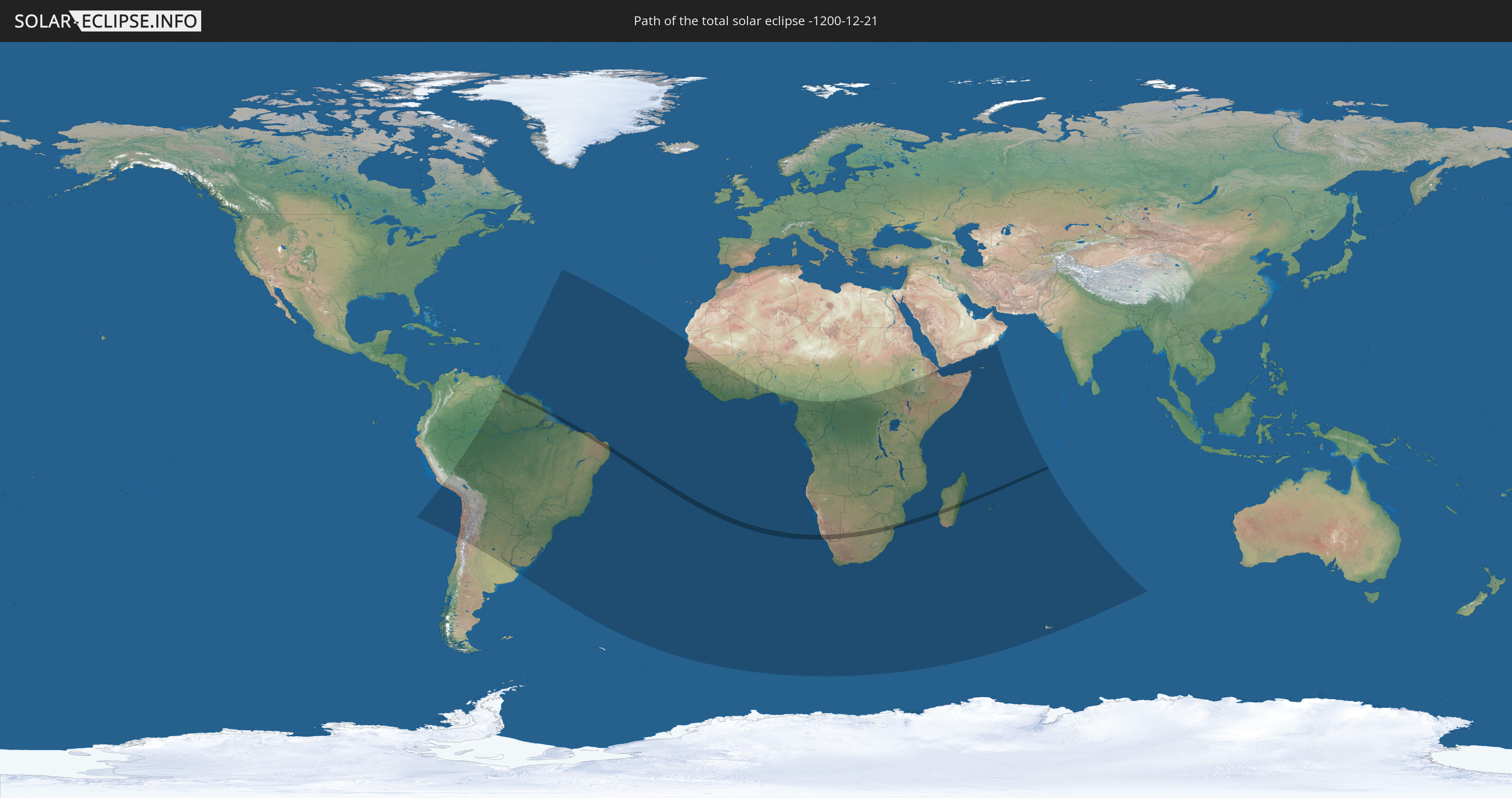
Die Sonnenfinsternis am 21.12.-1200 kann man in 62 Ländern als partielle Sonnenfinsternis beobachten.
Der Finsternispfad verläuft durch 10 Länder. Nur in diesen Ländern ist sie als totale Sonnenfinsternis zu sehen.
In den folgenden Ländern ist die Sonnenfinsternis total zu sehen
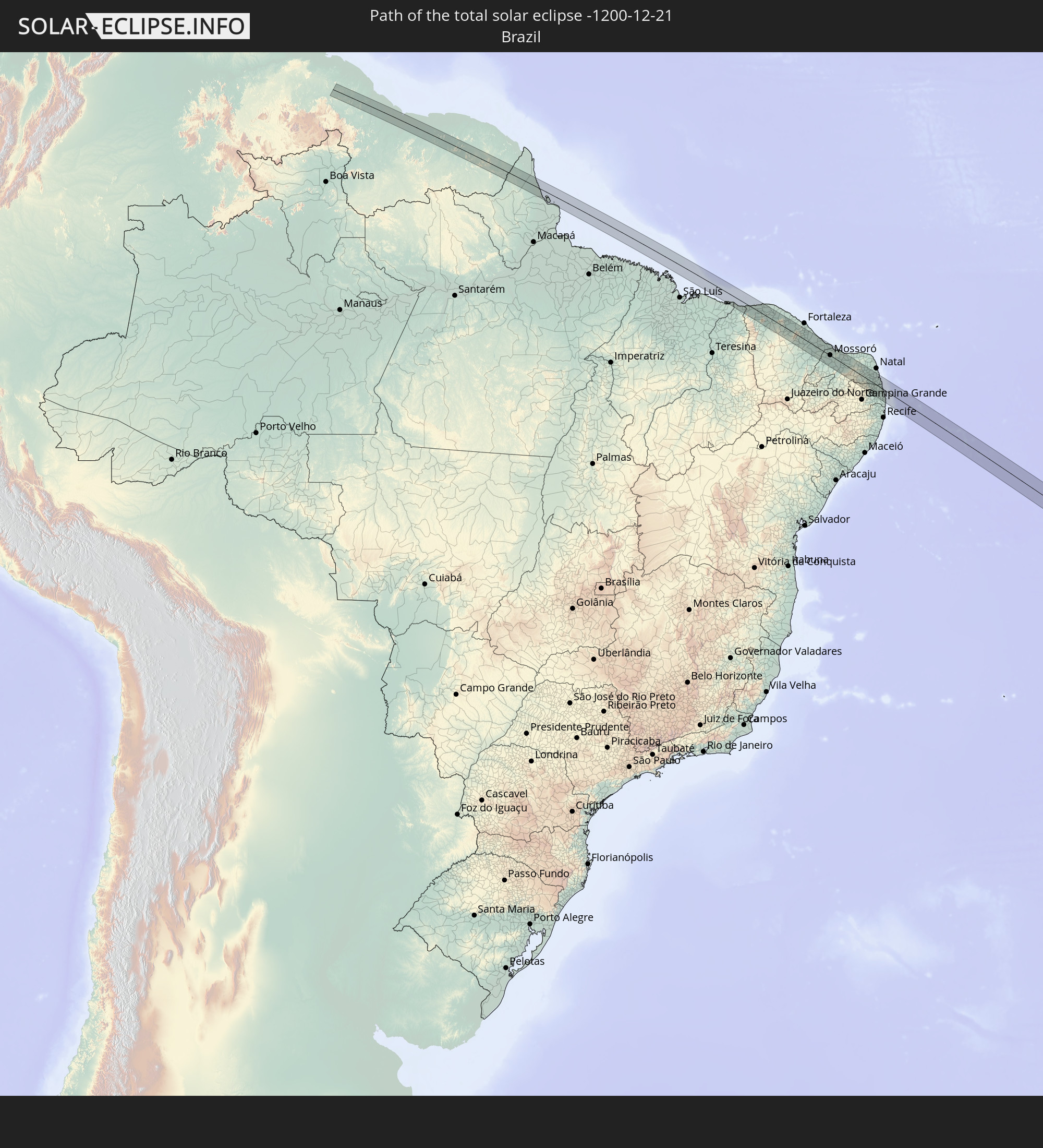 Brasilien
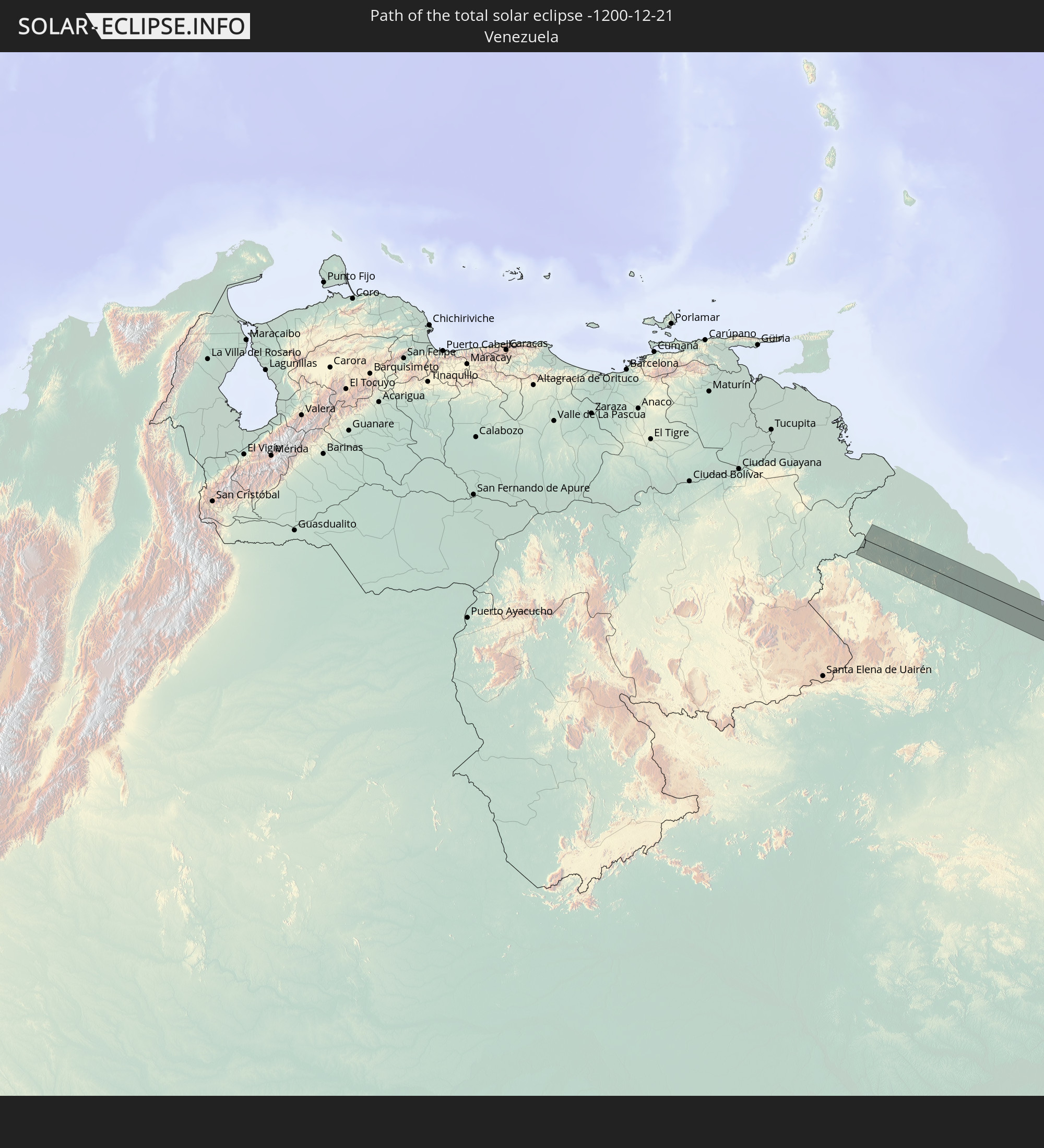 Venezuela
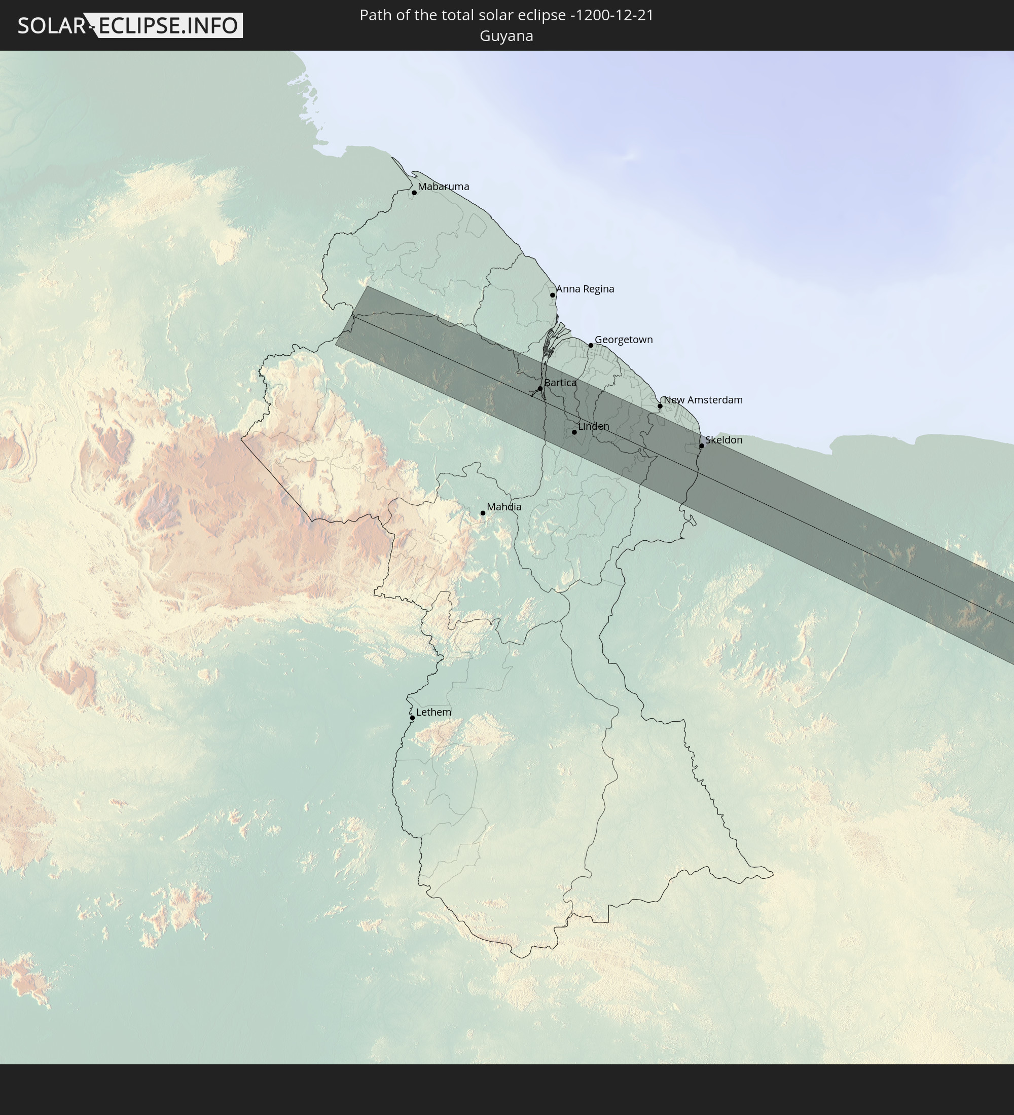 Guyana
 Suriname
 Französisch-Guayana
 Namibia
 Südafrika
 Mosambik
 Swasiland
 Madagaskar
In den folgenden Ländern ist die Sonnenfinsternis partiell zu sehen
 Chile
Chile
 Peru
Peru
 Brasilien
 Argentinien
 Venezuela
 Bolivien
 Paraguay
 Guyana
 Uruguay
 Suriname
 Französisch-Guayana
 Kap Verde
 Senegal
 Mauretanien
 Gambia
 Guinea-Bissau
 Guinea
 St. Helena
 Sierra Leone
 Mali
Mali
 Liberia
 Elfenbeinküste
 Burkina Faso
 Ghana
Ghana
 Togo
Togo
 Benin
Benin
 Nigeria
 Bouvetinsel
 Äquatorialguinea
 São Tomé und Príncipe
 Kamerun
 Gabun
Gabun
 Republik Kongo
 Angola
 Namibia
 Demokratische Republik Kongo
 Zentralafrikanische Republik
 Südafrika
 Botswana
 Sambia
 Simbabwe
 Lesotho
 Ruanda
 Burundi
 Tansania
 Uganda
 Mosambik
 Swasiland
 Malawi
 Äthiopien
 Kenia
Kenia
 Französische Süd- und Antarktisgebiete
 Somalia
 Dschibuti
 Jemen
Jemen
 Madagaskar
 Komoren
 Mayotte
 Seychellen
 Oman
Oman
 Réunion
 Mauritius
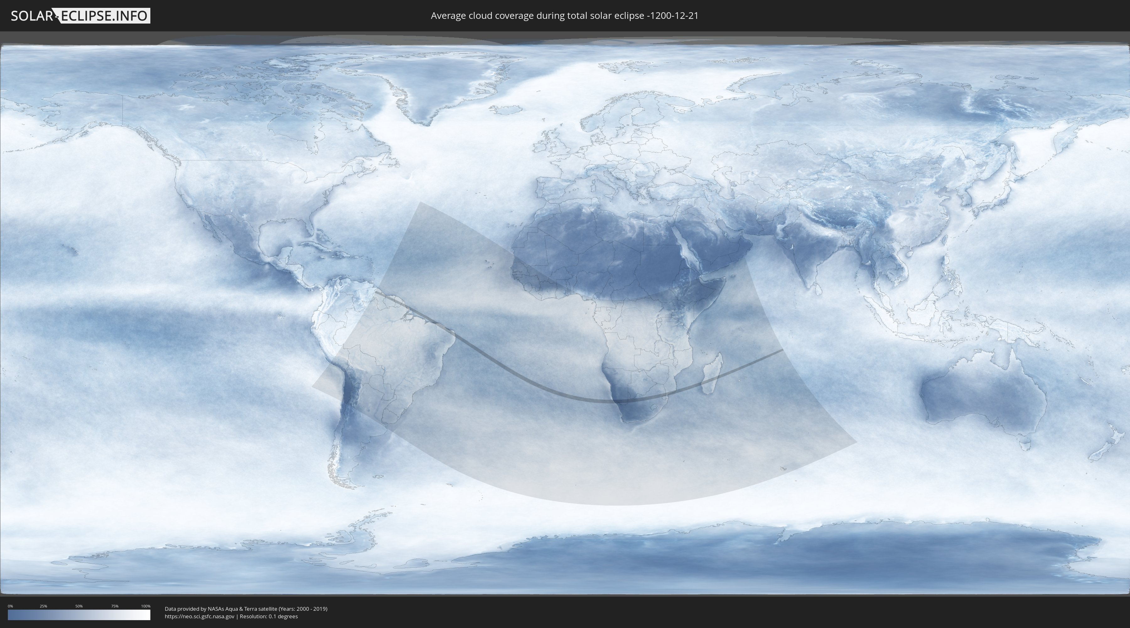
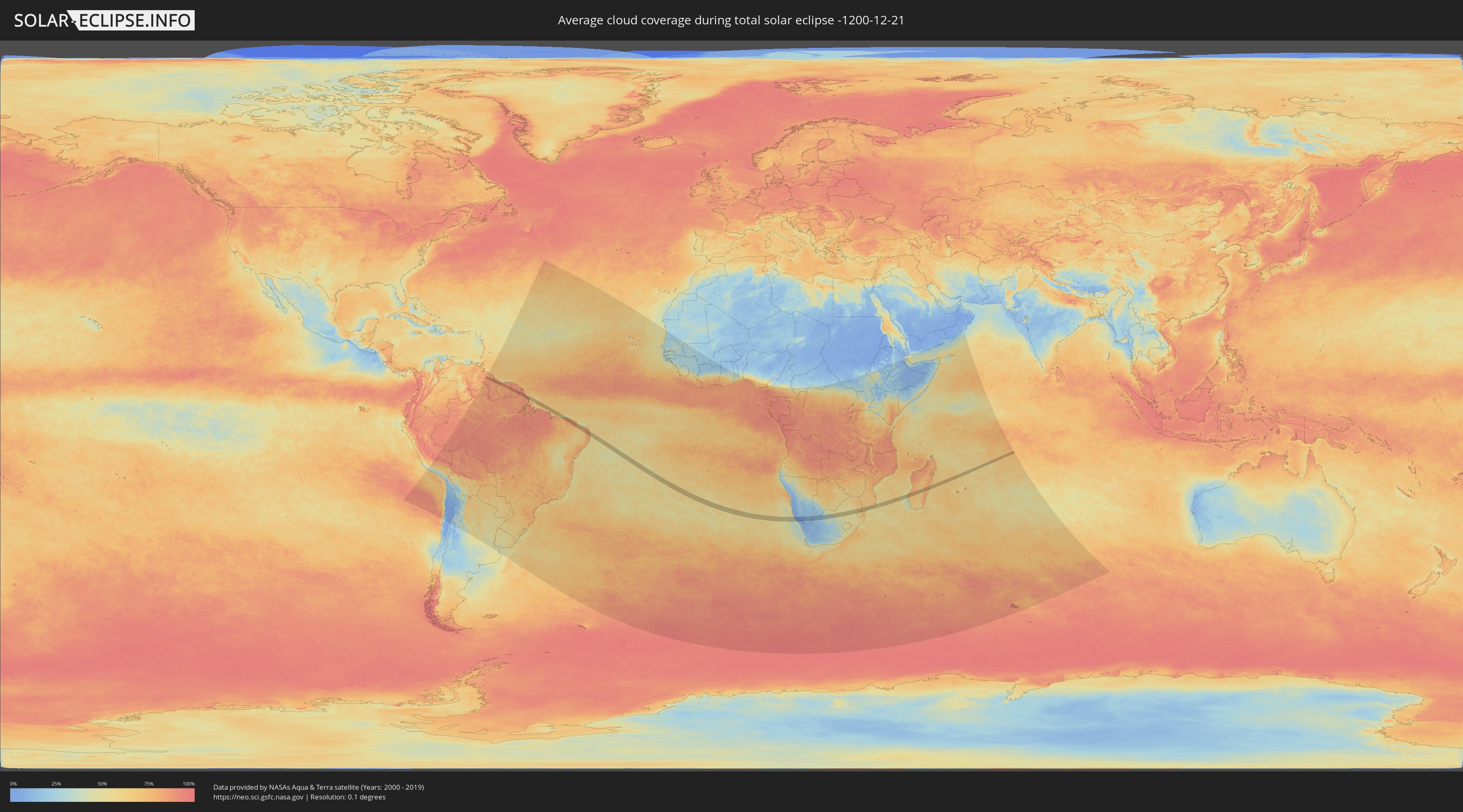
Wie wird das Wetter während der totalen Sonnenfinsternis am 21.12.-1200?
Wo ist der beste Ort, um die totale Sonnenfinsternis vom 21.12.-1200 zu beobachten?
Die folgenden Karten zeigen die durchschnittliche Bewölkung für den Tag, an dem die totale Sonnenfinsternis
stattfindet. Mit Hilfe der Karten lässt sich der Ort entlang des Finsternispfades eingrenzen,
der die besten Aussichen auf einen klaren wolkenfreien Himmel bietet.
Trotzdem muss man immer lokale Gegenenheiten beachten und sollte sich genau über das Wetter an seinem
gewählten Beobachtungsort informieren.
Die Daten stammen von den beiden NASA-Satelliten
AQUA und TERRA
und wurden über einen Zeitraum von 19 Jahren (2000 - 2019) gemittelt.
Detaillierte Länderkarten
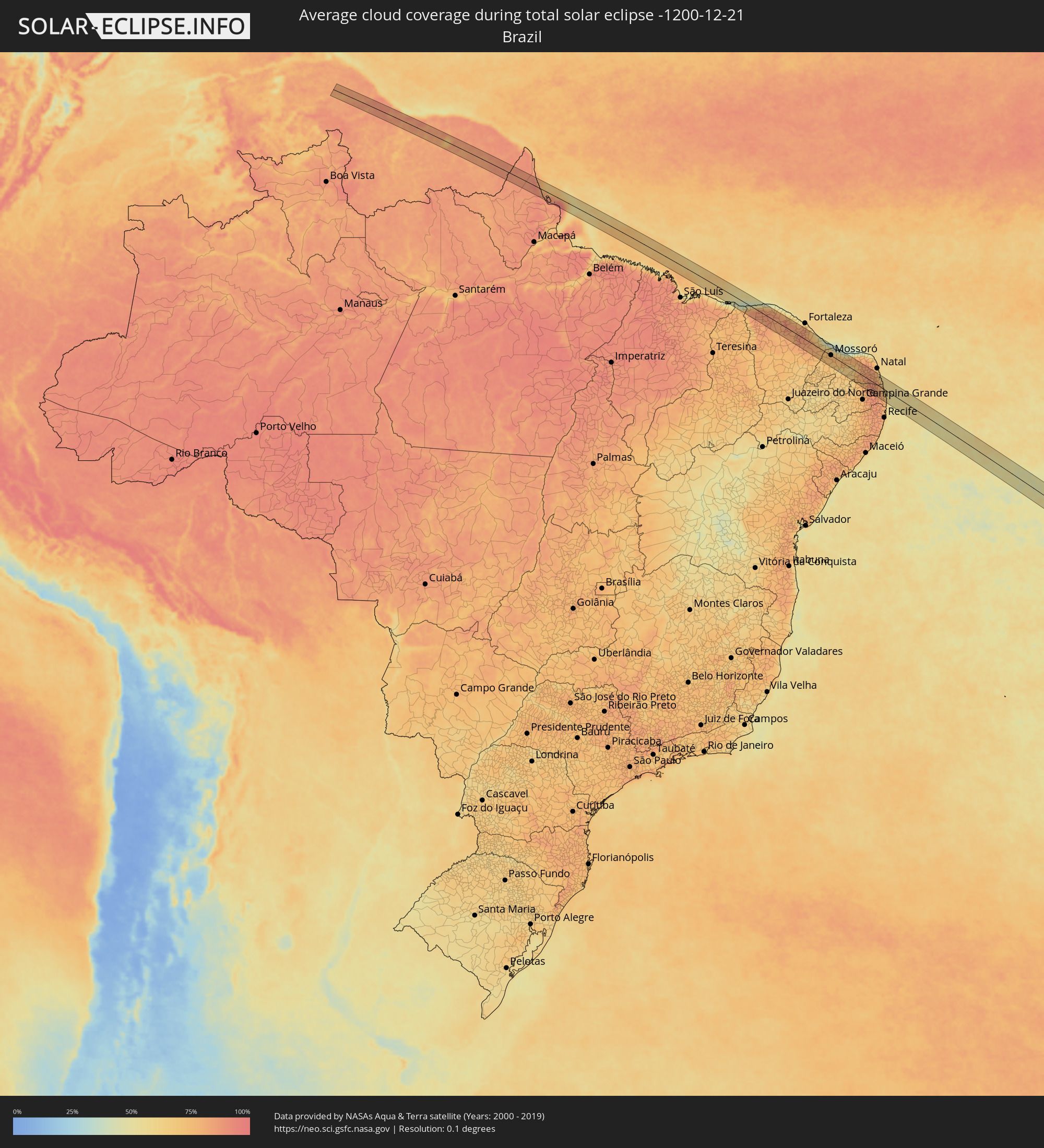 Brasilien
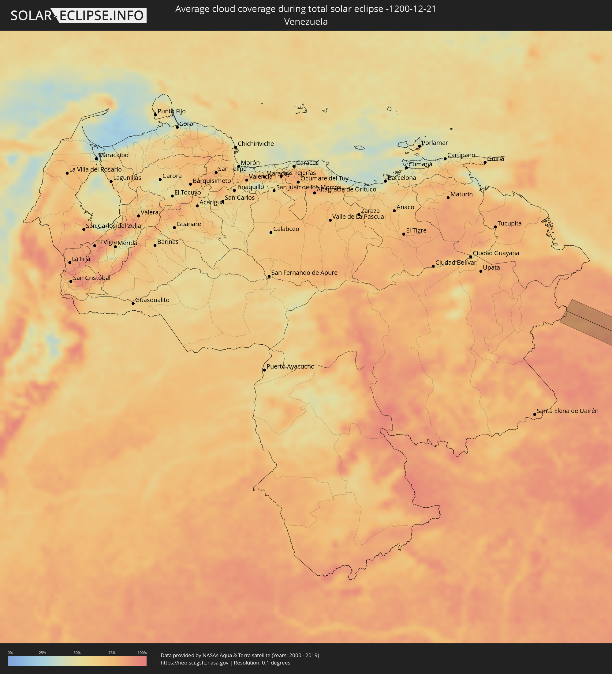 Venezuela
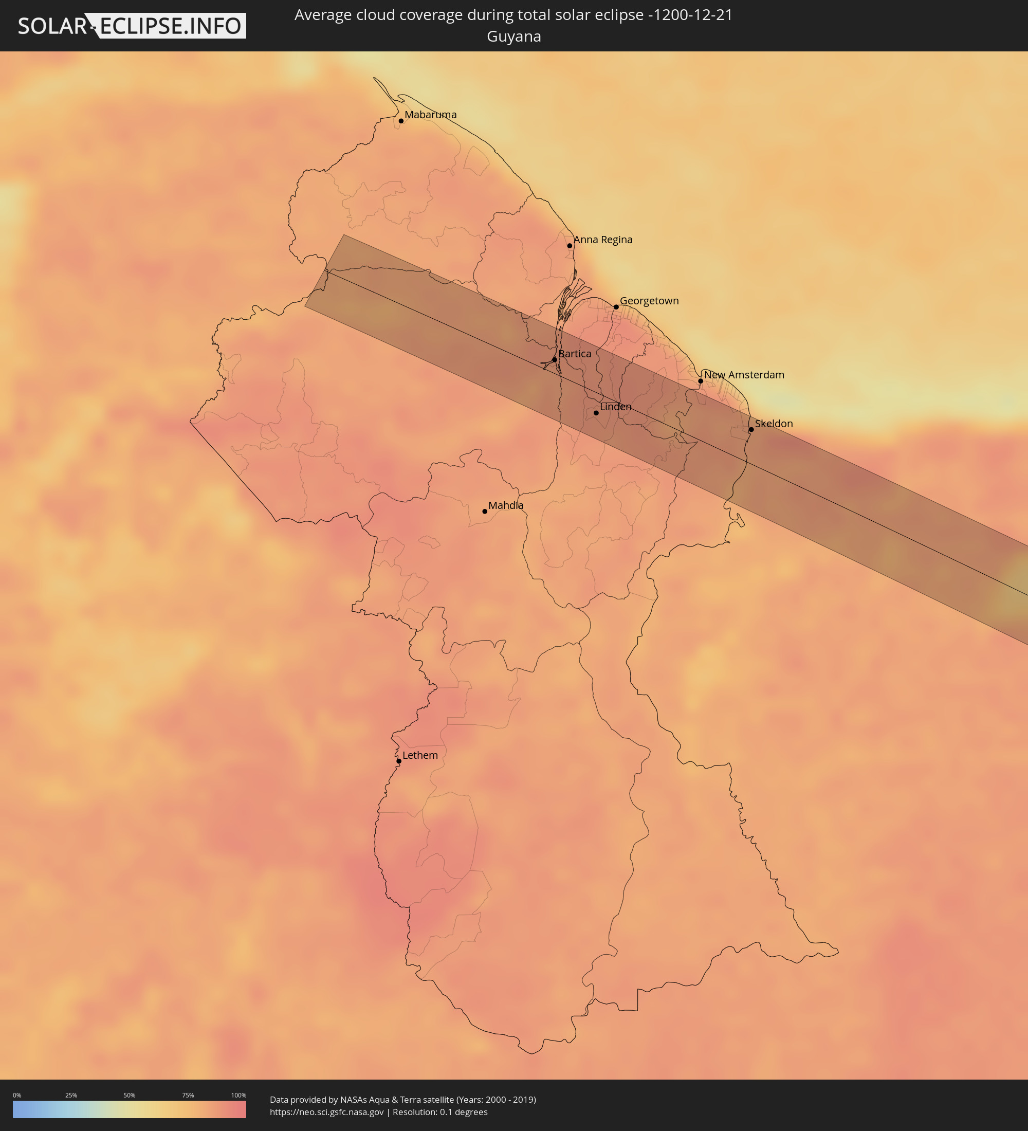 Guyana
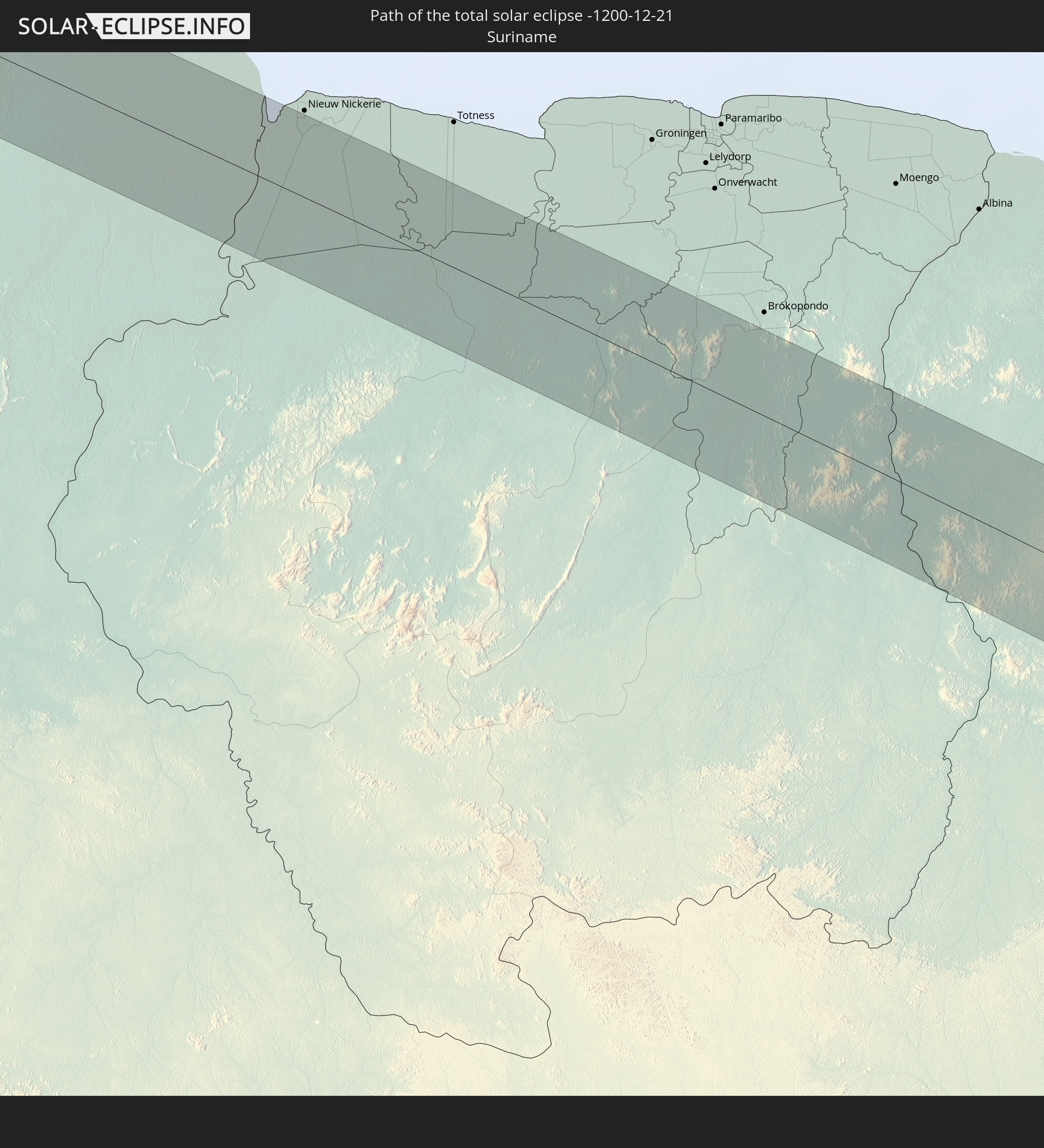
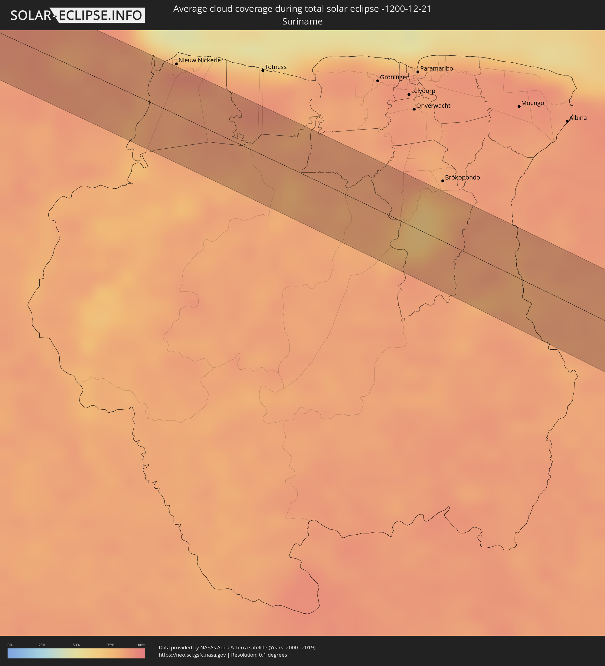 Suriname
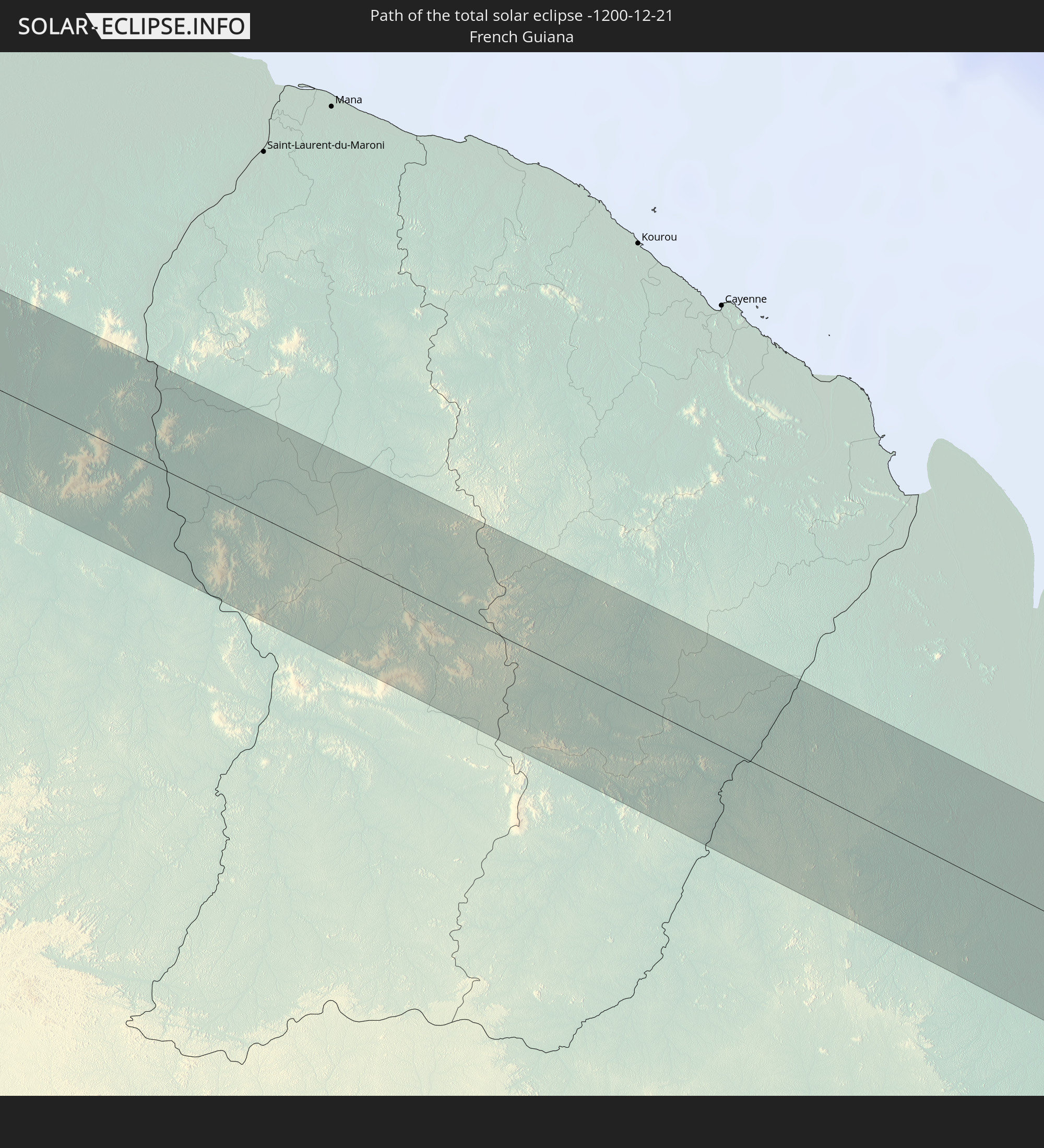
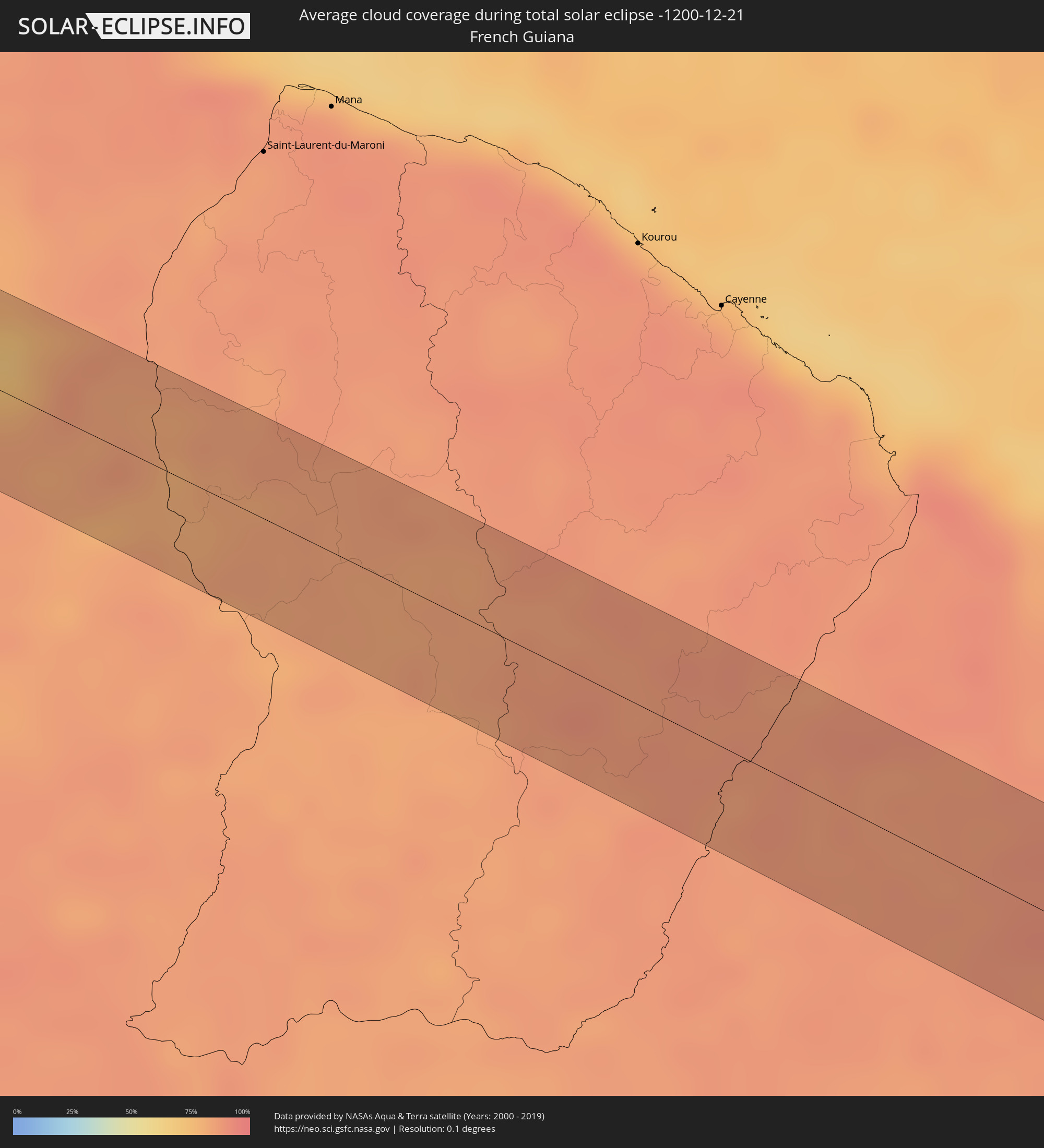 Französisch-Guayana
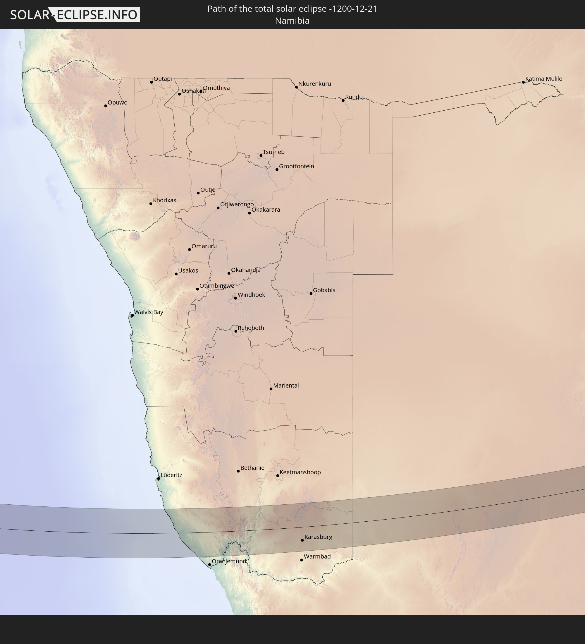
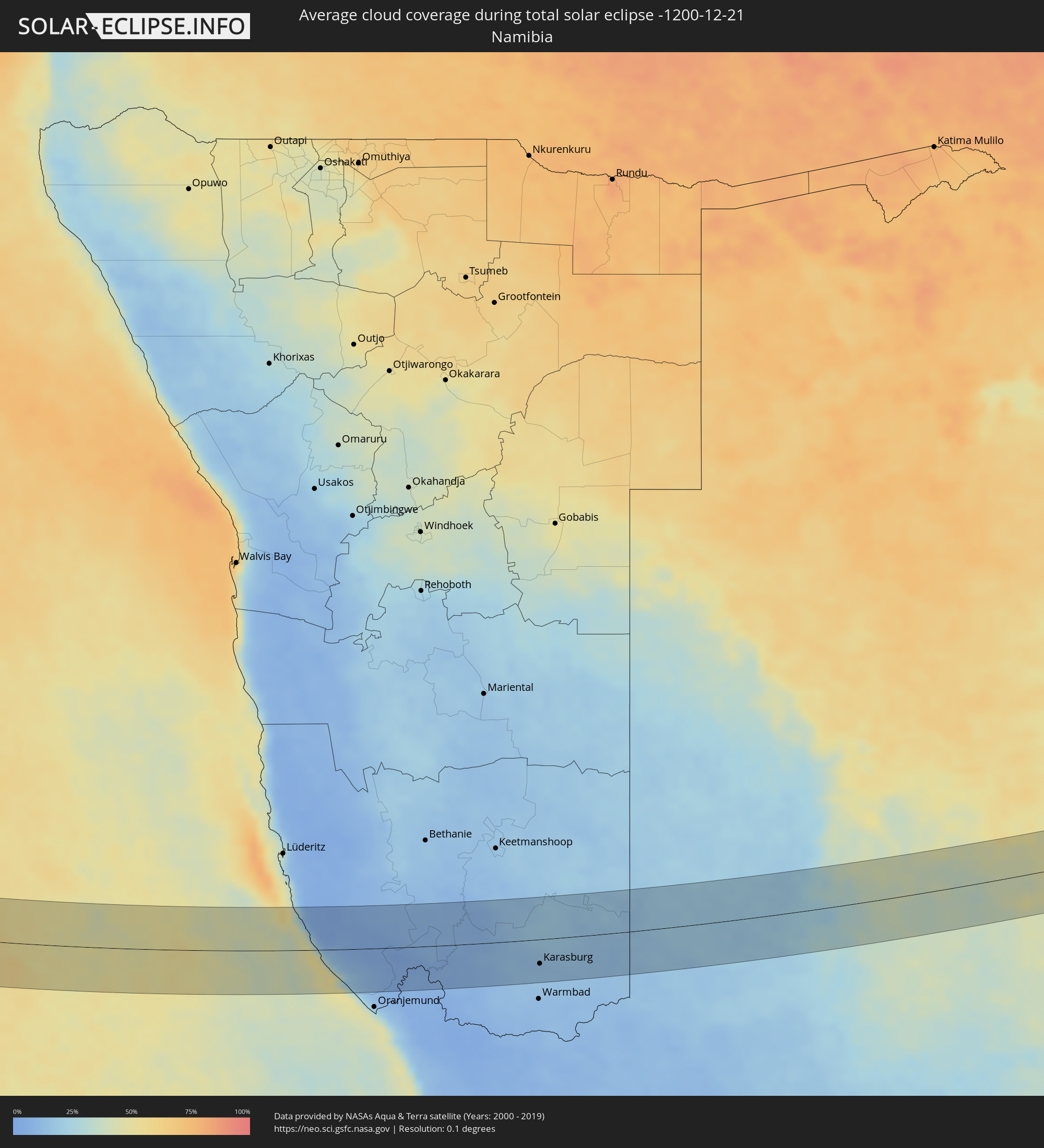 Namibia
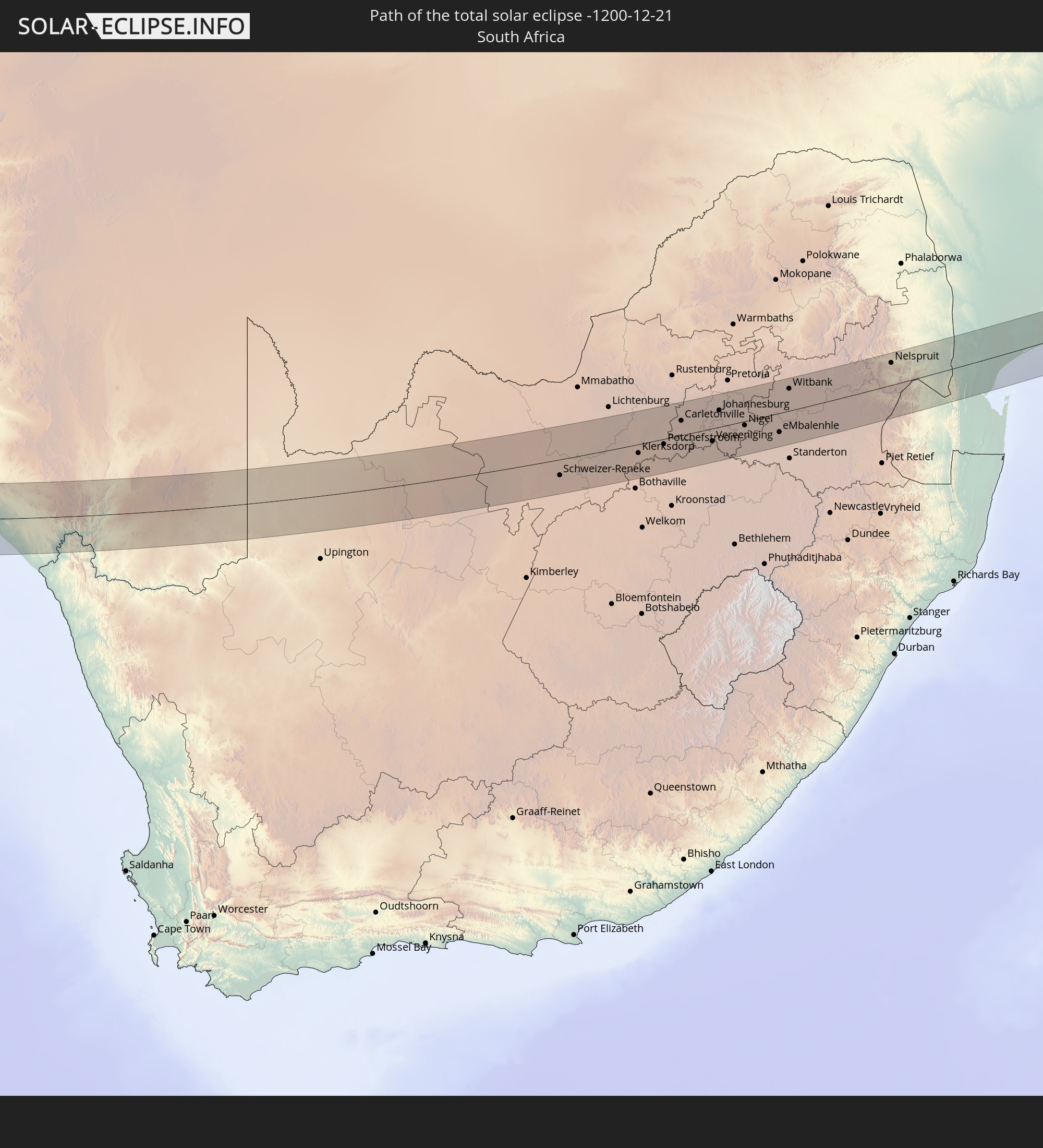
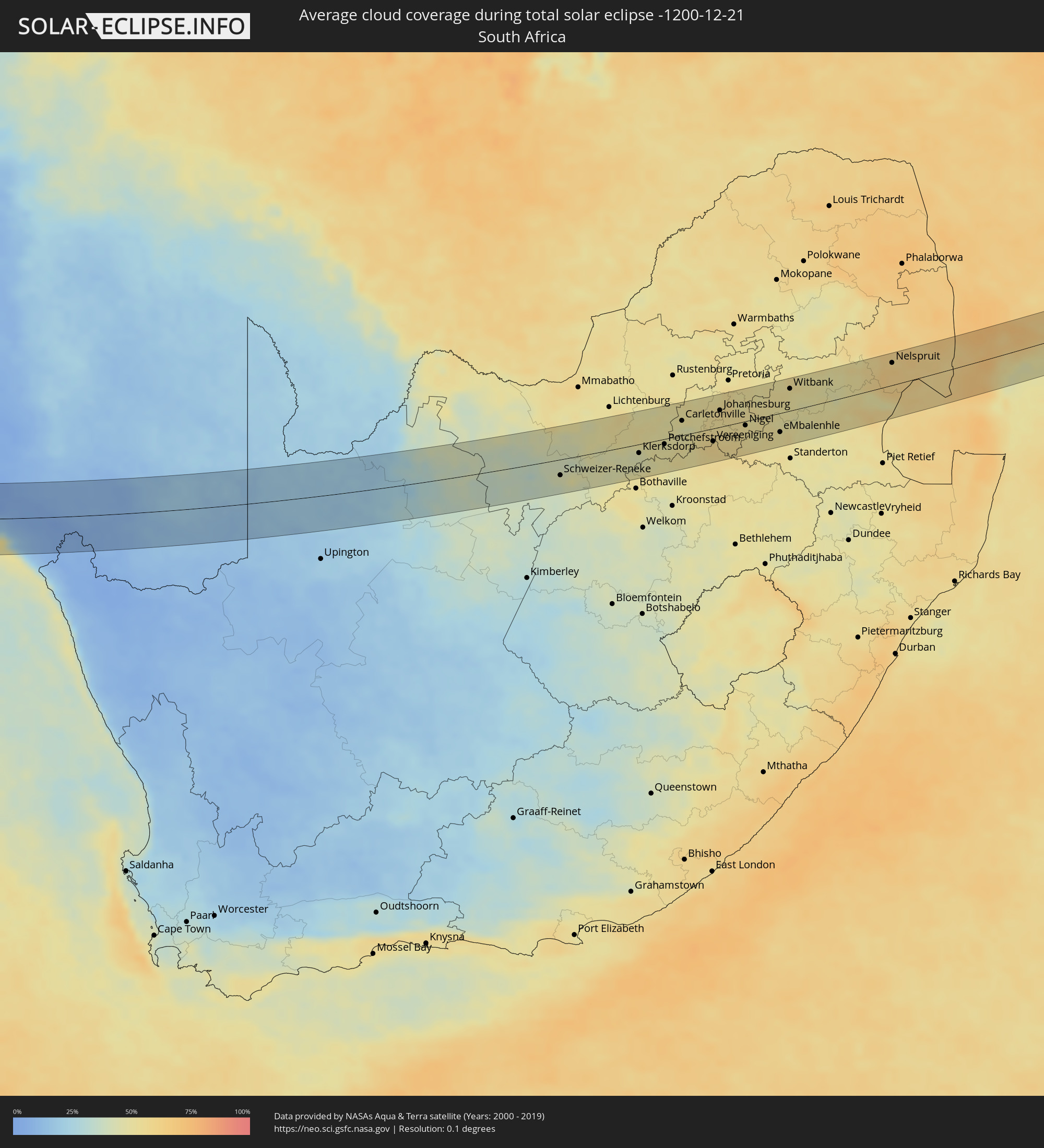 Südafrika
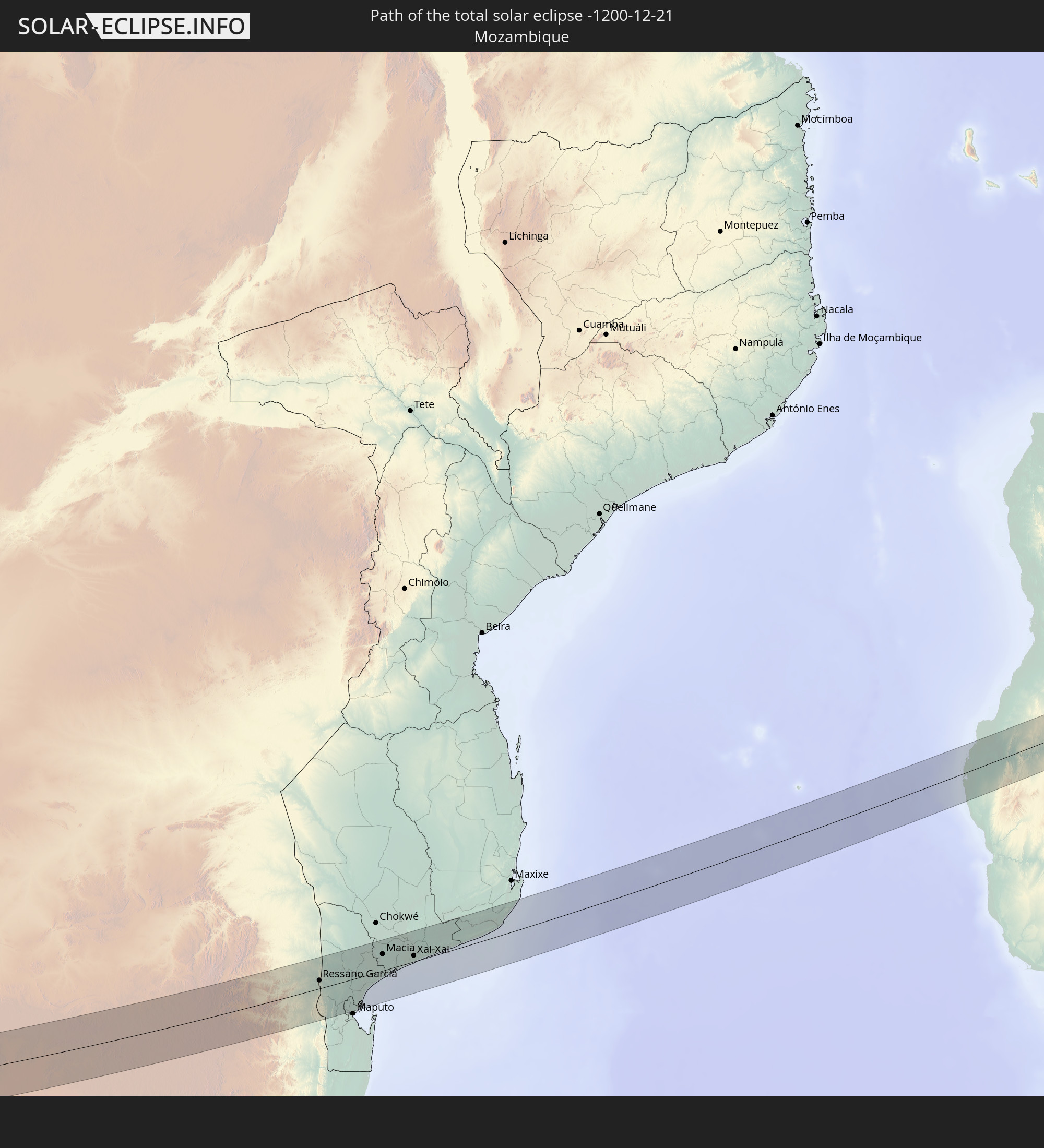
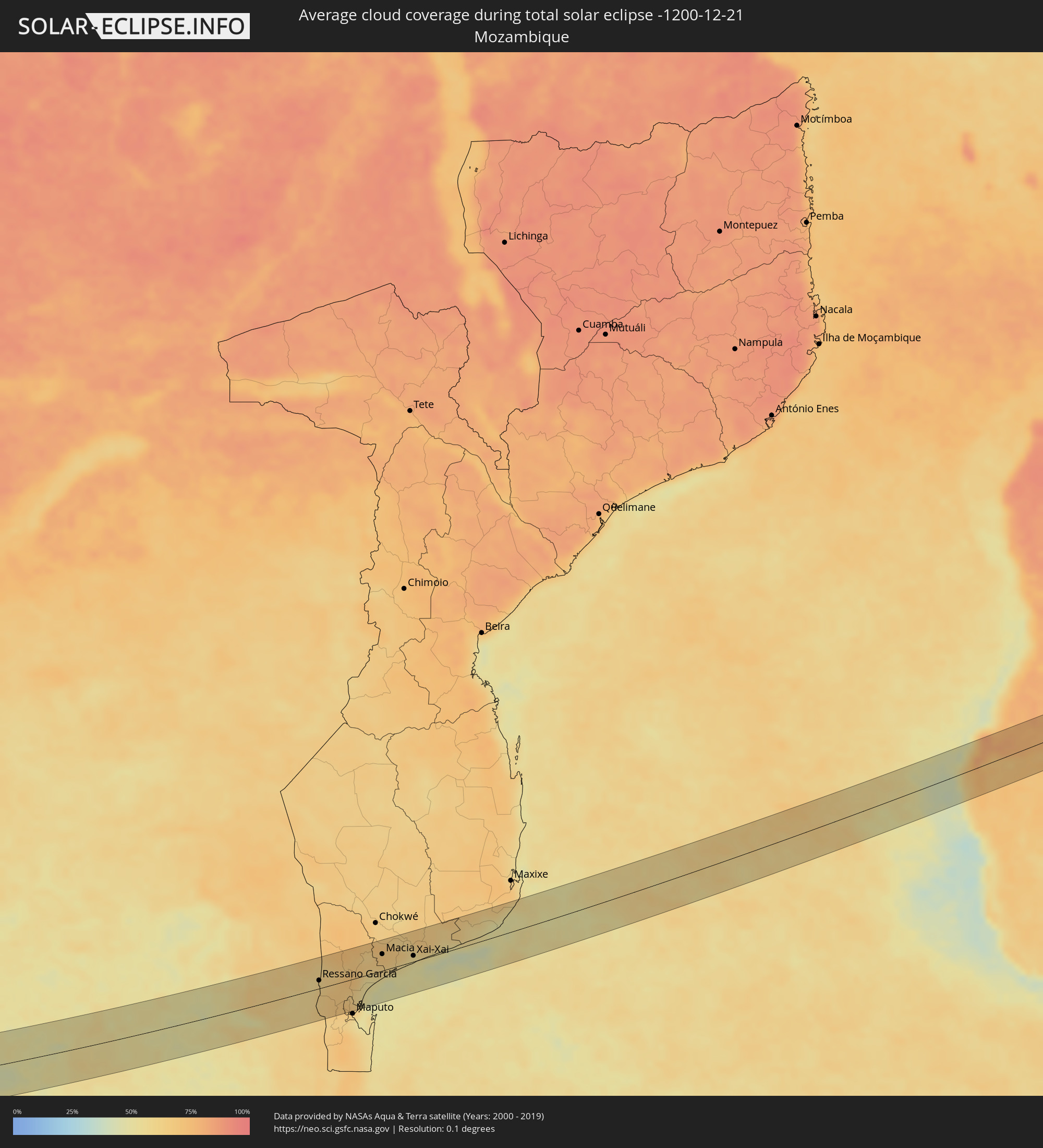 Mosambik
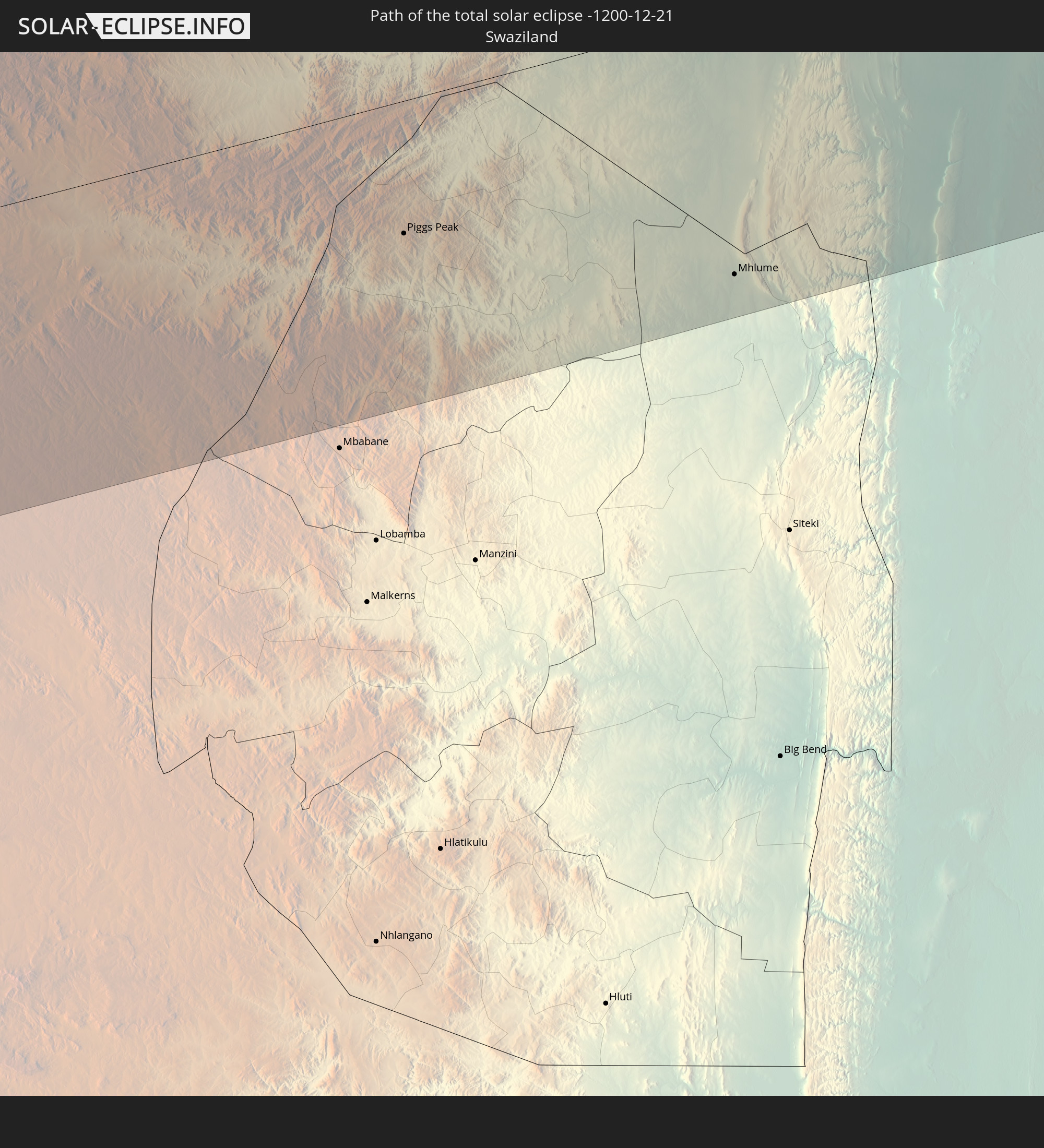
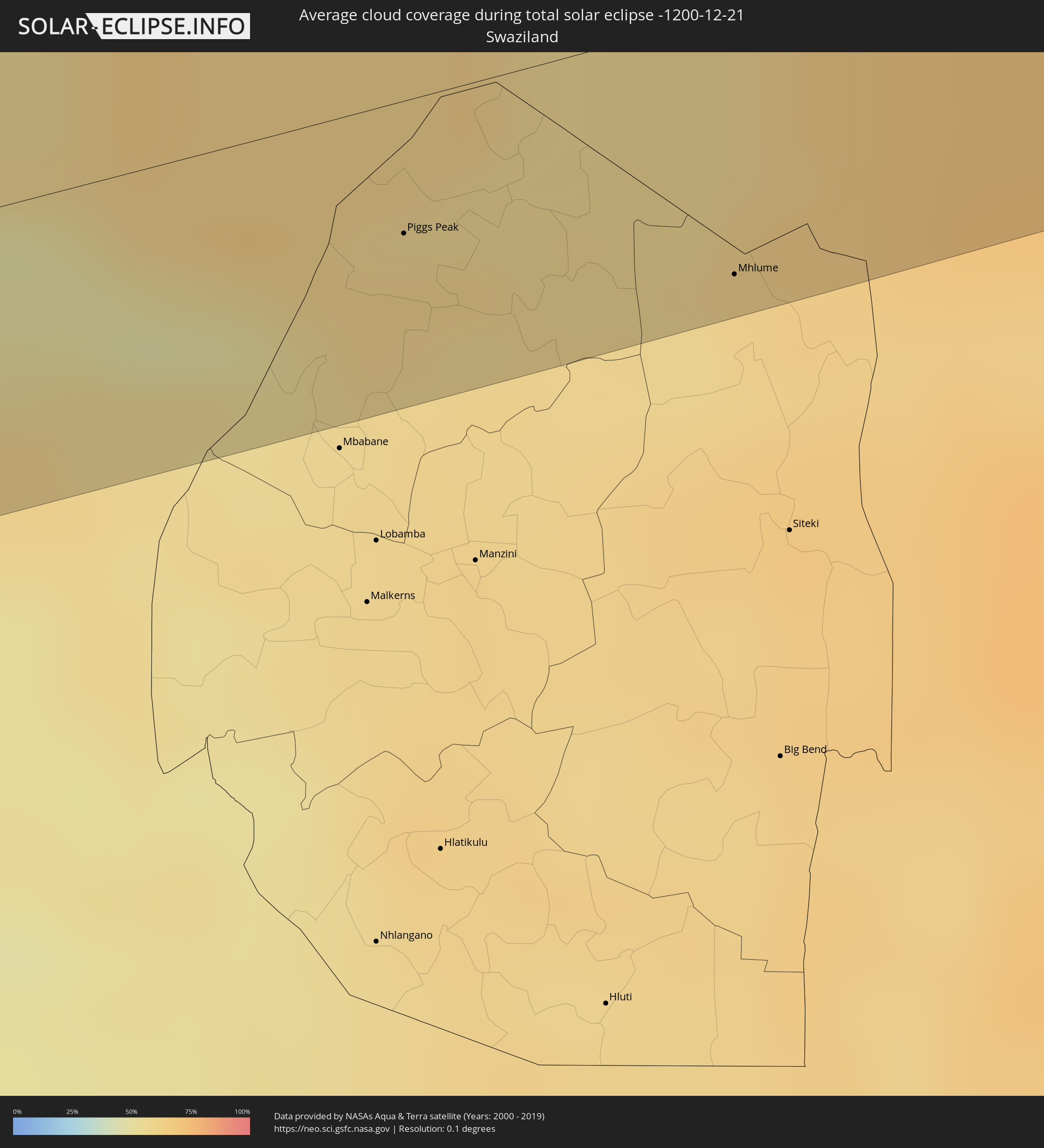 Swasiland
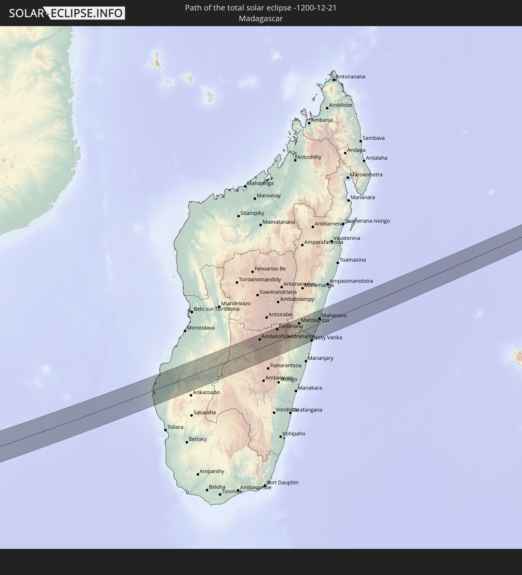
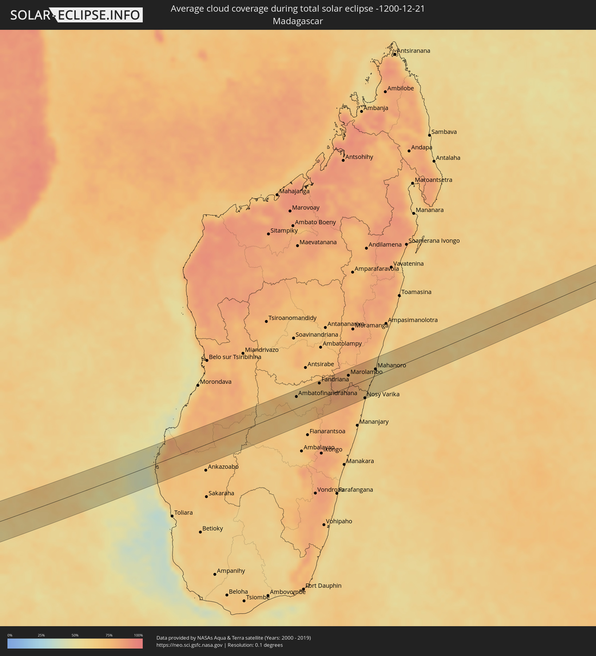 Madagaskar
Orte im Finsternispfad
Die nachfolgene Tabelle zeigt Städte und Orte mit mehr als 5.000 Einwohnern, die sich im Finsternispfad befinden. Städte mit mehr als 100.000 Einwohnern sind dick gekennzeichnet. Mit einem Klick auf den Ort öffnet sich eine Detailkarte die die Lage des jeweiligen Ortes zusammen mit dem Verlauf der zentralen Finsternis präsentiert.
| Ort | Typ | Dauer der Verfinsterung | Ortszeit bei maximaler Verfinsterung | Entfernung zur Zentrallinie | Ø Bewölkung |
|
Bartica, Cuyuni-Mazaruni
|
total | - | 06:22:53 UTC-03:52 | 10 km | 86% |
|
Linden, Upper Demerara-Berbice
|
total | - | 06:23:01 UTC-03:52 | 16 km | 87% |
|
Skeldon, East Berbice-Corentyne
|
total | - | 06:22:58 UTC-03:52 | 26 km | 84% |
|
Parnaíba, Piauí
|
total | - | 07:49:56 UTC-02:34 | 39 km | 70% |
|
Camocim, Ceará
|
total | - | 07:50:24 UTC-02:34 | 14 km | 81% |
|
Granja, Ceará
|
total | - | 07:50:35 UTC-02:34 | 5 km | 86% |
|
Sobral, Ceará
|
total | - | 07:51:20 UTC-02:34 | 32 km | 83% |
|
Itapagé, Ceará
|
total | - | 07:51:45 UTC-02:34 | 12 km | 82% |
|
Itapipoca, Ceará
|
total | - | 07:51:35 UTC-02:34 | 31 km | 86% |
|
Canindé, Ceará
|
total | - | 07:52:31 UTC-02:34 | 36 km | 78% |
|
Pentecoste, Ceará
|
total | - | 07:52:02 UTC-02:34 | 20 km | 84% |
|
Baturité, Ceará
|
total | - | 07:52:45 UTC-02:34 | 8 km | 87% |
|
Pacatuba, Ceará
|
total | - | 07:52:36 UTC-02:34 | 40 km | 82% |
|
Horizonte, Ceará
|
total | - | 07:52:47 UTC-02:34 | 37 km | 81% |
|
Cascavel, Ceará
|
total | - | 07:52:58 UTC-02:34 | 48 km | 69% |
|
Limoeiro do Norte, Ceará
|
total | - | 07:54:00 UTC-02:34 | 39 km | 76% |
|
Russas, Ceará
|
total | - | 07:53:53 UTC-02:34 | 13 km | 78% |
|
Jaguaruana, Ceará
|
total | - | 07:53:55 UTC-02:34 | 9 km | 75% |
|
Aracati, Ceará
|
total | - | 07:53:40 UTC-02:34 | 35 km | 66% |
|
Mossoró, Rio Grande do Norte
|
total | - | 07:54:33 UTC-02:34 | 1 km | 78% |
|
Areia Branca, Rio Grande do Norte
|
total | - | 07:54:28 UTC-02:34 | 35 km | 68% |
|
Açu, Rio Grande do Norte
|
total | - | 07:55:13 UTC-02:34 | 10 km | 67% |
|
Santa Cruz, Rio Grande do Norte
|
total | - | 07:56:31 UTC-02:34 | 18 km | 75% |
|
Belém, Paraíba
|
total | - | 07:57:22 UTC-02:34 | 33 km | 86% |
|
Guarabira, Paraíba
|
total | - | 07:57:34 UTC-02:34 | 45 km | 87% |
|
Nova Cruz, Rio Grande do Norte
|
total | - | 07:57:13 UTC-02:34 | 7 km | 87% |
|
São José de Mipibu, Rio Grande do Norte
|
total | - | 07:56:57 UTC-02:34 | 43 km | 72% |
|
Canguaretama, Rio Grande do Norte
|
total | - | 07:57:21 UTC-02:34 | 21 km | 78% |
|
Mamanguape, Paraíba
|
total | - | 07:57:50 UTC-02:34 | 22 km | 81% |
|
Conde, Paraíba
|
total | - | 07:58:27 UTC-02:34 | 48 km | 76% |
|
João Pessoa, Paraíba
|
total | - | 07:58:20 UTC-02:34 | 32 km | 76% |
|
Cabedelo, Paraíba
|
total | - | 07:58:13 UTC-02:34 | 18 km | 58% |
|
Karasburg, Karas
|
total | - | 14:17:23 UTC+01:30 | 33 km | 14% |
|
Vryburg, North-West
|
total | - | 14:30:08 UTC+01:30 | 10 km | 36% |
|
Schweizer-Reneke, North-West
|
total | - | 14:31:09 UTC+01:30 | 26 km | 42% |
|
Wolmaransstad, North-West
|
total | - | 14:32:21 UTC+01:30 | 39 km | 45% |
|
Klerksdorp, North-West
|
total | - | 14:33:47 UTC+01:30 | 15 km | 44% |
|
Stilfontein, North-West
|
total | - | 14:33:58 UTC+01:30 | 16 km | 46% |
|
Potchefstroom, North-West
|
total | - | 14:34:38 UTC+01:30 | 9 km | 49% |
|
Carletonville, Gauteng
|
total | - | 14:35:22 UTC+01:30 | 24 km | 46% |
|
Parys, Orange Free State
|
total | - | 14:35:09 UTC+01:30 | 36 km | 50% |
|
Fochville, North-West
|
total | - | 14:35:27 UTC+01:30 | 8 km | 49% |
|
Westonaria, Gauteng
|
total | - | 14:35:50 UTC+01:30 | 23 km | 49% |
|
Krugersdorp, Gauteng
|
total | - | 14:36:11 UTC+01:30 | 46 km | 52% |
|
Sasolburg, Orange Free State
|
total | - | 14:35:50 UTC+01:30 | 34 km | 55% |
|
Soweto, Gauteng
|
total | - | 14:36:14 UTC+01:30 | 24 km | 52% |
|
Vereeniging, Gauteng
|
total | - | 14:36:06 UTC+01:30 | 21 km | 57% |
|
Johannesburg, Gauteng
|
total | - | 14:36:35 UTC+01:30 | 28 km | 55% |
|
Tembisa, Gauteng
|
total | - | 14:37:02 UTC+01:30 | 46 km | 56% |
|
Benoni, Gauteng
|
total | - | 14:37:04 UTC+01:30 | 23 km | 53% |
|
Heidelberg, Gauteng
|
total | - | 14:36:57 UTC+01:30 | 12 km | 54% |
|
Nigel, Gauteng
|
total | - | 14:37:12 UTC+01:30 | 7 km | 52% |
|
Balfour, Mpumalanga
|
total | - | 14:37:15 UTC+01:30 | 35 km | 54% |
|
Delmas, Mpumalanga
|
total | - | 14:37:43 UTC+01:30 | 19 km | 51% |
|
Bronkhorstspruit, Gauteng
|
total | - | 14:38:01 UTC+01:30 | 54 km | 50% |
|
eMbalenhle, Mpumalanga
|
total | - | 14:38:07 UTC+01:30 | 31 km | 51% |
|
Witbank, Mpumalanga
|
total | - | 14:38:49 UTC+01:30 | 36 km | 51% |
|
Middelburg, Mpumalanga
|
total | - | 14:39:15 UTC+01:30 | 41 km | 50% |
|
Bethal, Mpumalanga
|
total | - | 14:38:50 UTC+01:30 | 32 km | 48% |
|
Ermelo, Mpumalanga
|
total | - | 14:39:37 UTC+01:30 | 53 km | 49% |
|
Nelspruit, Mpumalanga
|
total | - | 14:41:52 UTC+01:30 | 37 km | 64% |
|
Barberton, Mpumalanga
|
total | - | 14:41:48 UTC+01:30 | 1 km | 62% |
|
Piggs Peak, Hhohho
|
total | - | 14:41:59 UTC+01:30 | 23 km | 60% |
|
Mhlume, Lubombo
|
total | - | 14:42:51 UTC+01:30 | 46 km | 60% |
|
Ressano Garcia, Maputo
|
total | - | 15:23:48 UTC+02:10 | 13 km | 60% |
|
Macia, Gaza
|
total | - | 15:25:43 UTC+02:10 | 28 km | 68% |
|
Chibuto, Gaza
|
total | - | 15:26:34 UTC+02:10 | 52 km | 61% |
|
Xai-Xai, Gaza
|
total | - | 15:26:29 UTC+02:10 | 10 km | 52% |
|
Manjacaze, Gaza
|
total | - | 15:27:03 UTC+02:10 | 39 km | 65% |
|
Beroroha, Atsimo-Andrefana
|
total | - | 15:58:30 UTC+02:27 | 24 km | 64% |
|
Ikalamavony, Upper Matsiatra
|
total | - | 15:59:57 UTC+02:27 | 25 km | 64% |
|
Ambatofinandrahana, Amoron'i Mania
|
total | - | 16:00:31 UTC+02:27 | 28 km | 66% |
|
Ambositra, Amoron'i Mania
|
total | - | 16:00:51 UTC+02:27 | 13 km | 67% |
|
Fandriana, Amoron'i Mania
|
total | - | 16:01:09 UTC+02:27 | 38 km | 73% |
|
Marolambo, Atsinanana
|
total | - | 16:01:46 UTC+02:27 | 28 km | 78% |
|
Sahavato, Vatovavy Fitovinany
|
total | - | 16:01:32 UTC+02:27 | 37 km | 78% |
|
Nosy Varika, Vatovavy Fitovinany
|
total | - | 16:01:40 UTC+02:27 | 44 km | 62% |
|
Mahanoro, Atsinanana
|
total | - | 16:02:18 UTC+02:27 | 16 km | 59% |