Totale Sonnenfinsternis vom 20.01.-1321
| Wochentag: | Samstag |
| Maximale Dauer der Verfinsterung: | 03m32s |
| Maximale Breite des Finsternispfades: | 301 km |
| Saroszyklus: | 39 |
| Bedeckungsgrad: | 100% |
| Magnitude: | 1.0432 |
| Gamma: | 0.8791 |
Wo kann man die Sonnenfinsternis vom 20.01.-1321 sehen?
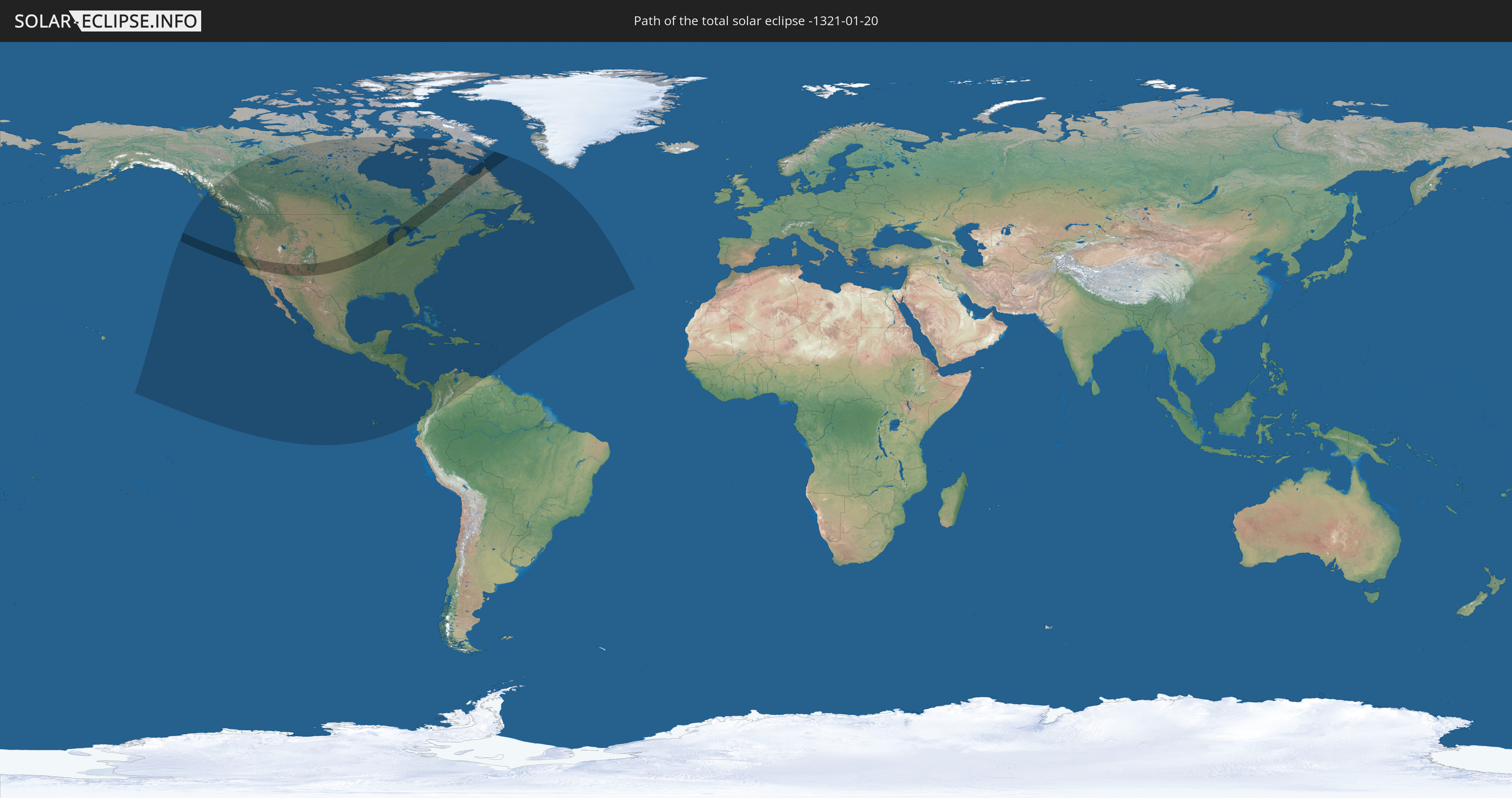
Die Sonnenfinsternis am 20.01.-1321 kann man in 40 Ländern als partielle Sonnenfinsternis beobachten.
Der Finsternispfad verläuft durch 2 Länder. Nur in diesen Ländern ist sie als totale Sonnenfinsternis zu sehen.
In den folgenden Ländern ist die Sonnenfinsternis total zu sehen
 Vereinigte Staaten
 Kanada
In den folgenden Ländern ist die Sonnenfinsternis partiell zu sehen
 Vereinigte Staaten
 United States Minor Outlying Islands
 Kanada
 Mexiko
 Grönland
 Guatemala
 Ecuador
 El Salvador
 Honduras
 Belize
 Nicaragua
 Costa Rica
 Kuba
Kuba
 Panama
 Kolumbien
 Kaimaninseln
 Bahamas
 Jamaika
 Haiti
Haiti
 Venezuela
 Turks- und Caicosinseln
 Dominikanische Republik
 Aruba
Aruba
 Puerto Rico
 Amerikanische Jungferninseln
 Bermuda
 Britische Jungferninseln
 Anguilla
 Saint-Martin
 Saint-Barthélemy
 St. Kitts und Nevis
 Antigua und Barbuda
 Montserrat
 Guadeloupe
 Grenada
 Dominica
 St. Vincent und die Grenadinen
 Martinique
 St. Lucia
 Saint-Pierre und Miquelon
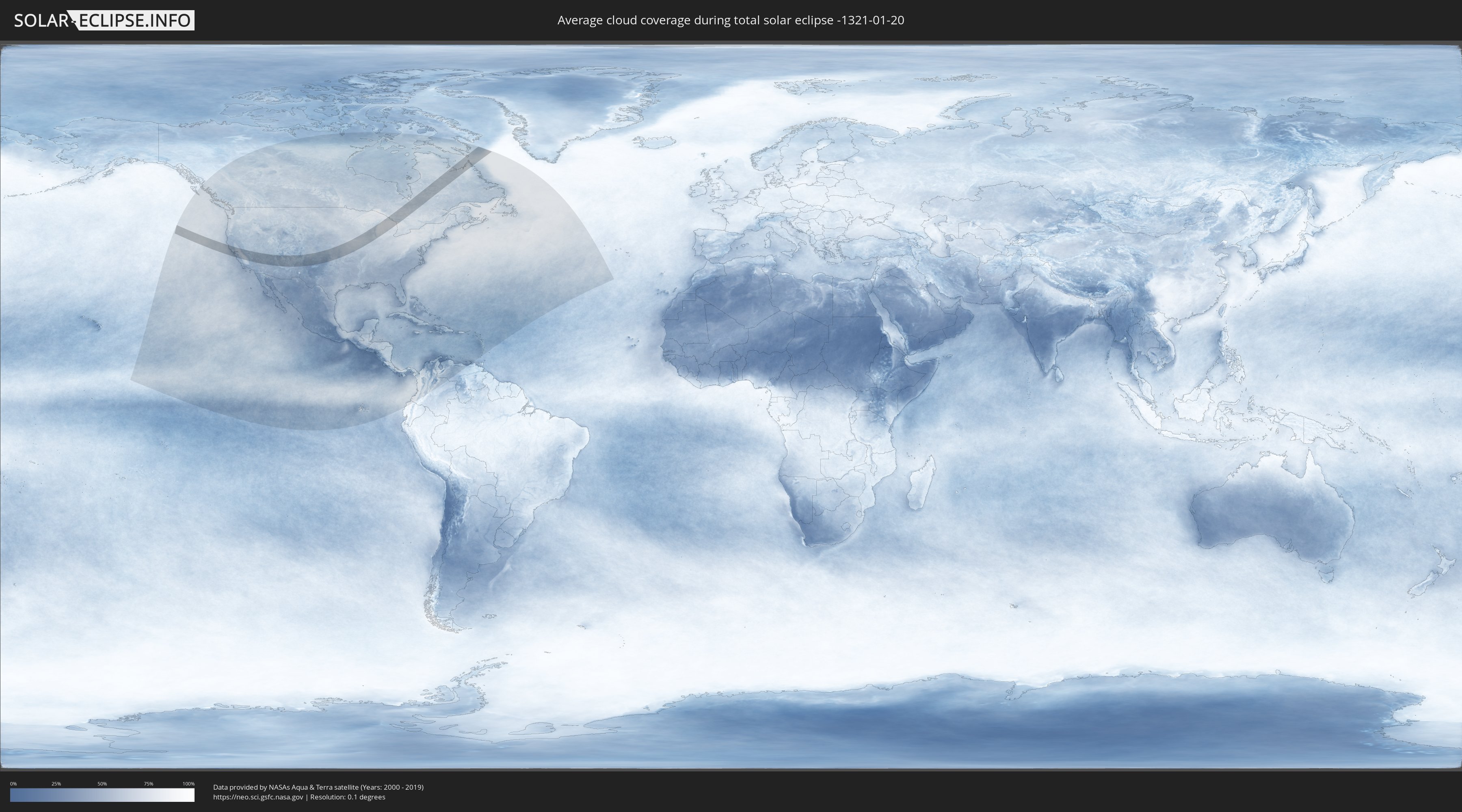
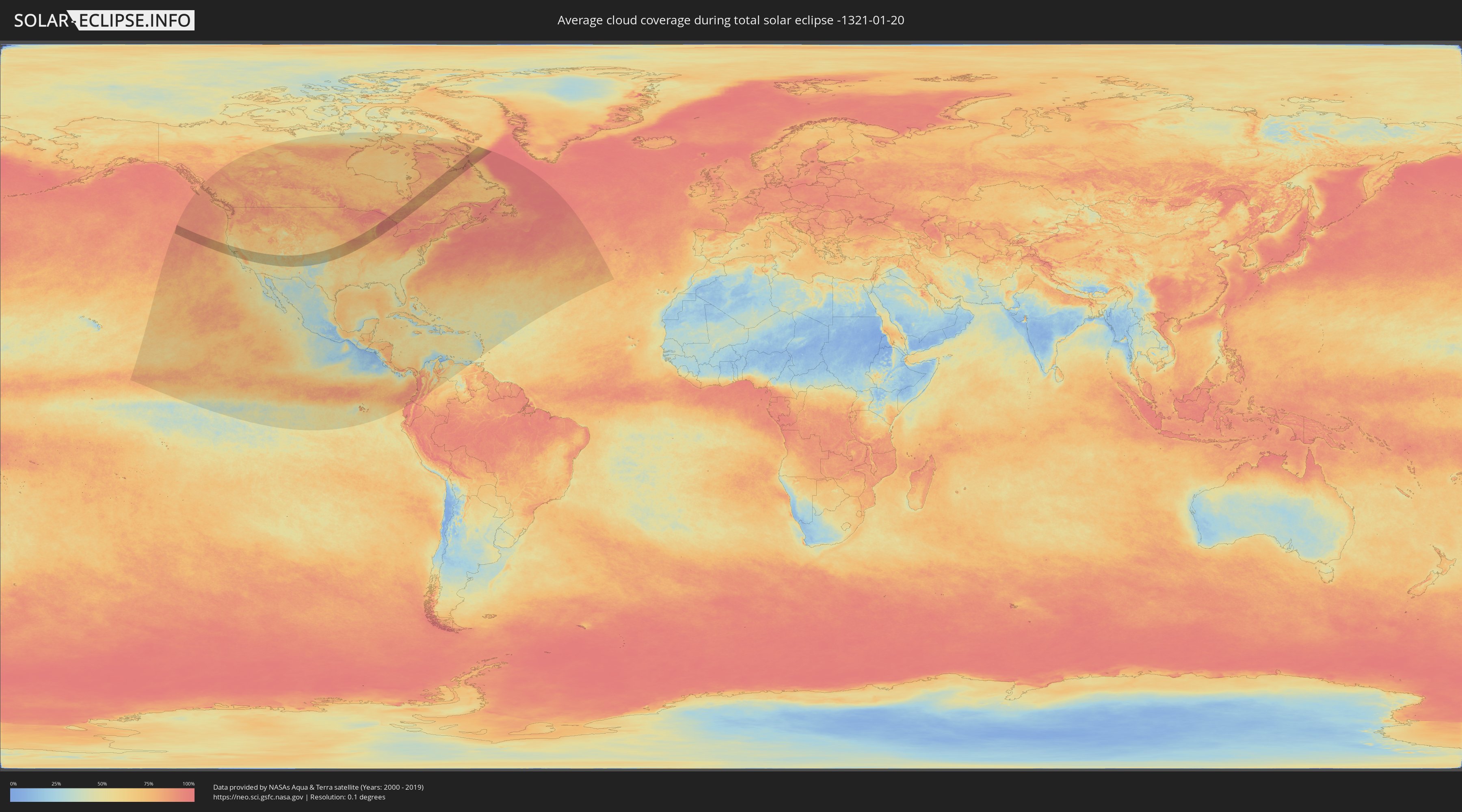
Wie wird das Wetter während der totalen Sonnenfinsternis am 20.01.-1321?
Wo ist der beste Ort, um die totale Sonnenfinsternis vom 20.01.-1321 zu beobachten?
Die folgenden Karten zeigen die durchschnittliche Bewölkung für den Tag, an dem die totale Sonnenfinsternis
stattfindet. Mit Hilfe der Karten lässt sich der Ort entlang des Finsternispfades eingrenzen,
der die besten Aussichen auf einen klaren wolkenfreien Himmel bietet.
Trotzdem muss man immer lokale Gegenenheiten beachten und sollte sich genau über das Wetter an seinem
gewählten Beobachtungsort informieren.
Die Daten stammen von den beiden NASA-Satelliten
AQUA und TERRA
und wurden über einen Zeitraum von 19 Jahren (2000 - 2019) gemittelt.
Detaillierte Länderkarten
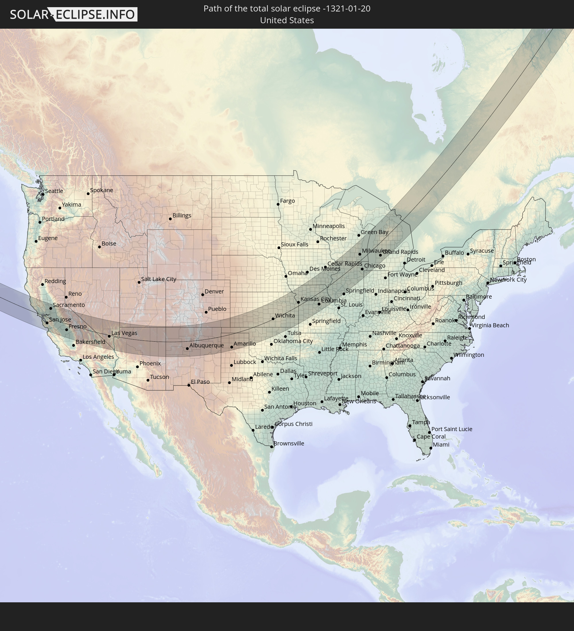
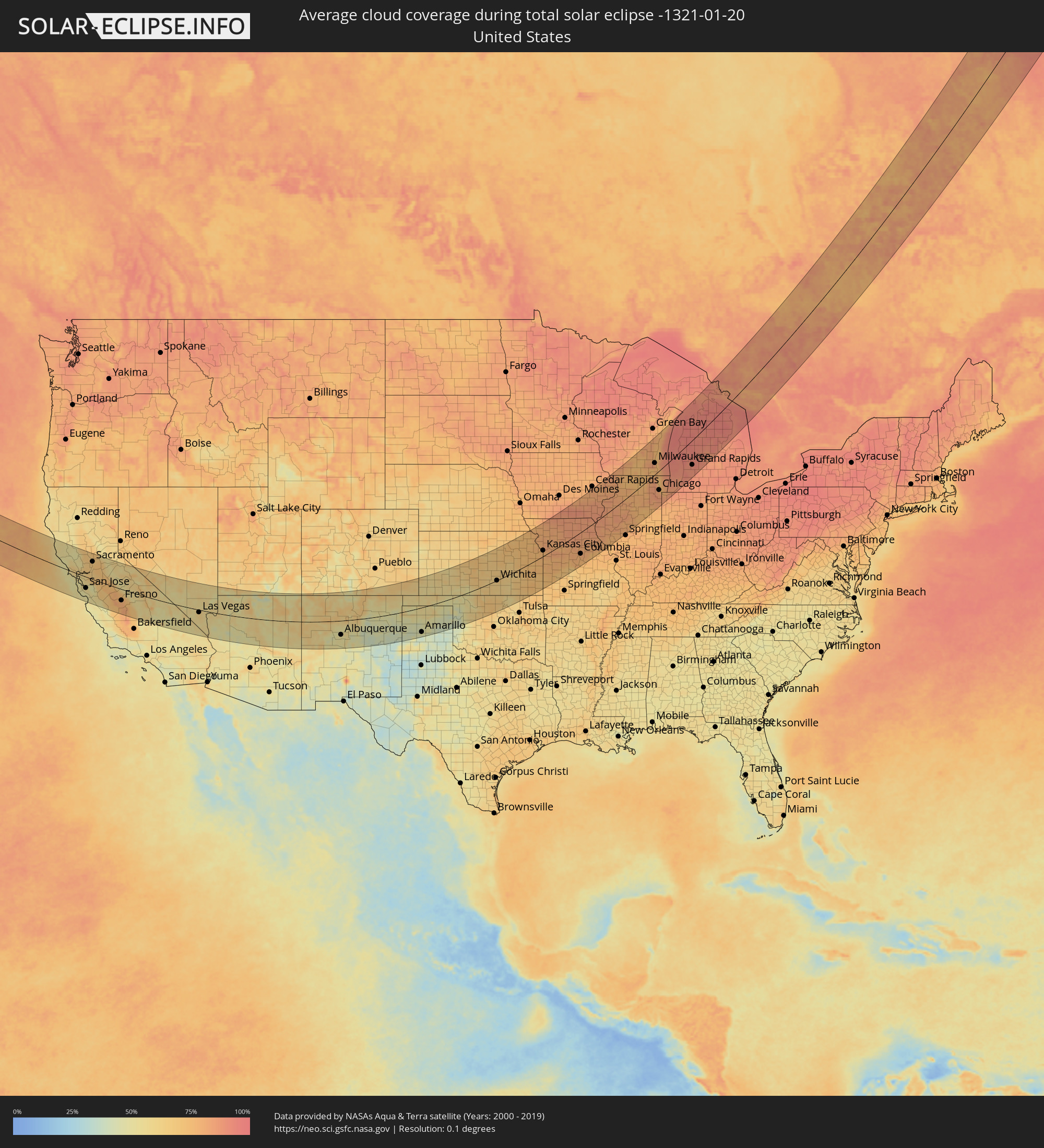 Vereinigte Staaten
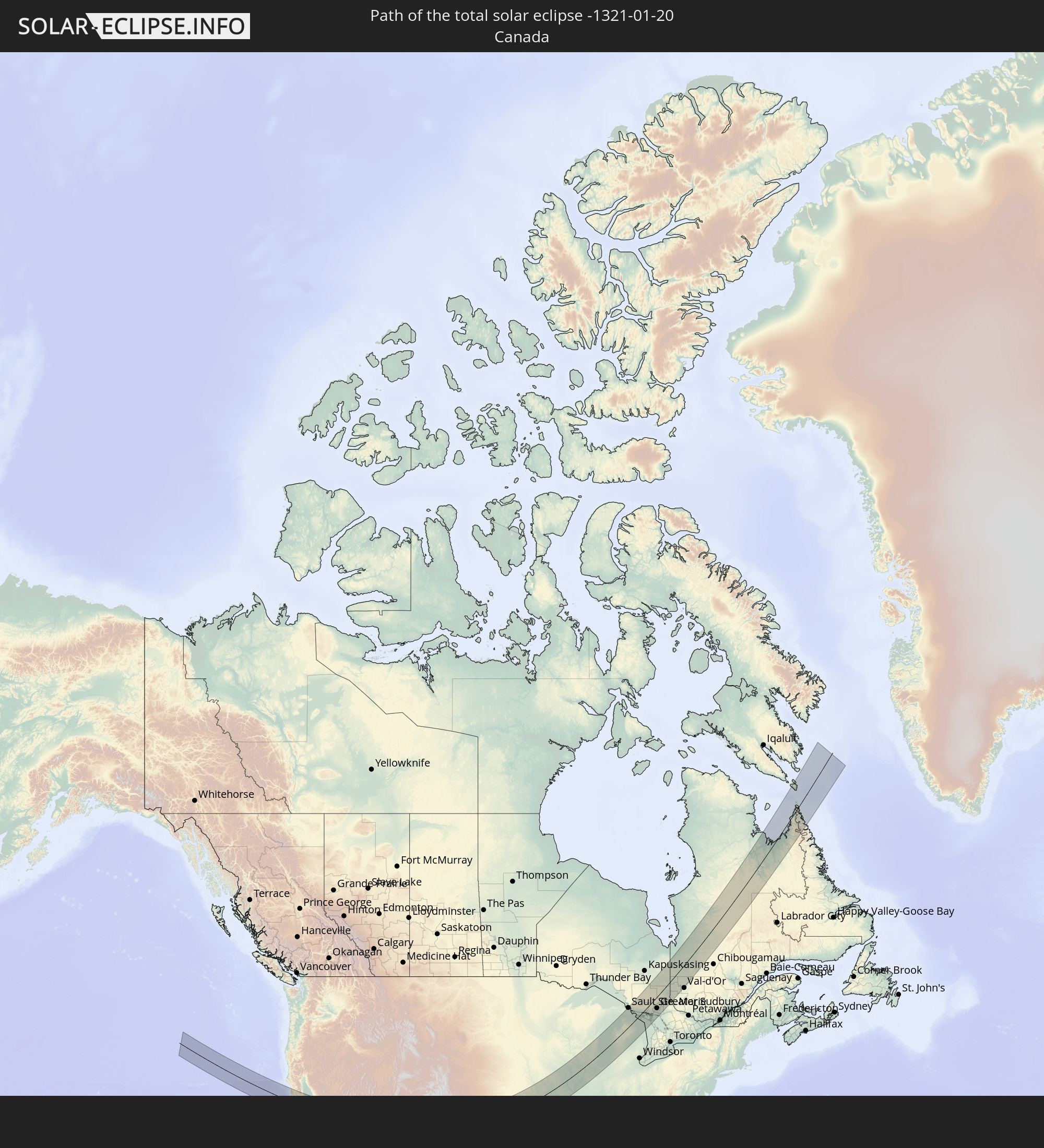
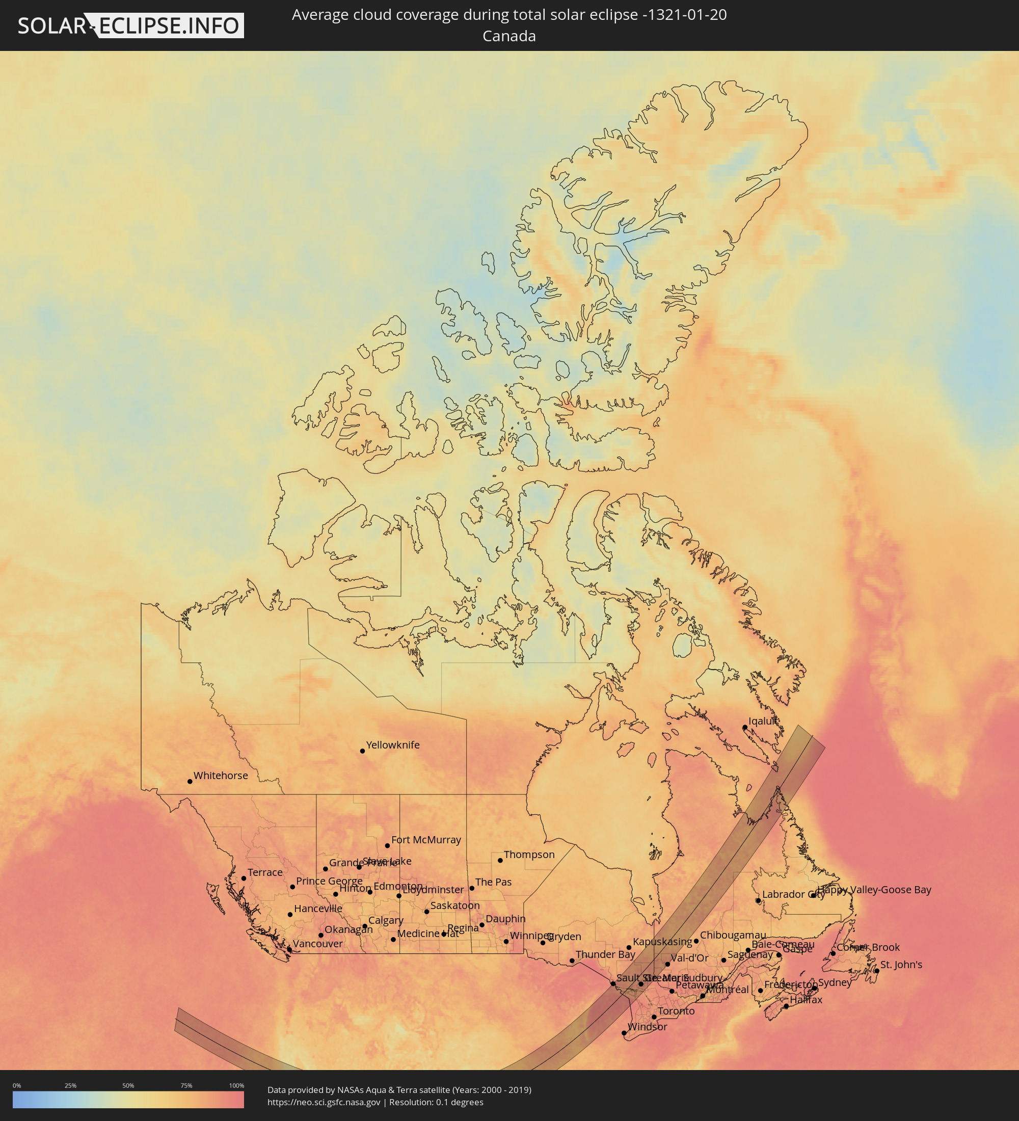 Kanada
Orte im Finsternispfad
Die nachfolgene Tabelle zeigt Städte und Orte mit mehr als 5.000 Einwohnern, die sich im Finsternispfad befinden. Städte mit mehr als 100.000 Einwohnern sind dick gekennzeichnet. Mit einem Klick auf den Ort öffnet sich eine Detailkarte die die Lage des jeweiligen Ortes zusammen mit dem Verlauf der zentralen Finsternis präsentiert.
| Ort | Typ | Dauer der Verfinsterung | Ortszeit bei maximaler Verfinsterung | Entfernung zur Zentrallinie | Ø Bewölkung |
|
Santa Rosa, California
|
total | - | 09:01:41 UTC-08:00 | 34 km | 65% |
|
Petaluma, California
|
total | - | 09:01:30 UTC-08:00 | 15 km | 62% |
|
Novato, California
|
total | - | 09:01:25 UTC-08:00 | 4 km | 59% |
|
San Rafael, California
|
total | - | 09:01:17 UTC-08:00 | 9 km | 55% |
|
Pacifica, California
|
total | - | 09:00:51 UTC-08:00 | 45 km | 49% |
|
San Francisco, California
|
total | - | 09:01:09 UTC-08:00 | 26 km | 55% |
|
San Mateo, California
|
total | - | 09:00:59 UTC-08:00 | 45 km | 49% |
|
Napa, California
|
total | - | 09:02:02 UTC-08:00 | 33 km | 60% |
|
Berkeley, California
|
total | - | 09:01:28 UTC-08:00 | 11 km | 55% |
|
Vallejo, California
|
total | - | 09:01:48 UTC-08:00 | 14 km | 59% |
|
Mountain View, California
|
total | - | 09:01:04 UTC-08:00 | 56 km | 53% |
|
Hayward, California
|
total | - | 09:01:27 UTC-08:00 | 26 km | 56% |
|
Fairfield, California
|
total | - | 09:02:16 UTC-08:00 | 35 km | 62% |
|
Concord, California
|
total | - | 09:01:55 UTC-08:00 | 7 km | 61% |
|
Santa Cruz, California
|
total | - | 09:00:35 UTC-08:00 | 97 km | 51% |
|
Fremont, California
|
total | - | 09:01:24 UTC-08:00 | 36 km | 62% |
|
San Ramon, California
|
total | - | 09:01:43 UTC-08:00 | 12 km | 58% |
|
San Jose, California
|
total | - | 09:01:15 UTC-08:00 | 55 km | 56% |
|
Antioch, California
|
total | - | 09:02:15 UTC-08:00 | 17 km | 67% |
|
Woodland, California
|
total | - | 09:03:12 UTC-08:00 | 88 km | 68% |
|
Livermore, California
|
total | - | 09:01:52 UTC-08:00 | 15 km | 61% |
|
Watsonville, California
|
total | - | 09:00:51 UTC-08:00 | 96 km | 49% |
|
Davis, California
|
total | - | 09:03:03 UTC-08:00 | 75 km | 67% |
|
Salinas, California
|
total | - | 09:00:41 UTC-08:00 | 117 km | 54% |
|
Morgan Hill, California
|
total | - | 09:01:17 UTC-08:00 | 70 km | 53% |
|
Gilroy, California
|
total | - | 09:01:14 UTC-08:00 | 80 km | 52% |
|
Sacramento, California
|
total | - | 09:03:25 UTC-08:00 | 87 km | 68% |
|
Tracy, California
|
total | - | 09:02:23 UTC-08:00 | 1 km | 72% |
|
Elk Grove, California
|
total | - | 09:03:21 UTC-08:00 | 72 km | 72% |
|
Rancho Cordova, California
|
total | - | 09:03:41 UTC-08:00 | 93 km | 69% |
|
Lincoln, California
|
total | - | 09:04:06 UTC-08:00 | 125 km | 70% |
|
Stockton, California
|
total | - | 09:02:51 UTC-08:00 | 28 km | 68% |
|
Roseville, California
|
total | - | 09:03:55 UTC-08:00 | 111 km | 68% |
|
Lodi, California
|
total | - | 09:03:06 UTC-08:00 | 46 km | 69% |
|
Manteca, California
|
total | - | 09:02:44 UTC-08:00 | 13 km | 69% |
|
El Dorado Hills, California
|
total | - | 09:04:06 UTC-08:00 | 110 km | 69% |
|
Modesto, California
|
total | - | 09:02:49 UTC-08:00 | 3 km | 71% |
|
Turlock, California
|
total | - | 09:02:50 UTC-08:00 | 8 km | 74% |
|
Merced, California
|
total | - | 09:03:04 UTC-08:00 | 18 km | 75% |
|
Madera, California
|
total | - | 09:03:11 UTC-08:00 | 42 km | 77% |
|
Fresno, California
|
total | - | 09:03:19 UTC-08:00 | 57 km | 79% |
|
Hanford, California
|
total | - | 09:02:56 UTC-08:00 | 98 km | 81% |
|
Visalia, California
|
total | - | 09:03:26 UTC-08:00 | 88 km | 72% |
|
Porterville, California
|
total | - | 09:03:29 UTC-08:00 | 110 km | 69% |
|
Enterprise, Nevada
|
total | - | 09:09:09 UTC-08:00 | 31 km | 60% |
|
Las Vegas, Nevada
|
total | - | 09:09:31 UTC-08:00 | 13 km | 63% |
|
Henderson, Nevada
|
total | - | 09:09:35 UTC-08:00 | 25 km | 61% |
|
Bullhead City, Arizona
|
total | - | 10:09:10 UTC-07:00 | 115 km | 59% |
|
Saint George, Utah
|
total | - | 10:13:12 UTC-07:00 | 115 km | 57% |
|
Flagstaff, Arizona
|
total | - | 10:14:11 UTC-07:00 | 72 km | 60% |
|
Farmington, New Mexico
|
total | - | 10:22:12 UTC-07:00 | 112 km | 62% |
|
Albuquerque, New Mexico
|
total | - | 10:23:21 UTC-07:00 | 76 km | 52% |
|
Enchanted Hills, New Mexico
|
total | - | 10:23:45 UTC-07:00 | 48 km | 53% |
|
Santa Fe, New Mexico
|
total | - | 10:25:24 UTC-07:00 | 14 km | 61% |
|
Amarillo, Texas
|
total | - | 11:33:13 UTC-06:00 | 128 km | 48% |
|
Hutchinson, Kansas
|
total | - | 11:43:53 UTC-06:00 | 58 km | 65% |
|
Enid, Oklahoma
|
total | - | 11:42:35 UTC-06:00 | 114 km | 67% |
|
Salina, Kansas
|
total | - | 11:45:10 UTC-06:00 | 125 km | 66% |
|
Wichita, Kansas
|
total | - | 11:44:48 UTC-06:00 | 1 km | 65% |
|
Manhattan, Kansas
|
total | - | 11:47:33 UTC-06:00 | 118 km | 73% |
|
Topeka, Kansas
|
total | - | 11:49:15 UTC-06:00 | 68 km | 73% |
|
Lawrence, Kansas
|
total | - | 11:50:05 UTC-06:00 | 42 km | 75% |
|
Saint Joseph, Missouri
|
total | - | 11:51:26 UTC-06:00 | 101 km | 79% |
|
Olathe, Kansas
|
total | - | 11:50:52 UTC-06:00 | 15 km | 76% |
|
Overland Park, Kansas
|
total | - | 11:51:14 UTC-06:00 | 18 km | 75% |
|
Kansas City, Missouri
|
total | - | 11:51:30 UTC-06:00 | 25 km | 76% |
|
Lee's Summit, Missouri
|
total | - | 11:51:46 UTC-06:00 | 1 km | 79% |
|
East Independence, Missouri
|
total | - | 11:51:57 UTC-06:00 | 15 km | 78% |
|
Columbia, Missouri
|
total | - | 11:55:56 UTC-06:00 | 91 km | 80% |
|
Jefferson City, Missouri
|
total | - | 11:56:02 UTC-06:00 | 134 km | 75% |
|
Iowa City, Iowa
|
total | - | 11:59:05 UTC-06:00 | 115 km | 82% |
|
Quincy, Illinois
|
total | - | 11:58:22 UTC-06:00 | 45 km | 83% |
|
Davenport, Iowa
|
total | - | 12:00:50 UTC-06:00 | 54 km | 84% |
|
Peoria, Illinois
|
total | - | 12:02:19 UTC-06:00 | 70 km | 83% |
|
Madison, Wisconsin
|
total | - | 12:03:45 UTC-06:00 | 125 km | 82% |
|
Rockford, Illinois
|
total | - | 12:03:59 UTC-06:00 | 41 km | 77% |
|
Janesville, Wisconsin
|
total | - | 12:04:18 UTC-06:00 | 72 km | 77% |
|
Bloomington, Illinois
|
total | - | 12:03:22 UTC-06:00 | 119 km | 78% |
|
DeKalb, Illinois
|
total | - | 12:04:28 UTC-06:00 | 6 km | 75% |
|
Fond du Lac, Wisconsin
|
total | - | 12:05:47 UTC-06:00 | 132 km | 82% |
|
Aurora, Illinois
|
total | - | 12:05:12 UTC-06:00 | 44 km | 80% |
|
Crystal Lake, Illinois
|
total | - | 12:05:25 UTC-06:00 | 3 km | 81% |
|
Elgin, Illinois
|
total | - | 12:05:23 UTC-06:00 | 22 km | 82% |
|
Waukesha, Wisconsin
|
total | - | 12:05:52 UTC-06:00 | 57 km | 84% |
|
Wheaton, Illinois
|
total | - | 12:05:39 UTC-06:00 | 46 km | 84% |
|
Joliet, Illinois
|
total | - | 12:05:33 UTC-06:00 | 76 km | 82% |
|
Bolingbrook, Illinois
|
total | - | 12:05:39 UTC-06:00 | 62 km | 84% |
|
Arlington Heights, Illinois
|
total | - | 12:05:58 UTC-06:00 | 34 km | 85% |
|
Milwaukee, Wisconsin
|
total | - | 12:06:28 UTC-06:00 | 42 km | 81% |
|
Orland Park, Illinois
|
total | - | 12:06:01 UTC-06:00 | 80 km | 85% |
|
Waukegan, Illinois
|
total | - | 12:06:20 UTC-06:00 | 18 km | 78% |
|
Kenosha, Wisconsin
|
total | - | 12:06:27 UTC-06:00 | 1 km | 76% |
|
Racine, Wisconsin
|
total | - | 12:06:35 UTC-06:00 | 9 km | 76% |
|
Sheboygan, Wisconsin
|
total | - | 12:07:04 UTC-06:00 | 90 km | 76% |
|
Evanston, Illinois
|
total | - | 12:06:29 UTC-06:00 | 53 km | 84% |
|
Chicago, Illinois
|
total | - | 12:06:29 UTC-06:00 | 72 km | 83% |
|
Hammond, Indiana
|
total | - | 12:06:40 UTC-06:00 | 103 km | 83% |
|
Muskegon, Michigan
|
total | - | 13:09:31 UTC-05:00 | 32 km | 93% |
|
Grand Rapids, Michigan
|
total | - | 13:10:28 UTC-05:00 | 87 km | 89% |
|
Sault Ste. Marie, Ontario
|
total | - | 13:13:30 UTC-05:00 | 120 km | 85% |
|
Midland, Michigan
|
total | - | 13:13:07 UTC-05:00 | 112 km | 89% |
|
Elliot Lake, Ontario
|
total | - | 13:16:14 UTC-05:00 | 14 km | 86% |
|
Timmins, Ontario
|
total | - | 13:18:19 UTC-05:00 | 96 km | 86% |
|
Rayside-Balfour, Ontario
|
total | - | 13:18:29 UTC-05:00 | 49 km | 88% |
|
Greater Sudbury, Ontario
|
total | - | 13:18:49 UTC-05:00 | 70 km | 88% |
|
Kirkland Lake, Ontario
|
total | - | 13:20:15 UTC-05:00 | 0 km | 88% |
|
Temiskaming Shores, Ontario
|
total | - | 13:20:46 UTC-05:00 | 66 km | 87% |
|
La Sarre, Quebec
|
total | - | 13:21:26 UTC-05:00 | 1 km | 85% |
|
Rouyn-Noranda, Quebec
|
total | - | 13:21:44 UTC-05:00 | 50 km | 87% |
|
Amos, Quebec
|
total | - | 13:23:01 UTC-05:00 | 76 km | 90% |