Totale Sonnenfinsternis vom 15.08.-1370
| Wochentag: | Freitag |
| Maximale Dauer der Verfinsterung: | 05m51s |
| Maximale Breite des Finsternispfades: | 241 km |
| Saroszyklus: | 23 |
| Bedeckungsgrad: | 100% |
| Magnitude: | 1.0633 |
| Gamma: | -0.5101 |
Wo kann man die Sonnenfinsternis vom 15.08.-1370 sehen?
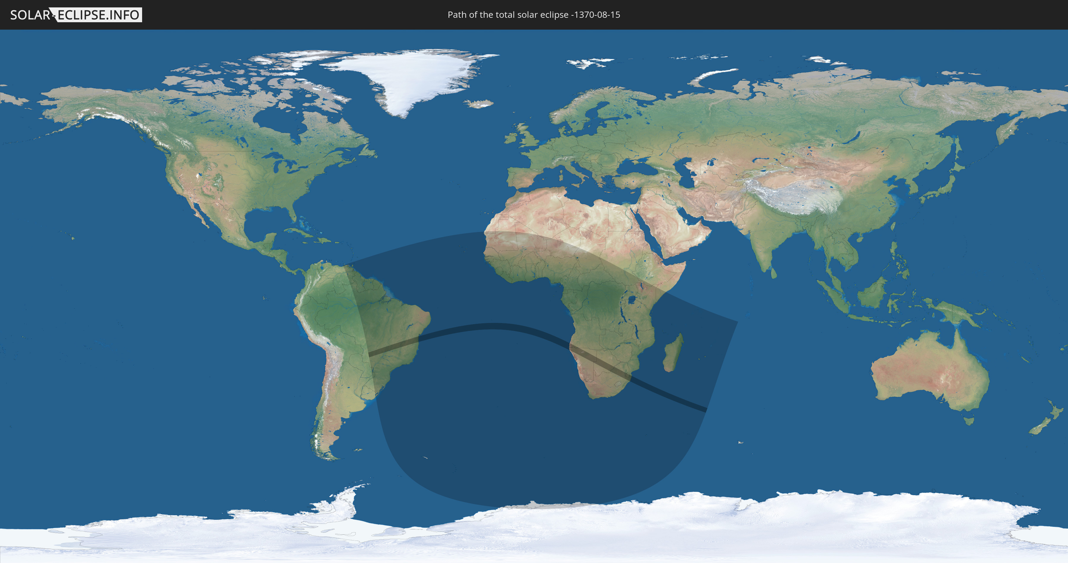
Die Sonnenfinsternis am 15.08.-1370 kann man in 63 Ländern als partielle Sonnenfinsternis beobachten.
Der Finsternispfad verläuft durch 7 Länder. Nur in diesen Ländern ist sie als totale Sonnenfinsternis zu sehen.
In den folgenden Ländern ist die Sonnenfinsternis total zu sehen
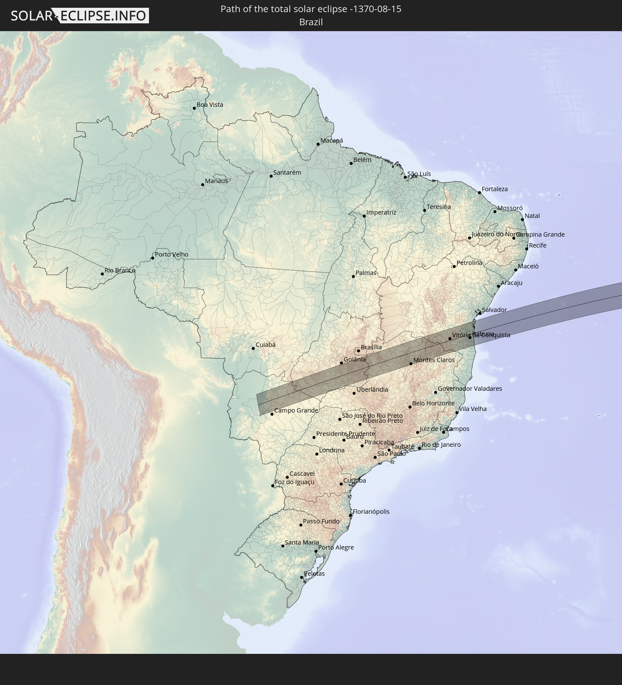 Brasilien
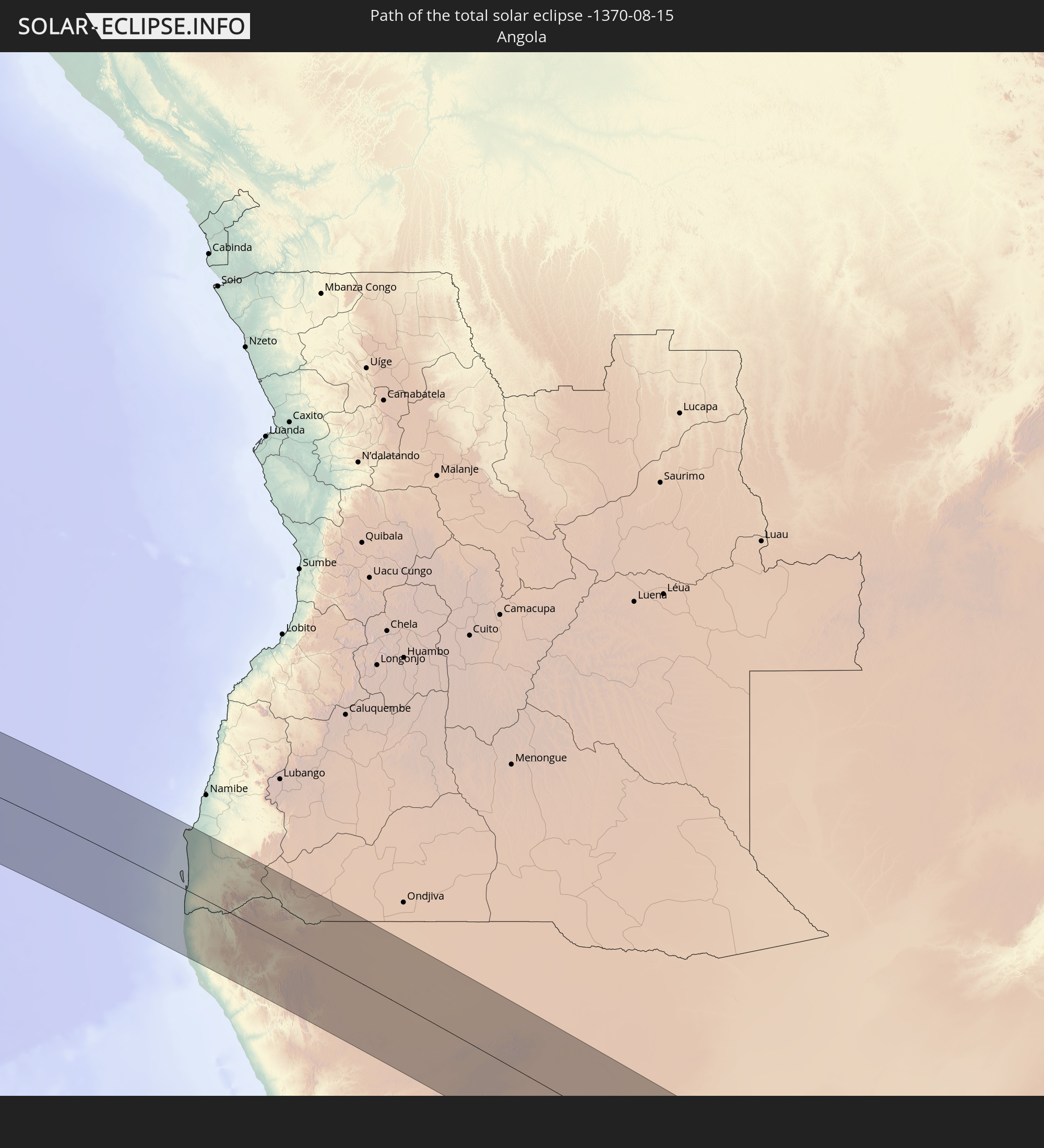 Angola
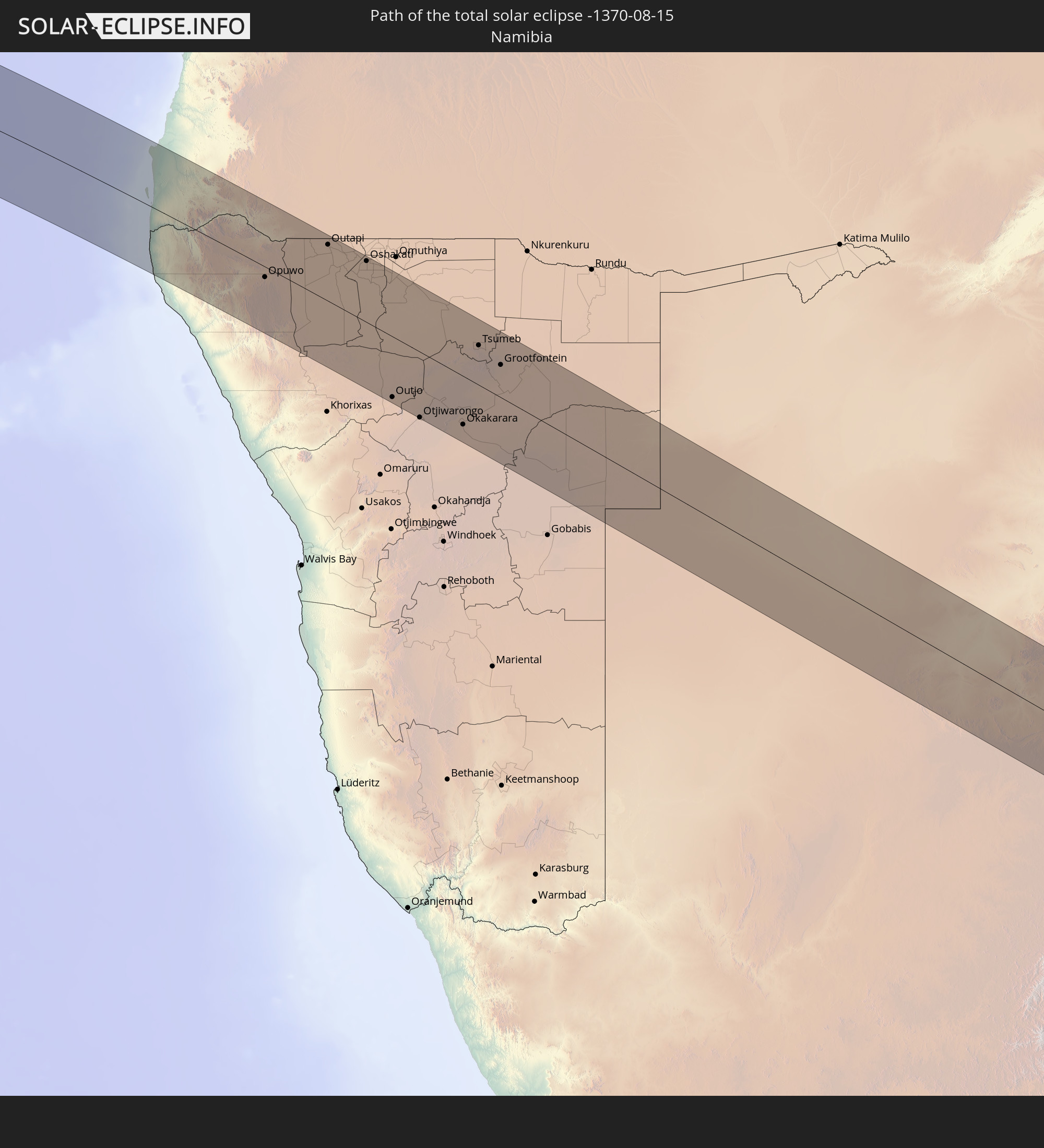 Namibia
 Südafrika
 Botswana
 Mosambik
 Swasiland
In den folgenden Ländern ist die Sonnenfinsternis partiell zu sehen
 Antarktika
 Brasilien
 Argentinien
 Venezuela
 Paraguay
 Trinidad und Tobago
 Guyana
 Uruguay
 Suriname
 Französisch-Guayana
 Südgeorgien und die Südlichen Sandwichinseln
 Kap Verde
 Senegal
 Mauretanien
 Gambia
 Guinea-Bissau
 Guinea
 St. Helena
 Sierra Leone
 Mali
Mali
 Liberia
 Algerien
 Elfenbeinküste
 Burkina Faso
 Ghana
Ghana
 Togo
Togo
 Niger
Niger
 Benin
Benin
 Nigeria
 Bouvetinsel
 Äquatorialguinea
 São Tomé und Príncipe
 Kamerun
 Gabun
Gabun
 Republik Kongo
 Angola
 Namibia
 Demokratische Republik Kongo
 Tschad
 Zentralafrikanische Republik
 Südafrika
 Botswana
 Sudan
Sudan
 Sambia
 Simbabwe
 Lesotho
 Ruanda
 Burundi
 Tansania
 Uganda
 Mosambik
 Swasiland
 Malawi
 Äthiopien
 Kenia
Kenia
 Französische Süd- und Antarktisgebiete
 Somalia
 Madagaskar
 Komoren
 Mayotte
 Seychellen
 Réunion
 Mauritius
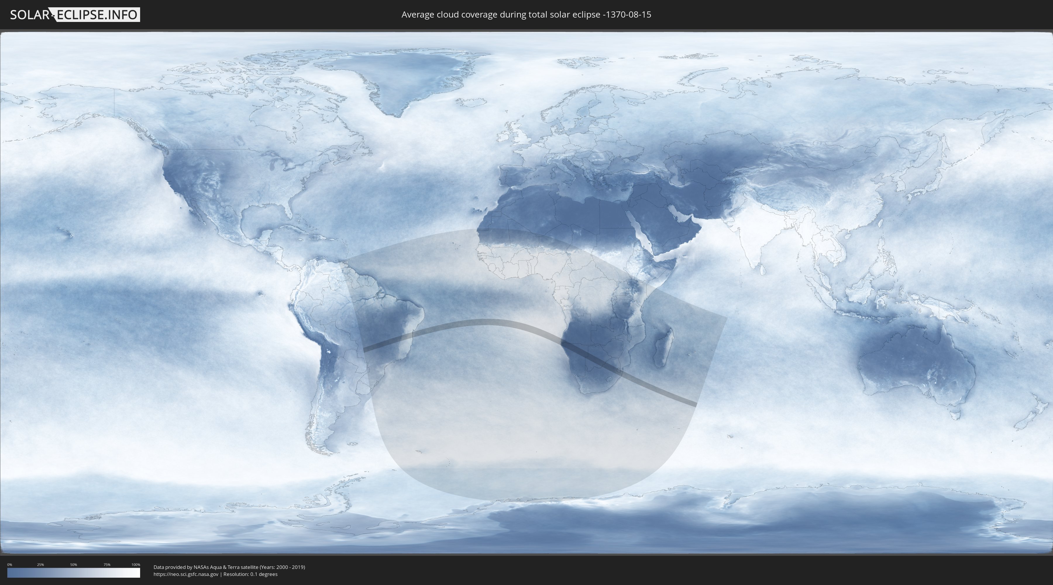
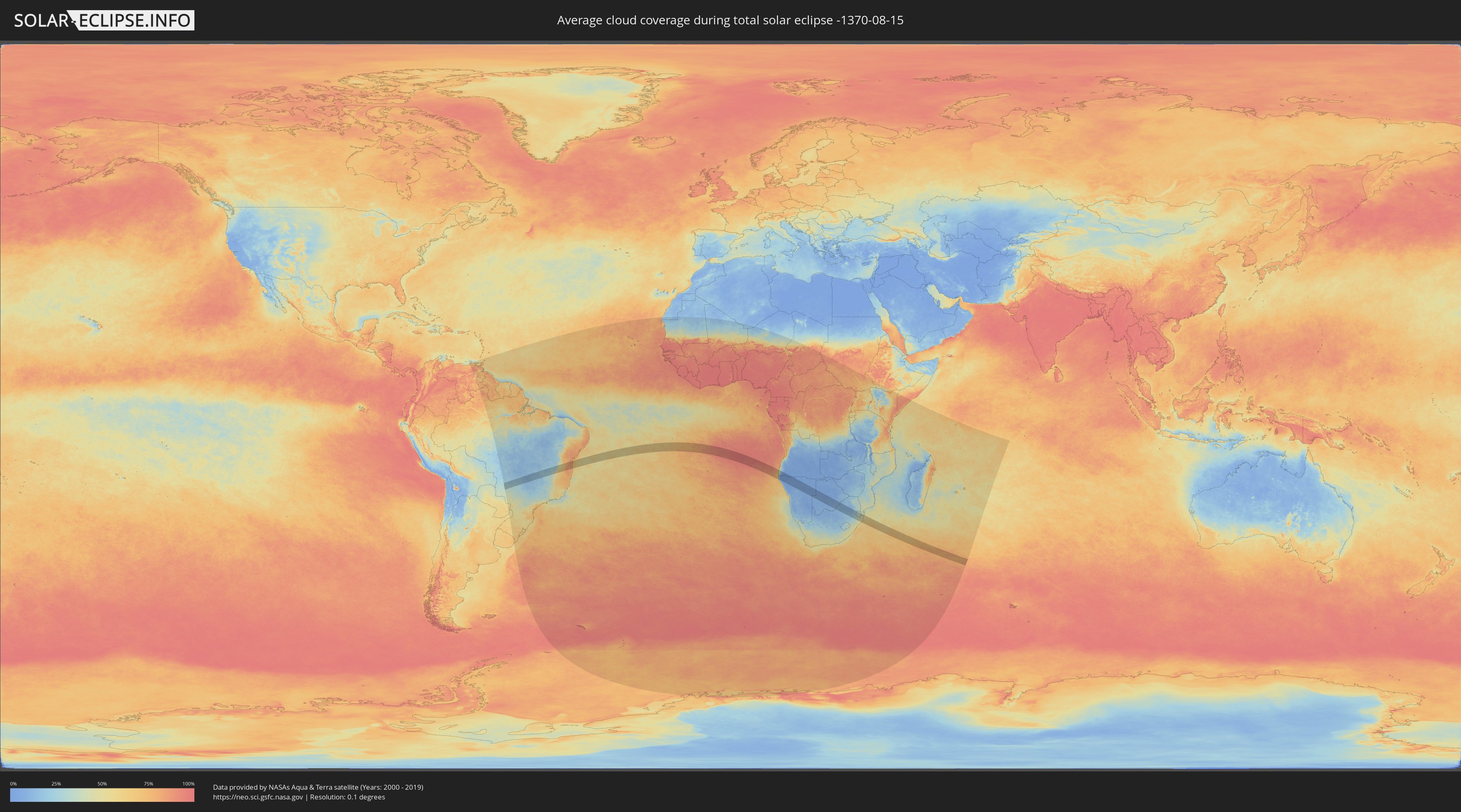
Wie wird das Wetter während der totalen Sonnenfinsternis am 15.08.-1370?
Wo ist der beste Ort, um die totale Sonnenfinsternis vom 15.08.-1370 zu beobachten?
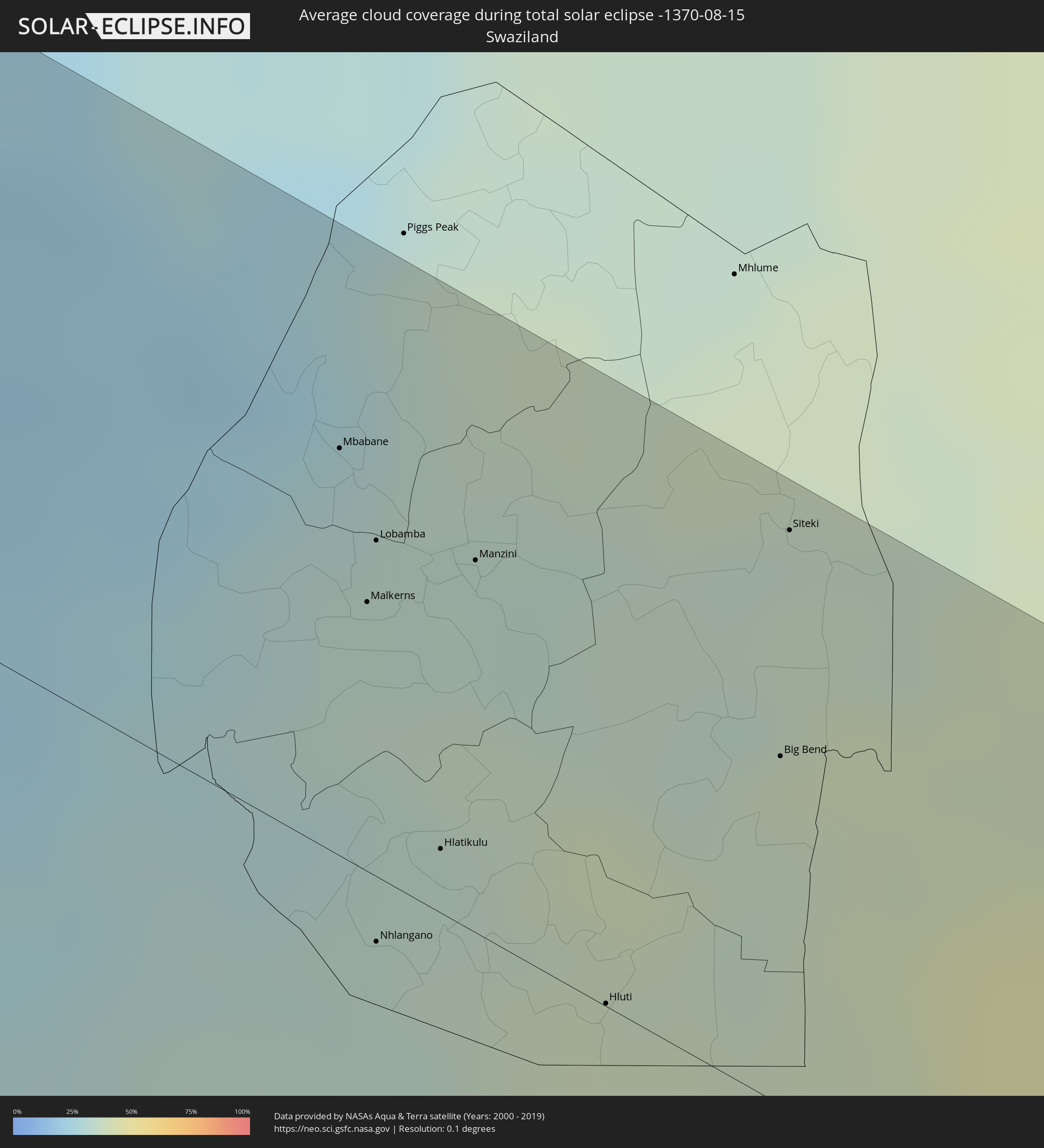
Die folgenden Karten zeigen die durchschnittliche Bewölkung für den Tag, an dem die totale Sonnenfinsternis
stattfindet. Mit Hilfe der Karten lässt sich der Ort entlang des Finsternispfades eingrenzen,
der die besten Aussichen auf einen klaren wolkenfreien Himmel bietet.
Trotzdem muss man immer lokale Gegenenheiten beachten und sollte sich genau über das Wetter an seinem
gewählten Beobachtungsort informieren.
Die Daten stammen von den beiden NASA-Satelliten
AQUA und TERRA
und wurden über einen Zeitraum von 19 Jahren (2000 - 2019) gemittelt.
Detaillierte Länderkarten
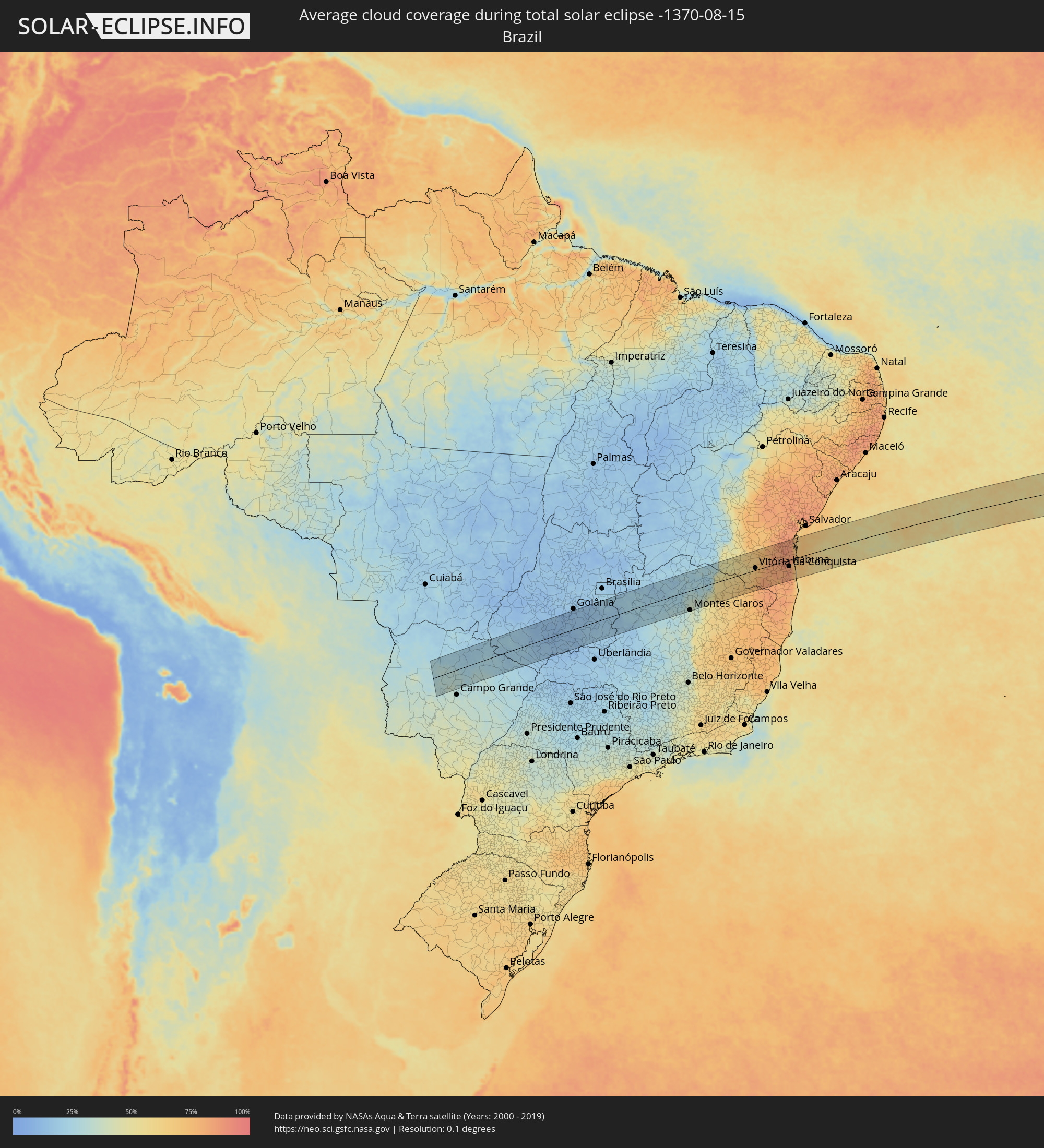 Brasilien
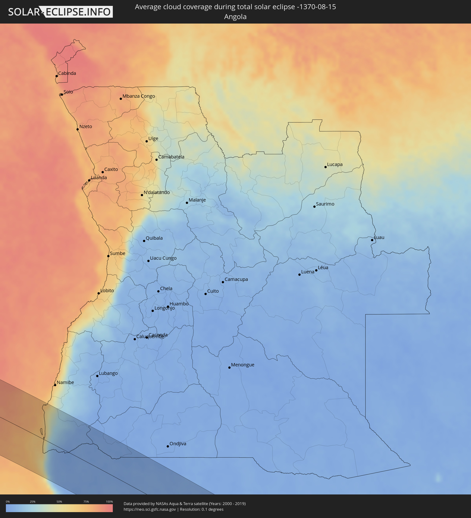 Angola
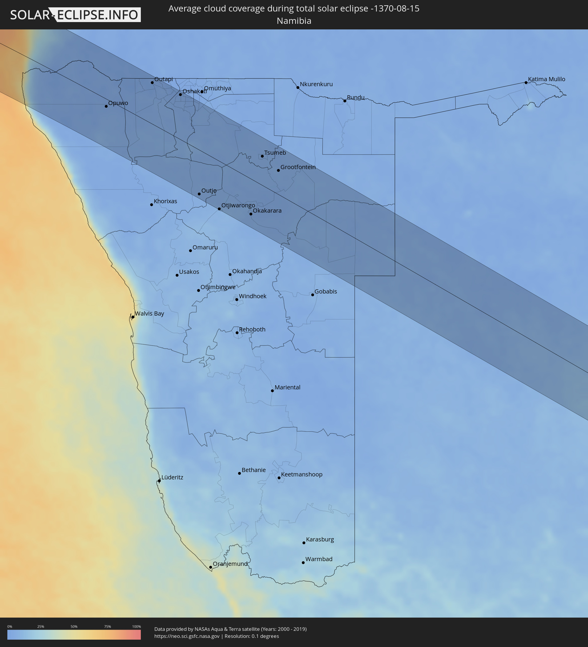 Namibia
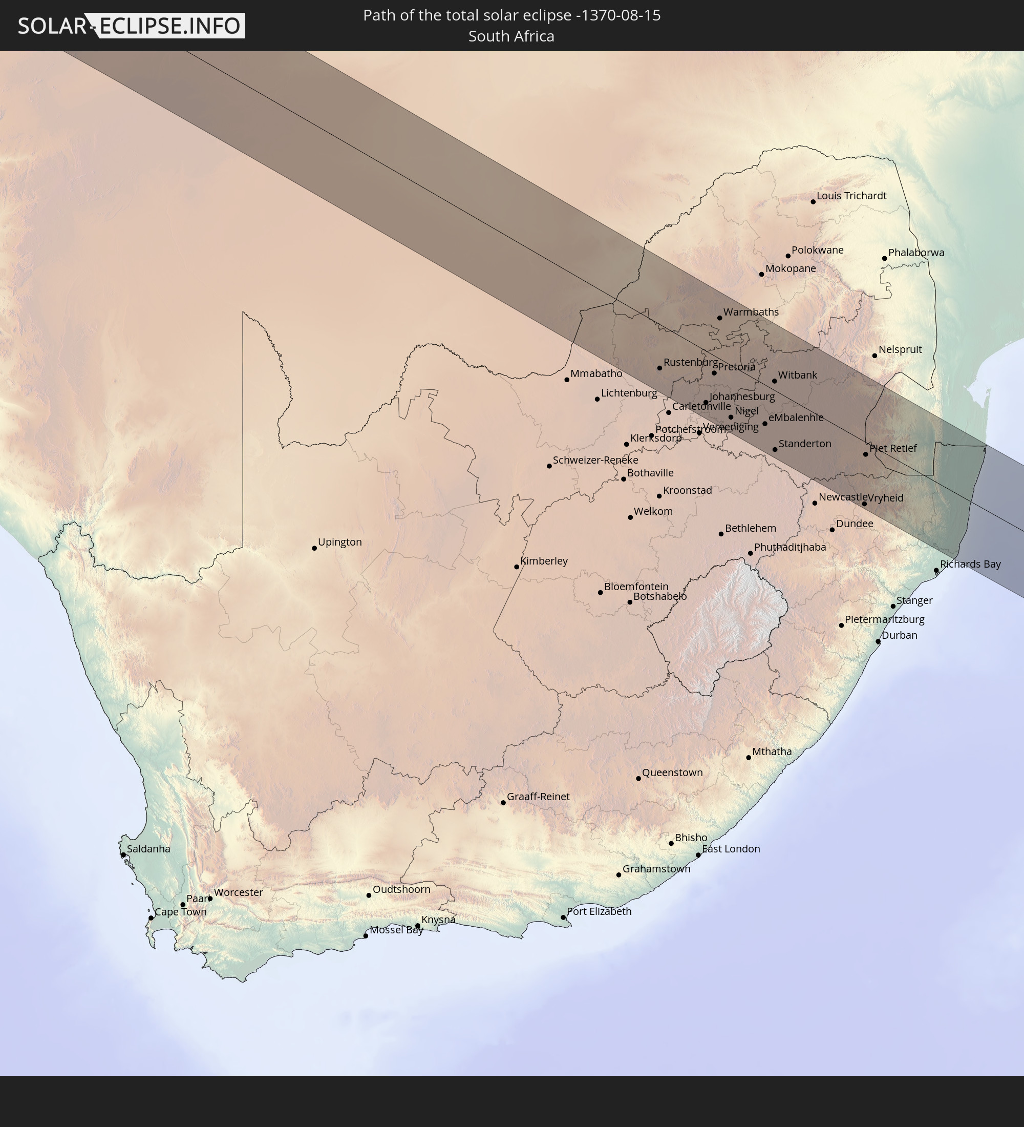
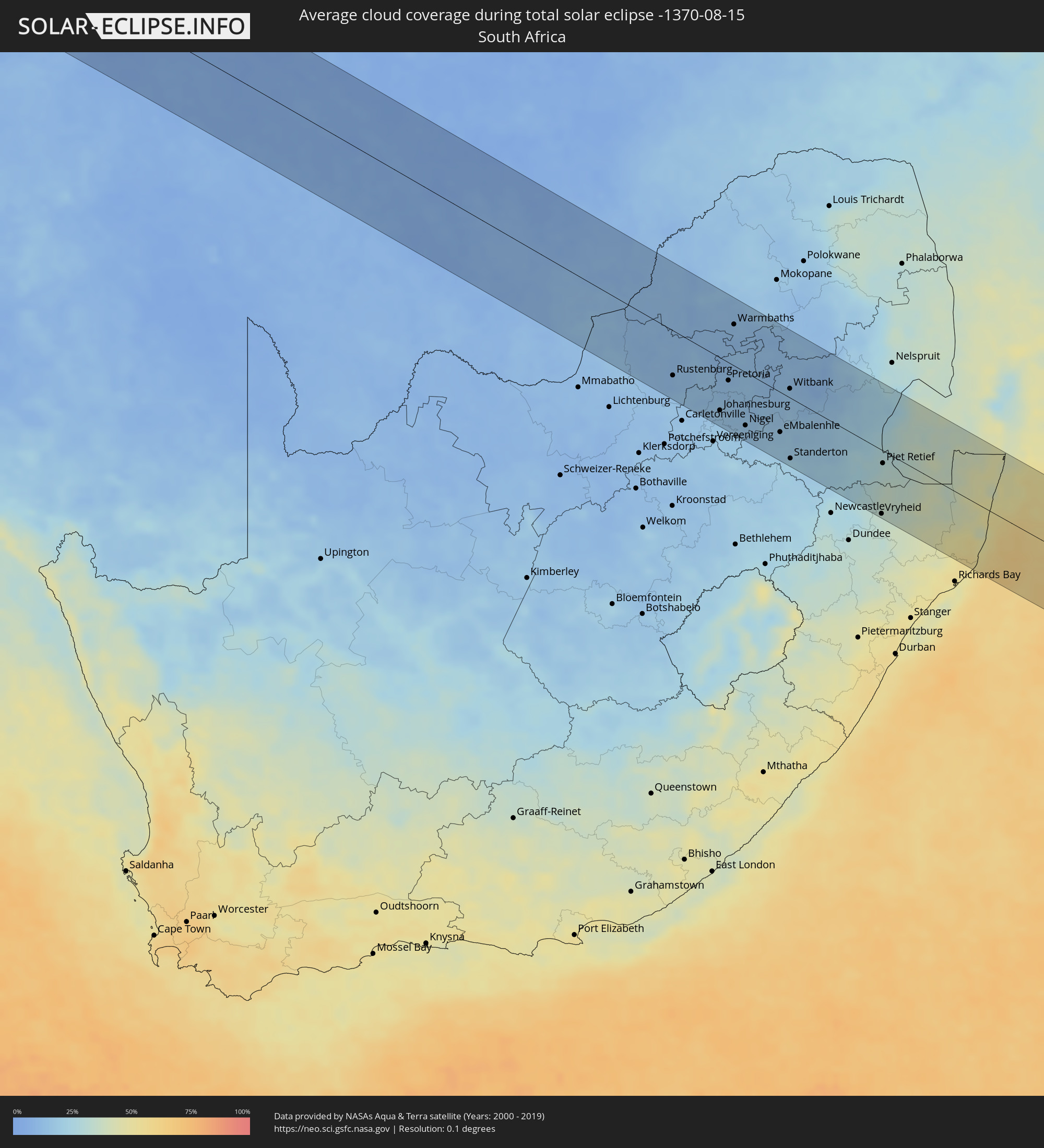 Südafrika
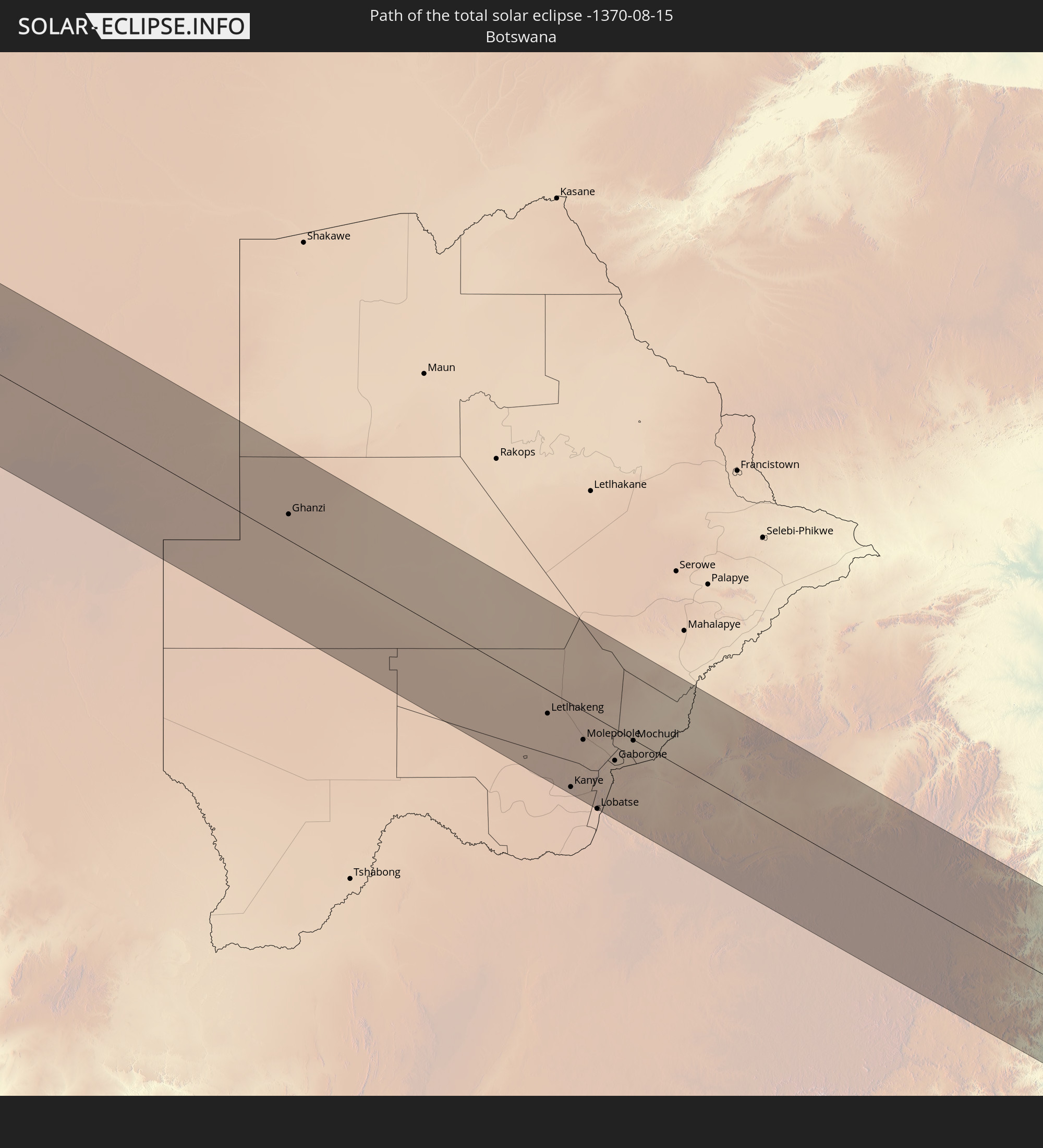
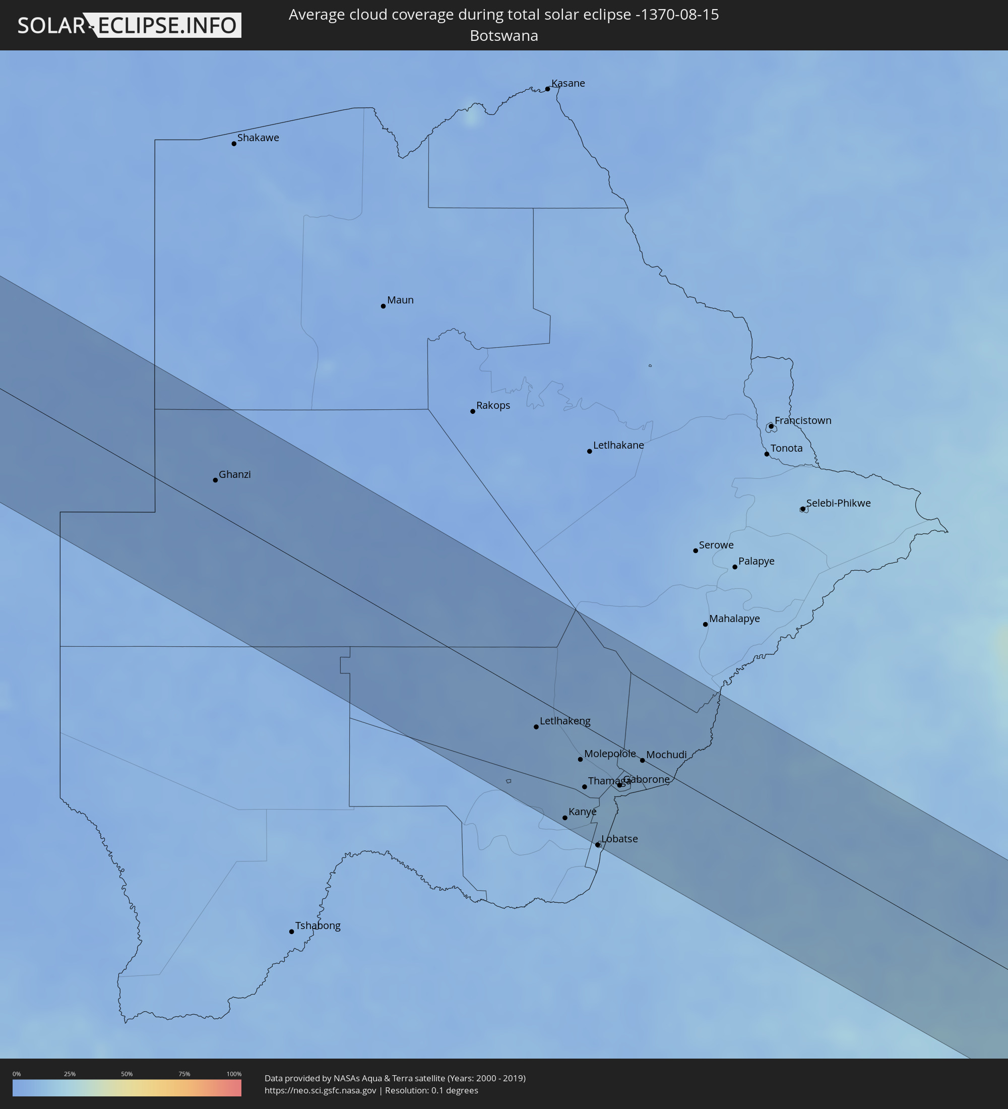 Botswana
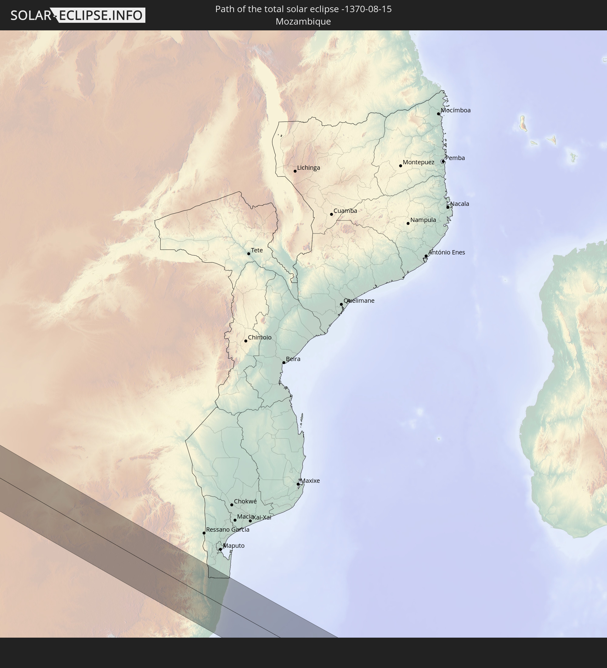
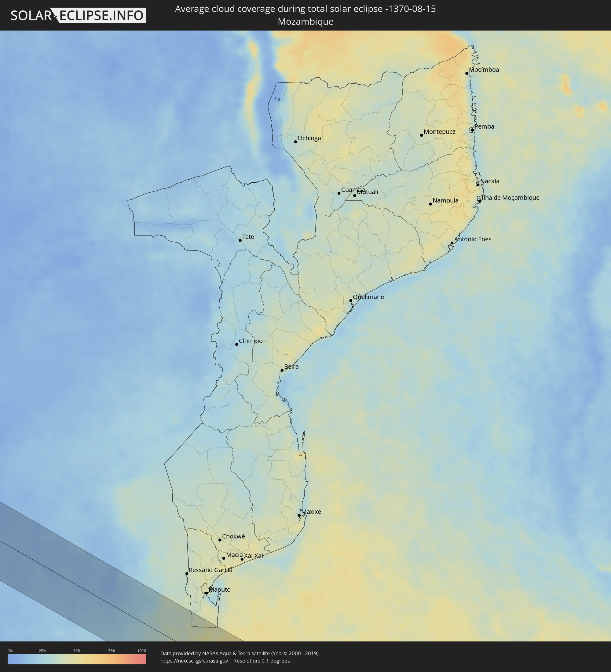 Mosambik
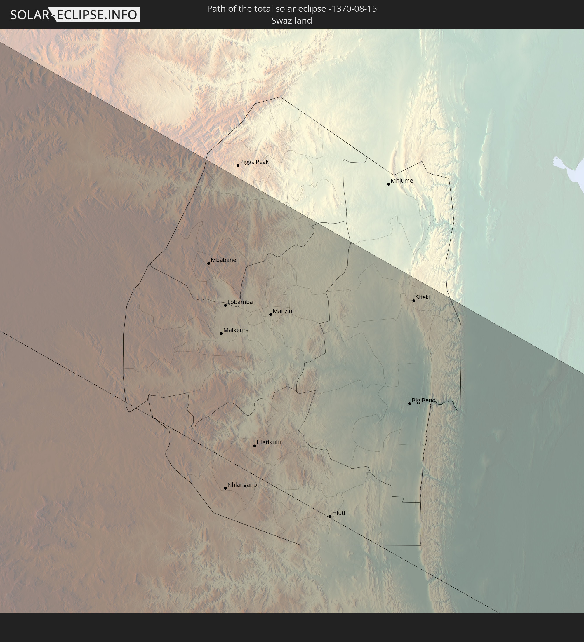
 Swasiland
Orte im Finsternispfad
Die nachfolgene Tabelle zeigt Städte und Orte mit mehr als 5.000 Einwohnern, die sich im Finsternispfad befinden. Städte mit mehr als 100.000 Einwohnern sind dick gekennzeichnet. Mit einem Klick auf den Ort öffnet sich eine Detailkarte die die Lage des jeweiligen Ortes zusammen mit dem Verlauf der zentralen Finsternis präsentiert.
| Ort | Typ | Dauer der Verfinsterung | Ortszeit bei maximaler Verfinsterung | Entfernung zur Zentrallinie | Ø Bewölkung |
|
Cassilândia, Mato Grosso do Sul
|
total | - | 06:35:32 UTC-03:38 | 75 km | 21% |
|
Jataí, Goiás
|
total | - | 07:06:41 UTC-03:06 | 54 km | 20% |
|
Santa Helena de Goiás, Goiás
|
total | - | 07:07:05 UTC-03:06 | 22 km | 13% |
|
Quirinópolis, Goiás
|
total | - | 07:07:35 UTC-03:06 | 50 km | 16% |
|
Goiatuba, Goiás
|
total | - | 07:07:47 UTC-03:06 | 41 km | 14% |
|
Aparecida de Goiânia, Goiás
|
total | - | 07:07:02 UTC-03:06 | 80 km | 14% |
|
Itumbiara, Goiás
|
total | - | 07:08:08 UTC-03:06 | 89 km | 11% |
|
Morrinhos, Goiás
|
total | - | 07:07:43 UTC-03:06 | 21 km | 15% |
|
Senador Canedo, Goiás
|
total | - | 07:07:02 UTC-03:06 | 87 km | 14% |
|
Piracanjuba, Goiás
|
total | - | 07:07:28 UTC-03:06 | 22 km | 15% |
|
Caldas Novas, Goiás
|
total | - | 07:07:57 UTC-03:06 | 38 km | 19% |
|
Pires do Rio, Goiás
|
total | - | 07:07:50 UTC-03:06 | 3 km | 17% |
|
Ipameri, Goiás
|
total | - | 07:08:11 UTC-03:06 | 52 km | 19% |
|
Cristalina, Goiás
|
total | - | 07:07:50 UTC-03:06 | 31 km | 16% |
|
Unaí, Minas Gerais
|
total | - | 07:07:58 UTC-03:06 | 50 km | 23% |
|
Paracatu, Minas Gerais
|
total | - | 07:08:33 UTC-03:06 | 42 km | 20% |
|
São Francisco, Minas Gerais
|
total | - | 07:08:58 UTC-03:06 | 25 km | 22% |
|
Januária, Minas Gerais
|
total | - | 07:09:01 UTC-03:06 | 57 km | 22% |
|
Montes Claros, Minas Gerais
|
total | - | 07:10:10 UTC-03:06 | 91 km | 36% |
|
Barreiro do Jaíba, Minas Gerais
|
total | - | 07:09:38 UTC-03:06 | 19 km | 25% |
|
Janaúba, Minas Gerais
|
total | - | 07:09:58 UTC-03:06 | 10 km | 30% |
|
Espinosa, Minas Gerais
|
total | - | 07:09:46 UTC-03:06 | 67 km | 28% |
|
Salinas, Minas Gerais
|
total | - | 07:10:59 UTC-03:06 | 82 km | 59% |
|
Taiobeiras, Minas Gerais
|
total | - | 07:10:47 UTC-03:06 | 46 km | 62% |
|
Vitória da Conquista, Bahia
|
total | - | 07:43:48 UTC-02:34 | 10 km | 72% |
|
Itambé, Bahia
|
total | - | 07:44:14 UTC-02:34 | 37 km | 79% |
|
Poções, Bahia
|
total | - | 07:44:00 UTC-02:34 | 31 km | 75% |
|
Itapetinga, Bahia
|
total | - | 07:44:34 UTC-02:34 | 49 km | 78% |
|
Jequié, Bahia
|
total | - | 07:43:51 UTC-02:34 | 94 km | 78% |
|
Itororó, Bahia
|
total | - | 07:44:38 UTC-02:34 | 41 km | 81% |
|
Ipiaú, Bahia
|
total | - | 07:44:19 UTC-02:34 | 54 km | 83% |
|
Ibicaraí, Bahia
|
total | - | 07:44:55 UTC-02:34 | 29 km | 80% |
|
Coaraci, Bahia
|
total | - | 07:44:48 UTC-02:34 | 6 km | 87% |
|
Gandu, Bahia
|
total | - | 07:44:19 UTC-02:34 | 87 km | 86% |
|
Ubaitaba, Bahia
|
total | - | 07:44:49 UTC-02:34 | 22 km | 85% |
|
Uruçuca, Bahia
|
total | - | 07:45:02 UTC-02:34 | 9 km | 84% |
|
Itabuna, Bahia
|
total | - | 07:45:09 UTC-02:34 | 30 km | 84% |
|
Ituberá, Bahia
|
total | - | 07:44:38 UTC-02:34 | 78 km | 73% |
|
Una, Bahia
|
total | - | 07:45:40 UTC-02:34 | 91 km | 77% |
|
Ilhéus, Bahia
|
total | - | 07:45:23 UTC-02:34 | 38 km | 65% |
|
Opuwo, Kunene
|
total | - | 13:52:56 UTC+01:30 | 18 km | 4% |
|
Outapi, Omusati
|
total | - | 13:55:17 UTC+01:30 | 95 km | 2% |
|
Oshakati, Oshana
|
total | - | 13:57:01 UTC+01:30 | 103 km | 3% |
|
Ongwediva, Oshana
|
total | - | 13:57:12 UTC+01:30 | 107 km | 2% |
|
Ondangwa, Oshana
|
total | - | 13:57:41 UTC+01:30 | 103 km | 3% |
|
Outjo, Kunene
|
total | - | 13:59:10 UTC+01:30 | 101 km | 5% |
|
Otjiwarongo, Otjozondjupa
|
total | - | 14:00:23 UTC+01:30 | 109 km | 8% |
|
Okakarara, Otjozondjupa
|
total | - | 14:02:06 UTC+01:30 | 80 km | 5% |
|
Tsumeb, Oshikoto
|
total | - | 14:02:08 UTC+01:30 | 66 km | 5% |
|
Grootfontein, Otjozondjupa
|
total | - | 14:03:07 UTC+01:30 | 54 km | 6% |
|
Ghanzi, Ghanzi
|
total | - | 14:51:05 UTC+02:10 | 30 km | 5% |
|
Letlhakeng, Kweneng
|
total | - | 14:57:24 UTC+02:10 | 27 km | 9% |
|
Kanye, Ngwaketsi
|
total | - | 14:57:59 UTC+02:10 | 96 km | 11% |
|
Mosopa, Ngwaketsi
|
total | - | 14:58:06 UTC+02:10 | 72 km | 13% |
|
Molepolole, Kweneng
|
total | - | 14:58:11 UTC+02:10 | 33 km | 13% |
|
Thamaga, Kweneng
|
total | - | 14:58:17 UTC+02:10 | 56 km | 12% |
|
Lobatse, South-East
|
total | - | 14:58:32 UTC+02:10 | 103 km | 12% |
|
Otse, South-East
|
total | - | 14:58:37 UTC+02:10 | 80 km | 13% |
|
Gabane, Kweneng
|
total | - | 14:58:40 UTC+02:10 | 44 km | 15% |
|
Metsemotlhaba, Kweneng
|
total | - | 14:58:41 UTC+02:10 | 32 km | 13% |
|
Mogoditshane, Kweneng
|
total | - | 14:58:47 UTC+02:10 | 36 km | 13% |
|
Ramotswa, South-East
|
total | - | 14:58:49 UTC+02:10 | 59 km | 13% |
|
Kopong, South-East
|
total | - | 14:58:48 UTC+02:10 | 21 km | 10% |
|
Gaborone, South-East
|
total | - | 14:58:51 UTC+02:10 | 36 km | 14% |
|
Mochudi, Kgatleng
|
total | - | 14:59:13 UTC+02:10 | 1 km | 11% |
|
Rustenburg, North-West
|
total | - | 14:20:36 UTC+01:30 | 67 km | 11% |
|
Randfontein, Gauteng
|
total | - | 14:21:17 UTC+01:30 | 93 km | 15% |
|
Krugersdorp, Gauteng
|
total | - | 14:21:23 UTC+01:30 | 80 km | 15% |
|
Brits, North-West
|
total | - | 14:21:23 UTC+01:30 | 36 km | 14% |
|
Soweto, Gauteng
|
total | - | 14:21:30 UTC+01:30 | 93 km | 16% |
|
Roodepoort, Gauteng
|
total | - | 14:21:32 UTC+01:30 | 83 km | 15% |
|
Ga-Rankuwa, North-West
|
total | - | 14:21:42 UTC+01:30 | 24 km | 12% |
|
Diepsloot, Gauteng
|
total | - | 14:21:44 UTC+01:30 | 53 km | 14% |
|
Johannesburg, Gauteng
|
total | - | 14:21:46 UTC+01:30 | 78 km | 17% |
|
Mabopane, Gauteng
|
total | - | 14:21:51 UTC+01:30 | 7 km | 11% |
|
Midrand, Gauteng
|
total | - | 14:21:54 UTC+01:30 | 53 km | 15% |
|
Centurion, Gauteng
|
total | - | 14:21:59 UTC+01:30 | 38 km | 14% |
|
Pretoria, Gauteng
|
total | - | 14:21:59 UTC+01:30 | 27 km | 13% |
|
Midstream, Gauteng
|
total | - | 14:22:00 UTC+01:30 | 43 km | 14% |
|
Tembisa, Gauteng
|
total | - | 14:22:02 UTC+01:30 | 49 km | 14% |
|
Warmbaths, Limpopo
|
total | - | 14:22:06 UTC+01:30 | 61 km | 12% |
|
Benoni, Gauteng
|
total | - | 14:22:10 UTC+01:30 | 63 km | 14% |
|
Heidelberg, Gauteng
|
total | - | 14:22:13 UTC+01:30 | 91 km | 16% |
|
Brakpan, Gauteng
|
total | - | 14:22:14 UTC+01:30 | 65 km | 14% |
|
Modimolle, Limpopo
|
total | - | 14:22:15 UTC+01:30 | 85 km | 12% |
|
Springs, Gauteng
|
total | - | 14:22:17 UTC+01:30 | 65 km | 15% |
|
Nigel, Gauteng
|
total | - | 14:22:23 UTC+01:30 | 78 km | 15% |
|
Cullinan, Gauteng
|
total | - | 14:22:27 UTC+01:30 | 3 km | 15% |
|
Balfour, Mpumalanga
|
total | - | 14:22:32 UTC+01:30 | 95 km | 17% |
|
Delmas, Mpumalanga
|
total | - | 14:22:41 UTC+01:30 | 41 km | 14% |
|
Bronkhorstspruit, Gauteng
|
total | - | 14:22:46 UTC+01:30 | 5 km | 13% |
|
Ekangala, Gauteng
|
total | - | 14:22:46 UTC+01:30 | 6 km | 12% |
|
Siyabuswa, Mpumalanga
|
total | - | 14:23:11 UTC+01:30 | 77 km | 11% |
|
eMbalenhle, Mpumalanga
|
total | - | 14:23:12 UTC+01:30 | 59 km | 17% |
|
Secunda, Mpumalanga
|
total | - | 14:23:20 UTC+01:30 | 56 km | 18% |
|
Witbank, Mpumalanga
|
total | - | 14:23:27 UTC+01:30 | 13 km | 14% |
|
Standerton, Mpumalanga
|
total | - | 14:23:25 UTC+01:30 | 89 km | 22% |
|
Middelburg, Mpumalanga
|
total | - | 14:23:46 UTC+01:30 | 34 km | 12% |
|
Bethal, Mpumalanga
|
total | - | 14:23:45 UTC+01:30 | 32 km | 16% |
|
Hendrina, Mpumalanga
|
total | - | 14:24:06 UTC+01:30 | 9 km | 15% |
|
Volksrust, Mpumalanga
|
total | - | 14:24:15 UTC+01:30 | 99 km | 25% |
|
Ermelo, Mpumalanga
|
total | - | 14:24:26 UTC+01:30 | 14 km | 19% |
|
Driefontein, Mpumalanga
|
total | - | 14:25:01 UTC+01:30 | 37 km | 24% |
|
Vryheid, KwaZulu-Natal
|
total | - | 14:25:23 UTC+01:30 | 93 km | 34% |
|
Piet Retief, Mpumalanga
|
total | - | 14:25:30 UTC+01:30 | 19 km | 30% |
|
Mbabane, Hhohho
|
total | - | 14:25:57 UTC+01:30 | 64 km | 29% |
|
Malkerns, Manzini
|
total | - | 14:26:00 UTC+01:30 | 42 km | 34% |
|
Nhlangano, Shiselweni
|
total | - | 14:25:59 UTC+01:30 | 10 km | 33% |
|
Lobamba, Hhohho
|
total | - | 14:26:02 UTC+01:30 | 53 km | 33% |
|
Hlatikulu, Shiselweni
|
total | - | 14:26:08 UTC+01:30 | 10 km | 34% |
|
Manzini, Manzini
|
total | - | 14:26:15 UTC+01:30 | 58 km | 34% |
|
Hluti, Shiselweni
|
total | - | 14:26:29 UTC+01:30 | 1 km | 39% |
|
Big Bend, Lubombo
|
total | - | 14:26:55 UTC+01:30 | 55 km | 36% |
|
Siteki, Lubombo
|
total | - | 14:26:58 UTC+01:30 | 91 km | 37% |