Totale Sonnenfinsternis vom 12.05.-1383
| Wochentag: | Samstag |
| Maximale Dauer der Verfinsterung: | 01m22s |
| Maximale Breite des Finsternispfades: | 72 km |
| Saroszyklus: | 35 |
| Bedeckungsgrad: | 100% |
| Magnitude: | 1.0173 |
| Gamma: | 0.5768 |
Wo kann man die Sonnenfinsternis vom 12.05.-1383 sehen?
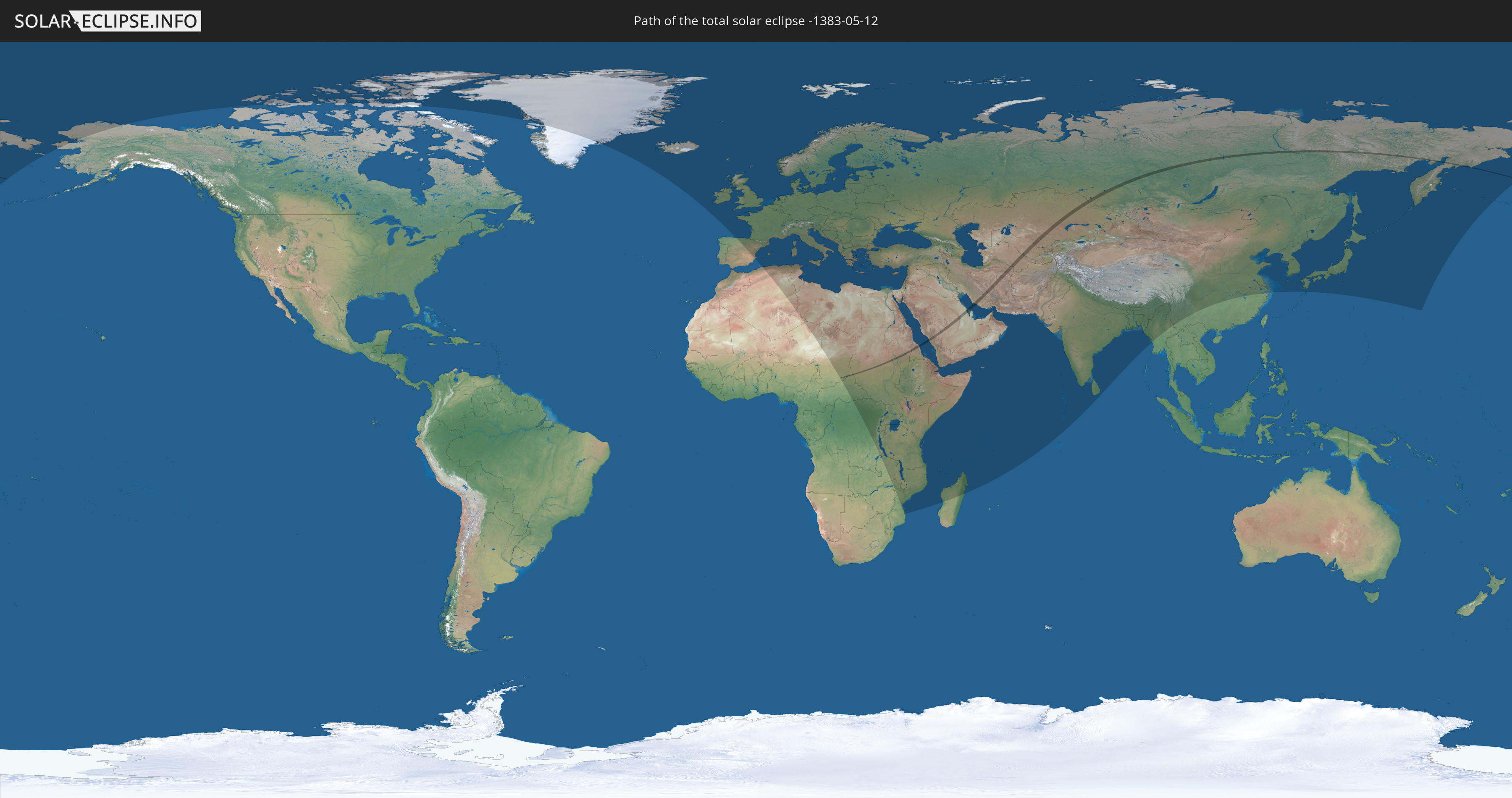
Die Sonnenfinsternis am 12.05.-1383 kann man in 117 Ländern als partielle Sonnenfinsternis beobachten.
Der Finsternispfad verläuft durch 11 Länder. Nur in diesen Ländern ist sie als totale Sonnenfinsternis zu sehen.
In den folgenden Ländern ist die Sonnenfinsternis total zu sehen
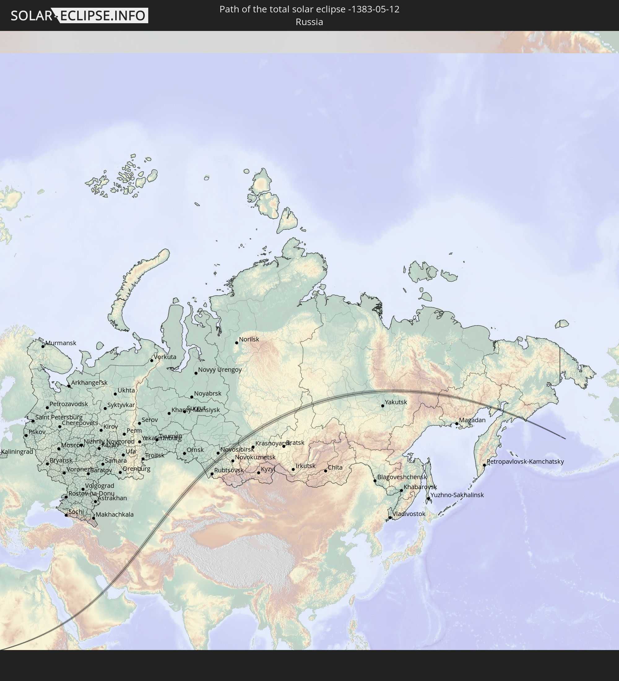 Russland
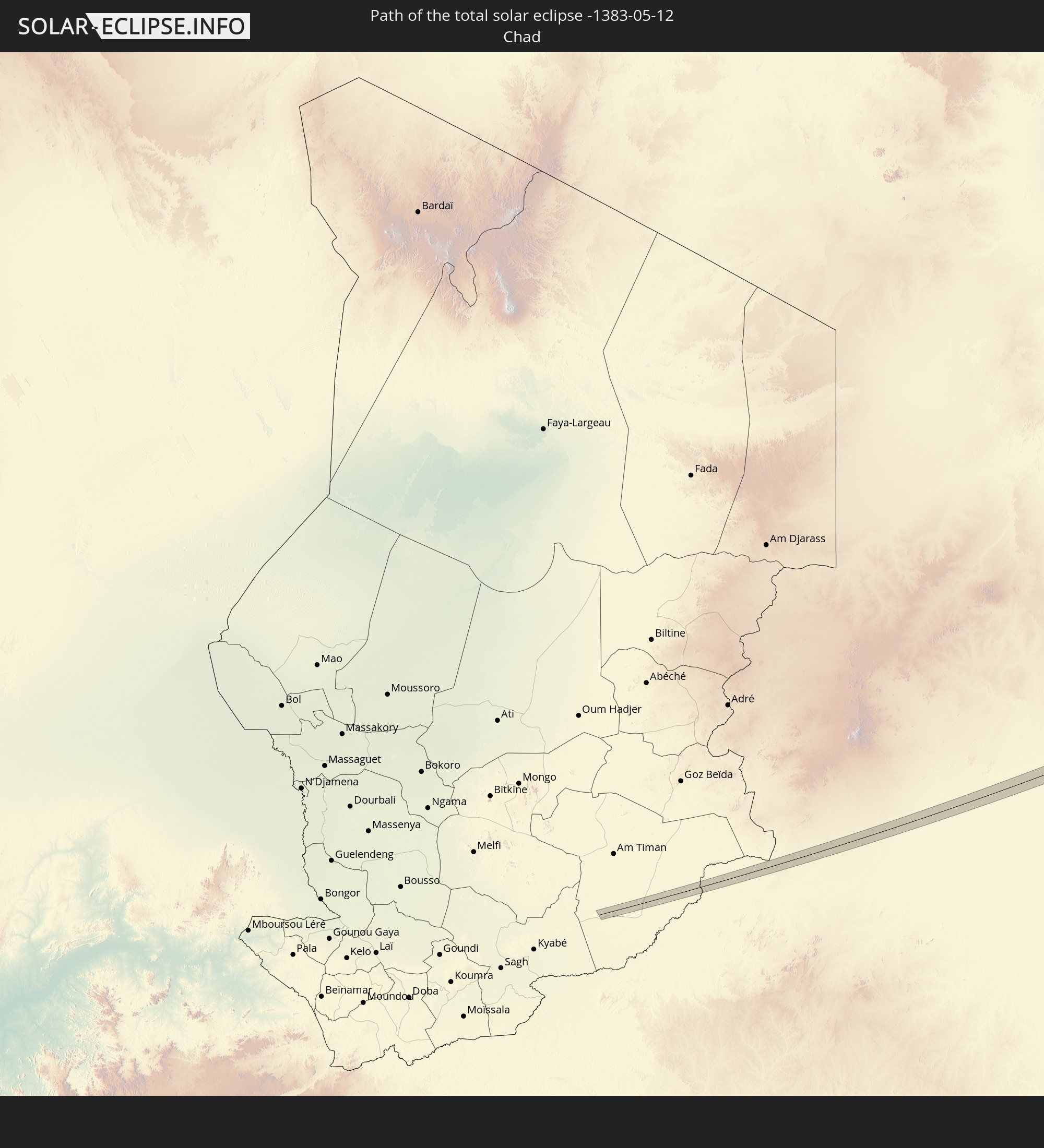 Tschad
 Zentralafrikanische Republik
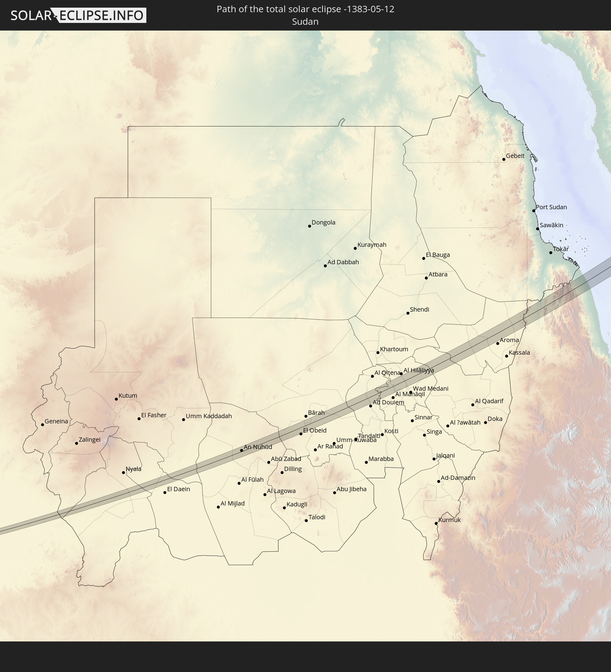 Sudan
Sudan
 Saudi-Arabien
 Eritrea
 Iran
Iran
 Kasachstan
 Bahrain
 Turkmenistan
 Usbekistan
In den folgenden Ländern ist die Sonnenfinsternis partiell zu sehen
 Russland
 Vereinigte Staaten
 Kanada
 Grönland
 Island
 Spanien
 Irland
 Spitzbergen
 Algerien
 Vereinigtes Königreich
 Färöer
 Frankreich
 Isle of Man
 Guernsey
 Jersey
 Niger
Niger
 Andorra
 Belgien
 Niederlande
 Norwegen
 Luxemburg
 Deutschland
 Schweiz
 Italien
 Monaco
 Tunesien
 Dänemark
 Libyen
 Liechtenstein
 Österreich
 Schweden
 Tschechien
 Demokratische Republik Kongo
 San Marino
 Vatikanstadt
 Slowenien
 Tschad
 Kroatien
 Polen
Polen
 Malta
Malta
 Zentralafrikanische Republik
 Bosnien und Herzegowina
 Ungarn
 Slowakei
 Montenegro
 Serbien
 Albanien
 Åland Islands
 Griechenland
 Rumänien
 Mazedonien
 Finnland
 Litauen
 Lettland
 Estland
 Sudan
Sudan
 Sambia
 Ukraine
 Bulgarien
 Weißrussland
 Ägypten
 Türkei
 Moldawien
 Ruanda
 Burundi
 Tansania
 Uganda
 Mosambik
 Republik Zypern
 Malawi
 Äthiopien
 Kenia
Kenia
 Staat Palästina
 Israel
 Saudi-Arabien
 Jordanien
 Libanon
 Syrien
 Eritrea
 Irak
Irak
 Georgien
 Französische Süd- und Antarktisgebiete
 Somalia
 Dschibuti
 Jemen
Jemen
 Madagaskar
 Komoren
 Armenien
 Iran
Iran
 Aserbaidschan
 Mayotte
 Seychellen
 Kasachstan
 Kuwait
 Bahrain
 Katar
Katar
 Vereinigte Arabische Emirate
 Oman
Oman
 Turkmenistan
 Usbekistan
 Mauritius
 Afghanistan
 Pakistan
 Tadschikistan
 Indien
 Kirgisistan
 Malediven
 Volksrepublik China
 Sri Lanka
 Nepal
Nepal
 Mongolei
 Bangladesch
 Bhutan
 Myanmar
 Japan
Japan
 Nordkorea
 Südkorea
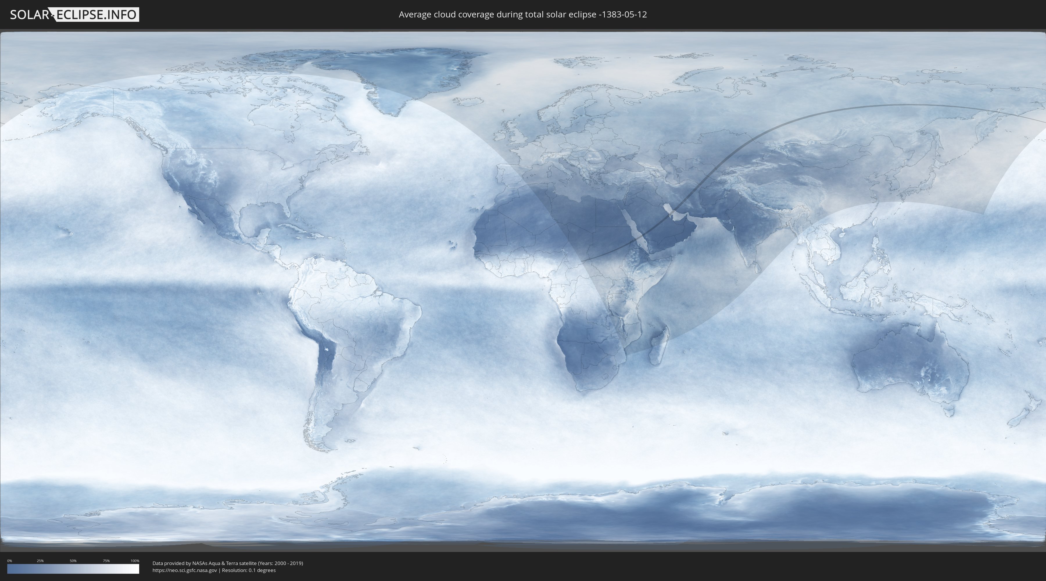
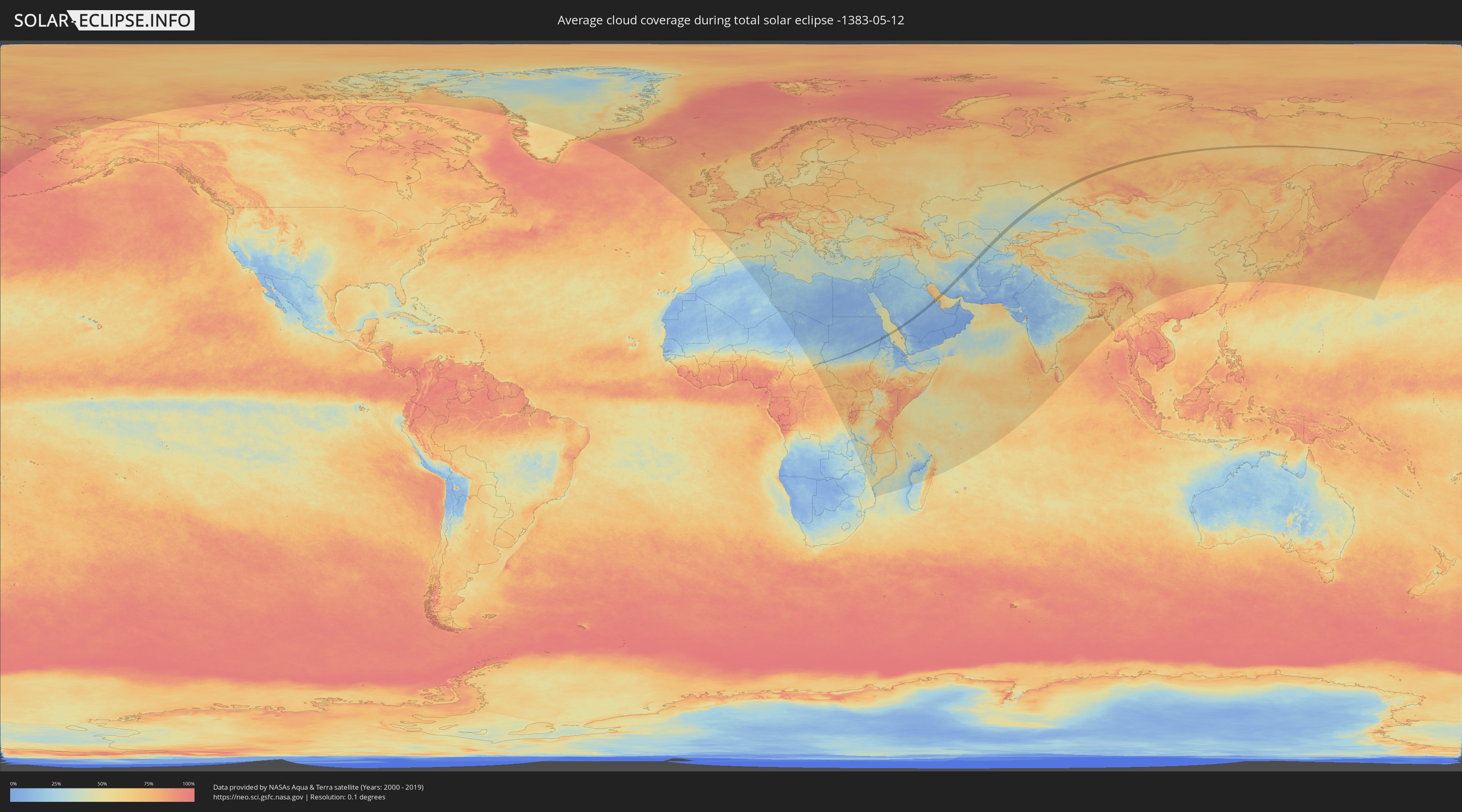
Wie wird das Wetter während der totalen Sonnenfinsternis am 12.05.-1383?
Wo ist der beste Ort, um die totale Sonnenfinsternis vom 12.05.-1383 zu beobachten?
Die folgenden Karten zeigen die durchschnittliche Bewölkung für den Tag, an dem die totale Sonnenfinsternis
stattfindet. Mit Hilfe der Karten lässt sich der Ort entlang des Finsternispfades eingrenzen,
der die besten Aussichen auf einen klaren wolkenfreien Himmel bietet.
Trotzdem muss man immer lokale Gegenenheiten beachten und sollte sich genau über das Wetter an seinem
gewählten Beobachtungsort informieren.
Die Daten stammen von den beiden NASA-Satelliten
AQUA und TERRA
und wurden über einen Zeitraum von 19 Jahren (2000 - 2019) gemittelt.
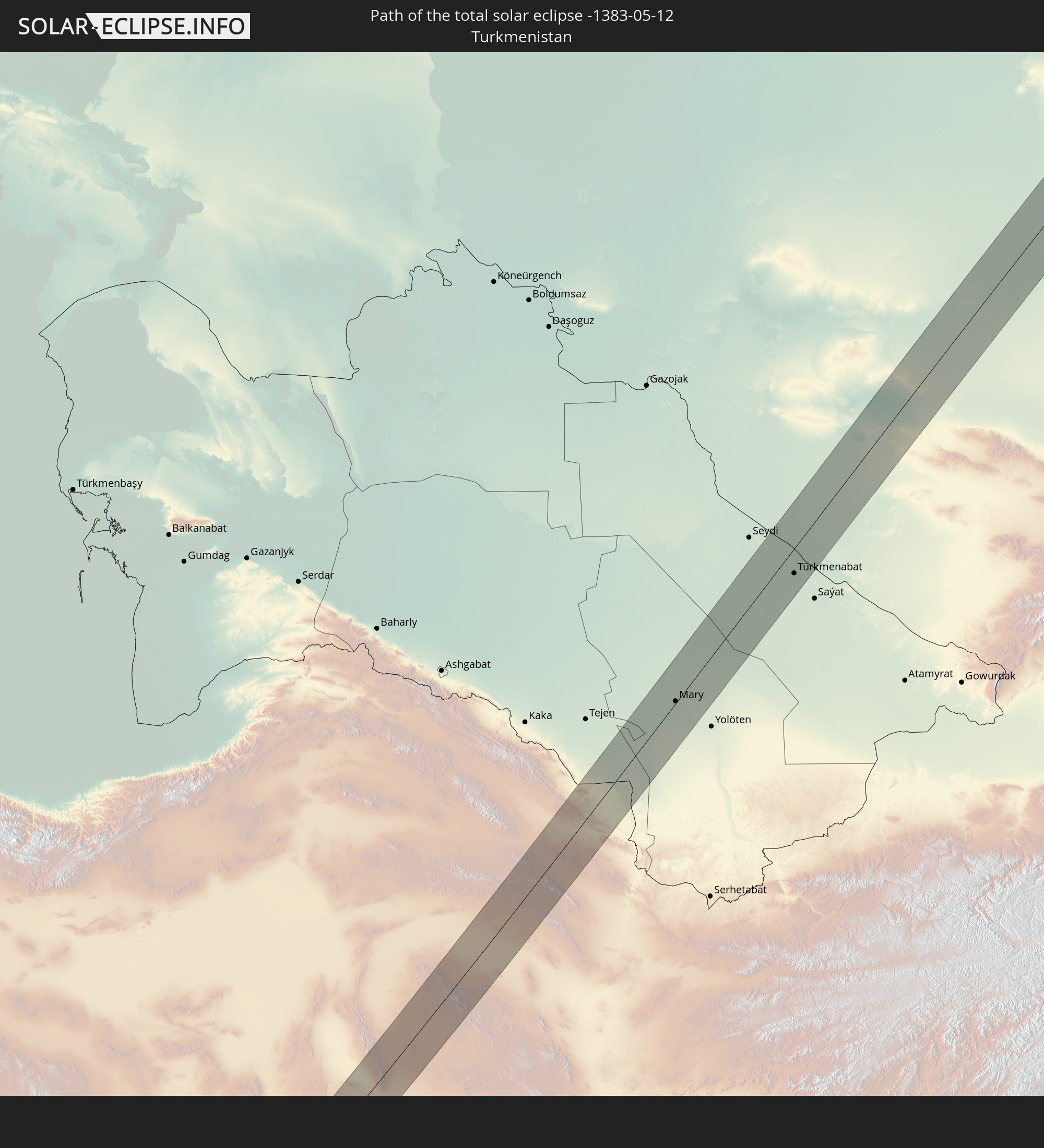
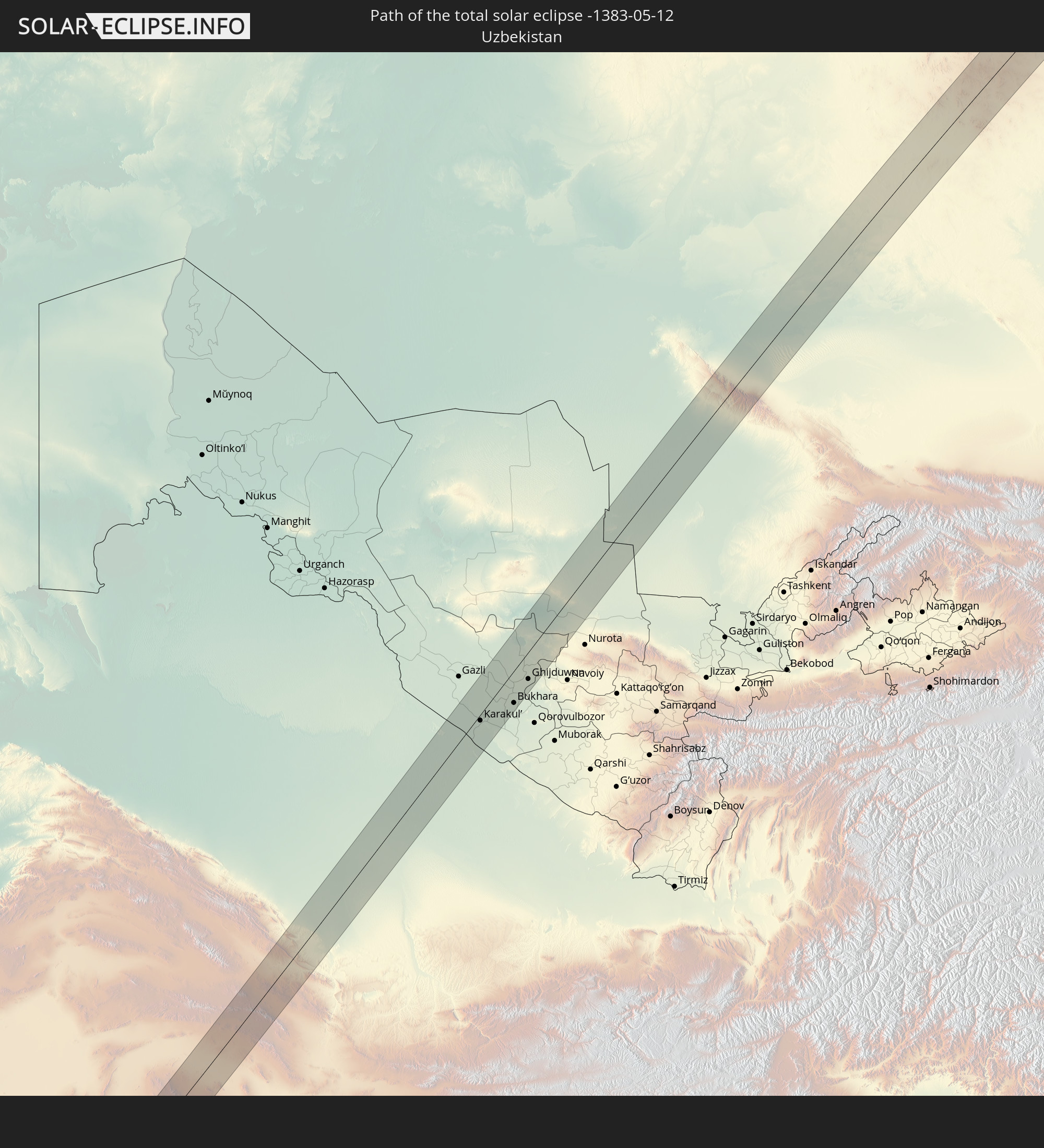
Detaillierte Länderkarten
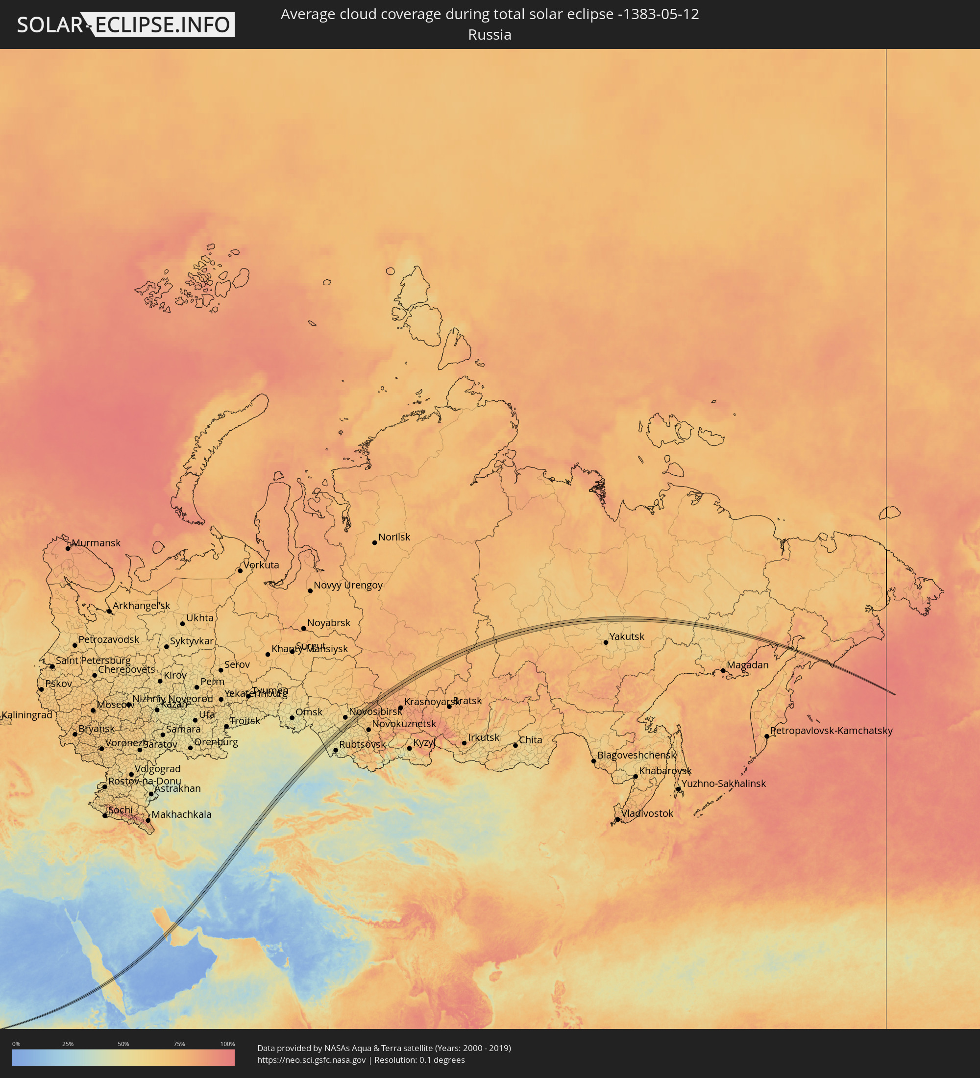 Russland
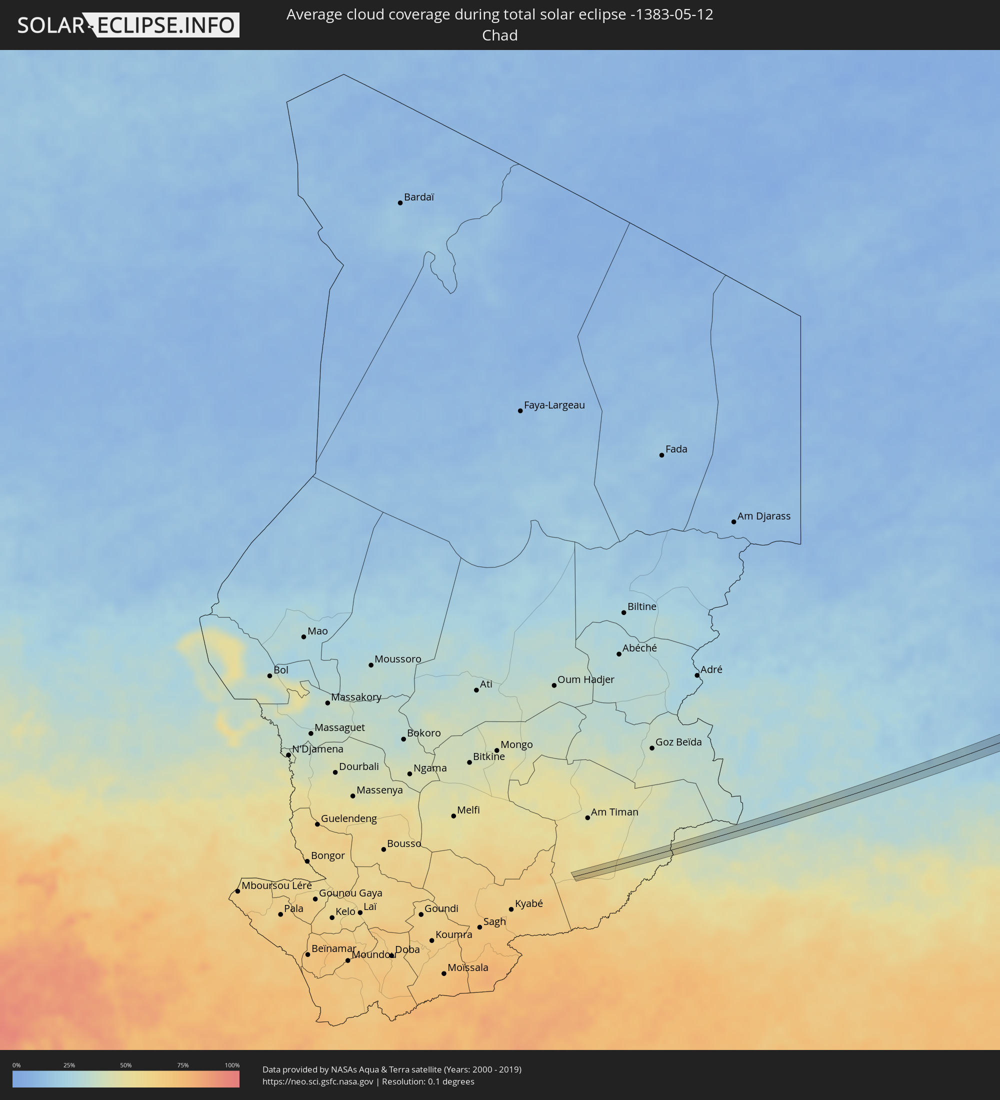 Tschad
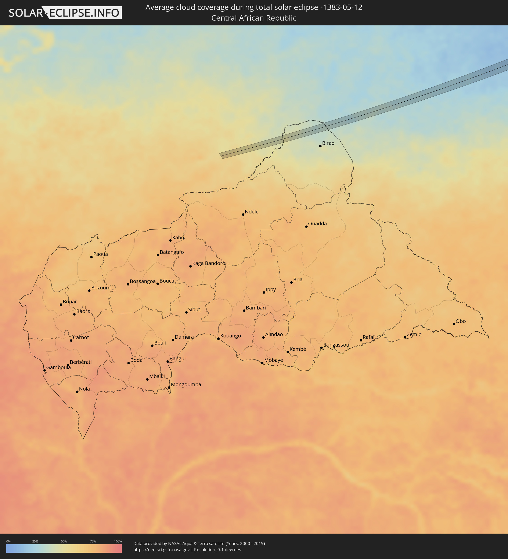 Zentralafrikanische Republik
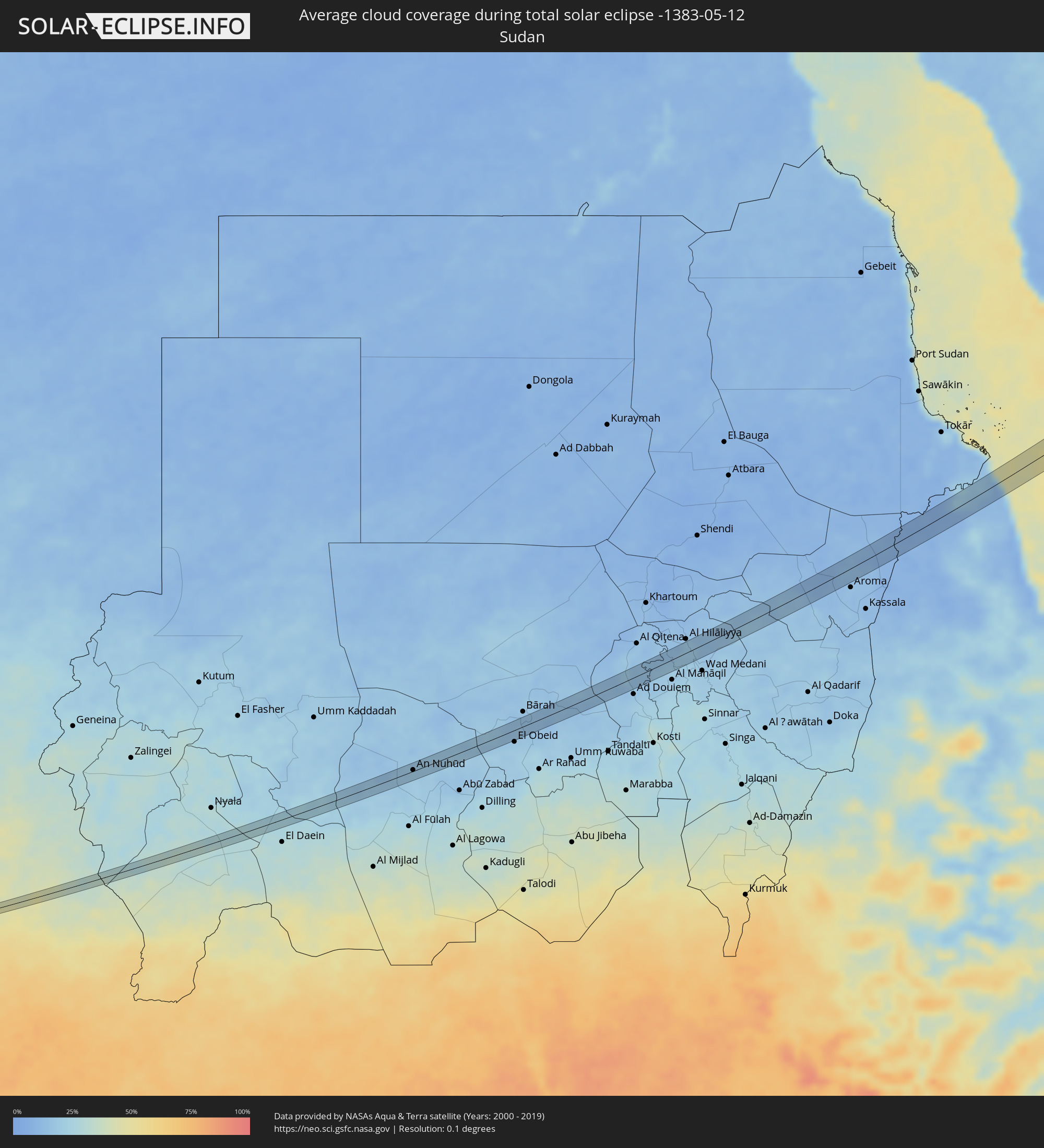 Sudan
Sudan
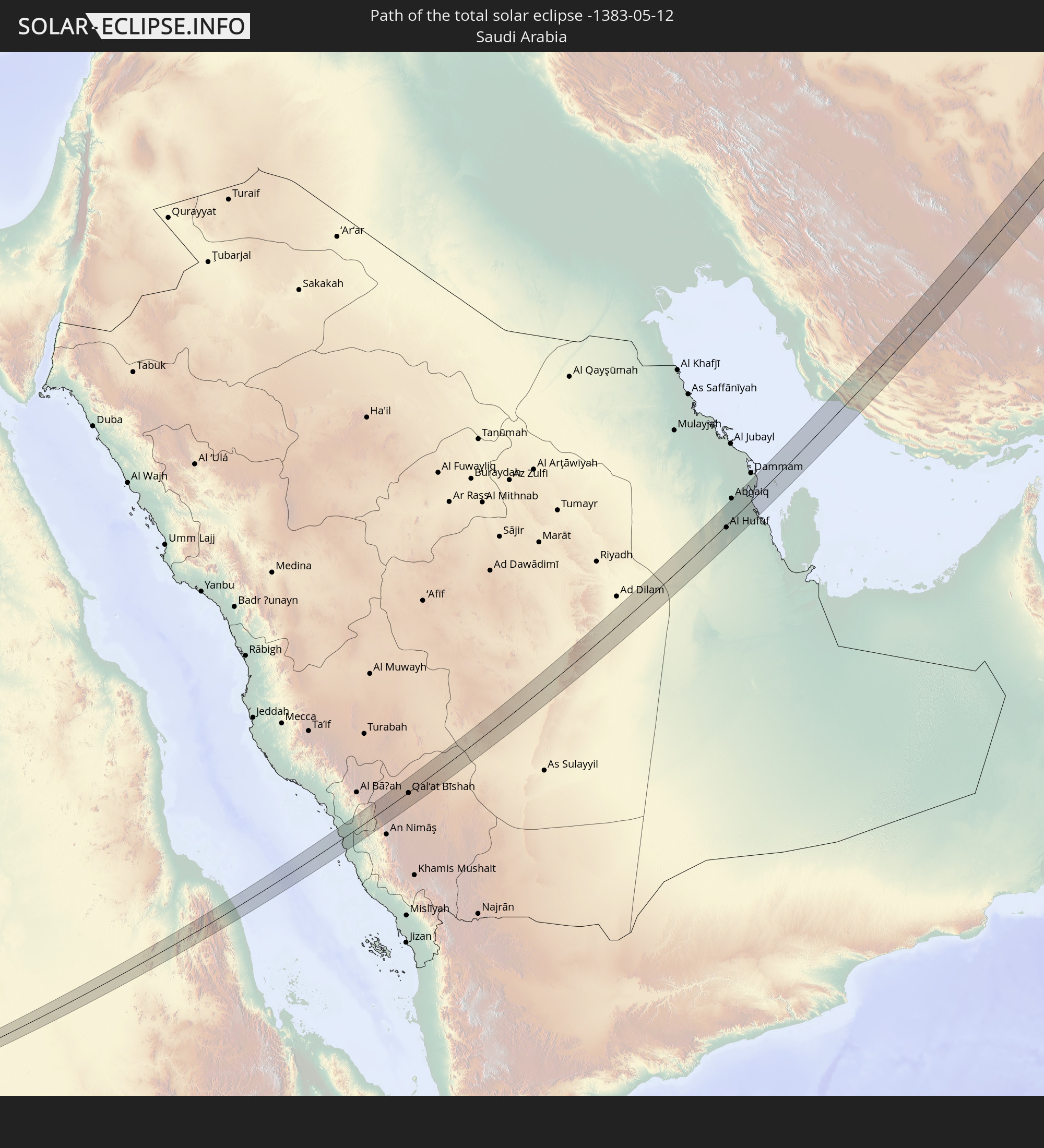
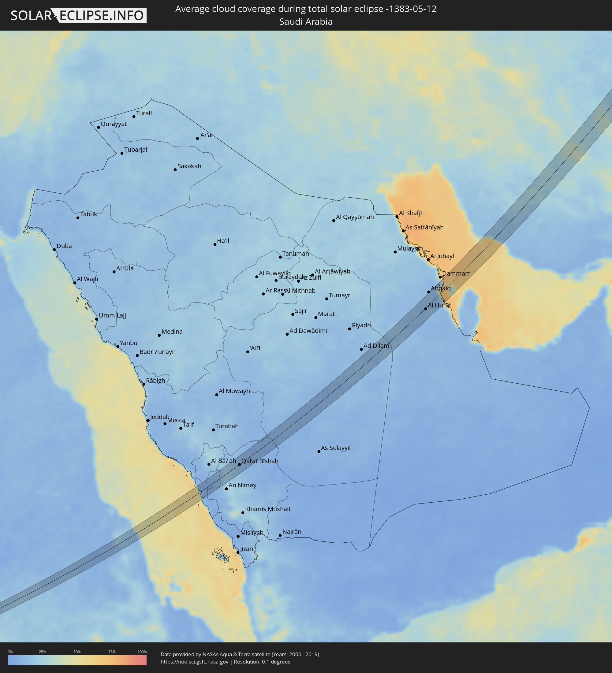 Saudi-Arabien
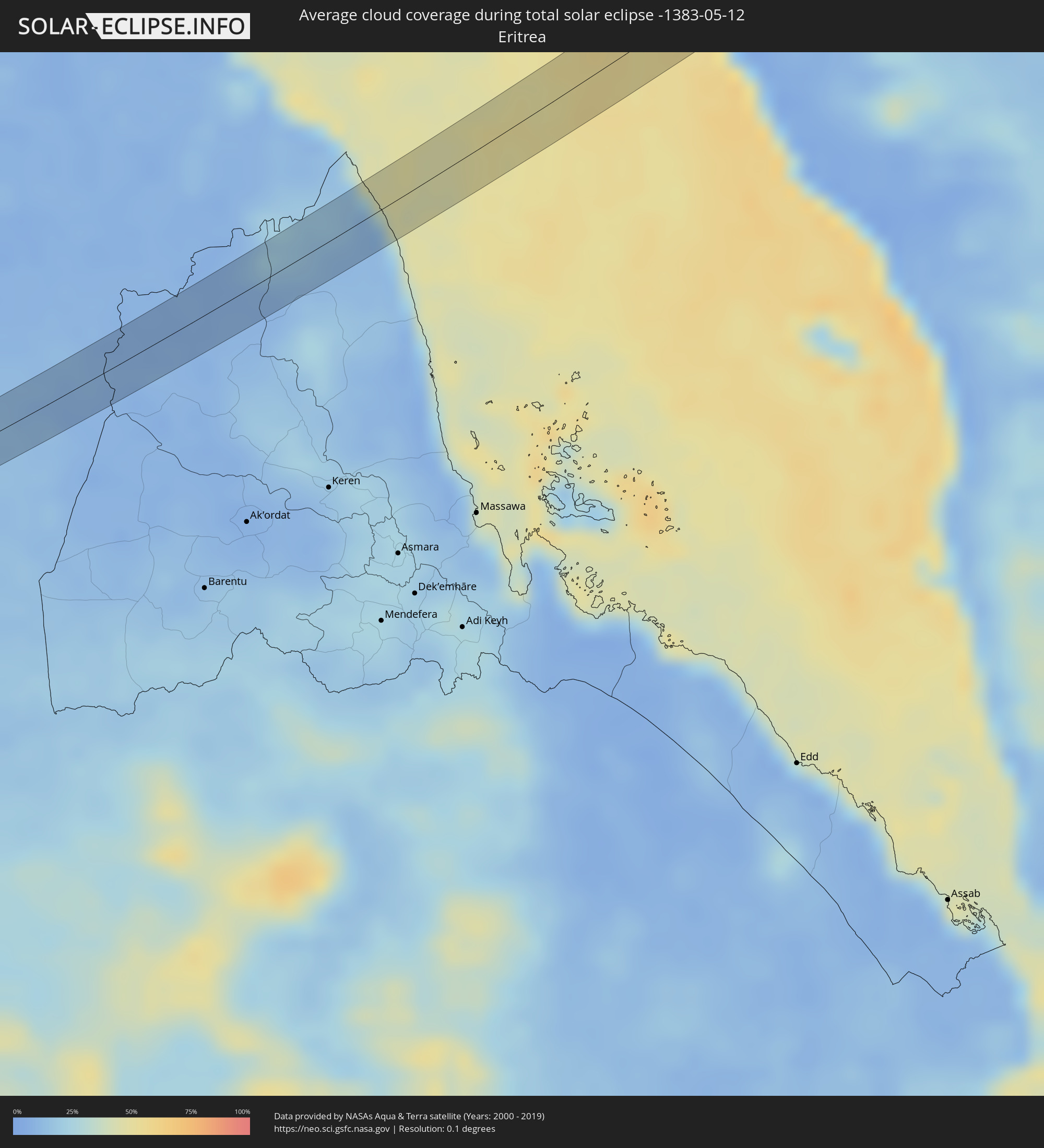 Eritrea
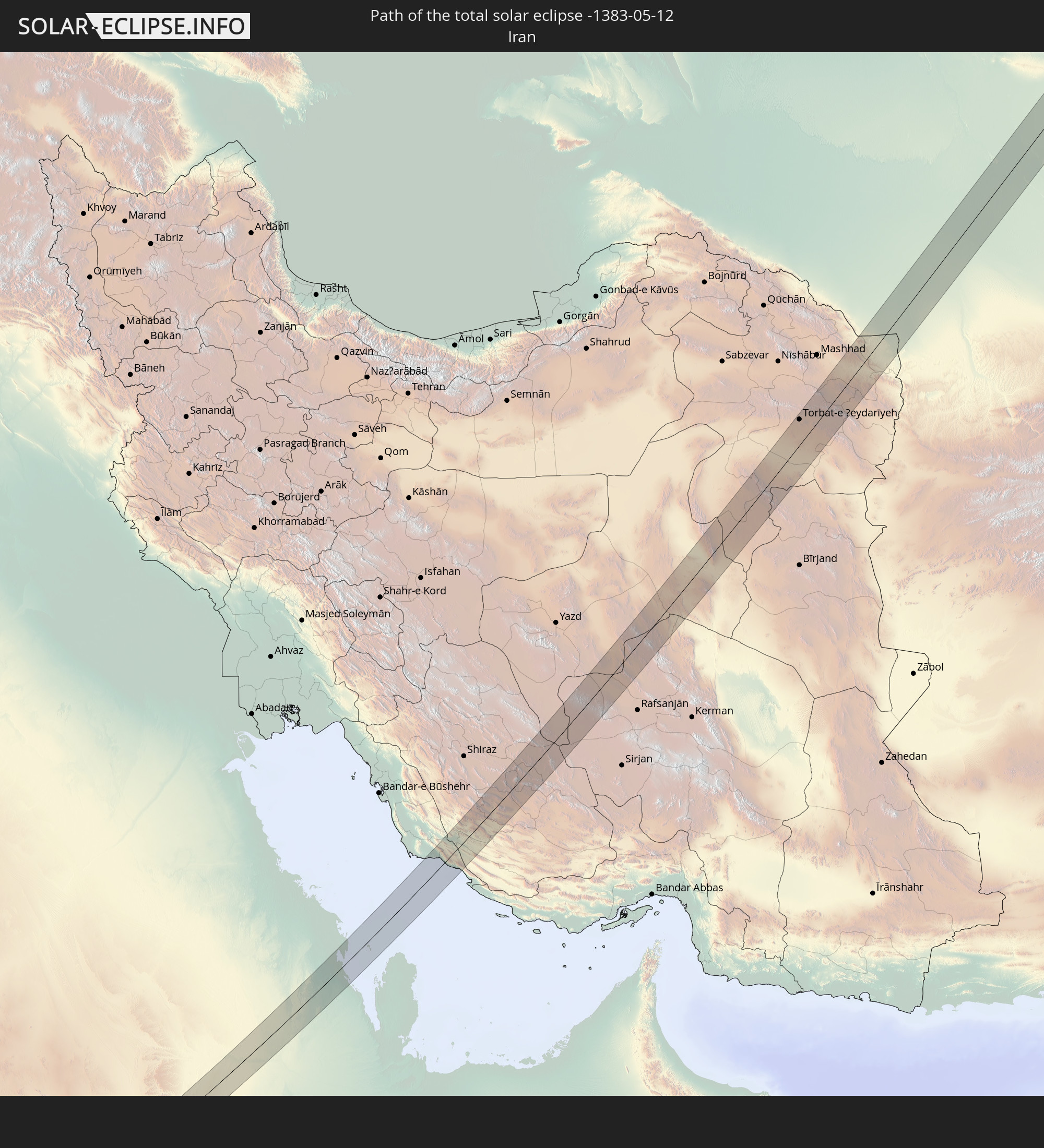
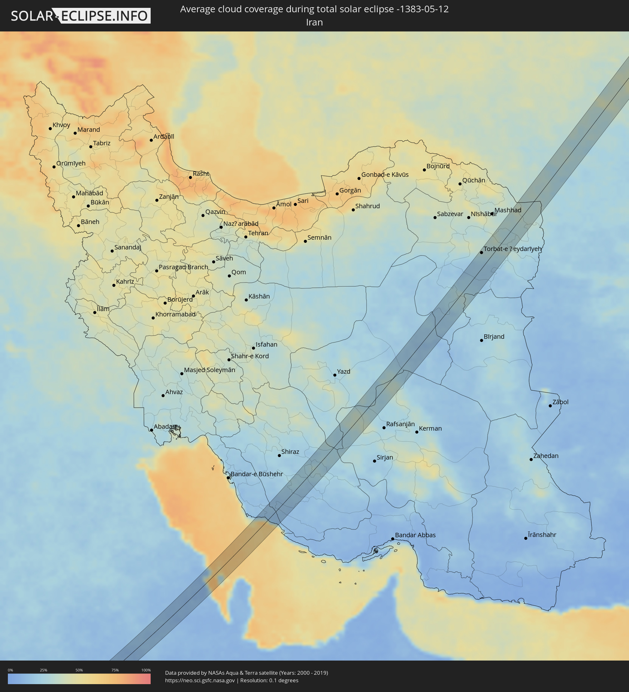 Iran
Iran
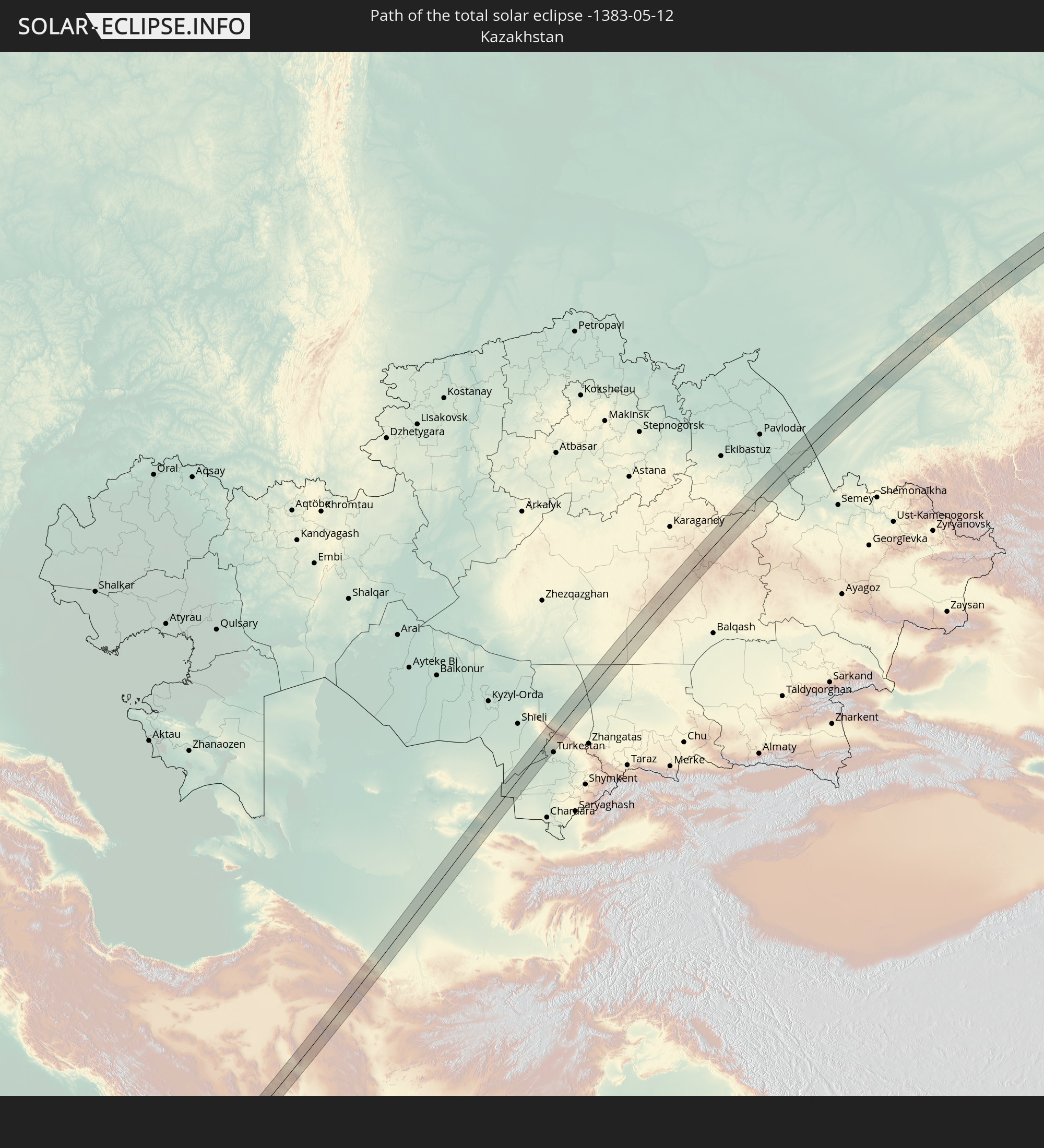
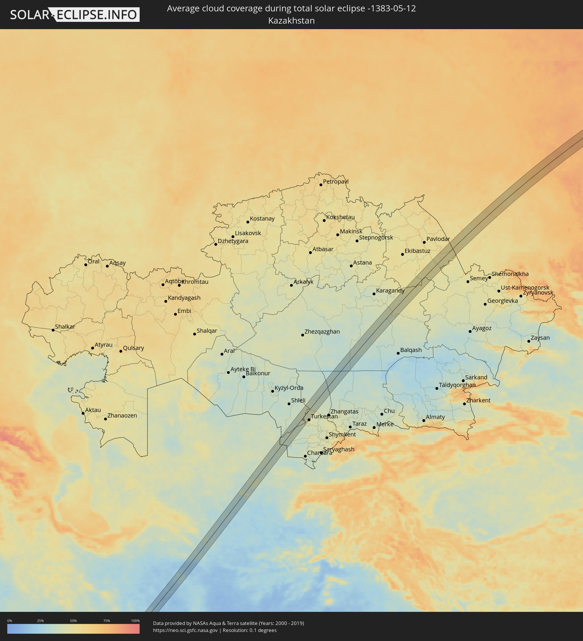 Kasachstan
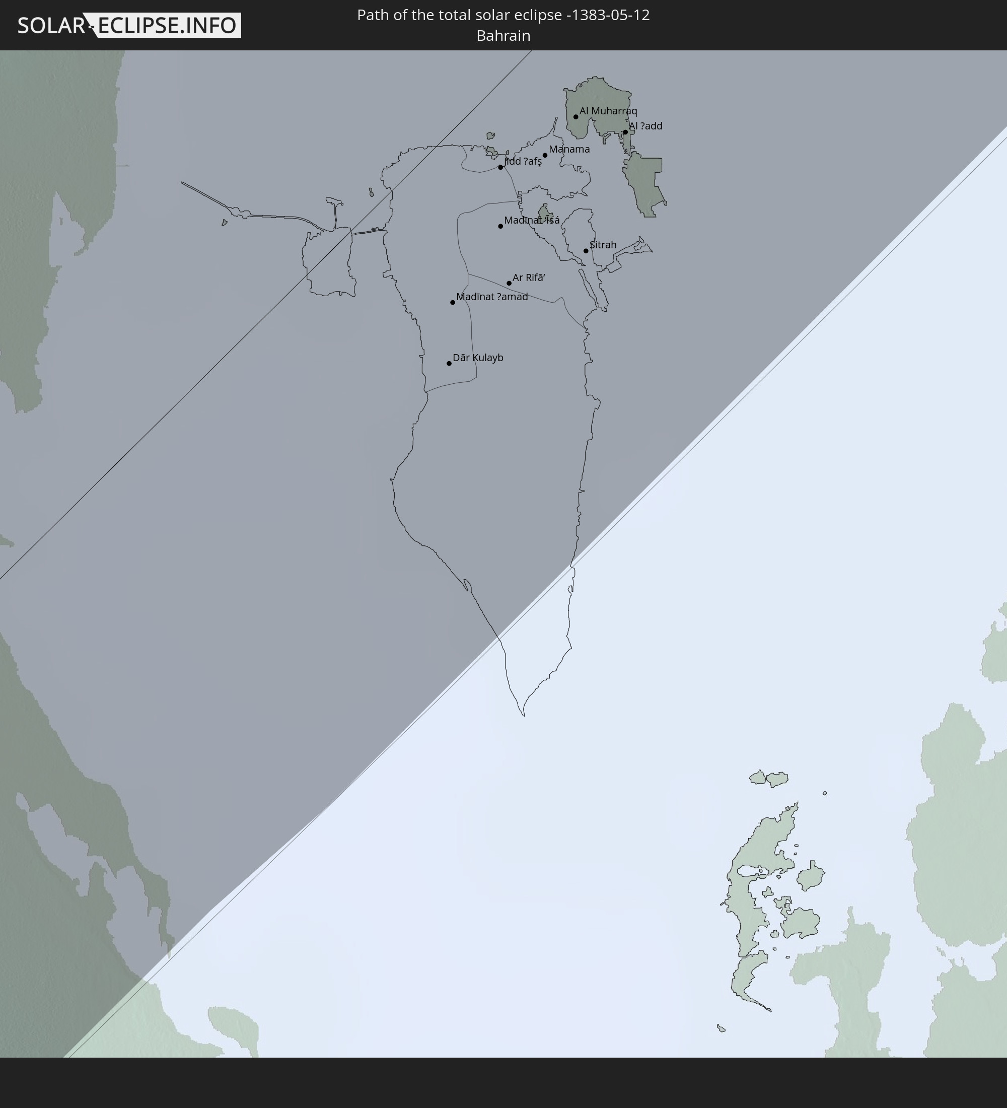
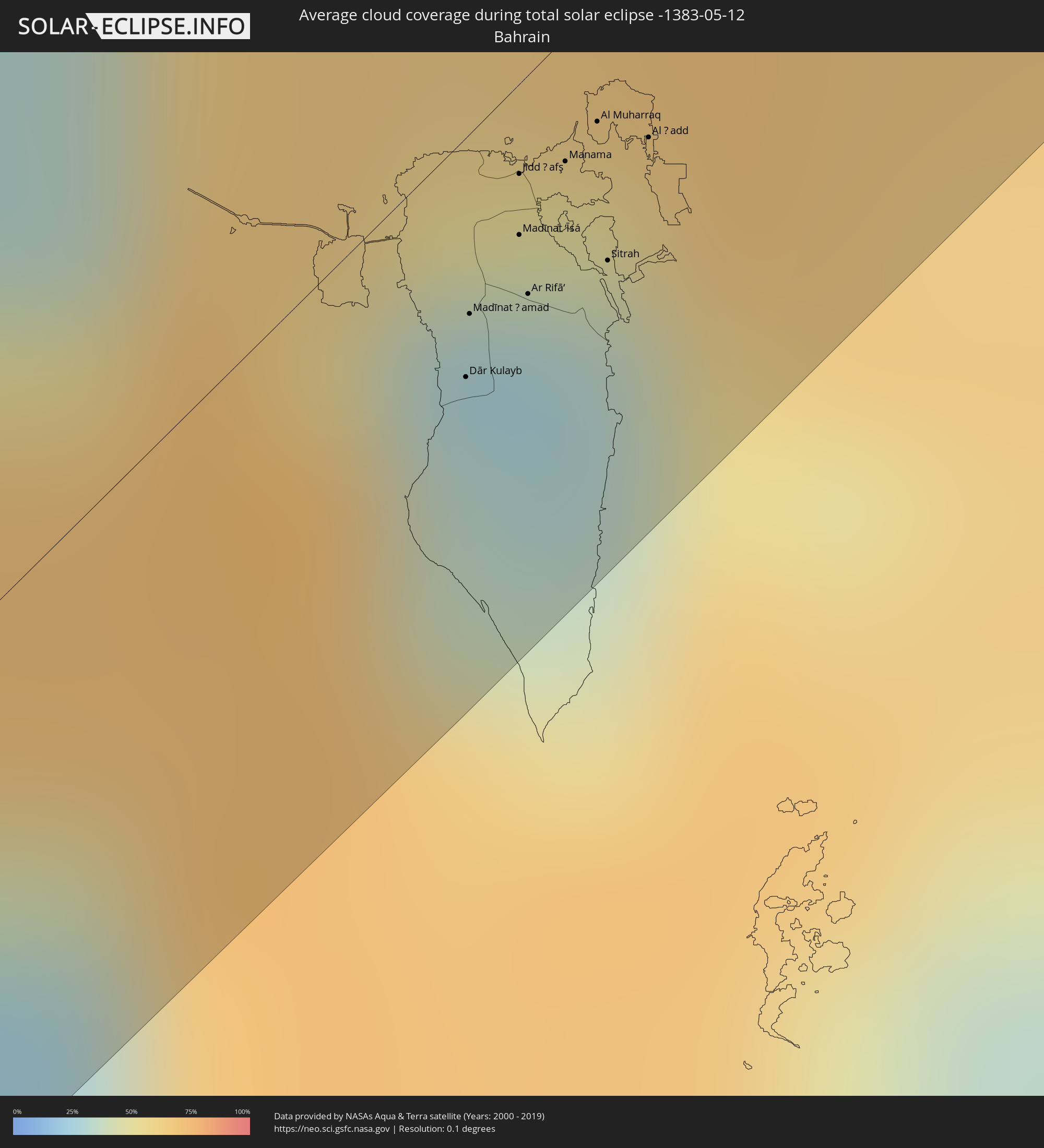 Bahrain
 Turkmenistan
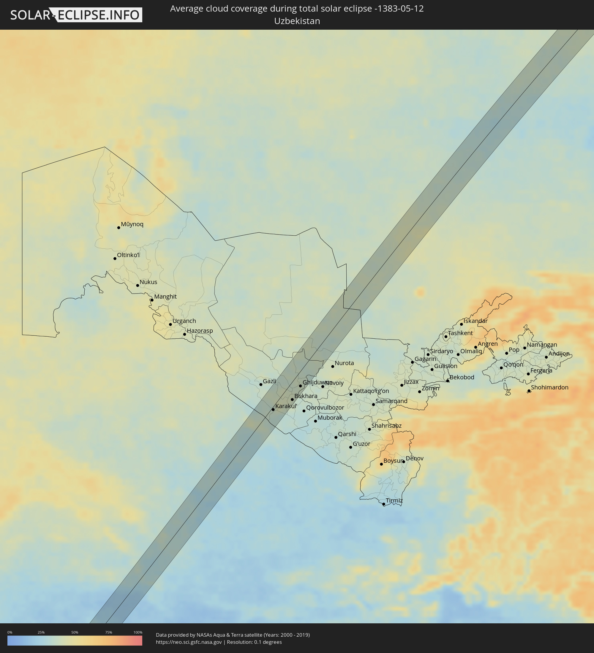 Usbekistan
Orte im Finsternispfad
Die nachfolgene Tabelle zeigt Städte und Orte mit mehr als 5.000 Einwohnern, die sich im Finsternispfad befinden. Städte mit mehr als 100.000 Einwohnern sind dick gekennzeichnet. Mit einem Klick auf den Ort öffnet sich eine Detailkarte die die Lage des jeweiligen Ortes zusammen mit dem Verlauf der zentralen Finsternis präsentiert.
| Ort | Typ | Dauer der Verfinsterung | Ortszeit bei maximaler Verfinsterung | Entfernung zur Zentrallinie | Ø Bewölkung |
|
An Nuhūd, West Kordofan State
|
total | - | 06:33:48 UTC+02:10 | 2 km | 18% |
|
Al Hasaheisa, Al Jazīrah
|
total | - | 06:36:35 UTC+02:10 | 2 km | 19% |
|
Al Masallamiyya, Al Jazīrah
|
total | - | 06:36:20 UTC+02:10 | 18 km | 20% |
|
Wagar, Kassala
|
total | - | 06:38:59 UTC+02:10 | 2 km | 13% |
|
Tabālah, 'Asir
|
total | - | 07:43:30 UTC+03:06 | 6 km | 15% |
|
Qal‘at Bīshah, 'Asir
|
total | - | 07:43:40 UTC+03:06 | 2 km | 12% |
|
Al Muţayrifī, Eastern Province
|
total | - | 07:57:17 UTC+03:06 | 6 km | 14% |
|
Al Hufūf, Eastern Province
|
total | - | 07:57:05 UTC+03:06 | 4 km | 12% |
|
Al Mubarraz, Eastern Province
|
total | - | 07:57:10 UTC+03:06 | 2 km | 12% |
|
Al Qurayn, Eastern Province
|
total | - | 07:57:20 UTC+03:06 | 3 km | 14% |
|
Julayjilah, Eastern Province
|
total | - | 07:57:22 UTC+03:06 | 4 km | 14% |
|
Al Baţţālīyah, Eastern Province
|
total | - | 07:57:15 UTC+03:06 | 3 km | 12% |
|
Al Jubayl, Eastern Province
|
total | - | 07:57:12 UTC+03:06 | 7 km | 13% |
|
Al Qārah, Eastern Province
|
total | - | 07:57:15 UTC+03:06 | 7 km | 13% |
|
Al Munayzilah, Eastern Province
|
total | - | 07:57:11 UTC+03:06 | 10 km | 13% |
|
Al Jafr, Eastern Province
|
total | - | 07:57:12 UTC+03:06 | 14 km | 13% |
|
Aţ Ţaraf, Eastern Province
|
total | - | 07:57:11 UTC+03:06 | 15 km | 13% |
|
Al Markaz, Eastern Province
|
total | - | 07:57:15 UTC+03:06 | 13 km | 13% |
|
Dhahran, Eastern Province
|
total | - | 07:59:14 UTC+03:06 | 31 km | 15% |
|
Khobar, Eastern Province
|
total | - | 07:59:17 UTC+03:06 | 23 km | 35% |
|
Dār Kulayb, Southern Governorate
|
total | - | 08:18:20 UTC+03:26 | 14 km | 34% |
|
Madīnat Ḩamad, Central Governorate
|
total | - | 08:18:26 UTC+03:26 | 11 km | 34% |
|
Madīnat ‘Īsá, Southern Governorate
|
total | - | 08:18:35 UTC+03:26 | 9 km | 29% |
|
Jidd Ḩafş, Manama
|
total | - | 08:18:40 UTC+03:26 | 5 km | 29% |
|
Ar Rifā‘, Southern Governorate
|
total | - | 08:18:30 UTC+03:26 | 13 km | 31% |
|
Manama, Manama
|
total | - | 08:18:42 UTC+03:26 | 7 km | 32% |
|
Al Muharraq, Muharraq
|
total | - | 08:18:47 UTC+03:26 | 7 km | 49% |
|
Sitrah, Manama
|
total | - | 08:18:35 UTC+03:26 | 15 km | 32% |
|
Al Ḩadd, Muharraq
|
total | - | 08:18:47 UTC+03:26 | 11 km | 57% |
|
Fasā, Fars
|
total | - | 08:26:01 UTC+03:25 | 19 km | 19% |
|
Gonābād, Razavi Khorasan
|
total | - | 08:41:48 UTC+03:25 | 4 km | 23% |
|
Torbat-e Ḩeydarīyeh, Razavi Khorasan
|
total | - | 08:44:16 UTC+03:25 | 29 km | 27% |
|
Sarakhs, Razavi Khorasan
|
total | - | 08:48:57 UTC+03:25 | 22 km | 29% |
|
Mary, Mary
|
total | - | 09:19:40 UTC+03:53 | 2 km | 29% |
|
Murgab
|
total | - | 09:19:37 UTC+03:53 | 15 km | 26% |
|
Bayramaly, Mary
|
total | - | 09:20:05 UTC+03:53 | 20 km | 27% |
|
Türkmenabat, Lebap
|
total | - | 09:24:40 UTC+03:53 | 19 km | 36% |
|
Farap, Lebap
|
total | - | 09:24:54 UTC+03:53 | 15 km | 38% |
|
Olot, Bukhara
|
total | - | 09:59:59 UTC+04:27 | 12 km | 33% |
|
Karakul’, Bukhara
|
total | - | 10:00:15 UTC+04:27 | 6 km | 35% |
|
Romiton, Bukhara
|
total | - | 10:01:41 UTC+04:27 | 16 km | 39% |
|
Bukhara, Bukhara
|
total | - | 10:01:26 UTC+04:27 | 30 km | 39% |
|
Galaosiyo, Bukhara
|
total | - | 10:01:38 UTC+04:27 | 25 km | 39% |
|
Shofirkon, Bukhara
|
total | - | 10:02:13 UTC+04:27 | 11 km | 37% |
|
Wobkent, Bukhara
|
total | - | 10:02:03 UTC+04:27 | 18 km | 39% |
|
Ghijduwon, Bukhara
|
total | - | 10:02:23 UTC+04:27 | 25 km | 38% |
|
Aktau, Qaraghandy
|
total | - | 10:21:15 UTC+04:21 | 24 km | 36% |
|
Qarqaraly, Qaraghandy
|
total | - | 10:26:49 UTC+04:21 | 18 km | 47% |
|
Klyuchi, Altai Krai
|
total | - | 12:25:07 UTC+06:11 | 16 km | 52% |
|
Blagoveshchenka, Altai Krai
|
total | - | 12:26:44 UTC+06:11 | 30 km | 55% |
|
Rodino, Altai Krai
|
total | - | 12:26:44 UTC+06:11 | 13 km | 52% |
|
Zav’yalovo, Altai Krai
|
total | - | 12:28:03 UTC+06:11 | 19 km | 55% |
|
Tyumentsevo, Altai Krai
|
total | - | 12:29:21 UTC+06:11 | 5 km | 56% |
|
Suzun, Novosibirsk
|
total | - | 12:30:54 UTC+06:11 | 3 km | 59% |
|
Iskitim, Novosibirsk
|
total | - | 12:33:02 UTC+06:11 | 25 km | 58% |
|
Linëvo, Novosibirsk
|
total | - | 12:32:57 UTC+06:11 | 7 km | 58% |
|
Cherepanovo, Novosibirsk
|
total | - | 12:32:42 UTC+06:11 | 13 km | 59% |
|
Toguchin, Novosibirsk
|
total | - | 12:34:57 UTC+06:11 | 31 km | 66% |
|
Topki, Kemerovo
|
total | - | 12:36:29 UTC+06:11 | 15 km | 73% |
|
Pioner, Kemerovo
|
total | - | 12:36:55 UTC+06:11 | 25 km | 73% |
|
Yagunovskiy, Kemerovo
|
total | - | 12:36:55 UTC+06:11 | 29 km | 73% |
|
Kedrovka, Kemerovo
|
total | - | 12:37:14 UTC+06:11 | 10 km | 75% |
|
Borovoy, Kemerovo
|
total | - | 12:37:11 UTC+06:11 | 20 km | 75% |
|
Kemerovo, Kemerovo
|
total | - | 12:37:06 UTC+06:11 | 29 km | 72% |
|
Berëzovskiy, Kemerovo
|
total | - | 12:37:29 UTC+06:11 | 10 km | 75% |
|
Promyshlennovskiy, Kemerovo
|
total | - | 12:37:22 UTC+06:11 | 20 km | 75% |
|
Izhmorskiy, Kemerovo
|
total | - | 12:38:31 UTC+06:11 | 25 km | 77% |
|
Mariinsk, Kemerovo
|
total | - | 12:39:51 UTC+06:11 | 15 km | 75% |
|
Lesosibirsk, Krasnoyarskiy
|
total | - | 12:46:38 UTC+06:11 | 5 km | 73% |
|
Strelka, Krasnoyarskiy
|
total | - | 12:47:10 UTC+06:11 | 28 km | 74% |
|
Nyurba, Sakha
|
total | - | 15:37:58 UTC+08:38 | 9 km | 68% |
|
Verkhnevilyuysk, Sakha
|
total | - | 15:39:15 UTC+08:38 | 10 km | 64% |
|
Vilyuysk, Sakha
|
total | - | 15:39:56 UTC+08:38 | 13 km | 65% |