Totale Sonnenfinsternis vom 28.11.-1385
| Wochentag: | Sonntag |
| Maximale Dauer der Verfinsterung: | 03m43s |
| Maximale Breite des Finsternispfades: | 150 km |
| Saroszyklus: | 20 |
| Bedeckungsgrad: | 100% |
| Magnitude: | 1.0404 |
| Gamma: | 0.4414 |
Wo kann man die Sonnenfinsternis vom 28.11.-1385 sehen?
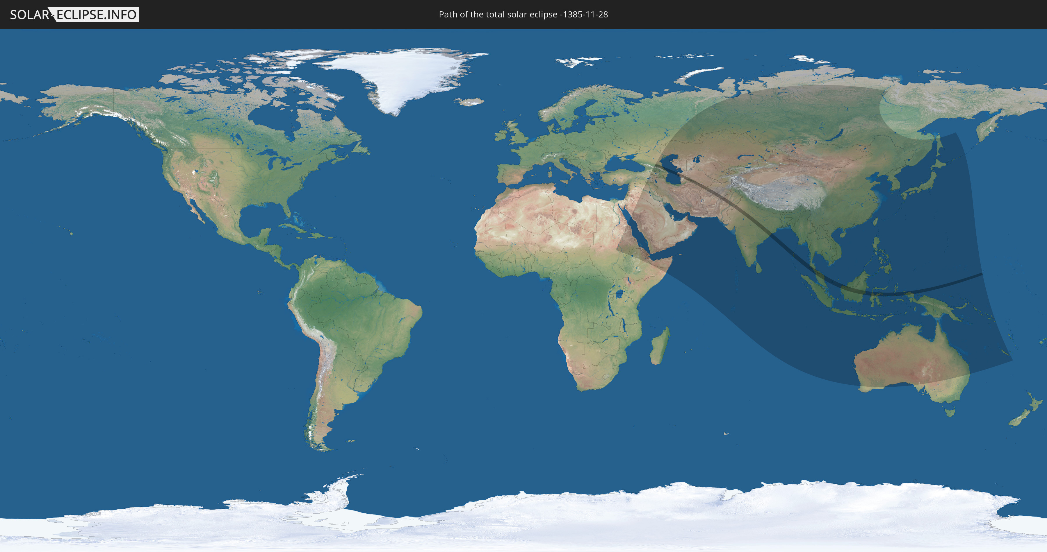
Die Sonnenfinsternis am 28.11.-1385 kann man in 64 Ländern als partielle Sonnenfinsternis beobachten.
Der Finsternispfad verläuft durch 12 Länder. Nur in diesen Ländern ist sie als totale Sonnenfinsternis zu sehen.
In den folgenden Ländern ist die Sonnenfinsternis total zu sehen
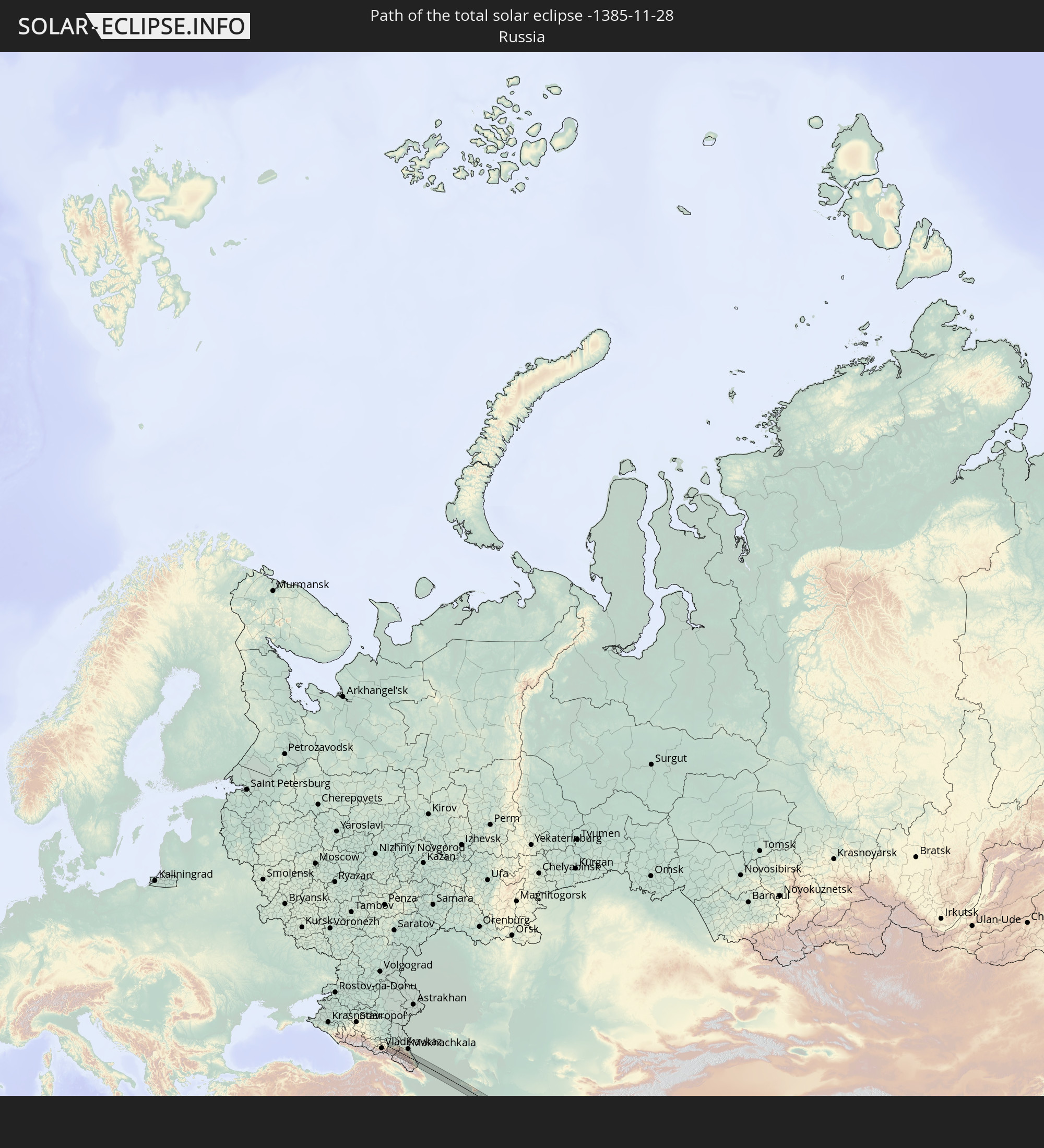 Russland
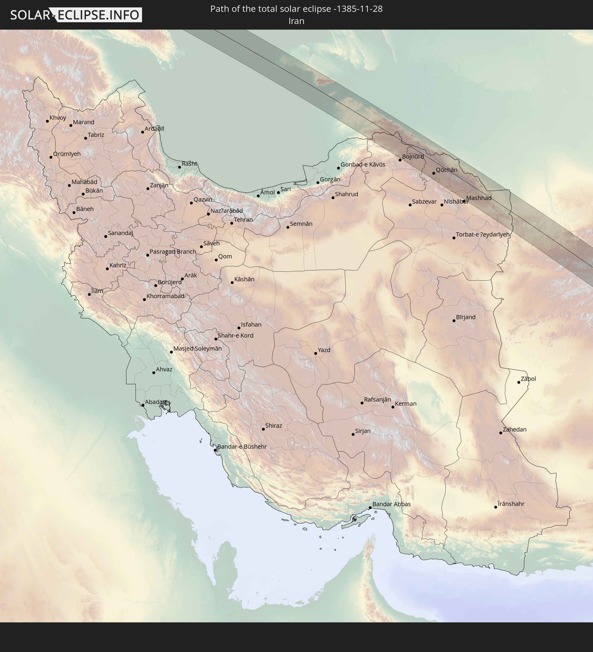 Iran
Iran
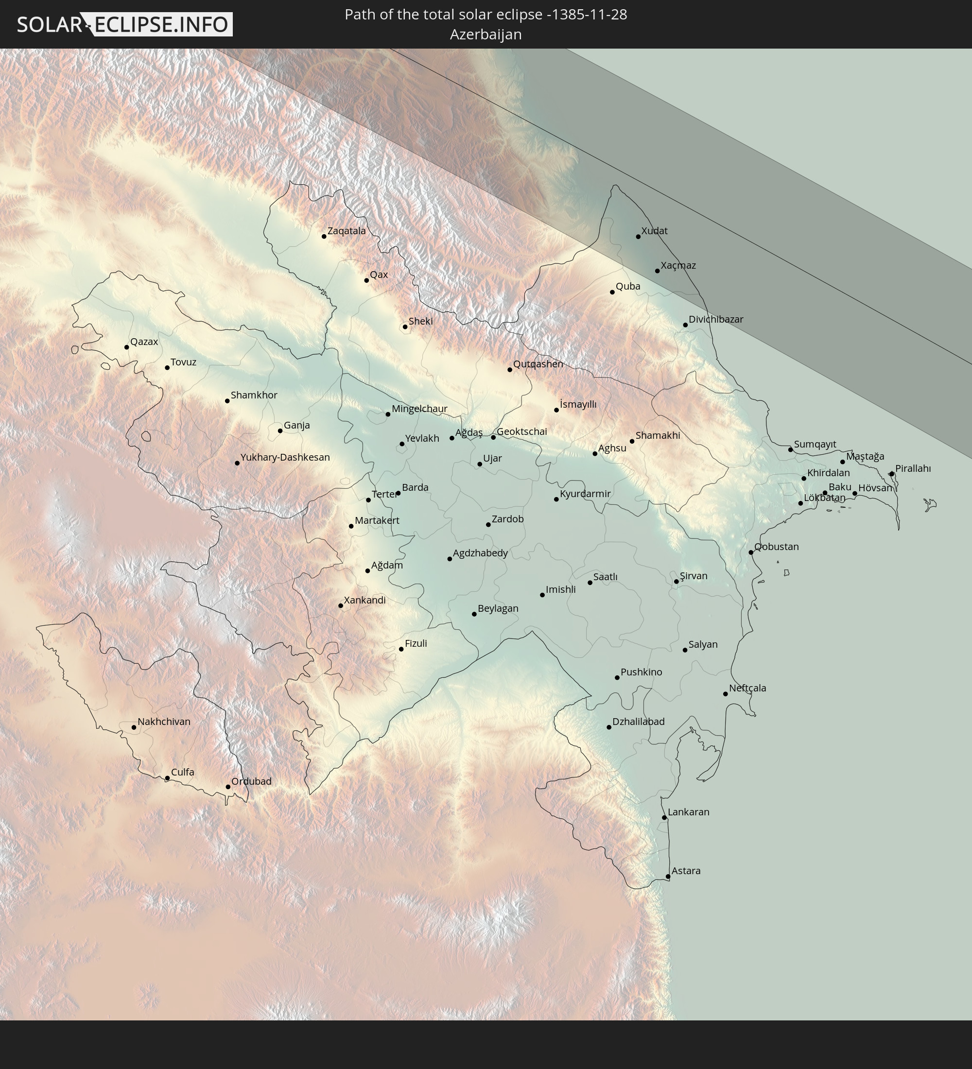 Aserbaidschan
 Turkmenistan
 Afghanistan
 Pakistan
 Indien
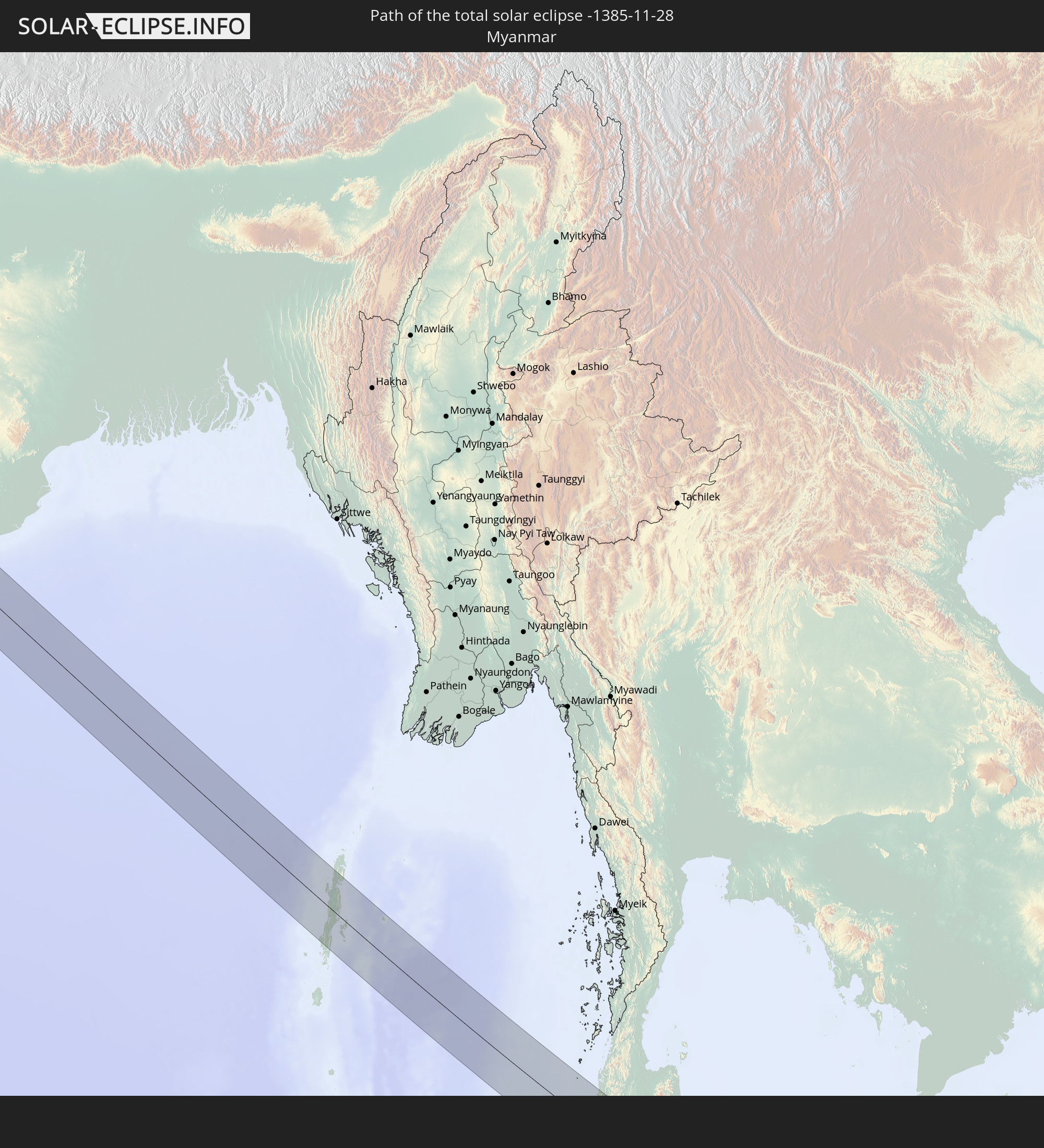 Myanmar
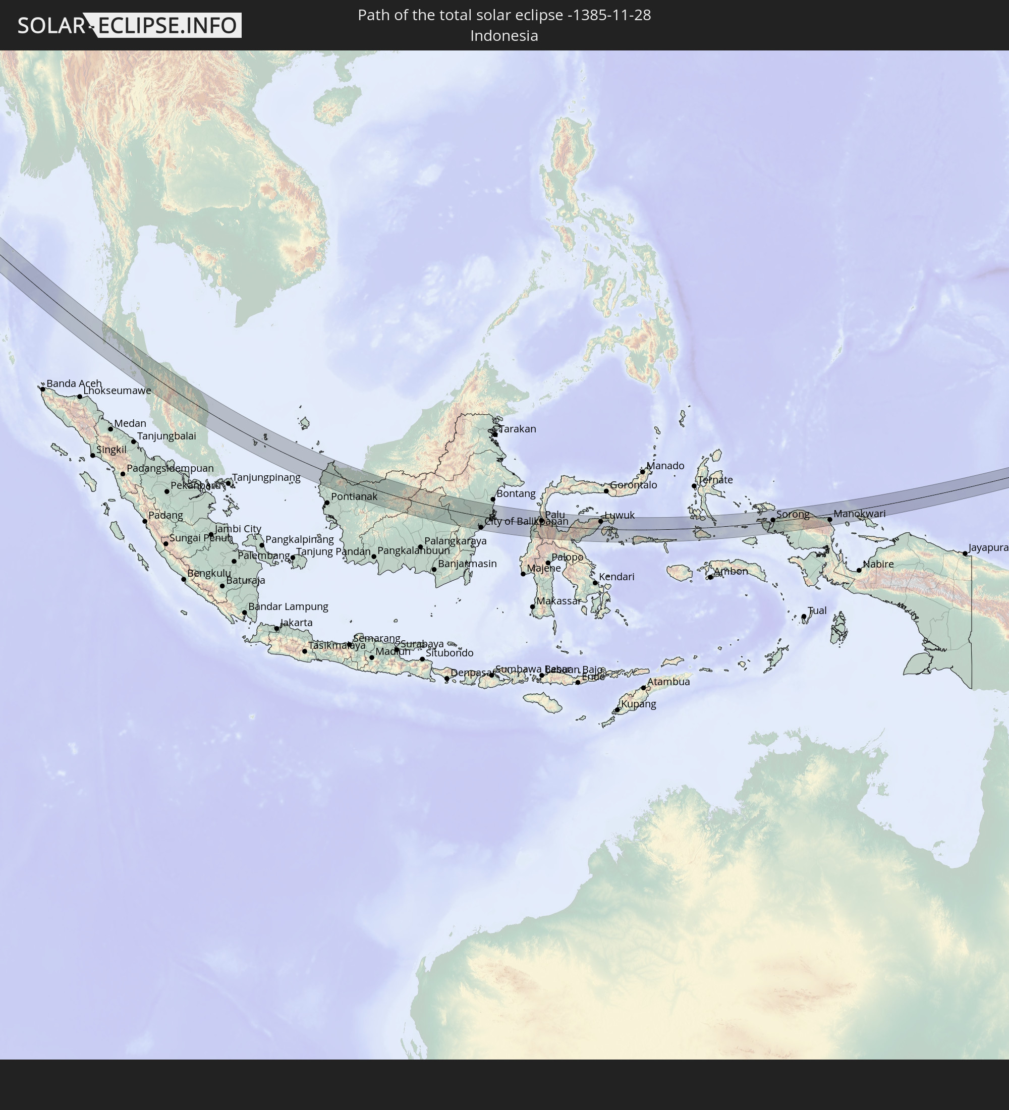 Indonesien
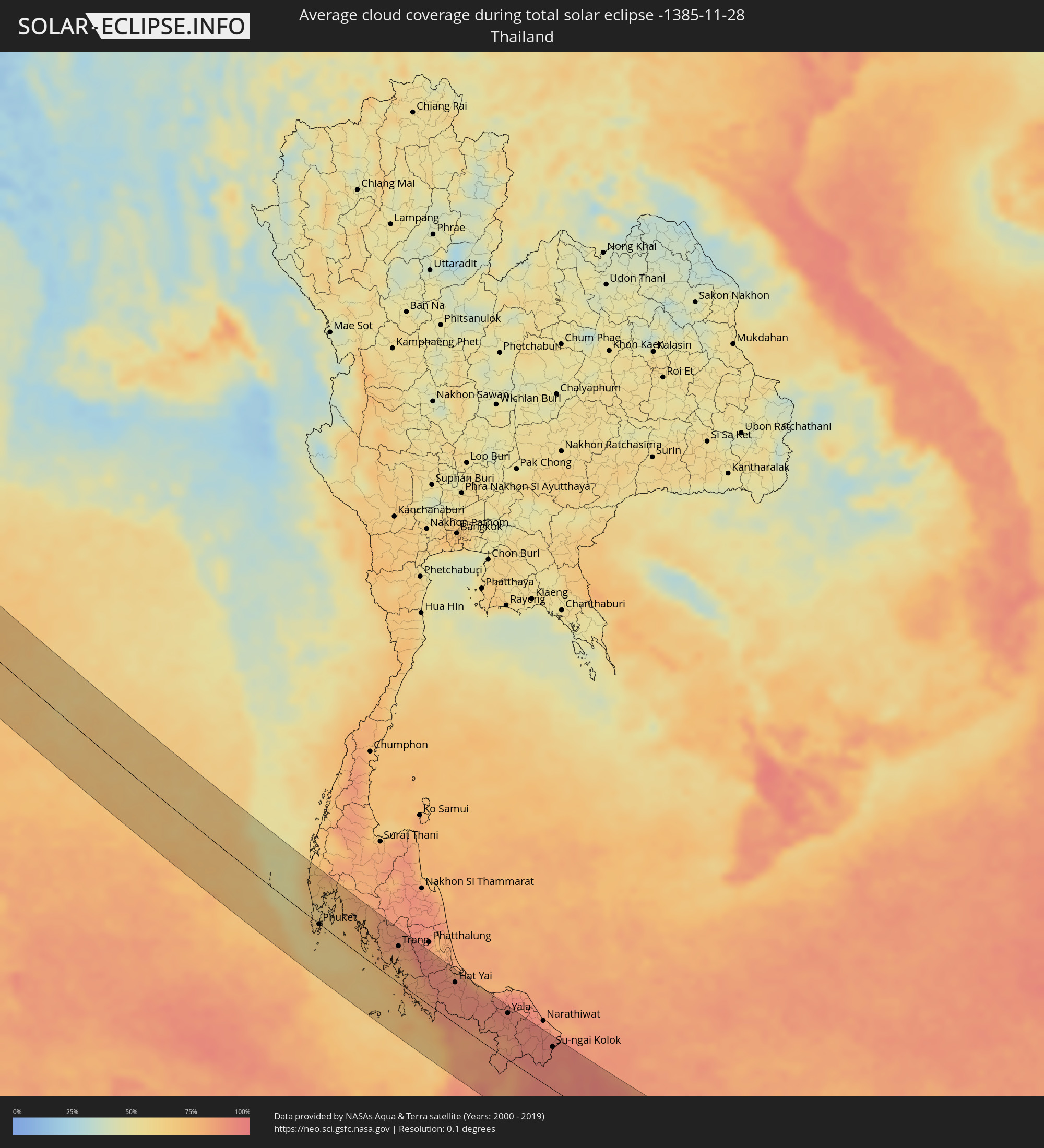
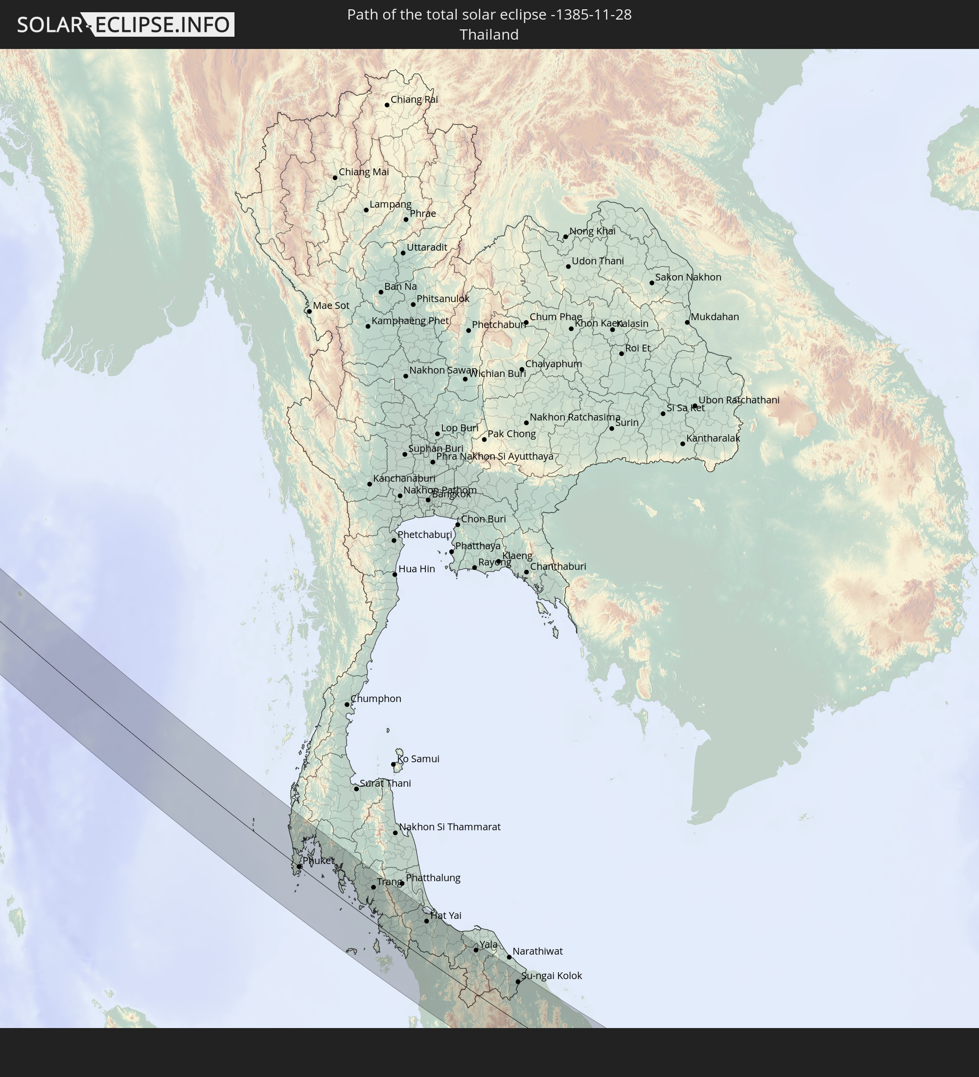 Thailand
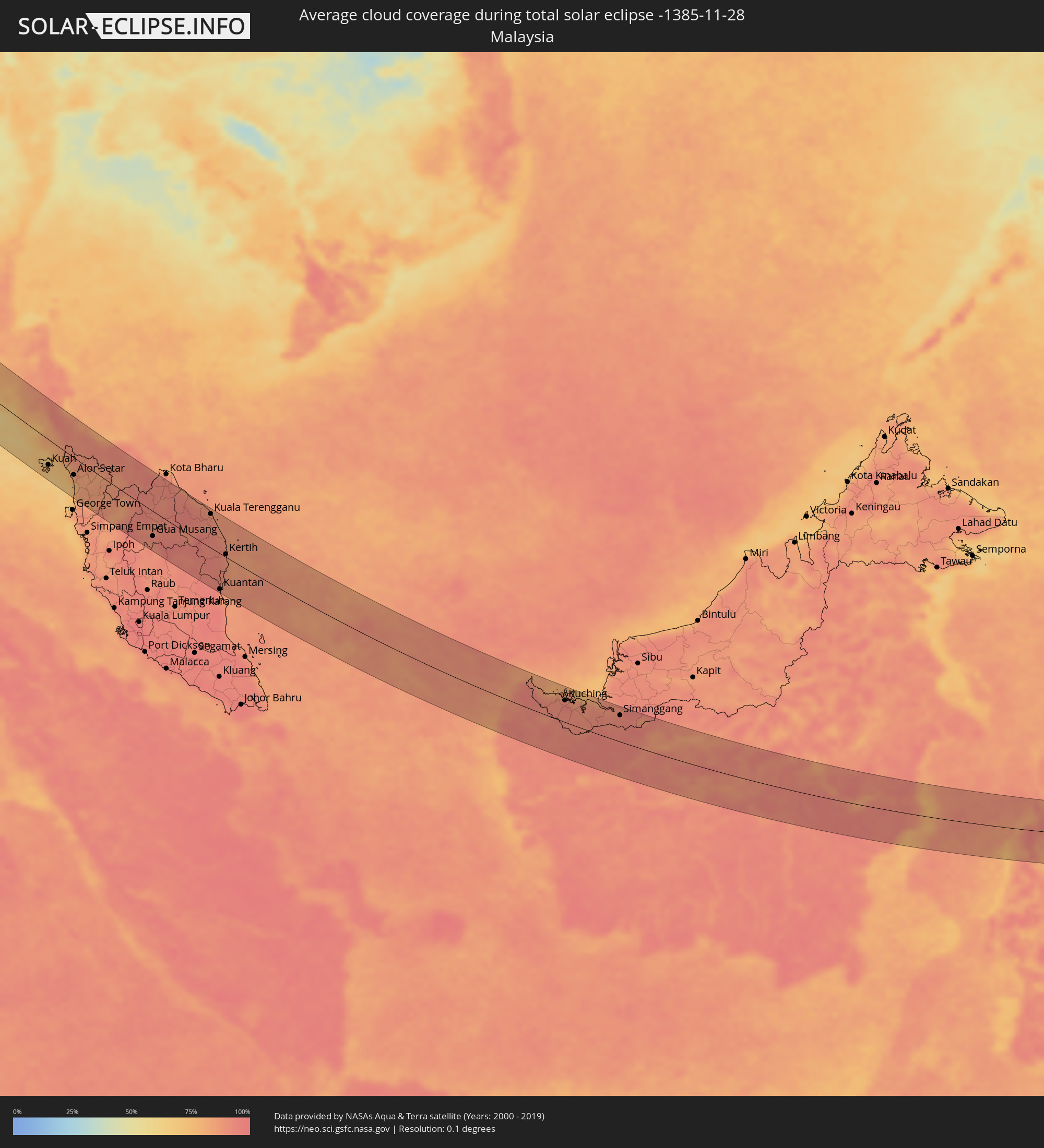
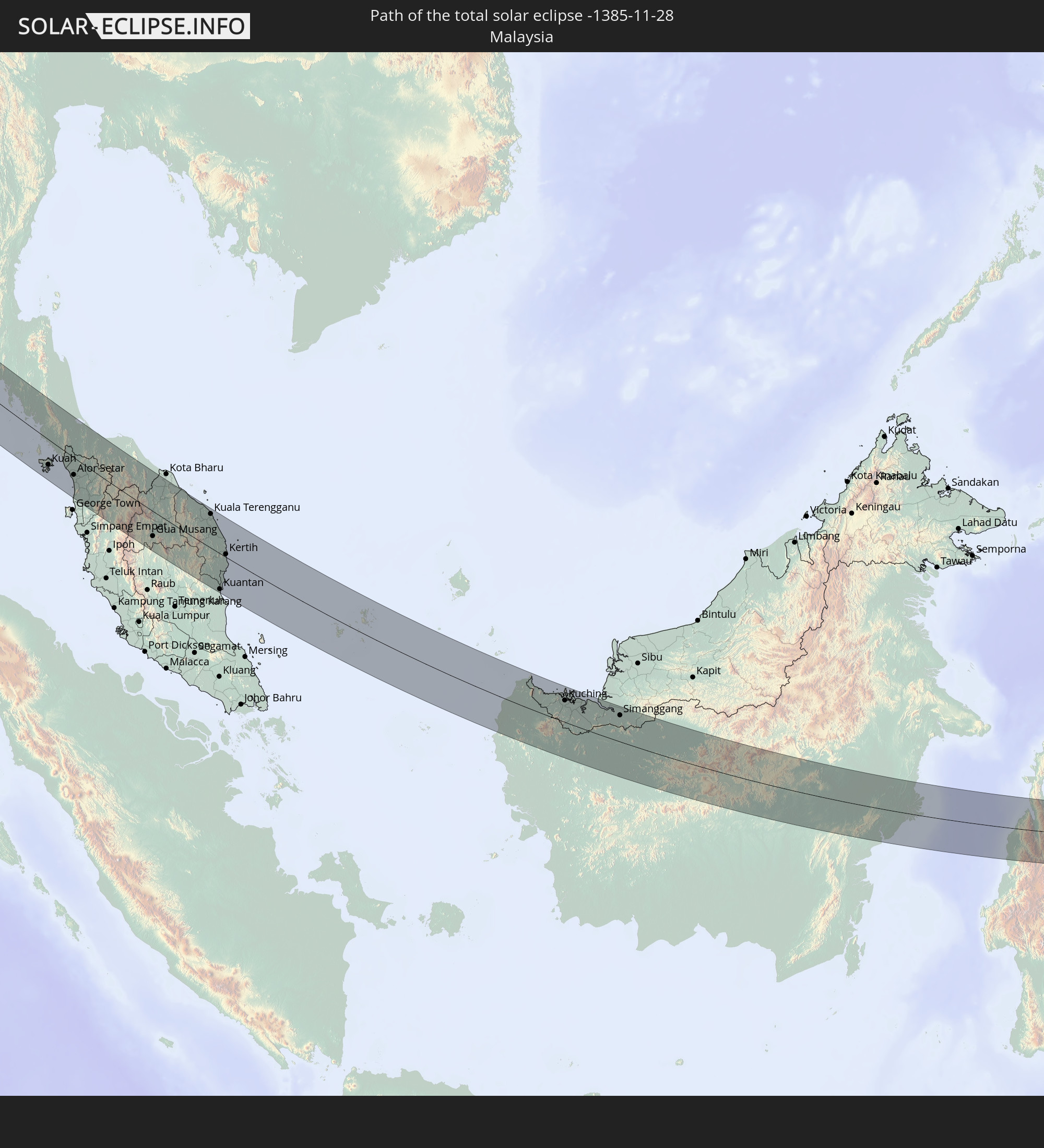 Malaysia
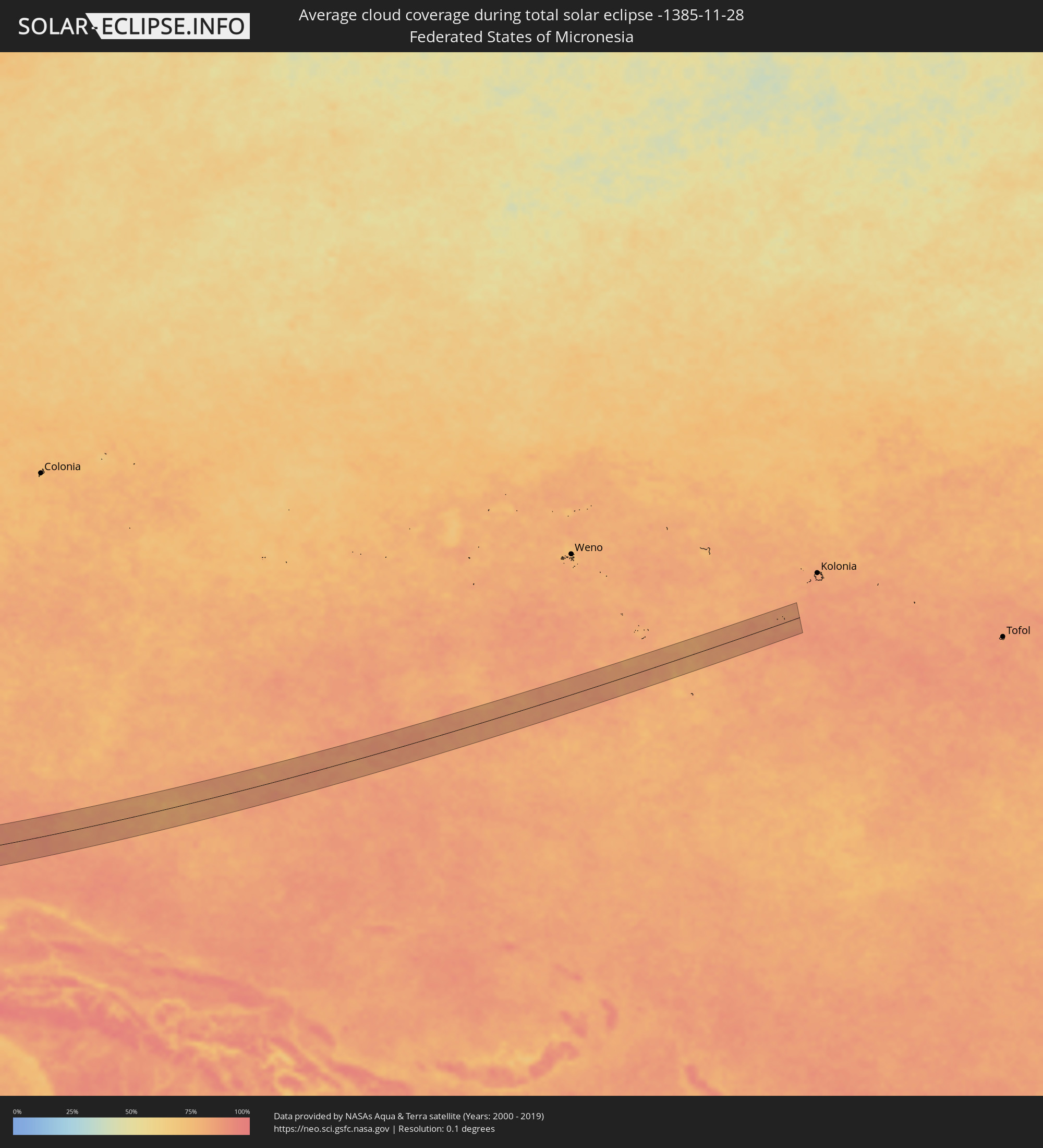
 Föderierte Staaten von Mikronesien
In den folgenden Ländern ist die Sonnenfinsternis partiell zu sehen
 Russland
 Sudan
Sudan
 Ägypten
 Türkei
 Äthiopien
 Saudi-Arabien
 Syrien
 Eritrea
 Irak
Irak
 Georgien
 Somalia
 Dschibuti
 Jemen
Jemen
 Armenien
 Iran
Iran
 Aserbaidschan
 Kasachstan
 Kuwait
 Bahrain
 Katar
Katar
 Vereinigte Arabische Emirate
 Oman
Oman
 Turkmenistan
 Usbekistan
 Afghanistan
 Pakistan
 Tadschikistan
 Indien
 Kirgisistan
 Britisches Territorium im Indischen Ozean
 Malediven
 Volksrepublik China
 Sri Lanka
 Nepal
Nepal
 Mongolei
 Bangladesch
 Bhutan
 Myanmar
 Indonesien
 Kokosinseln
 Thailand
 Malaysia
 Laos
Laos
 Vietnam
 Kambodscha
 Singapur
 Weihnachtsinsel
 Australien
 Macau
Macau
 Hongkong
 Brunei
 Taiwan
 Philippinen
 Japan
Japan
 Osttimor
 Nordkorea
 Südkorea
 Palau
Palau
 Föderierte Staaten von Mikronesien
 Papua-Neuguinea
 Guam
Guam
 Nördliche Marianen
 Salomonen
 Neukaledonien
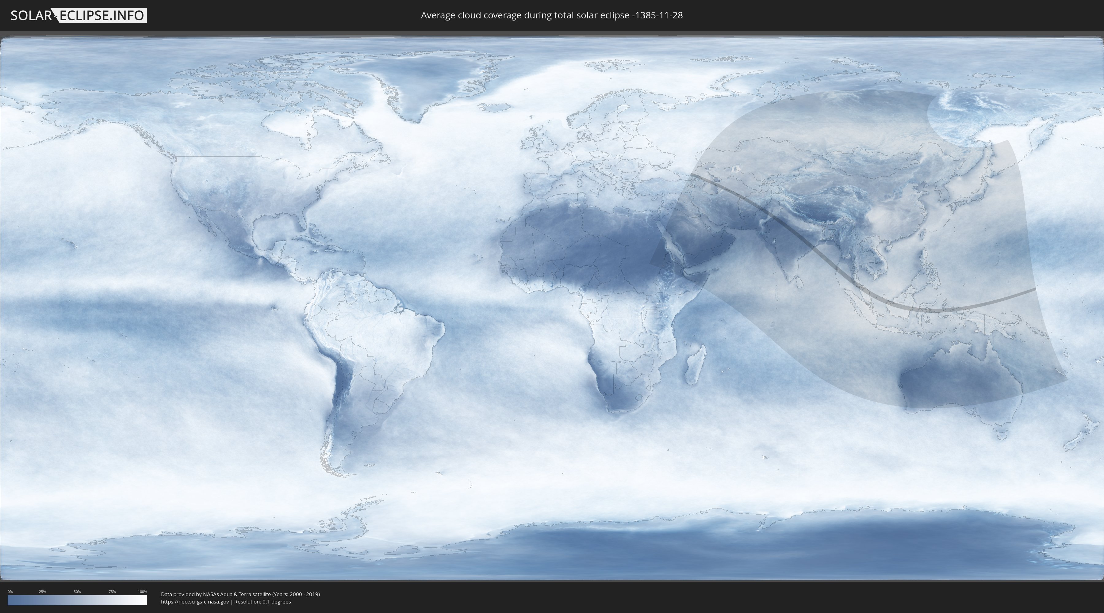
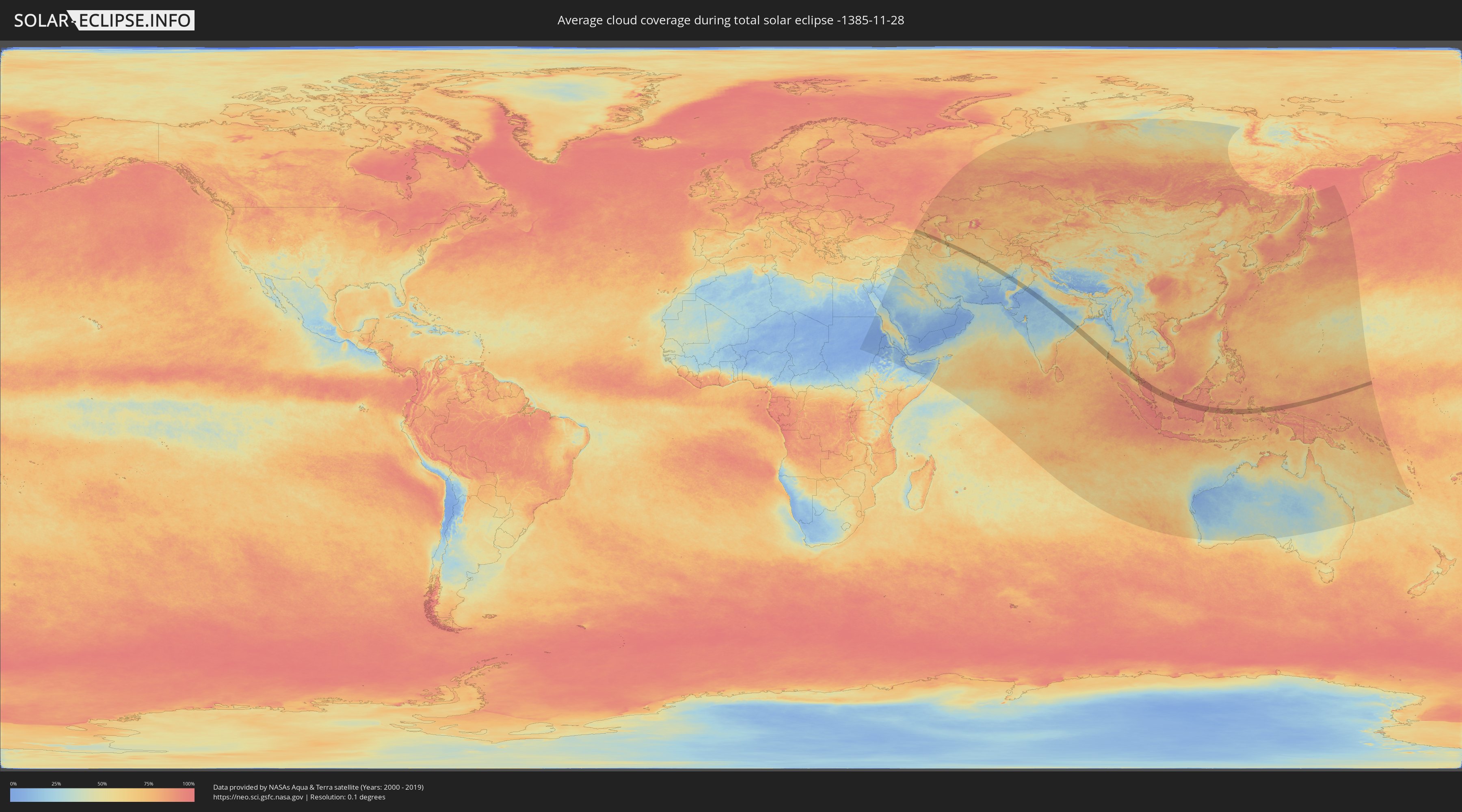
Wie wird das Wetter während der totalen Sonnenfinsternis am 28.11.-1385?
Wo ist der beste Ort, um die totale Sonnenfinsternis vom 28.11.-1385 zu beobachten?
Die folgenden Karten zeigen die durchschnittliche Bewölkung für den Tag, an dem die totale Sonnenfinsternis
stattfindet. Mit Hilfe der Karten lässt sich der Ort entlang des Finsternispfades eingrenzen,
der die besten Aussichen auf einen klaren wolkenfreien Himmel bietet.
Trotzdem muss man immer lokale Gegenenheiten beachten und sollte sich genau über das Wetter an seinem
gewählten Beobachtungsort informieren.
Die Daten stammen von den beiden NASA-Satelliten
AQUA und TERRA
und wurden über einen Zeitraum von 19 Jahren (2000 - 2019) gemittelt.
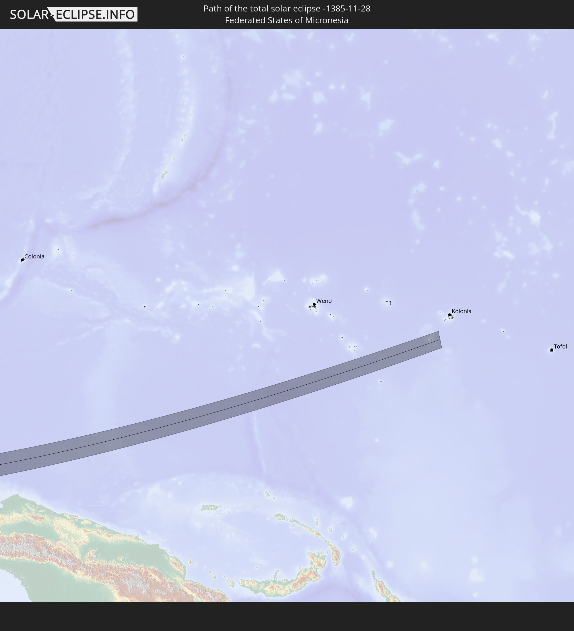
Detaillierte Länderkarten
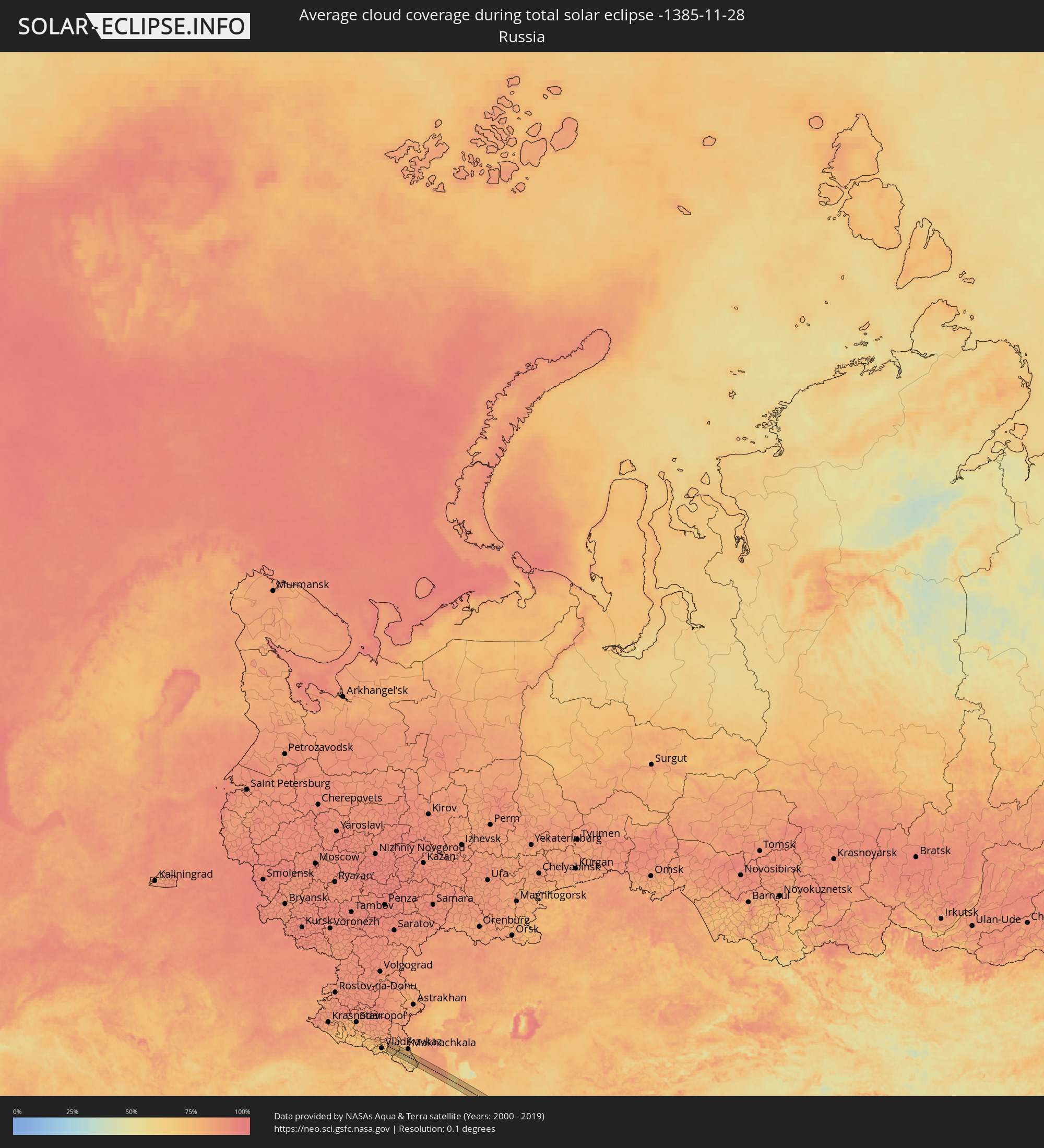 Russland
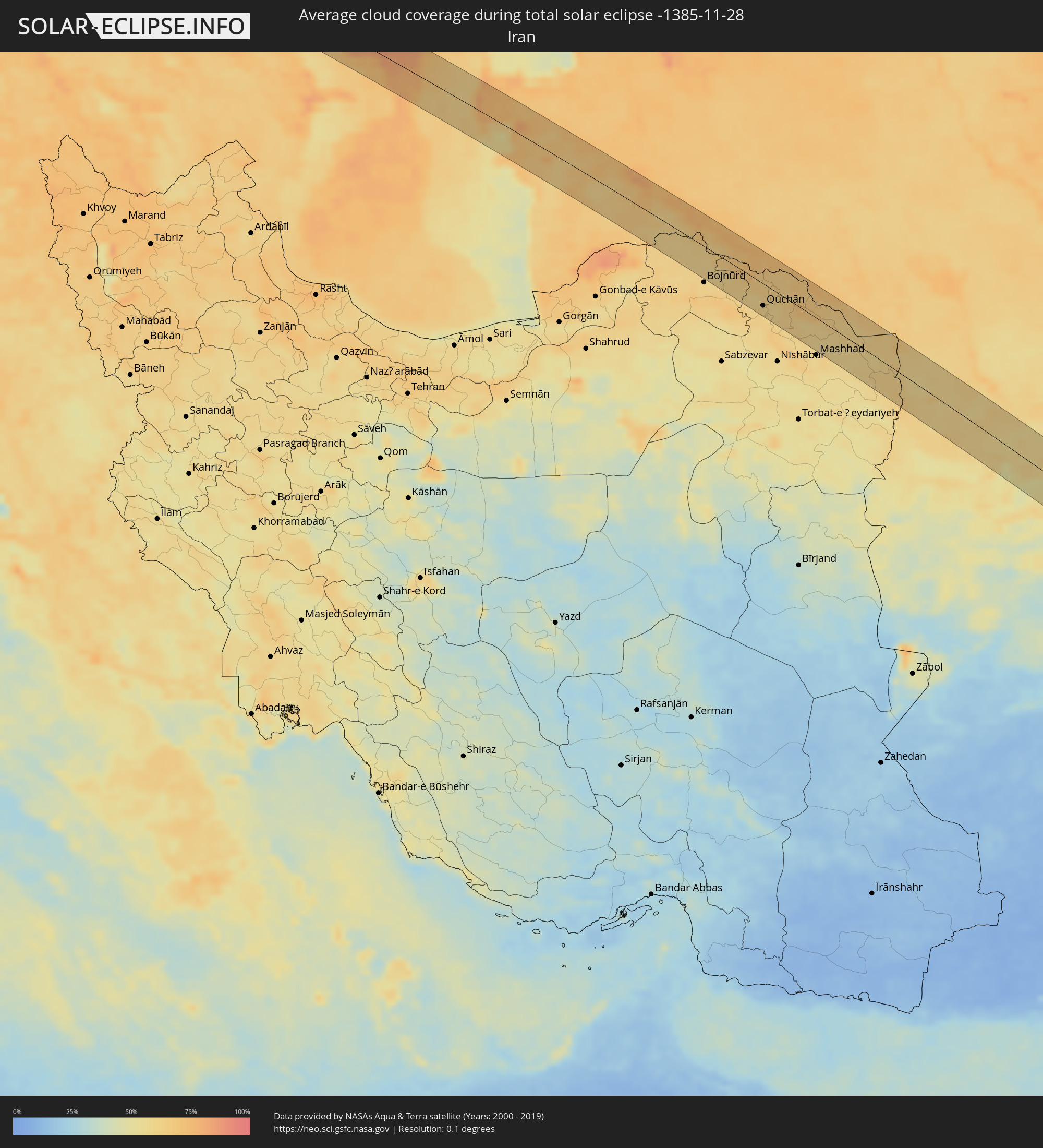 Iran
Iran
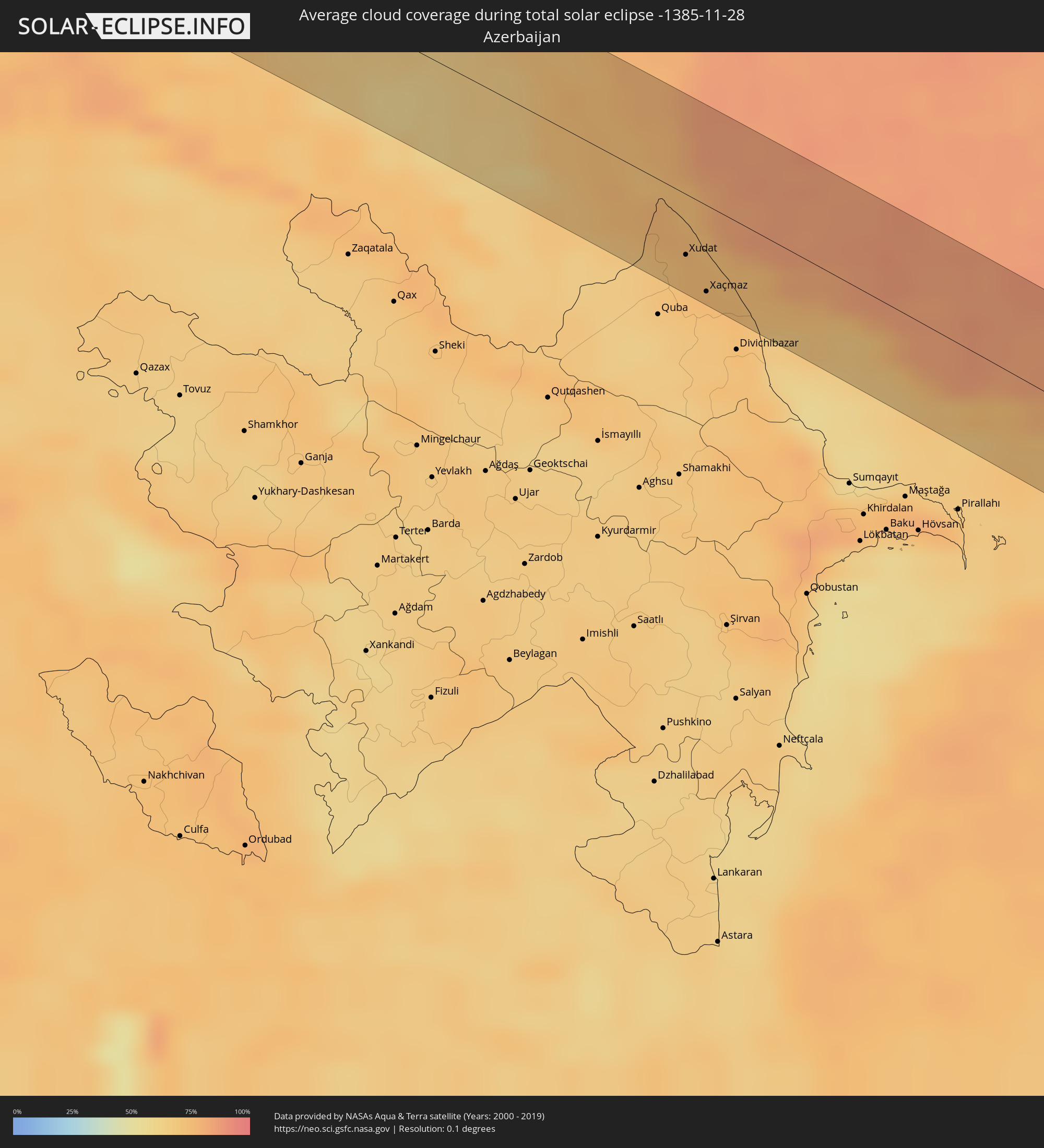 Aserbaidschan
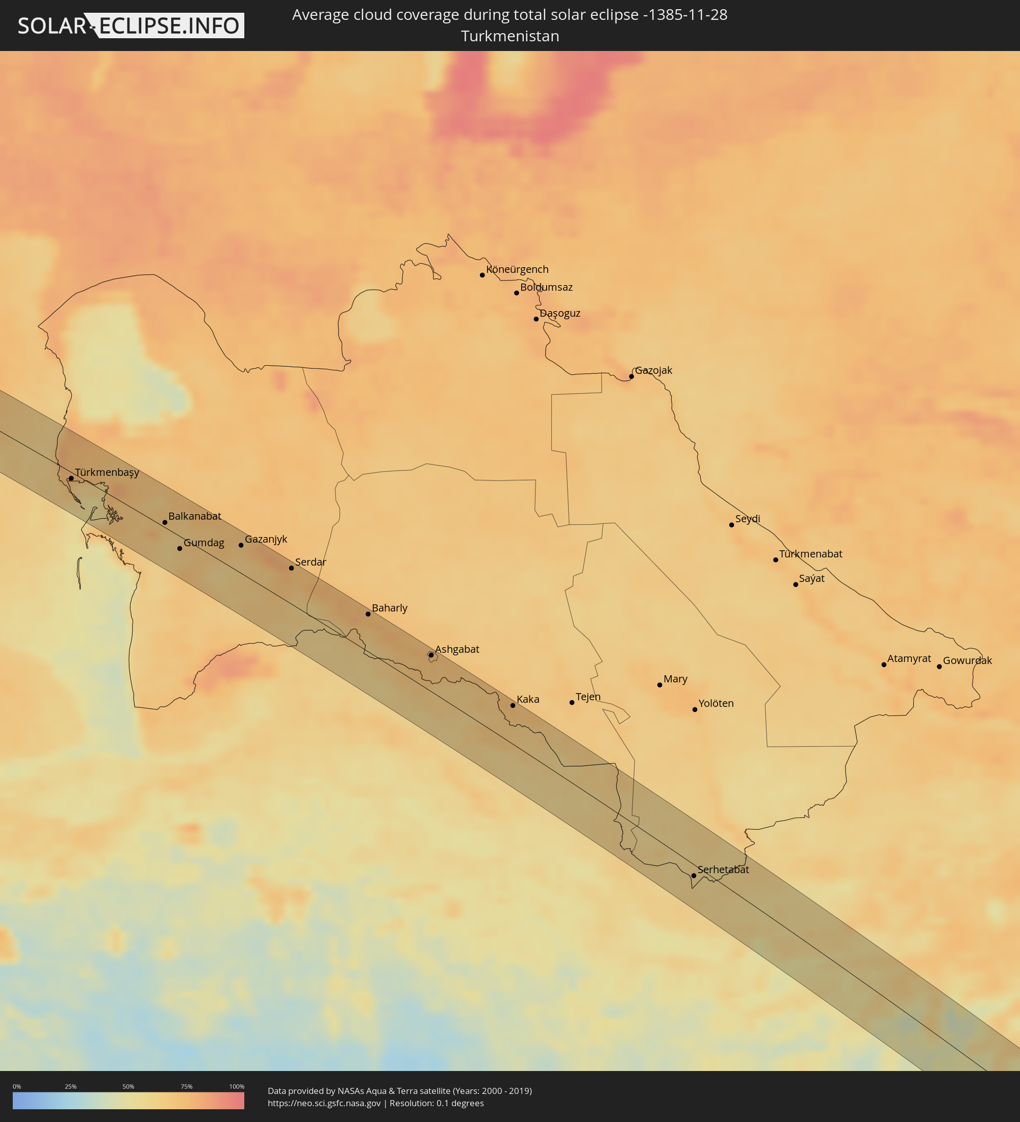 Turkmenistan
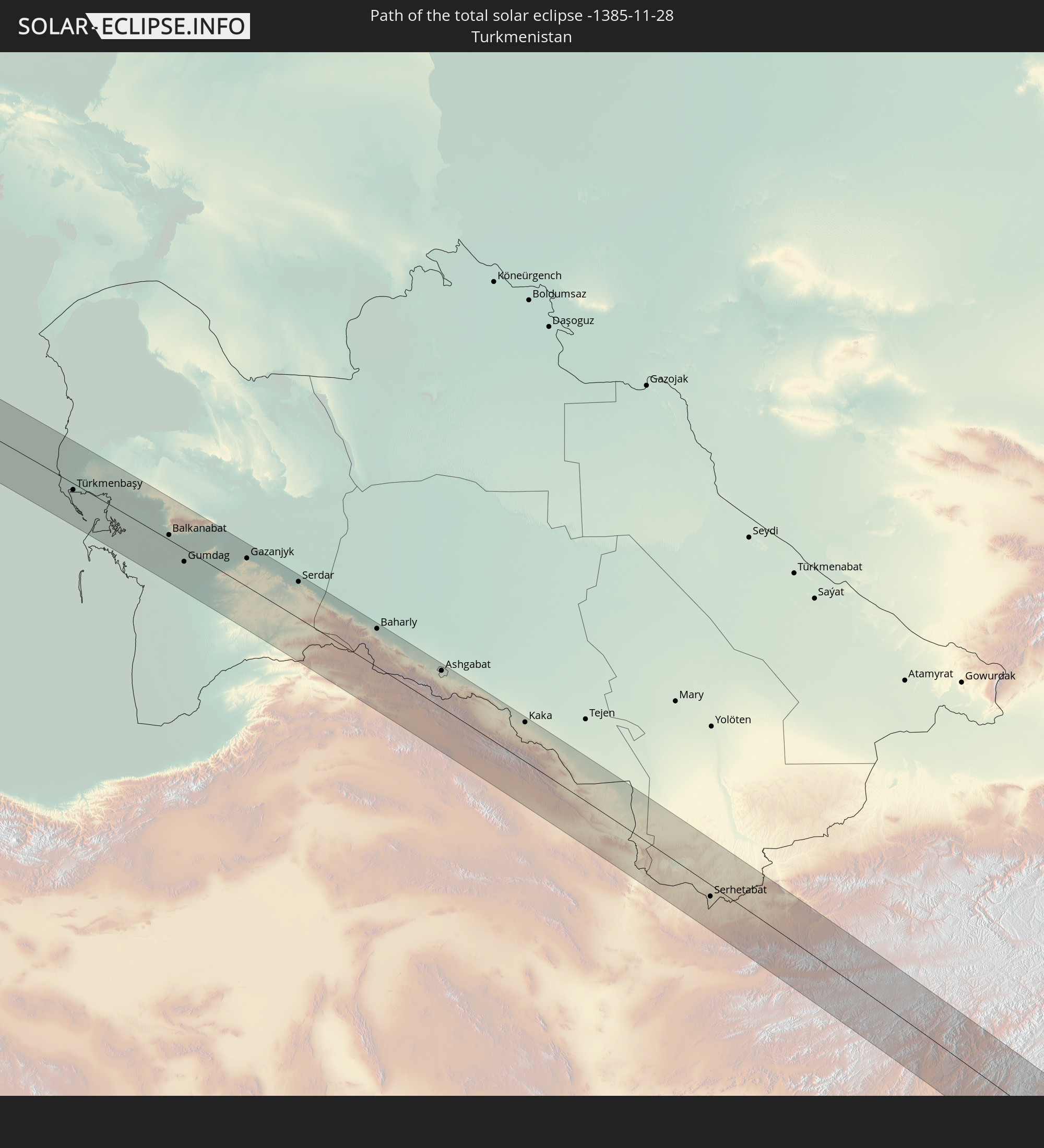
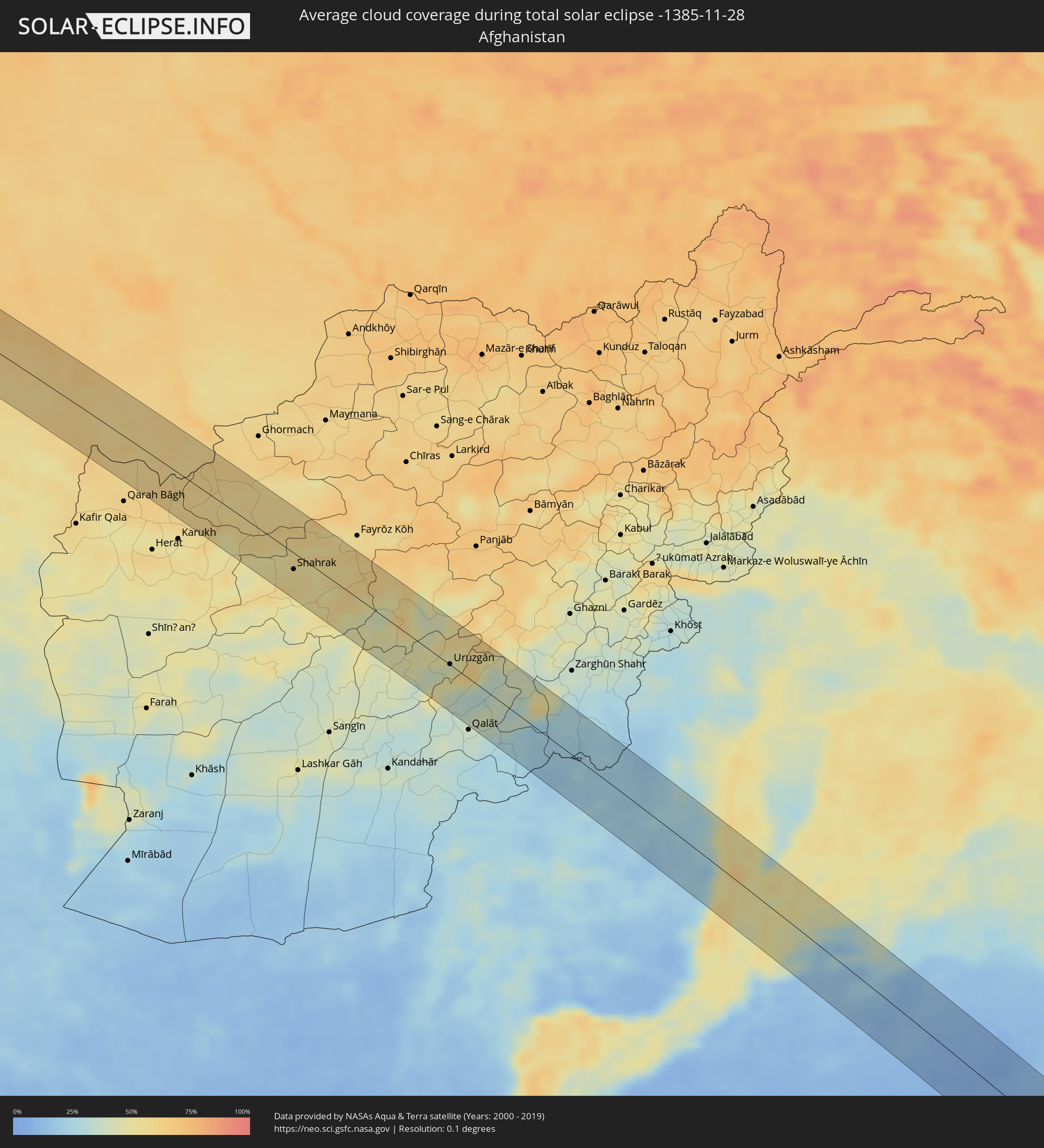 Afghanistan
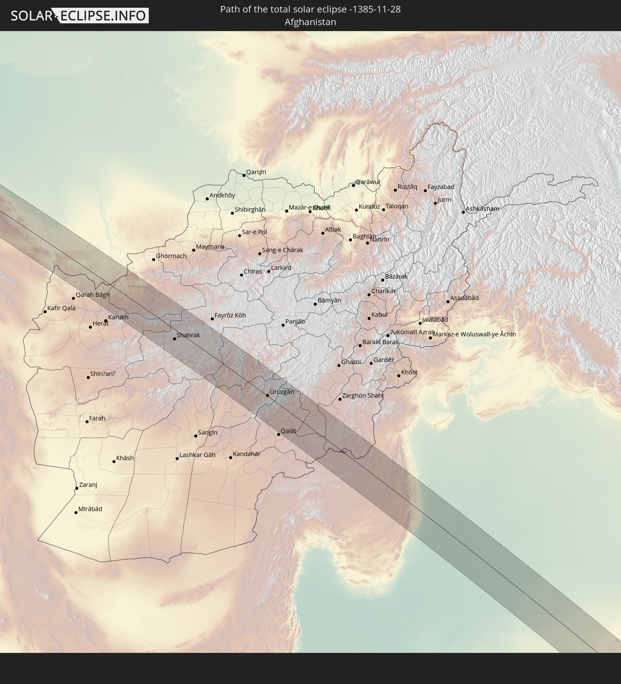
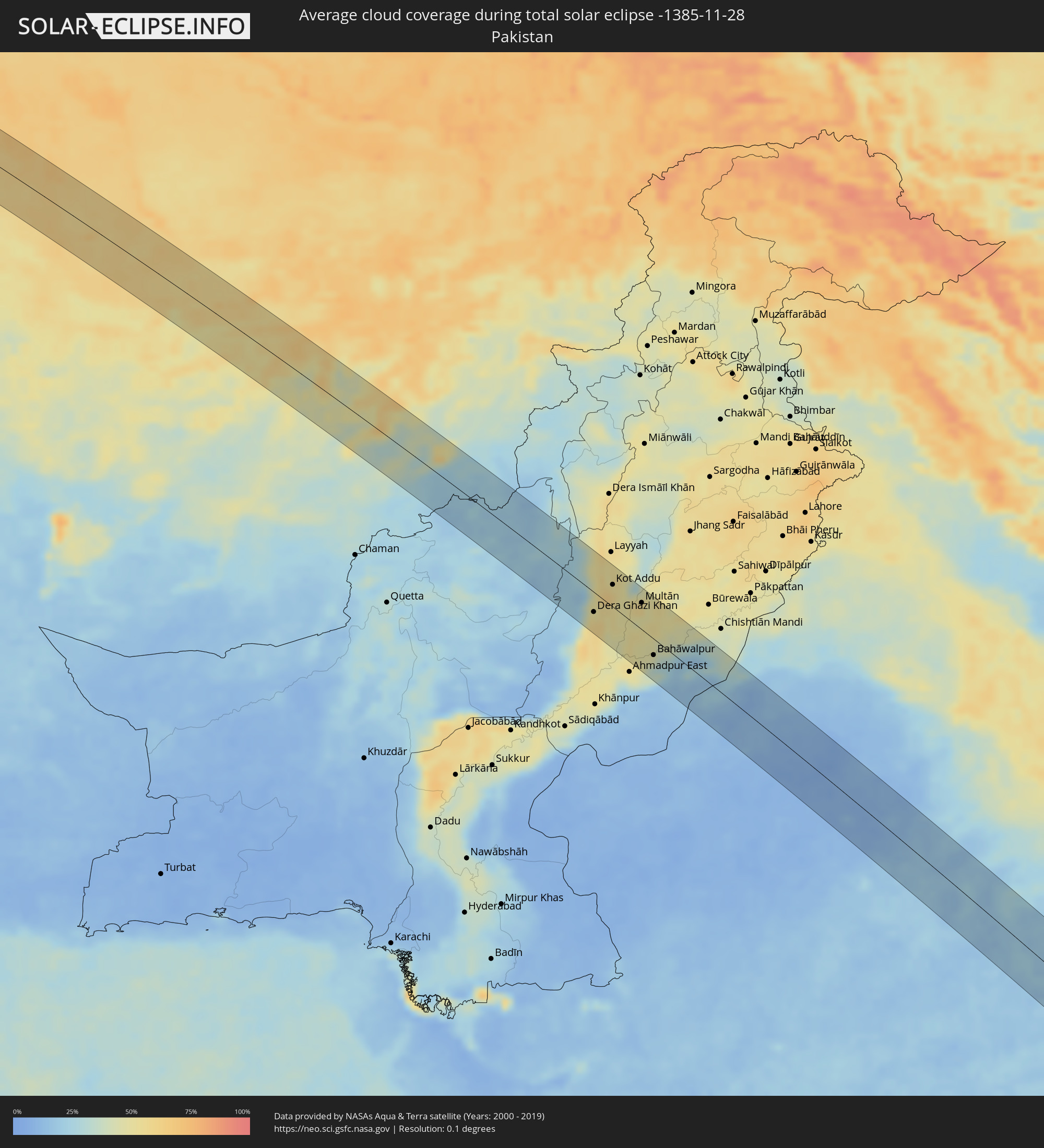 Pakistan
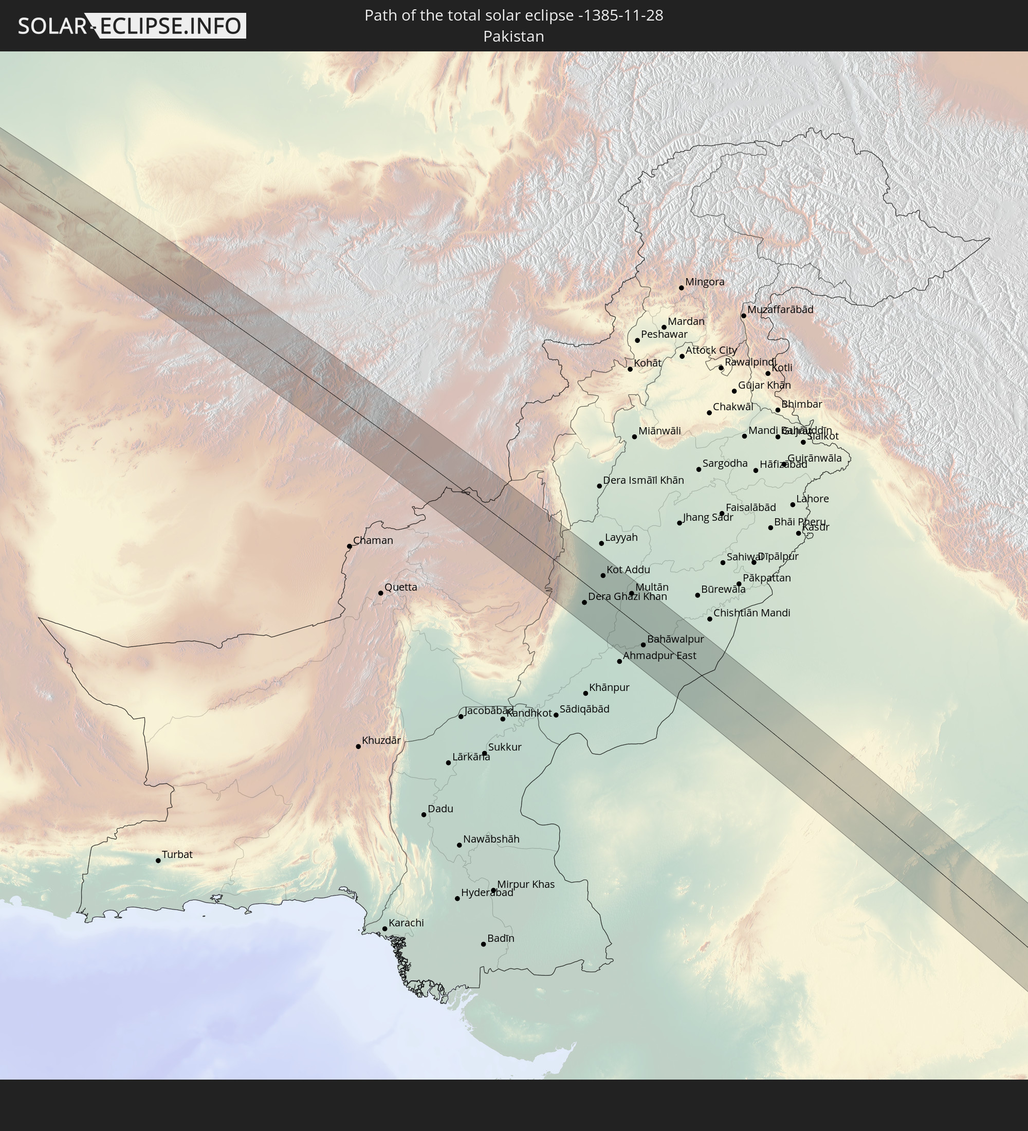
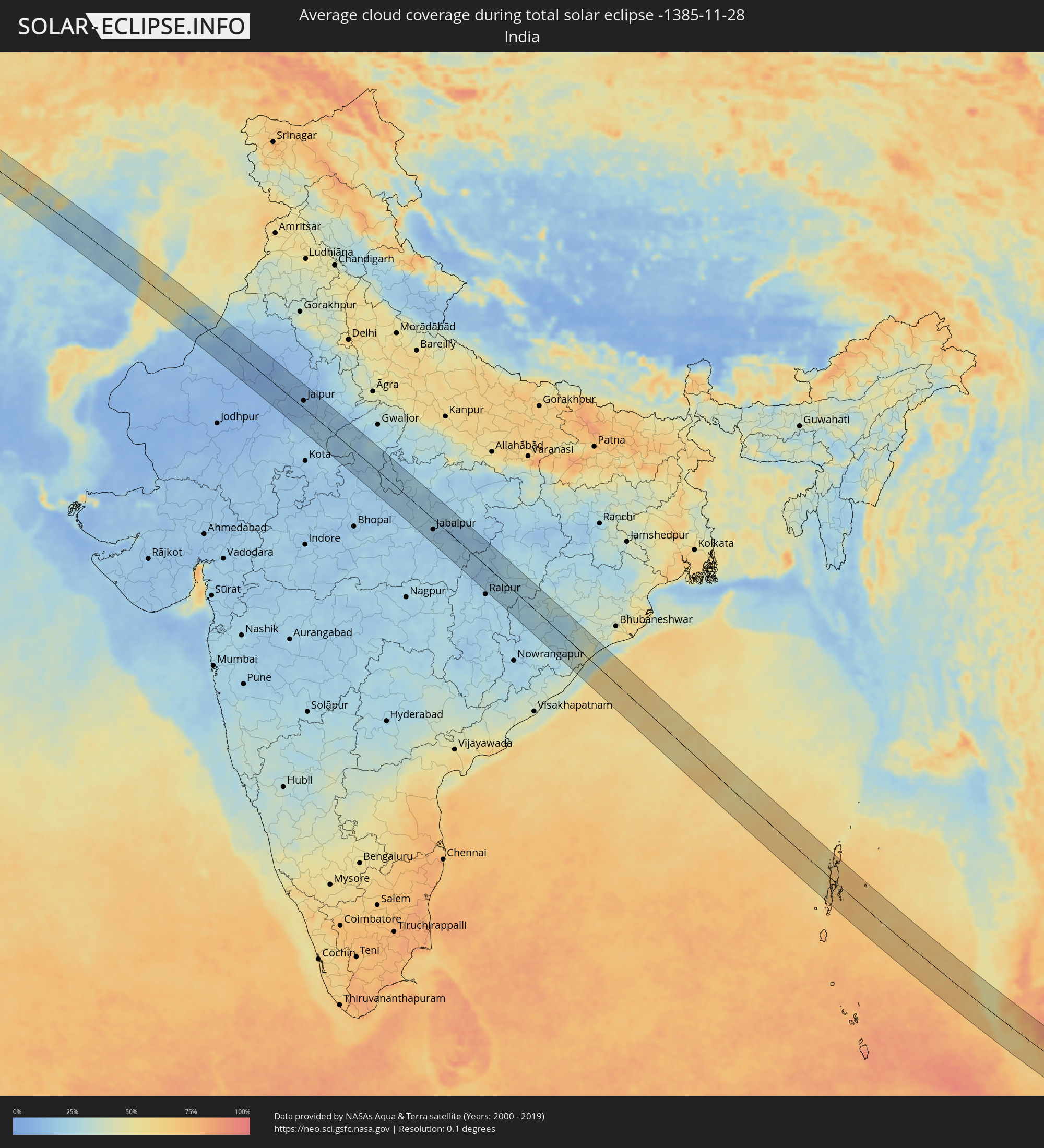 Indien
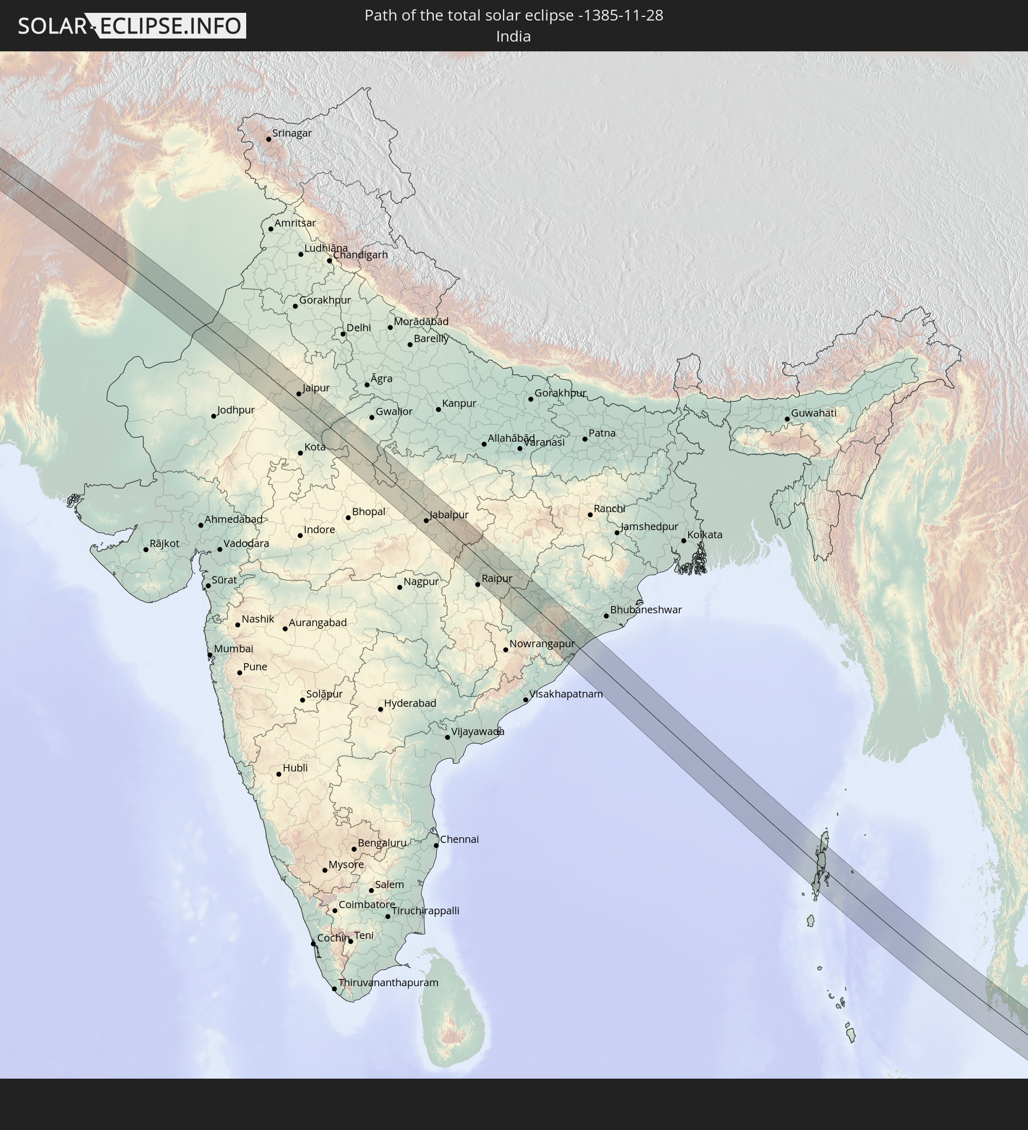
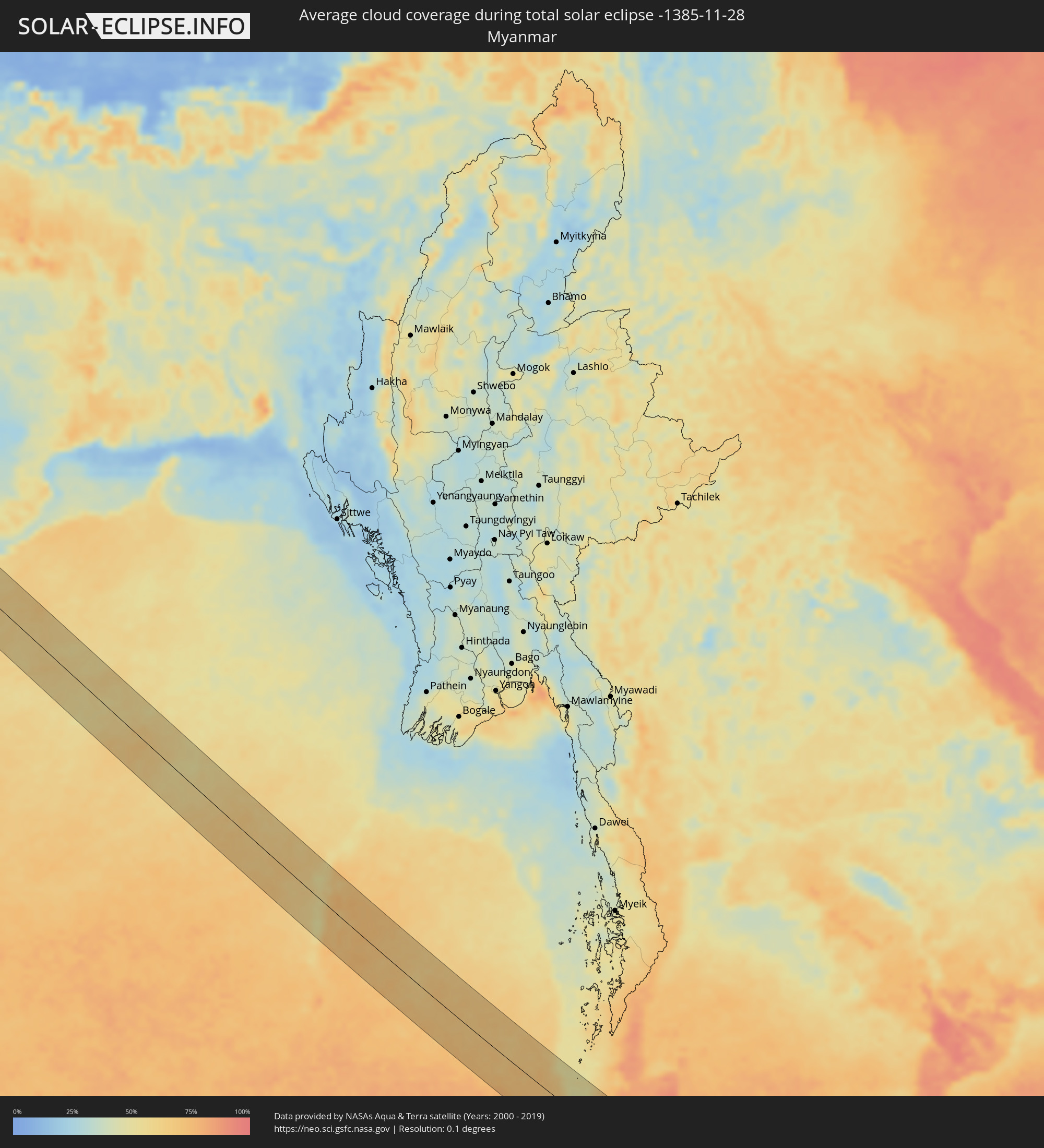 Myanmar
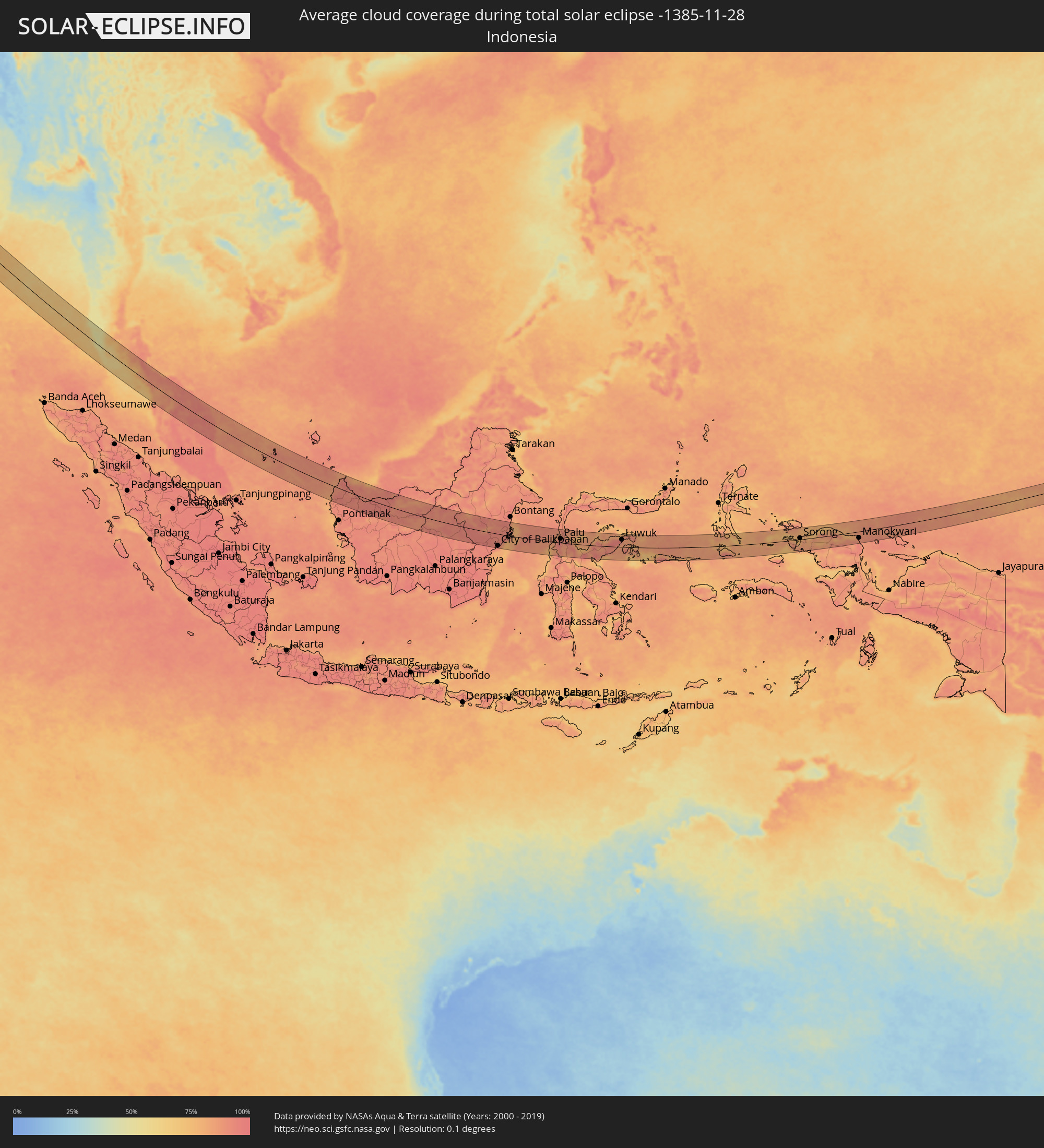 Indonesien
 Thailand
 Malaysia
 Föderierte Staaten von Mikronesien
Orte im Finsternispfad
Die nachfolgene Tabelle zeigt Städte und Orte mit mehr als 5.000 Einwohnern, die sich im Finsternispfad befinden. Städte mit mehr als 100.000 Einwohnern sind dick gekennzeichnet. Mit einem Klick auf den Ort öffnet sich eine Detailkarte die die Lage des jeweiligen Ortes zusammen mit dem Verlauf der zentralen Finsternis präsentiert.
| Ort | Typ | Dauer der Verfinsterung | Ortszeit bei maximaler Verfinsterung | Entfernung zur Zentrallinie | Ø Bewölkung |
|
Achkhoy-Martan, Chechnya
|
total | - | 06:38:25 UTC+02:30 | 3 km | 74% |
|
Urus-Martan, Chechnya
|
total | - | 06:38:26 UTC+02:30 | 3 km | 74% |
|
Groznyy, Chechnya
|
total | - | 06:38:34 UTC+02:30 | 25 km | 80% |
|
Tolstoy-Yurt, Chechnya
|
total | - | 06:38:39 UTC+02:30 | 41 km | 80% |
|
Argun, Chechnya
|
total | - | 06:38:36 UTC+02:30 | 30 km | 79% |
|
Shali, Chechnya
|
total | - | 06:38:31 UTC+02:30 | 16 km | 74% |
|
Kurchaloy, Chechnya
|
total | - | 06:38:35 UTC+02:30 | 28 km | 75% |
|
Alleroy, Chechnya
|
total | - | 06:38:38 UTC+02:30 | 37 km | 73% |
|
Dylym, Dagestan
|
total | - | 06:38:39 UTC+02:30 | 36 km | 70% |
|
Chirkey, Dagestan
|
total | - | 06:38:40 UTC+02:30 | 38 km | 72% |
|
Buynaksk, Dagestan
|
total | - | 06:38:38 UTC+02:30 | 29 km | 66% |
|
Levashi, Dagestan
|
total | - | 06:38:29 UTC+02:30 | 1 km | 62% |
|
Karabudakhkent, Dagestan
|
total | - | 06:38:41 UTC+02:30 | 36 km | 70% |
|
Sergokala, Dagestan
|
total | - | 06:38:35 UTC+02:30 | 14 km | 67% |
|
Izberbash, Dagestan
|
total | - | 06:38:41 UTC+02:30 | 34 km | 70% |
|
Kayakent, Dagestan
|
total | - | 06:38:36 UTC+02:30 | 17 km | 72% |
|
Mamedkala, Dagestan
|
total | - | 06:38:33 UTC+02:30 | 4 km | 73% |
|
Kasumkent, Dagestan
|
total | - | 06:38:20 UTC+02:30 | 43 km | 64% |
|
Derbent, Dagestan
|
total | - | 06:38:33 UTC+02:30 | 1 km | 73% |
|
Belidzhi, Dagestan
|
total | - | 06:38:30 UTC+02:30 | 12 km | 74% |
|
Xudat, Xaçmaz
|
total | - | 07:27:34 UTC+03:19 | 27 km | 74% |
|
Xaçmaz, Xaçmaz
|
total | - | 07:27:32 UTC+03:19 | 38 km | 74% |
|
Türkmenbaşy, Balkan
|
total | - | 08:02:27 UTC+03:53 | 7 km | 65% |
|
Balkanabat, Balkan
|
total | - | 08:02:50 UTC+03:53 | 5 km | 65% |
|
Gumdag, Balkan
|
total | - | 08:02:49 UTC+03:53 | 14 km | 65% |
|
Gazanjyk, Balkan
|
total | - | 08:03:14 UTC+03:53 | 31 km | 64% |
|
Serdar, Balkan
|
total | - | 08:03:30 UTC+03:53 | 40 km | 72% |
|
Baharly, Ahal
|
total | - | 08:03:55 UTC+03:53 | 42 km | 72% |
|
Shīrvān, Khorāsān-e Shomālī
|
total | - | 07:36:06 UTC+03:25 | 33 km | 60% |
|
Abadan, Ahal
|
total | - | 08:04:12 UTC+03:53 | 42 km | 74% |
|
Ashgabat, Ahal
|
total | - | 08:04:17 UTC+03:53 | 41 km | 73% |
|
Qūchān, Razavi Khorasan
|
total | - | 07:36:21 UTC+03:25 | 33 km | 59% |
|
Annau, Ahal
|
total | - | 08:04:20 UTC+03:53 | 41 km | 69% |
|
Chenārān, Razavi Khorasan
|
total | - | 07:36:36 UTC+03:25 | 46 km | 57% |
|
Kaka, Ahal
|
total | - | 08:04:49 UTC+03:53 | 43 km | 68% |
|
Sarakhs, Razavi Khorasan
|
total | - | 07:37:47 UTC+03:25 | 44 km | 64% |
|
Serhetabat, Mary
|
total | - | 08:06:11 UTC+03:53 | 13 km | 60% |
|
Qala i Naw, Badghis
|
total | - | 08:13:10 UTC+04:00 | 1 km | 57% |
|
Shahrak, Ghowr
|
total | - | 08:13:57 UTC+04:00 | 18 km | 55% |
|
Nīlī, Daykundi
|
total | - | 08:15:21 UTC+04:00 | 45 km | 47% |
|
Uruzgān, Oruzgan
|
total | - | 08:15:46 UTC+04:00 | 1 km | 48% |
|
Zhob, Balochistān
|
total | - | 08:46:36 UTC+04:28 | 18 km | 18% |
|
Dera Ghazi Khan, Punjab
|
total | - | 08:47:59 UTC+04:28 | 26 km | 51% |
|
Taunsa, Punjab
|
total | - | 08:47:52 UTC+04:28 | 31 km | 51% |
|
Kot Addu, Punjab
|
total | - | 08:48:13 UTC+04:28 | 29 km | 53% |
|
Shahr Sultān, Punjab
|
total | - | 08:48:30 UTC+04:28 | 46 km | 46% |
|
Khāngarh, Punjab
|
total | - | 08:48:33 UTC+04:28 | 7 km | 50% |
|
Muzaffargarh, Punjab
|
total | - | 08:48:32 UTC+04:28 | 8 km | 48% |
|
Jalālpur Pīrwāla, Punjab
|
total | - | 08:48:43 UTC+04:28 | 40 km | 49% |
|
Shujāābād, Punjab
|
total | - | 08:48:41 UTC+04:28 | 3 km | 50% |
|
Multān, Punjab
|
total | - | 08:48:48 UTC+04:28 | 36 km | 55% |
|
Lodhrān, Punjab
|
total | - | 08:49:07 UTC+04:28 | 12 km | 47% |
|
Qādirpur Rān, Punjab
|
total | - | 08:48:58 UTC+04:28 | 56 km | 49% |
|
Bahāwalpur, Punjab
|
total | - | 08:49:13 UTC+04:28 | 22 km | 40% |
|
Dunyāpur, Punjab
|
total | - | 08:49:09 UTC+04:28 | 16 km | 52% |
|
Yazman, Punjab
|
total | - | 08:49:22 UTC+04:28 | 42 km | 36% |
|
Dhanot, Punjab
|
total | - | 08:49:14 UTC+04:28 | 2 km | 41% |
|
Kohror Pakka, Punjab
|
total | - | 08:49:24 UTC+04:28 | 12 km | 43% |
|
Mailsi, Punjab
|
total | - | 08:49:37 UTC+04:28 | 43 km | 45% |
|
Khairpur, Punjab
|
total | - | 08:49:44 UTC+04:28 | 27 km | 32% |
|
Fort Abbās, Punjab
|
total | - | 08:50:30 UTC+04:28 | 31 km | 28% |
|
Bīkaner, Rajasthan
|
total | - | 09:44:22 UTC+05:21 | 43 km | 11% |
|
Sūjāngarh, Rajasthan
|
total | - | 09:45:48 UTC+05:21 | 2 km | 7% |
|
Makrāna, Rajasthan
|
total | - | 09:46:22 UTC+05:21 | 39 km | 9% |
|
Fatehpur, Rajasthan
|
total | - | 09:46:15 UTC+05:21 | 58 km | 7% |
|
Sīkar, Rajasthan
|
total | - | 09:46:37 UTC+05:21 | 36 km | 10% |
|
Jaipur, Rajasthan
|
total | - | 09:47:42 UTC+05:21 | 18 km | 13% |
|
Tonk, Rajasthan
|
total | - | 09:48:03 UTC+05:21 | 46 km | 18% |
|
Sawāi Mādhopur, Rajasthan
|
total | - | 09:48:49 UTC+05:21 | 23 km | 18% |
|
Gangāpur, Rajasthan
|
total | - | 09:49:03 UTC+05:21 | 39 km | 19% |
|
Shivpuri, Madhya Pradesh
|
total | - | 09:50:49 UTC+05:21 | 12 km | 18% |
|
Lalitpur, Uttar Pradesh
|
total | - | 09:52:15 UTC+05:21 | 0 km | 19% |
|
Saugor, Madhya Pradesh
|
total | - | 09:53:14 UTC+05:21 | 51 km | 17% |
|
Tīkamgarh, Madhya Pradesh
|
total | - | 09:52:47 UTC+05:21 | 31 km | 19% |
|
Damoh, Madhya Pradesh
|
total | - | 09:54:13 UTC+05:21 | 4 km | 20% |
|
Jabalpur, Madhya Pradesh
|
total | - | 09:55:24 UTC+05:21 | 26 km | 17% |
|
Murwāra, Madhya Pradesh
|
total | - | 09:55:34 UTC+05:21 | 60 km | 20% |
|
Bilāspur, Chhattisgarh
|
total | - | 09:59:30 UTC+05:21 | 34 km | 23% |
|
Balāngīr, Odisha
|
total | - | 10:02:47 UTC+05:21 | 13 km | 28% |
|
Brahmapur, Odisha
|
total | - | 10:06:15 UTC+05:21 | 10 km | 43% |
|
Port Blair, Andaman and Nicobar Islands
|
total | - | 10:30:59 UTC+05:21 | 69 km | 70% |
|
Patong, Phuket
|
total | - | 12:10:28 UTC+06:42 | 7 km | 68% |
|
Rawai, Phuket
|
total | - | 12:10:42 UTC+06:42 | 15 km | 64% |
|
Ban Chalong, Phuket
|
total | - | 12:10:39 UTC+06:42 | 8 km | 64% |
|
Ban Talat Nua, Phuket
|
total | - | 12:10:42 UTC+06:42 | 2 km | 67% |
|
Ban Ko Kaeo, Phuket
|
total | - | 12:10:39 UTC+06:42 | 4 km | 67% |
|
Phuket, Phuket
|
total | - | 12:10:43 UTC+06:42 | 0 km | 67% |
|
Phang Nga, Phangnga
|
total | - | 12:10:12 UTC+06:42 | 58 km | 72% |
|
Krabi, Krabi
|
total | - | 12:11:43 UTC+06:42 | 50 km | 78% |
|
Nuea Khlong, Krabi
|
total | - | 12:11:57 UTC+06:42 | 56 km | 78% |
|
Kantang, Trang
|
total | - | 12:14:16 UTC+06:42 | 30 km | 78% |
|
Trang, Trang
|
total | - | 12:14:17 UTC+06:42 | 50 km | 86% |
|
Huai Yot, Trang
|
total | - | 12:13:59 UTC+06:42 | 72 km | 88% |
|
Kuah, Kedah
|
total | - | 12:30:07 UTC+06:55 | 46 km | 71% |
|
Satun, Satun
|
total | - | 12:16:52 UTC+06:42 | 5 km | 80% |
|
Kangar, Perlis
|
total | - | 12:30:50 UTC+06:55 | 13 km | 77% |
|
Kuala Kedah, Kedah
|
total | - | 12:31:38 UTC+06:55 | 37 km | 76% |
|
Alor Setar, Kedah
|
total | - | 12:31:45 UTC+06:55 | 32 km | 81% |
|
Jitra, Kedah
|
total | - | 12:31:41 UTC+06:55 | 14 km | 86% |
|
Sadao, Songkhla
|
total | - | 12:17:46 UTC+06:42 | 20 km | 89% |
|
Hat Yai, Songkhla
|
total | - | 12:17:20 UTC+06:42 | 57 km | 91% |
|
Sungai Petani, Kedah
|
total | - | 12:32:48 UTC+06:55 | 67 km | 87% |
|
Bedong, Kedah
|
total | - | 12:32:44 UTC+06:55 | 58 km | 85% |
|
Betong, Yala
|
total | - | 12:20:46 UTC+06:42 | 19 km | 86% |
|
Yala, Yala
|
total | - | 12:20:08 UTC+06:42 | 65 km | 91% |
|
Ra-ngae, Narathiwat
|
total | - | 12:21:40 UTC+06:42 | 70 km | 92% |
|
Ban Su-ngai Pa Di, Narathiwat
|
total | - | 12:22:23 UTC+06:42 | 58 km | 94% |
|
Gua Musang, Kelantan
|
total | - | 12:37:49 UTC+06:55 | 47 km | 92% |
|
Su-ngai Kolok, Narathiwat
|
total | - | 12:22:42 UTC+06:42 | 60 km | 92% |
|
Pasir Mas, Kelantan
|
total | - | 12:36:29 UTC+06:55 | 72 km | 92% |
|
Tanah Merah, Kelantan
|
total | - | 12:36:53 UTC+06:55 | 50 km | 92% |
|
Kampong Pangkal Kalong, Kelantan
|
total | - | 12:36:53 UTC+06:55 | 65 km | 92% |
|
Kampong Kadok, Kelantan
|
total | - | 12:36:50 UTC+06:55 | 75 km | 94% |
|
Kuala Terengganu, Terengganu
|
total | - | 12:40:13 UTC+06:55 | 65 km | 92% |
|
Marang, Terengganu
|
total | - | 12:40:35 UTC+06:55 | 57 km | 89% |
|
Kuantan, Pahang
|
total | - | 12:43:01 UTC+06:55 | 69 km | 91% |
|
Cukai, Terengganu
|
total | - | 12:42:35 UTC+06:55 | 21 km | 93% |
|
Paka, Terengganu
|
total | - | 12:42:03 UTC+06:55 | 17 km | 91% |
|
Kertih, Terengganu
|
total | - | 12:42:16 UTC+06:55 | 6 km | 90% |
|
Pemangkat, West Kalimantan
|
total | - | 13:13:34 UTC+07:07 | 49 km | 90% |
|
Singkawang, West Kalimantan
|
total | - | 13:13:58 UTC+07:07 | 75 km | 91% |
|
Kuching, Sarawak
|
total | - | 13:30:46 UTC+07:21 | 46 km | 93% |
|
Simanggang, Sarawak
|
total | - | 13:34:06 UTC+07:21 | 56 km | 93% |
|
Balikpapan, East Kalimantan
|
total | - | 14:26:40 UTC+07:57 | 66 km | 86% |
|
City of Balikpapan, East Kalimantan
|
total | - | 14:26:47 UTC+07:57 | 62 km | 91% |
|
Loa Janan, East Kalimantan
|
total | - | 14:26:33 UTC+07:57 | 14 km | 94% |
|
Samarinda, East Kalimantan
|
total | - | 14:26:34 UTC+07:57 | 25 km | 92% |
|
Palu, Central Sulawesi
|
total | - | 14:33:11 UTC+07:57 | 20 km | 93% |
|
Poso, Central Sulawesi
|
total | - | 14:35:33 UTC+07:57 | 25 km | 79% |
|
Luwuk, Central Sulawesi
|
total | - | 14:39:23 UTC+07:57 | 38 km | 85% |
|
Sorong, West Papua
|
total | - | 16:19:24 UTC+09:22 | 7 km | 80% |
|
Manokwari, West Papua
|
total | - | 16:23:18 UTC+09:22 | 33 km | 88% |