Totale Sonnenfinsternis vom 11.06.-1459
| Wochentag: | Freitag |
| Maximale Dauer der Verfinsterung: | 04m34s |
| Maximale Breite des Finsternispfades: | 244 km |
| Saroszyklus: | 33 |
| Bedeckungsgrad: | 100% |
| Magnitude: | 1.0638 |
| Gamma: | 0.5183 |
Wo kann man die Sonnenfinsternis vom 11.06.-1459 sehen?
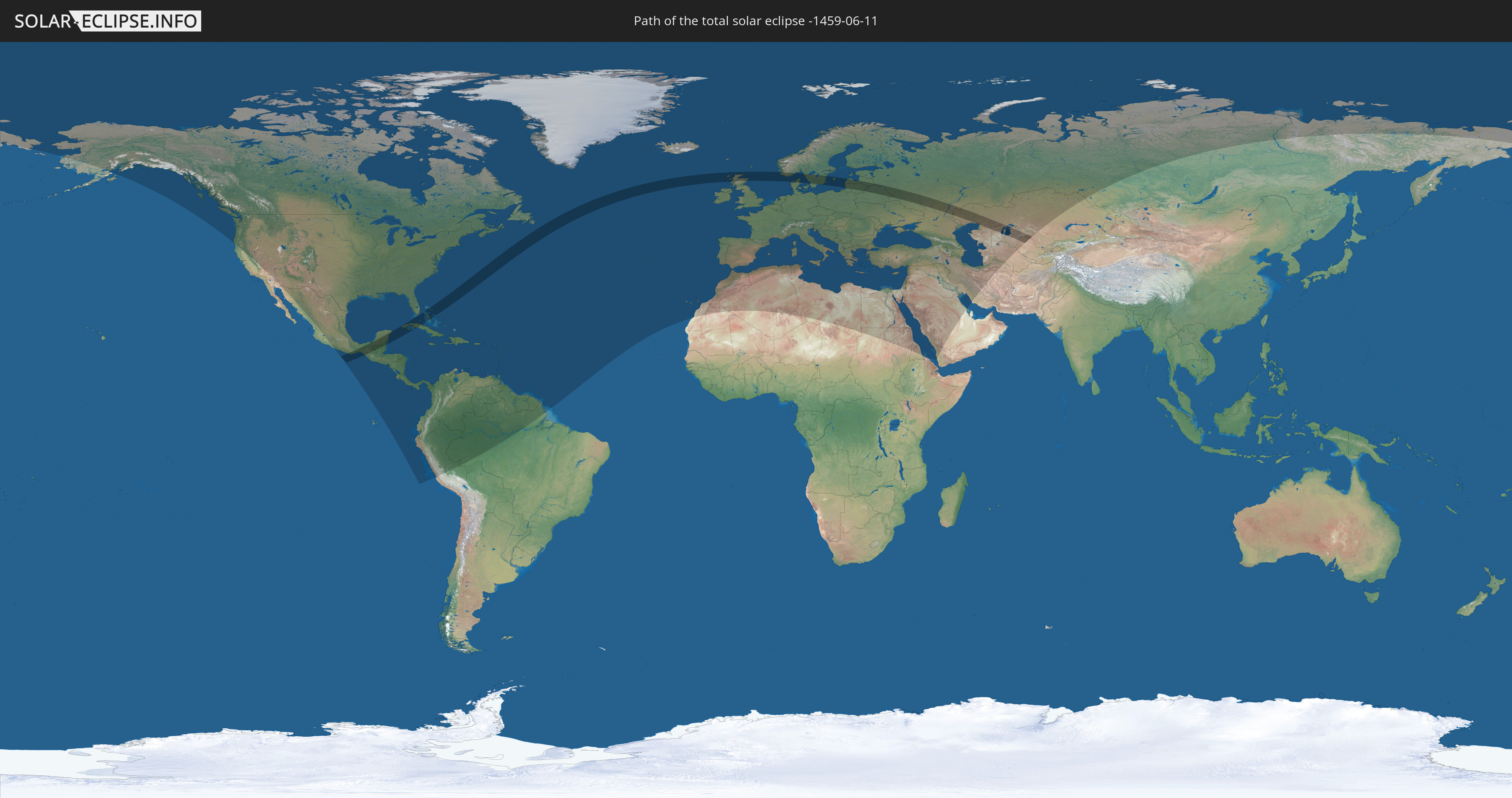
Die Sonnenfinsternis am 11.06.-1459 kann man in 124 Ländern als partielle Sonnenfinsternis beobachten.
Der Finsternispfad verläuft durch 15 Länder. Nur in diesen Ländern ist sie als totale Sonnenfinsternis zu sehen.
In den folgenden Ländern ist die Sonnenfinsternis total zu sehen
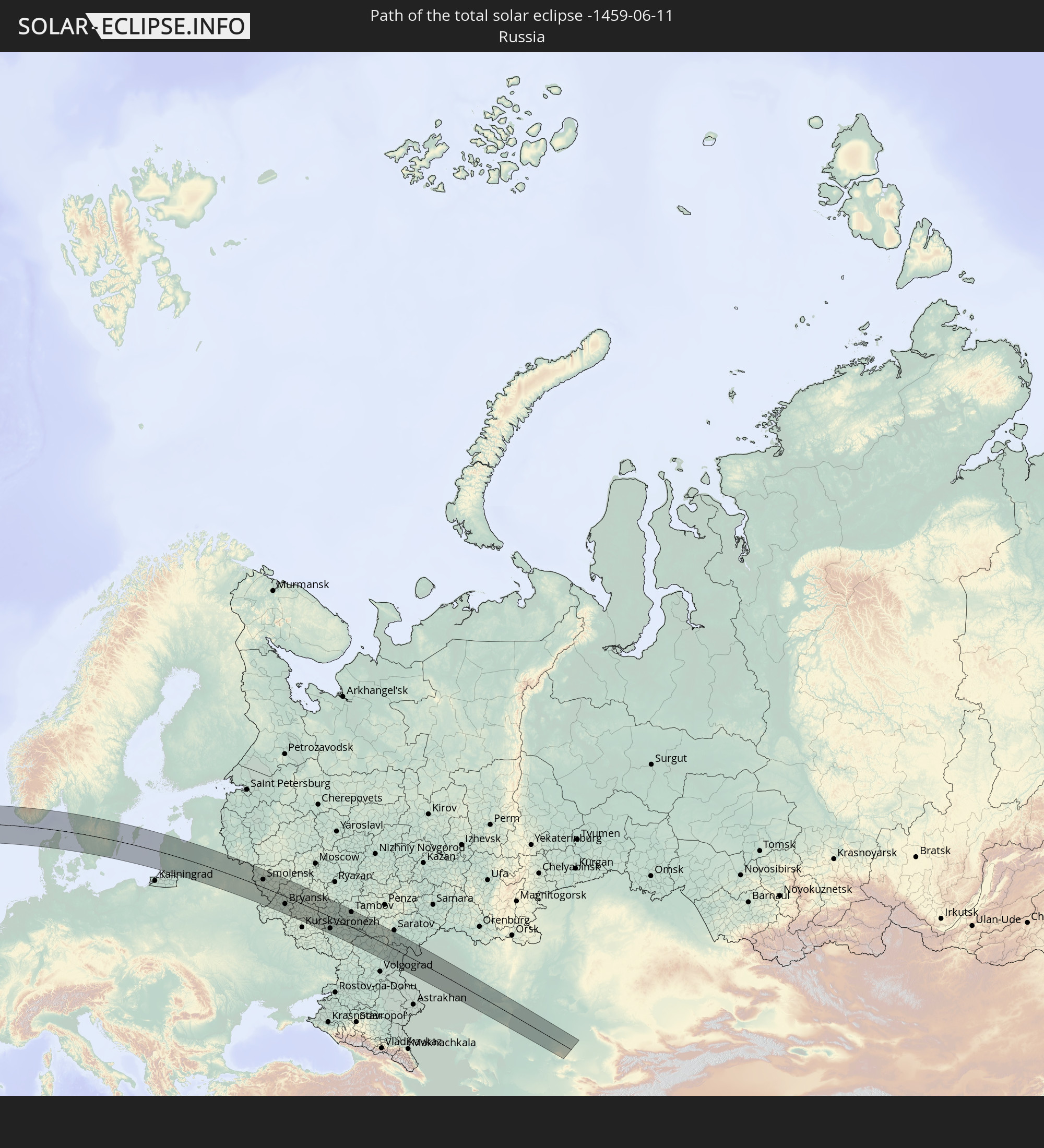 Russland
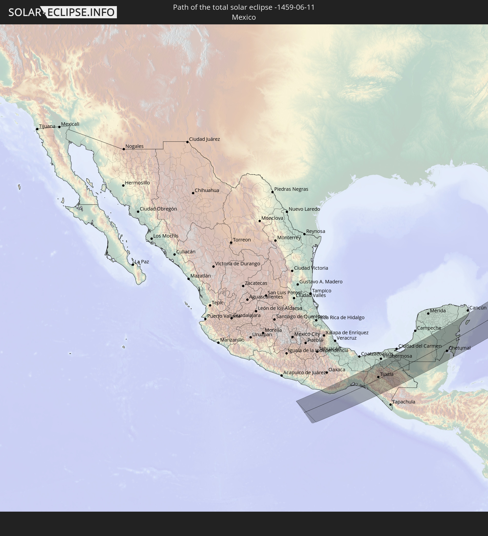 Mexiko
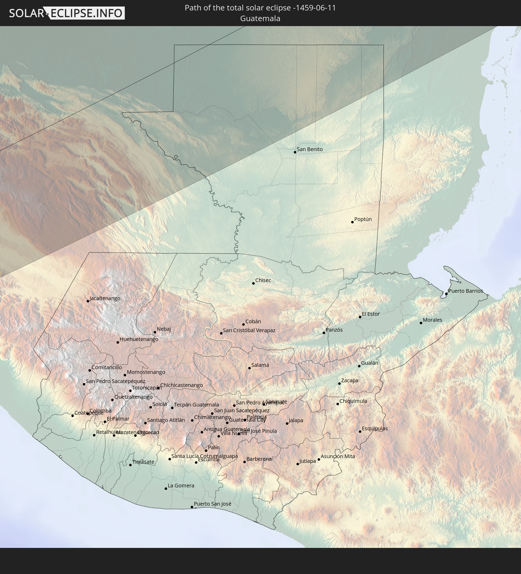 Guatemala
 Belize
 Kuba
Kuba
 Bahamas
 Vereinigtes Königreich
 Norwegen
 Dänemark
 Schweden
 Litauen
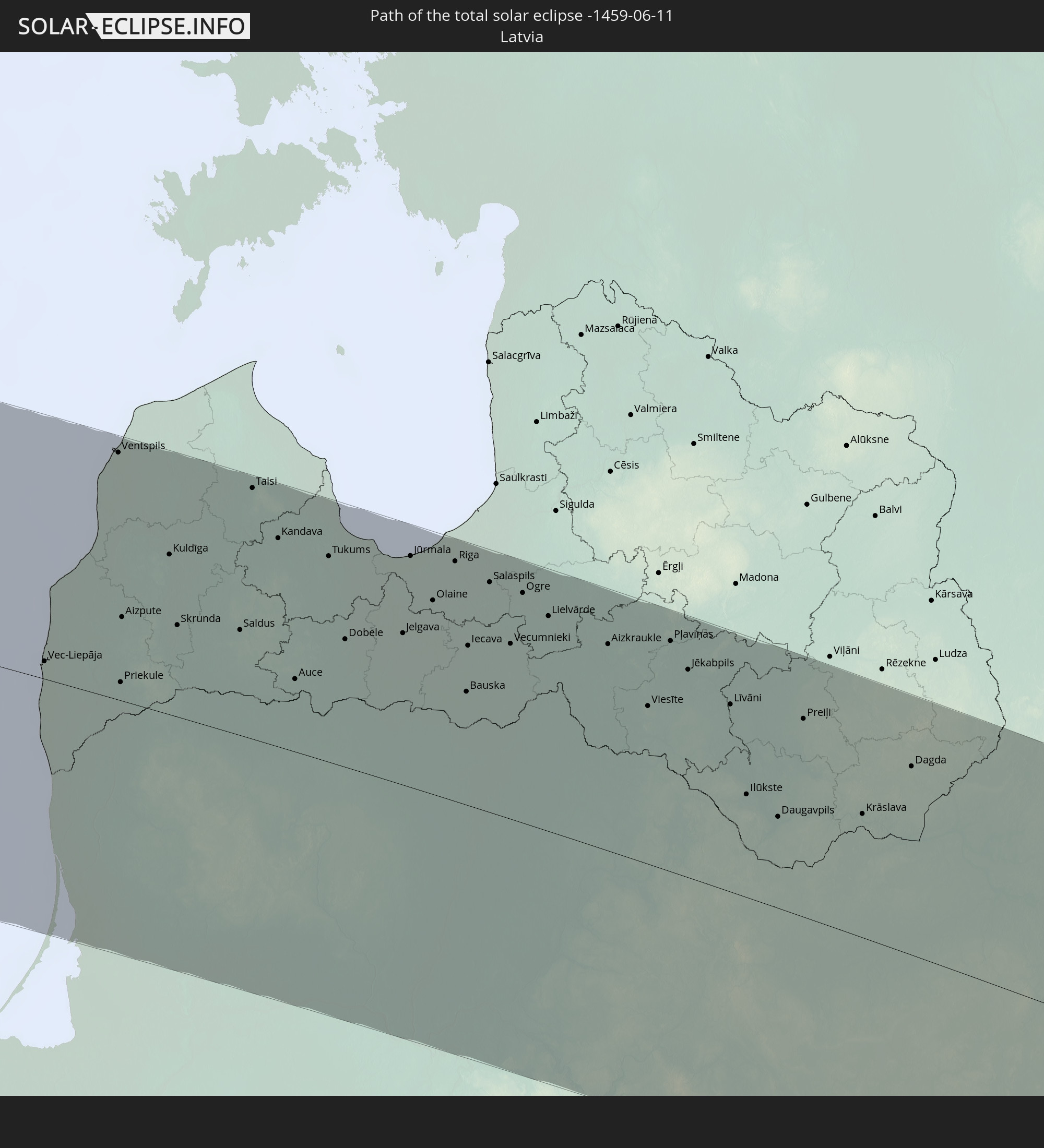 Lettland
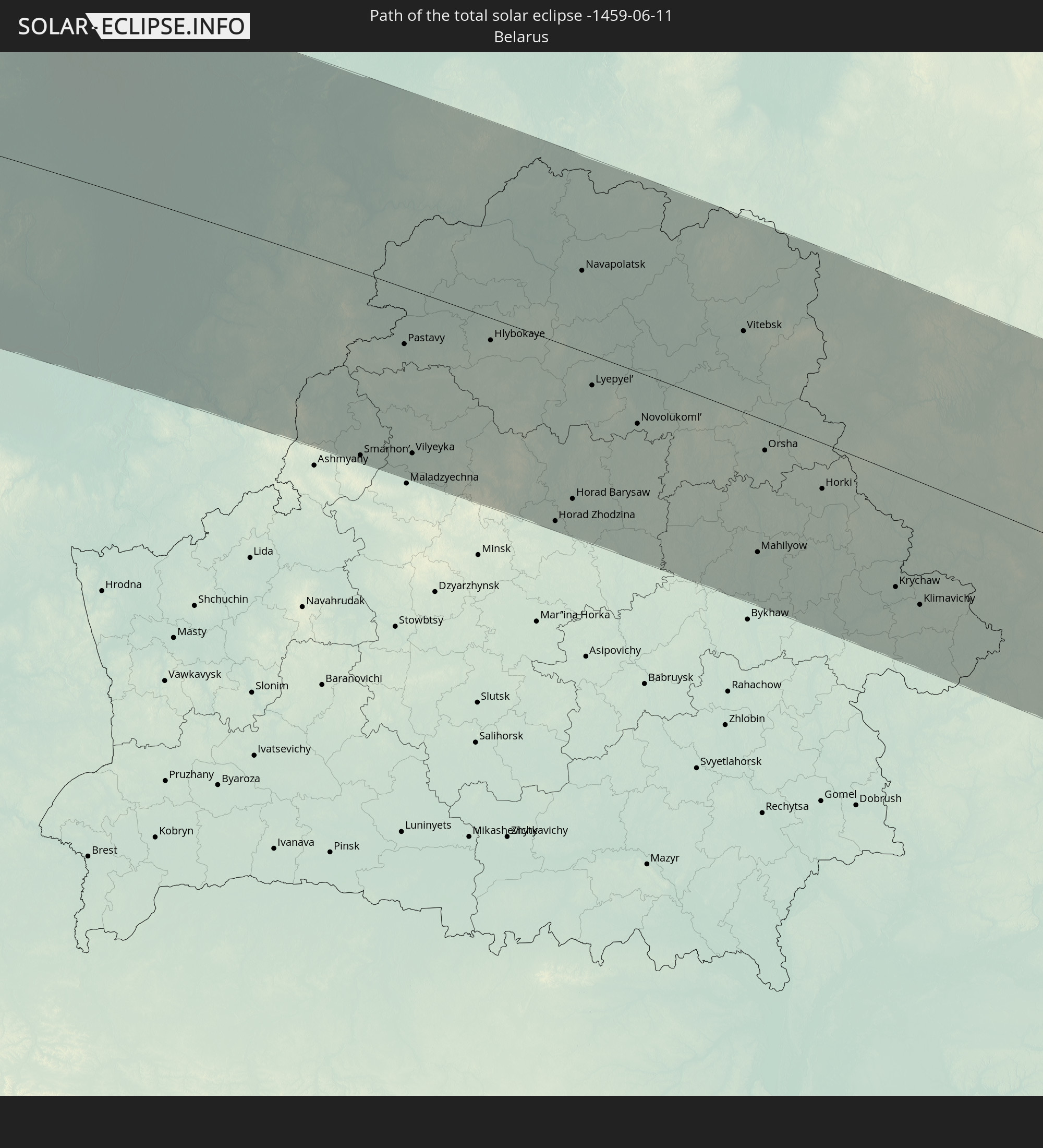 Weißrussland
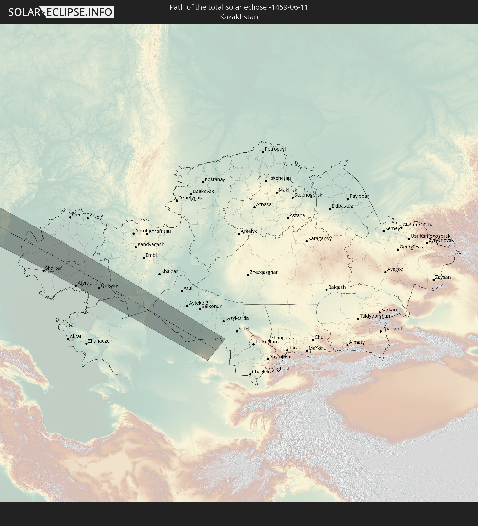 Kasachstan
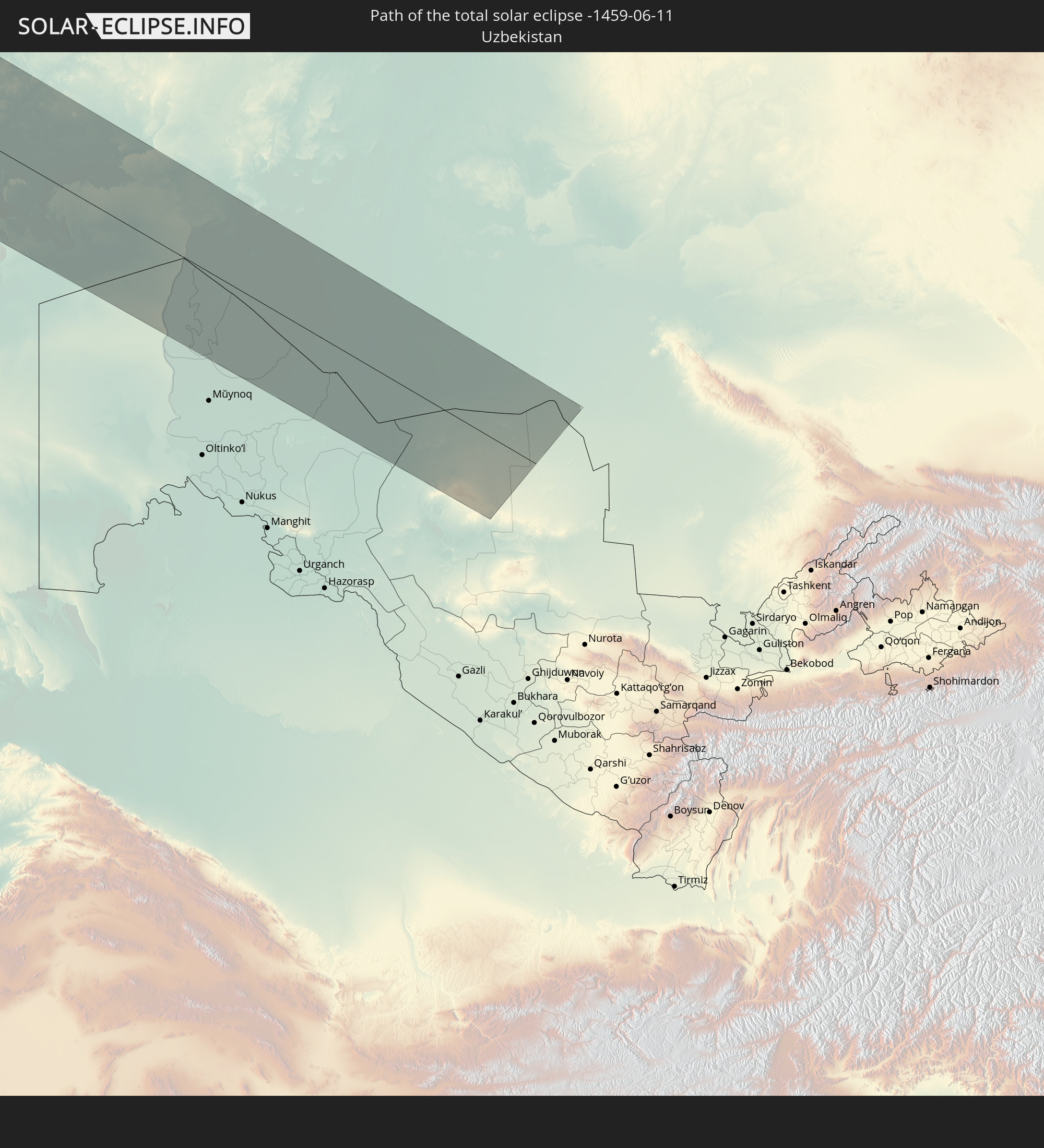 Usbekistan
In den folgenden Ländern ist die Sonnenfinsternis partiell zu sehen
 Russland
 Vereinigte Staaten
 United States Minor Outlying Islands
 Kanada
 Mexiko
 Grönland
 Guatemala
 Ecuador
 El Salvador
 Honduras
 Belize
 Nicaragua
 Costa Rica
 Kuba
Kuba
 Panama
 Kolumbien
 Kaimaninseln
 Peru
Peru
 Bahamas
 Jamaika
 Haiti
Haiti
 Brasilien
 Venezuela
 Turks- und Caicosinseln
 Dominikanische Republik
 Aruba
Aruba
 Puerto Rico
 Amerikanische Jungferninseln
 Bermuda
 Britische Jungferninseln
 Anguilla
 Saint-Martin
 Saint-Barthélemy
 St. Kitts und Nevis
 Antigua und Barbuda
 Montserrat
 Trinidad und Tobago
 Guadeloupe
 Grenada
 Dominica
 St. Vincent und die Grenadinen
 Guyana
 Martinique
 St. Lucia
 Barbados
 Suriname
 Saint-Pierre und Miquelon
 Französisch-Guayana
 Portugal
 Island
 Spanien
 Mauretanien
 Marokko
 Irland
 Spitzbergen
 Algerien
 Vereinigtes Königreich
 Färöer
 Gibraltar
 Frankreich
 Isle of Man
 Guernsey
 Jersey
 Andorra
 Belgien
 Niederlande
 Norwegen
 Luxemburg
 Deutschland
 Schweiz
 Italien
 Monaco
 Tunesien
 Dänemark
 Libyen
 Liechtenstein
 Österreich
 Schweden
 Tschechien
 San Marino
 Vatikanstadt
 Slowenien
 Kroatien
 Polen
Polen
 Malta
Malta
 Bosnien und Herzegowina
 Ungarn
 Slowakei
 Montenegro
 Serbien
 Albanien
 Åland Islands
 Griechenland
 Rumänien
 Mazedonien
 Finnland
 Litauen
 Lettland
 Estland
 Sudan
Sudan
 Ukraine
 Bulgarien
 Weißrussland
 Ägypten
 Türkei
 Moldawien
 Republik Zypern
 Staat Palästina
 Israel
 Saudi-Arabien
 Jordanien
 Libanon
 Syrien
 Eritrea
 Irak
Irak
 Georgien
 Jemen
Jemen
 Armenien
 Iran
Iran
 Aserbaidschan
 Kasachstan
 Kuwait
 Turkmenistan
 Usbekistan
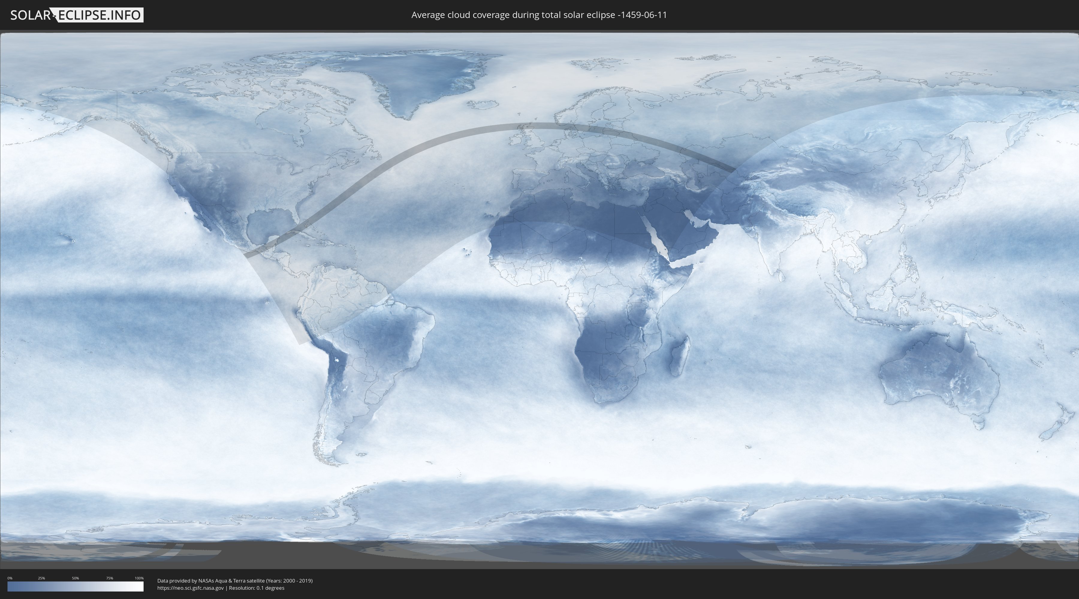
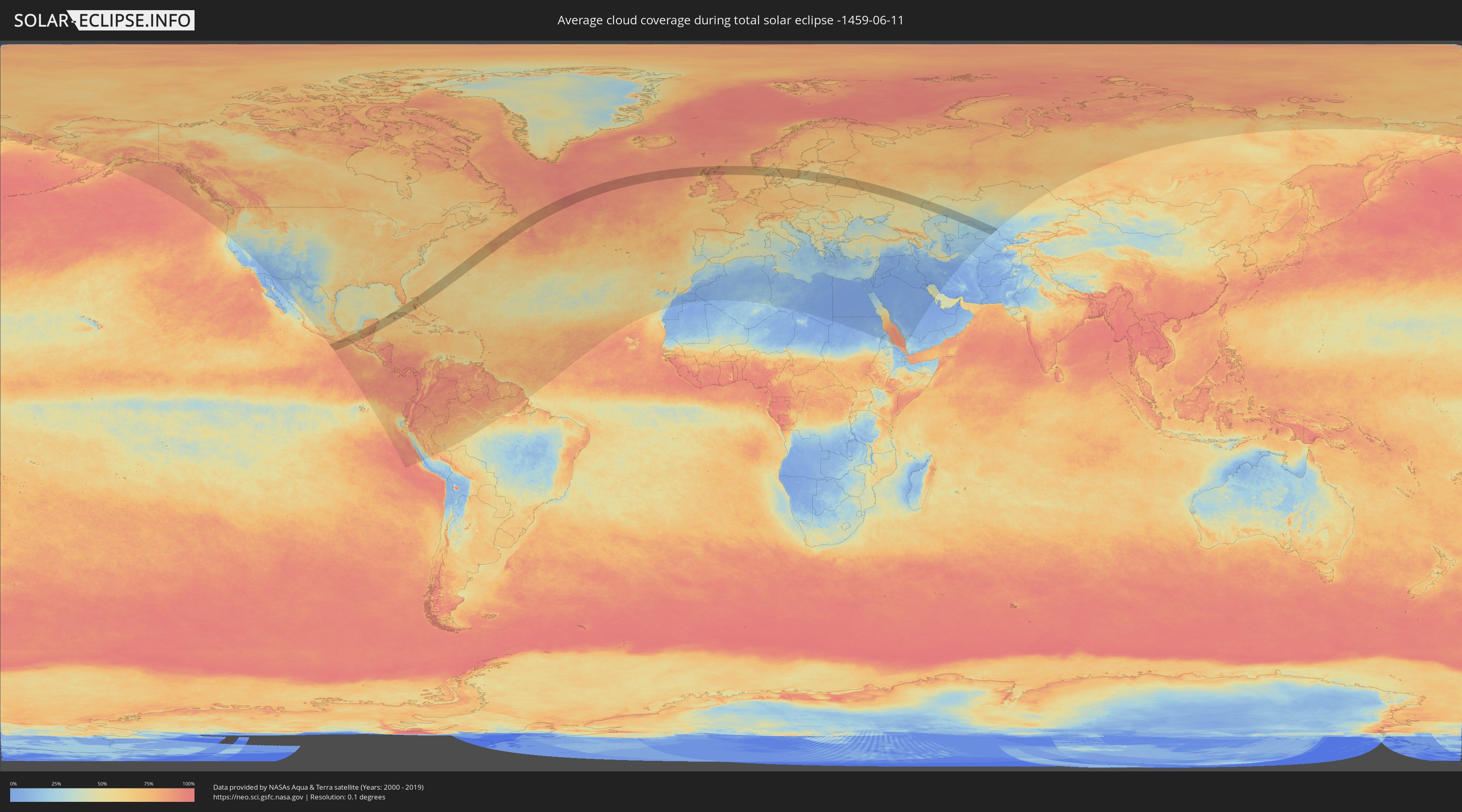
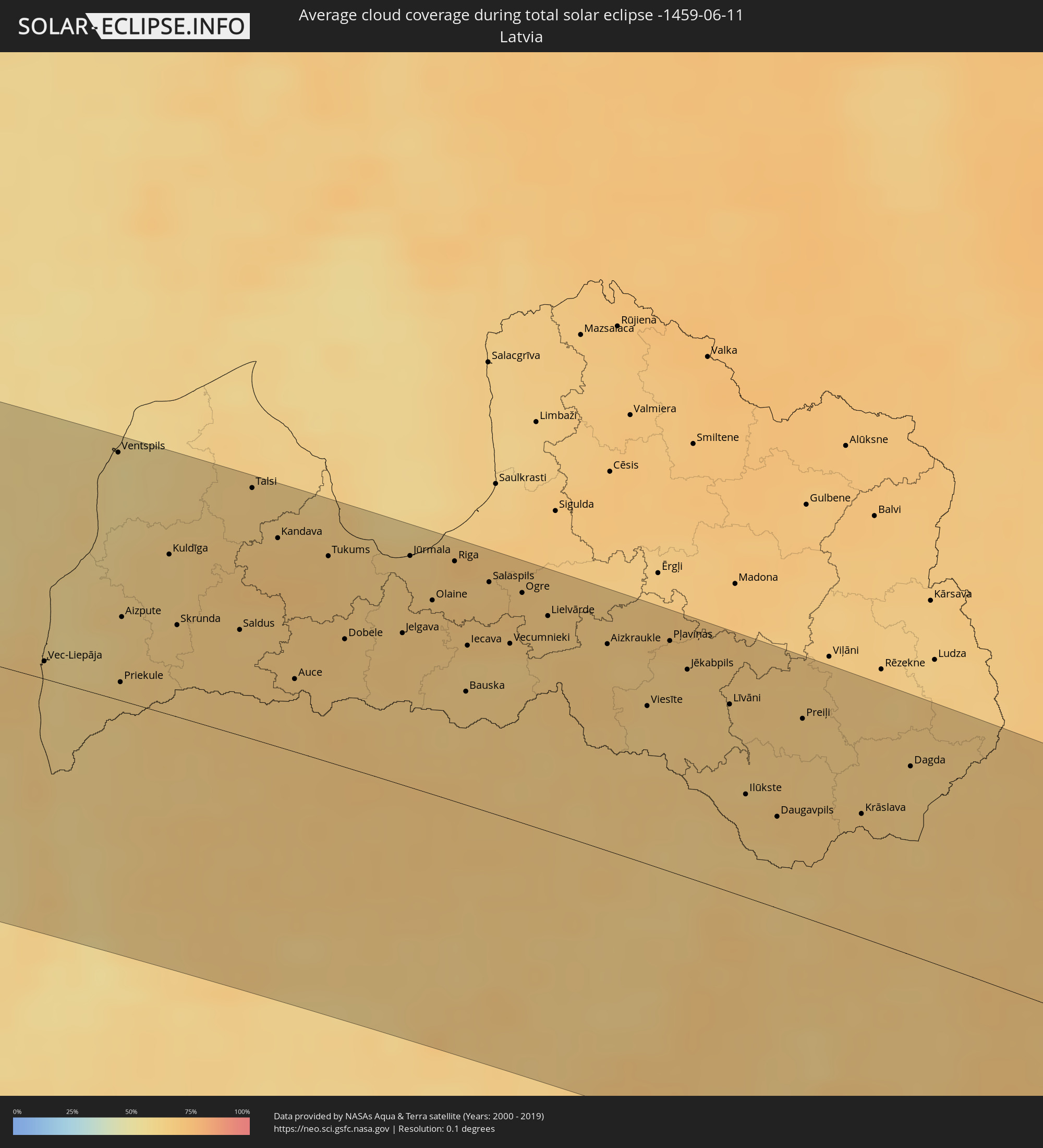
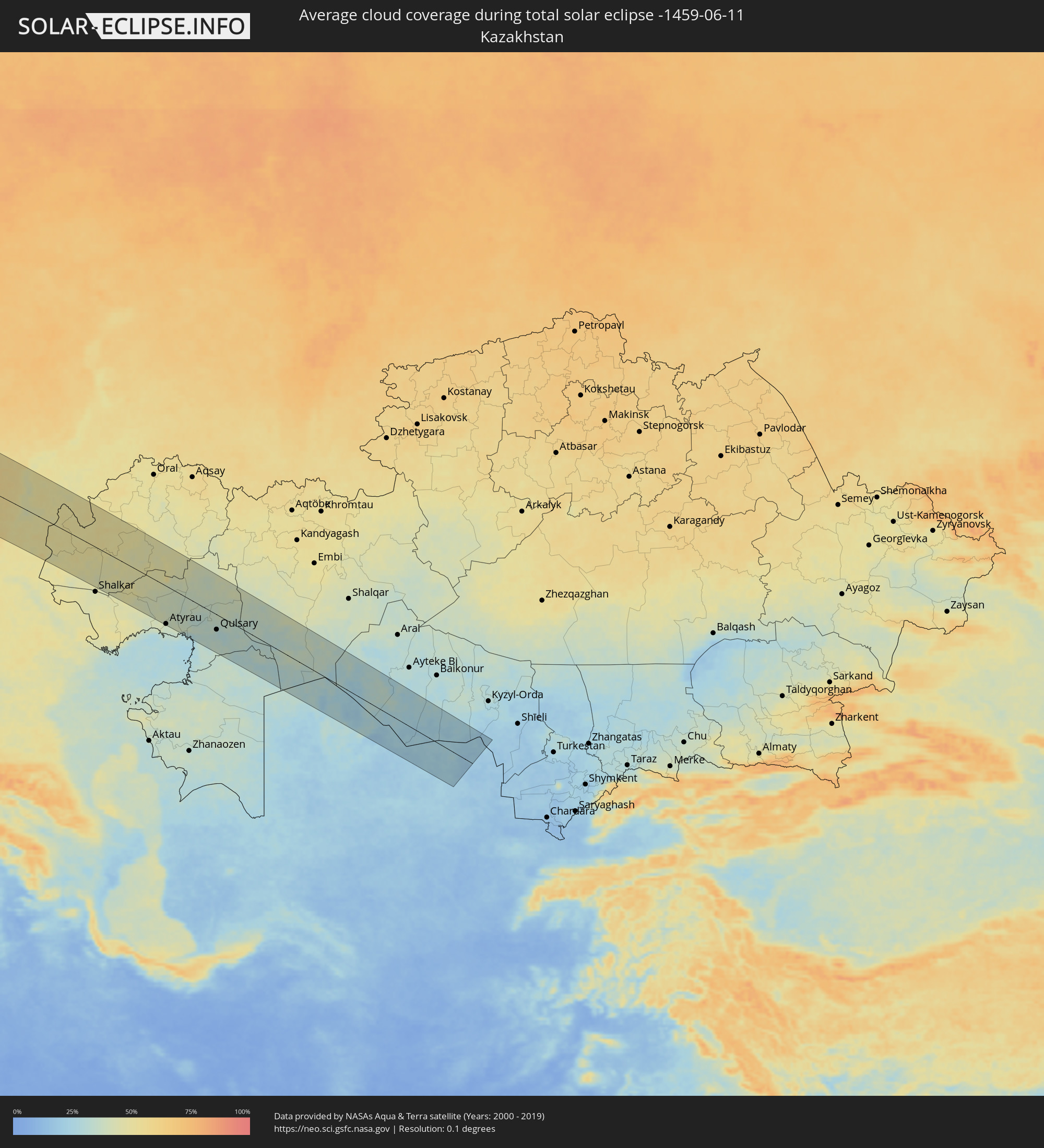
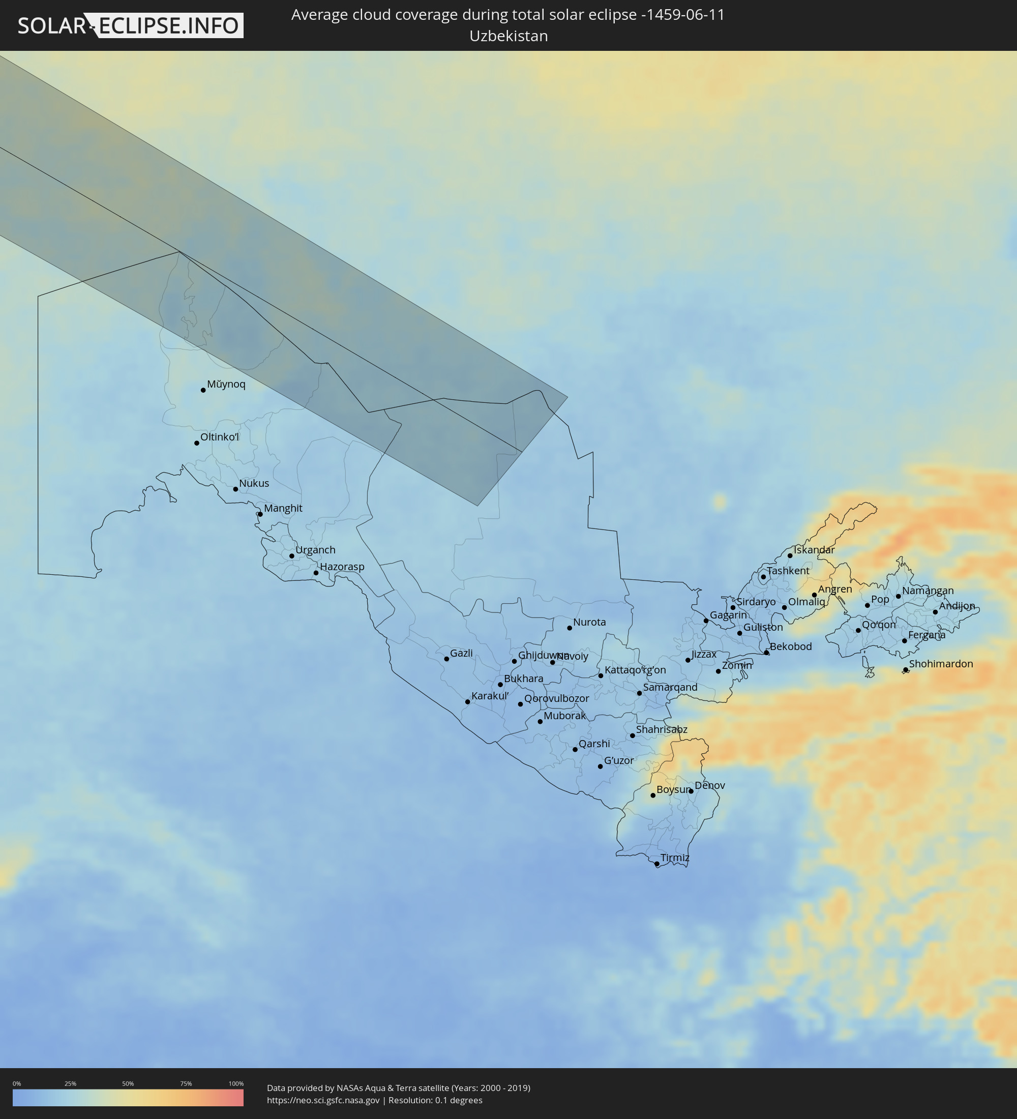
Wie wird das Wetter während der totalen Sonnenfinsternis am 11.06.-1459?
Wo ist der beste Ort, um die totale Sonnenfinsternis vom 11.06.-1459 zu beobachten?
Die folgenden Karten zeigen die durchschnittliche Bewölkung für den Tag, an dem die totale Sonnenfinsternis
stattfindet. Mit Hilfe der Karten lässt sich der Ort entlang des Finsternispfades eingrenzen,
der die besten Aussichen auf einen klaren wolkenfreien Himmel bietet.
Trotzdem muss man immer lokale Gegenenheiten beachten und sollte sich genau über das Wetter an seinem
gewählten Beobachtungsort informieren.
Die Daten stammen von den beiden NASA-Satelliten
AQUA und TERRA
und wurden über einen Zeitraum von 19 Jahren (2000 - 2019) gemittelt.
Detaillierte Länderkarten
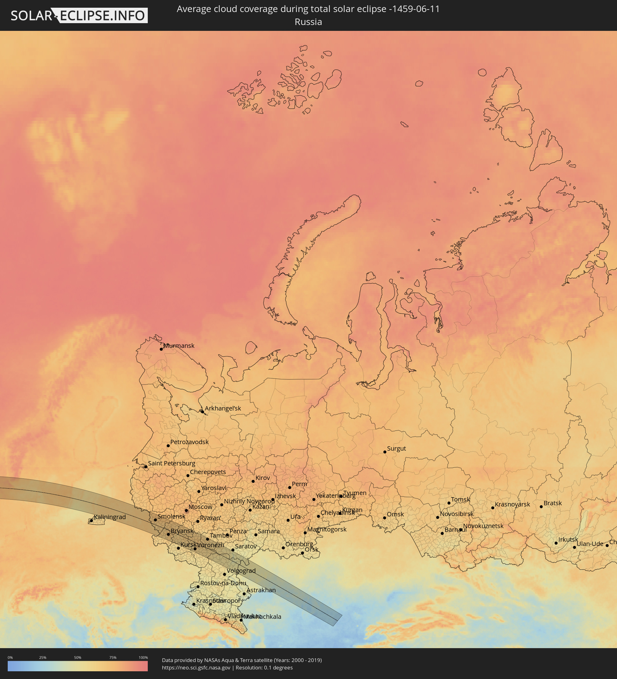 Russland
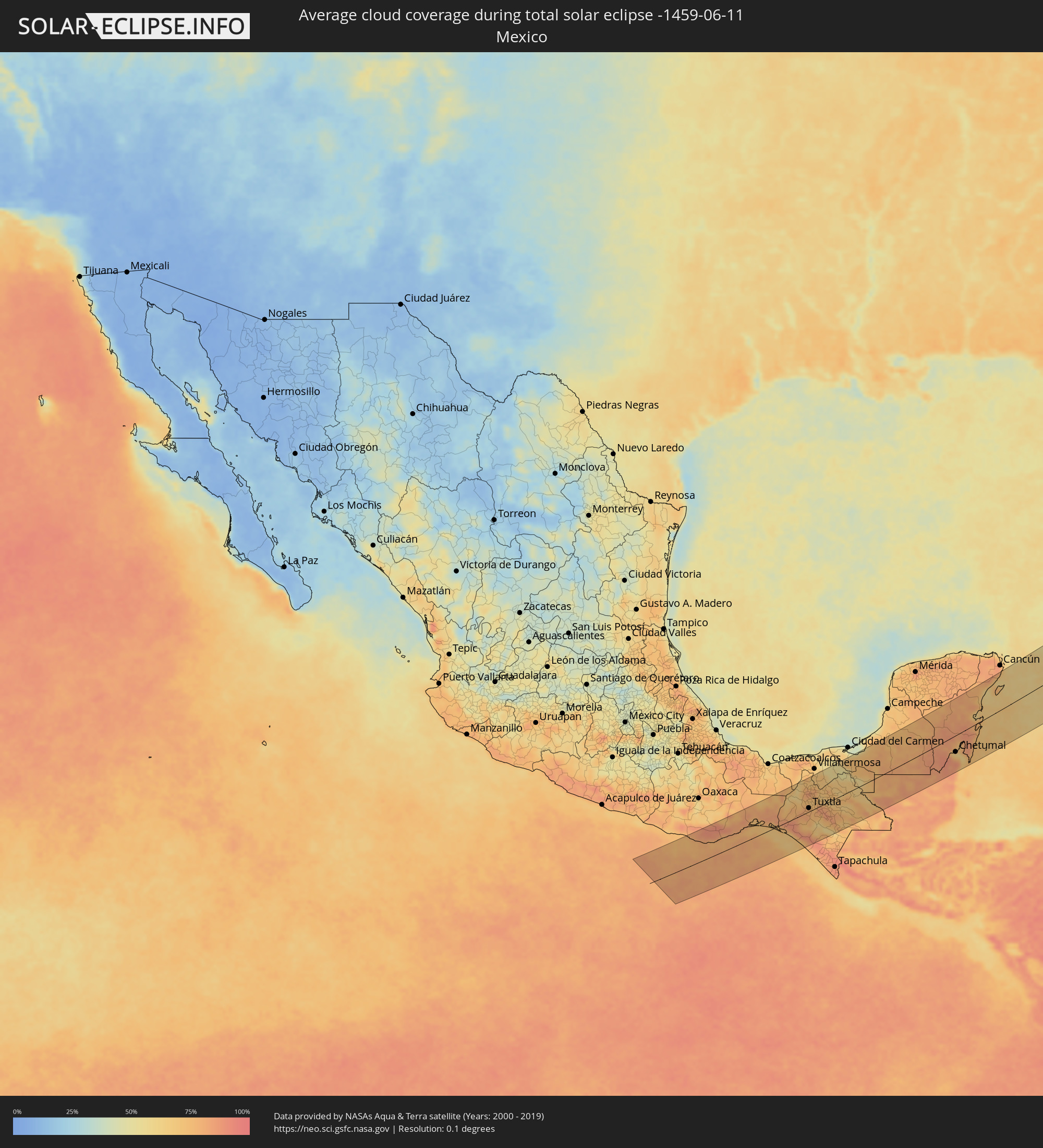 Mexiko
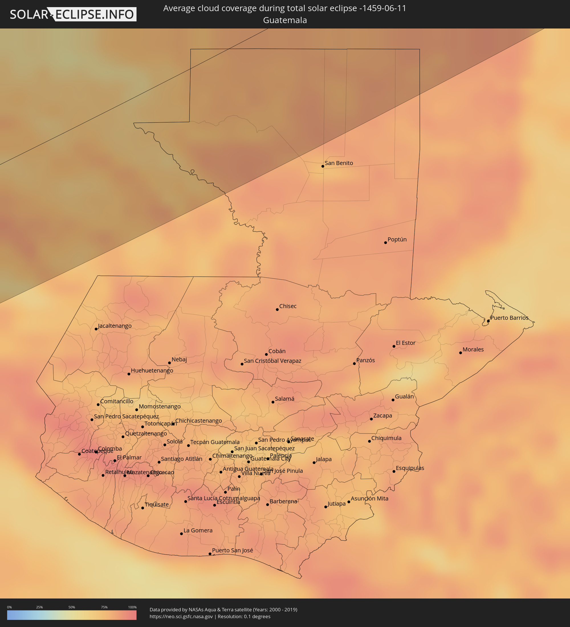 Guatemala
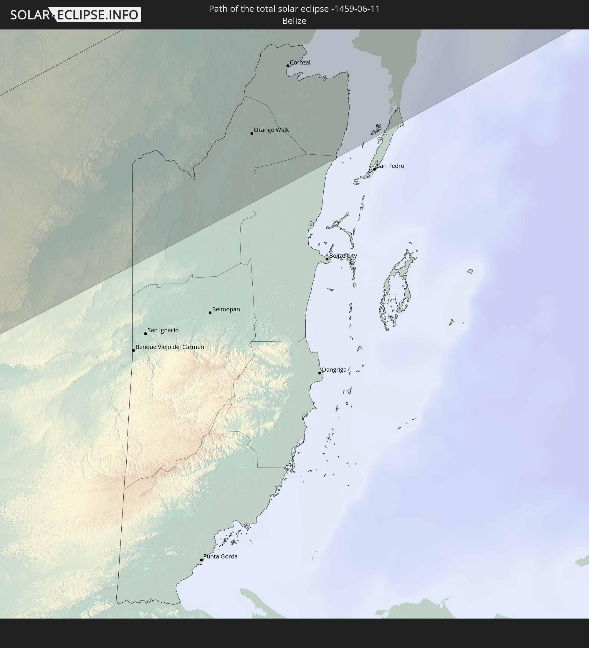
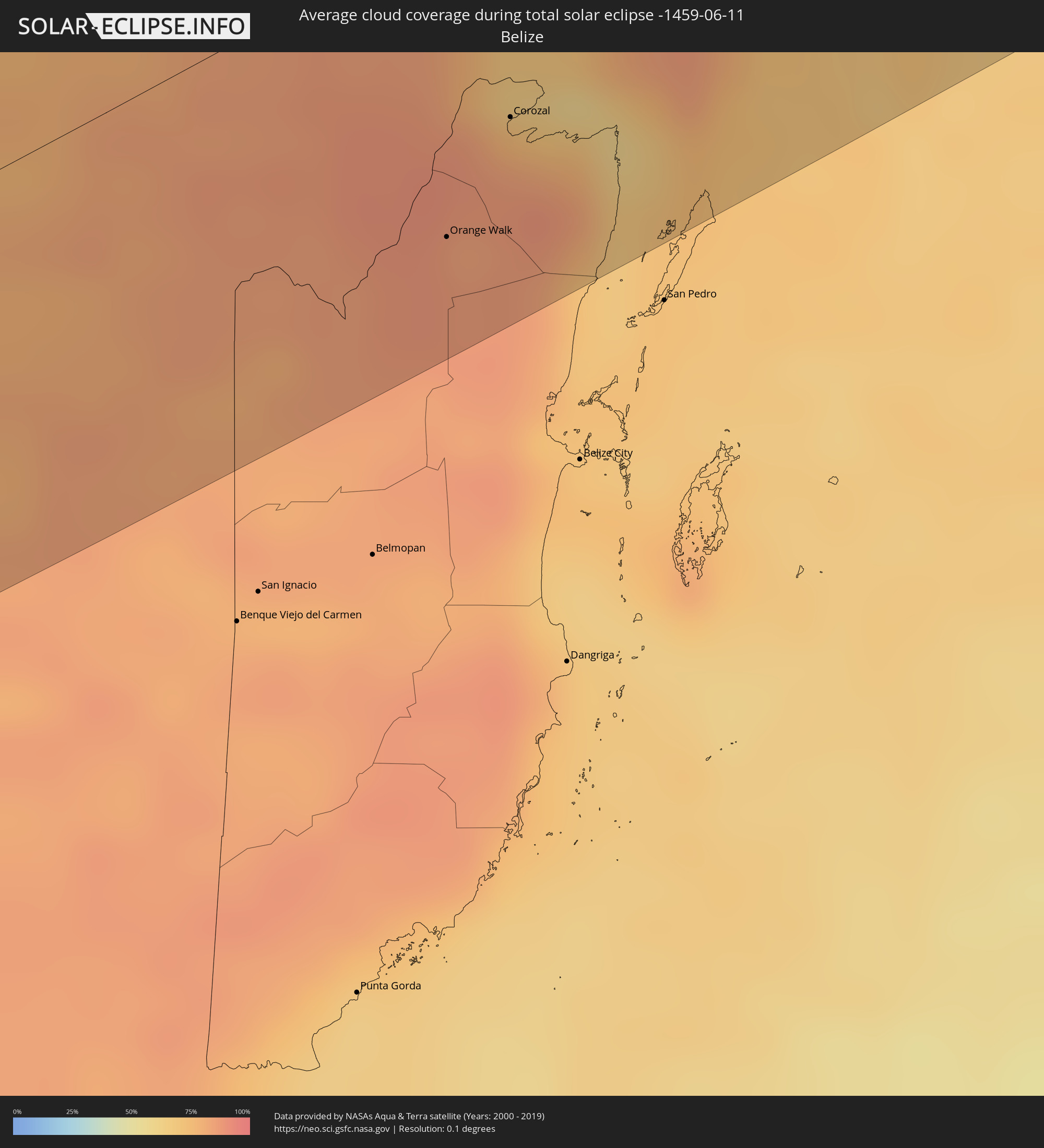 Belize
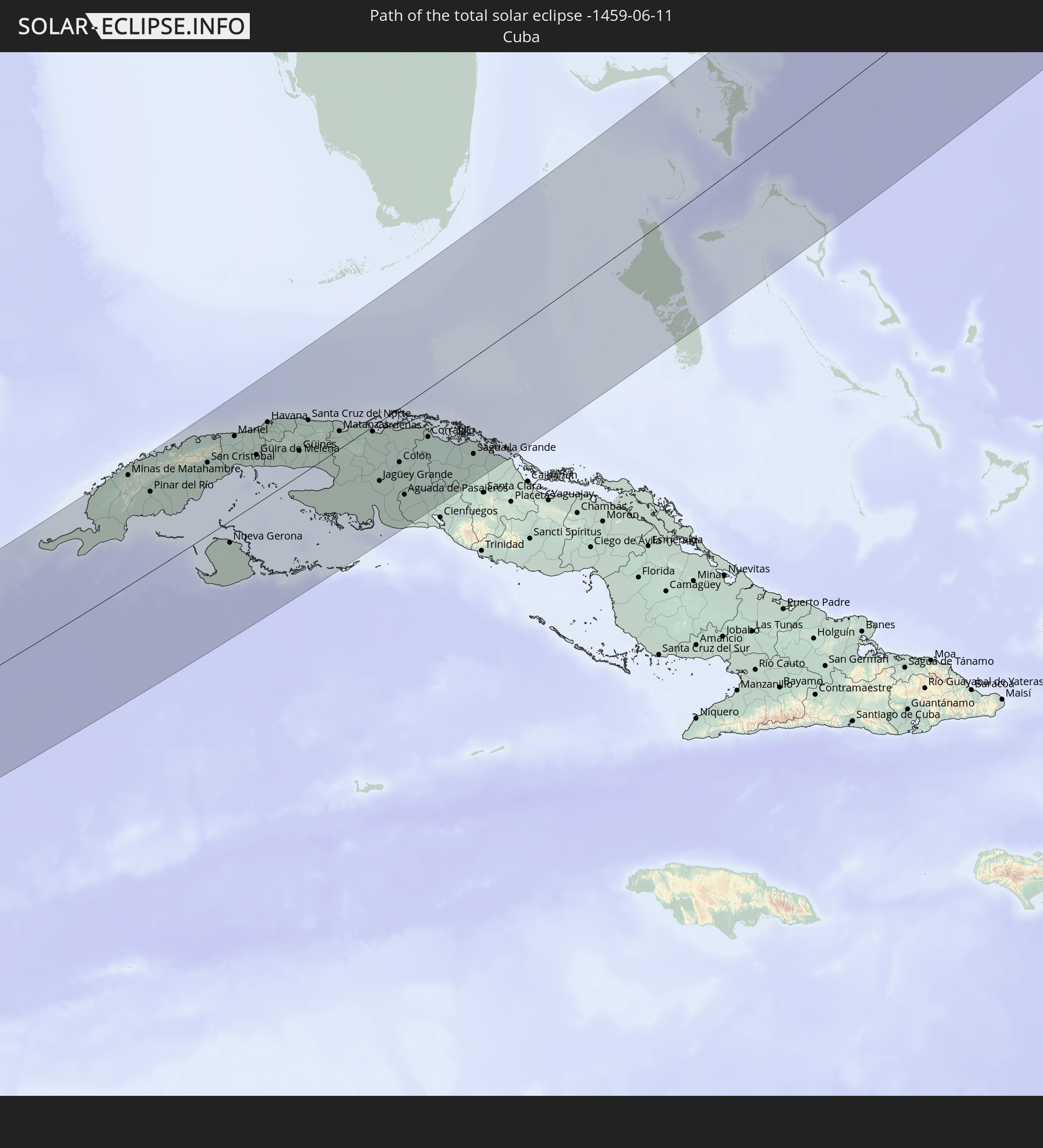
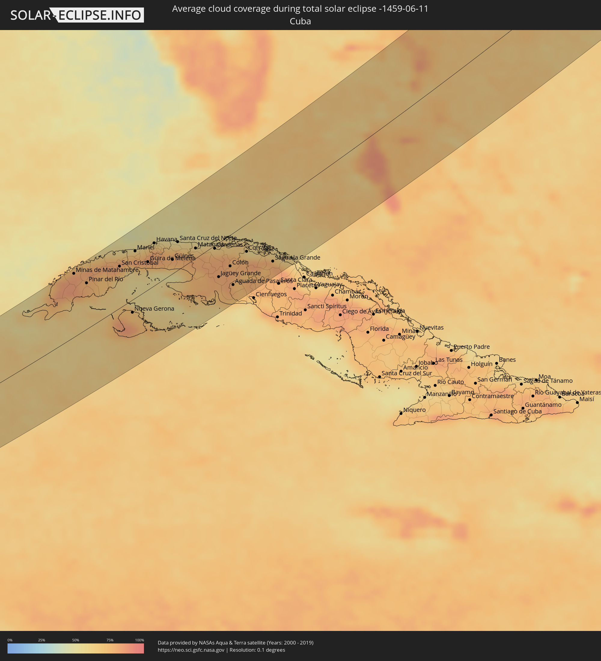 Kuba
Kuba
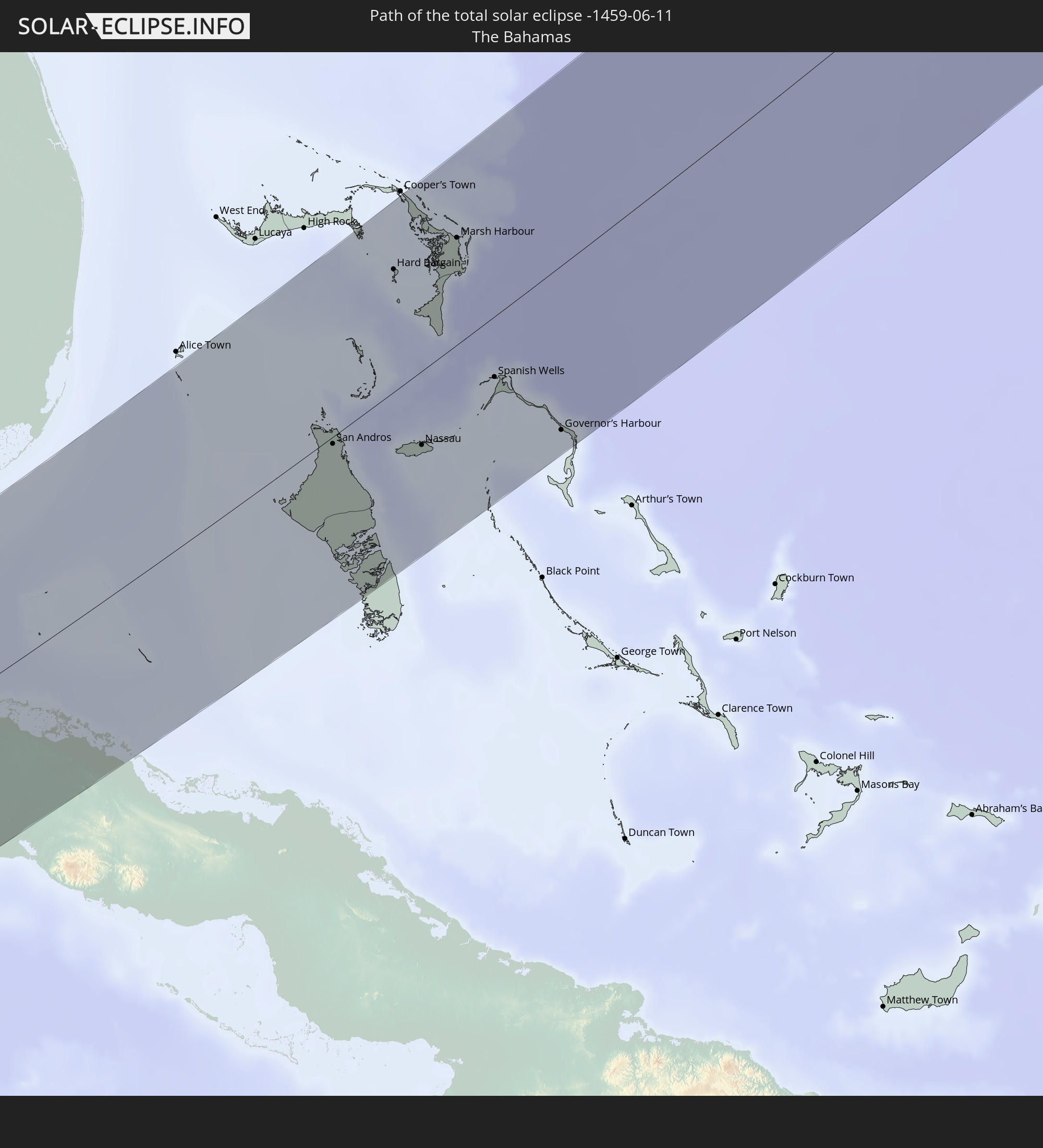
 Bahamas
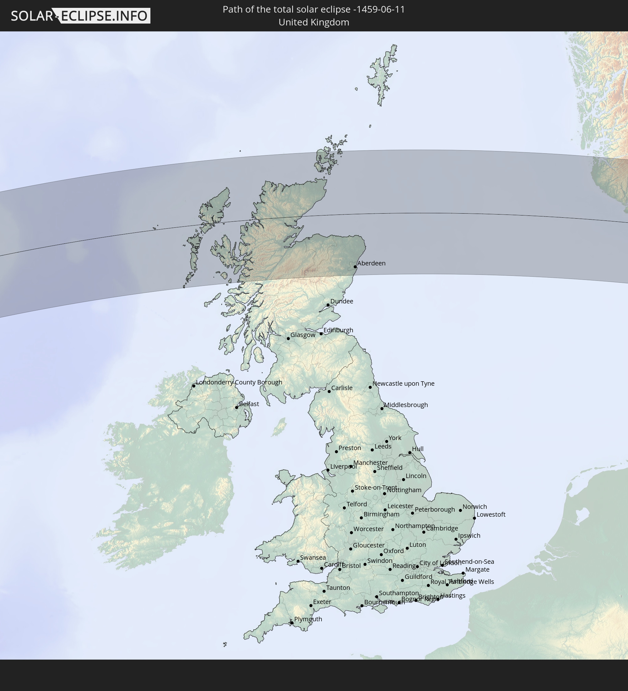
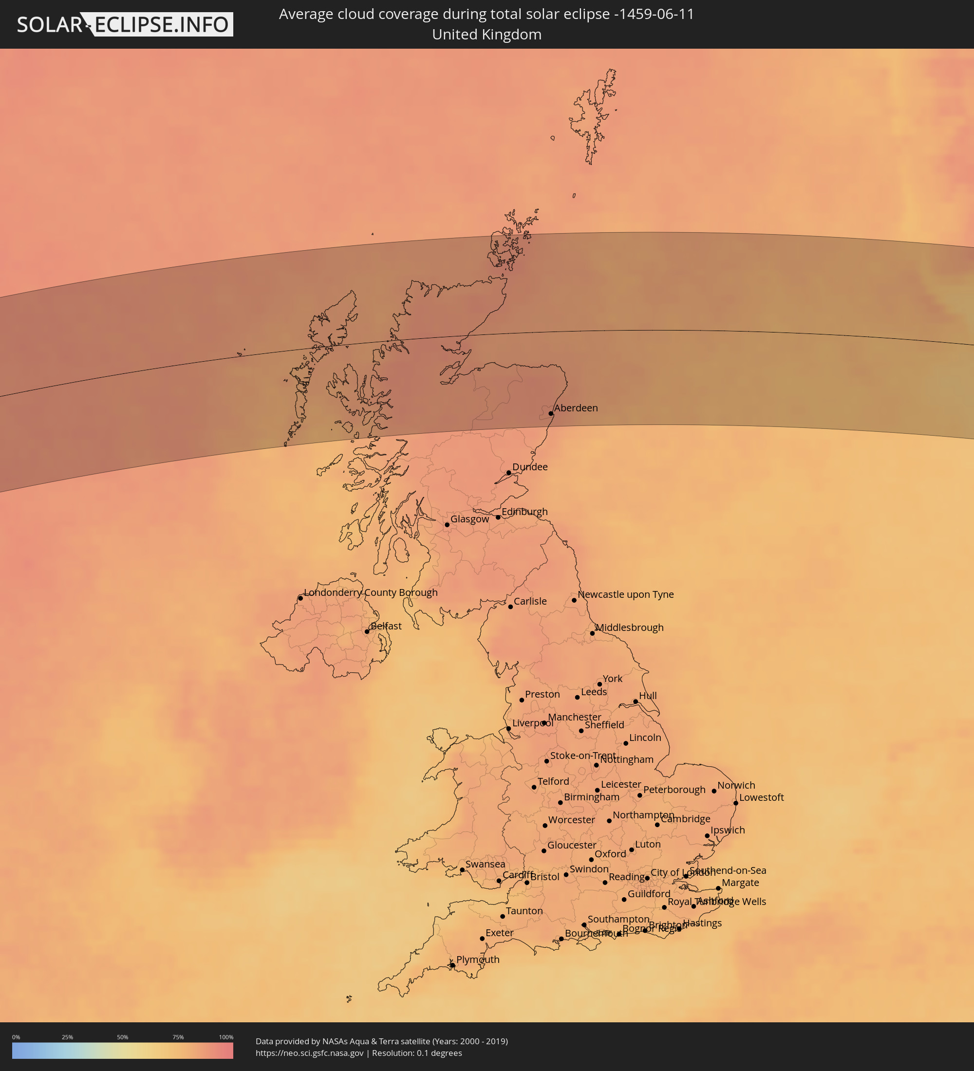 Vereinigtes Königreich
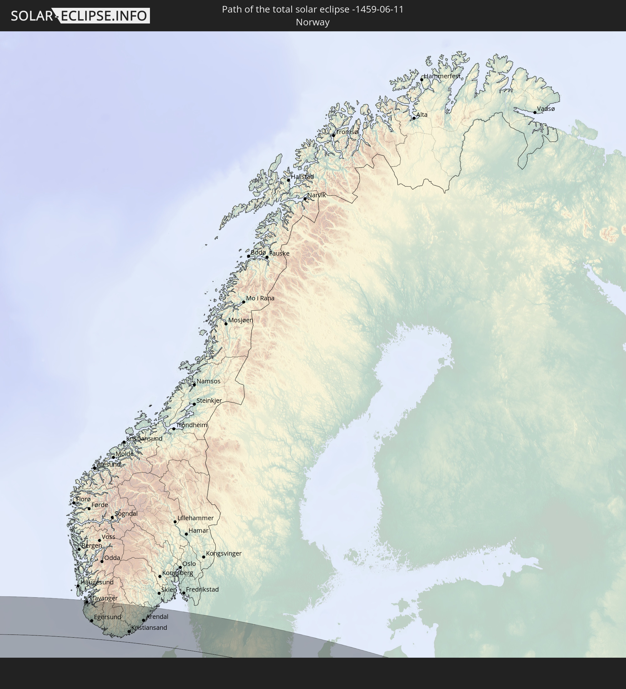
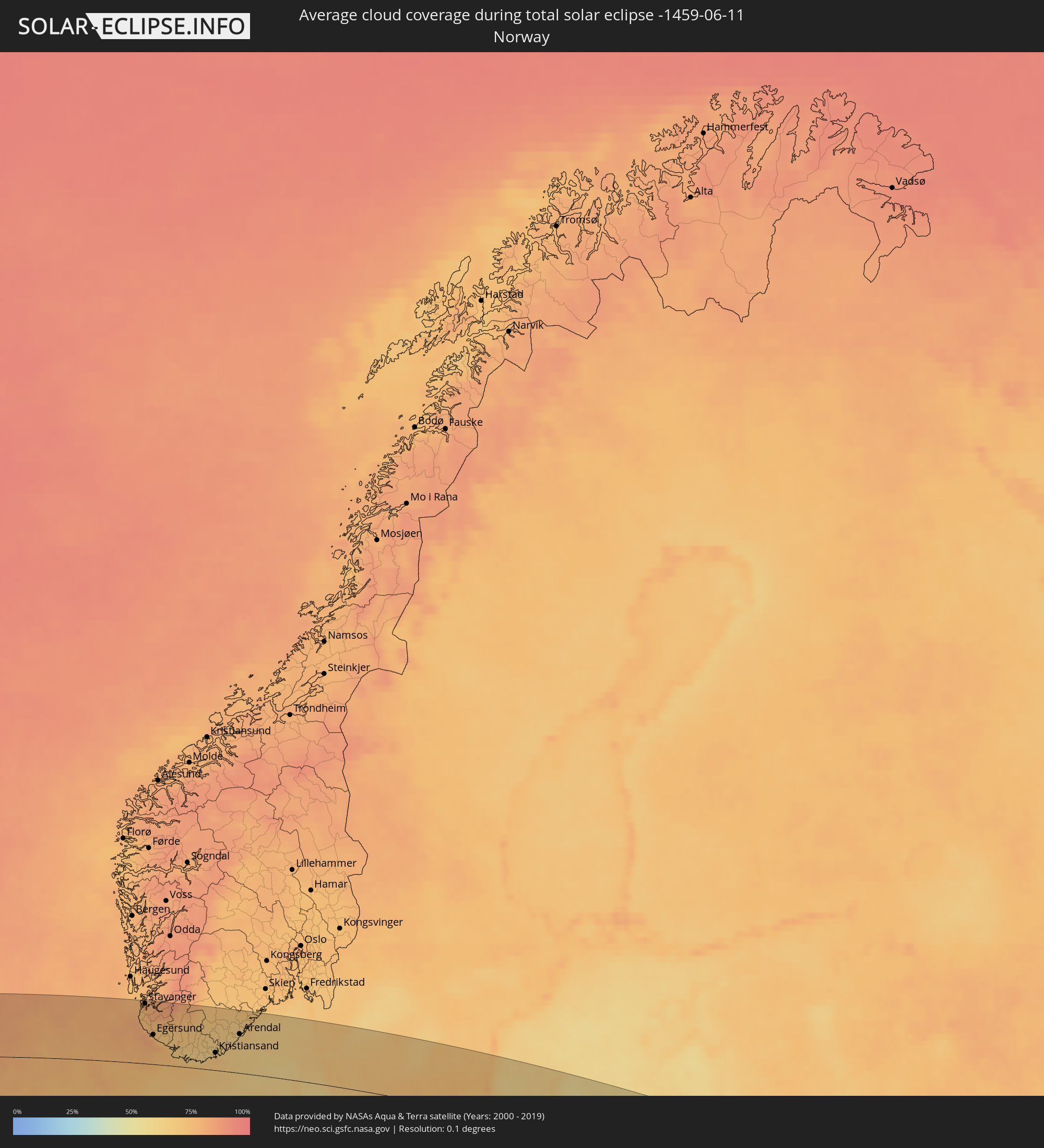 Norwegen
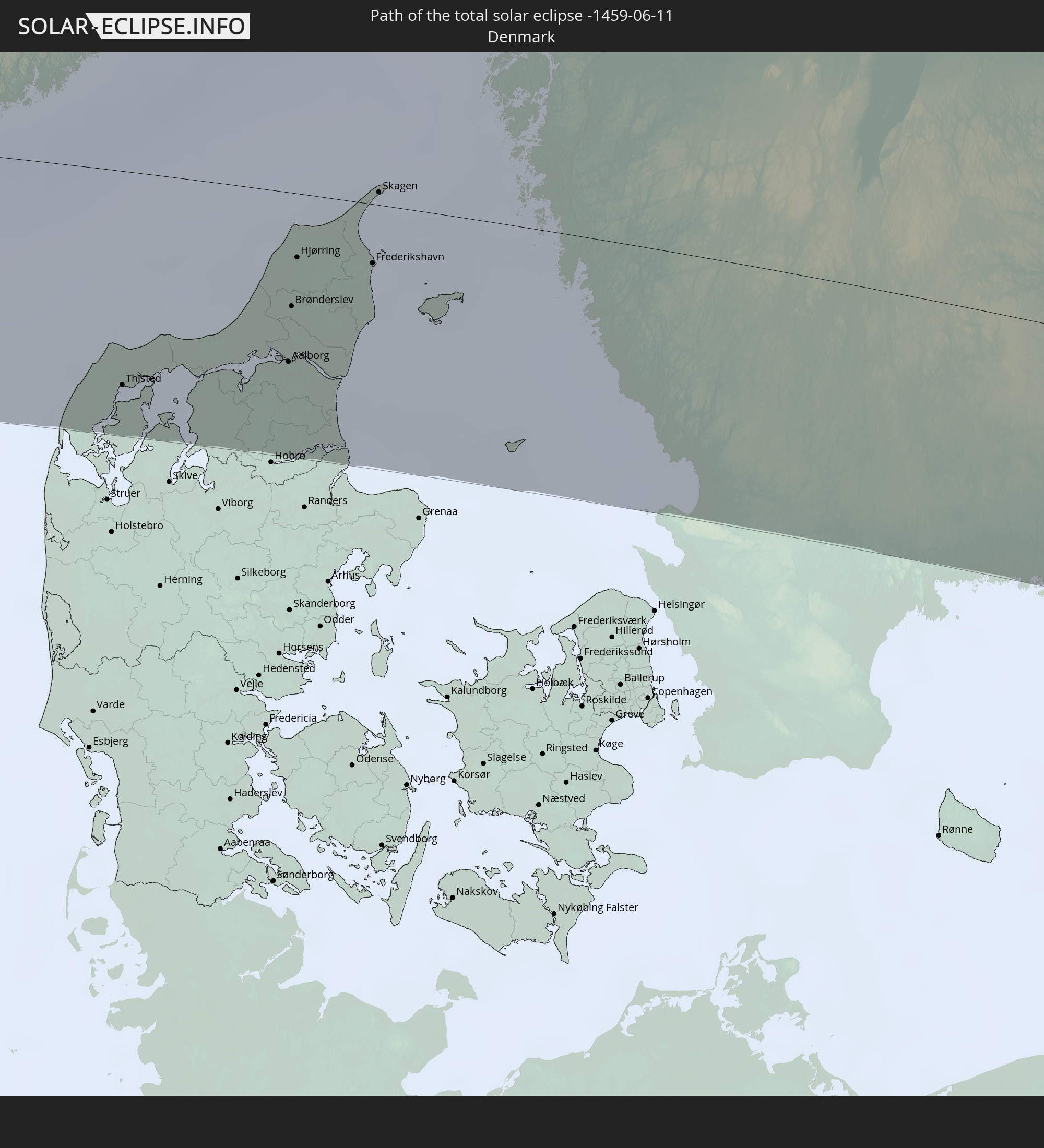
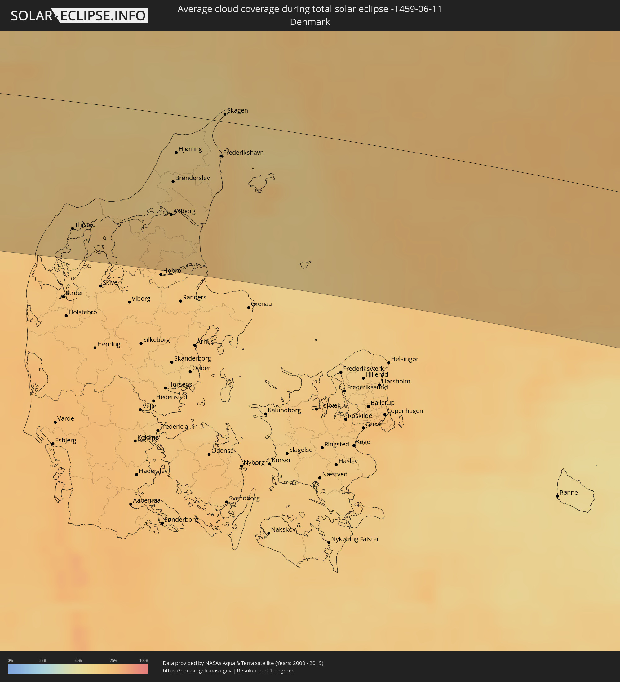 Dänemark
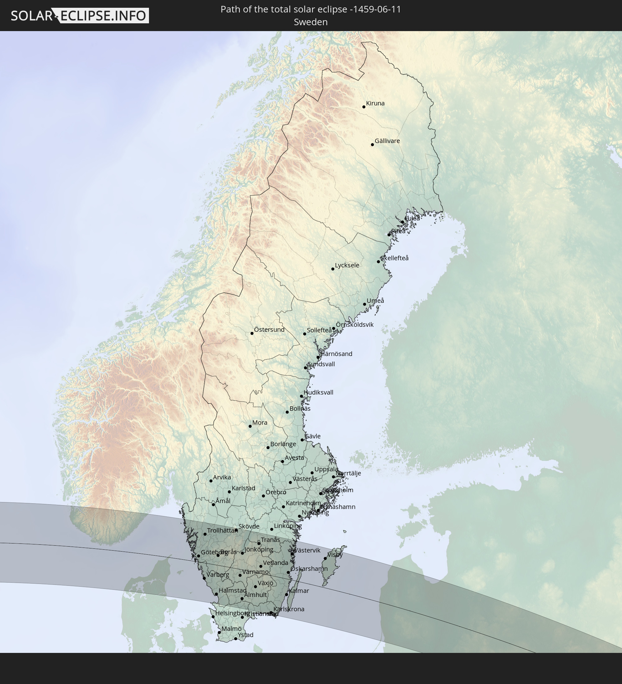
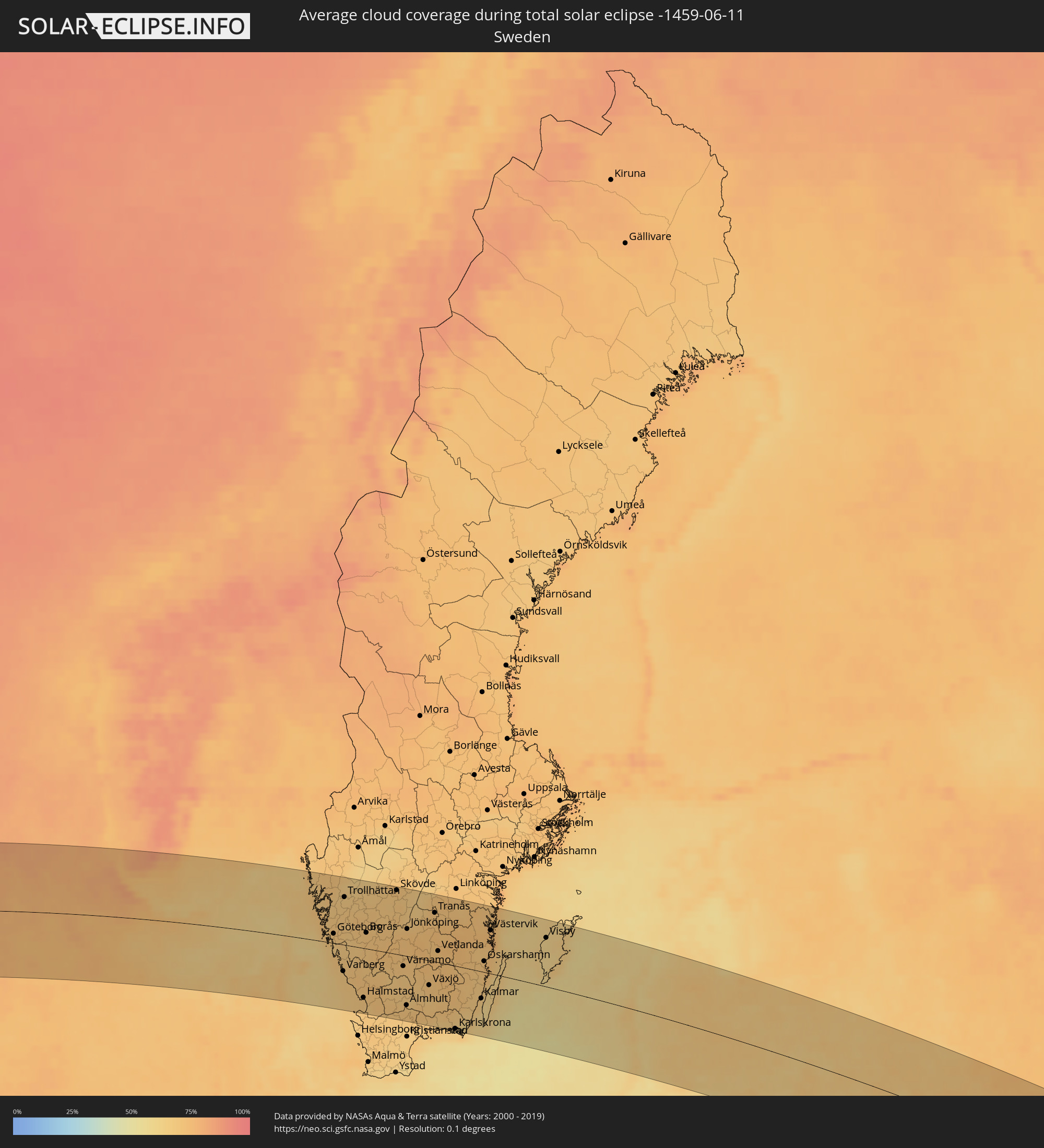 Schweden
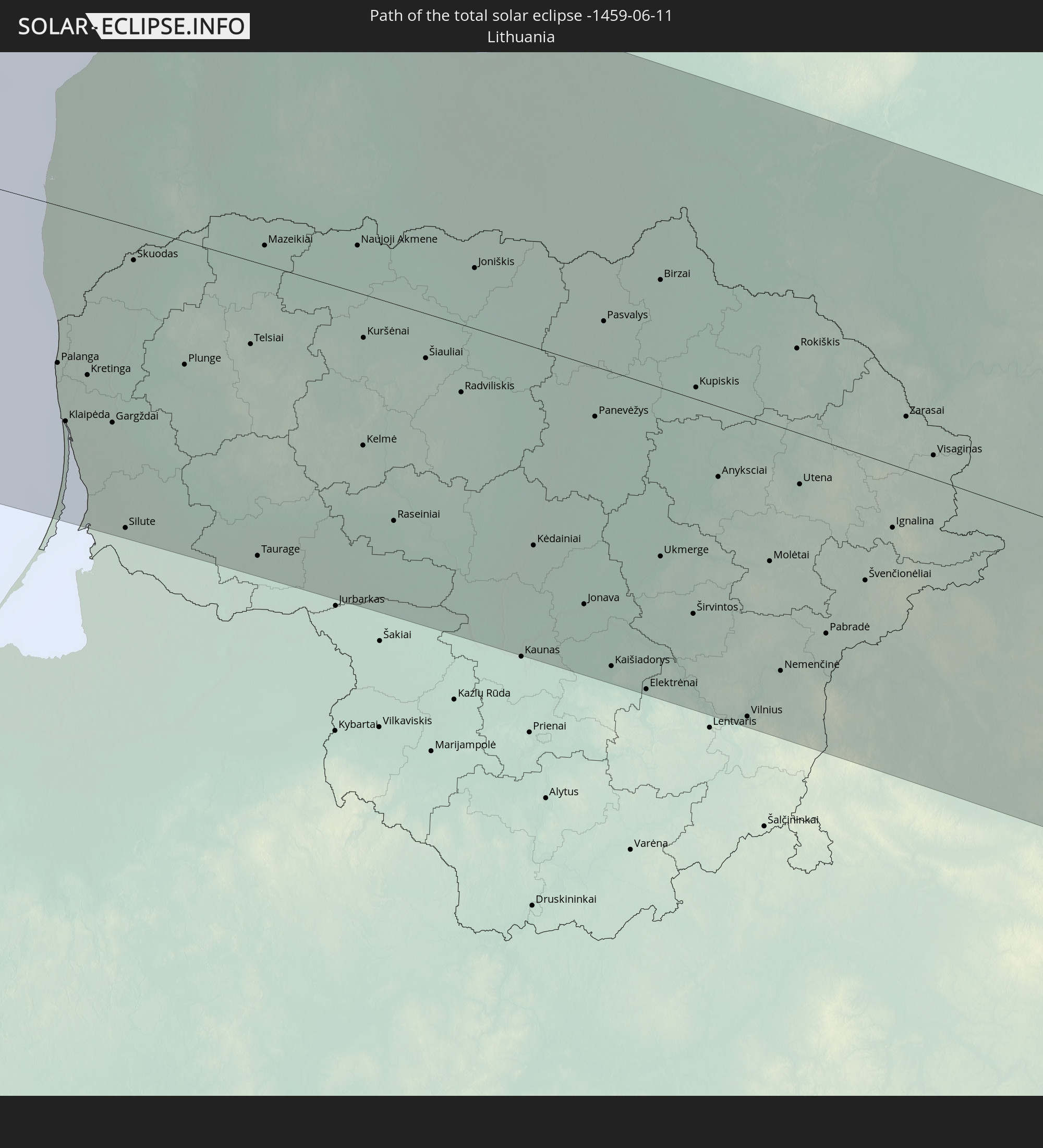
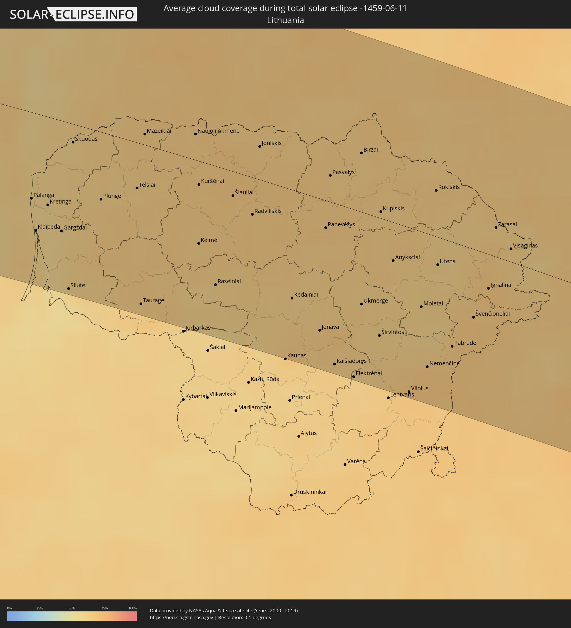 Litauen
 Lettland
 Weißrussland
 Kasachstan
 Usbekistan
Orte im Finsternispfad
Die nachfolgene Tabelle zeigt Städte und Orte mit mehr als 5.000 Einwohnern, die sich im Finsternispfad befinden. Städte mit mehr als 100.000 Einwohnern sind dick gekennzeichnet. Mit einem Klick auf den Ort öffnet sich eine Detailkarte die die Lage des jeweiligen Ortes zusammen mit dem Verlauf der zentralen Finsternis präsentiert.
| Ort | Typ | Dauer der Verfinsterung | Ortszeit bei maximaler Verfinsterung | Entfernung zur Zentrallinie | Ø Bewölkung |
|
Santo Domingo Tehuantepec, Oaxaca
|
total | - | 05:24:19 UTC-06:36 | 64 km | 82% |
|
Salina Cruz, Oaxaca
|
total | - | 05:24:09 UTC-06:36 | 48 km | 80% |
|
Juchitán de Zaragoza, Oaxaca
|
total | - | 05:24:22 UTC-06:36 | 71 km | 73% |
|
Tonalá, Chiapas
|
total | - | 05:23:38 UTC-06:36 | 31 km | 77% |
|
Cintalapa de Figueroa, Chiapas
|
total | - | 05:24:15 UTC-06:36 | 33 km | 78% |
|
Ocozocoautla de Espinosa, Chiapas
|
total | - | 05:24:14 UTC-06:36 | 35 km | 76% |
|
Tuxtla, Chiapas
|
total | - | 05:24:10 UTC-06:36 | 14 km | 78% |
|
San Cristóbal de las Casas, Chiapas
|
total | - | 05:24:01 UTC-06:36 | 27 km | 86% |
|
Macuspana, Tabasco
|
total | - | 05:25:08 UTC-06:36 | 91 km | 69% |
|
Comitán, Chiapas
|
total | - | 05:23:22 UTC-06:36 | 86 km | 76% |
|
Palenque, Chiapas
|
total | - | 05:24:42 UTC-06:36 | 38 km | 68% |
|
Las Margaritas, Chiapas
|
total | - | 05:23:24 UTC-06:36 | 89 km | 69% |
|
Tenosique de Pino Suárez, Tabasco
|
total | - | 05:24:32 UTC-06:36 | 11 km | 66% |
|
Orange Walk, Orange Walk
|
total | - | 06:08:30 UTC-05:52 | 79 km | 88% |
|
Corozal, Corozal
|
total | - | 06:08:50 UTC-05:52 | 60 km | 77% |
|
Chetumal, Quintana Roo
|
total | - | 06:14:42 UTC-05:47 | 50 km | 64% |
|
Playa del Carmen, Quintana Roo
|
total | - | 06:17:06 UTC-05:47 | 93 km | 70% |
|
San Miguel de Cozumel, Quintana Roo
|
total | - | 06:16:56 UTC-05:47 | 73 km | 74% |
|
Pinar del Río, Pinar del Río
|
total | - | 06:36:44 UTC-05:29 | 82 km | 79% |
|
Consolación del Sur, Pinar del Río
|
total | - | 06:36:51 UTC-05:29 | 77 km | 76% |
|
San Cristobal, Artemisa
|
total | - | 06:37:08 UTC-05:29 | 74 km | 79% |
|
Artemisa, Artemisa
|
total | - | 06:37:17 UTC-05:29 | 64 km | 72% |
|
Güira de Melena, Artemisa
|
total | - | 06:37:16 UTC-05:29 | 55 km | 74% |
|
Havana, La Habana
|
total | - | 06:37:44 UTC-05:29 | 71 km | 79% |
|
Arroyo Naranjo, La Habana
|
total | - | 06:37:34 UTC-05:29 | 56 km | 79% |
|
San José de las Lajas, Mayabeque
|
total | - | 06:37:30 UTC-05:29 | 43 km | 79% |
|
Güines, Mayabeque
|
total | - | 06:37:21 UTC-05:29 | 26 km | 71% |
|
Matanzas, Matanzas
|
total | - | 06:37:39 UTC-05:29 | 17 km | 75% |
|
Cárdenas, Matanzas
|
total | - | 06:37:40 UTC-05:29 | 5 km | 77% |
|
Jovellanos, Matanzas
|
total | - | 06:37:21 UTC-05:29 | 27 km | 80% |
|
Jagüey Grande, Matanzas
|
total | - | 06:36:59 UTC-05:29 | 56 km | 78% |
|
Colón, Matanzas
|
total | - | 06:37:16 UTC-05:29 | 51 km | 80% |
|
Corralillo, Villa Clara
|
total | - | 06:37:39 UTC-05:29 | 46 km | 68% |
|
Sagua la Grande, Villa Clara
|
total | - | 06:37:27 UTC-05:29 | 92 km | 77% |
|
San Andros, North Andros
|
total | - | 07:01:03 UTC-05:09 | 11 km | 83% |
|
Hard Bargain, Moore’s Island
|
total | - | 07:03:00 UTC-05:09 | 78 km | 67% |
|
Nassau, New Providence
|
total | - | 07:01:11 UTC-05:09 | 50 km | 80% |
|
Marsh Harbour, Central Abaco
|
total | - | 07:03:27 UTC-05:09 | 70 km | 83% |
|
Spanish Wells, Spanish Wells
|
total | - | 07:02:02 UTC-05:09 | 39 km | 77% |
|
Governor’s Harbour, Central Eleuthera
|
total | - | 12:11:05 UTC+00:00 | 104 km | 68% |
|
Isle of Lewis, Scotland
|
total | - | 14:12:21 UTC+00:00 | 34 km | 83% |
|
Isle of Skye, Scotland
|
total | - | 14:12:50 UTC+00:00 | 63 km | 84% |
|
Inverness, Scotland
|
total | - | 14:15:01 UTC+00:00 | 60 km | 87% |
|
Nairn, Scotland
|
total | - | 14:15:20 UTC+00:00 | 49 km | 87% |
|
Forres, Scotland
|
total | - | 14:15:36 UTC+00:00 | 48 km | 87% |
|
Thurso, Scotland
|
total | - | 14:15:11 UTC+00:00 | 62 km | 86% |
|
Elgin, Scotland
|
total | - | 14:15:54 UTC+00:00 | 44 km | 88% |
|
Wick, Scotland
|
total | - | 14:15:43 UTC+00:00 | 44 km | 88% |
|
Buckie, Scotland
|
total | - | 14:16:16 UTC+00:00 | 41 km | 85% |
|
Orkney, Scotland
|
total | - | 14:15:33 UTC+00:00 | 105 km | 88% |
|
Kirkwall, Scotland
|
total | - | 14:15:33 UTC+00:00 | 105 km | 88% |
|
Inverurie, Scotland
|
total | - | 14:17:06 UTC+00:00 | 86 km | 88% |
|
Aberdeen, Scotland
|
total | - | 14:17:29 UTC+00:00 | 103 km | 86% |
|
Ellon, Scotland
|
total | - | 14:17:23 UTC+00:00 | 78 km | 88% |
|
Fraserburgh, Scotland
|
total | - | 14:17:15 UTC+00:00 | 42 km | 85% |
|
Peterhead, Scotland
|
total | - | 14:17:35 UTC+00:00 | 63 km | 85% |
|
Tananger, Rogaland
|
total | - | 15:23:36 UTC+01:00 | 107 km | 75% |
|
Bryne, Rogaland
|
total | - | 15:23:50 UTC+01:00 | 85 km | 76% |
|
Stavanger, Rogaland
|
total | - | 15:23:42 UTC+01:00 | 112 km | 76% |
|
Sandnes, Rogaland
|
total | - | 15:23:49 UTC+01:00 | 99 km | 75% |
|
Hommersåk, Rogaland
|
total | - | 15:23:51 UTC+01:00 | 108 km | 80% |
|
Egersund, Rogaland
|
total | - | 15:24:24 UTC+01:00 | 56 km | 73% |
|
Flekkefjord, Vest-Agder
|
total | - | 15:25:06 UTC+01:00 | 42 km | 67% |
|
Mandal, Vest-Agder
|
total | - | 15:26:02 UTC+01:00 | 17 km | 70% |
|
Søgne, Vest-Agder
|
total | - | 15:26:16 UTC+01:00 | 29 km | 69% |
|
Vennesla, Vest-Agder
|
total | - | 15:26:15 UTC+01:00 | 47 km | 64% |
|
Kristiansand, Vest-Agder
|
total | - | 15:26:23 UTC+01:00 | 33 km | 70% |
|
Lillesand, Aust-Agder
|
total | - | 15:26:37 UTC+01:00 | 49 km | 65% |
|
Grimstad, Aust-Agder
|
total | - | 15:26:42 UTC+01:00 | 59 km | 66% |
|
Thisted, North Denmark
|
total | - | 15:28:07 UTC+01:00 | 94 km | 65% |
|
Arendal, Aust-Agder
|
total | - | 15:26:44 UTC+01:00 | 74 km | 66% |
|
Nykøbing Mors, North Denmark
|
total | - | 15:28:24 UTC+01:00 | 111 km | 67% |
|
Aars, North Denmark
|
total | - | 15:28:58 UTC+01:00 | 105 km | 69% |
|
Støvring, North Denmark
|
total | - | 15:29:10 UTC+01:00 | 93 km | 67% |
|
Aalborg, North Denmark
|
total | - | 15:29:04 UTC+01:00 | 74 km | 68% |
|
Nørresundby, North Denmark
|
total | - | 15:29:05 UTC+01:00 | 74 km | 68% |
|
Brønderslev, North Denmark
|
total | - | 15:28:52 UTC+01:00 | 50 km | 65% |
|
Hirtshals, North Denmark
|
total | - | 15:28:34 UTC+01:00 | 14 km | 62% |
|
Hjørring, North Denmark
|
total | - | 15:28:43 UTC+01:00 | 28 km | 62% |
|
Hadsund, North Denmark
|
total | - | 15:29:34 UTC+01:00 | 110 km | 68% |
|
Sæby, North Denmark
|
total | - | 15:29:17 UTC+01:00 | 38 km | 67% |
|
Frederikshavn, North Denmark
|
total | - | 15:29:11 UTC+01:00 | 26 km | 65% |
|
Skagen, North Denmark
|
total | - | 15:28:57 UTC+01:00 | 7 km | 65% |
|
Uddevalla, Västra Götaland
|
total | - | 15:29:22 UTC+01:00 | 88 km | 69% |
|
Göteborg, Västra Götaland
|
total | - | 15:30:03 UTC+01:00 | 17 km | 69% |
|
Kungälv, Västra Götaland
|
total | - | 15:29:53 UTC+01:00 | 35 km | 70% |
|
Varberg, Halland
|
total | - | 15:30:54 UTC+01:00 | 47 km | 67% |
|
Trollhättan, Västra Götaland
|
total | - | 15:29:42 UTC+01:00 | 83 km | 66% |
|
Alingsås, Västra Götaland
|
total | - | 15:30:15 UTC+01:00 | 47 km | 69% |
|
Halmstad, Halland
|
total | - | 15:31:50 UTC+01:00 | 88 km | 69% |
|
Borås, Västra Götaland
|
total | - | 15:30:47 UTC+01:00 | 29 km | 70% |
|
Lidköping, Västra Götaland
|
total | - | 15:30:06 UTC+01:00 | 117 km | 65% |
|
Skövde, Västra Götaland
|
total | - | 15:30:43 UTC+01:00 | 111 km | 71% |
|
Jönköping, Jönköping
|
total | - | 15:31:37 UTC+01:00 | 48 km | 71% |
|
Växjö, Kronoberg
|
total | - | 15:33:06 UTC+01:00 | 44 km | 71% |
|
Karlskrona, Blekinge
|
total | - | 15:34:28 UTC+01:00 | 112 km | 65% |
|
Kalmar, Kalmar
|
total | - | 15:34:27 UTC+01:00 | 48 km | 66% |
|
Västervik, Kalmar
|
total | - | 15:33:23 UTC+01:00 | 76 km | 72% |
|
Visby, Gotland
|
total | - | 15:34:37 UTC+01:00 | 85 km | 60% |
|
Vec-Liepāja, Liepāja
|
total | - | 16:14:12 UTC+01:36 | 8 km | 62% |
|
Klaipėda, Klaipėda County
|
total | - | 16:02:41 UTC+01:24 | 78 km | 63% |
|
Kretinga, Klaipėda County
|
total | - | 16:02:34 UTC+01:24 | 59 km | 61% |
|
Silute, Klaipėda County
|
total | - | 16:03:21 UTC+01:24 | 111 km | 56% |
|
Ventspils, Ventspils
|
total | - | 16:13:28 UTC+01:36 | 109 km | 56% |
|
Plunge, Telšiai County
|
total | - | 16:02:53 UTC+01:24 | 45 km | 65% |
|
Kuldīga, Kuldīgas Rajons
|
total | - | 16:14:12 UTC+01:36 | 71 km | 64% |
|
Telsiai, Telšiai County
|
total | - | 16:03:02 UTC+01:24 | 31 km | 65% |
|
Taurage, Tauragė County
|
total | - | 16:03:57 UTC+01:24 | 108 km | 66% |
|
Mazeikiai, Telšiai County
|
total | - | 16:02:40 UTC+01:24 | 15 km | 67% |
|
Saldus, Saldus Rajons
|
total | - | 16:14:53 UTC+01:36 | 49 km | 65% |
|
Talsi, Talsu Rajons
|
total | - | 16:14:13 UTC+01:36 | 111 km | 65% |
|
Tukums, Tukuma Rajons
|
total | - | 16:14:53 UTC+01:36 | 92 km | 68% |
|
Dobele, Dobeles Rajons
|
total | - | 16:15:22 UTC+01:36 | 57 km | 67% |
|
Šiauliai, Šiauliai County
|
total | - | 16:03:41 UTC+01:24 | 18 km | 67% |
|
Jelgava, Jelgava
|
total | - | 16:15:34 UTC+01:36 | 68 km | 67% |
|
Jūrmala, Jūrmala
|
total | - | 16:15:12 UTC+01:36 | 103 km | 65% |
|
Olaine, Olaine
|
total | - | 16:15:31 UTC+01:36 | 86 km | 67% |
|
Dainava (Kaunas), Kaunas County
|
total | - | 16:05:19 UTC+01:24 | 112 km | 65% |
|
Kėdainiai, Kaunas County
|
total | - | 16:04:51 UTC+01:24 | 74 km | 64% |
|
Riga, Riga
|
total | - | 16:15:24 UTC+01:36 | 106 km | 67% |
|
Jonava, Kaunas County
|
total | - | 16:05:17 UTC+01:24 | 90 km | 67% |
|
Panevėžys, Panevėžys
|
total | - | 16:04:30 UTC+01:24 | 19 km | 65% |
|
Salaspils, Salaspils
|
total | - | 16:15:39 UTC+01:36 | 102 km | 67% |
|
Ogre, Ogre
|
total | - | 16:15:50 UTC+01:36 | 102 km | 68% |
|
Ukmerge, Vilnius County
|
total | - | 16:05:19 UTC+01:24 | 62 km | 65% |
|
Vilnius, Vilnius County
|
total | - | 16:06:18 UTC+01:24 | 111 km | 70% |
|
Utena, Utena County
|
total | - | 16:05:26 UTC+01:24 | 23 km | 63% |
|
Jēkabpils, Jēkabpils Municipality
|
total | - | 16:16:51 UTC+01:36 | 92 km | 65% |
|
Smarhon’, Grodnenskaya
|
total | - | 16:33:08 UTC+01:50 | 110 km | 67% |
|
Visaginas, Utena County
|
total | - | 16:05:43 UTC+01:24 | 12 km | 65% |
|
Daugavpils, Daugavpils municipality
|
total | - | 16:17:58 UTC+01:36 | 42 km | 67% |
|
Pastavy, Vitebsk
|
total | - | 16:32:32 UTC+01:50 | 34 km | 64% |
|
Vilyeyka, Minsk
|
total | - | 16:33:22 UTC+01:50 | 98 km | 69% |
|
Krāslava, Krāslavas Rajons
|
total | - | 16:18:15 UTC+01:36 | 56 km | 67% |
|
Hlybokaye, Vitebsk
|
total | - | 16:32:54 UTC+01:50 | 21 km | 65% |
|
Horad Zhodzina, Minsk
|
total | - | 16:34:31 UTC+01:50 | 108 km | 67% |
|
Horad Barysaw, Minsk
|
total | - | 16:34:26 UTC+01:50 | 91 km | 68% |
|
Navapolatsk, Vitebsk
|
total | - | 16:32:48 UTC+01:50 | 48 km | 69% |
|
Lyepyel’, Vitebsk
|
total | - | 16:33:41 UTC+01:50 | 23 km | 63% |
|
Novolukoml’
|
total | - | 16:34:09 UTC+01:50 | 31 km | 62% |
|
Vitebsk, Vitebsk
|
total | - | 16:33:54 UTC+01:50 | 48 km | 70% |
|
Shklow, Mogilev
|
total | - | 16:35:12 UTC+01:50 | 52 km | 68% |
|
Mahilyow, Mogilev
|
total | - | 16:35:36 UTC+01:50 | 82 km | 71% |
|
Orsha, Vitebsk
|
total | - | 16:34:52 UTC+01:50 | 18 km | 70% |
|
Horki, Mogilev
|
total | - | 16:35:23 UTC+01:50 | 29 km | 69% |
|
Krychaw, Mogilev
|
total | - | 16:36:24 UTC+01:50 | 70 km | 68% |
|
Klimavichy, Mogilev
|
total | - | 16:36:37 UTC+01:50 | 75 km | 66% |
|
Smolensk, Smolensk
|
total | - | 17:15:24 UTC+02:30 | 52 km | 72% |
|
Yartsevo, Smolensk
|
total | - | 17:15:16 UTC+02:30 | 95 km | 73% |
|
Roslavl’, Smolensk
|
total | - | 17:16:46 UTC+02:30 | 16 km | 67% |
|
Bryansk, Brjansk
|
total | - | 17:18:10 UTC+02:30 | 51 km | 69% |
|
Orël, Orjol
|
total | - | 17:19:02 UTC+02:30 | 37 km | 67% |
|
Mtsensk, Orjol
|
total | - | 17:18:45 UTC+02:30 | 12 km | 65% |
|
Shchëkino, Tula
|
total | - | 17:18:02 UTC+02:30 | 113 km | 65% |
|
Livny, Orjol
|
total | - | 17:20:06 UTC+02:30 | 46 km | 63% |
|
Yelets, Lipetsk
|
total | - | 17:20:02 UTC+02:30 | 0 km | 64% |
|
Voronezh, Voronezj
|
total | - | 17:21:24 UTC+02:30 | 77 km | 69% |
|
Lipetsk, Lipetsk
|
total | - | 17:20:17 UTC+02:30 | 30 km | 74% |
|
Michurinsk, Tambov
|
total | - | 17:20:04 UTC+02:30 | 86 km | 66% |
|
Tambov, Tambov
|
total | - | 17:20:25 UTC+02:30 | 99 km | 66% |
|
Borisoglebsk, Voronezj
|
total | - | 17:22:14 UTC+02:30 | 25 km | 61% |
|
Balashov, Saratov
|
total | - | 18:12:11 UTC+03:20 | 33 km | 59% |
|
Kamyshin, Volgograd
|
total | - | 17:24:06 UTC+02:30 | 40 km | 50% |
|
Zhänibek, Batys Qazaqstan
|
total | - | 18:20:04 UTC+03:25 | 60 km | 49% |
|
Zhumysker
|
total | - | 18:20:08 UTC+03:25 | 30 km | 51% |
|
Dzhangala
|
total | - | 18:20:13 UTC+03:25 | 44 km | 45% |
|
Makhambet, Atyraū
|
total | - | 18:21:54 UTC+03:25 | 62 km | 39% |
|
Īnderbor, Atyraū
|
total | - | 18:20:53 UTC+03:25 | 31 km | 49% |
|
Atyrau, Atyraū
|
total | - | 18:22:29 UTC+03:25 | 105 km | 37% |
|
Dossor, Atyraū
|
total | - | 18:21:54 UTC+03:25 | 28 km | 36% |
|
Maqat, Atyraū
|
total | - | 18:21:43 UTC+03:25 | 16 km | 36% |
|
Qulsary, Atyraū
|
total | - | 18:22:23 UTC+03:25 | 46 km | 30% |