Totale Sonnenfinsternis vom 13.09.-1492
| Wochentag: | Dienstag |
| Maximale Dauer der Verfinsterung: | 02m29s |
| Maximale Breite des Finsternispfades: | 97 km |
| Saroszyklus: | 30 |
| Bedeckungsgrad: | 100% |
| Magnitude: | 1.0277 |
| Gamma: | -0.2831 |
Wo kann man die Sonnenfinsternis vom 13.09.-1492 sehen?
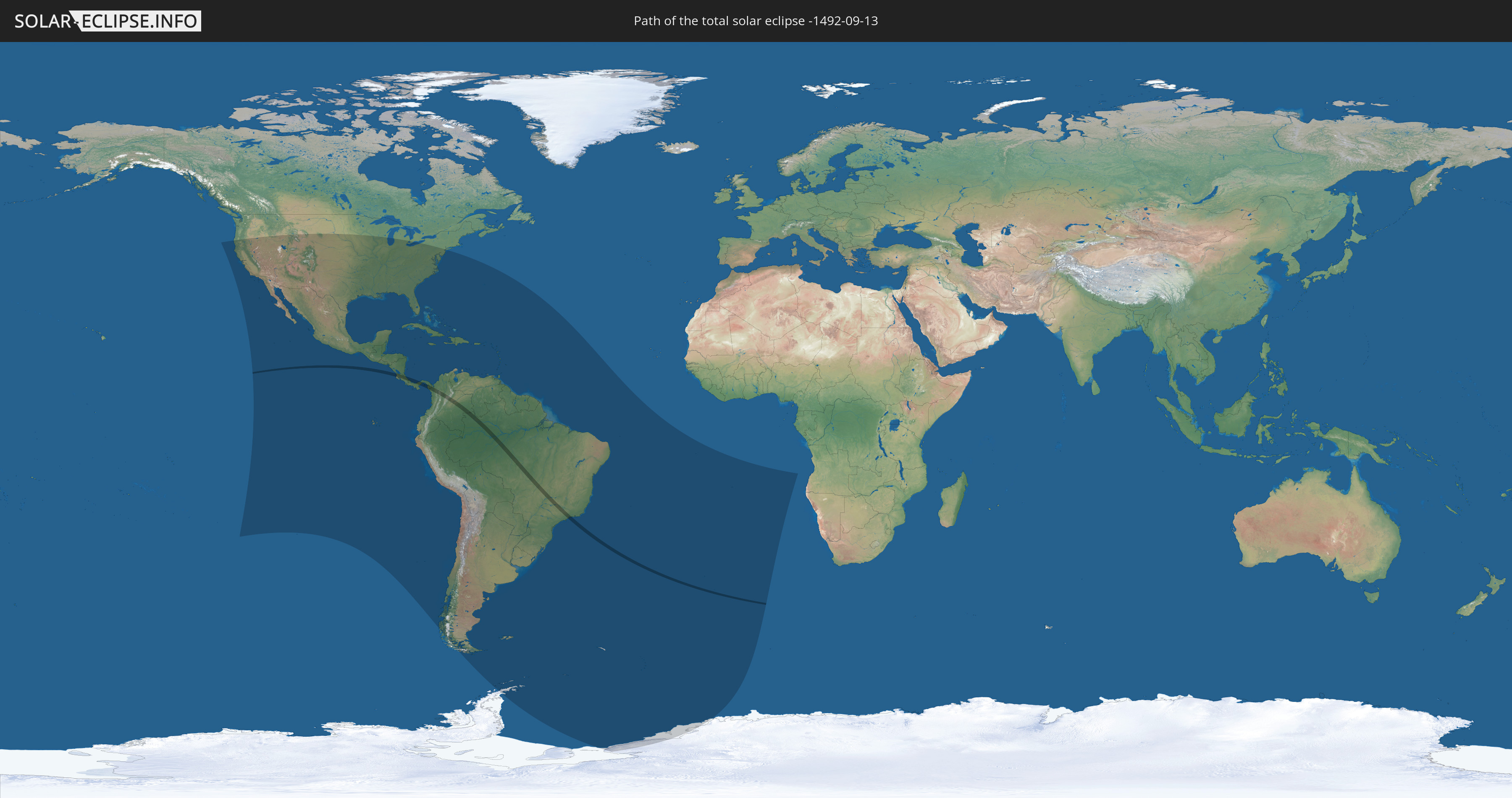
Die Sonnenfinsternis am 13.09.-1492 kann man in 54 Ländern als partielle Sonnenfinsternis beobachten.
Der Finsternispfad verläuft durch 5 Länder. Nur in diesen Ländern ist sie als totale Sonnenfinsternis zu sehen.
In den folgenden Ländern ist die Sonnenfinsternis total zu sehen
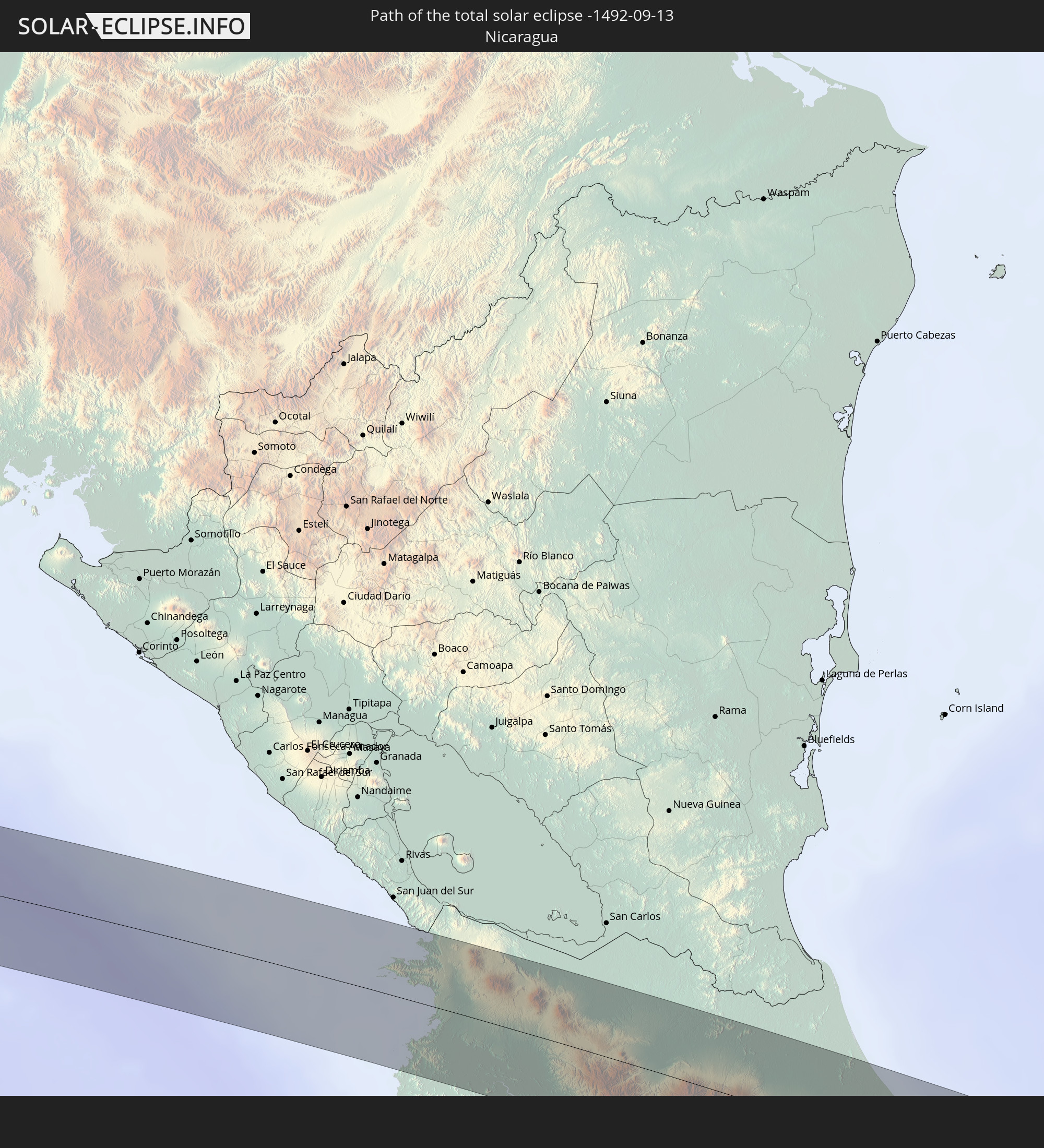 Nicaragua
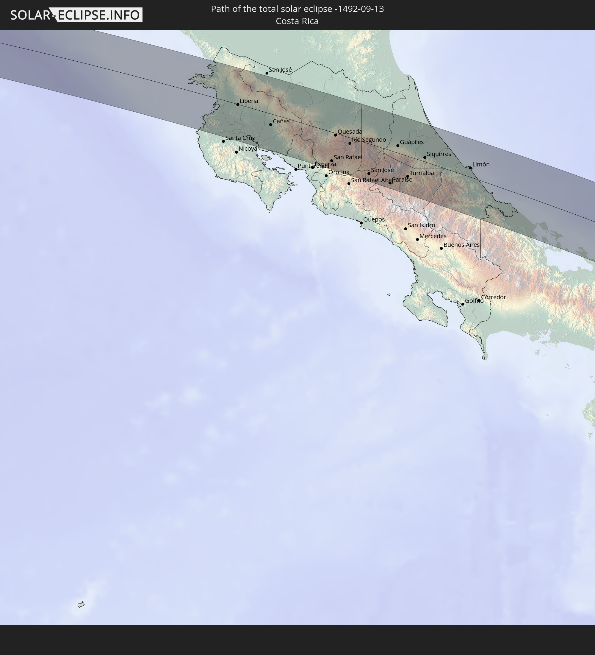 Costa Rica
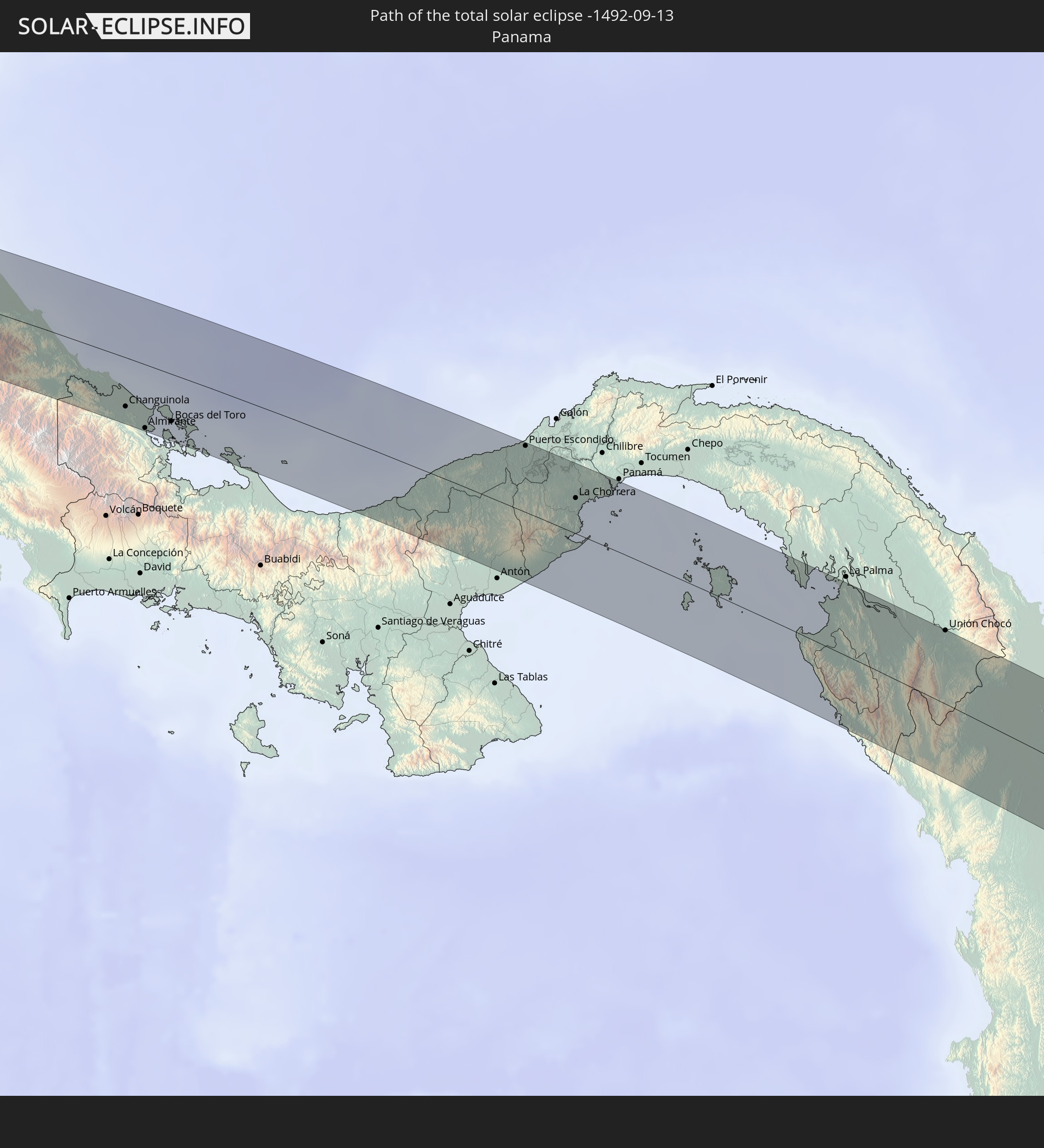 Panama
 Kolumbien
 Brasilien
In den folgenden Ländern ist die Sonnenfinsternis partiell zu sehen
 Antarktika
 Vereinigte Staaten
 United States Minor Outlying Islands
 Kanada
 Mexiko
 Chile
Chile
 Guatemala
 Ecuador
 El Salvador
 Honduras
 Belize
 Nicaragua
 Costa Rica
 Kuba
Kuba
 Panama
 Kolumbien
 Kaimaninseln
 Peru
Peru
 Bahamas
 Jamaika
 Haiti
Haiti
 Brasilien
 Argentinien
 Venezuela
 Turks- und Caicosinseln
 Dominikanische Republik
 Aruba
Aruba
 Bolivien
 Puerto Rico
 Amerikanische Jungferninseln
 Bermuda
 Britische Jungferninseln
 Anguilla
 Saint-Martin
 Saint-Barthélemy
 St. Kitts und Nevis
 Paraguay
 Antigua und Barbuda
 Montserrat
 Trinidad und Tobago
 Guadeloupe
 Grenada
 Dominica
 St. Vincent und die Grenadinen
 Falklandinseln
 Guyana
 Martinique
 St. Lucia
 Barbados
 Uruguay
 Suriname
 Französisch-Guayana
 Südgeorgien und die Südlichen Sandwichinseln
 St. Helena
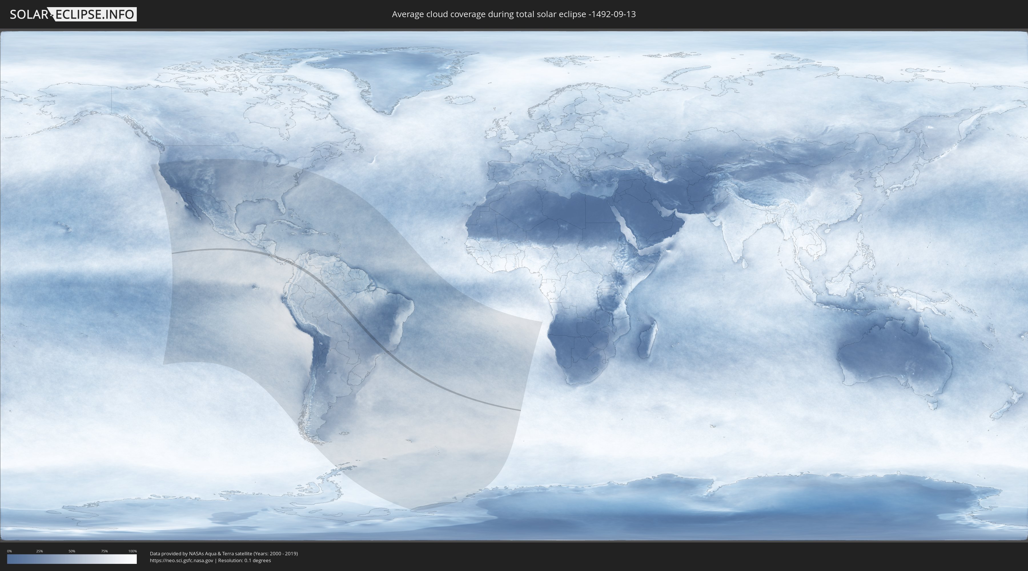
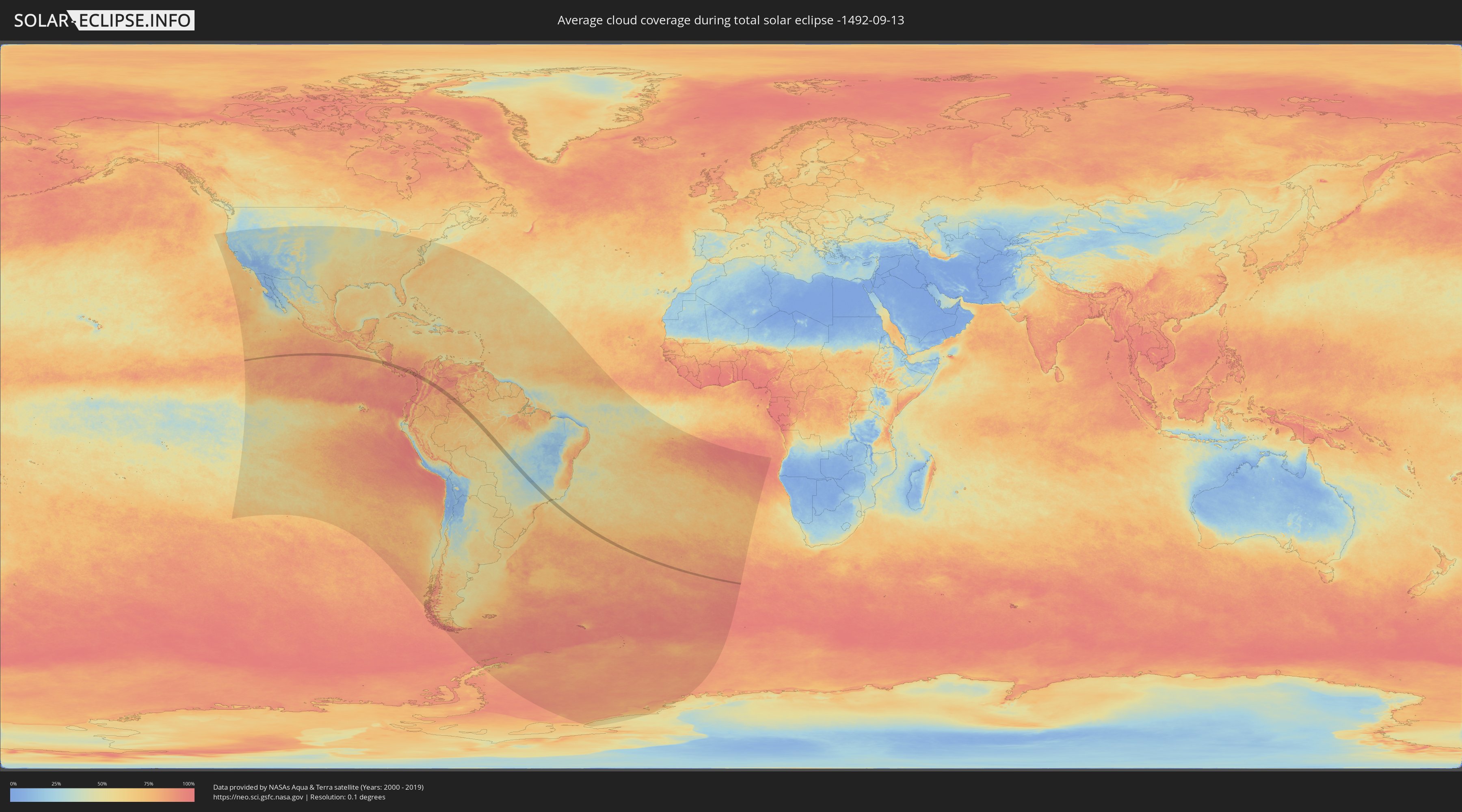
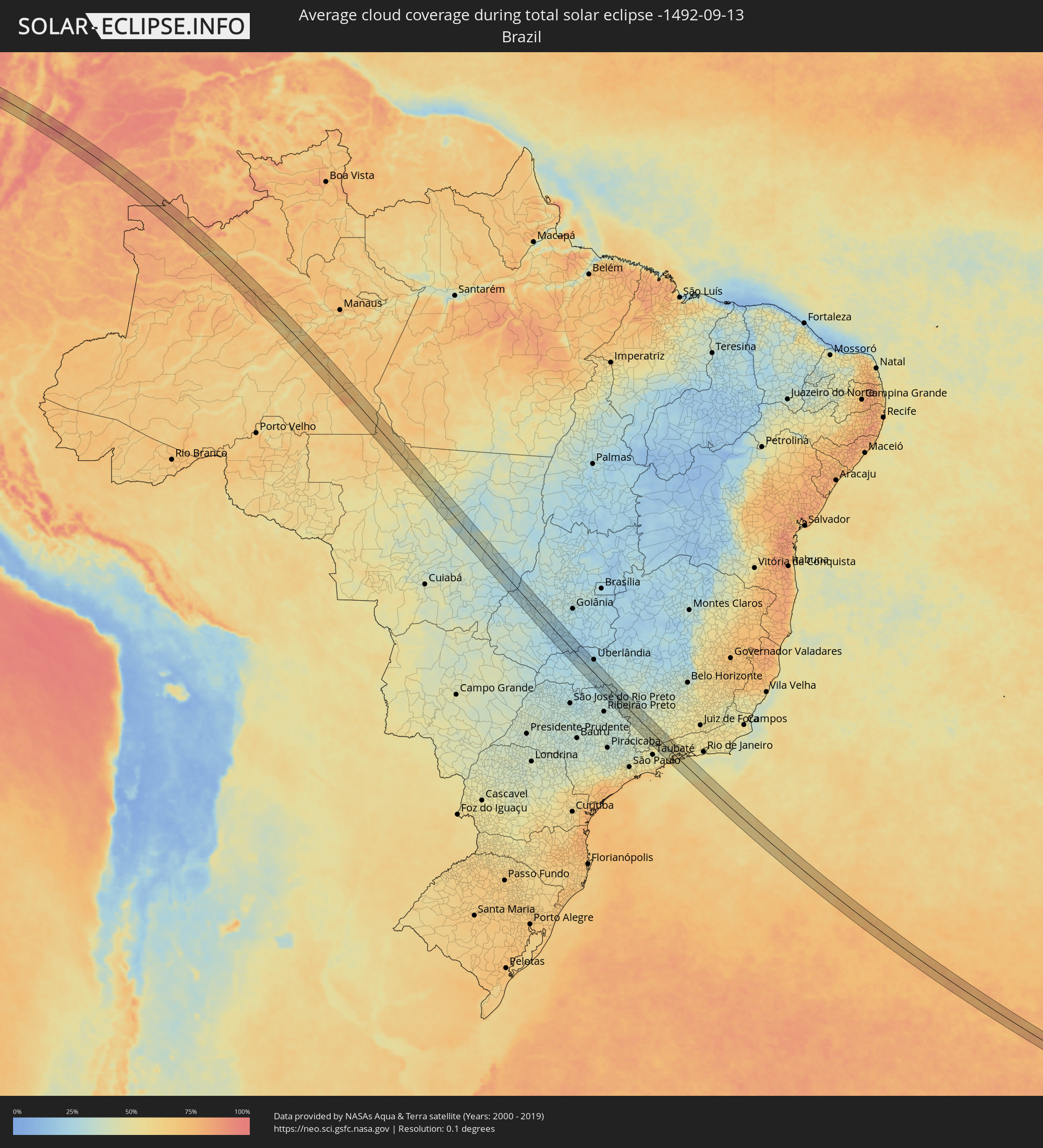
Wie wird das Wetter während der totalen Sonnenfinsternis am 13.09.-1492?
Wo ist der beste Ort, um die totale Sonnenfinsternis vom 13.09.-1492 zu beobachten?
Die folgenden Karten zeigen die durchschnittliche Bewölkung für den Tag, an dem die totale Sonnenfinsternis
stattfindet. Mit Hilfe der Karten lässt sich der Ort entlang des Finsternispfades eingrenzen,
der die besten Aussichen auf einen klaren wolkenfreien Himmel bietet.
Trotzdem muss man immer lokale Gegenenheiten beachten und sollte sich genau über das Wetter an seinem
gewählten Beobachtungsort informieren.
Die Daten stammen von den beiden NASA-Satelliten
AQUA und TERRA
und wurden über einen Zeitraum von 19 Jahren (2000 - 2019) gemittelt.
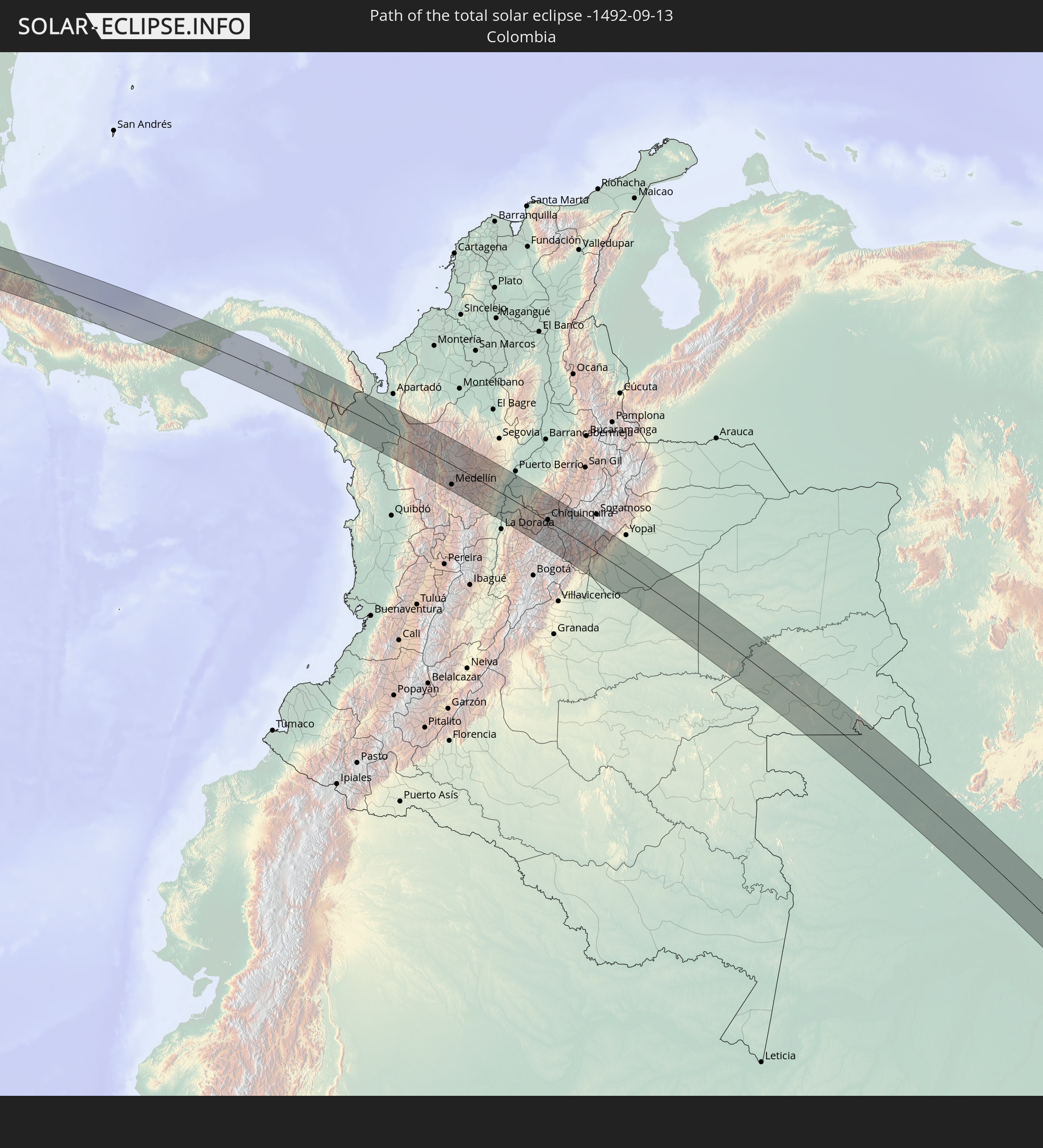
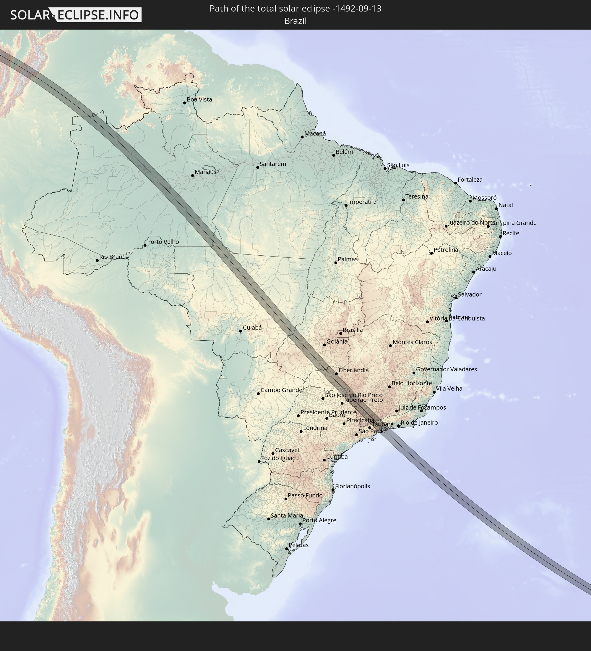
Detaillierte Länderkarten
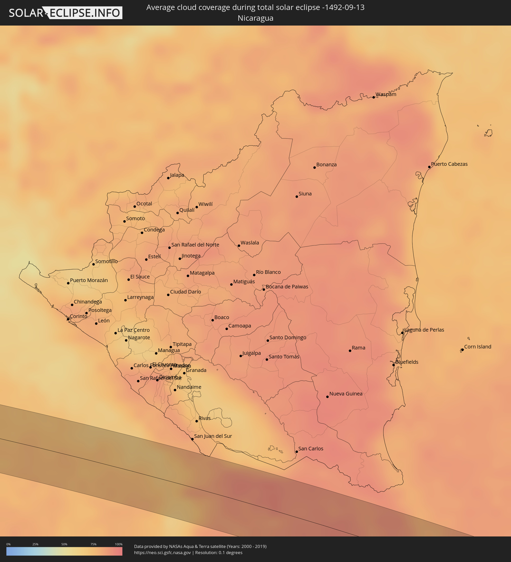 Nicaragua
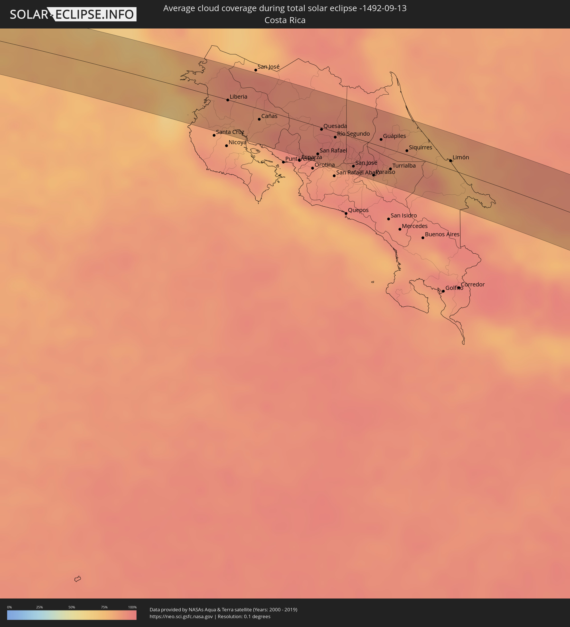 Costa Rica
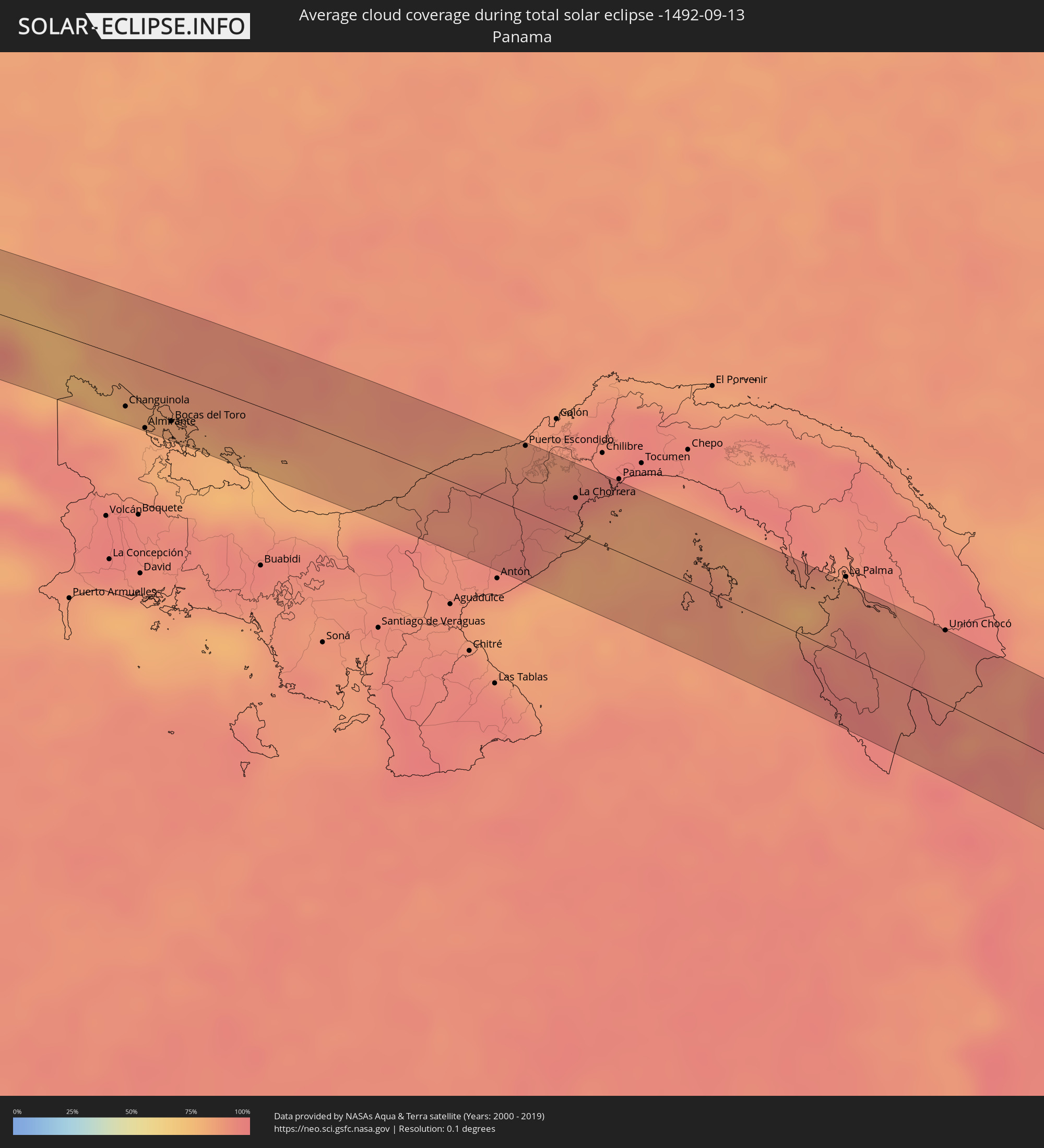 Panama
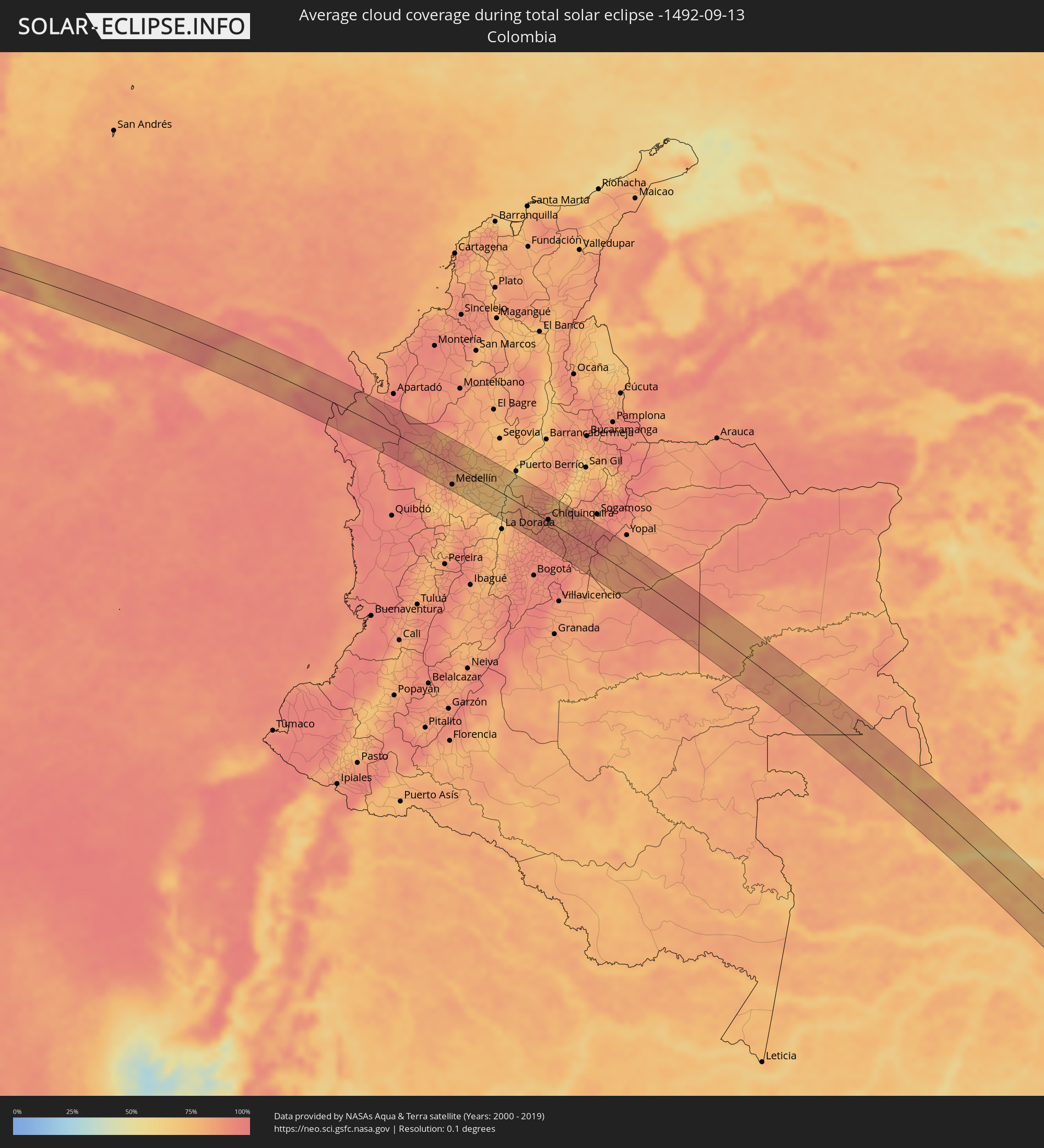 Kolumbien
 Brasilien
Orte im Finsternispfad
Die nachfolgene Tabelle zeigt Städte und Orte mit mehr als 5.000 Einwohnern, die sich im Finsternispfad befinden. Städte mit mehr als 100.000 Einwohnern sind dick gekennzeichnet. Mit einem Klick auf den Ort öffnet sich eine Detailkarte die die Lage des jeweiligen Ortes zusammen mit dem Verlauf der zentralen Finsternis präsentiert.
| Ort | Typ | Dauer der Verfinsterung | Ortszeit bei maximaler Verfinsterung | Entfernung zur Zentrallinie | Ø Bewölkung |
|
Liberia, Guanacaste
|
total | - | 08:42:47 UTC-05:36 | 1 km | 86% |
|
Cañas, Guanacaste
|
total | - | 08:43:31 UTC-05:36 | 12 km | 87% |
|
Tilarán, Guanacaste
|
total | - | 08:43:40 UTC-05:36 | 4 km | 87% |
|
San Ramón, Alajuela
|
total | - | 08:44:52 UTC-05:36 | 29 km | 92% |
|
San Rafael, Alajuela
|
total | - | 08:44:54 UTC-05:36 | 31 km | 92% |
|
Quesada, Alajuela
|
total | - | 08:44:39 UTC-05:36 | 2 km | 96% |
|
Atenas, Alajuela
|
total | - | 08:45:08 UTC-05:36 | 38 km | 85% |
|
Naranjo, Alajuela
|
total | - | 08:44:59 UTC-05:36 | 25 km | 87% |
|
San Juan, Alajuela
|
total | - | 08:45:05 UTC-05:36 | 22 km | 87% |
|
Río Segundo, Alajuela
|
total | - | 08:44:59 UTC-05:36 | 6 km | 93% |
|
Colón, Heredia
|
total | - | 08:45:25 UTC-05:36 | 40 km | 89% |
|
Alajuela, Alajuela
|
total | - | 08:45:21 UTC-05:36 | 28 km | 86% |
|
San Antonio, Heredia
|
total | - | 08:45:26 UTC-05:36 | 31 km | 86% |
|
Santa Ana, San José
|
total | - | 08:45:29 UTC-05:36 | 36 km | 89% |
|
Escazú, San José
|
total | - | 08:45:34 UTC-05:36 | 36 km | 88% |
|
San Rafael, San José
|
total | - | 08:45:34 UTC-05:36 | 35 km | 88% |
|
Mercedes, Heredia
|
total | - | 08:45:29 UTC-05:36 | 26 km | 88% |
|
Heredia, Heredia
|
total | - | 08:45:31 UTC-05:36 | 26 km | 88% |
|
San Felipe, San José
|
total | - | 08:45:39 UTC-05:36 | 36 km | 88% |
|
Alajuelita, San José
|
total | - | 08:45:39 UTC-05:36 | 36 km | 88% |
|
San Rafael, Heredia
|
total | - | 08:45:31 UTC-05:36 | 25 km | 88% |
|
San Josecito, Heredia
|
total | - | 08:45:31 UTC-05:36 | 24 km | 88% |
|
San Pablo, Heredia
|
total | - | 08:45:33 UTC-05:36 | 26 km | 88% |
|
Colima, San José
|
total | - | 08:45:37 UTC-05:36 | 31 km | 88% |
|
San Juan de Dios, San José
|
total | - | 08:45:42 UTC-05:36 | 39 km | 88% |
|
San José, San José
|
total | - | 08:45:39 UTC-05:36 | 33 km | 88% |
|
San Juan, San José
|
total | - | 08:45:37 UTC-05:36 | 30 km | 88% |
|
San Rafael Arriba, San José
|
total | - | 08:45:43 UTC-05:36 | 38 km | 88% |
|
Calle Blancos, San José
|
total | - | 08:45:39 UTC-05:36 | 30 km | 88% |
|
San Miguel, San José
|
total | - | 08:45:45 UTC-05:36 | 38 km | 88% |
|
Guadalupe, San José
|
total | - | 08:45:40 UTC-05:36 | 30 km | 88% |
|
San Pedro, San José
|
total | - | 08:45:42 UTC-05:36 | 32 km | 88% |
|
San Vicente de Moravia, San José
|
total | - | 08:45:40 UTC-05:36 | 28 km | 91% |
|
San Vicente, San José
|
total | - | 08:45:40 UTC-05:36 | 29 km | 91% |
|
Sabanilla, San José
|
total | - | 08:45:42 UTC-05:36 | 30 km | 85% |
|
Patarrá, San José
|
total | - | 08:45:47 UTC-05:36 | 36 km | 85% |
|
Purral, San José
|
total | - | 08:45:42 UTC-05:36 | 28 km | 91% |
|
Granadilla, San José
|
total | - | 08:45:45 UTC-05:36 | 30 km | 85% |
|
Ipís, San José
|
total | - | 08:45:43 UTC-05:36 | 27 km | 91% |
|
San Diego, Cartago
|
total | - | 08:45:49 UTC-05:36 | 33 km | 85% |
|
Concepción, Cartago
|
total | - | 08:45:46 UTC-05:36 | 30 km | 85% |
|
Tres Ríos, Cartago
|
total | - | 08:45:49 UTC-05:36 | 32 km | 85% |
|
Cartago, Cartago
|
total | - | 08:45:59 UTC-05:36 | 34 km | 83% |
|
Cot, Cartago
|
total | - | 08:46:01 UTC-05:36 | 30 km | 83% |
|
Paraíso, Cartago
|
total | - | 08:46:06 UTC-05:36 | 35 km | 89% |
|
Guápiles, Limón
|
total | - | 08:45:46 UTC-05:36 | 8 km | 94% |
|
Guácimo, Limón
|
total | - | 08:45:55 UTC-05:36 | 10 km | 90% |
|
Turrialba, Cartago
|
total | - | 08:46:18 UTC-05:36 | 22 km | 84% |
|
Siquirres, Limón
|
total | - | 08:46:21 UTC-05:36 | 4 km | 85% |
|
Limón, Limón
|
total | - | 08:47:13 UTC-05:36 | 10 km | 75% |
|
Guabito, Bocas del Toro
|
total | - | 09:05:08 UTC-05:19 | 28 km | 78% |
|
Changuinola, Bocas del Toro
|
total | - | 09:05:22 UTC-05:19 | 31 km | 83% |
|
Almirante, Bocas del Toro
|
total | - | 09:05:43 UTC-05:19 | 40 km | 82% |
|
Bocas del Toro, Bocas del Toro
|
total | - | 09:05:56 UTC-05:19 | 30 km | 82% |
|
Penonomé, Coclé
|
total | - | 09:10:12 UTC-05:19 | 40 km | 93% |
|
Puerto Escondido, Colón
|
total | - | 09:09:44 UTC-05:19 | 41 km | 88% |
|
El Coco, Panamá
|
total | - | 09:10:39 UTC-05:19 | 19 km | 93% |
|
Guadalupe, Panamá
|
total | - | 09:10:40 UTC-05:19 | 18 km | 93% |
|
La Chorrera, Panamá
|
total | - | 09:10:41 UTC-05:19 | 22 km | 93% |
|
Nuevo Arraiján, Panamá
|
total | - | 09:10:45 UTC-05:19 | 28 km | 89% |
|
Vista Alegre, Panamá
|
total | - | 09:10:45 UTC-05:19 | 31 km | 89% |
|
Arraiján, Panamá
|
total | - | 09:10:49 UTC-05:19 | 35 km | 95% |
|
Veracruz, Panamá
|
total | - | 09:10:56 UTC-05:19 | 29 km | 87% |
|
Ancón, Panamá
|
total | - | 09:10:58 UTC-05:19 | 40 km | 91% |
|
Unión Chocó, Emberá
|
total | - | 09:15:49 UTC-05:19 | 44 km | 92% |
|
Riosucio, Chocó
|
total | - | 09:40:52 UTC-04:56 | 1 km | 92% |
|
Dabeiba, Antioquia
|
total | - | 09:43:09 UTC-04:56 | 1 km | 92% |
|
Frontino, Antioquia
|
total | - | 09:43:46 UTC-04:56 | 15 km | 84% |
|
Cañasgordas, Antioquia
|
total | - | 09:44:00 UTC-04:56 | 11 km | 85% |
|
Antioquia, Antioquia
|
total | - | 09:44:41 UTC-04:56 | 19 km | 79% |
|
Ituango, Antioquia
|
total | - | 09:43:49 UTC-04:56 | 44 km | 82% |
|
Itagüí, Antioquia
|
total | - | 09:45:43 UTC-04:56 | 43 km | 82% |
|
Envigado, Antioquia
|
total | - | 09:45:45 UTC-04:56 | 44 km | 82% |
|
Medellín, Antioquia
|
total | - | 09:45:41 UTC-04:56 | 35 km | 79% |
|
San Pedro, Antioquia
|
total | - | 09:45:20 UTC-04:56 | 14 km | 84% |
|
Municipio de Copacabana, Antioquia
|
total | - | 09:45:38 UTC-04:56 | 23 km | 78% |
|
Santa Rosa de Osos, Antioquia
|
total | - | 09:45:14 UTC-04:56 | 9 km | 82% |
|
Guarne, Antioquia
|
total | - | 09:45:52 UTC-04:56 | 25 km | 74% |
|
Yarumal, Antioquia
|
total | - | 09:44:48 UTC-04:56 | 42 km | 81% |
|
Don Matías, Antioquia
|
total | - | 09:45:37 UTC-04:56 | 3 km | 80% |
|
Rionegro, Antioquia
|
total | - | 09:46:12 UTC-04:56 | 34 km | 70% |
|
Marinilla, Antioquia
|
total | - | 09:46:15 UTC-04:56 | 30 km | 68% |
|
San Vicente, Antioquia
|
total | - | 09:46:09 UTC-04:56 | 24 km | 68% |
|
Carmen de Viboral, Antioquia
|
total | - | 09:46:24 UTC-04:56 | 39 km | 71% |
|
Barbosa, Antioquia
|
total | - | 09:45:49 UTC-04:56 | 4 km | 76% |
|
Santuario, Antioquia
|
total | - | 09:46:26 UTC-04:56 | 29 km | 71% |
|
Granada, Antioquia
|
total | - | 09:46:35 UTC-04:56 | 25 km | 71% |
|
Cocorná, Antioquia
|
total | - | 09:46:43 UTC-04:56 | 33 km | 71% |
|
Guatapé, Antioquia
|
total | - | 09:46:28 UTC-04:56 | 15 km | 69% |
|
Cisneros, Antioquia
|
total | - | 09:46:07 UTC-04:56 | 19 km | 77% |
|
San Rafael, Antioquia
|
total | - | 09:46:38 UTC-04:56 | 1 km | 71% |
|
San Roque, Antioquia
|
total | - | 09:46:20 UTC-04:56 | 18 km | 75% |
|
Yolombó, Antioquia
|
total | - | 09:46:10 UTC-04:56 | 29 km | 72% |
|
San Carlos, Antioquia
|
total | - | 09:46:53 UTC-04:56 | 10 km | 73% |
|
San Luis, Antioquia
|
total | - | 09:47:07 UTC-04:56 | 24 km | 69% |
|
Puerto Boyacá, Boyacá
|
total | - | 09:48:01 UTC-04:56 | 7 km | 65% |
|
Muzo, Boyacá
|
total | - | 09:49:41 UTC-04:56 | 22 km | 85% |
|
La Mesa, Cundinamarca
|
total | - | 09:50:31 UTC-04:56 | 36 km | 93% |
|
Chiquinquirá, Boyacá
|
total | - | 09:50:07 UTC-04:56 | 3 km | 87% |
|
Ubaté, Cundinamarca
|
total | - | 09:50:39 UTC-04:56 | 26 km | 90% |
|
Chocontá, Cundinamarca
|
total | - | 09:51:11 UTC-04:56 | 34 km | 91% |
|
Puente Nacional, Santander
|
total | - | 09:49:57 UTC-04:56 | 36 km | 78% |
|
Barbosa, Santander
|
total | - | 09:49:58 UTC-04:56 | 44 km | 80% |
|
Villapinzón, Cundinamarca
|
total | - | 09:51:15 UTC-04:56 | 22 km | 93% |
|
Moniquirá, Boyacá
|
total | - | 09:50:09 UTC-04:56 | 42 km | 80% |
|
Villa de Leiva, Boyacá
|
total | - | 09:50:34 UTC-04:56 | 20 km | 80% |
|
Guateque, Boyacá
|
total | - | 09:51:51 UTC-04:56 | 34 km | 91% |
|
Tunja, Boyacá
|
total | - | 09:51:08 UTC-04:56 | 21 km | 90% |
|
Garagoa, Boyacá
|
total | - | 09:51:56 UTC-04:56 | 21 km | 87% |
|
Ramiriquí, Boyacá
|
total | - | 09:51:26 UTC-04:56 | 11 km | 94% |
|
Pesca, Boyacá
|
total | - | 09:51:44 UTC-04:56 | 42 km | 90% |
|
Monterrey, Casanare
|
total | - | 09:53:13 UTC-04:56 | 12 km | 88% |
|
Aguazul, Casanare
|
total | - | 09:53:23 UTC-04:56 | 37 km | 84% |
|
Maní, Casanare
|
total | - | 09:54:32 UTC-04:56 | 20 km | 85% |
|
Puerto Gaitán, Meta
|
total | - | 09:55:51 UTC-04:56 | 14 km | 89% |
|
Sinop, Mato Grosso
|
total | - | 12:20:02 UTC-03:38 | 14 km | 40% |
|
Barra do Garças, Mato Grosso
|
total | - | 12:33:25 UTC-03:38 | 42 km | 27% |
|
Aragarças, Goiás
|
total | - | 12:33:27 UTC-03:38 | 42 km | 27% |
|
Iporá, Goiás
|
total | - | 13:08:22 UTC-03:06 | 8 km | 27% |
|
Capinópolis, Minas Gerais
|
total | - | 13:14:42 UTC-03:06 | 38 km | 24% |
|
Goiatuba, Goiás
|
total | - | 13:13:58 UTC-03:06 | 30 km | 22% |
|
Itumbiara, Goiás
|
total | - | 13:14:52 UTC-03:06 | 10 km | 16% |
|
Prata, Minas Gerais
|
total | - | 13:16:44 UTC-03:06 | 35 km | 30% |
|
Monte Alegre de Minas, Minas Gerais
|
total | - | 13:16:07 UTC-03:06 | 1 km | 27% |
|
Tupaciguara, Minas Gerais
|
total | - | 13:15:58 UTC-03:06 | 36 km | 19% |
|
Conceição das Alagoas, Minas Gerais
|
total | - | 13:18:32 UTC-03:06 | 40 km | 28% |
|
Uberlândia, Minas Gerais
|
total | - | 13:17:11 UTC-03:06 | 44 km | 25% |
|
Miguelópolis, São Paulo
|
total | - | 13:19:30 UTC-03:06 | 33 km | 29% |
|
Uberaba, Minas Gerais
|
total | - | 13:19:01 UTC-03:06 | 7 km | 29% |
|
Guará, São Paulo
|
total | - | 13:20:12 UTC-03:06 | 37 km | 31% |
|
Ituverava, São Paulo
|
total | - | 13:20:08 UTC-03:06 | 27 km | 30% |
|
Igarapava, São Paulo
|
total | - | 13:19:45 UTC-03:06 | 1 km | 29% |
|
Sacramento, Minas Gerais
|
total | - | 13:19:58 UTC-03:06 | 35 km | 31% |
|
Franca, São Paulo
|
total | - | 13:21:02 UTC-03:06 | 14 km | 29% |
|
São Sebastião do Paraíso, Minas Gerais
|
total | - | 13:22:13 UTC-03:06 | 12 km | 35% |
|
Monte Santo de Minas, Minas Gerais
|
total | - | 13:22:38 UTC-03:06 | 32 km | 35% |
|
Cássia, Minas Gerais
|
total | - | 13:21:51 UTC-03:06 | 19 km | 35% |
|
Guaranésia, Minas Gerais
|
total | - | 13:23:04 UTC-03:06 | 28 km | 36% |
|
Itaú de Minas, Minas Gerais
|
total | - | 13:22:20 UTC-03:06 | 20 km | 35% |
|
Guaxupé, Minas Gerais
|
total | - | 13:23:12 UTC-03:06 | 22 km | 38% |
|
Caconde, São Paulo
|
total | - | 13:23:38 UTC-03:06 | 34 km | 37% |
|
Passos, Minas Gerais
|
total | - | 13:22:32 UTC-03:06 | 32 km | 37% |
|
Muzambinho, Minas Gerais
|
total | - | 13:23:36 UTC-03:06 | 13 km | 40% |
|
Alpinópolis, Minas Gerais
|
total | - | 13:23:05 UTC-03:06 | 37 km | 40% |
|
Alfenas, Minas Gerais
|
total | - | 13:24:33 UTC-03:06 | 25 km | 39% |
|
Pouso Alegre, Minas Gerais
|
total | - | 13:25:40 UTC-03:06 | 37 km | 42% |
|
Machado, Minas Gerais
|
total | - | 13:24:56 UTC-03:06 | 8 km | 44% |
|
Paraguaçu, Minas Gerais
|
total | - | 13:25:02 UTC-03:06 | 31 km | 43% |
|
Santa Rita do Sapucaí, Minas Gerais
|
total | - | 13:26:03 UTC-03:06 | 22 km | 43% |
|
São Gonçalo do Sapucaí, Minas Gerais
|
total | - | 13:25:44 UTC-03:06 | 15 km | 44% |
|
Elói Mendes, Minas Gerais
|
total | - | 13:25:23 UTC-03:06 | 39 km | 44% |
|
Itajubá, Minas Gerais
|
total | - | 13:26:39 UTC-03:06 | 17 km | 43% |
|
Campanha, Minas Gerais
|
total | - | 13:25:57 UTC-03:06 | 33 km | 46% |
|
Lambari, Minas Gerais
|
total | - | 13:26:12 UTC-03:06 | 26 km | 46% |
|
Aparecida, São Paulo
|
total | - | 13:27:33 UTC-03:06 | 34 km | 43% |
|
Guaratinguetá, São Paulo
|
total | - | 13:27:34 UTC-03:06 | 29 km | 43% |
|
Piquete, São Paulo
|
total | - | 13:27:19 UTC-03:06 | 12 km | 46% |
|
São Lourenço, Minas Gerais
|
total | - | 13:26:50 UTC-03:06 | 36 km | 44% |
|
Cruzeiro, São Paulo
|
total | - | 13:27:34 UTC-03:06 | 6 km | 42% |
|
Passa Quatro, Minas Gerais
|
total | - | 13:27:20 UTC-03:06 | 21 km | 45% |
|
Cunha, São Paulo
|
total | - | 13:28:14 UTC-03:06 | 33 km | 49% |
|
Paraty, Rio de Janeiro
|
total | - | 13:28:47 UTC-03:06 | 27 km | 57% |
|
Itatiaia, Rio de Janeiro
|
total | - | 13:28:04 UTC-03:06 | 41 km | 49% |
|
Angra dos Reis, Rio de Janeiro
|
total | - | 13:29:05 UTC-03:06 | 18 km | 57% |
|
Mangaratiba, Rio de Janeiro
|
total | - | 13:29:26 UTC-03:06 | 42 km | 52% |