Totale Sonnenfinsternis vom 20.04.-1522
| Wochentag: | Montag |
| Maximale Dauer der Verfinsterung: | 05m05s |
| Maximale Breite des Finsternispfades: | 234 km |
| Saroszyklus: | 14 |
| Bedeckungsgrad: | 100% |
| Magnitude: | 1.0625 |
| Gamma: | 0.4886 |
Wo kann man die Sonnenfinsternis vom 20.04.-1522 sehen?
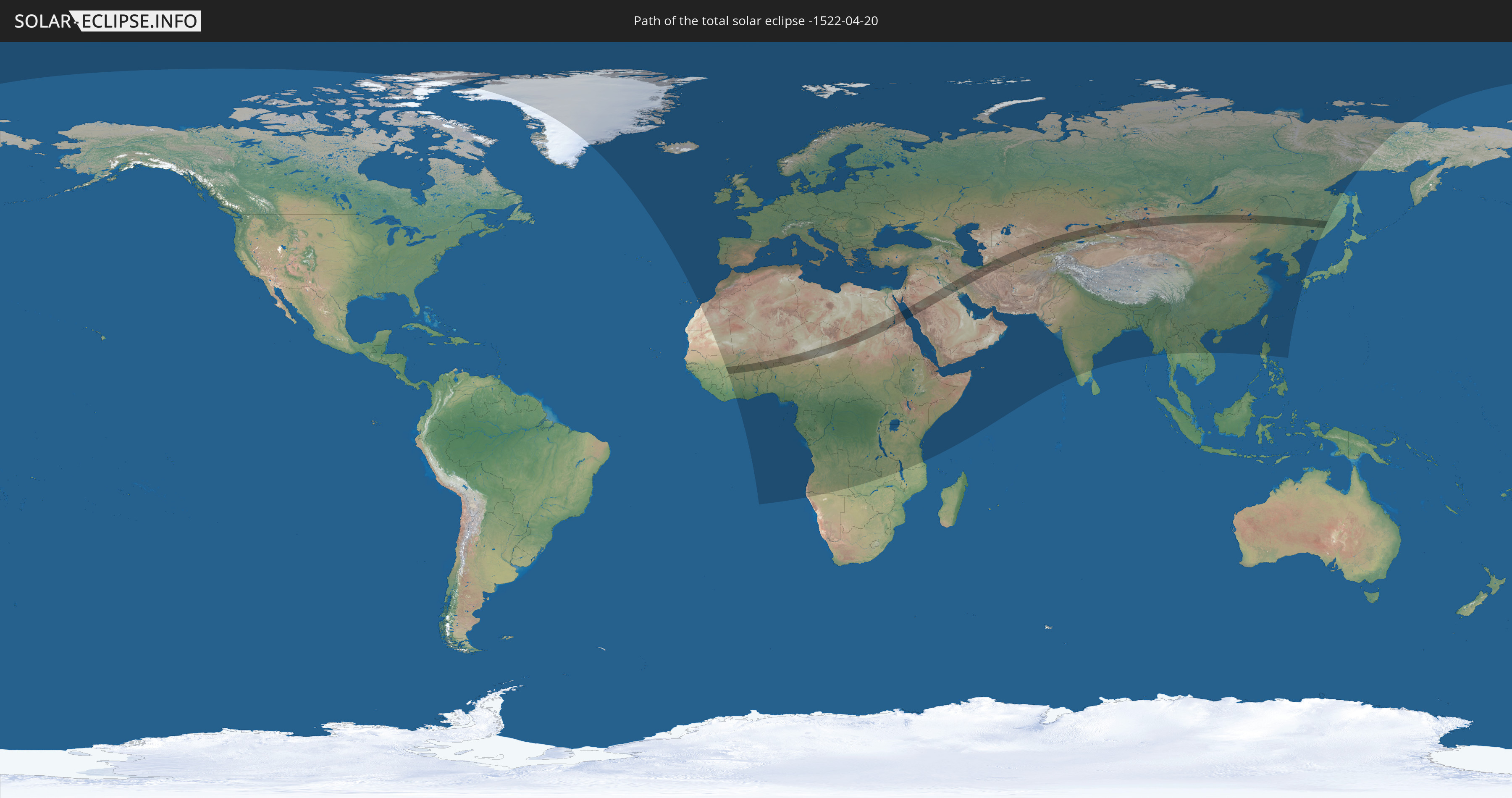
Die Sonnenfinsternis am 20.04.-1522 kann man in 133 Ländern als partielle Sonnenfinsternis beobachten.
Der Finsternispfad verläuft durch 19 Länder. Nur in diesen Ländern ist sie als totale Sonnenfinsternis zu sehen.
In den folgenden Ländern ist die Sonnenfinsternis total zu sehen
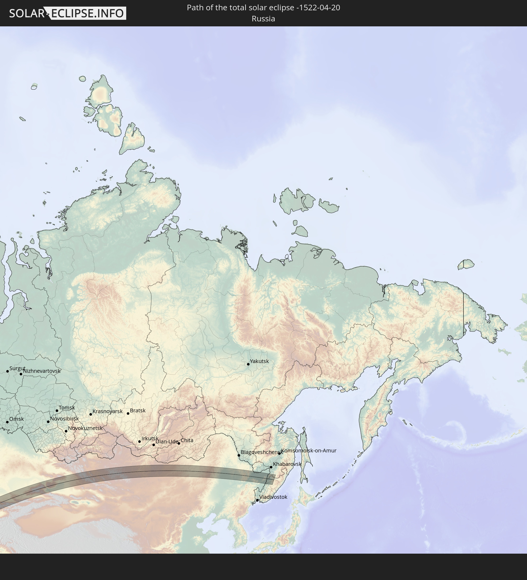 Russland
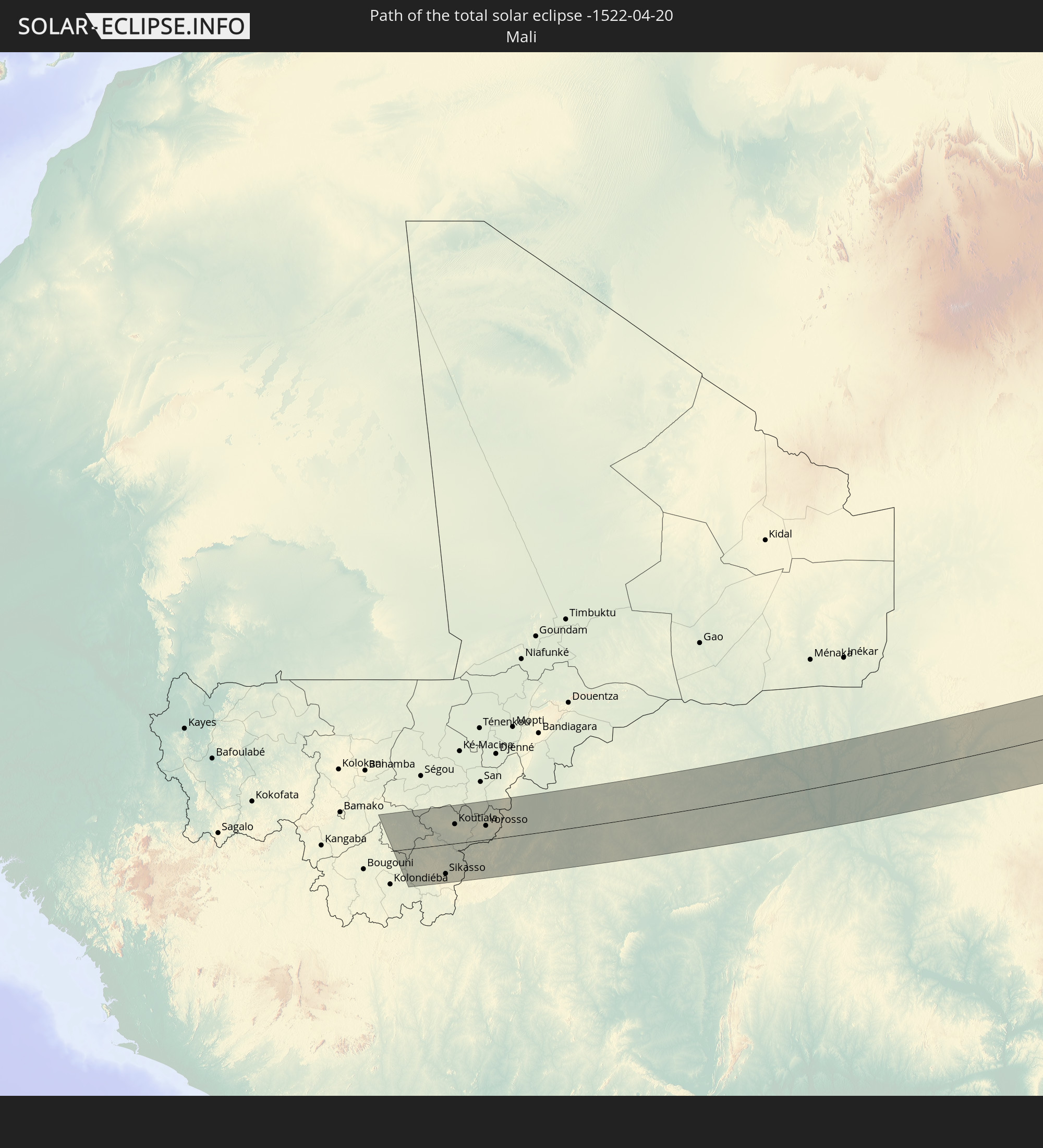 Mali
Mali
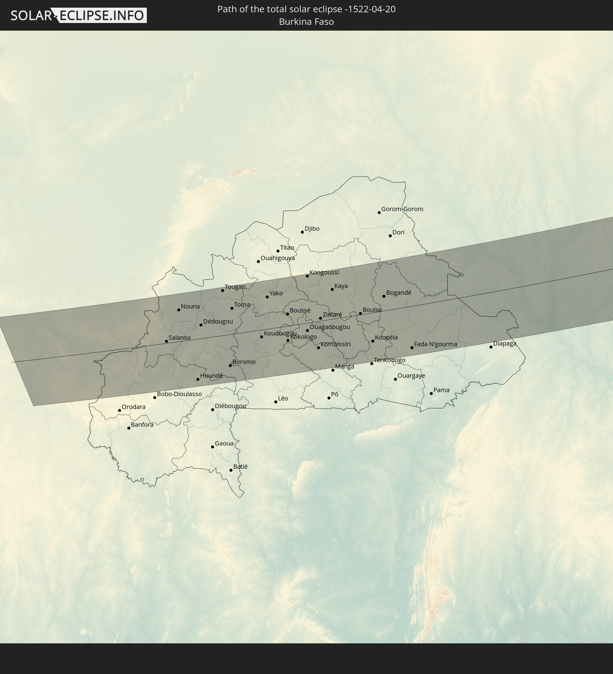 Burkina Faso
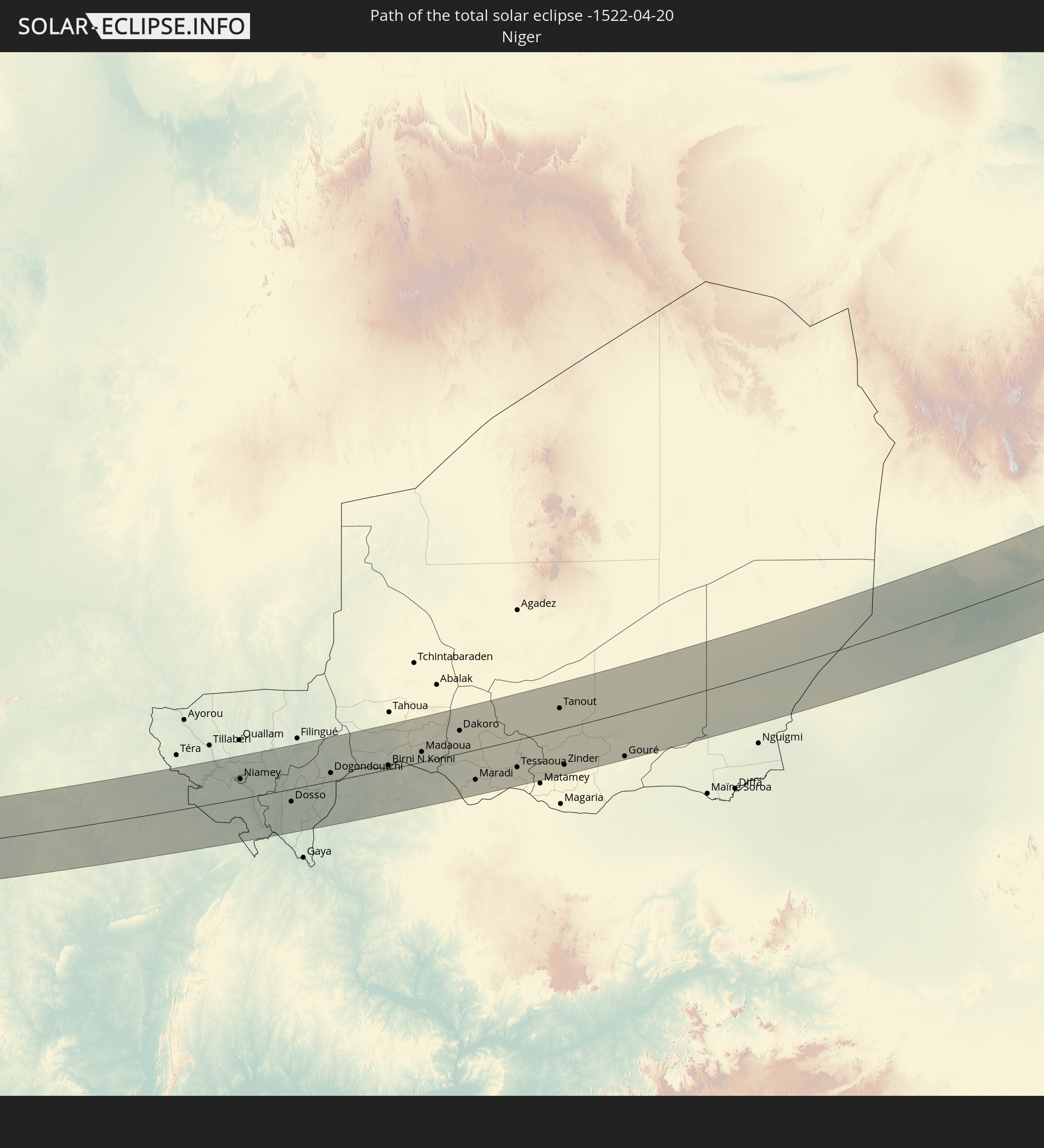 Niger
Niger
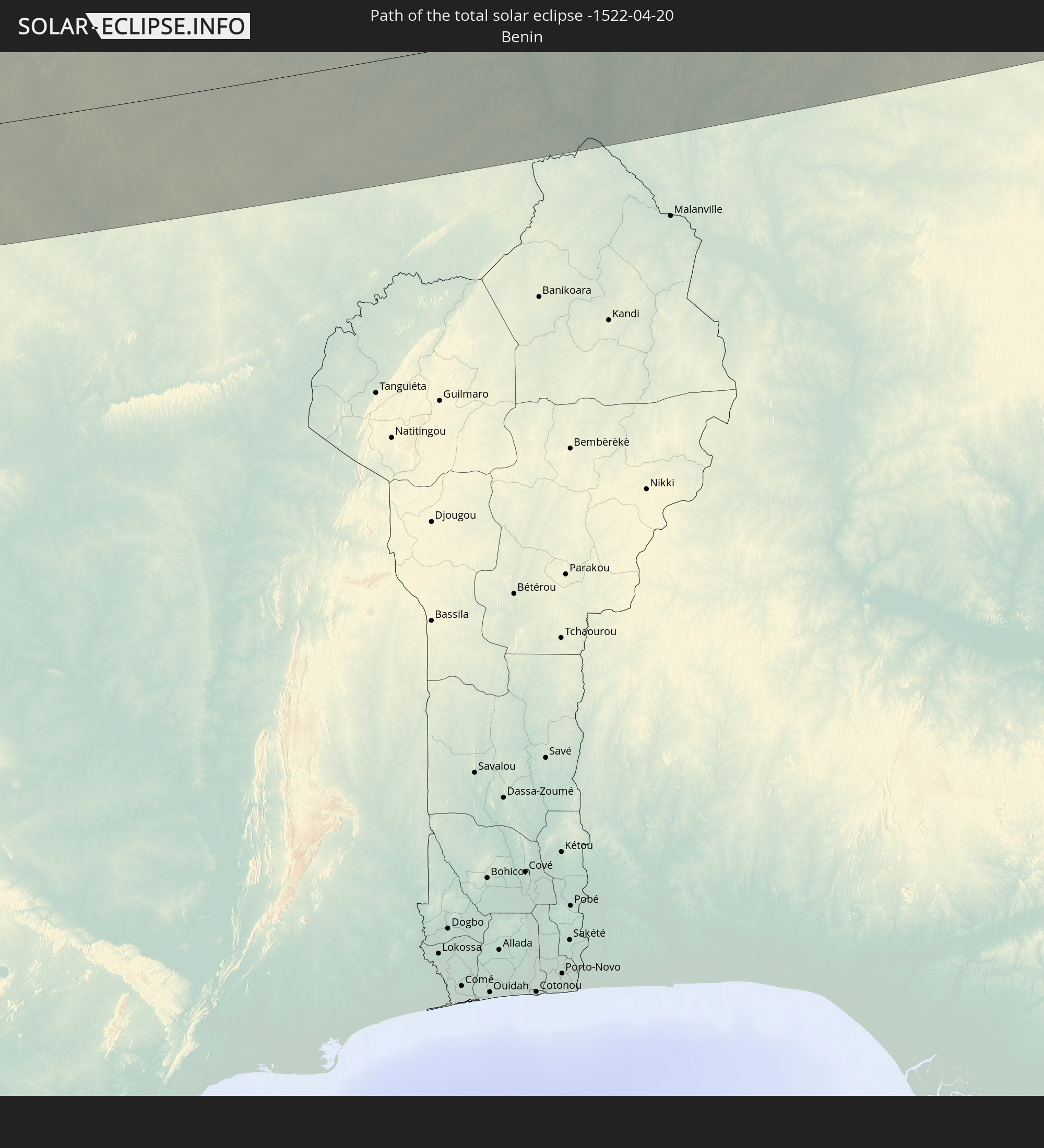 Benin
Benin
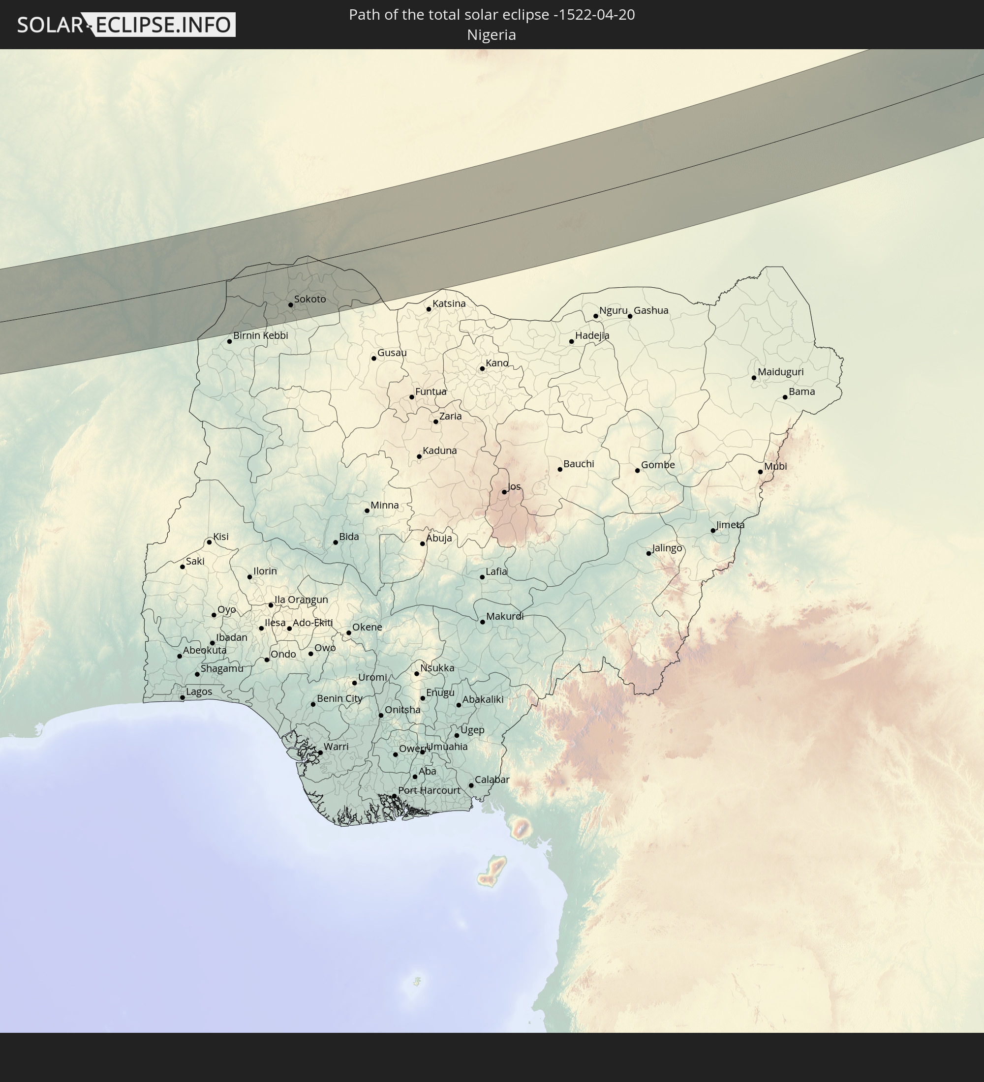 Nigeria
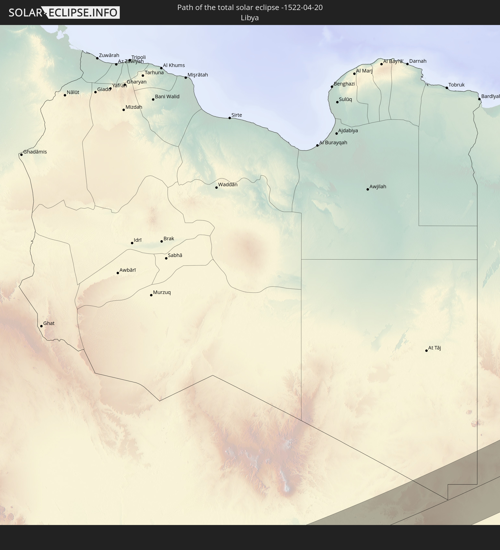 Libyen
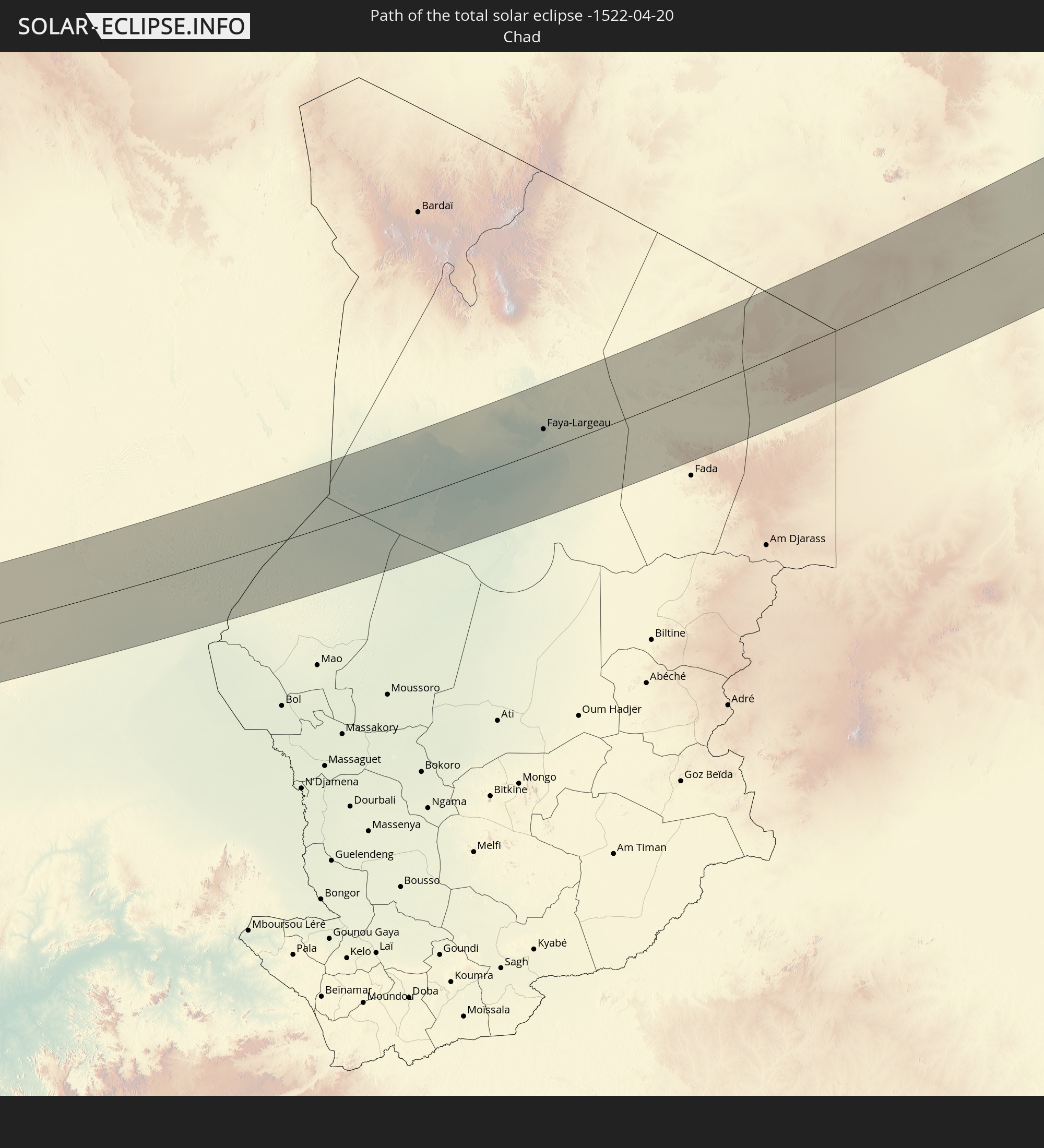 Tschad
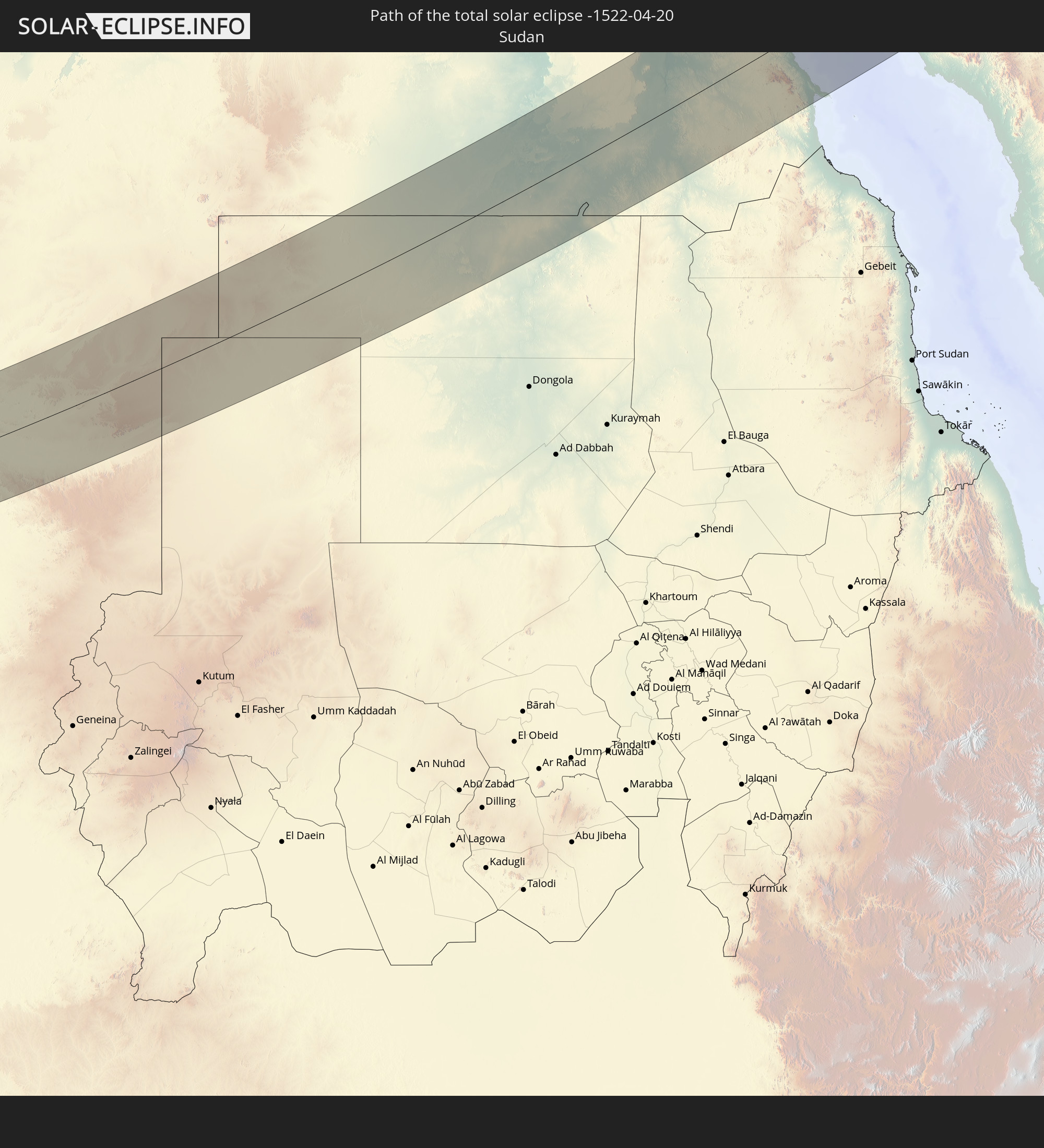 Sudan
Sudan
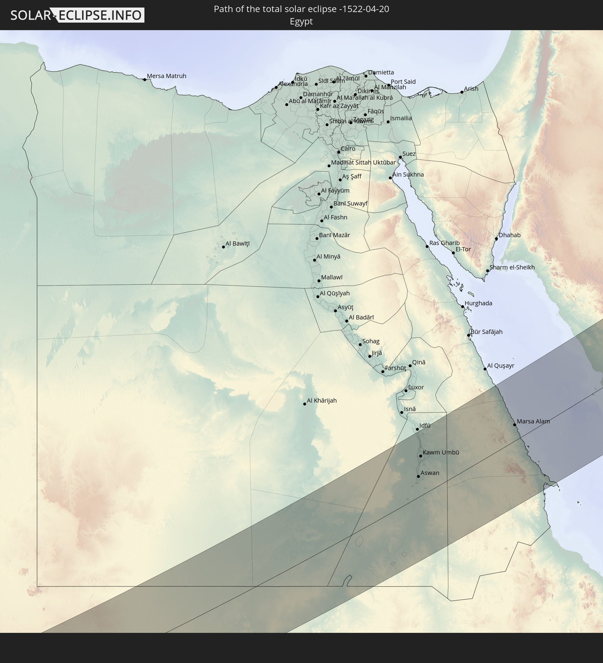 Ägypten
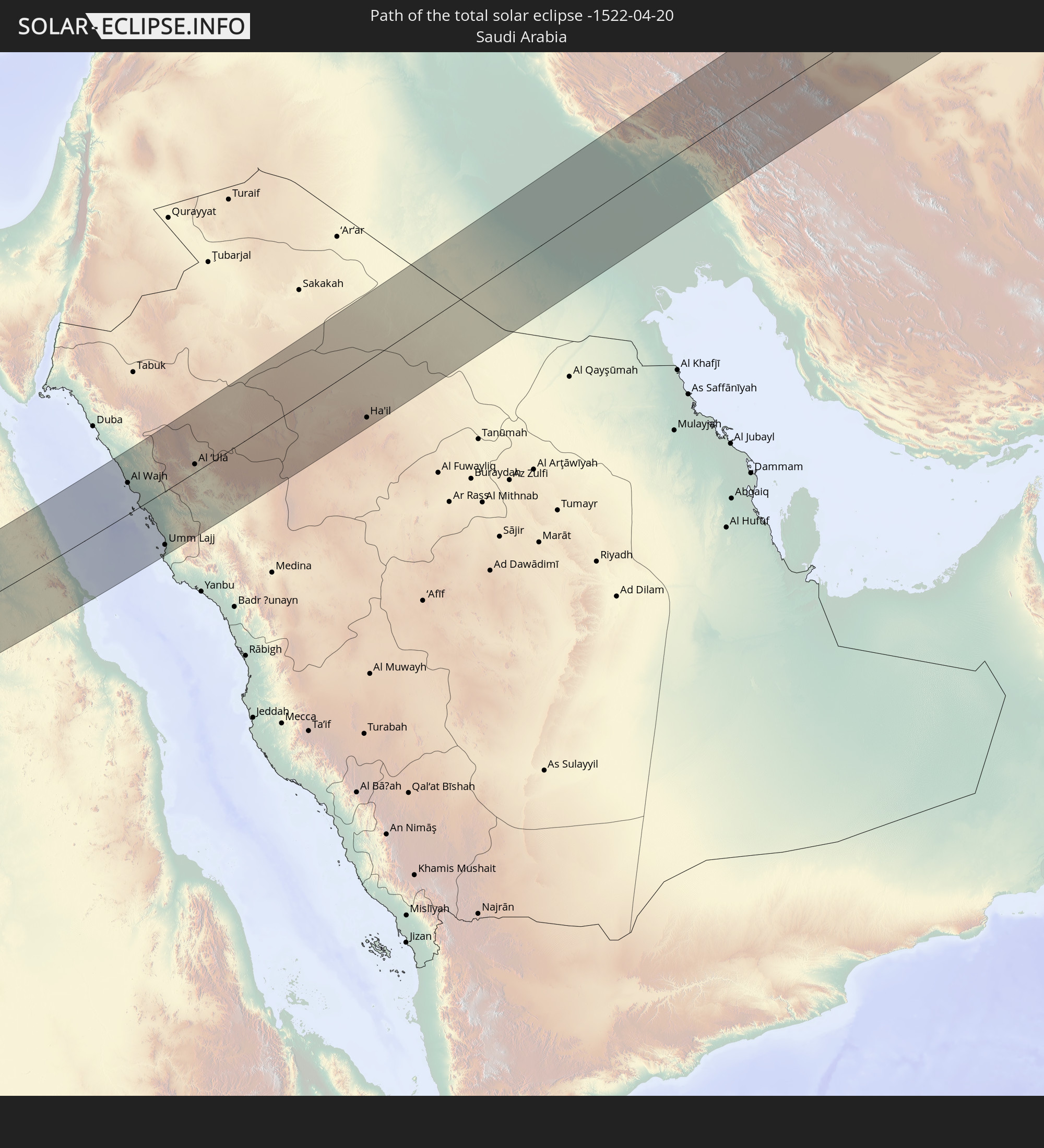 Saudi-Arabien
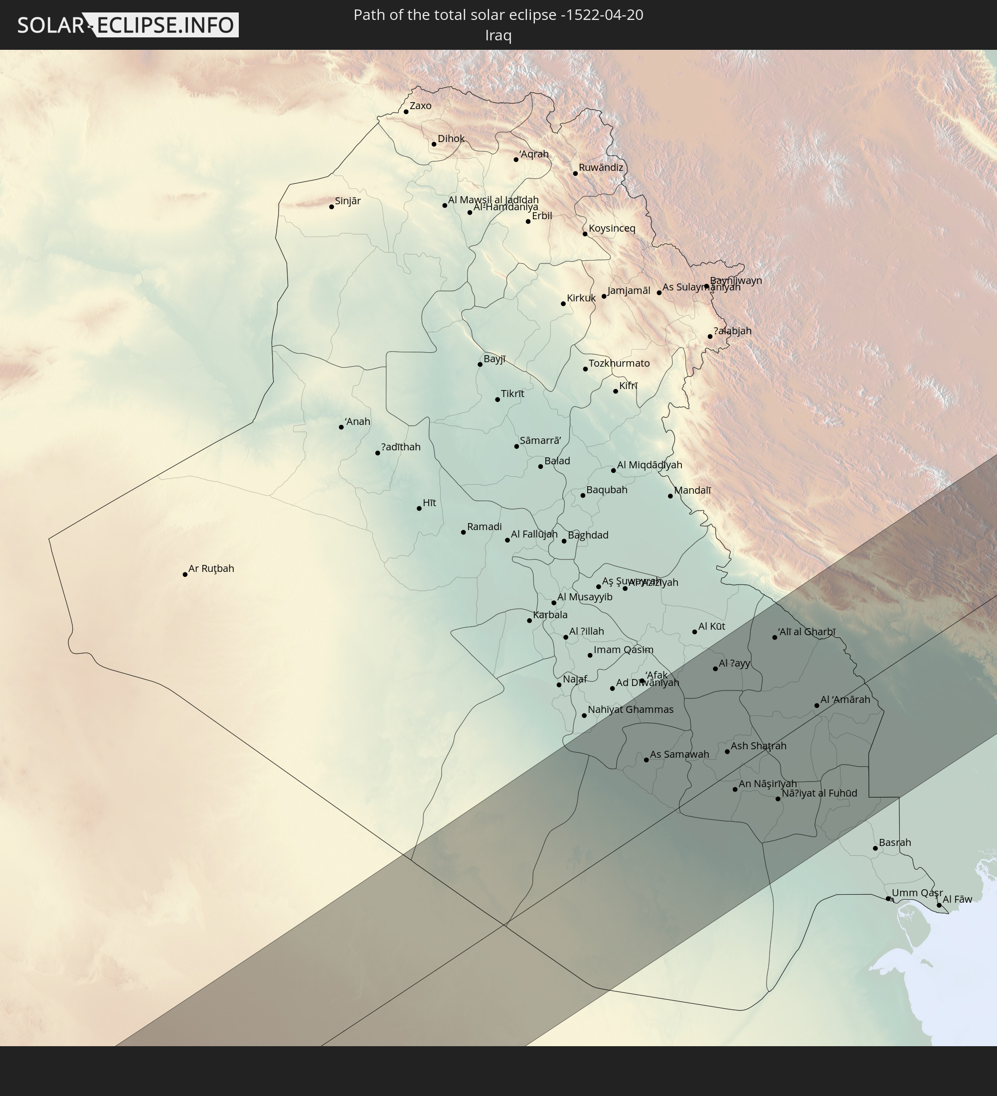 Irak
Irak
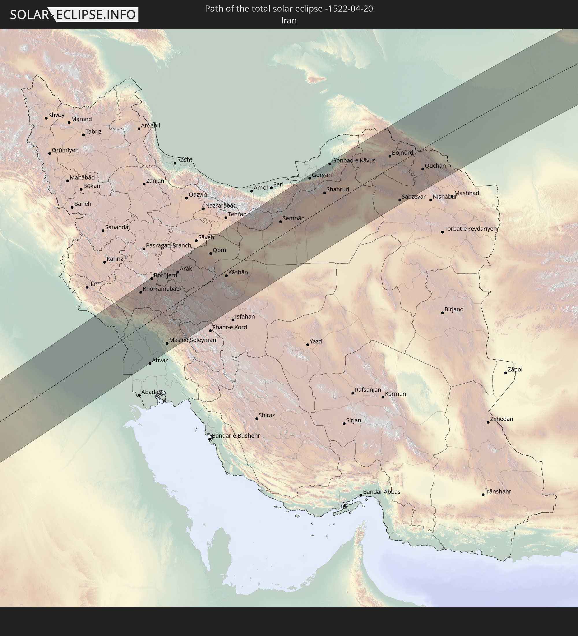 Iran
Iran
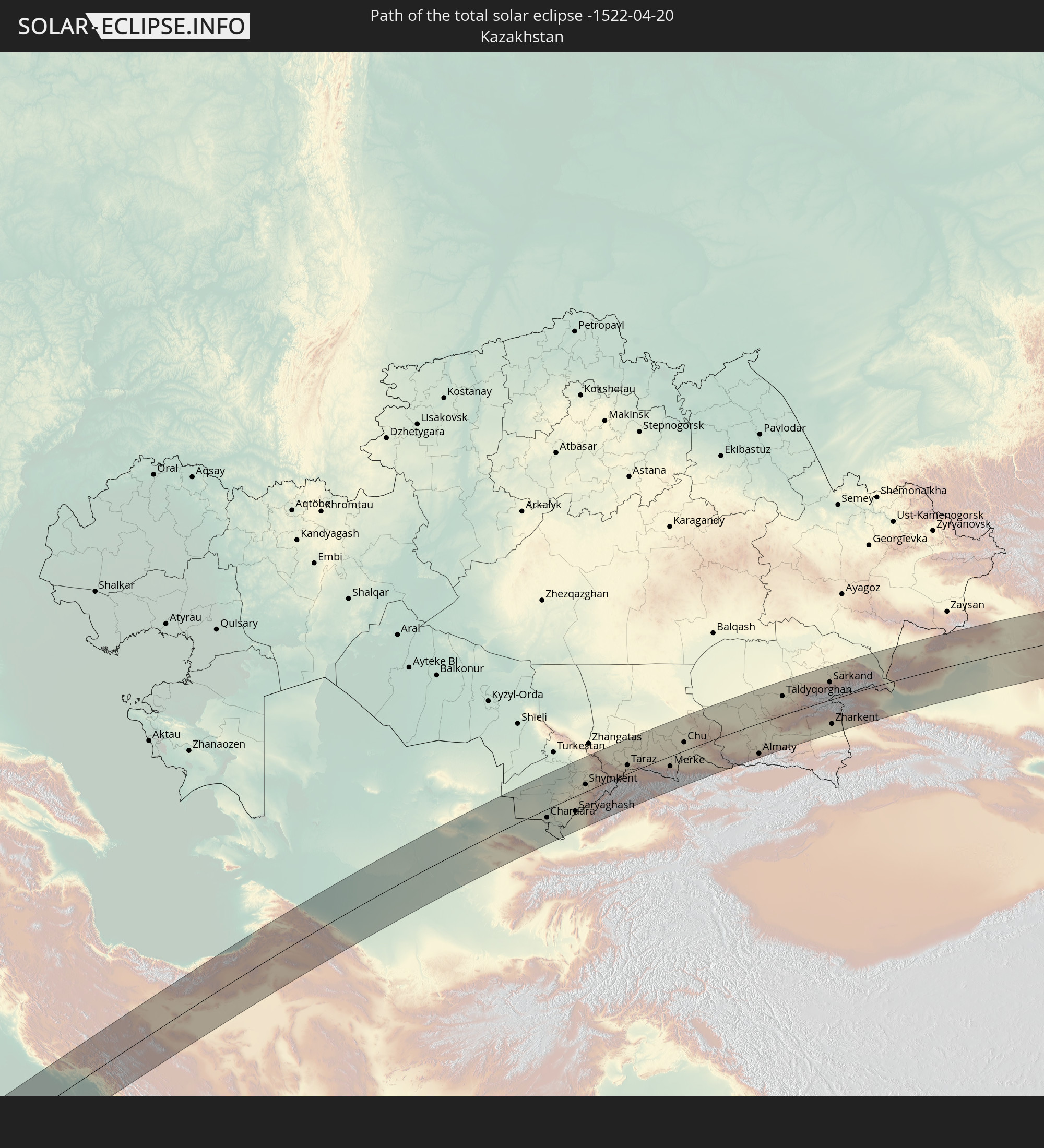 Kasachstan
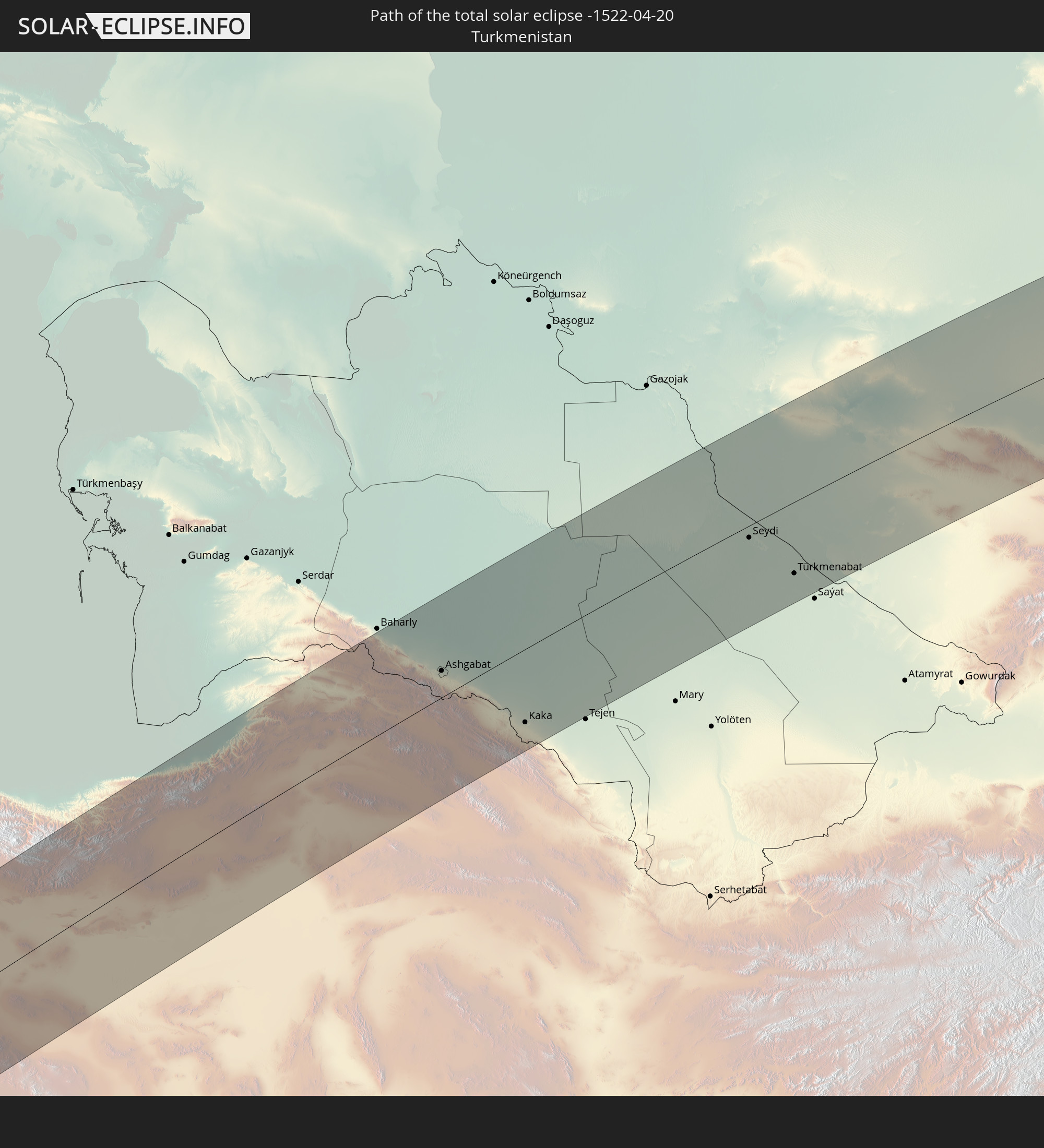 Turkmenistan
 Usbekistan
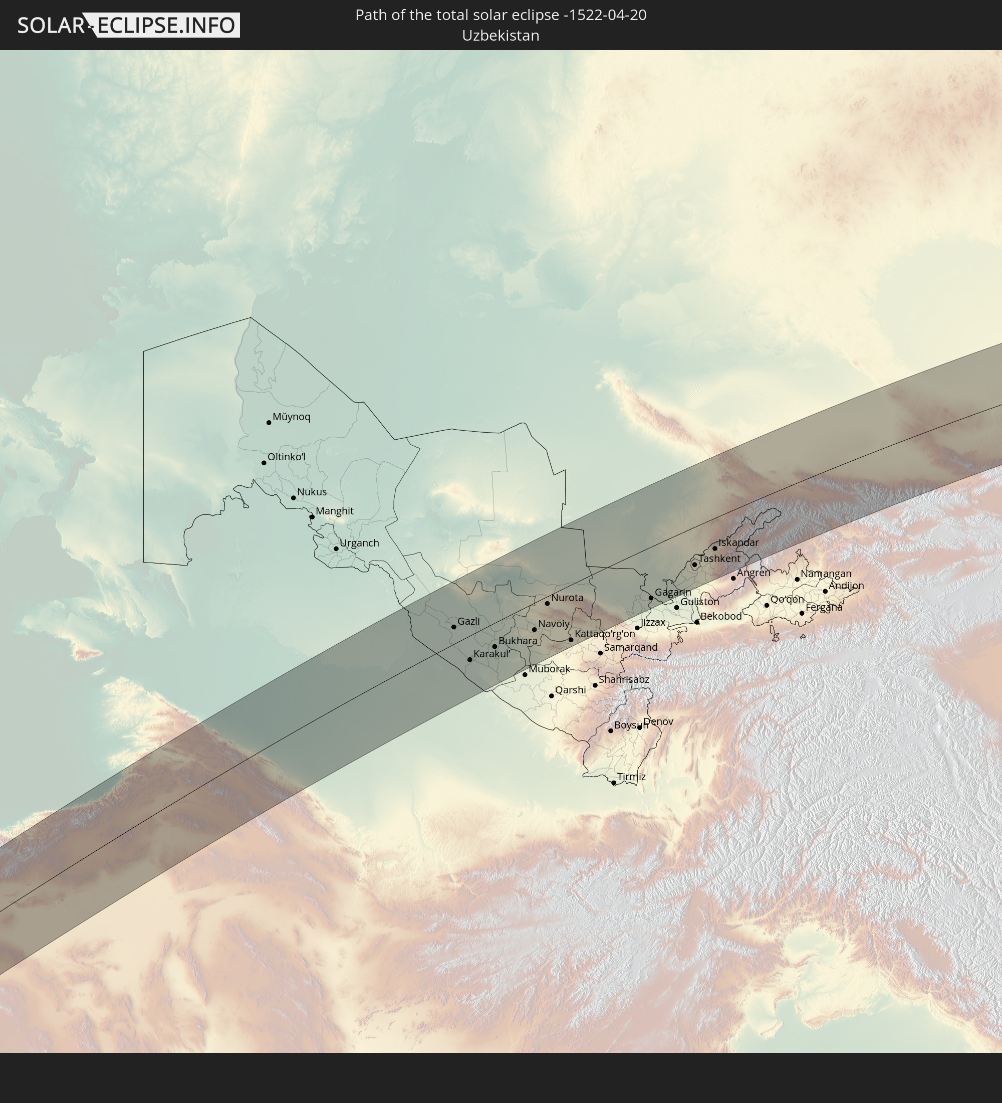
 Kirgisistan
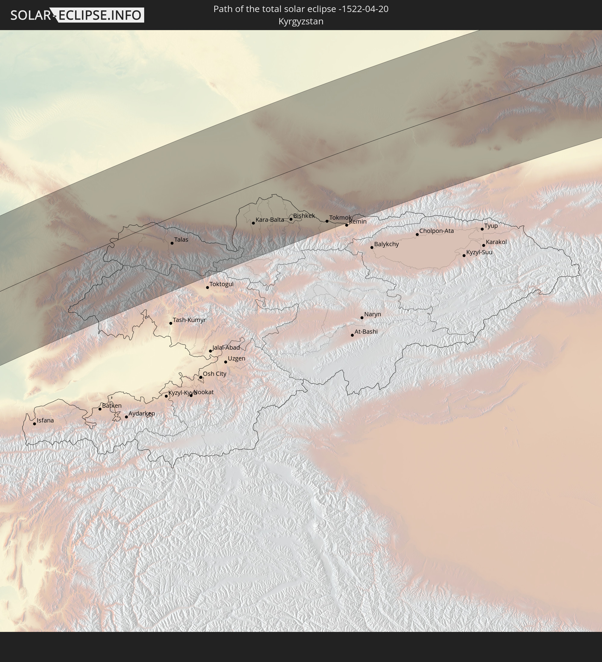
 Volksrepublik China
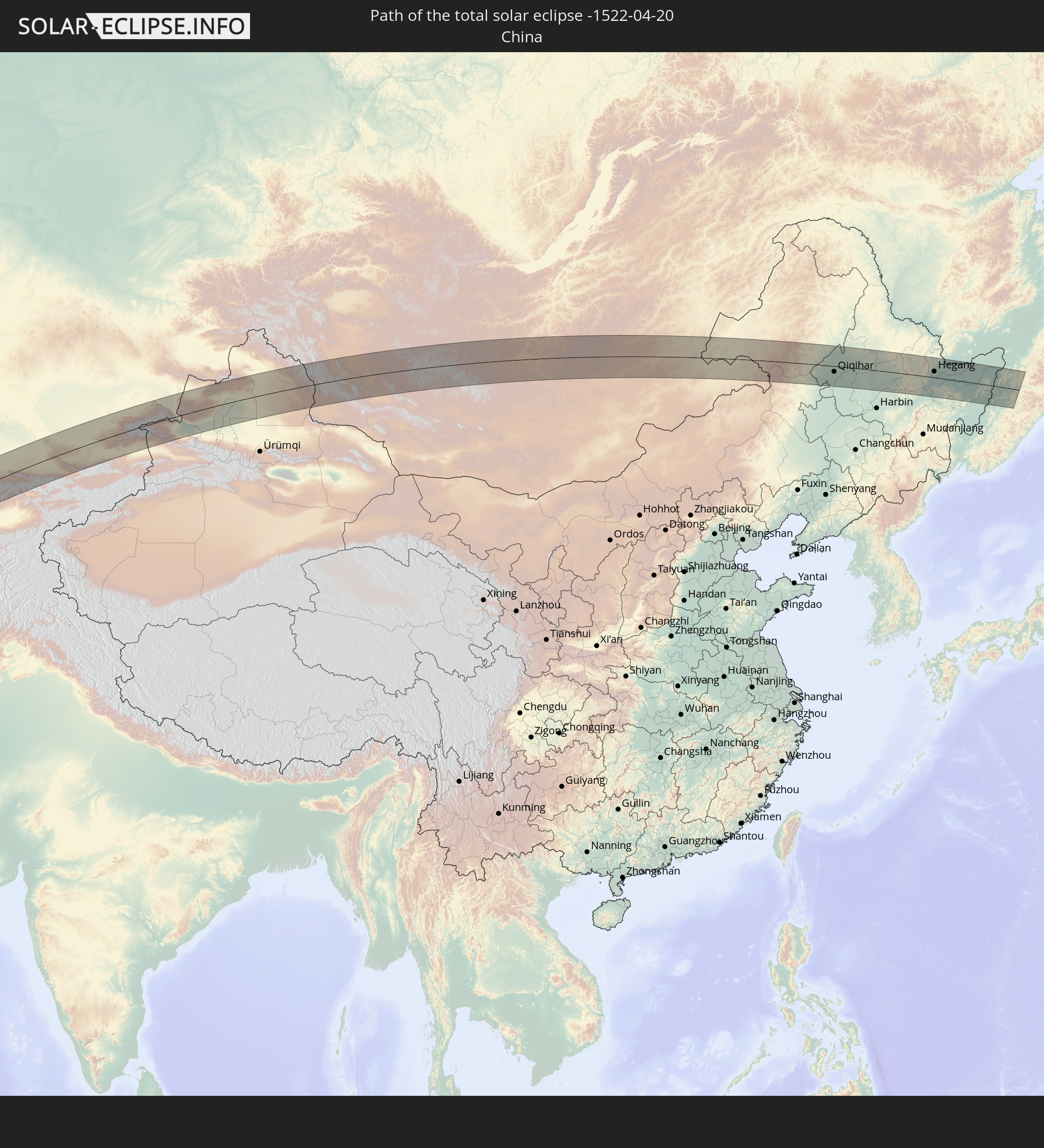
 Mongolei
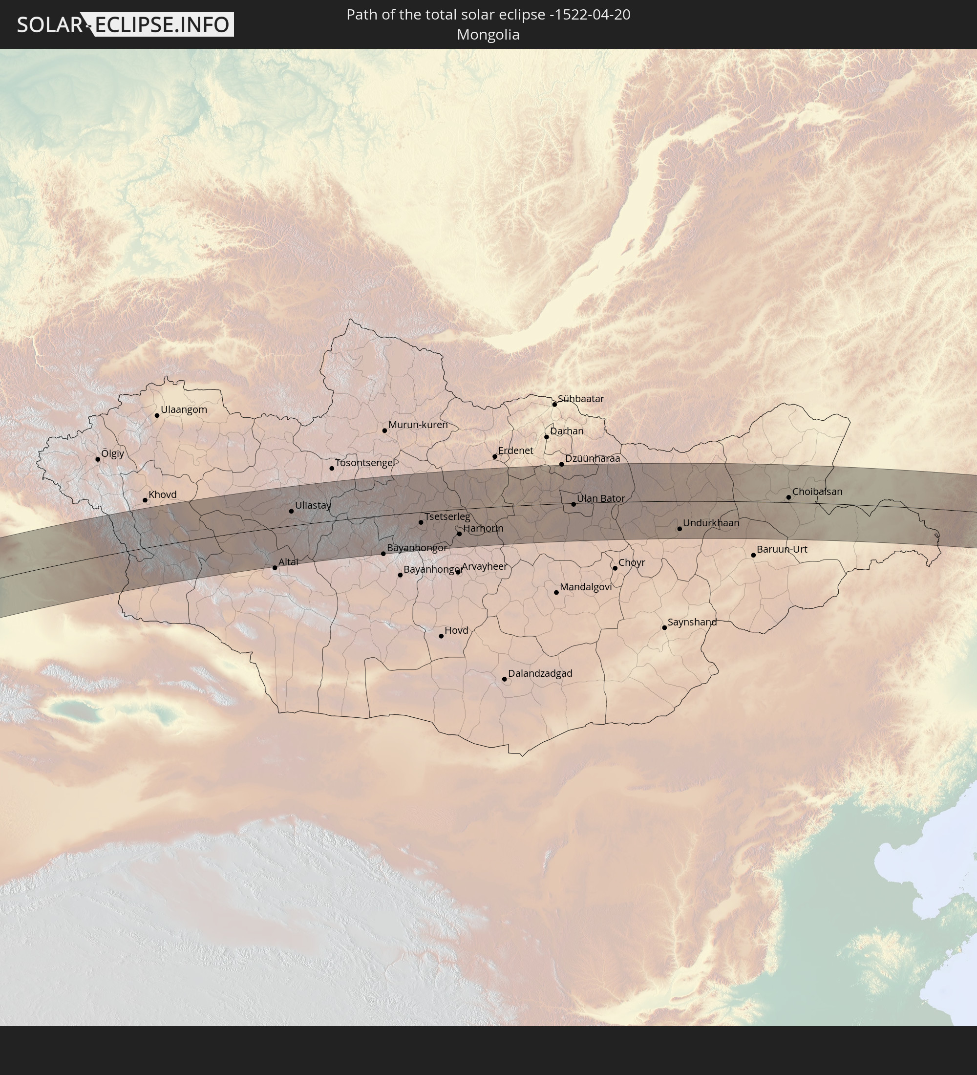
In den folgenden Ländern ist die Sonnenfinsternis partiell zu sehen
 Russland
 Kanada
 Grönland
 Portugal
 Island
 Spanien
 Mauretanien
 Marokko
 Mali
Mali
 Irland
 Spitzbergen
 Algerien
 Vereinigtes Königreich
 Elfenbeinküste
 Färöer
 Burkina Faso
 Gibraltar
 Frankreich
 Isle of Man
 Ghana
Ghana
 Guernsey
 Jersey
 Togo
Togo
 Niger
Niger
 Benin
Benin
 Andorra
 Belgien
 Nigeria
 Niederlande
 Norwegen
 Äquatorialguinea
 Luxemburg
 Deutschland
 Schweiz
 São Tomé und Príncipe
 Italien
 Monaco
 Tunesien
 Dänemark
 Kamerun
 Gabun
Gabun
 Libyen
 Liechtenstein
 Österreich
 Schweden
 Republik Kongo
 Angola
 Namibia
 Tschechien
 Demokratische Republik Kongo
 San Marino
 Vatikanstadt
 Slowenien
 Tschad
 Kroatien
 Polen
Polen
 Malta
Malta
 Zentralafrikanische Republik
 Bosnien und Herzegowina
 Ungarn
 Slowakei
 Montenegro
 Serbien
 Albanien
 Åland Islands
 Griechenland
 Rumänien
 Mazedonien
 Finnland
 Litauen
 Lettland
 Estland
 Sudan
Sudan
 Sambia
 Ukraine
 Bulgarien
 Weißrussland
 Ägypten
 Türkei
 Moldawien
 Ruanda
 Burundi
 Tansania
 Uganda
 Mosambik
 Republik Zypern
 Malawi
 Äthiopien
 Kenia
Kenia
 Staat Palästina
 Israel
 Saudi-Arabien
 Jordanien
 Libanon
 Syrien
 Eritrea
 Irak
Irak
 Georgien
 Somalia
 Dschibuti
 Jemen
Jemen
 Armenien
 Iran
Iran
 Aserbaidschan
 Kasachstan
 Kuwait
 Bahrain
 Katar
Katar
 Vereinigte Arabische Emirate
 Oman
Oman
 Turkmenistan
 Usbekistan
 Afghanistan
 Pakistan
 Tadschikistan
 Indien
 Kirgisistan
 Volksrepublik China
 Nepal
Nepal
 Mongolei
 Bangladesch
 Bhutan
 Myanmar
 Thailand
 Laos
Laos
 Vietnam
 Macau
Macau
 Hongkong
 Taiwan
 Philippinen
 Japan
Japan
 Nordkorea
 Südkorea
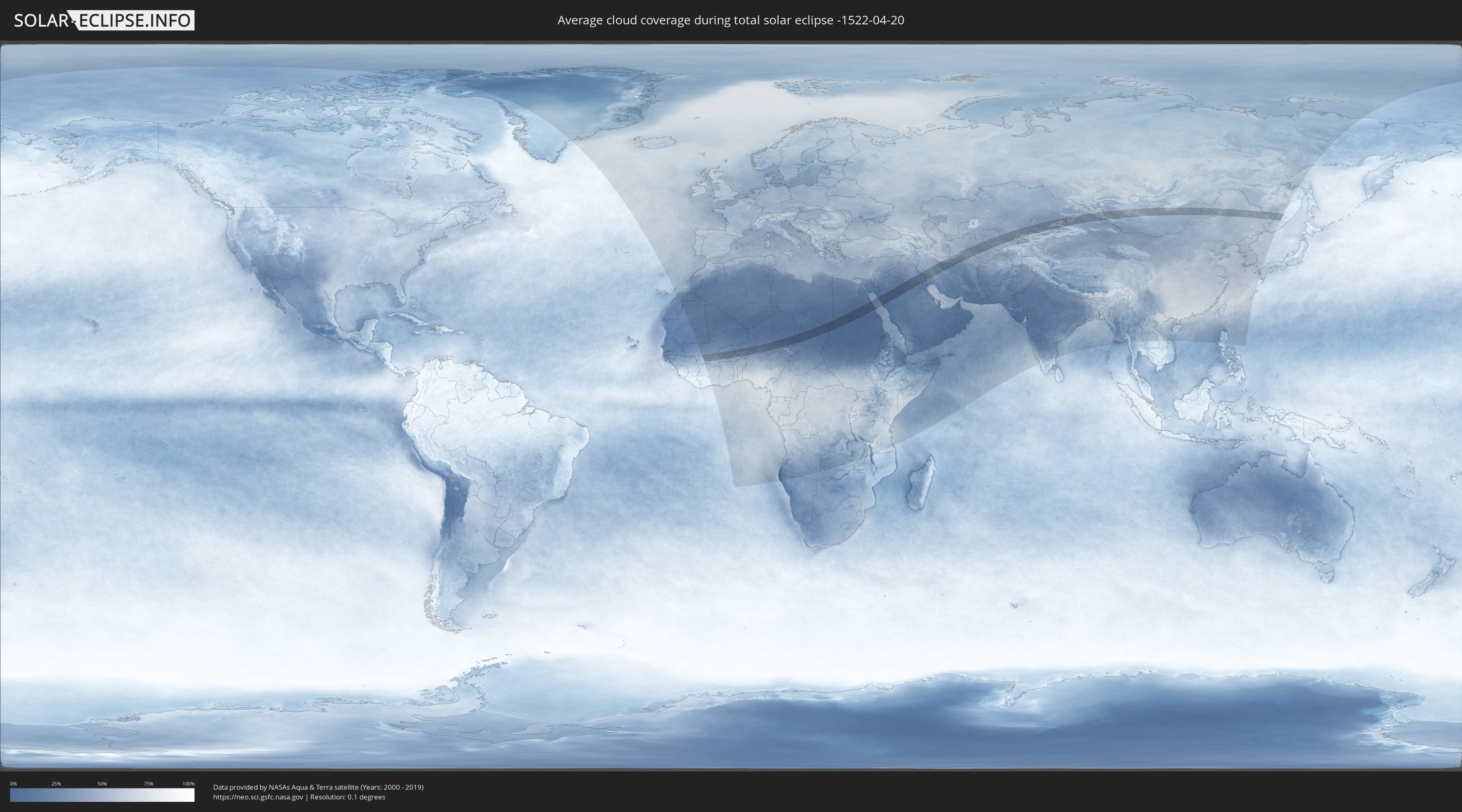
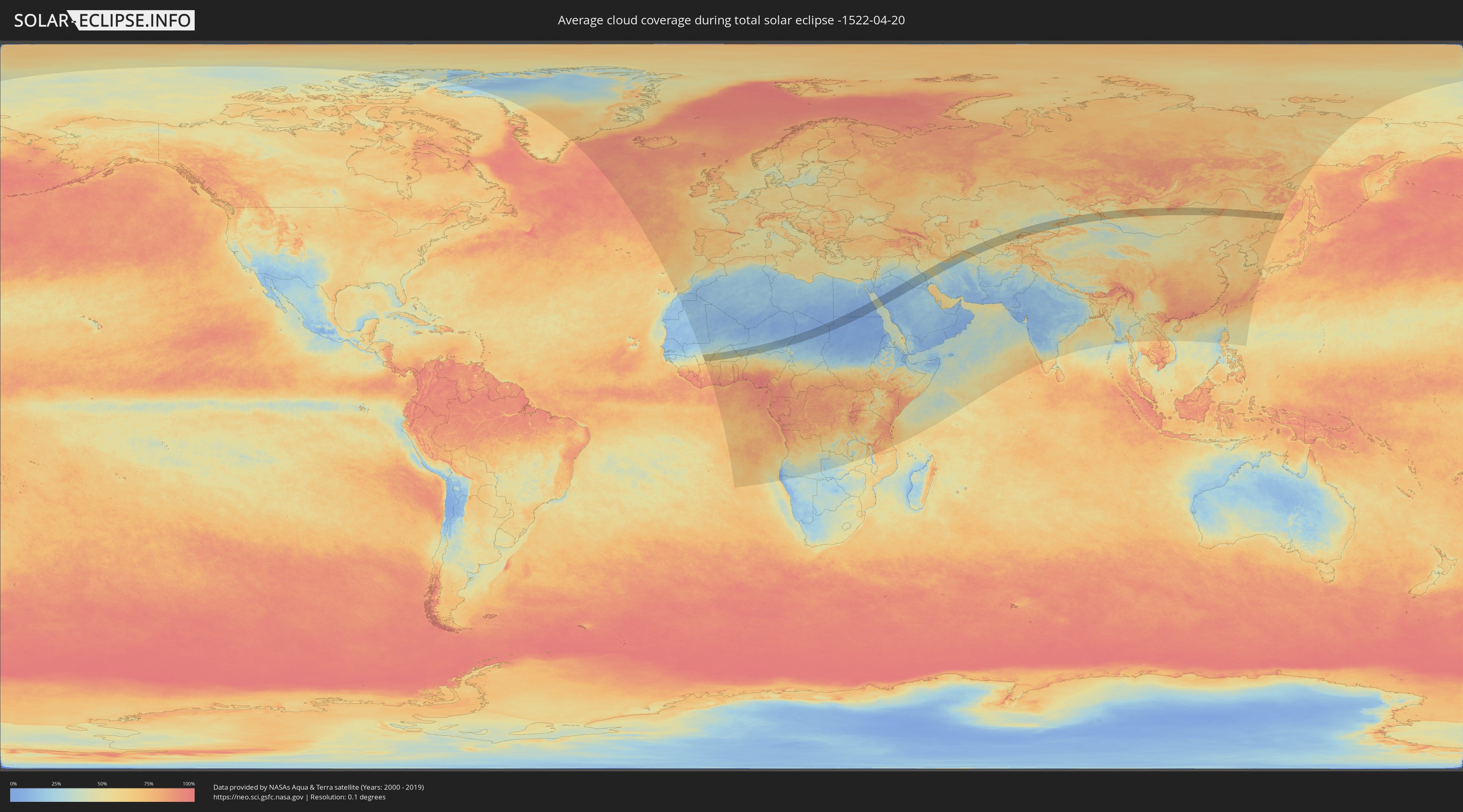
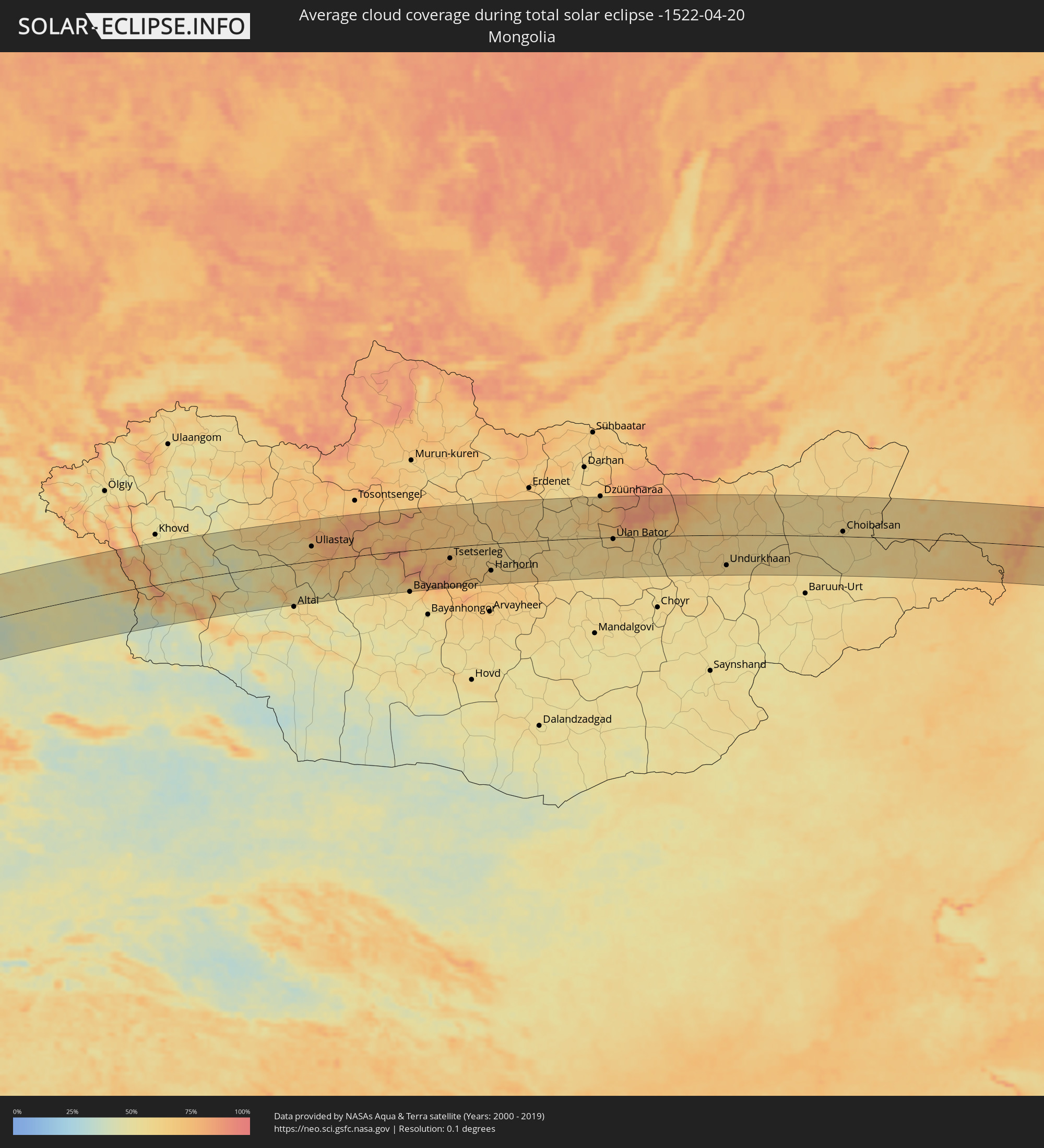
Wie wird das Wetter während der totalen Sonnenfinsternis am 20.04.-1522?
Wo ist der beste Ort, um die totale Sonnenfinsternis vom 20.04.-1522 zu beobachten?
Die folgenden Karten zeigen die durchschnittliche Bewölkung für den Tag, an dem die totale Sonnenfinsternis
stattfindet. Mit Hilfe der Karten lässt sich der Ort entlang des Finsternispfades eingrenzen,
der die besten Aussichen auf einen klaren wolkenfreien Himmel bietet.
Trotzdem muss man immer lokale Gegenenheiten beachten und sollte sich genau über das Wetter an seinem
gewählten Beobachtungsort informieren.
Die Daten stammen von den beiden NASA-Satelliten
AQUA und TERRA
und wurden über einen Zeitraum von 19 Jahren (2000 - 2019) gemittelt.
Detaillierte Länderkarten
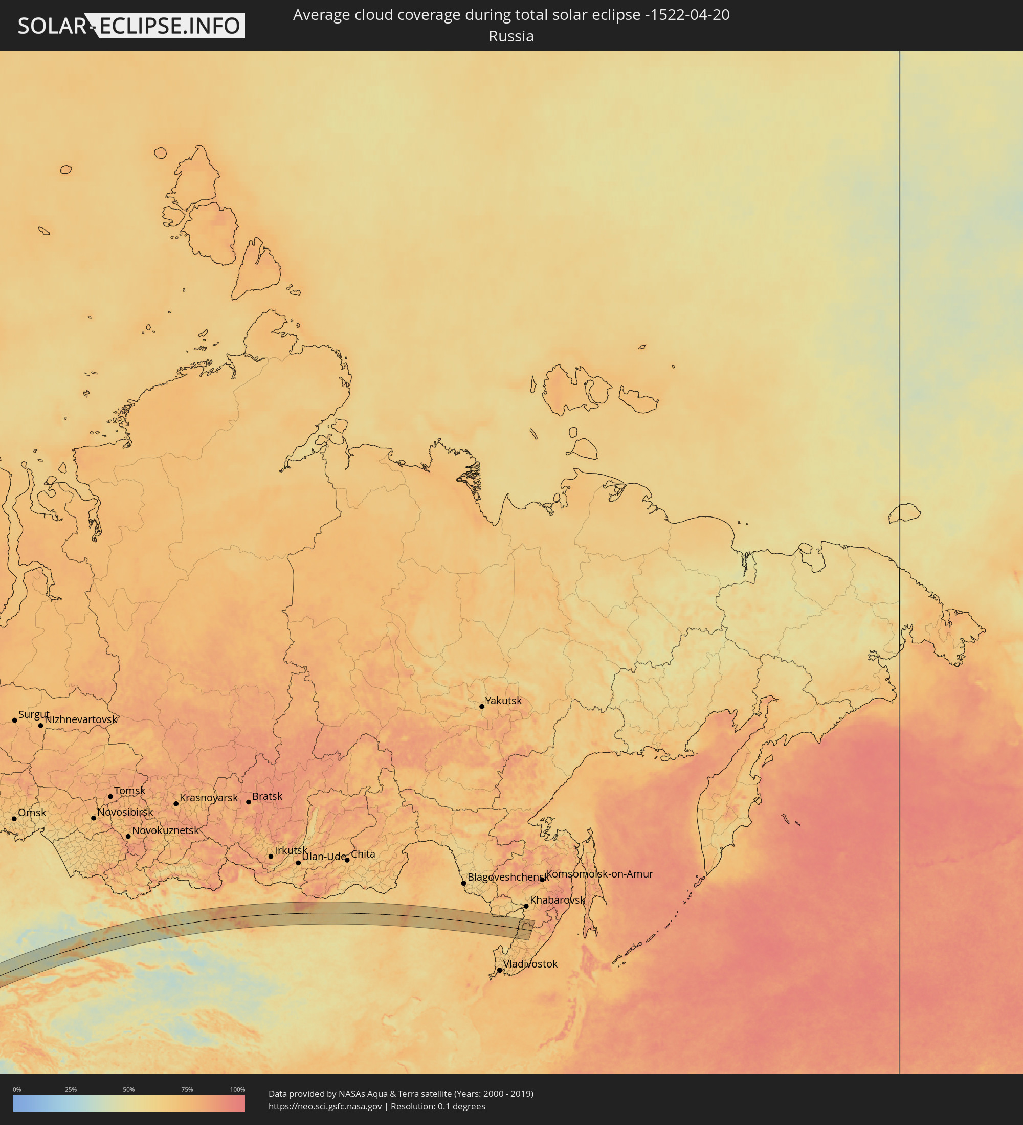 Russland
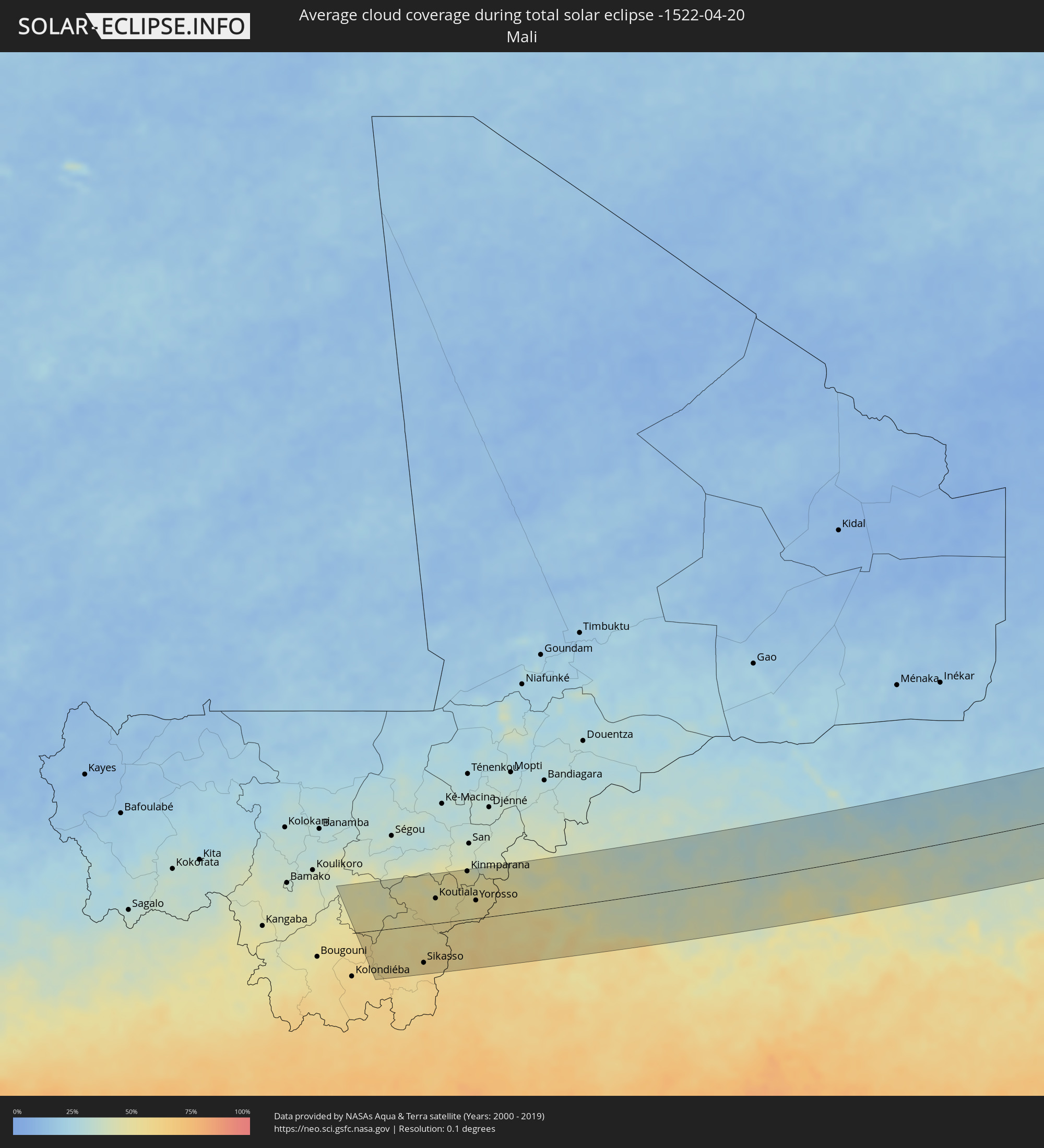 Mali
Mali
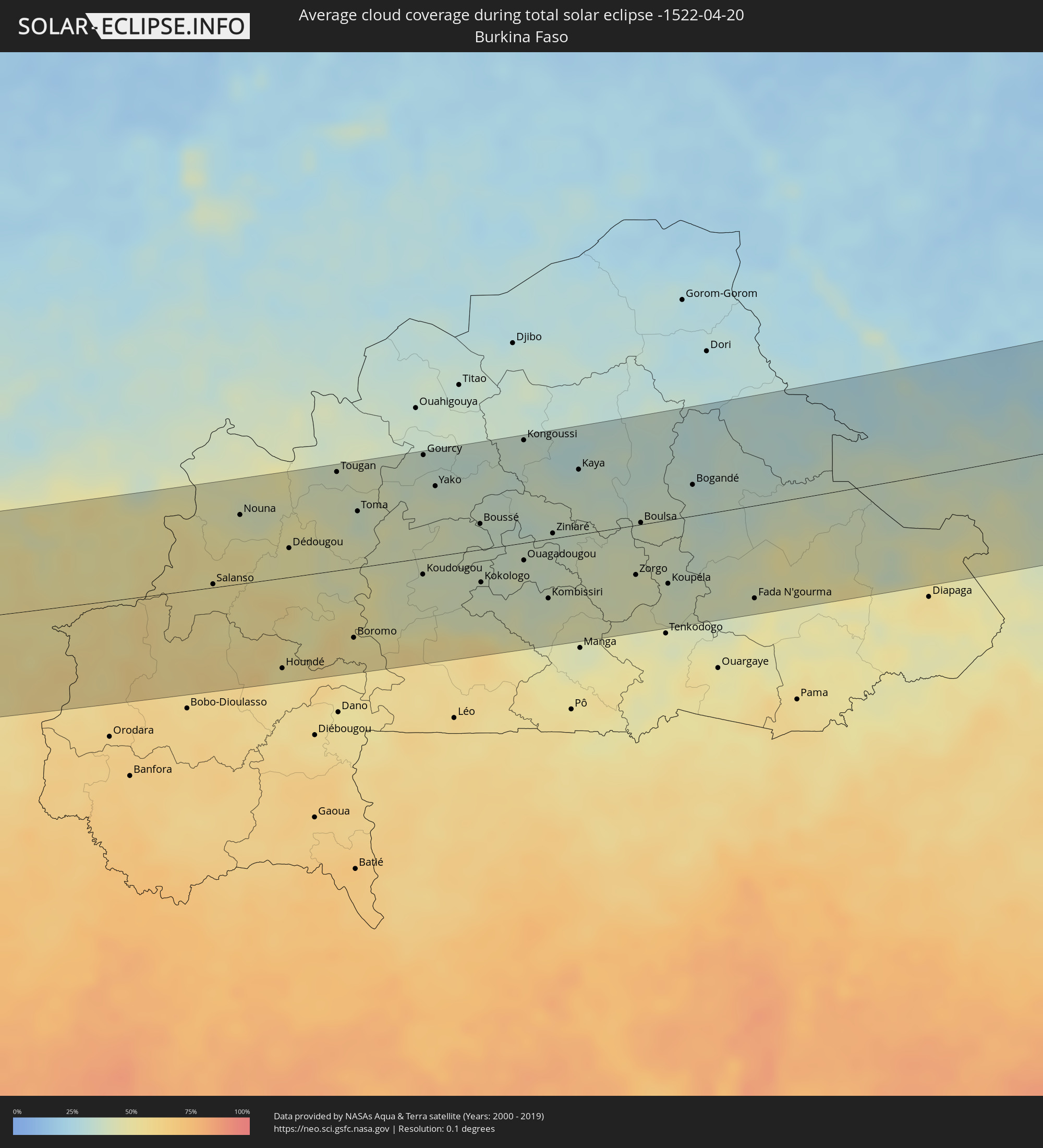 Burkina Faso
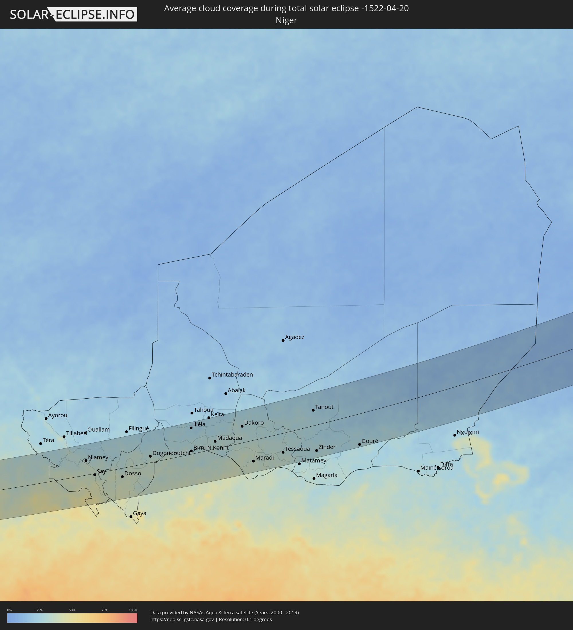 Niger
Niger
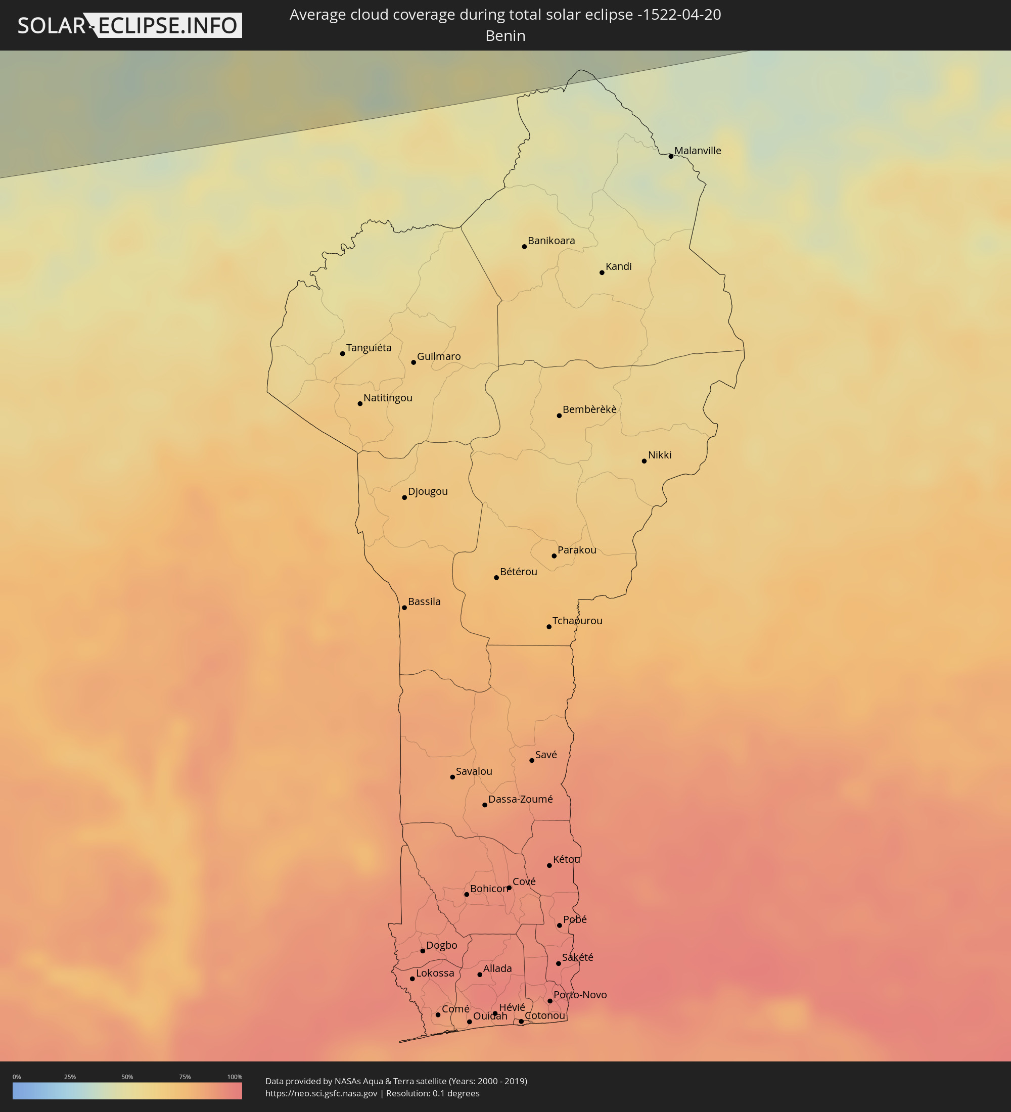 Benin
Benin
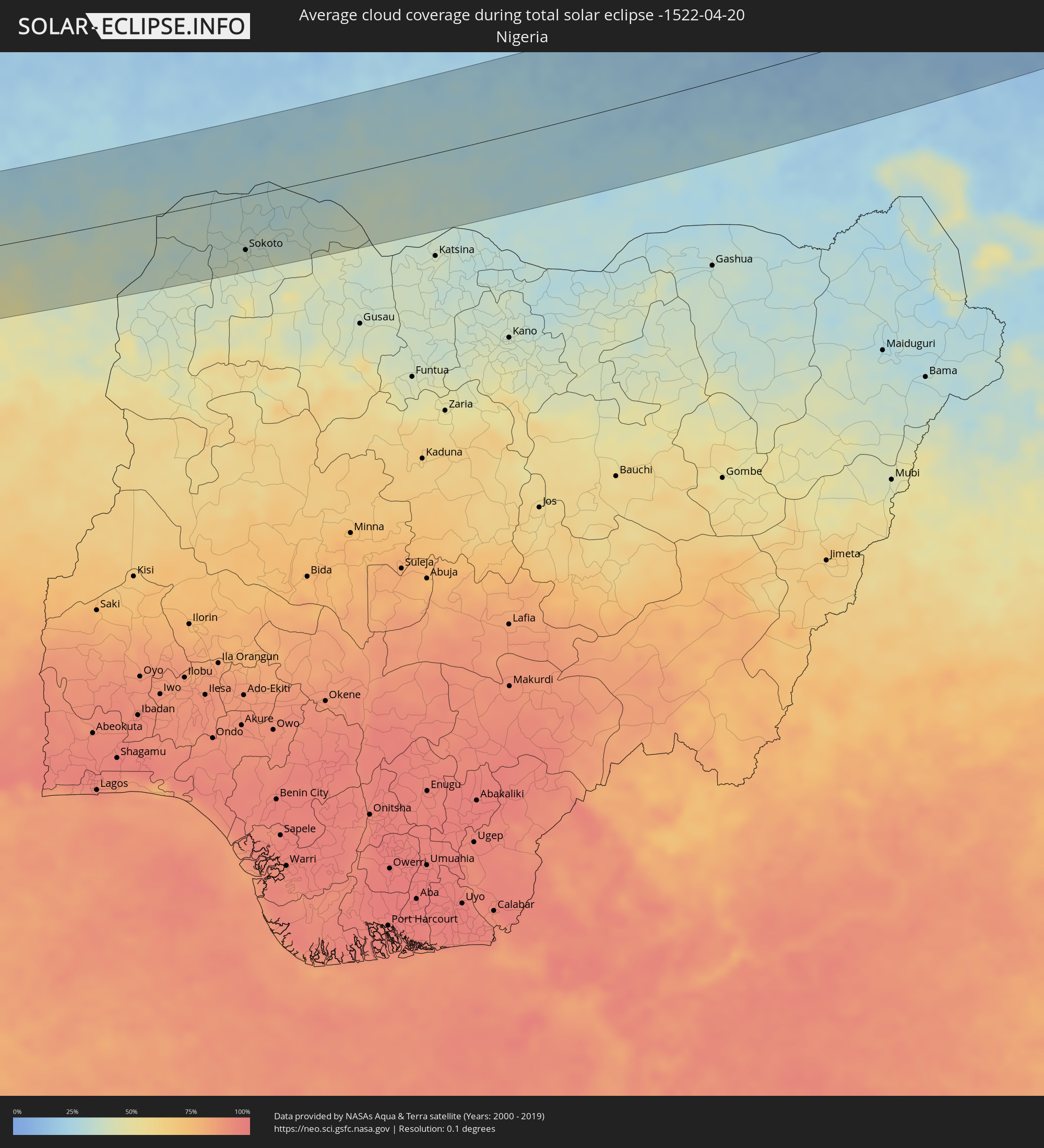 Nigeria
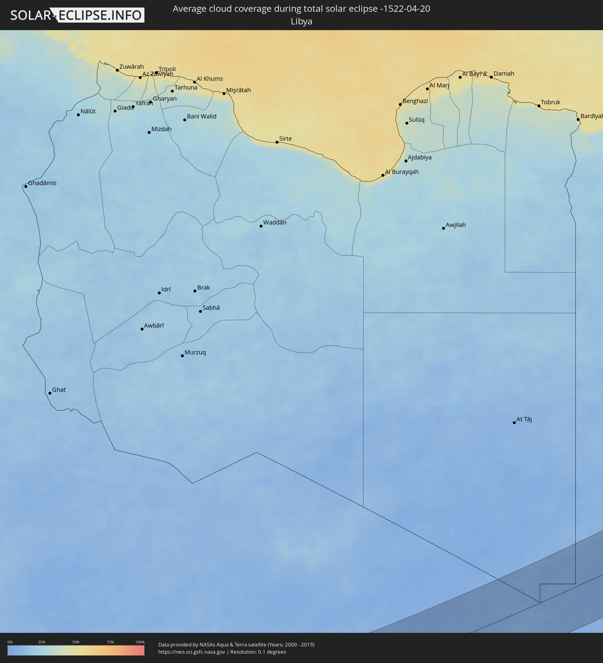 Libyen
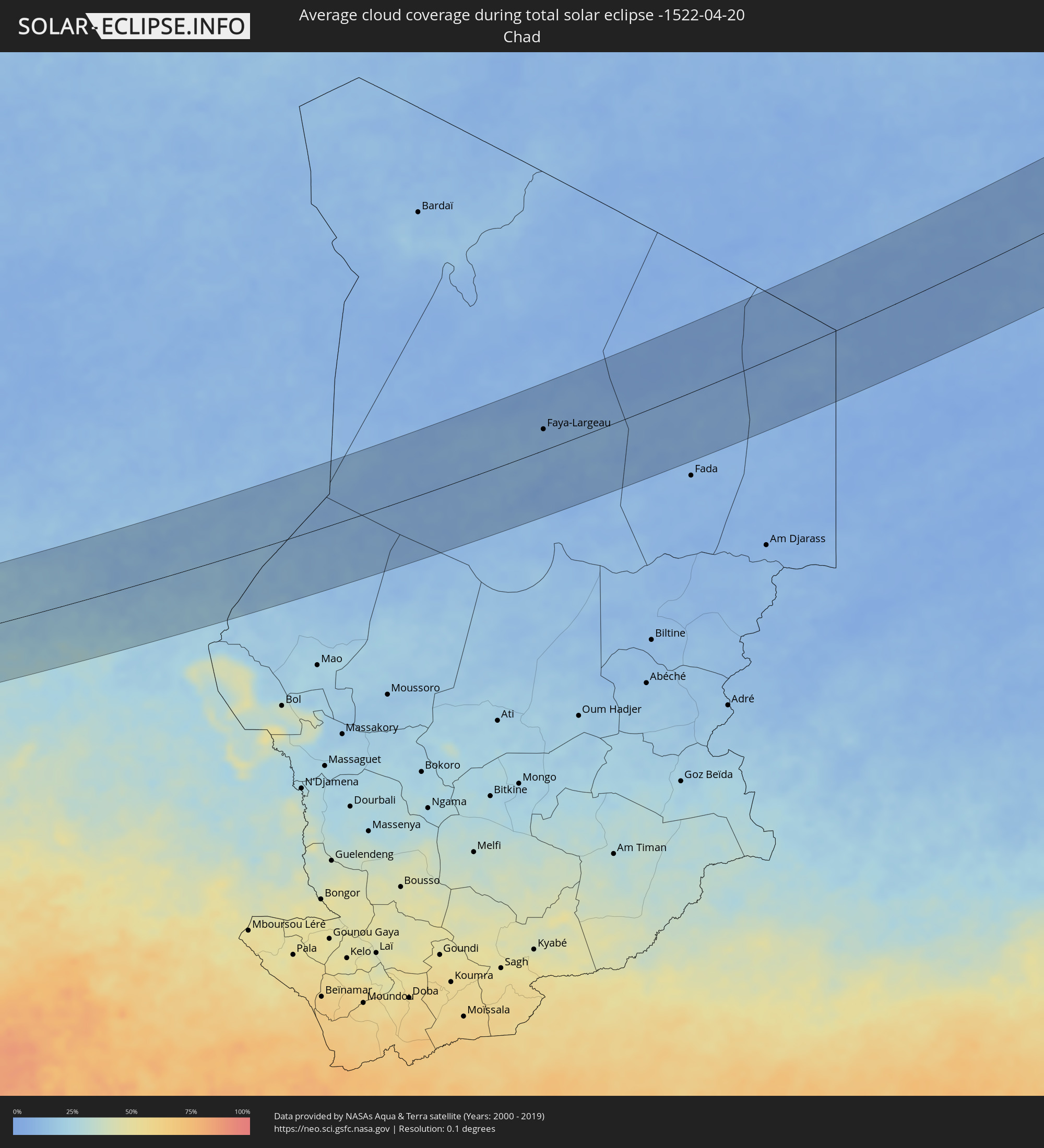 Tschad
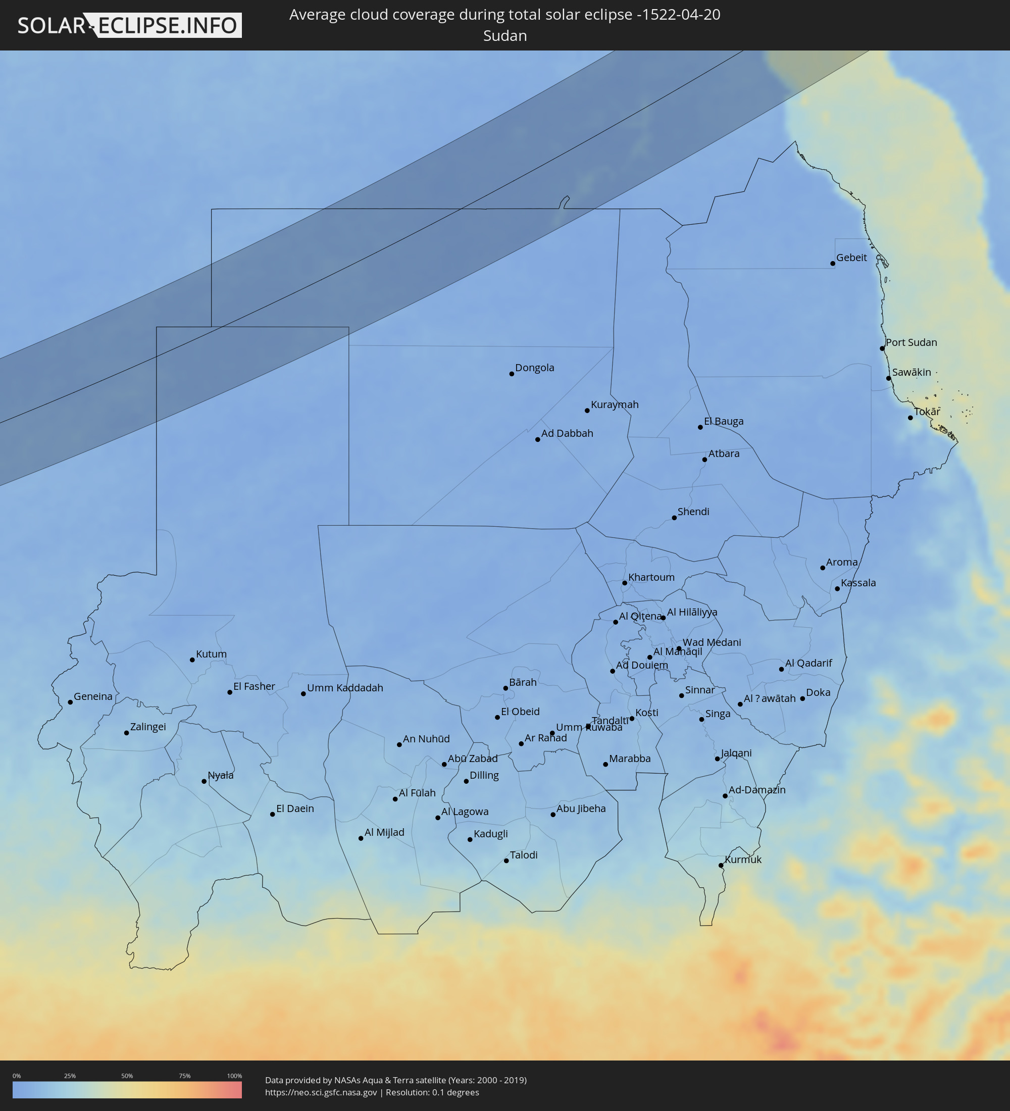 Sudan
Sudan
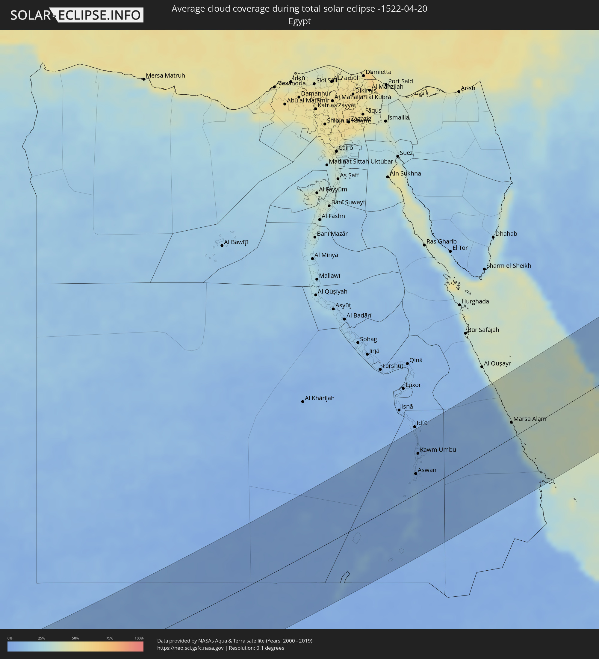 Ägypten
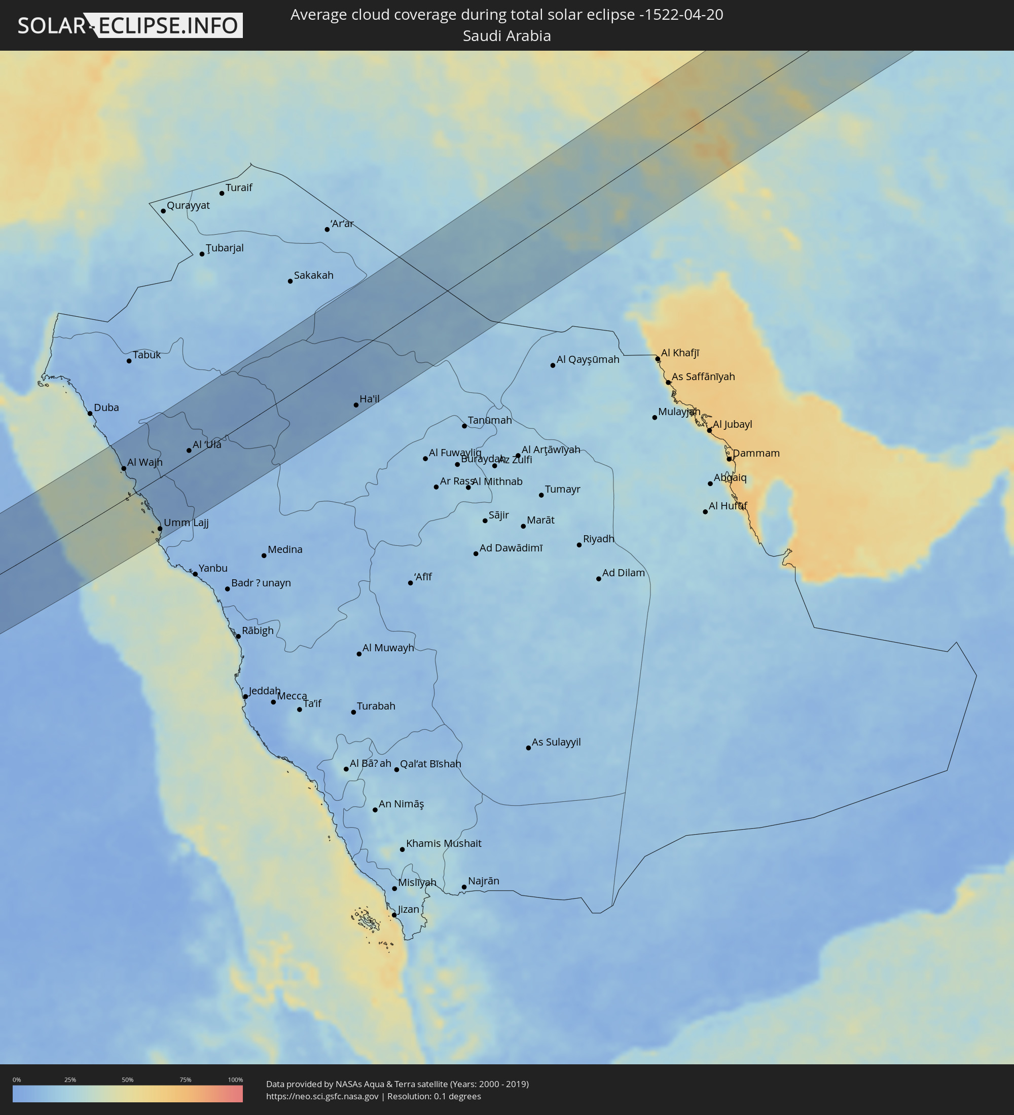 Saudi-Arabien
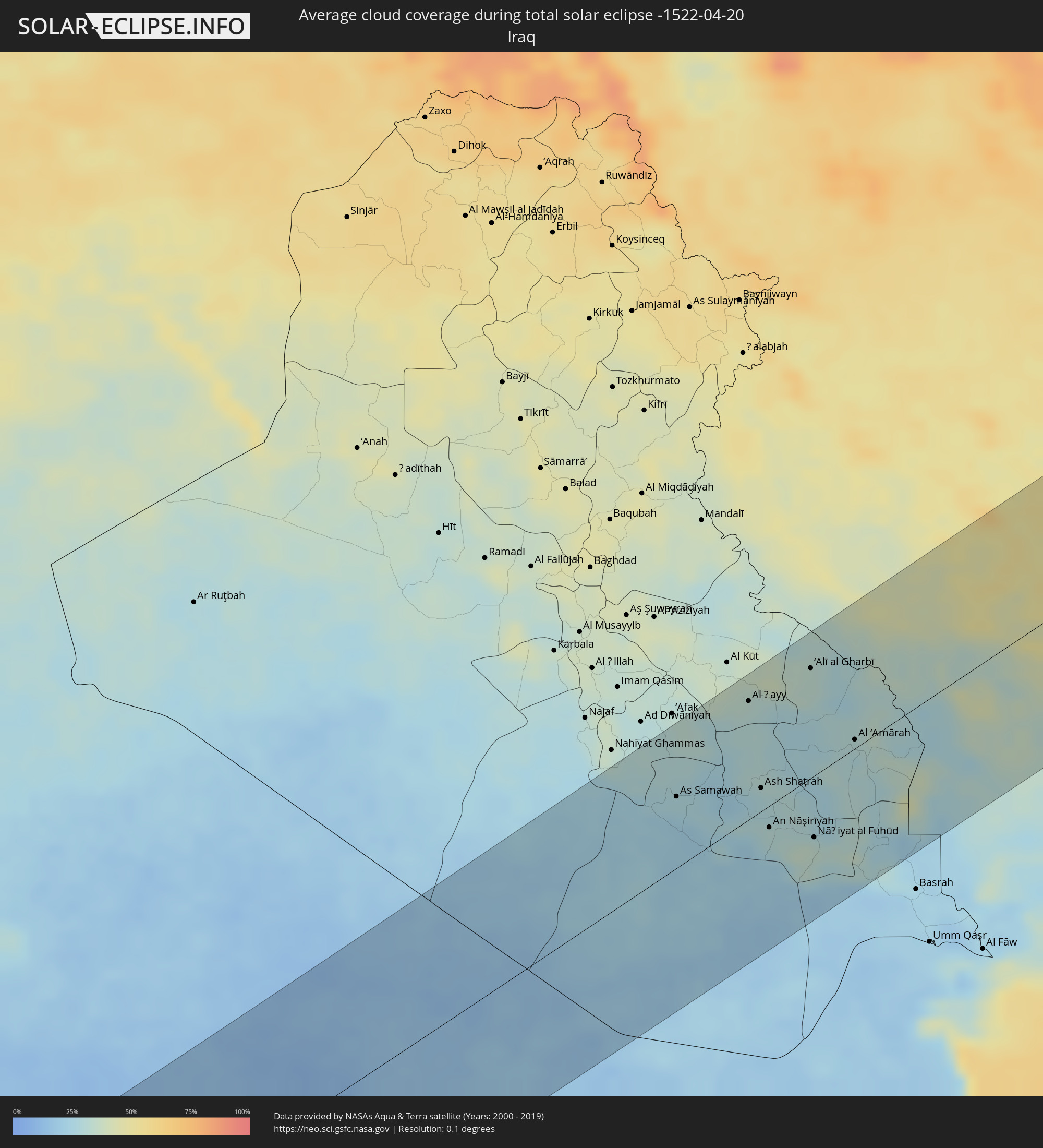 Irak
Irak
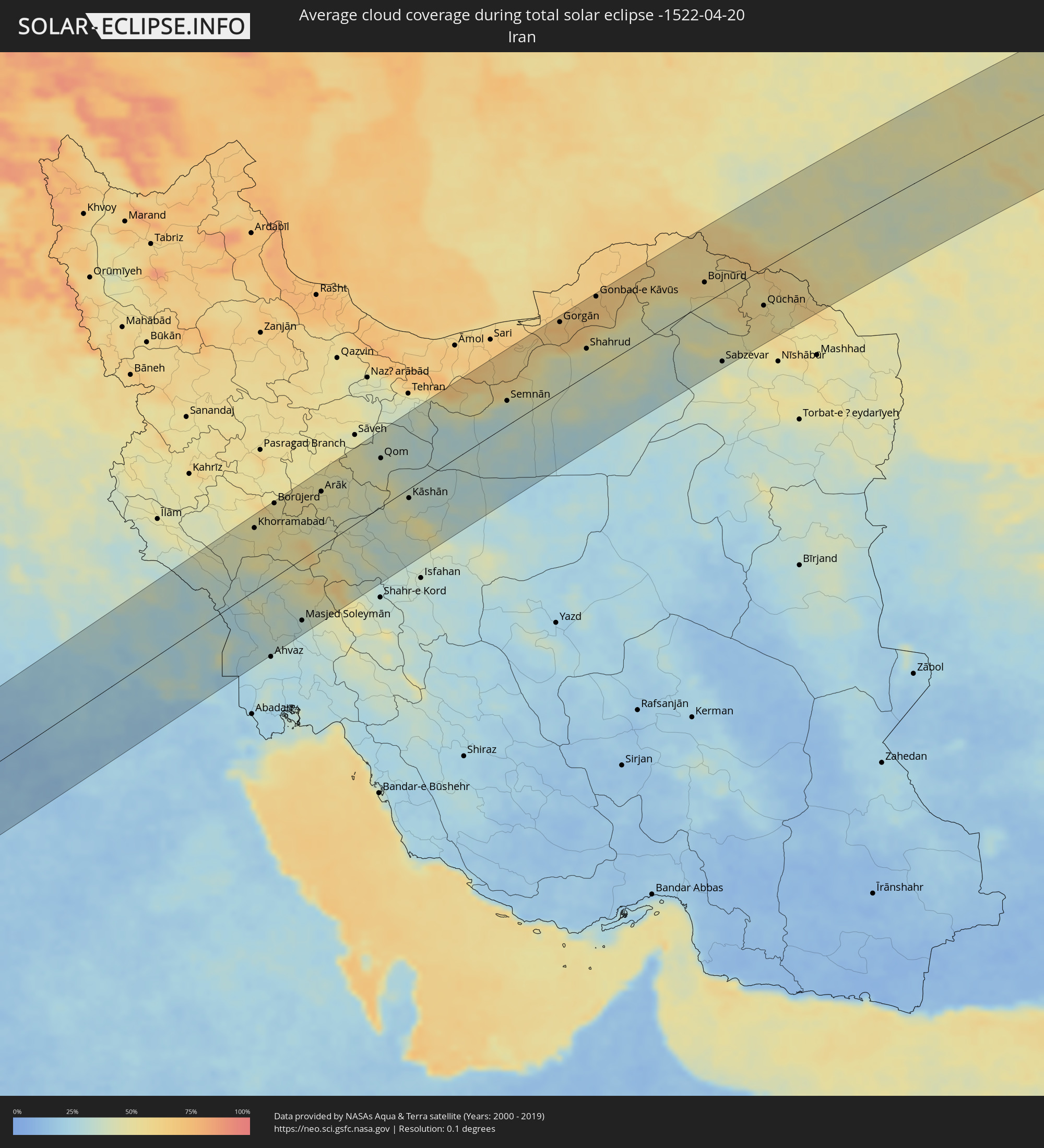 Iran
Iran
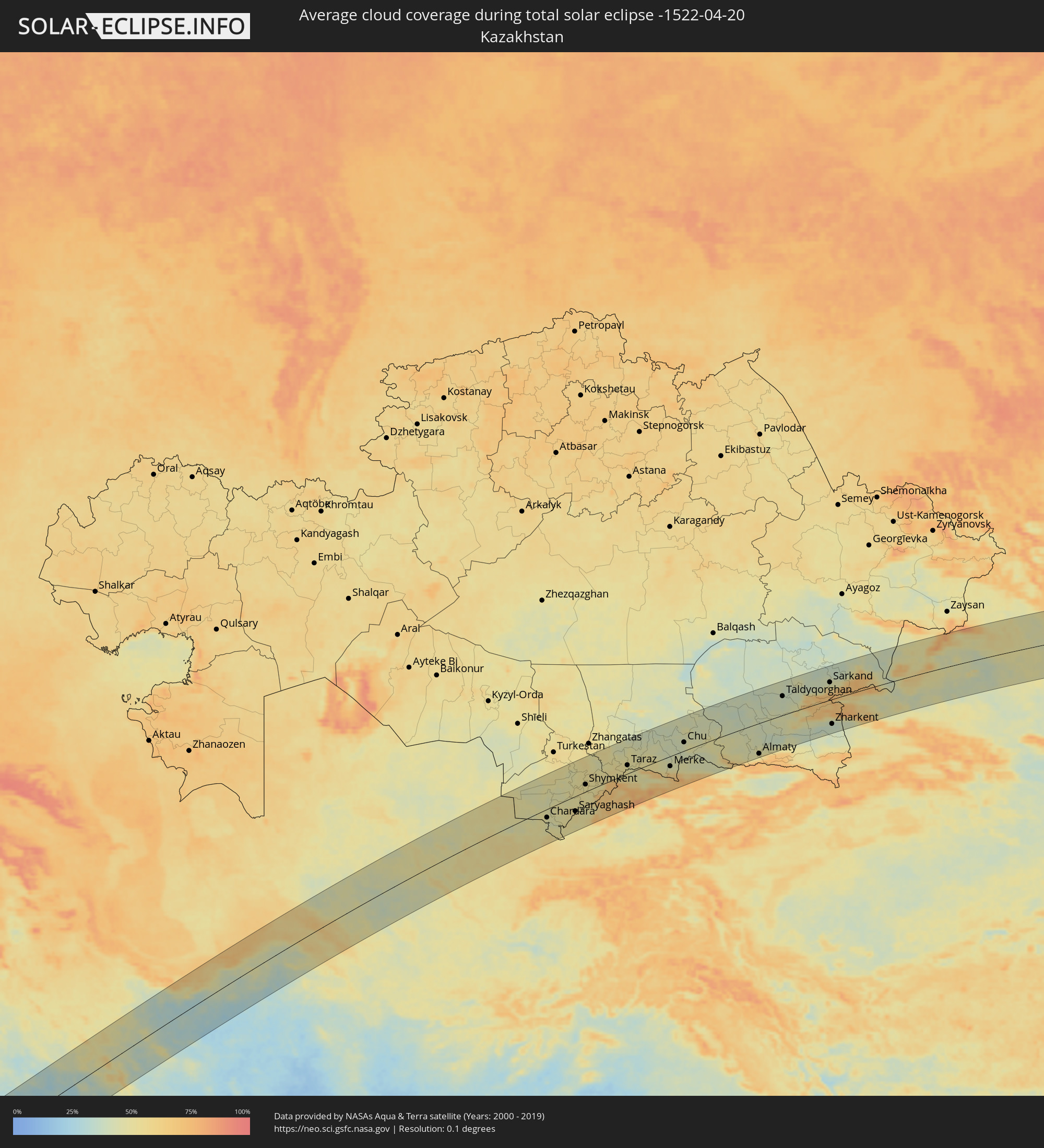 Kasachstan
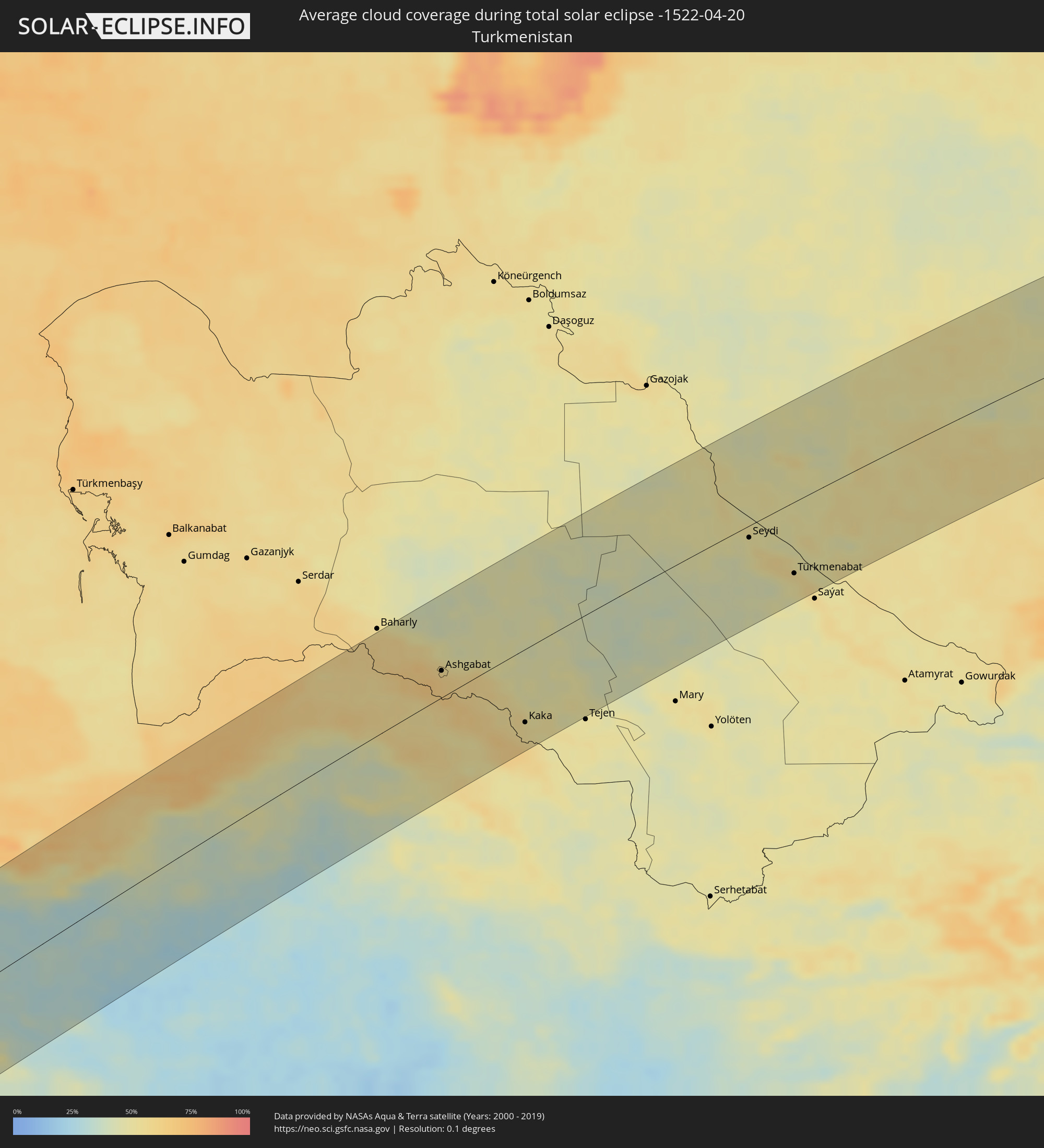 Turkmenistan
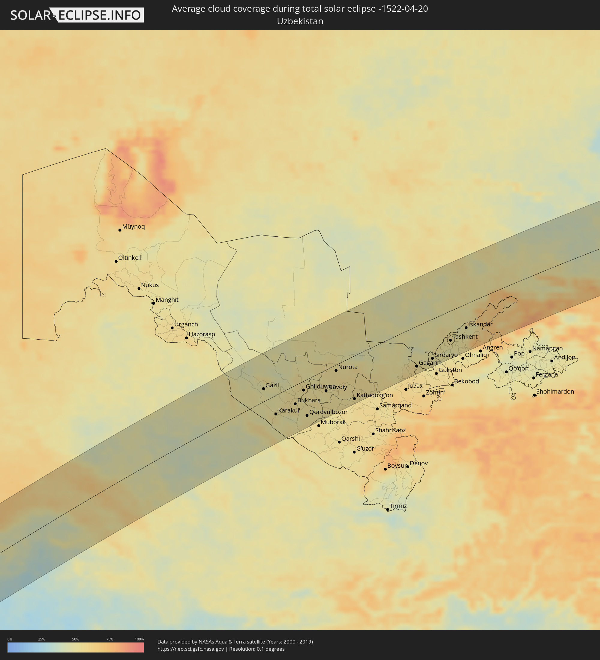 Usbekistan
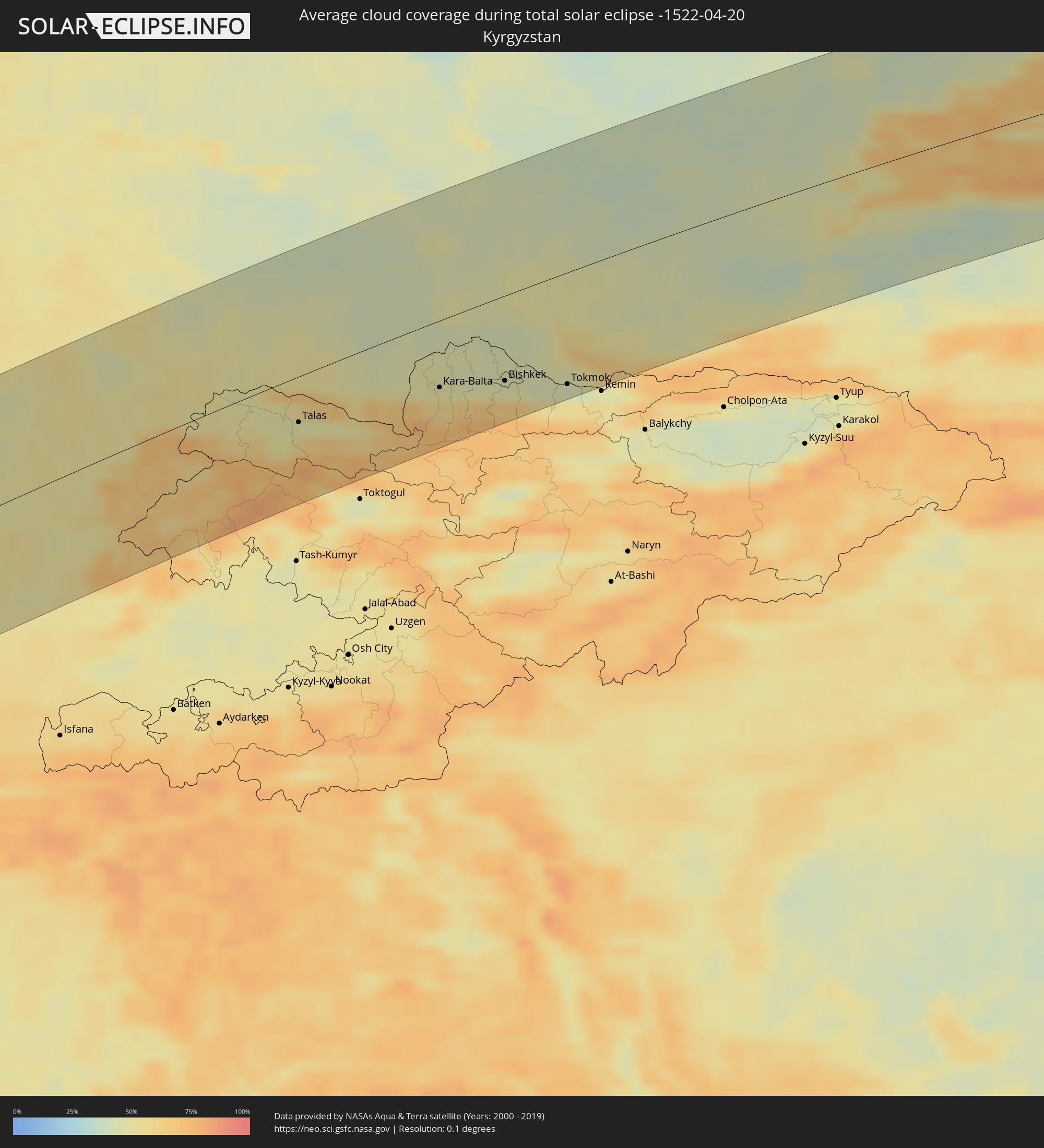 Kirgisistan
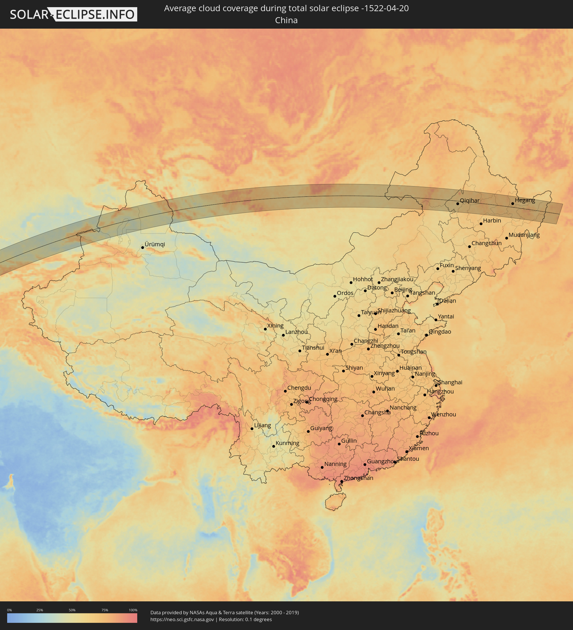 Volksrepublik China
 Mongolei
Orte im Finsternispfad
Die nachfolgene Tabelle zeigt Städte und Orte mit mehr als 5.000 Einwohnern, die sich im Finsternispfad befinden. Städte mit mehr als 100.000 Einwohnern sind dick gekennzeichnet. Mit einem Klick auf den Ort öffnet sich eine Detailkarte die die Lage des jeweiligen Ortes zusammen mit dem Verlauf der zentralen Finsternis präsentiert.
| Ort | Typ | Dauer der Verfinsterung | Ortszeit bei maximaler Verfinsterung | Entfernung zur Zentrallinie | Ø Bewölkung |
|
Ntossoni, Sikasso
|
total | - | 06:06:40 UTC-00:16 | 65 km | 52% |
|
Sikasso, Sikasso
|
total | - | 06:05:32 UTC-00:16 | 70 km | 56% |
|
Koutiala, Sikasso
|
total | - | 06:06:31 UTC-00:16 | 46 km | 48% |
|
Kinmparana, Ségou
|
total | - | 06:06:56 UTC-00:16 | 88 km | 50% |
|
Yorosso, Sikasso
|
total | - | 06:06:27 UTC-00:16 | 33 km | 49% |
|
Nouna, Boucle du Mouhoun
|
total | - | 06:06:48 UTC-00:16 | 61 km | 46% |
|
Houndé, Hauts-Bassins
|
total | - | 06:05:36 UTC-00:16 | 80 km | 54% |
|
Dédougou, Boucle du Mouhoun
|
total | - | 06:06:32 UTC-00:16 | 26 km | 48% |
|
Koudougou, Centre-Ouest
|
total | - | 06:06:20 UTC-00:16 | 15 km | 42% |
|
Kokologo, Centre-Ouest
|
total | - | 06:06:18 UTC-00:16 | 29 km | 40% |
|
Kongoussi, Centre-Nord
|
total | - | 06:07:27 UTC-00:16 | 90 km | 37% |
|
Ouagadougou, Centre
|
total | - | 06:06:29 UTC-00:16 | 15 km | 39% |
|
Kombissiri, Centre-Sud
|
total | - | 06:06:11 UTC-00:16 | 52 km | 40% |
|
Kaya, Centre-Nord
|
total | - | 06:07:15 UTC-00:16 | 57 km | 34% |
|
Zorgo, Plateau-Central
|
total | - | 06:06:26 UTC-00:16 | 44 km | 44% |
|
Garango, Centre-Est
|
total | - | 06:05:59 UTC-00:16 | 94 km | 46% |
|
Koupéla, Centre-Est
|
total | - | 06:06:23 UTC-00:16 | 56 km | 42% |
|
Fada N'gourma, Est
|
total | - | 06:06:20 UTC-00:16 | 82 km | 45% |
|
Niamey, Niamey
|
total | - | 06:37:48 UTC+00:13 | 45 km | 35% |
|
Dosso, Dosso
|
total | - | 06:37:30 UTC+00:13 | 28 km | 38% |
|
Kangiwa, Kebbi
|
total | - | 06:37:06 UTC+00:13 | 95 km | 39% |
|
Dogondoutchi, Dosso
|
total | - | 06:38:20 UTC+00:13 | 19 km | 33% |
|
Gulma, Kebbi
|
total | - | 06:37:19 UTC+00:13 | 97 km | 38% |
|
Argungu, Kebbi
|
total | - | 06:37:28 UTC+00:13 | 90 km | 38% |
|
Binji, Sokoto
|
total | - | 06:38:06 UTC+00:13 | 46 km | 34% |
|
Gwadabawa, Sokoto
|
total | - | 06:38:20 UTC+00:13 | 39 km | 33% |
|
Sokoto, Sokoto
|
total | - | 06:38:00 UTC+00:13 | 71 km | 36% |
|
Illéla, Tahoua
|
total | - | 06:39:34 UTC+00:13 | 81 km | 24% |
|
Birni N Konni, Tahoua
|
total | - | 06:38:49 UTC+00:13 | 9 km | 33% |
|
Illela, Sokoto
|
total | - | 06:38:46 UTC+00:13 | 1 km | 34% |
|
Dange, Sokoto
|
total | - | 06:37:48 UTC+00:13 | 96 km | 35% |
|
Wurno, Sokoto
|
total | - | 06:38:18 UTC+00:13 | 50 km | 37% |
|
Rabah, Sokoto
|
total | - | 06:38:09 UTC+00:13 | 70 km | 37% |
|
Goronyo, Sokoto
|
total | - | 06:38:33 UTC+00:13 | 39 km | 33% |
|
Gandi, Sokoto
|
total | - | 06:38:02 UTC+00:13 | 93 km | 39% |
|
Madaoua, Tahoua
|
total | - | 06:39:20 UTC+00:13 | 23 km | 30% |
|
Shinkafi, Zamfara
|
total | - | 06:38:23 UTC+00:13 | 99 km | 41% |
|
Dakoro, Maradi
|
total | - | 06:40:06 UTC+00:13 | 51 km | 29% |
|
Tibiri, Maradi
|
total | - | 06:39:06 UTC+00:13 | 59 km | 35% |
|
Maradi, Maradi
|
total | - | 06:39:03 UTC+00:13 | 67 km | 35% |
|
Mayahi, Maradi
|
total | - | 06:39:47 UTC+00:13 | 32 km | 31% |
|
Tessaoua, Maradi
|
total | - | 06:39:40 UTC+00:13 | 61 km | 32% |
|
Zinder, Zinder
|
total | - | 06:40:06 UTC+00:13 | 81 km | 30% |
|
Mirriah, Zinder
|
total | - | 06:40:03 UTC+00:13 | 96 km | 28% |
|
Faya-Largeau, Borkou
|
total | - | 07:38:19 UTC+01:00 | 35 km | 10% |
|
Aswan, Aswan
|
total | - | 09:03:46 UTC+02:00 | 37 km | 6% |
|
Kawm Umbū, Aswan
|
total | - | 09:04:29 UTC+02:00 | 72 km | 7% |
|
Marsa Alam, Red Sea
|
total | - | 09:08:25 UTC+02:00 | 28 km | 20% |
|
Al Wajh, Tabuk
|
total | - | 10:19:47 UTC+03:06 | 59 km | 24% |
|
Umm Lajj, Tabuk
|
total | - | 10:19:02 UTC+03:06 | 100 km | 23% |
|
Al ‘Ulá, Al Madīnah al Munawwarah
|
total | - | 10:22:49 UTC+03:06 | 15 km | 10% |
|
Ha'il, Ḩāʼil
|
total | - | 10:30:56 UTC+03:06 | 101 km | 12% |
|
Nāḩiyat ash Shināfīyah, Al Qādisīyah
|
total | - | 10:33:46 UTC+02:57 | 116 km | 28% |
|
Ar Rumaythah, Al Muthanná
|
total | - | 10:34:43 UTC+02:57 | 82 km | 28% |
|
As Samawah, Al Muthanná
|
total | - | 10:34:35 UTC+02:57 | 59 km | 25% |
|
Al Ḩayy, Wāsiţ
|
total | - | 10:37:19 UTC+02:57 | 97 km | 31% |
|
Ash Shaţrah, Dhi Qar
|
total | - | 10:36:22 UTC+02:57 | 19 km | 28% |
|
An Nāşirīyah, Dhi Qar
|
total | - | 10:35:59 UTC+02:57 | 18 km | 30% |
|
‘Alī al Gharbī, Maysan
|
total | - | 10:38:59 UTC+02:57 | 89 km | 32% |
|
Nāḩiyat al Fuhūd, Dhi Qar
|
total | - | 10:36:44 UTC+02:57 | 51 km | 32% |
|
Al ‘Amārah, Maysan
|
total | - | 10:38:54 UTC+02:57 | 7 km | 27% |
|
Khorramabad, Lorestān
|
total | - | 11:11:51 UTC+03:25 | 97 km | 46% |
|
Borūjerd, Lorestān
|
total | - | 11:13:13 UTC+03:25 | 114 km | 49% |
|
Arāk, Markazi
|
total | - | 11:15:18 UTC+03:25 | 84 km | 48% |
|
Qom, Qom
|
total | - | 11:18:22 UTC+03:25 | 75 km | 39% |
|
Kāshān, Isfahan
|
total | - | 11:18:34 UTC+03:25 | 15 km | 39% |
|
Qarchak, Tehrān
|
total | - | 11:20:48 UTC+03:25 | 113 km | 40% |
|
Semnān, Semnān
|
total | - | 11:24:32 UTC+03:25 | 37 km | 37% |
|
Gorgān, Golestān
|
total | - | 11:28:08 UTC+03:25 | 106 km | 72% |
|
Shahrud, Semnān
|
total | - | 11:28:40 UTC+03:25 | 41 km | 43% |
|
Gonbad-e Kāvūs, Golestān
|
total | - | 11:30:01 UTC+03:25 | 110 km | 68% |
|
Bojnūrd, Khorāsān-e Shomālī
|
total | - | 11:34:27 UTC+03:25 | 32 km | 58% |
|
Sabzevar, Razavi Khorasan
|
total | - | 11:33:46 UTC+03:25 | 105 km | 42% |
|
Abadan, Ahal
|
total | - | 12:04:32 UTC+03:53 | 48 km | 61% |
|
Ashgabat, Ahal
|
total | - | 12:04:47 UTC+03:53 | 30 km | 58% |
|
Qūchān, Razavi Khorasan
|
total | - | 11:36:22 UTC+03:25 | 57 km | 54% |
|
Annau, Ahal
|
total | - | 12:04:58 UTC+03:53 | 18 km | 61% |
|
Kaka, Ahal
|
total | - | 12:06:34 UTC+03:53 | 82 km | 54% |
|
Seydi, Mary
|
total | - | 12:14:46 UTC+03:53 | 13 km | 49% |
|
Türkmenabat, Lebap
|
total | - | 12:15:42 UTC+03:53 | 80 km | 55% |
|
Farap, Lebap
|
total | - | 12:15:51 UTC+03:53 | 72 km | 55% |
|
Bukhara, Bukhara
|
total | - | 12:52:09 UTC+04:27 | 44 km | 54% |
|
Shofirkon, Bukhara
|
total | - | 12:52:31 UTC+04:27 | 13 km | 51% |
|
Ghijduwon, Bukhara
|
total | - | 12:52:51 UTC+04:27 | 22 km | 52% |
|
Navoiy, Navoiy
|
total | - | 12:54:07 UTC+04:27 | 50 km | 53% |
|
Nurota, Navoiy
|
total | - | 12:54:58 UTC+04:27 | 14 km | 54% |
|
Oqtosh, Samarqand
|
total | - | 12:55:01 UTC+04:27 | 87 km | 52% |
|
Kattaqo’rg’on, Samarqand
|
total | - | 12:55:37 UTC+04:27 | 102 km | 54% |
|
Sirdaryo, Sirdaryo
|
total | - | 13:00:28 UTC+04:27 | 93 km | 51% |
|
Arys, Ongtüstik Qazaqstan
|
total | - | 12:55:23 UTC+04:21 | 63 km | 48% |
|
Yangiyŭl, Toshkent
|
total | - | 13:01:16 UTC+04:27 | 79 km | 50% |
|
Tashkent, Toshkent Shahri
|
total | - | 13:01:37 UTC+04:27 | 70 km | 53% |
|
Salor, Toshkent
|
total | - | 13:01:57 UTC+04:27 | 64 km | 50% |
|
Chirchiq, Toshkent
|
total | - | 13:02:21 UTC+04:27 | 61 km | 48% |
|
Shymkent, Ongtüstik Qazaqstan
|
total | - | 12:56:40 UTC+04:21 | 23 km | 50% |
|
Parkent, Toshkent
|
total | - | 13:02:26 UTC+04:27 | 82 km | 53% |
|
Karatau, Zhambyl
|
total | - | 12:58:25 UTC+04:21 | 84 km | 51% |
|
Taraz, Zhambyl
|
total | - | 12:59:49 UTC+04:21 | 27 km | 49% |
|
Talas, Talas
|
total | - | 13:37:42 UTC+04:58 | 39 km | 48% |
|
Kaindy, Chüy
|
total | - | 13:40:06 UTC+04:58 | 52 km | 52% |
|
Chu, Zhambyl
|
total | - | 13:03:49 UTC+04:21 | 27 km | 45% |
|
Kara-Balta, Chüy
|
total | - | 13:40:23 UTC+04:58 | 58 km | 50% |
|
Sosnovka, Chüy
|
total | - | 13:40:26 UTC+04:58 | 78 km | 66% |
|
Bishkek, Bishkek
|
total | - | 13:41:35 UTC+04:58 | 74 km | 45% |
|
Kant, Chüy
|
total | - | 13:42:00 UTC+04:58 | 79 km | 43% |
|
Tokmok, Chüy
|
total | - | 13:42:42 UTC+04:58 | 97 km | 44% |
|
Almaty, Almaty Qalasy
|
total | - | 13:08:44 UTC+04:21 | 98 km | 49% |
|
Kapshagay, Almaty Oblysy
|
total | - | 13:08:56 UTC+04:21 | 37 km | 39% |
|
Talghar, Almaty Oblysy
|
total | - | 13:09:12 UTC+04:21 | 101 km | 60% |
|
Esik, Almaty Oblysy
|
total | - | 13:09:32 UTC+04:21 | 101 km | 54% |
|
Taldyqorghan, Almaty Oblysy
|
total | - | 13:10:09 UTC+04:21 | 60 km | 39% |
|
Taldykorgan, Almaty Oblysy
|
total | - | 13:10:48 UTC+04:21 | 51 km | 41% |
|
Sarkand, Almaty Oblysy
|
total | - | 13:12:55 UTC+04:21 | 56 km | 48% |
|
Zharkent, Almaty Oblysy
|
total | - | 13:13:14 UTC+04:21 | 79 km | 36% |
|
Uliastay, Dzabkhan
|
total | - | 15:15:39 UTC+06:06 | 37 km | 68% |
|
Tsetserleg, Arhangay
|
total | - | 16:20:30 UTC+07:07 | 29 km | 73% |
|
Kharkhorin, Övörhangay
|
total | - | 16:21:43 UTC+07:07 | 68 km | 66% |
|
Harhorin, Övörhangay
|
total | - | 16:21:44 UTC+07:07 | 67 km | 66% |
|
Ulan Bator, Ulaanbaatar
|
total | - | 16:23:45 UTC+07:07 | 4 km | 67% |
|
Зуунмод, Central Aimak
|
total | - | 16:23:58 UTC+07:07 | 27 km | 61% |
|
Dzuunmod, Central Aimak
|
total | - | 16:23:58 UTC+07:07 | 27 km | 61% |
|
Undurkhaan, Hentiy
|
total | - | 16:26:18 UTC+07:07 | 75 km | 61% |
|
Choibalsan, East Aimak
|
total | - | 16:27:17 UTC+07:07 | 12 km | 59% |
|
Zhalantun, Inner Mongolia
|
total | - | 17:22:06 UTC+08:00 | 39 km | 62% |
|
Longjiang, Heilongjiang
|
total | - | 17:22:51 UTC+08:00 | 33 km | 59% |
|
Hulan Ergi, Heilongjiang
|
total | - | 17:23:03 UTC+08:00 | 44 km | 60% |
|
Qiqihar, Heilongjiang
|
total | - | 17:22:58 UTC+08:00 | 27 km | 61% |
|
Hailun, Heilongjiang
|
total | - | 17:23:12 UTC+08:00 | 9 km | 73% |
|
Suihua, Heilongjiang
|
total | - | 17:24:00 UTC+08:00 | 81 km | 69% |
|
Tieli, Heilongjiang
|
total | - | 17:23:45 UTC+08:00 | 34 km | 66% |
|
Yichun, Heilongjiang
|
total | - | 17:23:04 UTC+08:00 | 55 km | 70% |
|
Lianhe, Heilongjiang
|
total | - | 17:23:39 UTC+08:00 | 6 km | 67% |
|
Hegang, Heilongjiang
|
total | - | 17:23:28 UTC+08:00 | 28 km | 70% |
|
Jiamusi, Heilongjiang
|
total | - | 17:24:00 UTC+08:00 | 33 km | 69% |
|
Amurzet, Jewish Autonomous Oblast
|
total | - | 18:10:39 UTC+08:47 | 74 km | 68% |
|
Shuangyashan, Heilongjiang
|
total | - | 17:24:09 UTC+08:00 | 42 km | 72% |
|
Baoshan, Heilongjiang
|
total | - | 17:24:13 UTC+08:00 | 48 km | 72% |
|
Dal’nerechensk, Primorskiy
|
total | - | 18:12:13 UTC+08:47 | 92 km | 68% |
|
Luchegorsk, Primorskiy
|
total | - | 18:11:41 UTC+08:47 | 26 km | 68% |
|
Bikin, Khabarovsk Krai
|
total | - | 18:11:22 UTC+08:47 | 11 km | 68% |