Totale Sonnenfinsternis vom 30.03.-1558
| Wochentag: | Freitag |
| Maximale Dauer der Verfinsterung: | 05m39s |
| Maximale Breite des Finsternispfades: | 224 km |
| Saroszyklus: | 14 |
| Bedeckungsgrad: | 100% |
| Magnitude: | 1.0642 |
| Gamma: | 0.352 |
Wo kann man die Sonnenfinsternis vom 30.03.-1558 sehen?
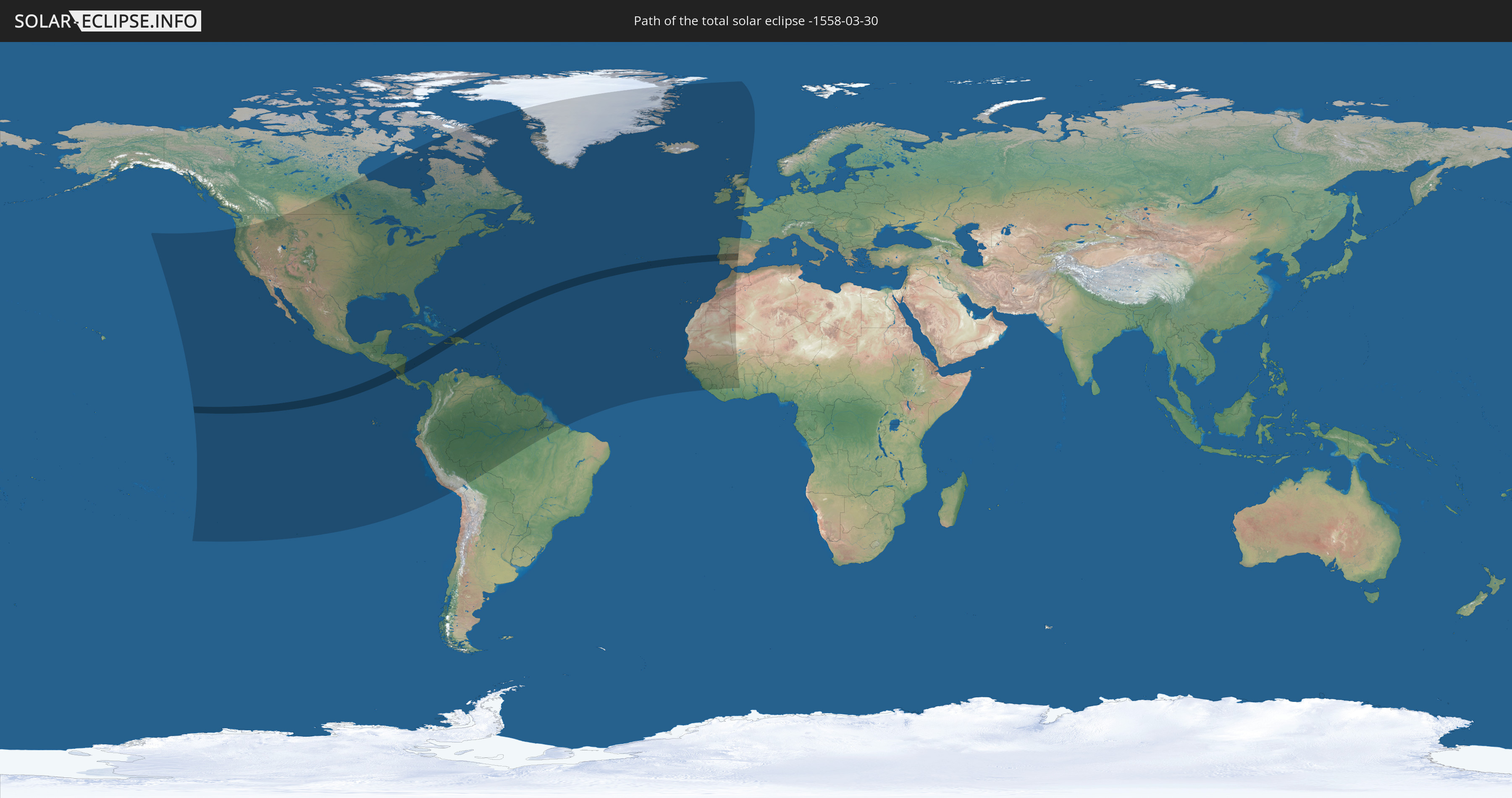
Die Sonnenfinsternis am 30.03.-1558 kann man in 73 Ländern als partielle Sonnenfinsternis beobachten.
Der Finsternispfad verläuft durch 9 Länder. Nur in diesen Ländern ist sie als totale Sonnenfinsternis zu sehen.
In den folgenden Ländern ist die Sonnenfinsternis total zu sehen
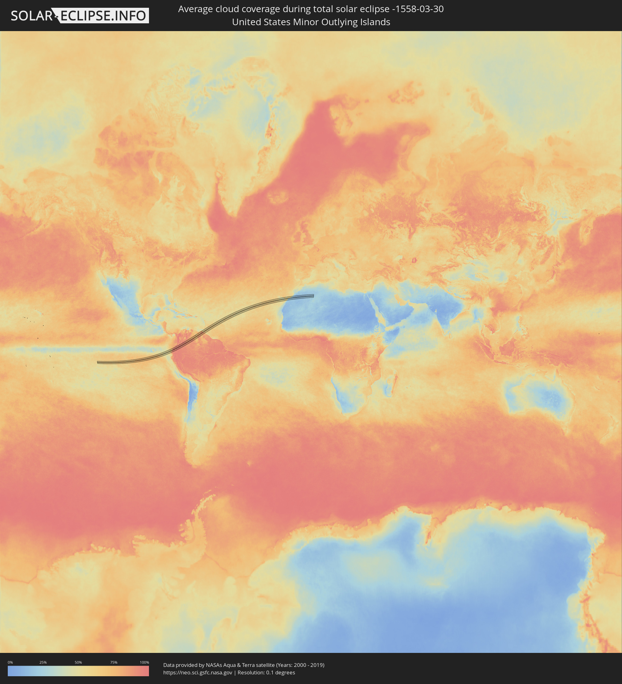
 United States Minor Outlying Islands
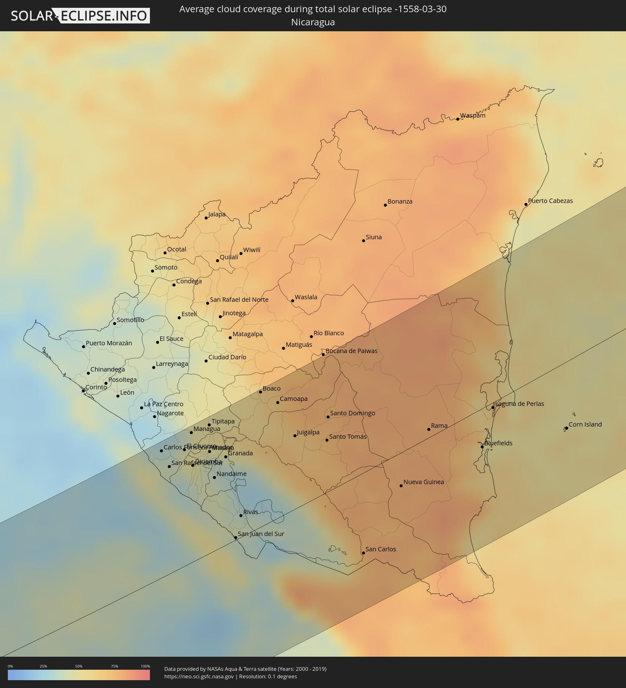
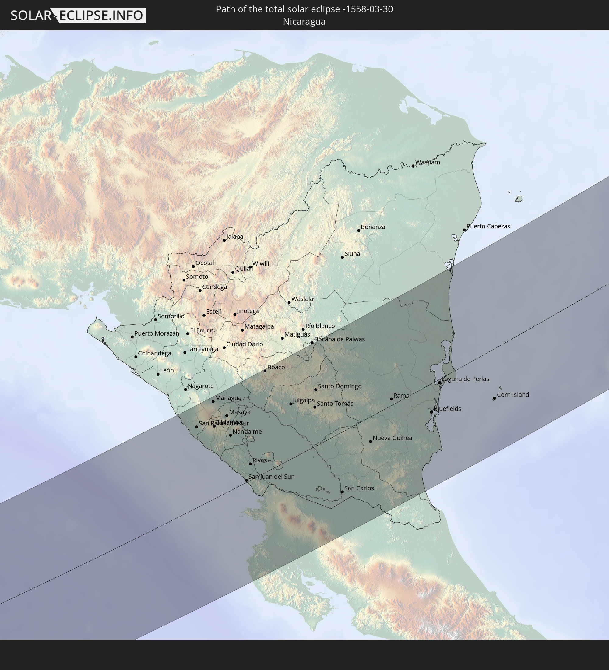 Nicaragua
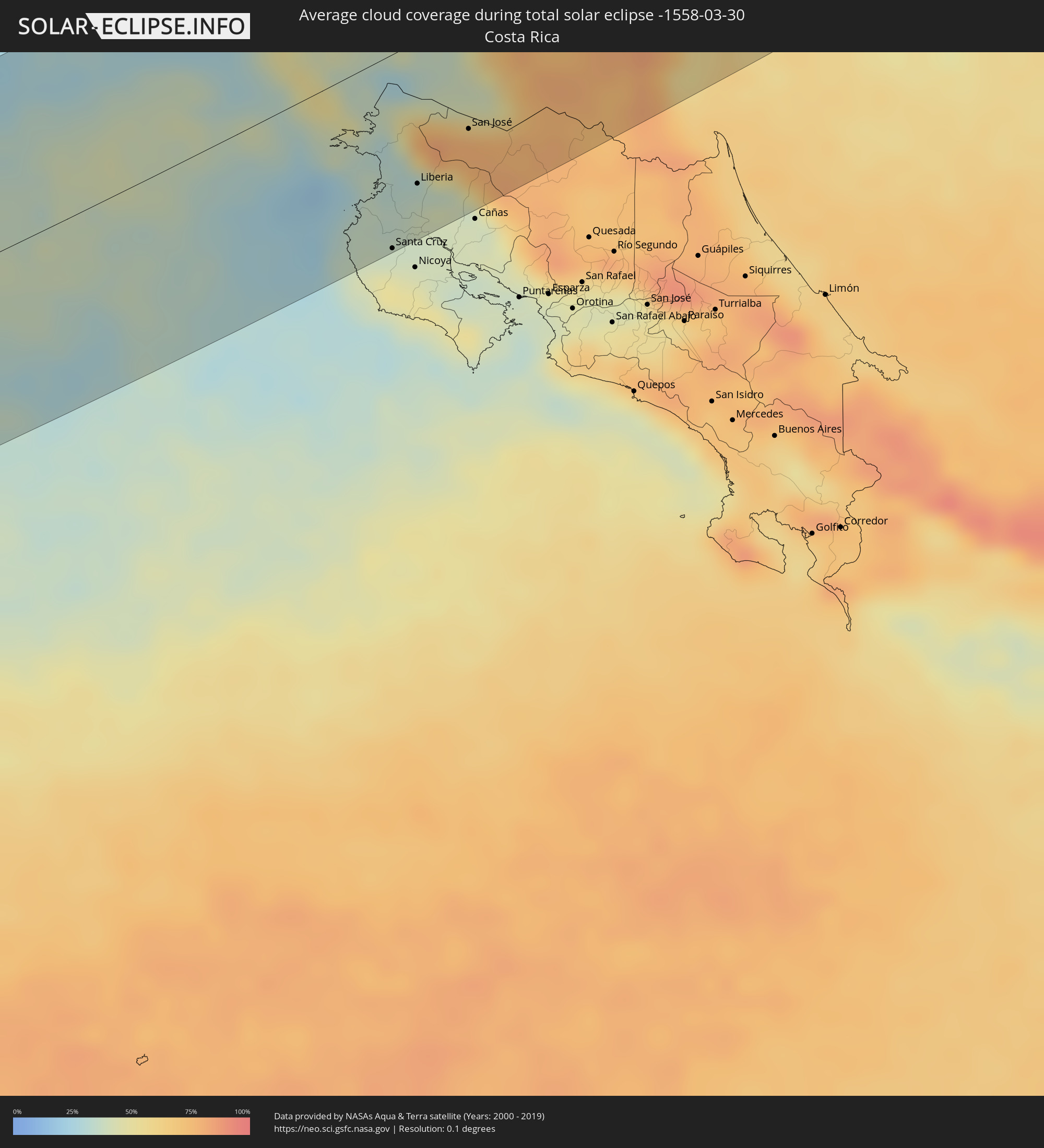
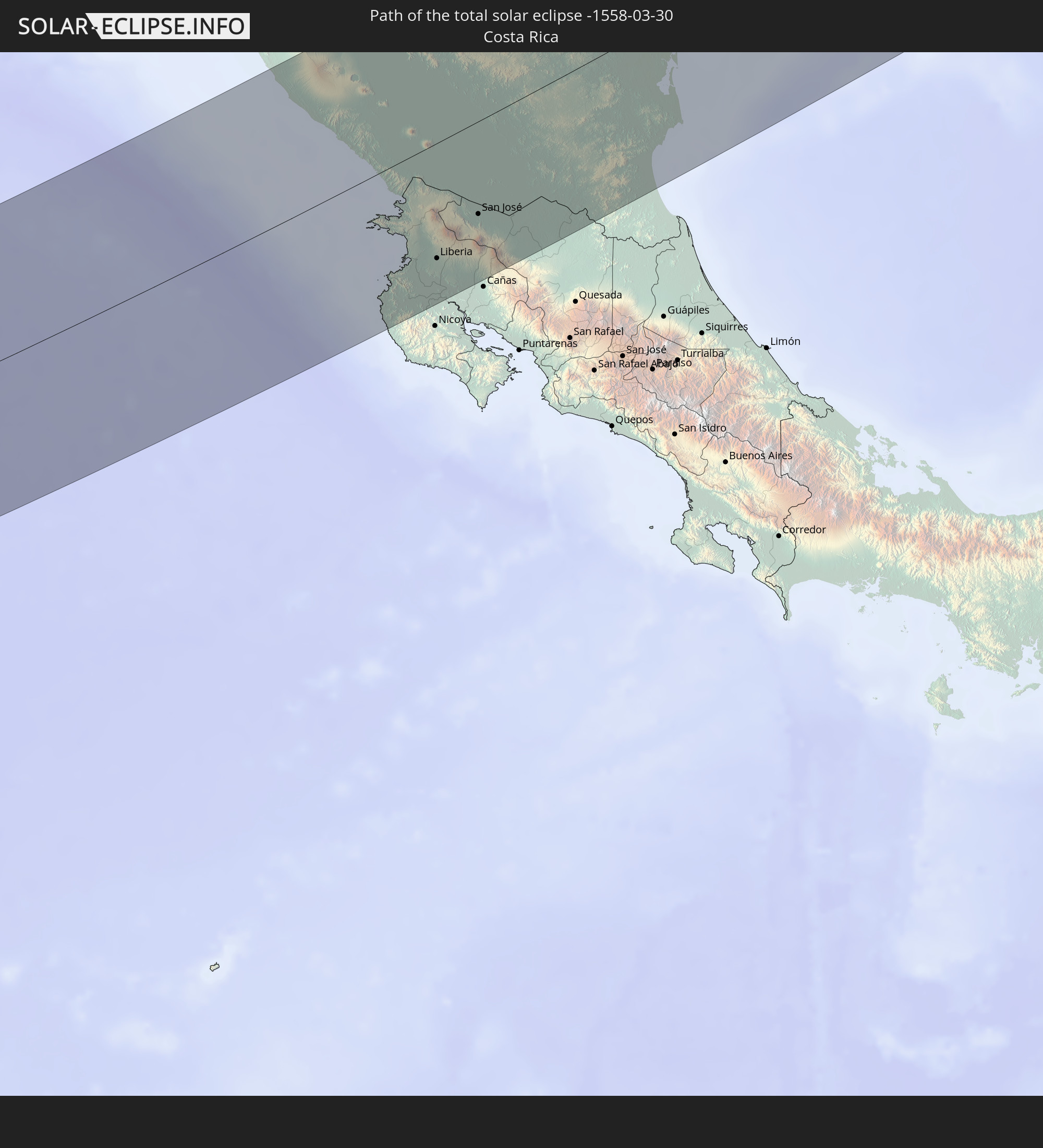 Costa Rica
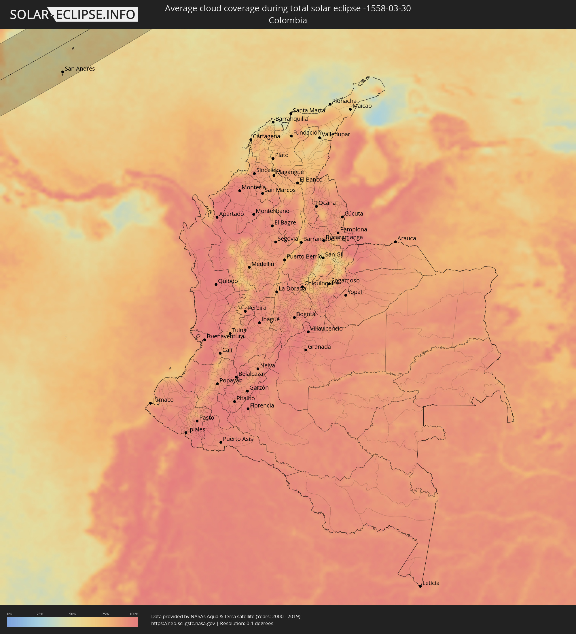
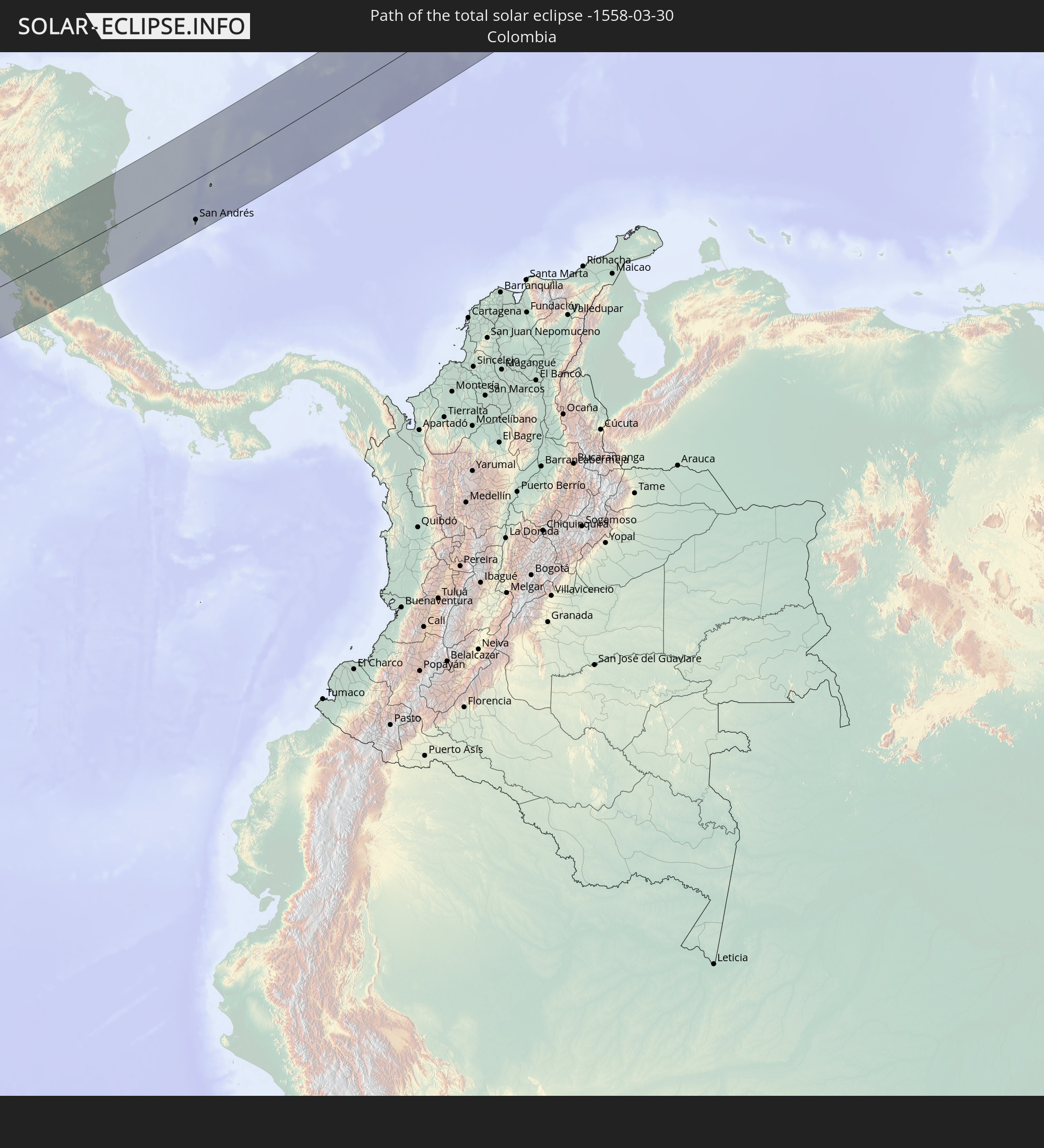 Kolumbien
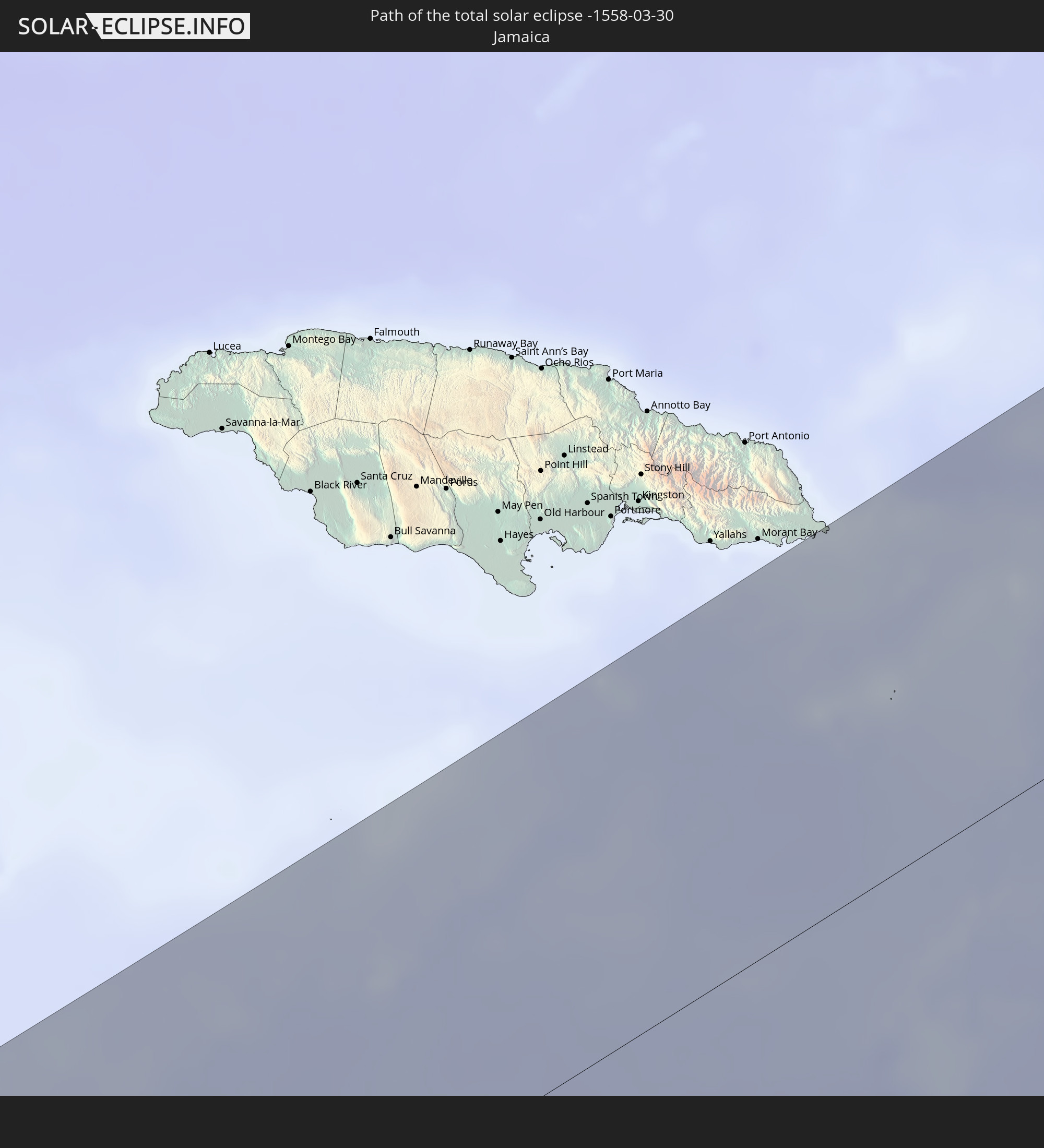 Jamaika
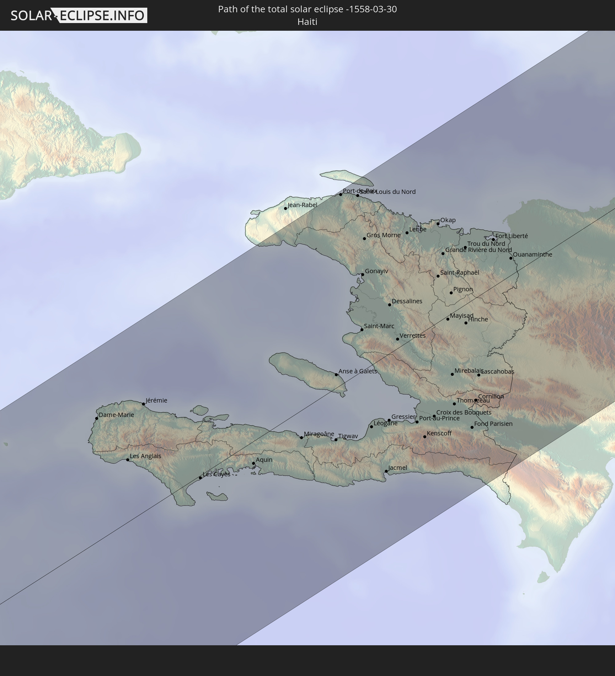 Haiti
Haiti
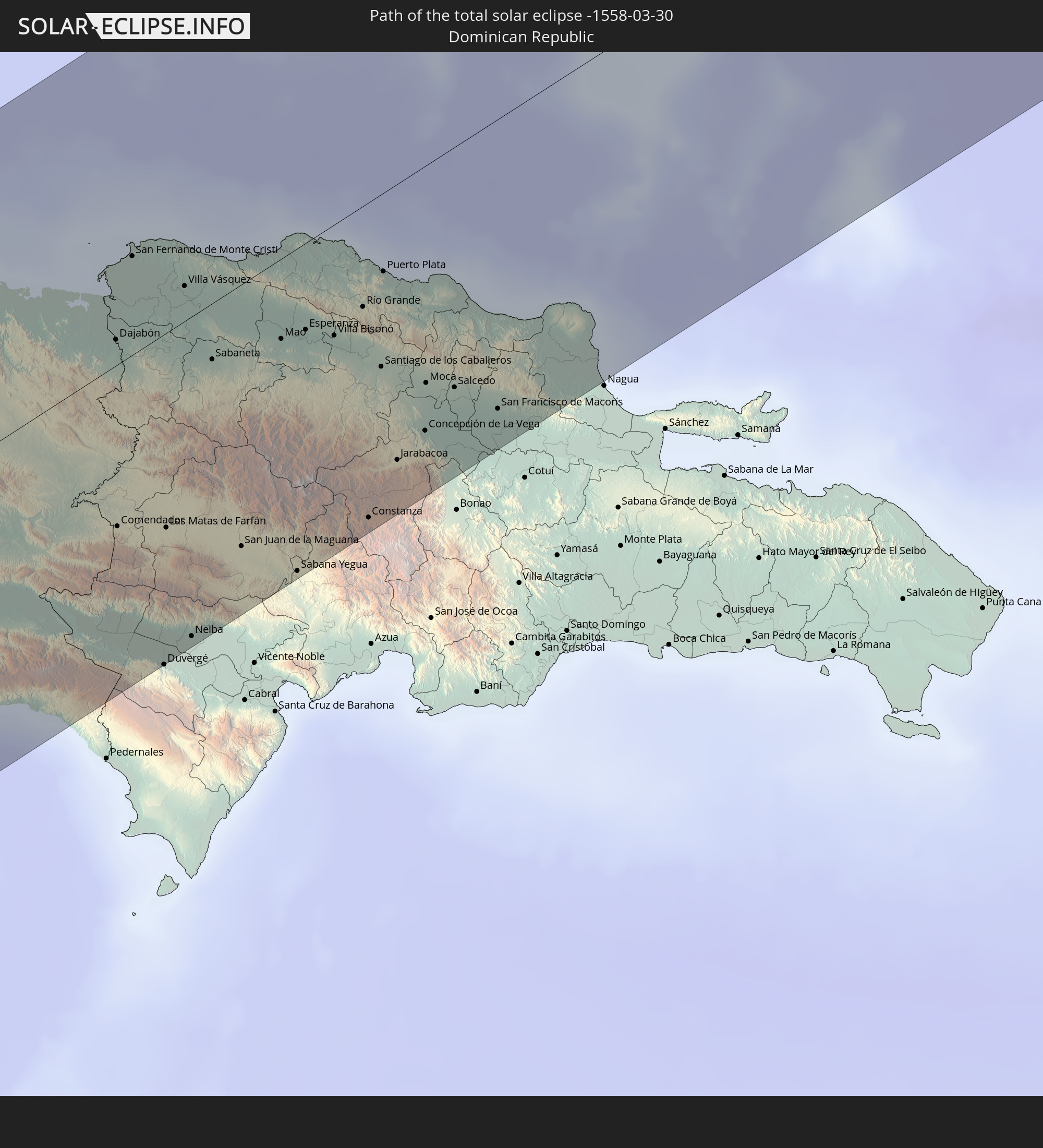 Dominikanische Republik
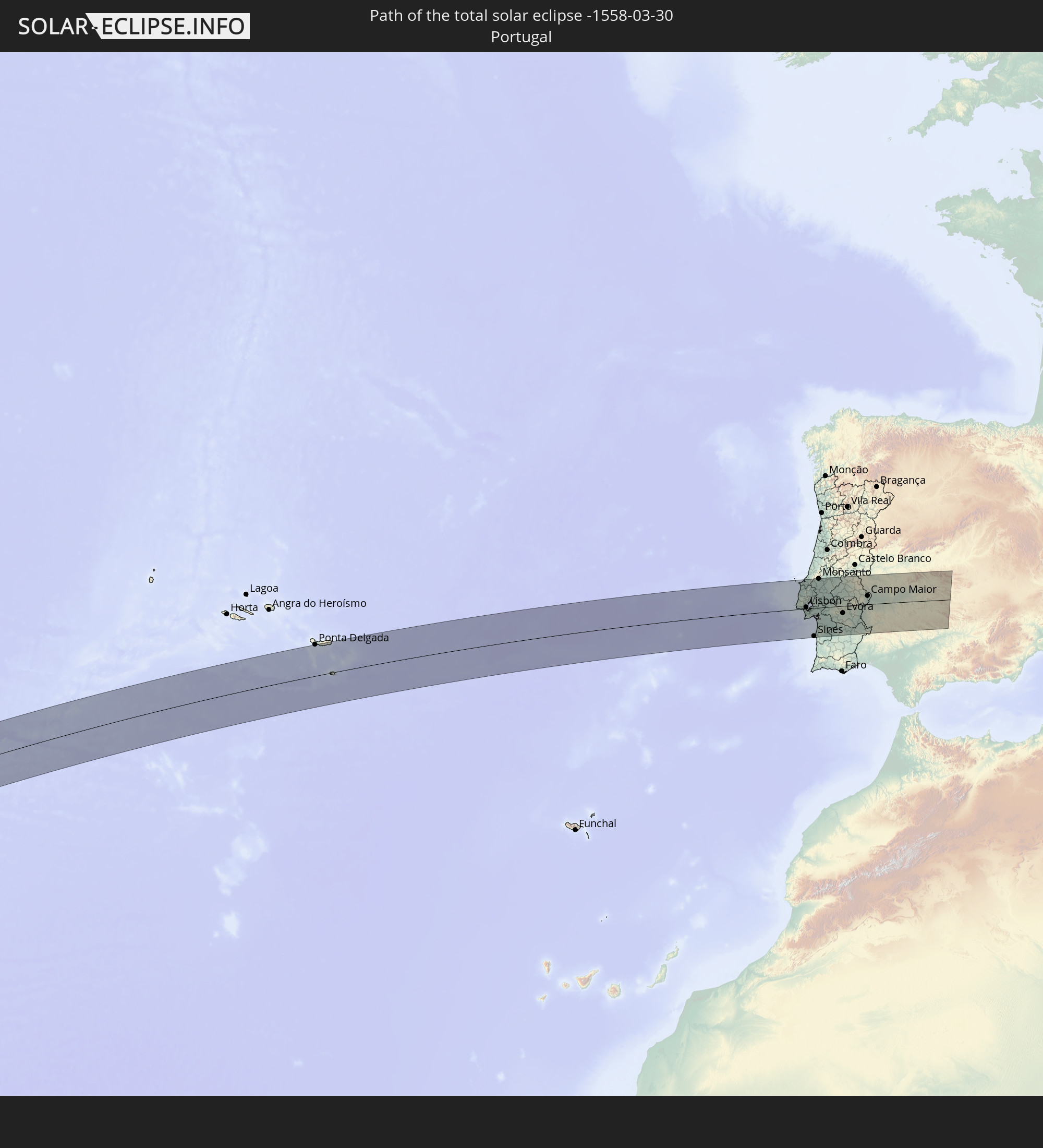 Portugal
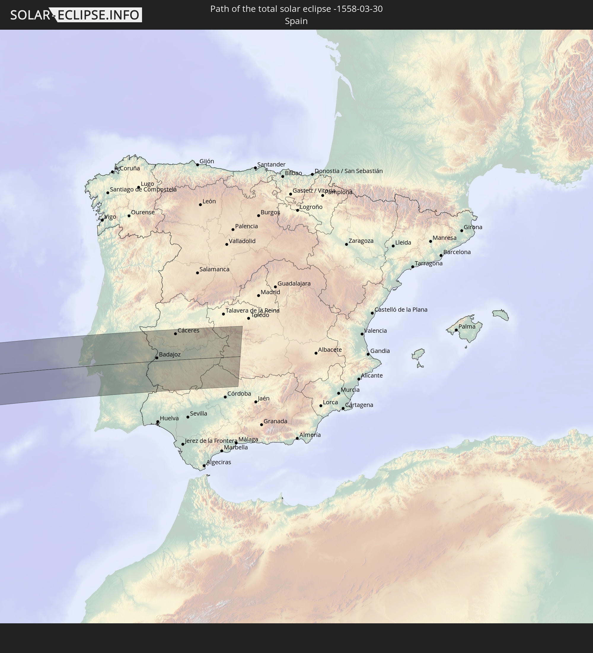 Spanien
In den folgenden Ländern ist die Sonnenfinsternis partiell zu sehen
 Vereinigte Staaten
 United States Minor Outlying Islands
 Kanada
 Pitcairninseln
 Mexiko
 Chile
Chile
 Grönland
 Guatemala
 Ecuador
 El Salvador
 Honduras
 Belize
 Nicaragua
 Costa Rica
 Kuba
Kuba
 Panama
 Kolumbien
 Kaimaninseln
 Peru
Peru
 Bahamas
 Jamaika
 Haiti
Haiti
 Brasilien
 Venezuela
 Turks- und Caicosinseln
 Dominikanische Republik
 Aruba
Aruba
 Bolivien
 Puerto Rico
 Amerikanische Jungferninseln
 Bermuda
 Britische Jungferninseln
 Anguilla
 Saint-Martin
 Saint-Barthélemy
 St. Kitts und Nevis
 Antigua und Barbuda
 Montserrat
 Trinidad und Tobago
 Guadeloupe
 Grenada
 Dominica
 St. Vincent und die Grenadinen
 Guyana
 Martinique
 St. Lucia
 Barbados
 Suriname
 Saint-Pierre und Miquelon
 Französisch-Guayana
 Portugal
 Kap Verde
 Island
 Spanien
 Senegal
 Mauretanien
 Gambia
 Guinea-Bissau
 Guinea
 Sierra Leone
 Marokko
 Mali
Mali
 Liberia
 Irland
 Spitzbergen
 Algerien
 Vereinigtes Königreich
 Elfenbeinküste
 Färöer
 Burkina Faso
 Gibraltar
 Frankreich
 Isle of Man
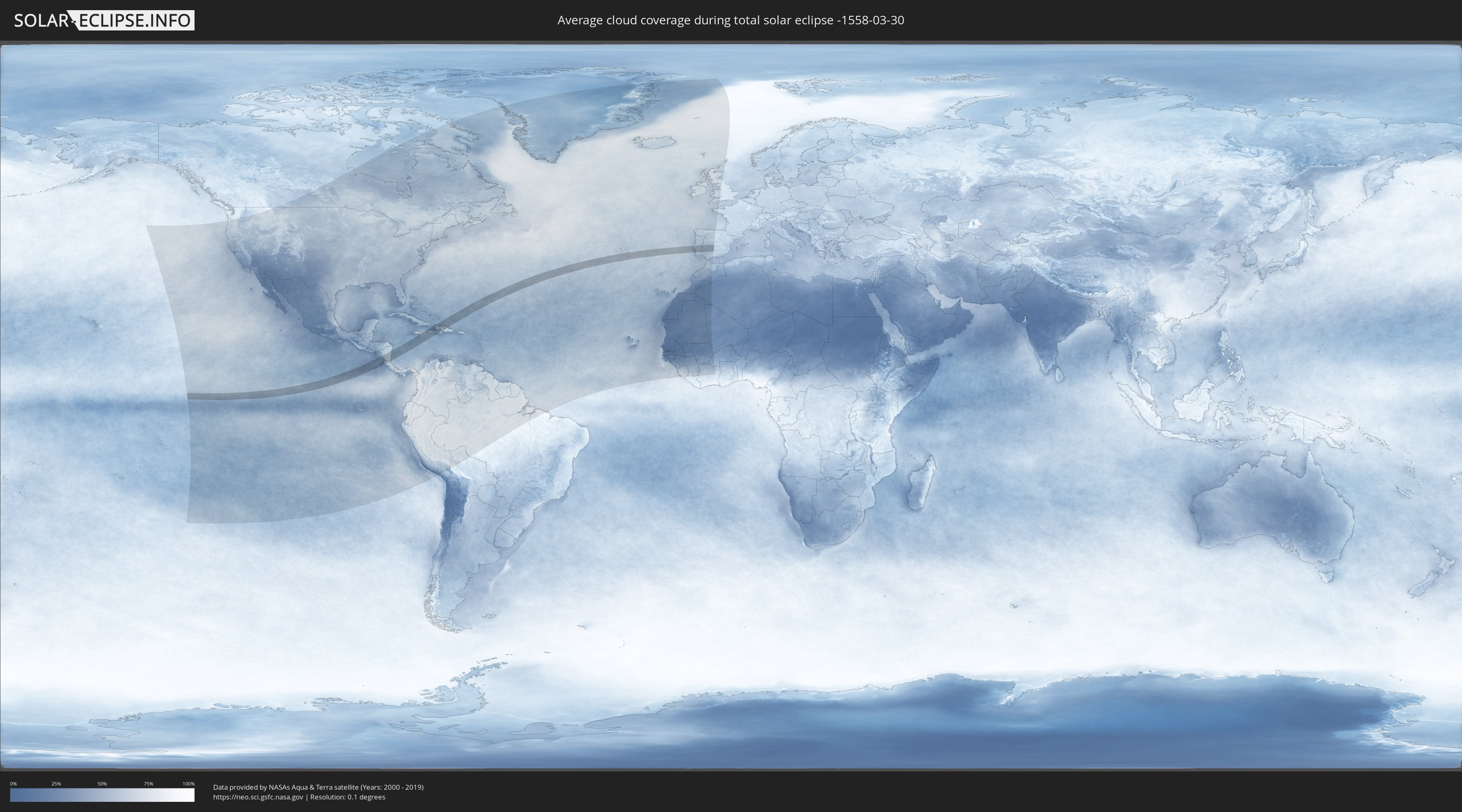
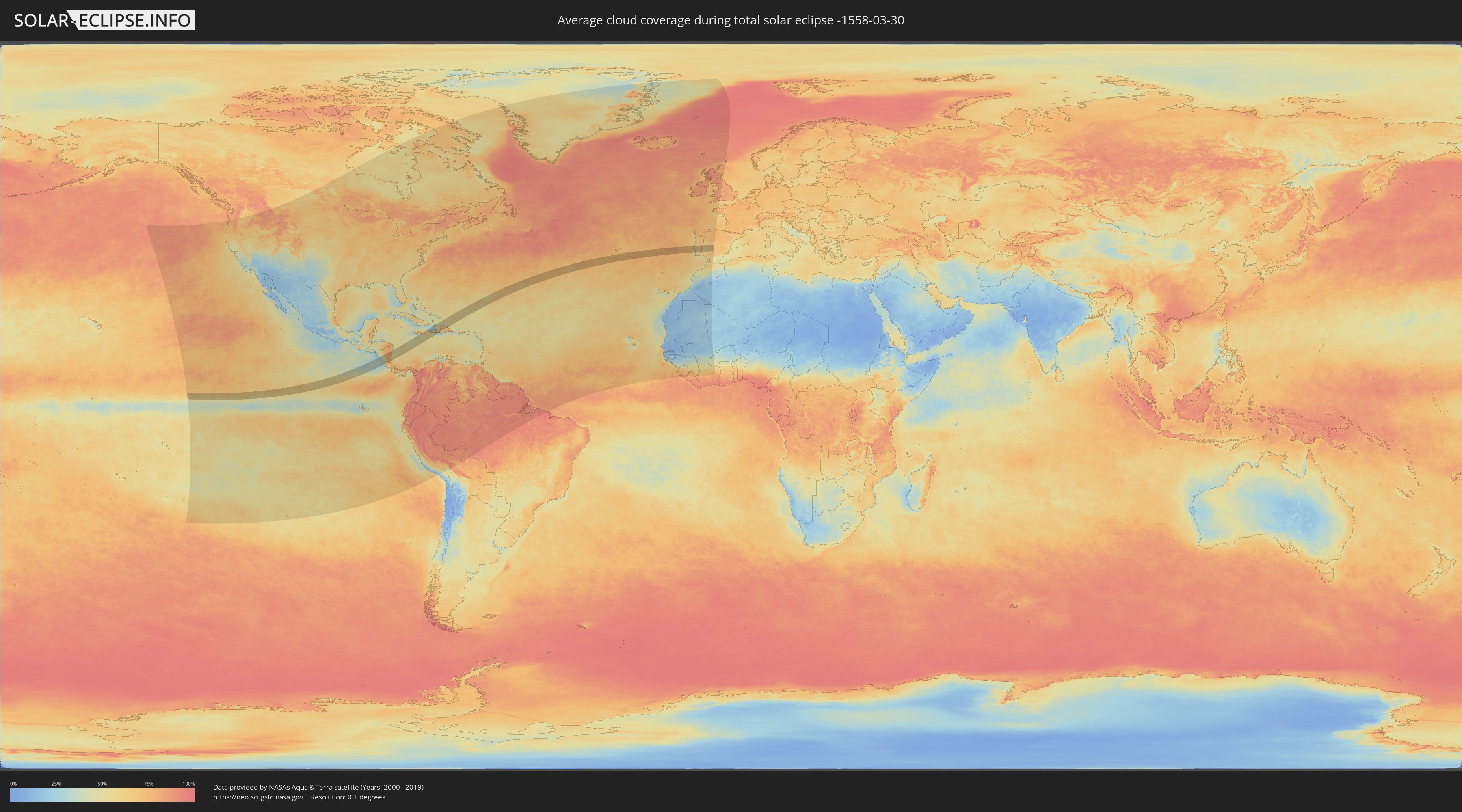
Wie wird das Wetter während der totalen Sonnenfinsternis am 30.03.-1558?
Wo ist der beste Ort, um die totale Sonnenfinsternis vom 30.03.-1558 zu beobachten?
Die folgenden Karten zeigen die durchschnittliche Bewölkung für den Tag, an dem die totale Sonnenfinsternis
stattfindet. Mit Hilfe der Karten lässt sich der Ort entlang des Finsternispfades eingrenzen,
der die besten Aussichen auf einen klaren wolkenfreien Himmel bietet.
Trotzdem muss man immer lokale Gegenenheiten beachten und sollte sich genau über das Wetter an seinem
gewählten Beobachtungsort informieren.
Die Daten stammen von den beiden NASA-Satelliten
AQUA und TERRA
und wurden über einen Zeitraum von 19 Jahren (2000 - 2019) gemittelt.
Detaillierte Länderkarten
 United States Minor Outlying Islands
 Nicaragua
 Costa Rica
 Kolumbien
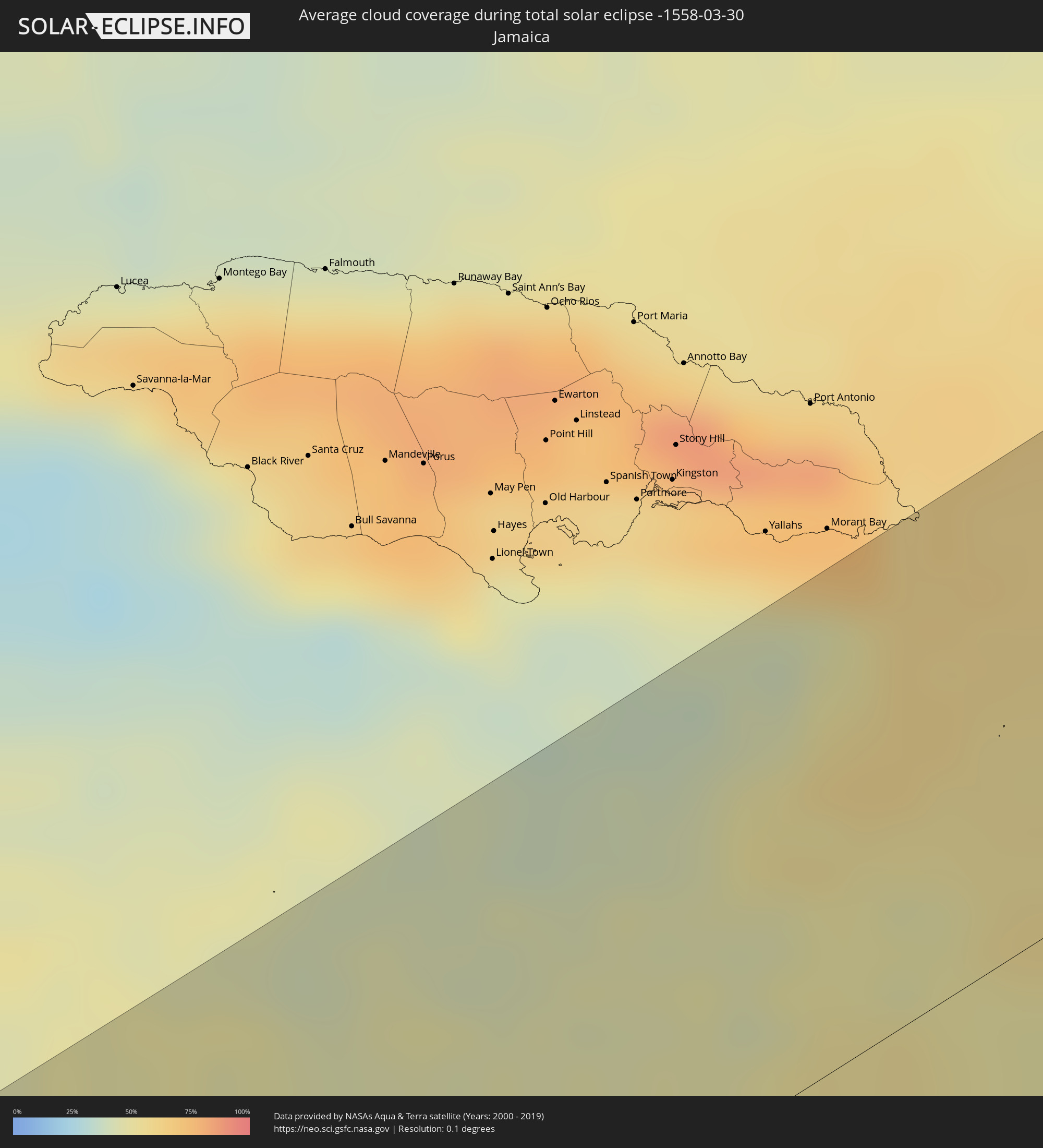 Jamaika
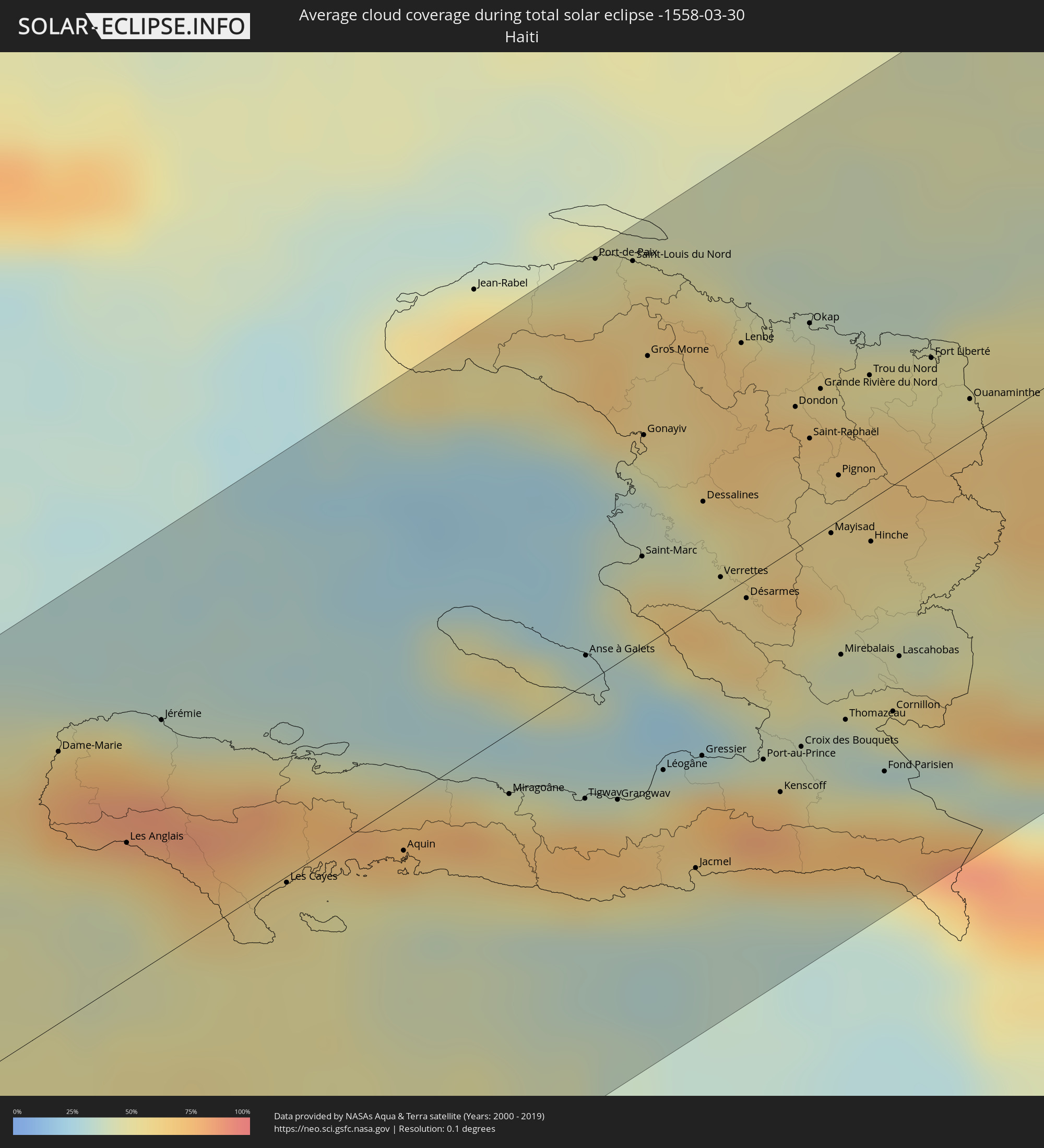 Haiti
Haiti
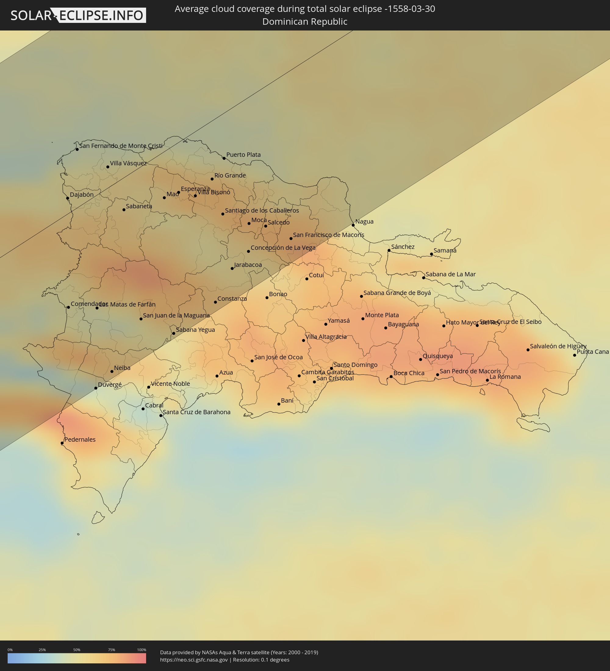 Dominikanische Republik
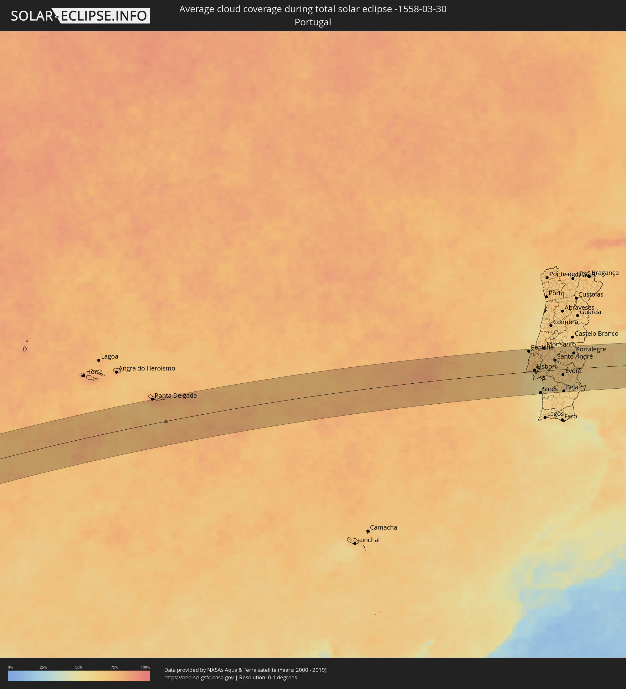 Portugal
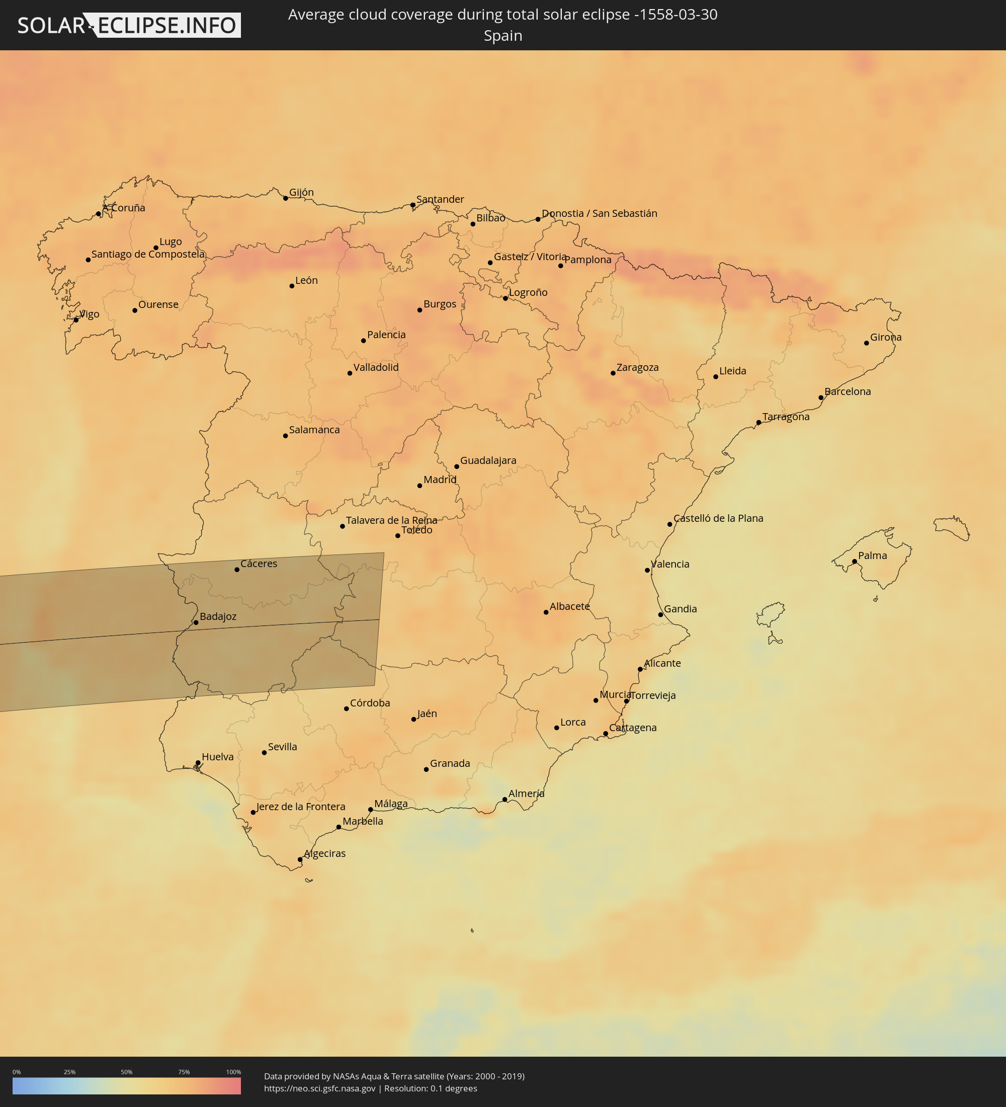 Spanien
Orte im Finsternispfad
Die nachfolgene Tabelle zeigt Städte und Orte mit mehr als 5.000 Einwohnern, die sich im Finsternispfad befinden. Städte mit mehr als 100.000 Einwohnern sind dick gekennzeichnet. Mit einem Klick auf den Ort öffnet sich eine Detailkarte die die Lage des jeweiligen Ortes zusammen mit dem Verlauf der zentralen Finsternis präsentiert.
| Ort | Typ | Dauer der Verfinsterung | Ortszeit bei maximaler Verfinsterung | Entfernung zur Zentrallinie | Ø Bewölkung |
|
San Rafael del Sur, Managua
|
total | - | 10:20:56 UTC-05:45 | 89 km | 36% |
|
El Crucero, Managua
|
total | - | 10:21:27 UTC-05:45 | 96 km | 42% |
|
Managua, Managua
|
total | - | 10:21:48 UTC-05:45 | 108 km | 46% |
|
Diriamba, Carazo
|
total | - | 10:21:24 UTC-05:45 | 80 km | 41% |
|
Dolores, Carazo
|
total | - | 10:21:27 UTC-05:45 | 79 km | 41% |
|
Ticuantepe, Managua
|
total | - | 10:21:44 UTC-05:45 | 94 km | 47% |
|
Masatepe, Masaya
|
total | - | 10:21:42 UTC-05:45 | 81 km | 42% |
|
Nindirí, Masaya
|
total | - | 10:21:53 UTC-05:45 | 88 km | 40% |
|
Tipitapa, Managua
|
total | - | 10:22:14 UTC-05:45 | 106 km | 49% |
|
Niquinohomo, Masaya
|
total | - | 10:21:47 UTC-05:45 | 77 km | 42% |
|
Masaya, Masaya
|
total | - | 10:21:54 UTC-05:45 | 84 km | 40% |
|
Nandaime, Granada
|
total | - | 10:21:39 UTC-05:45 | 61 km | 44% |
|
Diriomo, Granada
|
total | - | 10:21:50 UTC-05:45 | 72 km | 42% |
|
Granada, Granada
|
total | - | 10:22:08 UTC-05:45 | 73 km | 37% |
|
San Juan del Sur, Rivas
|
total | - | 10:21:16 UTC-05:45 | 2 km | 46% |
|
Rivas, Rivas
|
total | - | 10:21:39 UTC-05:45 | 18 km | 36% |
|
San Jorge, Rivas
|
total | - | 10:21:44 UTC-05:45 | 18 km | 40% |
|
San Lorenzo, Boaco
|
total | - | 10:23:29 UTC-05:45 | 102 km | 58% |
|
Boaco, Boaco
|
total | - | 10:23:39 UTC-05:45 | 111 km | 57% |
|
Santa Cruz, Guanacaste
|
total | - | 10:29:21 UTC-05:36 | 111 km | 39% |
|
Camoapa, Boaco
|
total | - | 10:23:51 UTC-05:45 | 95 km | 63% |
|
Liberia, Guanacaste
|
total | - | 10:30:16 UTC-05:36 | 81 km | 39% |
|
Juigalpa, Chontales
|
total | - | 10:23:45 UTC-05:45 | 60 km | 71% |
|
Acoyapa, Chontales
|
total | - | 10:23:58 UTC-05:45 | 37 km | 70% |
|
San José, Alajuela
|
total | - | 10:31:26 UTC-05:36 | 65 km | 77% |
|
Santo Tomás, Chontales
|
total | - | 10:24:18 UTC-05:45 | 43 km | 70% |
|
Villa Sandino, Chontales
|
total | - | 10:24:29 UTC-05:45 | 35 km | 71% |
|
San Carlos, Río San Juan
|
total | - | 10:23:32 UTC-05:45 | 66 km | 72% |
|
Nueva Guinea, Atlántico Sur
|
total | - | 10:25:09 UTC-05:45 | 28 km | 79% |
|
Rama, Atlántico Sur
|
total | - | 10:26:26 UTC-05:45 | 6 km | 79% |
|
Bluefields, Atlántico Sur
|
total | - | 10:27:15 UTC-05:45 | 32 km | 63% |
|
Corn Island, Atlántico Sur
|
total | - | 10:29:10 UTC-05:45 | 54 km | 52% |
|
San Andrés, Archipiélago de San Andrés, Providencia y Santa Catalina
|
total | - | 11:21:54 UTC-04:56 | 86 km | 56% |
|
Jérémie, GrandʼAnse
|
total | - | 11:57:01 UTC-04:49 | 62 km | 42% |
|
Les Cayes, Sud
|
total | - | 11:57:15 UTC-04:49 | 2 km | 54% |
|
Miragoâne, Nippes
|
total | - | 11:59:13 UTC-04:49 | 16 km | 70% |
|
Tigwav, Ouest
|
total | - | 11:59:45 UTC-04:49 | 30 km | 72% |
|
Ti Port-de-Paix, Nord-Ouest
|
total | - | 12:02:00 UTC-04:49 | 109 km | 53% |
|
Port-de-Paix, Nord-Ouest
|
total | - | 12:02:00 UTC-04:49 | 109 km | 53% |
|
Grangwav, Ouest
|
total | - | 11:59:58 UTC-04:49 | 36 km | 69% |
|
Saint-Louis du Nord, Nord-Ouest
|
total | - | 12:02:16 UTC-04:49 | 102 km | 59% |
|
Saint-Marc, Artibonite
|
total | - | 12:01:09 UTC-04:49 | 24 km | 58% |
|
Gonayiv, Artibonite
|
total | - | 12:01:39 UTC-04:49 | 55 km | 37% |
|
Léogâne, Ouest
|
total | - | 12:00:25 UTC-04:49 | 36 km | 60% |
|
Jacmel, Sud-Est
|
total | - | 12:00:15 UTC-04:49 | 67 km | 43% |
|
Gressier, Ouest
|
total | - | 12:00:46 UTC-04:49 | 39 km | 37% |
|
Dessalines, Artibonite
|
total | - | 12:01:48 UTC-04:49 | 28 km | 50% |
|
Verrettes, Artibonite
|
total | - | 12:01:37 UTC-04:49 | 5 km | 56% |
|
Lenbe, Nord
|
total | - | 12:02:43 UTC-04:49 | 63 km | 65% |
|
Désarmes, Artibonite
|
total | - | 12:01:43 UTC-04:49 | 5 km | 57% |
|
Port-au-Prince, Ouest
|
total | - | 12:01:11 UTC-04:49 | 50 km | 67% |
|
Kenscoff, Ouest
|
total | - | 12:01:11 UTC-04:49 | 61 km | 79% |
|
Okap, Nord
|
total | - | 12:03:17 UTC-04:49 | 56 km | 41% |
|
Saint-Raphaël, Nord
|
total | - | 12:02:49 UTC-04:49 | 26 km | 57% |
|
Grande Rivière du Nord, Nord
|
total | - | 12:03:06 UTC-04:49 | 37 km | 67% |
|
Mirebalais, Centre
|
total | - | 12:02:10 UTC-04:49 | 36 km | 49% |
|
Thomazeau, Ouest
|
total | - | 12:01:57 UTC-04:49 | 53 km | 38% |
|
Trou du Nord, Nord-Est
|
total | - | 12:03:30 UTC-04:49 | 33 km | 66% |
|
Hinche, Centre
|
total | - | 12:02:51 UTC-04:49 | 11 km | 54% |
|
Fond Parisien, Ouest
|
total | - | 12:02:01 UTC-04:49 | 74 km | 52% |
|
Fort Liberté, Nord-Est
|
total | - | 12:04:00 UTC-04:49 | 27 km | 49% |
|
Ouanaminthe, Nord-Est
|
total | - | 12:04:07 UTC-04:49 | 10 km | 65% |
|
Dajabón, Dajabón
|
total | - | 12:13:09 UTC-04:40 | 9 km | 65% |
|
Comendador, Elías Piña
|
total | - | 12:12:13 UTC-04:40 | 54 km | 49% |
|
San Fernando de Monte Cristi, Monte Cristi
|
total | - | 12:13:44 UTC-04:40 | 33 km | 50% |
|
Las Matas de Farfán, San Juan
|
total | - | 12:12:40 UTC-04:40 | 65 km | 44% |
|
Las Matas de Santa Cruz, Monte Cristi
|
total | - | 12:13:49 UTC-04:40 | 9 km | 54% |
|
Villa Jaragua, Baoruco
|
total | - | 12:12:11 UTC-04:40 | 103 km | 40% |
|
Villa Vásquez, Monte Cristi
|
total | - | 12:14:04 UTC-04:40 | 12 km | 58% |
|
Neiba, Baoruco
|
total | - | 12:12:20 UTC-04:40 | 108 km | 44% |
|
Sabaneta, Santiago Rodríguez
|
total | - | 12:13:57 UTC-04:40 | 19 km | 63% |
|
San Juan de la Maguana, San Juan
|
total | - | 12:13:15 UTC-04:40 | 88 km | 52% |
|
Laguna Salada, Valverde
|
total | - | 12:14:48 UTC-04:40 | 17 km | 59% |
|
Mao, Valverde
|
total | - | 12:14:41 UTC-04:40 | 27 km | 51% |
|
Sabana Yegua, Azua
|
total | - | 12:13:39 UTC-04:40 | 109 km | 51% |
|
San José de Las Matas, Santiago
|
total | - | 12:14:43 UTC-04:40 | 55 km | 62% |
|
Villa Bisonó, Santiago
|
total | - | 12:15:11 UTC-04:40 | 37 km | 55% |
|
Imbert, Puerto Plata
|
total | - | 12:15:34 UTC-04:40 | 22 km | 61% |
|
Villa González, Santiago
|
total | - | 12:15:22 UTC-04:40 | 44 km | 52% |
|
Río Grande, Puerto Plata
|
total | - | 12:15:36 UTC-04:40 | 34 km | 71% |
|
Constanza, La Vega
|
total | - | 12:14:35 UTC-04:40 | 106 km | 68% |
|
Santiago de los Caballeros, Santiago
|
total | - | 12:15:28 UTC-04:40 | 58 km | 57% |
|
Puerto Plata, Puerto Plata
|
total | - | 12:15:57 UTC-04:40 | 26 km | 60% |
|
Jarabacoa, La Vega
|
total | - | 12:15:08 UTC-04:40 | 93 km | 67% |
|
Concepción de La Vega, La Vega
|
total | - | 12:15:32 UTC-04:40 | 89 km | 57% |
|
Moca, Espaillat
|
total | - | 12:15:47 UTC-04:40 | 73 km | 60% |
|
Salsipuedes, Hermanas Mirabal
|
total | - | 12:16:10 UTC-04:40 | 80 km | 66% |
|
Tenares, Hermanas Mirabal
|
total | - | 12:16:11 UTC-04:40 | 85 km | 66% |
|
San Francisco de Macorís, Duarte
|
total | - | 12:16:19 UTC-04:40 | 97 km | 63% |
|
Las Guáranas, Duarte
|
total | - | 12:16:17 UTC-04:40 | 110 km | 64% |
|
Río San Juan, María Trinidad Sánchez
|
total | - | 12:17:13 UTC-04:40 | 75 km | 67% |
|
Ponta Delgada, Azores
|
total | - | 16:19:06 UTC-01:54 | 92 km | 77% |
|
Peniche, Leiria
|
total | - | 17:42:00 UTC-00:36 | 76 km | 63% |
|
Mafra, Lisbon
|
total | - | 17:42:16 UTC-00:36 | 30 km | 73% |
|
Cacém, Lisbon
|
total | - | 17:42:23 UTC-00:36 | 10 km | 71% |
|
Torres Vedras, Lisbon
|
total | - | 17:42:11 UTC-00:36 | 46 km | 73% |
|
Caldas da Rainha, Leiria
|
total | - | 17:42:01 UTC-00:36 | 80 km | 70% |
|
Lisbon, Lisbon
|
total | - | 17:42:26 UTC-00:36 | 4 km | 64% |
|
Sesimbra, Setúbal
|
total | - | 17:42:36 UTC-00:36 | 27 km | 56% |
|
Póvoa de Santa Iria, Lisbon
|
total | - | 17:42:21 UTC-00:36 | 19 km | 72% |
|
Alenquer, Lisbon
|
total | - | 17:42:15 UTC-00:36 | 40 km | 70% |
|
Rio Maior, Santarém
|
total | - | 17:42:05 UTC-00:36 | 71 km | 68% |
|
Setúbal, Setúbal
|
total | - | 17:42:35 UTC-00:36 | 19 km | 58% |
|
Samora Correia, Santarém
|
total | - | 17:42:20 UTC-00:36 | 26 km | 64% |
|
Sines, Setúbal
|
total | - | 17:42:55 UTC-00:36 | 82 km | 54% |
|
Santo André, Setúbal
|
total | - | 17:42:53 UTC-00:36 | 72 km | 51% |
|
Monsanto, Santarém
|
total | - | 17:42:02 UTC-00:36 | 84 km | 66% |
|
Santarém, Santarém
|
total | - | 17:42:11 UTC-00:36 | 58 km | 69% |
|
Grândola, Setúbal
|
total | - | 17:42:50 UTC-00:36 | 60 km | 60% |
|
Entroncamento, Santarém
|
total | - | 17:42:04 UTC-00:36 | 83 km | 67% |
|
Vendas Novas, Évora
|
total | - | 17:42:33 UTC-00:36 | 5 km | 66% |
|
Santo André, Portalegre
|
total | - | 17:42:21 UTC-00:36 | 36 km | 65% |
|
Montemor-o-Novo, Évora
|
total | - | 17:42:36 UTC-00:36 | 10 km | 66% |
|
Abrantes, Santarém
|
total | - | 17:42:05 UTC-00:36 | 81 km | 67% |
|
Ponte de Sôr, Portalegre
|
total | - | 17:42:15 UTC-00:36 | 56 km | 66% |
|
Évora, Évora
|
total | - | 17:42:41 UTC-00:36 | 21 km | 67% |
|
Beja, Beja
|
total | - | 17:43:01 UTC-00:36 | 82 km | 64% |
|
Vale da Amoreira, Portalegre
|
total | - | 17:42:24 UTC-00:36 | 34 km | 68% |
|
Portalegre, Portalegre
|
total | - | 17:42:17 UTC-00:36 | 57 km | 68% |
|
Valencia de Alcántara, Extremadura
|
total | - | 18:18:59 UTC+00:00 | 69 km | 65% |
|
Elvas, Portalegre
|
total | - | 17:42:34 UTC-00:36 | 10 km | 67% |
|
Alburquerque, Extremadura
|
total | - | 18:19:07 UTC+00:00 | 47 km | 64% |
|
Badajoz, Extremadura
|
total | - | 18:19:20 UTC+00:00 | 8 km | 66% |
|
Oliva de la Frontera, Extremadura
|
total | - | 18:19:42 UTC+00:00 | 59 km | 61% |
|
Jerez de los Caballeros, Extremadura
|
total | - | 18:19:41 UTC+00:00 | 55 km | 61% |
|
Puebla de la Calzada, Extremadura
|
total | - | 18:19:21 UTC+00:00 | 8 km | 63% |
|
Montijo, Extremadura
|
total | - | 18:19:21 UTC+00:00 | 10 km | 63% |
|
Arroyo de la Luz, Extremadura
|
total | - | 18:18:59 UTC+00:00 | 74 km | 64% |
|
Fuente del Maestre, Extremadura
|
total | - | 18:19:35 UTC+00:00 | 34 km | 64% |
|
Zafra, Extremadura
|
total | - | 18:19:39 UTC+00:00 | 46 km | 63% |
|
Almendralejo, Extremadura
|
total | - | 18:19:30 UTC+00:00 | 16 km | 59% |
|
Calamonte, Extremadura
|
total | - | 18:19:22 UTC+00:00 | 6 km | 61% |
|
Los Santos de Maimona, Extremadura
|
total | - | 18:19:38 UTC+00:00 | 42 km | 64% |
|
Cáceres, Extremadura
|
total | - | 18:19:00 UTC+00:00 | 72 km | 64% |
|
Mérida, Extremadura
|
total | - | 18:19:22 UTC+00:00 | 9 km | 61% |
|
Villafranca de los Barros, Extremadura
|
total | - | 18:19:35 UTC+00:00 | 30 km | 59% |
|
Guareña, Extremadura
|
total | - | 18:19:25 UTC+00:00 | 2 km | 62% |
|
Llerena, Extremadura
|
total | - | 18:19:48 UTC+00:00 | 68 km | 60% |
|
El Casar, Extremadura
|
total | - | 18:19:37 UTC+00:00 | 36 km | 64% |
|
Miajadas, Extremadura
|
total | - | 18:19:14 UTC+00:00 | 33 km | 67% |
|
Trujillo, Extremadura
|
total | - | 18:19:03 UTC+00:00 | 67 km | 65% |
|
Don Benito, Extremadura
|
total | - | 18:19:22 UTC+00:00 | 11 km | 64% |
|
Azuaga, Extremadura
|
total | - | 18:19:48 UTC+00:00 | 66 km | 62% |
|
Castuera, Extremadura
|
total | - | 18:19:31 UTC+00:00 | 15 km | 65% |
|
Peñarroya-Pueblonuevo, Andalusia
|
total | - | 18:19:48 UTC+00:00 | 65 km | 61% |
|
Cabeza del Buey, Extremadura
|
total | - | 18:19:33 UTC+00:00 | 18 km | 65% |
|
Hinojosa del Duque, Andalusia
|
total | - | 18:19:41 UTC+00:00 | 43 km | 65% |
|
Pozoblanco, Andalusia
|
total | - | 18:19:46 UTC+00:00 | 58 km | 63% |
|
Villanueva de Córdoba, Andalusia
|
total | - | 18:19:48 UTC+00:00 | 65 km | 63% |