Totale Sonnenfinsternis vom 31.07.-1583
| Wochentag: | Samstag |
| Maximale Dauer der Verfinsterung: | 05m26s |
| Maximale Breite des Finsternispfades: | 230 km |
| Saroszyklus: | 20 |
| Bedeckungsgrad: | 100% |
| Magnitude: | 1.0683 |
| Gamma: | 0.2452 |
Wo kann man die Sonnenfinsternis vom 31.07.-1583 sehen?
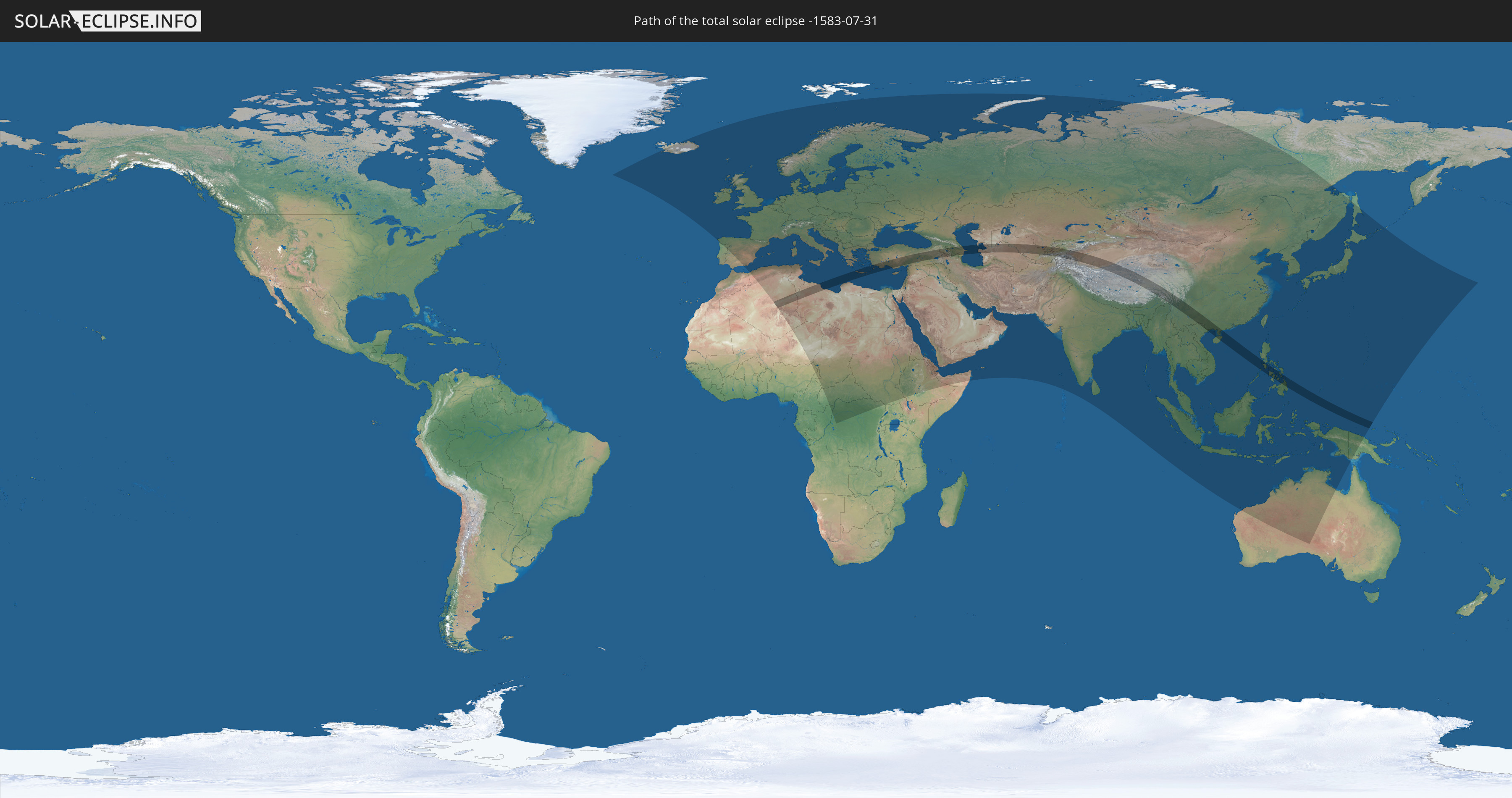
Die Sonnenfinsternis am 31.07.-1583 kann man in 123 Ländern als partielle Sonnenfinsternis beobachten.
Der Finsternispfad verläuft durch 22 Länder. Nur in diesen Ländern ist sie als totale Sonnenfinsternis zu sehen.
In den folgenden Ländern ist die Sonnenfinsternis total zu sehen
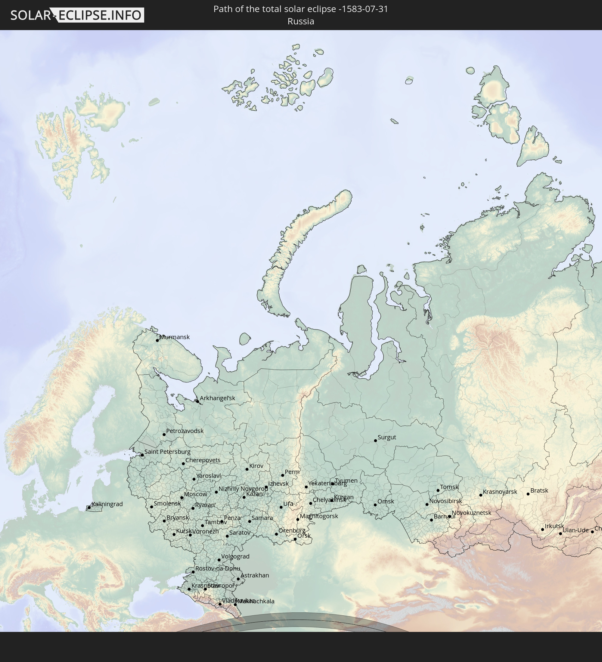 Russland
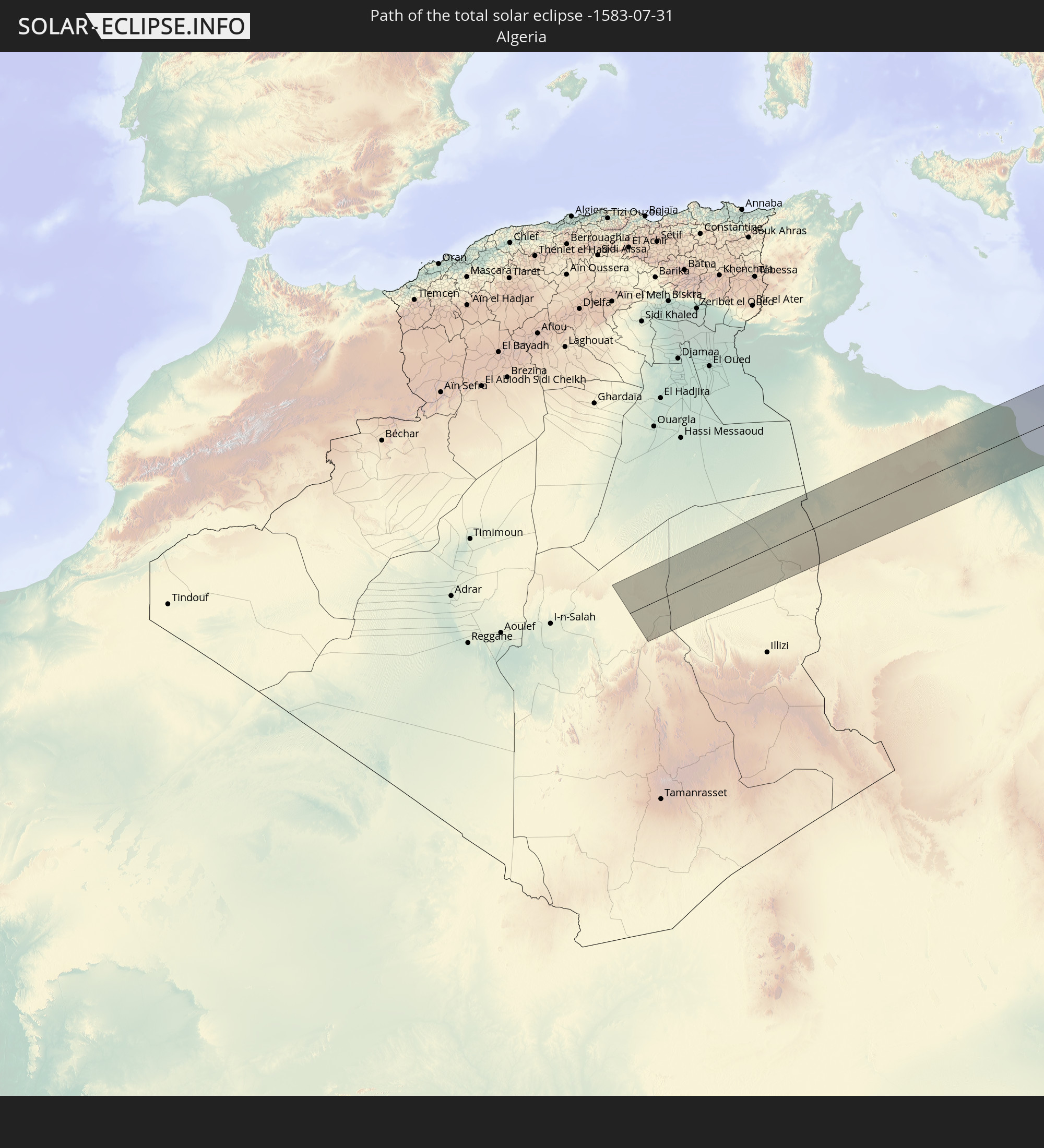 Algerien
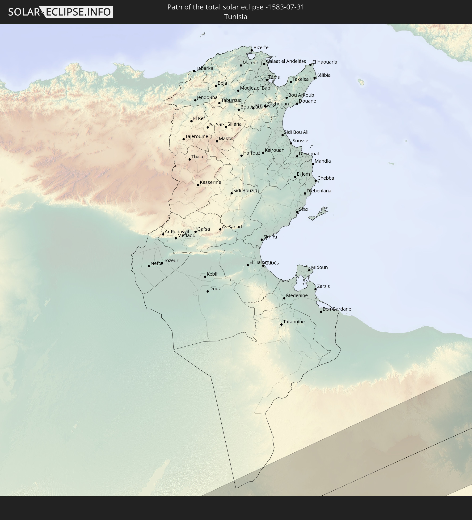 Tunesien
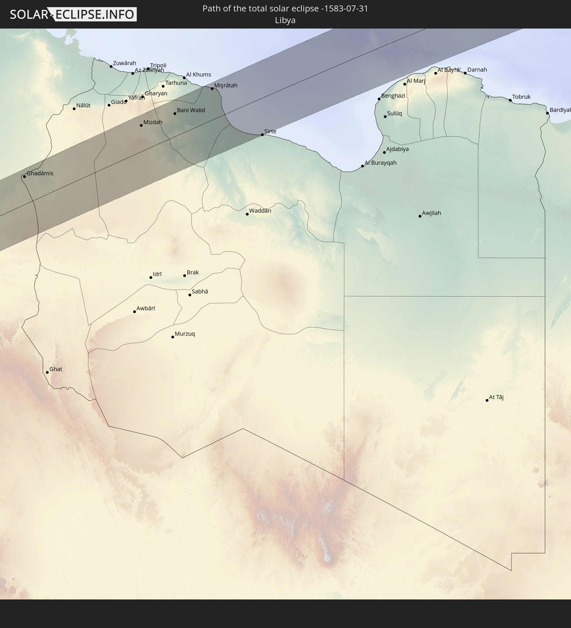 Libyen
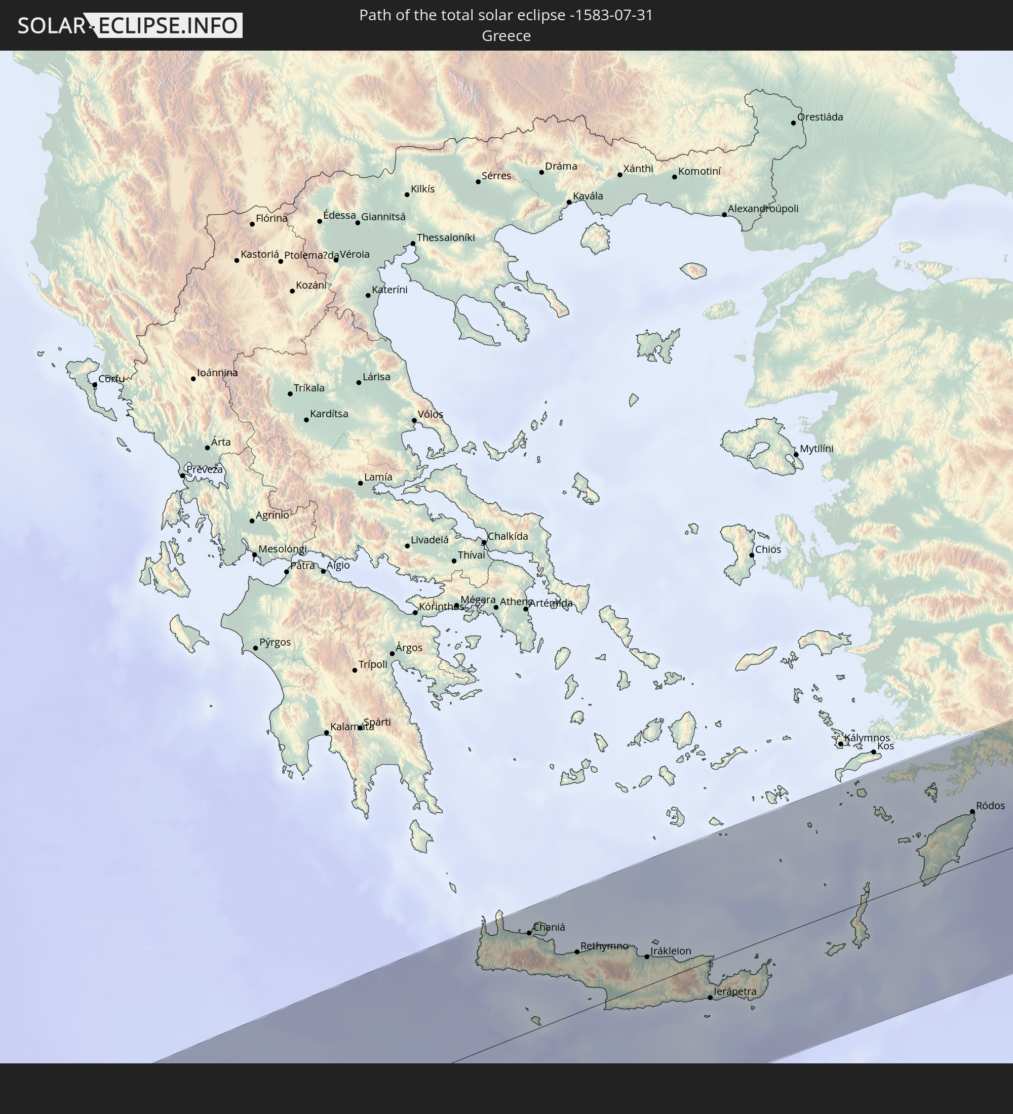 Griechenland
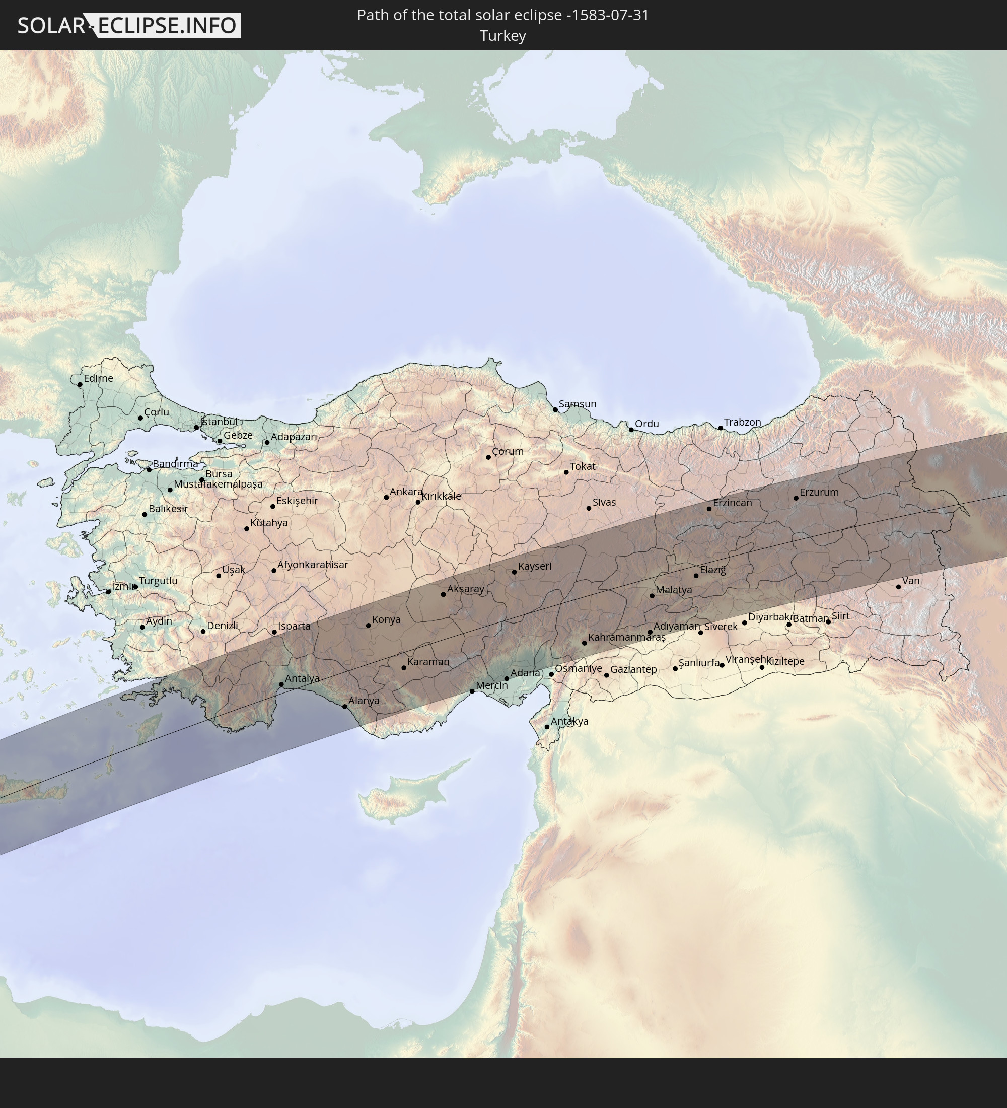 Türkei
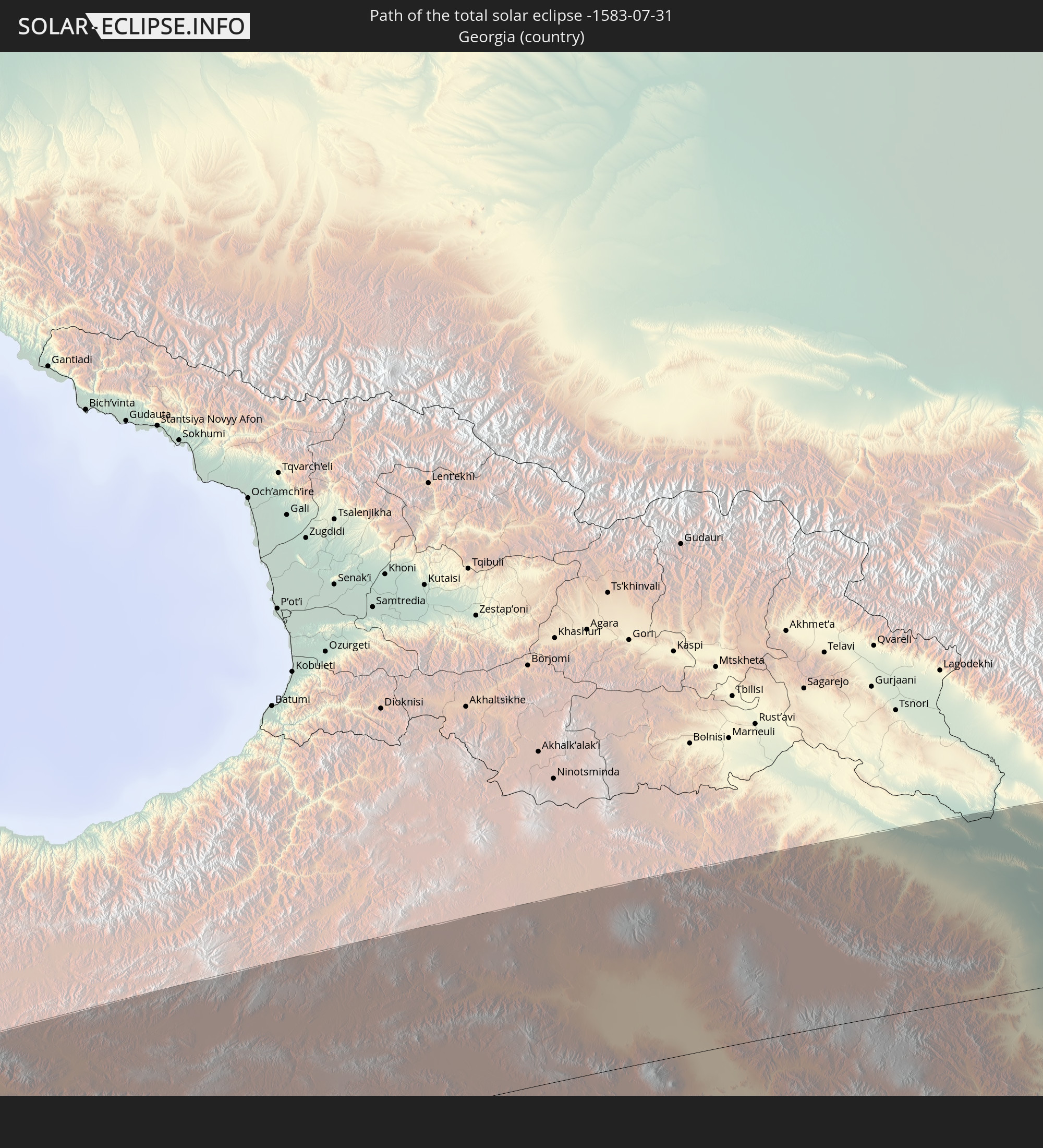 Georgien
 Armenien
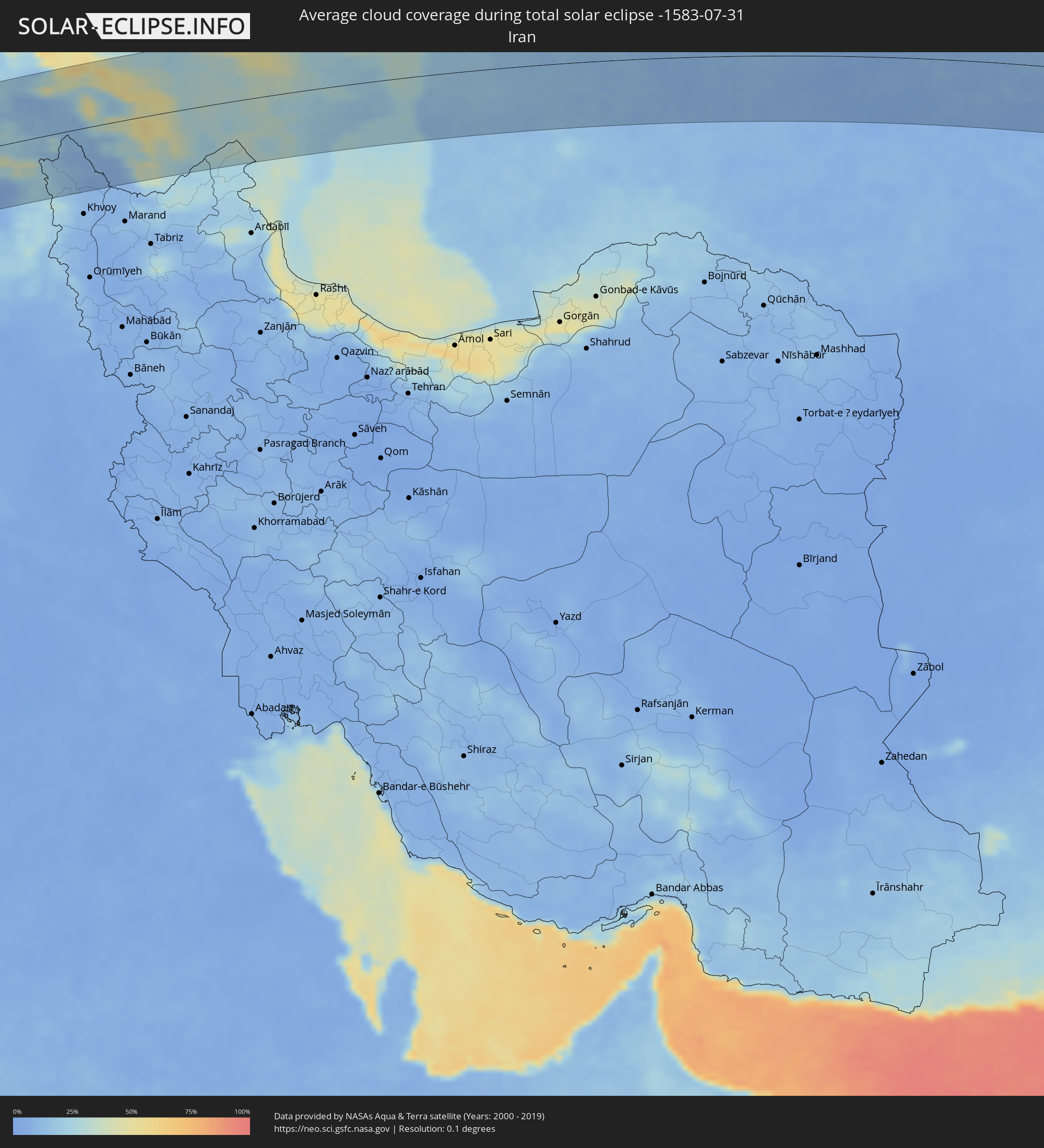
 Iran
Iran
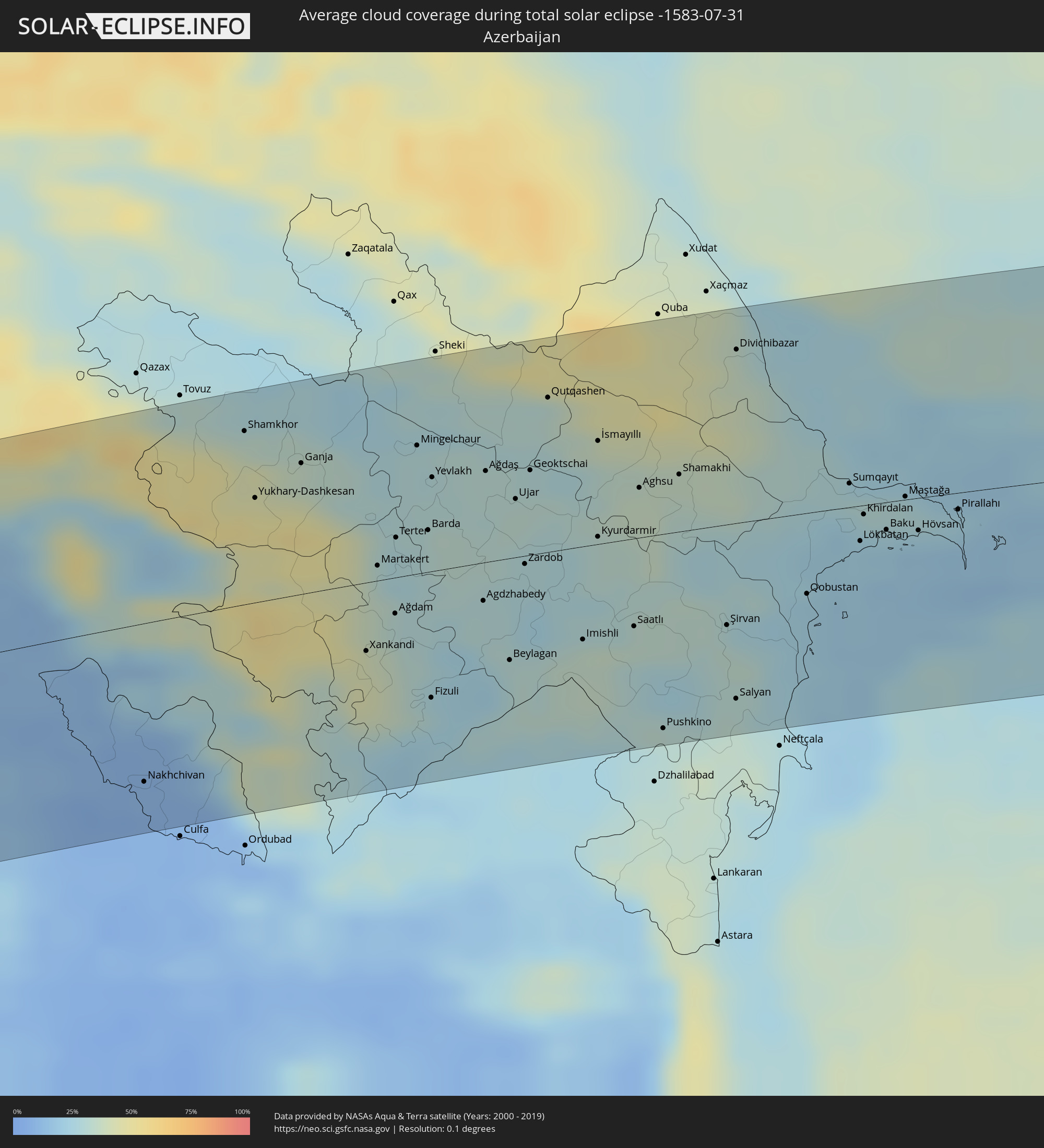
 Aserbaidschan
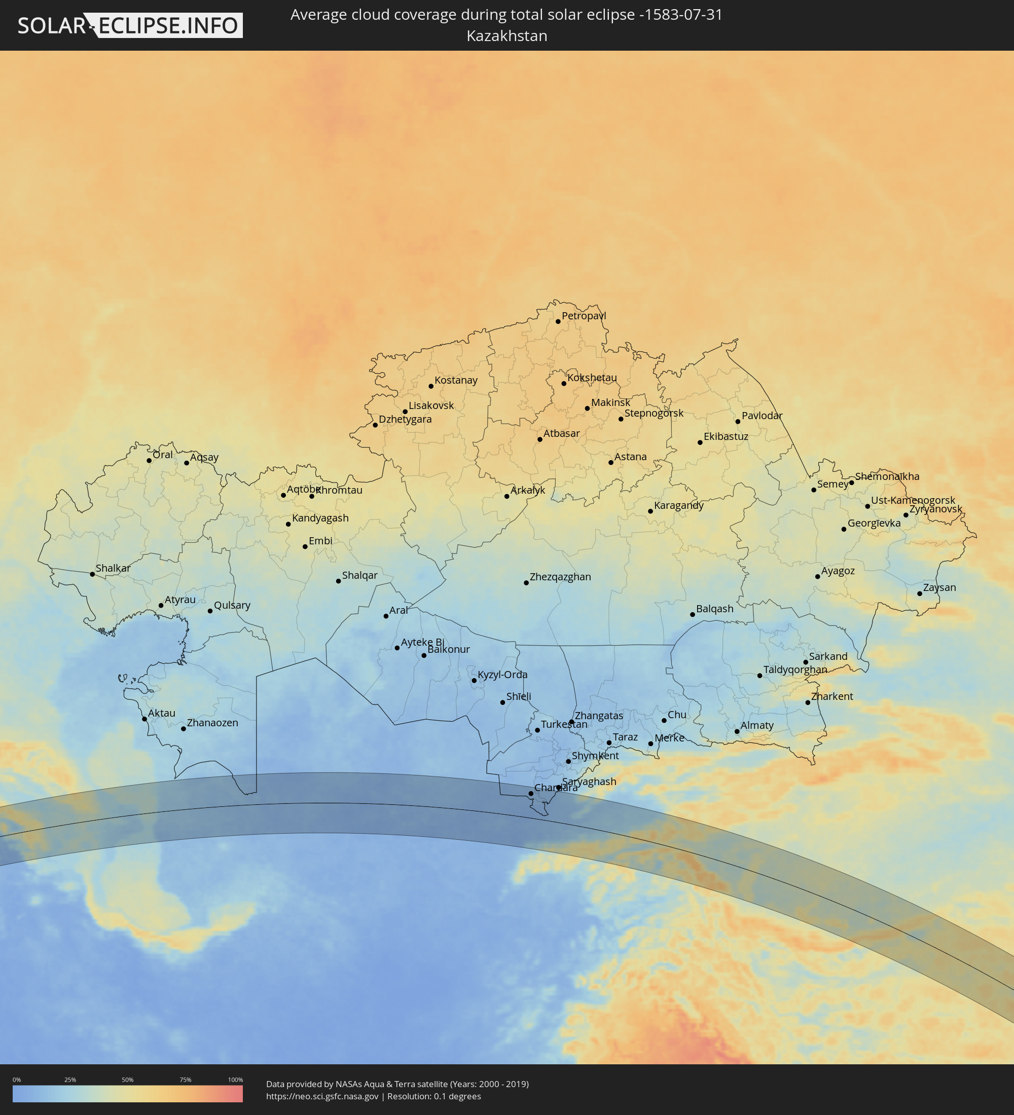
 Kasachstan
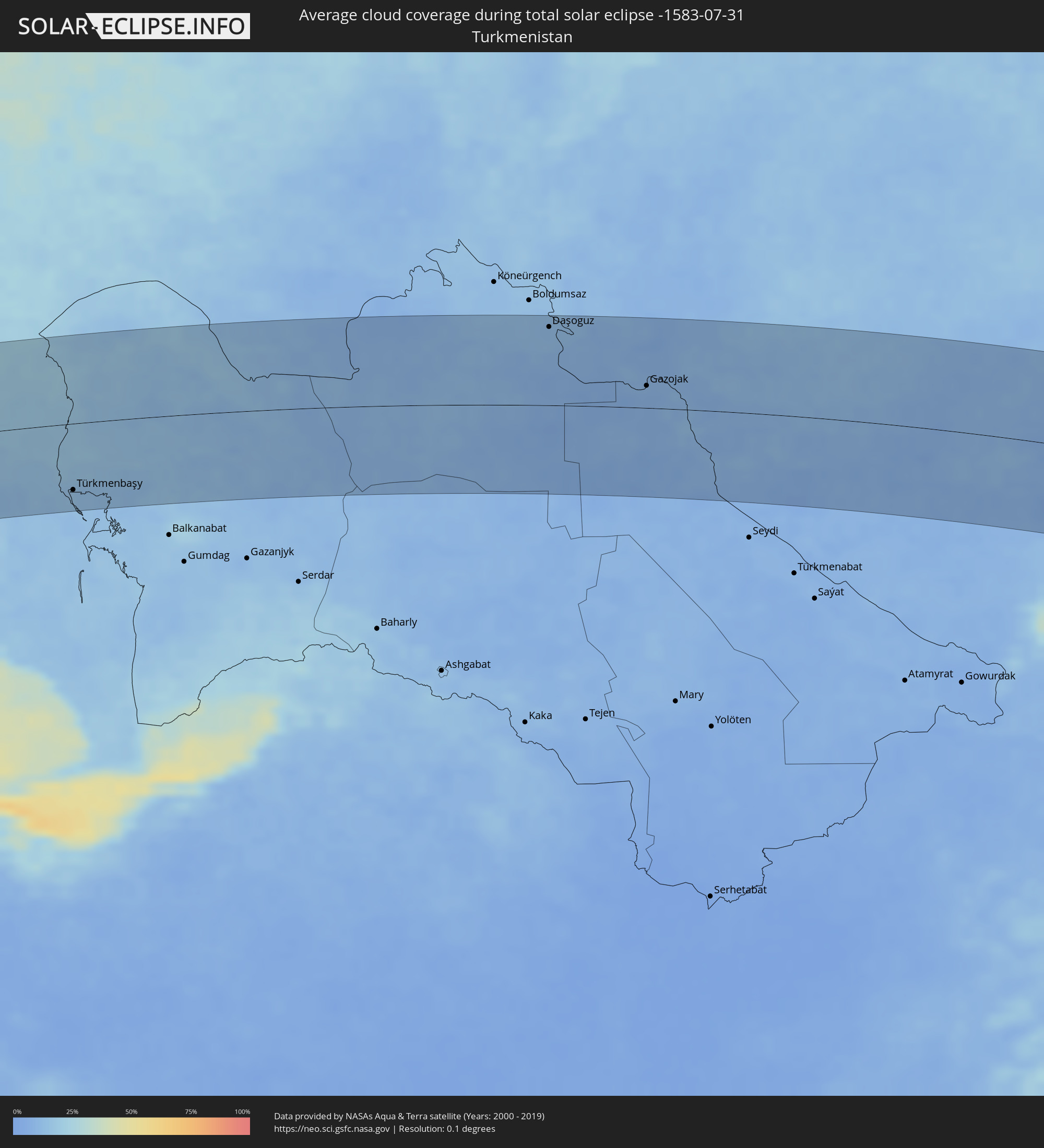
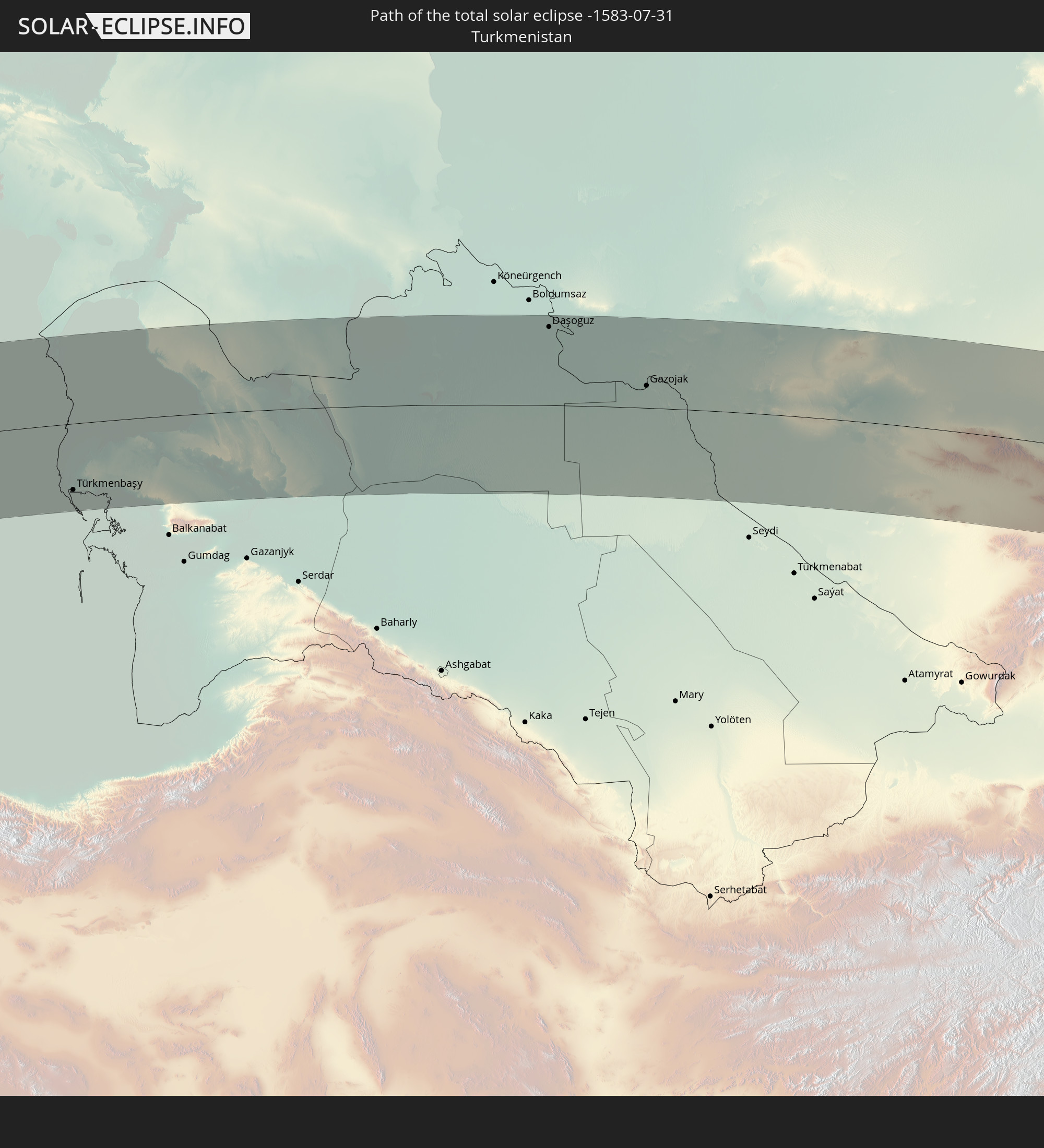 Turkmenistan
 Usbekistan
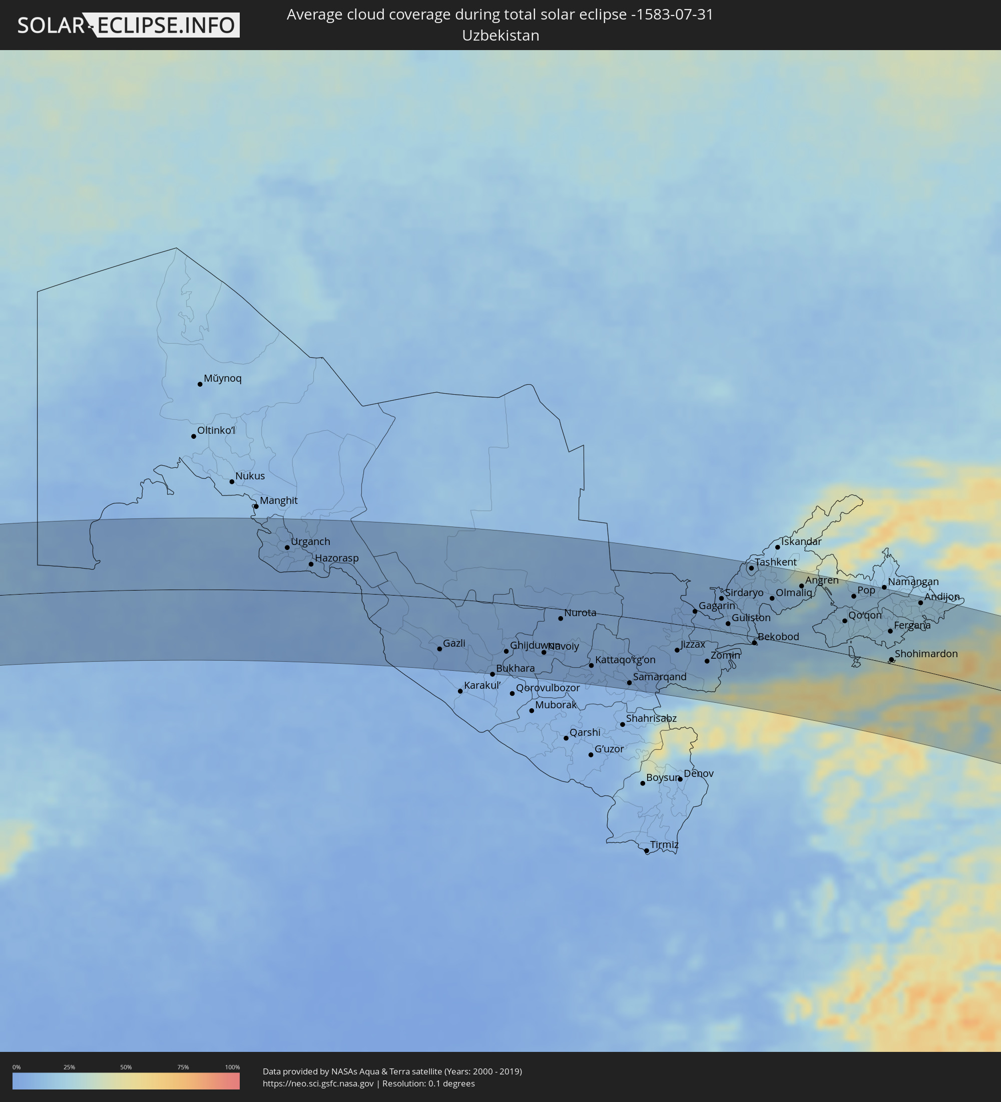
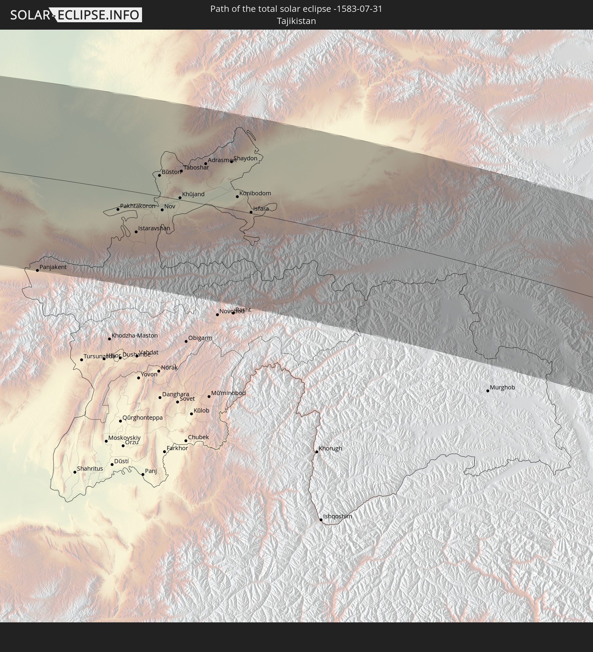 Tadschikistan
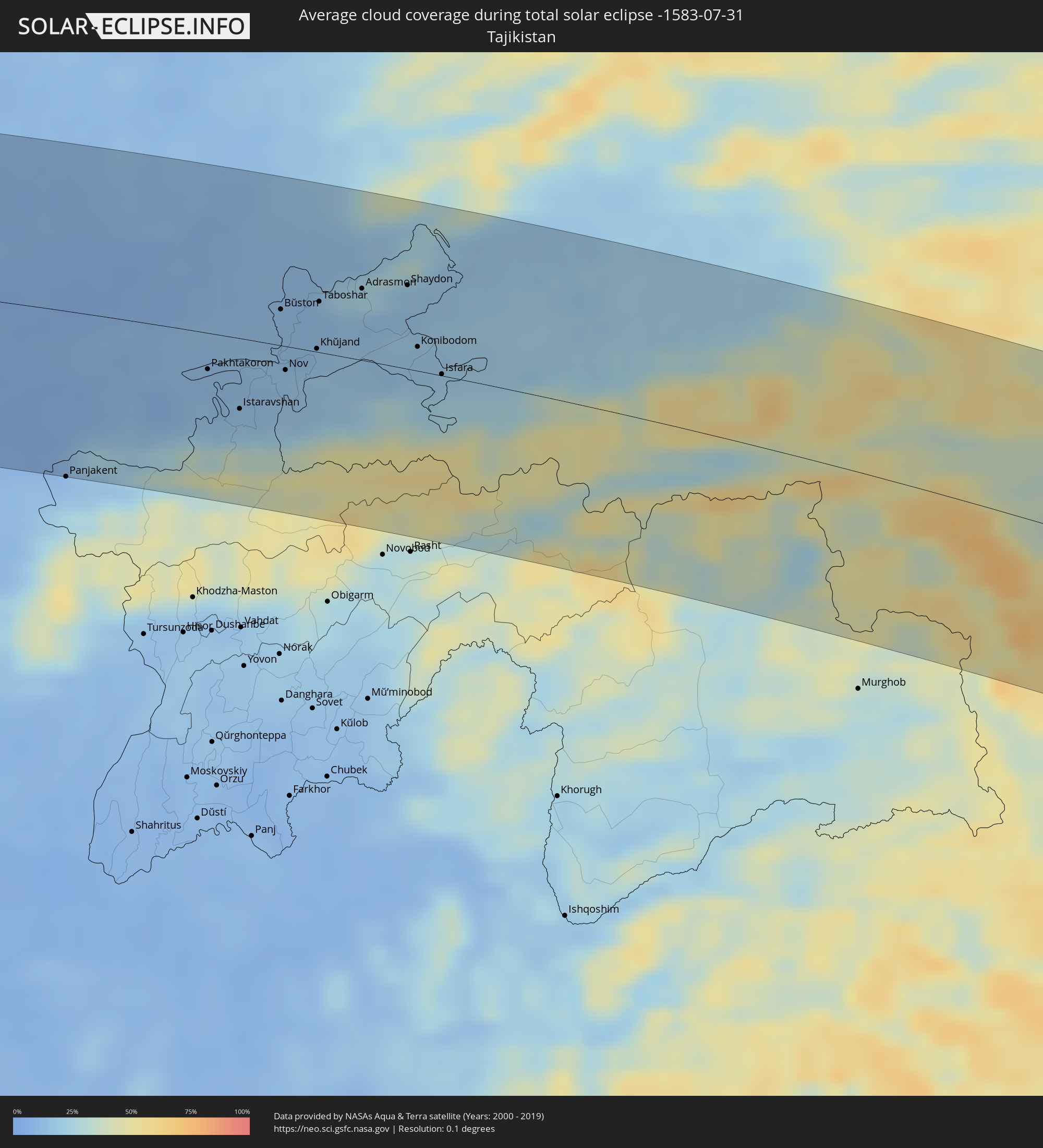
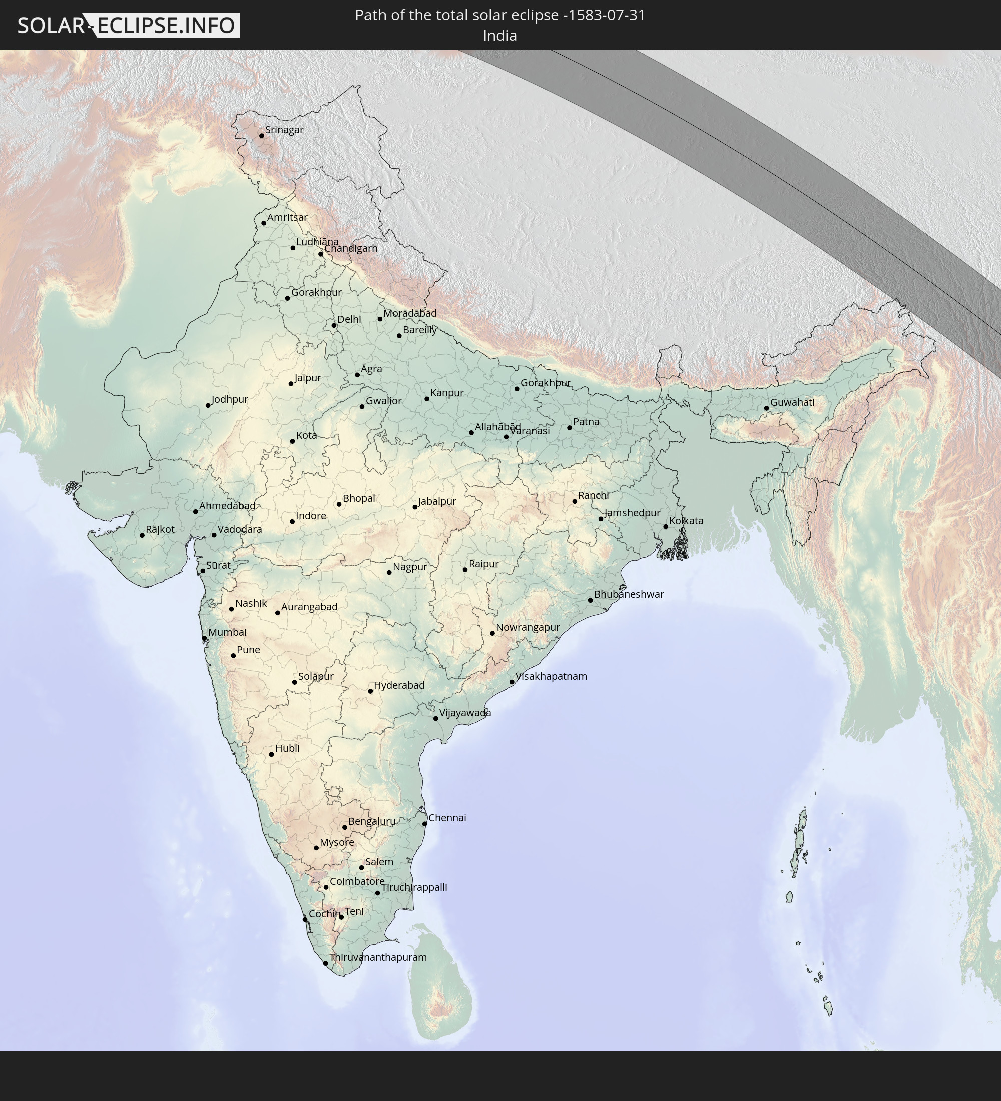 Indien
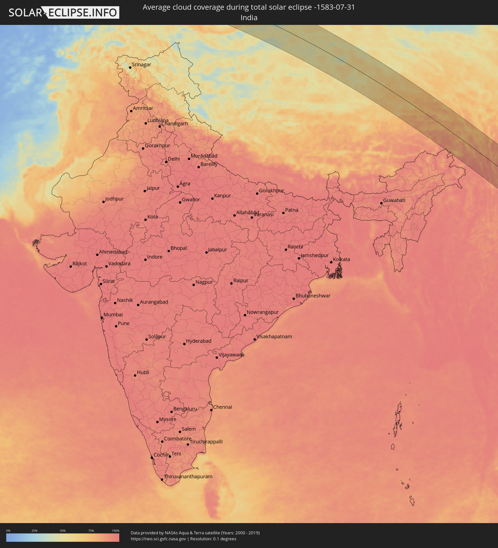
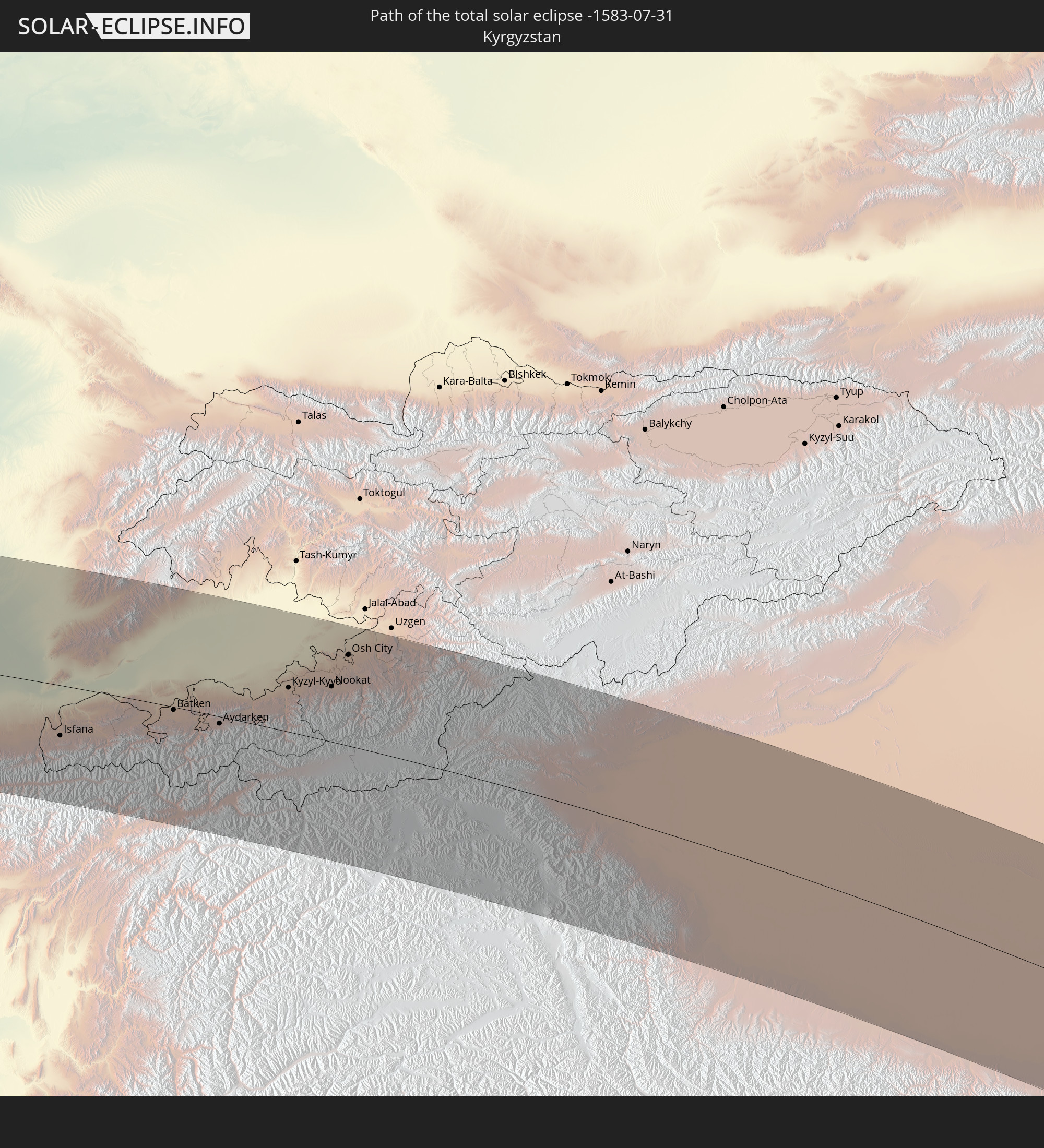 Kirgisistan
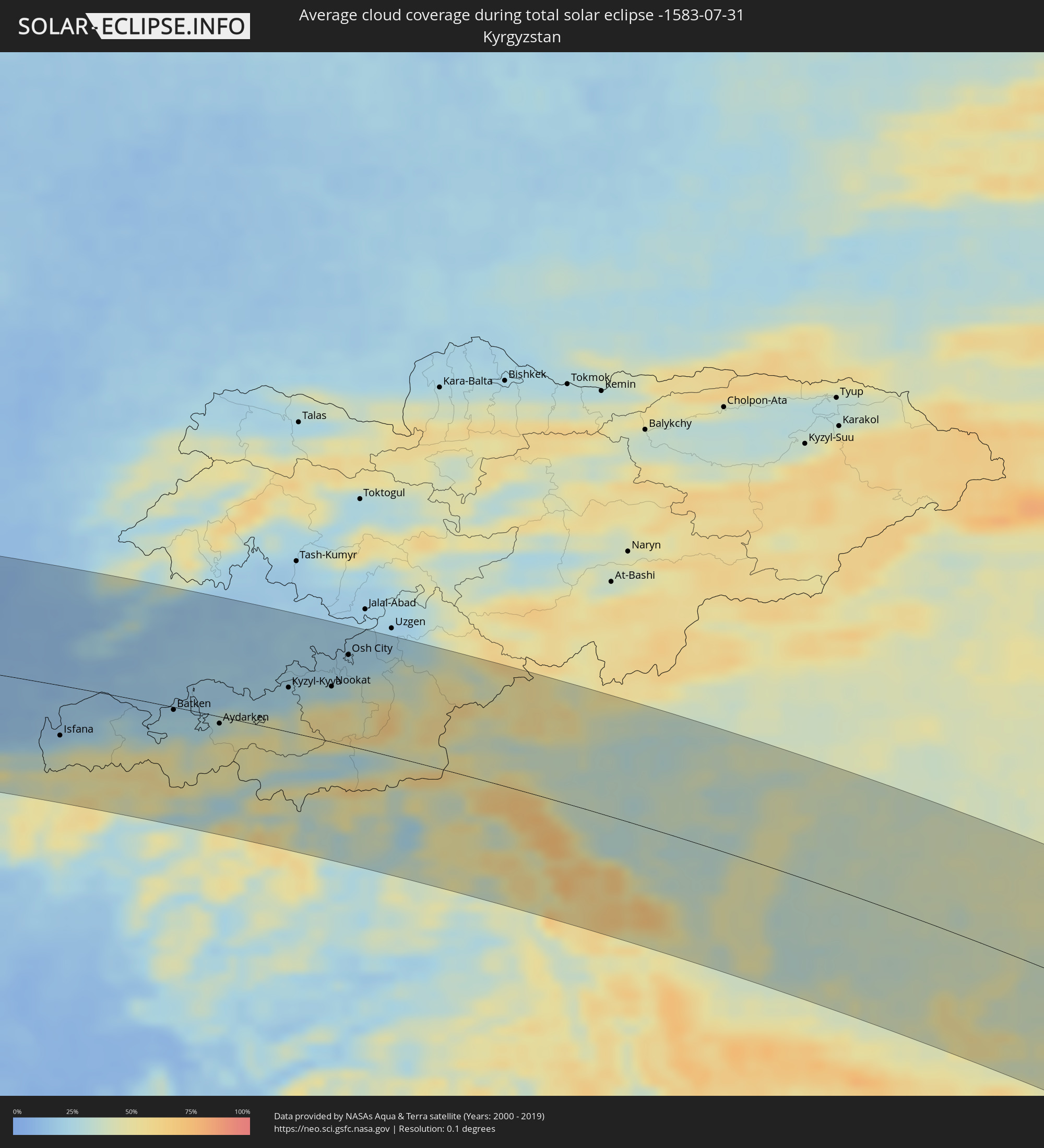
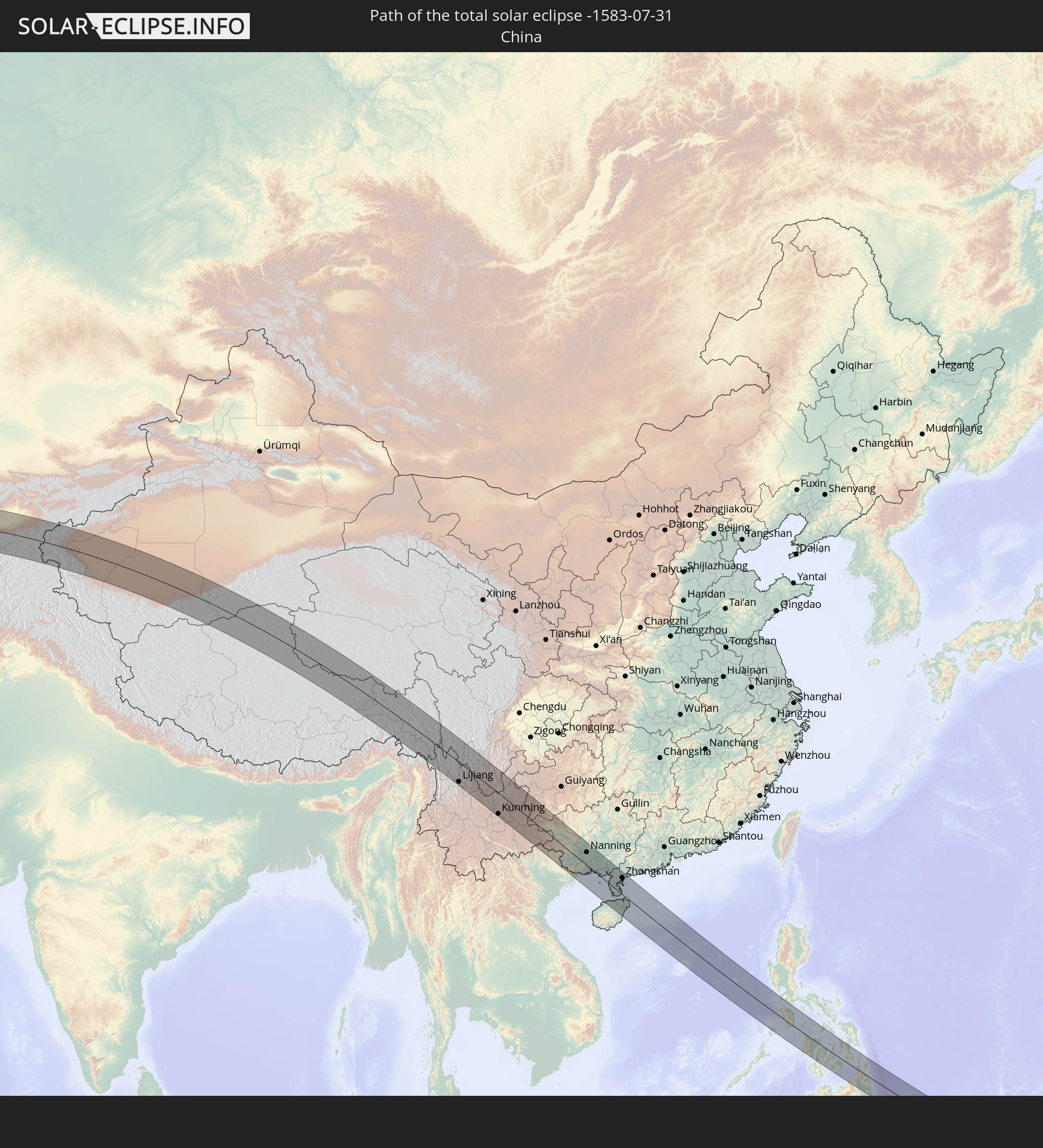 Volksrepublik China
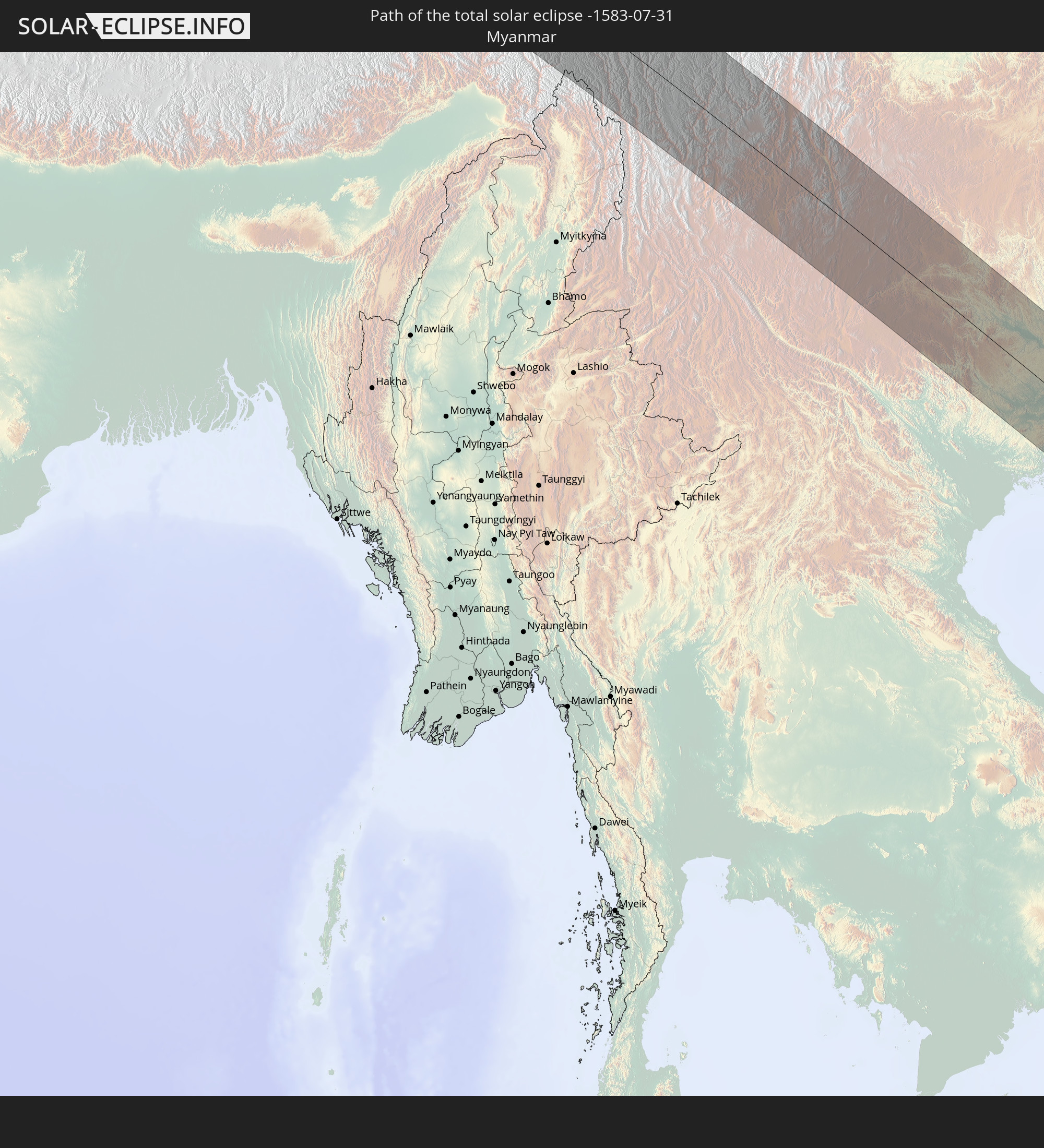 Myanmar
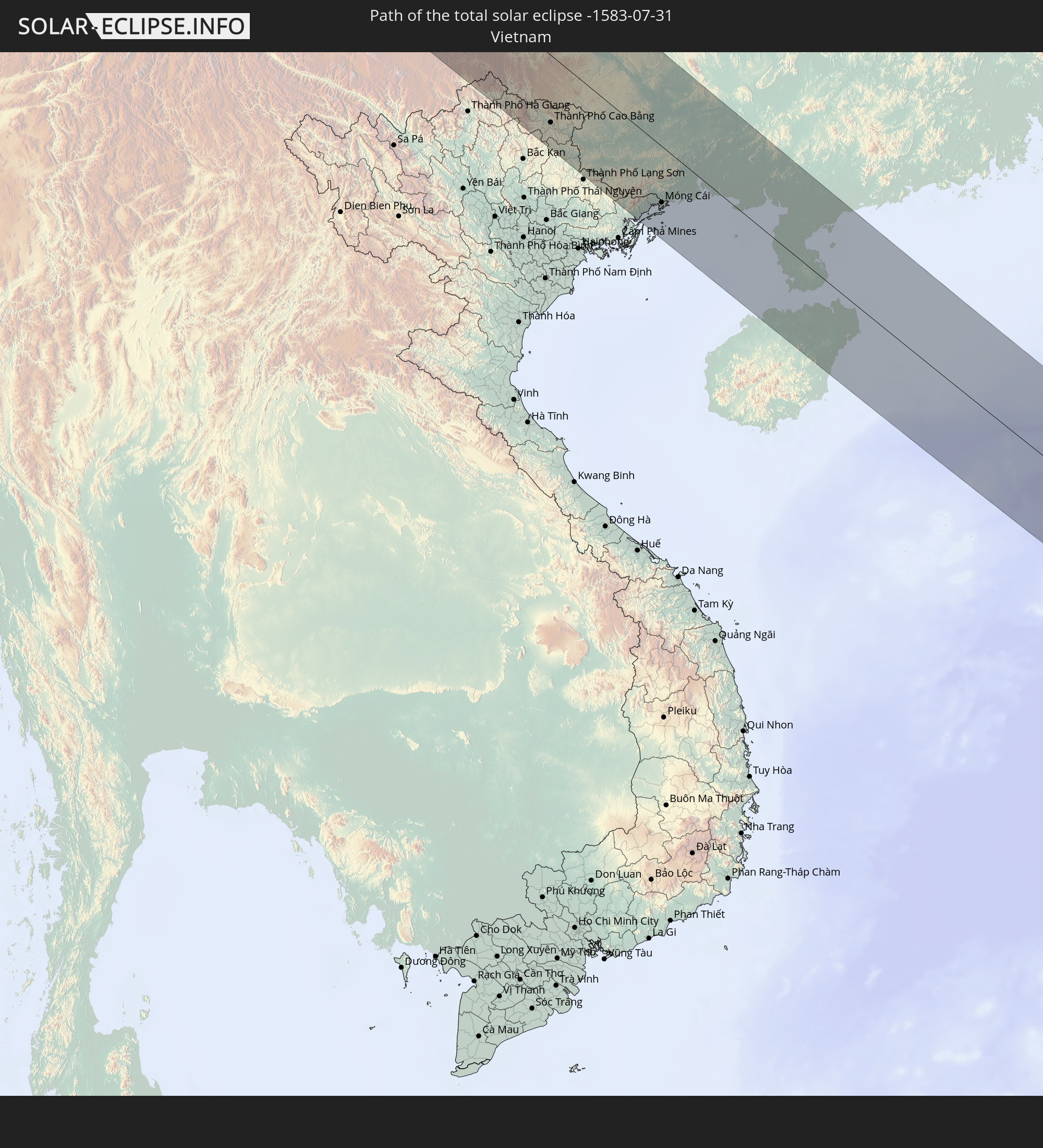 Vietnam
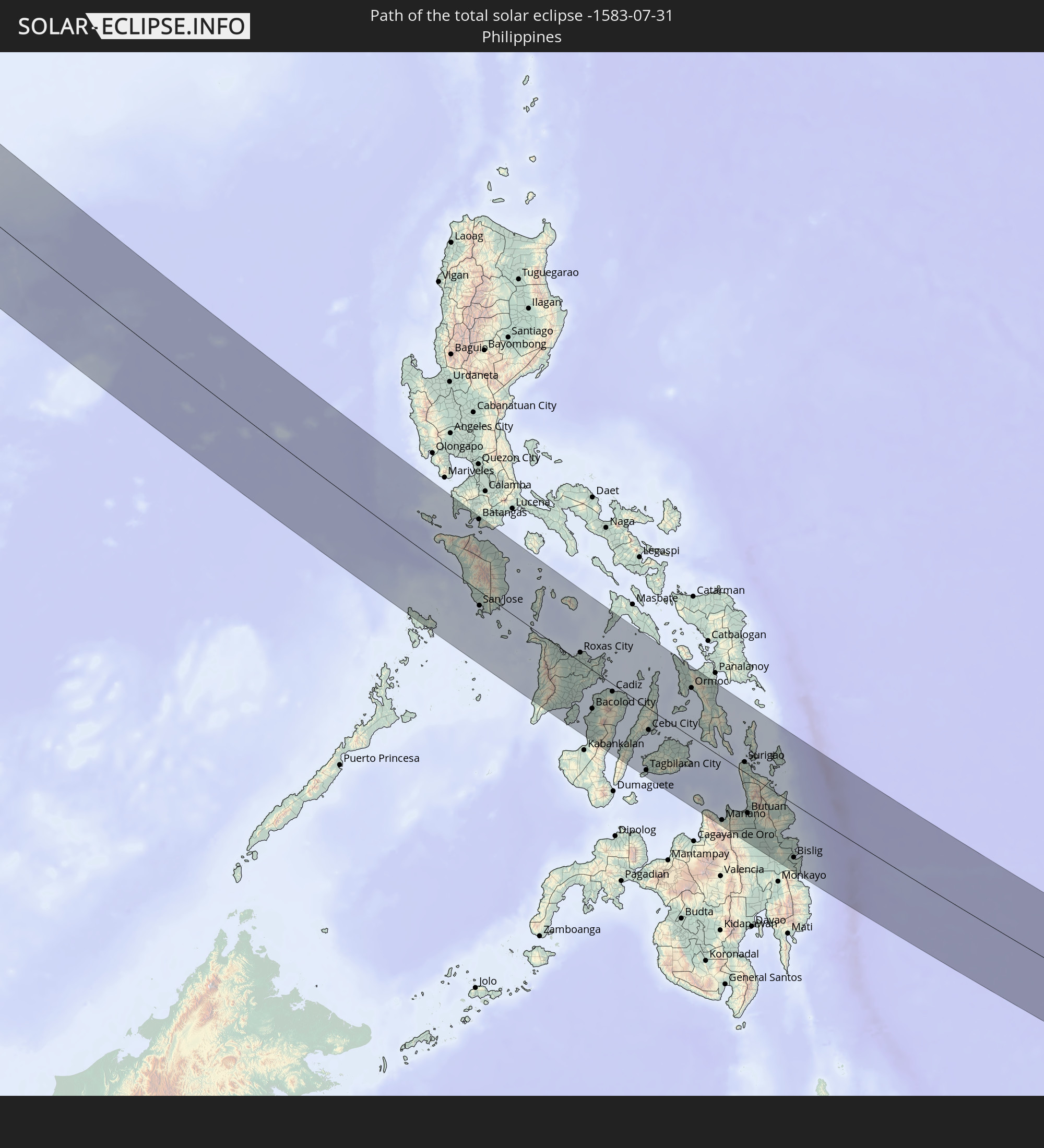 Philippinen
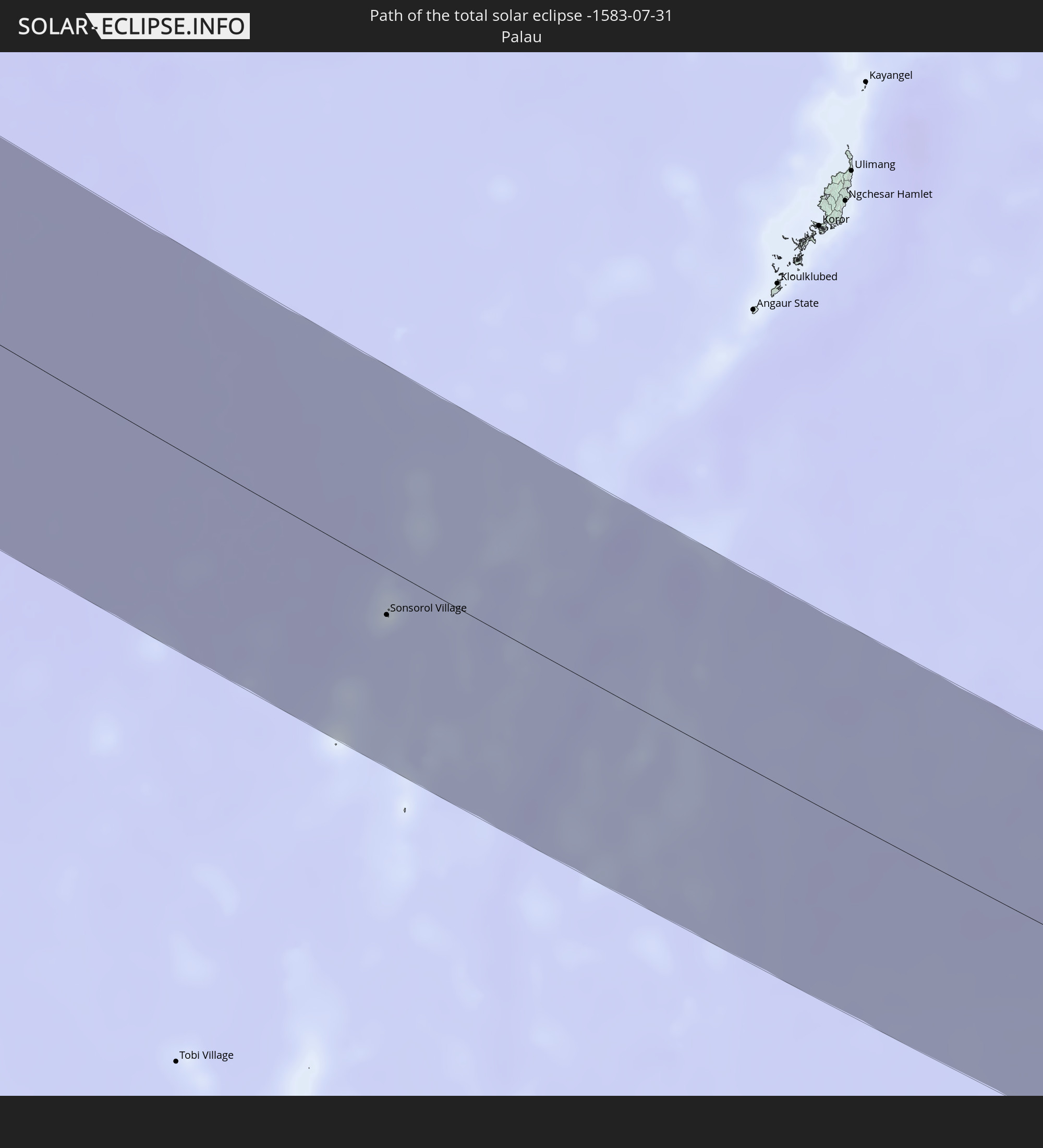 Palau
Palau
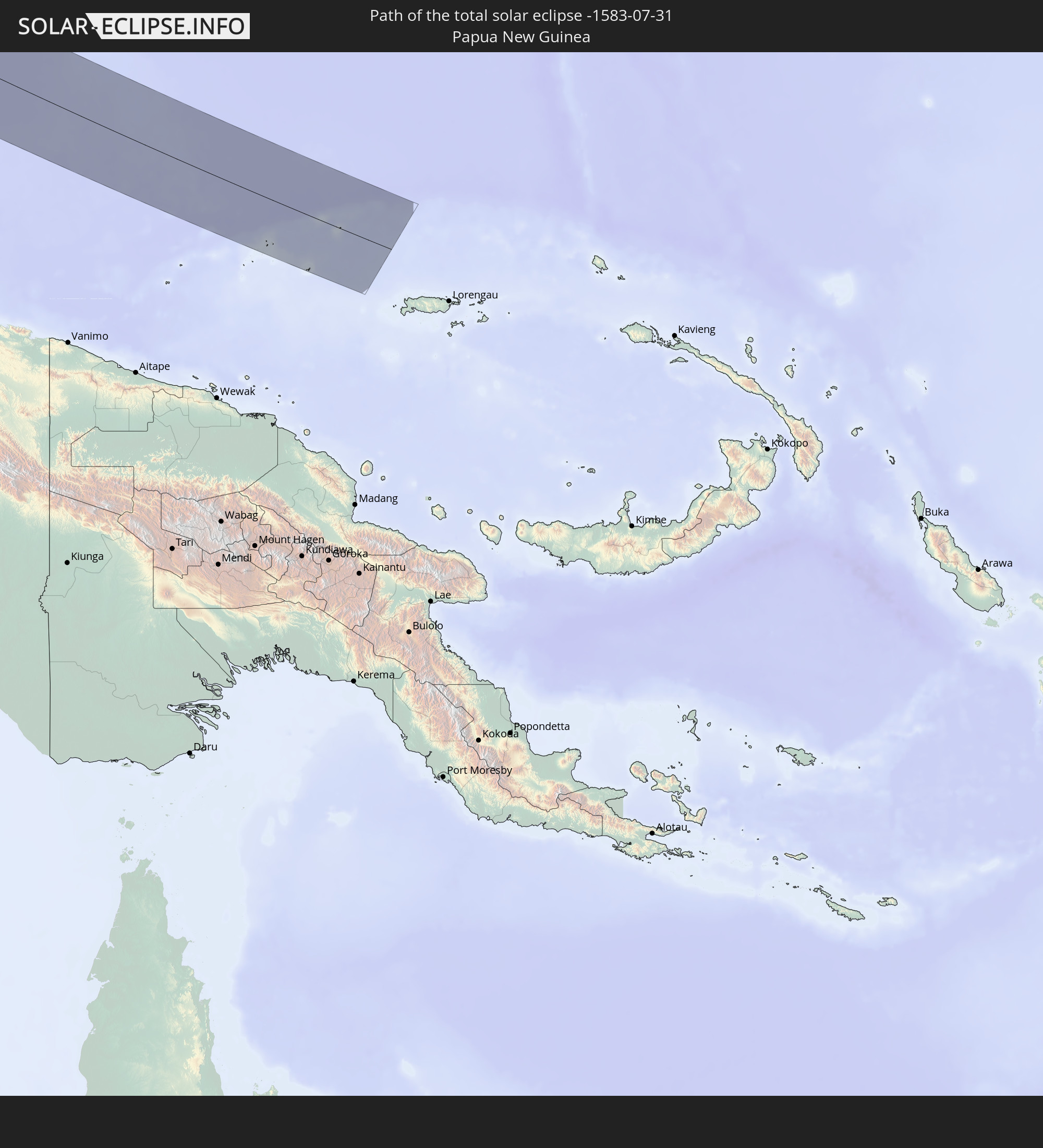 Papua-Neuguinea
In den folgenden Ländern ist die Sonnenfinsternis partiell zu sehen
 Russland
 Portugal
 Island
 Spanien
 Irland
 Spitzbergen
 Algerien
 Vereinigtes Königreich
 Färöer
 Frankreich
 Isle of Man
 Guernsey
 Jersey
 Niger
Niger
 Andorra
 Belgien
 Nigeria
 Niederlande
 Norwegen
 Luxemburg
 Deutschland
 Schweiz
 Italien
 Monaco
 Tunesien
 Dänemark
 Kamerun
 Libyen
 Liechtenstein
 Österreich
 Schweden
 Republik Kongo
 Tschechien
 Demokratische Republik Kongo
 San Marino
 Vatikanstadt
 Slowenien
 Tschad
 Kroatien
 Polen
Polen
 Malta
Malta
 Zentralafrikanische Republik
 Bosnien und Herzegowina
 Ungarn
 Slowakei
 Montenegro
 Serbien
 Albanien
 Åland Islands
 Griechenland
 Rumänien
 Mazedonien
 Finnland
 Litauen
 Lettland
 Estland
 Sudan
Sudan
 Ukraine
 Bulgarien
 Weißrussland
 Ägypten
 Türkei
 Moldawien
 Republik Zypern
 Äthiopien
 Staat Palästina
 Israel
 Saudi-Arabien
 Jordanien
 Libanon
 Syrien
 Eritrea
 Irak
Irak
 Georgien
 Somalia
 Dschibuti
 Jemen
Jemen
 Armenien
 Iran
Iran
 Aserbaidschan
 Kasachstan
 Kuwait
 Bahrain
 Katar
Katar
 Vereinigte Arabische Emirate
 Oman
Oman
 Turkmenistan
 Usbekistan
 Afghanistan
 Pakistan
 Tadschikistan
 Indien
 Kirgisistan
 Volksrepublik China
 Sri Lanka
 Nepal
Nepal
 Mongolei
 Bangladesch
 Bhutan
 Myanmar
 Indonesien
 Thailand
 Malaysia
 Laos
Laos
 Vietnam
 Kambodscha
 Singapur
 Weihnachtsinsel
 Australien
 Macau
Macau
 Hongkong
 Brunei
 Taiwan
 Philippinen
 Japan
Japan
 Osttimor
 Nordkorea
 Südkorea
 Palau
Palau
 Föderierte Staaten von Mikronesien
 Papua-Neuguinea
 Guam
Guam
 Nördliche Marianen
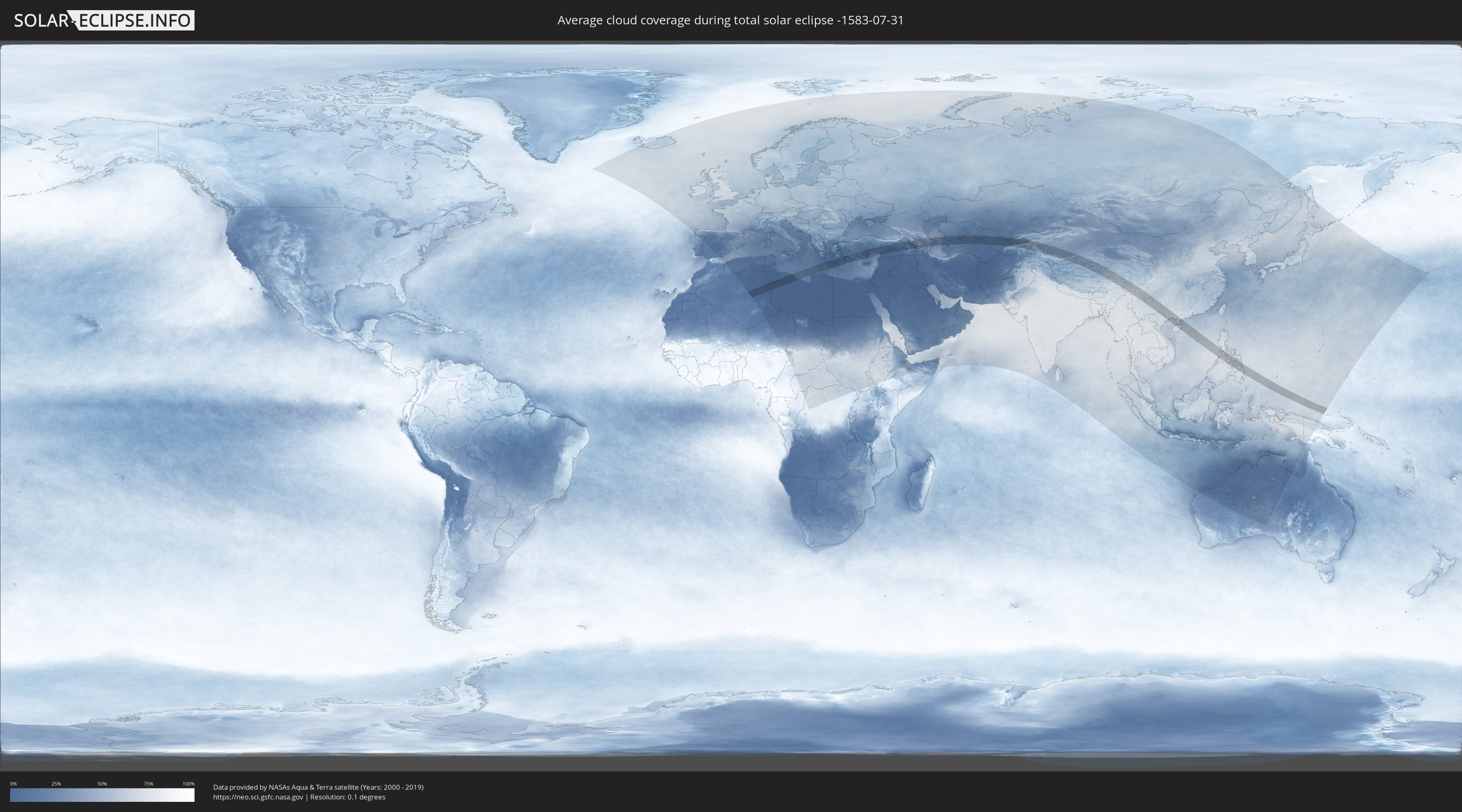
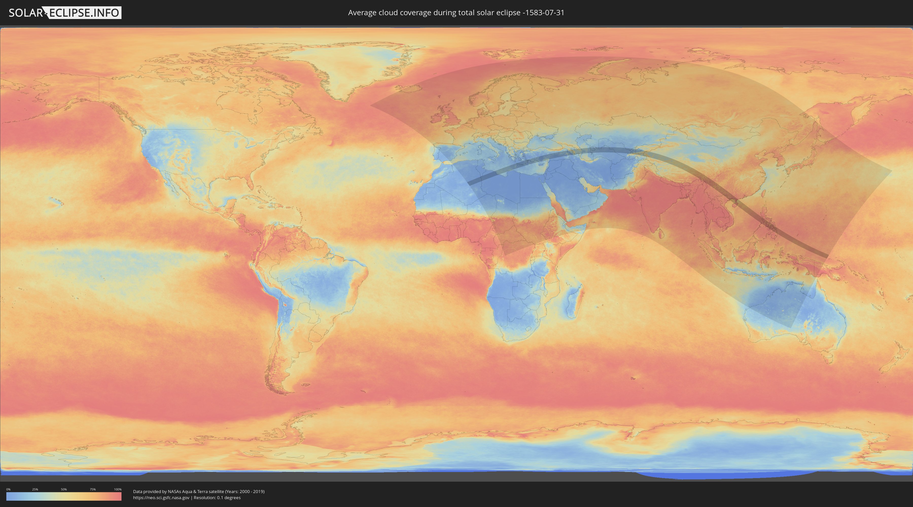
Wie wird das Wetter während der totalen Sonnenfinsternis am 31.07.-1583?
Wo ist der beste Ort, um die totale Sonnenfinsternis vom 31.07.-1583 zu beobachten?
Die folgenden Karten zeigen die durchschnittliche Bewölkung für den Tag, an dem die totale Sonnenfinsternis
stattfindet. Mit Hilfe der Karten lässt sich der Ort entlang des Finsternispfades eingrenzen,
der die besten Aussichen auf einen klaren wolkenfreien Himmel bietet.
Trotzdem muss man immer lokale Gegenenheiten beachten und sollte sich genau über das Wetter an seinem
gewählten Beobachtungsort informieren.
Die Daten stammen von den beiden NASA-Satelliten
AQUA und TERRA
und wurden über einen Zeitraum von 19 Jahren (2000 - 2019) gemittelt.
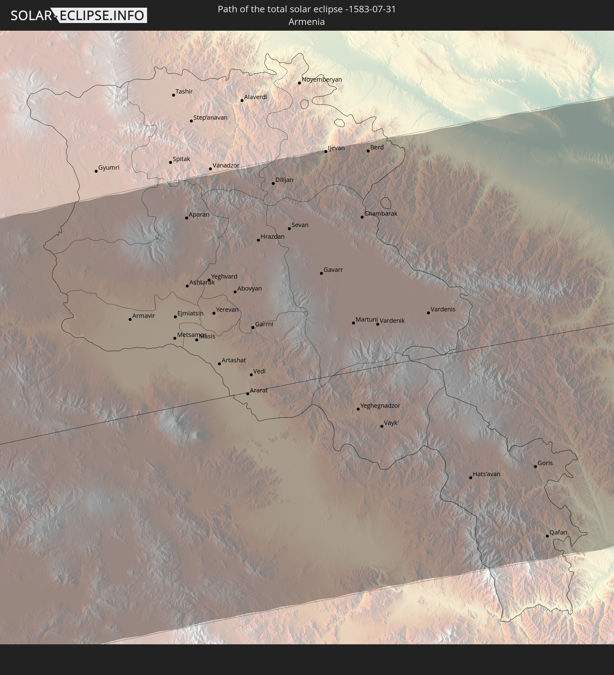
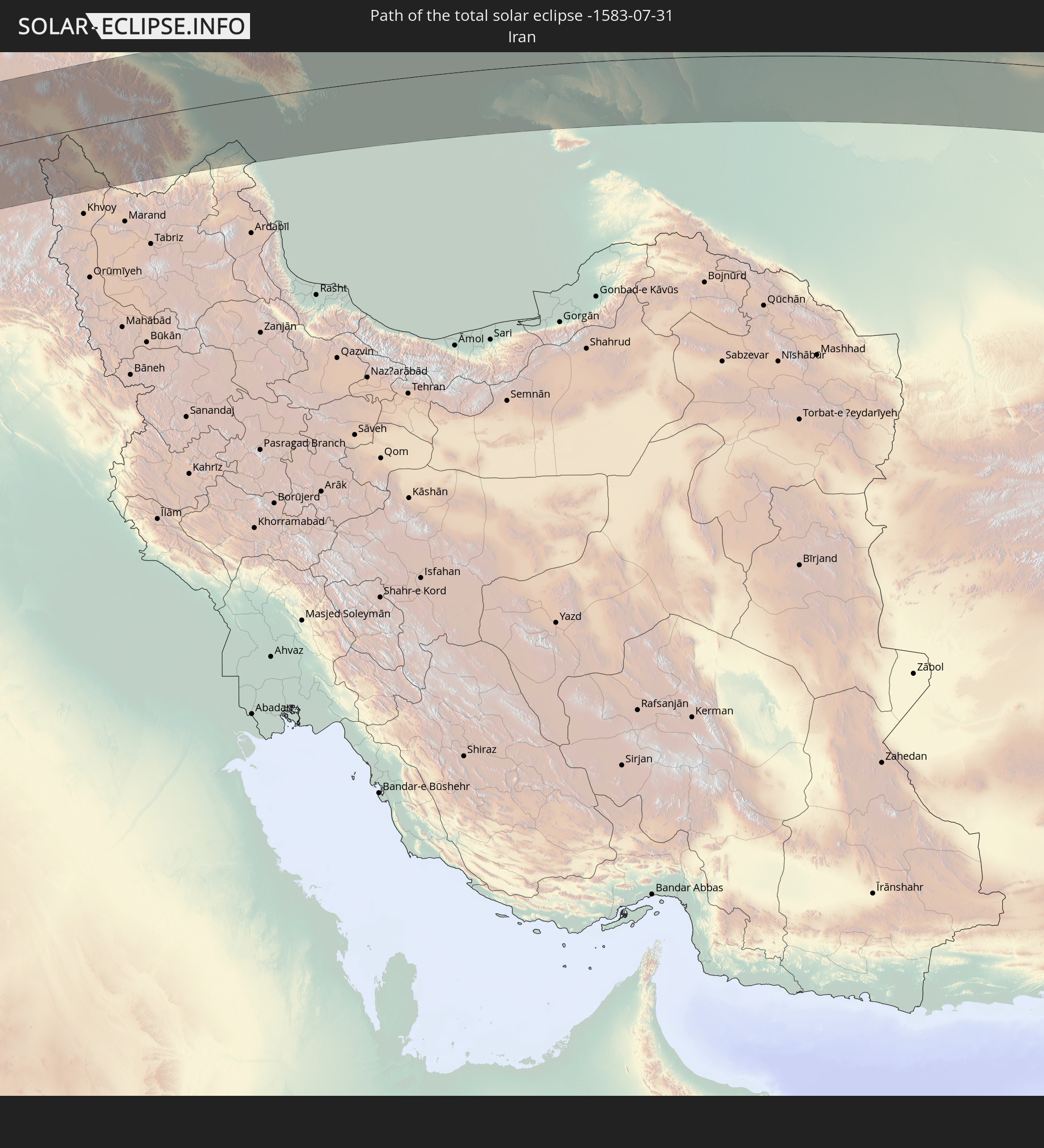
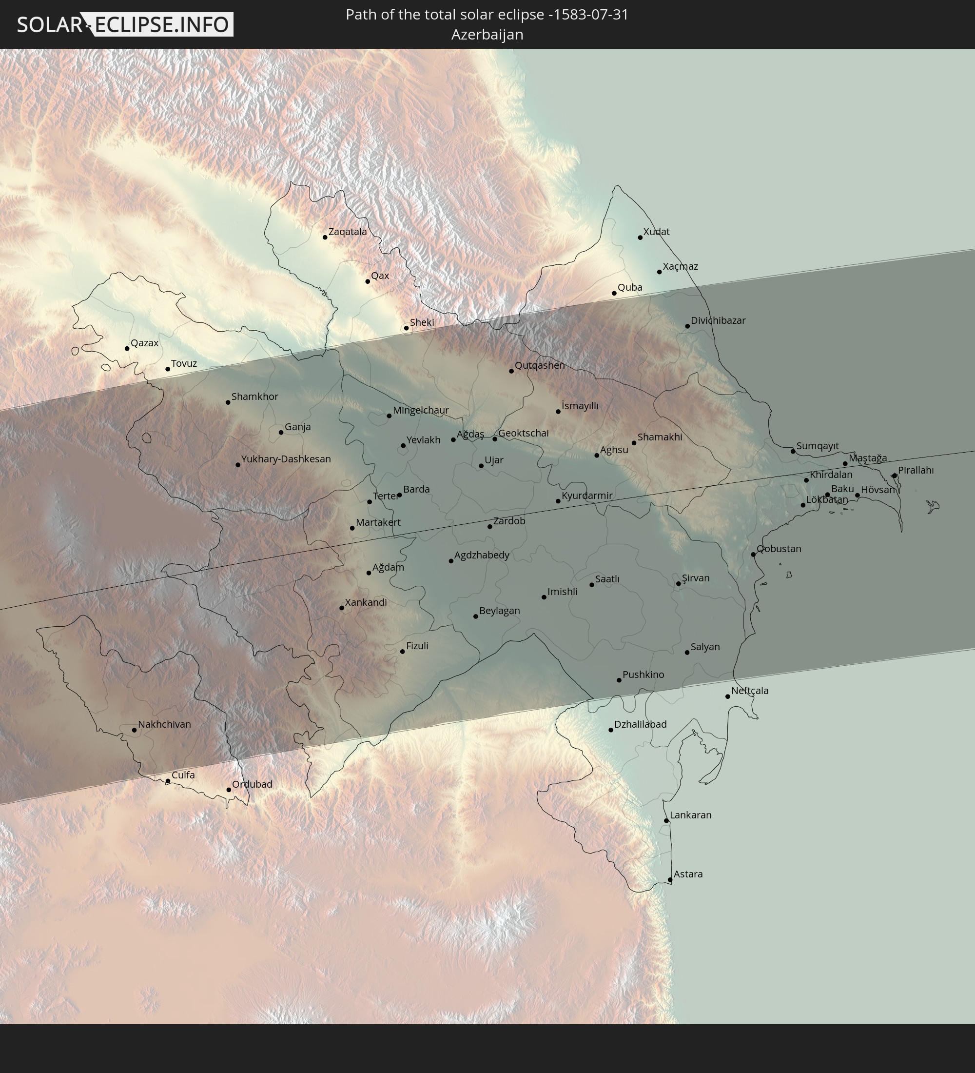
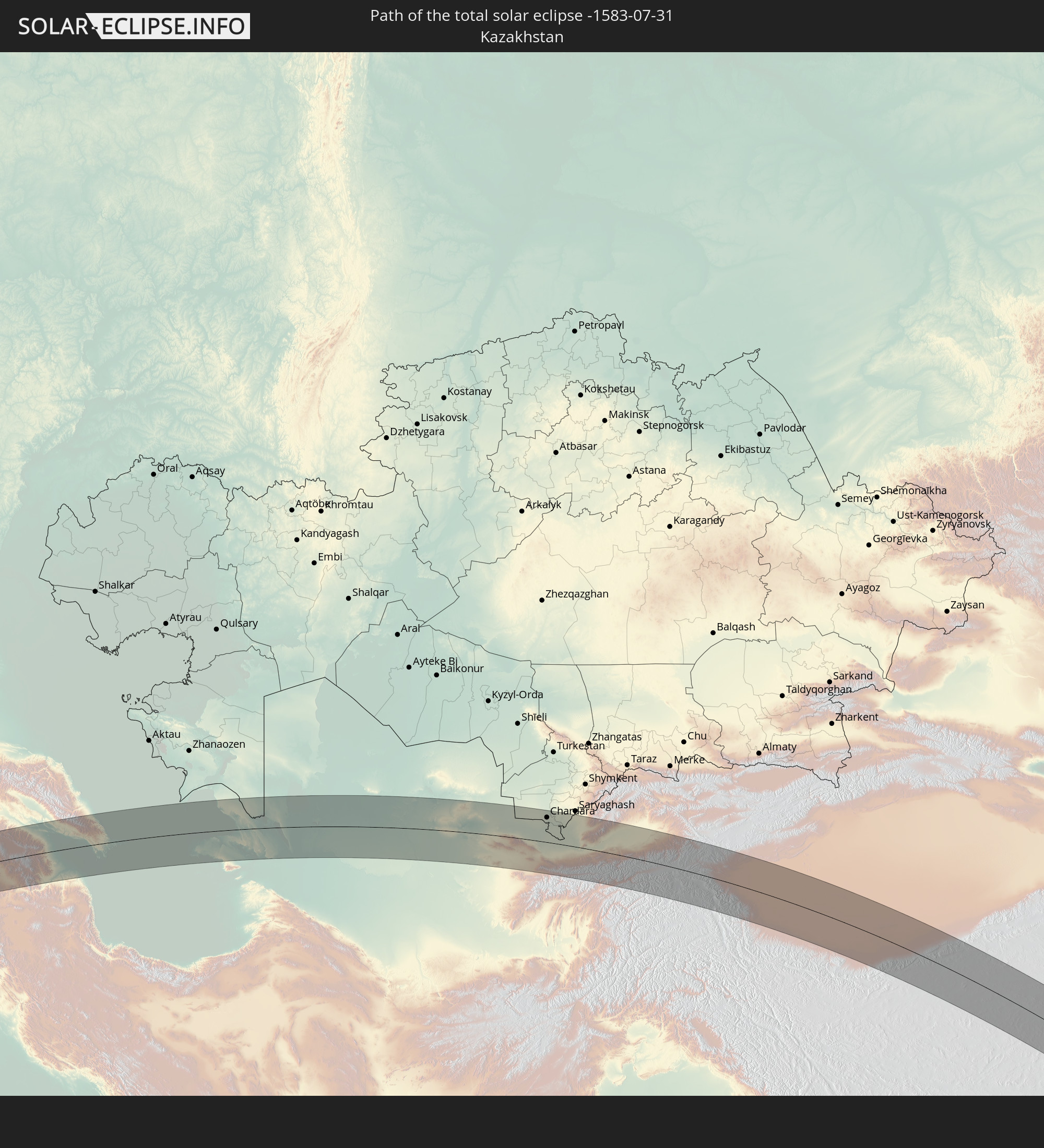
Detaillierte Länderkarten
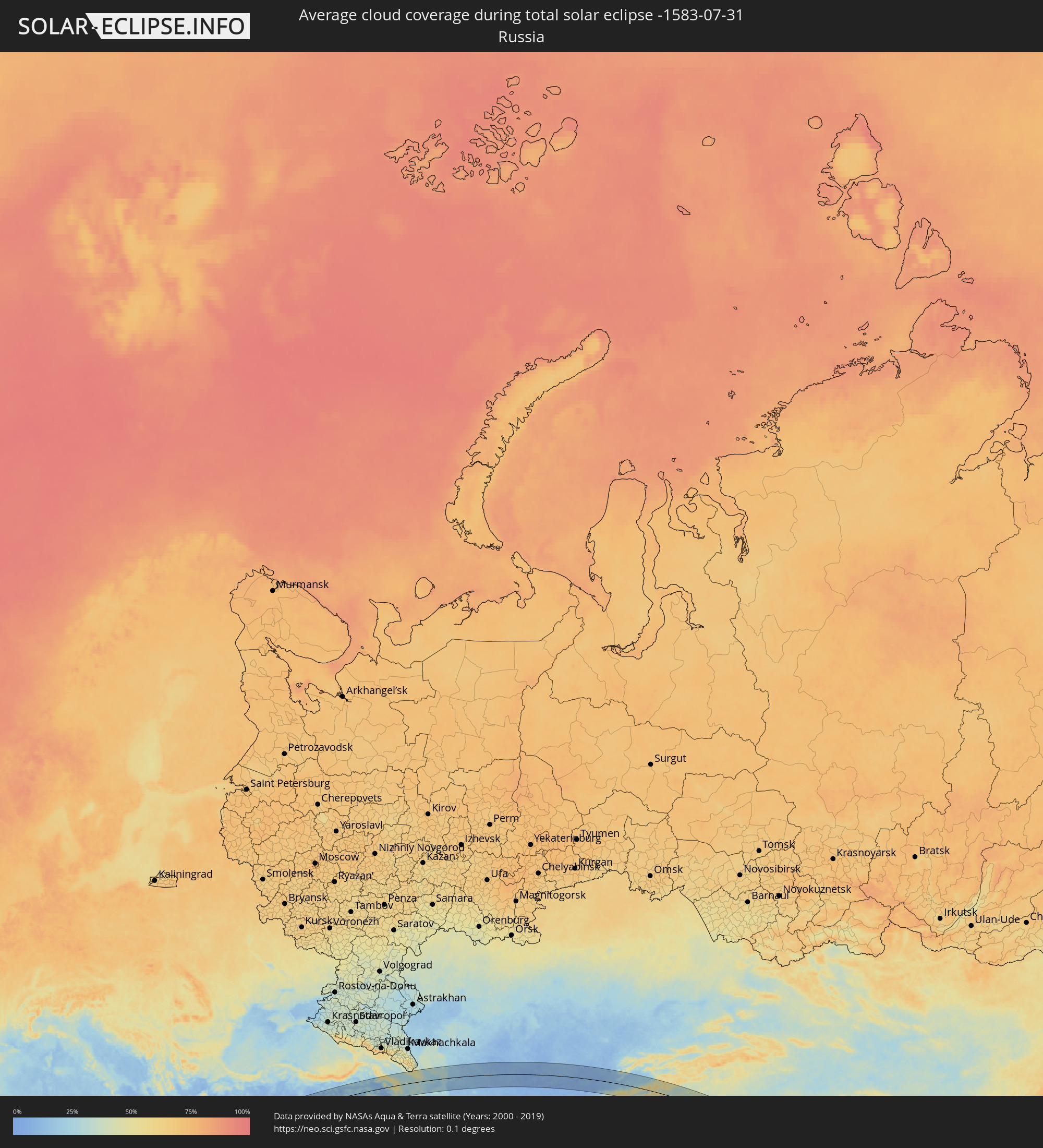 Russland
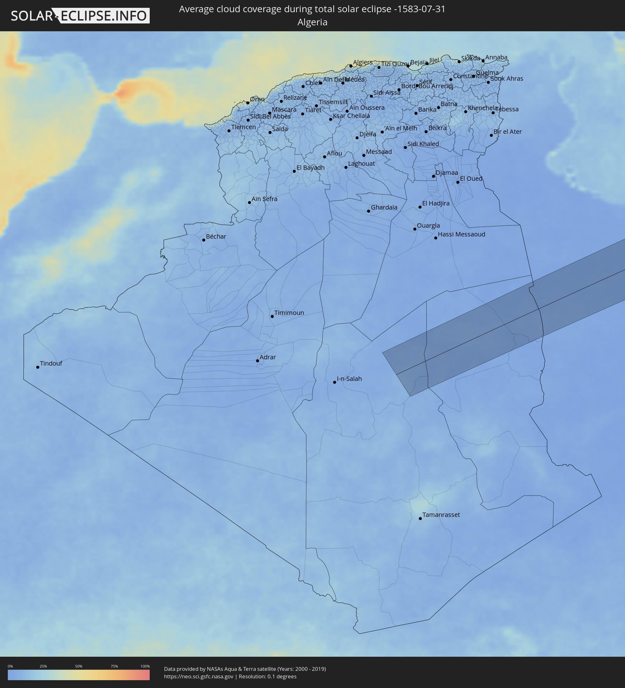 Algerien
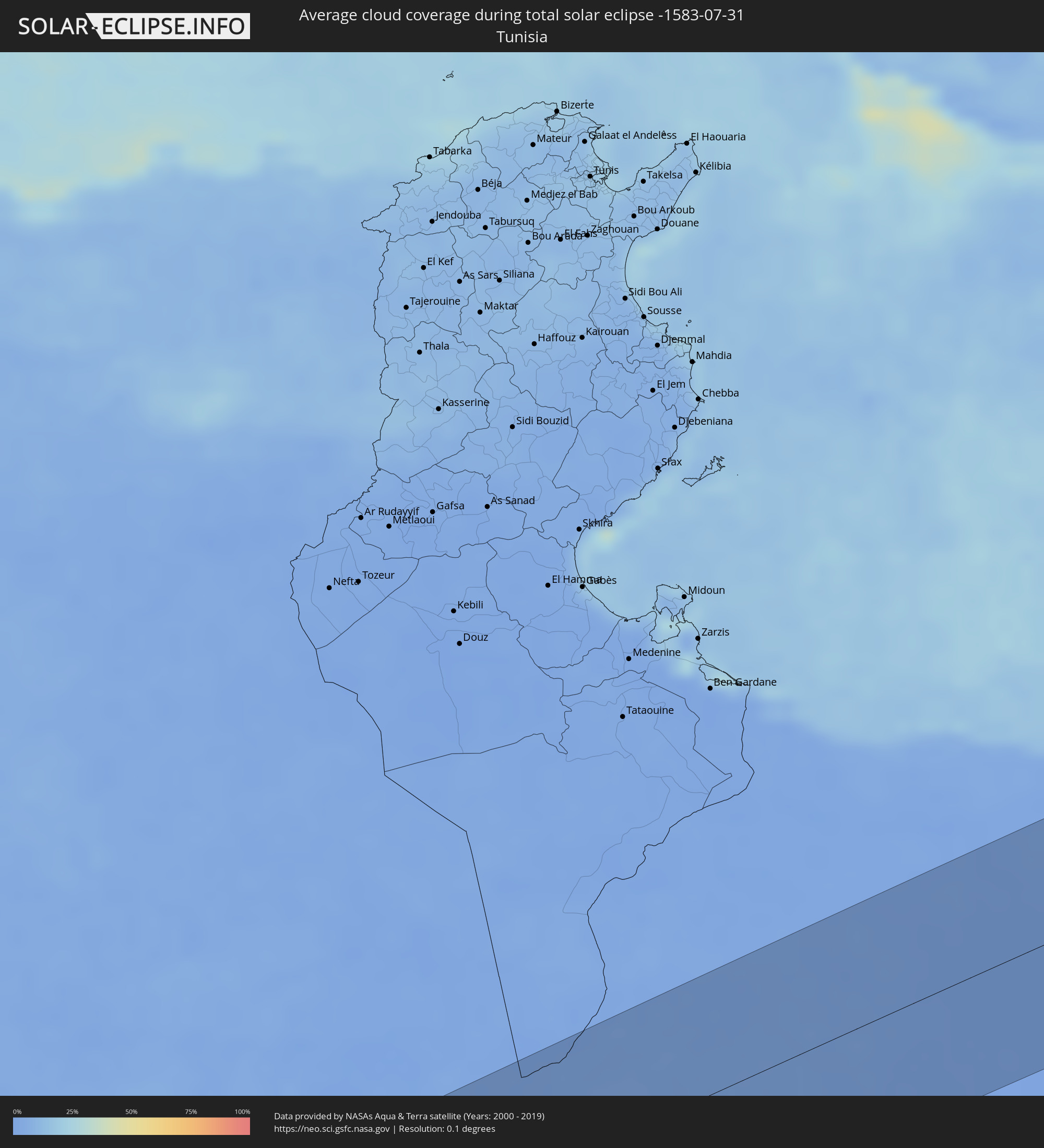 Tunesien
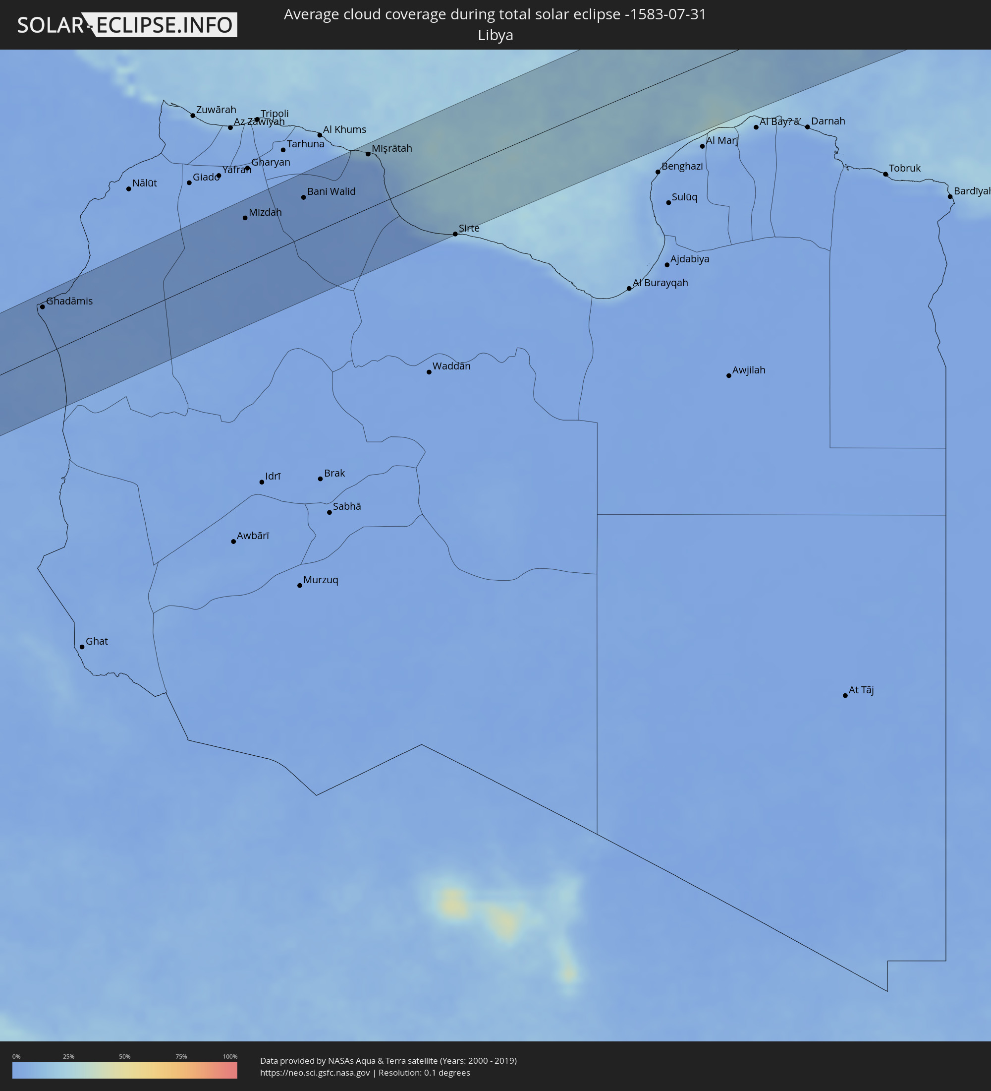 Libyen
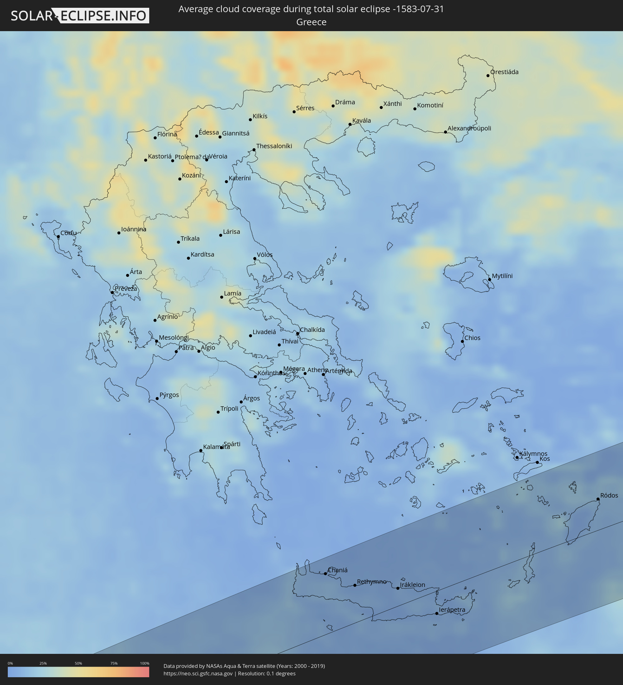 Griechenland
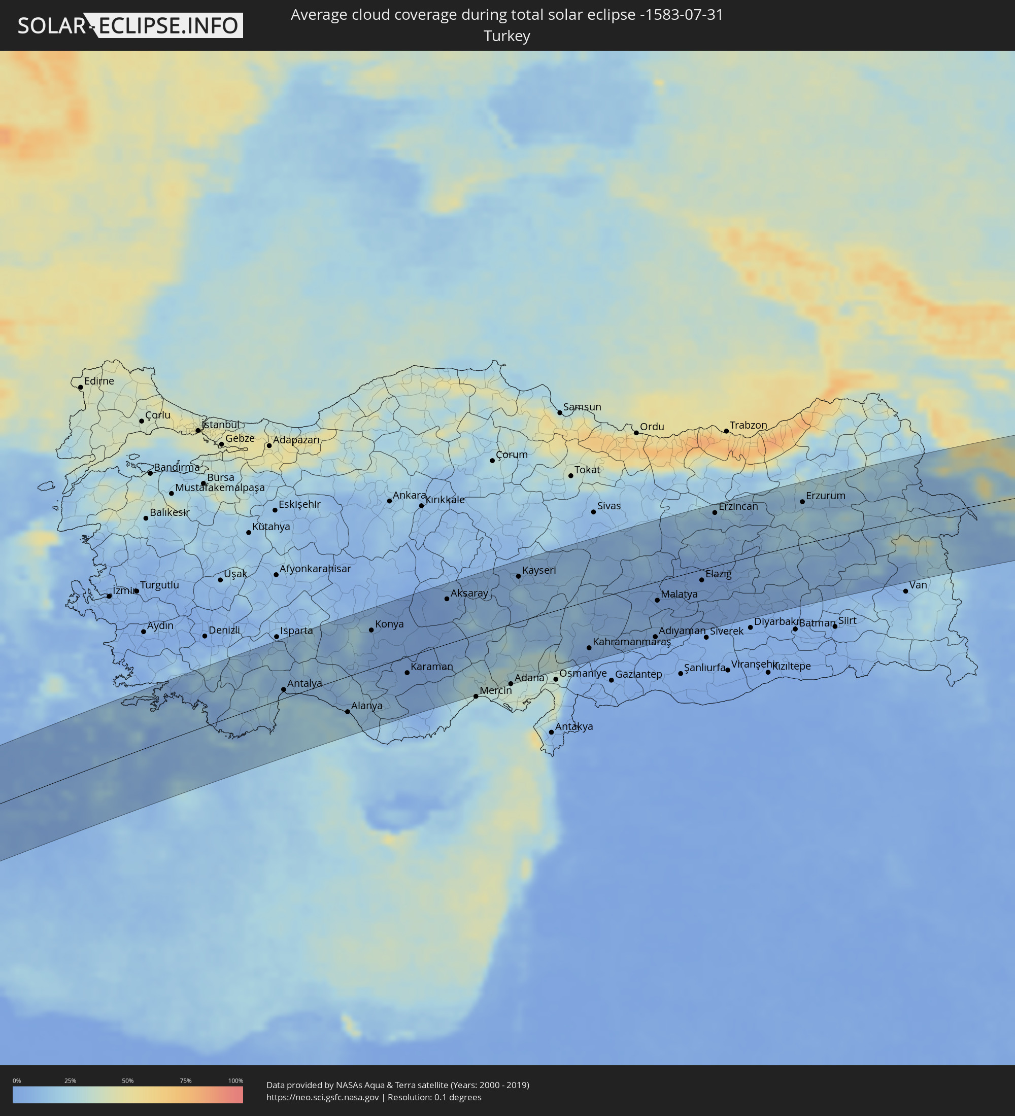 Türkei
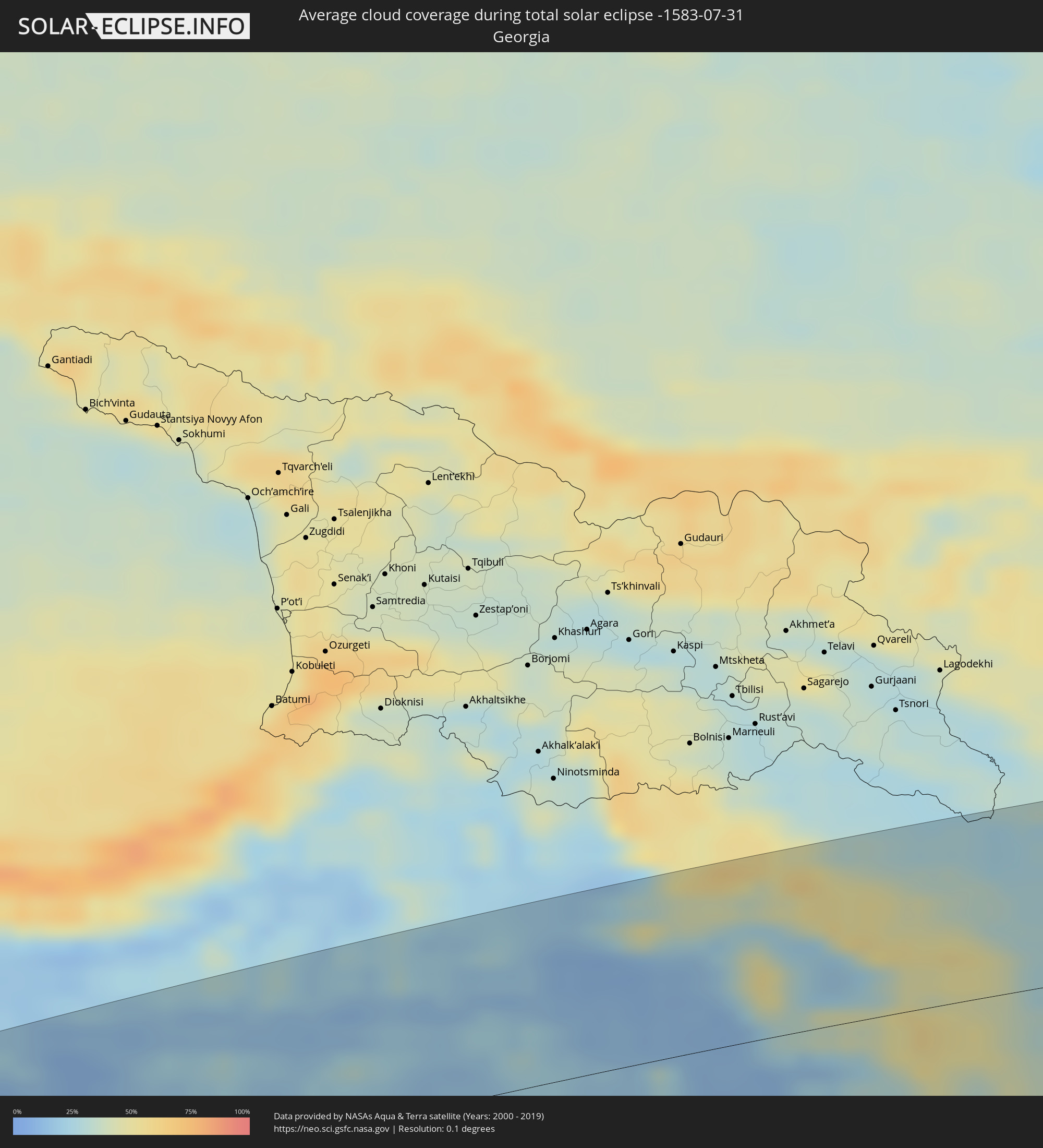 Georgien
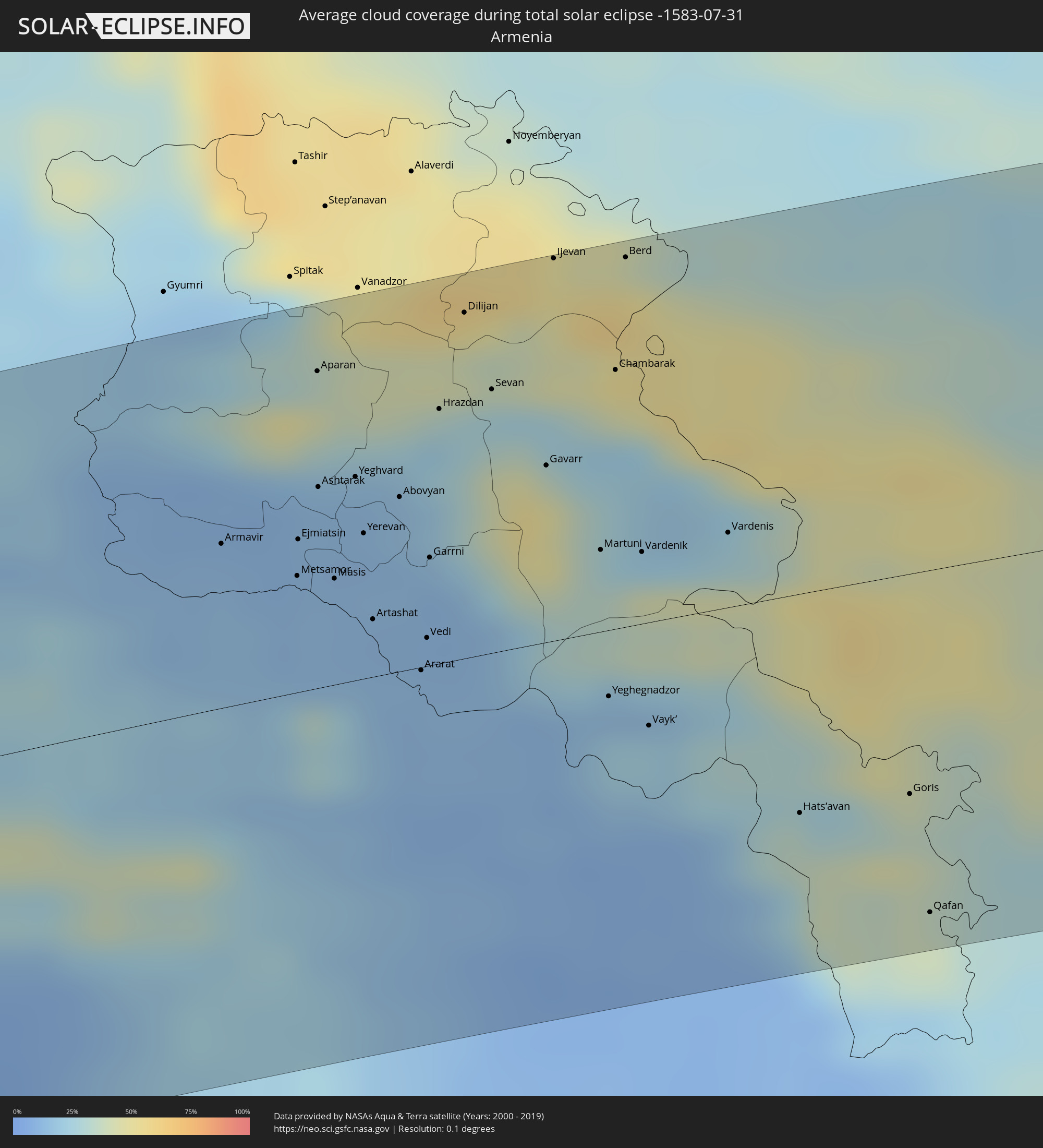 Armenien
 Iran
Iran
 Aserbaidschan
 Kasachstan
 Turkmenistan
 Usbekistan
 Tadschikistan
 Indien
 Kirgisistan
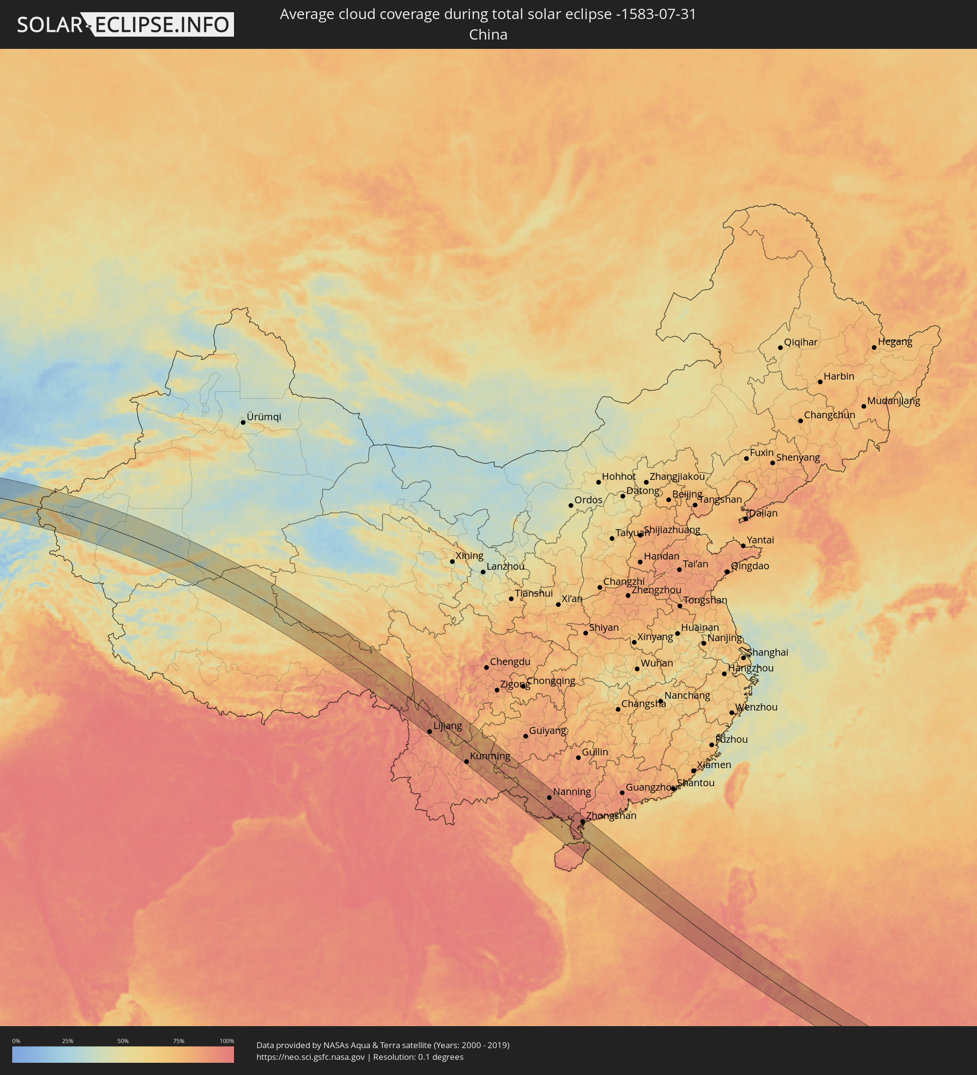 Volksrepublik China
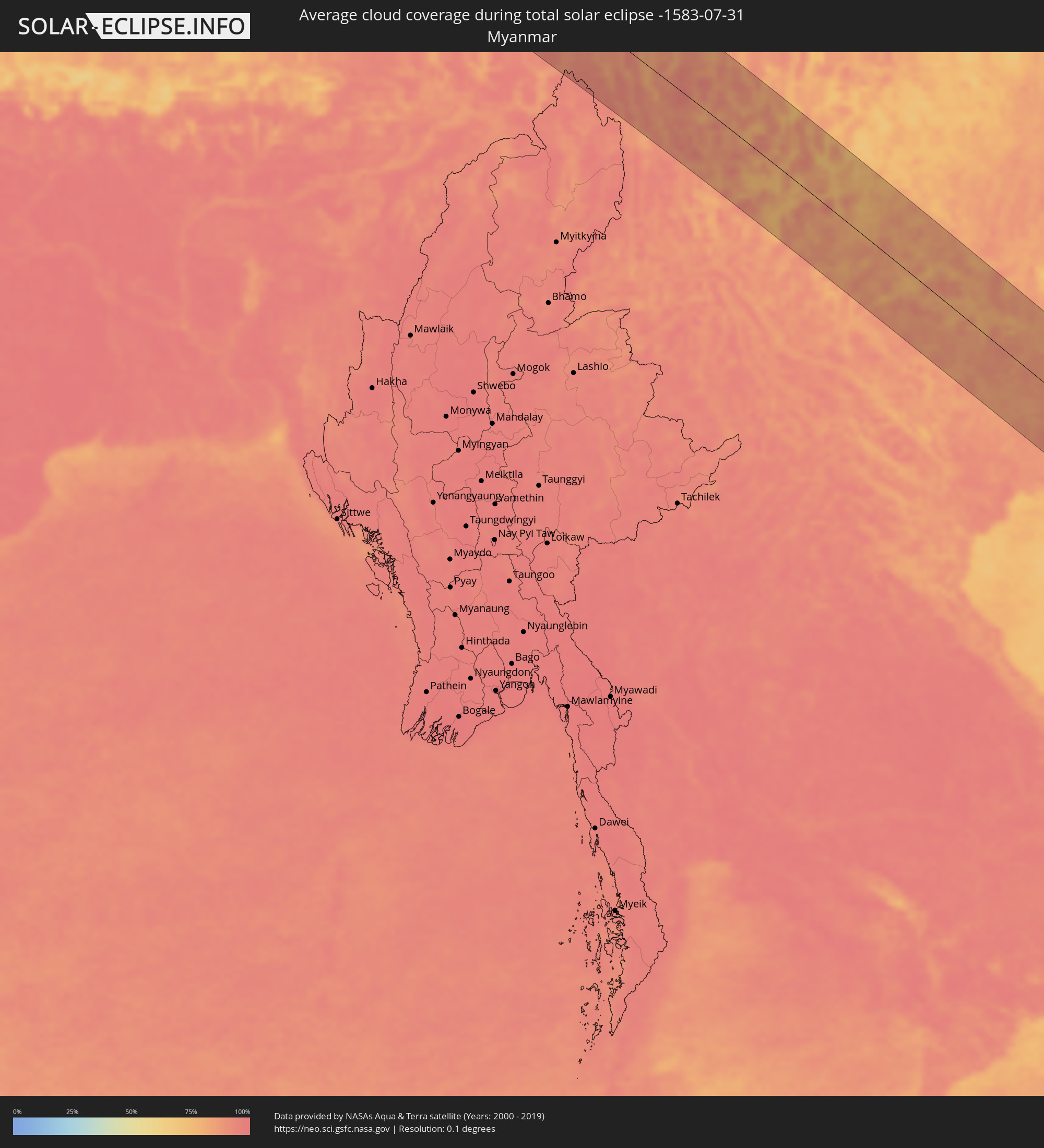 Myanmar
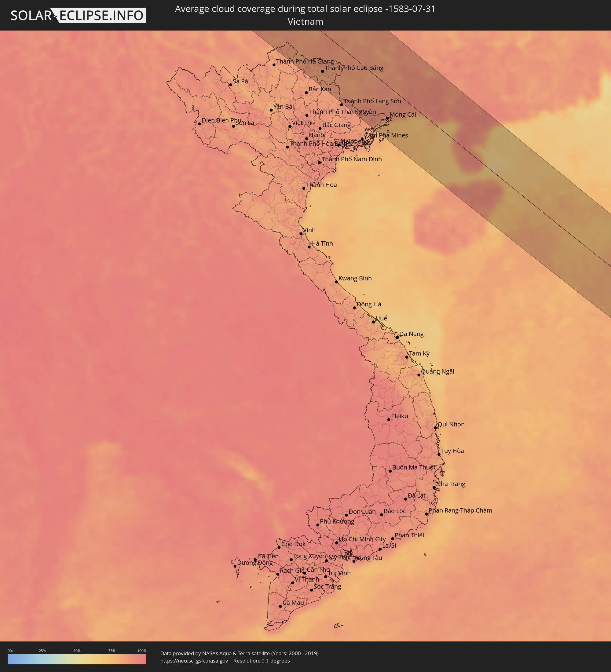 Vietnam
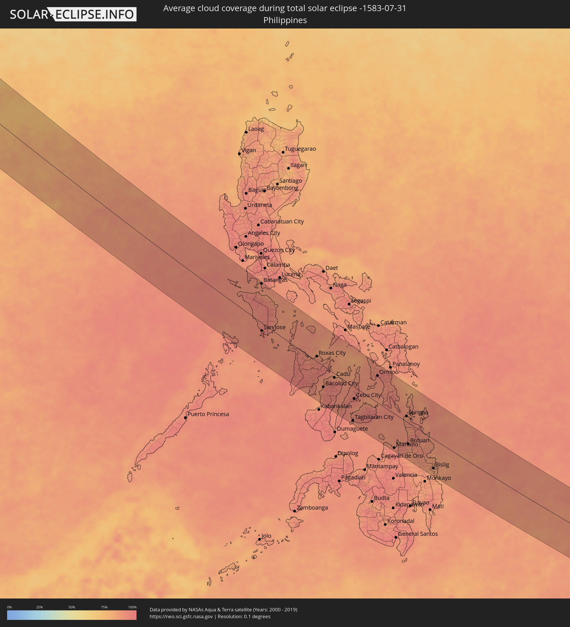 Philippinen
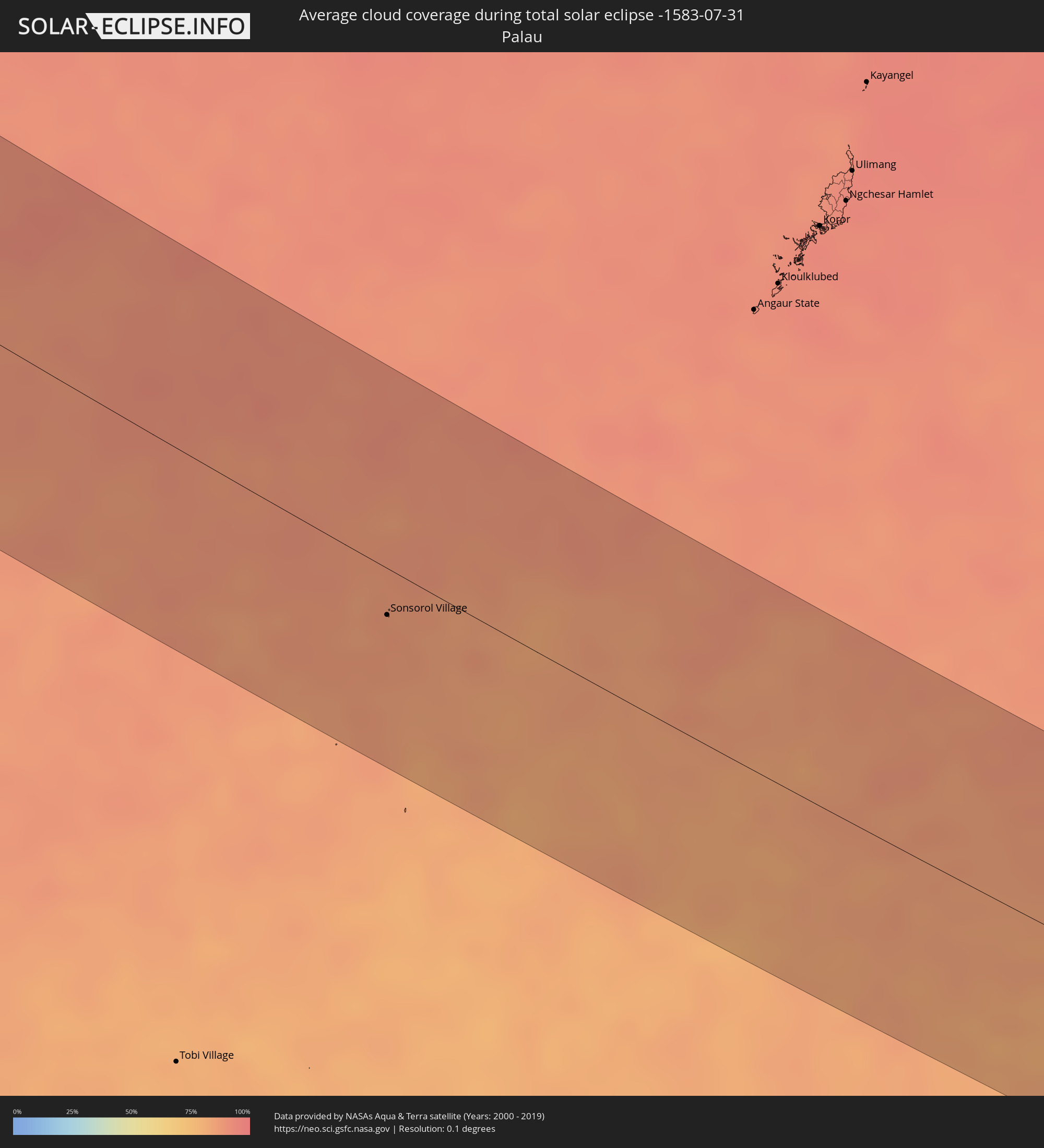 Palau
Palau
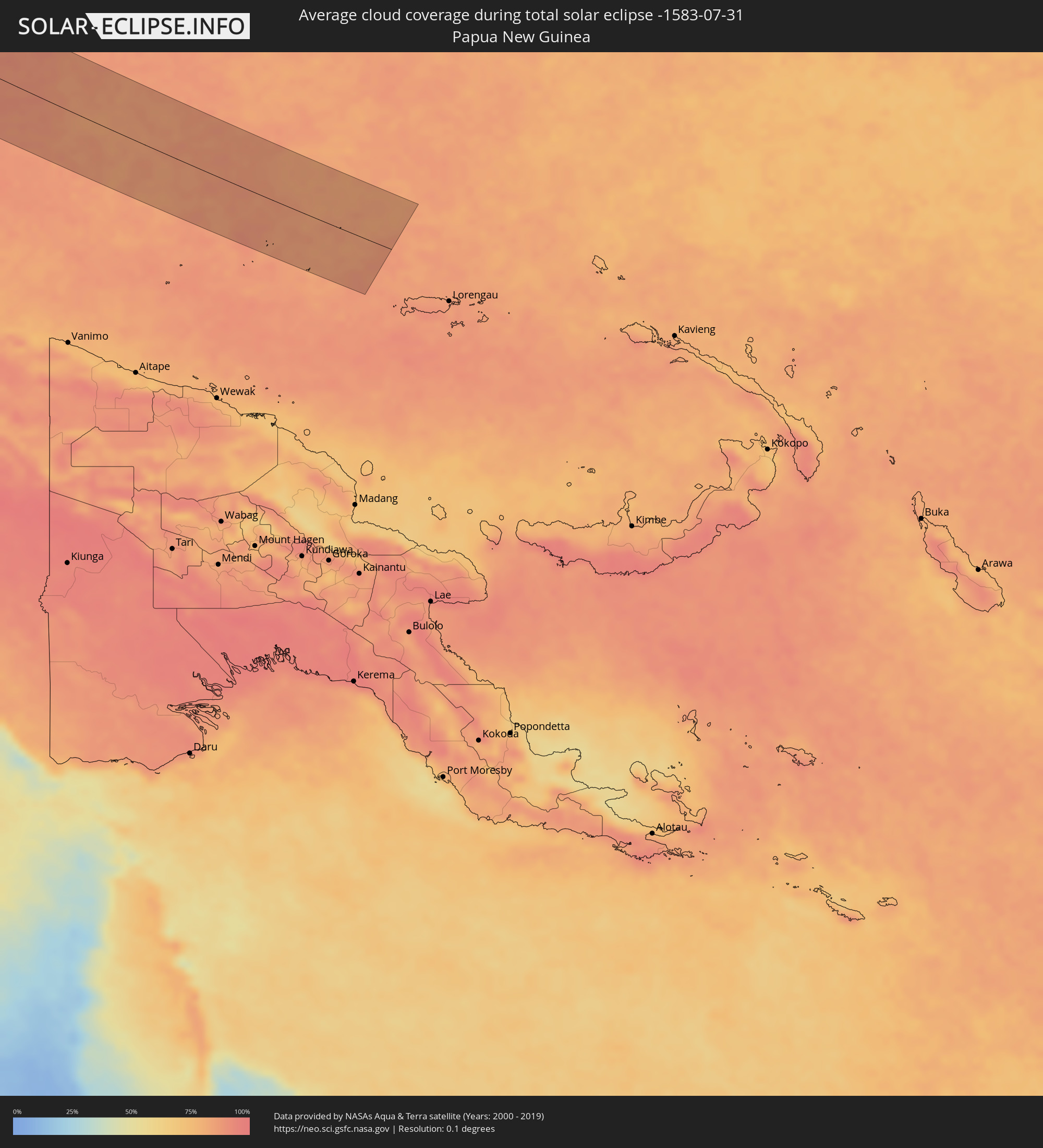 Papua-Neuguinea
Orte im Finsternispfad
Die nachfolgene Tabelle zeigt Städte und Orte mit mehr als 5.000 Einwohnern, die sich im Finsternispfad befinden. Städte mit mehr als 100.000 Einwohnern sind dick gekennzeichnet. Mit einem Klick auf den Ort öffnet sich eine Detailkarte die die Lage des jeweiligen Ortes zusammen mit dem Verlauf der zentralen Finsternis präsentiert.
| Ort | Typ | Dauer der Verfinsterung | Ortszeit bei maximaler Verfinsterung | Entfernung zur Zentrallinie | Ø Bewölkung |
|
Ghadāmis, Sha‘bīyat Nālūt
|
total | - | 05:47:46 UTC+00:52 | 72 km | 2% |
|
Mizdah, Jabal al Gharbi District
|
total | - | 05:48:29 UTC+00:52 | 67 km | 1% |
|
Bani Walid, Mişrātah
|
total | - | 05:48:43 UTC+00:52 | 58 km | 1% |
|
Mişrātah, Mişrātah
|
total | - | 05:49:14 UTC+00:52 | 79 km | 4% |
|
Chaniá, Crete
|
total | - | 06:35:39 UTC+01:34 | 79 km | 12% |
|
Soúda, Crete
|
total | - | 06:35:38 UTC+01:34 | 75 km | 13% |
|
Rethymno, Crete
|
total | - | 06:35:40 UTC+01:34 | 48 km | 8% |
|
Moíres, Crete
|
total | - | 06:35:32 UTC+01:34 | 3 km | 5% |
|
Gázi, Crete
|
total | - | 06:35:51 UTC+01:34 | 25 km | 5% |
|
Irákleion, Crete
|
total | - | 06:35:52 UTC+01:34 | 23 km | 5% |
|
Néa Alikarnassós, Crete
|
total | - | 06:35:53 UTC+01:34 | 23 km | 5% |
|
Ágios Nikólaos, Crete
|
total | - | 06:35:58 UTC+01:34 | 10 km | 6% |
|
Ierápetra, Crete
|
total | - | 06:35:49 UTC+01:34 | 30 km | 10% |
|
Sitia, Crete
|
total | - | 06:36:08 UTC+01:34 | 21 km | 6% |
|
Afántou, South Aegean
|
total | - | 06:38:00 UTC+01:34 | 26 km | 10% |
|
Triánta, South Aegean
|
total | - | 06:38:06 UTC+01:34 | 38 km | 10% |
|
Faliraki, South Aegean
|
total | - | 06:38:03 UTC+01:34 | 30 km | 10% |
|
Ródos, South Aegean
|
total | - | 06:38:09 UTC+01:34 | 40 km | 10% |
|
Antalya, Antalya
|
total | - | 07:01:55 UTC+01:56 | 14 km | 25% |
|
Manavgat, Antalya
|
total | - | 07:02:15 UTC+01:56 | 20 km | 23% |
|
Alanya, Antalya
|
total | - | 07:02:22 UTC+01:56 | 62 km | 26% |
|
Konya, Konya
|
total | - | 07:03:51 UTC+01:56 | 65 km | 8% |
|
Karaman, Karaman
|
total | - | 07:03:42 UTC+01:56 | 28 km | 5% |
|
Aksaray, Aksaray
|
total | - | 07:05:19 UTC+01:56 | 76 km | 6% |
|
Tarsus, Mersin
|
total | - | 07:04:37 UTC+01:56 | 101 km | 28% |
|
Kayseri, Kayseri
|
total | - | 07:06:40 UTC+01:56 | 76 km | 14% |
|
Kahramanmaraş, Kahramanmaraş
|
total | - | 07:06:45 UTC+01:56 | 82 km | 5% |
|
Adıyaman, Adıyaman
|
total | - | 07:08:01 UTC+01:56 | 95 km | 4% |
|
Malatya, Malatya
|
total | - | 07:08:33 UTC+01:56 | 33 km | 4% |
|
Elazığ, Elazığ
|
total | - | 07:09:37 UTC+01:56 | 19 km | 4% |
|
Erzincan, Erzincan
|
total | - | 07:10:46 UTC+01:56 | 90 km | 15% |
|
Erzurum, Erzurum
|
total | - | 07:12:32 UTC+01:56 | 71 km | 28% |
|
Armavir, Armavir Province
|
total | - | 08:16:33 UTC+02:58 | 46 km | 12% |
|
Ejmiatsin, Armavir Province
|
total | - | 08:16:49 UTC+02:58 | 43 km | 12% |
|
Ashtarak, Aragatsotn Province
|
total | - | 08:17:00 UTC+02:58 | 56 km | 12% |
|
Masis, Ararat Province
|
total | - | 08:16:52 UTC+02:58 | 30 km | 12% |
|
Yerevan, Yerevan
|
total | - | 08:17:04 UTC+02:58 | 41 km | 12% |
|
Artashat, Ararat Province
|
total | - | 08:16:55 UTC+02:58 | 16 km | 12% |
|
Ararat, Ararat Province
|
total | - | 08:17:00 UTC+02:58 | 1 km | 13% |
|
Hrazdan, Kotayk Province
|
total | - | 08:17:35 UTC+02:58 | 71 km | 26% |
|
Sevan, Gegharkunik Province
|
total | - | 08:17:49 UTC+02:58 | 73 km | 32% |
|
Gavarr, Gegharkunik Province
|
total | - | 08:17:51 UTC+02:58 | 49 km | 35% |
|
Ijevan, Tavush Province
|
total | - | 08:18:18 UTC+02:58 | 106 km | 51% |
|
Nakhchivan, Nakhichevan
|
total | - | 08:38:41 UTC+03:19 | 81 km | 9% |
|
Hats’avan, Syunik Province
|
total | - | 08:18:06 UTC+02:58 | 62 km | 29% |
|
Goris, Syunik Province
|
total | - | 08:18:34 UTC+02:58 | 62 km | 36% |
|
Ganja, Gǝncǝ
|
total | - | 08:40:53 UTC+03:19 | 66 km | 35% |
|
Qafan, Syunik Province
|
total | - | 08:18:25 UTC+02:58 | 96 km | 38% |
|
Xankandi, Xankǝndi
|
total | - | 08:40:40 UTC+03:19 | 35 km | 40% |
|
Ağdam, Ağdam
|
total | - | 08:41:00 UTC+03:19 | 18 km | 32% |
|
Mingelchaur, Mingǝcevir
|
total | - | 08:41:44 UTC+03:19 | 65 km | 29% |
|
Barda, Bǝrdǝ
|
total | - | 08:41:31 UTC+03:19 | 21 km | 30% |
|
Yevlakh, Yevlax City
|
total | - | 08:41:44 UTC+03:19 | 47 km | 30% |
|
Pārsābād, Ardabīl
|
total | - | 08:48:16 UTC+03:25 | 70 km | 33% |
|
Saatlı, Saatlı
|
total | - | 08:42:41 UTC+03:19 | 45 km | 33% |
|
Şirvan, Shirvan
|
total | - | 08:43:22 UTC+03:19 | 51 km | 33% |
|
Salyan, Salyan
|
total | - | 08:43:13 UTC+03:19 | 89 km | 31% |
|
Sumqayıt, Sumqayit
|
total | - | 08:44:45 UTC+03:19 | 12 km | 29% |
|
Baku, Baki
|
total | - | 08:44:53 UTC+03:19 | 14 km | 25% |
|
Maştağa, Baki
|
total | - | 08:45:08 UTC+03:19 | 2 km | 28% |
|
Hövsan, Baki
|
total | - | 08:45:08 UTC+03:19 | 16 km | 24% |
|
Türkmenbaşy, Balkan
|
total | - | 09:22:53 UTC+03:53 | 82 km | 13% |
|
Yylanly, Daşoguz
|
total | - | 09:33:40 UTC+03:53 | 96 km | 11% |
|
Tagta, Daşoguz
|
total | - | 09:34:01 UTC+03:53 | 76 km | 12% |
|
Daşoguz, Daşoguz
|
total | - | 09:34:09 UTC+03:53 | 96 km | 11% |
|
Urganch, Xorazm
|
total | - | 10:09:29 UTC+04:27 | 66 km | 9% |
|
Gazojak, Lebap
|
total | - | 09:36:17 UTC+03:53 | 27 km | 8% |
|
Navoiy, Navoiy
|
total | - | 10:17:20 UTC+04:27 | 71 km | 8% |
|
Kattaqo’rg’on, Samarqand
|
total | - | 10:18:55 UTC+04:27 | 83 km | 7% |
|
Samarqand, Samarqand
|
total | - | 10:20:13 UTC+04:27 | 102 km | 9% |
|
Panjakent, Viloyati Sughd
|
partiell | - | 10:28:46 UTC+04:35 | 112 km | 13% |
|
Jizzax, Jizzax
|
total | - | 10:21:49 UTC+04:27 | 41 km | 8% |
|
Chardara, Ongtüstik Qazaqstan
|
total | - | 10:15:55 UTC+04:21 | 87 km | 11% |
|
Asyqata, Ongtüstik Qazaqstan
|
total | - | 10:16:39 UTC+04:21 | 52 km | 10% |
|
Atakent, Ongtüstik Qazaqstan
|
total | - | 10:16:55 UTC+04:21 | 48 km | 9% |
|
Slavyanka, Ongtüstik Qazaqstan
|
total | - | 10:17:01 UTC+04:21 | 28 km | 8% |
|
Pakhtakoron, Viloyati Sughd
|
total | - | 10:30:48 UTC+04:35 | 24 km | 12% |
|
Istaravshan, Viloyati Sughd
|
total | - | 10:31:19 UTC+04:35 | 47 km | 17% |
|
Yangiyŭl, Toshkent
|
total | - | 10:23:53 UTC+04:27 | 85 km | 11% |
|
Tashkent, Toshkent Shahri
|
total | - | 10:24:10 UTC+04:27 | 104 km | 13% |
|
Bekobod, Toshkent
|
total | - | 10:24:27 UTC+04:27 | 10 km | 15% |
|
Bŭston, Viloyati Sughd
|
total | - | 10:31:49 UTC+04:35 | 24 km | 13% |
|
Nov, Viloyati Sughd
|
total | - | 10:31:58 UTC+04:35 | 16 km | 15% |
|
Proletar, Viloyati Sughd
|
total | - | 10:32:12 UTC+04:35 | 12 km | 16% |
|
Isfana, Batken
|
total | - | 10:55:31 UTC+04:58 | 48 km | 29% |
|
Suluktu, Batken
|
total | - | 10:55:34 UTC+04:58 | 37 km | 21% |
|
Olmaliq, Toshkent
|
total | - | 10:24:56 UTC+04:27 | 63 km | 11% |
|
Khŭjand, Viloyati Sughd
|
total | - | 10:32:24 UTC+04:35 | 2 km | 14% |
|
Taboshar, Viloyati Sughd
|
total | - | 10:32:23 UTC+04:35 | 34 km | 12% |
|
Chkalov, Viloyati Sughd
|
total | - | 10:32:33 UTC+04:35 | 2 km | 17% |
|
Konsoy, Viloyati Sughd
|
total | - | 10:32:31 UTC+04:35 | 26 km | 12% |
|
Adrasmon, Viloyati Sughd
|
total | - | 10:33:00 UTC+04:35 | 48 km | 16% |
|
Angren, Toshkent
|
total | - | 10:25:54 UTC+04:27 | 90 km | 16% |
|
Shaydon, Viloyati Sughd
|
total | - | 10:33:40 UTC+04:35 | 56 km | 16% |
|
Konibodom, Viloyati Sughd
|
total | - | 10:33:55 UTC+04:35 | 16 km | 17% |
|
Isfara, Viloyati Sughd
|
total | - | 10:34:19 UTC+04:35 | 1 km | 20% |
|
Batken, Batken
|
total | - | 10:57:54 UTC+04:58 | 3 km | 21% |
|
Qo‘qon, Fergana
|
total | - | 10:27:29 UTC+04:27 | 50 km | 20% |
|
Chust Shahri, Namangan
|
total | - | 10:27:53 UTC+04:27 | 107 km | 17% |
|
Aydarken, Batken
|
total | - | 10:58:56 UTC+04:58 | 7 km | 41% |
|
Fergana, Fergana
|
total | - | 10:29:07 UTC+04:27 | 49 km | 20% |
|
Iradan, Batken
|
total | - | 11:00:16 UTC+04:58 | 42 km | 23% |
|
Kyzyl-Kyya, Batken
|
total | - | 11:00:19 UTC+04:58 | 42 km | 23% |
|
Andijon, Andijon
|
total | - | 10:30:02 UTC+04:27 | 103 km | 20% |
|
Nookat
|
total | - | 11:01:15 UTC+04:58 | 52 km | 27% |
|
Osh, Osh
|
total | - | 11:01:29 UTC+04:58 | 84 km | 22% |
|
Osh City, Osh City
|
total | - | 11:01:30 UTC+04:58 | 86 km | 22% |
|
Kara Suu, Osh
|
total | - | 11:01:33 UTC+04:58 | 105 km | 21% |
|
Kashgar, Xinjiang Uyghur Autonomous Region
|
total | - | 14:09:42 UTC+08:00 | 42 km | 34% |
|
Hotan, Xinjiang Uyghur Autonomous Region
|
total | - | 14:19:19 UTC+08:00 | 95 km | 53% |
|
Shangri-La, Yunnan
|
total | - | 15:10:02 UTC+08:00 | 44 km | 89% |
|
Lijiang, Yunnan
|
total | - | 15:12:28 UTC+08:00 | 97 km | 85% |
|
Dadukou, Sichuan
|
total | - | 15:15:18 UTC+08:00 | 34 km | 82% |
|
Kunming, Yunnan
|
total | - | 15:19:23 UTC+08:00 | 103 km | 81% |
|
Qujing, Yunnan
|
total | - | 15:20:09 UTC+08:00 | 3 km | 82% |
|
Thành Phố Cao Bằng, Cao Bằng
|
total | - | 14:34:56 UTC+07:06 | 82 km | 84% |
|
Móng Cái, Quảng Ninh
|
total | - | 14:38:57 UTC+07:06 | 69 km | 80% |
|
Nanning, Guangxi Zhuang Autonomous Region
|
total | - | 15:30:34 UTC+08:00 | 65 km | 91% |
|
Qinzhou, Guangxi Zhuang Autonomous Region
|
total | - | 15:32:20 UTC+08:00 | 13 km | 93% |
|
Beihai, Guangxi Zhuang Autonomous Region
|
total | - | 15:33:42 UTC+08:00 | 2 km | 82% |
|
Haikou, Hainan
|
total | - | 15:37:25 UTC+08:00 | 41 km | 89% |
|
Zhanjiang, Guangdong
|
total | - | 15:35:25 UTC+08:00 | 66 km | 94% |
|
Zhongshan, Guangdong
|
total | - | 15:35:37 UTC+08:00 | 84 km | 84% |
|
Wuchuan, Guangdong
|
total | - | 15:35:36 UTC+08:00 | 109 km | 87% |
|
Batangas, Calabarzon
|
total | - | 15:55:39 UTC+08:00 | 105 km | 92% |
|
San Jose, Mimaropa
|
total | - | 15:57:31 UTC+08:00 | 21 km | 93% |
|
Iloilo, Western Visayas
|
total | - | 16:00:25 UTC+08:00 | 79 km | 92% |
|
Roxas City, Western Visayas
|
total | - | 15:59:24 UTC+08:00 | 14 km | 91% |
|
Bago City, Western Visayas
|
total | - | 16:00:45 UTC+08:00 | 77 km | 86% |
|
Bacolod City, Western Visayas
|
total | - | 16:00:38 UTC+08:00 | 58 km | 94% |
|
Victorias, Western Visayas
|
total | - | 16:00:25 UTC+08:00 | 29 km | 94% |
|
Cadiz, Western Visayas
|
total | - | 16:00:28 UTC+08:00 | 11 km | 95% |
|
Toledo, Central Visayas
|
total | - | 16:01:19 UTC+08:00 | 42 km | 90% |
|
Tagbilaran City, Central Visayas
|
total | - | 16:02:17 UTC+08:00 | 96 km | 90% |
|
Cebu City, Central Visayas
|
total | - | 16:01:31 UTC+08:00 | 33 km | 93% |
|
Ormoc, Eastern Visayas
|
total | - | 16:01:00 UTC+08:00 | 75 km | 91% |
|
Surigao, Caraga
|
total | - | 16:02:49 UTC+08:00 | 16 km | 89% |
|
Butuan, Caraga
|
total | - | 16:03:48 UTC+08:00 | 60 km | 89% |
|
Sonsorol Village, Sonsorol
|
total | - | 17:09:21 UTC+09:00 | 23 km | 85% |