Totale Sonnenfinsternis vom 24.01.-1666
| Wochentag: | Dienstag |
| Maximale Dauer der Verfinsterung: | 05m10s |
| Maximale Breite des Finsternispfades: | 184 km |
| Saroszyklus: | 14 |
| Bedeckungsgrad: | 100% |
| Magnitude: | 1.0554 |
| Gamma: | 0.0825 |
Wo kann man die Sonnenfinsternis vom 24.01.-1666 sehen?
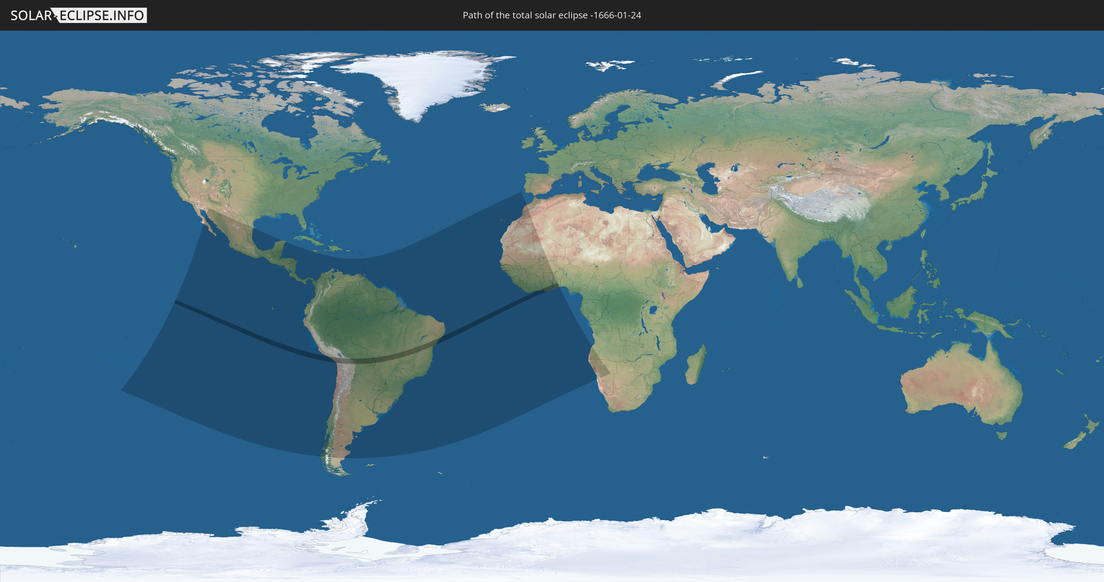
Die Sonnenfinsternis am 24.01.-1666 kann man in 55 Ländern als partielle Sonnenfinsternis beobachten.
Der Finsternispfad verläuft durch 8 Länder. Nur in diesen Ländern ist sie als totale Sonnenfinsternis zu sehen.
In den folgenden Ländern ist die Sonnenfinsternis total zu sehen
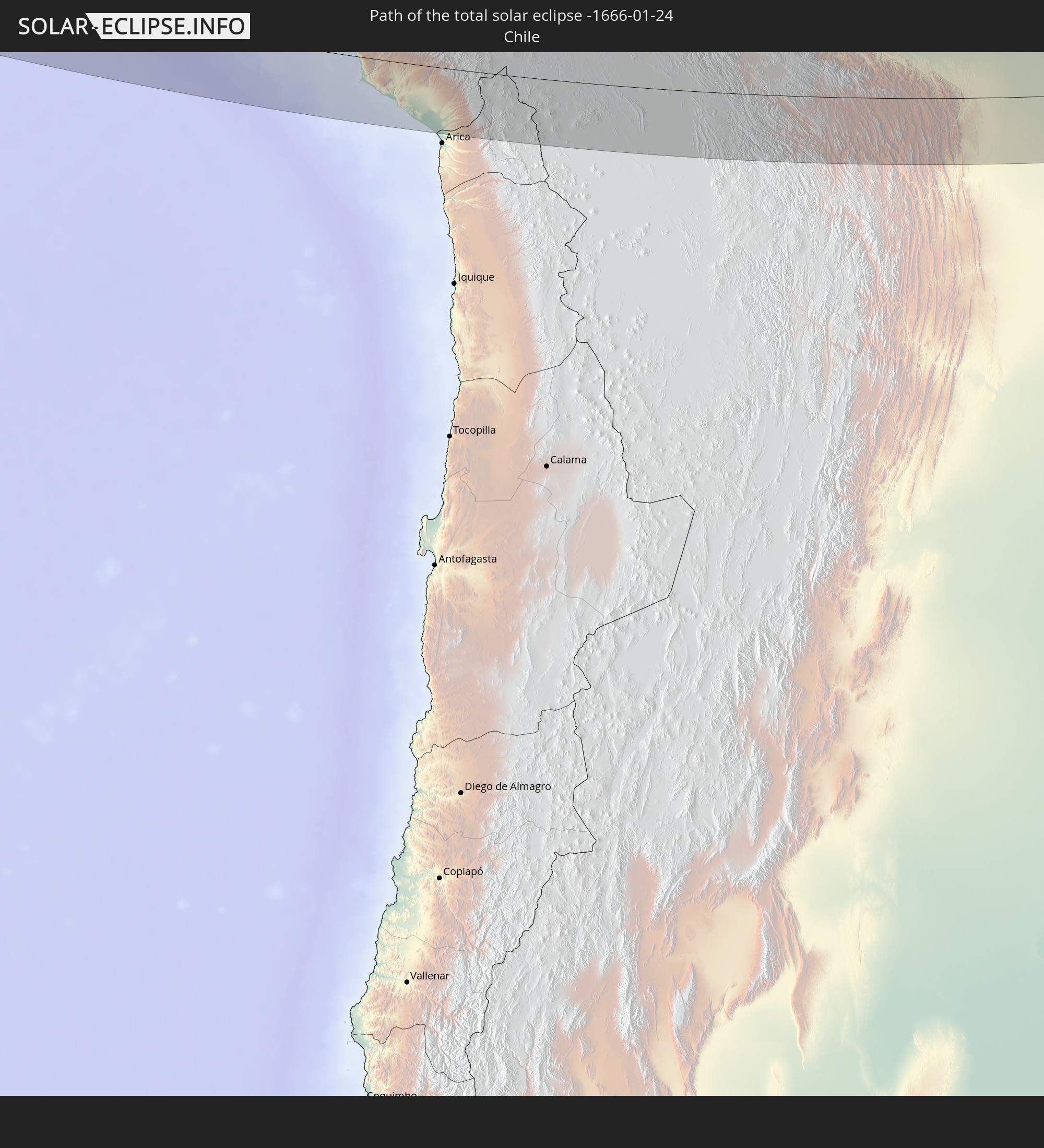 Chile
Chile
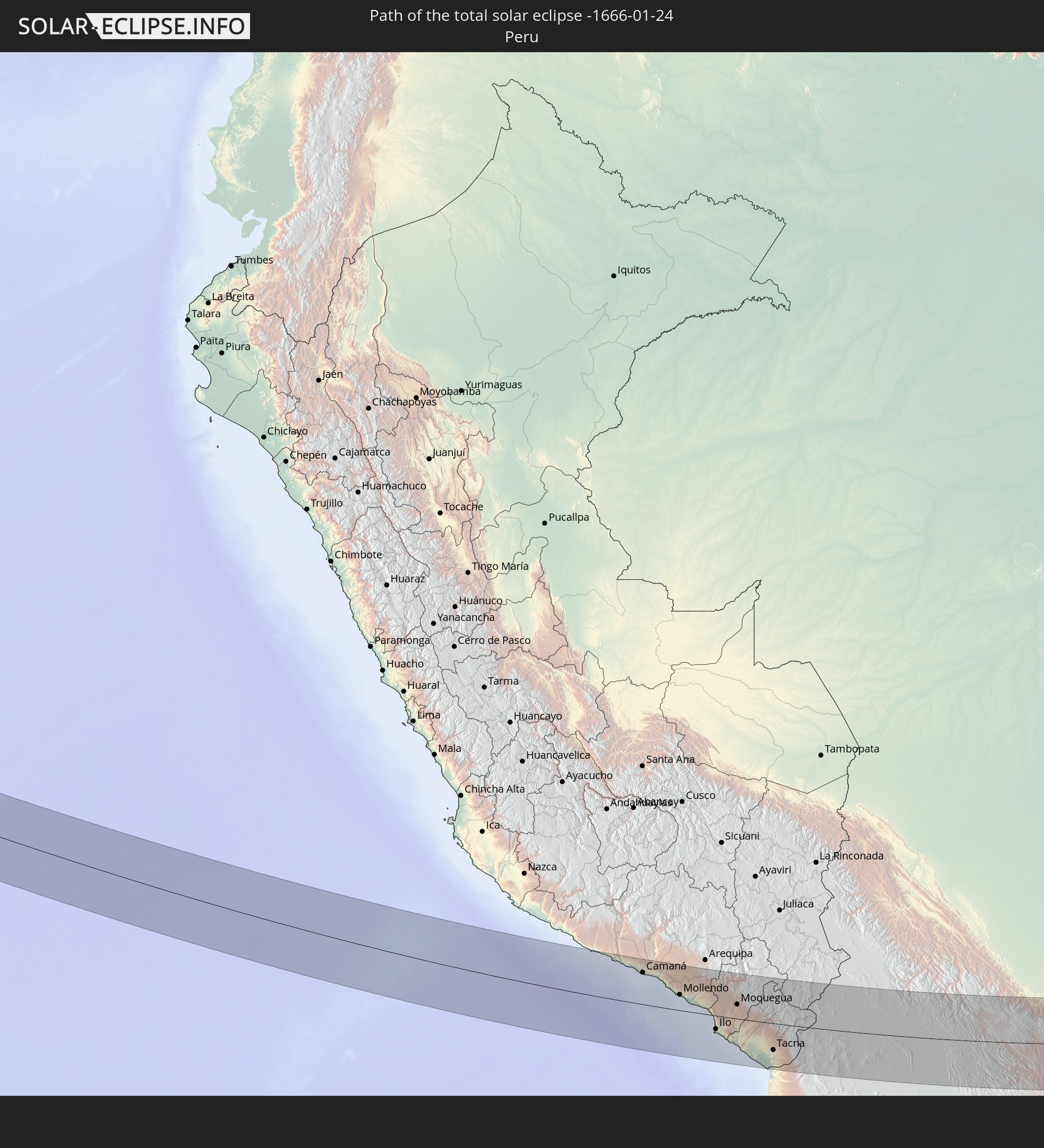 Peru
Peru
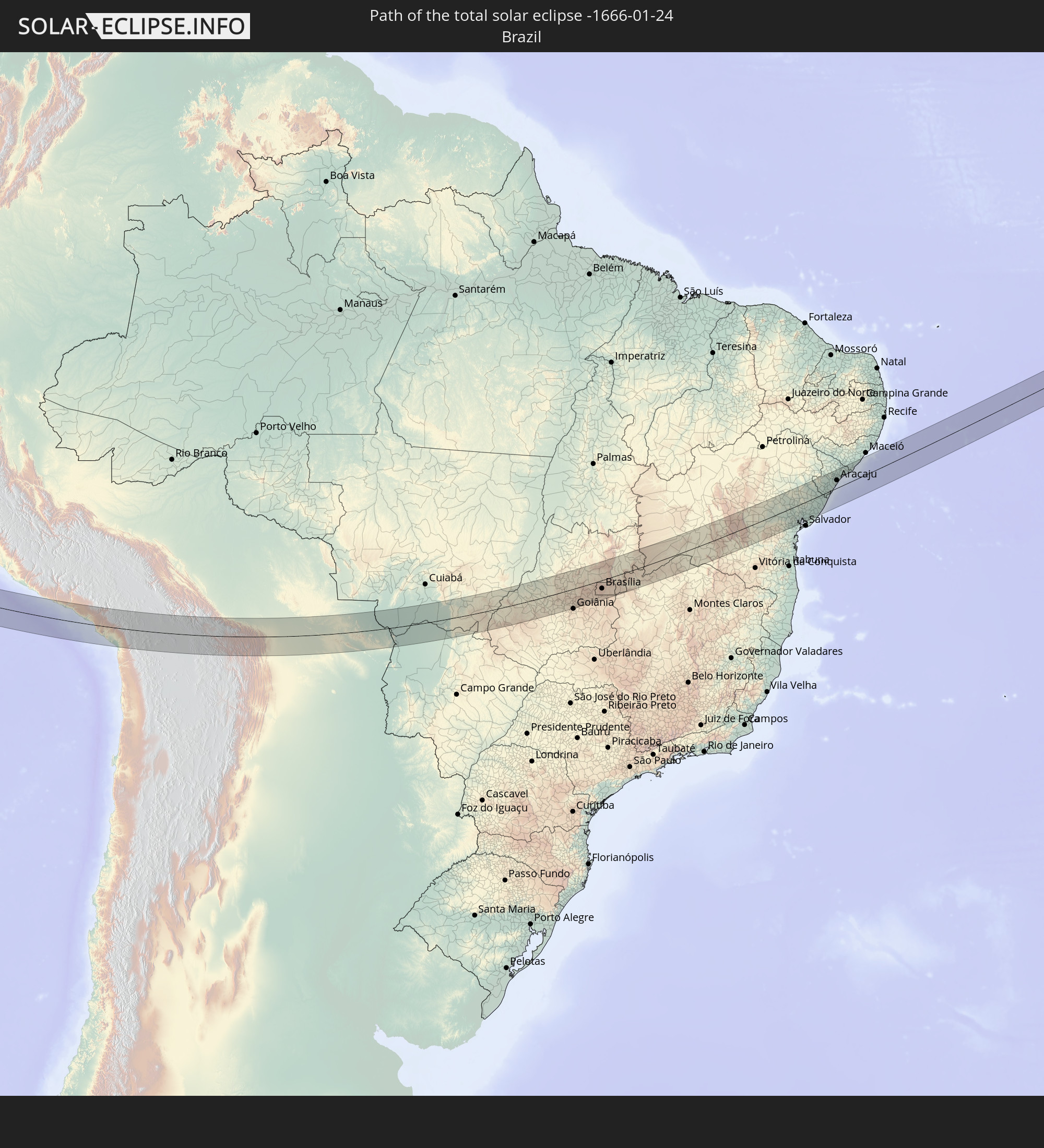 Brasilien
 Bolivien
 Elfenbeinküste
 Ghana
Ghana
 Togo
Togo
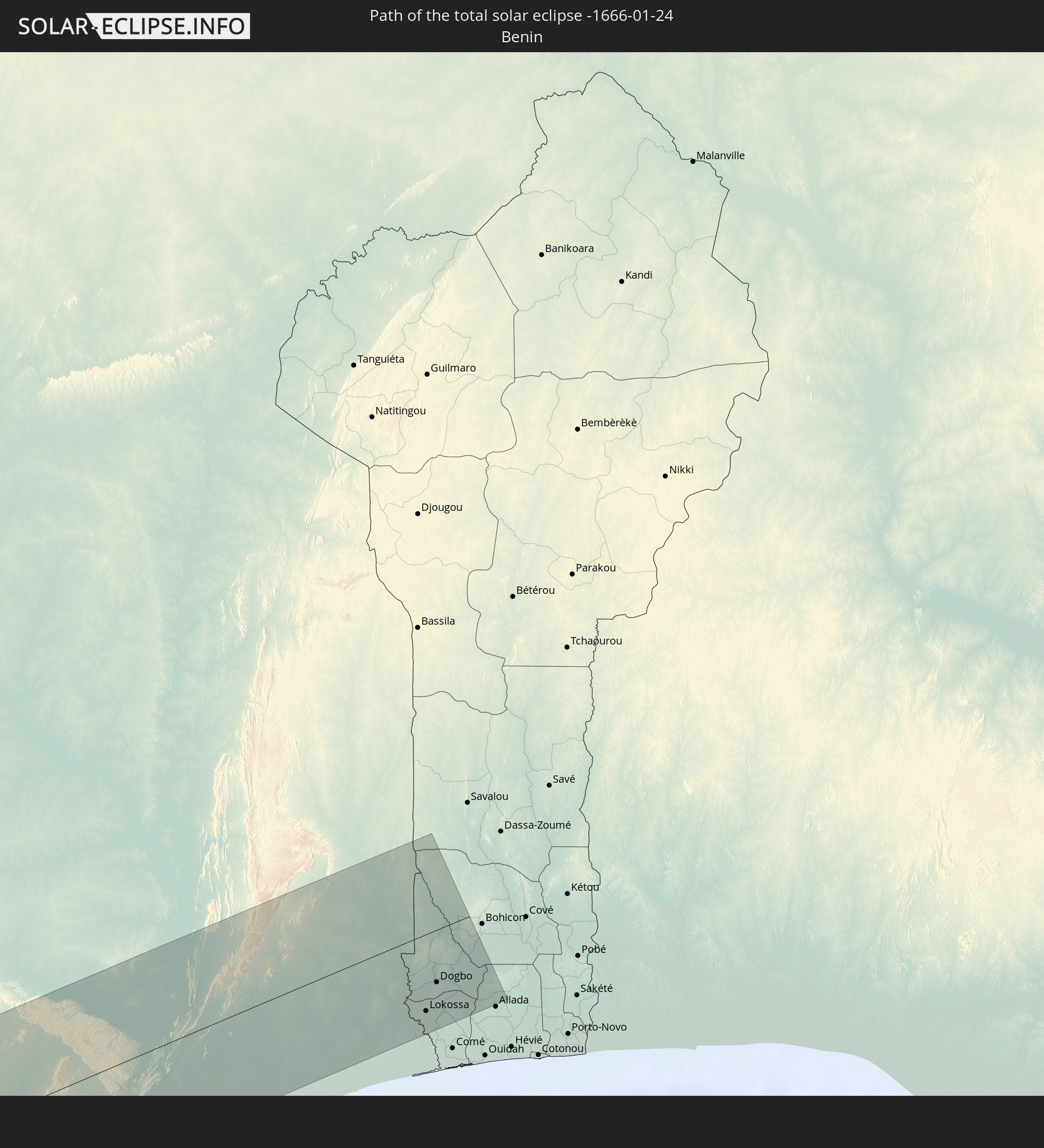 Benin
Benin
In den folgenden Ländern ist die Sonnenfinsternis partiell zu sehen
 Vereinigte Staaten
 Französisch-Polynesien
 Pitcairninseln
 Mexiko
 Chile
Chile
 Guatemala
 Ecuador
 El Salvador
 Honduras
 Belize
 Nicaragua
 Costa Rica
 Panama
 Kolumbien
 Peru
Peru
 Jamaika
 Brasilien
 Argentinien
 Venezuela
 Aruba
Aruba
 Bolivien
 Paraguay
 Trinidad und Tobago
 Grenada
 Dominica
 St. Vincent und die Grenadinen
 Guyana
 Martinique
 St. Lucia
 Barbados
 Uruguay
 Suriname
 Französisch-Guayana
 Portugal
 Kap Verde
 Spanien
 Senegal
 Mauretanien
 Gambia
 Guinea-Bissau
 Guinea
 St. Helena
 Sierra Leone
 Marokko
 Mali
Mali
 Liberia
 Algerien
 Elfenbeinküste
 Burkina Faso
 Ghana
Ghana
 Togo
Togo
 Benin
Benin
 Äquatorialguinea
 Angola
 Namibia
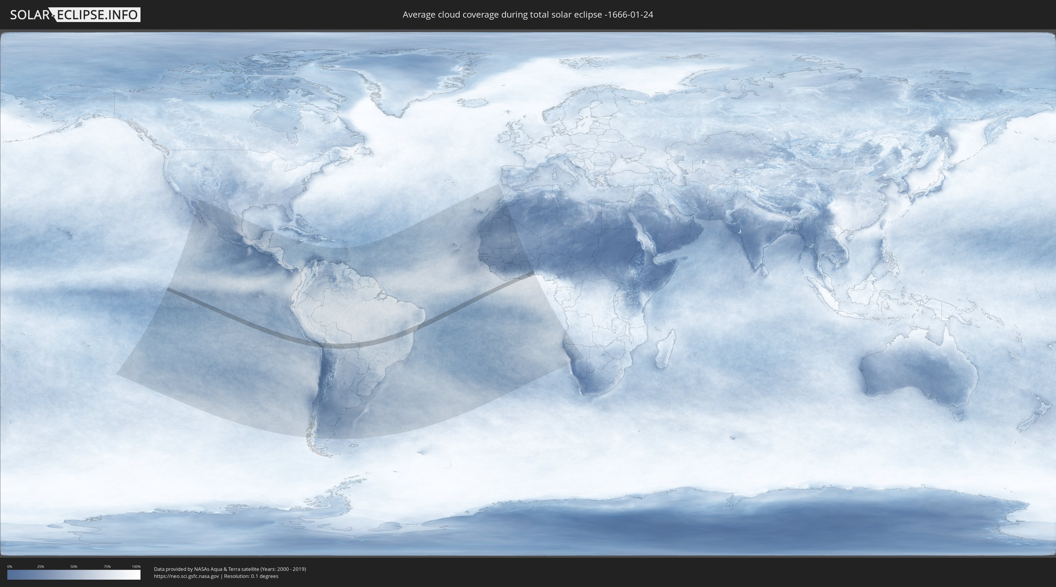
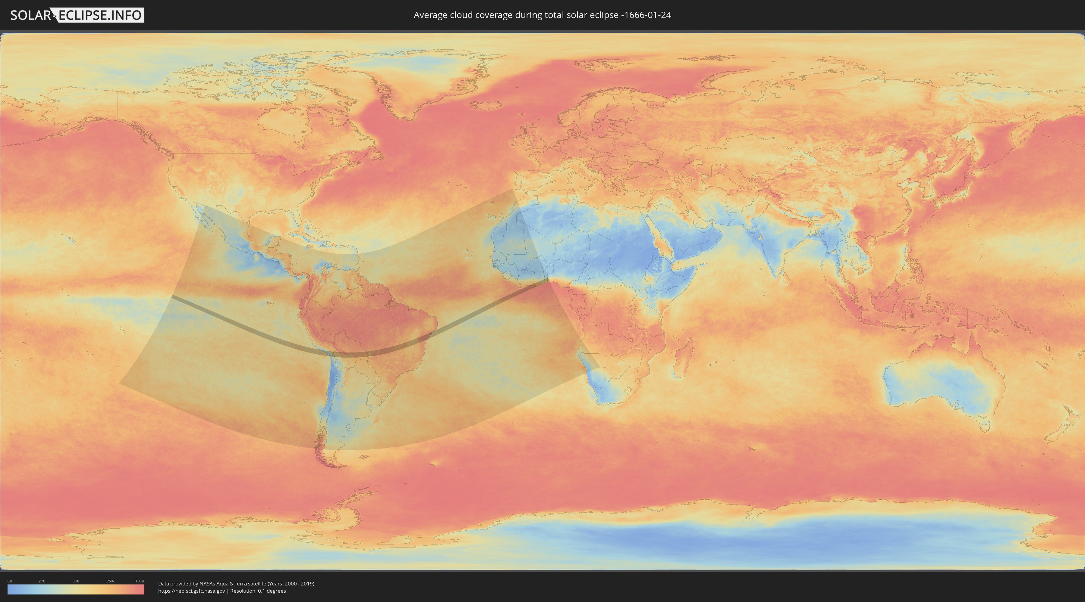
Wie wird das Wetter während der totalen Sonnenfinsternis am 24.01.-1666?
Wo ist der beste Ort, um die totale Sonnenfinsternis vom 24.01.-1666 zu beobachten?
Die folgenden Karten zeigen die durchschnittliche Bewölkung für den Tag, an dem die totale Sonnenfinsternis
stattfindet. Mit Hilfe der Karten lässt sich der Ort entlang des Finsternispfades eingrenzen,
der die besten Aussichen auf einen klaren wolkenfreien Himmel bietet.
Trotzdem muss man immer lokale Gegenenheiten beachten und sollte sich genau über das Wetter an seinem
gewählten Beobachtungsort informieren.
Die Daten stammen von den beiden NASA-Satelliten
AQUA und TERRA
und wurden über einen Zeitraum von 19 Jahren (2000 - 2019) gemittelt.
Detaillierte Länderkarten
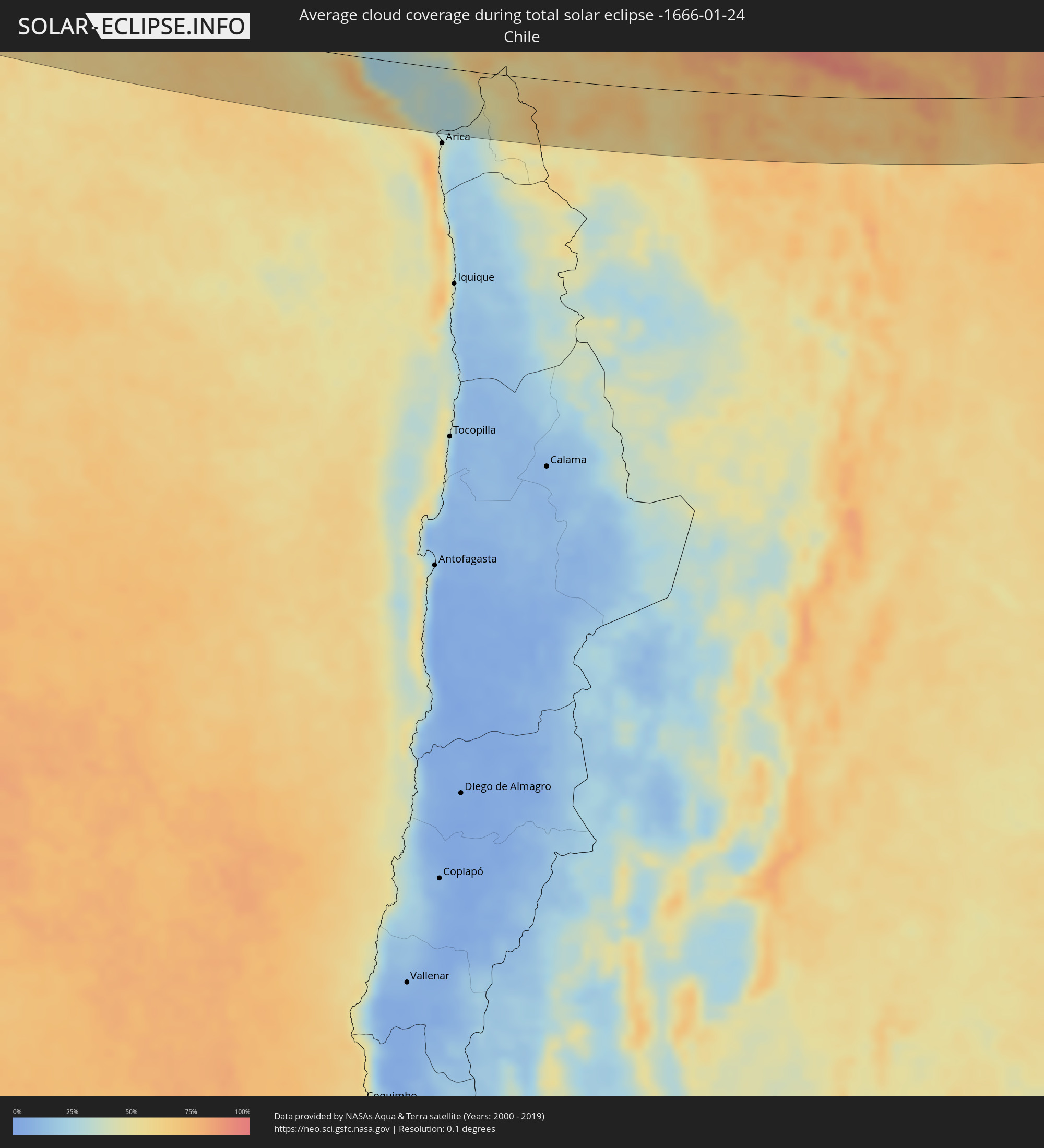 Chile
Chile
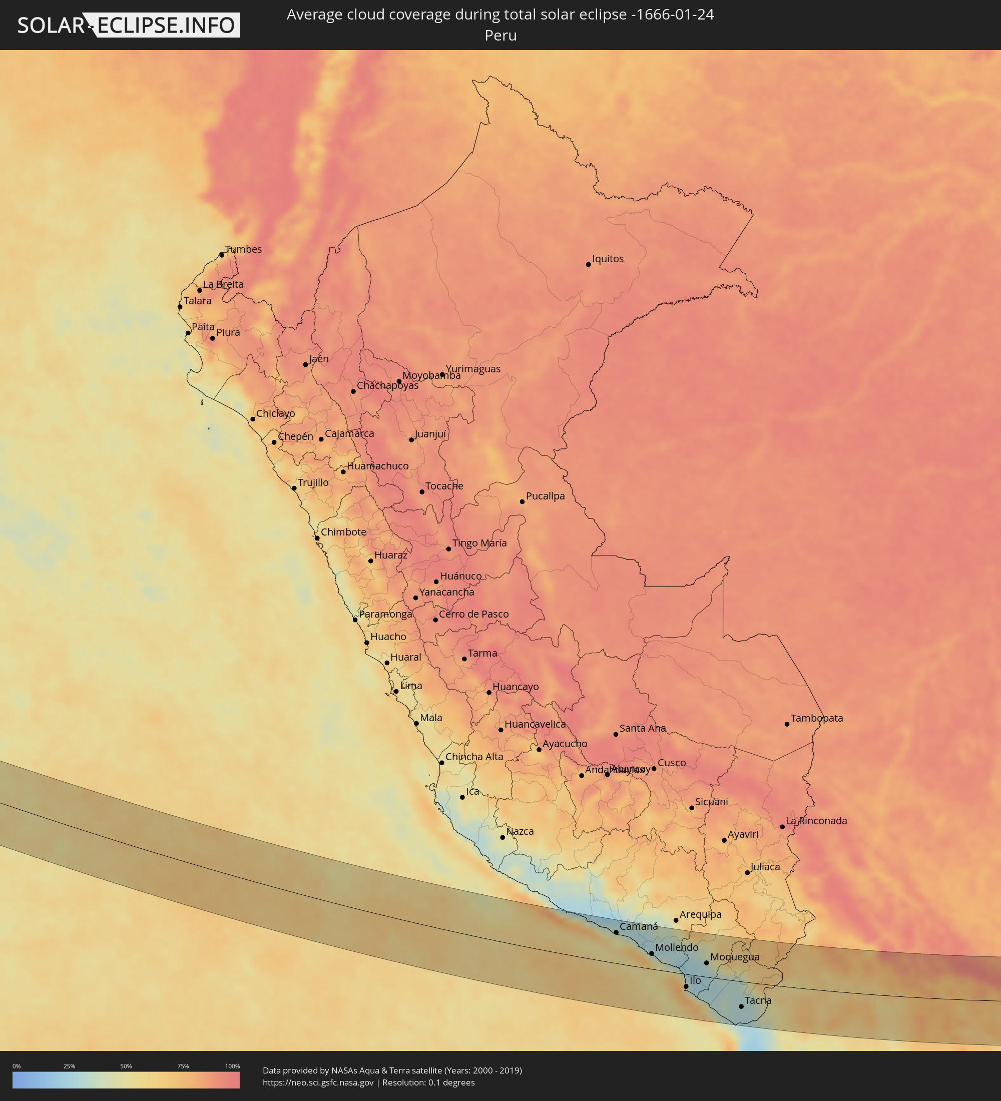 Peru
Peru
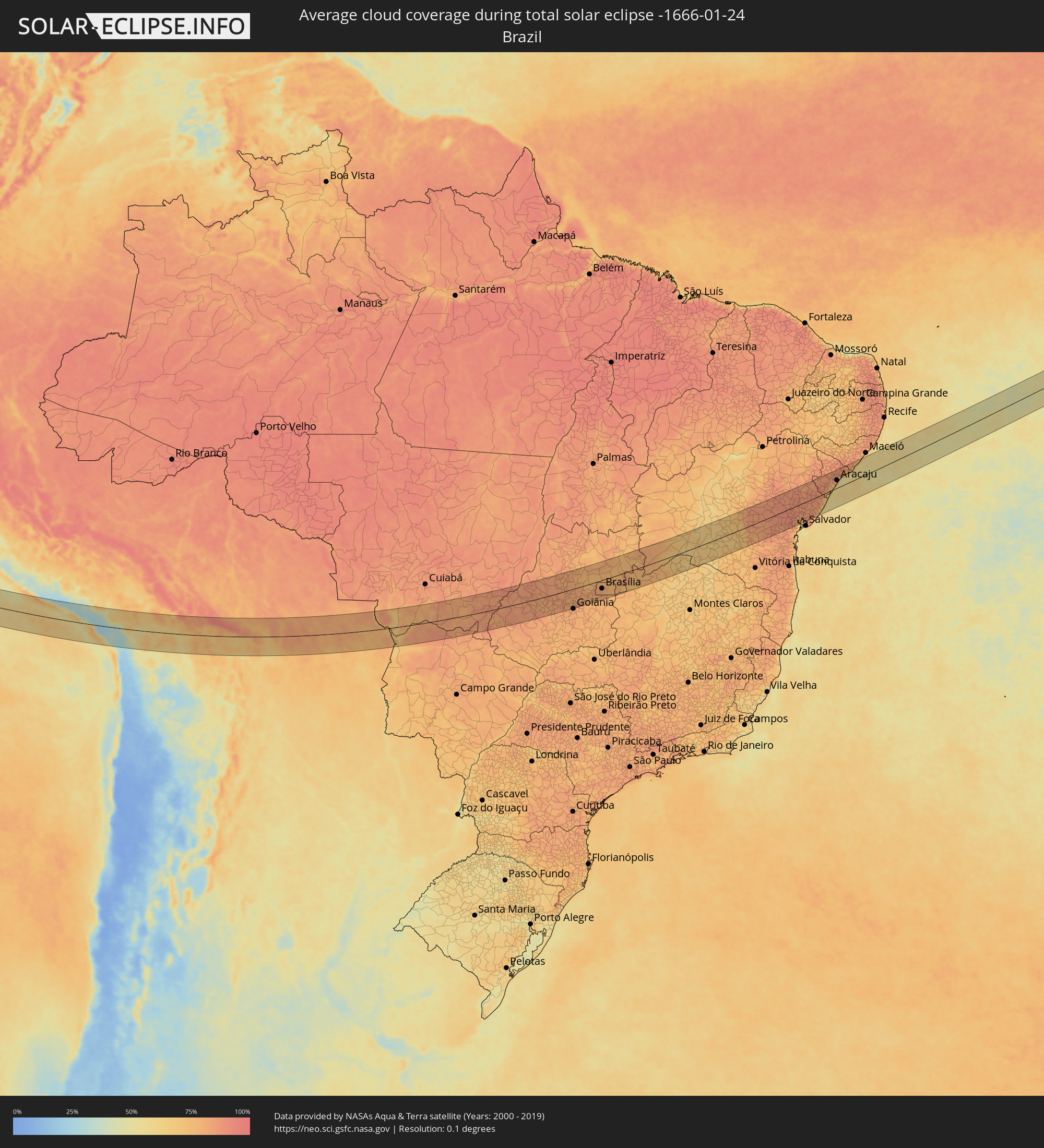 Brasilien
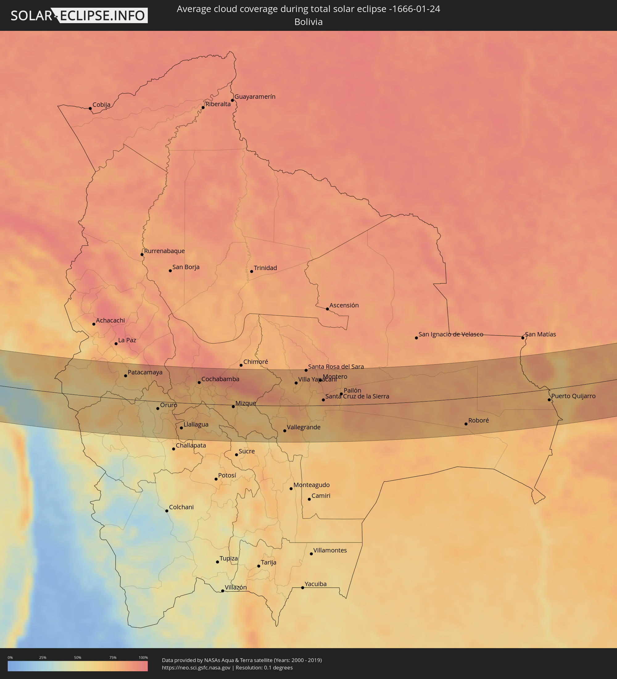 Bolivien
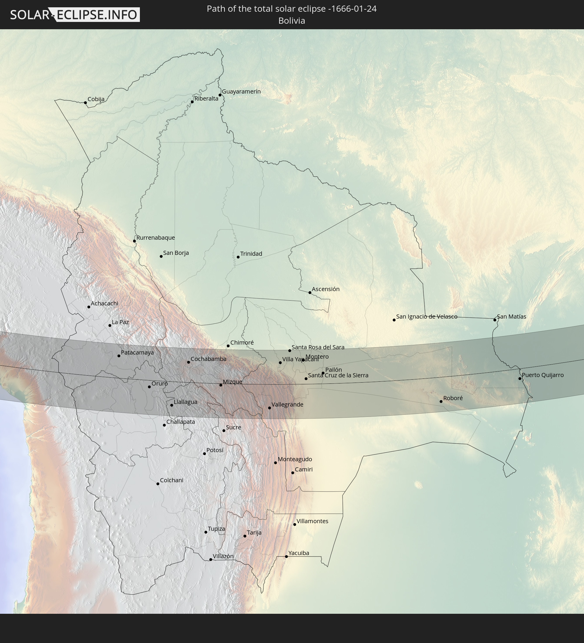
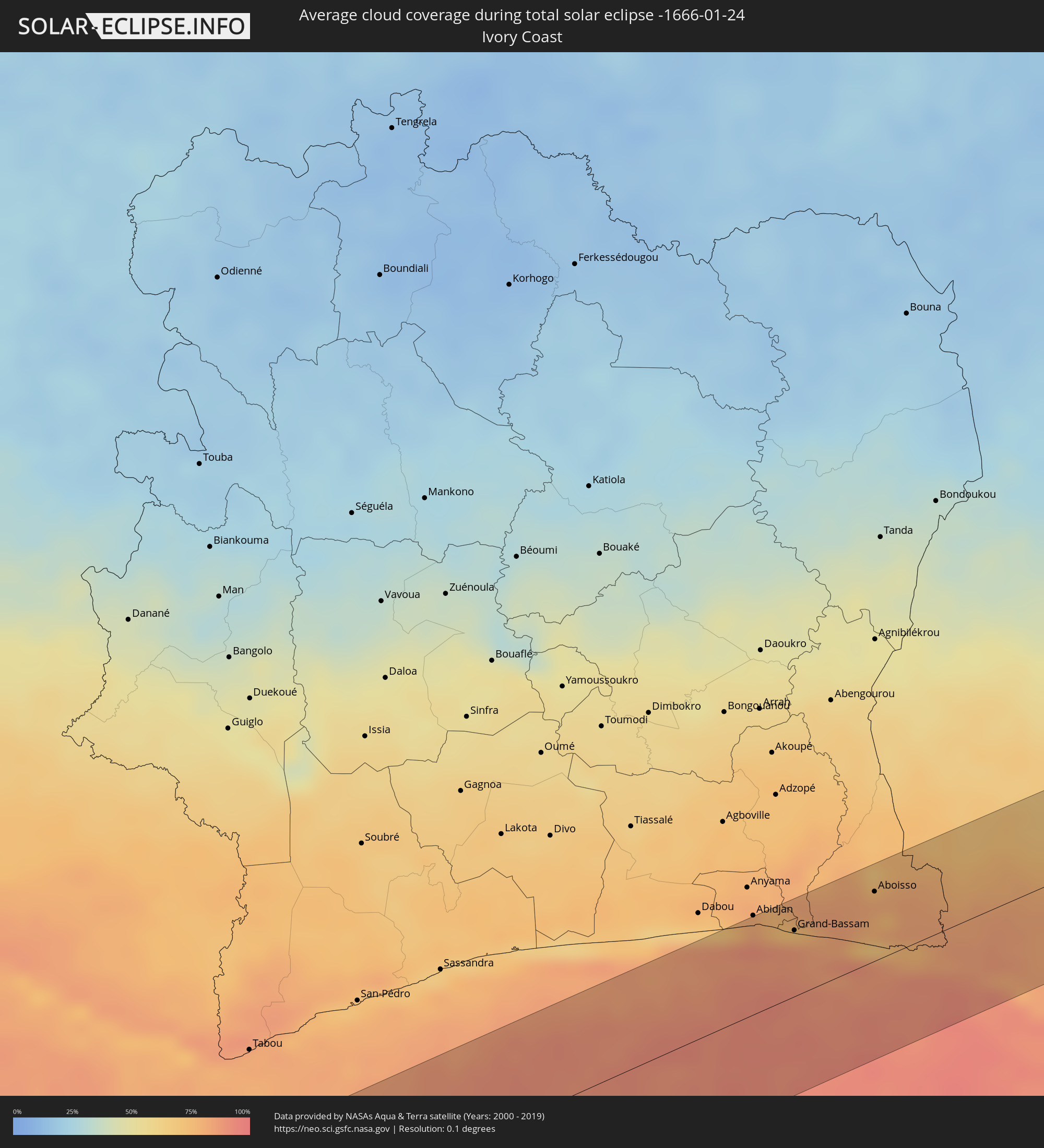 Elfenbeinküste
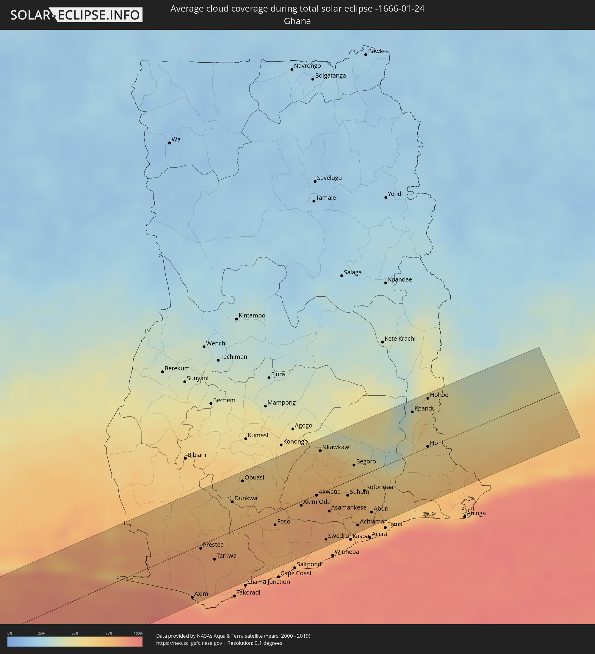 Ghana
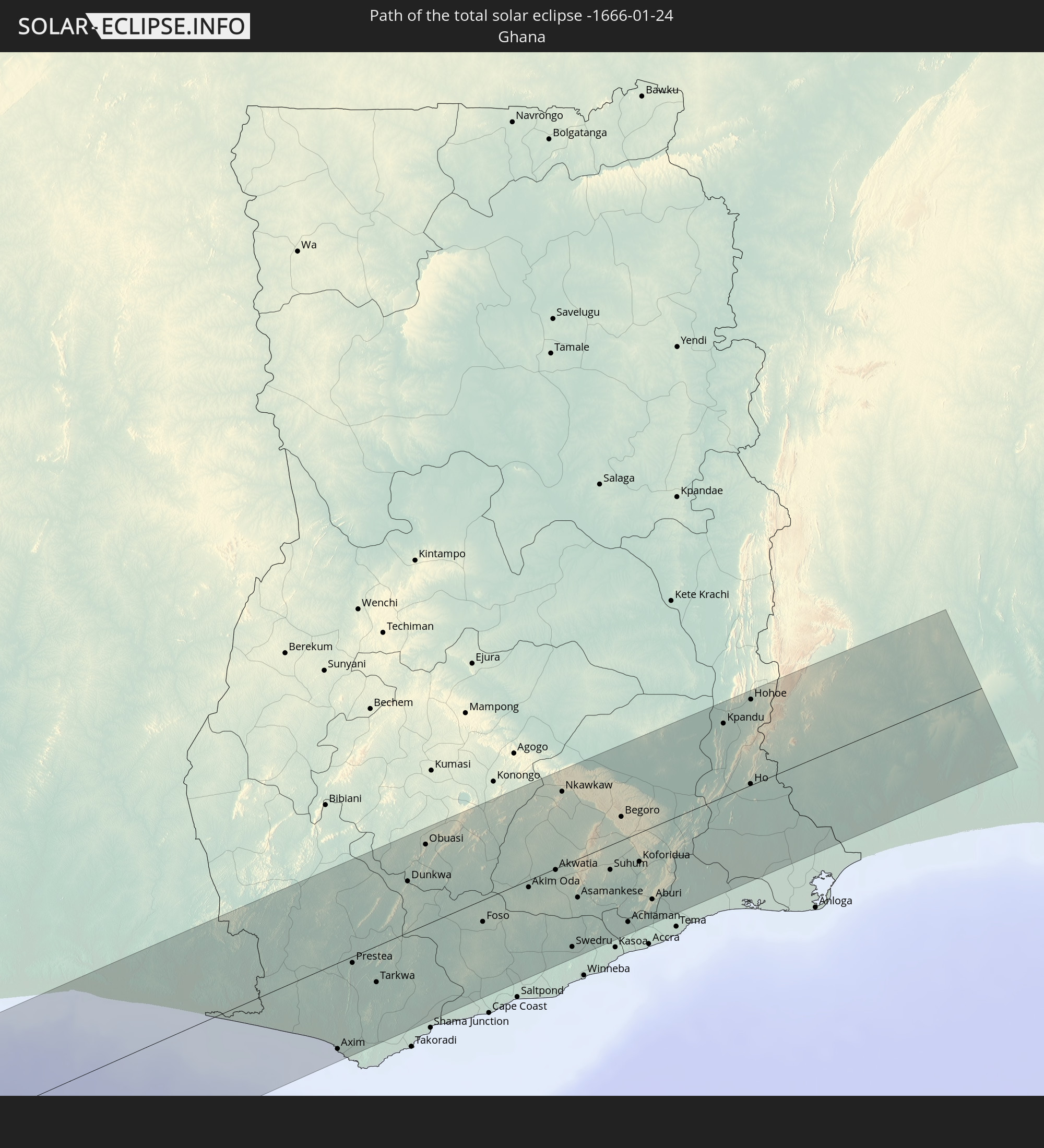
Ghana
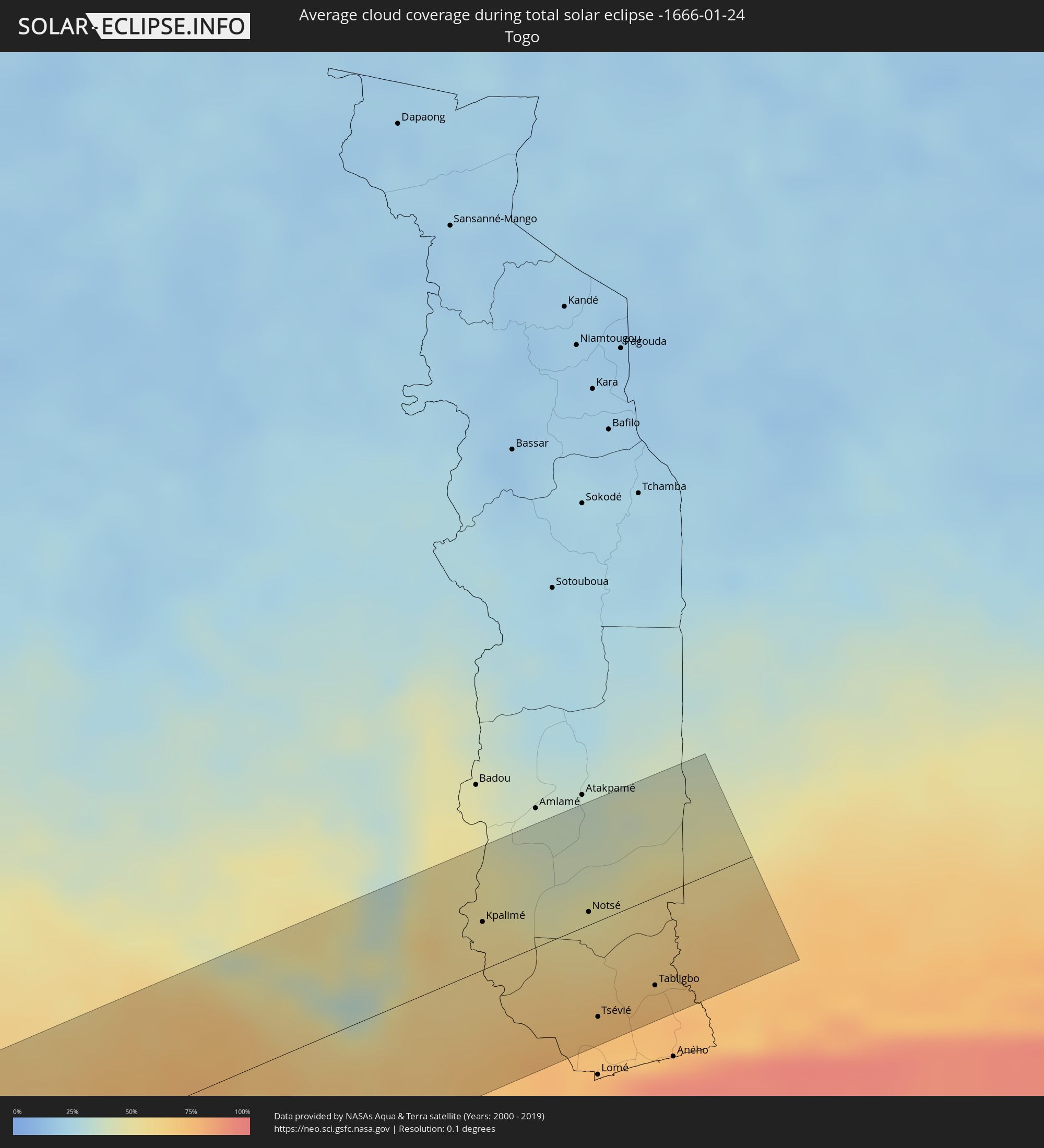 Togo
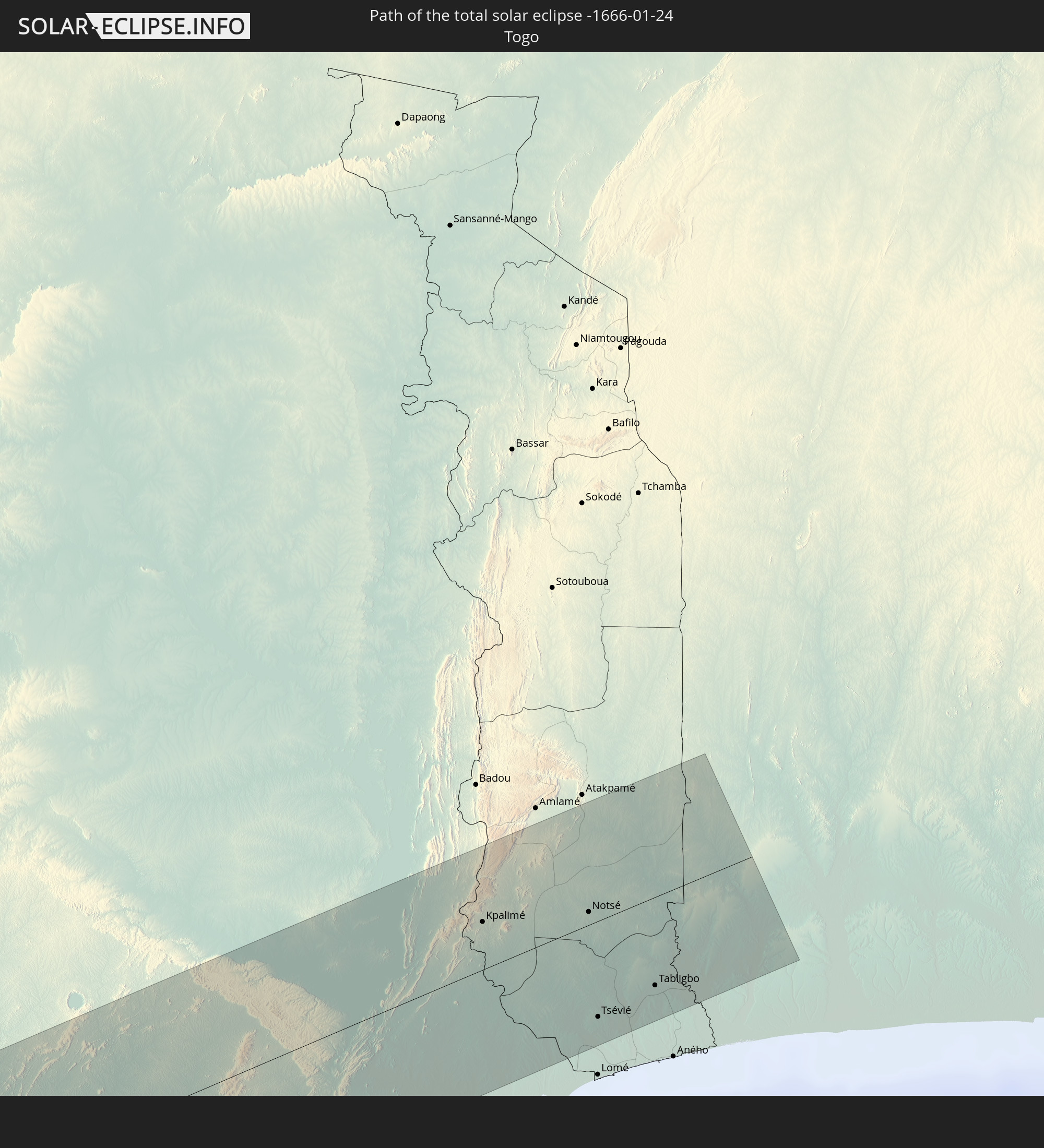
Togo
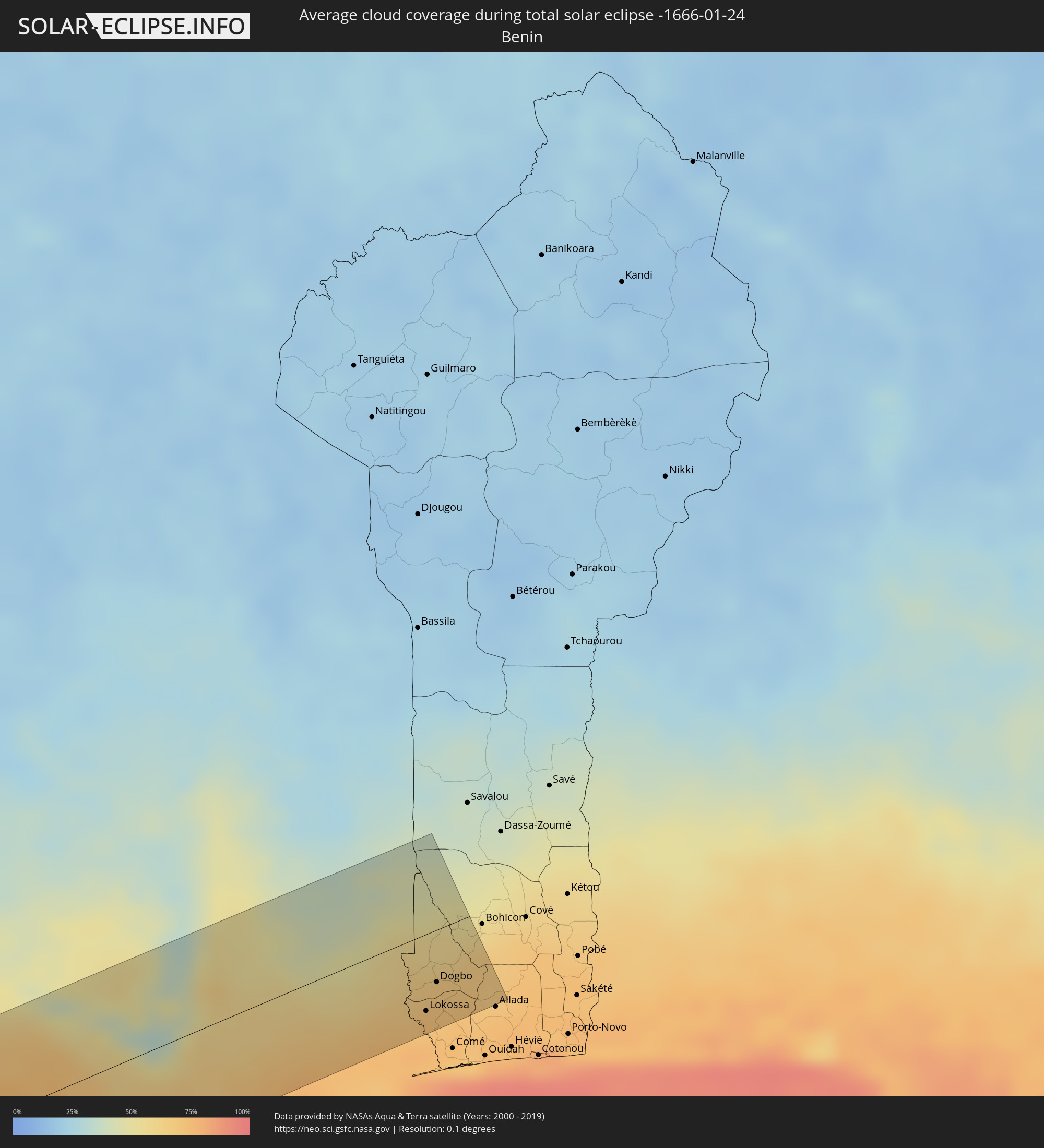 Benin
Benin
Orte im Finsternispfad
Die nachfolgene Tabelle zeigt Städte und Orte mit mehr als 5.000 Einwohnern, die sich im Finsternispfad befinden. Städte mit mehr als 100.000 Einwohnern sind dick gekennzeichnet. Mit einem Klick auf den Ort öffnet sich eine Detailkarte die die Lage des jeweiligen Ortes zusammen mit dem Verlauf der zentralen Finsternis präsentiert.
| Ort | Typ | Dauer der Verfinsterung | Ortszeit bei maximaler Verfinsterung | Entfernung zur Zentrallinie | Ø Bewölkung |
|
Camaná, Arequipa
|
total | - | 10:26:40 UTC-05:08 | 63 km | 49% |
|
Mollendo, Arequipa
|
total | - | 10:28:40 UTC-05:08 | 31 km | 47% |
|
Punta de Bombón, Arequipa
|
total | - | 10:29:19 UTC-05:08 | 18 km | 48% |
|
Cocachacra, Arequipa
|
total | - | 10:29:23 UTC-05:08 | 28 km | 46% |
|
Ilo, Moquegua
|
total | - | 10:30:42 UTC-05:08 | 26 km | 38% |
|
Pacocha, Moquegua
|
total | - | 10:30:42 UTC-05:08 | 20 km | 38% |
|
Moquegua, Moquegua
|
total | - | 10:31:38 UTC-05:08 | 28 km | 34% |
|
Torata, Moquegua
|
total | - | 10:31:51 UTC-05:08 | 43 km | 44% |
|
Ilabaya, Tacna
|
total | - | 10:32:52 UTC-05:08 | 10 km | 33% |
|
Tacna, Tacna
|
total | - | 10:33:45 UTC-05:08 | 53 km | 30% |
|
Patacamaya, La Paz
|
total | - | 11:16:05 UTC-04:32 | 59 km | 69% |
|
Oruro, Oruro
|
total | - | 11:18:25 UTC-04:32 | 19 km | 61% |
|
Huanuni, Oruro
|
total | - | 11:19:21 UTC-04:32 | 51 km | 74% |
|
Llallagua, Potosí
|
total | - | 11:20:06 UTC-04:32 | 64 km | 73% |
|
Capinota, Cochabamba
|
total | - | 11:20:57 UTC-04:32 | 17 km | 69% |
|
Cochabamba, Cochabamba
|
total | - | 11:21:14 UTC-04:32 | 53 km | 73% |
|
Tarata, Cochabamba
|
total | - | 11:21:38 UTC-04:32 | 29 km | 73% |
|
Cliza, Cochabamba
|
total | - | 11:21:54 UTC-04:32 | 32 km | 75% |
|
Punata, Cochabamba
|
total | - | 11:22:11 UTC-04:32 | 37 km | 74% |
|
Mizque, Cochabamba
|
total | - | 11:23:39 UTC-04:32 | 5 km | 71% |
|
Aiquile, Cochabamba
|
total | - | 11:24:07 UTC-04:32 | 34 km | 72% |
|
Vallegrande, Santa Cruz
|
total | - | 11:27:15 UTC-04:32 | 64 km | 71% |
|
Villa Yapacaní, Santa Cruz
|
total | - | 11:28:06 UTC-04:32 | 57 km | 72% |
|
Santa Rosa del Sara, Santa Cruz
|
total | - | 11:28:49 UTC-04:32 | 89 km | 81% |
|
Portachuelo, Santa Cruz
|
total | - | 11:29:25 UTC-04:32 | 62 km | 78% |
|
Santiago del Torno, Santa Cruz
|
total | - | 11:29:24 UTC-04:32 | 9 km | 66% |
|
Montero, Santa Cruz
|
total | - | 11:29:51 UTC-04:32 | 63 km | 82% |
|
Mineros, Santa Cruz
|
total | - | 11:29:55 UTC-04:32 | 88 km | 82% |
|
La Bélgica, Santa Cruz
|
total | - | 11:29:56 UTC-04:32 | 40 km | 82% |
|
Santa Cruz de la Sierra, Santa Cruz
|
total | - | 11:30:01 UTC-04:32 | 13 km | 81% |
|
Warnes, Santa Cruz
|
total | - | 11:30:05 UTC-04:32 | 43 km | 83% |
|
Cotoca, Santa Cruz
|
total | - | 11:30:24 UTC-04:32 | 10 km | 83% |
|
San Julian, Santa Cruz
|
total | - | 11:30:57 UTC-04:32 | 13 km | 80% |
|
Pailón, Santa Cruz
|
total | - | 11:31:19 UTC-04:32 | 28 km | 77% |
|
Roboré, Santa Cruz
|
total | - | 11:40:04 UTC-04:32 | 66 km | 75% |
|
Puerto Quijarro, Santa Cruz
|
total | - | 11:46:08 UTC-04:32 | 28 km | 78% |
|
Rondonópolis, Mato Grosso
|
total | - | 12:50:05 UTC-03:38 | 64 km | 81% |
|
Barra do Garças, Mato Grosso
|
total | - | 12:57:17 UTC-03:38 | 73 km | 87% |
|
Inhumas, Goiás
|
total | - | 13:36:34 UTC-03:06 | 53 km | 82% |
|
Trindade, Goiás
|
total | - | 13:36:22 UTC-03:06 | 84 km | 81% |
|
Goianésia, Goiás
|
total | - | 13:38:22 UTC-03:06 | 47 km | 78% |
|
Anápolis, Goiás
|
total | - | 13:38:01 UTC-03:06 | 66 km | 83% |
|
Luziânia, Goiás
|
total | - | 13:40:41 UTC-03:06 | 89 km | 78% |
|
Brasília, Federal District
|
total | - | 13:41:07 UTC-03:06 | 39 km | 81% |
|
Planaltina, Federal District
|
total | - | 13:41:59 UTC-03:06 | 31 km | 77% |
|
Planaltina, Goiás
|
total | - | 13:42:12 UTC-03:06 | 15 km | 78% |
|
Formosa, Goiás
|
total | - | 13:42:51 UTC-03:06 | 33 km | 81% |
|
Bom Jesus da Lapa, Bahia
|
total | - | 14:26:51 UTC-02:34 | 64 km | 62% |
|
Guanambi, Bahia
|
total | - | 14:27:26 UTC-02:34 | 61 km | 71% |
|
Itaberaba, Bahia
|
total | - | 14:34:24 UTC-02:34 | 12 km | 86% |
|
Conceição do Coité, Bahia
|
total | - | 14:37:24 UTC-02:34 | 67 km | 87% |
|
Santo Antônio de Jesus, Bahia
|
total | - | 14:36:09 UTC-02:34 | 77 km | 85% |
|
Cruz das Almas, Bahia
|
total | - | 14:36:45 UTC-02:34 | 54 km | 88% |
|
Serrinha, Bahia
|
total | - | 14:37:52 UTC-02:34 | 45 km | 86% |
|
Feira de Santana, Bahia
|
total | - | 14:37:24 UTC-02:34 | 19 km | 86% |
|
Santo Amaro, Bahia
|
total | - | 14:37:39 UTC-02:34 | 58 km | 81% |
|
Alagoinhas, Bahia
|
total | - | 14:38:36 UTC-02:34 | 29 km | 86% |
|
Catu, Bahia
|
total | - | 14:38:29 UTC-02:34 | 53 km | 86% |
|
Lagarto, Sergipe
|
total | - | 14:41:13 UTC-02:34 | 61 km | 87% |
|
Estância, Sergipe
|
total | - | 14:41:18 UTC-02:34 | 15 km | 68% |
|
Itabaiana, Sergipe
|
total | - | 14:41:51 UTC-02:34 | 74 km | 85% |
|
São Cristóvão, Sergipe
|
total | - | 14:41:58 UTC-02:34 | 31 km | 66% |
|
Aracaju, Sergipe
|
total | - | 14:42:19 UTC-02:34 | 35 km | 71% |
|
Penedo, Alagoas
|
total | - | 14:43:47 UTC-02:34 | 76 km | 78% |
|
Coruripe, Alagoas
|
total | - | 14:44:41 UTC-02:34 | 74 km | 70% |
|
Bingerville, Abidjan
|
total | - | 17:39:21 UTC-00:16 | 66 km | 76% |
|
Grand-Bassam, Comoé
|
total | - | 17:39:20 UTC-00:16 | 44 km | 85% |
|
Bonoua
|
total | - | 17:39:22 UTC-00:16 | 44 km | 77% |
|
Adiaké, Comoé
|
total | - | 17:39:24 UTC-00:16 | 32 km | 80% |
|
Aboisso, Comoé
|
total | - | 17:39:27 UTC-00:16 | 47 km | 81% |
|
Ayamé, Comoé
|
total | - | 17:39:29 UTC-00:16 | 58 km | 74% |
|
Axim, Western
|
total | - | 17:54:40 UTC-00:00 | 57 km | 80% |
|
Prestea, Western
|
total | - | 17:54:48 UTC-00:00 | 4 km | 82% |
|
Tarkwa, Western
|
total | - | 17:54:47 UTC-00:00 | 24 km | 82% |
|
Aboso
|
total | - | 17:54:48 UTC-00:00 | 20 km | 81% |
|
Dunkwa, Central
|
total | - | 17:54:56 UTC-00:00 | 34 km | 68% |
|
Obuasi, Ashanti
|
total | - | 17:54:59 UTC-00:00 | 53 km | 65% |
|
Foso, Central
|
total | - | 17:54:54 UTC-00:00 | 15 km | 77% |
|
Akim Swedru
|
total | - | 17:54:57 UTC-00:00 | 7 km | 78% |
|
Akim Oda, Eastern
|
total | - | 17:54:57 UTC-00:00 | 5 km | 78% |
|
Akwatia, Eastern
|
total | - | 17:54:59 UTC-00:00 | 1 km | 81% |
|
Nkawkaw, Eastern
|
total | - | 17:55:05 UTC-00:00 | 49 km | 66% |
|
Mpraeso
|
total | - | 17:55:05 UTC-00:00 | 52 km | 65% |
|
Swedru, Central
|
total | - | 17:54:53 UTC-00:00 | 57 km | 78% |
|
Asamankese, Eastern
|
total | - | 17:54:57 UTC-00:00 | 26 km | 79% |
|
Kibi
|
total | - | 17:55:01 UTC-00:00 | 1 km | 72% |
|
Suhum, Eastern
|
total | - | 17:54:59 UTC-00:00 | 17 km | 78% |
|
Begoro, Eastern
|
total | - | 17:55:03 UTC-00:00 | 16 km | 64% |
|
Nsawam, Eastern
|
total | - | 17:54:57 UTC-00:00 | 45 km | 76% |
|
Achiaman, Greater Accra
|
total | - | 17:54:55 UTC-00:00 | 57 km | 78% |
|
Koforidua, Eastern
|
total | - | 17:55:00 UTC-00:00 | 19 km | 72% |
|
Aburi, Eastern
|
total | - | 17:54:57 UTC-00:00 | 48 km | 75% |
|
Akropong
|
total | - | 17:54:59 UTC-00:00 | 39 km | 68% |
|
Kpandu, Volta
|
total | - | 17:55:09 UTC-00:00 | 49 km | 52% |
|
Ho, Volta
|
total | - | 17:55:05 UTC-00:00 | 1 km | 60% |
|
Hohoe, Volta
|
total | - | 17:55:11 UTC-00:00 | 57 km | 53% |
|
Kpalimé, Plateaux
|
total | - | 17:39:52 UTC-00:16 | 24 km | 55% |
|
Notsé, Plateaux
|
total | - | 17:39:52 UTC-00:16 | 7 km | 49% |
|
Tsévié, Maritime
|
total | - | 17:39:46 UTC-00:16 | 49 km | 74% |
|
Tabligbo, Maritime
|
total | - | 17:39:47 UTC-00:16 | 45 km | 71% |
|
Aplahoué, Kouffo
|
total | - | 18:09:33 UTC+00:13 | 17 km | 66% |
|
Lokossa, Mono
|
total | - | 18:09:30 UTC+00:13 | 49 km | 72% |
|
Dogbo, Kouffo
|
total | - | 18:09:32 UTC+00:13 | 33 km | 69% |
|
Abomey, Zou
|
total | - | 18:09:34 UTC+00:13 | 5 km | 58% |