Totale Sonnenfinsternis vom 24.01.-1685
| Wochentag: | Samstag |
| Maximale Dauer der Verfinsterung: | 03m23s |
| Maximale Breite des Finsternispfades: | 187 km |
| Saroszyklus: | 4 |
| Bedeckungsgrad: | 100% |
| Magnitude: | 1.0365 |
| Gamma: | 0.7549 |
Wo kann man die Sonnenfinsternis vom 24.01.-1685 sehen?
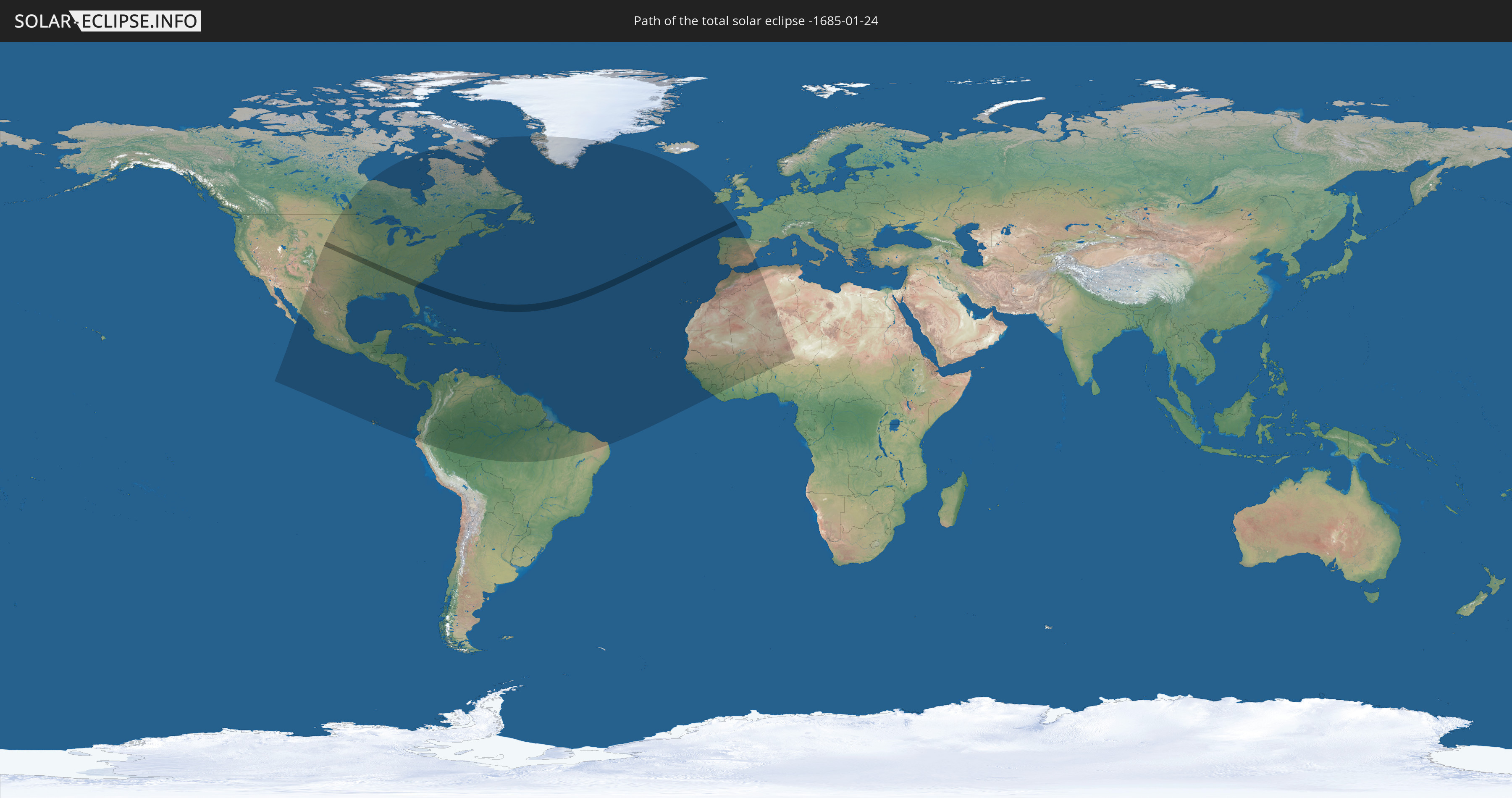
Die Sonnenfinsternis am 24.01.-1685 kann man in 69 Ländern als partielle Sonnenfinsternis beobachten.
Der Finsternispfad verläuft durch 2 Länder. Nur in diesen Ländern ist sie als totale Sonnenfinsternis zu sehen.
In den folgenden Ländern ist die Sonnenfinsternis total zu sehen
 Vereinigte Staaten
 Portugal
In den folgenden Ländern ist die Sonnenfinsternis partiell zu sehen
 Vereinigte Staaten
 United States Minor Outlying Islands
 Kanada
 Mexiko
 Grönland
 Guatemala
 Ecuador
 El Salvador
 Honduras
 Belize
 Nicaragua
 Costa Rica
 Kuba
Kuba
 Panama
 Kolumbien
 Kaimaninseln
 Peru
Peru
 Bahamas
 Jamaika
 Haiti
Haiti
 Brasilien
 Venezuela
 Turks- und Caicosinseln
 Dominikanische Republik
 Aruba
Aruba
 Puerto Rico
 Amerikanische Jungferninseln
 Bermuda
 Britische Jungferninseln
 Anguilla
 Saint-Martin
 Saint-Barthélemy
 St. Kitts und Nevis
 Antigua und Barbuda
 Montserrat
 Trinidad und Tobago
 Guadeloupe
 Grenada
 Dominica
 St. Vincent und die Grenadinen
 Guyana
 Martinique
 St. Lucia
 Barbados
 Suriname
 Saint-Pierre und Miquelon
 Französisch-Guayana
 Portugal
 Kap Verde
 Spanien
 Senegal
 Mauretanien
 Gambia
 Guinea-Bissau
 Guinea
 Sierra Leone
 Marokko
 Mali
Mali
 Liberia
 Irland
 Algerien
 Elfenbeinküste
 Burkina Faso
 Gibraltar
 Ghana
Ghana
 Togo
Togo
 Niger
Niger
 Benin
Benin
 Nigeria
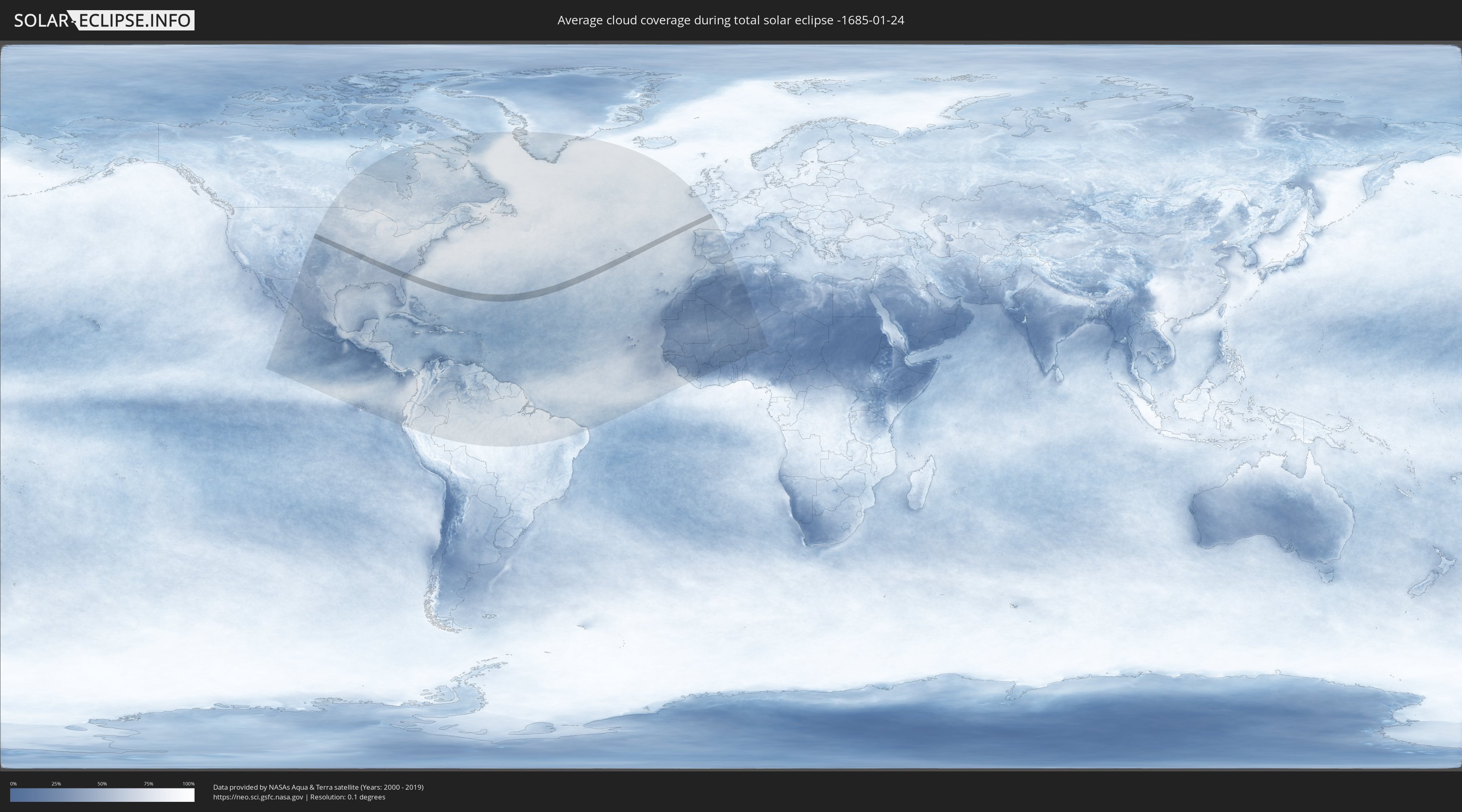
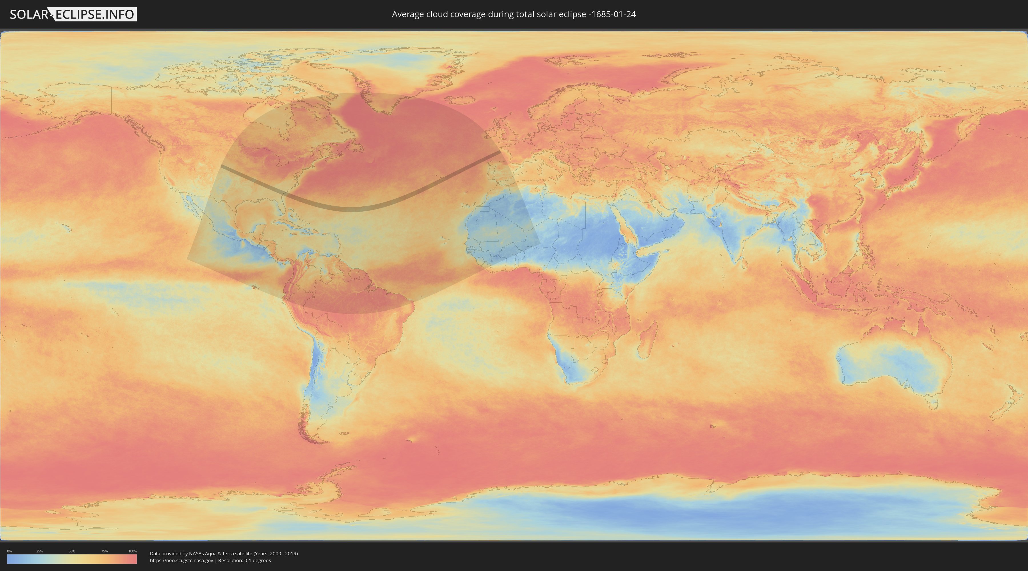
Wie wird das Wetter während der totalen Sonnenfinsternis am 24.01.-1685?
Wo ist der beste Ort, um die totale Sonnenfinsternis vom 24.01.-1685 zu beobachten?
Die folgenden Karten zeigen die durchschnittliche Bewölkung für den Tag, an dem die totale Sonnenfinsternis
stattfindet. Mit Hilfe der Karten lässt sich der Ort entlang des Finsternispfades eingrenzen,
der die besten Aussichen auf einen klaren wolkenfreien Himmel bietet.
Trotzdem muss man immer lokale Gegenenheiten beachten und sollte sich genau über das Wetter an seinem
gewählten Beobachtungsort informieren.
Die Daten stammen von den beiden NASA-Satelliten
AQUA und TERRA
und wurden über einen Zeitraum von 19 Jahren (2000 - 2019) gemittelt.
Detaillierte Länderkarten
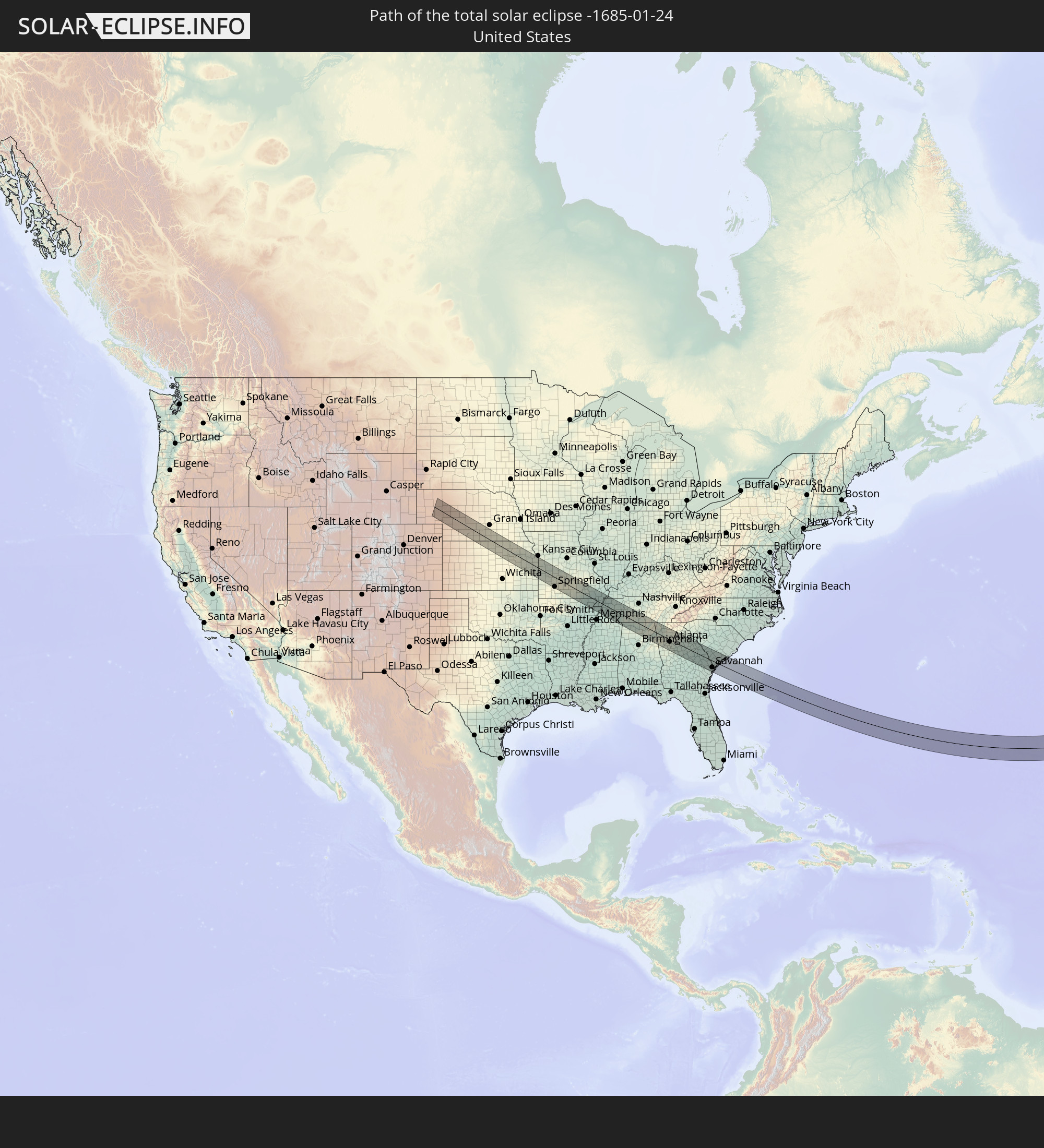
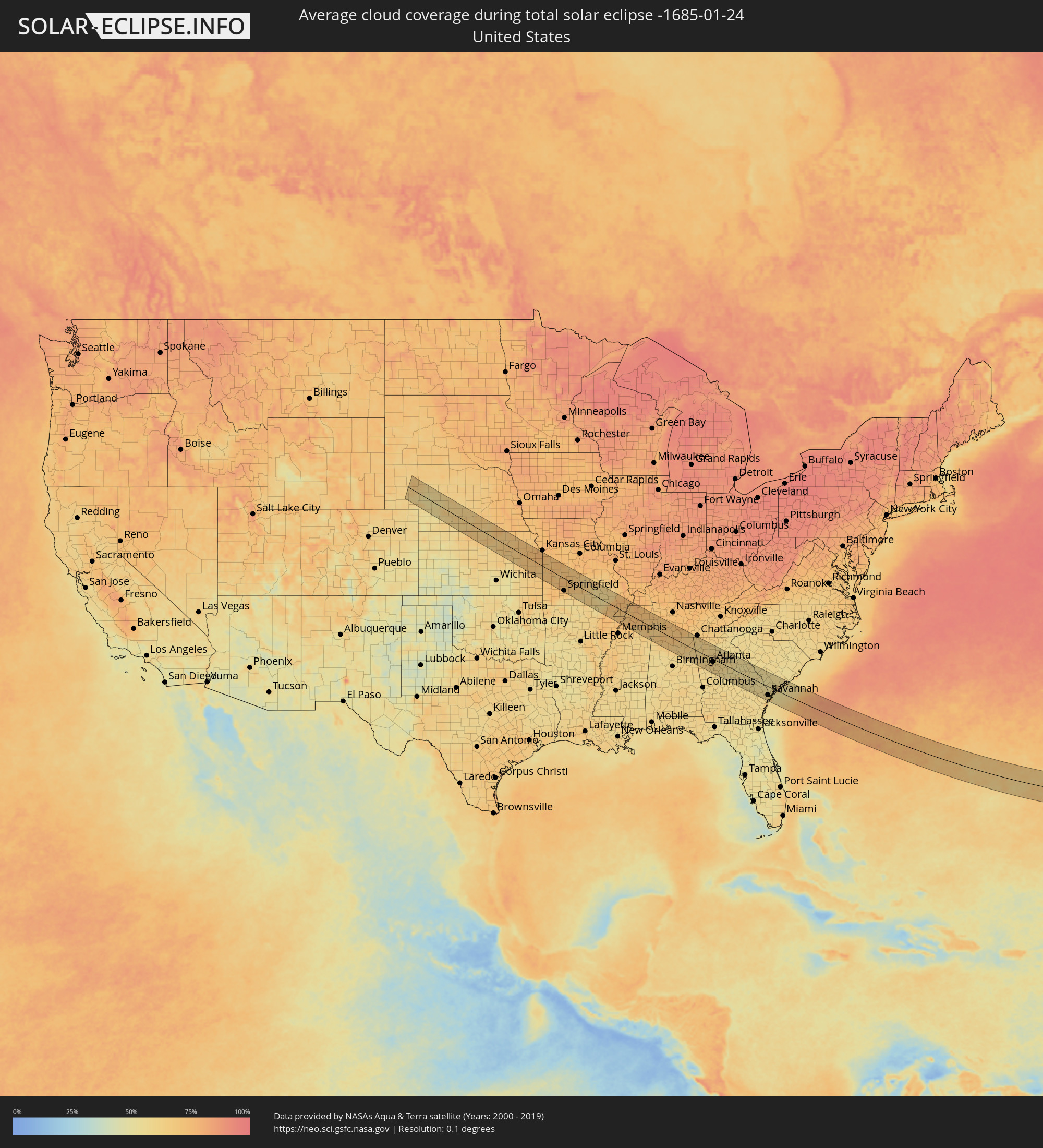 Vereinigte Staaten
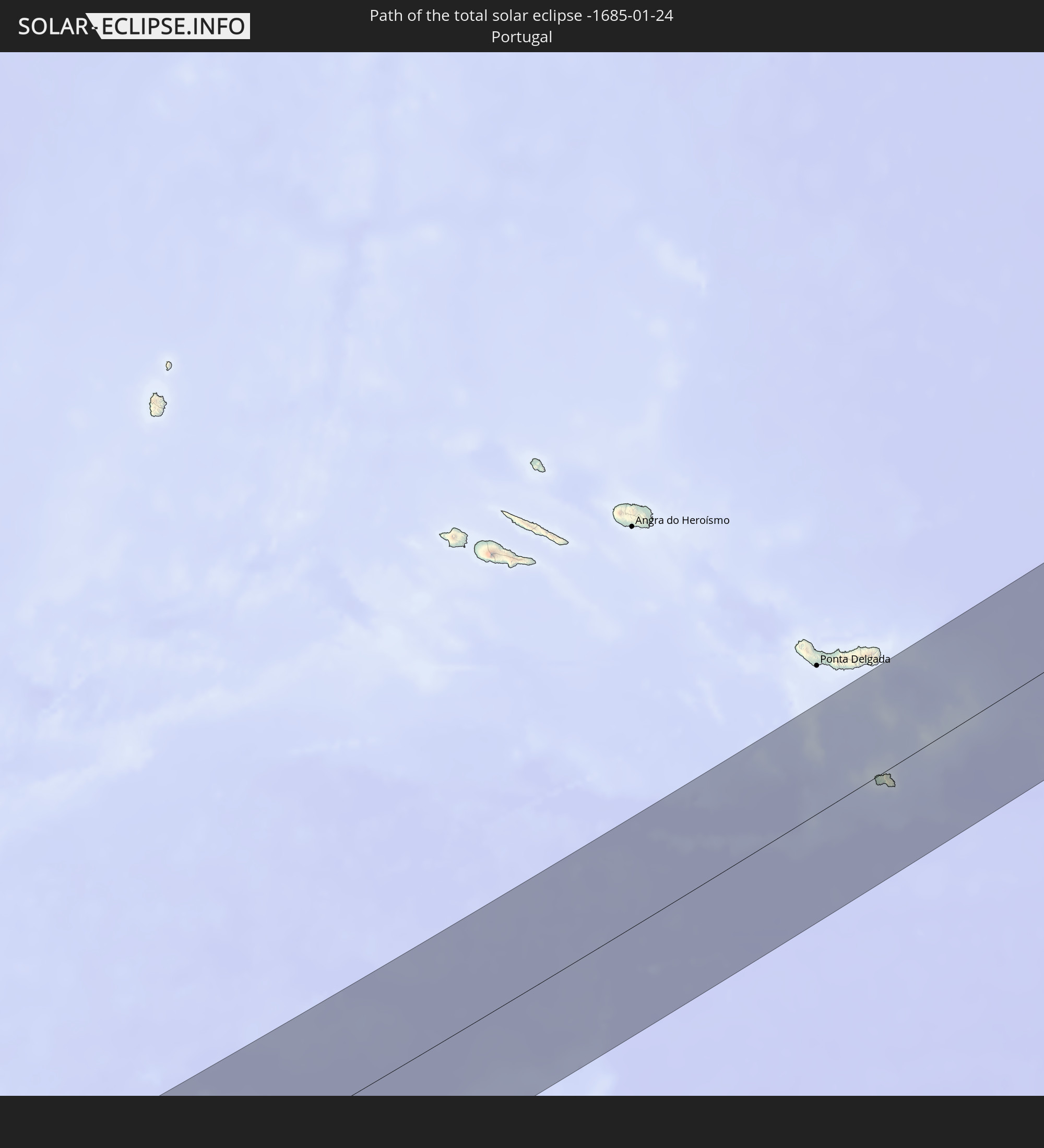
 Portugal
Orte im Finsternispfad
Die nachfolgene Tabelle zeigt Städte und Orte mit mehr als 5.000 Einwohnern, die sich im Finsternispfad befinden. Städte mit mehr als 100.000 Einwohnern sind dick gekennzeichnet. Mit einem Klick auf den Ort öffnet sich eine Detailkarte die die Lage des jeweiligen Ortes zusammen mit dem Verlauf der zentralen Finsternis präsentiert.
| Ort | Typ | Dauer der Verfinsterung | Ortszeit bei maximaler Verfinsterung | Entfernung zur Zentrallinie | Ø Bewölkung |
|
North Platte, Nebraska
|
total | - | 08:33:35 UTC-06:00 | 3 km | 58% |
|
Lexington, Nebraska
|
total | - | 08:33:48 UTC-06:00 | 8 km | 64% |
|
Kearney, Nebraska
|
total | - | 08:34:08 UTC-06:00 | 29 km | 66% |
|
Hastings, Nebraska
|
total | - | 08:34:28 UTC-06:00 | 48 km | 68% |
|
Junction City, Kansas
|
total | - | 08:33:49 UTC-06:00 | 34 km | 65% |
|
Fort Riley North, Kansas
|
total | - | 08:33:55 UTC-06:00 | 26 km | 68% |
|
Manhattan, Kansas
|
total | - | 08:34:11 UTC-06:00 | 8 km | 68% |
|
Topeka, Kansas
|
total | - | 08:34:43 UTC-06:00 | 17 km | 74% |
|
Ottawa, Kansas
|
total | - | 08:34:34 UTC-06:00 | 6 km | 70% |
|
Lawrence, Kansas
|
total | - | 08:34:59 UTC-06:00 | 29 km | 74% |
|
Eudora, Kansas
|
total | - | 08:35:04 UTC-06:00 | 32 km | 74% |
|
Gardner, Kansas
|
total | - | 08:35:03 UTC-06:00 | 27 km | 76% |
|
Bonner Springs, Kansas
|
total | - | 08:35:22 UTC-06:00 | 53 km | 75% |
|
Olathe, Kansas
|
total | - | 08:35:13 UTC-06:00 | 39 km | 76% |
|
Fort Scott, Kansas
|
total | - | 08:34:11 UTC-06:00 | 57 km | 66% |
|
Merriam, Kansas
|
total | - | 08:35:29 UTC-06:00 | 58 km | 76% |
|
Overland Park, Kansas
|
total | - | 08:35:27 UTC-06:00 | 55 km | 76% |
|
Mission, Kansas
|
total | - | 08:35:31 UTC-06:00 | 60 km | 76% |
|
Prairie Village, Kansas
|
total | - | 08:35:29 UTC-06:00 | 57 km | 74% |
|
Roeland Park, Kansas
|
total | - | 08:35:33 UTC-06:00 | 62 km | 74% |
|
Leawood, Kansas
|
total | - | 08:35:29 UTC-06:00 | 56 km | 74% |
|
Grandview, Missouri
|
total | - | 08:35:28 UTC-06:00 | 51 km | 74% |
|
Belton, Missouri
|
total | - | 08:35:23 UTC-06:00 | 44 km | 74% |
|
Raymore, Missouri
|
total | - | 08:35:26 UTC-06:00 | 47 km | 74% |
|
Lee's Summit, Missouri
|
total | - | 08:35:37 UTC-06:00 | 60 km | 75% |
|
Nevada, Missouri
|
total | - | 08:34:29 UTC-06:00 | 42 km | 71% |
|
Harrisonville, Missouri
|
total | - | 08:35:22 UTC-06:00 | 37 km | 72% |
|
Pleasant Hill, Missouri
|
total | - | 08:35:34 UTC-06:00 | 53 km | 73% |
|
Clinton, Missouri
|
total | - | 08:35:32 UTC-06:00 | 34 km | 72% |
|
Bolivar, Missouri
|
total | - | 08:35:03 UTC-06:00 | 23 km | 77% |
|
Springfield, Missouri
|
total | - | 08:34:44 UTC-06:00 | 57 km | 71% |
|
Marshfield, Missouri
|
total | - | 08:35:13 UTC-06:00 | 28 km | 70% |
|
Lebanon, Missouri
|
total | - | 08:35:47 UTC-06:00 | 16 km | 71% |
|
Saint John, Missouri
|
total | - | 08:36:16 UTC-06:00 | 49 km | 66% |
|
Fort Leonard Wood, Missouri
|
total | - | 08:36:17 UTC-06:00 | 41 km | 60% |
|
West Plains, Missouri
|
total | - | 08:35:34 UTC-06:00 | 41 km | 65% |
|
Pocahontas, Arkansas
|
total | - | 08:35:56 UTC-06:00 | 48 km | 65% |
|
Paragould, Arkansas
|
total | - | 08:36:12 UTC-06:00 | 48 km | 69% |
|
Poplar Bluff, Missouri
|
total | - | 08:37:01 UTC-06:00 | 25 km | 68% |
|
Kennett, Missouri
|
total | - | 08:36:50 UTC-06:00 | 11 km | 66% |
|
Osceola, Arkansas
|
total | - | 08:36:24 UTC-06:00 | 59 km | 72% |
|
Dexter, Missouri
|
total | - | 08:37:30 UTC-06:00 | 48 km | 74% |
|
Blytheville, Arkansas
|
total | - | 08:36:40 UTC-06:00 | 36 km | 72% |
|
Caruthersville, Missouri
|
total | - | 08:37:12 UTC-06:00 | 2 km | 69% |
|
Covington, Tennessee
|
total | - | 08:36:36 UTC-06:00 | 59 km | 74% |
|
Ripley, Tennessee
|
total | - | 08:36:54 UTC-06:00 | 36 km | 72% |
|
Dyersburg, Tennessee
|
total | - | 08:37:20 UTC-06:00 | 2 km | 73% |
|
Brownsville, Tennessee
|
total | - | 08:37:02 UTC-06:00 | 40 km | 70% |
|
Union City, Tennessee
|
total | - | 08:38:04 UTC-06:00 | 50 km | 75% |
|
Humboldt, Tennessee
|
total | - | 08:37:37 UTC-06:00 | 3 km | 74% |
|
Martin, Tennessee
|
total | - | 08:38:12 UTC-06:00 | 51 km | 75% |
|
Jackson, Tennessee
|
total | - | 08:37:32 UTC-06:00 | 18 km | 68% |
|
Milan, Tennessee
|
total | - | 08:37:53 UTC-06:00 | 14 km | 74% |
|
Henderson, Tennessee
|
total | - | 08:37:33 UTC-06:00 | 28 km | 67% |
|
Lexington, Tennessee
|
total | - | 08:38:02 UTC-06:00 | 3 km | 72% |
|
Savannah, Tennessee
|
total | - | 08:37:47 UTC-06:00 | 32 km | 65% |
|
Tuscumbia, Alabama
|
total | - | 08:37:56 UTC-06:00 | 57 km | 66% |
|
Sheffield, Alabama
|
total | - | 08:37:58 UTC-06:00 | 54 km | 67% |
|
Florence, Alabama
|
total | - | 08:38:01 UTC-06:00 | 50 km | 67% |
|
Muscle Shoals, Alabama
|
total | - | 08:37:59 UTC-06:00 | 55 km | 66% |
|
East Florence, Alabama
|
total | - | 08:38:04 UTC-06:00 | 47 km | 69% |
|
Lawrenceburg, Tennessee
|
total | - | 08:38:50 UTC-06:00 | 9 km | 73% |
|
Danville, Alabama
|
total | - | 08:38:21 UTC-06:00 | 62 km | 64% |
|
Columbia, Tennessee
|
total | - | 08:39:32 UTC-06:00 | 58 km | 71% |
|
Pulaski, Tennessee
|
total | - | 08:39:09 UTC-06:00 | 17 km | 71% |
|
Decatur, Alabama
|
total | - | 08:38:39 UTC-06:00 | 39 km | 67% |
|
Athens, Alabama
|
total | - | 08:38:50 UTC-06:00 | 19 km | 71% |
|
Hartselle, Alabama
|
total | - | 08:38:33 UTC-06:00 | 53 km | 64% |
|
Lewisburg, Tennessee
|
total | - | 08:39:40 UTC-06:00 | 52 km | 70% |
|
Madison, Alabama
|
total | - | 08:39:00 UTC-06:00 | 20 km | 67% |
|
Huntsville, Alabama
|
total | - | 08:39:14 UTC-06:00 | 10 km | 67% |
|
Meridianville, Alabama
|
total | - | 08:39:21 UTC-06:00 | 3 km | 71% |
|
Fayetteville, Tennessee
|
total | - | 08:39:38 UTC-06:00 | 32 km | 69% |
|
Arab, Alabama
|
total | - | 08:38:57 UTC-06:00 | 46 km | 65% |
|
Lynchburg, Tennessee
|
total | - | 08:40:00 UTC-06:00 | 54 km | 69% |
|
Guntersville, Alabama
|
total | - | 08:39:14 UTC-06:00 | 34 km | 63% |
|
Tullahoma, Tennessee
|
total | - | 08:40:16 UTC-06:00 | 69 km | 70% |
|
Albertville, Alabama
|
total | - | 08:39:15 UTC-06:00 | 39 km | 65% |
|
Boaz, Alabama
|
total | - | 08:39:15 UTC-06:00 | 44 km | 64% |
|
Winchester, Tennessee
|
total | - | 08:40:13 UTC-06:00 | 55 km | 72% |
|
Attalla, Alabama
|
total | - | 08:39:11 UTC-06:00 | 58 km | 59% |
|
Rainbow City, Alabama
|
total | - | 08:39:11 UTC-06:00 | 63 km | 58% |
|
Scottsboro, Alabama
|
total | - | 08:39:50 UTC-06:00 | 8 km | 64% |
|
Southside, Alabama
|
total | - | 08:39:10 UTC-06:00 | 65 km | 58% |
|
Gadsden, Alabama
|
total | - | 08:39:16 UTC-06:00 | 56 km | 58% |
|
Jacksonville, Alabama
|
total | - | 08:39:24 UTC-06:00 | 65 km | 58% |
|
Fort Payne, Alabama
|
total | - | 08:40:01 UTC-06:00 | 1 km | 63% |
|
Fairview, Georgia
|
total | - | 09:41:01 UTC-05:00 | 67 km | 62% |
|
LaFayette, Georgia
|
total | - | 09:40:48 UTC-05:00 | 43 km | 61% |
|
Fort Oglethorpe, Georgia
|
total | - | 09:41:04 UTC-05:00 | 68 km | 62% |
|
Cedartown, Georgia
|
total | - | 09:40:15 UTC-05:00 | 20 km | 60% |
|
Rome, Georgia
|
total | - | 09:40:33 UTC-05:00 | 4 km | 61% |
|
Bremen, Georgia
|
total | - | 09:40:05 UTC-05:00 | 48 km | 60% |
|
Carrollton, Georgia
|
total | - | 09:40:03 UTC-05:00 | 59 km | 63% |
|
Dalton, Georgia
|
total | - | 09:41:15 UTC-05:00 | 63 km | 63% |
|
Calhoun, Georgia
|
total | - | 09:41:02 UTC-05:00 | 37 km | 63% |
|
Villa Rica, Georgia
|
total | - | 09:40:23 UTC-05:00 | 38 km | 62% |
|
Dallas, Georgia
|
total | - | 09:40:39 UTC-05:00 | 15 km | 61% |
|
Cartersville, Georgia
|
total | - | 09:40:55 UTC-05:00 | 10 km | 61% |
|
Newnan, Georgia
|
total | - | 09:40:14 UTC-05:00 | 67 km | 58% |
|
Douglasville, Georgia
|
total | - | 09:40:37 UTC-05:00 | 28 km | 62% |
|
Powder Springs, Georgia
|
total | - | 09:40:48 UTC-05:00 | 15 km | 63% |
|
Acworth, Georgia
|
total | - | 09:41:00 UTC-05:00 | 6 km | 62% |
|
Lithia Springs, Georgia
|
total | - | 09:40:46 UTC-05:00 | 21 km | 62% |
|
Austell, Georgia
|
total | - | 09:40:49 UTC-05:00 | 18 km | 63% |
|
Kennesaw, Georgia
|
total | - | 09:41:02 UTC-05:00 | 4 km | 61% |
|
Tyrone, Georgia
|
total | - | 09:40:34 UTC-05:00 | 50 km | 60% |
|
Peachtree City, Georgia
|
total | - | 09:40:30 UTC-05:00 | 57 km | 58% |
|
Mableton, Georgia
|
total | - | 09:40:54 UTC-05:00 | 15 km | 63% |
|
Fairburn, Georgia
|
total | - | 09:40:40 UTC-05:00 | 40 km | 62% |
|
Marietta, Georgia
|
total | - | 09:41:03 UTC-05:00 | 0 km | 61% |
|
Fair Oaks, Georgia
|
total | - | 09:41:02 UTC-05:00 | 4 km | 62% |
|
Union City, Georgia
|
total | - | 09:40:45 UTC-05:00 | 36 km | 62% |
|
Woodstock, Georgia
|
total | - | 09:41:14 UTC-05:00 | 16 km | 60% |
|
Holly Springs, Georgia
|
total | - | 09:41:19 UTC-05:00 | 24 km | 61% |
|
Canton, Georgia
|
total | - | 09:41:23 UTC-05:00 | 30 km | 61% |
|
Vinings, Georgia
|
total | - | 09:41:05 UTC-05:00 | 5 km | 62% |
|
Fayetteville, Georgia
|
total | - | 09:40:44 UTC-05:00 | 46 km | 59% |
|
College Park, Georgia
|
total | - | 09:40:55 UTC-05:00 | 26 km | 64% |
|
East Point, Georgia
|
total | - | 09:40:58 UTC-05:00 | 23 km | 64% |
|
Riverdale, Georgia
|
total | - | 09:40:54 UTC-05:00 | 32 km | 62% |
|
Hapeville, Georgia
|
total | - | 09:40:59 UTC-05:00 | 23 km | 64% |
|
Atlanta, Georgia
|
total | - | 09:41:05 UTC-05:00 | 14 km | 64% |
|
Sandy Springs, Georgia
|
total | - | 09:41:15 UTC-05:00 | 4 km | 61% |
|
Forest Park, Georgia
|
total | - | 09:41:00 UTC-05:00 | 25 km | 62% |
|
Irondale, Georgia
|
total | - | 09:40:53 UTC-05:00 | 39 km | 60% |
|
Morrow, Georgia
|
total | - | 09:41:00 UTC-05:00 | 28 km | 61% |
|
Druid Hills, Georgia
|
total | - | 09:41:11 UTC-05:00 | 8 km | 61% |
|
Conley, Georgia
|
total | - | 09:41:05 UTC-05:00 | 21 km | 61% |
|
Lovejoy, Georgia
|
total | - | 09:40:55 UTC-05:00 | 41 km | 62% |
|
Gresham Park, Georgia
|
total | - | 09:41:09 UTC-05:00 | 15 km | 62% |
|
North Druid Hills, Georgia
|
total | - | 09:41:15 UTC-05:00 | 4 km | 61% |
|
North Decatur, Georgia
|
total | - | 09:41:14 UTC-05:00 | 6 km | 61% |
|
Milton, Georgia
|
total | - | 09:41:33 UTC-05:00 | 28 km | 61% |
|
Chamblee, Georgia
|
total | - | 09:41:20 UTC-05:00 | 4 km | 60% |
|
Decatur, Georgia
|
total | - | 09:41:14 UTC-05:00 | 7 km | 61% |
|
Doraville, Georgia
|
total | - | 09:41:21 UTC-05:00 | 6 km | 60% |
|
Hampton, Georgia
|
total | - | 09:40:54 UTC-05:00 | 45 km | 62% |
|
Candler-McAfee, Georgia
|
total | - | 09:41:13 UTC-05:00 | 11 km | 62% |
|
Panthersville, Georgia
|
total | - | 09:41:12 UTC-05:00 | 13 km | 62% |
|
Belvedere Park, Georgia
|
total | - | 09:41:15 UTC-05:00 | 8 km | 61% |
|
Scottdale, Georgia
|
total | - | 09:41:17 UTC-05:00 | 4 km | 61% |
|
Griffin, Georgia
|
total | - | 09:40:49 UTC-05:00 | 58 km | 59% |
|
Clarkston, Georgia
|
total | - | 09:41:20 UTC-05:00 | 1 km | 60% |
|
Stockbridge, Georgia
|
total | - | 09:41:07 UTC-05:00 | 27 km | 62% |
|
Tucker, Georgia
|
total | - | 09:41:24 UTC-05:00 | 4 km | 61% |
|
Norcross, Georgia
|
total | - | 09:41:29 UTC-05:00 | 13 km | 61% |
|
Johns Creek, Georgia
|
total | - | 09:41:35 UTC-05:00 | 22 km | 61% |
|
Stone Mountain, Georgia
|
total | - | 09:41:26 UTC-05:00 | 2 km | 60% |
|
McDonough, Georgia
|
total | - | 09:41:08 UTC-05:00 | 33 km | 60% |
|
Duluth, Georgia
|
total | - | 09:41:38 UTC-05:00 | 22 km | 62% |
|
Lilburn, Georgia
|
total | - | 09:41:32 UTC-05:00 | 11 km | 61% |
|
Redan, Georgia
|
total | - | 09:41:25 UTC-05:00 | 3 km | 61% |
|
Mountain Park, Georgia
|
total | - | 09:41:31 UTC-05:00 | 7 km | 60% |
|
Suwanee, Georgia
|
total | - | 09:41:46 UTC-05:00 | 30 km | 61% |
|
Sugar Hill, Georgia
|
total | - | 09:41:52 UTC-05:00 | 37 km | 60% |
|
Snellville, Georgia
|
total | - | 09:41:40 UTC-05:00 | 13 km | 61% |
|
Conyers, Georgia
|
total | - | 09:41:30 UTC-05:00 | 6 km | 61% |
|
Buford, Georgia
|
total | - | 09:41:55 UTC-05:00 | 39 km | 60% |
|
Lawrenceville, Georgia
|
total | - | 09:41:48 UTC-05:00 | 24 km | 61% |
|
Loganville, Georgia
|
total | - | 09:41:49 UTC-05:00 | 16 km | 61% |
|
Covington, Georgia
|
total | - | 09:41:39 UTC-05:00 | 6 km | 61% |
|
Auburn, Georgia
|
total | - | 09:42:04 UTC-05:00 | 36 km | 61% |
|
Gainesville, Georgia
|
total | - | 09:42:19 UTC-05:00 | 65 km | 58% |
|
Braselton, Georgia
|
total | - | 09:42:14 UTC-05:00 | 48 km | 61% |
|
Winder, Georgia
|
total | - | 09:42:11 UTC-05:00 | 39 km | 61% |
|
Monroe, Georgia
|
total | - | 09:42:01 UTC-05:00 | 19 km | 61% |
|
Jefferson, Georgia
|
total | - | 09:42:30 UTC-05:00 | 57 km | 59% |
|
Commerce, Georgia
|
total | - | 09:42:44 UTC-05:00 | 71 km | 59% |
|
Country Club Estates, Georgia
|
total | - | 09:42:36 UTC-05:00 | 51 km | 58% |
|
Eatonton, Georgia
|
total | - | 09:42:03 UTC-05:00 | 14 km | 54% |
|
Athens, Georgia
|
total | - | 09:42:37 UTC-05:00 | 50 km | 58% |
|
Milledgeville, Georgia
|
total | - | 09:42:03 UTC-05:00 | 32 km | 55% |
|
Sandersville, Georgia
|
total | - | 09:42:33 UTC-05:00 | 24 km | 58% |
|
Thomson, Georgia
|
total | - | 09:43:24 UTC-05:00 | 37 km | 53% |
|
Swainsboro, Georgia
|
total | - | 09:42:54 UTC-05:00 | 43 km | 56% |
|
Grovetown, Georgia
|
total | - | 09:43:49 UTC-05:00 | 48 km | 56% |
|
Evans, Georgia
|
total | - | 09:43:59 UTC-05:00 | 59 km | 55% |
|
Martinez, Georgia
|
total | - | 09:44:03 UTC-05:00 | 60 km | 55% |
|
Waynesboro, Georgia
|
total | - | 09:43:46 UTC-05:00 | 20 km | 55% |
|
Augusta, Georgia
|
total | - | 09:44:09 UTC-05:00 | 59 km | 54% |
|
North Augusta, South Carolina
|
total | - | 09:44:12 UTC-05:00 | 63 km | 54% |
|
Belvedere, South Carolina
|
total | - | 09:44:15 UTC-05:00 | 67 km | 53% |
|
Statesboro, Georgia
|
total | - | 09:43:34 UTC-05:00 | 35 km | 57% |
|
Richmond Hill, Georgia
|
total | - | 09:43:52 UTC-05:00 | 67 km | 58% |
|
Pooler, Georgia
|
total | - | 09:44:05 UTC-05:00 | 46 km | 61% |
|
Rincon, Georgia
|
total | - | 09:44:15 UTC-05:00 | 28 km | 57% |
|
Georgetown, Georgia
|
total | - | 09:44:01 UTC-05:00 | 59 km | 61% |
|
Garden City, Georgia
|
total | - | 09:44:13 UTC-05:00 | 43 km | 61% |
|
Savannah, Georgia
|
total | - | 09:44:17 UTC-05:00 | 44 km | 58% |
|
Skidaway Island, Georgia
|
total | - | 09:44:14 UTC-05:00 | 57 km | 61% |
|
Whitemarsh Island, Georgia
|
total | - | 09:44:22 UTC-05:00 | 46 km | 68% |
|
Wilmington Island, Georgia
|
total | - | 09:44:24 UTC-05:00 | 47 km | 68% |
|
Bluffton, South Carolina
|
total | - | 09:44:46 UTC-05:00 | 19 km | 60% |
|
Laurel Bay, South Carolina
|
total | - | 09:45:03 UTC-05:00 | 6 km | 57% |
|
Hilton Head Island, South Carolina
|
total | - | 09:44:55 UTC-05:00 | 16 km | 57% |
|
Burton, South Carolina
|
total | - | 09:45:08 UTC-05:00 | 7 km | 59% |
|
Port Royal, South Carolina
|
total | - | 09:45:08 UTC-05:00 | 3 km | 59% |
|
Beaufort, South Carolina
|
total | - | 09:45:13 UTC-05:00 | 9 km | 59% |
|
Charleston, South Carolina
|
total | - | 09:46:37 UTC-05:00 | 73 km | 58% |