Totale Sonnenfinsternis vom 19.09.-1688
| Wochentag: | Mittwoch |
| Maximale Dauer der Verfinsterung: | 04m53s |
| Maximale Breite des Finsternispfades: | 181 km |
| Saroszyklus: | 17 |
| Bedeckungsgrad: | 100% |
| Magnitude: | 1.0537 |
| Gamma: | -0.2045 |
Wo kann man die Sonnenfinsternis vom 19.09.-1688 sehen?
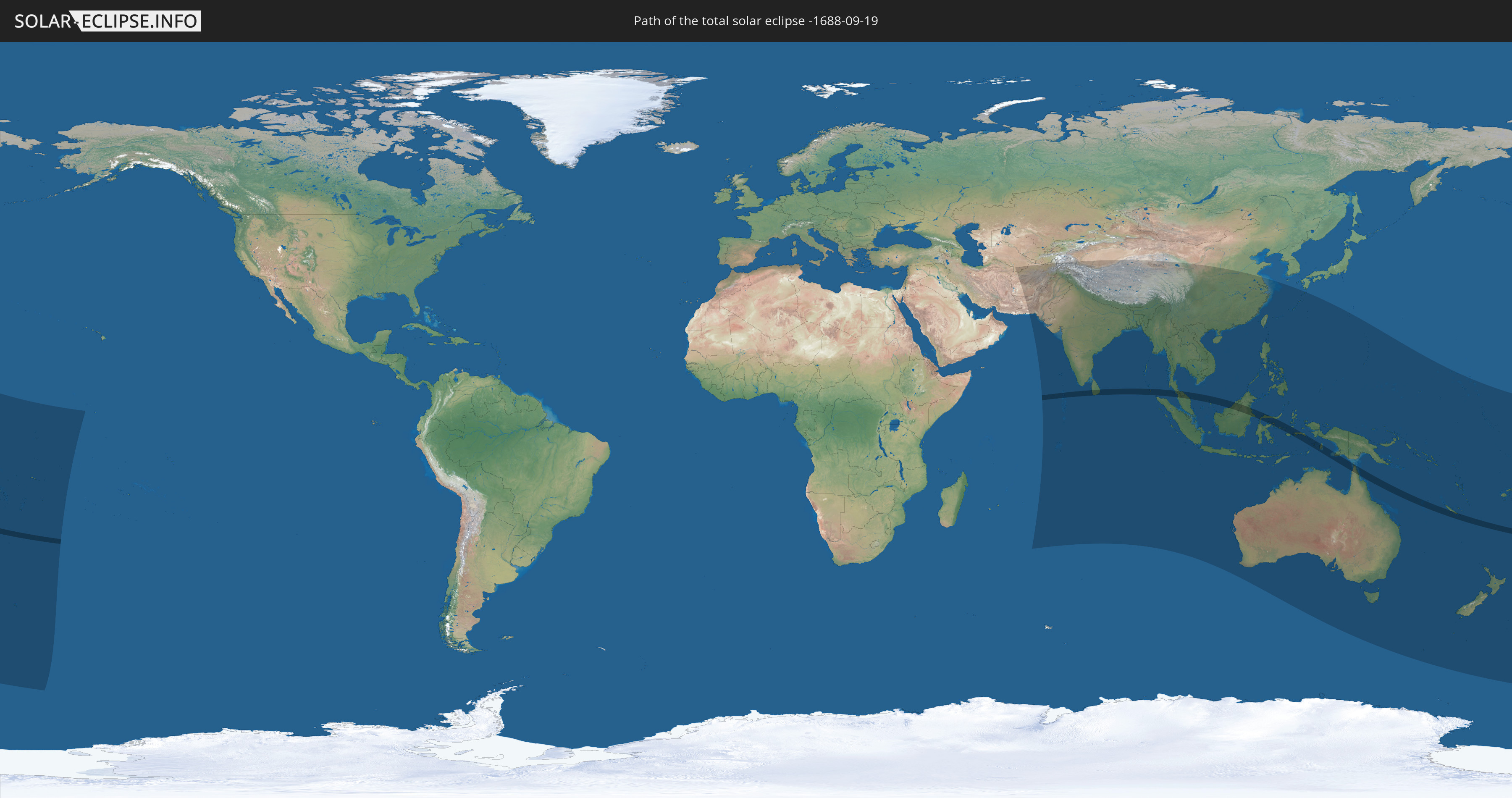
Die Sonnenfinsternis am 19.09.-1688 kann man in 53 Ländern als partielle Sonnenfinsternis beobachten.
Der Finsternispfad verläuft durch 8 Länder. Nur in diesen Ländern ist sie als totale Sonnenfinsternis zu sehen.
In den folgenden Ländern ist die Sonnenfinsternis total zu sehen
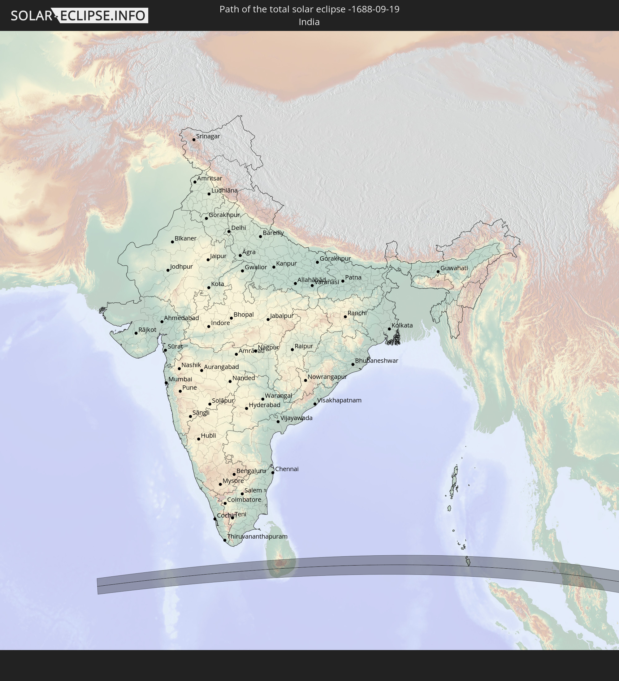 Indien
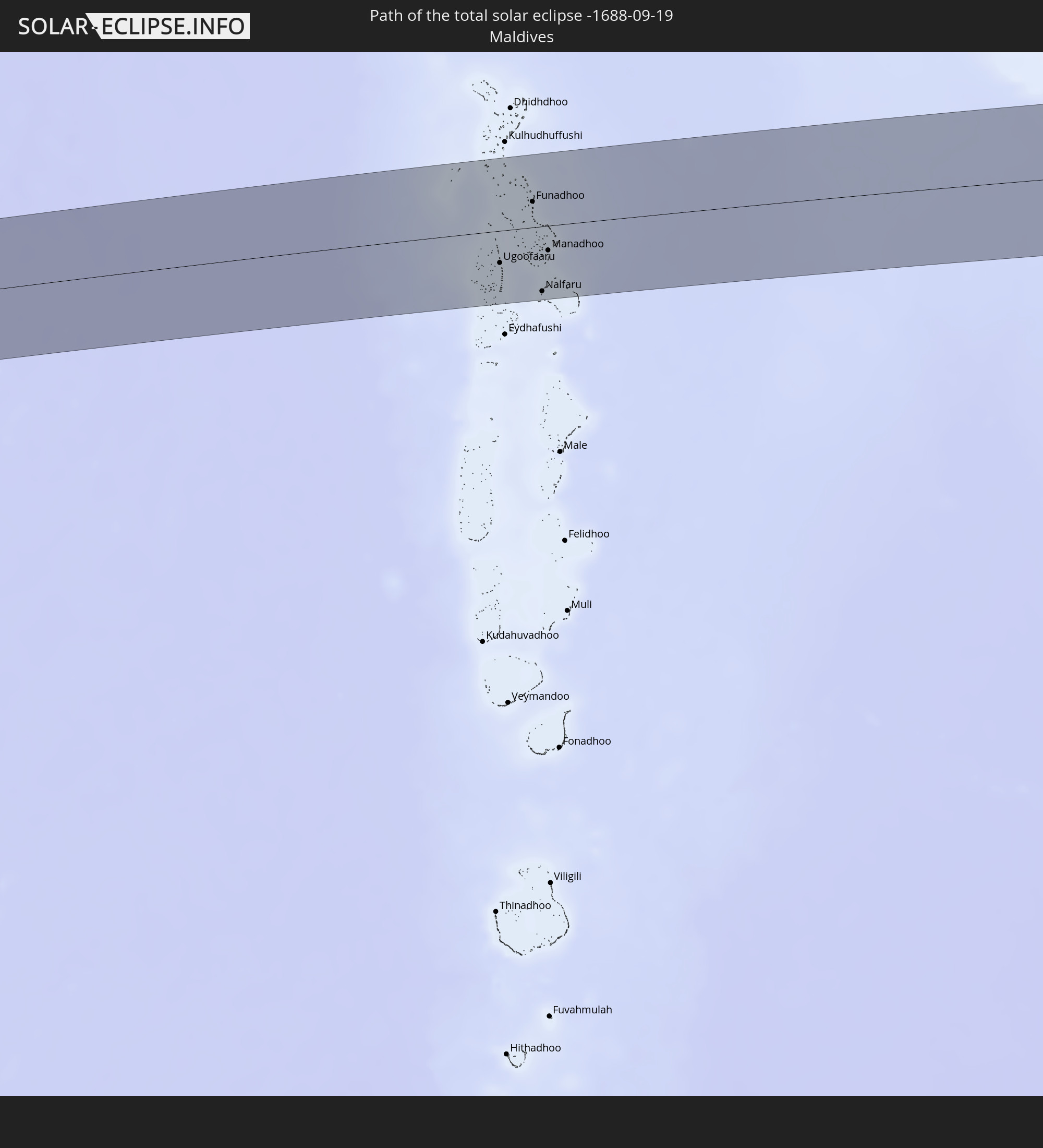 Malediven
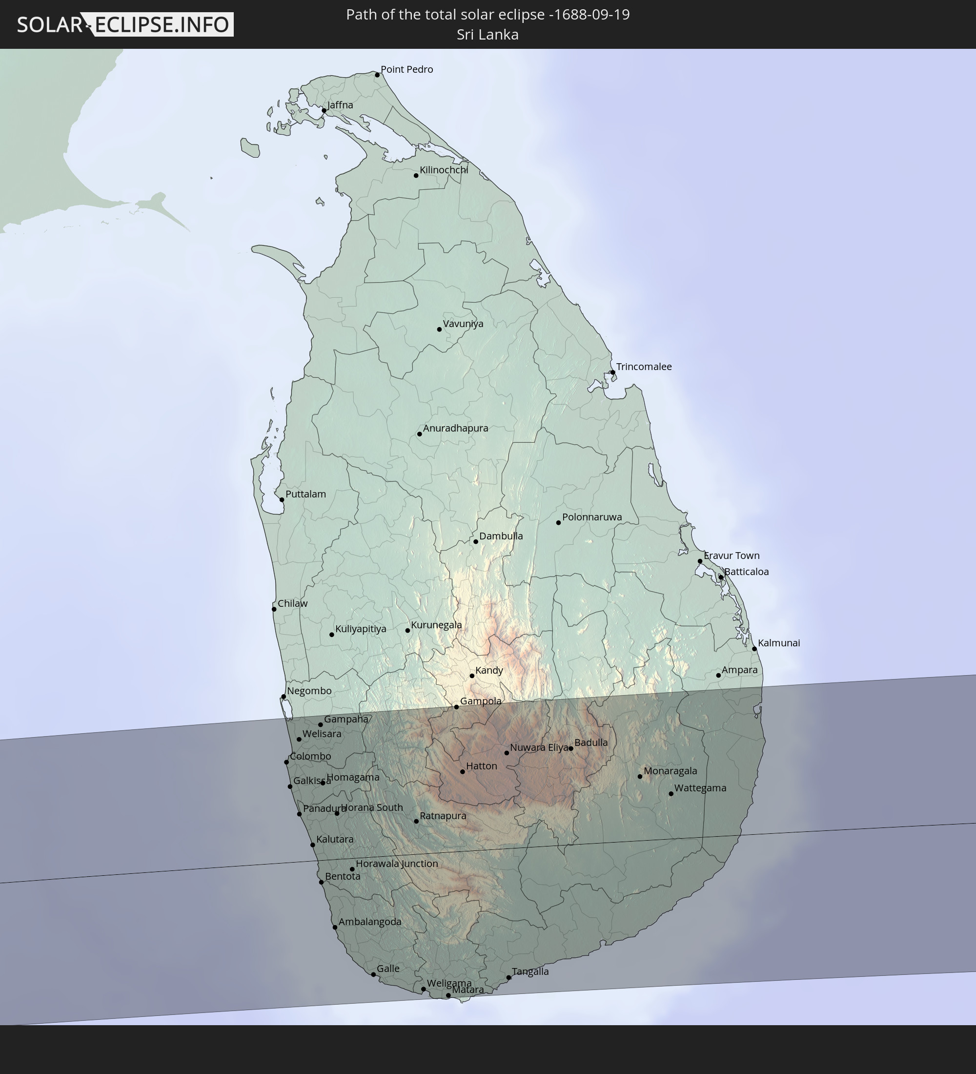 Sri Lanka
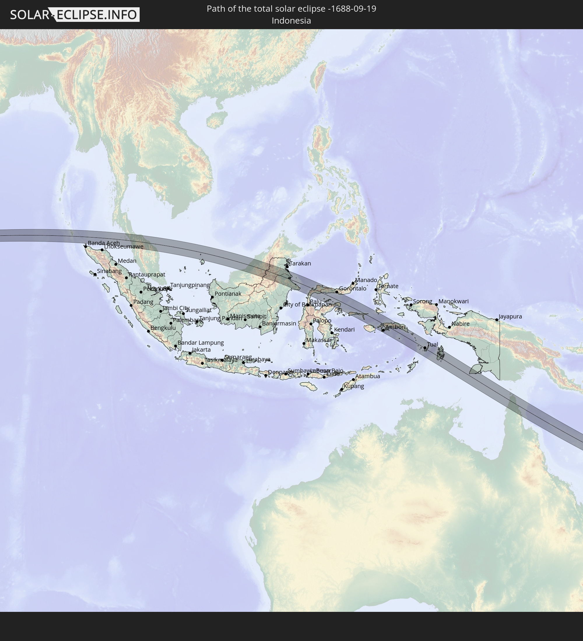 Indonesien
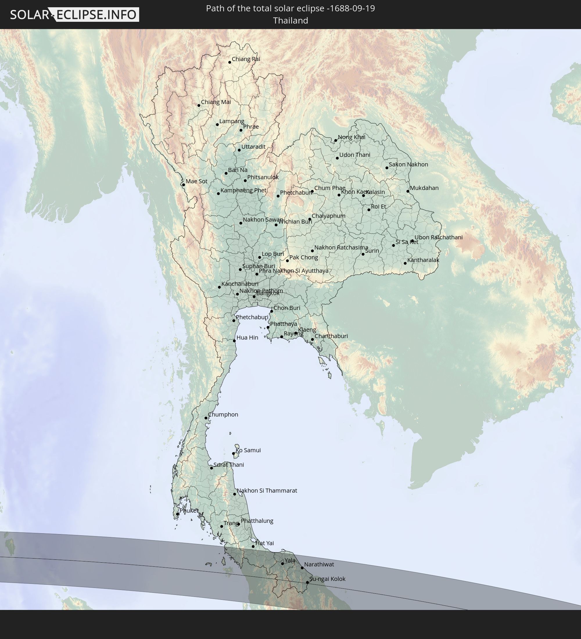 Thailand
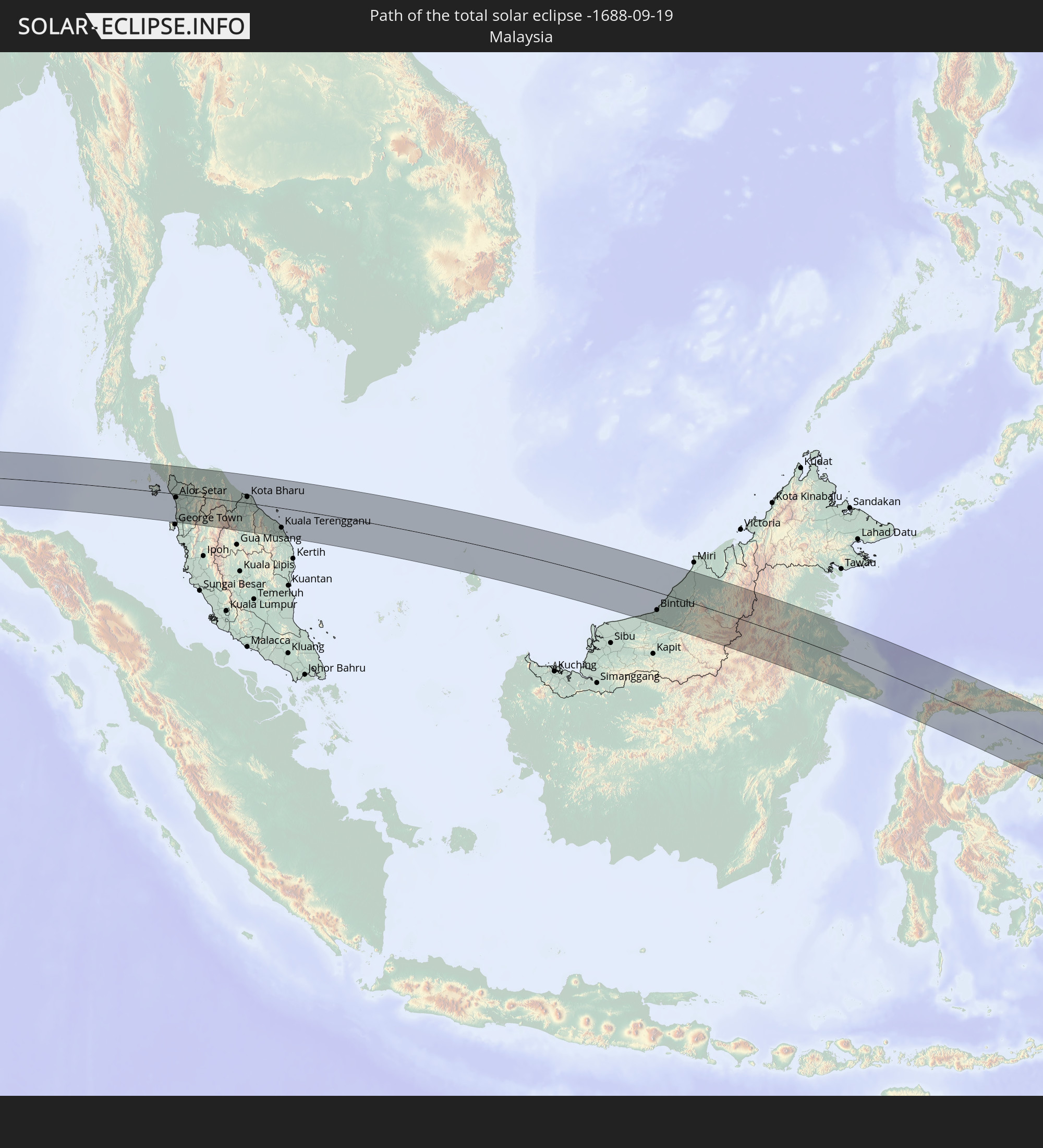 Malaysia
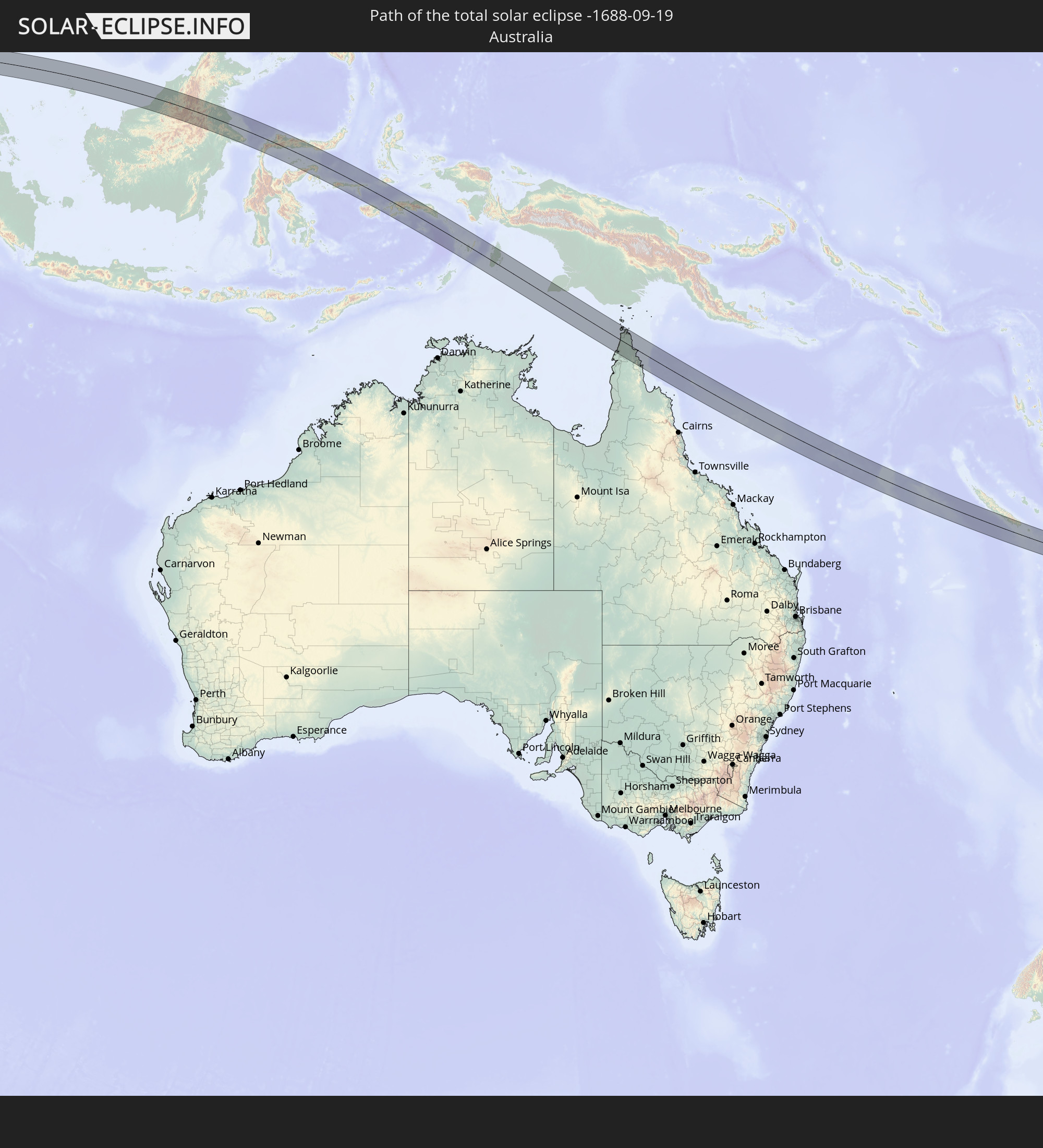 Australien
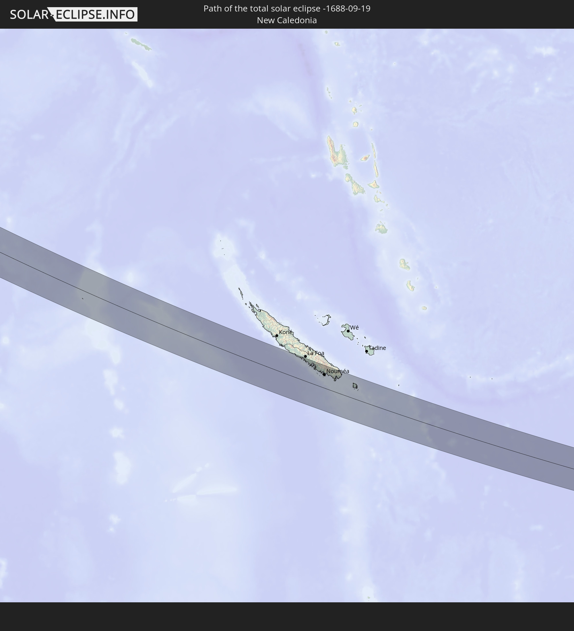 Neukaledonien
In den folgenden Ländern ist die Sonnenfinsternis partiell zu sehen
 Fidschi
 Neuseeland
 United States Minor Outlying Islands
 Wallis und Futuna
 Tonga
Tonga
 Kiribati
 Samoa
Samoa
 Tokelau
 Amerikanisch-Samoa
 Niue
Niue
 Cookinseln
 Turkmenistan
 Afghanistan
 Pakistan
 Tadschikistan
 Indien
 Britisches Territorium im Indischen Ozean
 Malediven
 Volksrepublik China
 Sri Lanka
 Nepal
Nepal
 Bangladesch
 Bhutan
 Myanmar
 Indonesien
 Kokosinseln
 Thailand
 Malaysia
 Laos
Laos
 Vietnam
 Kambodscha
 Singapur
 Weihnachtsinsel
 Australien
 Macau
Macau
 Hongkong
 Brunei
 Taiwan
 Philippinen
 Japan
Japan
 Osttimor
 Palau
Palau
 Föderierte Staaten von Mikronesien
 Papua-Neuguinea
 Guam
Guam
 Nördliche Marianen
 Salomonen
 Neukaledonien
 Marshallinseln
 Vanuatu
 Nauru
Nauru
 Norfolkinsel
 Tuvalu
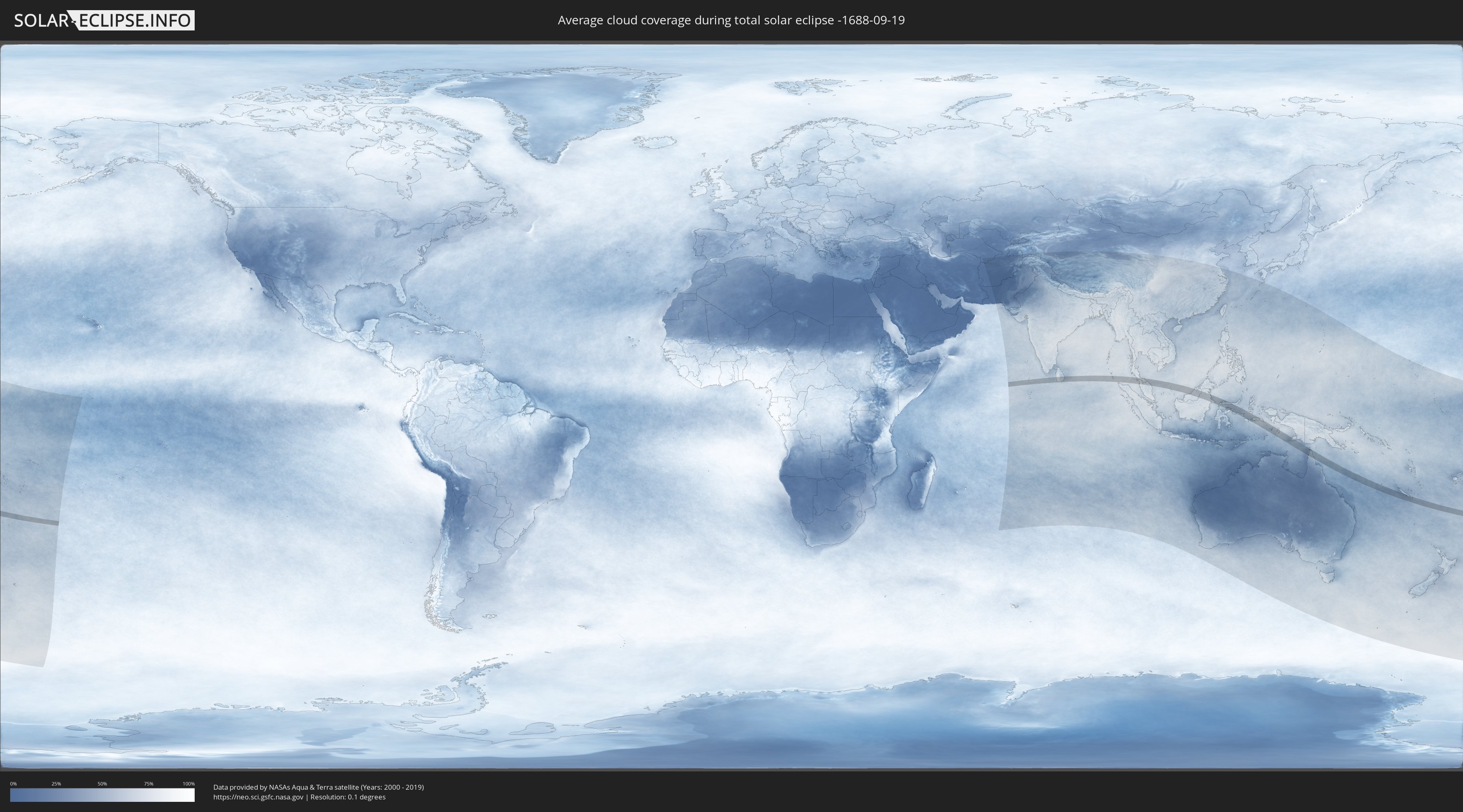
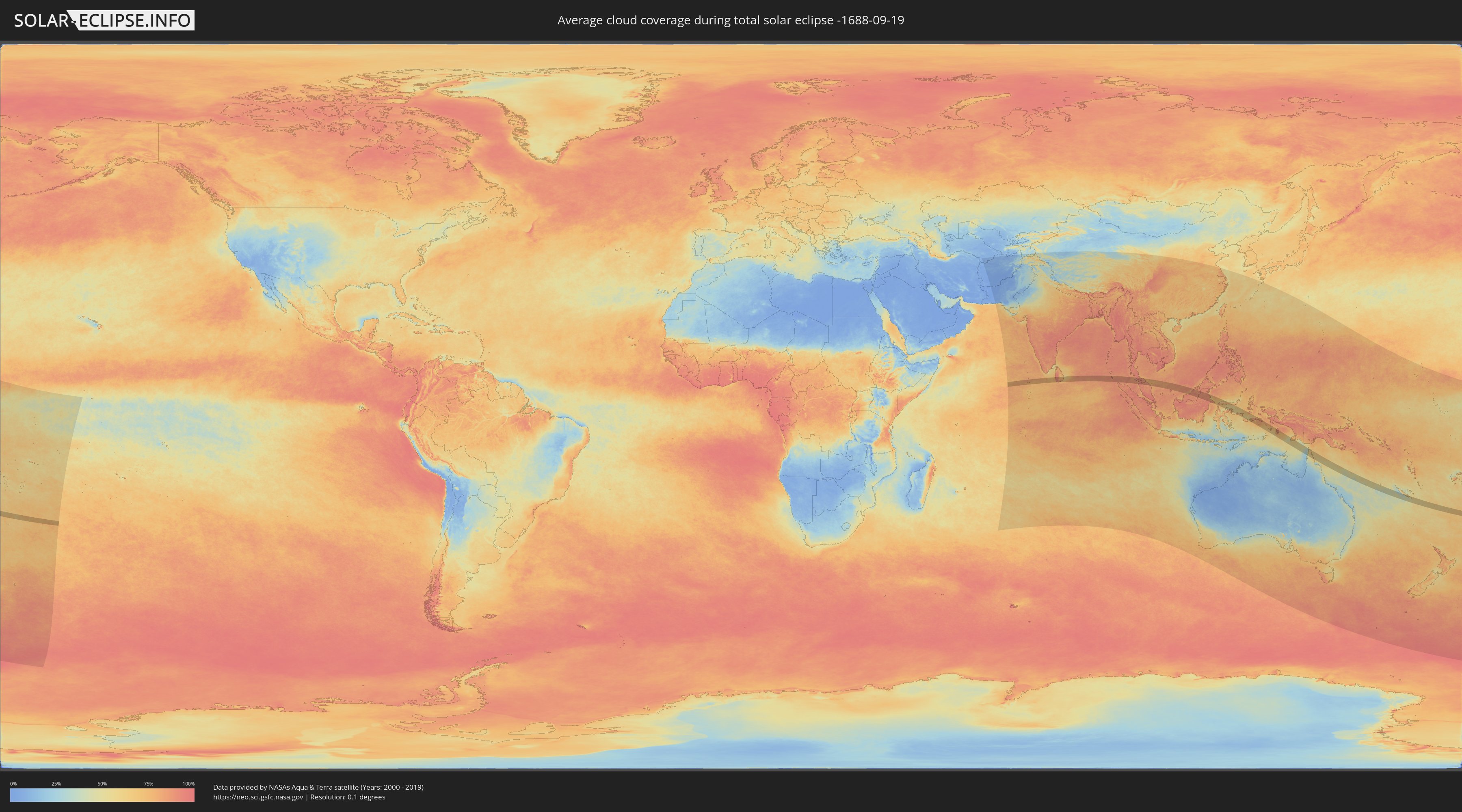
Wie wird das Wetter während der totalen Sonnenfinsternis am 19.09.-1688?
Wo ist der beste Ort, um die totale Sonnenfinsternis vom 19.09.-1688 zu beobachten?
Die folgenden Karten zeigen die durchschnittliche Bewölkung für den Tag, an dem die totale Sonnenfinsternis
stattfindet. Mit Hilfe der Karten lässt sich der Ort entlang des Finsternispfades eingrenzen,
der die besten Aussichen auf einen klaren wolkenfreien Himmel bietet.
Trotzdem muss man immer lokale Gegenenheiten beachten und sollte sich genau über das Wetter an seinem
gewählten Beobachtungsort informieren.
Die Daten stammen von den beiden NASA-Satelliten
AQUA und TERRA
und wurden über einen Zeitraum von 19 Jahren (2000 - 2019) gemittelt.
Detaillierte Länderkarten
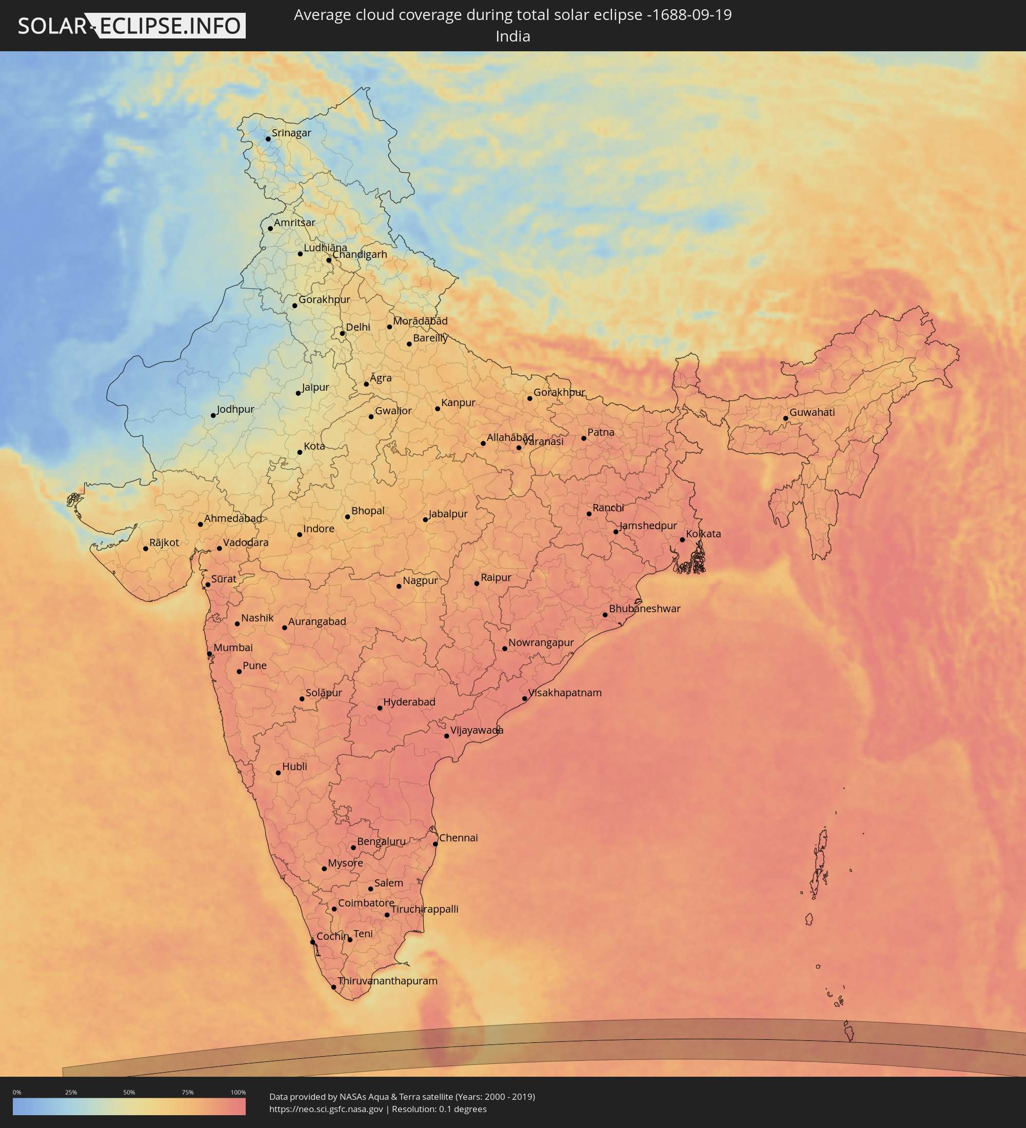 Indien
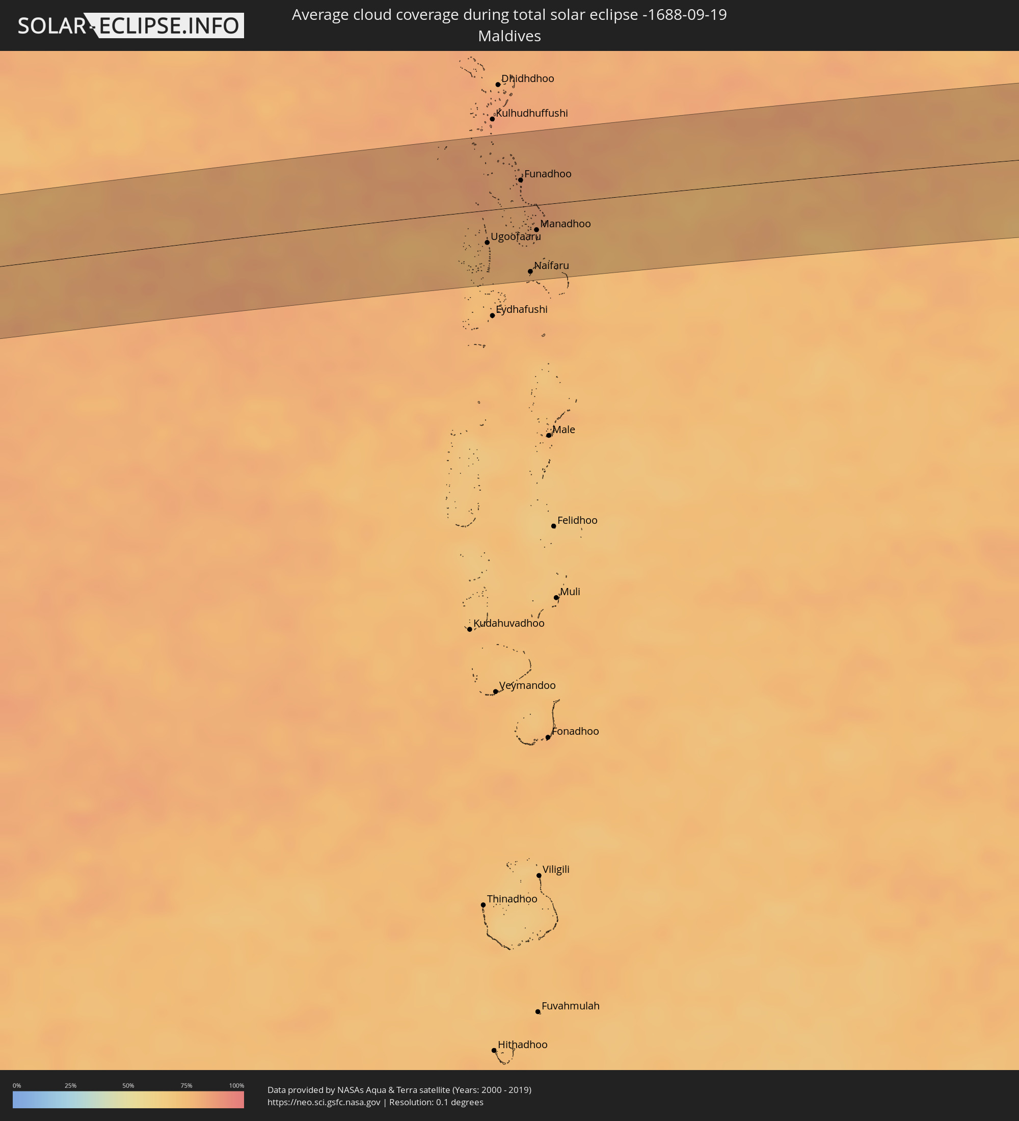 Malediven
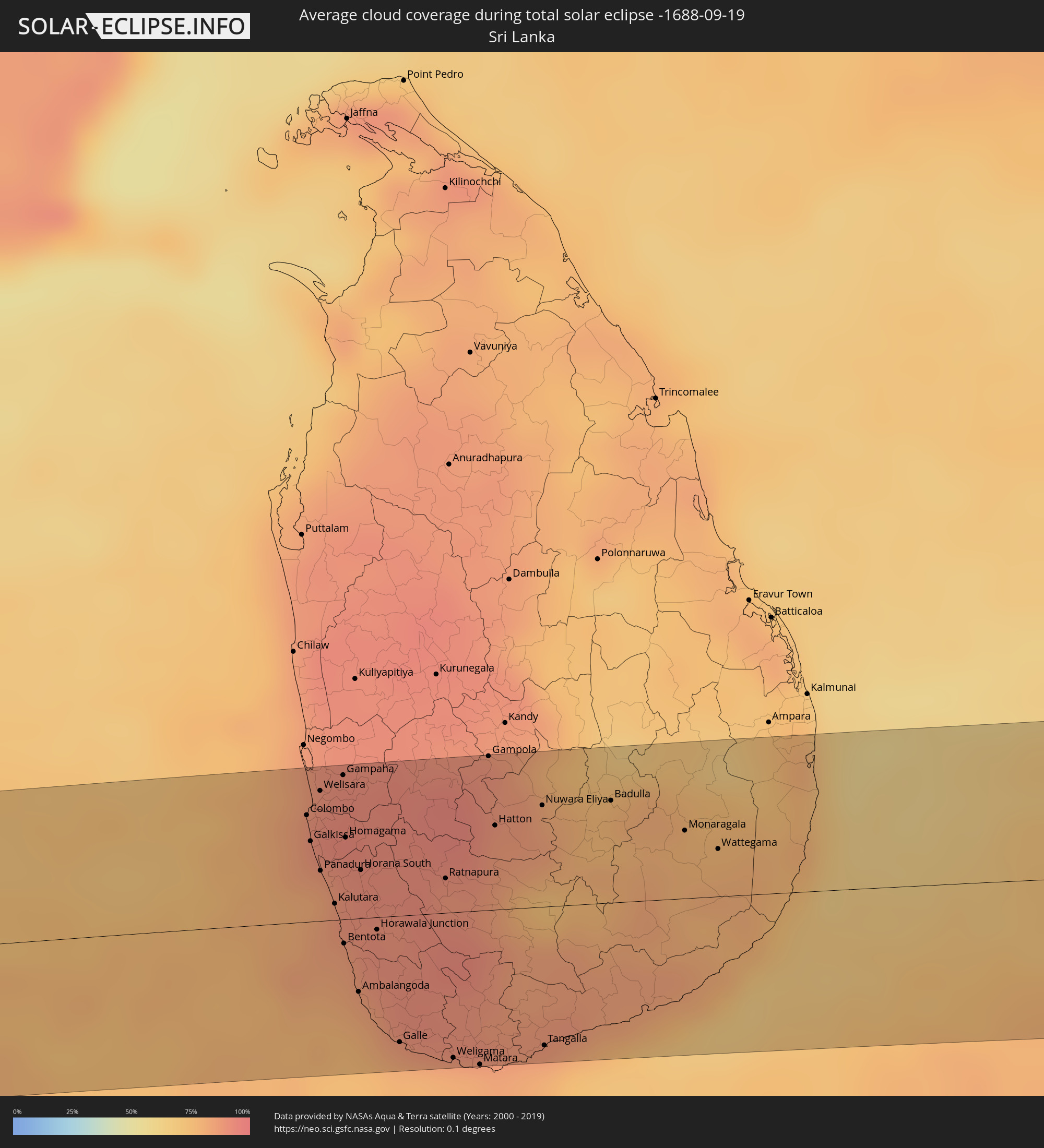 Sri Lanka
 Indonesien
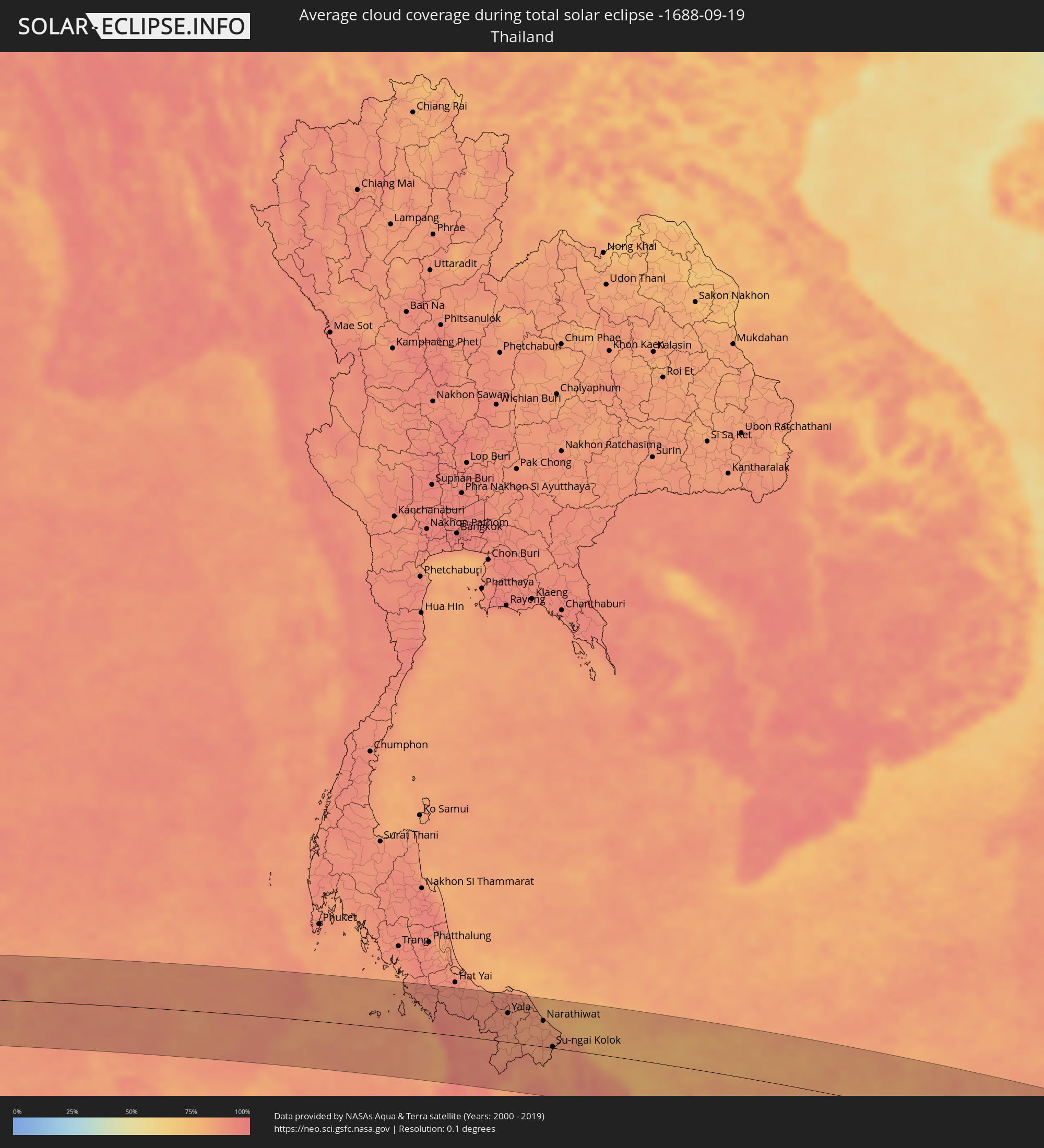 Thailand
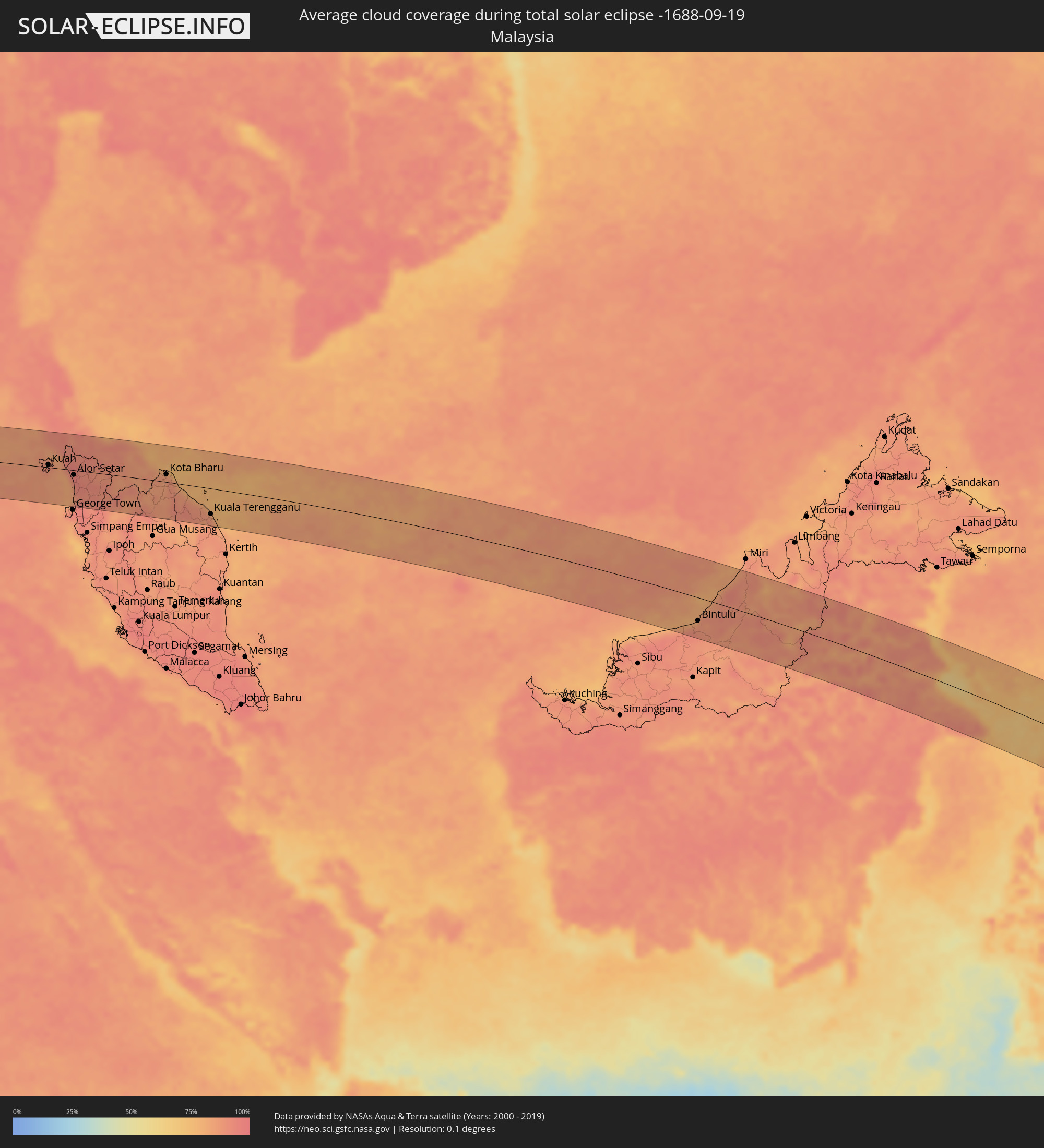 Malaysia
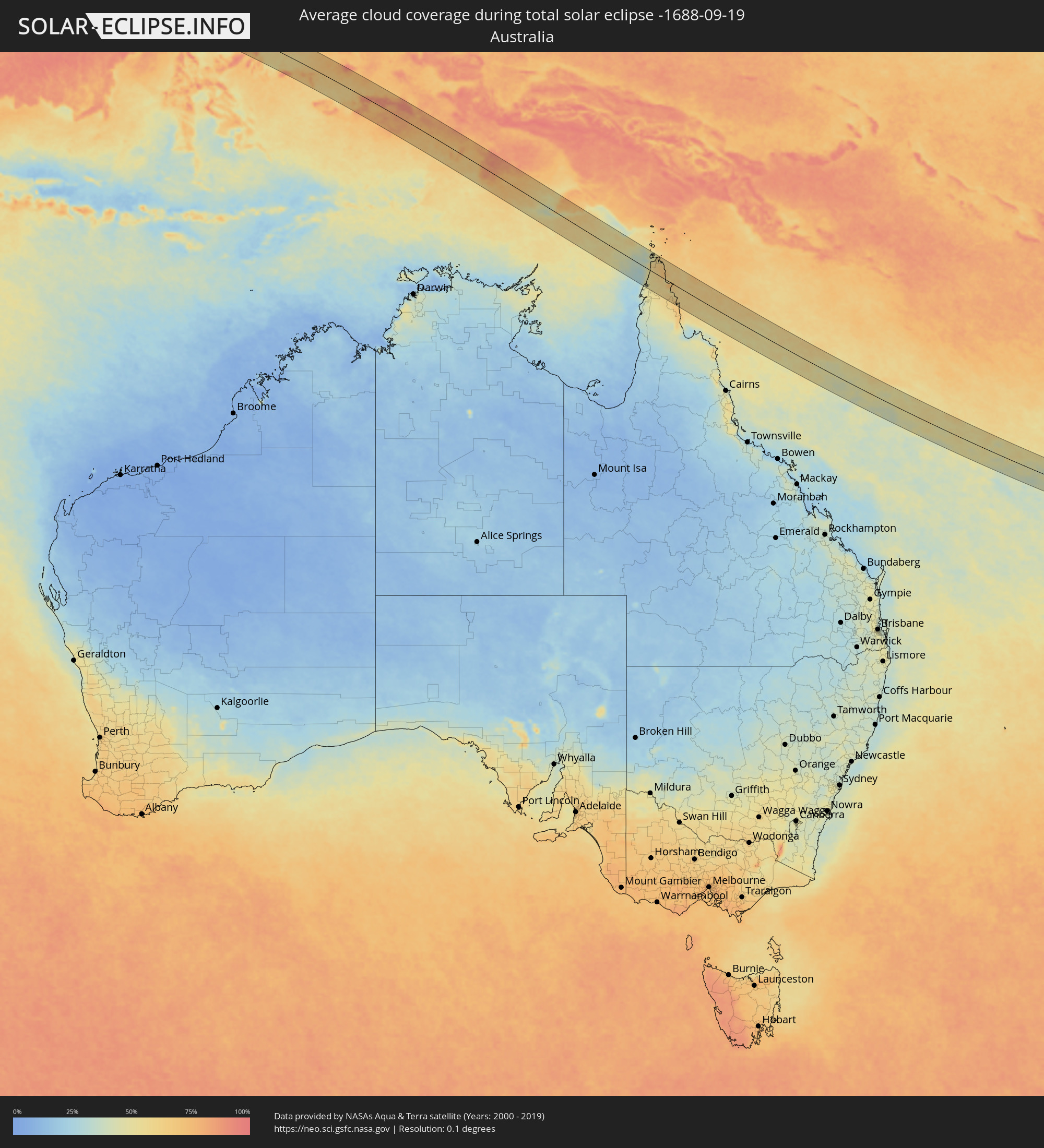 Australien
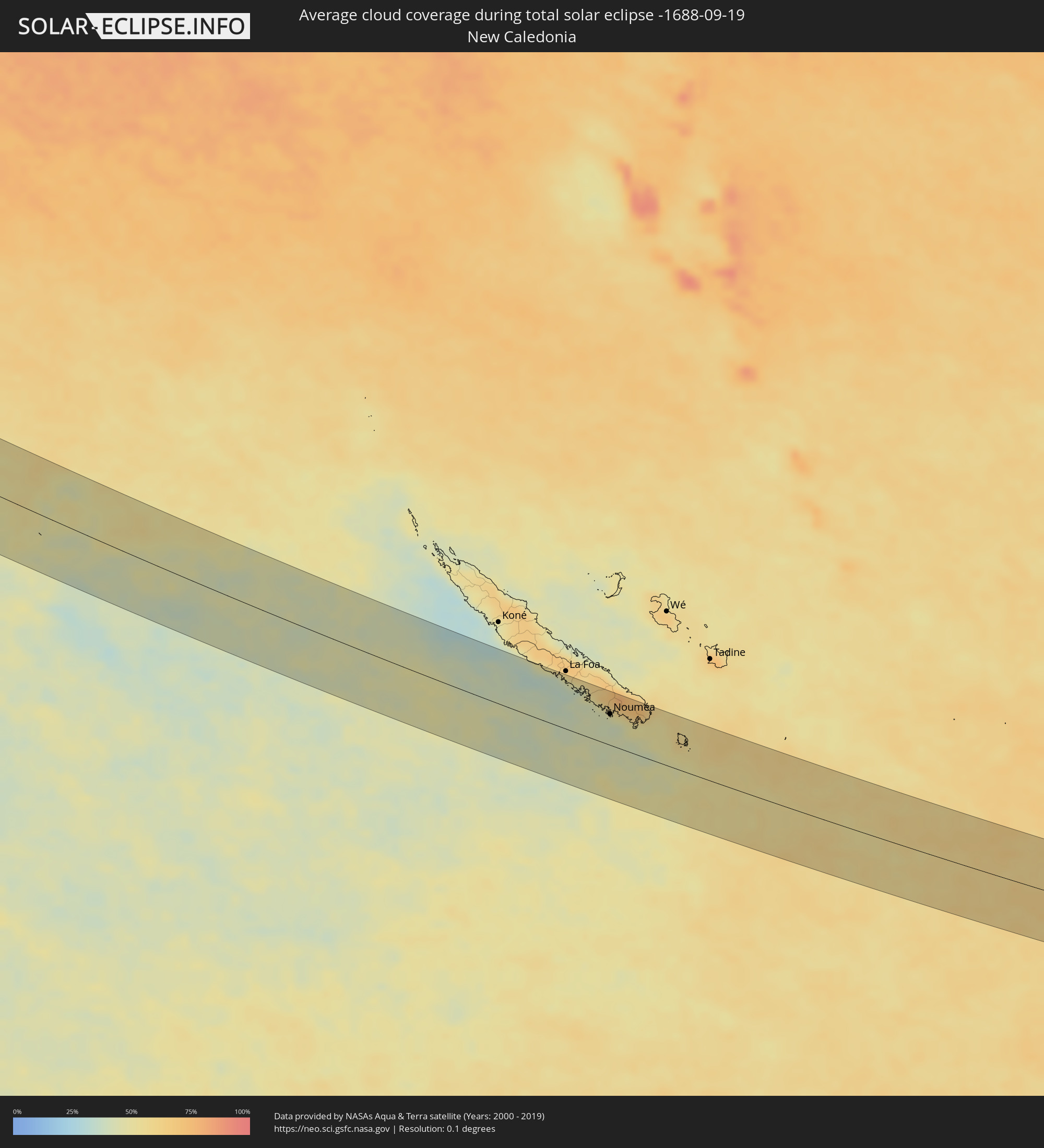 Neukaledonien
Orte im Finsternispfad
Die nachfolgene Tabelle zeigt Städte und Orte mit mehr als 5.000 Einwohnern, die sich im Finsternispfad befinden. Städte mit mehr als 100.000 Einwohnern sind dick gekennzeichnet. Mit einem Klick auf den Ort öffnet sich eine Detailkarte die die Lage des jeweiligen Ortes zusammen mit dem Verlauf der zentralen Finsternis präsentiert.
| Ort | Typ | Dauer der Verfinsterung | Ortszeit bei maximaler Verfinsterung | Entfernung zur Zentrallinie | Ø Bewölkung |
|
Ugoofaaru, Raa Atoll
|
total | - | 06:19:36 UTC+04:54 | 28 km | 77% |
|
Funadhoo, Shaviyani Atholhu
|
total | - | 06:19:31 UTC+04:54 | 22 km | 83% |
|
Naifaru, Lhaviyani Atholhu
|
total | - | 06:19:44 UTC+04:54 | 57 km | 80% |
|
Manadhoo, Noonu Atoll
|
total | - | 06:19:39 UTC+04:54 | 22 km | 80% |
|
Colombo, Western
|
total | - | 06:46:58 UTC+05:19 | 47 km | 84% |
|
Moratuwa, Western
|
total | - | 06:47:02 UTC+05:19 | 29 km | 86% |
|
Hendala, Western
|
total | - | 06:46:58 UTC+05:19 | 53 km | 91% |
|
Peliyagoda, Western
|
total | - | 06:46:58 UTC+05:19 | 51 km | 91% |
|
Kolonnawa, Western
|
total | - | 06:46:59 UTC+05:19 | 47 km | 91% |
|
Wattala, Western
|
total | - | 06:46:58 UTC+05:19 | 52 km | 91% |
|
Ja Ela, Western
|
total | - | 06:46:57 UTC+05:19 | 62 km | 89% |
|
Kandana, Western
|
total | - | 06:46:57 UTC+05:19 | 59 km | 91% |
|
Welisara, Western
|
total | - | 06:46:58 UTC+05:19 | 57 km | 91% |
|
Panadura, Western
|
total | - | 06:47:04 UTC+05:19 | 22 km | 82% |
|
Kotikawatta, Western
|
total | - | 06:47:00 UTC+05:19 | 46 km | 91% |
|
Battaramulla South, Western
|
total | - | 06:47:01 UTC+05:19 | 42 km | 91% |
|
Kelaniya, Western
|
total | - | 06:47:00 UTC+05:19 | 49 km | 91% |
|
Maharagama, Western
|
total | - | 06:47:02 UTC+05:19 | 37 km | 86% |
|
Mulleriyawa, Western
|
total | - | 06:47:00 UTC+05:19 | 46 km | 91% |
|
Kalutara, Western
|
total | - | 06:47:07 UTC+05:19 | 7 km | 89% |
|
Beruwala, Western
|
total | - | 06:47:10 UTC+05:19 | 5 km | 86% |
|
Gampaha, Western
|
total | - | 06:46:59 UTC+05:19 | 63 km | 92% |
|
Bentota, Southern
|
total | - | 06:47:11 UTC+05:19 | 11 km | 83% |
|
Homagama, Western
|
total | - | 06:47:04 UTC+05:19 | 36 km | 90% |
|
Ambalangoda, Southern
|
total | - | 06:47:17 UTC+05:19 | 32 km | 82% |
|
Horana South, Western
|
total | - | 06:47:08 UTC+05:19 | 21 km | 91% |
|
Hanwella Ihala, Western
|
total | - | 06:47:05 UTC+05:19 | 42 km | 92% |
|
Galle, Southern
|
total | - | 06:47:25 UTC+05:19 | 55 km | 77% |
|
Ratnapura, Sabaragamuwa
|
total | - | 06:47:18 UTC+05:19 | 15 km | 89% |
|
Weligama, Southern
|
total | - | 06:47:33 UTC+05:19 | 64 km | 80% |
|
Matara, Southern
|
total | - | 06:47:36 UTC+05:19 | 67 km | 77% |
|
Gampola, Central
|
total | - | 06:47:14 UTC+05:19 | 67 km | 89% |
|
Hatton, Central
|
total | - | 06:47:20 UTC+05:19 | 37 km | 87% |
|
Nuwara Eliya, Central
|
total | - | 06:47:24 UTC+05:19 | 44 km | 82% |
|
Tangalla, Southern
|
total | - | 06:47:42 UTC+05:19 | 61 km | 78% |
|
Badulla, Uva
|
total | - | 06:47:31 UTC+05:19 | 45 km | 79% |
|
Monaragala, Uva
|
total | - | 06:47:43 UTC+05:19 | 30 km | 77% |
|
Wattegama, Uva
|
total | - | 06:47:48 UTC+05:19 | 21 km | 78% |
|
Pantai Cenang, Perlis
|
total | - | 08:41:20 UTC+06:55 | 1 km | 88% |
|
Padang Mat Sirat, Kedah
|
total | - | 08:41:19 UTC+06:55 | 8 km | 90% |
|
Ayer Hangat, Kedah
|
total | - | 08:41:24 UTC+06:55 | 16 km | 91% |
|
Kuah, Kedah
|
total | - | 08:41:29 UTC+06:55 | 6 km | 89% |
|
Satun, Satun
|
total | - | 08:28:16 UTC+06:42 | 42 km | 87% |
|
Kuala Perlis, Perlis
|
total | - | 08:41:51 UTC+06:55 | 18 km | 84% |
|
Kangar, Perlis
|
total | - | 08:41:56 UTC+06:55 | 23 km | 94% |
|
Kuala Kedah, Kedah
|
total | - | 08:42:17 UTC+06:55 | 13 km | 88% |
|
Alor Setar, Kedah
|
total | - | 08:42:22 UTC+06:55 | 10 km | 95% |
|
Jitra, Kedah
|
total | - | 08:42:22 UTC+06:55 | 7 km | 95% |
|
Sadao, Songkhla
|
total | - | 08:28:47 UTC+06:42 | 48 km | 92% |
|
Kepala Batas, Penang
|
total | - | 08:42:51 UTC+06:55 | 76 km | 94% |
|
Gurun, Kedah
|
total | - | 08:42:44 UTC+06:55 | 42 km | 92% |
|
Sungai Petani, Kedah
|
total | - | 08:42:52 UTC+06:55 | 61 km | 95% |
|
Tasek Glugor, Penang
|
total | - | 08:42:59 UTC+06:55 | 79 km | 96% |
|
Bedong, Kedah
|
total | - | 08:42:50 UTC+06:55 | 52 km | 94% |
|
Betong, Yala
|
total | - | 08:30:18 UTC+06:42 | 39 km | 88% |
|
Nong Chik, Pattani
|
total | - | 08:29:46 UTC+06:42 | 80 km | 92% |
|
Yala, Yala
|
total | - | 08:30:07 UTC+06:42 | 48 km | 90% |
|
Sai Buri, Pattani
|
total | - | 08:30:32 UTC+06:42 | 71 km | 86% |
|
Ra-ngae, Narathiwat
|
total | - | 08:30:58 UTC+06:42 | 28 km | 85% |
|
Narathiwat, Narathiwat
|
total | - | 08:31:01 UTC+06:42 | 44 km | 85% |
|
Ban Su-ngai Pa Di, Narathiwat
|
total | - | 08:31:20 UTC+06:42 | 5 km | 87% |
|
Su-ngai Kolok, Narathiwat
|
total | - | 08:31:30 UTC+06:42 | 2 km | 86% |
|
Tak Bai, Narathiwat
|
total | - | 08:31:29 UTC+06:42 | 29 km | 81% |
|
Pasir Mas, Kelantan
|
total | - | 08:45:07 UTC+06:55 | 7 km | 85% |
|
Tanah Merah, Kelantan
|
total | - | 08:45:18 UTC+06:55 | 21 km | 85% |
|
Tumpat, Kelantan
|
total | - | 08:45:04 UTC+06:55 | 24 km | 85% |
|
Kampong Pangkal Kalong, Kelantan
|
total | - | 08:45:20 UTC+06:55 | 7 km | 84% |
|
Kota Bharu, Kelantan
|
total | - | 08:45:13 UTC+06:55 | 17 km | 85% |
|
Kampong Kadok, Kelantan
|
total | - | 08:45:19 UTC+06:55 | 3 km | 89% |
|
Peringat, Kelantan
|
total | - | 08:45:21 UTC+06:55 | 7 km | 89% |
|
Jertih, Terengganu
|
total | - | 08:45:53 UTC+06:55 | 23 km | 86% |
|
Kuala Terengganu, Terengganu
|
total | - | 08:47:14 UTC+06:55 | 57 km | 89% |
|
Marang, Terengganu
|
total | - | 08:47:26 UTC+06:55 | 69 km | 84% |
|
Bintulu, Sarawak
|
total | - | 09:34:14 UTC+07:21 | 50 km | 84% |
|
Tanjung Selor, North Kalimantan
|
total | - | 10:20:52 UTC+07:57 | 70 km | 90% |
|
Luwuk, Central Sulawesi
|
total | - | 10:39:28 UTC+07:57 | 79 km | 70% |
|
Gorontalo, Gorontalo
|
total | - | 10:38:07 UTC+07:57 | 83 km | 64% |
|
Ambon, Maluku
|
total | - | 12:23:00 UTC+09:22 | 71 km | 82% |
|
Amahai, Maluku
|
total | - | 12:24:26 UTC+09:22 | 4 km | 74% |
|
Tual, Maluku
|
total | - | 12:38:05 UTC+09:22 | 3 km | 69% |
|
Païta, South Province
|
total | - | 15:39:14 UTC+11:05 | 55 km | 59% |
|
Dumbéa, South Province
|
total | - | 15:39:20 UTC+11:05 | 56 km | 55% |
|
Nouméa, South Province
|
total | - | 15:39:22 UTC+11:05 | 43 km | 46% |
|
Mont-Dore, South Province
|
total | - | 15:39:29 UTC+11:05 | 48 km | 49% |