Totale Sonnenfinsternis vom 12.01.-1703
| Wochentag: | Sonntag |
| Maximale Dauer der Verfinsterung: | 03m01s |
| Maximale Breite des Finsternispfades: | 158 km |
| Saroszyklus: | 4 |
| Bedeckungsgrad: | 100% |
| Magnitude: | 1.0318 |
| Gamma: | 0.7358 |
Wo kann man die Sonnenfinsternis vom 12.01.-1703 sehen?
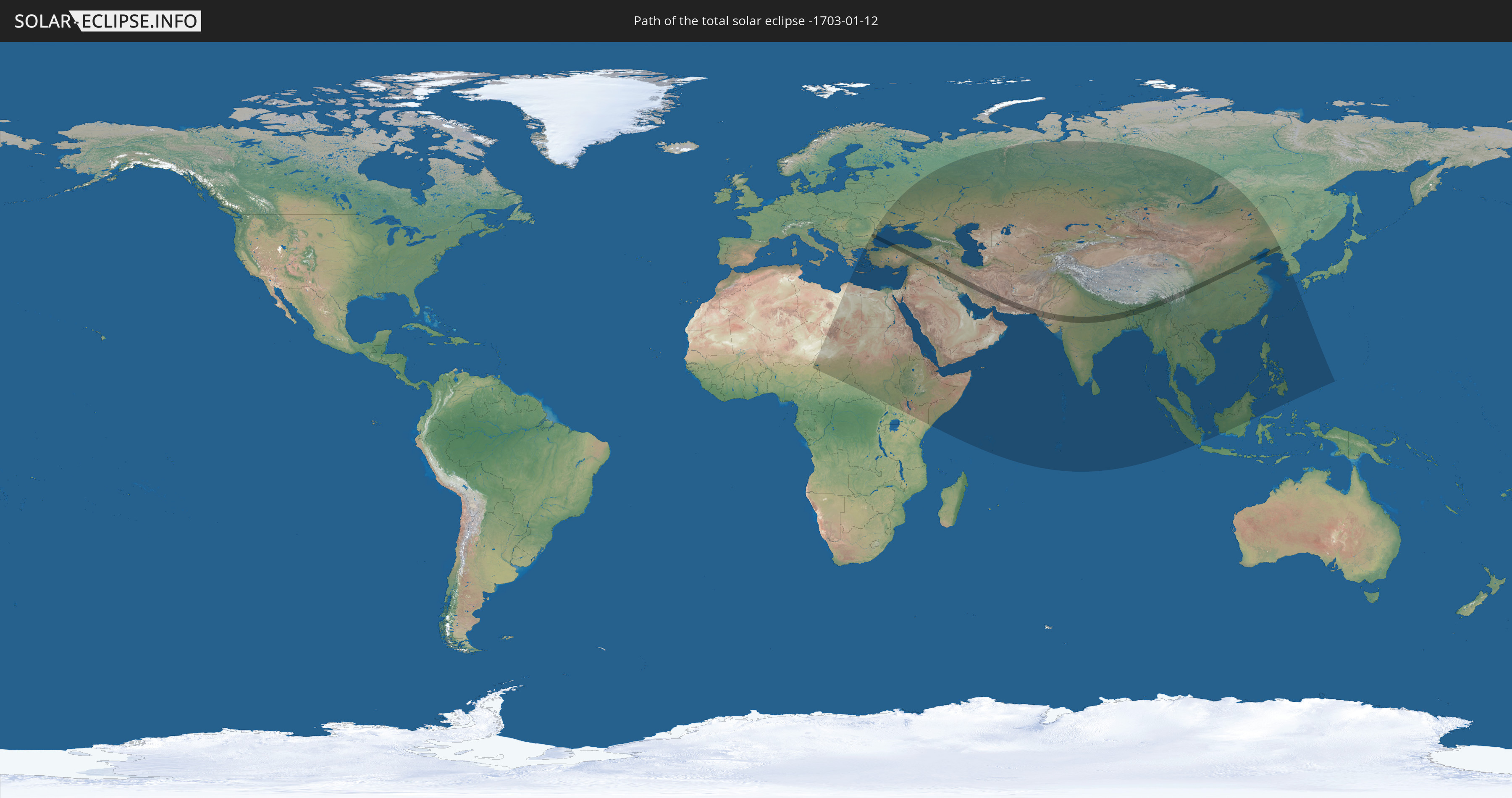
Die Sonnenfinsternis am 12.01.-1703 kann man in 73 Ländern als partielle Sonnenfinsternis beobachten.
Der Finsternispfad verläuft durch 12 Länder. Nur in diesen Ländern ist sie als totale Sonnenfinsternis zu sehen.
In den folgenden Ländern ist die Sonnenfinsternis total zu sehen
 Rumänien
 Bulgarien
 Türkei
 Syrien
 Irak
Irak
 Iran
Iran
 Pakistan
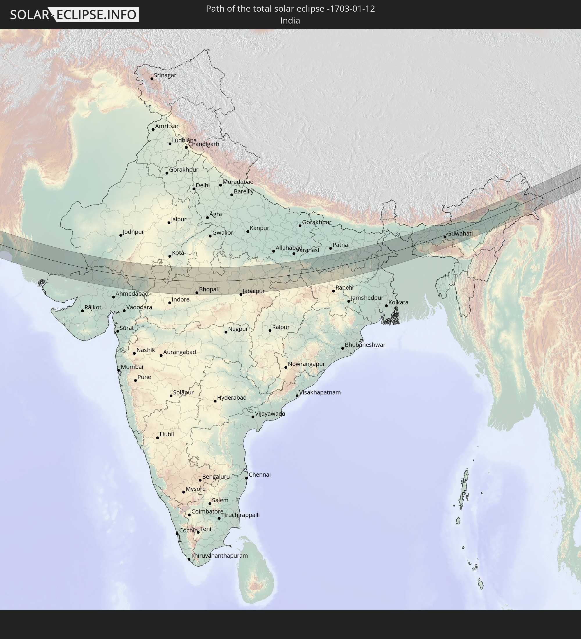 Indien
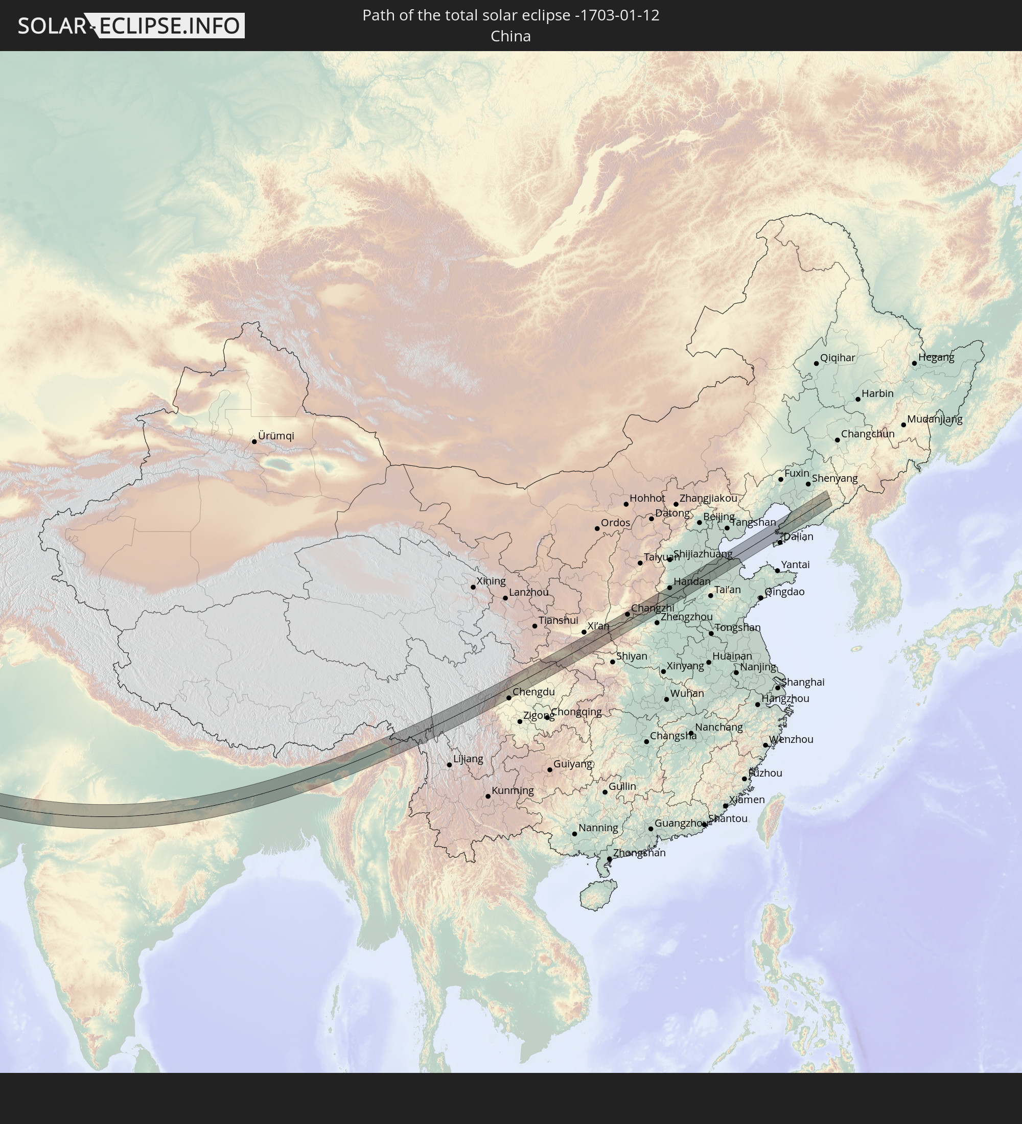 Volksrepublik China
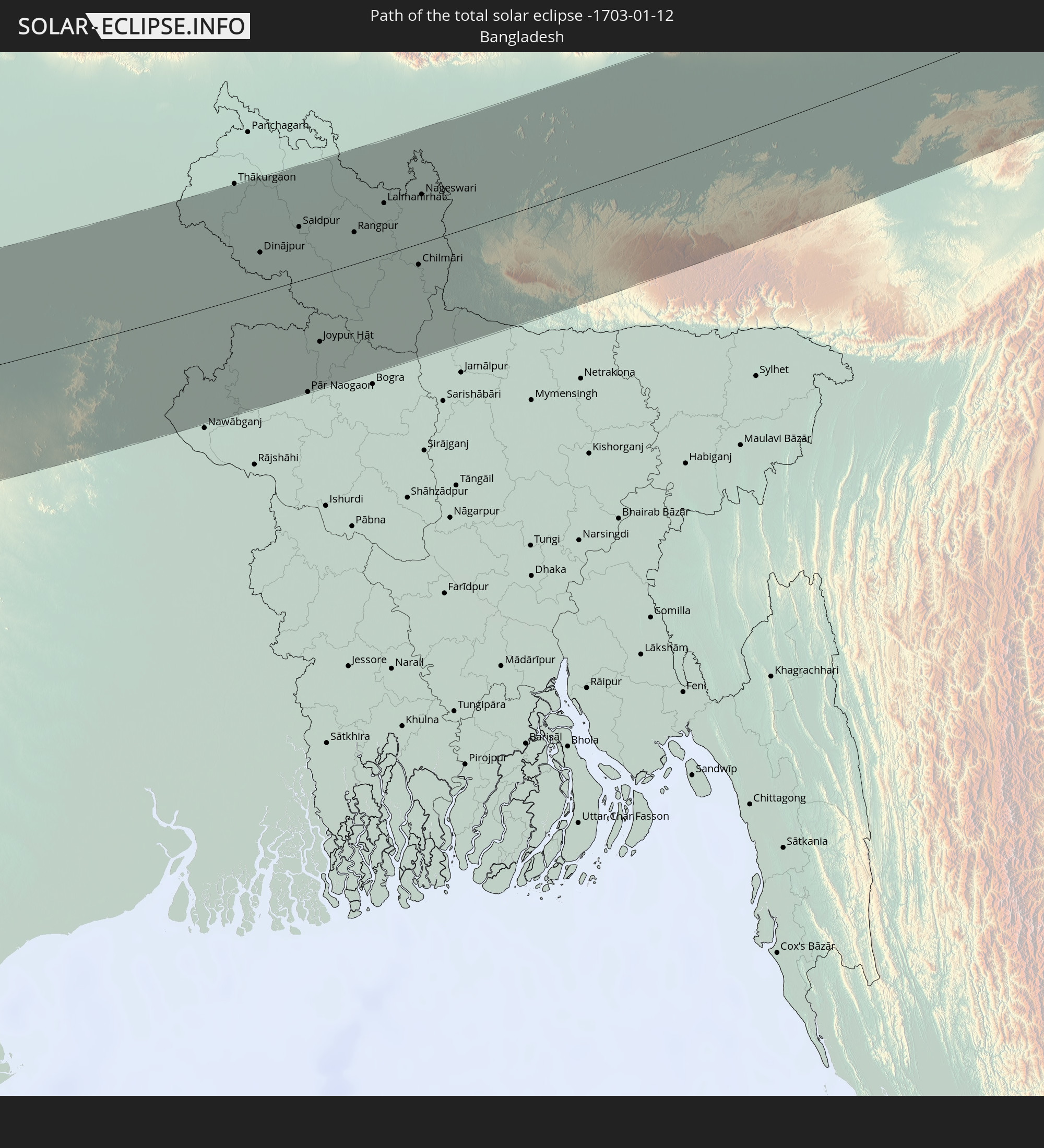 Bangladesch
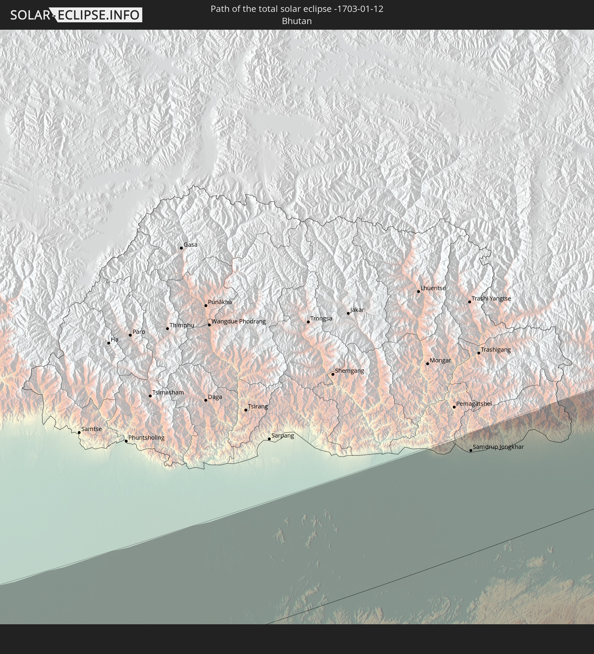 Bhutan
 Myanmar
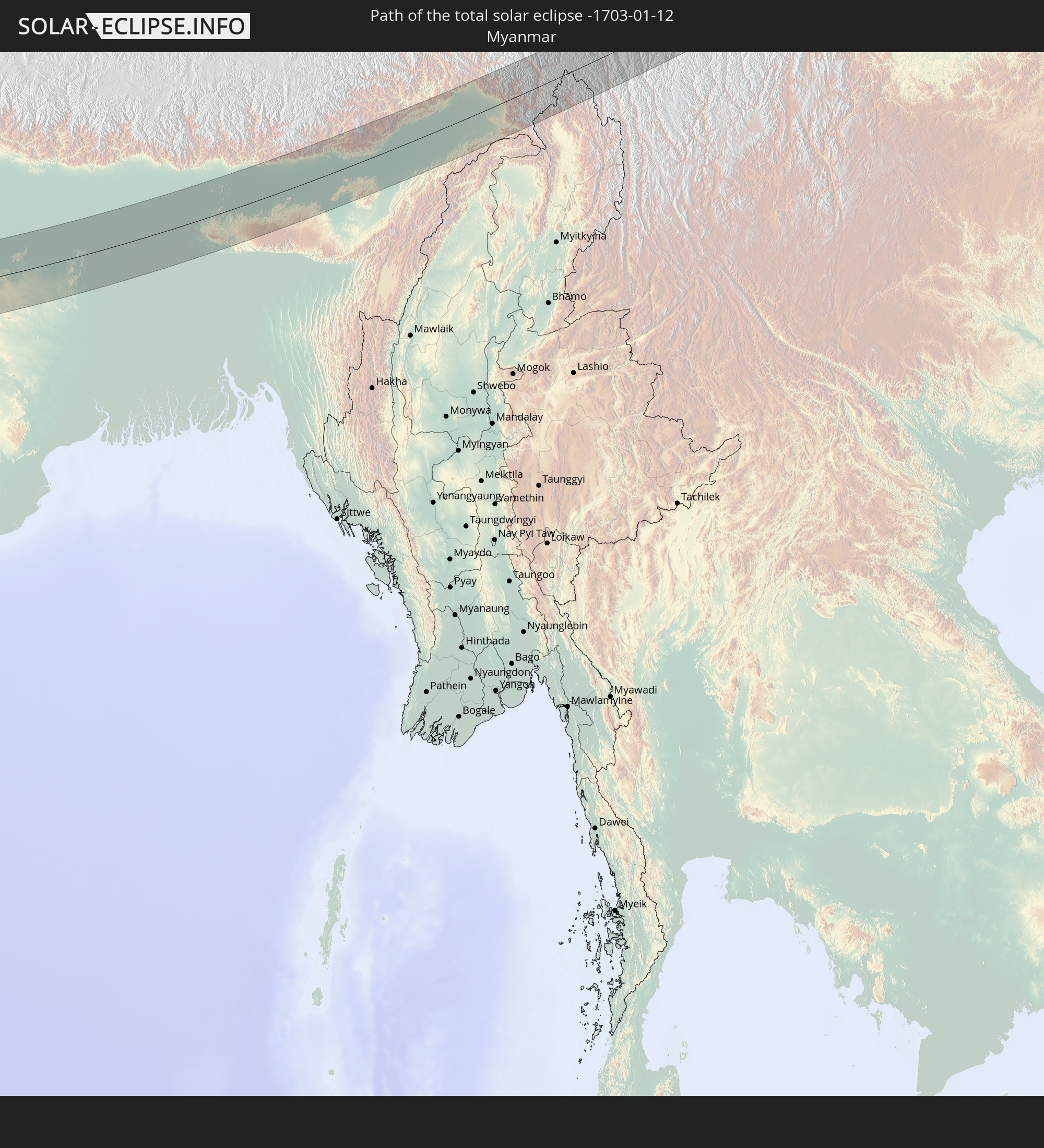
In den folgenden Ländern ist die Sonnenfinsternis partiell zu sehen
 Russland
 Niger
Niger
 Nigeria
 Kamerun
 Libyen
 Tschad
 Zentralafrikanische Republik
 Griechenland
 Rumänien
 Sudan
Sudan
 Ukraine
 Bulgarien
 Ägypten
 Türkei
 Moldawien
 Uganda
 Republik Zypern
 Äthiopien
 Kenia
Kenia
 Staat Palästina
 Israel
 Saudi-Arabien
 Jordanien
 Libanon
 Syrien
 Eritrea
 Irak
Irak
 Georgien
 Somalia
 Dschibuti
 Jemen
Jemen
 Armenien
 Iran
Iran
 Aserbaidschan
 Seychellen
 Kasachstan
 Kuwait
 Bahrain
 Katar
Katar
 Vereinigte Arabische Emirate
 Oman
Oman
 Turkmenistan
 Usbekistan
 Afghanistan
 Pakistan
 Tadschikistan
 Indien
 Kirgisistan
 Britisches Territorium im Indischen Ozean
 Malediven
 Volksrepublik China
 Sri Lanka
 Nepal
Nepal
 Mongolei
 Bangladesch
 Bhutan
 Myanmar
 Indonesien
 Thailand
 Malaysia
 Laos
Laos
 Vietnam
 Kambodscha
 Singapur
 Macau
Macau
 Hongkong
 Brunei
 Taiwan
 Philippinen
 Japan
Japan
 Nordkorea
 Südkorea
 Palau
Palau
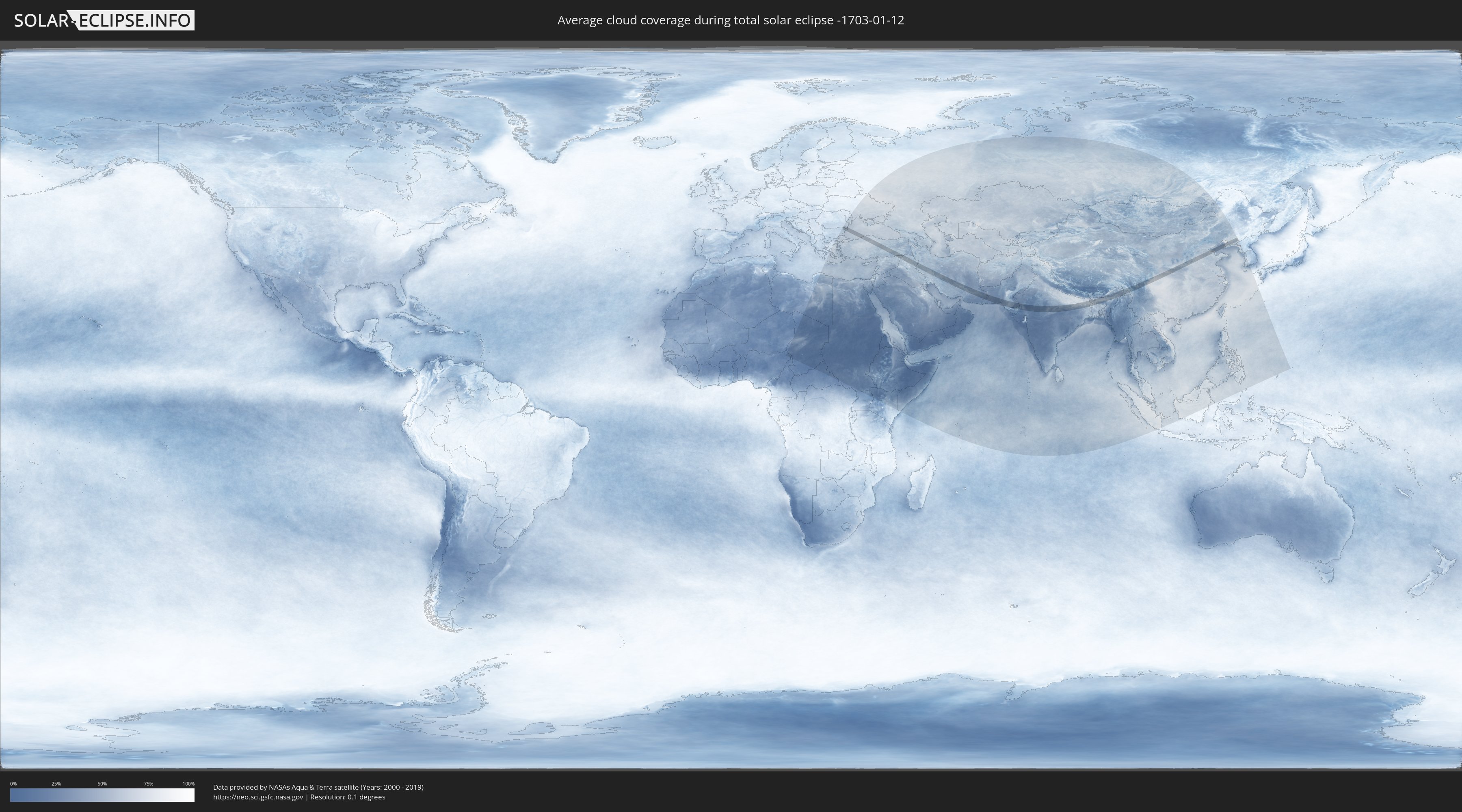
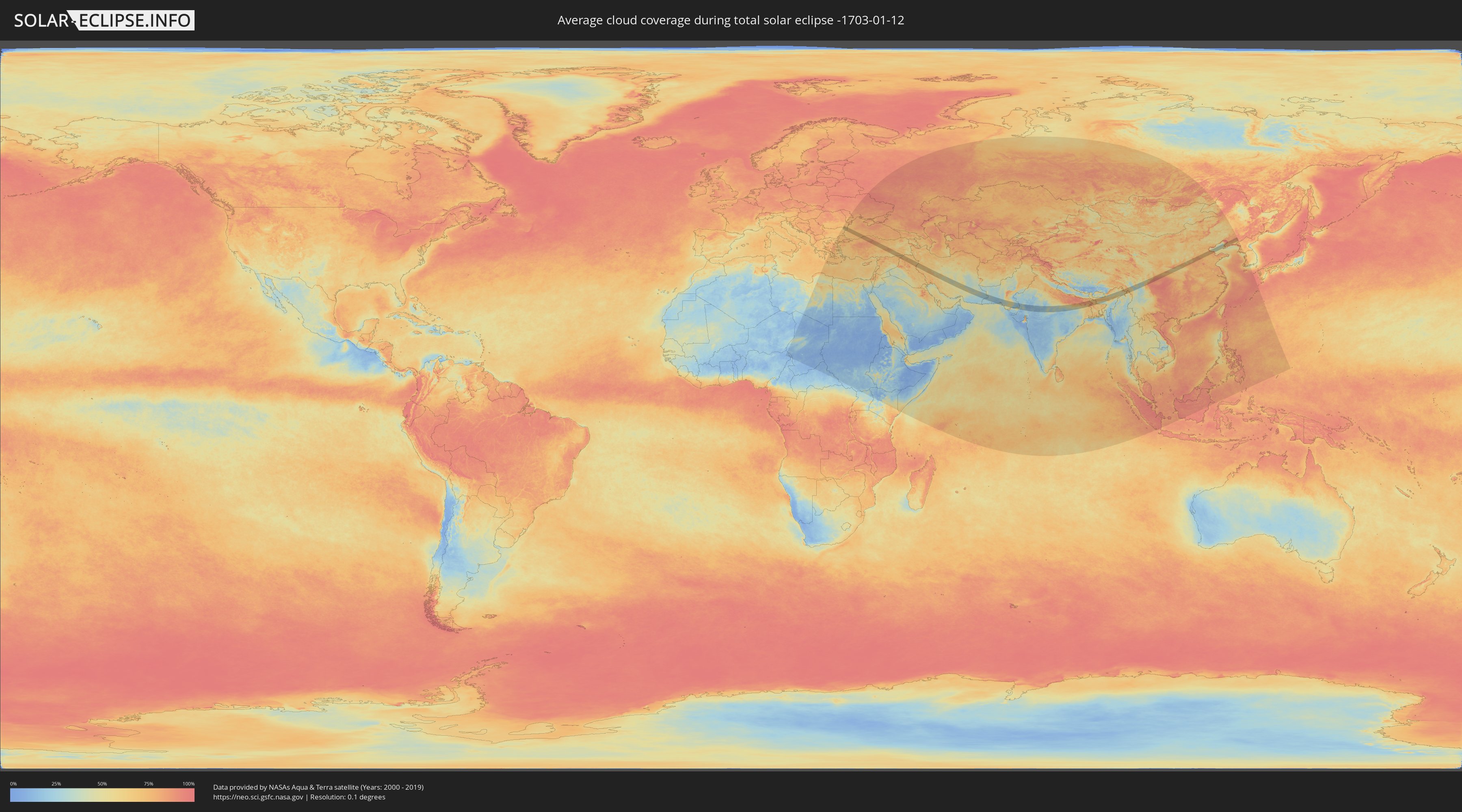
Wie wird das Wetter während der totalen Sonnenfinsternis am 12.01.-1703?
Wo ist der beste Ort, um die totale Sonnenfinsternis vom 12.01.-1703 zu beobachten?
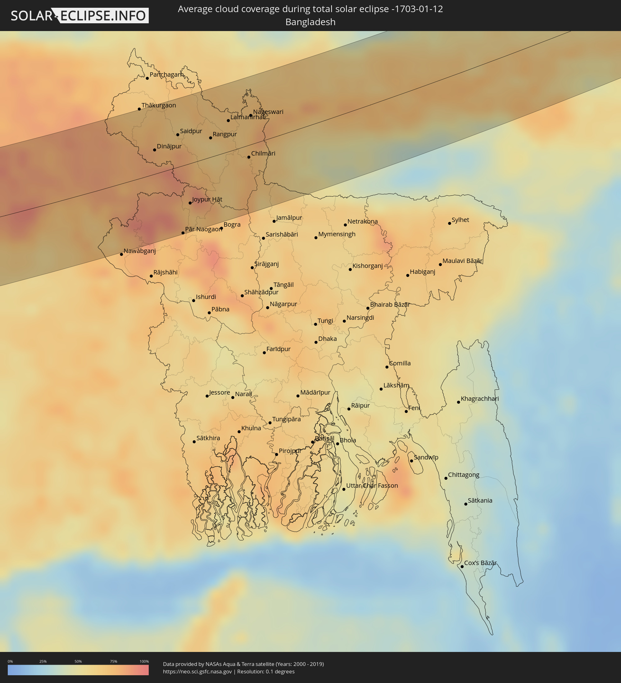
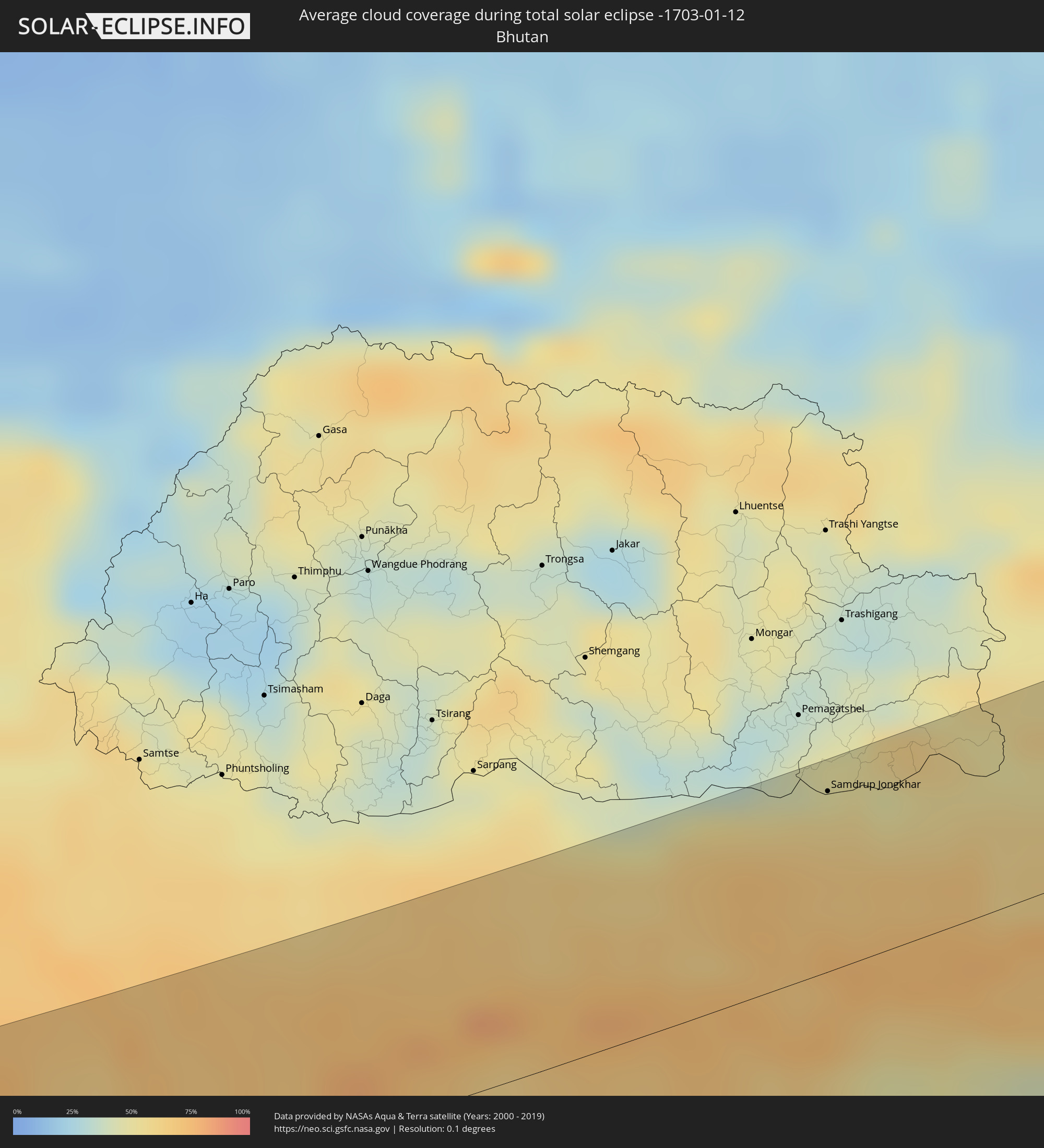
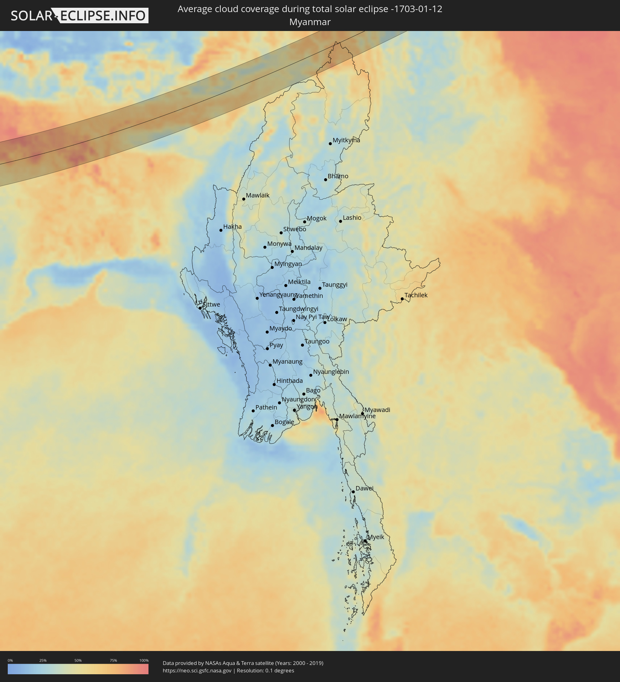
Die folgenden Karten zeigen die durchschnittliche Bewölkung für den Tag, an dem die totale Sonnenfinsternis
stattfindet. Mit Hilfe der Karten lässt sich der Ort entlang des Finsternispfades eingrenzen,
der die besten Aussichen auf einen klaren wolkenfreien Himmel bietet.
Trotzdem muss man immer lokale Gegenenheiten beachten und sollte sich genau über das Wetter an seinem
gewählten Beobachtungsort informieren.
Die Daten stammen von den beiden NASA-Satelliten
AQUA und TERRA
und wurden über einen Zeitraum von 19 Jahren (2000 - 2019) gemittelt.
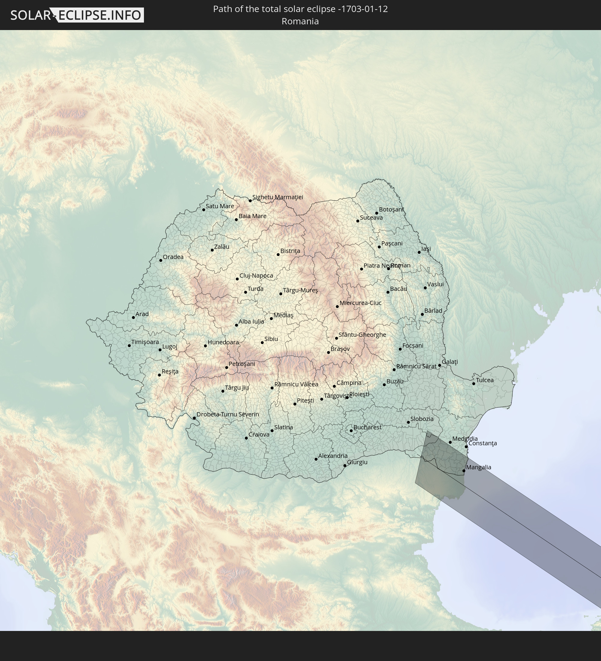
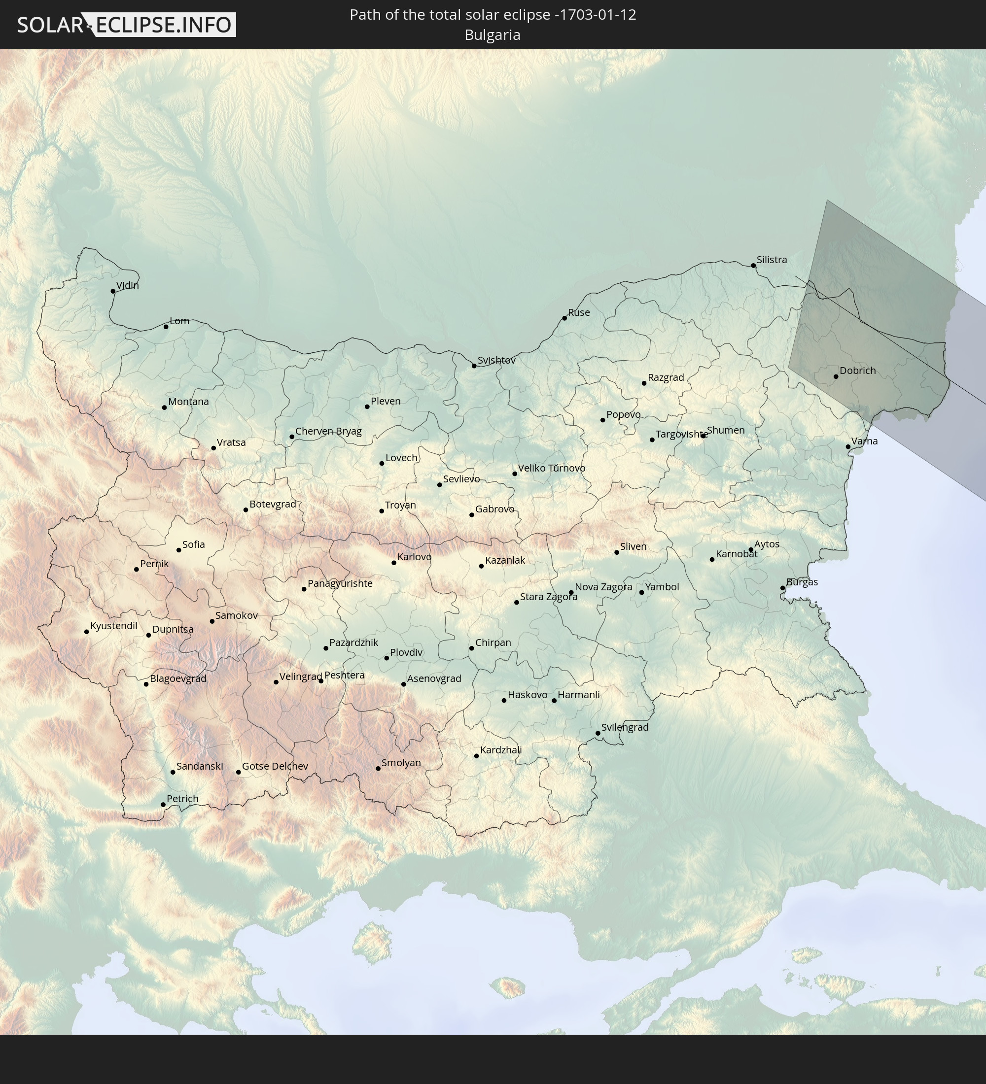
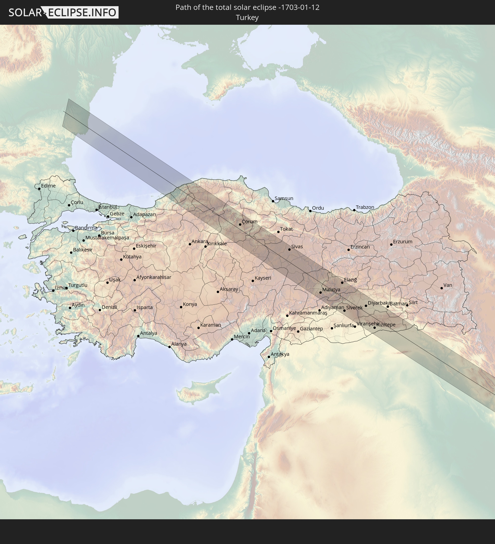
Detaillierte Länderkarten
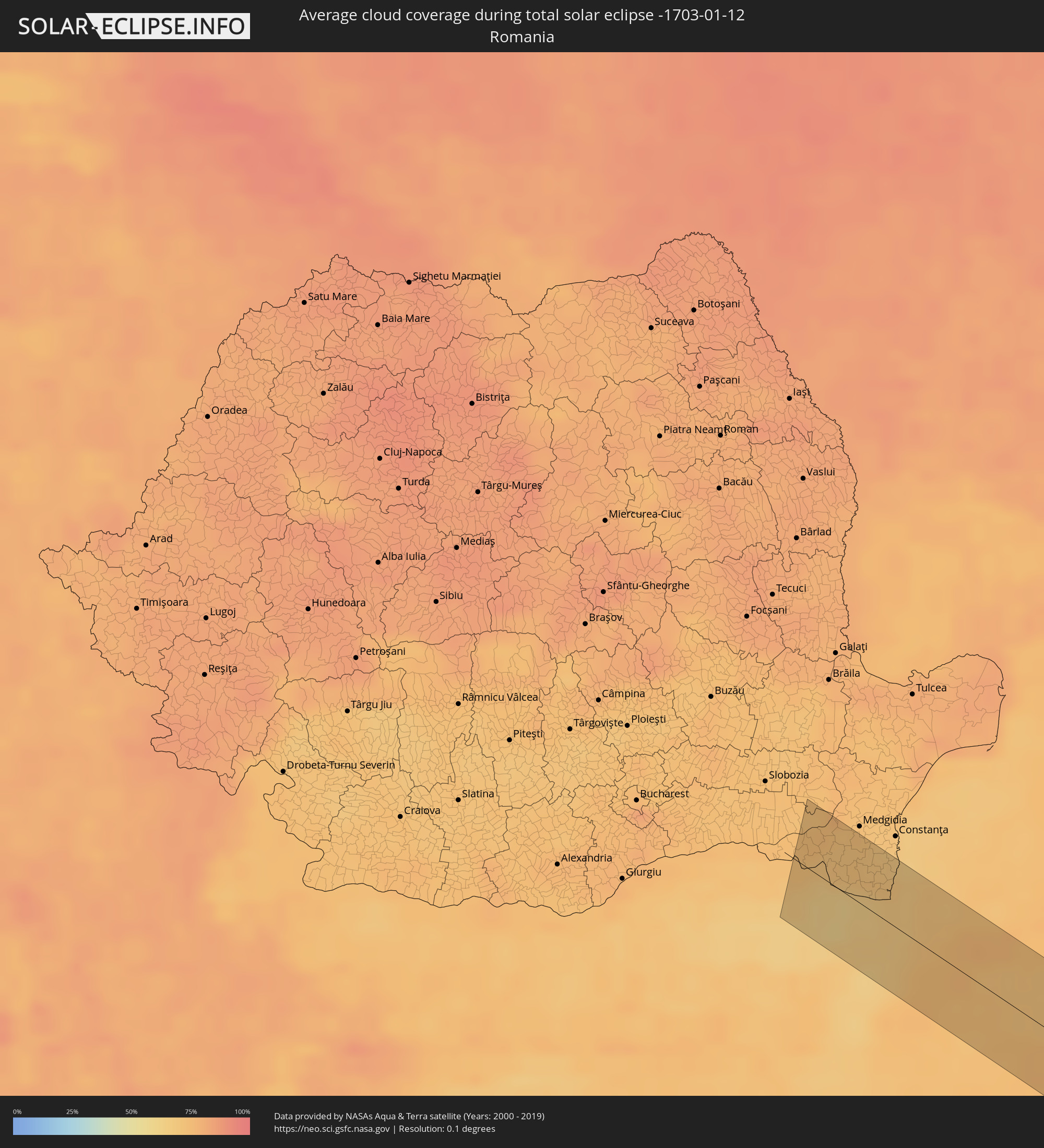 Rumänien
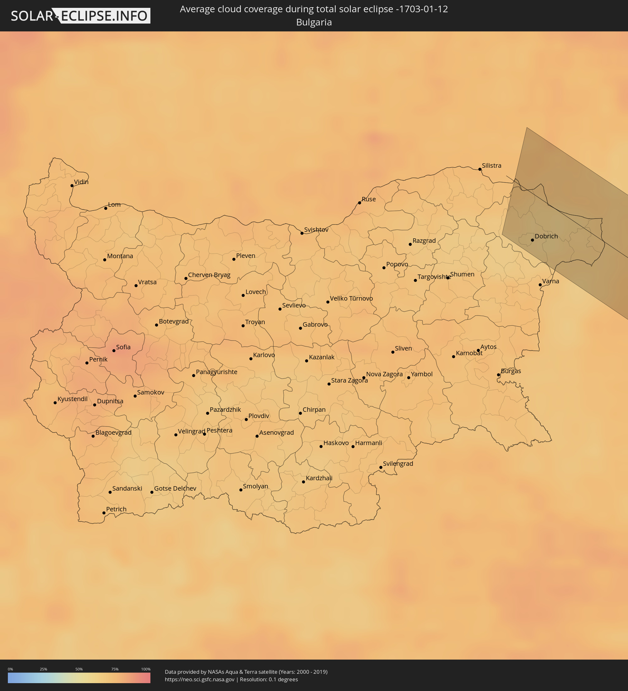 Bulgarien
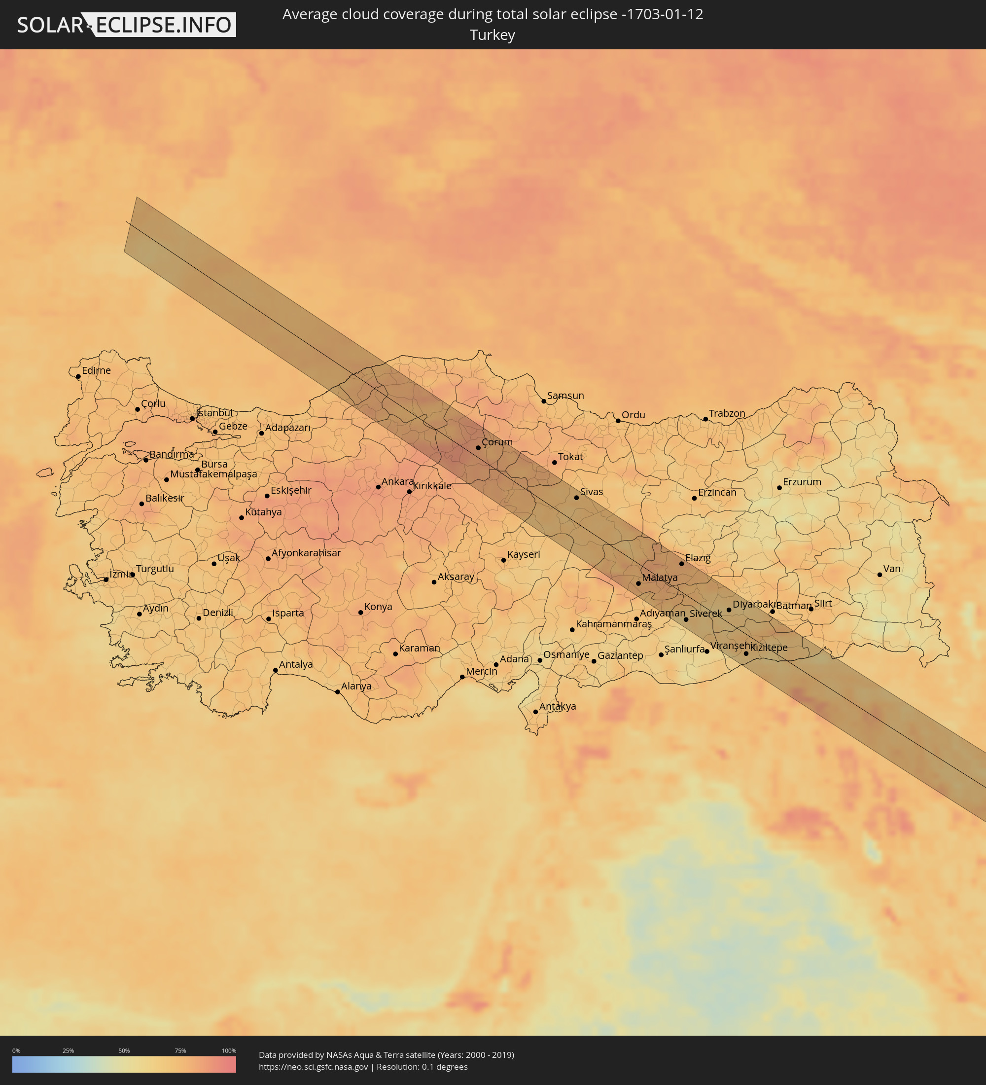 Türkei
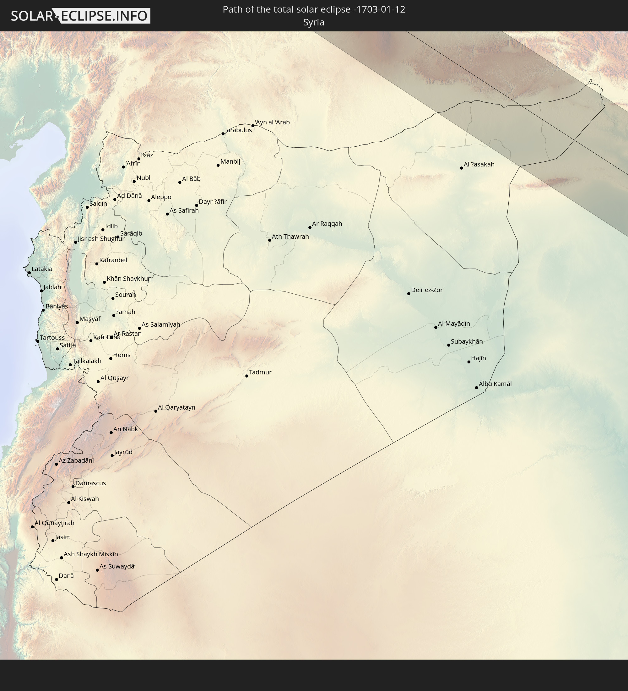
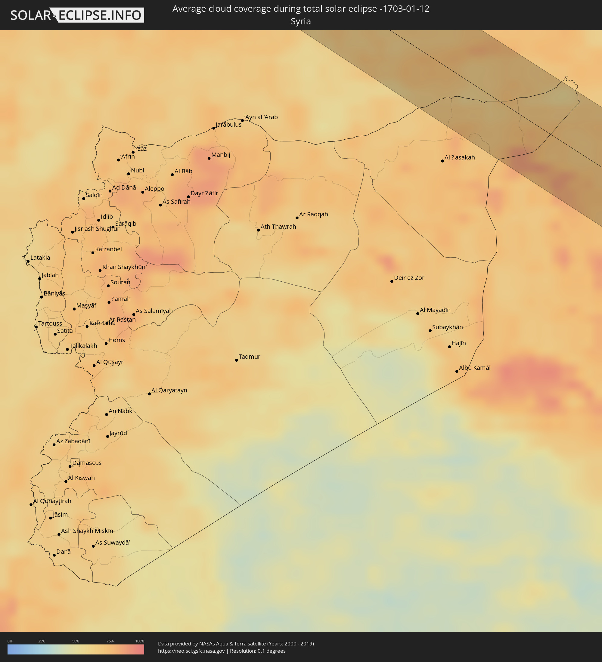 Syrien
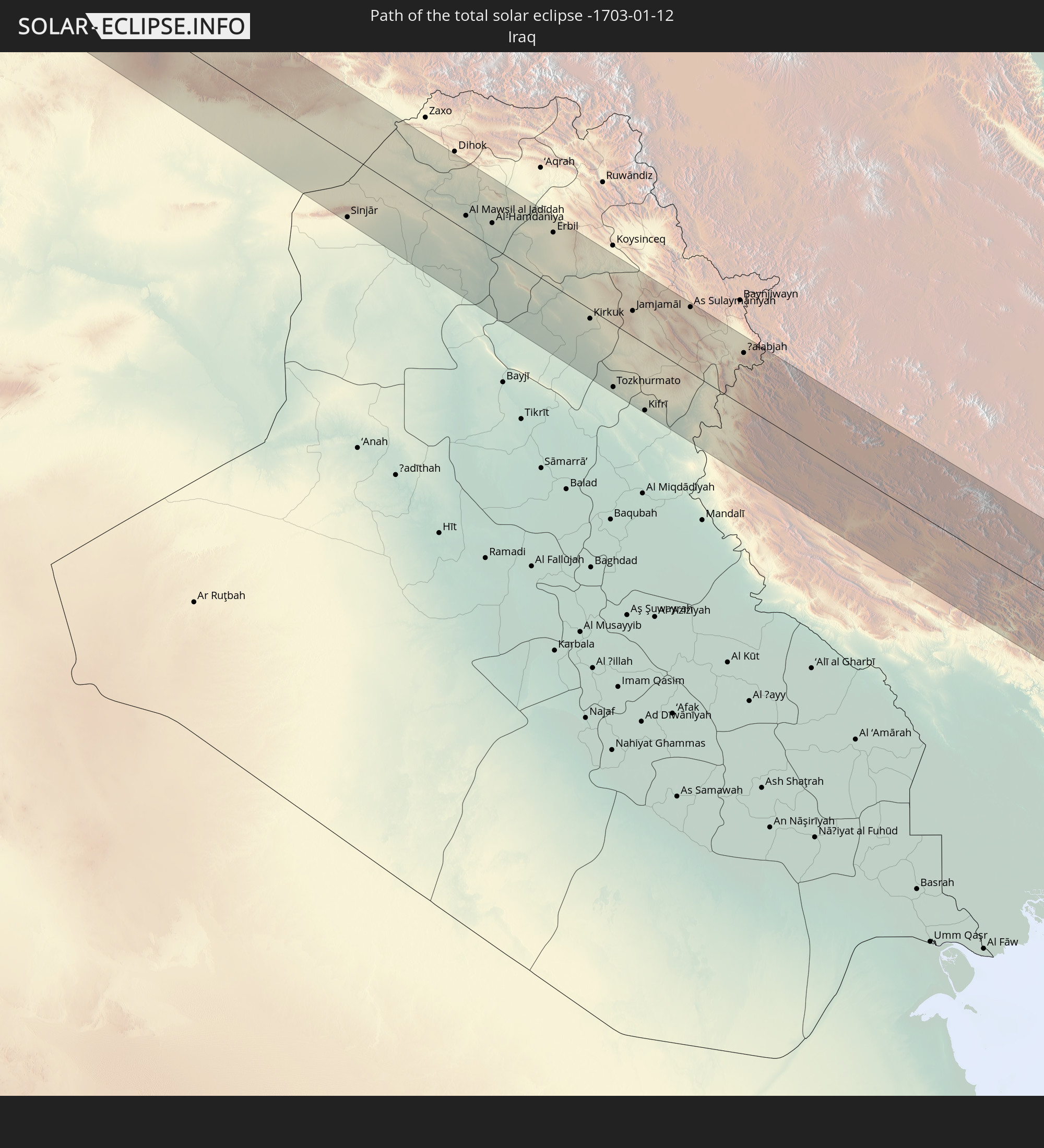
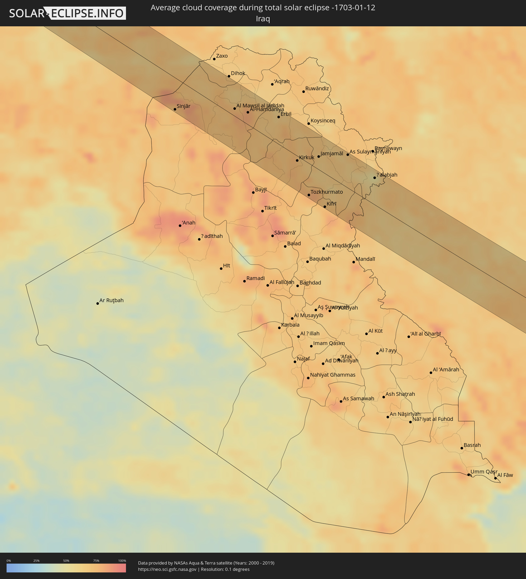 Irak
Irak
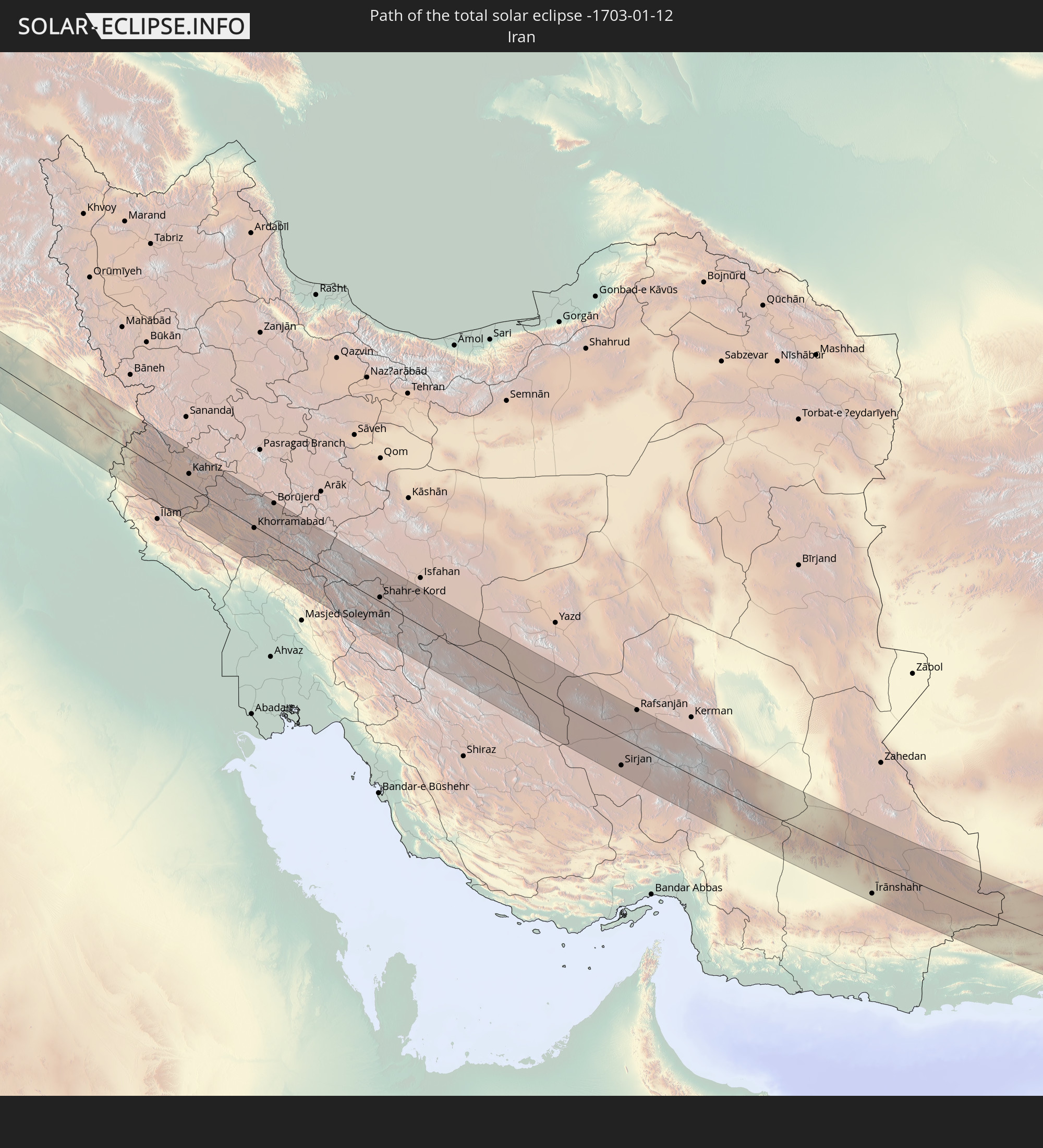
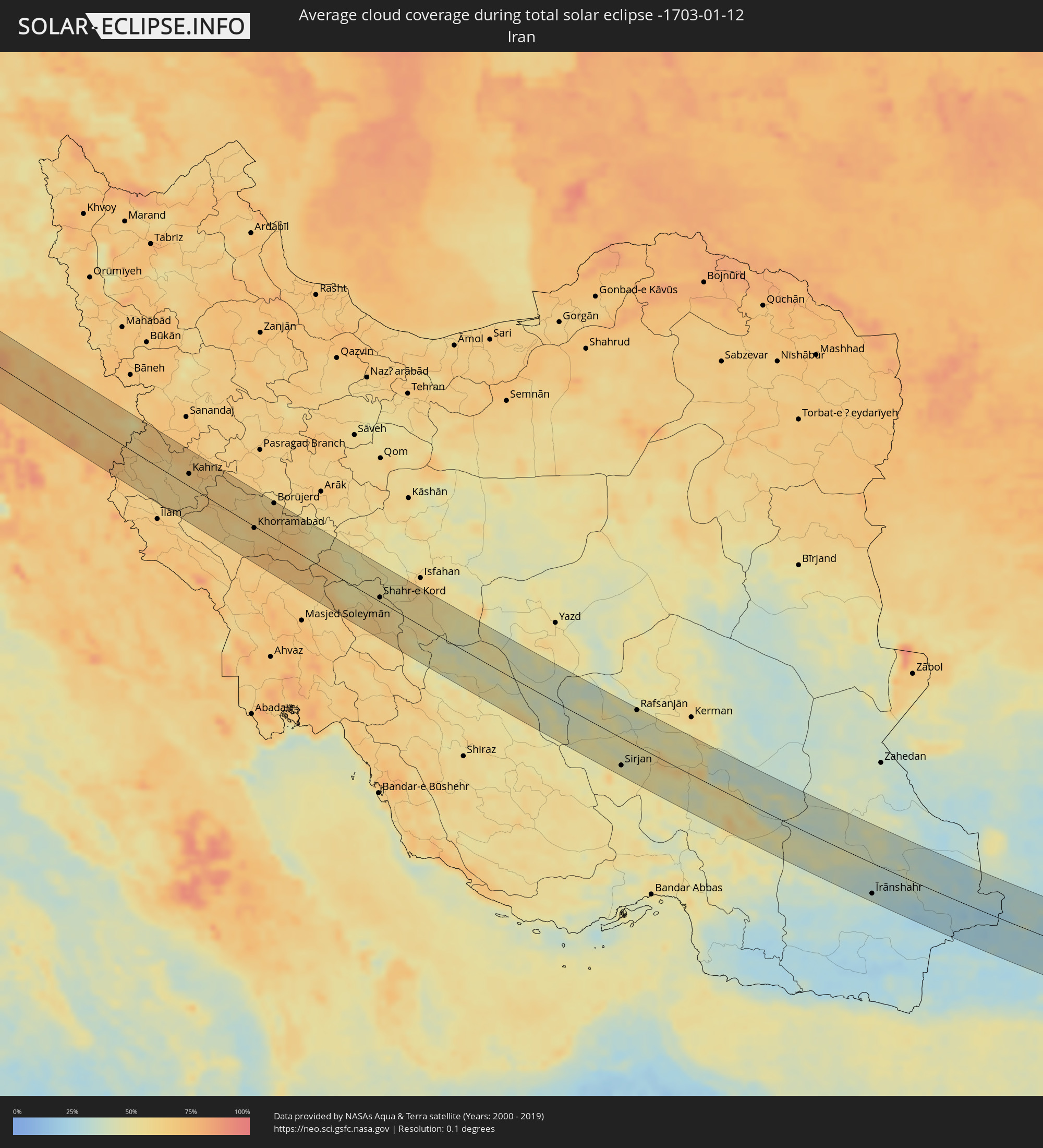 Iran
Iran
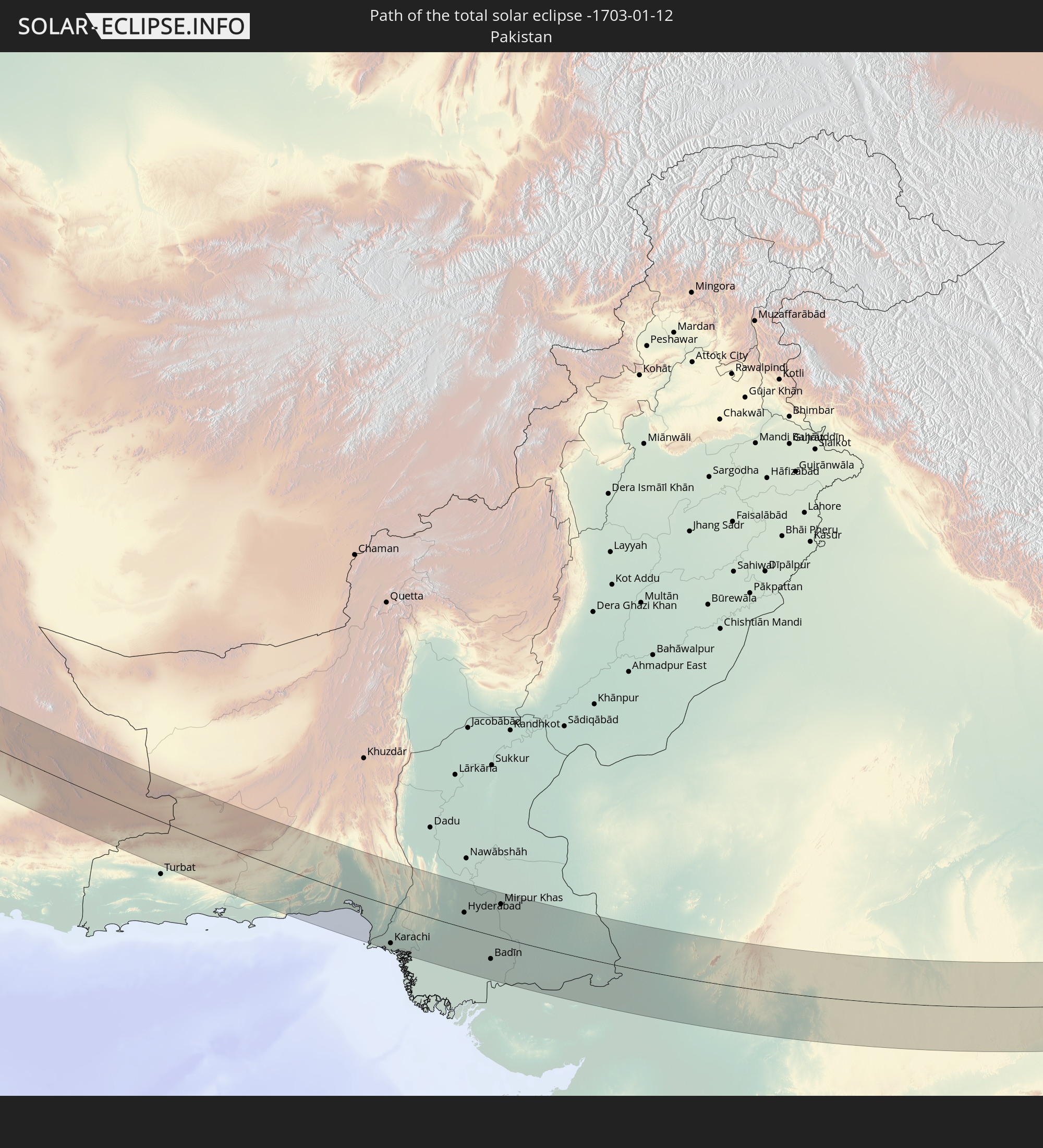
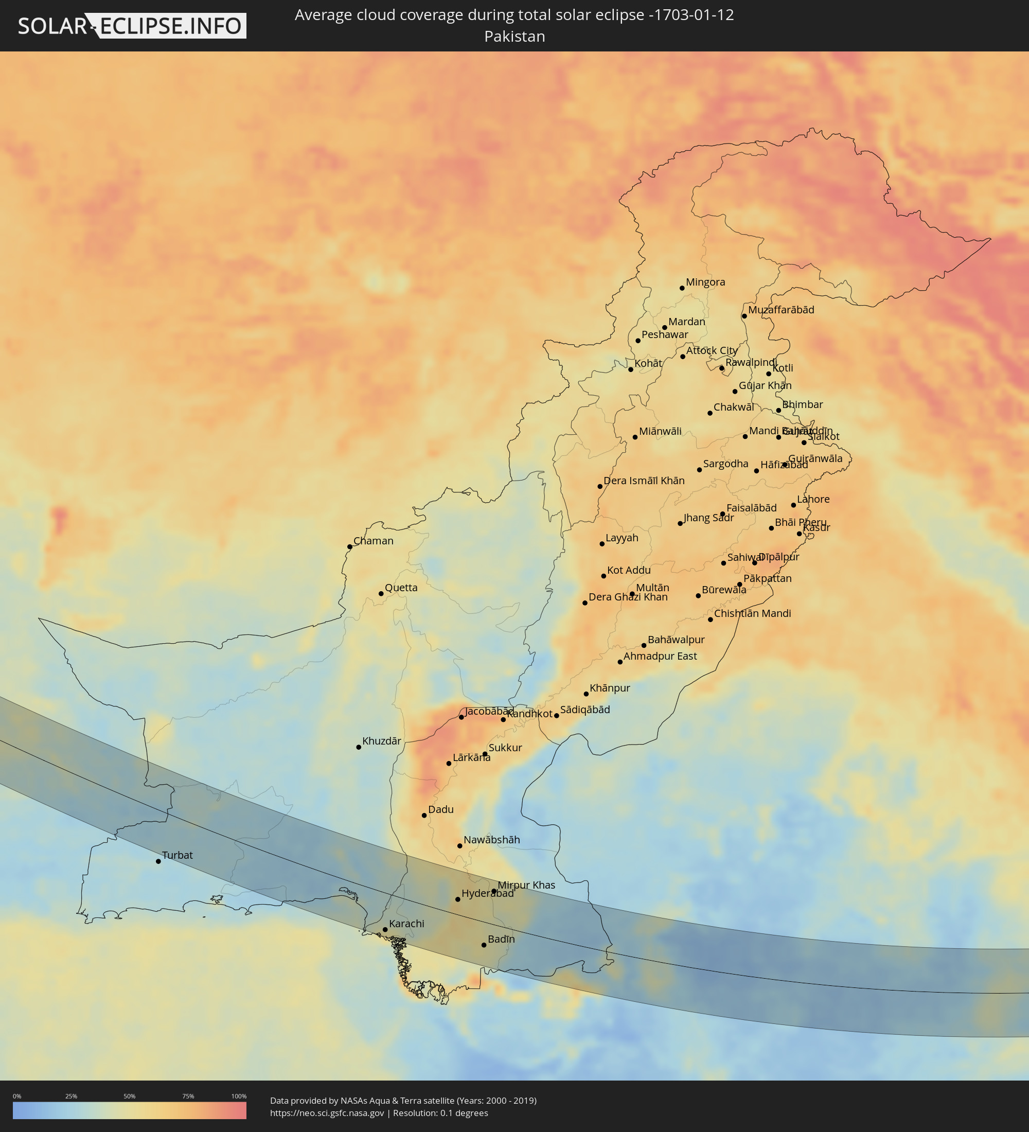 Pakistan
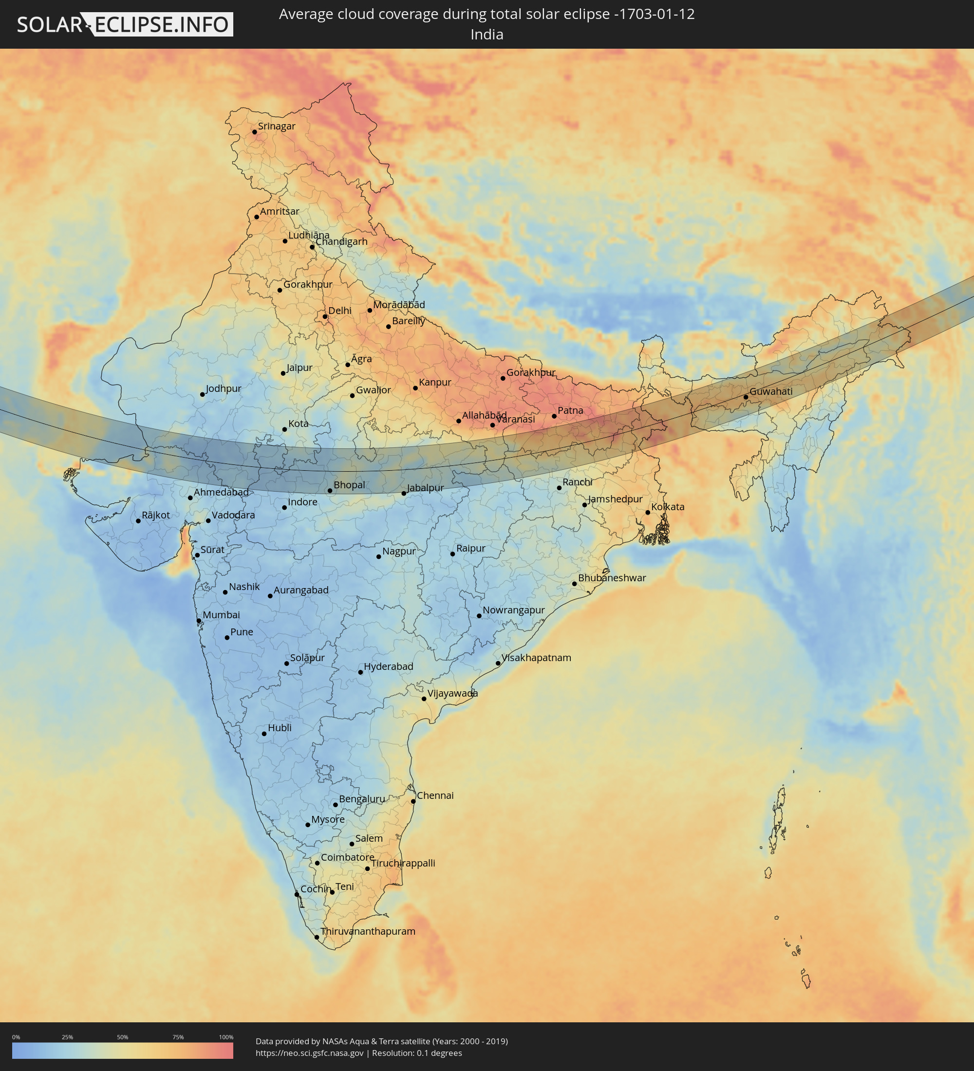 Indien
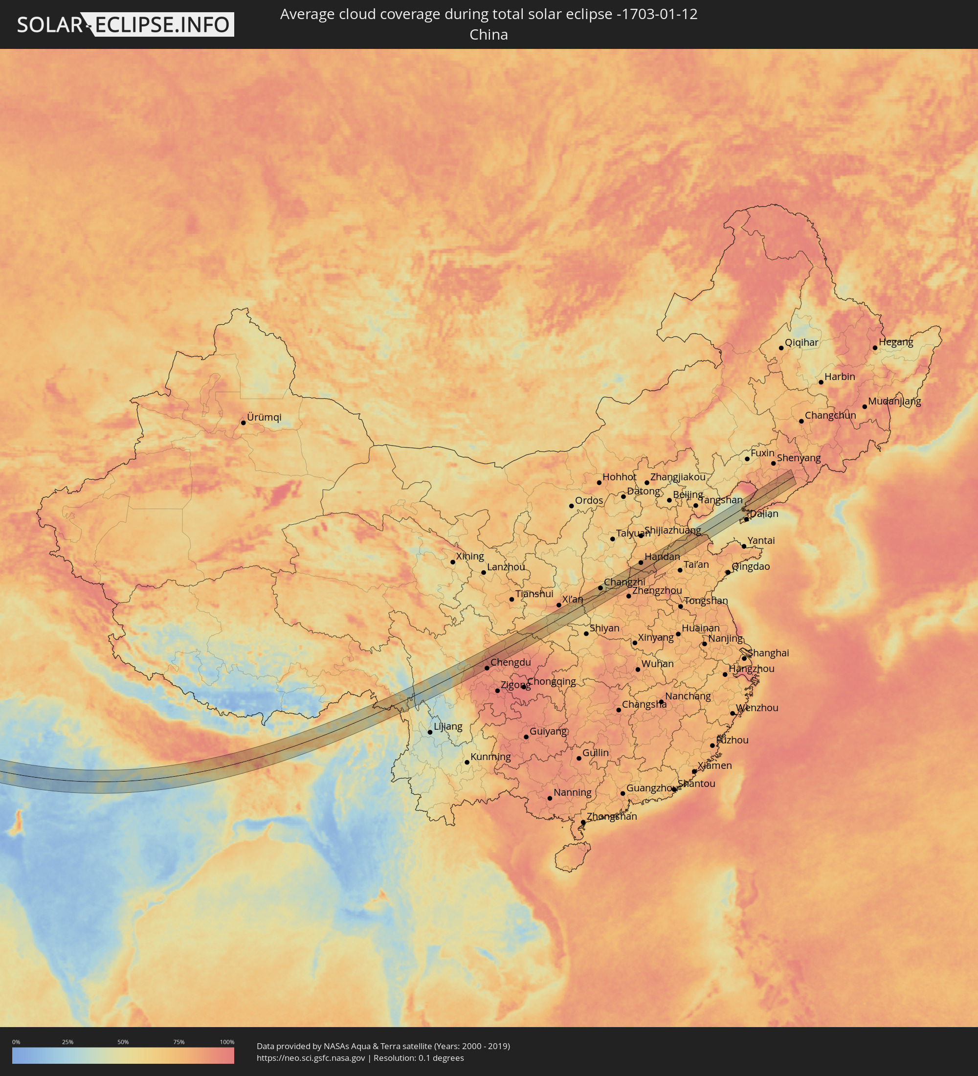 Volksrepublik China
 Bangladesch
 Bhutan
 Myanmar
Orte im Finsternispfad
Die nachfolgene Tabelle zeigt Städte und Orte mit mehr als 5.000 Einwohnern, die sich im Finsternispfad befinden. Städte mit mehr als 100.000 Einwohnern sind dick gekennzeichnet. Mit einem Klick auf den Ort öffnet sich eine Detailkarte die die Lage des jeweiligen Ortes zusammen mit dem Verlauf der zentralen Finsternis präsentiert.
| Ort | Typ | Dauer der Verfinsterung | Ortszeit bei maximaler Verfinsterung | Entfernung zur Zentrallinie | Ø Bewölkung |
|
Băneasa, Constanța
|
total | - | 07:45:57 UTC+01:44 | 7 km | 72% |
|
Borcea, Călăraşi
|
total | - | 07:46:16 UTC+01:44 | 34 km | 74% |
|
Dobrich, Dobrich
|
total | - | 08:01:04 UTC+02:00 | 34 km | 63% |
|
Feteşti, Ialomiţa
|
total | - | 07:46:22 UTC+01:44 | 42 km | 72% |
|
General-Toshevo, Dobrich
|
total | - | 08:01:19 UTC+02:00 | 12 km | 61% |
|
Balchik, Dobrich
|
total | - | 08:01:05 UTC+02:00 | 33 km | 66% |
|
Negru Vodă, Constanța
|
total | - | 07:45:56 UTC+01:44 | 6 km | 64% |
|
Cobadin, Constanța
|
total | - | 07:46:15 UTC+01:44 | 31 km | 72% |
|
Kavarna, Dobrich
|
total | - | 08:01:12 UTC+02:00 | 24 km | 65% |
|
Topraisar, Constanța
|
total | - | 07:46:18 UTC+01:44 | 36 km | 70% |
|
Mangalia, Constanța
|
total | - | 07:46:08 UTC+01:44 | 22 km | 68% |
|
Tuzla, Constanța
|
total | - | 07:46:23 UTC+01:44 | 42 km | 70% |
|
Bartın, Bartın
|
total | - | 07:58:45 UTC+01:56 | 7 km | 78% |
|
Karabük, Karabük
|
total | - | 07:58:32 UTC+01:56 | 34 km | 79% |
|
Khanjarah, Çankırı
|
total | - | 07:58:39 UTC+01:56 | 44 km | 86% |
|
Kastamonu, Kastamonu
|
total | - | 07:59:32 UTC+01:56 | 36 km | 79% |
|
Osmancık, Çorum
|
total | - | 07:59:56 UTC+01:56 | 47 km | 85% |
|
Çorum, Çorum
|
total | - | 07:59:38 UTC+01:56 | 14 km | 83% |
|
Sorgun, Yozgat
|
total | - | 07:59:06 UTC+01:56 | 43 km | 77% |
|
Zile, Tokat
|
total | - | 08:00:09 UTC+01:56 | 35 km | 75% |
|
Sivas, Sivas
|
total | - | 08:00:35 UTC+01:56 | 37 km | 68% |
|
Malatya, Malatya
|
total | - | 08:00:30 UTC+01:56 | 31 km | 78% |
|
Elazığ, Elazığ
|
total | - | 08:01:39 UTC+01:56 | 43 km | 77% |
|
Siverek, Şanlıurfa
|
total | - | 08:00:57 UTC+01:56 | 38 km | 63% |
|
Ergani, Diyarbakır
|
total | - | 08:01:49 UTC+01:56 | 31 km | 68% |
|
Diyarbakır, Diyarbakır
|
total | - | 08:01:59 UTC+01:56 | 20 km | 66% |
|
Kızıltepe, Mardin
|
total | - | 08:01:45 UTC+01:56 | 31 km | 64% |
|
Ad Darbāsīyah, Al-Hasakah
|
total | - | 08:30:00 UTC+02:25 | 38 km | 67% |
|
Bismil, Diyarbakır
|
total | - | 08:02:23 UTC+01:56 | 35 km | 65% |
|
Mardin, Mardin
|
total | - | 08:02:01 UTC+01:56 | 11 km | 66% |
|
Nusaybin, Mardin
|
total | - | 08:02:19 UTC+01:56 | 11 km | 66% |
|
Midyat, Mardin
|
total | - | 08:02:44 UTC+01:56 | 28 km | 64% |
|
Sinjār, Nīnawá
|
total | - | 09:03:06 UTC+02:57 | 49 km | 72% |
|
Sīnah, Dahūk
|
total | - | 09:04:48 UTC+02:57 | 53 km | 68% |
|
Al Mawşil al Jadīdah, Nīnawá
|
total | - | 09:04:30 UTC+02:57 | 11 km | 80% |
|
Mosul, Nīnawá
|
total | - | 09:04:31 UTC+02:57 | 12 km | 80% |
|
Tallkayf, Nīnawá
|
total | - | 09:04:39 UTC+02:57 | 27 km | 69% |
|
Al-Hamdaniya, Nīnawá
|
total | - | 09:04:46 UTC+02:57 | 19 km | 79% |
|
Erbil, Arbīl
|
total | - | 09:05:28 UTC+02:57 | 42 km | 71% |
|
Kirkuk, At Taʼmīm
|
total | - | 09:05:23 UTC+02:57 | 7 km | 72% |
|
Tozkhurmato, Salah ad Din Governorate
|
total | - | 09:05:16 UTC+02:57 | 50 km | 75% |
|
Jamjamāl, As Sulaymānīyah
|
total | - | 09:05:59 UTC+02:57 | 20 km | 64% |
|
Kifrī, Diyālá
|
total | - | 09:05:32 UTC+02:57 | 53 km | 76% |
|
As Sulaymānīyah, As Sulaymānīyah
|
total | - | 09:06:45 UTC+02:57 | 52 km | 68% |
|
Sarpol-e Z̄ahāb, Kermānshāh
|
total | - | 09:34:40 UTC+03:25 | 31 km | 66% |
|
Ḩalabjah, As Sulaymānīyah
|
total | - | 09:07:12 UTC+02:57 | 43 km | 62% |
|
Kāmyārān, Kordestān
|
total | - | 09:36:19 UTC+03:25 | 53 km | 67% |
|
Kahrīz, Kermānshāh
|
total | - | 09:36:12 UTC+03:25 | 19 km | 69% |
|
Harsīn, Kermānshāh
|
total | - | 09:36:52 UTC+03:25 | 35 km | 64% |
|
Kūhdasht, Lorestān
|
total | - | 09:36:25 UTC+03:25 | 34 km | 64% |
|
Nūrābād, Lorestān
|
total | - | 09:37:16 UTC+03:25 | 34 km | 61% |
|
Khorramabad, Lorestān
|
total | - | 09:37:27 UTC+03:25 | 3 km | 64% |
|
Borūjerd, Lorestān
|
total | - | 09:38:17 UTC+03:25 | 55 km | 64% |
|
Alīgūdarz, Lorestān
|
total | - | 09:39:22 UTC+03:25 | 54 km | 54% |
|
Shahr-e Kord, Chahār Maḩāll va Bakhtīārī
|
total | - | 09:40:33 UTC+03:25 | 7 km | 55% |
|
Borūjen, Chahār Maḩāll va Bakhtīārī
|
total | - | 09:41:02 UTC+03:25 | 8 km | 54% |
|
Najafābād, Isfahan
|
total | - | 09:41:32 UTC+03:25 | 61 km | 63% |
|
Shāhreẕā, Isfahan
|
total | - | 09:42:02 UTC+03:25 | 27 km | 56% |
|
Ābādeh, Fars
|
total | - | 09:42:53 UTC+03:25 | 21 km | 45% |
|
Shahr-e Bābak, Kerman
|
total | - | 09:46:47 UTC+03:25 | 7 km | 50% |
|
Sirjan, Kerman
|
total | - | 09:47:34 UTC+03:25 | 47 km | 48% |
|
Rafsanjān, Kerman
|
total | - | 09:48:33 UTC+03:25 | 61 km | 47% |
|
Bam, Kerman
|
total | - | 09:52:45 UTC+03:25 | 38 km | 42% |
|
Īrānshahr, Sistan and Baluchestan
|
total | - | 09:57:11 UTC+03:25 | 55 km | 35% |
|
Bela, Balochistān
|
total | - | 11:12:57 UTC+04:28 | 52 km | 35% |
|
Karachi, Sindh
|
total | - | 11:14:49 UTC+04:28 | 64 km | 53% |
|
Thatta, Sindh
|
total | - | 11:17:01 UTC+04:28 | 56 km | 51% |
|
Hyderabad, Sindh
|
total | - | 11:18:15 UTC+04:28 | 25 km | 59% |
|
Hāla, Sindh
|
total | - | 11:18:24 UTC+04:28 | 72 km | 54% |
|
Tando Muhammad Khān, Sindh
|
total | - | 11:18:40 UTC+04:28 | 1 km | 53% |
|
Tando Jām, Sindh
|
total | - | 11:18:41 UTC+04:28 | 34 km | 52% |
|
Mātli, Sindh
|
total | - | 11:18:59 UTC+04:28 | 4 km | 50% |
|
Tando Ādam, Sindh
|
total | - | 11:19:02 UTC+04:28 | 73 km | 52% |
|
Tando Allāhyār, Sindh
|
total | - | 11:19:11 UTC+04:28 | 42 km | 53% |
|
Talhār, Sindh
|
total | - | 11:19:25 UTC+04:28 | 17 km | 49% |
|
Badīn, Sindh
|
total | - | 11:19:28 UTC+04:28 | 41 km | 49% |
|
Mirpur Khas, Sindh
|
total | - | 11:19:58 UTC+04:28 | 57 km | 46% |
|
Digri, Sindh
|
total | - | 11:20:13 UTC+04:28 | 20 km | 41% |
|
Naukot, Sindh
|
total | - | 11:21:00 UTC+04:28 | 5 km | 38% |
|
Kunri, Sindh
|
total | - | 11:21:27 UTC+04:28 | 34 km | 44% |
|
Dhoro Naro, Sindh
|
total | - | 11:21:28 UTC+04:28 | 69 km | 44% |
|
Umarkot, Sindh
|
total | - | 11:21:55 UTC+04:28 | 58 km | 37% |
|
Mithi, Sindh
|
total | - | 11:22:04 UTC+04:28 | 8 km | 23% |
|
Udaipur, Rajasthan
|
total | - | 12:25:53 UTC+05:21 | 47 km | 19% |
|
Ratlām, Madhya Pradesh
|
total | - | 12:29:51 UTC+05:21 | 75 km | 19% |
|
Bhopal, Madhya Pradesh
|
total | - | 12:36:39 UTC+05:21 | 71 km | 30% |
|
Saugor, Madhya Pradesh
|
total | - | 12:40:23 UTC+05:21 | 7 km | 27% |
|
Murwāra, Madhya Pradesh
|
total | - | 12:45:05 UTC+05:21 | 15 km | 31% |
|
Satna, Madhya Pradesh
|
total | - | 12:46:09 UTC+05:21 | 64 km | 47% |
|
Rewa, Madhya Pradesh
|
total | - | 12:47:27 UTC+05:21 | 54 km | 45% |
|
Singrauli, Madhya Pradesh
|
total | - | 12:51:22 UTC+05:21 | 1 km | 45% |
|
Gaya, Bihar
|
total | - | 12:57:29 UTC+05:21 | 25 km | 69% |
|
Hazārībāg, Jharkhand
|
total | - | 12:58:40 UTC+05:21 | 69 km | 38% |
|
Bihār Sharīf, Bihar
|
total | - | 12:58:44 UTC+05:21 | 58 km | 74% |
|
Monghyr, Bihar
|
total | - | 13:01:08 UTC+05:21 | 55 km | 84% |
|
Bhāgalpur, Bihar
|
total | - | 13:02:27 UTC+05:21 | 29 km | 83% |
|
Purnia, Bihar
|
total | - | 13:03:32 UTC+05:21 | 73 km | 80% |
|
Katihar, Bihar
|
total | - | 13:03:52 UTC+05:21 | 45 km | 82% |
|
Rāiganj, West Bengal
|
total | - | 13:05:13 UTC+05:21 | 38 km | 83% |
|
Ingrāj Bāzār, West Bengal
|
total | - | 13:05:29 UTC+05:21 | 28 km | 70% |
|
Shibganj, Rājshāhi
|
total | - | 13:37:48 UTC+05:53 | 62 km | 70% |
|
Pīrgaaj, Rangpur Division
|
total | - | 13:37:52 UTC+05:53 | 57 km | 74% |
|
Dinājpur, Rangpur Division
|
total | - | 13:38:39 UTC+05:53 | 25 km | 84% |
|
Bālurghāt, West Bengal
|
total | - | 13:06:58 UTC+05:21 | 22 km | 83% |
|
Saidpur, Rājshāhi
|
total | - | 13:39:12 UTC+05:53 | 34 km | 72% |
|
Parbatipur, Rangpur Division
|
total | - | 13:39:21 UTC+05:53 | 21 km | 81% |
|
Pār Naogaon, Rājshāhi
|
total | - | 13:39:42 UTC+05:53 | 72 km | 80% |
|
Joypur Hāt, Rājshāhi
|
total | - | 13:39:47 UTC+05:53 | 42 km | 71% |
|
Badarganj, Rangpur Division
|
total | - | 13:39:38 UTC+05:53 | 18 km | 69% |
|
Rangpur, Rangpur Division
|
total | - | 13:40:05 UTC+05:53 | 20 km | 61% |
|
Lalmanirhat, Rangpur Division
|
total | - | 13:40:29 UTC+05:53 | 32 km | 70% |
|
Chilmāri, Rangpur Division
|
total | - | 13:41:10 UTC+05:53 | 13 km | 75% |
|
Nageswari, Rangpur Division
|
total | - | 13:41:03 UTC+05:53 | 30 km | 69% |
|
Samdrup Jongkhar, Samdrup Jongkhar
|
total | - | 13:50:11 UTC+05:58 | 59 km | 56% |
|
Guwahati, Assam
|
total | - | 13:13:34 UTC+05:21 | 14 km | 63% |
|
Deyang, Sichuan
|
total | - | 16:12:53 UTC+08:00 | 28 km | 92% |
|
Mianyang, Sichuan
|
total | - | 16:13:04 UTC+08:00 | 8 km | 90% |
|
Jiangyou, Sichuan
|
total | - | 16:12:54 UTC+08:00 | 20 km | 88% |
|
Guangyuan, Sichuan
|
total | - | 16:13:56 UTC+08:00 | 36 km | 80% |
|
Hanzhong, Shaanxi
|
total | - | 16:15:02 UTC+08:00 | 42 km | 85% |
|
Huayin, Shaanxi
|
total | - | 16:17:28 UTC+08:00 | 46 km | 77% |
|
Yuncheng, Shanxi
|
total | - | 16:18:06 UTC+08:00 | 47 km | 76% |
|
Changzhi, Shanxi
|
total | - | 16:18:44 UTC+08:00 | 31 km | 72% |
|
Jincheng, Shanxi
|
total | - | 16:19:36 UTC+08:00 | 8 km | 69% |
|
Jiaozuo, Henan
|
total | - | 16:20:14 UTC+08:00 | 35 km | 80% |
|
Hebi, Henan
|
total | - | 16:20:33 UTC+08:00 | 17 km | 80% |
|
Linshui, Hebei
|
total | - | 16:20:04 UTC+08:00 | 33 km | 77% |
|
Anyang, Henan
|
total | - | 16:20:32 UTC+08:00 | 7 km | 80% |
|
Handan, Hebei
|
total | - | 16:20:08 UTC+08:00 | 37 km | 79% |
|
Qingnian, Shandong
|
total | - | 16:21:02 UTC+08:00 | 3 km | 74% |
|
Liaocheng, Shandong
|
total | - | 16:21:38 UTC+08:00 | 46 km | 77% |
|
Dezhou, Shandong
|
total | - | 16:20:57 UTC+08:00 | 33 km | 71% |
|
Wafangdian, Liaoning
|
total | - | 16:22:53 UTC+08:00 | 22 km | 73% |
|
Fengcheng, Liaoning
|
total | - | 16:23:12 UTC+08:00 | 36 km | 72% |