Totale Sonnenfinsternis vom 29.08.-1705
| Wochentag: | Dienstag |
| Maximale Dauer der Verfinsterung: | 03m16s |
| Maximale Breite des Finsternispfades: | 162 km |
| Saroszyklus: | 27 |
| Bedeckungsgrad: | 100% |
| Magnitude: | 1.0416 |
| Gamma: | 0.515 |
Wo kann man die Sonnenfinsternis vom 29.08.-1705 sehen?

Die Sonnenfinsternis am 29.08.-1705 kann man in 107 Ländern als partielle Sonnenfinsternis beobachten.
Der Finsternispfad verläuft durch 24 Länder. Nur in diesen Ländern ist sie als totale Sonnenfinsternis zu sehen.
In den folgenden Ländern ist die Sonnenfinsternis total zu sehen
 Irland
 Vereinigtes Königreich
 Frankreich
 Belgien
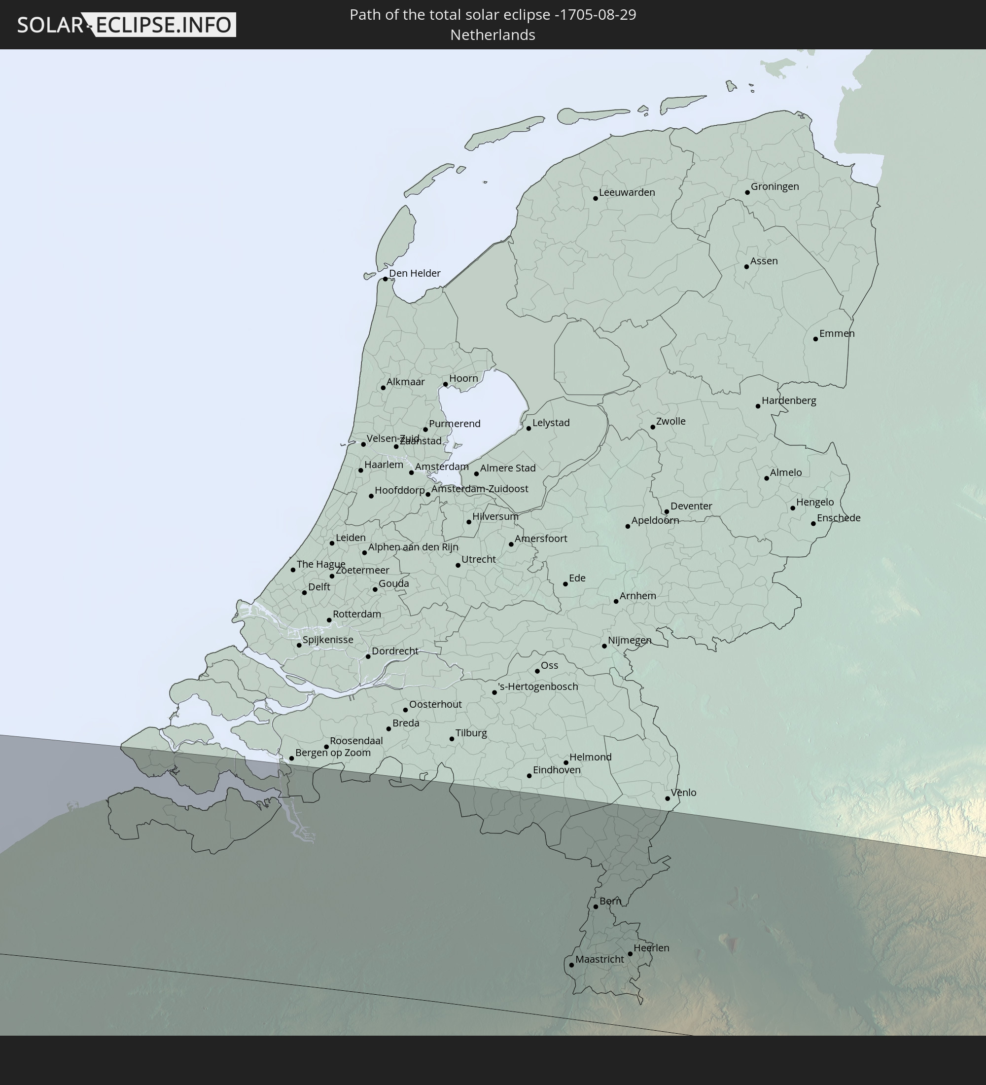 Niederlande
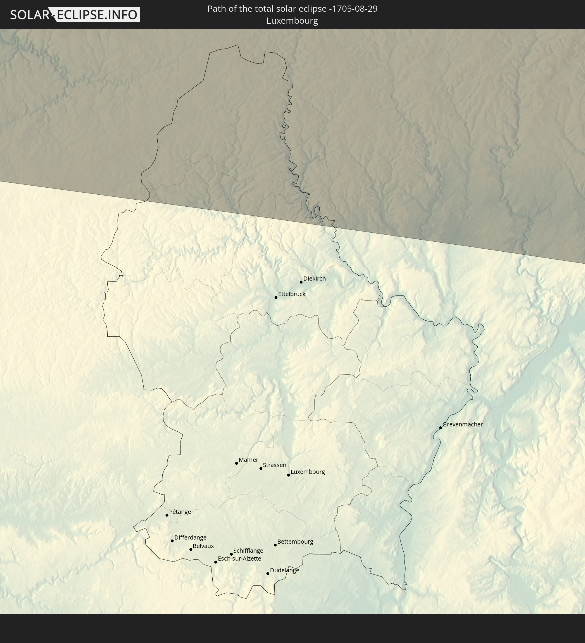 Luxemburg
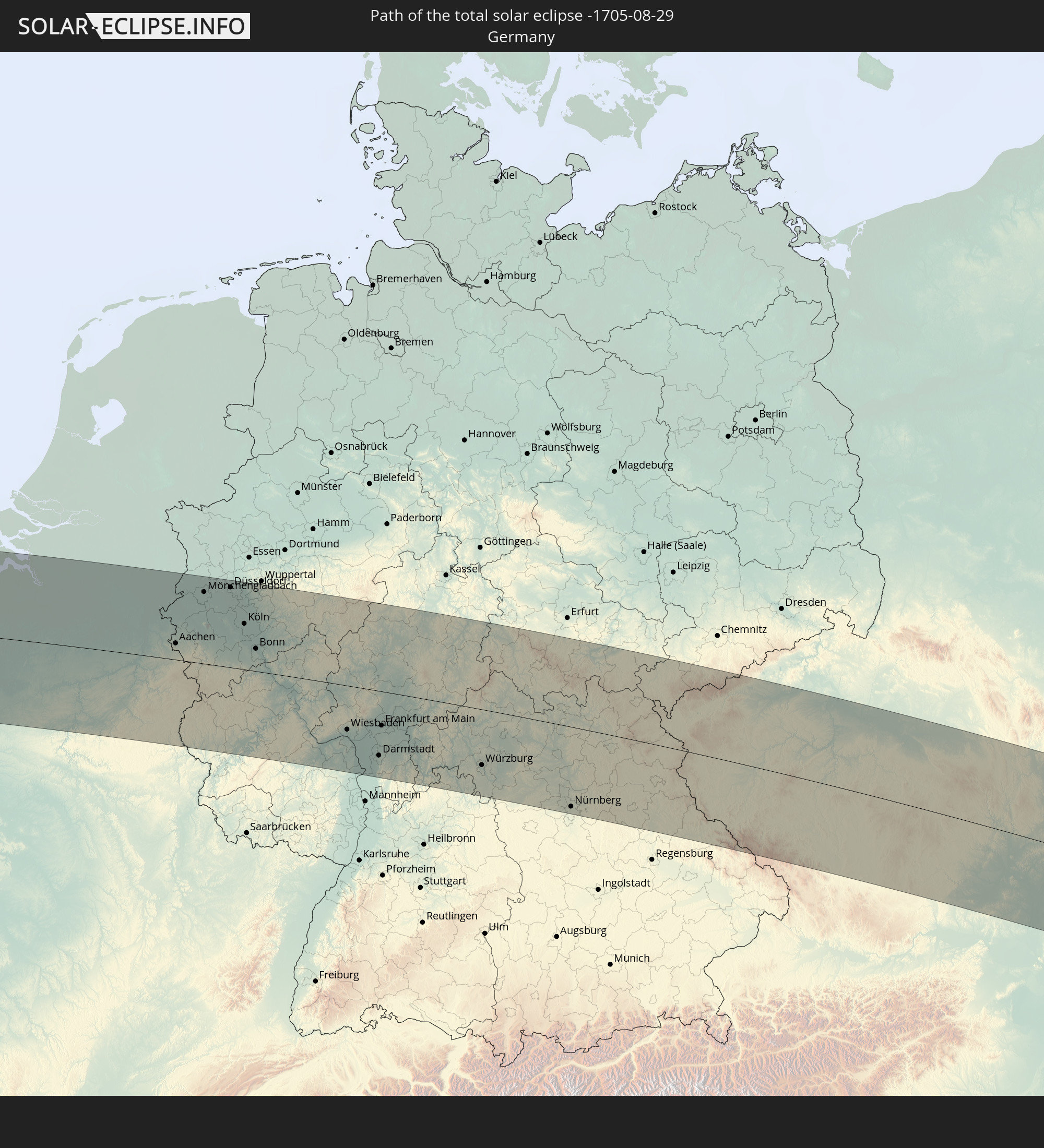 Deutschland
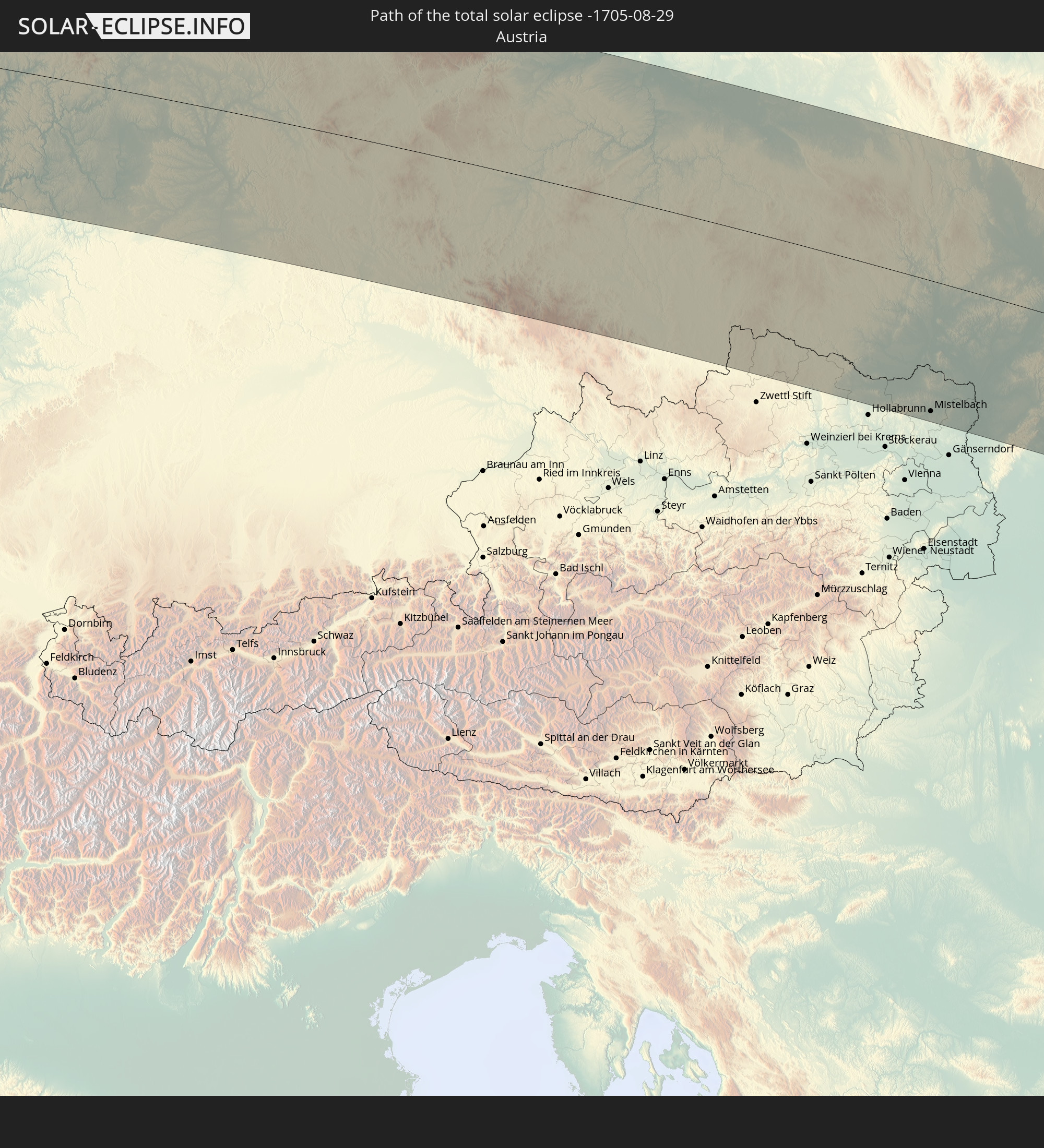 Österreich
 Tschechien
 Polen
Polen
 Ungarn
 Slowakei
 Rumänien
 Ukraine
 Türkei
 Moldawien
 Georgien
 Armenien
 Iran
Iran
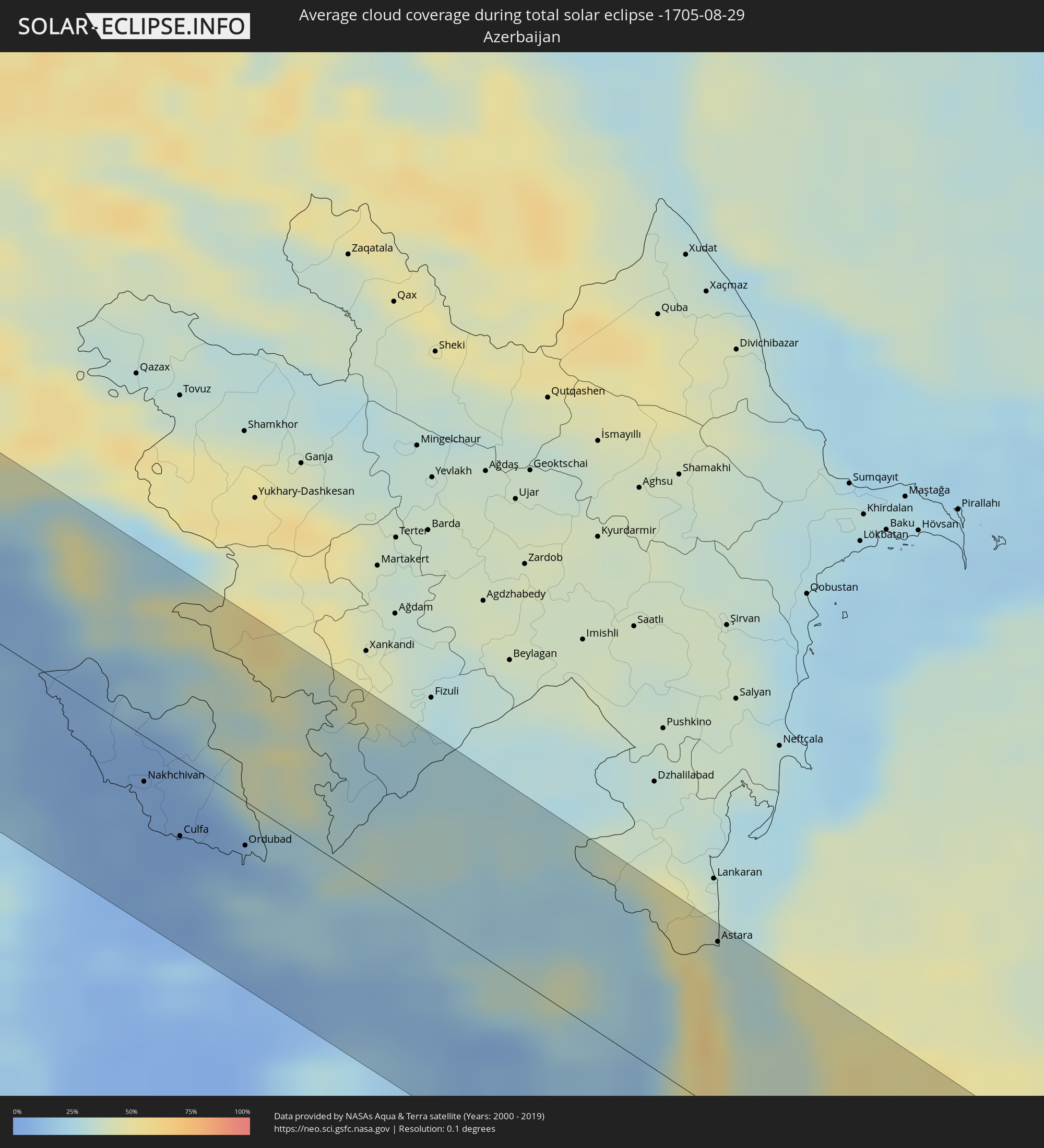
 Aserbaidschan
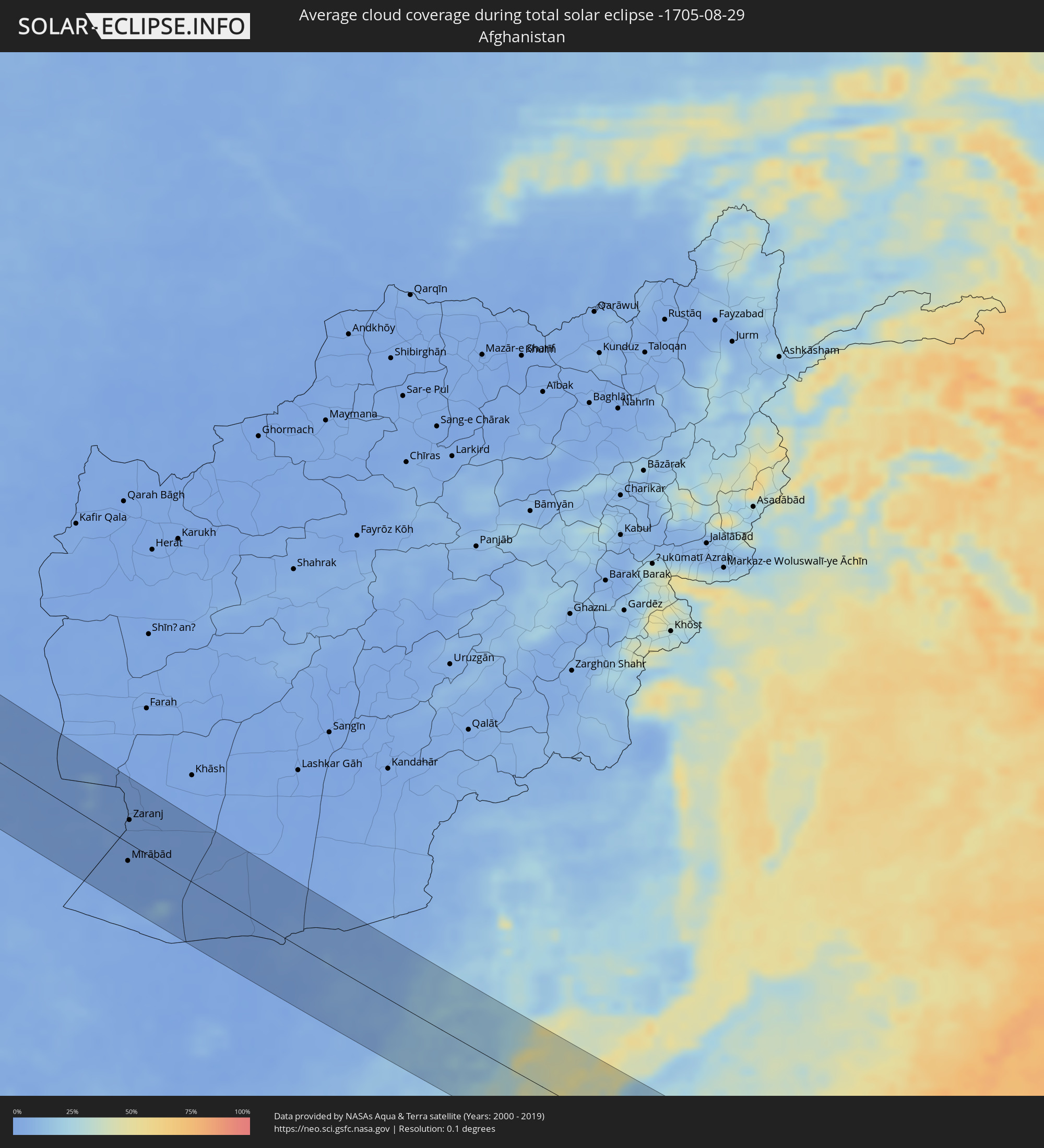
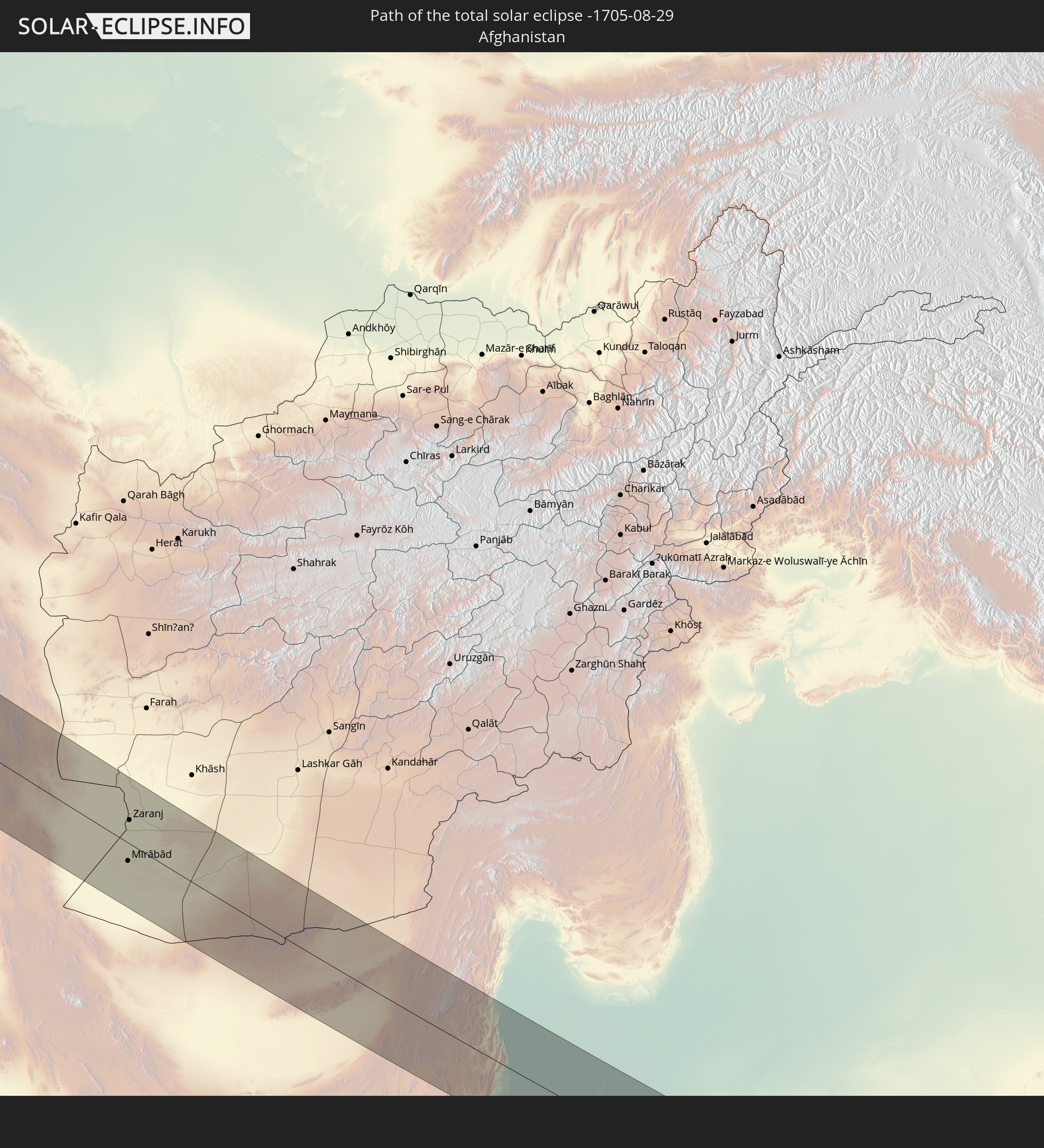 Afghanistan
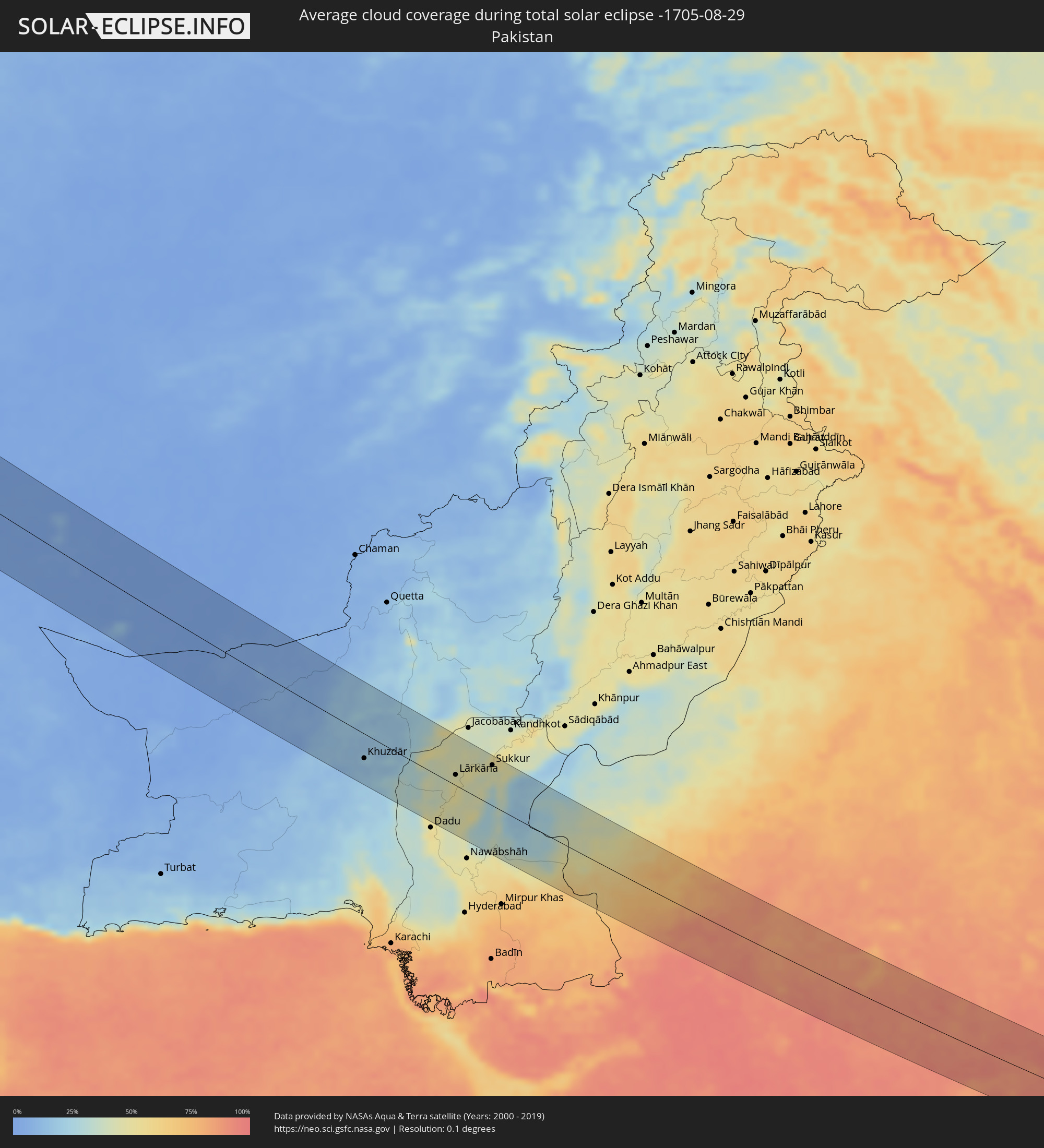
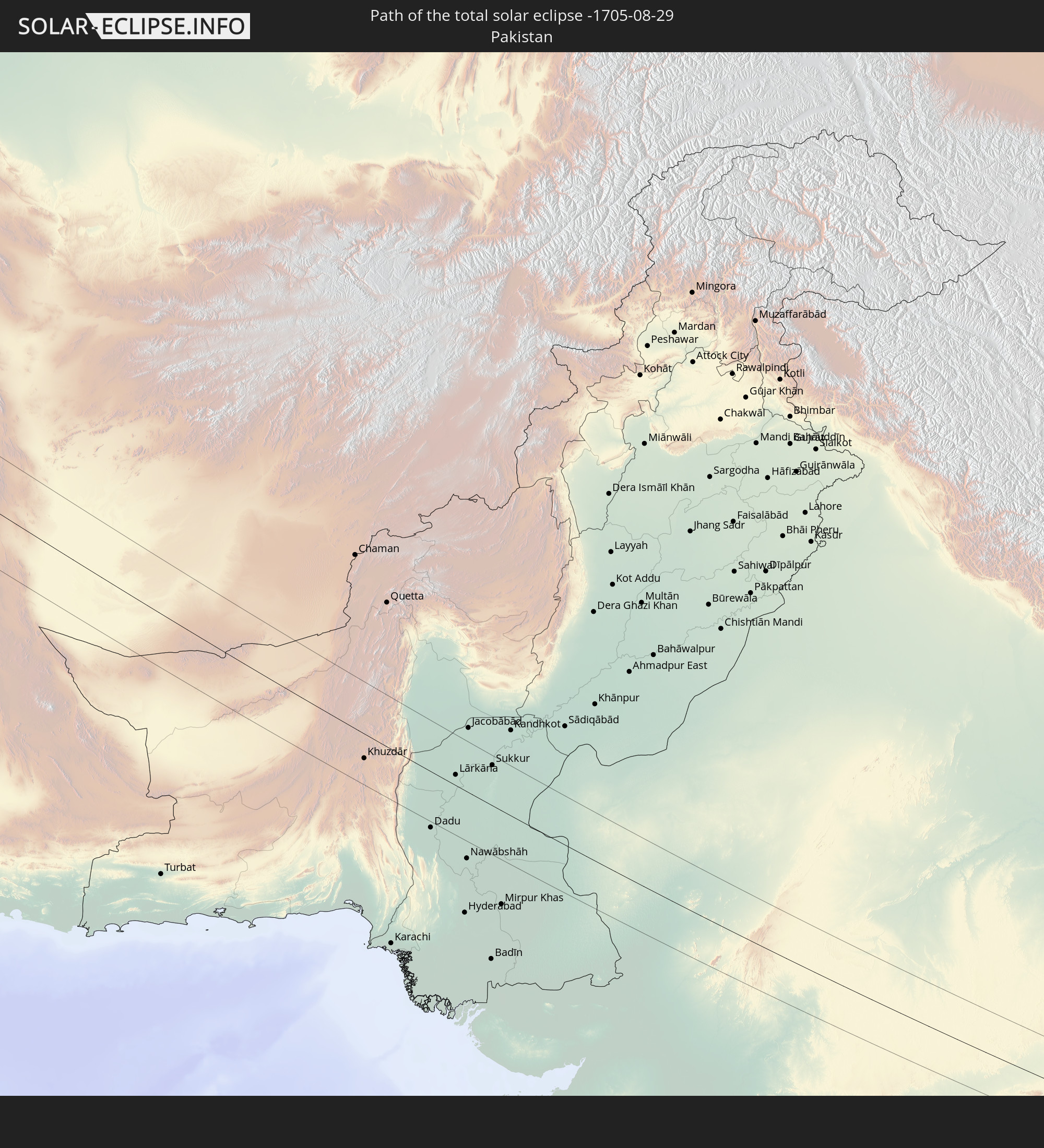 Pakistan
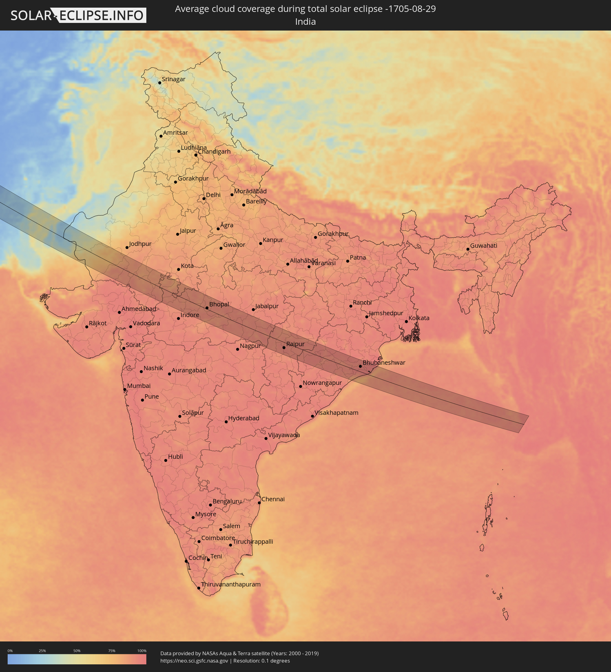
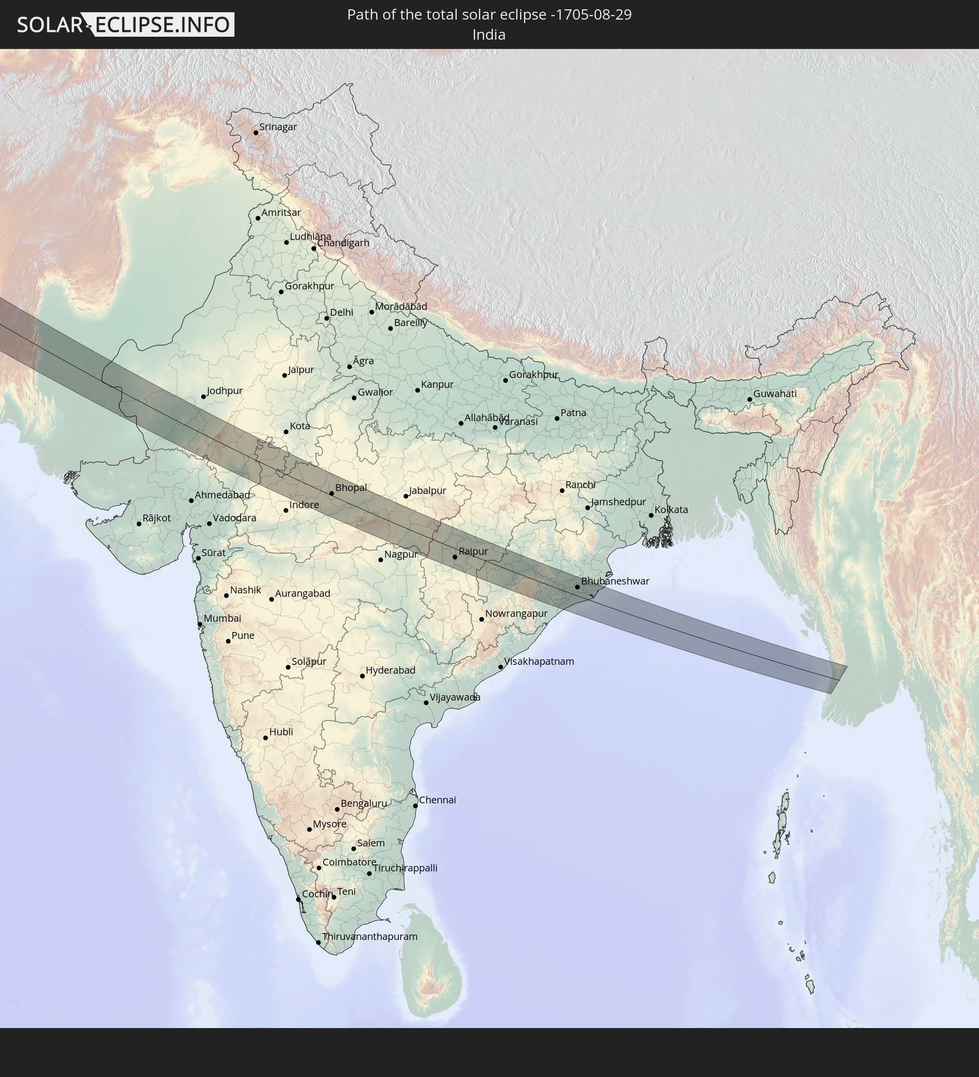 Indien
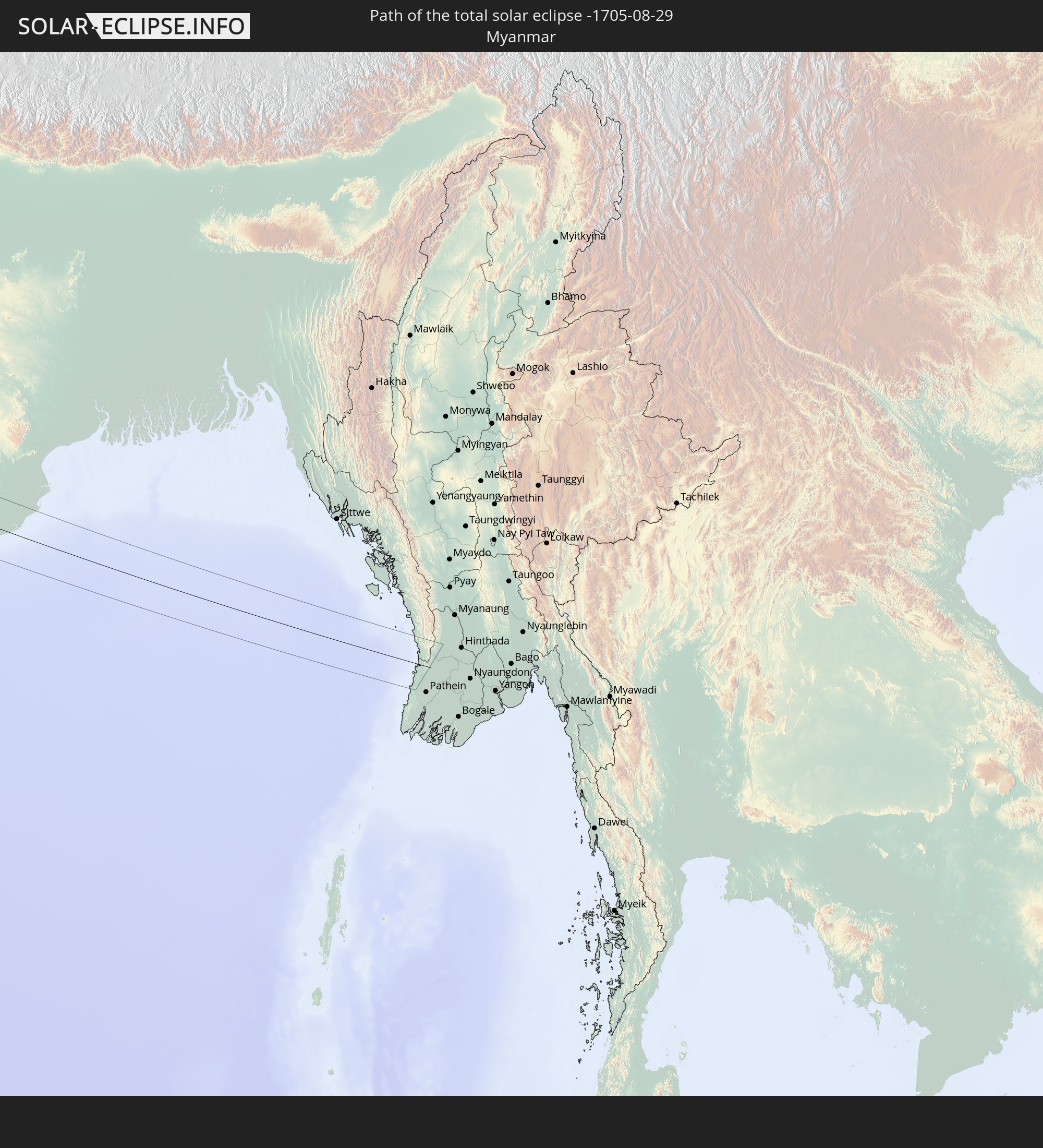 Myanmar
In den folgenden Ländern ist die Sonnenfinsternis partiell zu sehen
 Russland
 Kanada
 Grönland
 Saint-Pierre und Miquelon
 Portugal
 Kap Verde
 Island
 Spanien
 Mauretanien
 Marokko
 Mali
Mali
 Irland
 Spitzbergen
 Algerien
 Vereinigtes Königreich
 Färöer
 Gibraltar
 Frankreich
 Isle of Man
 Guernsey
 Jersey
 Niger
Niger
 Andorra
 Belgien
 Niederlande
 Norwegen
 Luxemburg
 Deutschland
 Schweiz
 Italien
 Monaco
 Tunesien
 Dänemark
 Libyen
 Liechtenstein
 Österreich
 Schweden
 Tschechien
 San Marino
 Vatikanstadt
 Slowenien
 Tschad
 Kroatien
 Polen
Polen
 Malta
Malta
 Bosnien und Herzegowina
 Ungarn
 Slowakei
 Montenegro
 Serbien
 Albanien
 Åland Islands
 Griechenland
 Rumänien
 Mazedonien
 Finnland
 Litauen
 Lettland
 Estland
 Sudan
Sudan
 Ukraine
 Bulgarien
 Weißrussland
 Ägypten
 Türkei
 Moldawien
 Republik Zypern
 Äthiopien
 Kenia
Kenia
 Staat Palästina
 Israel
 Saudi-Arabien
 Jordanien
 Libanon
 Syrien
 Eritrea
 Irak
Irak
 Georgien
 Somalia
 Dschibuti
 Jemen
Jemen
 Armenien
 Iran
Iran
 Aserbaidschan
 Seychellen
 Kasachstan
 Kuwait
 Bahrain
 Katar
Katar
 Vereinigte Arabische Emirate
 Oman
Oman
 Turkmenistan
 Usbekistan
 Afghanistan
 Pakistan
 Tadschikistan
 Indien
 Kirgisistan
 Britisches Territorium im Indischen Ozean
 Malediven
 Volksrepublik China
 Sri Lanka
 Nepal
Nepal
 Mongolei
 Bangladesch
 Bhutan
 Myanmar
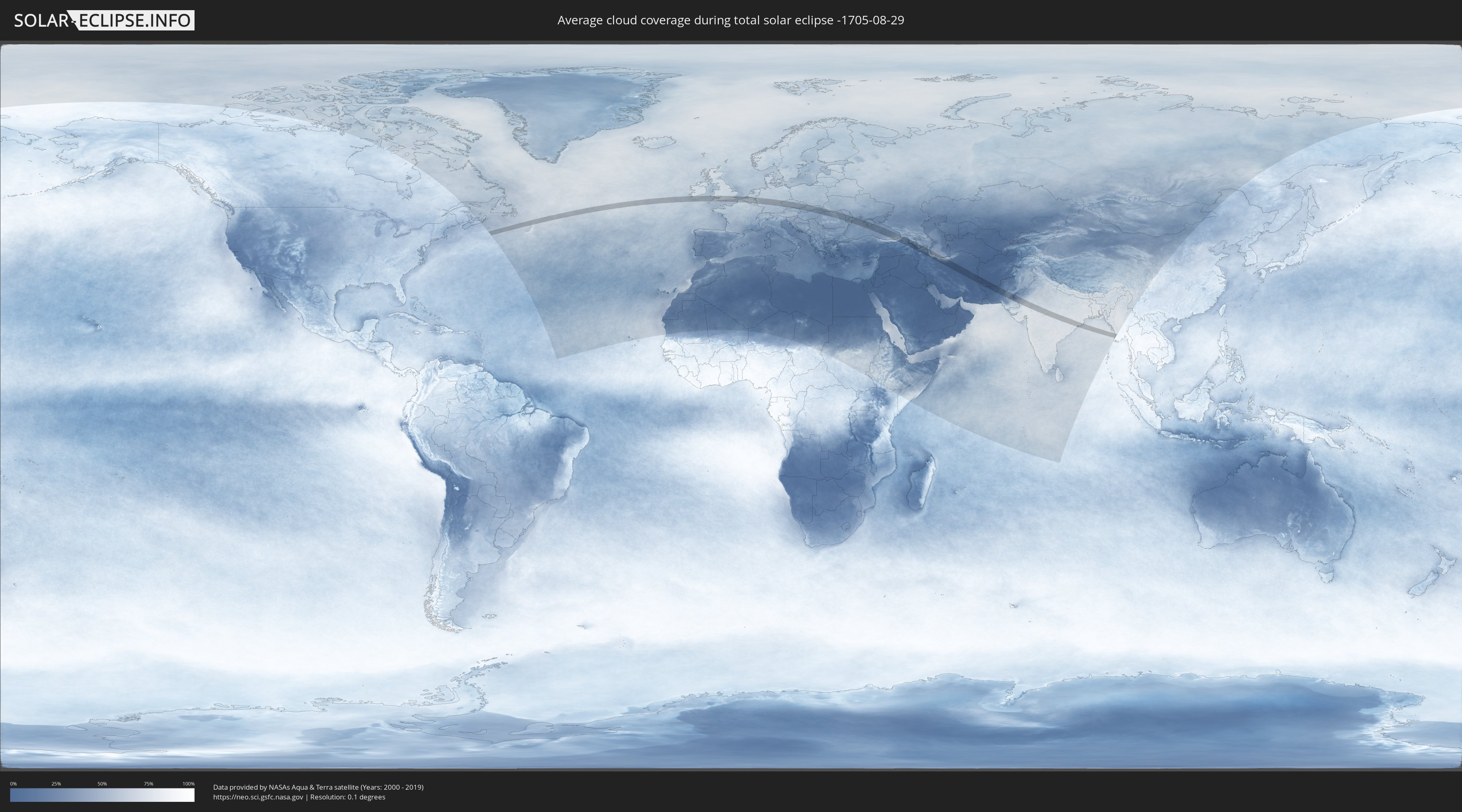
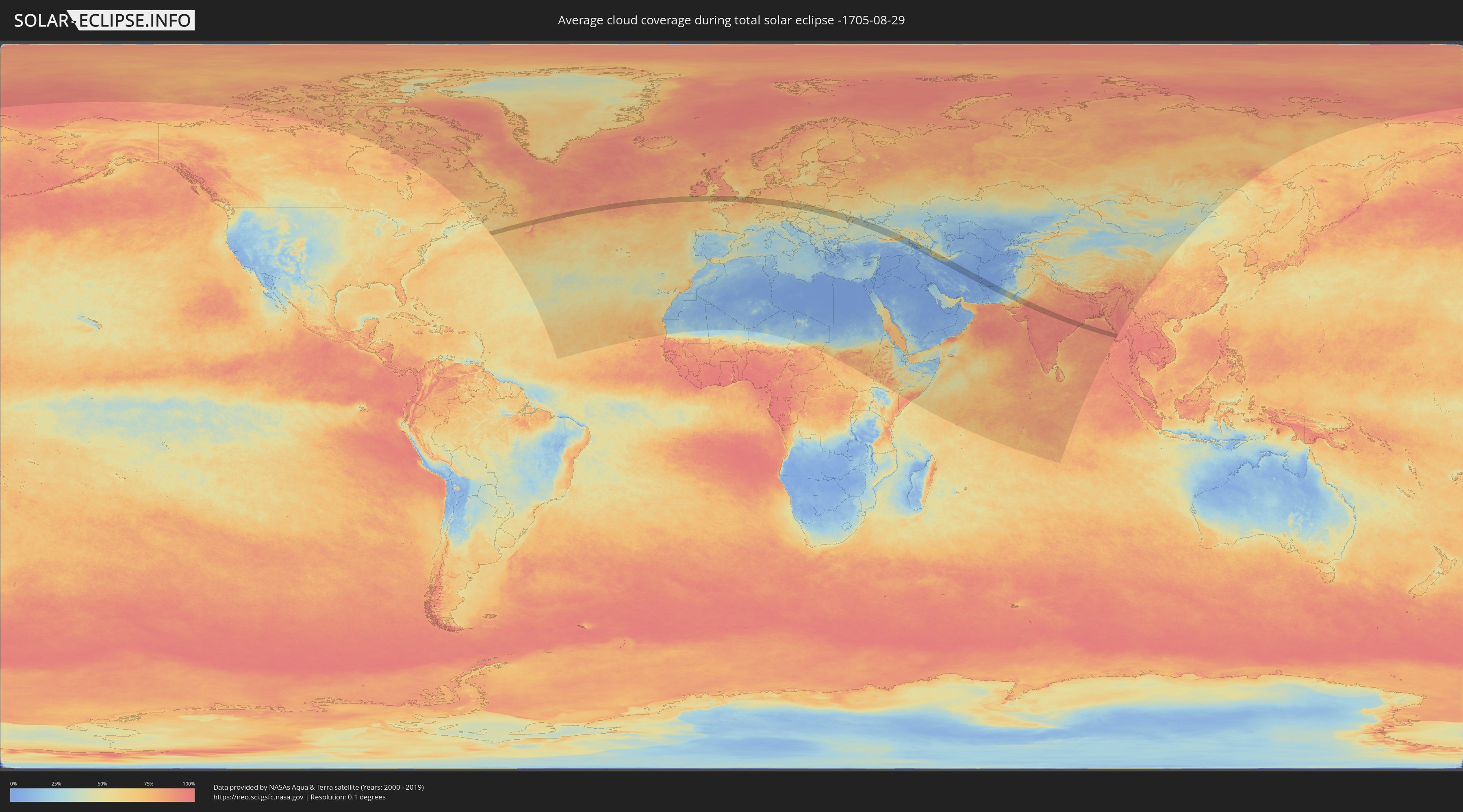
Wie wird das Wetter während der totalen Sonnenfinsternis am 29.08.-1705?
Wo ist der beste Ort, um die totale Sonnenfinsternis vom 29.08.-1705 zu beobachten?
Die folgenden Karten zeigen die durchschnittliche Bewölkung für den Tag, an dem die totale Sonnenfinsternis
stattfindet. Mit Hilfe der Karten lässt sich der Ort entlang des Finsternispfades eingrenzen,
der die besten Aussichen auf einen klaren wolkenfreien Himmel bietet.
Trotzdem muss man immer lokale Gegenenheiten beachten und sollte sich genau über das Wetter an seinem
gewählten Beobachtungsort informieren.
Die Daten stammen von den beiden NASA-Satelliten
AQUA und TERRA
und wurden über einen Zeitraum von 19 Jahren (2000 - 2019) gemittelt.
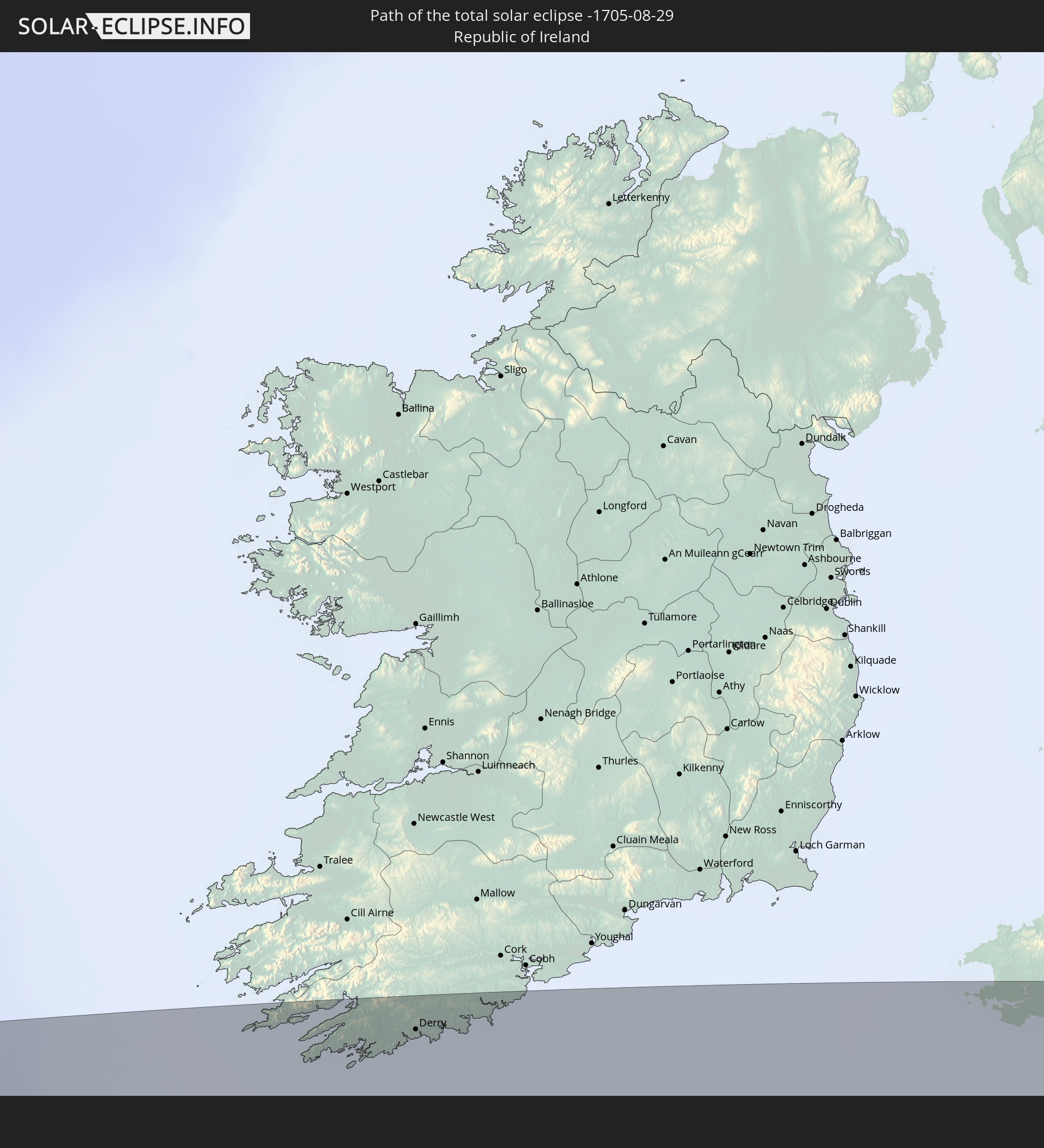
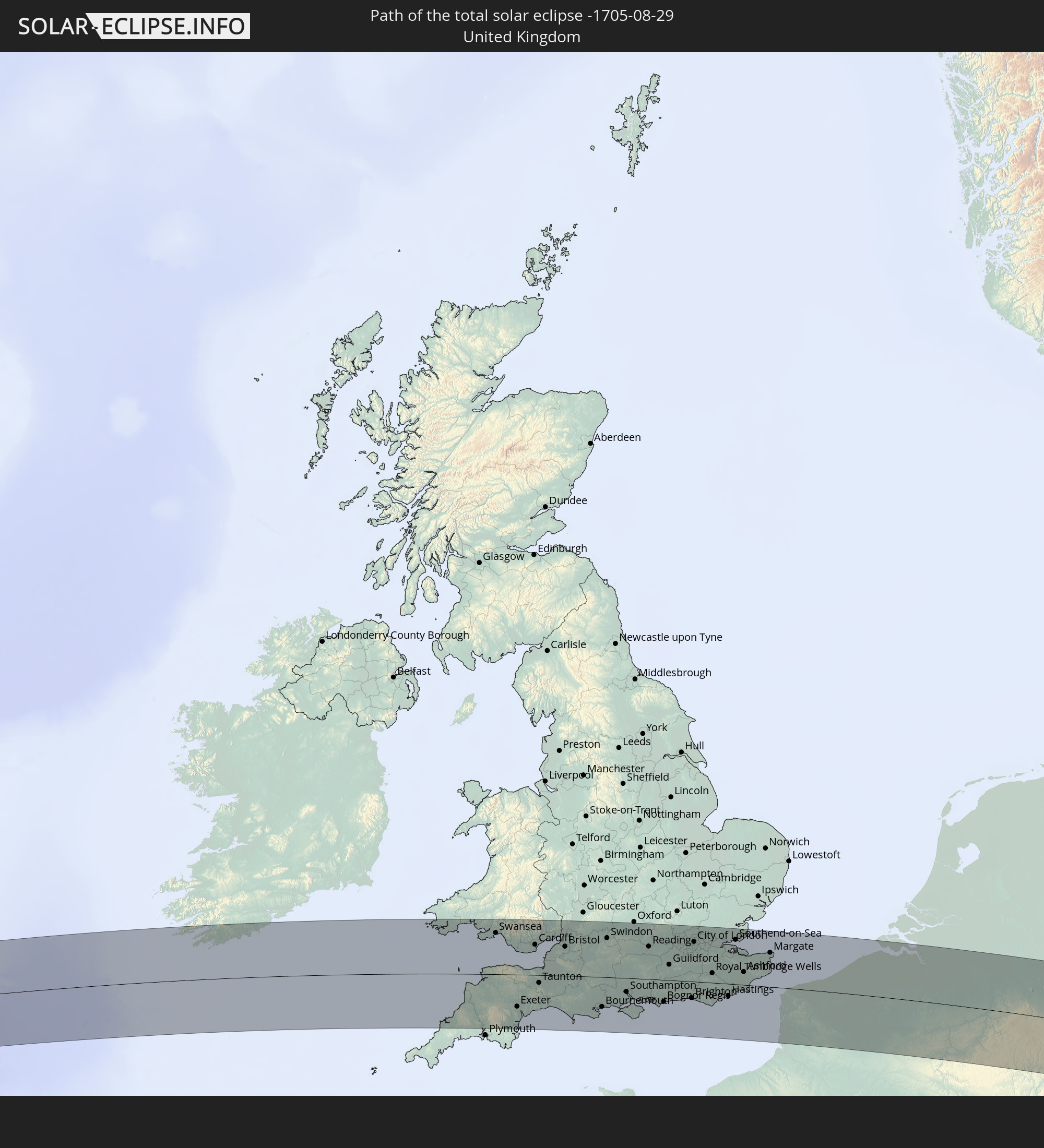
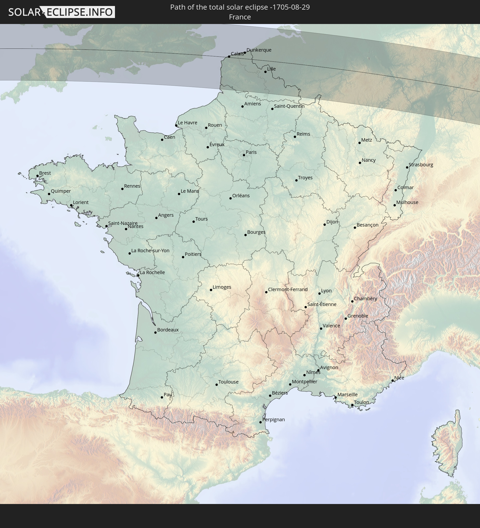
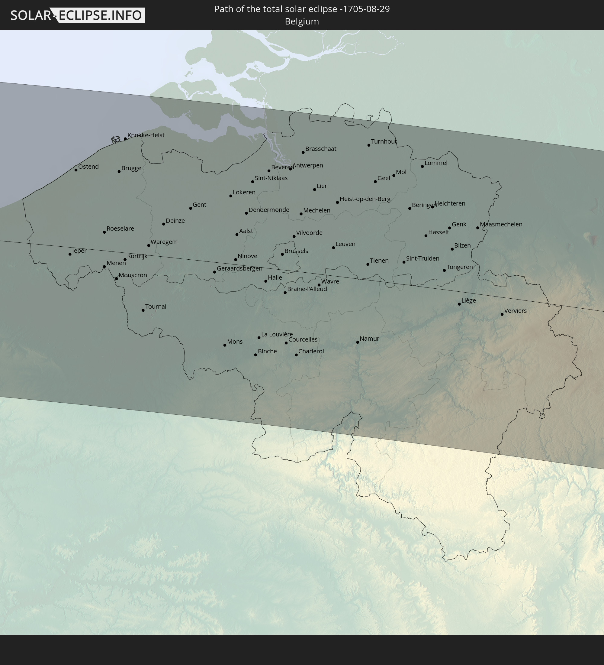
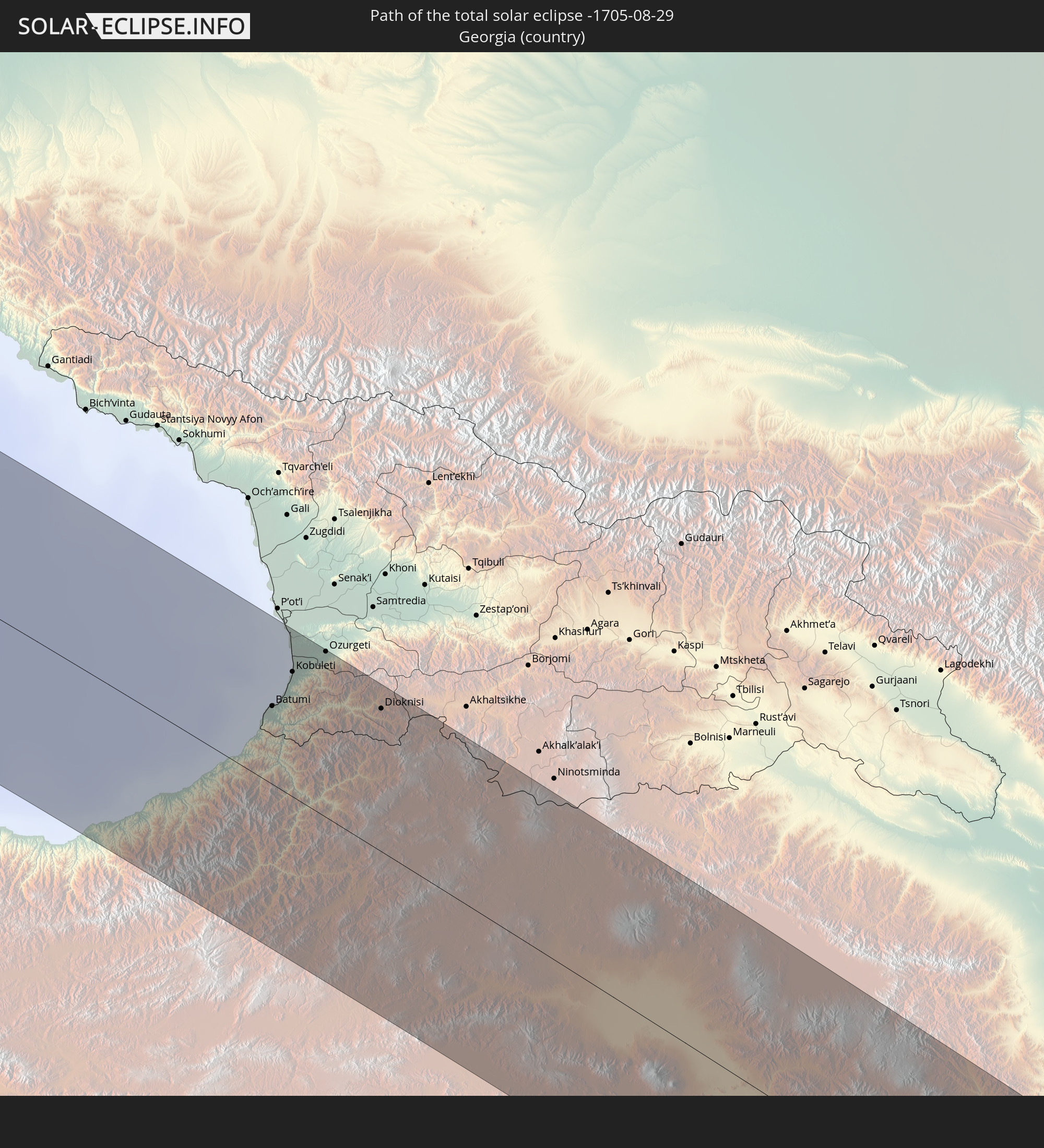
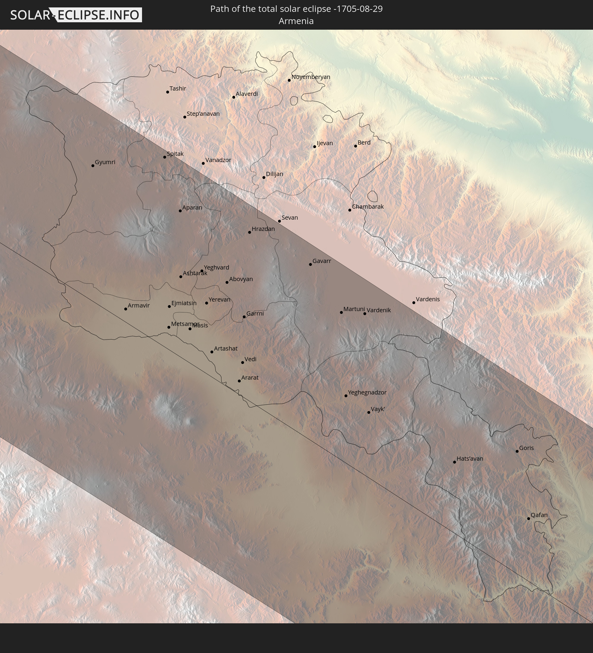
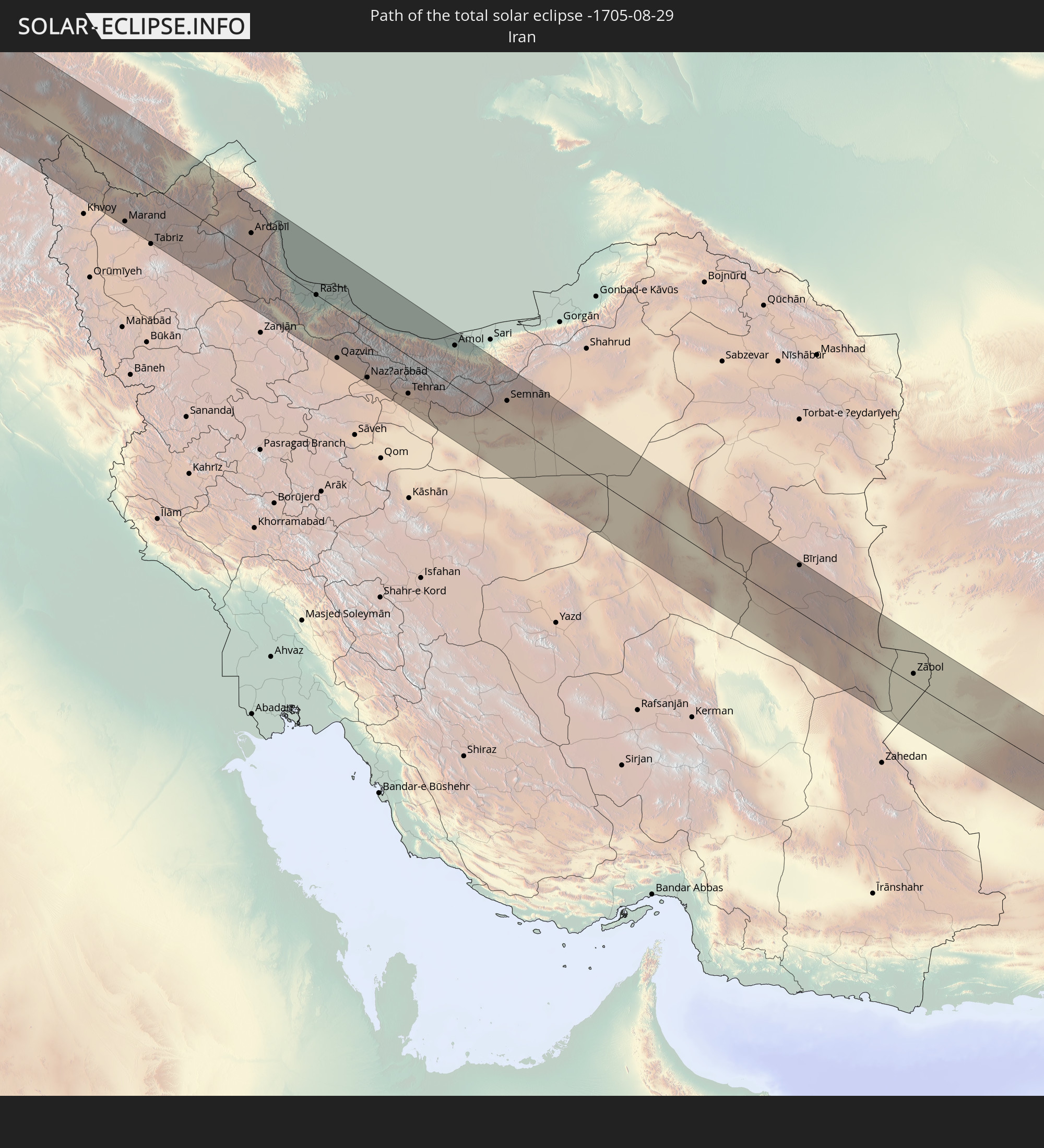
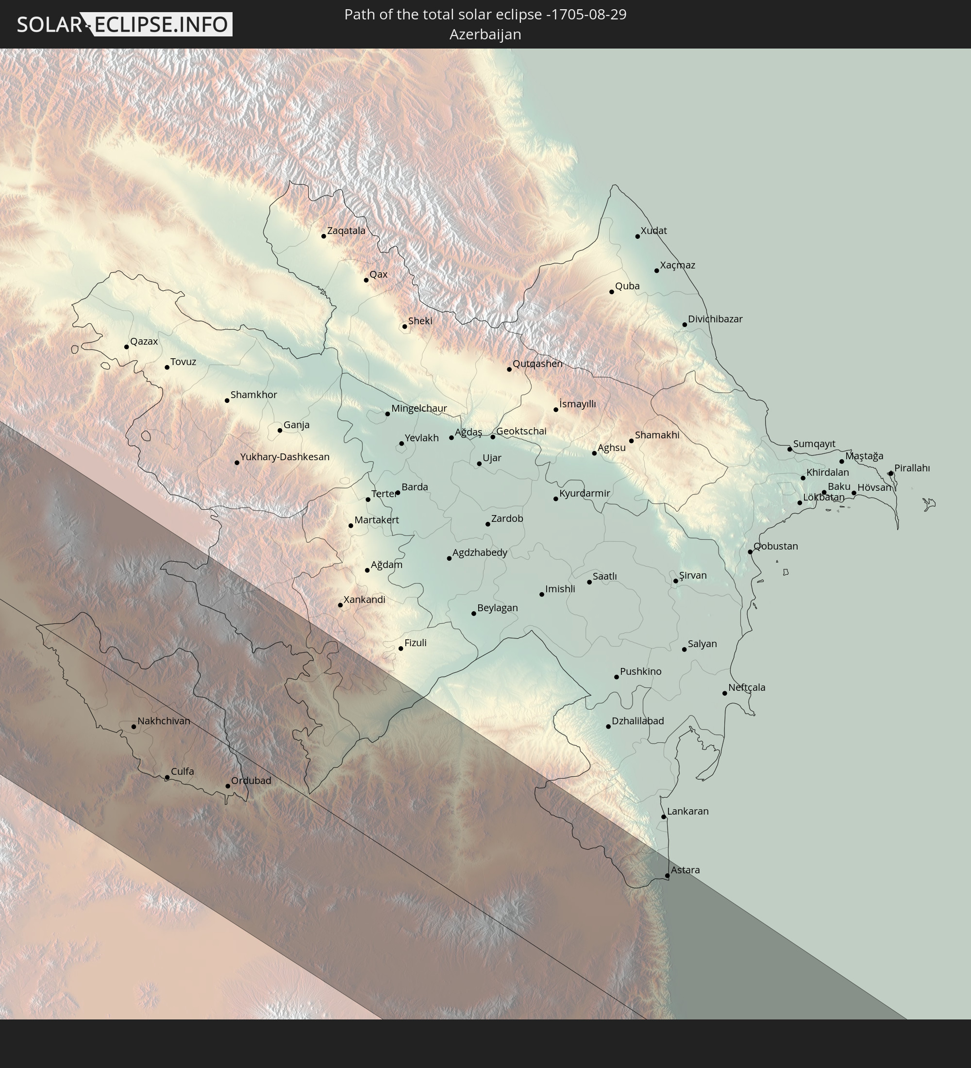
Detaillierte Länderkarten
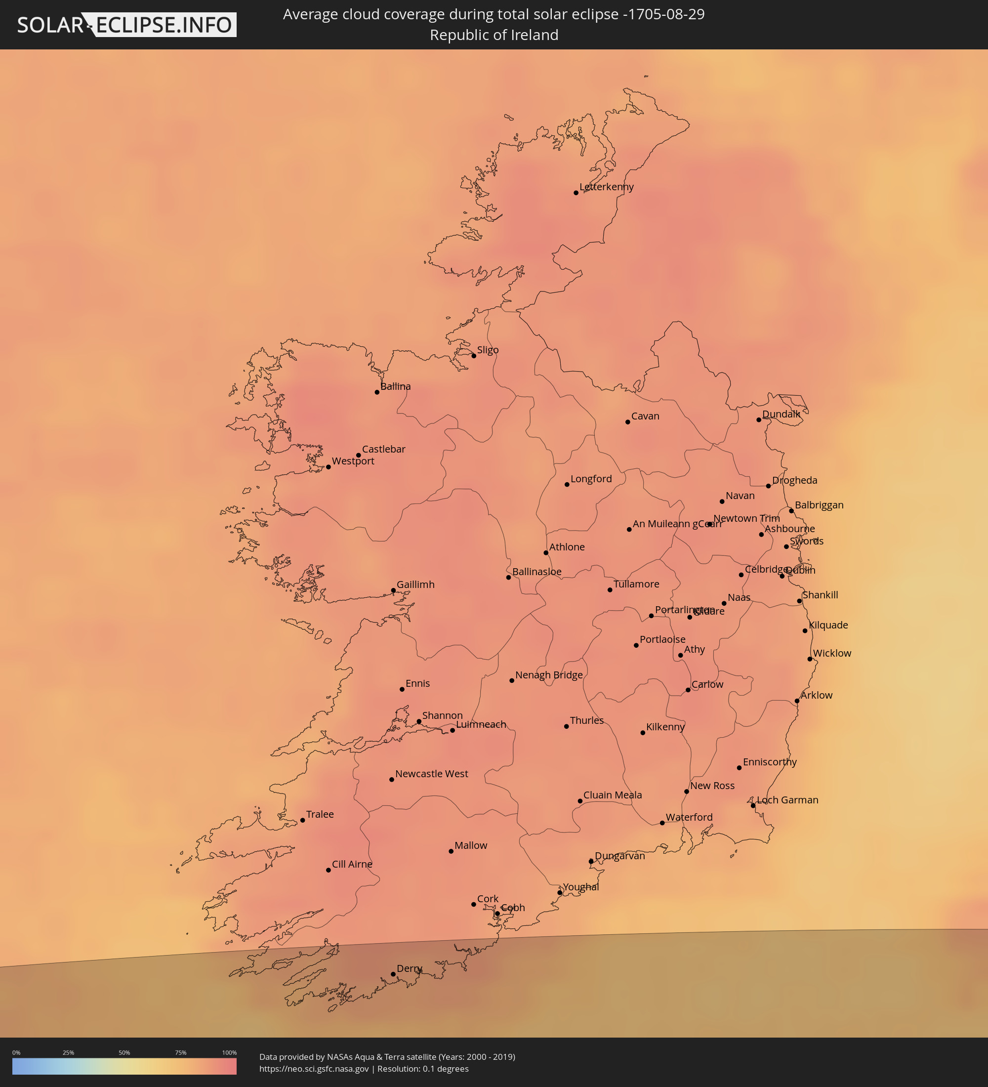 Irland
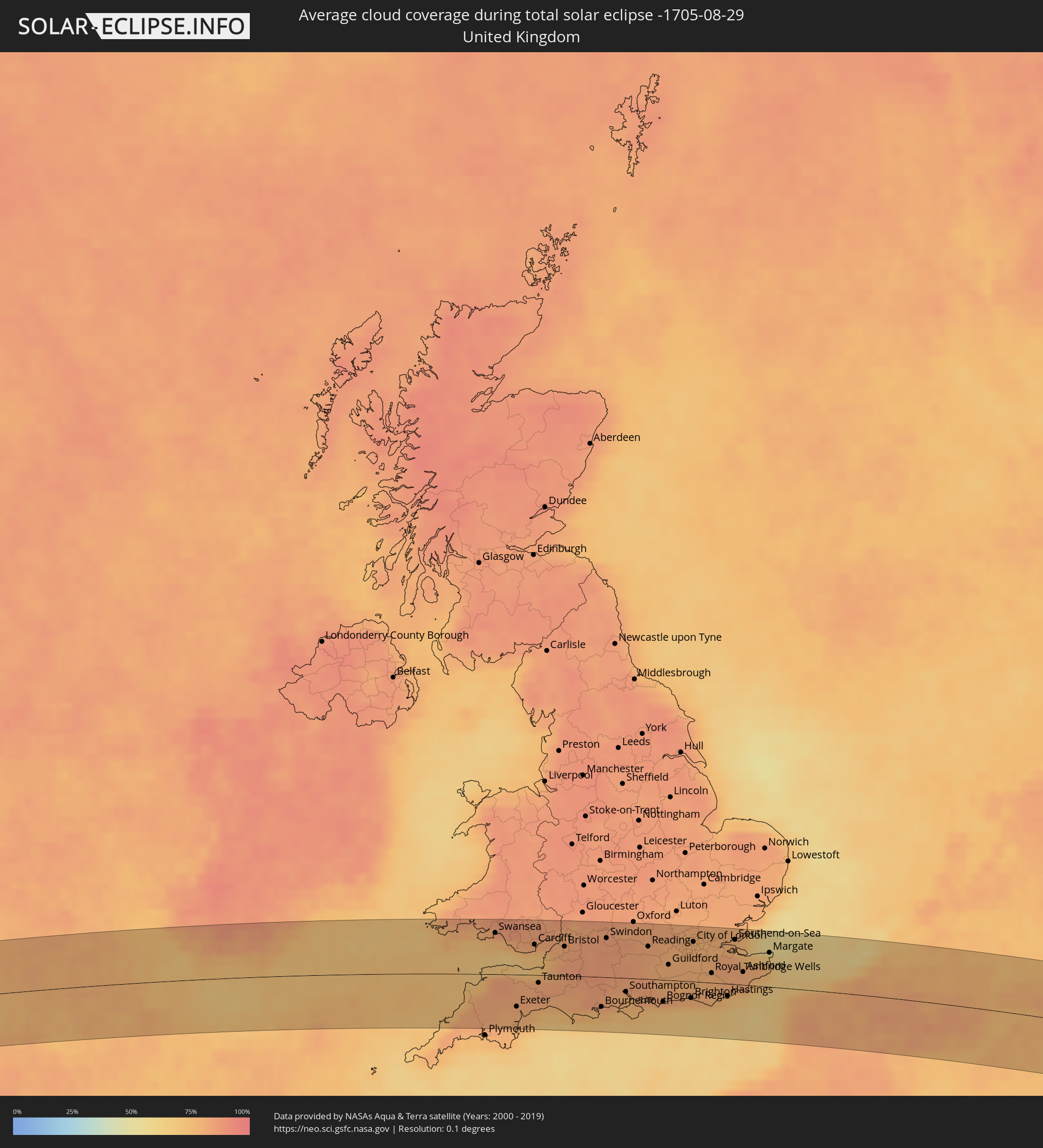 Vereinigtes Königreich
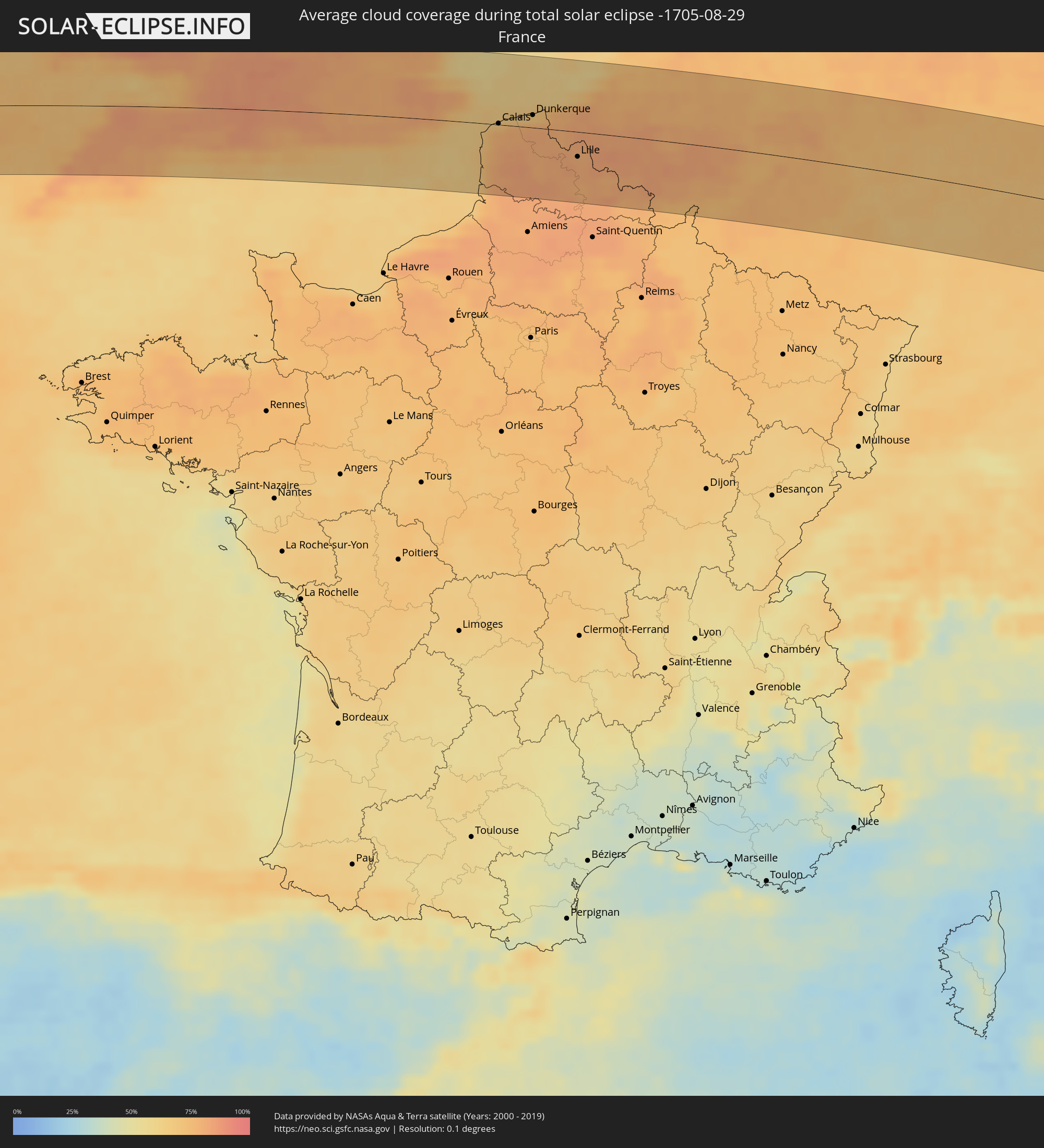 Frankreich
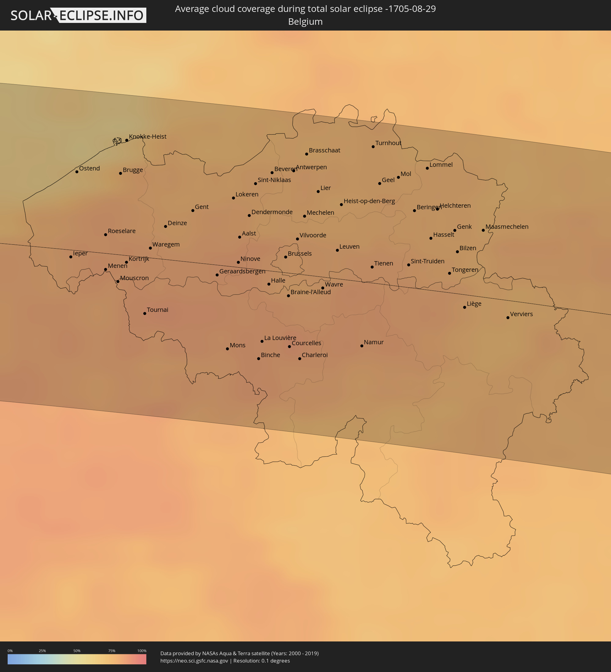 Belgien
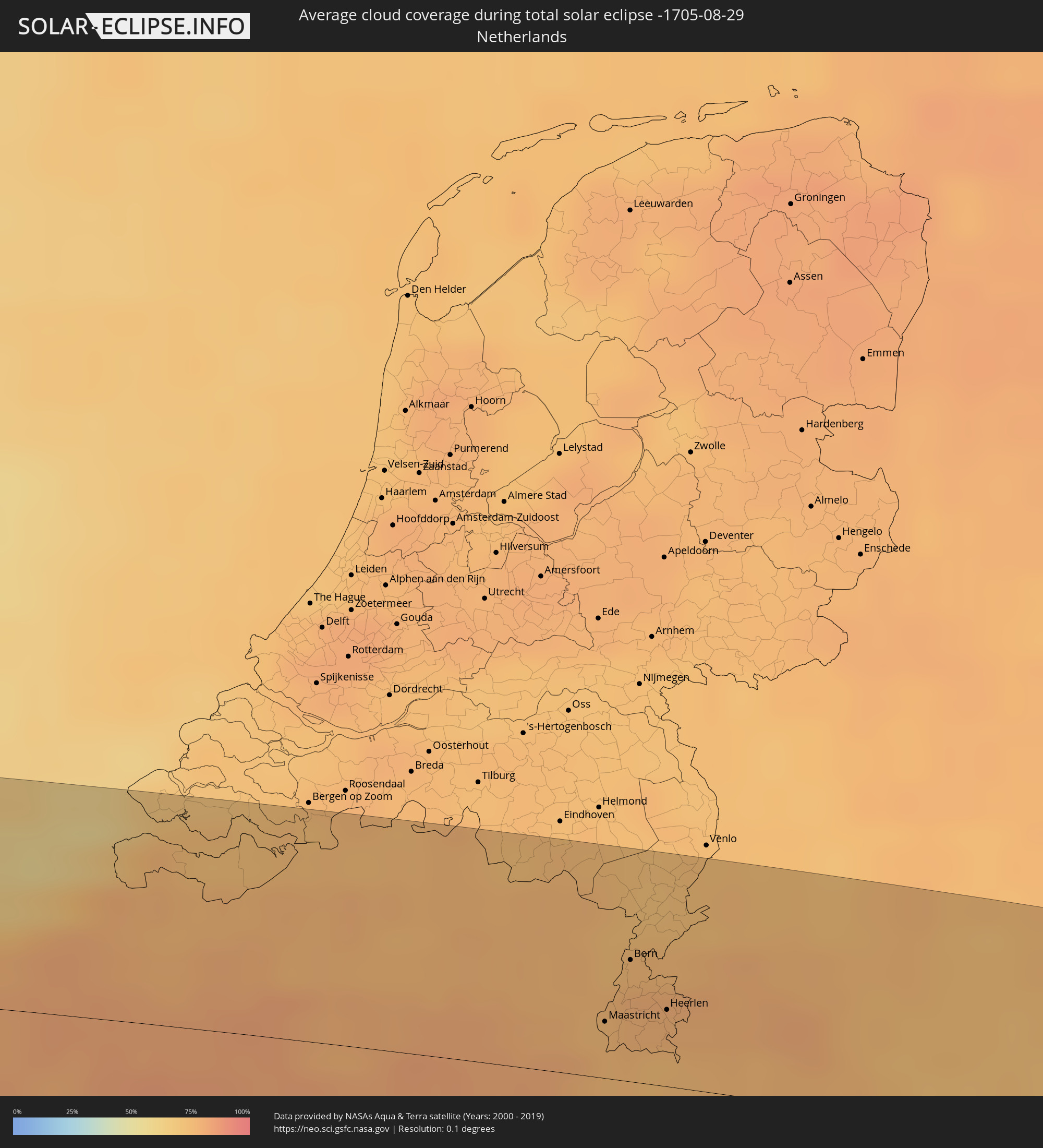 Niederlande
 Luxemburg
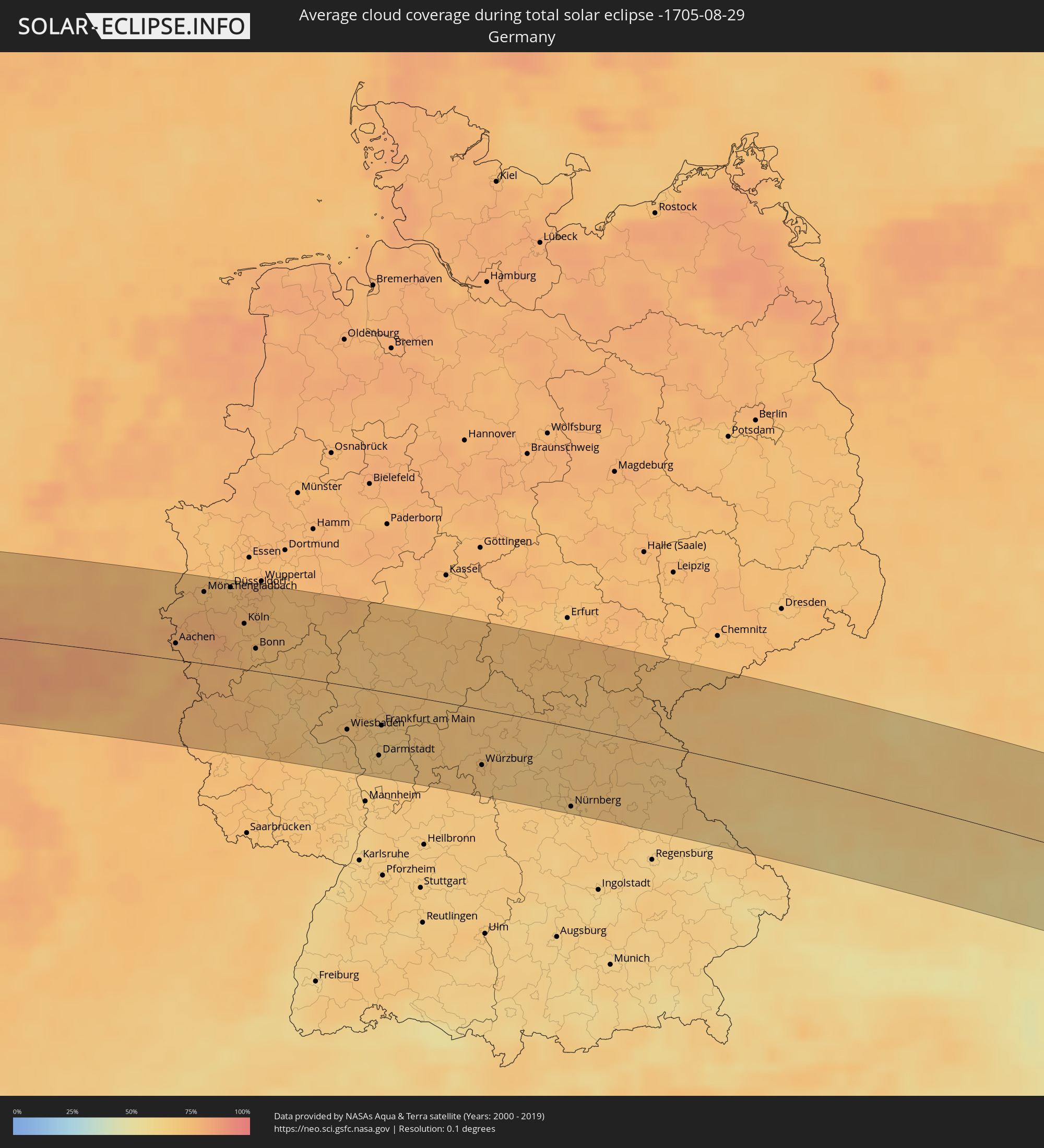 Deutschland
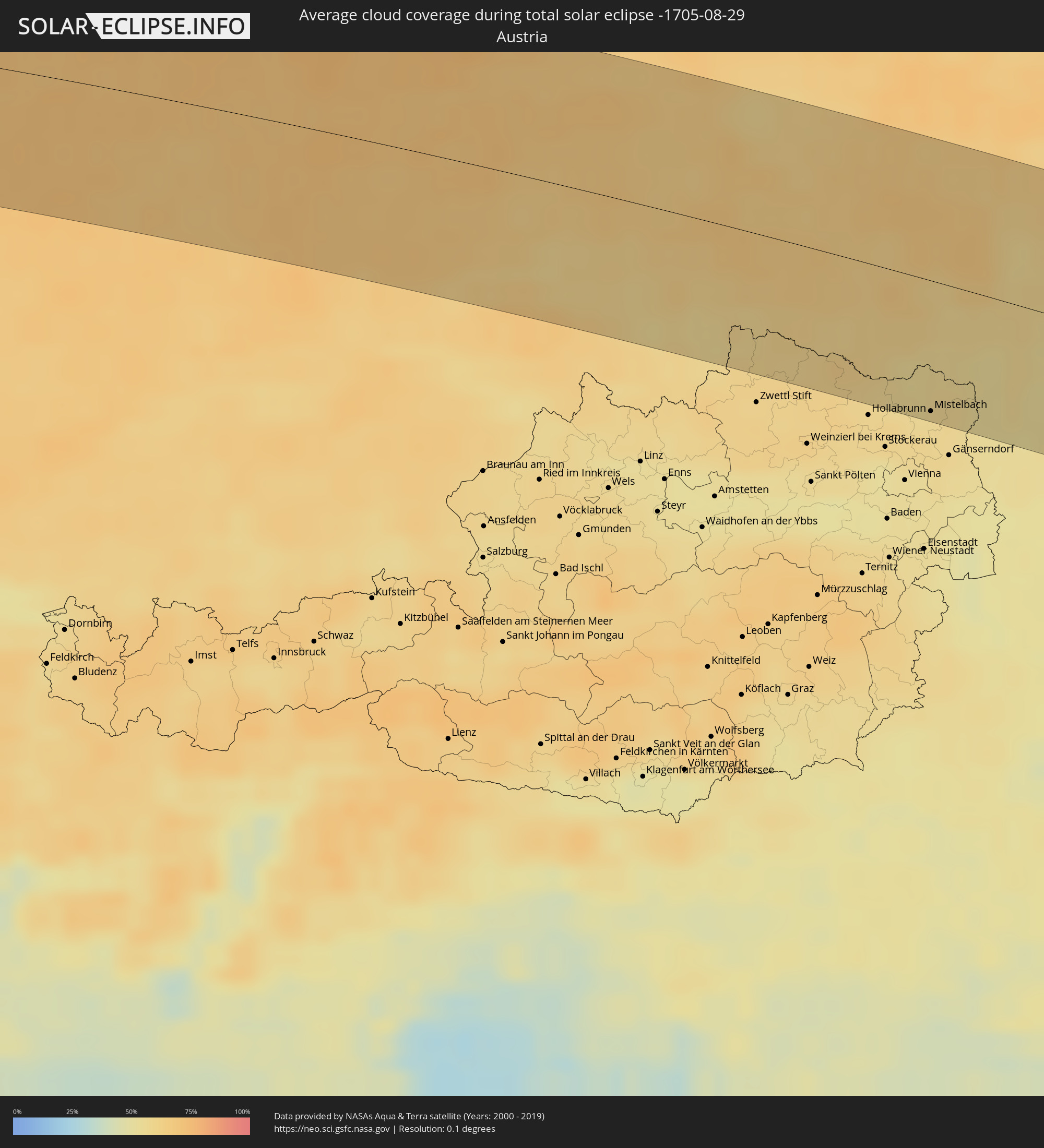 Österreich
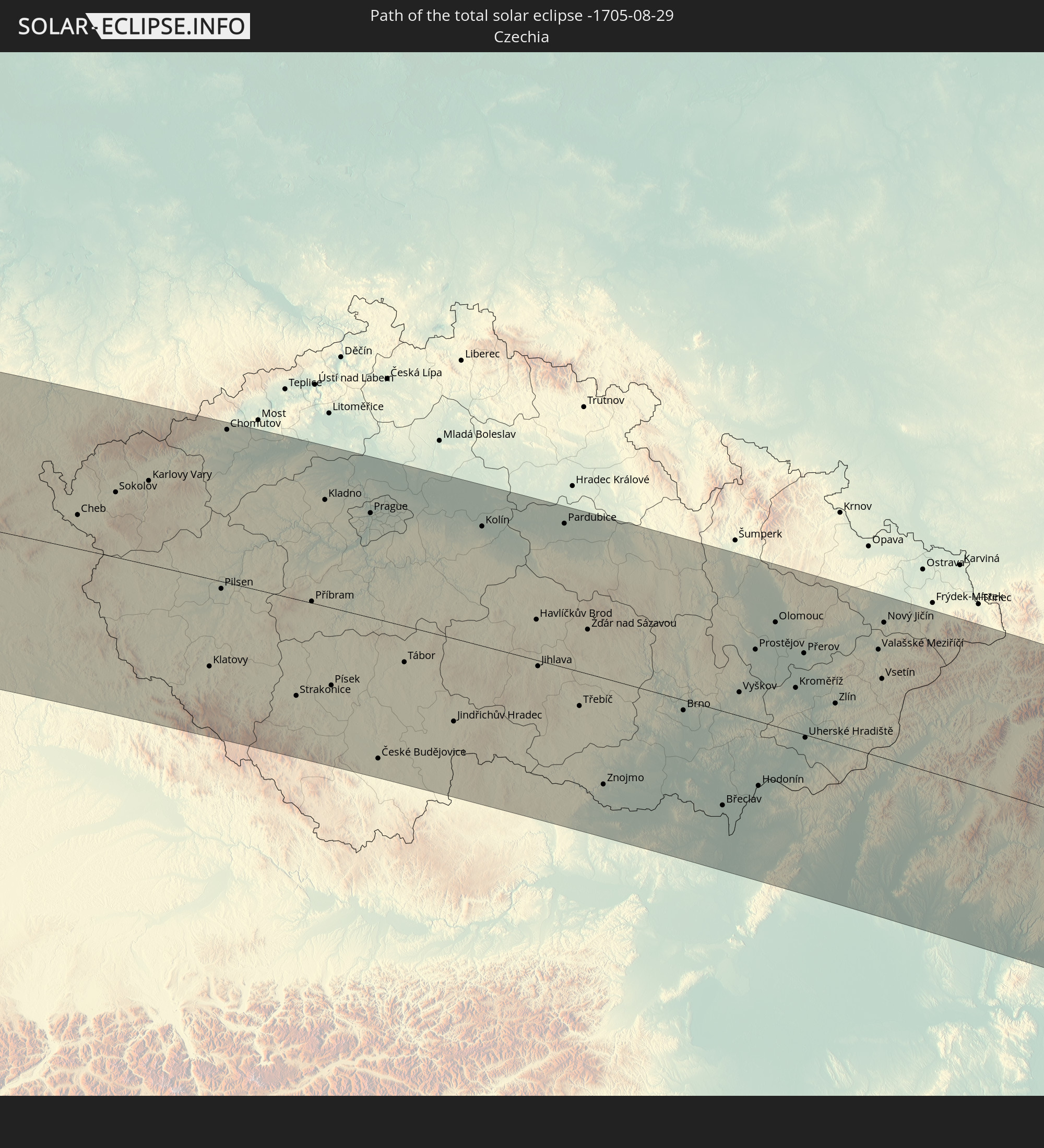
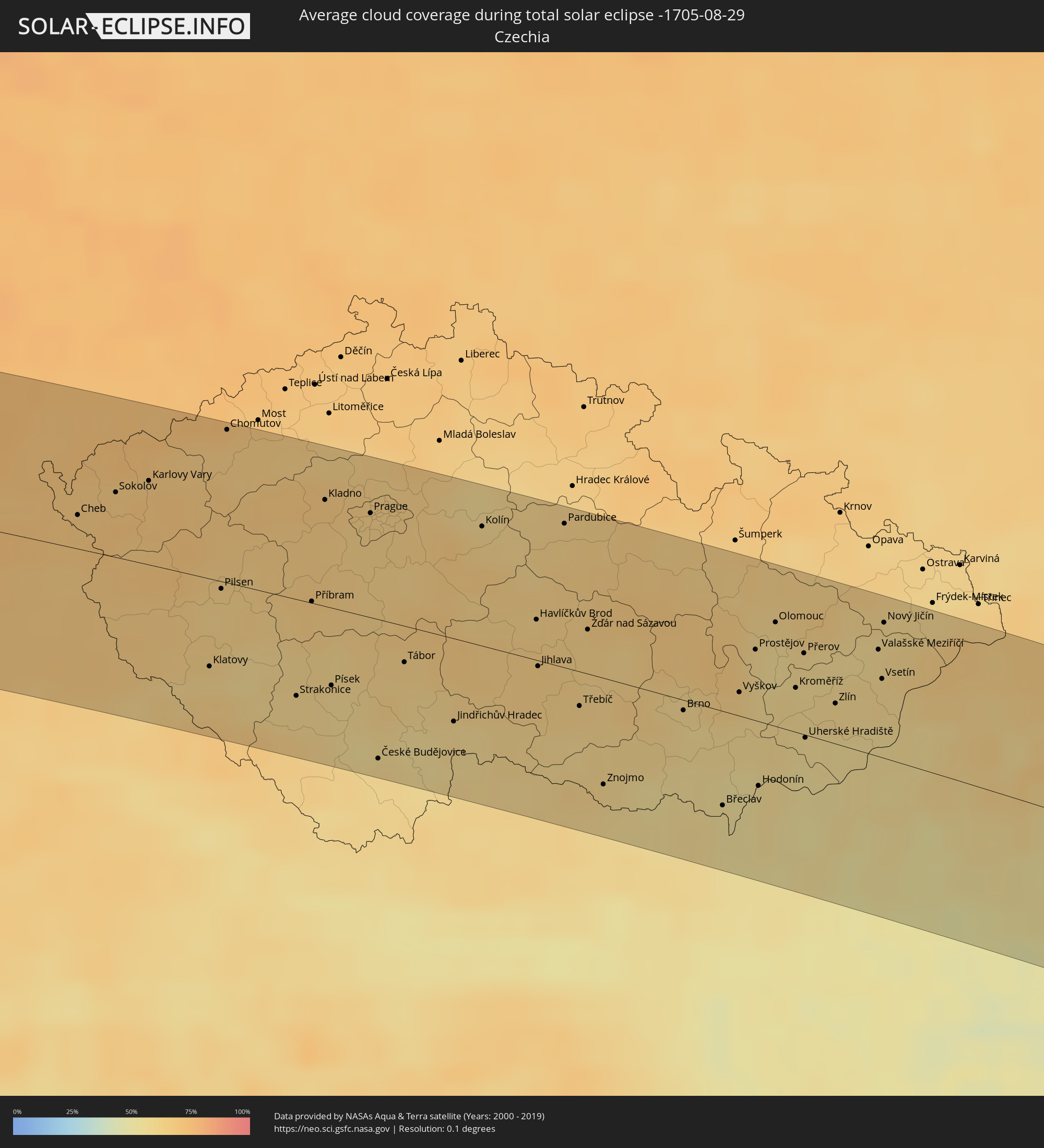 Tschechien
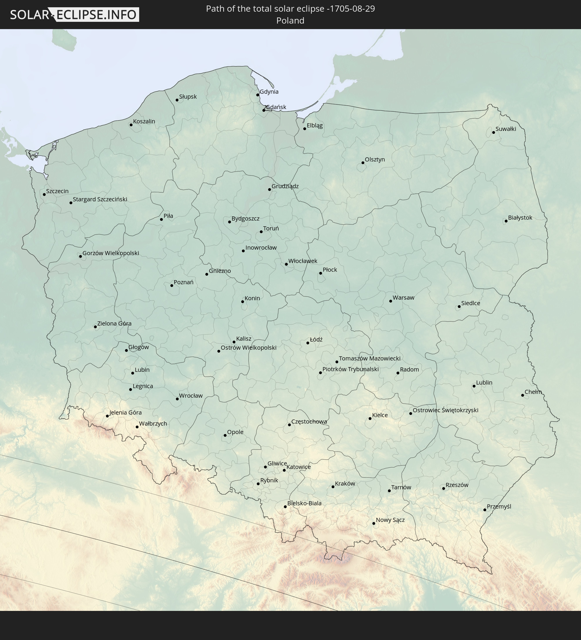
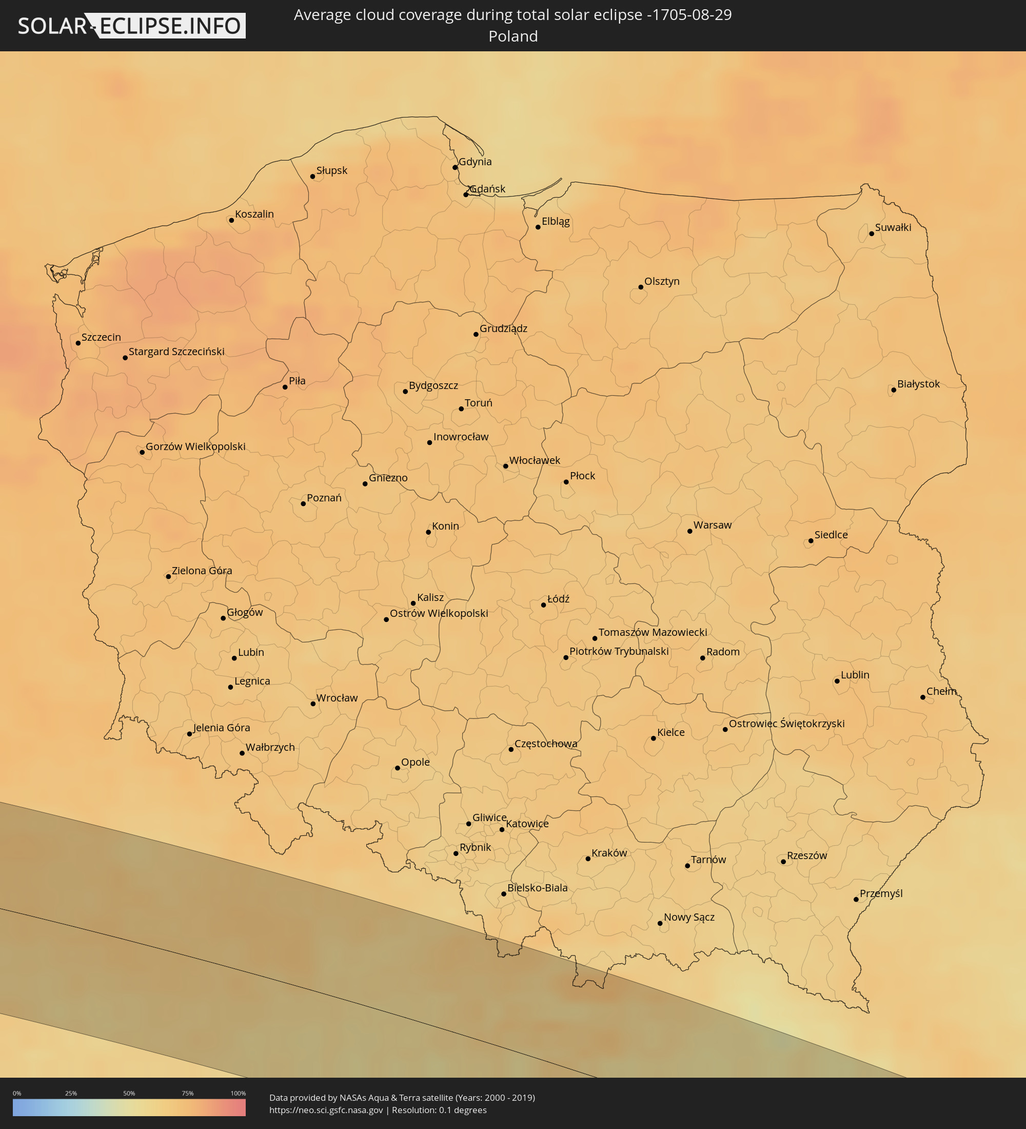 Polen
Polen
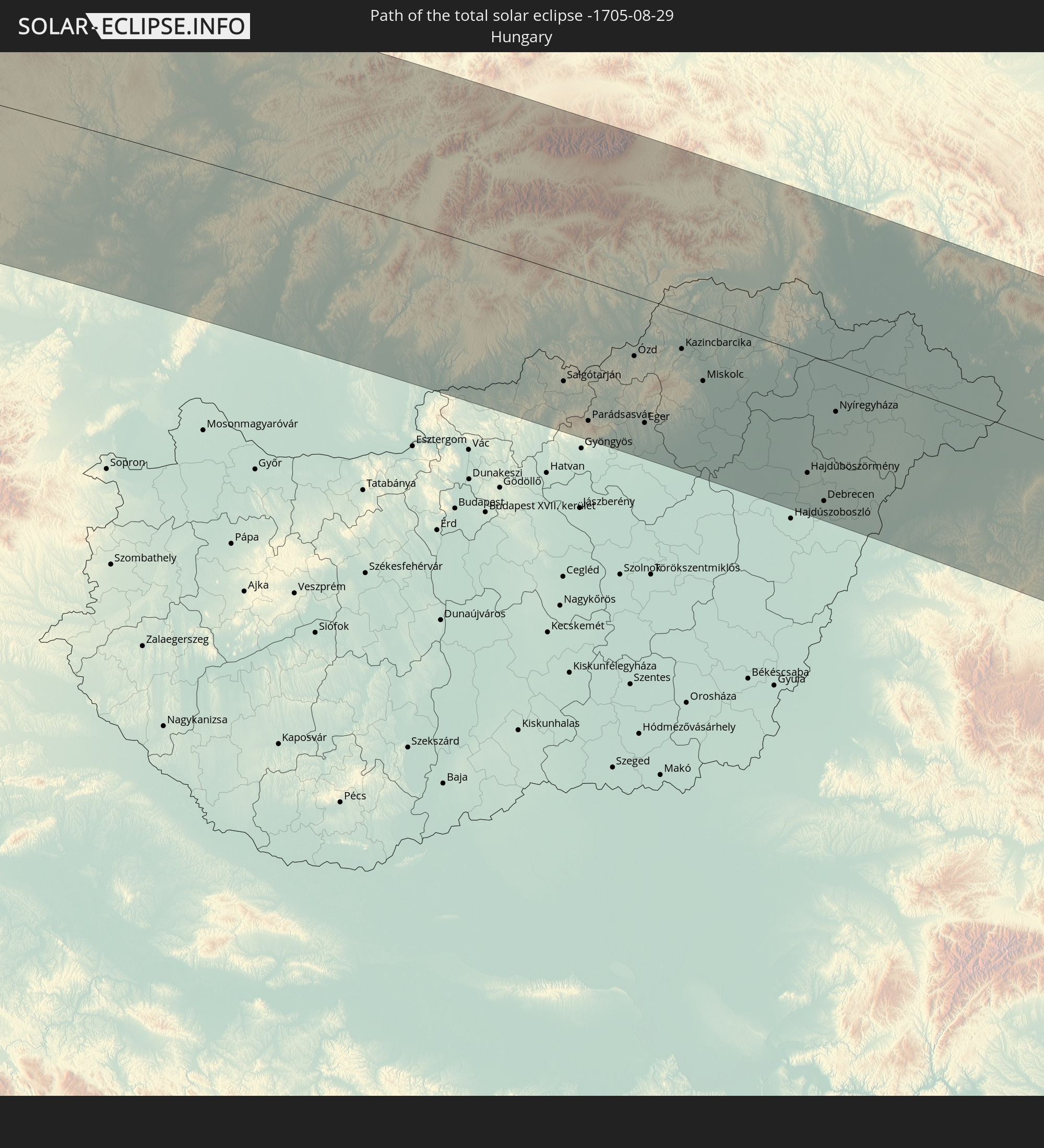
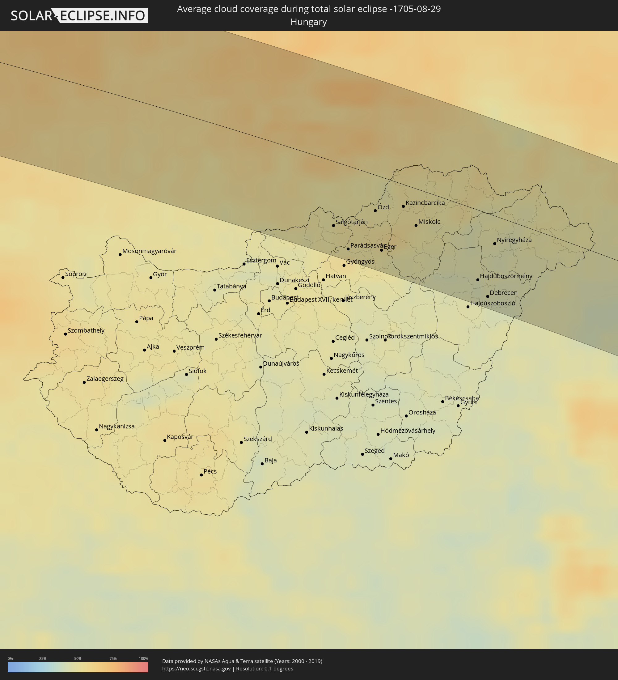 Ungarn
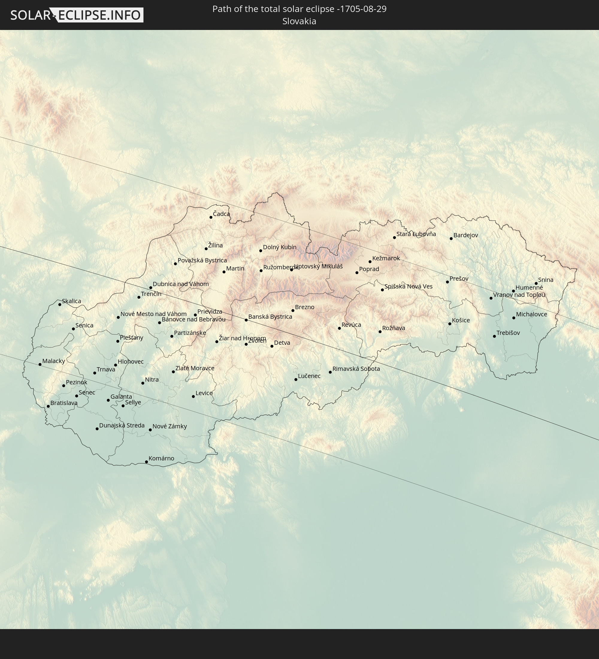
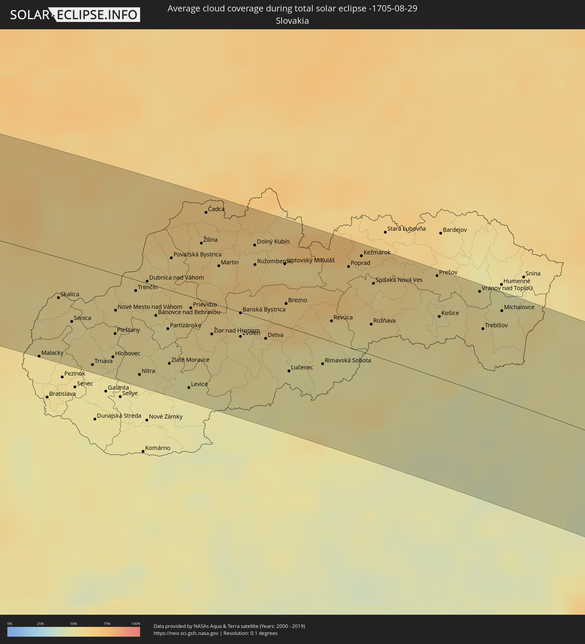 Slowakei
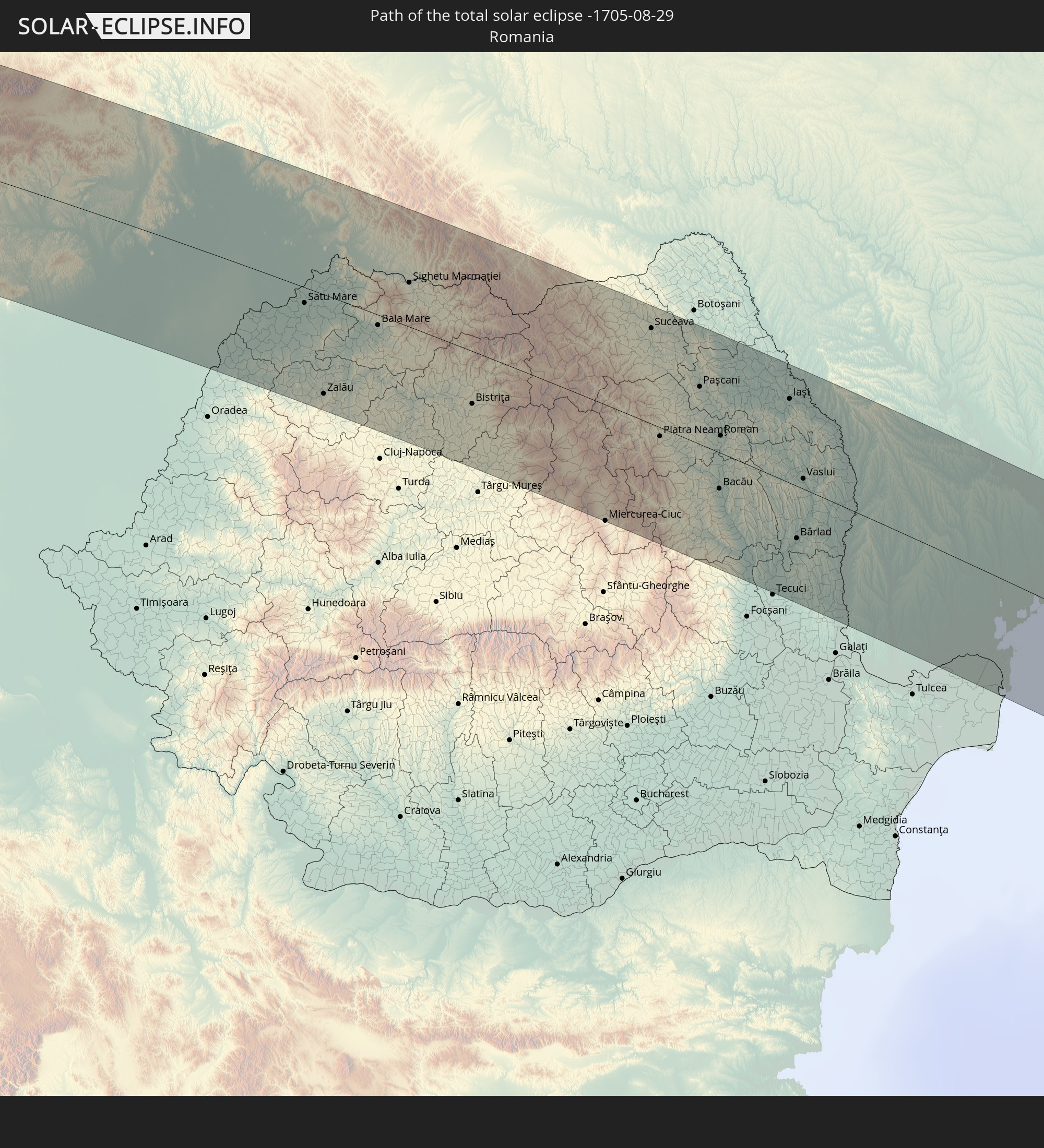
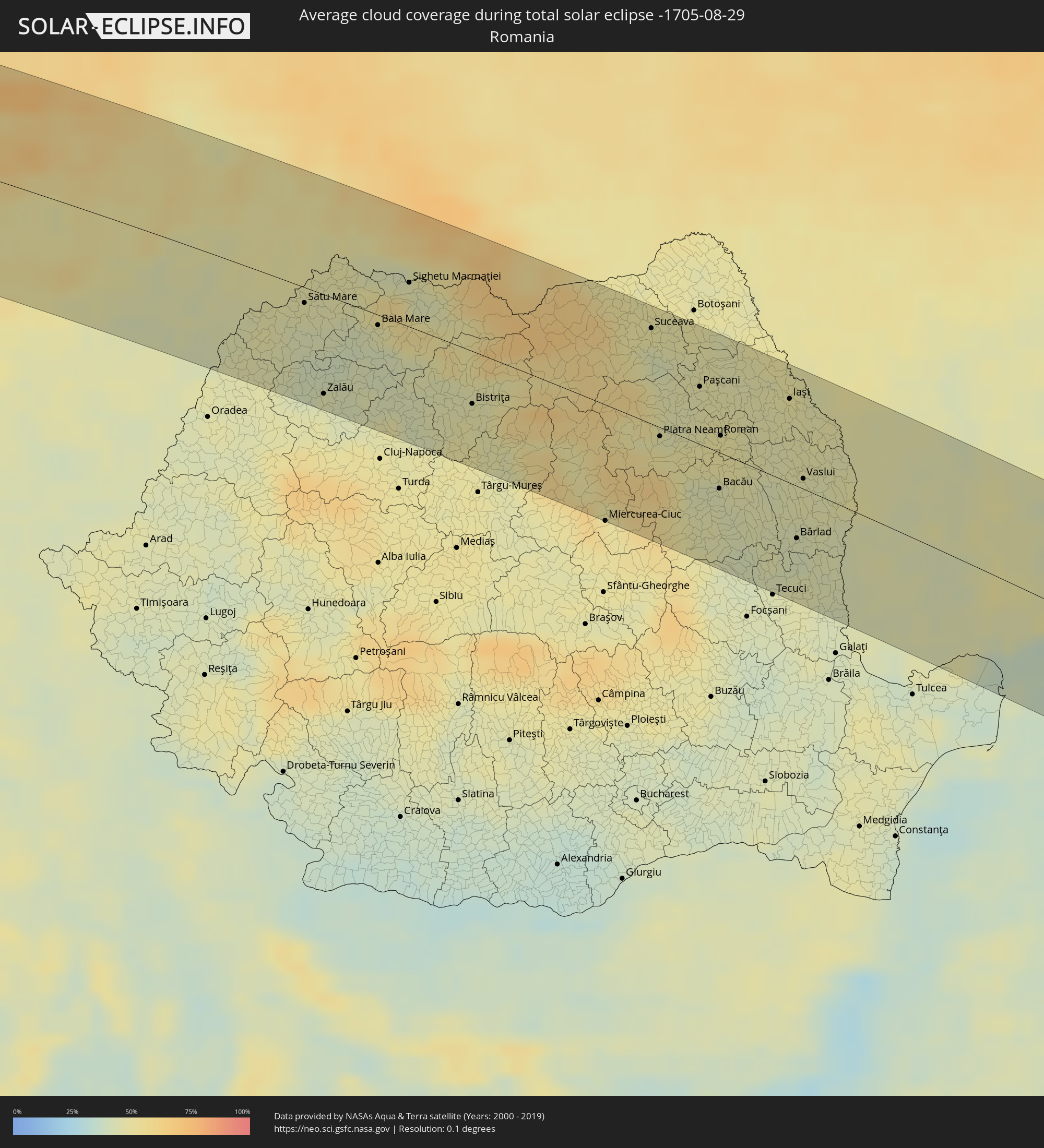 Rumänien
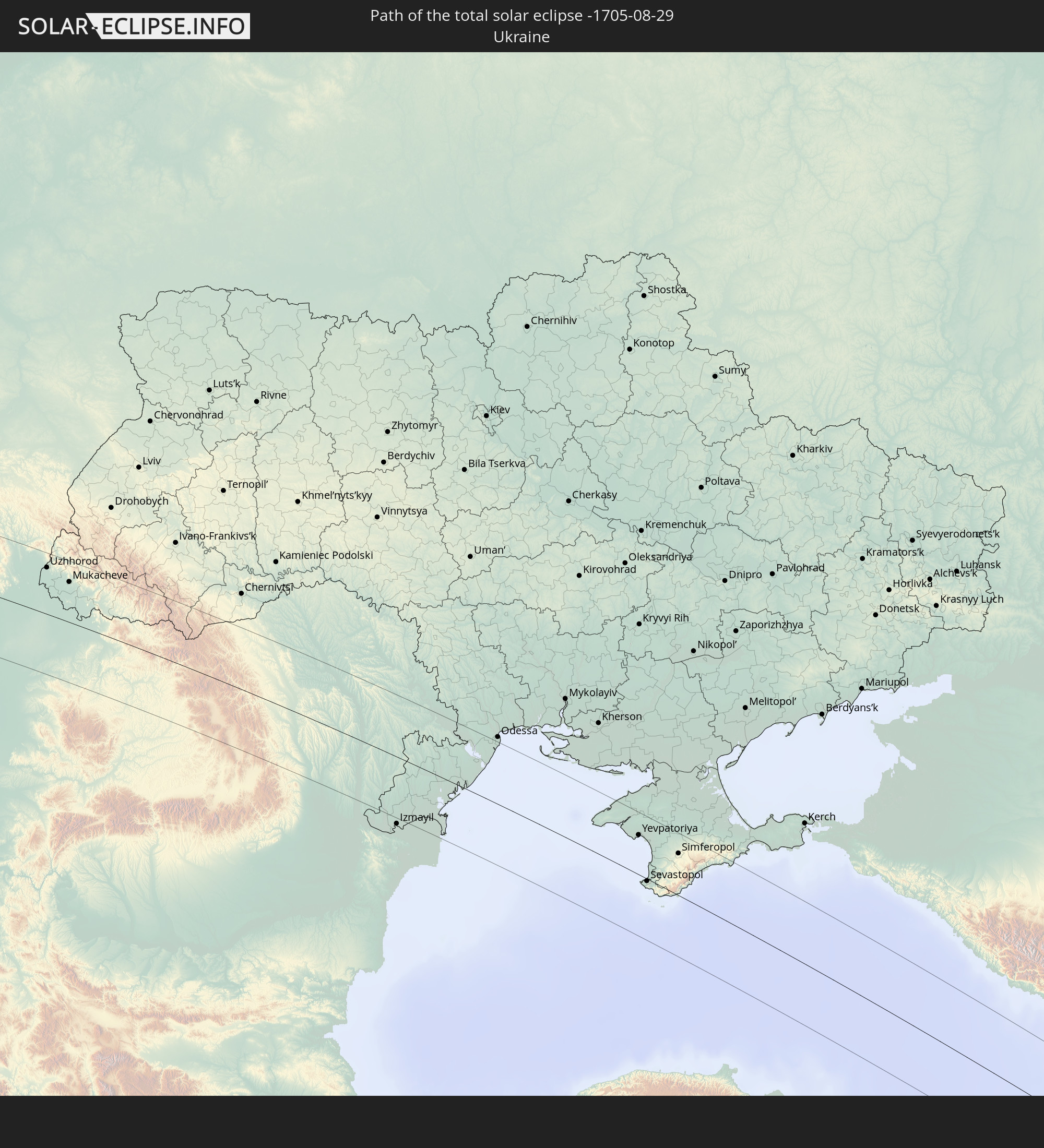
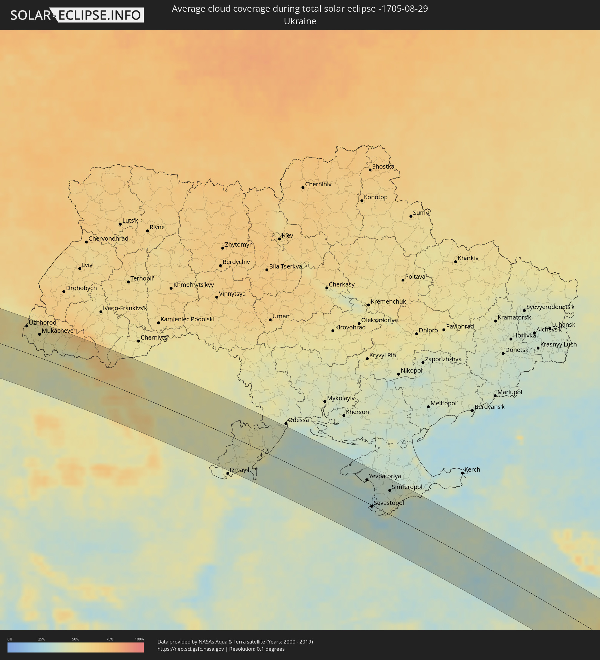 Ukraine
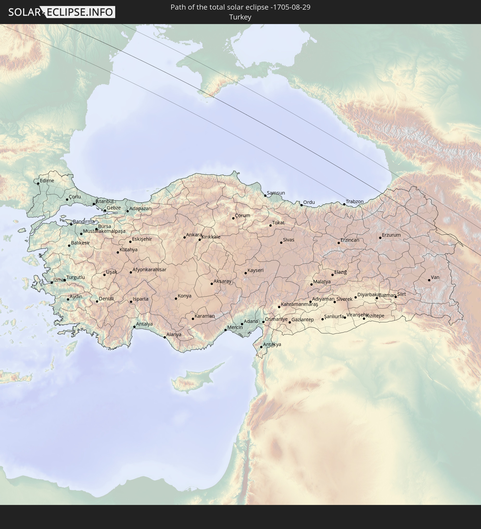
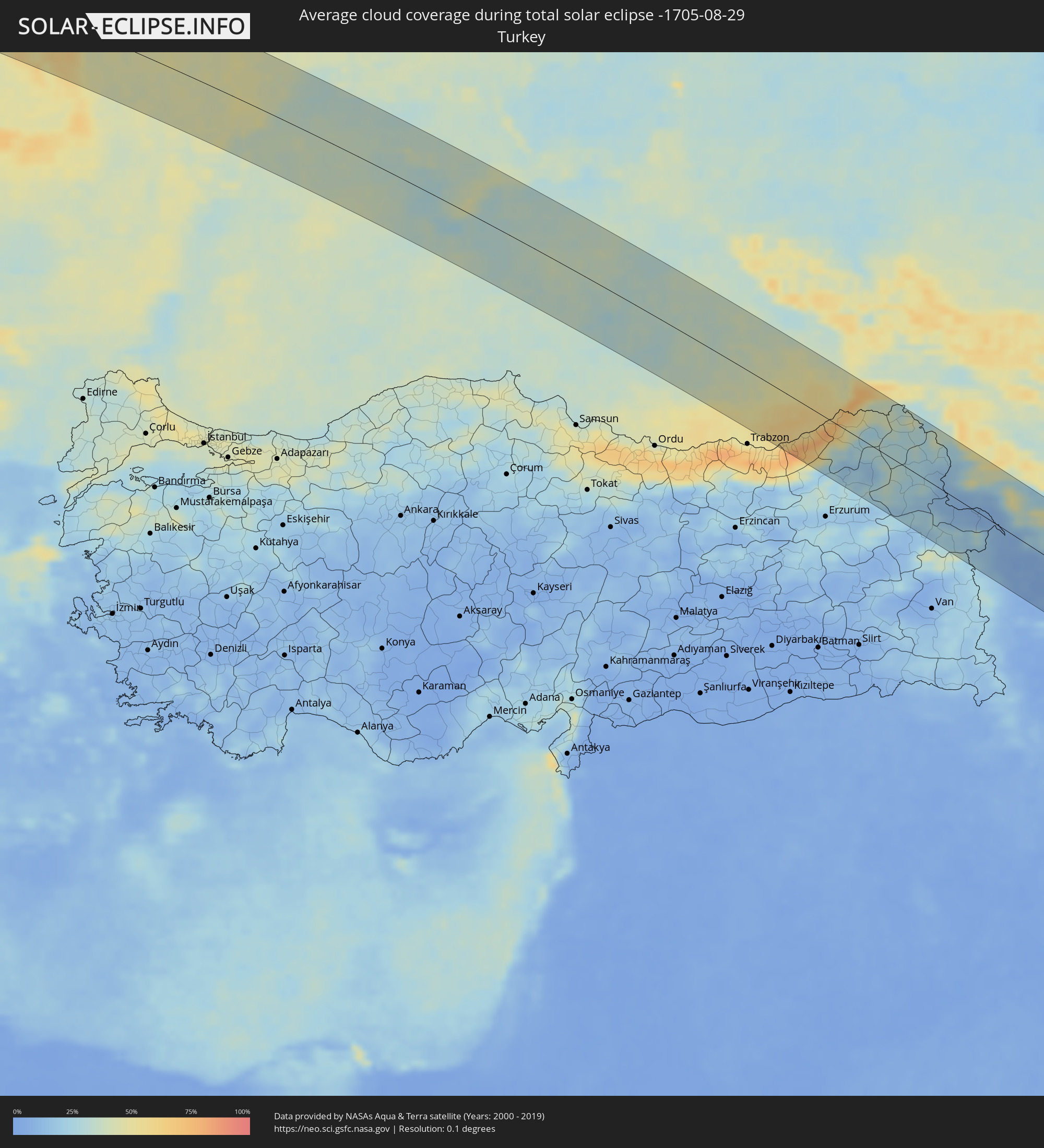 Türkei
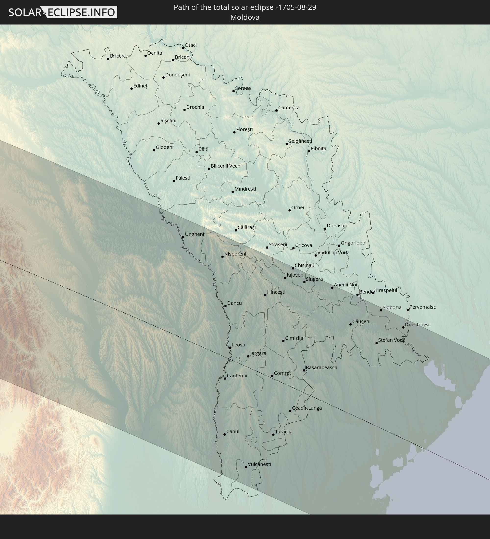
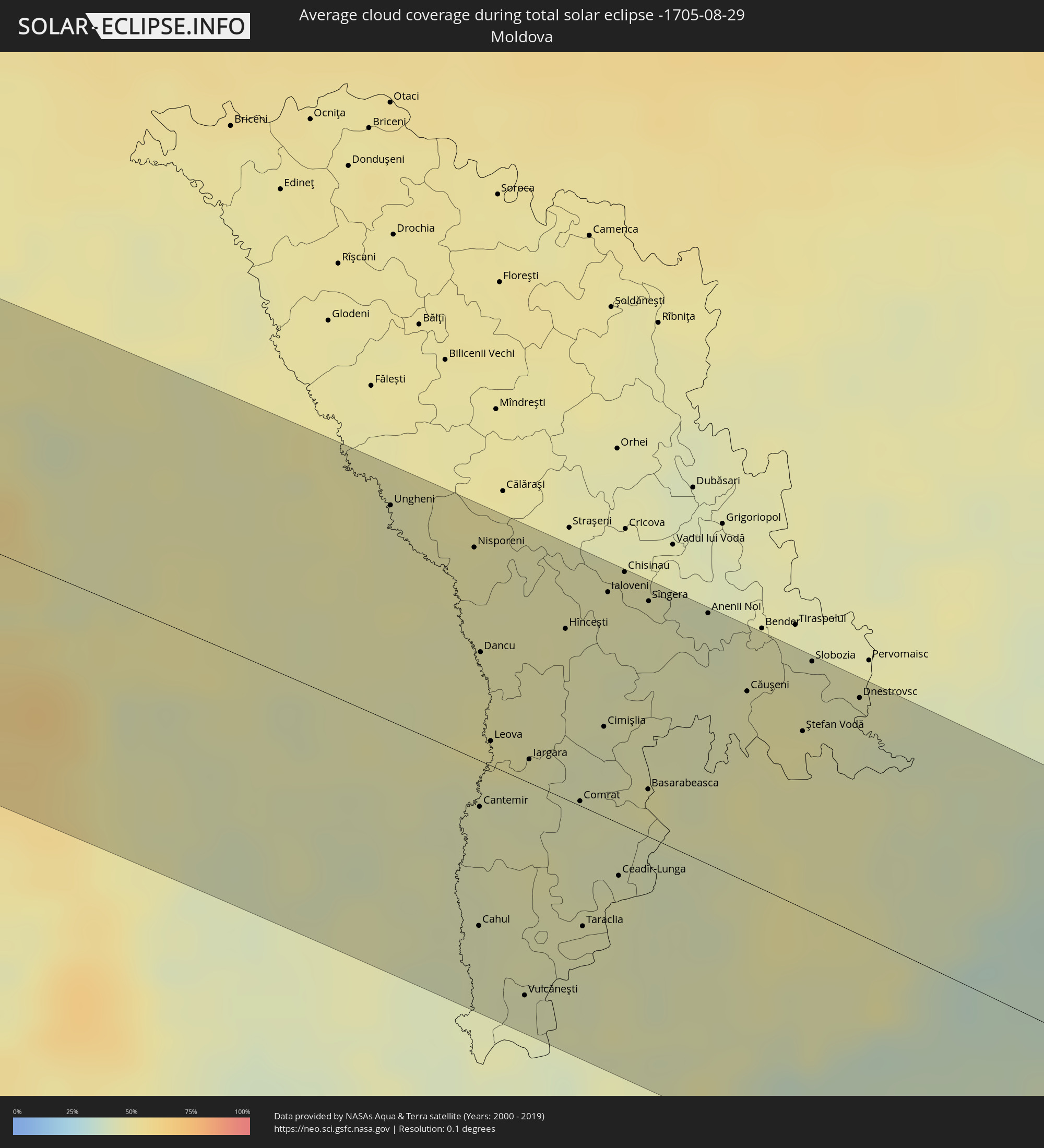 Moldawien
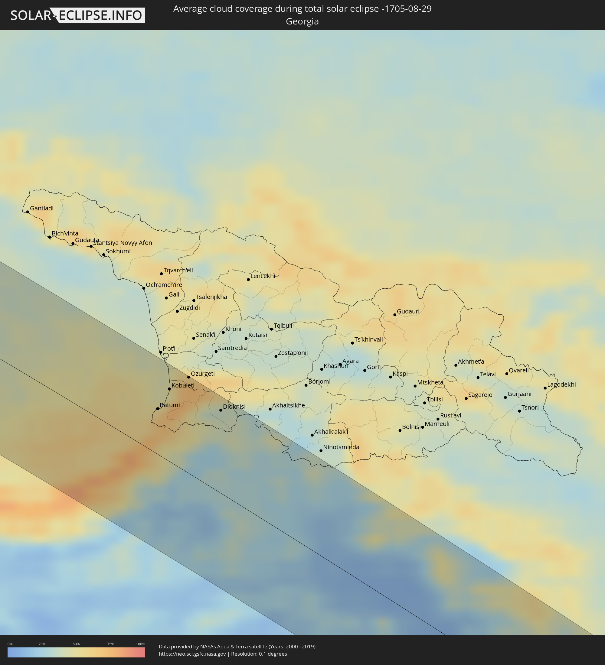 Georgien
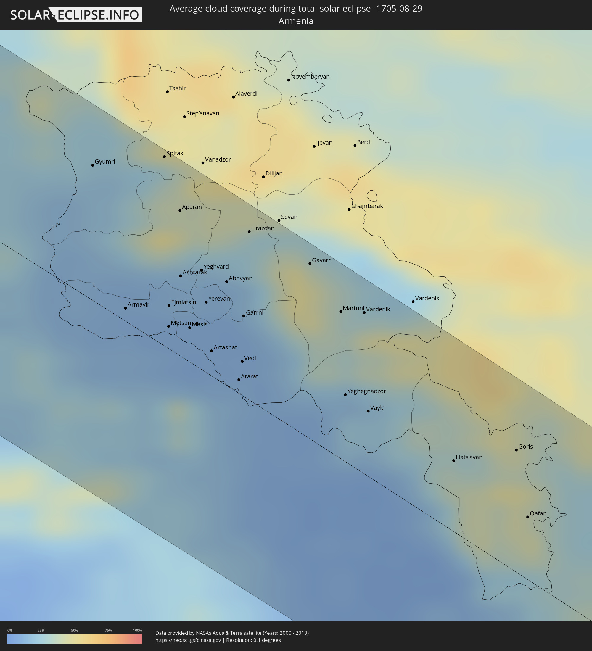 Armenien
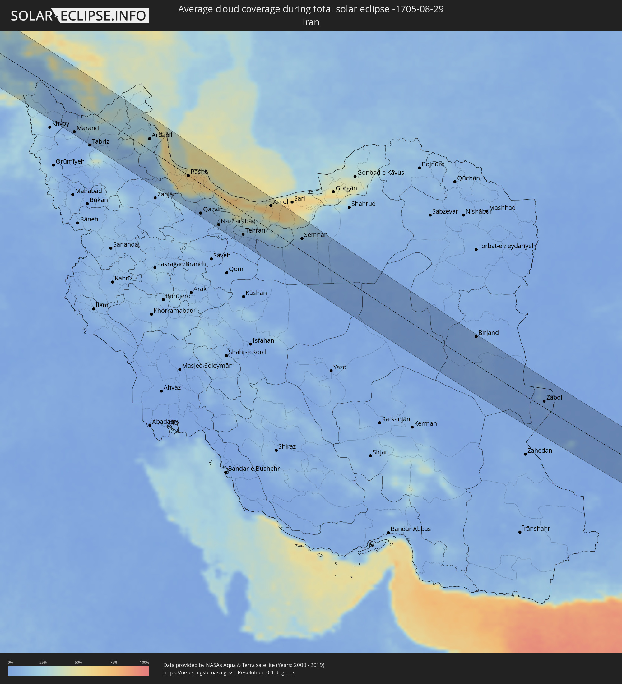 Iran
Iran
 Aserbaidschan
 Afghanistan
 Pakistan
 Indien
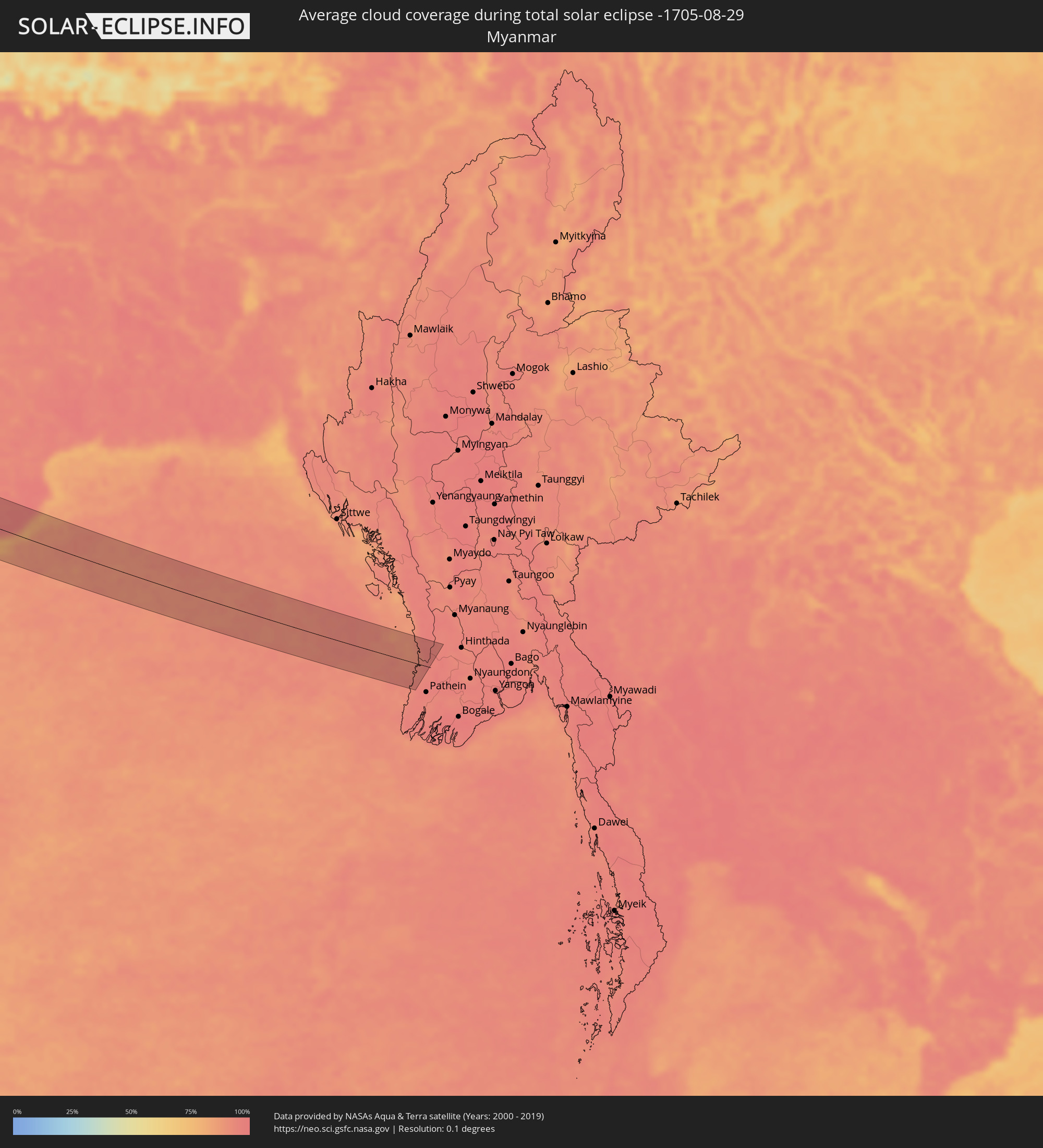 Myanmar
Orte im Finsternispfad
Die nachfolgene Tabelle zeigt Städte und Orte mit mehr als 5.000 Einwohnern, die sich im Finsternispfad befinden. Städte mit mehr als 100.000 Einwohnern sind dick gekennzeichnet. Mit einem Klick auf den Ort öffnet sich eine Detailkarte die die Lage des jeweiligen Ortes zusammen mit dem Verlauf der zentralen Finsternis präsentiert.
| Ort | Typ | Dauer der Verfinsterung | Ortszeit bei maximaler Verfinsterung | Entfernung zur Zentrallinie | Ø Bewölkung |
|
Derry, Munster
|
total | - | 09:06:24 UTC-00:25 | 57 km | 82% |
|
Swansea, Wales
|
total | - | 09:37:15 UTC+00:00 | 56 km | 75% |
|
Cardiff, Wales
|
total | - | 09:38:01 UTC+00:00 | 41 km | 76% |
|
Bristol, England
|
total | - | 09:38:41 UTC+00:00 | 39 km | 83% |
|
Bournemouth, England
|
total | - | 09:39:02 UTC+00:00 | 41 km | 76% |
|
Southampton, England
|
total | - | 09:39:44 UTC+00:00 | 19 km | 77% |
|
Portsmouth, England
|
total | - | 09:40:03 UTC+00:00 | 29 km | 75% |
|
Reading, England
|
total | - | 09:40:37 UTC+00:00 | 44 km | 82% |
|
Sutton, England
|
total | - | 09:41:29 UTC+00:00 | 35 km | 79% |
|
London, England
|
total | - | 09:41:41 UTC+00:00 | 53 km | 79% |
|
Bexley, England
|
total | - | 09:41:58 UTC+00:00 | 47 km | 79% |
|
Boulogne-sur-Mer, Hauts-de-France
|
total | - | 09:52:46 UTC+00:09 | 26 km | 70% |
|
Calais, Hauts-de-France
|
total | - | 09:53:12 UTC+00:09 | 1 km | 71% |
|
Dunkerque, Hauts-de-France
|
total | - | 09:53:55 UTC+00:09 | 13 km | 78% |
|
Béthune, Hauts-de-France
|
total | - | 09:54:01 UTC+00:09 | 40 km | 81% |
|
Arras, Hauts-de-France
|
total | - | 09:54:06 UTC+00:09 | 66 km | 80% |
|
Lens, Hauts-de-France
|
total | - | 09:54:13 UTC+00:09 | 50 km | 81% |
|
Lille, Hauts-de-France
|
total | - | 09:54:38 UTC+00:09 | 26 km | 80% |
|
Douai, Hauts-de-France
|
total | - | 09:54:31 UTC+00:09 | 56 km | 78% |
|
Brugge, Flanders
|
total | - | 09:45:46 UTC+00:00 | 38 km | 79% |
|
Valenciennes, Hauts-de-France
|
total | - | 09:55:08 UTC+00:09 | 54 km | 79% |
|
Middelburg, Zeeland
|
total | - | 10:05:57 UTC+00:19 | 73 km | 72% |
|
Gent, Flanders
|
total | - | 09:46:20 UTC+00:00 | 24 km | 77% |
|
Terneuzen, Zeeland
|
total | - | 10:06:09 UTC+00:19 | 57 km | 76% |
|
Goes, Zeeland
|
total | - | 10:06:18 UTC+00:19 | 76 km | 75% |
|
Mons, Wallonia
|
total | - | 09:46:24 UTC+00:00 | 40 km | 80% |
|
Maubeuge, Hauts-de-France
|
total | - | 09:55:42 UTC+00:09 | 59 km | 80% |
|
Aalst, Flanders
|
total | - | 09:46:43 UTC+00:00 | 14 km | 82% |
|
Woensdrecht, North Brabant
|
total | - | 10:06:49 UTC+00:19 | 71 km | 75% |
|
Brussels, Brussels Capital
|
total | - | 09:47:06 UTC+00:00 | 7 km | 79% |
|
Antwerpen, Flanders
|
total | - | 09:47:20 UTC+00:00 | 49 km | 77% |
|
Charleroi, Wallonia
|
total | - | 09:47:03 UTC+00:00 | 41 km | 80% |
|
Leuven, Flanders
|
total | - | 09:47:35 UTC+00:00 | 13 km | 79% |
|
Namur, Wallonia
|
total | - | 09:47:39 UTC+00:00 | 31 km | 78% |
|
Valkenswaard, North Brabant
|
total | - | 10:08:20 UTC+00:19 | 72 km | 75% |
|
Liège, Wallonia
|
total | - | 09:48:41 UTC+00:00 | 6 km | 75% |
|
Maastricht, Limburg
|
total | - | 10:08:27 UTC+00:19 | 19 km | 75% |
|
Weert, Limburg
|
total | - | 10:08:37 UTC+00:19 | 63 km | 75% |
|
Born, Limburg
|
total | - | 10:08:41 UTC+00:19 | 40 km | 78% |
|
Heerlen, Limburg
|
total | - | 10:08:52 UTC+00:19 | 25 km | 77% |
|
Roermond, Limburg
|
total | - | 10:08:59 UTC+00:19 | 60 km | 73% |
|
Aachen, North Rhine-Westphalia
|
total | - | 10:49:26 UTC+01:00 | 14 km | 75% |
|
Mönchengladbach, North Rhine-Westphalia
|
total | - | 10:50:04 UTC+01:00 | 63 km | 74% |
|
Düsseldorf, North Rhine-Westphalia
|
total | - | 10:50:32 UTC+01:00 | 70 km | 73% |
|
Köln, North Rhine-Westphalia
|
total | - | 10:50:41 UTC+01:00 | 40 km | 75% |
|
Solingen, North Rhine-Westphalia
|
total | - | 10:50:57 UTC+01:00 | 68 km | 75% |
|
Bonn, North Rhine-Westphalia
|
total | - | 10:50:50 UTC+01:00 | 20 km | 73% |
|
Wiesbaden, Hesse
|
total | - | 10:52:19 UTC+01:00 | 39 km | 68% |
|
Darmstadt, Hesse
|
total | - | 10:52:51 UTC+01:00 | 57 km | 68% |
|
Frankfurt am Main, Hesse
|
total | - | 10:52:57 UTC+01:00 | 30 km | 67% |
|
Nürnberg, Bavaria
|
total | - | 10:56:25 UTC+01:00 | 71 km | 66% |
|
Karlovy Vary, Karlovarský
|
total | - | 10:59:10 UTC+01:00 | 41 km | 69% |
|
Pilsen, Plzeňský
|
total | - | 10:59:57 UTC+01:00 | 4 km | 62% |
|
Chomutov, Ústecký
|
total | - | 10:59:59 UTC+01:00 | 74 km | 70% |
|
Kladno, Central Bohemia
|
total | - | 11:01:02 UTC+01:00 | 52 km | 67% |
|
Prague, Praha
|
total | - | 11:01:31 UTC+01:00 | 51 km | 64% |
|
České Budějovice, Jihočeský
|
total | - | 11:01:42 UTC+01:00 | 69 km | 59% |
|
Waidhofen an der Thaya, Lower Austria
|
total | - | 11:03:01 UTC+01:00 | 71 km | 61% |
|
Pardubice, Pardubický
|
total | - | 11:03:36 UTC+01:00 | 70 km | 63% |
|
Laa an der Thaya, Lower Austria
|
total | - | 11:04:47 UTC+01:00 | 61 km | 57% |
|
Mistelbach, Lower Austria
|
total | - | 11:05:08 UTC+01:00 | 73 km | 57% |
|
Brno, South Moravian
|
total | - | 11:05:03 UTC+01:00 | 5 km | 60% |
|
Poysdorf, Lower Austria
|
total | - | 11:05:12 UTC+01:00 | 61 km | 57% |
|
Zistersdorf, Lower Austria
|
total | - | 11:05:25 UTC+01:00 | 73 km | 56% |
|
Olomouc, Olomoucký
|
total | - | 11:05:59 UTC+01:00 | 51 km | 59% |
|
Trnava, Trnavský
|
total | - | 11:06:49 UTC+01:00 | 73 km | 52% |
|
Zlín, Zlín
|
total | - | 11:06:44 UTC+01:00 | 20 km | 60% |
|
Trenčín, Trenčiansky
|
total | - | 11:07:25 UTC+01:00 | 8 km | 55% |
|
Nitra, Nitriansky
|
total | - | 11:07:39 UTC+01:00 | 70 km | 50% |
|
Prievidza, Nitriansky
|
total | - | 11:08:24 UTC+01:00 | 8 km | 57% |
|
Žilina, Žilinský
|
total | - | 11:08:26 UTC+01:00 | 42 km | 62% |
|
Martin, Žilinský
|
total | - | 11:08:47 UTC+01:00 | 29 km | 59% |
|
Banská Bystrica, Banskobystrický
|
total | - | 11:09:15 UTC+01:00 | 1 km | 52% |
|
Salgótarján, Nógrád
|
total | - | 11:10:34 UTC+01:00 | 54 km | 50% |
|
Zakopane, Lesser Poland Voivodeship
|
total | - | 11:34:20 UTC+01:24 | 76 km | 72% |
|
Parádsasvár, Heves
|
total | - | 11:10:55 UTC+01:00 | 70 km | 54% |
|
Poprad, Prešovský
|
total | - | 11:10:59 UTC+01:00 | 59 km | 62% |
|
Ózd, Borsod-Abaúj-Zemplén
|
total | - | 11:11:20 UTC+01:00 | 30 km | 51% |
|
Eger, Heves
|
total | - | 11:11:35 UTC+01:00 | 61 km | 48% |
|
Kazincbarcika, Borsod-Abaúj-Zemplén
|
total | - | 11:11:52 UTC+01:00 | 19 km | 51% |
|
Miskolc, Borsod-Abaúj-Zemplén
|
total | - | 11:12:11 UTC+01:00 | 31 km | 50% |
|
Prešov, Prešovský
|
total | - | 11:12:31 UTC+01:00 | 75 km | 56% |
|
Košice, Košický
|
total | - | 11:12:41 UTC+01:00 | 45 km | 52% |
|
Hajdúböszörmény, Hajdú-Bihar
|
total | - | 11:13:36 UTC+01:00 | 59 km | 43% |
|
Debrecen, Hajdú-Bihar
|
total | - | 11:13:52 UTC+01:00 | 70 km | 43% |
|
Nyíregyháza, Szabolcs-Szatmár-Bereg
|
total | - | 11:13:47 UTC+01:00 | 23 km | 45% |
|
Uzhhorod, Zakarpattia
|
total | - | 12:16:29 UTC+02:02 | 61 km | 52% |
|
Mátészalka, Szabolcs-Szatmár-Bereg
|
total | - | 11:14:48 UTC+01:00 | 8 km | 48% |
|
Mukacheve, Zakarpattia
|
total | - | 12:17:15 UTC+02:02 | 52 km | 49% |
|
Satu Mare, Satu Mare
|
total | - | 12:00:11 UTC+01:44 | 11 km | 46% |
|
Baia Mare, Satu Mare
|
total | - | 12:01:27 UTC+01:44 | 7 km | 47% |
|
Bistriţa, Bistriţa-Năsăud
|
total | - | 12:03:20 UTC+01:44 | 36 km | 47% |
|
Suceava, Suceava
|
total | - | 12:05:54 UTC+01:44 | 65 km | 46% |
|
Piatra Neamţ, Neamţ
|
total | - | 12:06:34 UTC+01:44 | 6 km | 51% |
|
Bacău, Bacău
|
total | - | 12:07:49 UTC+01:44 | 25 km | 44% |
|
Roman, Neamţ
|
total | - | 12:07:34 UTC+01:44 | 12 km | 50% |
|
Iaşi, Iaşi
|
total | - | 12:08:29 UTC+01:44 | 57 km | 48% |
|
Bârlad, Vaslui
|
total | - | 12:09:22 UTC+01:44 | 36 km | 42% |
|
Vaslui, Vaslui
|
total | - | 12:09:09 UTC+01:44 | 7 km | 47% |
|
Ungheni, Ungheni
|
total | - | 12:19:23 UTC+01:55 | 68 km | 46% |
|
Cahul, Cahul
|
total | - | 12:21:10 UTC+01:55 | 53 km | 43% |
|
Leova, Leova
|
total | - | 12:20:45 UTC+01:55 | 8 km | 48% |
|
Vulcăneşti, Găgăuzia
|
total | - | 12:21:42 UTC+01:55 | 68 km | 44% |
|
Hînceşti, Hînceşti
|
total | - | 12:21:01 UTC+01:55 | 54 km | 46% |
|
Comrat, Găgăuzia
|
total | - | 12:21:35 UTC+01:55 | 1 km | 45% |
|
Ceadîr-Lunga, Găgăuzia
|
total | - | 12:22:05 UTC+01:55 | 17 km | 46% |
|
Chisinau, Chişinău
|
total | - | 12:21:18 UTC+01:55 | 80 km | 46% |
|
Căuşeni, Căuşeni
|
total | - | 12:22:32 UTC+01:55 | 60 km | 46% |
|
Slobozia, Stînga Nistrului
|
total | - | 12:22:57 UTC+01:55 | 79 km | 47% |
|
Bilhorod-Dnistrovs’kyy, Odessa
|
total | - | 12:31:35 UTC+02:02 | 46 km | 41% |
|
Illichivs’k, Odessa
|
total | - | 12:31:59 UTC+02:02 | 67 km | 38% |
|
Yevpatoriya, Republic of Crimea
|
total | - | 12:51:33 UTC+02:16 | 52 km | 38% |
|
Sevastopol, Gorod Sevastopol
|
total | - | 12:52:30 UTC+02:16 | 3 km | 30% |
|
Saki, Republic of Crimea
|
total | - | 12:52:01 UTC+02:16 | 54 km | 33% |
|
Simferopol, Republic of Crimea
|
total | - | 12:53:03 UTC+02:16 | 55 km | 36% |
|
Yalta, Republic of Crimea
|
total | - | 12:53:40 UTC+02:16 | 12 km | 36% |
|
Alushta, Republic of Crimea
|
total | - | 12:53:52 UTC+02:16 | 38 km | 37% |
|
Rize, Rize
|
total | - | 12:49:37 UTC+01:56 | 69 km | 77% |
|
Çayeli, Rize
|
total | - | 12:49:50 UTC+01:56 | 54 km | 73% |
|
Ardeşen, Rize
|
total | - | 12:50:06 UTC+01:56 | 32 km | 72% |
|
Batumi, Ajaria
|
total | - | 13:52:42 UTC+02:59 | 39 km | 66% |
|
Chakvi, Ajaria
|
total | - | 13:52:44 UTC+02:59 | 51 km | 67% |
|
Kobuleti, Ajaria
|
total | - | 13:52:39 UTC+02:59 | 62 km | 68% |
|
Artvin, Artvin
|
total | - | 12:51:25 UTC+01:56 | 3 km | 38% |
|
Ozurgeti, Guria
|
total | - | 13:52:51 UTC+02:59 | 82 km | 73% |
|
Dioknisi, Ajaria
|
total | - | 13:53:53 UTC+02:59 | 71 km | 40% |
|
Sarıkamış, Kars
|
total | - | 12:53:54 UTC+01:56 | 44 km | 28% |
|
Ağrı, Ağrı
|
total | - | 12:55:33 UTC+01:56 | 80 km | 15% |
|
Kars, Kars
|
total | - | 12:54:15 UTC+01:56 | 4 km | 24% |
|
Kağızman, Kars
|
total | - | 12:55:00 UTC+01:56 | 35 km | 17% |
|
Gyumri, Shirak Province
|
total | - | 13:56:09 UTC+02:58 | 57 km | 18% |
|
Armavir, Armavir Province
|
total | - | 13:57:26 UTC+02:58 | 5 km | 10% |
|
Iğdır, Iğdır
|
total | - | 12:56:44 UTC+01:56 | 16 km | 17% |
|
Doğubayazıt, Ağrı
|
total | - | 12:57:23 UTC+01:56 | 50 km | 26% |
|
Ejmiatsin, Armavir Province
|
total | - | 13:57:48 UTC+02:58 | 18 km | 9% |
|
Yerevan, Yerevan
|
total | - | 13:58:06 UTC+02:58 | 30 km | 9% |
|
Artashat, Ararat Province
|
total | - | 13:58:30 UTC+02:58 | 10 km | 9% |
|
Ararat, Ararat Province
|
total | - | 13:58:56 UTC+02:58 | 6 km | 11% |
|
Hrazdan, Kotayk Province
|
total | - | 13:57:59 UTC+02:58 | 71 km | 30% |
|
Sharur City, Nakhichevan
|
total | - | 14:21:11 UTC+03:19 | 8 km | 9% |
|
Gavarr, Gegharkunik Province
|
total | - | 13:58:44 UTC+02:58 | 74 km | 38% |
|
Nakhchivan, Nakhichevan
|
total | - | 14:22:22 UTC+03:19 | 20 km | 7% |
|
Cahri, Nakhichevan
|
total | - | 14:22:09 UTC+03:19 | 7 km | 6% |
|
Culfa, Nakhichevan
|
total | - | 14:23:06 UTC+03:19 | 34 km | 5% |
|
Yaycı, Nakhichevan
|
total | - | 14:23:16 UTC+03:19 | 30 km | 8% |
|
Ordubad, Nakhichevan
|
total | - | 14:23:44 UTC+03:19 | 19 km | 10% |
|
Goris, Syunik Province
|
total | - | 14:01:49 UTC+02:58 | 52 km | 39% |
|
Qafan, Syunik Province
|
total | - | 14:02:24 UTC+02:58 | 27 km | 43% |
|
Zangilan, Zǝngilan
|
total | - | 14:24:21 UTC+03:19 | 27 km | 27% |
|
Jebrail, Jabrayil
|
total | - | 14:24:23 UTC+03:19 | 74 km | 25% |
|
Ardabīl, Ardabīl
|
total | - | 14:34:21 UTC+03:25 | 27 km | 24% |
|
Lerik, Lerik
|
total | - | 14:27:19 UTC+03:19 | 82 km | 39% |
|
Astara, Astara
|
total | - | 14:28:28 UTC+03:19 | 75 km | 34% |
|
Rasht, Gīlān
|
total | - | 14:37:43 UTC+03:25 | 0 km | 61% |
|
Qazvin, Qazvīn
|
total | - | 14:39:58 UTC+03:25 | 73 km | 7% |
|
Naz̧arābād, Alborz
|
total | - | 14:41:17 UTC+03:25 | 73 km | 9% |
|
Karaj, Alborz
|
total | - | 14:41:59 UTC+03:25 | 65 km | 7% |
|
Tehran, Tehrān
|
total | - | 14:42:46 UTC+03:25 | 57 km | 8% |
|
Qarchak, Tehrān
|
total | - | 14:43:25 UTC+03:25 | 74 km | 5% |
|
Āmol, Māzandarān
|
total | - | 14:42:38 UTC+03:25 | 62 km | 61% |
|
Semnān, Semnān
|
total | - | 14:45:25 UTC+03:25 | 31 km | 9% |
|
Bīrjand, Khorāsān-e Jonūbī
|
total | - | 14:56:20 UTC+03:25 | 74 km | 5% |
|
Mīrābād, Nimroz
|
total | - | 15:37:03 UTC+04:00 | 22 km | 1% |
|
Zaranj, Nimroz
|
total | - | 15:36:13 UTC+04:00 | 29 km | 1% |
|
Rūdbār, Nimroz
|
total | - | 15:38:10 UTC+04:00 | 11 km | 1% |
|
‘Alāqahdārī Dīshū, Helmand
|
total | - | 15:38:16 UTC+04:00 | 51 km | 1% |
|
Khuzdār, Balochistān
|
total | - | 16:13:05 UTC+04:28 | 37 km | 14% |
|
Shahdād Kot, Sindh
|
total | - | 16:13:51 UTC+04:28 | 30 km | 41% |
|
Kambar, Sindh
|
total | - | 16:14:19 UTC+04:28 | 9 km | 38% |
|
New Bādāh, Sindh
|
total | - | 16:14:43 UTC+04:28 | 14 km | 41% |
|
Usta Muhammad, Balochistān
|
total | - | 16:13:26 UTC+04:28 | 68 km | 44% |
|
Lārkāna, Sindh
|
total | - | 16:14:29 UTC+04:28 | 16 km | 45% |
|
Ratodero, Sindh
|
total | - | 16:14:09 UTC+04:28 | 44 km | 44% |
|
Shikārpur, Sindh
|
total | - | 16:14:08 UTC+04:28 | 75 km | 43% |
|
Khairpur, Sindh
|
total | - | 16:14:51 UTC+04:28 | 40 km | 44% |
|
Sukkur, Sindh
|
total | - | 16:14:38 UTC+04:28 | 61 km | 43% |
|
Udaipur, Rajasthan
|
total | - | 17:14:33 UTC+05:21 | 24 km | 86% |
|
Bhopal, Madhya Pradesh
|
total | - | 17:17:32 UTC+05:21 | 5 km | 89% |
|
Vidisha, Madhya Pradesh
|
total | - | 17:17:17 UTC+05:21 | 50 km | 92% |
|
Chhindwāra, Madhya Pradesh
|
total | - | 17:19:27 UTC+05:21 | 53 km | 92% |
|
Durg, Chhattisgarh
|
total | - | 17:20:54 UTC+05:21 | 48 km | 92% |
|
Bhilai, Chhattisgarh
|
total | - | 17:20:54 UTC+05:21 | 40 km | 92% |
|
Raipur, Chhattisgarh
|
total | - | 17:20:53 UTC+05:21 | 30 km | 94% |
|
Puri, Odisha
|
total | - | 17:22:46 UTC+05:21 | 22 km | 83% |
|
Bhubaneshwar, Odisha
|
total | - | 17:22:13 UTC+05:21 | 28 km | 97% |
|
Cuttack, Odisha
|
total | - | 17:22:00 UTC+05:21 | 49 km | 94% |