Totale Sonnenfinsternis vom 10.02.-1825
| Wochentag: | Mittwoch |
| Maximale Dauer der Verfinsterung: | 05m25s |
| Maximale Breite des Finsternispfades: | 206 km |
| Saroszyklus: | 11 |
| Bedeckungsgrad: | 100% |
| Magnitude: | 1.0627 |
| Gamma: | 0.0732 |
Wo kann man die Sonnenfinsternis vom 10.02.-1825 sehen?
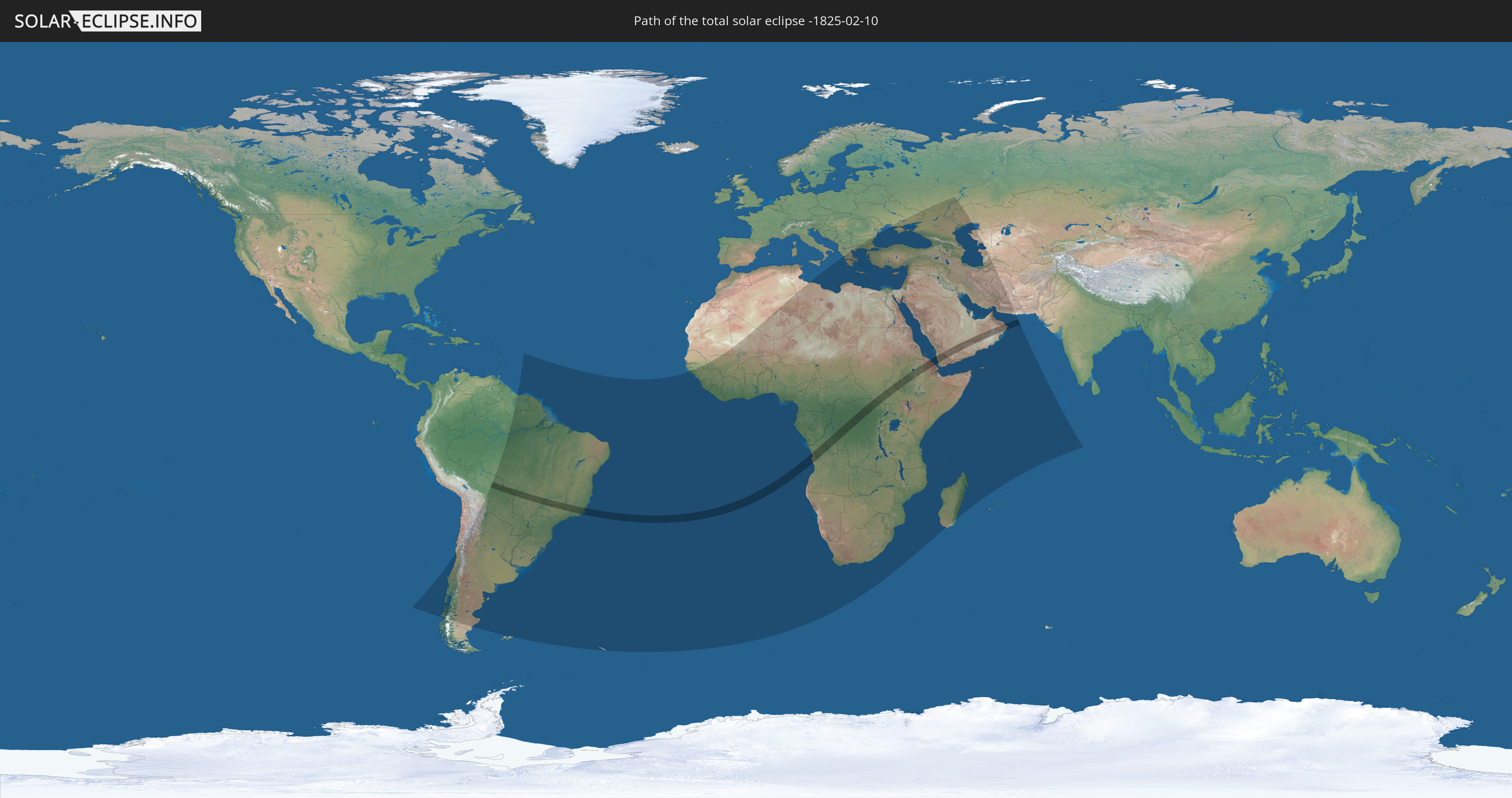
Die Sonnenfinsternis am 10.02.-1825 kann man in 93 Ländern als partielle Sonnenfinsternis beobachten.
Der Finsternispfad verläuft durch 11 Länder. Nur in diesen Ländern ist sie als totale Sonnenfinsternis zu sehen.
In den folgenden Ländern ist die Sonnenfinsternis total zu sehen
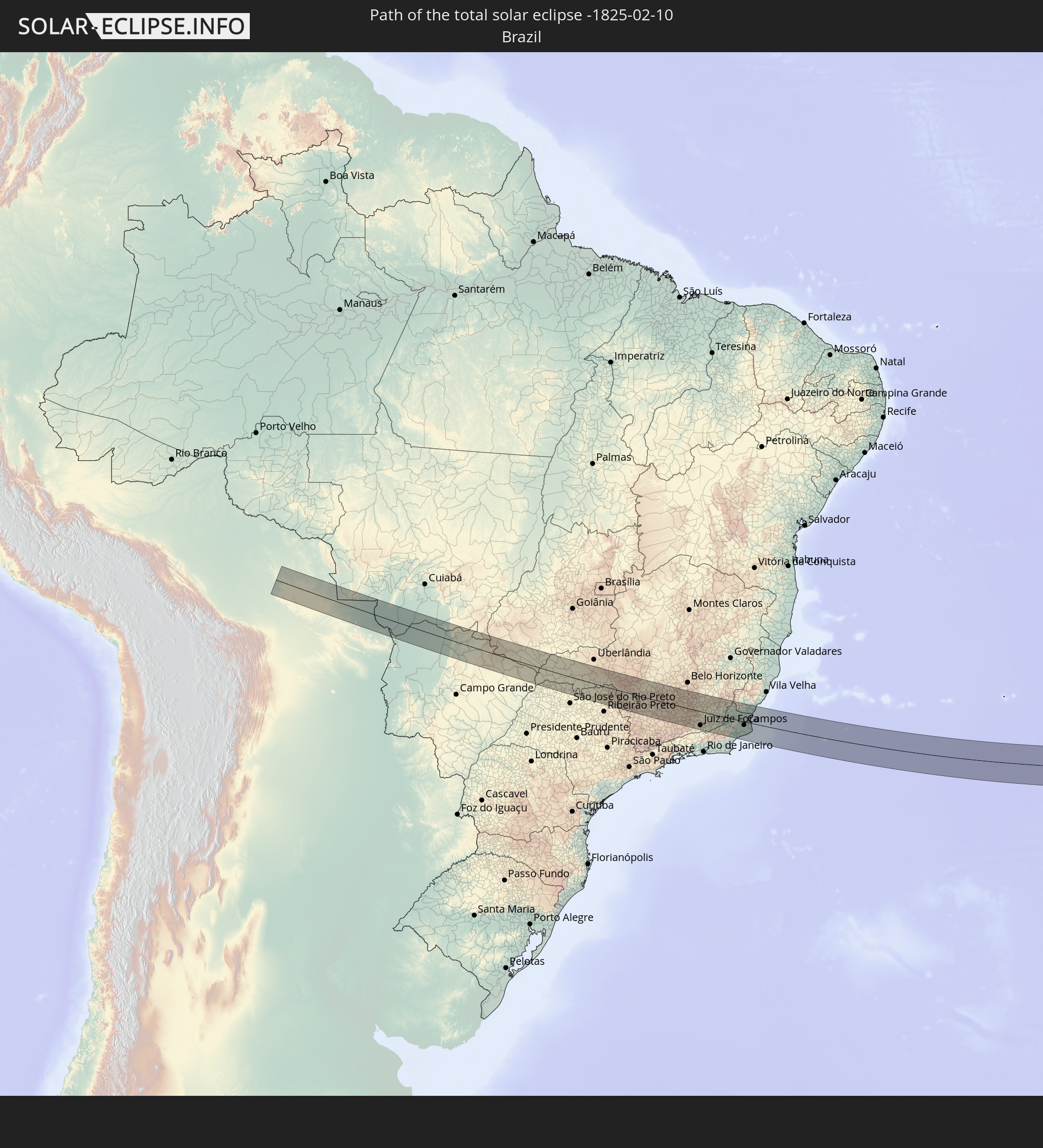 Brasilien
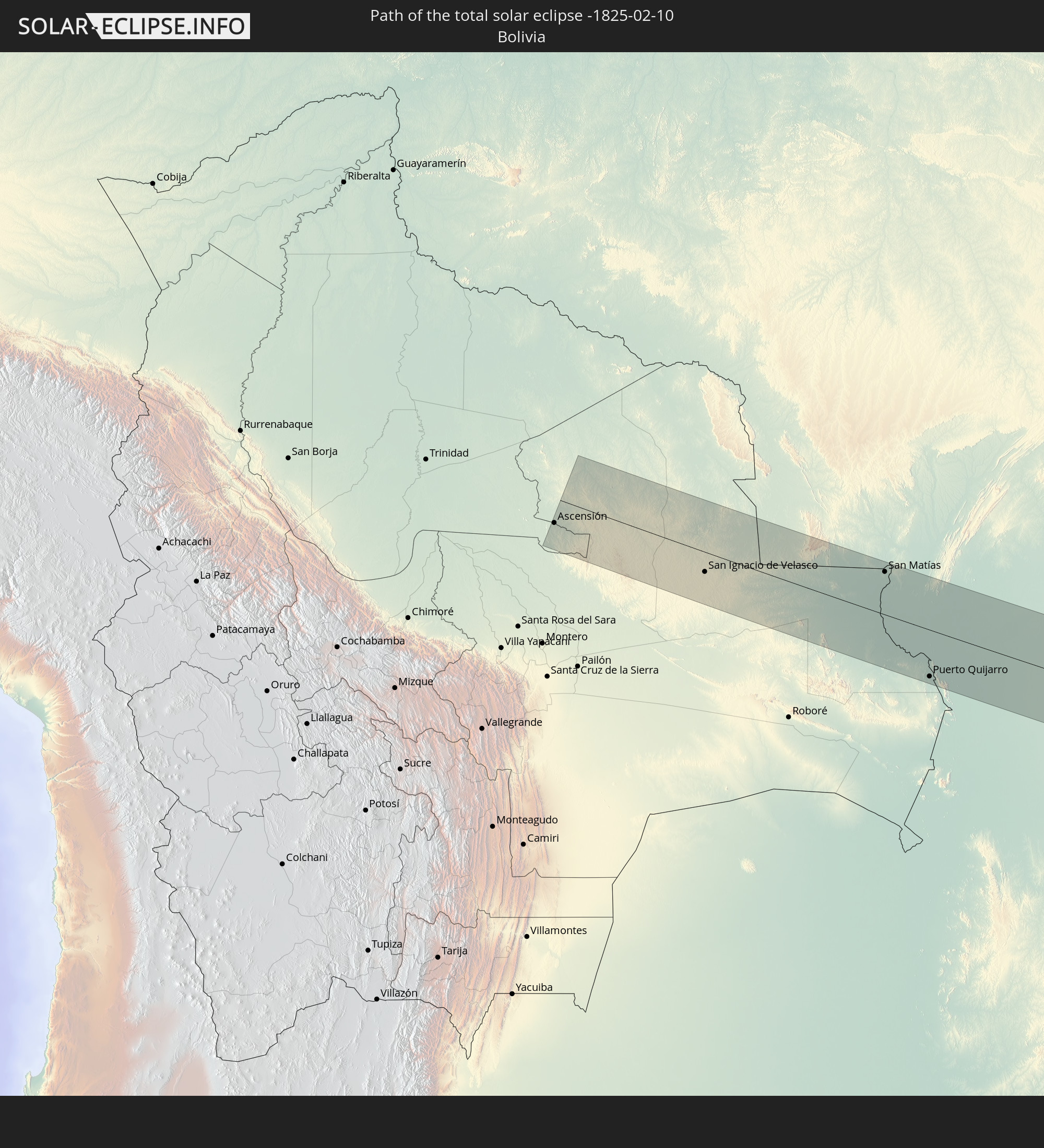 Bolivien
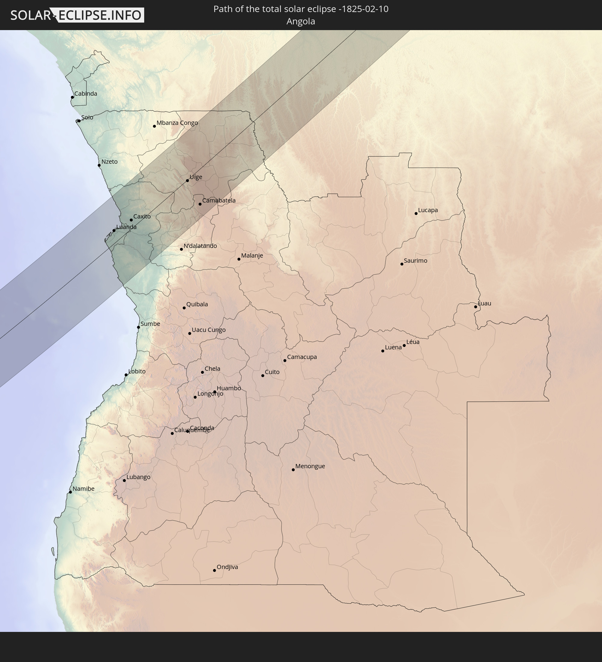 Angola
 Demokratische Republik Kongo
 Sudan
Sudan
 Südsudan
 Äthiopien
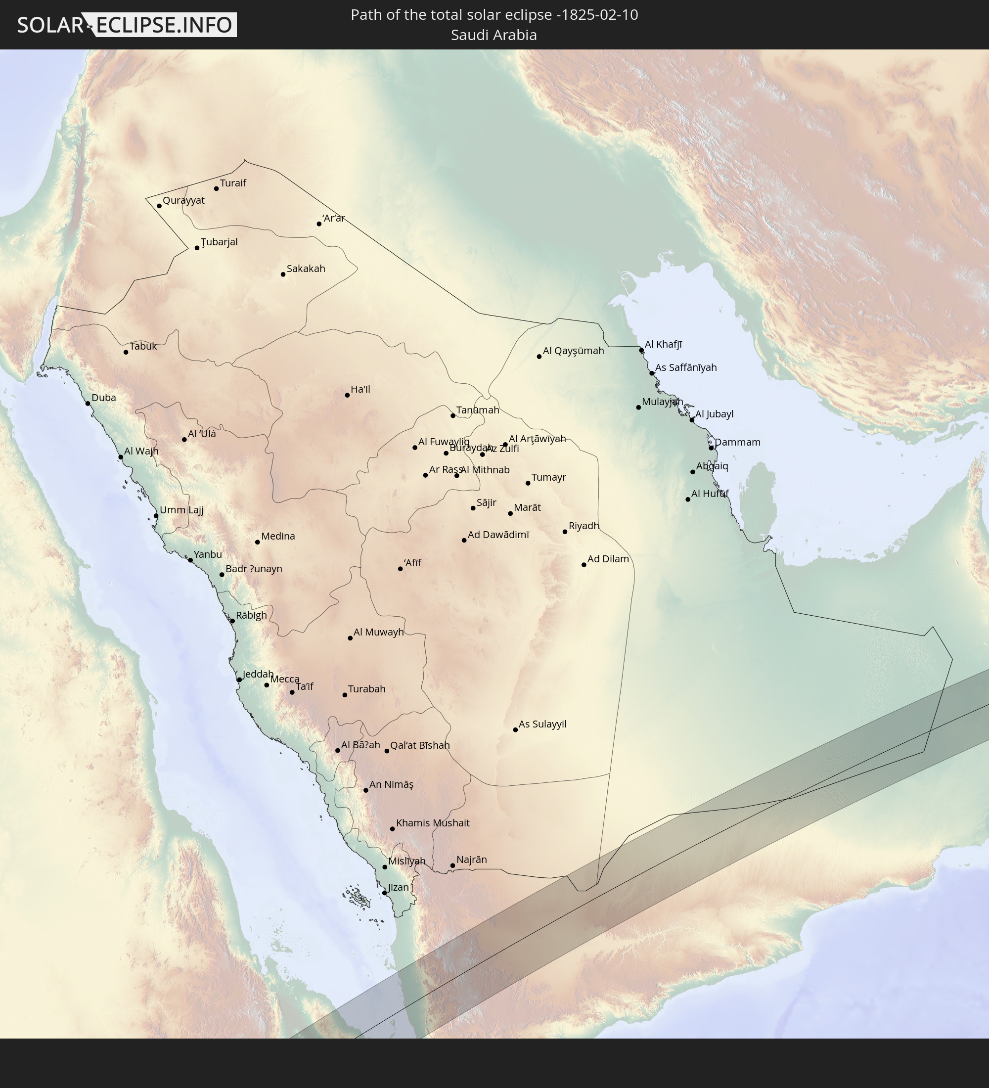 Saudi-Arabien
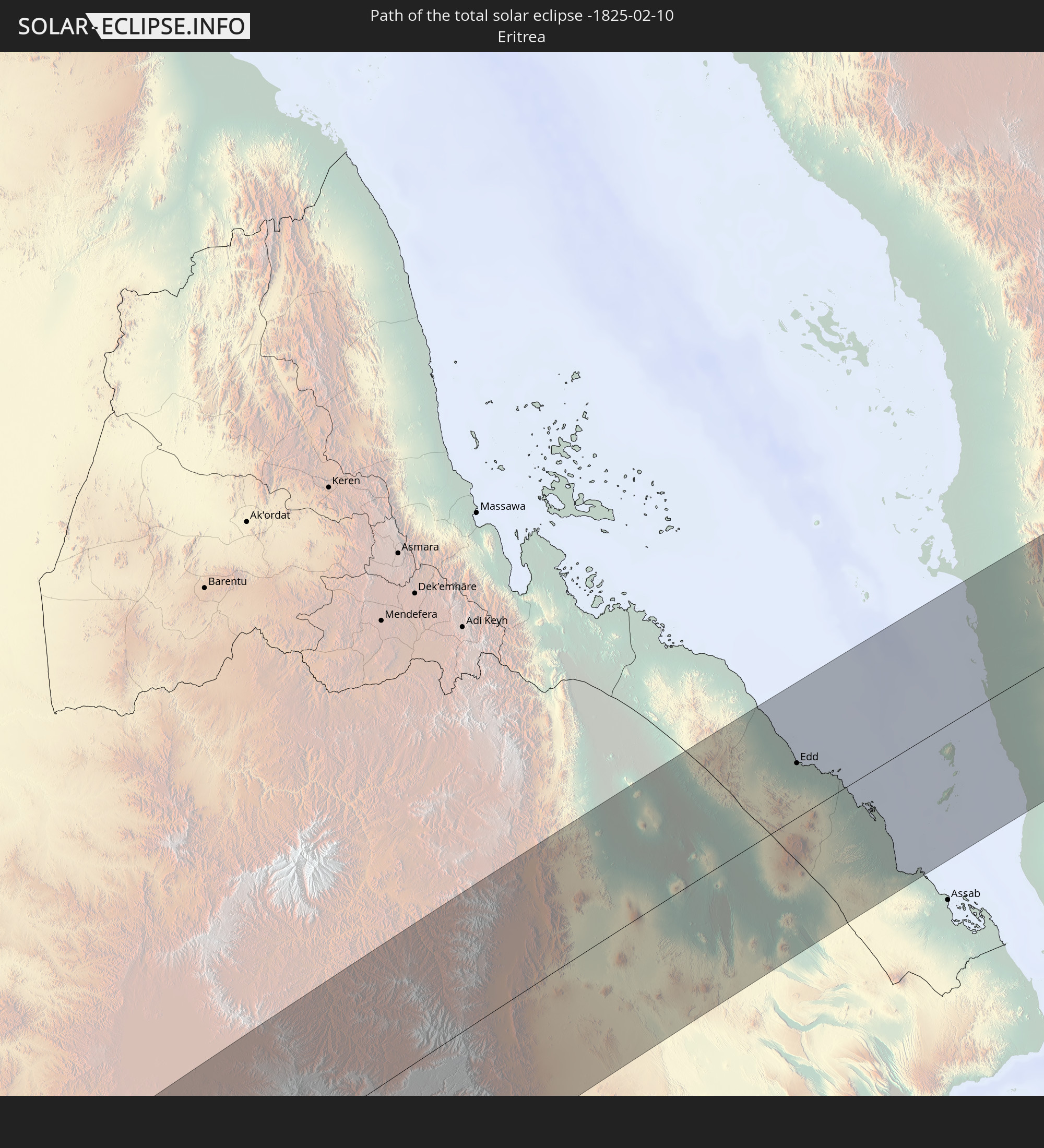 Eritrea
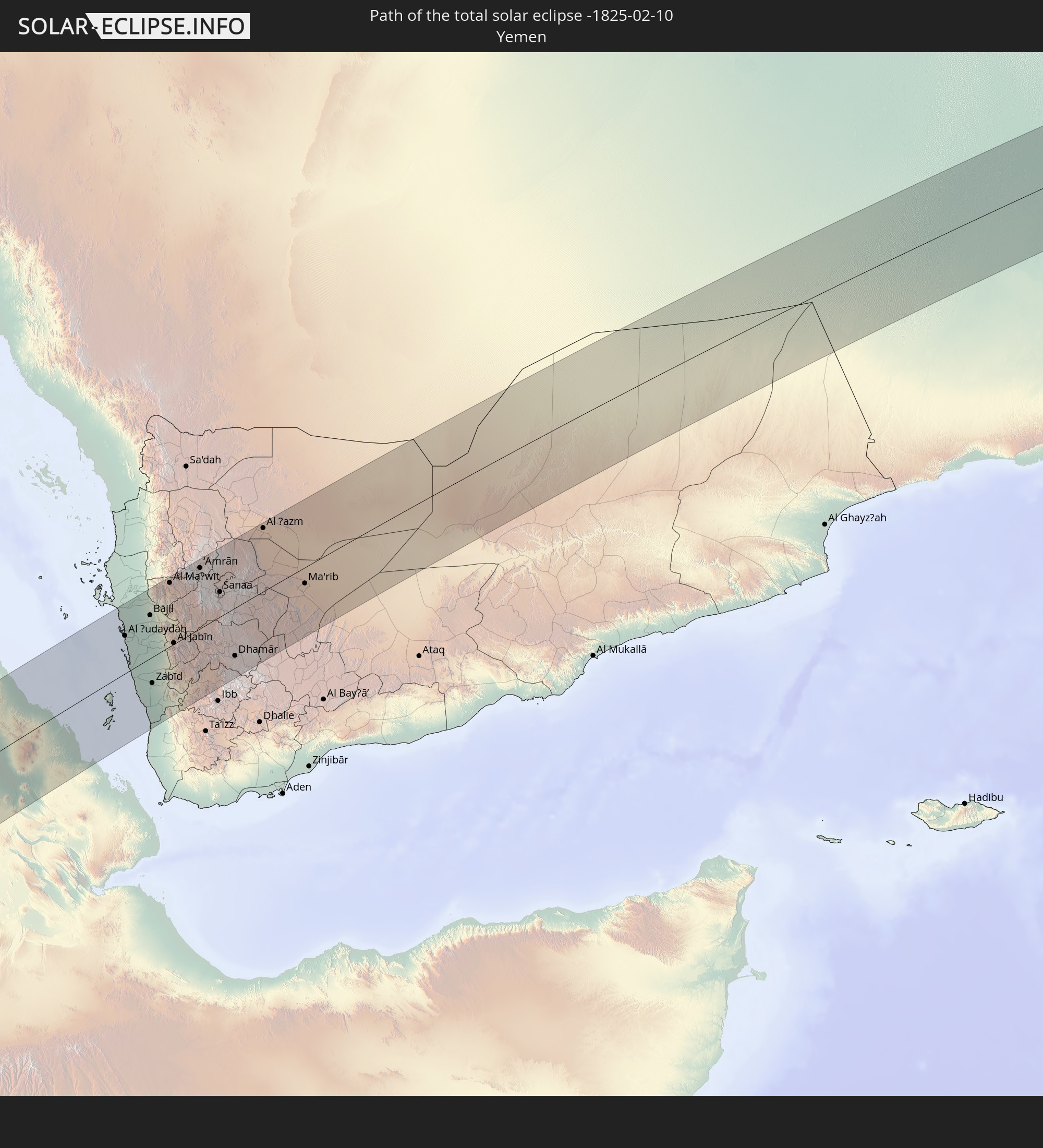 Jemen
Jemen
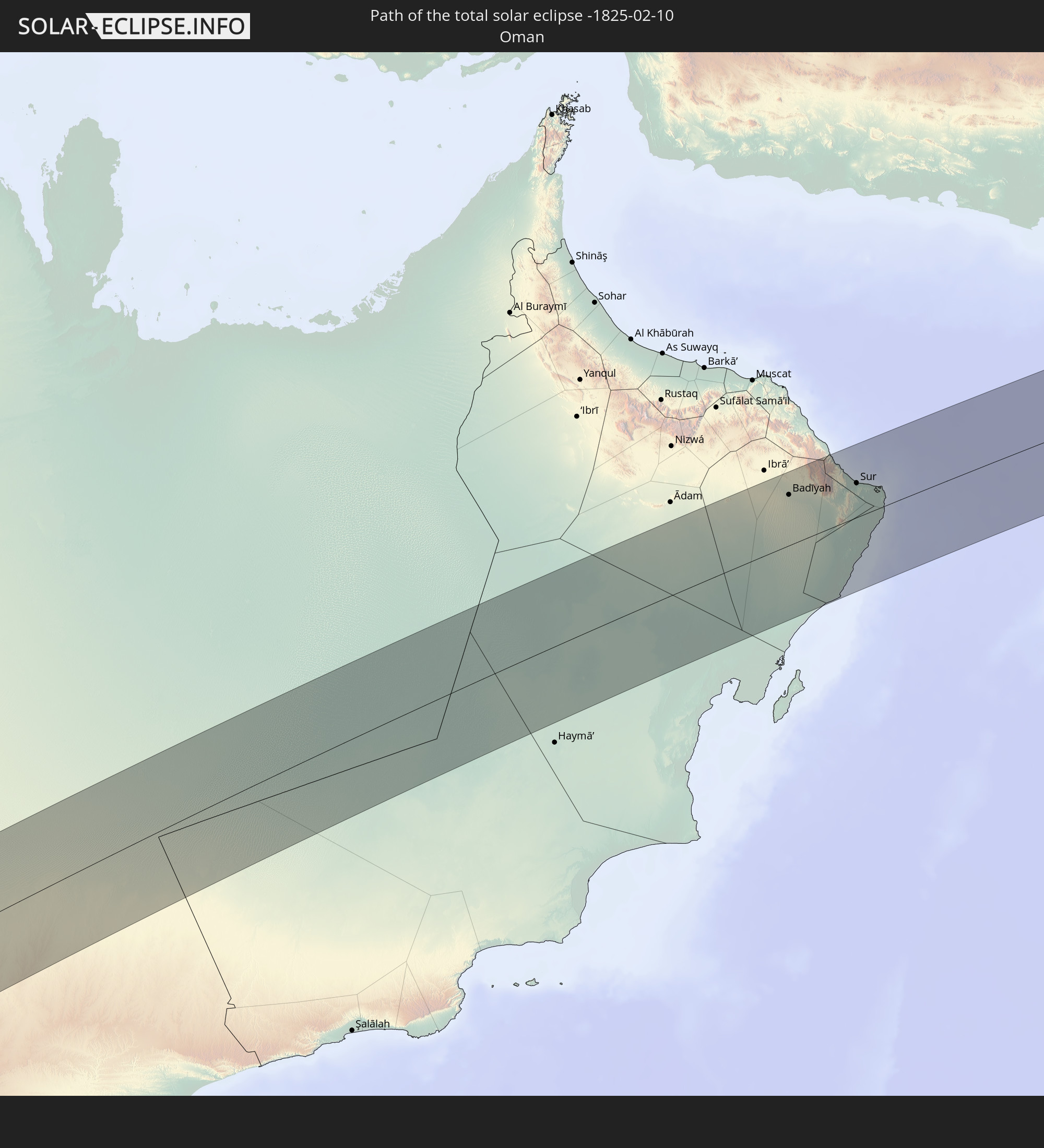 Oman
Oman
In den folgenden Ländern ist die Sonnenfinsternis partiell zu sehen
 Russland
 Chile
Chile
 Brasilien
 Argentinien
 Bolivien
 Paraguay
 Falklandinseln
 Guyana
 Uruguay
 Suriname
 Französisch-Guayana
 Südgeorgien und die Südlichen Sandwichinseln
 Senegal
 Mauretanien
 Guinea-Bissau
 Guinea
 St. Helena
 Sierra Leone
 Mali
Mali
 Liberia
 Algerien
 Elfenbeinküste
 Burkina Faso
 Ghana
Ghana
 Togo
Togo
 Niger
Niger
 Benin
Benin
 Nigeria
 Äquatorialguinea
 São Tomé und Príncipe
 Tunesien
 Kamerun
 Gabun
Gabun
 Libyen
 Republik Kongo
 Angola
 Namibia
 Demokratische Republik Kongo
 Tschad
 Zentralafrikanische Republik
 Südafrika
 Griechenland
 Botswana
 Rumänien
 Sudan
Sudan
 Sambia
 Ukraine
 Bulgarien
 Ägypten
 Simbabwe
 Türkei
 Lesotho
 Ruanda
 Burundi
 Tansania
 Uganda
 Mosambik
 Swasiland
 Republik Zypern
 Malawi
 Äthiopien
 Kenia
Kenia
 Staat Palästina
 Israel
 Saudi-Arabien
 Jordanien
 Libanon
 Syrien
 Eritrea
 Irak
Irak
 Georgien
 Französische Süd- und Antarktisgebiete
 Somalia
 Dschibuti
 Jemen
Jemen
 Madagaskar
 Komoren
 Armenien
 Iran
Iran
 Aserbaidschan
 Mayotte
 Seychellen
 Kasachstan
 Kuwait
 Bahrain
 Katar
Katar
 Vereinigte Arabische Emirate
 Oman
Oman
 Turkmenistan
 Mauritius
 Pakistan
 Britisches Territorium im Indischen Ozean
 Malediven
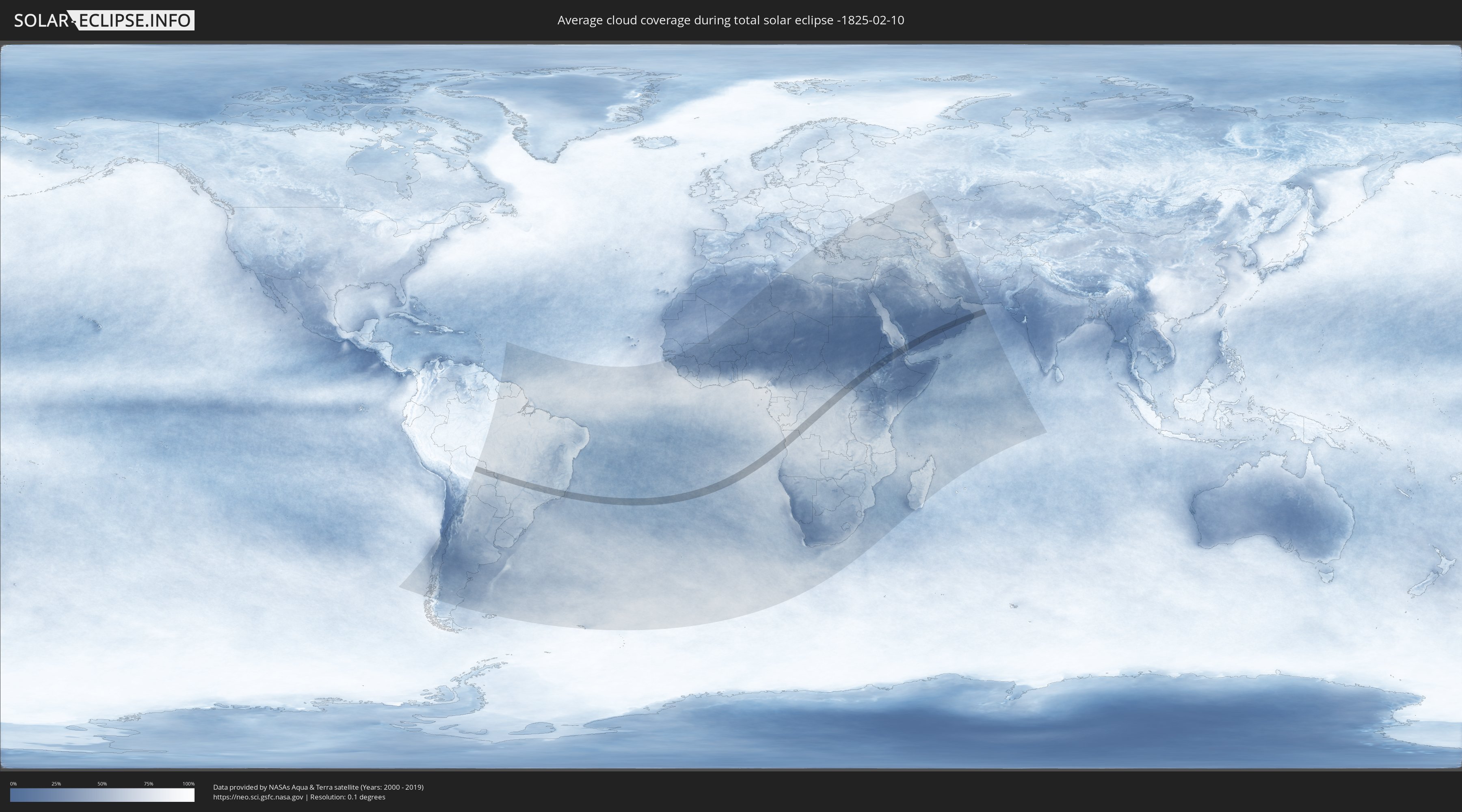
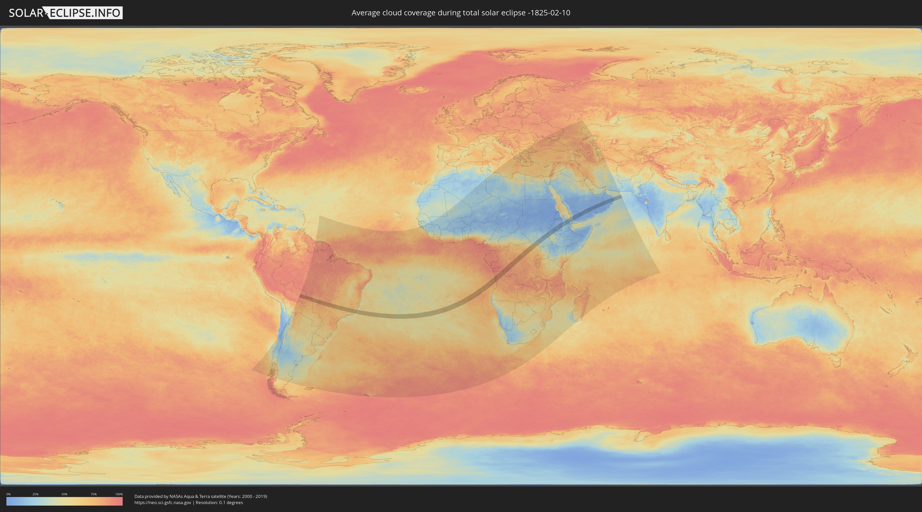
Wie wird das Wetter während der totalen Sonnenfinsternis am 10.02.-1825?
Wo ist der beste Ort, um die totale Sonnenfinsternis vom 10.02.-1825 zu beobachten?
Die folgenden Karten zeigen die durchschnittliche Bewölkung für den Tag, an dem die totale Sonnenfinsternis
stattfindet. Mit Hilfe der Karten lässt sich der Ort entlang des Finsternispfades eingrenzen,
der die besten Aussichen auf einen klaren wolkenfreien Himmel bietet.
Trotzdem muss man immer lokale Gegenenheiten beachten und sollte sich genau über das Wetter an seinem
gewählten Beobachtungsort informieren.
Die Daten stammen von den beiden NASA-Satelliten
AQUA und TERRA
und wurden über einen Zeitraum von 19 Jahren (2000 - 2019) gemittelt.
Detaillierte Länderkarten
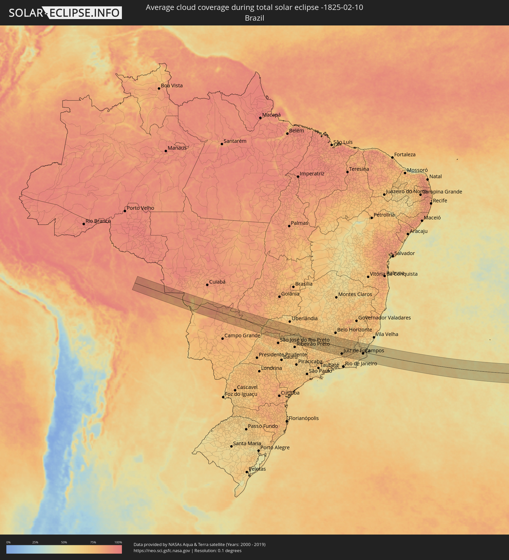 Brasilien
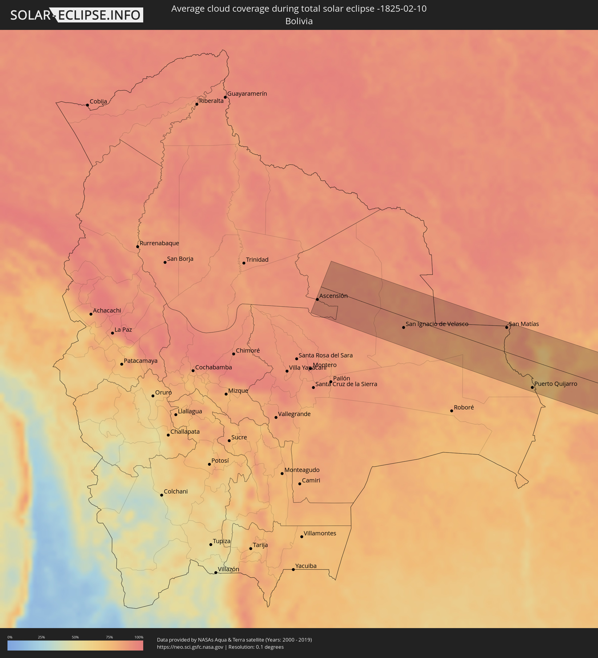 Bolivien
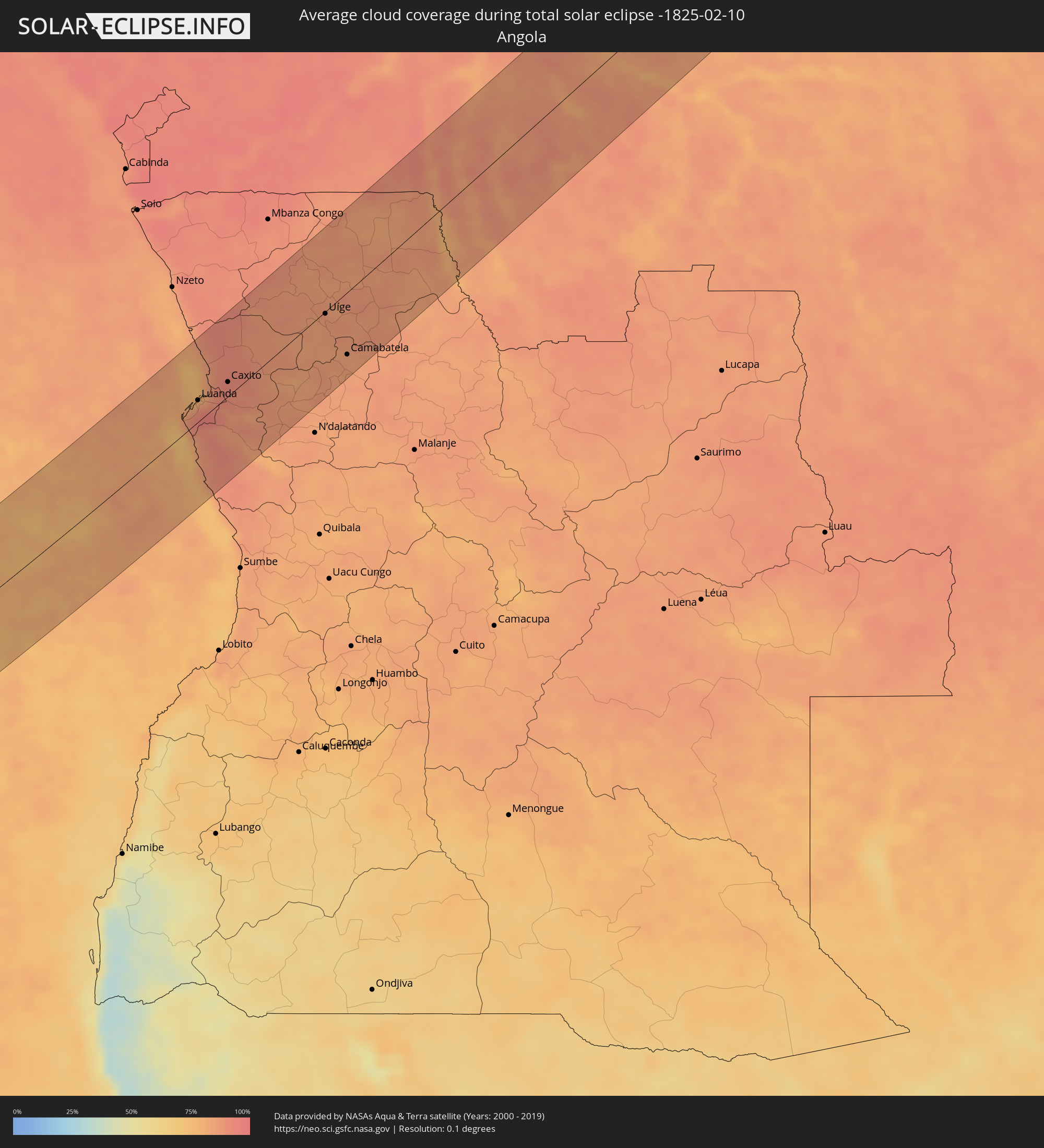 Angola
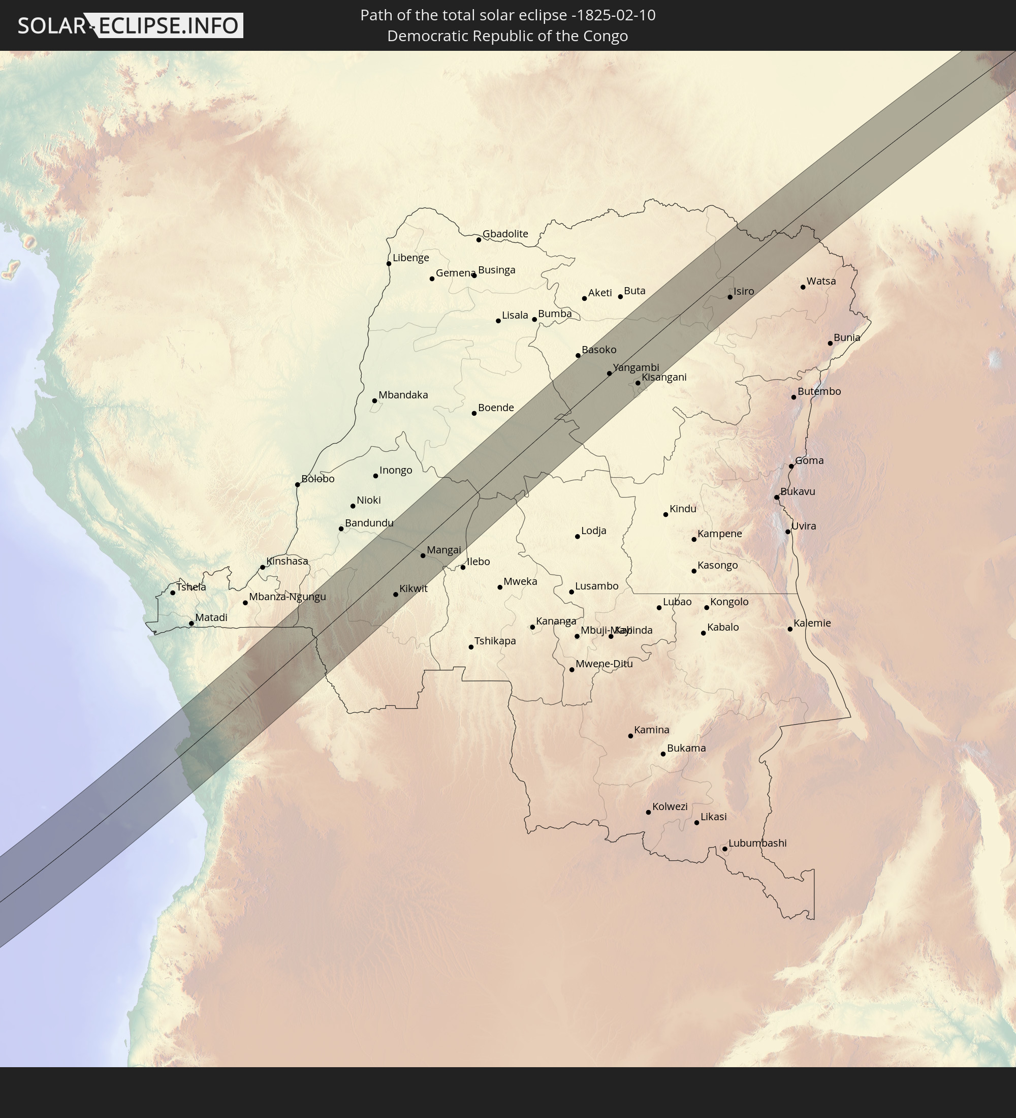
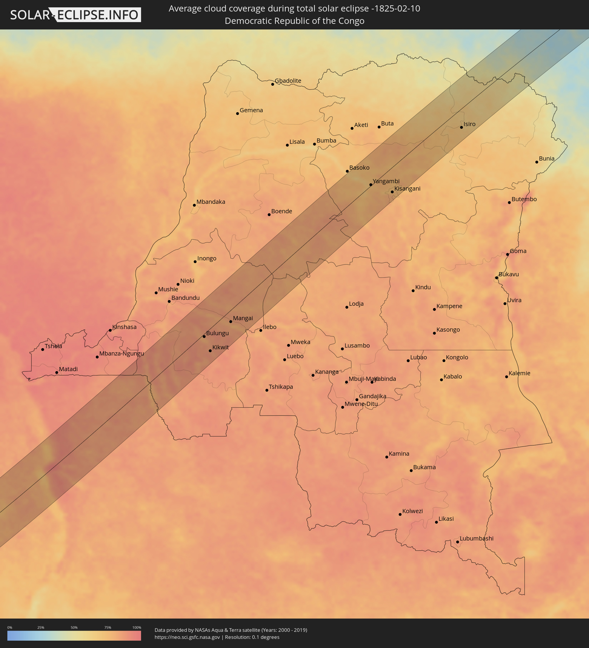 Demokratische Republik Kongo
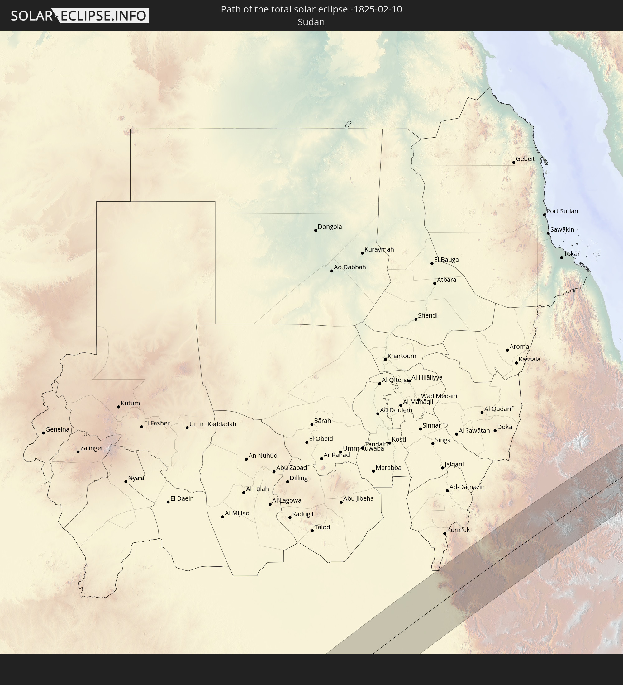
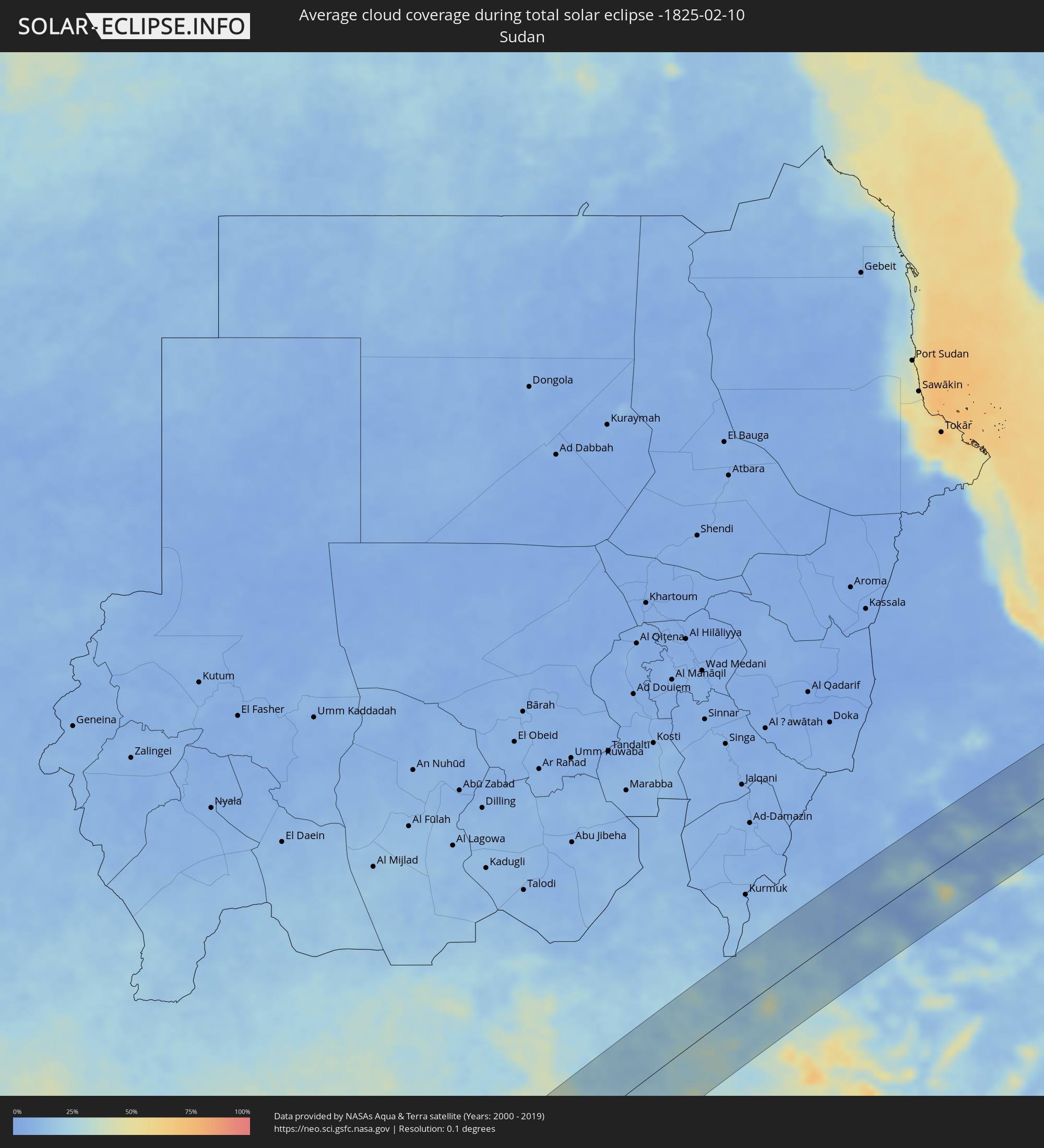 Sudan
Sudan
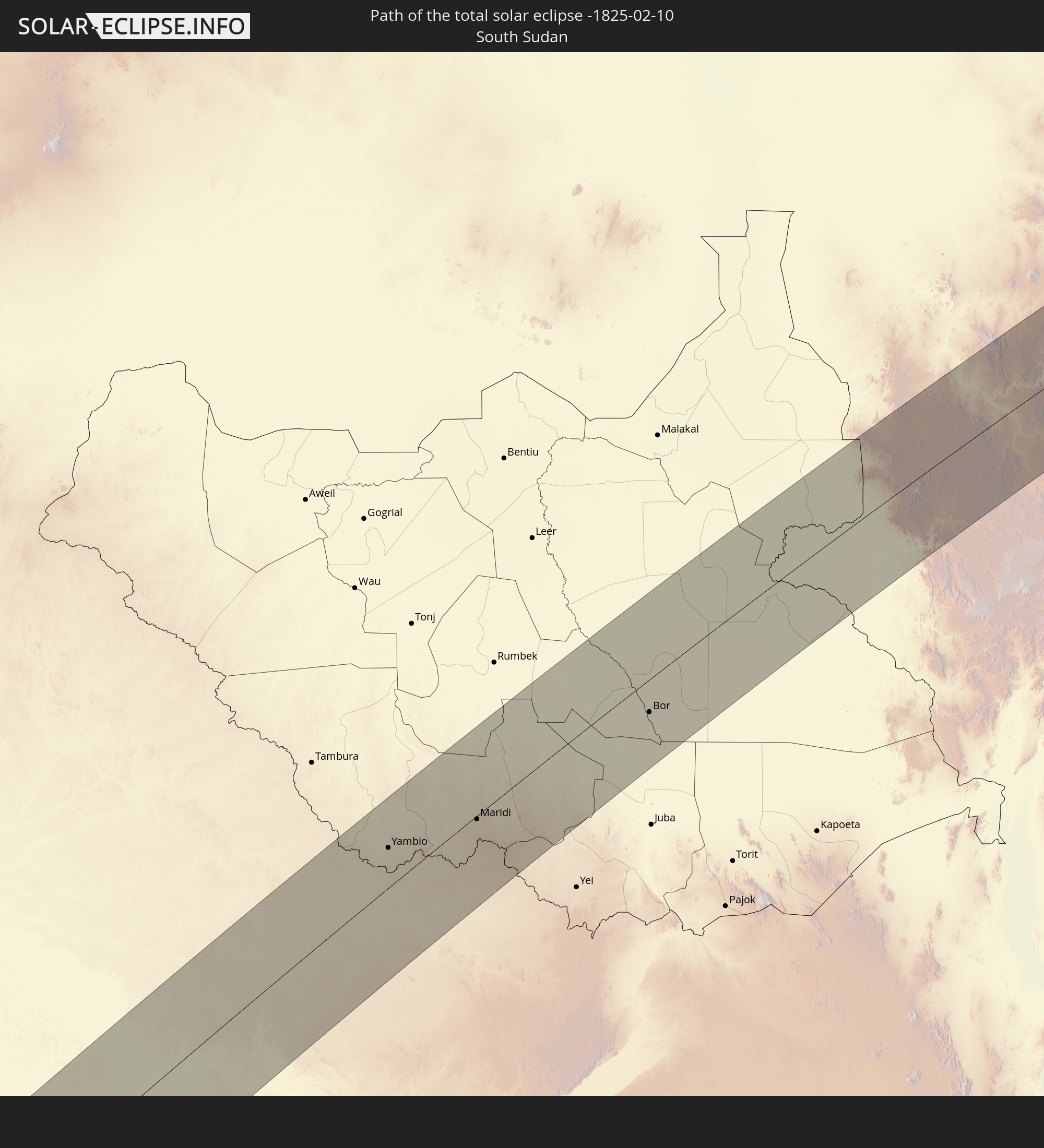
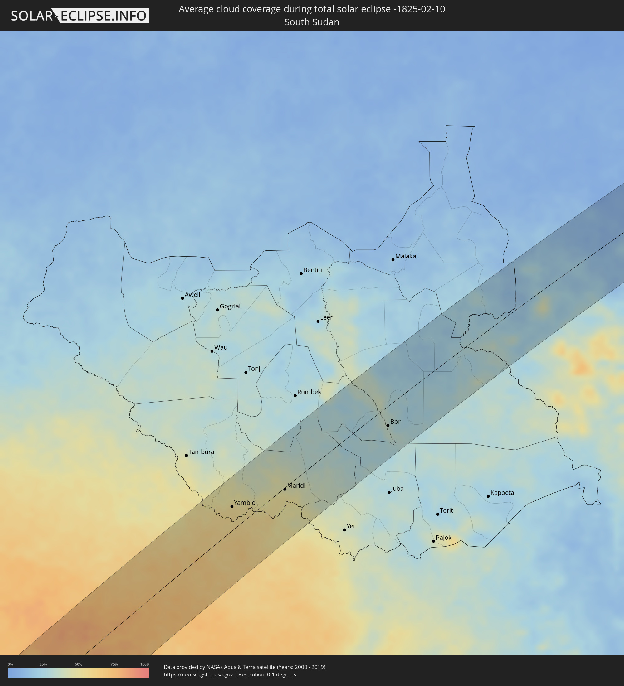 Südsudan
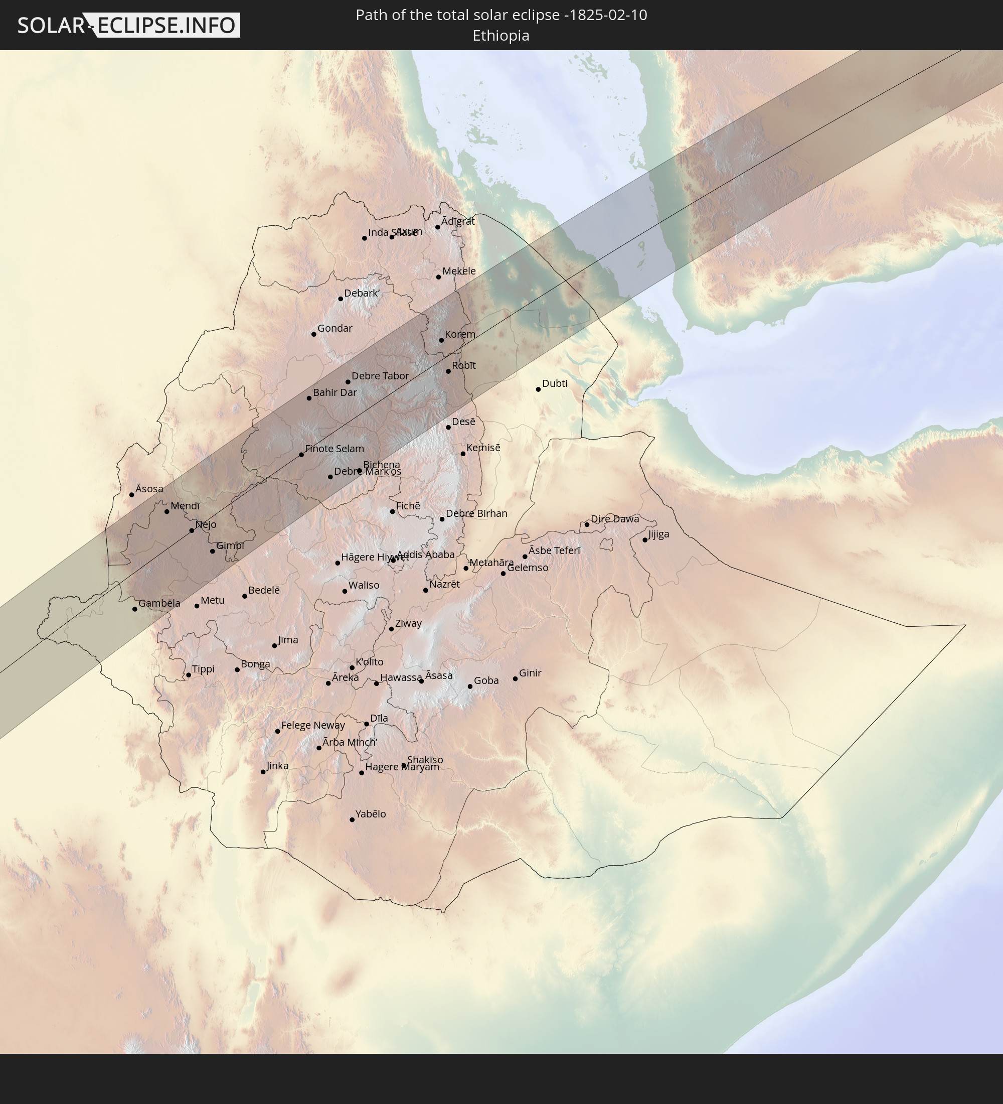
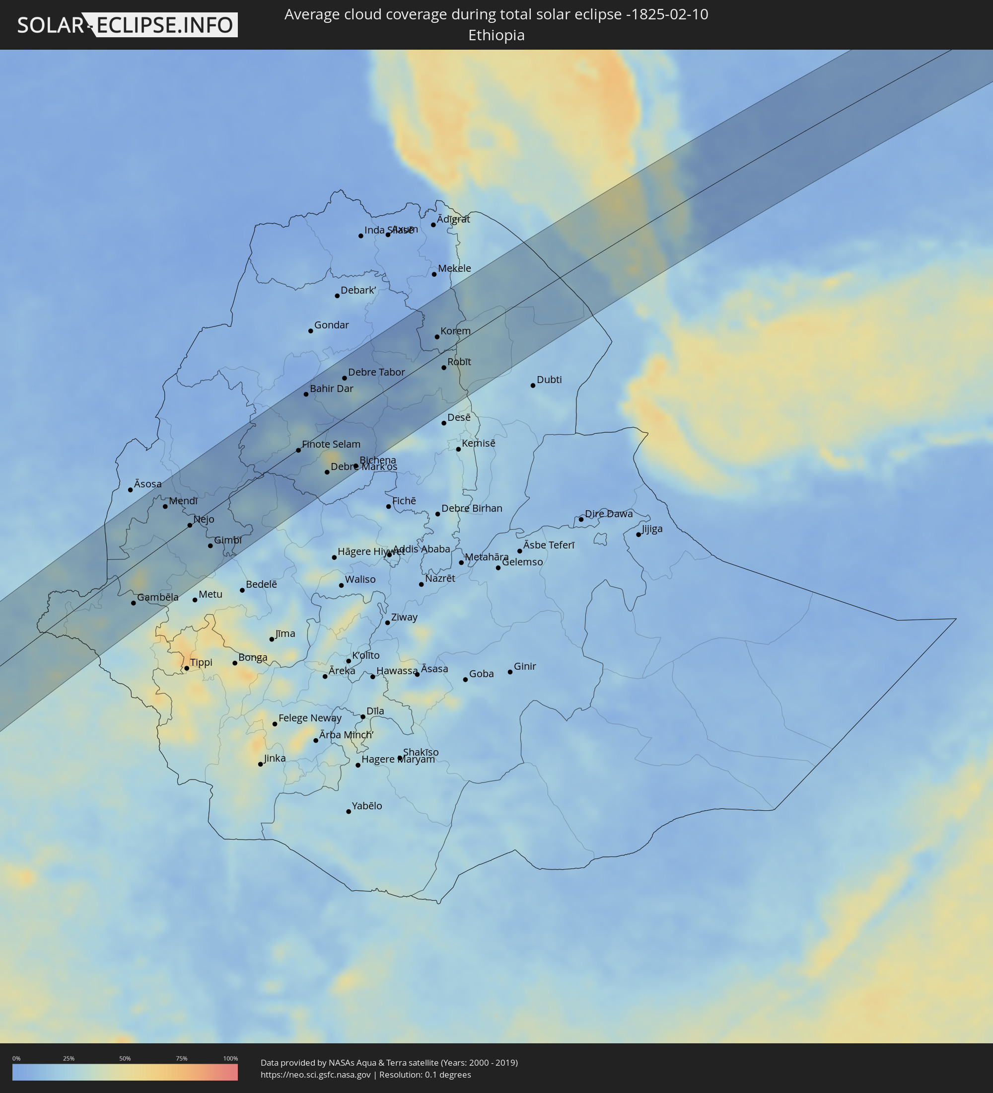 Äthiopien
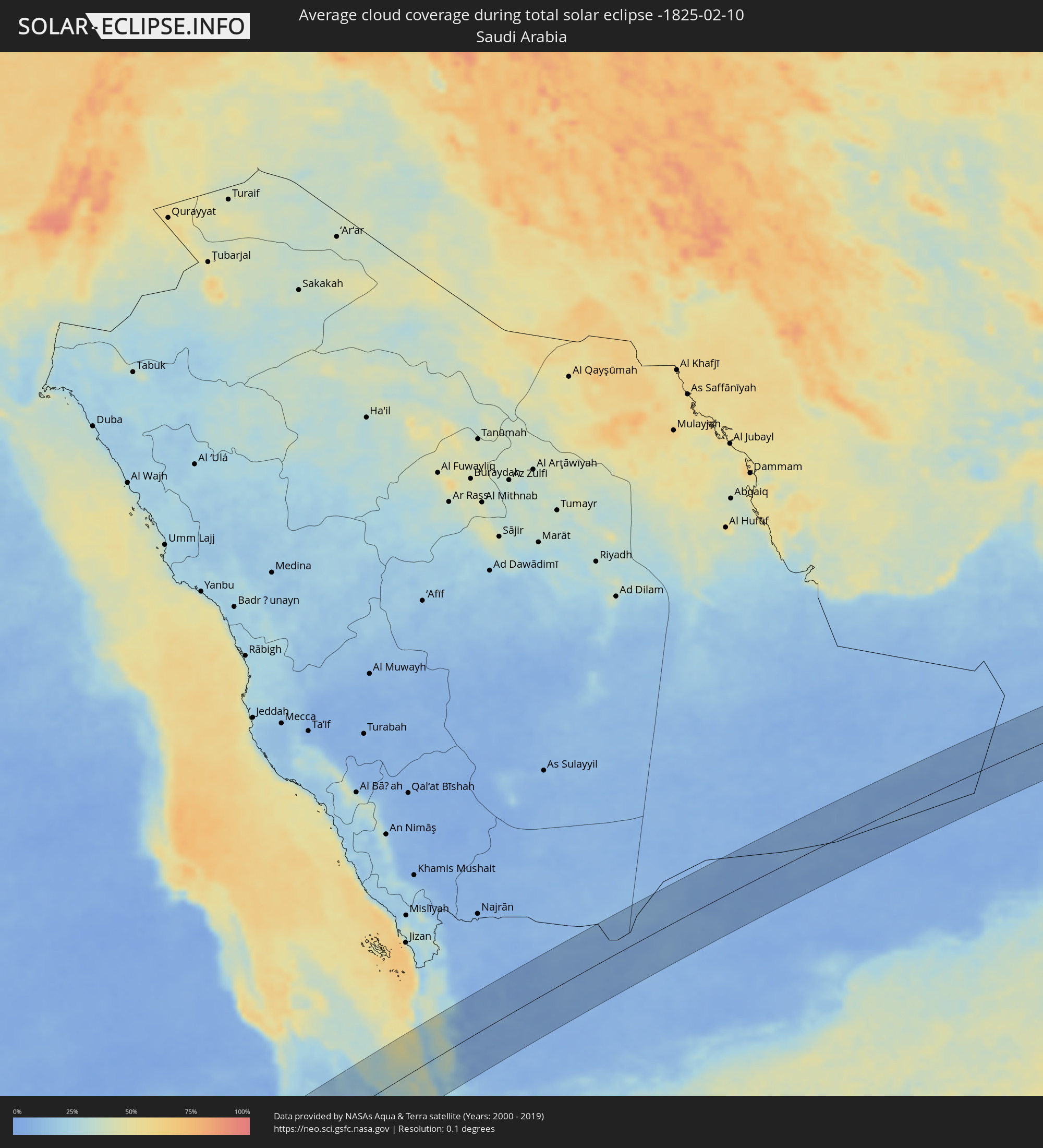 Saudi-Arabien
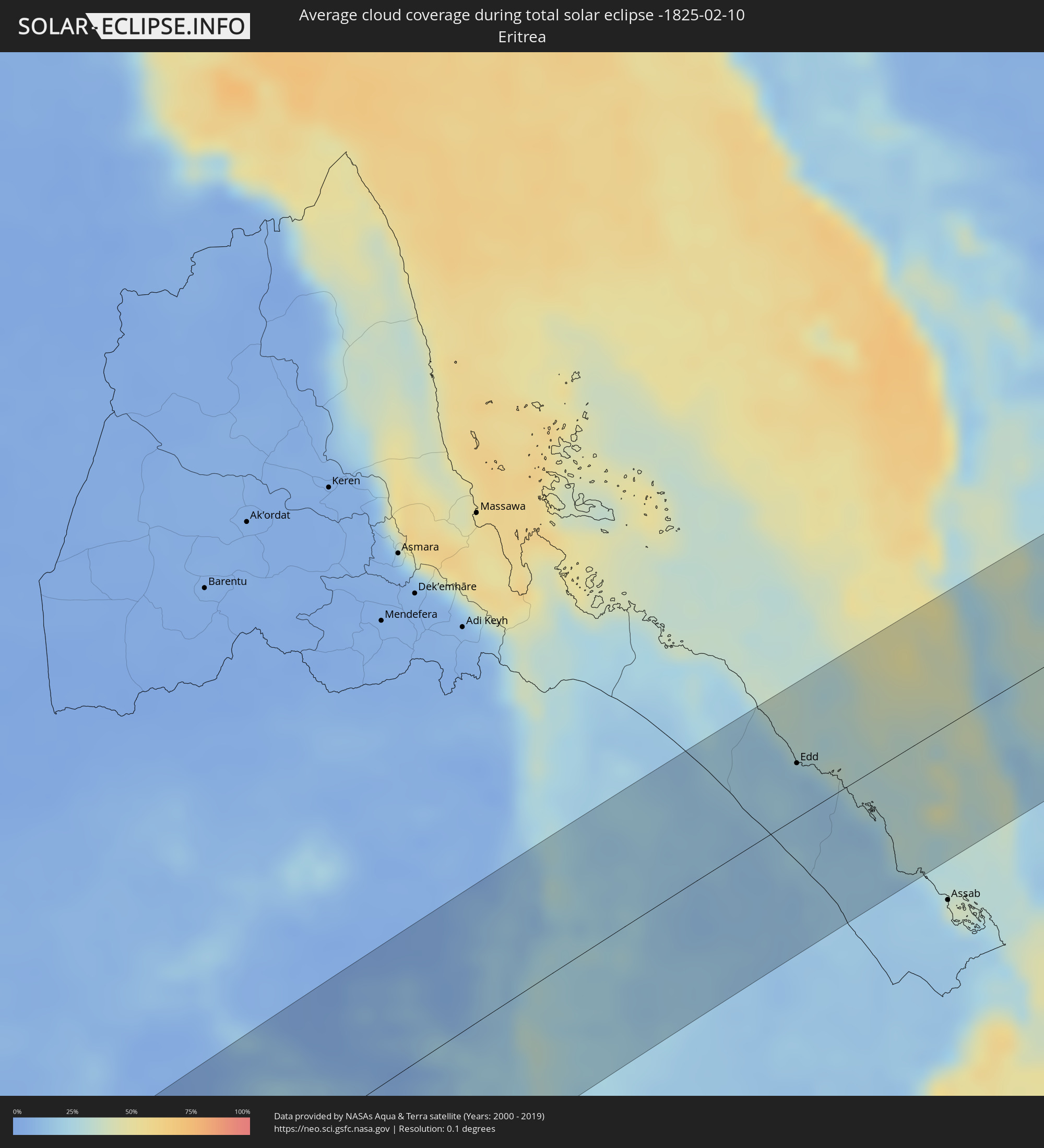 Eritrea
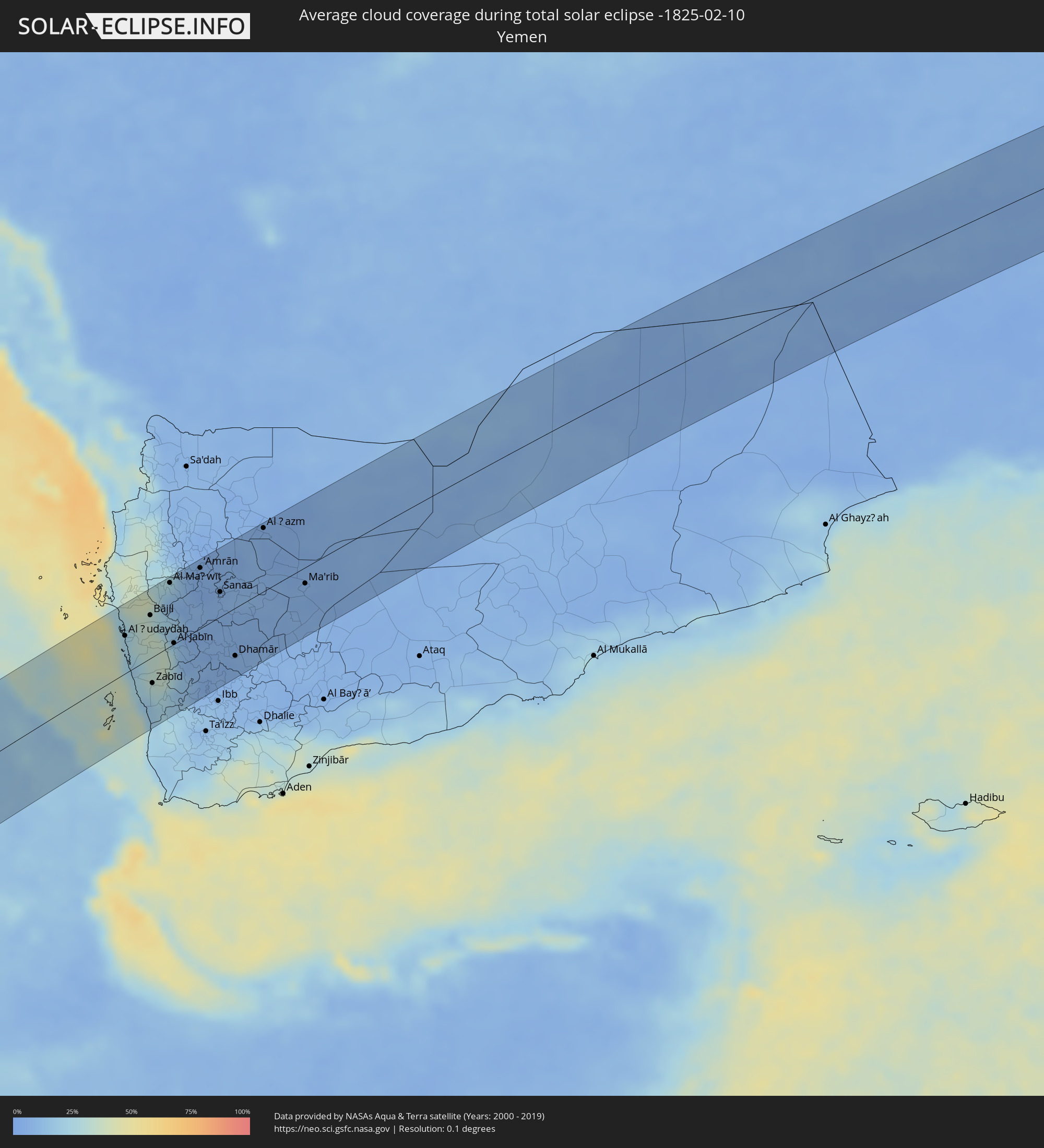 Jemen
Jemen
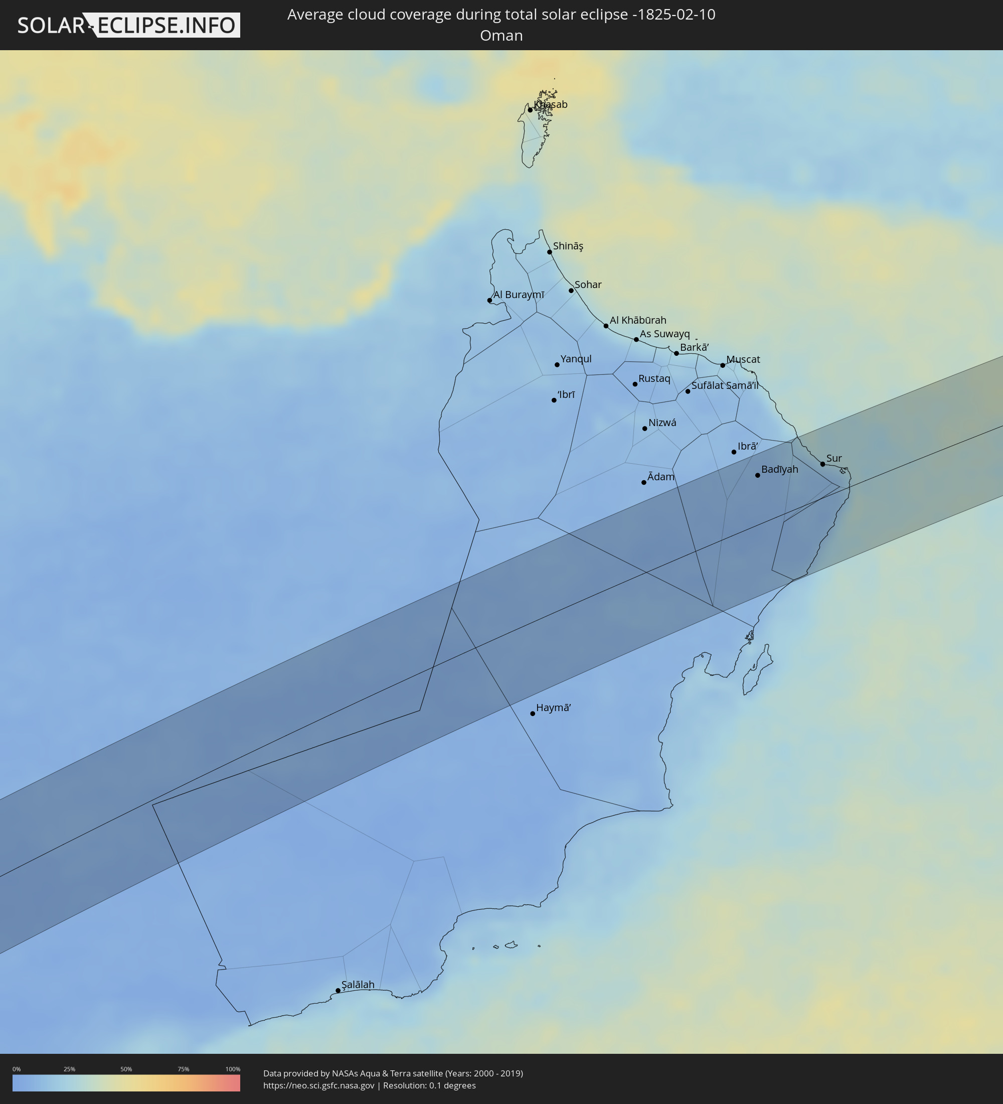 Oman
Oman
Orte im Finsternispfad
Die nachfolgene Tabelle zeigt Städte und Orte mit mehr als 5.000 Einwohnern, die sich im Finsternispfad befinden. Städte mit mehr als 100.000 Einwohnern sind dick gekennzeichnet. Mit einem Klick auf den Ort öffnet sich eine Detailkarte die die Lage des jeweiligen Ortes zusammen mit dem Verlauf der zentralen Finsternis präsentiert.
| Ort | Typ | Dauer der Verfinsterung | Ortszeit bei maximaler Verfinsterung | Entfernung zur Zentrallinie | Ø Bewölkung |
|
Ascensión, Santa Cruz
|
total | - | 05:37:18 UTC-04:32 | 36 km | 90% |
|
San Ignacio de Velasco, Santa Cruz
|
total | - | 05:37:22 UTC-04:32 | 28 km | 86% |
|
Concepción, Santa Cruz
|
total | - | 05:37:23 UTC-04:32 | 34 km | 87% |
|
San Matías, Santa Cruz
|
total | - | 05:37:31 UTC-04:32 | 61 km | 81% |
|
Puerto Quijarro, Santa Cruz
|
total | - | 05:37:50 UTC-04:32 | 66 km | 76% |
|
Ituiutaba, Minas Gerais
|
total | - | 07:06:27 UTC-03:06 | 71 km | 78% |
|
Barretos, São Paulo
|
total | - | 07:07:12 UTC-03:06 | 72 km | 66% |
|
Uberaba, Minas Gerais
|
total | - | 07:07:19 UTC-03:06 | 33 km | 73% |
|
Batatais, São Paulo
|
total | - | 07:07:45 UTC-03:06 | 80 km | 72% |
|
Franca, São Paulo
|
total | - | 07:07:45 UTC-03:06 | 37 km | 71% |
|
São Sebastião do Paraíso, Minas Gerais
|
total | - | 07:08:03 UTC-03:06 | 67 km | 70% |
|
Araxá, Minas Gerais
|
total | - | 07:07:47 UTC-03:06 | 77 km | 72% |
|
Passos, Minas Gerais
|
total | - | 07:08:12 UTC-03:06 | 35 km | 68% |
|
Formiga, Minas Gerais
|
total | - | 07:08:49 UTC-03:06 | 24 km | 71% |
|
Lavras, Minas Gerais
|
total | - | 07:09:15 UTC-03:06 | 49 km | 68% |
|
Divinópolis, Minas Gerais
|
total | - | 07:09:05 UTC-03:06 | 72 km | 67% |
|
São João del Rei, Minas Gerais
|
total | - | 07:09:41 UTC-03:06 | 19 km | 65% |
|
Congonhas, Minas Gerais
|
total | - | 07:09:49 UTC-03:06 | 59 km | 67% |
|
Conselheiro Lafaiete, Minas Gerais
|
total | - | 07:09:54 UTC-03:06 | 44 km | 67% |
|
Barbacena, Minas Gerais
|
total | - | 07:10:01 UTC-03:06 | 17 km | 68% |
|
Ouro Preto, Minas Gerais
|
total | - | 07:10:02 UTC-03:06 | 80 km | 71% |
|
Juiz de Fora, Minas Gerais
|
total | - | 07:10:26 UTC-03:06 | 64 km | 69% |
|
Ubá, Minas Gerais
|
total | - | 07:10:34 UTC-03:06 | 15 km | 66% |
|
Viçosa, Minas Gerais
|
total | - | 07:10:32 UTC-03:06 | 56 km | 67% |
|
Cataguases, Minas Gerais
|
total | - | 07:10:48 UTC-03:06 | 8 km | 66% |
|
Muriaé, Minas Gerais
|
total | - | 07:10:59 UTC-03:06 | 28 km | 63% |
|
Itaperuna, Rio de Janeiro
|
total | - | 07:11:21 UTC-03:06 | 31 km | 62% |
|
Campos, Rio de Janeiro
|
total | - | 07:11:53 UTC-03:06 | 16 km | 62% |
|
Luanda, Luanda
|
total | - | 12:34:35 UTC+00:13 | 26 km | 87% |
|
Caxito, Bengo
|
total | - | 12:35:54 UTC+00:13 | 17 km | 89% |
|
Uíge, Uíge
|
total | - | 12:40:22 UTC+00:13 | 3 km | 86% |
|
Camabatela, Cuanza Norte
|
total | - | 12:39:58 UTC+00:13 | 74 km | 83% |
|
Kasongo-Lunda, Bandundu
|
total | - | 12:45:38 UTC+00:13 | 37 km | 76% |
|
Bulungu, Bandundu
|
total | - | 12:52:05 UTC+00:13 | 9 km | 78% |
|
Kikwit, Bandundu
|
total | - | 12:51:38 UTC+00:13 | 66 km | 88% |
|
Mangai, Bandundu
|
total | - | 12:54:32 UTC+00:13 | 35 km | 81% |
|
Yangambi, Orientale
|
total | - | 15:06:14 UTC+02:10 | 2 km | 71% |
|
Kisangani, Orientale
|
total | - | 15:06:55 UTC+02:10 | 74 km | 77% |
|
Isiro, Orientale
|
total | - | 15:13:10 UTC+02:10 | 57 km | 68% |
 Yambio, Western Equatoria
|
total | - | 15:12:31 UTC+02:06 | 42 km | 54% |
|
Maridi, Western Equatoria
|
total | - | 15:14:10 UTC+02:06 | 4 km | 48% |
|
Bor, Jonglei
|
total | - | 15:17:55 UTC+02:06 | 35 km | 33% |
|
Gambēla, Gambela
|
total | - | 15:43:46 UTC+02:27 | 55 km | 23% |
|
Dembī Dolo, Oromiya
|
total | - | 15:44:14 UTC+02:27 | 43 km | 27% |
|
Mendī, Oromiya
|
total | - | 15:45:42 UTC+02:27 | 52 km | 20% |
|
Nejo, Oromiya
|
total | - | 15:45:46 UTC+02:27 | 1 km | 21% |
|
Gimbi, Oromiya
|
total | - | 15:45:44 UTC+02:27 | 52 km | 21% |
|
Burē, Amhara
|
total | - | 15:48:05 UTC+02:27 | 10 km | 7% |
|
Finote Selam, Amhara
|
total | - | 15:48:14 UTC+02:27 | 3 km | 6% |
|
Bahir Dar, Amhara
|
total | - | 15:49:04 UTC+02:27 | 72 km | 8% |
|
Addiet Canna, Amhara
|
total | - | 15:48:53 UTC+02:27 | 36 km | 13% |
|
Werota, Amhara
|
total | - | 15:49:34 UTC+02:27 | 82 km | 8% |
|
Debre Mark’os, Amhara
|
total | - | 15:48:18 UTC+02:27 | 64 km | 19% |
|
Debre Tabor, Amhara
|
total | - | 15:49:44 UTC+02:27 | 57 km | 19% |
|
Debre Werk’, Amhara
|
total | - | 15:48:53 UTC+02:27 | 61 km | 16% |
|
Bichena, Amhara
|
total | - | 15:48:43 UTC+02:27 | 83 km | 15% |
|
Lalībela, Amhara
|
total | - | 15:50:36 UTC+02:27 | 12 km | 6% |
|
Korem, Tigray
|
total | - | 15:51:17 UTC+02:27 | 27 km | 15% |
|
Maych’ew, Tigray
|
total | - | 15:51:30 UTC+02:27 | 52 km | 13% |
|
Robīt, Amhara
|
total | - | 15:50:59 UTC+02:27 | 25 km | 23% |
|
Edd, Southern Red Sea
|
total | - | 15:53:38 UTC+02:27 | 35 km | 18% |
|
Al Ḩudaydah, Muḩāfaz̧at al Ḩudaydah
|
total | - | 16:34:29 UTC+03:06 | 46 km | 23% |
|
Bājil, Muḩāfaz̧at al Ḩudaydah
|
total | - | 16:34:49 UTC+03:06 | 52 km | 35% |
|
Zabīd, Muḩāfaz̧at al Ḩudaydah
|
total | - | 16:34:18 UTC+03:06 | 32 km | 25% |
|
Bayt al Faqīh, Muḩāfaz̧at al Ḩudaydah
|
total | - | 16:34:30 UTC+03:06 | 2 km | 30% |
|
Al Maḩwīt, Al Maḩwīt
|
total | - | 16:35:11 UTC+03:06 | 77 km | 20% |
|
Al Jabīn, Raymah
|
total | - | 16:34:46 UTC+03:06 | 1 km | 29% |
|
‘Amrān, Omran
|
total | - | 16:35:29 UTC+03:06 | 74 km | 5% |
|
Sanaa, Sanaa
|
total | - | 16:35:27 UTC+03:06 | 30 km | 7% |
|
Saḩar, Sanaa
|
total | - | 16:35:28 UTC+03:06 | 21 km | 7% |
|
Sayyān, Sanaa
|
total | - | 16:35:24 UTC+03:06 | 6 km | 6% |
|
Yarīm, Ibb
|
total | - | 16:34:54 UTC+03:06 | 81 km | 7% |
|
Dhamār, Dhamār
|
total | - | 16:35:04 UTC+03:06 | 59 km | 6% |
|
Al Ḩazm, Al Jawf
|
total | - | 16:36:10 UTC+03:06 | 77 km | 6% |
|
Ma'rib, Ma’rib
|
total | - | 16:36:02 UTC+03:06 | 20 km | 6% |
|
Al Qābil, Ash Sharqiyah North Governorate
|
total | - | 17:16:06 UTC+03:41 | 69 km | 11% |
|
Badīyah, Ash Sharqiyah North Governorate
|
total | - | 17:16:05 UTC+03:41 | 52 km | 10% |
|
Sur, Ash Sharqiyah South Governorate
|
total | - | 17:16:08 UTC+03:41 | 35 km | 15% |