Totale Sonnenfinsternis vom 07.10.-1828
| Wochentag: | Montag |
| Maximale Dauer der Verfinsterung: | 02m15s |
| Maximale Breite des Finsternispfades: | 127 km |
| Saroszyklus: | 24 |
| Bedeckungsgrad: | 100% |
| Magnitude: | 1.029 |
| Gamma: | -0.6527 |
Wo kann man die Sonnenfinsternis vom 07.10.-1828 sehen?
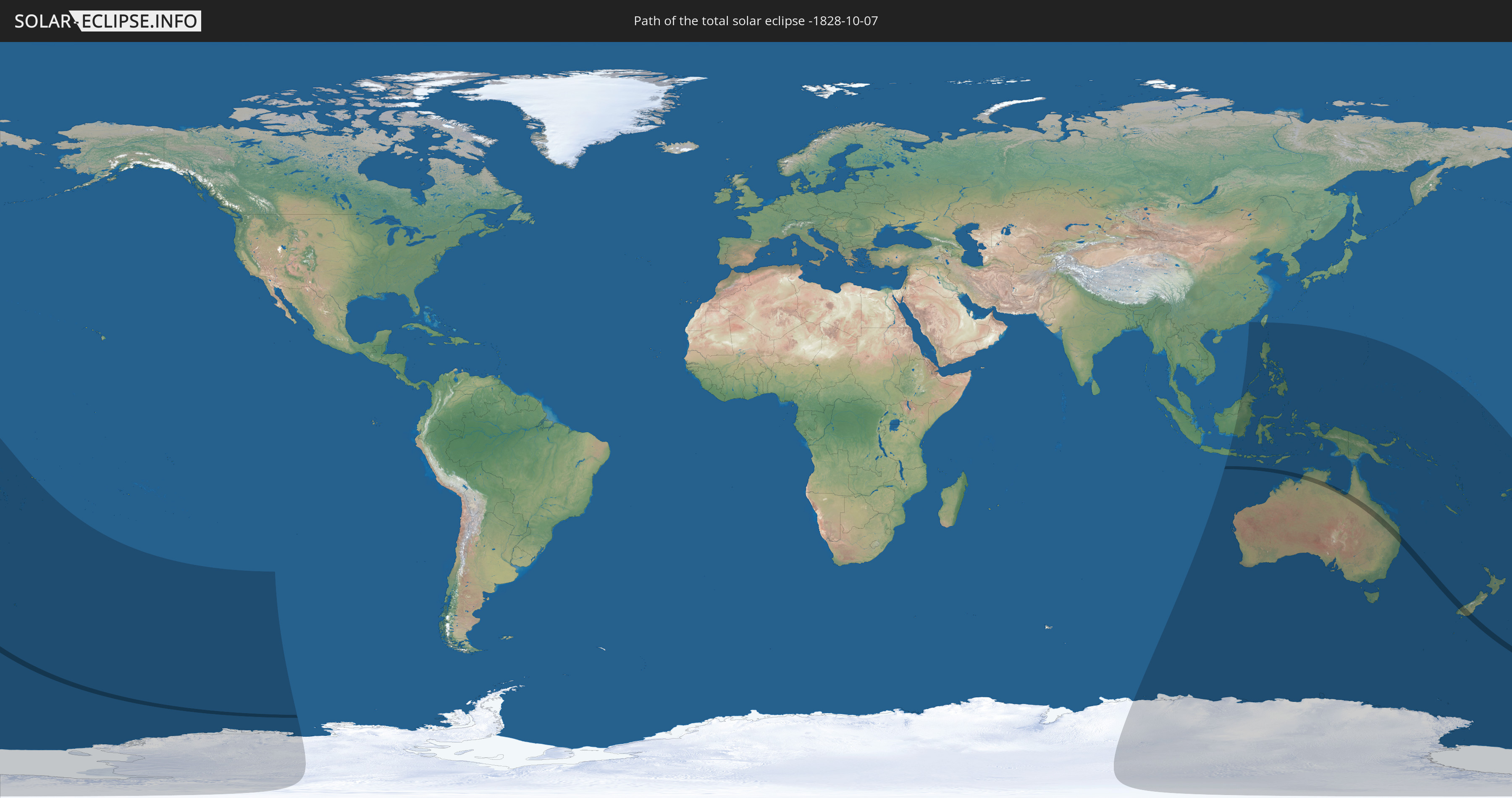
Die Sonnenfinsternis am 07.10.-1828 kann man in 27 Ländern als partielle Sonnenfinsternis beobachten.
Der Finsternispfad verläuft durch 2 Länder. Nur in diesen Ländern ist sie als totale Sonnenfinsternis zu sehen.
In den folgenden Ländern ist die Sonnenfinsternis total zu sehen
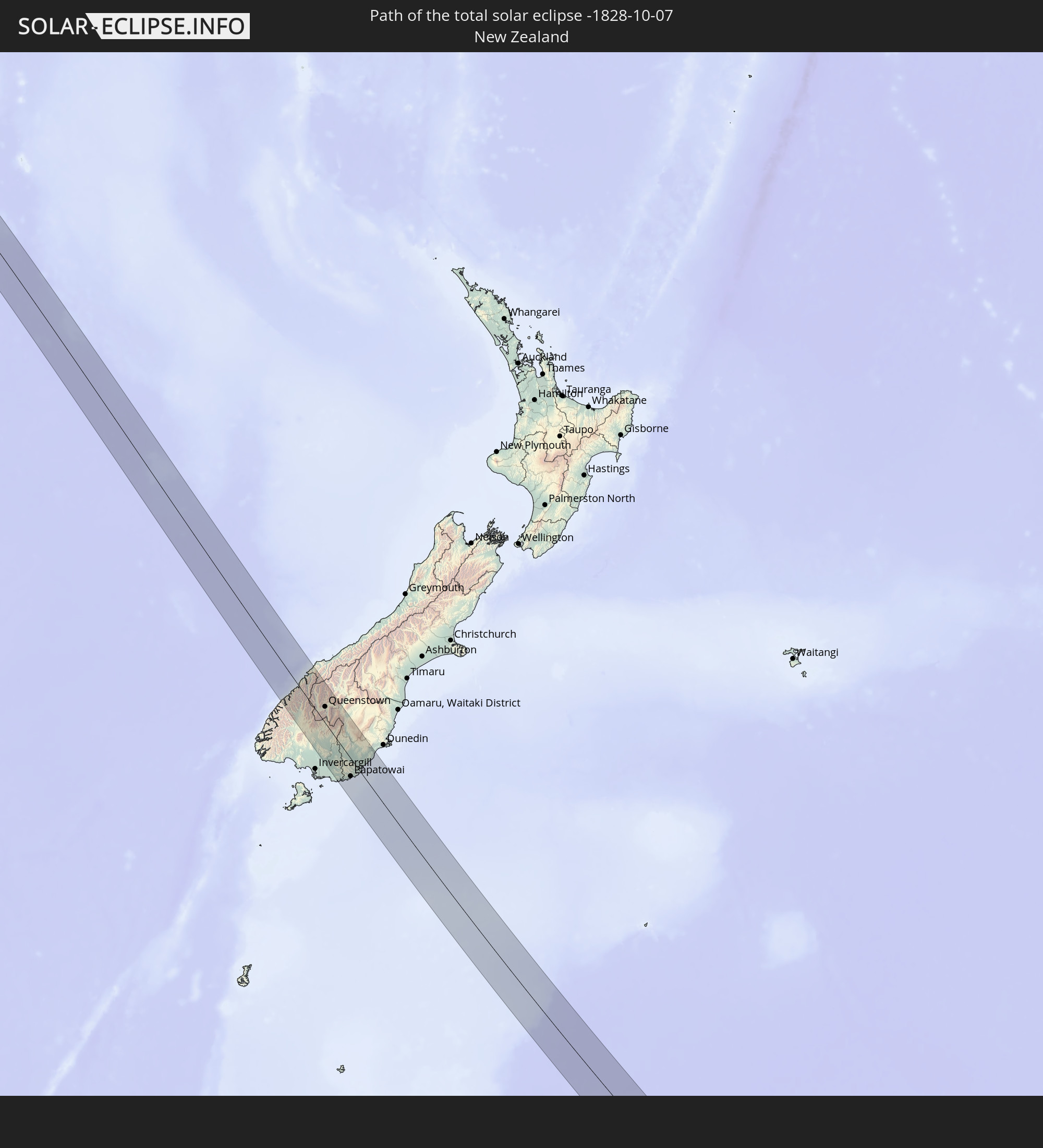 Neuseeland
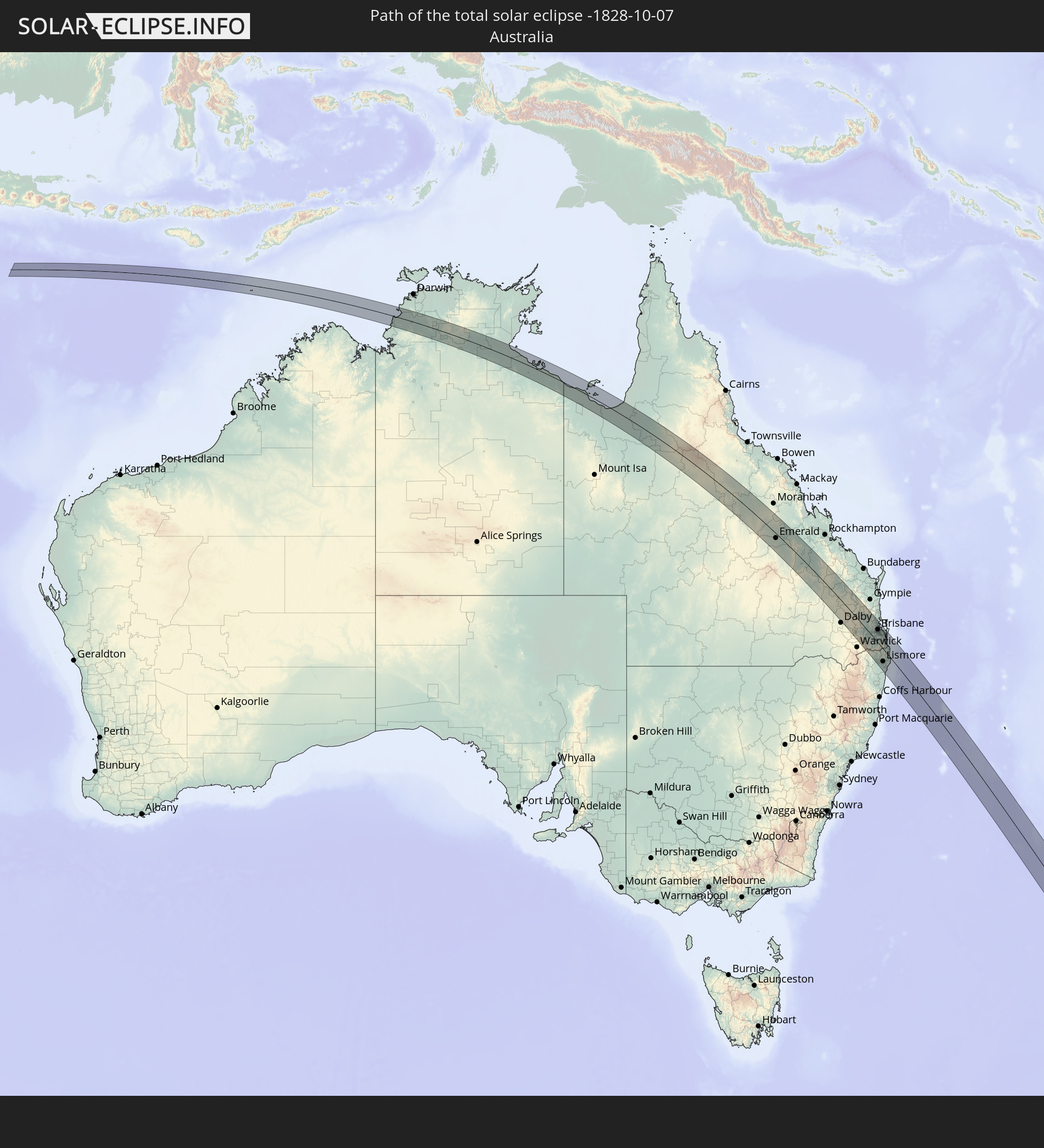 Australien
In den folgenden Ländern ist die Sonnenfinsternis partiell zu sehen
 Antarktika
 Fidschi
 Neuseeland
 Wallis und Futuna
 Tonga
Tonga
 Kiribati
 Samoa
Samoa
 Niue
Niue
 Indonesien
 Malaysia
 Australien
 Brunei
 Taiwan
 Philippinen
 Osttimor
 Palau
Palau
 Föderierte Staaten von Mikronesien
 Papua-Neuguinea
 Guam
Guam
 Nördliche Marianen
 Salomonen
 Neukaledonien
 Marshallinseln
 Vanuatu
 Nauru
Nauru
 Norfolkinsel
 Tuvalu
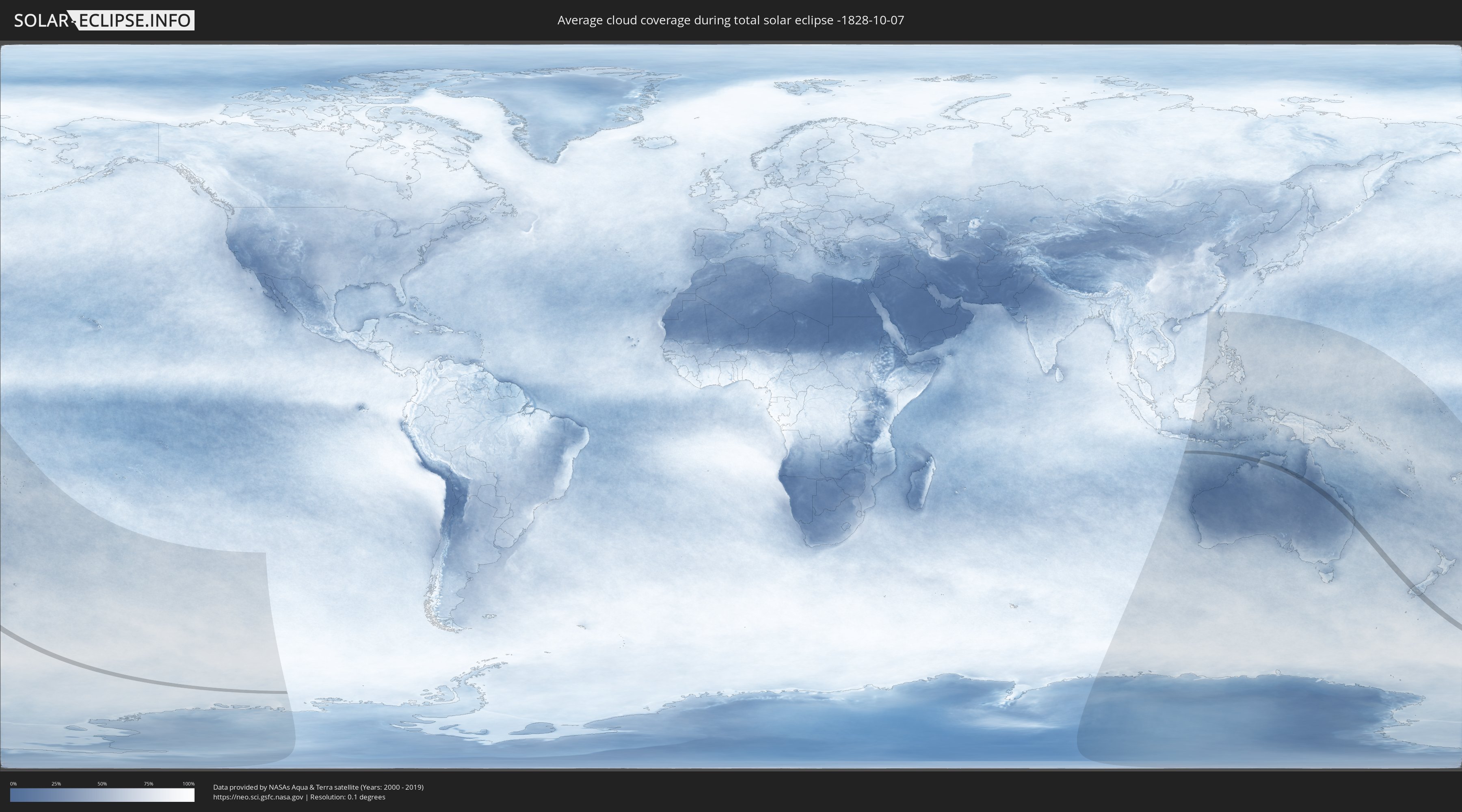
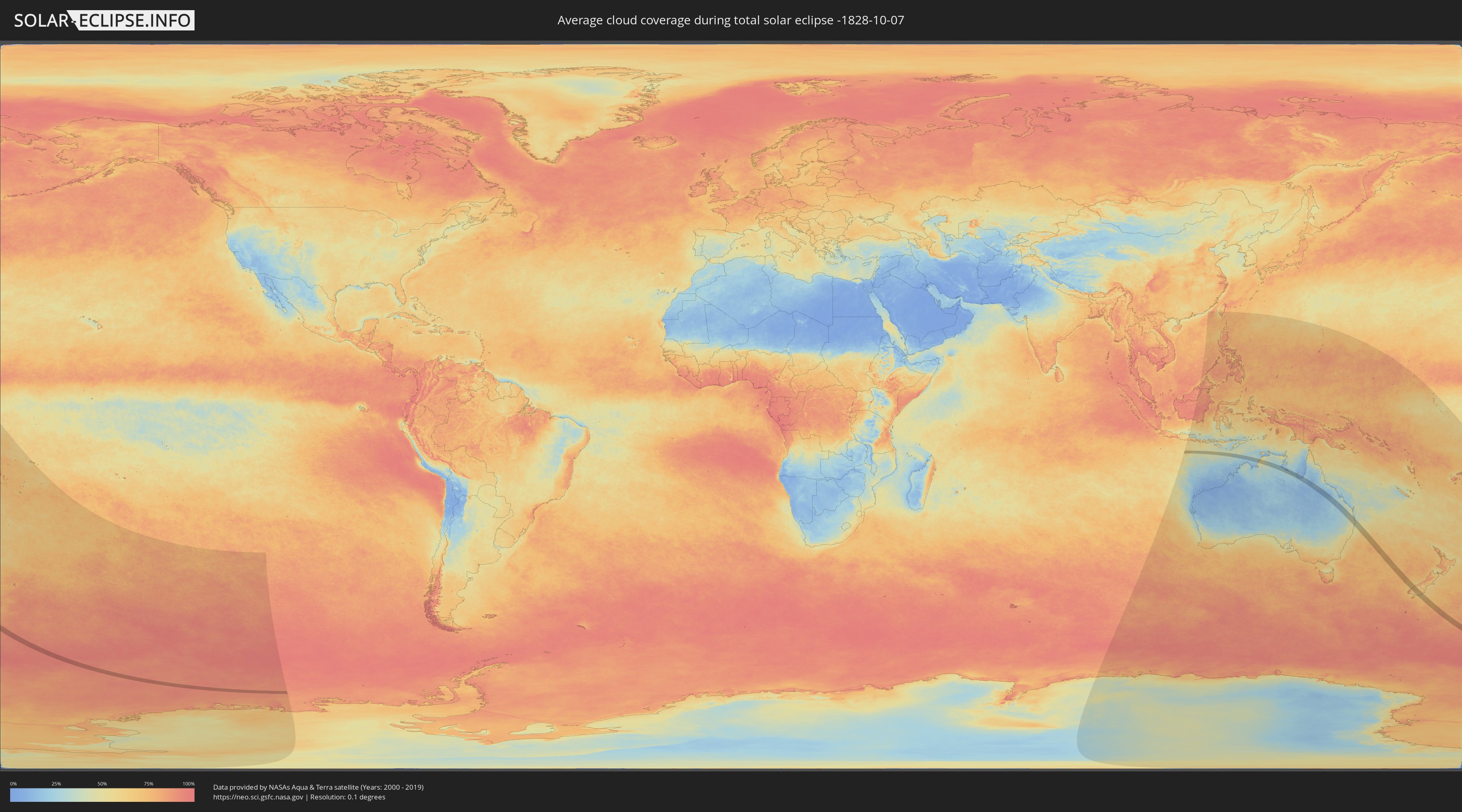
Wie wird das Wetter während der totalen Sonnenfinsternis am 07.10.-1828?
Wo ist der beste Ort, um die totale Sonnenfinsternis vom 07.10.-1828 zu beobachten?
Die folgenden Karten zeigen die durchschnittliche Bewölkung für den Tag, an dem die totale Sonnenfinsternis
stattfindet. Mit Hilfe der Karten lässt sich der Ort entlang des Finsternispfades eingrenzen,
der die besten Aussichen auf einen klaren wolkenfreien Himmel bietet.
Trotzdem muss man immer lokale Gegenenheiten beachten und sollte sich genau über das Wetter an seinem
gewählten Beobachtungsort informieren.
Die Daten stammen von den beiden NASA-Satelliten
AQUA und TERRA
und wurden über einen Zeitraum von 19 Jahren (2000 - 2019) gemittelt.
Detaillierte Länderkarten
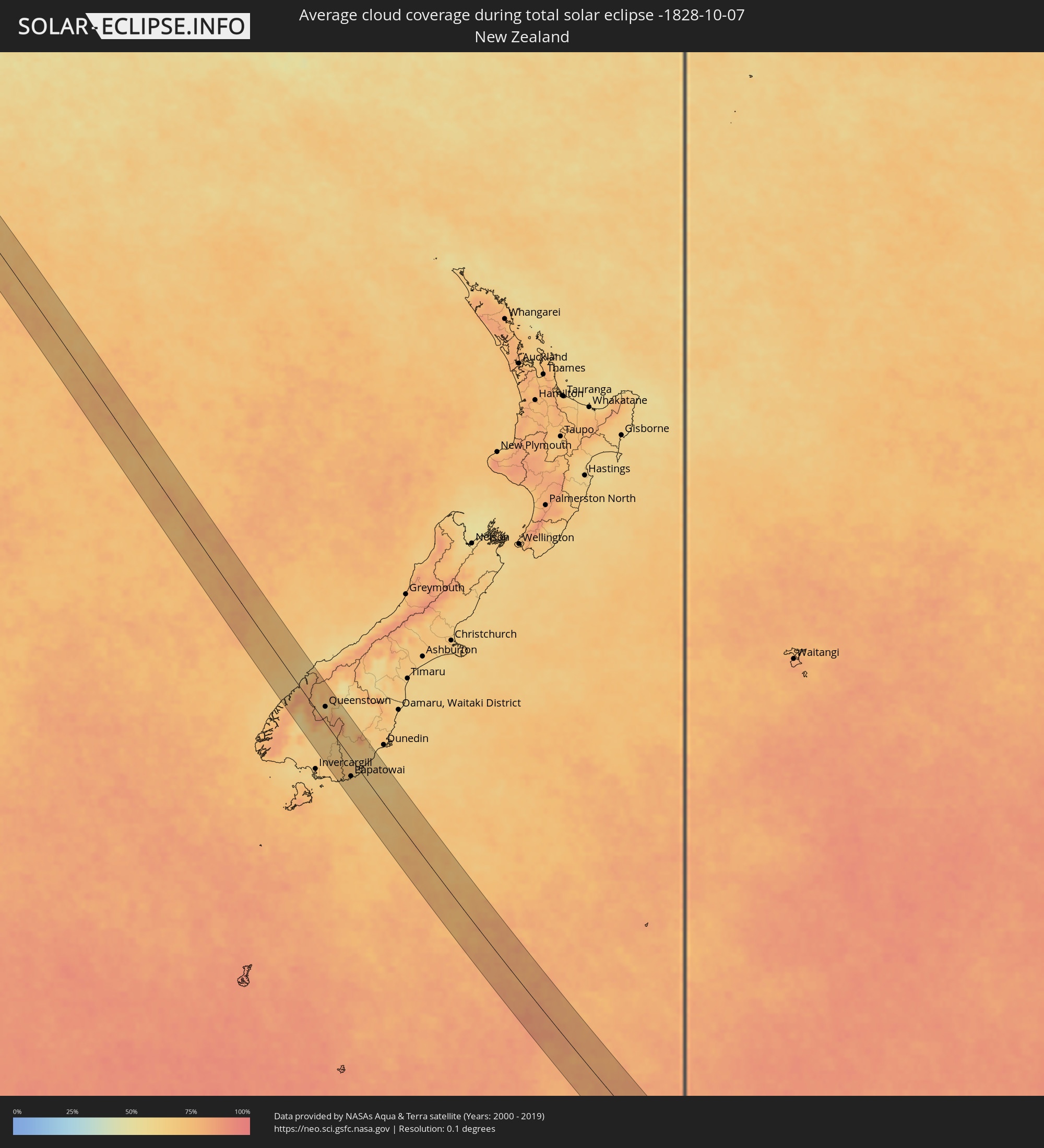 Neuseeland
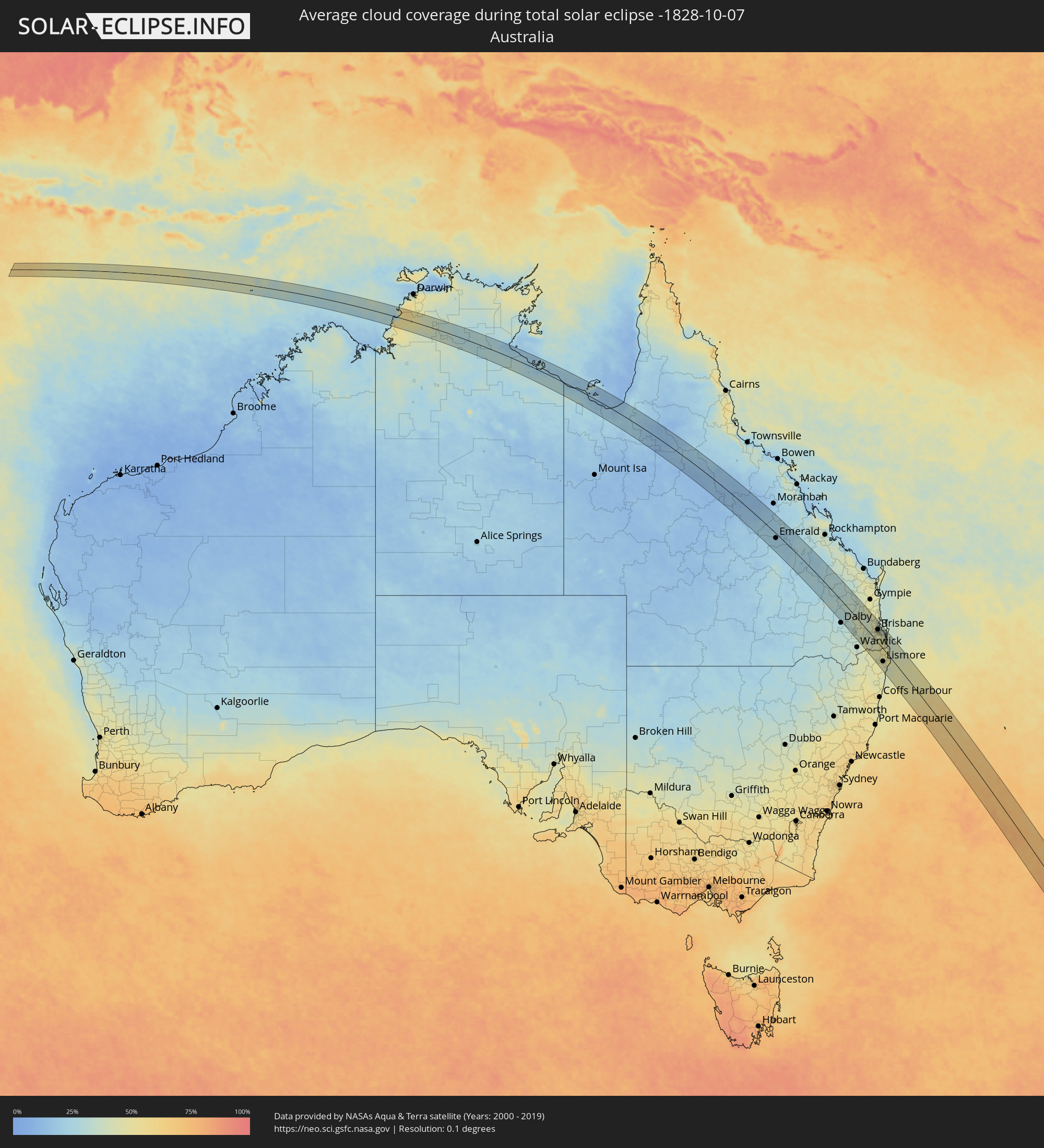 Australien
Orte im Finsternispfad
Die nachfolgene Tabelle zeigt Städte und Orte mit mehr als 5.000 Einwohnern, die sich im Finsternispfad befinden. Städte mit mehr als 100.000 Einwohnern sind dick gekennzeichnet. Mit einem Klick auf den Ort öffnet sich eine Detailkarte die die Lage des jeweiligen Ortes zusammen mit dem Verlauf der zentralen Finsternis präsentiert.
| Ort | Typ | Dauer der Verfinsterung | Ortszeit bei maximaler Verfinsterung | Entfernung zur Zentrallinie | Ø Bewölkung |
|
Katherine, Northern Territory
|
total | - | 08:12:16 UTC+09:30 | 28 km | 36% |
|
Emerald, Queensland
|
total | - | 09:14:32 UTC+10:00 | 16 km | 20% |
|
Blackwater, Queensland
|
total | - | 09:15:34 UTC+10:00 | 30 km | 21% |
|
Kingaroy, Queensland
|
total | - | 09:25:18 UTC+10:00 | 18 km | 35% |
|
Darling Heights, Queensland
|
total | - | 09:27:31 UTC+10:00 | 52 km | 36% |
|
Toowoomba, Queensland
|
total | - | 09:27:28 UTC+10:00 | 48 km | 39% |
|
East Toowoomba, Queensland
|
total | - | 09:27:31 UTC+10:00 | 47 km | 39% |
|
Rangeville, Queensland
|
total | - | 09:27:33 UTC+10:00 | 47 km | 39% |
|
Gatton, Queensland
|
total | - | 09:27:54 UTC+10:00 | 23 km | 37% |
|
Brassall, Queensland
|
total | - | 09:28:37 UTC+10:00 | 9 km | 41% |
|
Flinders View, Queensland
|
total | - | 09:28:46 UTC+10:00 | 8 km | 42% |
|
Raceview, Queensland
|
total | - | 09:28:44 UTC+10:00 | 9 km | 41% |
|
Booval, Queensland
|
total | - | 09:28:43 UTC+10:00 | 11 km | 41% |
|
Bundamba, Queensland
|
total | - | 09:28:44 UTC+10:00 | 13 km | 41% |
|
Redbank Plains, Queensland
|
total | - | 09:28:52 UTC+10:00 | 14 km | 42% |
|
Collingwood Park, Queensland
|
total | - | 09:28:48 UTC+10:00 | 17 km | 42% |
|
Samford Valley, Queensland
|
total | - | 09:28:21 UTC+10:00 | 35 km | 45% |
|
Goodna, Queensland
|
total | - | 09:28:51 UTC+10:00 | 20 km | 42% |
|
Springfield, Queensland
|
total | - | 09:28:58 UTC+10:00 | 18 km | 44% |
|
Ferny Hills, Queensland
|
total | - | 09:28:29 UTC+10:00 | 38 km | 45% |
|
Morayfield, Queensland
|
total | - | 09:27:56 UTC+10:00 | 60 km | 43% |
|
Caboolture, Queensland
|
total | - | 09:27:53 UTC+10:00 | 62 km | 38% |
|
Burpengary, Queensland
|
total | - | 09:28:02 UTC+10:00 | 57 km | 38% |
|
Narangba, Queensland
|
total | - | 09:28:08 UTC+10:00 | 54 km | 38% |
|
Forest Lake, Queensland
|
total | - | 09:28:59 UTC+10:00 | 24 km | 45% |
|
Inala, Queensland
|
total | - | 09:28:56 UTC+10:00 | 26 km | 45% |
|
Taringa, Queensland
|
total | - | 09:28:44 UTC+10:00 | 34 km | 45% |
|
Everton Park, Queensland
|
total | - | 09:28:35 UTC+10:00 | 41 km | 44% |
|
Strathpine, Queensland
|
total | - | 09:28:23 UTC+10:00 | 49 km | 43% |
|
Bridegman Downs, Queensland
|
total | - | 09:28:29 UTC+10:00 | 45 km | 44% |
|
Bald Hills, Queensland
|
total | - | 09:28:26 UTC+10:00 | 49 km | 43% |
|
Stafford Heights, Queensland
|
total | - | 09:28:35 UTC+10:00 | 44 km | 44% |
|
Murrumba Downs, Queensland
|
total | - | 09:28:20 UTC+10:00 | 53 km | 43% |
|
Stafford, Queensland
|
total | - | 09:28:37 UTC+10:00 | 43 km | 44% |
|
Chermside West, Queensland
|
total | - | 09:28:34 UTC+10:00 | 45 km | 44% |
|
Yeronga, Queensland
|
total | - | 09:28:50 UTC+10:00 | 35 km | 45% |
|
South Brisbane, Queensland
|
total | - | 09:28:46 UTC+10:00 | 38 km | 45% |
|
Deception Bay, Queensland
|
total | - | 09:28:12 UTC+10:00 | 59 km | 38% |
|
Brisbane, Queensland
|
total | - | 09:28:45 UTC+10:00 | 40 km | 45% |
|
Windsor, Queensland
|
total | - | 09:28:41 UTC+10:00 | 42 km | 44% |
|
Bracken Ridge, Queensland
|
total | - | 09:28:27 UTC+10:00 | 51 km | 43% |
|
Annerley, Queensland
|
total | - | 09:28:51 UTC+10:00 | 37 km | 45% |
|
Tarragindi, Queensland
|
total | - | 09:28:53 UTC+10:00 | 35 km | 45% |
|
Wooloowin, Queensland
|
total | - | 09:28:41 UTC+10:00 | 44 km | 44% |
|
Taigum, Queensland
|
total | - | 09:28:32 UTC+10:00 | 50 km | 43% |
|
Zillmere, Queensland
|
total | - | 09:28:33 UTC+10:00 | 49 km | 44% |
|
Wavell Heights, Queensland
|
total | - | 09:28:38 UTC+10:00 | 47 km | 44% |
|
Casino, New South Wales
|
total | - | 09:31:31 UTC+10:00 | 58 km | 47% |
|
Greenslopes, Queensland
|
total | - | 09:28:52 UTC+10:00 | 38 km | 45% |
|
Sunnybank, Queensland
|
total | - | 09:29:01 UTC+10:00 | 33 km | 45% |
|
Sunnybank Hills, Queensland
|
total | - | 09:29:04 UTC+10:00 | 31 km | 45% |
|
Brighton, Queensland
|
total | - | 09:28:27 UTC+10:00 | 54 km | 39% |
|
Ascot, Queensland
|
total | - | 09:28:43 UTC+10:00 | 45 km | 43% |
|
Morningside, Queensland
|
total | - | 09:28:48 UTC+10:00 | 44 km | 45% |
|
Camp Hill, Queensland
|
total | - | 09:28:52 UTC+10:00 | 42 km | 45% |
|
Clontarf, Queensland
|
total | - | 09:28:24 UTC+10:00 | 59 km | 39% |
|
Mount Gravatt East, Queensland
|
total | - | 09:28:58 UTC+10:00 | 39 km | 45% |
|
Upper Mount Gravatt, Queensland
|
total | - | 09:29:01 UTC+10:00 | 37 km | 45% |
|
Margate, Queensland
|
total | - | 09:28:25 UTC+10:00 | 61 km | 36% |
|
Mansfield, Queensland
|
total | - | 09:28:59 UTC+10:00 | 40 km | 45% |
|
Woodridge, Queensland
|
total | - | 09:29:11 UTC+10:00 | 33 km | 45% |
|
Carindale, Queensland
|
total | - | 09:28:56 UTC+10:00 | 43 km | 45% |
|
Scarborough, Queensland
|
total | - | 09:28:20 UTC+10:00 | 65 km | 36% |
|
Logan City, Queensland
|
total | - | 09:29:12 UTC+10:00 | 34 km | 45% |
|
Rochedale South, Queensland
|
total | - | 09:29:08 UTC+10:00 | 38 km | 45% |
|
Springwood, Queensland
|
total | - | 09:29:10 UTC+10:00 | 37 km | 45% |
|
Waterford West, Queensland
|
total | - | 09:29:20 UTC+10:00 | 32 km | 46% |
|
Slacks Creek, Queensland
|
total | - | 09:29:17 UTC+10:00 | 36 km | 47% |
|
Wynnum West, Queensland
|
total | - | 09:28:54 UTC+10:00 | 50 km | 42% |
|
Wynnum, Queensland
|
total | - | 09:28:53 UTC+10:00 | 51 km | 38% |
|
Manly West, Queensland
|
total | - | 09:28:57 UTC+10:00 | 50 km | 42% |
|
Tamborine Mountain, Queensland
|
total | - | 09:29:59 UTC+10:00 | 17 km | 50% |
|
Beenleigh, Queensland
|
total | - | 09:29:28 UTC+10:00 | 35 km | 47% |
|
Wellington Point, Queensland
|
total | - | 09:29:05 UTC+10:00 | 55 km | 38% |
|
Cleveland, Queensland
|
total | - | 09:29:12 UTC+10:00 | 53 km | 38% |
|
Lismore, New South Wales
|
total | - | 09:31:45 UTC+10:00 | 37 km | 47% |
|
East Lismore, New South Wales
|
total | - | 09:31:47 UTC+10:00 | 37 km | 47% |
|
Upper Coomera, Queensland
|
total | - | 09:29:59 UTC+10:00 | 29 km | 47% |
|
Victoria Point, Queensland
|
total | - | 09:29:22 UTC+10:00 | 53 km | 41% |
|
Oxenford, Queensland
|
total | - | 09:29:59 UTC+10:00 | 31 km | 47% |
|
Goonellabah, New South Wales
|
total | - | 09:31:48 UTC+10:00 | 35 km | 47% |
|
Nerang, Queensland
|
total | - | 09:30:12 UTC+10:00 | 26 km | 48% |
|
Murwillumbah, New South Wales
|
total | - | 09:30:57 UTC+10:00 | 6 km | 50% |
|
Southport, Queensland
|
total | - | 09:30:15 UTC+10:00 | 32 km | 43% |
|
Varsity Lakes, Queensland
|
total | - | 09:30:30 UTC+10:00 | 24 km | 48% |
|
Burleigh Waters, Queensland
|
total | - | 09:30:33 UTC+10:00 | 24 km | 48% |
|
Surfers Paradise, Queensland
|
total | - | 09:30:22 UTC+10:00 | 32 km | 43% |
|
Gold Coast, Queensland
|
total | - | 09:30:21 UTC+10:00 | 32 km | 43% |
|
Palm Beach, Queensland
|
total | - | 09:30:38 UTC+10:00 | 26 km | 40% |
|
Tweed Heads West, New South Wales
|
total | - | 09:30:51 UTC+10:00 | 26 km | 44% |
|
Banora Point, New South Wales
|
total | - | 09:30:55 UTC+10:00 | 25 km | 44% |
|
Ballina, New South Wales
|
total | - | 09:32:14 UTC+10:00 | 19 km | 43% |
|
Kingscliff, New South Wales
|
total | - | 09:31:04 UTC+10:00 | 25 km | 43% |
|
East Ballina, New South Wales
|
total | - | 09:32:16 UTC+10:00 | 18 km | 43% |
|
Byron Bay, New South Wales
|
total | - | 09:31:52 UTC+10:00 | 0 km | 44% |
|
Queenstown, Otago
|
total | - | 11:50:34 UTC+11:30 | 24 km | 60% |
|
Gore, Southland
|
total | - | 11:52:17 UTC+11:30 | 28 km | 68% |
|
Papatowai, Otago
|
total | - | 11:53:30 UTC+11:30 | 25 km | 66% |